
CHAPTER 12 · PDF fileCHAPTER 12 . Revised January 1 ... VDOT requires that all plans and...
14
CHAPTER 12 Revised January 1, 2013 SIGNING AND SEALING OF PROFESSIONAL SURVEY DELIVERABLES Chapter Contents Sec. 12.01 Introduction Sec. 12.02 Business & Legal Purpose For Signing And Sealing Survey Products Sec. 12.03 Engineering/Topographic Surveys Sec. 12.04 Right-of-Way, Boundary And Easement Surveys Sec. 12.05 Construction Surveys Sec. 12.06 Survey Information Not Requiring A Seal Or Signature
Transcript of CHAPTER 12 · PDF fileCHAPTER 12 . Revised January 1 ... VDOT requires that all plans and...
CHAPTER 12 Revised January 1, 2013
SIGNING AND SEALING OF PROFESSIONAL
SURVEY DELIVERABLES
Chapter Contents
Sec. 12.01 Introduction Sec. 12.02 Business & Legal Purpose For Signing And Sealing
Survey Products Sec. 12.03 Engineering/Topographic Surveys Sec. 12.04 Right-of-Way, Boundary And Easement Surveys Sec. 12.05 Construction Surveys Sec. 12.06 Survey Information Not Requiring A Seal Or
Signature
12-1
Sec. 12.01 Introduction The pur pose o f t he V DOT S urvey P rogram A rea i s t o pr ovide accurate a nd complete s urvey information, w hich m eets l egally required m inimum s tandards and c an be ut ilized f or de sign, right-of-way and construction efforts. The creation of survey plan base, the platting of rights-of-way and easements, and the monumentation of right-of-way limits falls under the responsibility and purview of professional land surveyors. This chapter establishes new processes, streamlines existing processes and addresses issues that will bring VDOT into compliance with the Code of Virginia with r espect t o the professional practice of l and surveying. T his chapter i s a general plan to focus attention on t hese areas of practice within the Department, to aid management in scheduling and budgeting resources for successful implementation and to assure compliance with both the Code of Virginia and Department policies and procedures. Sec. 12.02 Business and Legal Purpose for Signing and Sealing Survey Products In accordance with t he Chief E ngineer’s di rectives, be ginning J uly 1, 2009, a ll new VDOT surveys, de liverables a nd s ervices l isted a nd de scribed i n t his c hapter a nd t he c urrent V DOT L&D IIM-243 “Sealing and Signing of Plans and Documents”, shall be sealed and signed by a surveyor, licensed in the Commonwealth of Virginia. The work shall be performed by, or under the di rect supervision of , a l and surveyor i n good s tanding, l icensed in t he Commonwealth of Virginia. The s urvey p roducts a nd s ervices s hall m eet a pplicable A PELSCIDLA mini mum standards a nd r egulations and shall f ollow p rocedures a nd pr actices e stablished i n t he Department’s Survey Manual.
VDOT requires that all plans and documents are to be signed with ACES (Access Certificates for Electronic S ervices) B usiness R epresentatives D igital C ertificates. These ce rtificates a re purchased from IdenTrust, LLC, and supplied to VDOT staff. Adobe Acrobat Standard Version 9 w ill be t he s igning s olution f or V DOT. F or i nformation r egarding t he a pplication of these products refer to VDOT’s CADD Manual. Sec. 12.02.1 Description of Work and Guidance These services cons ist o f performing records research, f ield work and office computations that ultimately provide certified professionally surveyed information to the Department for its use in evaluating and ascertaining an area for its suitability for transportation purposes, construction or for a ny ot her pur pose i ncidental t hereto. S afety i n t he f ield i s pa ramount t herefore; a ll w ork zones shall conform to the VDOT Work Zone Safety Protection Manual. Sec. 12.02.2 Materials Necessary to Provide Services Survey work shall be performed using calibrated, modern surveying equipment, combined with practices and procedures that ensure applicable accuracy requirements are met. All work shall be a uthorized b y t he respective D istrict S urvey Manager (VDOT employees) or S tate S urvey Program Manager (limited services consultants) with a written notice to proceed and anticipated

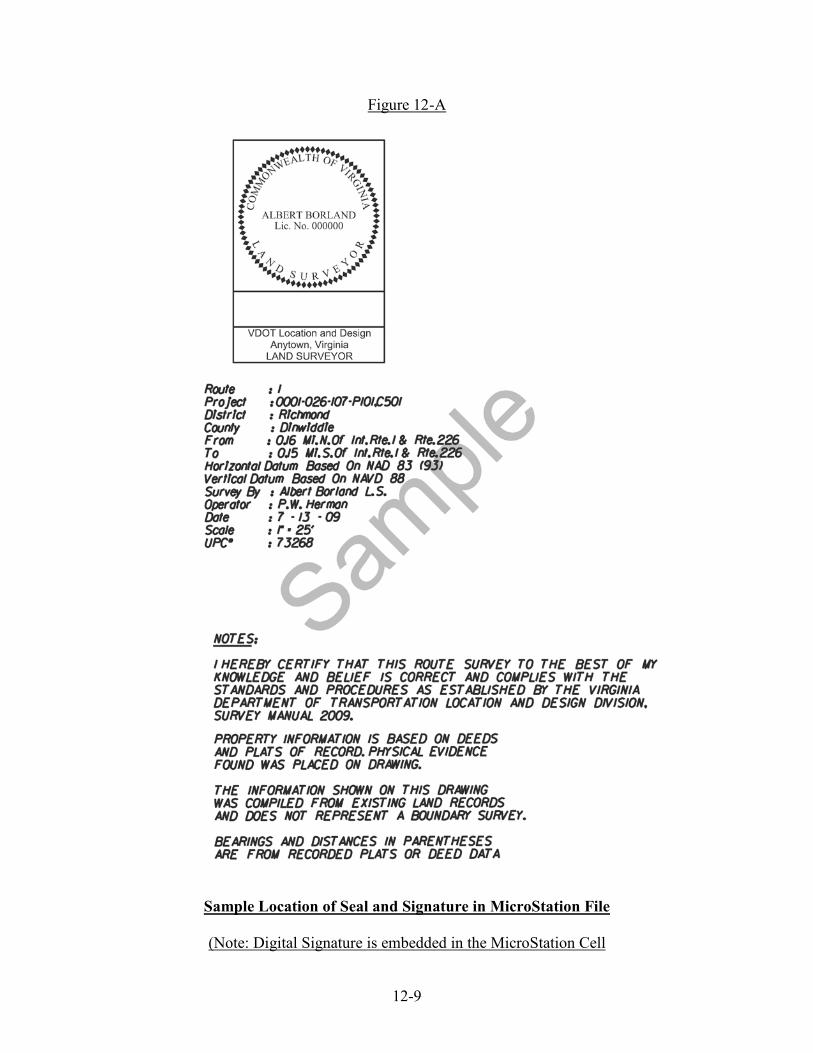
12-2
delivery da te. T he l imits of t he area and/ or ide ntified facilities r equiring s urvey inf ormation shall be identified as the result of a scoping meeting or field site review. Sec. 12.02.3 Application of Survey Seal These s urvey p roducts w ill c ontain the s urveyor’s e lectronic s eal, digital s ignature and certification statement(s) pr ior to de livery to the requestor. These products may contain notes and statements, by the professional, that define what the product represents and what it does not. The Survey Cell Library contains sample notes for modification and insertion into the CADD file product. T hese survey products are deliverables contained within the MicroStation CADD environment. The surveyor shall affix his seal in the proximity of the Title Block portion of the survey f ile as d epicted Figure 12-A. A dditionally, t he s urveyor s hall i nclude ge neral not es pertaining to the representation of the survey in the same proximity of his seal. In the case of specific not es, t he s urveyor s hall pl ace t hese i n pr oximity t o t he a reas o f c oncern t hat r equire attention. D igital s ignatures a re to be pl aced with ACES ( Access C ertificates f or E lectronic Services) Business Representatives Digital Certificates. Sec. 12.03 Engineering/Topographic Surveys The m ajority of t his w ork oc curs a fter p roject s coping, onc e f unding i s a uthorized, a nd i s delivered at va rious pe riods pr ior t o t he P lan Coordination R eview s tage a s de picted i n t he VDOT Project Development Process. Sec. 12.03.1 Professional Surveying Services & Responsibilities The application of the p rofessional’s seal, e lectronic s ignature, and date shall be evidence that the s urvey meets the minimum r equirements of D POR’s A PELSCIDLA r egulations, is a n accurate representation of the existing site and ownership conditions on that date for the area of concern, and correct to the best of the professional’s knowledge, information, and belief on that date for:
a. Location Surveys These types of surveys shall conform to Chapter 4 of the VDOT Survey Manual, titled, “Location S urveys”. T hese s urveys i nclude and e ncompass ow nership of r ecord, compiled t itle e vidence, t opography, pl animetry, dr ainage i nformation, s ubsurface utilities a nd ba se s urvey control. T hese s urveys a re requested t o obt ain i nformation pertaining to wetland identification and mitigation and bridge s ite s urveys. Survey updates w ill be ev aluated during t he D etailed D esign phase of t he V DOT pr oject pl an process. Updates are critical to the successful completion of the plan, all survey and sue information will be evaluated to see if it warrants updating the survey or sue information. If consultants or VDOT personnel are being used on the project, the same party should be used t o c omplete t he project t hrough s etting monumentation a t t he c ompletion of construction if a vailable b y c ontract. If the or iginal c onsultant is not available, it is imperative that the Project Manager and District Survey Manager determine who will be responsible for signing and sealing the plans.

12-3
b. Photogrammetric Surveys These types of surveys shall conform to Chapter 5 of the VDOT Survey Manual, titled, “Photogrammetric Surveys”. (Appendix D of VDOT Survey Manual)
c. Hydraulic Surveys These types of surveys shall conform to Chapter 7 of the VDOT Survey Manual, titled, “Hydraulic Surveys”. These surveys are requested for the specific purpose of hydrologic and h ydraulic ope ning e valuation a nd e ngineering. T he V DOT Survey M anual establishes the m ethods a nd c riteria t o a chieve t he de sired r esult. T his s ection of t he Manual c ontains guidance f or t he pe rformance of Bridge S ituation s urveys a nd deliverables.
Sec. 12.04 Right-of-Way, Boundary and Easement Surveys The m ajority of t his w ork oc curs af ter t he Design Approval pha se as d epicted in the V DOT Project Development Process but before the Project Advertisement phase. T his work requires good c ommunication a nd c oordination be tween Survey and D esign t eam m embers dur ing t he project. Sec. 12.04.1 Description of Work and Guidance On O ctober 28, 2009, t he D epartment pr esented t he D POR w ith a l etter e ntitled “ Virginia Department o f Transportation – Documents R equired t o be S igned a nd Sealed” out lining t he documents to be signed and sealed. On July 17, 2012, the Department sent an updated document to clarify the use of the right of way plan s heet, m onumentation be set a nd the timing f or s etting f inal monum entation. The LS/PE board met on A ugust 16, 2012 a nd accepted the clarification. O n September 25, 2012, t he full APELSCIDLA met and accepted the clarification letter. L & D S urvey and R ight of W ay ha ve agreed upon t he following work p roducts and documentation includes:
• The R ight-of-Way Section will record each acquisition r ecordation i nstrument with a right of way plan sheet for partial takes and a plat for total take parcels per the Right-of-Way Manual. A dditional plats may be necessary and will be provided on an as needed basis.
• The right-of-way plan sheet or plat will be referenced in the conveyance documents.
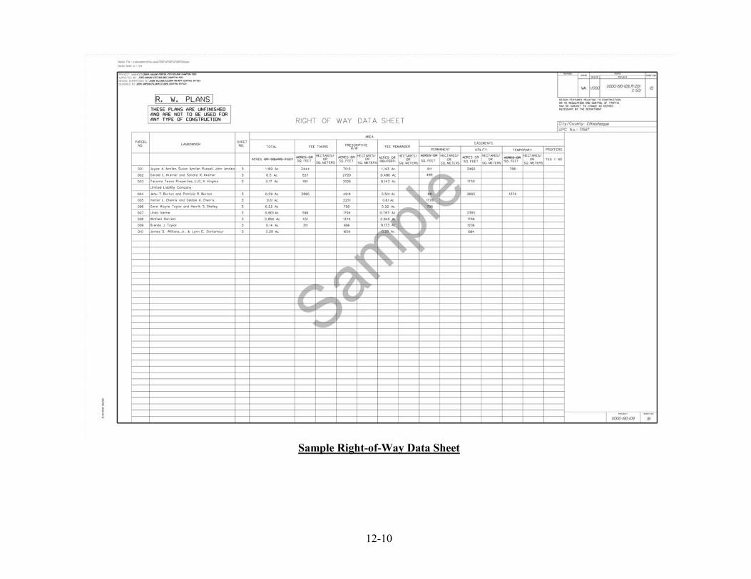
• The Survey Section will pr ovide acr eage f or f ee t ake, permanent and temporary easements at the appraisal stage.
12-4
• The R ight-of-Way Section will pa y l andowners f or the replacement o f l ot cor ners. VDOT o r a consultant will be r esponsible f or setting t he r ight o f w ay c orners on ce construction is complete.
Sec. 12.04.2 Professional Surveying Services & Responsibilities – January 1, 2013 Right of Way Plan Sheets - Right-of-Way Division and the Location and Design have agreed to utilize a right of way plan sheet to acquire properties. This will be a collaborative effort by the design teams and the survey teams. Communication is the key to the success of this process. Design Team responsibilities:
a. The design team will create the master right of way design file. The master Right of Way design file will only have the line work for proposed right of way and easements t hat i s r eferenced into the m aster r oadway design files.
b. After UFI is reached and comments are addressed the Design team will create a RW file for each plan sheet in the R folder. At the discretion of the Project Manager and District Survey Manager, these may be created at F I so Survey can proceed with checking and sheet setup.
Permissions will be restricted to Survey staff only for the R and O folders after UFI. The D esign teams will pr ovide t he G EOPAK GPK f iles tha t ha ve the alignment data so GEOPAK can be used to annotate the stations and offsets.
c. The handoff from Design to Survey shall be documented so each team understands their responsibilities.
d. The Design team will coordinate any changes to the SPO and Right of way design files through Survey.
Survey Team responsibilities:
a. The S urvey t eam i s r esponsible for master right of w ay d esign file, r ight of w ay d ata sheet and SPO file from the handoff until Ad. Any changes to this line work through the checking or annotation process should be communicated back to the PM and the design team s o all r eference f iles can be upda ted. Survey w ill remove al l design i nformation from the RW sheet except for proposed right of way and easements for c larity. Design levels can be turned off.
b. All existing monumentation, owners’ i nformation, and bounda ry da ta should be shown and referenced to the construction centerline. The typical notes should be added to the sheet and all references to sheet numbers should be corrected to RW this includes match line references.

12-5
c. All angle breaks should be annotated using plus and offsets for the proposed right of way and proposed easements. The perimeter of the new proposed right of way will be shown with metes and bounds sufficient to close the right of way, tie lines may be necessary.
An example sheet has been provided. See Figure 12-E. Please reference Chapter 5 of the CADD manual for more specific details. Final R ight-of-Way P lans s hall be s ubmitted w ith the a dvertisement pl ans a t pl an coordination r eview stage in a ccordance w ith t he A dvertisement C ut-Off C hart. F or In-House D esign O nly, t hey shall be e lectronically s ealed a nd di gitally s igned by all pa rties when notified that the status has been set to seal/sign in Falcon by Plan Coordination Section. Once the pl ats have been electronically sealed and digitally s igned, they shall be posted in Falcon. For Consultants, once the Plan Coordination Review has been completed, the plans shall be electronically sealed and digitally signed and f iles pos ted to Falcon. This is the same time tha t the advertisement pl ans ar e electronically s ealed and digitally signed. T he Final Right-of-Way plan s heets will a lso be included in t he pr oject c onstruction c ontract documents. See Electronic Plan Submission Process Reference Guides link below.
Electronic Plan Flow Chart http://www.extranet.vdot.state.va.us/locdes/reference-guides/ElectronicPlan_Submission.pdf Right of Way Submission Tier 1 & Tier 2 http://www.virginiadot.org/business/locdes/Right_of_way_partial_take.asp
Closed Surveys These types of surveys shall conform to Chapter 6 of the VDOT Survey Manual, titled, “Closed Surveys” and Section 5.6.6-5.6.9 in the Right o f Way Manual of Instructions. T hese surveys, also referred to as Boundary Surveys or Metes and Bounds Surveys, represent an extensive effort beyond a typical location survey, to identify and delineate record title lines of a parcel of interest to VDOT. Sec. 12.04.3 Plat Process prior to January 1, 2013.
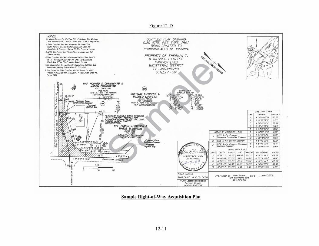
Right-of-Way Acquisition Plats
Right-of-Way D ivision a nd Location a nd D esign a greed i n 2010 to a p ilot pr ogram to utilize the Survey Section to develop right-of-way acquisition plats for use in acquiring fee property and/or interest in property for transportation purposes. The plat shall contain a note that it is produced from compiled data, and will contain the fee take, all easements and a pplicable m inimum r equirements a s required b y DPOR’s APELSCIDLA regulations. The plat shall meet the State Library standards for recordation. Preliminary plat preparation shall begin after all Field Inspection comments have been incorporated into the project plans. The naming convention of the plats shall be s (project#)_parcel#.

12-6
Preliminary Plats shall be submitted to the Central Office Plan Coordination Section prior to t he F orm LD-368 be ing c ompleted t o not ify R ight-of-Way D ivision tha t plans ar e available for p rinting and viewing for Notice to Proceed (NTP) in accordance with the Electronic Plan Submission Process Flow Chart. Preliminary plats shall be provided to right-of-way s taff pr ior t o t he i nitial of fer be ing m ade t o a p roperty ow ner. U pon completion of ne gotiations w ith pr operty o wners, t he pl ats s hall be finalized and electronically s ealed and di gitally s igned and submitted to the R egional R ight-of-Way Team Leader for recordation within 45 da ys. If the courthouse will not accept a digital signature, then a wet signature shall be placed on the seal and provided to the courthouse for recordation. B y sealing and signing the product, the land surveyor is testifying that the i nformation s hown a nd de picted i n t he R ight-of-Way A cquisition Plat is a representation of the existing field and ownership conditions on t hat date for the area of concern, i t i s pr oduced from c ompiled s ources of da ta and that the s urvey meets th e minimum requirements of DPOR’s APELSCIDLA regulations pertaining to boundary or compilation surveys and plats of record. Please refer to Figure 12-D for a sample Right-of-Way Acquisition Plat. Bearings an d D istances ar e t he controlling elements f or acquisition pl ats. Stations and offsets are s hown on the plat to tie the p lat to the project baseline controls (Provide a minimum of 2 points).. Plats shall reference the VDOT pr oject number, UPC number parcel num ber and t he c orresponding plan sheet as sociated w ith t hese p roject con trols and p lusses an d o ffsets. P lats shall clearly show cal culated ar eas of ri ght-of-way and/or eas ements req uired t o construct the project. As part of plat development, recordation and prior to the commencement of construction, The S urveyor of R ecord w ill b e res ponsible f or s etting right-of-way b reak p oints and points of intersection between the new right-of-way and existing property lines. Such break points will be shown on the acquisition plats. VDOT will no longer pay the affected property owners for the placement of these points. Final Right-of-Way Acquisition Plats shall be submitted with the advertisement plans at plan coordination review stage in accordance with the Advertisement Cut-Off Chart. For In-House Design Only, they s hall be electronically s ealed and digitally s igned by a ll parties w hen notified that the s tatus h as be en set to seal/sign in F alcon by P lan Coordination Section. Once the plats have been electronically sealed and digitally signed, they shall be posted in Falcon. For Consultants, once the Plan Coordination Review has been c ompleted, t he pl ats s hall be electronically sealed and digitally signed and f iles posted to Falcon. This i s the same time that the advertisement pl ans a re electronically sealed and digitally signed. The Final Right-of-Way Acquisition Plats put to record will also be included in the project construction contract documents.
Sec. 12.05 Construction Surveys The majority of this work occurs after the Project Advertisement phase as depicted in the VDOT Project Development.
12-7
Sec. 12.05.1 Professional Surveying Services & Responsibilities All s urvey work s hall a dhere t o t he m inimum specifications a nd guidance as r eferenced in Chapters 8 and 9 of the VDOT Survey Manual and Sec. 12.02
a. Levels, Benchmarks and Project Elevations These t ypes of s urveys shall c onform t o Chapter 8, Sec. 8.03 of t he VDOT S urvey Manual, t itled, “ Levels, B enchmarks a nd P roject E levations”. P roject benchmarks are shown on the survey alignment data sheet in the plan set. Benchmarks should be checked prior to their use in stakeout. Differential leveling should be run between benchmarks and recorded i n f ield not es. A ny a ppreciable di fferences i n be nchmark e levation s hould be recorded i n f ield not es a nd c heck l evels s hould be r un t o ve rify t he di fference. If additional benchmarks are set on the project, a list of the benchmarks with a description and e levation should be given to t he project i nspector and contractor. For examples of level notes see Figures 8F, 8G, and 8H of the VDOT Survey Manual.
b. Borrow Pits These t ypes of sur veys shall conform t o Chapter 8, Sec. 8.05 of t he VDOT S urvey Manual, titled, “Borrow Pits”. Borrow Pits will be surveyed by creating a digital DTM surface. D TM’s are us ed t o s ecure elevations, t hen a n a ppropriate num ber of control stations should be used to i nsure i ntegrity o f t he pi t and readings should be secured a t appropriate intervals to insure accurate coverage for computations of volume.
c. Culvert Stakeout These t ypes of s urveys shall c onform t o Chapter 8, Sec. 8.06 of t he VDOT S urvey Manual, t itled, “ Culvert S takeout”. A ll bo x c ulverts a re t o be s taked, a ccording t o furnished alignment and grades. Figure 8-L illustrates a procedure for checking the stake out of a box culvert. All culverts will be staked in accordance with Section 105.13 an d 517 of VDOT’s Road and Bridge Standards and Figure 1 as shown at the beginning of Figure 8-L of the VDOT Survey Manual. All pipe culverts, with an equivalent hydraulic opening of 12.6 square feet and larger, and all culverts with design grades, are to be s taked in accordance with section 105.13 and 517 of the Road and Bridge Specifications. All p ipe culverts with equivalent h ydraulic openings less than 12.6 square feet may be staked by contract personnel. All pi pe c ulverts w ith d esign grades, s uch a s s torm s ewers, r egardless of s ize m ay b e staked by the contract surveyor when specifically requested by the project engineer.
d. Bridge Stakeout These t ypes of s urveys shall c onform t o Chapter 8, Sec, 8.07 of t he VDOT S urvey Manual, titled, “Bridge Stakeout”. Stakes should be set at the intersection of the baseline of the bridge and the centerline of each pier. Also, stakes shall be set on the baseline of the bridge at the intersection of the lines shown on the plans on the abutments from which the di mensions w ere r eferenced. T hese i ntersection poi nts w ill be s hown on t he s ub-

12-8
structure layout sheet of the bridge plans. All bridge staking shall be in accordance with Section 105.13 and 517 of VDOT’s Road and Bridge Standards and Figures 2 and 3 in Chapter 8 of the VDOT Survey Manual.
e. As-built or Final Surveys These types of surveys shall conform to Chapter 4 of the VDOT Survey Manual, titled, “Location Surveys” and Chapter 9 of t he S urvey Manual t itled, “ Final S urveys”. As-built S urveys r epresent t he e xisting c ondition pos t-construction. T hese s urveys a re invoked b y s pecial r equest a nd c an i nclude a nd e ncompass l ocation a nd vol umetric information for the e ntire pr oject or jus t ite ms s elected specifically f or r eview and investigation. By sealing and signing the product, the land surveyor is testifying that the information shown and depicted in the survey file product is an accurate representation of the e xisting s ite, feature or f acility pos t-construction on t hat da te f or t he a rea(s) of concern. C urrently, t hese pr oducts m ay be de livered a s a P DF or M icroStation C AD file(s).
Sec. 12.06 Survey Information Not Requiring a Seal or Signature Asset m anagement s urveys, or t hose s urveys t hat a re f or pu rely qu antitative pur poses ( i.e. measuring l inear f eet of g uardrail, num ber of s igns, e tc.) w ill not r equire a s eal or s ignature unless deemed necessary by the requestor. Information secured by surveyors that does not depict critical elevations or planimetric locations, modeled existing conditions or boundary evidence are not required to be sealed and signed. Information not listed above that is contained within the Chapter Contents section of Chapter 8 of the VDOT Survey Manual will not require sealing and signing unless specifically requested.
IIM-LD-243 Signing and Sealing http://www.virginiadot.org/business/locdes/rd-ii-memoranda-index.asp
12-9
Figure 12-A
Sample Location of Seal and Signature in MicroStation File
(Note: Digital Signature is embedded in the MicroStation Cell
12-10
Sample Right-of-Way Data Sheet
12-11
Figure 12-D
Sample Right-of-Way Acquisition Plat
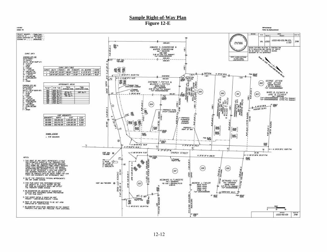
Sample Right-of-Way Plan Figure 12-E
12-12

12-13