Chapter 11 BILL WILLIAMS RIVER WATERSHED - … 11 Bill... · U.S. Fish and Wildlife Service Arizona...
99
U.S. Fish and Wildlife Service Arizona Game and Fish Department Bill Williams River Watershed Biological Assessment of the Arizona Game and Fish Department’s January 2011 Statewide and Urban Fisheries Stocking Program 11-1 Chapter 11 BILL WILLIAMS RIVER WATERSHED Chapter 11 Bill Williams River Watershed ............................................................................... 11-1 Santa Maria Sub-Watershed .................................................................................................. 11-7 Santa Maria Complex ........................................................................................................ 11-9 Bass Tank ....................................................................................................................... 11-9 Blue Tank ..................................................................................................................... 11-15 Granite Mountain #1 Tank ........................................................................................... 11-20 Granite Mountain #2 Tank ........................................................................................... 11-25 Santa Maria Complex Analysis ....................................................................................... 11-29 Big Sandy River Sub-Watershed ......................................................................................... 11-40 Burro Creek Complex ...................................................................................................... 11-40 Carter Tank .................................................................................................................. 11-44 Antelope Tank .............................................................................................................. 11-49 Harmon Tank #2 .......................................................................................................... 11-52 Bar 37 Tank.................................................................................................................. 11-54 Little Antelope Tank .................................................................................................... 11-58 McElhaney Tank .......................................................................................................... 11-61 Harman Tank ............................................................................................................... 11-66 Stubb’s Tank ................................................................................................................ 11-69 Swale Tank................................................................................................................... 11-74 Coors Lake ................................................................................................................... 11-78 Burro Creek Complex Analysis ....................................................................................... 11-86 Bill Williams River Watershed Analysis ................................................................................. 11-93
Transcript of Chapter 11 BILL WILLIAMS RIVER WATERSHED - … 11 Bill... · U.S. Fish and Wildlife Service Arizona...
U.S. Fish and Wildlife Service Arizona Game and Fish Department Bill Williams River Watershed
Biological Assessment of the Arizona Game and Fish Department’s January 2011 Statewide and Urban Fisheries Stocking Program
11-1
Chapter 11 BILL WILLIAMS RIVER WATERSHED
Chapter 11 Bill Williams River Watershed ............................................................................... 11-1
Santa Maria Sub-Watershed .................................................................................................. 11-7
Santa Maria Complex ........................................................................................................ 11-9
Bass Tank ....................................................................................................................... 11-9
Blue Tank ..................................................................................................................... 11-15
Granite Mountain #1 Tank ........................................................................................... 11-20
Granite Mountain #2 Tank ........................................................................................... 11-25
Santa Maria Complex Analysis ....................................................................................... 11-29
Big Sandy River Sub-Watershed ......................................................................................... 11-40
Burro Creek Complex ...................................................................................................... 11-40
Carter Tank .................................................................................................................. 11-44
Antelope Tank .............................................................................................................. 11-49
Harmon Tank #2 .......................................................................................................... 11-52
Bar 37 Tank.................................................................................................................. 11-54
Little Antelope Tank .................................................................................................... 11-58
McElhaney Tank .......................................................................................................... 11-61
Harman Tank ............................................................................................................... 11-66
Stubb’s Tank ................................................................................................................ 11-69
Swale Tank................................................................................................................... 11-74
Coors Lake ................................................................................................................... 11-78
Burro Creek Complex Analysis ....................................................................................... 11-86
Bill Williams River Watershed Analysis ................................................................................. 11-93
U.S. Fish and Wildlife Service Arizona Game and Fish Department Bill Williams River Watershed
Biological Assessment of the Arizona Game and Fish Department’s January 2011 Statewide and Urban Fisheries Stocking Program
11-2
List of Figures Figure 1. Bill Williams Watershed. ........................................................................................... 11-6 Figure 2. Land ownership in the Bill Williams Watershed. ...................................................... 11-7 Figure 3. Overview of the Santa Maria River Sub-Watershed, showing points of available
fish collection data from the Kansas State Aquatic GAP database. .............................. 11-9 Figure 4.Bass Tank on Loco Creek............................................................................................ 11-9 Figure 5. Bass Tank imagery on Loco Creek .......................................................................... 11-10 Figure 6. Bass Tank, July 2002. ............................................................................................... 11-11 Figure 7. Bass Tank photograph. ............................................................................................. 11-11 Figure 8. Loco Creek below Blue Tank. .................................................................................. 11-13 Figure 9. Loco Creek below Boundary Spring. ....................................................................... 11-14 Figure 10. Blue Tank ............................................................................................................... 11-16 Figure 11. Berm dam at Blue Tank. Water spills to the left of the Cottonwood trees............. 11-17 Figure 12. Blue Tank in 2007. ................................................................................................. 11-17 Figure 13. Overview map of Granite Mountain 1.................................................................... 11-21 Figure 14. Granite Mountain 1 with tributaries. ...................................................................... 11-22 Figure 15. Annual peak flows at Santa Maria River near Bagdad........................................... 11-24 Figure 16. Granite Mountain 2 along Little Shipp Wash......................................................... 11-26 Figure 17. Granite Mountain 2 imagery .................................................................................. 11-27 Figure 18. Sampling sites on Sycamore Creek May 6-8, 2009. Mouth of Loco Creek is in
upper right hand portion of map. ................................................................................. 11-33 Figure 19. Sample site on Loco Creek where no fish were collected in May 7, 2009. ........... 11-34 Figure 20. Overview map of the Bill Williams watershed. ..................................................... 11-41 Figure 21. Overview map of the Burro Creek watershed. ....................................................... 11-43 Figure 22. Overview of stock tanks in Pine Creek watershed. ................................................ 11-45 Figure 23. Carter Tank, July 2002. .......................................................................................... 11-46 Figure 24. Antelope Tank, July 2002....................................................................................... 11-49 Figure 25. Harmon Tank #2, July 2002. .................................................................................. 11-52 Figure 26. Bar 37 Tank, July 2002. ......................................................................................... 11-55 Figure 27. Little Antelope Tank, August 2007. ....................................................................... 11-58 Figure 28. McElhaney Tank, August 2007. ............................................................................. 11-62 Figure 29. Yolo Ranch along Boulder Creek........................................................................... 11-65 Figure 30. Harman Tank, August 2007. .................................................................................. 11-67 Figure 31. Stubb’s Tank, June 2006. ....................................................................................... 11-70 Figure 32. Stubb’s Tank photograph. ..................................................................................... 11-71 Figure 33. Breech at Stubb’s Dam, October 2007. .................................................................. 11-72 Figure 34. Stubb’s Dam breech looking downstream, October 2007. ..................................... 11-72 Figure 35. Swale Tank, October 2004. .................................................................................... 11-74 Figure 36. Swale and Slaughter Tanks .................................................................................... 11-77 Figure 37. Coors Lake, May 2007. .......................................................................................... 11-79 Figure 38. Coors Lake and ephemeral tributaries to Boulder Creek ....................................... 11-83 Figure 39. Cyprus Bagdad Mining Company operations near Coors Lake ............................. 11-85 Figure 40. Vertical Drop on Pine Creek UTM 12S 310728E 3858237N, June 2008. ............. 11-88

U.S. Fish and Wildlife Service Arizona Game and Fish Department Bill Williams River Watershed
Biological Assessment of the Arizona Game and Fish Department’s January 2011 Statewide and Urban Fisheries Stocking Program
11-3
Figure 41. Surface elevation of Alamo Lake over time, 1968 to present (Brown and Jacobson 2007a). .......................................................................................................... 11-94
Figure 42. USGS gauge data for peak discharge below Alamo Dam before and after dam construction completed in July 1968. .......................................................................... 11-95
List of Tables Table 1. Stocking history at Bass Tank. .................................................................................. 11-12 Table 2. Surveys at Bass Tank by year, method, species, number caught, and lengths (in
mm). ............................................................................................................................. 11-15 Table 3. Stocking History for Blue Tank. ................................................................................ 11-18 Table 4. Surveys at Blue Tank by year, method, species, number caught, and lengths (in
mm). ............................................................................................................................. 11-19 Table 5. Surveys at Granite Mountain Tank #1 by year, method, species, number caught,
and lengths (in mm): .................................................................................................... 11-24 Table 6. Stocking history at Granite Mountain #2 Tank. ........................................................ 11-27 Table 7. Surveys at Granite Mountain Tank #2 by year, method, species, number caught,
and lengths (in mm): .................................................................................................... 11-29 Table 8. Sample results from backpack electrofishing, Sycamore Creek May 6, 2009. ......... 11-33 Table 9. Sample results from gillnetting, Sycamore Creek May 6, 2009. ............................... 11-34 Table 10. Peak stream flow from USGS 09424900 Santa Maria River near Bagdad, AZ. ..... 11-37 Table 11. Stocking history for Carter Tank ............................................................................. 11-46 Table 12. USGS Burro Creek gauging station 09424447 from 1980 to 2007. ........................ 11-48 Table 13. Surveys at Carter Tank by year, method, species, number caught, and lengths
(in millimeters): ........................................................................................................... 11-48 Table 14. Stocking history for Antelope Tank......................................................................... 11-50 Table 15. Surveys at Antelope Tank by year, method, species, number caught, and
lengths (in mm). ........................................................................................................... 11-51 Table 16. Stocking history for Harmon Tank #2. .................................................................... 11-53 Table 17. Surveys at Harmon Tank #2 by year, method, species, number caught, and
lengths. ......................................................................................................................... 11-54 Table 18. Stocking history for Bar 37 Tank. ........................................................................... 11-56 Table 19. Surveys at Bar 37 Tank by year, method, species, number caught, and length. ...... 11-57 Table 20. Stocking history for Little Antelope Tank. .............................................................. 11-59 Table 21. Surveys at Little Antelope Tank by year, method, species, number caught, and
length............................................................................................................................ 11-60 Table 22. Conger Creek survey results, May 2003. Samples from Conger Spring area
using backpack electrofisher. Effort = 35.35 minutes. ................................................ 11-61 Table 23. Stocking history at McElhaney Tank....................................................................... 11-62 Table 24. Surveys at McElhaney Tank by year, method, species, number caught, and
length............................................................................................................................ 11-66 Table 25. Stocking history for Harman Tank. ......................................................................... 11-67 Table 26. Survey results from hoop net samples at Harman Tank, August 23, 2007.............. 11-69

U.S. Fish and Wildlife Service Arizona Game and Fish Department Bill Williams River Watershed
Biological Assessment of the Arizona Game and Fish Department’s January 2011 Statewide and Urban Fisheries Stocking Program
11-4
Table 27. Surveys at Harman Tank by year, method, species, number caught, and length. ... 11-69 Table 28. Stocking history for Stubb’s Tank. .......................................................................... 11-71 Table 29. Surveys at Stubb’s Tank by year, method, species, number caught, and length. .... 11-73 Table 30. Stocking history for Swale Tank. ............................................................................ 11-75 Table 31. Surveys at Swale Tank by year, method, species, number caught, and length. ....... 11-77 Table 32. Stocking history for Coors Lake. ............................................................................. 11-80 Table 33. Number, relative abundance, relative biomass and catch per unit effort by
electrofishing at Coors Lake 1998-2007. ..................................................................... 11-85 Table 34. Peak stream flow for USGS 09424447 Burro Creek at old US 93 bridge near
Bagdad, Az. .................................................................................................................. 11-90 Table 35. Species composition, by number and percent, and mean catch per unit effort
(CPUE) of fish sampled in Alamo Lake on spring and fall surveys from 2003 through spring 2007 (Brown and Jacobson 2007a). .................................................... 11-95
Table 36. Species composition, by number and percent, and mean catch per unit effort (CPUE), of fish sampled by electrofishing in Lake Havasu from fall 2003 through fall 2006. One unit of effort is 900 seconds of electrofishing (Brown and Jacobson 2007b). ......................................................................................................................... 11-96
U.S. Fish and Wildlife Service Arizona Game and Fish Department Bill Williams River Watershed
Biological Assessment of the Arizona Game and Fish Department’s January 2011 Statewide and Urban Fisheries Stocking Program
11-5
Bill Williams River Watershed Physical geographic description
Drainage Area The Bill Williams River Basin (Figure 1) drainage area covers approximately 5,373 mi2 in west-central Arizona. The Bill Williams River proper measures approximately 50 miles in length, covers approximately 1,109 mi2, with its upstream-most approximately5.3 miles consisting of water impounded behind Alamo Dam. Downstream of Alamo Dam, the river flows approximately45 miles before reaching its confluence with the Colorado River at Lake Havasu. The western portion of the basin is within the Basin and Range province and the eastern portion is within the Central Highlands province.
There are 3 major rivers in the watershed including the Bill Williams proper, the Big Sandy (2,852 mi2), and Santa Maria River (1,442 mi2), the latter two form the headwaters of the Bill Williams River at Alamo Lake. The Big Sandy River drainage comprises more than 100 miles of perennial and ephemeral streams flowing from the north, with the Burro Creek Sub-Watershed (713 mi2) joining the Big Sandy approximately 17 miles upstream from where the river enters Alamo Lake.
The Santa Maria River including its headwaters, courses for more than 90 miles consisting of mostly ephemeral flow with limited perennial stretches from the northeast part of the drainage and flows directly into Alamo Lake which is impounded by Alamo Dam. Sites proposed for stocking in the drainage are small stock tanks located within the east-central portion of the watershed on intermittent and/or ephemeral drainage courses with infrequent spillage/connection to downstream waters. There are a total of 14 stocking sites in the Bill Williams River Watershed. Four sites are located in the Santa Maria Sub-Watershed: Bass, Blue, Granite Mountain #1, and Granite Mountain #2 tanks; and ten sites in the Burro Creek Sub-Watershed: Carter, Antelope, Harmon #2, Bar 37, Little Antelope, McElhaney, Harman, Stubbs, and Swale tanks, as well as Coors Lake. Coors Lake is the only closed system in this watershed. There are 426 known registered stock ponds within the Big Sandy Basin (ADWR unknown date).

U.S. Fish and Wildlife Service Arizona Game and Fish Department Bill Williams River Watershed
Biological Assessment of the Arizona Game and Fish Department’s January 2011 Statewide and Urban Fisheries Stocking Program
11-6
Figure 1. Bill Williams Watershed.

U.S. Fish and Wildlife Service Arizona Game and Fish Department Bill Williams River Watershed
Biological Assessment of the Arizona Game and Fish Department’s January 2011 Statewide and Urban Fisheries Stocking Program
11-7
Range of elevations
The Big Sandy River reaches to elevations of approximately 2,400 feet but has feeder tributaries such as Tuckayou Wash that range up to 5,300 feet elevation. The Santa Maria River reaches to approximately 2,600 feet elevation, with tributaries reaching higher into the 6,000 feet range. The Bill William River drops from an elevation of approximately 1,100 feet down to an elevation of 449 feet. Tributaries Other significant streams with perennial flow include Burro and Trout Creeks which feed into the Big Sandy River, and Sycamore and Kirkland Creeks, which are tributaries of the Santa Maria River. Numerous intermittent streams are located in the northeastern portion of the basin. Several springs resulting in localized surface flow can also be found in the eastern and north central areas of the watershed. Vegetation The watershed of the Bill Williams River spans diverse physiography ranging from high elevation forested mountains along the western margin of the central highlands province to low-lying, rugged desert mountains and intervening alluvial valleys in the basin and range province. The biotic communities include the Great Basin conifer woodlands, Interior chaparral and Sonoran desert scrub. Riparian vegetation includes cottonwood/willow, mesquite, tamarisk and mixed broadleaf (Burro Creek). Riparian vegetation grows in many locations within the valley of the watershed with adjacent sparsely vegetated uplands. Riparian vegetation along the river is dominated by several woody species common to low elevation southwestern riparian ecosystems, including Fremont cottonwood (Populus fremontii S. Watson), Goodding willow (Salix gooddingii Ball), saltcedar (Tamarix ramosissima Ledebour), seep willow (Baccharis salicifolia (R. & P.)), and mesquite (Prosopis spp.) Herbaceous vegetation tends to be quite sparse, except adjacent to areas where water and light availability are high. The herbaceous flora comprises the greatest plant diversity along the river.
Figure 2. Land ownership in the Bill Williams Watershed.
SANTA MARIA SUB-WATERSHED Physical geographic description The Santa Maria River begins at the confluence of Sycamore Creek and Kirkland Creek on the properties of the Mule Shoe Ranch. From this point it runs 47-miles southwest into Alamo Lake and is characterized by broad, shallow, sandy-bottomed runs with few riffles and low gradient. Pools and eddies occur only in areas where the open floodplain has constricted due to the narrow canyons (Kepner 1980). The Santa Maria River is classified as a “flashy” type desert stream prone to prolonged dry periods followed by extreme high water events that transport large

U.S. Fish and Wildlife Service Arizona Game and Fish Department Bill Williams River Watershed
Biological Assessment of the Arizona Game and Fish Department’s January 2011 Statewide and Urban Fisheries Stocking Program
11-8
amounts of sedimentary materials (Kepner 1980). These events often preclude establishment of reproducing populations of all the proposed stocking species or temporarily remove suitable habitats for them. The Santa Maria flows to the southwest and meets the Big Sandy to flow into Alamo Lake.
Range of elevations The elevation range of the Santa Maria is from 2,640ft at the Kirkland/Sycamore Creek junction to 1,240ft at Alamo Lake.
Tributaries Several intermittent and perennial tributaries drain into the Santa Maria River including: Sycamore Creek, Smith Canyon, Loco Creek, Waterman Creek, and Peoples Canyon Creek. The Santa Maria River has 3 perennial reaches
The Santa Maria River stocking complex contains four proposed stocking locations: Bass, Blue, Granite Mountain #1 and #2 tanks (Figure 3). The individual tanks are described in more detail below.

U.S. Fish and Wildlife Service Arizona Game and Fish Department Bill Williams River Watershed
Biological Assessment of the Arizona Game and Fish Department’s January 2011 Statewide and Urban Fisheries Stocking Program
11-9
Figure 3. Overview of the Santa Maria River Sub-Watershed, showing points of available fish collection data from the Kansas State Aquatic GAP database.
SANTA MARIA COMPLEX Bass Tank Site Description Bass Tank is a 1.3 acre earthen cattle tank maintained by precipitation. The tank is located about 16 miles north and east of Bagdad, Arizona. It is situated on a private parcel owned by the Yolo Ranch. It sits at approximately 5,170 feet elevation at the headwaters of Loco Creek, a small ephemeral tributary of Sycamore Creek, which in turn feeds into the Santa Maria River (Figure 4 and Figure 5). The tank is surrounded by State Trust Land. The tank was constructed in 1971 according to water rights records filed with the Arizona Department of Water Resources (38-27125). This tank has not been known to dry completely in the last 20-years. The tank has a spill way into Loco Creek that is evident in aerial photos. However, in 2002 water levels were very low (Figure 6 and Figure 7).
Figure 4.Bass Tank on Loco Creek.

U.S. Fish and Wildlife Service Arizona Game and Fish Department Bill Williams River Watershed
Biological Assessment of the Arizona Game and Fish Department’s January 2011 Statewide and Urban Fisheries Stocking Program
11-10
Figure 5. Bass Tank imagery on Loco Creek
Management of Water Body The fishery at Bass Tank is maintained in cooperation with Yolo Ranch. It is managed as a self-sustaining warm water fishery with largemouth bass and bluegill sunfish. As with all the small ponds or cattle waters in the area, Bass Tank dries periodically to the point where warm water sport fish species may stunt or die. Re-stocking needs are evaluated periodically.

U.S. Fish and Wildlife Service Arizona Game and Fish Department Bill Williams River Watershed
Biological Assessment of the Arizona Game and Fish Department’s January 2011 Statewide and Urban Fisheries Stocking Program
11-11
Figure 6. Bass Tank, July 2002.
Figure 7. Bass Tank photograph.

U.S. Fish and Wildlife Service Arizona Game and Fish Department Bill Williams River Watershed
Biological Assessment of the Arizona Game and Fish Department’s January 2011 Statewide and Urban Fisheries Stocking Program
11-12
Table 1. Stocking history at Bass Tank.
Species First Year Last Year Number of Stockings Num. Stocked
Bluegill 2002 2002 1 500
Largemouth bass 1997 1997 1 200
Total 2 700
Future management objectives would be to provide a largemouth bass, redear sunfish and bluegill sunfish fishery. Periodic stocking to maintain catchable sizes may be necessary due to drying and/or catastrophic wildfire.
Proposed action The Department proposes to stock largemouth bass, bluegill sunfish and redear sunfish for the period covered by this consultation.
Redear sunfish would be established; numbers and sizes of fish stocked for this purpose will be determined according to stocking guidelines identified in the sport fish stocking protocol. Largemouth bass (fry/fingerling, sub-catchables, catchables), bluegill sunfish (fry/fingerling, sub-catchables, catchables), redear sunfish (fry/fingerling, sub-catchables, catchables), may be stocked as needed at any time during the year to augment the fishery or to recover the fishery following catastrophic events. Numbers of fish stocked for this purpose would be determined according to stocking guidelines identified in the sport fish stocking protocol.
Water Distribution \ Connectivity Bass Tank receives water from snowmelt and precipitation events. There are no USGS stream gauges on Loco Creek. The probability of a spill is low from Bass Tank because of the limited watershed contribution and the relative large capacity of the tank. No spill has been documented at Bass Tank; however water has been seen below the tank within the ephemeral Loco Creek. Bass Tank sits high in the Loco Creek drainage and extends approximately 6.5 miles through Loco Creek via ephemeral drainage. Loco Creek is then intermittent and extends another approximately 5 miles to its mouth with Sycamore Creek. Loco Creek has natural barriers upstream existing in several areas due to the geologic make-up (bedrock dominated) of the creek. There is approximately ½ mile of rugged ephemeral wash above Bass Tank, but no ponds/tanks that can harbor fish limiting any opportunity for persistence. Large waterfalls are not known from Loco Creek but extensive areas of sharp elevation change in narrow, slot rocky canyons do exist (Figure 8 and Figure 9).

U.S. Fish and Wildlife Service Arizona Game and Fish Department Bill Williams River Watershed
Biological Assessment of the Arizona Game and Fish Department’s January 2011 Statewide and Urban Fisheries Stocking Program
11-13
Sycamore Creek from its confluence with Loco Creek extends another 6.5 miles to the confluence with Kirkland Creek and has intermittent flow and usually a few small perennial pools along its course. From this confluence the channel is called the Santa Maria River. The Santa Maria River is intermittent and dominated by large stretches of dry streambed with some limited perennial pool habitat persisting through the driest periods.
Fish Movement Loco Creek is a high gradient, bedrock dominated stream that does not provide adequate aquatic habitats for most fishes to persist (Figure 8 and Figure 9). Fish movement through Loco Creek would be during spring runoff events and flash floods that create increased sediment loads, high turbidity, rapid currents, altered habitat conditions, increased stress levels of organisms in transport, altered fish behavior and mortality, all of which limit the ability of survival during transport. There is approximately ½ mile of rugged ephemeral wash above Bass Tank, but no ponds/tanks that can harbor fish. No fish have ever been sighted by the fisheries biologist in 10 years of observation and it is the biologist’s opinion that Loco Creek does not provide adequate aquatic habitat to support fish. (A. Clark pers. comm.)
Figure 8. Loco Creek below Blue Tank.

U.S. Fish and Wildlife Service Arizona Game and Fish Department Bill Williams River Watershed
Biological Assessment of the Arizona Game and Fish Department’s January 2011 Statewide and Urban Fisheries Stocking Program
11-14
Figure 9. Loco Creek below Boundary Spring.
Community Description Surveys at Bass tank have been done in summer months using netting methods (Table 2). Two 150-foot gillnets were used in 1988 and allowed to fish overnight. Two to three hoopnets were used in 1991, 1995, 1997, and 1998 in overnight sets adjacent to shoreline cover. Anecdotal reports from Department technicians performing the surveys claimed bullfrogs were plentiful. A visit to the tank in 2002 by Andy Clark and Wildlife Manager Darren Tucker confirmed that the tank was very low and numerous bullfrogs were persisting; however, no fish were seen or angled.
In 2009, the Region III Fisheries Program and Wildlife Manager Tucker checked water levels and angled one bluegill. No largemouth bass were seen or caught by four anglers fishing approximately 30 minutes. No other aquatic wildlife has been noted at the tank and no threatened or endangered species are known from the area.

U.S. Fish and Wildlife Service Arizona Game and Fish Department Bill Williams River Watershed
Biological Assessment of the Arizona Game and Fish Department’s January 2011 Statewide and Urban Fisheries Stocking Program
11-15
Roundtail chub have been historically documented in Sycamore Creek approximately 11 miles downstream from Bass Tank. A survey completed in 2009, did not document any fish species in Loco Creek near Boundary Spring about 6 miles upstream of Sycamore Creek or roundtail chub in Sycamore Creek. Desert sucker, Sonora sucker and green sunfish were found in isolated pools of Sycamore Creek downstream of the mouth of Loco Creek in 2009 (A. Clark, pers. comm.).
Table 2. Surveys at Bass Tank by year, method, species, number caught, and lengths (in mm).
Survey Year Survey method(s) Species encountered Num. Length (mm) 1988 Gill Net Largemouth bass 9 181-504 Bluegill 2 181-186 1991 Hoop Net Largemouth bass 1 165 Bluegill 9 124-159 1995 Hoop Net Largemouth bass 3 202-310 Bluegill 14 169-195 1997 Hoop Net Largemouth bass 5 162-256 Bluegill 68 170-202 1998 Hoop Net Largemouth bass 3 162-240 Bluegill 95 110-210 2002 Visual Largemouth bass 0 Bluegill 0 2009 Angling Bluegill 1 215
Consultation Species or Critical Habitat No aquatic species of concern are within the vicinity of this stocking site. Roundtail chub are discussed in the Santa Maria complex analysis as they may maintain populations in downstream tributaries to the Santa Maria River.
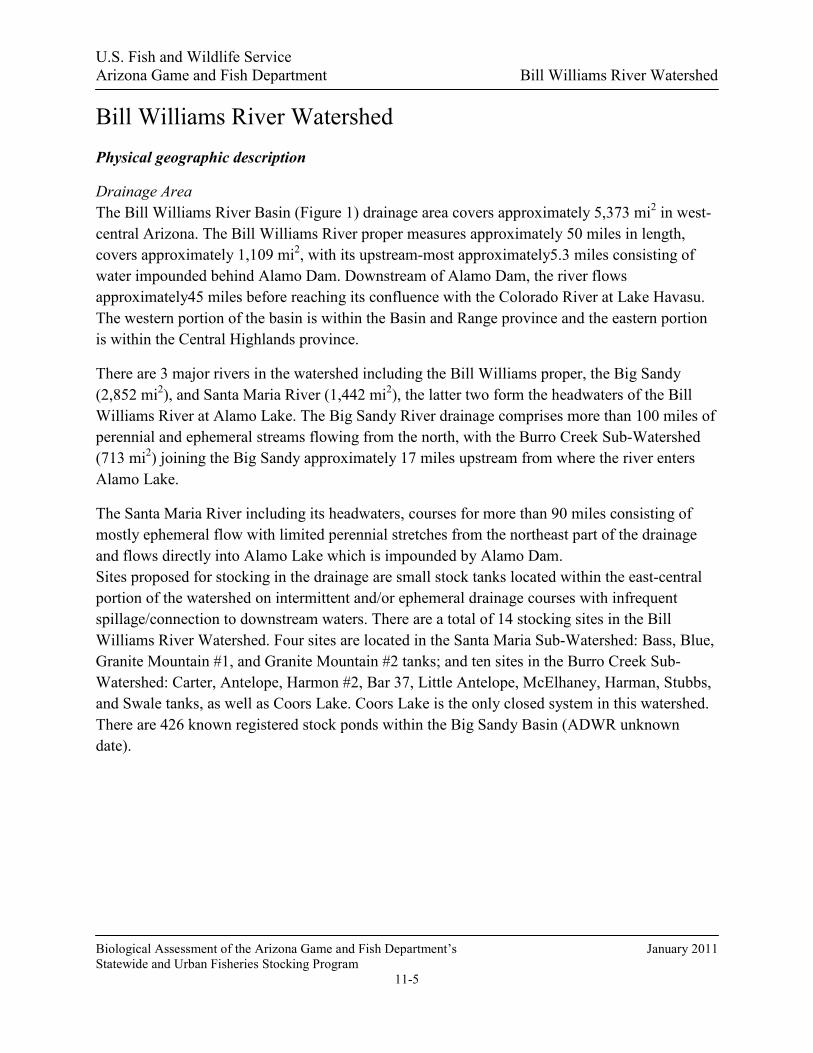
Blue Tank Site Description Blue Tank is a 3.5 acre earthen livestock tank maintained by precipitation on State Trust Land leased by the Yolo Ranch (Figure 10 and Figure 12). It sits at approximately 4,695 feet elevation in a small ephemeral tributary of Loco Creek, a tributary to Sycamore Creek that feeds into the Santa Maria River. According to Arizona Department of Water Rights records (Reservoir Application No. 3R-2596), Blue Water Dam was constructed in 1967. The spillway is evident in aerial imagery and a photo of the earthen berm dam is below (Figure 11).
U.S. Fish and Wildlife Service Arizona Game and Fish Department Bill Williams River Watershed
Biological Assessment of the Arizona Game and Fish Department’s January 2011 Statewide and Urban Fisheries Stocking Program
11-16
Figure 10. Blue Tank

U.S. Fish and Wildlife Service Arizona Game and Fish Department Bill Williams River Watershed
Biological Assessment of the Arizona Game and Fish Department’s January 2011 Statewide and Urban Fisheries Stocking Program
11-17
Figure 11. Berm dam at Blue Tank. Water spills to the left of the Cottonwood trees.
Figure 12. Blue Tank in 2007.
Management of Water Body Currently Blue Tank is managed as a self-sustaining warmwater fishery with largemouth bass and bluegill sunfish. As with most small ponds or livestock waters in the area, Blue Tank dries periodically to the point where warmwater sport fish species may stunt or die. Stocking is periodically evaluated by angling or netting surveys (Table 3).

U.S. Fish and Wildlife Service Arizona Game and Fish Department Bill Williams River Watershed
Biological Assessment of the Arizona Game and Fish Department’s January 2011 Statewide and Urban Fisheries Stocking Program
11-18
Table 3. Stocking History for Blue Tank.
Species First Year Last Year Num. of Stockings Num. Stocked
Bluegill 1993 2002 1 5,500
Largemouth bass 1993 2007 4 2,914
Total 4 8,414
Future management objectives would center on providing stock sizes of largemouth bass, redear and bluegill sunfish for anglers to enjoy. Periodic stocking to maintain sizes usable to anglers may be necessary due to drying and/or catastrophic wildfire.
Proposed Action The Department proposes to stock largemouth bass, bluegill sunfish and redear sunfish for the period covered by this consultation.
Redear sunfish would be established; numbers and sizes of fish stocked for this purpose will be determined according to stocking guidelines identified in the sport fish stocking protocol. Largemouth bass (fry/fingerling, sub-catchables, catchables), bluegill sunfish (fry/fingerling, sub-catchables, catchables), redear sunfish (fry/fingerling, sub-catchables, catchables), may be stocked as needed at any time during the year to augment the fishery or to recover the fishery following catastrophic events. Numbers of fish stocked for this purpose would be determined according to stocking guidelines identified in the sport fish stocking protocol.
Water Distribution \ Connectivity Blue Tank receives water from snowmelt and precipitation events and from upstream of the watershed which is less than 1 square mile in area. There are no USGS stream gauges on Loco Creek. However, the probability of spill is low from Blue Tank because of the limited watershed contribution and the relative large capacity of the tank; however, a spill was observed in 2007 (A. Clark, pers. comm.). Water exiting the spillway at Blue tank drains slightly more than 1/10th mile down a small tributary of Loco Creek. From this point Loco Creek courses 7 miles to its mouth with Sycamore Creek. Sycamore Creek from that point is intermittent and drains another 6.5 miles to the confluence with Kirkland Creek forming the Santa Maria River.
The Santa Maria River is intermittent dominated by large stretches of dry streambed with some limited perennial pool habitat persisting through the driest periods. Loco Creek is ephemeral bedrock dominated with natural barriers existing in several areas.
Fish Movement

U.S. Fish and Wildlife Service Arizona Game and Fish Department Bill Williams River Watershed
Biological Assessment of the Arizona Game and Fish Department’s January 2011 Statewide and Urban Fisheries Stocking Program
11-19
Loco Creek is a high gradient, bedrock dominated stream that does not provide adequate aquatic habitats for most fishes to persist. Fish movement through Loco Creek would be during periodic spring runoff events and flash floods that create increased sediment loads, high turbidity, rapid currents, altered habitat conditions, increased stress levels of organisms in transport, altered fish behavior and mortality, all of which limits the ability of survival during transport. Upstream movement by fish is very limited in this stream and consists of 4 miles of mostly rugged and unsuitable habitat up to Bass Tank. Large waterfalls are not known from Loco Creek but extensive areas of sharp elevation change in narrow and slot rocky canyons. Figure 8 and Figure 9 provide representative photos of the habitats.
Community Description Surveys at Blue tank are periodic and usually done in summer months using netting methods. In 1988, two 150-foot gill nets were used and allowed to fish overnight. Two to three hoop nets were used in 1991, 1995, 1997, and 1998 in overnight sets adjacent to shoreline cover (Table 4). Anecdotal reports from Department technicians performing the surveys claimed bullfrog were very plentiful. A visit to the tank in 2002 by Andy Clark and Wildlife Manager Darren Tucker confirmed that the tank had adequate water but no fish or other aquatic wildlife was present. In 2009, the Region III Fisheries Program staff and Wildlife Manager Tucker checked water levels and confirmed the presence of largemouth bass by visual observation. No threatened or endangered species are known from the area.
Roundtail chub have been historically documented in Sycamore Creek 7-miles downstream from Blue Tank, most recently in 1999. Recent surveys in 2009 have not documented any fish species in Loco Creek or roundtail chub in Sycamore Creek. Desert sucker, Sonora sucker and green sunfish were found in isolated pools of Sycamore Creek downstream of the mouth of Loco Creek in 2009 (A. Clark pers. comm.).
A large wildfire impacted the watershed in late summer 2004. Fine sediments from the surrounding hills created a fish kill in the spring of 2005. The kill was not complete however, as bluegill were angled from the tank in 2006 (D. Tucker pers. comm.) The full impact of siltation is not known at Blue Tank. Due to its remoteness and relatively light fishing pressure, Blue Tank is not sampled frequently. Bullfrogs, crayfish and tiger salamanders have been historically documented from the tank in addition to bluegill and largemouth bass (Chmiel 2007a).
Table 4. Surveys at Blue Tank by year, method, species, number caught, and lengths (in mm).
Survey Year Survey method Species Number Length (mm) 1988 Gill Net Largemouth bass 2 280-293 Bluegill 3 120-182

U.S. Fish and Wildlife Service Arizona Game and Fish Department Bill Williams River Watershed
Biological Assessment of the Arizona Game and Fish Department’s January 2011 Statewide and Urban Fisheries Stocking Program
11-20
1991 Hoop Net Largemouth bass 5 167-2431 Bluegill 123 115-239 1995 Hoop Net Largemouth bass 0 Bluegill 39 120-214 1997 Hoop Net Largemouth bass 0 Bluegill 43 109-224 1998 Hoop Net Largemouth bass 4 198-243 Bluegill 66 102-212 2002 Visual survey Largemouth bass 0 Bluegill 0 2007 Hoop Net Largemouth2 bass 0 Bluegill 0
2 Largemouth bass were observed but not captured.
Consultation Species or Critical Habitat No aquatic species of concern are within the vicinity of this stocking site. Roundtail chub are discussed in the Santa Maria complex analysis as they may maintain populations in downstream tributaries to the Santa Maria River.
Granite Mountain #1 Tank Site Description Granite Mountain #1 is a 1.6 acre livestock water tank located on State Trust Land about 3.5 miles from Bagdad Arizona at approximately 3,675 feet elevation. It is maintained by precipitation and is located 6.8 miles upstream of Little Shipp Wash (Figure 14), on an ephemeral tributary called Iron Springs Wash (Figure 13). This tank is also referred to as Gray Tank.
1 Young of the year largemouth bass and bluegill were observed in Blue Tank in 1991.

U.S. Fish and Wildlife Service Arizona Game and Fish Department Bill Williams River Watershed
Biological Assessment of the Arizona Game and Fish Department’s January 2011 Statewide and Urban Fisheries Stocking Program
11-21
Figure 13. Overview map of Granite Mountain 1.

U.S. Fish and Wildlife Service Arizona Game and Fish Department Bill Williams River Watershed
Biological Assessment of the Arizona Game and Fish Department’s January 2011 Statewide and Urban Fisheries Stocking Program
11-22
Figure 14. Granite Mountain 1 with tributaries.
Management of Water body Currently, Granite Mountain #1 Tank is managed as a self-sustaining warmwater fishery with bluegill and green sunfish present. As with most small ponds or cattle waters in the area, Granite Mountain #1 dries periodically to the point where warm water sport fish species may stunt or die. Restocking has not been evaluated to date.
Future management objectives would center on providing stock sizes of redear and bluegill sunfish for anglers to enjoy. Periodic stocking to maintain sizes usable to anglers may be
U.S. Fish and Wildlife Service Arizona Game and Fish Department Bill Williams River Watershed
Biological Assessment of the Arizona Game and Fish Department’s January 2011 Statewide and Urban Fisheries Stocking Program
11-23
necessary due to drying and/or catastrophic wildfire. Periodic sampling using hoop-nets or gillnets would be used to monitor populations.
Proposed Action The Department proposes to stock bluegill sunfish and redear sunfish for the period covered by this consultation.
Redear sunfish would be established; numbers and sizes of fish stocked for this purpose will be determined according to stocking guidelines identified in the sport fish stocking protocol. Bluegill sunfish (fry/fingerling, sub-catchables, catchables), redear sunfish (fry/fingerling, sub-catchables, catchables), may be stocked as needed at any time during the year to augment the fishery or to recover the fishery following catastrophic events. Numbers of fish stocked for this purpose would be determined according to stocking guidelines identified in the sport fish stocking protocol.
Water Distribution \ Connectivity Water exiting Granite Mountain #1 may travel 6.4 miles down Iron Spring Wash, an ephemeral tributary to Little Shipp Wash, which is an ephemeral tributary to the Santa Maria River. Little Ships Wash , then drains another 3 miles to the confluence of the Santa Maria River, joining it about 8 miles downstream from Sycamore/Kirkland confluence. The watershed is made up of primarily bedrock canyon reaches and is prone to flash flooding. The nearest USGS gauging station is approximately 35 miles down the drainage in the Santa Maria River near Baghdad AZ (Figure 15). Despite peak recorded flows in the Santa Maria of up to 25,000 cfs (in 1979), about half of the peak flows are under 5,000 cfs in the Santa Maria River. Granite Mountain #1 has not been known to spill and the probability of future spilling is extremely low because of the limited watershed contribution and the relative large capacity of the tank. No spill has been documented.
Fish Movement Iron Spring Wash and Little Ship Wash are high gradient, bedrock dominated streams that do not provide adequate aquatic habitats for fishes to persist. Fish movement through these systems would be during primarily spring runoff events and flash floods that create increased sediment loads, high turbidity, rapid currents, altered habitat conditions, increased stress levels of organisms in transport, altered fish behavior and mortality, all of which limit the ability of survival during transport. There are no known barriers to downstream movement from Iron Spring Wash or Little Shipp Wash; however, there is very limited upstream movement due to bed rock features and gradient. There is about 1.5 miles of rugged ephemeral wash above Granite Mountain Tank #1, but no other tanks/ponds.

U.S. Fish and Wildlife Service Arizona Game and Fish Department Bill Williams River Watershed
Biological Assessment of the Arizona Game and Fish Department’s January 2011 Statewide and Urban Fisheries Stocking Program
11-24
Figure 15. Annual peak flows at Santa Maria River near Bagdad.
Community Description The fishery at Granite Mountain #1 has not been sampled since 1995 and there are no records of stocking. Surveys prior to this year found bluegill, green sunfish and waterdogs, although origins remain unknown. Limited surveys have been conducted in the Santa Maria River due to its ephemeral nature and access challenges on privately held lands. Surveys that have been conducted on the Santa Maria and large tributaries are discussed in the Complex discussion.
Table 5. Surveys at Granite Mountain Tank #1 by year, method, species, number caught, and lengths (in mm):
Survey Year
Survey method
Species Number Length/Range (mm)
1986 Angling Bluegill 4 140-152 1988 Gill net Green sunfish 6 78-167 1991 Hoop net Green sunfish 39 122-192 1995 Hoop net None
Consultation Species or Critical Habitat No aquatic species of concern are within the vicinity to the stocking site. Roundtail chub are discussed in the Santa Maria complex analysis as they may maintain downstream populations in tributaries to the Santa Maria River.

U.S. Fish and Wildlife Service Arizona Game and Fish Department Bill Williams River Watershed
Biological Assessment of the Arizona Game and Fish Department’s January 2011 Statewide and Urban Fisheries Stocking Program
11-25
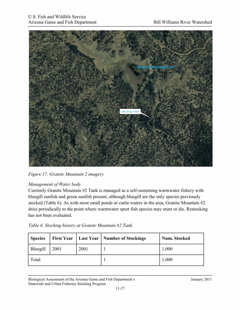
Granite Mountain #2 Tank Site Description Granite Mountain #2 is a 3.7 acre earthen livestock water tank located on State Trust Land about 5 miles east of Bagdad Arizona at 3,800 feet elevation. Water in the tank is maintained by precipitation. The tank is located on Little Ship Wash which is an ephemeral tributary to the Santa Maria River (Figure 16 and Figure 17). Granite Mountain #2 is also referred to as Brushy Basin Tank.

U.S. Fish and Wildlife Service Arizona Game and Fish Department Bill Williams River Watershed
Biological Assessment of the Arizona Game and Fish Department’s January 2011 Statewide and Urban Fisheries Stocking Program
11-26
Figure 16. Granite Mountain 2 along Little Shipp Wash
U.S. Fish and Wildlife Service Arizona Game and Fish Department Bill Williams River Watershed
Biological Assessment of the Arizona Game and Fish Department’s January 2011 Statewide and Urban Fisheries Stocking Program
11-27
Figure 17. Granite Mountain 2 imagery
Management of Water body Currently Granite Mountain #2 Tank is managed as a self-sustaining warmwater fishery with bluegill sunfish and green sunfish present, although bluegill are the only species previously stocked (Table 6). As with most small ponds or cattle waters in the area, Granite Mountain #2 dries periodically to the point where warmwater sport fish species may stunt or die. Restocking has not been evaluated.
Table 6. Stocking history at Granite Mountain #2 Tank.
Species First Year Last Year Number of Stockings Num. Stocked
Bluegill 2001 2001 1 1,000
Total 1 1,000

U.S. Fish and Wildlife Service Arizona Game and Fish Department Bill Williams River Watershed
Biological Assessment of the Arizona Game and Fish Department’s January 2011 Statewide and Urban Fisheries Stocking Program
11-28
Future management objectives would center on providing stock sizes of redear and bluegill sunfish for anglers to enjoy. Periodic stocking to maintain sizes usable to anglers may be necessary due to drying and/or catastrophic wildfire. Periodic sampling using hoop-nets or gillnets would be used to monitor populations.
Proposed action The Department proposes to stock bluegill sunfish and redear sunfish for the period covered by this consultation.
Redear sunfish would be established; numbers and sizes of fish stocked for this purpose will be determined according to stocking guidelines identified in the sport fish stocking protocol. Bluegill sunfish (fry/fingerling, sub-catchables, catchables), redear sunfish (fry/fingerling, sub-catchables, catchables), may be stocked as needed at any time during the year to augment the fishery or to recover the fishery following catastrophic events. Numbers of fish stocked for this purpose would be determined according to stocking guidelines identified in the sport fish stocking protocol.
Water Distribution / Connectivity Granite Mountain #2 is 9.7 miles upstream of the confluence of Little Shipp Wash and the Santa Maria River. Little Shipp Wash is ephemeral from the tank downhill for 6.8 miles to Iron Spring Wash. Thereafter, drainage flows another 3.7 miles where it joins the Santa Maria River approximately 3/10ths mile down from Quail Spring Wash. The Santa Maria River is ephemeral for approximately 4-7 more miles before it enters a perennial segment which is dominated by very shallow, sandy runs. Granite Mountain #2 has not been known to spill and the probability of spill is extremely low because of the limited watershed contribution and the relative large capacity of the tank. No spill has been documented.
Fish Movement Little Shipp Wash is a high gradient, bedrock dominated stream that does not provide adequate aquatic habitats for fishes to persist. Spilling, if it occurred, would be most likely to occur during spring runoff events and and flash floods that create increased sediment loads, high turbidity, rapid currents, altered habitat conditions, increased stress levels of organisms in transport, altered fish behavior and mortality, all of which limit the ability of survival during transport. No barrier to downstream movement of fishes is known from Little Shipp Wash. There is very limited upstream movement due to bed rock features and gradient. There is no possibility for upstream movement as it backs to Granite Mountain.
Community Description

U.S. Fish and Wildlife Service Arizona Game and Fish Department Bill Williams River Watershed
Biological Assessment of the Arizona Game and Fish Department’s January 2011 Statewide and Urban Fisheries Stocking Program
11-29
The fishery at Granite Mountain #2 has not been sampled since 1995. Surveys prior to this year found bluegill, hybrid sunfish, green sunfish and black crappie although origins are not known.
Limited surveys have been conducted in the Santa Maria River due to its ephemeral nature and access challenges on privately held lands. Surveys that have been conducted on the Santa Maria and large tributaries are discussed in the Complex discussion.
Table 7. Surveys at Granite Mountain Tank #2 by year, method, species, number caught, and lengths (in mm):
Year Survey method Species encountered Number Length/Range (mm) 1986 Angling Bluegill 5 133-171 1988 Gill net Hybrid sunfish 44 100-181 1991 Hoop net Green sunfish 171 126-262 1995 Hoop net Hybrid sunfish 472 120-186 Black crappie 1 217
Consultation Species or Critical Habitat No aquatic species of concern are within the vicinity of the stocking site. Roundtail chub are discussed in the complex analysis as they may maintain populations in tributaries to the Santa Maria River.
SANTA MARIA COMPLEX ANALYSIS Four small ponds or cattle waters are proposed to be maintained as sport fishing opportunities within the Santa Maria Complex. These waters, although small, offer significant recreational opportunity to rural western Yavapai County. All the waters would be maintained as self-sustaining warm water fisheries supplemented by stocking on an as-needed basis. Occasional sampling by hoop net or gill net would dictate this need. Largemouth bass, bluegill, and redear sunfish would be the three non-native fish species utilized. Stockings would typically be in summer months although spring or fall stockings may be warranted depending on species availability from suppliers. Surveys would be performed in Loco Creek, Sycamore Creek and the Santa Maria River every other year over 6 years for a total of 3 sampling events in each stream system. If largemouth bass, bluegill or redear sunfish are discovered in these streams, stockings would be halted and consultation re-initiated.
Water Connectivity / Distribution Bass Tank and Blue Tank receive water from snowmelt and precipitation events. There are no USGS stream gauges on Loco Creek. The probability of a spill is low from Bass Tank and Blue Tank because of the limited watershed contribution and the relative large capacity of the tanks. No spill has been documented at Bass Tank; however, water has been seen below the tank,

U.S. Fish and Wildlife Service Arizona Game and Fish Department Bill Williams River Watershed
Biological Assessment of the Arizona Game and Fish Department’s January 2011 Statewide and Urban Fisheries Stocking Program
11-30
making a spill of Bass Tank a possibility. Bass Tank sits high in the Loco Creek drainage which extends about 6.5 miles through ephemeral reaches of Loco Creek and then about 5miles of intermittent reach to get to Sycamore Creek.
Loco Creek is intermittent and courses another approximately5 miles to its mouth with Sycamore Creek. Loco Creek is bedrock dominated with natural barriers existing in several areas. Upstream movement of fish is very limited in this stream but there are no barriers to downstream movement. Large waterfalls are not known from Loco Creek but extensive areas of sharp elevation change in narrow, slot canyons do exist. Sycamore Creek from its confluence with Loco Creek drains another 6.5 miles to the confluence with Kirkland Creek and has intermittent flow and a few small perennial pools along its course. From this point it becomes the Santa Maria River. The Santa Maria River is intermittent dominated by large stretches of dry streambed with some limited perennial pool habitat persisting through the driest periods.
Water exiting Granite Mountain #1 may travel 6.4 miles down Iron Spring Wash, an ephemeral tributary to Little Shipp Wash. Granite Mountain #2 is located in Little Ship Wash which is a high gradient, bedrock dominated stream that does not provide adequate aquatic habitats for fishes to persist. No barrier to downstream movement of fishes is known from Little Ship Wash. There is very limited upstream movement due to bed rock features and gradient. There is no possibility for upstream movement as both tanks essentially abut Granite Mountain.
This Complex Analysis includes the point from the junction of the Santa Maria River at the confluence of Little Shipp Wash to Alamo Lake. The Santa Maria River is intermittent dominated by large stretches of dry streambed with some limited perennial pool habitat persisting through the driest periods. There is a perennial segment of the Santa Maria approximately 16 miles upriver from the mouth of Alamo Lake, near where the river crosses under State highway 93, which is dominated by very shallow, sandy runs. However, flooding events are comparatively infrequent in the watershed above the proposed stocking sites, and habitat is largely unsuitable to support the proposed species within the ephemeral drainages including Loco Creek and Sycamore Creek. Nonetheless, isolated and disjunct pools and/or other small perennial segments of water may contain sufficient habitat so that fish could persist.
Fish Movement Loco Creek is a high gradient, bedrock dominated stream that does not provide adequate aquatic habitats for most fishes to persist. Fish movement through Loco Creek would be during periodic spring runoff events and involve extensive sediment loads and require extreme physical demands. Upstream movement by fish is very limited in this stream and consists of 4 miles of mostly rugged and unsuitable habitat from Blue Tank up to Bass Tank. Large waterfalls are not known from Loco Creek but extensive areas of sharp elevation change in narrow, slot canyons

U.S. Fish and Wildlife Service Arizona Game and Fish Department Bill Williams River Watershed
Biological Assessment of the Arizona Game and Fish Department’s January 2011 Statewide and Urban Fisheries Stocking Program
11-31
do exist. Probability of spill is low from Bass and Blue Tank because of the limited watershed contribution and the capacity of the tanks.
Spilling from the Granite Mountain sites in Little Shipp Wash would be most likely to occur during spring runoff events and involve extensive sediment loads and physical demands by fish. No barrier to downstream movement of fishes is known from Little Ship Wash. There is very limited upstream movement due to bed rock features and gradient. There is no possibility for upstream movement from the tanks as both essentially abut Granite Mountain.
Stream discharge in this complex typically follows a bimodal hydrological cycle with winter and summer precipitation causing flash flooding and hydrologic connectivity in the system punctuated by low or no flows in spring and fall when the system becomes intermittent, interrupted perennial or completely dry (Kepner 1980). Flash flooding is generally short in duration but capable of transporting vast quantities of inorganic material and organic debris that affect drainage channels (Kepner 1980). The Santa Maria River, although in the Bill Williams Drainage as is Burro Creek, often has differing periods between high water events. About one event of 10,000 cubic feet per second (cfs) or more has been recorded every 10 years since 1967. The Yavapai County Flood Control District confirmed that the Santa Maria does not see significant flooding events but every 10 years (Mark Massis pers. com). In more recent years, the frequency of high water events has declined. Until January 2010, there had not been a high water event exceeding 10,000 cfs since 1993.
Community Description Historically, tributaries as well as mainstem portions of the Santa Maria River maintained viable native fish populations (Kepner 1980; Fresques et al. 1997; Morgan et al. 1997). These populations consisted mainly of roundtail chub (called “bonytail” by the local ranchers), desert sucker, Sonora sucker, longfin dace and speckled dace. However, since the about 1995, these populations have been in decline. More recent spot check type surveys in 2003, 2007 and 2009 have not found roundtail chub in Sycamore Creek or the mainstem Santa Maria River (Cummins 2009 (2), Table 8 and Table 9). Green sunfish and desert sucker have been found in locally high numbers in persistent pools in Sycamore Creek and the Santa Maria River mainstem (Cummins 2009 (2) and Table 8 and Table 9). Loco Creek was sampled in 2009 (Figure 19). No fish were collected during this electrofishing survey. Fish stocking into the tanks by the Department did not start until the 1990’s for the waters proposed for stocking. Most had existing populations of bullhead catfish, largemouth bass, black crappie and bluegill and/or green sunfish stocked by ranchers working the area.
The only listed fish species occurrence upstream of Alamo Lake within the watershed it the Gila topminnow, located at Yerba Mansa Spring (Weedman and Young 1997). This topminnow population is located in a pond formed by an impounded spring and is outside of the Santa Maria

U.S. Fish and Wildlife Service Arizona Game and Fish Department Bill Williams River Watershed
Biological Assessment of the Arizona Game and Fish Department’s January 2011 Statewide and Urban Fisheries Stocking Program
11-32
River channel. Two other small sites in the Santa Maria drainage were stocked with topminnow but failed to persist (Peoples Canyon and Tres Alamos).
No designated critical habitat for listed fish occur upstream of Alamo Lake. However, a 12-month finding on a petition to list a distinct population segment (DPS) of roundtail chub in the lower Colorado River basin as threatened or endangered under ESA and to designate critical habitat was delivered by the US FWS on June 30, 2009. After review of available scientific and commercial information, the US FWS found that the petitioned listing action is warranted, but precluded by higher priority actions. Roundtail chub has consequently been added to the list of candidate species and impacts to the species are assessed in this consultation process.

U.S. Fish and Wildlife Service Arizona Game and Fish Department Bill Williams River Watershed
Biological Assessment of the Arizona Game and Fish Department’s January 2011 Statewide and Urban Fisheries Stocking Program
11-33
Figure 18. Sampling sites on Sycamore Creek May 6-8, 2009. Mouth of Loco Creek is in upper right hand portion of map.
Table 8. Sample results from backpack electrofishing, Sycamore Creek May 6, 2009.
Effort in minutes = 16.2. Site is “pool 1” in Figure 18.
Species Number Size Range (millimeters) Green sunfish 34 80-174 Yellow bullhead 4 92-187

U.S. Fish and Wildlife Service Arizona Game and Fish Department Bill Williams River Watershed
Biological Assessment of the Arizona Game and Fish Department’s January 2011 Statewide and Urban Fisheries Stocking Program
11-34
Table 9. Sample results from gillnetting, Sycamore Creek May 6, 2009.
Effort in hours = 3 hours. Site is “Net 1” in Figure 18.
Species Number Size Range (millimeters) Sonora sucker 37 147-300 Green sunfish 23 100-180
Figure 19. Sample site on Loco Creek where no fish were collected in May 7, 2009.
Consultation Species or Critical Habitat Impacts to roundtail chub are discussed below because populations may exist in the Santa Maria River and several of its tributaries (Kirkland Creek and Sycamore Creek) downstream of the

U.S. Fish and Wildlife Service Arizona Game and Fish Department Bill Williams River Watershed
Biological Assessment of the Arizona Game and Fish Department’s January 2011 Statewide and Urban Fisheries Stocking Program
11-35
tanks proposed for stocking (HDMS Data: Santa Maria River 1979, 1998 and 1999; Sycamore Creek 1991 and 1999; Kirkland Creek 1980 and 1999).
Potential impacts from the proposed action to candidate and listed species are described below. Please refer to Chapter 4 for a detailed description of the nature of the impacts (which may include predation, competition for space and food, and hybridization etc.).Subsequent responses (resulting from the frequency, magnitude and duration of the impacts) between proposed stocked and candidate and listed species, and any site or complex factors that provide context for determining the meaningfulness of the impacts, are discussed below. Impacts from the proposed action resulting from angler related recreation and/or potential introduction of disease, pathogen or invasive species are evaluated at a broad scale for the entire action area and are described in Chapter 4. If potential impacts specific to a stocking site or complex have been identified they are discussed below.
The populations of Gila topminnow and desert pupfish downstream in Peoples Canyon were considered extirpated in 1989 (Weedman and Young 1997) and are not further discussed. Designated critical habitat for the Southwestern willow flycatcher exists within the Big Sandy River, far downstream from all stocking sites. This species is therefore, not considered further due to the distance from the proposed sites and lack of habitat suitability near the stock tanks. Roundtail chub are analyzed and discussed below.
The presence of Alamo Dam and the existing warm water fishery within Alamo Lake (which maintains a self-sustaining community of non-native fish without supplemental stockings) serves to drastically minimize the potential for impacts of proposed stocking activities from designated critical habitat and the presence of the endangered razorback sucker and bonytail chub in Lake Havasu. Alamo Lake is managed primarily for flood control. As such, it is managed at approximately16% capacity or lower, with a capacity (depending on pool volume at the time) of over 800,000 acre feet.
Roundtail Chub Roundtail chub is currently the only fish species of concern in this system. Roundtail chub tend to do well in desert stream systems in which they evolved, provided periodic flooding occurs to ensure habitat for their young (Rinne 1996). Since 1967, the Santa Maria River does not appear to flood often enough to sustain roundtail chub, although roundtail chub may maintain populations in tributaries to the Santa Maria River such as Kirkland Creek or Sycamore Creek. The last survey which detected roundtail chub in the Santa Maria below Little Shipp Wash was in 1999 (HDMS Data). Surveys conducted as described above in the community descriptions did not document chub occurrence.

U.S. Fish and Wildlife Service Arizona Game and Fish Department Bill Williams River Watershed
Biological Assessment of the Arizona Game and Fish Department’s January 2011 Statewide and Urban Fisheries Stocking Program
11-36
Roundtail chub are thought to live up to 10 years but more commonly die off after 7-8 years (Brouder et al. 2000). In general, if low flow conditions persist over 6-7 years consecutively, observations suggest roundtail chub populations decline (A. Clark pers. comm.). The gauge data (Table 10) show generally low flows and that peak flow conditions in this complex during run off did not exceeded 10,000 cfs between 1993 and 2008, however, in January 2010; a high water event exceeded 10,000 cfs. It is unknown whether reproduction of roundtail chub occurred in response to this flow event
Conservation actions are being planned in the Santa Maria River drainage to benefit roundtail chub under the recent 6 species Conservation Agreement (AGFD 2006). Conservation actions would include stocking of roundtail chub in some stock tanks in the area to both increase chub populations as well as continue to provide unique sport fishing opportunities. However, due to land development, access, and lack of water, the opportunities for roundtail chub population enhancement is limited in the Santa Maria River Basin.
Native species, especially roundtail chub, desert sucker and Sonora sucker are very dependent on high flow events for recruitment. When these high flow events occur, the native species may successfully recruit, despite the presence of non-native fish species. W. L. Minckley substantiates this when he states “Gila r. robusta is one native fish that appears capable of maintaining its populations fairly well despite the numbers of introduced fishes that now infest the waters of Arizona” (Minckley 1973). Regardless, nonnative species that compete with or prey on roundtail chub still remain a serious and persistent threat to the continued existence of roundtail chub (USFWS 2009c).
Potential Impacts The species proposed for stocking into the Santa Maria River basins do not appear to be limiting factors for native fish populations within this watershed for reasons discussed below.
Few surveys from the Santa Maria have been conducted in recent years. Spot check surveys in 2003, 2007 and 2009 yielded very little to no water in areas sampled. None of the species proposed for stocking were found in any historic surveys (all data considered; see methods for data sources), with the exception of one largemouth bass collected from the Kirkland Junction confluence in 1999 and two bluegill in the Santa Maria River. All but one of the species (redear sunfish) have been present in both drainages (Little Ship Wash and Loco Creek) in stocking tanks since at least 1988, when the first records of species occurrence in area tanks were collected. Based on data collected from these drainages over 30 years, only one occurrence of largemouth bass and 2 occurrences of bluegill in the Santa Maria River have been recorded, all in 1999 (Kansas State Aq. GAP database). All data points available in this dataset (174 point/species combinations spanning 1947-2003) for the Santa Maria watershed were depicted in Figure 3. The largemouth bass and one of the bluegill collections were at or near a private ranch

U.S. Fish and Wildlife Service Arizona Game and Fish Department Bill Williams River Watershed
Biological Assessment of the Arizona Game and Fish Department’s January 2011 Statewide and Urban Fisheries Stocking Program
11-37
with a pond on the premises, believed to be stocked with these species. It is unknown if largemouth bass are still present in this pond. The other bluegill collection, about 7 miles downstream from the previously described location is suspect because the available 1999 Scientific Collecting Permit Report doesn’t agree with the SonFishes/Kansas GAP databases. Bluegill have not been collected elsewhere in the Santa Maria River, and there are no collections of redear sunfish.
A larger data set depicting the relationship between flow events and roundtail chub recruitment is available for the Verde River system. Data collected in the headwaters reaches of the Verde River by the Region III Fisheries Program between 2000 and 2005 using canoe electrofishing recorded reduced young age classes of chub in surveys in 2000 through 2004; during this time there were also no high flow events (see Verde River section). The sampling used methodology and techniques were designed to collect all fish species and age classes. Adult chub numbers also began to drop in this timeframe.
At the same time that adult numbers of chub were dropping in the Verde River, the recorded flows in the Santa Maria (Table 10) were consistently lower than in past years and large peak flows were not as common or as strong as in years prior to 1994 (Table 10). Assuming roundtail chub recruited in 1995, that cohort would have likely died of old age between 2002 and 2004, which coincides with the electrofishing data collected in the Verde River. If an assumption made that the relationship between flow events and chub populations in the Verde River holds true for chub population responses to flow events in the Santa Maria River, a decline in roundtail chub is possibly due to the low flows over the past years, which would have prevented successful reproduction in the Santa Maria watershed. Decline in fishes is likely due primarily to the low or no flows. Stocked fish species have not been found other than in the two occurrences listed above.
Largemouth bass characteristically become most abundant in lentic waters, i.e. lakes, ponds, reservoirs, and in slow–moving, downstream portions of larger streams (Minckley 1973). Habitat suitability indices for bluegill sunfish and largemouth bass developed by the U. S. Fish and Wildlife Service, Biological Services Program in the early 80’s show these two species prefer slow to slack water habitats that have woody cover and warm water conditions (Stuber et al. 1982a; Stuber et al. 1982b). These species typically do not maintain viable populations in systems, like the Santa Maria, with frequent flash type flooding and wide extremes in seasonal temperatures.
Table 10. Peak stream flow from USGS 09424900 Santa Maria River near Bagdad, AZ.
Water Year Date Stream-flow (cfs) 1967 Dec. 07, 1966 13,500

U.S. Fish and Wildlife Service Arizona Game and Fish Department Bill Williams River Watershed
Biological Assessment of the Arizona Game and Fish Department’s January 2011 Statewide and Urban Fisheries Stocking Program
11-38
1968 Jan. 28, 1968 6,500 1969 Jan. 26, 1969 7,200 1970 Mar. 03, 1970 1,420 1971 Aug. 25, 1971 2,940 1972 Aug. 13, 1972 1,350 1973 Oct. 19, 1972 11,000 1974 Aug. 05, 1974 6002 1975 Jul. 29, 1975 1,890 1976 Feb. 09, 1976 11,800 1977 Sep. 11, 1977 1,500 1978 Mar. 01, 1978 24,600 1979 Dec. 18, 1978 17,200 1980 Jan. 30, 1980 19,800 1981 Mar. 06, 1981 191 1982 Feb. 11, 1982 6,750 1983 Sep. 24, 1983 15,200 1984 Aug. 17, 1984 5,450 1985 Feb. 10, 1985 10,400 1989 Feb. 06, 1989 394 1990 Oct. 04, 1989 6,650 1991 Mar. 01, 1991 18,900 1992 Aug. 23, 1992 9,310 1993 Feb. 09, 1993 15,700 1994 Sep. 03, 1994 2,170 1995 Feb. 14, 1995 8,790 1997 Sep. 26, 1997 4,200 1998 Feb. 15, 1998 2,350 1999 Sep. 24, 1999 1,130 2000 Aug. 29, 2000 312 2001 Mar. 07, 2001 2,090 2003 Mar. 17, 2003 2,280 2004 Sep. 19, 2004 1,150 2005 Dec. 29, 2004 8,900 2006 Aug. 25, 2006 739 2007 Sep. 22, 2007 533 2008 Jan. 27, 2008 7,230
U.S. Fish and Wildlife Service Arizona Game and Fish Department Bill Williams River Watershed
Biological Assessment of the Arizona Game and Fish Department’s January 2011 Statewide and Urban Fisheries Stocking Program
11-39
It is unlikely that Bass or Blue Tanks spill often because of the limited watershed contribution and the relatively large capacity of the tanks. However, water has been seen below Bass Tank and a spill was observed from Blue Tank in 2007. When these two tanks spill the water would run into Loco Creek. Loco Creek is a high gradient, bedrock dominated stream that does not provide adequate aquatic habitats for most fishes to persist because it dries up between the tanks and Sycamore Creek. Fish movement through Loco Creek would be during periodic spring runoff events and flash floods that create increased sediment loads, high turbidity, rapid currents, altered habitat conditions, increased stress levels of organisms in transport, altered fish behavior and cause mortality limiting the ability to survive during transport.
Granite Mountain #1 and #2 have not been known to spill, although water was found below Granite Mountain #2 in 2007. The probability that either will spill in the next 10 years at flows with the capacity to carry fish is low because the watershed contribution of these tanks is limited. Also, the relatively large capacity of the tank would minimize potential for spill.
If stocked fish were to interact with roundtail chub in this system, the effects would be some unknown level of competition and possibly predation. If roundtail chub spawned in 2010, when the system reached over 15,000 cfs in January, there is also the potential for predation on eggs, larvae and young roundtail chub.

U.S. Fish and Wildlife Service Arizona Game and Fish Department Bill Williams River Watershed
Biological Assessment of the Arizona Game and Fish Department’s January 2011 Statewide and Urban Fisheries Stocking Program
11-40
BIG SANDY RIVER SUB-WATERSHED
BURRO CREEK COMPLEX Physical geographic description
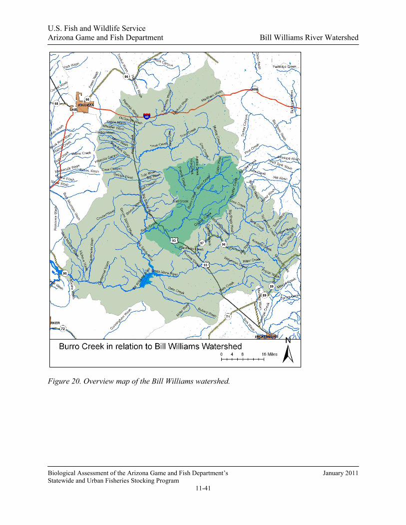
Burro creek begins at the confluence of Cabin Wash and Pine Creek in the Santa Maria Mountains of North West Yavapai County. It flows from an elevation of over 6,000 feet in the tributaries (4,400 feet at the confluence of Pine Creek and Cabin Wash) to 1,500 feet at the confluence with the Big Sandy River and covers over 50 miles from top to bottom (Figure 20).
U.S. Fish and Wildlife Service Arizona Game and Fish Department Bill Williams River Watershed
Biological Assessment of the Arizona Game and Fish Department’s January 2011 Statewide and Urban Fisheries Stocking Program
11-41
Figure 20. Overview map of the Bill Williams watershed.

U.S. Fish and Wildlife Service Arizona Game and Fish Department Bill Williams River Watershed
Biological Assessment of the Arizona Game and Fish Department’s January 2011 Statewide and Urban Fisheries Stocking Program
11-42
Drainage area Burro Creek sub-watershed covers approximately 712 square miles and drains southwest into the Big Sandy River (Figure 20). It is predominantly characterized by riffles, runs and pool habitats but during dry months is reduced to intermittent pools (Kepner 1979). Burro Creek is interrupted perennial in the upper most reaches near the confluence of Conger Creek, perennial near the confluence of Francis Creek, intermittent/ephemeral in the upper/middle reaches, near the confluence of Boulder Creek above and below until it reaches a perennial segment for 7 miles, interrupted by a small intermittent/ephemeral stretch before reaching the confluence with the Big Sandy River (AGFD 1993 and 1997) (Figure 2). No perennial flows feed into the Bill Williams River (BWRCSC 2010).
Tributaries Several intermittent and perennial tributaries drain into Burro Creek including Pine, Conger, Francis, Salt, and Boulder Creeks. Francis Creek receives discharge from wells from confluence with Burro Creek with Francis Creek supplying public water for Bagdad and a large mining operation (ADWR no date) .

U.S. Fish and Wildlife Service Arizona Game and Fish Department Bill Williams River Watershed
Biological Assessment of the Arizona Game and Fish Department’s January 2011 Statewide and Urban Fisheries Stocking Program
11-43
Figure 21. Overview map of the Burro Creek watershed.
Vegetation
The biotic communities within Burro Creek consist of Great Basin conifer woodland, and interior chaparral in upper elevations and Sonoran desert scrub in the lower reaches. There are vast stretches of thick cottonwood/willow stands, especially above the Francis Creek confluence. The US 93 campground (BLM) area contains a decent canopy cover approximately 1-mile long. Riparian vegetation remains sparse from there until closer proximity to the Big Sandy.
Stocking Site Descriptions Ten stocking sites in the Burro Creek Complex are proposed: Carter Tank, Coors Lake, Antelope Tank, Bar 37 Tank, Harman Tank, Harmon Tank 2, Little Antelope Tank, McElhaney Tank, Stubb’s Tank and Swale.
Carter Tank is located at approximately 6,200 feet elevation near the very top of Pine Creek about 14 miles upstream from the confluence with Burro Creek (Figure 22). Antelope Tank is

U.S. Fish and Wildlife Service Arizona Game and Fish Department Bill Williams River Watershed
Biological Assessment of the Arizona Game and Fish Department’s January 2011 Statewide and Urban Fisheries Stocking Program
11-44
located in a small tributary drainage to Pine Creek about 8.5 miles upstream from the same confluence. Harmon Tank #2 is located in an ephemeral tributary about 0.75 miles up from Pine Creek and about 6 miles up from the Pine Creek confluence with Burro Creek. Bar 37 Tank is located about 1.5 miles upstream from Pine Creek in a tributary, and about 5.8 miles above the Pine Creek confluence with Burro Creek. Pine Creek and all its tributaries appear to be ephemeral channels except for the last mile above Burro Creek. Burro Creek is perennial.
Carter Tank Site Description Carter Tank is a 0.5 acre earthen livestock tank located on the Prescott National Forest approximately 40 miles north and west of Prescott at approximately 6,200 feet elevation (Figure 23). It is maintained by precipitation and is located on a small ephemeral tributary located at the beginning of Pine Creek, a tributary to Burro Creek. The date this tank was created is unknown but from stocking records it is a minimum of 35 years old. The probability of a spill is low and the downstream channels are ephemeral. There is no defined wash or spillway evident from aerial photos.
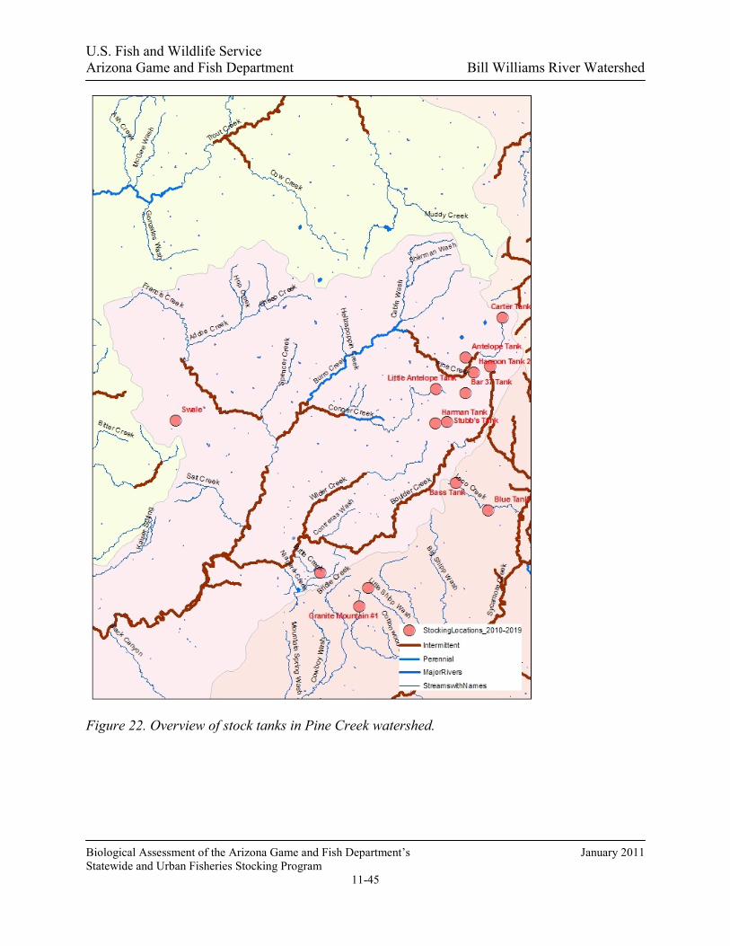
U.S. Fish and Wildlife Service Arizona Game and Fish Department Bill Williams River Watershed
Biological Assessment of the Arizona Game and Fish Department’s January 2011 Statewide and Urban Fisheries Stocking Program
11-45
Figure 22. Overview of stock tanks in Pine Creek watershed.
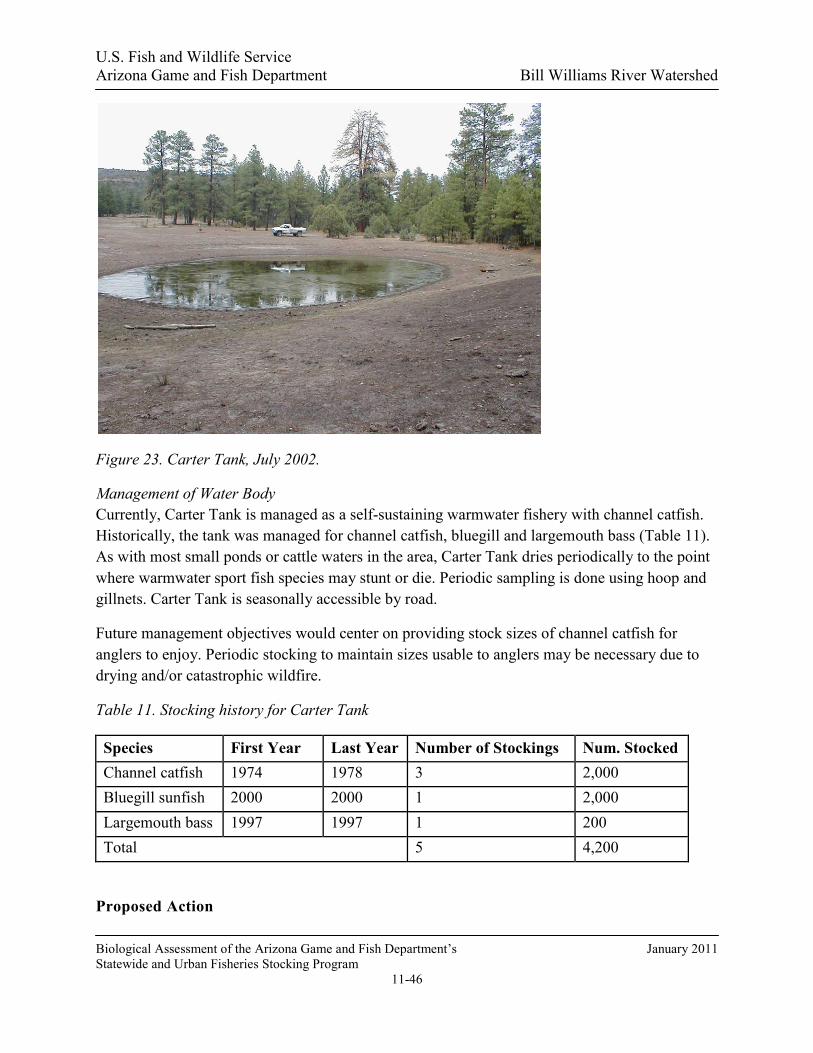
U.S. Fish and Wildlife Service Arizona Game and Fish Department Bill Williams River Watershed
Biological Assessment of the Arizona Game and Fish Department’s January 2011 Statewide and Urban Fisheries Stocking Program
11-46
Figure 23. Carter Tank, July 2002.
Management of Water Body Currently, Carter Tank is managed as a self-sustaining warmwater fishery with channel catfish. Historically, the tank was managed for channel catfish, bluegill and largemouth bass (Table 11). As with most small ponds or cattle waters in the area, Carter Tank dries periodically to the point where warmwater sport fish species may stunt or die. Periodic sampling is done using hoop and gillnets. Carter Tank is seasonally accessible by road.
Future management objectives would center on providing stock sizes of channel catfish for anglers to enjoy. Periodic stocking to maintain sizes usable to anglers may be necessary due to drying and/or catastrophic wildfire.
Table 11. Stocking history for Carter Tank
Species First Year Last Year Number of Stockings Num. Stocked Channel catfish 1974 1978 3 2,000 Bluegill sunfish 2000 2000 1 2,000 Largemouth bass 1997 1997 1 200 Total 5 4,200
Proposed Action

U.S. Fish and Wildlife Service Arizona Game and Fish Department Bill Williams River Watershed
Biological Assessment of the Arizona Game and Fish Department’s January 2011 Statewide and Urban Fisheries Stocking Program
11-47
The Department proposes to stock channel catfish for the period covered by this consultation.
Channel catfish (sub-catchables, catchables), may be stocked as needed at any time during the year to augment existing populations or recover the fishery following catastrophic events. Numbers of fish stocked for this purpose would be determined according to stocking guidelines identified in the sport fish stocking protocol.
Water Distribution / Connectivity Carter tank sits in the headwater area of Pine Creek and as such has a small watershed that contributes water via snow runoff. No defined spillway exists at Carter Tank. The frequency of water spilling over Carter Tank is unknown, but believed to be infrequent as probability of a spill is low and the downstream channels are ephemeral. In addition, there is no evidence of a defined wash or spillway from the tank.
Pine Creek below Carter tank flows approximately seven miles through low gradient ponderosa pine lined wash before hitting a bedrock created dam at Pine Creek Dam. From this point, it flows an additional three miles before gradient increases and Pine Creek starts into a deeply incised canyon-bound channel. The remaining five miles can be characterized as very steep, very narrow stream bed that is very susceptible to flash flooding. This stretch has natural barriers to upstream movement of fishes. Pine Creek is ephemeral for the last one mile before its confluence with Burro Creek, which becomes perennial for approximately 10 miles before becoming intermittent near the confluence with Conger Creek. Pine Creek Dam typically retains water due to canopy shading and a bedrock substrate. No aquatic vegetation or animal life is known to be in the localized aquatic area.
Fish Movement Fish movement out of Carter tank is not known nor documented to occur. Carter Tank has been known to go dry periodically and has been infrequently stocked. It is currently assumed fishless as it was known to have dried completely in 2003 and has not been restocked. No barriers to fish movement are known below Carter tank in Pine Creek. There is no opportunity for fishes to move upstream out of Carter Tank as no riparian or aquatic habitat exists upstream. If fishes were to move downstream out of Carter Tank, habitat conditions due to the ephemeral nature of Pine Creek in the stretch below the tank making it unlikely for survival during the warmer months as the creek dries. If the tank spilled during winter run-off or due to sporadic monsoonal events, flash flooding conditions would limit the survivability of fish moving downstream. These conditions create increased sediment loads, high turbidity, rapid currents, alteration of habitat conditions, increased stress levels of organisms in transport, altering of fish behavior and mortality. In addition, the steep rocky canyon bound channel of the creek would make it further unlikely fish would survive. Extreme seasonal high water events do occur in this drainage as is
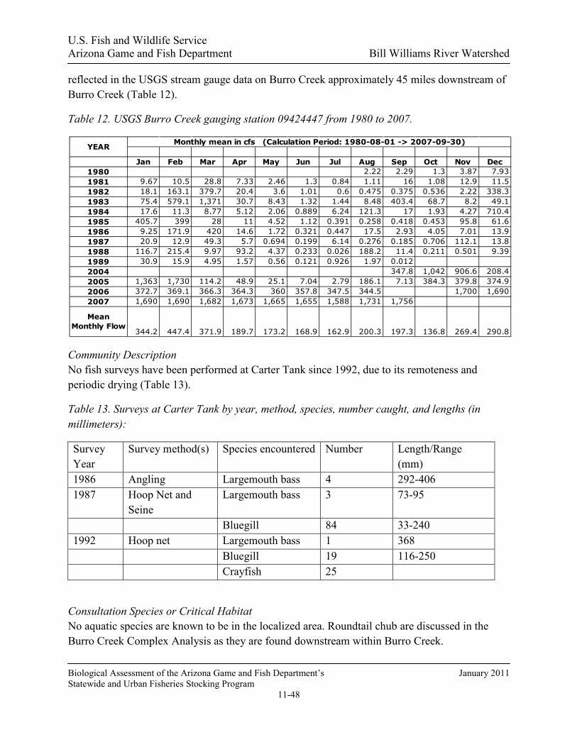
U.S. Fish and Wildlife Service Arizona Game and Fish Department Bill Williams River Watershed
Biological Assessment of the Arizona Game and Fish Department’s January 2011 Statewide and Urban Fisheries Stocking Program
11-48
reflected in the USGS stream gauge data on Burro Creek approximately 45 miles downstream of Burro Creek (Table 12).
Table 12. USGS Burro Creek gauging station 09424447 from 1980 to 2007.
Community Description No fish surveys have been performed at Carter Tank since 1992, due to its remoteness and periodic drying (Table 13).
Table 13. Surveys at Carter Tank by year, method, species, number caught, and lengths (in millimeters):
Survey Year
Survey method(s) Species encountered Number Length/Range (mm)
1986 Angling Largemouth bass 4 292-406 1987 Hoop Net and
Seine Largemouth bass 3 73-95
Bluegill 84 33-240 1992 Hoop net Largemouth bass 1 368 Bluegill 19 116-250 Crayfish 25
Consultation Species or Critical Habitat No aquatic species are known to be in the localized area. Roundtail chub are discussed in the Burro Creek Complex Analysis as they are found downstream within Burro Creek.
Jan Feb Mar Apr May Jun Jul Aug Sep Oct Nov Dec1980 2.22 2.29 1.3 3.87 7.931981 9.67 10.5 28.8 7.33 2.46 1.3 0.84 1.11 16 1.08 12.9 11.51982 18.1 163.1 379.7 20.4 3.6 1.01 0.6 0.475 0.375 0.536 2.22 338.31983 75.4 579.1 1,371 30.7 8.43 1.32 1.44 8.48 403.4 68.7 8.2 49.11984 17.6 11.3 8.77 5.12 2.06 0.889 6.24 121.3 17 1.93 4.27 710.41985 405.7 399 28 11 4.52 1.12 0.391 0.258 0.418 0.453 95.8 61.61986 9.25 171.9 420 14.6 1.72 0.321 0.447 17.5 2.93 4.05 7.01 13.91987 20.9 12.9 49.3 5.7 0.694 0.199 6.14 0.276 0.185 0.706 112.1 13.81988 116.7 215.4 9.97 93.2 4.37 0.233 0.026 188.2 11.4 0.211 0.501 9.391989 30.9 15.9 4.95 1.57 0.56 0.121 0.926 1.97 0.0122004 347.8 1,042 906.6 208.42005 1,363 1,730 114.2 48.9 25.1 7.04 2.79 186.1 7.13 384.3 379.8 374.92006 372.7 369.1 366.3 364.3 360 357.8 347.5 344.5 1,700 1,6902007 1,690 1,690 1,682 1,673 1,665 1,655 1,588 1,731 1,756
197.3 136.8 269.4 290.8
Mean Monthly Flow
YEARMonthly mean in cfs (Calculation Period: 1980-08-01 -> 2007-09-30)
344.2 447.4 371.9 189.7 173.2 168.9 162.9 200.3
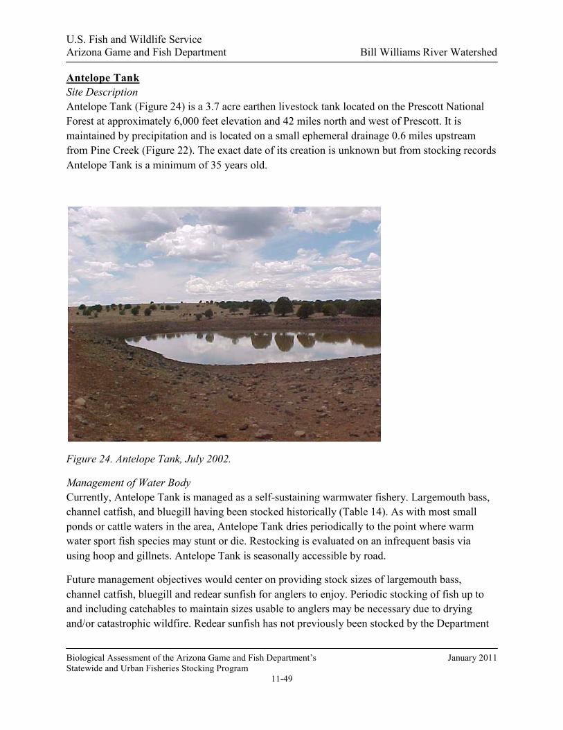
U.S. Fish and Wildlife Service Arizona Game and Fish Department Bill Williams River Watershed
Biological Assessment of the Arizona Game and Fish Department’s January 2011 Statewide and Urban Fisheries Stocking Program
11-49
Antelope Tank Site Description Antelope Tank (Figure 24) is a 3.7 acre earthen livestock tank located on the Prescott National Forest at approximately 6,000 feet elevation and 42 miles north and west of Prescott. It is maintained by precipitation and is located on a small ephemeral drainage 0.6 miles upstream from Pine Creek (Figure 22). The exact date of its creation is unknown but from stocking records Antelope Tank is a minimum of 35 years old.
Figure 24. Antelope Tank, July 2002.
Management of Water Body Currently, Antelope Tank is managed as a self-sustaining warmwater fishery. Largemouth bass, channel catfish, and bluegill having been stocked historically (Table 14). As with most small ponds or cattle waters in the area, Antelope Tank dries periodically to the point where warm water sport fish species may stunt or die. Restocking is evaluated on an infrequent basis via using hoop and gillnets. Antelope Tank is seasonally accessible by road.
Future management objectives would center on providing stock sizes of largemouth bass, channel catfish, bluegill and redear sunfish for anglers to enjoy. Periodic stocking of fish up to and including catchables to maintain sizes usable to anglers may be necessary due to drying and/or catastrophic wildfire. Redear sunfish has not previously been stocked by the Department

U.S. Fish and Wildlife Service Arizona Game and Fish Department Bill Williams River Watershed
Biological Assessment of the Arizona Game and Fish Department’s January 2011 Statewide and Urban Fisheries Stocking Program
11-50
and is not currently present in Antelope Tank or in the drainage, (except downstream at Alamo Lake).
Table 14. Stocking history for Antelope Tank.
Species First Year Last Year Number of Stockings Num. Stocked Channel catfish 1974 2003 4 3,500 Bluegill 2001 2003 1 2,000 Largemouth bass 1999 1999 1 100 Total 6 5,600
Proposed Action The Department proposes to stock bluegill sunfish, redear sunfish, channel catfish and largemouth bass for the period covered by this consultation
Largemouth bass (fry/fingerling, sub-catchables, catchables), channel catfish (sub-catchables, catchables), redear sunfish (sub-catchables, catchables), and bluegill sunfish (sub-catchables, catchables) may be stocked as needed at any time during the year to augment existing populations or recover the fishery following catastrophic events. Numbers of fish stocked for this purpose would be determined according to stocking guidelines identified in the sport fish stocking protocol.
Water Distribution / Connectivity Antelope Tank sits in a large open flat at the top of a small tributary of Pine Creek. It is a comparatively large stock tank with a decent storage capacity. Two small shallow drainages feed the tank from the north end. The frequency of water spilling from Antelope Tank is not known; however, given its capacity and position in the watershed, spills are believed to be infrequent. There is no defined spillway for Antelope Tank.
Water spilling from Antelope Tank would travel down an unnamed tributary 0.6 miles to Pine Creek and from this point water would flow 1.5 miles to Pine Creek Dam. Pine Creek Dam typically retains water due to canopy shading and a bedrock substrate. No aquatic vegetation or aquatic animal life is known from this natural feature.
From Pine Creek Dam, it flows an additional three miles before the gradient increases into a deeply incised canyon-bound channel. The remaining five miles can be characterized as a steep, narrow stream bed that is very susceptible to flash flooding. This stretch has natural barriers to upstream movement of fishes. No barrier to downstream movement of fishes is known from Pine Creek. Pine Creek is ephemeral for the last mile before its confluence with Burro Creek, which has perennial flow.
U.S. Fish and Wildlife Service Arizona Game and Fish Department Bill Williams River Watershed
Biological Assessment of the Arizona Game and Fish Department’s January 2011 Statewide and Urban Fisheries Stocking Program
11-51
Fish Movement Fish movement out of Antelope Tank is not known to occur. Antelope Tank has been known to go dry periodically and has been infrequently stocked. It is currently assumed fishless as it was known to have dried completely in 2003 and has not been restocked. No barriers to downstream fish movement are known below Antelope tank in Pine Creek. There is very little opportunity for fishes to move upstream out of Antelope Tank due to slope and lack of aquatic habitat. If fishes were to move downstream out of Antelope Tank, extreme conditions would make survival of stocked species unlikely due to the ephemeral nature of Pine Creek in the stretch below the tank making it unlikely for survival during the warmer months as the creek dries. If the tank spilled during winter run-off or due to sporadic monsoonal events, flash flooding conditions would limit the survivability of fish moving downstream. These conditions create increased sediment loads, high turbidity, rapid currents, alteration of habitat conditions, increased stress levels of organisms in transport, altering of fish behavior and mortality. In addition, the steep rocky canyon bound channel of the creek would make it further unlikely fish would survive. Extreme seasonal high water events do occur in this drainage as is reflected in the USGS stream gauge data on Burro Creek approximately 45 miles downstream of Burro Creek (Table 12).
Community Description No surveys have been done at Antelope Tank since 1998, due to its remoteness and frequency of drying (Table 15).
Department personnel, Andy Clark and Wildlife Manager Darren Tucker, visually inspected Antelope Tank in July 2002 and observed that the tank’s water level was very low and there was no aquatic life. The Department last stocked into Antelope Tank in April 2003. Local ranchers claimed the tank went dry in late summer of 2003 and it has not been restocked since.
Table 15. Surveys at Antelope Tank by year, method, species, number caught, and lengths (in mm).
Survey Year Survey method Species Number Length/Range (mm) 1977 Seine Waterdogs ? ? 1978 Gill net Waterdogs 10 1987 Gill net None 1998 Hoop Net Largemouth bass 4 173-282 Yellow bullhead 3 200-365 Bluegill 122 110-210
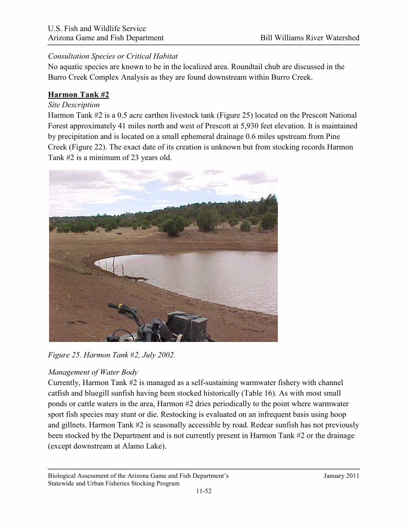
U.S. Fish and Wildlife Service Arizona Game and Fish Department Bill Williams River Watershed
Biological Assessment of the Arizona Game and Fish Department’s January 2011 Statewide and Urban Fisheries Stocking Program
11-52
Consultation Species or Critical Habitat No aquatic species are known to be in the localized area. Roundtail chub are discussed in the Burro Creek Complex Analysis as they are found downstream within Burro Creek.
Harmon Tank #2 Site Description Harmon Tank #2 is a 0.5 acre earthen livestock tank (Figure 25) located on the Prescott National Forest approximately 41 miles north and west of Prescott at 5,930 feet elevation. It is maintained by precipitation and is located on a small ephemeral drainage 0.6 miles upstream from Pine Creek (Figure 22). The exact date of its creation is unknown but from stocking records Harmon Tank #2 is a minimum of 23 years old.
Figure 25. Harmon Tank #2, July 2002.
Management of Water Body Currently, Harmon Tank #2 is managed as a self-sustaining warmwater fishery with channel catfish and bluegill sunfish having been stocked historically (Table 16). As with most small ponds or cattle waters in the area, Harmon #2 dries periodically to the point where warmwater sport fish species may stunt or die. Restocking is evaluated on an infrequent basis using hoop and gillnets. Harmon Tank #2 is seasonally accessible by road. Redear sunfish has not previously been stocked by the Department and is not currently present in Harmon Tank #2 or the drainage (except downstream at Alamo Lake).
U.S. Fish and Wildlife Service Arizona Game and Fish Department Bill Williams River Watershed
Biological Assessment of the Arizona Game and Fish Department’s January 2011 Statewide and Urban Fisheries Stocking Program
11-53
Table 16. Stocking history for Harmon Tank #2.
Species First Year Last Year Number of Stockings Num. Stocked Bluegill 2003 2003 300 Channel catfish 1987 2003 200 Total 500
Proposed Action The Department proposes to stock bluegill sunfish and redear sunfish, for the period covered by this consultation.
Redear sunfish (sub-catchables, catchables), and bluegill sunfish (sub-catchables, catchables) may be stocked as needed at any time during the year to augment existing populations or recover the fishery following catastrophic events. Numbers of fish stocked for this purpose would be determined according to stocking guidelines identified in the sport fish stocking protocol.
Water Distribution / Connectivity Harmon Tank #2 sits in small valley at the top of a small tributary of Pine Creek. It is a relatively small tank with low capacity. Two small shallow drainages feed the tank from the south east end. The frequency of water spilling from Harmon Tank #2 is not known, however, spills are believed to be infrequent as the tank is located in a small watershed and is maintained by precipitation, thus, probability of spill is extremely low. No defined spillway is evident at Harmon Tank #2.
Water spilling from Harmon Tank #2 would travel down an unnamed tributary 0.6 miles to Pine Creek. From this point water would flow 1.5 miles to Pine Creek Dam. From this point, it flows an additional three miles before gradient increases and Pine Creek starts into a deeply incised canyon-bound channel. The remaining five miles can be characterized as very steep, very narrow stream bed that is very susceptible to flash flooding. This stretch has natural barriers to upstream movement of fishes. Pine Creek is ephemeral for the last one mile before its confluence with Burro Creek, which also has perennial flow. Pine Creek Dam typically retains water due to canopy shading and a bedrock substrate.
Fish Movement Fish movement out of Harmon Tank #2 is not known to occur. Harmon Tank #2 has been known to go dry periodically and has been infrequently stocked. It is currently assumed fishless as it was known to have dried completely in 2003 and has not been restocked. No barriers to downstream fish movement are known below Harmon Tank #2 in Pine Creek. There is very little opportunity for fishes to move upstream out of Harmon Tank #2 due to lack of riparian or aquatic habitat. If fishes were to move downstream out of Harmon Tank #2, extreme conditions

U.S. Fish and Wildlife Service Arizona Game and Fish Department Bill Williams River Watershed
Biological Assessment of the Arizona Game and Fish Department’s January 2011 Statewide and Urban Fisheries Stocking Program
11-54
would make survival of stocked species unlikely due to the ephemeral nature of Pine Creek in the stretch below the tank making it unlikely for survival during the warmer months as the creek dries. If the tank spilled during winter run-off or due to sporadic monsoonal events, flash flooding conditions would limit the survivability of fish moving downstream. These conditions create increased sediment loads, high turbidity, rapid currents, alteration of habitat conditions, increased stress levels of organisms in transport, altering of fish behavior and mortality. In addition, the steep rocky canyon bound channel of the creek would make it further unlikely fish would survive. Extreme seasonal high water events do occur in this drainage as is reflected in the USGS stream gauge data on Burro Creek approximately 45 miles downstream of Burro Creek (Table 12).
Community Description In 2001, anglers reported catching dozens of small bullhead catfish (A. Clark pers. comm.). Department personnel, Andy Clark and Wildlife Manager Darren Tucker, visually inspected Harmon Tank #2 in July 2002 and observed that the tank’s water level was very low and there was no aquatic life. The Department last stocked Harmon Tank #2 in April 2003. Local ranchers claimed the tank went dry in late summer of 2003 and the tank has not been restocked since then. Harmon Tank #2 was sampled as recently as 2007, to ascertain the status of the bluegill and channel catfish stocking in 2003 and attempt to verify that the tank went dry (Table 17).
Table 17. Surveys at Harmon Tank #2 by year, method, species, number caught, and lengths.
Survey Year
Survey method(s) Species encountered Number Length/Range (mm)
1991 Hoop net Bluegill 65 <50-173 Channel catfish 3 296-338 1992 Hoop net Bullhead 2 244-273 Bluegill 15 125-152 2007 Hoop net Waterdogs 68 ?
Consultation Species or Critical Habitat No aquatic species are known to be in the localized area. Roundtail chub are discussed in the Burro Creek Complex Analysis as they are found downstream within Burro Creek.
Bar 37 Tank Site Description Bar 37 Tank is a 3.4 acre earthen livestock tank (Figure 26) located at 5,820 feet elevation and adjacent to the Prescott National Forest on a parcel of deeded land owned by the Yolo Ranch. It sits approximately 42 miles north and west of Prescott. It is maintained by precipitation and is

U.S. Fish and Wildlife Service Arizona Game and Fish Department Bill Williams River Watershed
Biological Assessment of the Arizona Game and Fish Department’s January 2011 Statewide and Urban Fisheries Stocking Program
11-55
located on a small ephemeral drainage 1.6 miles upstream from Pine Creek (Figure 22). The exact date of its creation is unknown but from survey records Bar 37 Tank is a minimum of 24 years old.
Figure 26. Bar 37 Tank, July 2002.
Management of Water Body Currently Bar 37 Tank is managed as a self-sustaining warm water fishery with largemouth bass, channel catfish and bluegill sunfish, although only bluegill and channel catfish have been stocked by the Department (Table 18). As with most small ponds or cattle waters in the area, Bar 37 Tank dries periodically to the point where warmwater sport fish species may stunt or die. Restocking is evaluated on an infrequent basis using hoop and gillnets. Bar 37 Tank is seasonally accessible by road.
Future management objectives would center on providing stock sizes of largemouth bass, channel catfish, bluegill and redear sunfish for anglers to enjoy. Periodic stocking of fish up to and including catchables to maintain sizes usable to anglers may be necessary due to drying

U.S. Fish and Wildlife Service Arizona Game and Fish Department Bill Williams River Watershed
Biological Assessment of the Arizona Game and Fish Department’s January 2011 Statewide and Urban Fisheries Stocking Program
11-56
and/or catastrophic wildfire. Redear sunfish and largemouth bass have not previously been stocked by the Department and are not currently believed to be present in Bar 37 Tank. Largemouth bass are present elsewhere and have been stocked in the drainage previously, but redear sunfish are only previously known from downstream at Alamo Lake.
Table 18. Stocking history for Bar 37 Tank.
Species First Year Last Year Number of Stockings Num. Stocked Bluegill 2003 300 Channel catfish 2003 200 Total 500
Proposed action The Department proposes to stock bluegill sunfish, redear sunfish, channel catfish and largemouth bass for the period covered by this consultation
Largemouth bass (fry/fingerling, sub-catchables, catchables), channel catfish (sub-catchables, catchables), redear sunfish (sub-catchables, catchables), and bluegill sunfish (sub-catchables, catchables) may be stocked as needed at any time during the year to augment existing populations or recover the fishery following catastrophic events. Numbers of fish stocked for this purpose would be determined according to stocking guidelines identified in the sport fish stocking protocol.
Water Distribution / Connectivity Bar 37 Tank sits in a small valley at the top of a moderate sized tributary of Pine Creek. It is a comparatively large tank with decent storage capacity. A small ephemeral drainage feeds the tank from the south end. The frequency of water spilling from Bar 37 Tank is not known, however given its size and capacity, spills are believed to be infrequent. There is no defined spillway at Bar 37 Tank.
Water spilling from Bar 37 Tank would travel down an unnamed tributary 1.5 miles to Pine Creek. The mouth of this tributary is 0.4 miles downstream of Pine Creek Dam. From this point, it flows an additional three miles before gradient increases and Pine Creek enters a deeply incised canyon-bound channel. The remaining five miles are characterized as a steep, narrow stream bed that is very susceptible to flash flooding. This stretch has natural barriers to upstream movement of fishes. No barrier to downstream movement of fishes is known from Pine Creek. Pine Creek is ephemeral for the last mile before its confluence with Burro Creek, which has perennial flow.

U.S. Fish and Wildlife Service Arizona Game and Fish Department Bill Williams River Watershed
Biological Assessment of the Arizona Game and Fish Department’s January 2011 Statewide and Urban Fisheries Stocking Program
11-57
Fish Movement Fish movement out of Bar 37 tank has not been documented. This tank did not go dry in 2003 as many of the tanks in the area did. No barriers to downstream fish movement are known below Bar 37 Tank or in Pine Creek. There is very little opportunity for fishes to move upstream out of Bar 37 Tank due to slope and lack of aquatic habitat. If fishes were to move downstream out of Bar 37 Tank, extreme conditions would make survival of stocked species unlikely due to the ephemeral nature of Pine Creek in the stretch below the tank making it unlikely for survival during the warmer months as the creek dries. If the tank spilled during winter run-off or due to sporadic monsoonal events, flash flooding conditions would limit the survivability of fish moving downstream. These conditions create increased sediment loads, high turbidity, rapid currents, alteration of habitat conditions, increased stress levels of organisms in transport, altering of fish behavior and mortality. In addition, the steep rocky canyon bound channel of the creek would make it further unlikely fish would survive. Extreme seasonal high water events do occur in this drainage as is reflected in the USGS stream gauge data on Burro Creek approximately 45 miles downstream of Burro Creek (Table 12).
Community Description Bar 37 Tank was sampled as recently as 2007 to ascertain the status of the bluegill and channel catfish stocking in 2003 (Table 19).
Table 19. Surveys at Bar 37 Tank by year, method, species, number caught, and length.
Year method Species Number Length/Range (mm) 1986 Angling Yellow bullhead 8 114-216 1987 Gill net Yellow bullhead 7 184-208 1988 Gill net Yellow bullhead 13 160-197 1991 Gill net Yellow bullhead 6 181-194 Bluegill 1 163 1992 Hoop net Yellow bullhead 3 214-226 Channel catfish 1 298 Bluegill 10 186-198 1995 Hoop net Yellow bullhead 3 175-199 Bluegill 24 141-210 1997 Hoop net Yellow bullhead 36 148-202 Bluegill 102 94-176 2007 Hoop net Yellow bullhead 1 250 Bluegill 1 198

U.S. Fish and Wildlife Service Arizona Game and Fish Department Bill Williams River Watershed
Biological Assessment of the Arizona Game and Fish Department’s January 2011 Statewide and Urban Fisheries Stocking Program
11-58
Consultation Species or Critical Habitat No aquatic species are known to be in the localized area. Roundtail chub are discussed in the Burro Creek Complex Analysis as they are found downstream within Burro Creek.
Little Antelope Tank Site Description Little Antelope Tank (Figure 27) is a 4 acre earthen livestock tank located on State Trust Land approximately 25 miles north of Bagdad at 5,790 feet elevation. It is maintained by precipitation and is located on an intermittent/ephemeral section of Conger Creek. The exact date of its creation is unknown but from survey records Little Antelope Tank is a minimum of 21 years old.
Figure 27. Little Antelope Tank, August 2007.
Management of water body Currently, Little Antelope Tank is managed as a self-sustaining warmwater fishery with largemouth bass, channel catfish and bluegill sunfish, although only largemouth bass have been stocked by the department (Table 20). As with most small ponds or cattle waters in the area, Little Antelope Tank dries periodically to the point where warmwater sport fish species may stunt or die. Restocking is evaluated on an infrequent basis using hoop and gillnets. Little Antelope Tank is seasonally accessible by road.
U.S. Fish and Wildlife Service Arizona Game and Fish Department Bill Williams River Watershed
Biological Assessment of the Arizona Game and Fish Department’s January 2011 Statewide and Urban Fisheries Stocking Program
11-59
Future management objectives would center on providing stock sizes of largemouth bass, redear and bluegill sunfish for anglers to enjoy. Periodic stocking to maintain sizes usable to anglers may be necessary due to drying and/or catastrophic wildfire. Periodic sampling using hoop-nets or gillnets would be used to monitor populations. Redear and bluegill sunfish have not previously been stocked by the Department in this tank. Redear sunfish are not currently present elsewhere in the drainage, (except downstream at Alamo Lake), but bluegill have been stocked in other tanks in the past.
Table 20. Stocking history for Little Antelope Tank.
Species First Year Last Year Number of Stockings Num. Stocked Largemouth bass 2003 1 400 Total
Proposed Action The Department proposes to stock bluegill sunfish, redear sunfish and largemouth bass for the period covered by this consultation
Largemouth bass (fry/fingerling, sub-catchables, catchables), redear sunfish (sub-catchables, catchables) and bluegill sunfish (sub-catchables, catchables) may be stocked as needed at any time during the year to augment existing populations or recover the fishery following catastrophic events. Numbers of fish stocked for this purpose would be determined according to stocking guidelines identified in the sport fish stocking protocol.
Water Distribution / Connectivity Little Antelope Tank sits near the top of a moderate sized tributary to Conger Creek. It is a comparatively large tank with decent storage capacity. The outflow from the tank flows (ephemeral) two miles downstream to another earthen stock tank, Halfway House Tank. The dam at Halfway House Tank is roughly 400 yards upstream from where this unnamed tributary meets Conger Creek. Conger Creek is intermittent/ephemeral for 6.5 miles until it reaches a 3 mile perennial segment maintained by a large spring. Below this perennial stretch, Conger Creek is intermittent/ephemeral for 3.5 miles where it drains into the downstream end of a perennial portion of Burro Creek. About 54 miles downstream of the Conger Creek confluence Burro Creek joins the Big Sandy River. The tank spilled in September 2004 and a small spillway does exist at this tank.
Fish Movement Fish movement out of Little Antelope Tank has not been documented. This tank did not go dry in 2003, as many of the tanks in the area did. No barriers to downstream fish movement are known

U.S. Fish and Wildlife Service Arizona Game and Fish Department Bill Williams River Watershed
Biological Assessment of the Arizona Game and Fish Department’s January 2011 Statewide and Urban Fisheries Stocking Program
11-60
below Little Antelope Tank or in Conger Creek. There is very little opportunity for fishes to move upstream out of Little Antelope Tank due to slope and lack of aquatic habitat upstream. If fishes were to move downstream out of Little Antelope Tank, extreme conditions would make survival of stocked species unlikely due to the ephemeral nature of Conger Creek in the stretch below the tank making it unlikely for survival during the warmer months as the creek dries. If the tank spilled during winter run-off or due to sporadic monsoonal events, flash flooding conditions would limit the survivability of fish moving downstream. These conditions create increased sediment loads, high turbidity, rapid currents, alteration of habitat conditions, increased stress levels of organisms in transport, altering of fish behavior and mortality. In addition, the steep rocky canyon bound channel of the creek would make it further unlikely fish would survive. Extreme seasonal high water events do occur in this drainage as is reflected in the USGS stream gauge data on Burro Creek approximately 45 miles downstream of Burro Creek (Table 12).
Community Description Little Antelope Tank was sampled as recently as 2007 to ascertain the status of the largemouth bass stocking in 2003 (Table 21). The origin of bluegill or mosquitofish is unknown as the Department has not stocked nor authorized this water to be stocked with these species.
Table 21. Surveys at Little Antelope Tank by year, method, species, number caught, and length.
Year method Species Number Length/Range (mm) 1988 Hoop net and
seine Bluegill 74 64-194
Largemouth bass 3 127-470 Yellow bullhead 7 165-280 2007 Hoop net and
Seine Bluegill 47 27-140
Mosquitofish 3 fry
Lower Conger Creek was surveyed by electrofishing at two sites on May 14, 1998 by the Department. Roundtail chub, longfin dace, Sonora sucker, desert sucker and green sunfish were found. This survey was to duplicate BLM surveys done by Kepner, 1979 at the confluence with Burro Creek and about ¾ mile upstream from the confluence. The BLM did not collect green sunfish.
Conger Creek was sampled by electrofishing in May 2003. The purpose of the survey was to check the status of the roundtail chub population, and if other species such as green sunfish were persisting. Results can be found in Table 22. On October 14, 2004, fourteen roundtail chub of various lengths were collected from Conger Creek just below the spring. The purpose of these
U.S. Fish and Wildlife Service Arizona Game and Fish Department Bill Williams River Watershed
Biological Assessment of the Arizona Game and Fish Department’s January 2011 Statewide and Urban Fisheries Stocking Program
11-61
surveys was to collect roundtail chub specimens for a fish health assessment within the watershed. All specimens were sent for testing to the Pinetop Fish Health Center. Habitat consisted of primarily riffles, runs and a few small pools. Larger roundtail chub and desert suckers were observed in two pools too deep to survey with a backpack electrofishing unit. Seven desert suckers were also surveyed in this section (Fong 2004 (1)). No largemouth bass or other non natives were documented in these recent survey efforts, further supporting the lack of establishment of stocked fish species potentially from the tank.
Table 22. Conger Creek survey results, May 2003. Samples from Conger Spring area using backpack electrofisher. Effort = 35.35 minutes.
Species Number sampled Size Range (mm) Roundtail chub 74 65-200 Speckled dace 28 55-98 Desert sucker 20 80-170
Consultation Species or Critical Habitat No aquatic species are known to be in the localized area. Roundtail chub are discussed in the Burro Creek Complex Analysis as they are found downstream within Burro Creek.
McElhaney Tank Site Description McElhaney Tank (Figure 28) is a 1.5 acre earthen livestock tank located on the Prescott National Forest at approximately 6,000 feet elevation and 27 miles north of Bagdad. It is maintained by precipitation and is located on Connell Gulch, 8.7 miles upstream from the confluence with Stubb’s Wash. The exact date of its creation is unknown but based on available data in Arizona water rights filings (Application #38-22420); water was first put to beneficial use in 1950.
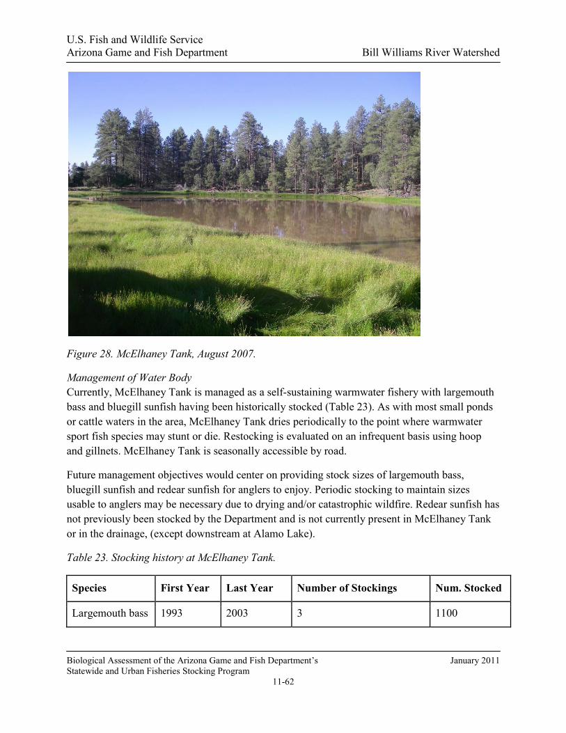
U.S. Fish and Wildlife Service Arizona Game and Fish Department Bill Williams River Watershed
Biological Assessment of the Arizona Game and Fish Department’s January 2011 Statewide and Urban Fisheries Stocking Program
11-62
Figure 28. McElhaney Tank, August 2007.
Management of Water Body Currently, McElhaney Tank is managed as a self-sustaining warmwater fishery with largemouth bass and bluegill sunfish having been historically stocked (Table 23). As with most small ponds or cattle waters in the area, McElhaney Tank dries periodically to the point where warmwater sport fish species may stunt or die. Restocking is evaluated on an infrequent basis using hoop and gillnets. McElhaney Tank is seasonally accessible by road.
Future management objectives would center on providing stock sizes of largemouth bass, bluegill sunfish and redear sunfish for anglers to enjoy. Periodic stocking to maintain sizes usable to anglers may be necessary due to drying and/or catastrophic wildfire. Redear sunfish has not previously been stocked by the Department and is not currently present in McElhaney Tank or in the drainage, (except downstream at Alamo Lake).
Table 23. Stocking history at McElhaney Tank.
Species First Year Last Year Number of Stockings Num. Stocked
Largemouth bass 1993 2003 3 1100

U.S. Fish and Wildlife Service Arizona Game and Fish Department Bill Williams River Watershed
Biological Assessment of the Arizona Game and Fish Department’s January 2011 Statewide and Urban Fisheries Stocking Program
11-63
Bluegill sunfish 1993 2003 2 5200
Total
Proposed action The Department proposes to stock bluegill sunfish, redear sunfish, and largemouth bass for the period covered by this consultation
Largemouth bass (fry/fingerling, sub-catchables, catchables), redear sunfish (sub-catchables, catchables) and bluegill sunfish (sub-catchables, catchables) may be stocked as needed at any time during the year to augment existing populations or recover the fishery following catastrophic events. Numbers of fish stocked for this purpose would be determined according to stocking guidelines identified in the sport fish stocking protocol.
Water Distribution / Connectivity McElhaney Tank sits in a clearing surrounded by Ponderosa Pine forest at just slightly over 6,000 feet in elevation. It is at the headwaters of Connell Gulch and is fed by one wash that drains the west side of Camp Wood Mountain. McElhaney tank is not a large tank but retains water during most extended drought periods primarily because of shading and elevation. From the dam at McElhaney Tank, Connell Gulch flows nine miles to its confluence with Stubb’s Gulch. The confluence of Connell Gulch and Stubb’s Wash forms the headwaters of Boulder Creek. Boulder Creek is ephemeral/intermittent for 23 miles and drains into Burro Creek.
Burro Creek is intermittent/ephemeral for 19 miles until it reaches a perennial segment for 7 miles before reaching the Big Sandy River. McElhaney Tank is maintained primarily by snow runoff and spills from this tank would be most likely to occur during spring runoff. McElhaney Tank spilled in September 2004.
Fish Movement Fish movement out of McElhaney Tank has not been documented. This tank did not go dry in 2003 as many of the tanks in the area did. No barriers to downstream fish movement are known below McElhaney or in Boulder Creek. There is very little opportunity for fishes to move upstream out of McElhaney Tank due to lack of aquatic habitat upstream. If fishes were to move downstream out of McElhaney, extreme conditions would make survival of stocked species unlikely due to the ephemeral nature of Boulder Creek in the stretch below the tank making it unlikely for survival during the warmer months as the creek dries. If the tank spilled during winter run-off or due to sporadic monsoonal events, flash flooding conditions would limit the survivability of fish moving downstream. These conditions create increased sediment loads, high turbidity, rapid currents, alteration of habitat conditions, increased stress levels of organisms in

U.S. Fish and Wildlife Service Arizona Game and Fish Department Bill Williams River Watershed
Biological Assessment of the Arizona Game and Fish Department’s January 2011 Statewide and Urban Fisheries Stocking Program
11-64
transport, altering of fish behavior and mortality. In addition, the steep rocky canyon bound channel of the creek would make it further unlikely fish would survive. Extreme seasonal high water events do occur in this drainage as is reflected in the USGS stream gauge data on Burro Creek approximately 45 miles downstream of Burro Creek (Table 12).
In addition, Connell Gulch runs through the headquarters of the Yolo Ranch, downstream of the tank along Boulder Creek. The ranch maintains a privately owned pond containing resident largemouth bass, bluegill and fathead minnow (Figure 29). The private pond is not in the flood plain, but is situated between two drainages feeding Connell Gulch and therefore a potential source for largemouth bass and bluegill found downstream. The pond can spill, and did in Sept. 2004. Earlier spills are unknown, but likely occurred with other run-off events and future spills would likely be rare but unpredictable.

U.S. Fish and Wildlife Service Arizona Game and Fish Department Bill Williams River Watershed
Biological Assessment of the Arizona Game and Fish Department’s January 2011 Statewide and Urban Fisheries Stocking Program
11-65
Figure 29. Yolo Ranch along Boulder Creek
Community Description Connell Gulch was surveyed by backpack electrofishing in May 2004 by Department staff just below the Yolo Headquarters; 844 seconds were expended to sample 58 fathead minnow ranging in size from 35 mm to 72 mm. Leopard frogs were also sampled and identified as Rio Grande leopard frog (Fong 2004 (7)).

U.S. Fish and Wildlife Service Arizona Game and Fish Department Bill Williams River Watershed
Biological Assessment of the Arizona Game and Fish Department’s January 2011 Statewide and Urban Fisheries Stocking Program
11-66
Table 24. Surveys at McElhaney Tank by year, method, species, number caught, and length.
Survey Year Survey method Species Number Length/Range (mm) 1988 Gill net Largemouth bass 1 402 1991 Hoop net Largemouth bass 6 197-218 & young of
year Bluegill 153 98-178 & young of
year 1992 Hoop net Largemouth bass 4 143-248 Bluegill 218 114-178 1995 Hoop net Largemouth bass 2 234-255 Bluegill 80 110-199 1997 Hoop net Bluegill 15 104-221 2007 Hoop net Waterdogs ? ?
Consultation Species or Critical Habitat No aquatic species are known to be in the localized area. Roundtail chub are discussed in the Burro Creek Complex Analysis as they are found downstream within Burro Creek.
Harman Tank Site Description Harman Tank (Figure 30) is a 5.25 acre earthen livestock tank located on State Trust Land at 5,660 feet elevation. It is approximately 20 miles north of Bagdad. Harman is maintained by precipitation and is located 1.8 miles upstream on an ephemeral tributary of Stubb’s Wash. The exact date of its creation is unknown but from survey records it is at least 23 years old.

U.S. Fish and Wildlife Service Arizona Game and Fish Department Bill Williams River Watershed
Biological Assessment of the Arizona Game and Fish Department’s January 2011 Statewide and Urban Fisheries Stocking Program
11-67
Figure 30. Harman Tank, August 2007.
Management of Water Body Currently, Harman Tank is managed as a self-sustaining warmwater fishery with channel catfish (Table 25). As with most small ponds or cattle waters in the area, Harman Tank dries periodically to the point where warmwater sport fish species may stunt or die. Restocking is evaluated on an infrequent basis using hoop and gillnets. Harman Tank is seasonally accessible by road.
Future management objectives would center on providing stock sizes of channel catfish for anglers to enjoy. Periodic stocking to maintain sizes usable to anglers may be necessary due to drying and/or catastrophic wildfire.
Table 25. Stocking history for Harman Tank.
Species First Year Last Year Number of Stockings Number Stocked Channel catfish 1988 2003 3 2,520 Total 3 2,520
Proposed Action The Department proposes to stock channel catfish for the period covered by this consultation

U.S. Fish and Wildlife Service Arizona Game and Fish Department Bill Williams River Watershed
Biological Assessment of the Arizona Game and Fish Department’s January 2011 Statewide and Urban Fisheries Stocking Program
11-68
Channel catfish (fry/fingerling, sub-catchables, catchables) may be stocked as needed at any time during the year to augment existing populations or recover the fishery following catastrophic events. Numbers of fish stocked for this purpose would be determined according to stocking guidelines identified in the sport fish stocking protocol.
Water Distribution / Connectivity Harman Tank sits in a large open flat near the top of a moderately sized tributary to Stubb’s Wash. Two smaller drainages feed it from the north end. Harman is a comparatively large tank with a decent storage capacity. It is fed by snow runoff and to a lesser degree summer rains. Spills around the dam at Harman would most commonly be during spring runoff events in above-average snowfall years. Harman Tank did overflow in September 2004.
Water leaving Harman Tank would travel two miles of ephemeral drainage to Stubb’s Wash. Stubb’s Wash is also ephemeral and drains 0.6 miles into Boulder Creek. Boulder Creek has extensive pockets of water that persist during dry times and is considered interrupted perennial for 23 miles before draining into Burro Creek. Burro Creek is intermittent/ephemeral for 19 miles until it reaches a perennial segment for seven miles before reaching the Big Sandy River.
Fish Movement Fish movement out of Harman Tank has not been documented. This tank did not go dry in 2003 as many of the tanks in the area did. No barriers to downstream fish movement are known below Harman Tank or in Boulder Creek. There is very little opportunity for fishes to move upstream out of Harman Tank due to slope and lack of habitat. No riparian or aquatic habitat exists upstream. If fishes were to move downstream out of Harman Tank, extreme conditions would make survival of stocked species unlikely due to the ephemeral nature of both Stubb’s Wash and Boulder Creek below the tank making it unlikely for survival during the warmer months as the creek dries; however, a few pools may not completely dry. If the tank spilled during winter run-off or due to sporadic monsoonal events, flash flooding conditions would limit the survivability of fish moving downstream. These conditions create increased sediment loads, high turbidity, rapid currents, alteration of habitat conditions, increased stress levels of organisms in transport, altering of fish behavior and mortality. In addition, the steep rocky canyon bound channel of the creek would make it further unlikely fish would survive. Extreme seasonal high water events do occur in this drainage as is reflected in the USGS stream gauge data on Burro Creek approximately 45 miles downstream of Burro Creek (Table 12).
Community Description Harman Tank was sampled as recently as 2007 to ascertain the status of the channel catfish stocking in 2003 (Table 26). Two 2-foot diameter hoop nets were deployed overnight. Channel and bluegill were captured (Cummins 2007 (2)). Harman Tank has also been sampled historically since 1987 (Table 27).
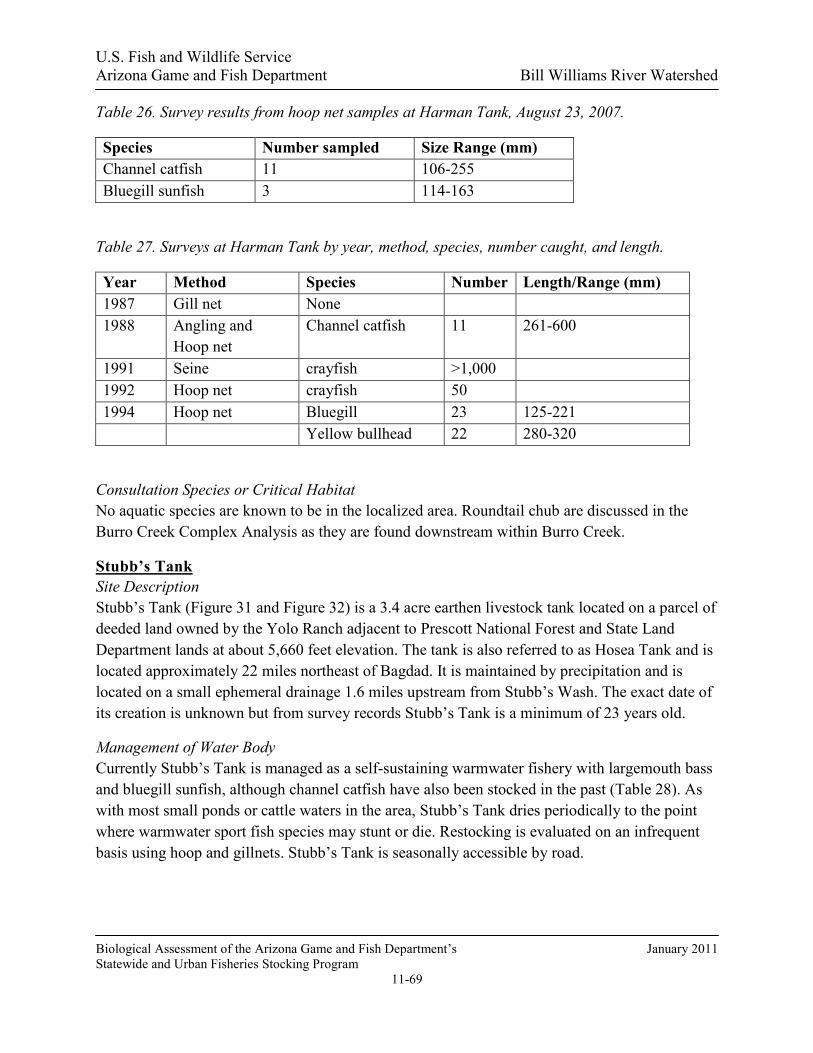
U.S. Fish and Wildlife Service Arizona Game and Fish Department Bill Williams River Watershed
Biological Assessment of the Arizona Game and Fish Department’s January 2011 Statewide and Urban Fisheries Stocking Program
11-69
Table 26. Survey results from hoop net samples at Harman Tank, August 23, 2007.
Species Number sampled Size Range (mm) Channel catfish 11 106-255 Bluegill sunfish 3 114-163
Table 27. Surveys at Harman Tank by year, method, species, number caught, and length.
Year Method Species Number Length/Range (mm) 1987 Gill net None 1988 Angling and
Hoop net Channel catfish 11 261-600
1991 Seine crayfish >1,000 1992 Hoop net crayfish 50 1994 Hoop net Bluegill 23 125-221 Yellow bullhead 22 280-320
Consultation Species or Critical Habitat No aquatic species are known to be in the localized area. Roundtail chub are discussed in the Burro Creek Complex Analysis as they are found downstream within Burro Creek.
Stubb’s Tank Site Description Stubb’s Tank (Figure 31 and Figure 32) is a 3.4 acre earthen livestock tank located on a parcel of deeded land owned by the Yolo Ranch adjacent to Prescott National Forest and State Land Department lands at about 5,660 feet elevation. The tank is also referred to as Hosea Tank and is located approximately 22 miles northeast of Bagdad. It is maintained by precipitation and is located on a small ephemeral drainage 1.6 miles upstream from Stubb’s Wash. The exact date of its creation is unknown but from survey records Stubb’s Tank is a minimum of 23 years old.
Management of Water Body Currently Stubb’s Tank is managed as a self-sustaining warmwater fishery with largemouth bass and bluegill sunfish, although channel catfish have also been stocked in the past (Table 28). As with most small ponds or cattle waters in the area, Stubb’s Tank dries periodically to the point where warmwater sport fish species may stunt or die. Restocking is evaluated on an infrequent basis using hoop and gillnets. Stubb’s Tank is seasonally accessible by road.
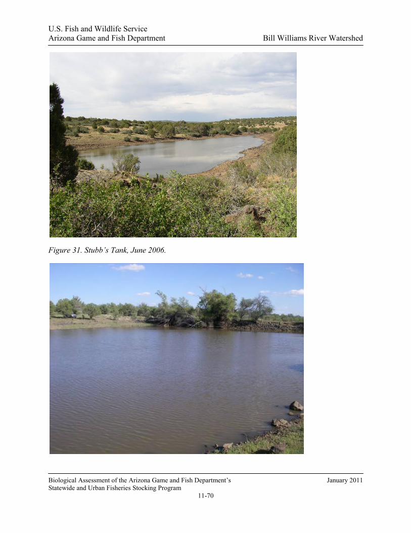
U.S. Fish and Wildlife Service Arizona Game and Fish Department Bill Williams River Watershed
Biological Assessment of the Arizona Game and Fish Department’s January 2011 Statewide and Urban Fisheries Stocking Program
11-70
Figure 31. Stubb’s Tank, June 2006.
U.S. Fish and Wildlife Service Arizona Game and Fish Department Bill Williams River Watershed
Biological Assessment of the Arizona Game and Fish Department’s January 2011 Statewide and Urban Fisheries Stocking Program
11-71
Figure 32. Stubb’s Tank photograph.
Future management objectives would center on providing stock sizes of largemouth bass, redear and bluegill sunfish for anglers to enjoy. Periodic stocking to maintain sizes usable to anglers may be necessary due to drying and/or catastrophic wildfire. Redear sunfish has not previously been stocked by the Department and is not currently present in Stubb’s Tank or in the drainage, (except downstream at Alamo Lake).
Table 28. Stocking history for Stubb’s Tank.
Species First Year Last Year Number of Stockings Num. Stocked Bluegill 1997 2003 3 4,300 Channel catfish 2001 2001 1 400 Largemouth bass 1997 2007 4 3,014 Total 5 7,714
Proposed Action The Department proposes to stock bluegill, redear sunfish, and largemouth bass for the period covered by this consultation
Largemouth bass (fry/fingerling, sub-catchables, catchables), redear sunfish (sub-catchables, catchables) and bluegill sunfish (sub-catchables, catchables) may be stocked as needed at any time during the year to augment existing populations or recover the fishery following catastrophic events. In addition, redear sunfish would be established in the fishery. All numbers of fish stocked for this purpose would be determined according to stocking guidelines identified in the sport fish stocking protocol.
Water Distribution / Connectivity Stubb’s Tank sits in a large open juniper lined flat near the top of a small tributary to Stubb’s Wash. The dam at Stubb’s began to erode significantly on its western edge starting in September 2004. High flows in the summer of 2007 created a large wash out as a result of very heavy rainfall and corresponding runoff in the area (Figure 33 and Figure 34). The dam remained functional but capacity of the tank was reduced. The Yolo ranch repaired the dam in the summer of 2008. The tank, prior to 2005, had not been known to spill. It has a small contributing watershed and is a comparatively large tank. Water leaving Stubb’s Tank would flow down an unnamed wash one mile until meeting Stubb’s Wash. Stubb’s Wash is also ephemeral and drains 0.6 miles where it meets Connell Gulch forming Boulder Creek. Boulder Creek has numerous/extensive pockets of water that persist during dry times and is considered interrupted perennial for 23 miles before draining into Burro Creek. Burro Creek is intermittent/ephemeral for 19 miles until it reaches a perennial segment for 7 miles before reaching the Big Sandy River.

U.S. Fish and Wildlife Service Arizona Game and Fish Department Bill Williams River Watershed
Biological Assessment of the Arizona Game and Fish Department’s January 2011 Statewide and Urban Fisheries Stocking Program
11-72
Figure 33. Breech at Stubb’s Dam, October 2007.
Figure 34. Stubb’s Dam breech looking downstream, October 2007.

U.S. Fish and Wildlife Service Arizona Game and Fish Department Bill Williams River Watershed
Biological Assessment of the Arizona Game and Fish Department’s January 2011 Statewide and Urban Fisheries Stocking Program
11-73
Fish Movement Fish movement out of Stubb’s Tank has not been documented. This tank did not go dry in 2003 as many of the tanks in the area did. No barriers to downstream fish movement are known below Stubb’s Tank or in Boulder Creek. There is very little opportunity for fishes to move upstream out of Stubb’s Tank due to slope and lack of aquatic habitat. If fishes were to move downstream out of Stubb’s Tank, extreme conditions would make survival of stocked species unlikely due to the ephemeral nature of Stubb’s Wash and Boulder Creek below the tank making it unlikely for survival during the warmer months as the creek dries; however, a few pools may not completely dry. If the tank spilled during winter run-off or due to sporadic monsoonal events, flash flooding conditions would limit the survivability of fish moving downstream. These conditions create increased sediment loads, high turbidity, rapid currents, alteration of habitat conditions, increased stress levels of organisms in transport, altering of fish behavior and mortality. In addition, the steep rocky canyon bound channel of the creek would make it further unlikely fish would survive. Extreme seasonal high water events do occur in this drainage as is reflected in the USGS stream gauge data on Burro Creek approximately 45 miles downstream of Burro Creek (Table 12).
Community Description Stubb’s has historically held water consistently through dry periods and has been locally known for its largemouth bass fishery. Survey efforts in summer of 2002 yielded high numbers of fish (Table 29), but mortality was high due to low oxygen and netting stress. Local anglers reported reduced catch rates on largemouth bass in following years. Stubb’s Tank was sampled as recently as 2007 to determine impacts to the fishery resulting from the 2004 flooding.
Table 29. Surveys at Stubb’s Tank by year, method, species, number caught, and length.
Year Method Species Number Length/Range (mm) 1987 Seine Bluegill 41 72-150 & young of year 1991 Seine Largemouth bass 42 YOY Bluegill 27 YOY Crayfish 100s 1992 Hoop net and
Seine Bluegill 78 74-249
Crayfish 250 1994 Hoop net Bluegill 83 140-245 Largemouth bass 2 212-221 1996 Hoop net Largemouth bass 1 355 Bluegill 88 84-225

U.S. Fish and Wildlife Service Arizona Game and Fish Department Bill Williams River Watershed
Biological Assessment of the Arizona Game and Fish Department’s January 2011 Statewide and Urban Fisheries Stocking Program
11-74
1998 Hoop net Largemouth bass 1 270 Bluegill 45 110-199 2002 Hoop net Bluegill 257 22-271 Largemouth bass 46 135-450 2007 Hoop net Crayfish ?
Consultation Species or Critical Habitat No aquatic species are known to be in the localized area. Roundtail chub are discussed in the Complex Analysis as they are found within Burro Creek.
Swale Tank Site Description Swale Tank is a 10 acre earthen livestock tank (Figure 35) located approximately 28 miles east of Wikiup at 4,520 feet elevation on land managed by the Bureau of Land Management. It is maintained by precipitation and is located 3.5 miles upstream on Black Canyon, an ephemeral tributary of Francis Creek. According to ADWR records, this tank was built prior to a water rights filing in 1979 and appears on topo maps created from 1973 aerial photos.
Figure 35. Swale Tank, October 2004.

U.S. Fish and Wildlife Service Arizona Game and Fish Department Bill Williams River Watershed
Biological Assessment of the Arizona Game and Fish Department’s January 2011 Statewide and Urban Fisheries Stocking Program
11-75
Management of Water Body Currently, Swale Tank is managed as a self-sustaining warmwater fishery with channel catfish, which have been stocked in the past (Table 30). As with most small ponds or cattle waters in the area, Swale Tank dries periodically to the point where warmwater sport fish species may stunt or die. Restocking is evaluated on an infrequent basis using hoop and gillnets. Swale Tank is seasonally accessible by road.
Future management objectives would center on providing stock sizes of channel catfish for anglers to enjoy. Periodic stocking to maintain sizes usable to anglers may be necessary due to drying and/or catastrophic wildfire.
Table 30. Stocking history for Swale Tank.
Species First Year Last Year Number of Stockings Number Stocked
Channel catfish 1992 1997 2 1,550
Total 2 1,550
Proposed Action The Department proposes to stock channel catfish for the period covered by this consultation.
Channel catfish (fry/fingerling, sub-catchables, catchables) may be stocked as needed at any time during the year to augment existing populations or recover the fishery following catastrophic events. Numbers of fish stocked for this purpose would be determined according to stocking guidelines identified in the sport fish stocking protocol.
Water Distribution / Connectivity Swale Tank sits in an open valley on top of Goodwin Mesa in the Aquarius Mountains. As stated above, it is a large tank with decent retention capacity. Swale is maintained primarily by snow melt, but can receive high runoff from summer storms as well. The tank went dry in 2003 but filled to capacity and spilled in September 2004. The extent of the spill is unknown, but site visits to the tank in the winter of 2004 revealed water levels several feet from spilling (S. Fong pers. comm.). Prior to 2004, Swale Tank was not known to spill. Water leaving Swale Tank would flow 3.7 miles down Black Canyon to its confluence with Francis Creek. Water spilling from Swale Tank drops approximately 6 feet onto large rocks. Another 6-foot drop onto rocks occurs down Black Canyon approximately 1 mile. Black Canyon does not maintain sufficient aquatic habitat for fish during most years.

U.S. Fish and Wildlife Service Arizona Game and Fish Department Bill Williams River Watershed
Biological Assessment of the Arizona Game and Fish Department’s January 2011 Statewide and Urban Fisheries Stocking Program
11-76
Francis Creek is intermittent for five miles then has perennial flow for 2.1 miles to the confluence with Burro Creek. Burro Creek is perennial for 4.2 miles and then becomes ephemeral/intermittent for 30 miles to the confluence with the Big Sandy River.
Fish Movement Fish movement out of Swale Tank has not been documented. The tank was confirmed dry in 2003. No barriers to downstream fish movement are known below Swale Tank or in either Black Canyon or Francis Creek. There is little opportunity for fishes to move upstream out of Swale Tank due to limited aquatic habitat. Slaughter tank resides approximately 0.6 miles up an ephemeral wash from Swale Tank (Figure 36). It is unknown if there are fish or other aquatic organisms in Slaughter Tank, nor what the nature of the spillway is like. Absent information, we presume that escaped fish from Swale Tank could enter Slaughter Tank. Upstream from Slaughter Tank there is no riparian or aquatic habitat. If fishes were to move downstream out of Swale Tank, extreme conditions would make survival of stocked species unlikely due to two vertical drops onto rocks and very limited aquatic habitats in addition to ephemeral nature of the system.
If the tank spilled during winter run-off or due to sporadic monsoonal events, flash flooding conditions would limit the survivability of fish moving downstream. These conditions create increased sediment loads, high turbidity, rapid currents, alteration of habitat conditions, increased stress levels of organisms in transport, altering of fish behavior and mortality. In addition, the steep rocky canyon bound channel of the creek would make it further unlikely fish would survive. Extreme seasonal high water events do occur in this drainage as is reflected in the USGS stream gauge data on Burro Creek approximately 45 miles downstream of Burro Creek (Table 12).

U.S. Fish and Wildlife Service Arizona Game and Fish Department Bill Williams River Watershed
Biological Assessment of the Arizona Game and Fish Department’s January 2011 Statewide and Urban Fisheries Stocking Program
11-77
Figure 36. Swale and Slaughter Tanks
Community Description No surveys have been done a Swale Tank since 1996 due to its remoteness and infrequency of stockings (Table 31). Channel catfish were confirmed present by anglers in 2000 (K. Morgan, pers. comm.). Channel catfish were documented dying as a result of low water and corresponding poor water quality in the summer of 2002 (G. Elms, pers. comm.). The tank dried completely in 2003 and has not been restocked. It is currently presumed fishless.
Table 31. Surveys at Swale Tank by year, method, species, number caught, and length.
Year method Species Number Length/Range (mm) 1988 Hoop net and Seine Channel catfish 19 95-634

U.S. Fish and Wildlife Service Arizona Game and Fish Department Bill Williams River Watershed
Biological Assessment of the Arizona Game and Fish Department’s January 2011 Statewide and Urban Fisheries Stocking Program
11-78
1996 Hoop net and Seine Channel catfish 8 90-100
Channel catfish were first stocked in 1992 and had opportunity to access Francis Creek and have not been documented there. Fish surveys in 1966 reported: carp, speckled dace and roundtail chub as being present in Francis Creek just downstream of the Black Canyon confluence. Roundtail chub are known from Francis Creek further downstream. More recent fish surveys (1991-1995) in Francis Creek downstream from the confluence reported: longfin dace, Sonora sucker, roundtail chub, green sunfish, desert sucker and speckled dace. Channel catfish were first stocked in 1992 and had opportunity to access Francis Creek and have not been documented there. Channel catfish are likely to persist in the system should they wash out of Swale Tank; however, they have been stocked in Swale Tank twice since 1992 and have not been documented in Francis Creek or downstream in Burro Creek. Peak stream flow provided in (Table 34) shows that discharges in Burro Creek in 1993 were over double those measured in 2004 when the tank was known to spill. It is highly probable that this tank also spilled during the 1993 winter season.
Consultation Species or Critical Habitat No aquatic species are known to be in the localized area. Roundtail chub are discussed in the Burro Creek Complex Analysis as they are found downstream within Burro Creek.
Coors Lake Site Description Coors Lake is a 35 acre impoundment of Butte Creek in western Yavapai County (Figure 37) at 3,700 feet elevation. The earthen dam that created Coors Lake was completed in 1982 by the Cyprus-Bagdad Copper Company (Hinkle 1987). The lake sits about 2 miles north of the town of Bagdad, and approximately one mile northeast of the Bagdad open pit copper mine now owned and operated by Freeport McMoran Corp.
The land ownership status of Coors Lake and the lake access road borders private land. Access currently is open to the public through a dirt road that originates immediately in front of the main gate of the mine. Coors Lake is considered a closed system; stocked fish cannot exit the system, nor can fish enter the lake.

U.S. Fish and Wildlife Service Arizona Game and Fish Department Bill Williams River Watershed
Biological Assessment of the Arizona Game and Fish Department’s January 2011 Statewide and Urban Fisheries Stocking Program
11-79
Figure 37. Coors Lake, May 2007.
Management of Water Body Coors Lake has been managed as a self-sustaining warmwater fishery featuring largemouth bass, black crappie, bluegill sunfish, and channel catfish. In 1982, Coors was first stocked with largemouth bass from nearby Vaughn’s Pond. Vaughn’s was the original lake on mine property but was filled in due to deposition of unmineralized overburden. Since that time the lake has received several supplemental stockings (Table 32). The various owners of the mine have also stocked channel catfish and largemouth bass into Coors Lake. The lake is accessible by road year round.
The Arizona Department of Environmental Quality (ADEQ) issued a human health fish consumption advisory on largemouth bass at Coors Lake in 2004. The advisory was based on the accumulation of mercury in the flesh of these fish. The advisory was deemed warranted after testing mercury concentrations in the flesh of largemouth bass and black crappie. Elevated mercury levels were not found in the black crappie population. Shortly after the advisory was issued, an incomplete fish kill occurred mostly affecting the largemouth bass population. The kill was attributed to very low water levels and deteriorating water quality due to dense aquatic vegetation. Largemouth bass were restocked in 2006 by the owner at the time, Phelps Dodge. AGFD has monitored the fish populations of Coors Lake since 1986 primarily by electrofishing.
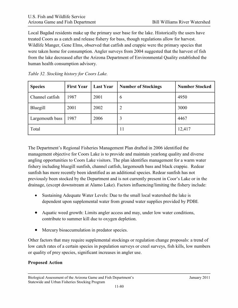
U.S. Fish and Wildlife Service Arizona Game and Fish Department Bill Williams River Watershed
Biological Assessment of the Arizona Game and Fish Department’s January 2011 Statewide and Urban Fisheries Stocking Program
11-80
Local Bagdad residents make up the primary user base for the lake. Historically the users have treated Coors as a catch and release fishery for bass, though regulations allow for harvest. Wildlife Manger, Gene Elms, observed that catfish and crappie were the primary species that were taken home for consumption. Angler surveys from 2004 suggested that the harvest of fish from the lake decreased after the Arizona Department of Environmental Quality established the human health consumption advisory.
Table 32. Stocking history for Coors Lake.
Species First Year Last Year Number of Stockings Number Stocked
Channel catfish 1987 2001 6 4950
Bluegill 2001 2002 2 3000
Largemouth bass 1987 2006 3 4467
Total 11 12,417
The Department’s Regional Fisheries Management Plan drafted in 2006 identified the management objective for Coors Lake is to provide and maintain yearlong quality and diverse angling opportunities to Coors Lake visitors. The plan identifies management for a warm water fishery including bluegill sunfish, channel catfish, largemouth bass and black crappie. Redear sunfish has more recently been identified as an additional species. Redear sunfish has not previously been stocked by the Department and is not currently present in Coor’s Lake or in the drainage, (except downstream at Alamo Lake). Factors influencing/limiting the fishery include:
• Sustaining Adequate Water Levels: Due to the small local watershed the lake is dependent upon supplemental water from ground water supplies provided by PDBI.
• Aquatic weed growth: Limits angler access and may, under low water conditions, contribute to summer kill due to oxygen depletion.
• Mercury bioaccumulation in predator species.
Other factors that may require supplemental stockings or regulation change proposals: a trend of low catch rates of a certain species in population surveys or creel surveys, fish kills, low numbers or quality of prey species, significant increases in angler use.
Proposed Action

U.S. Fish and Wildlife Service Arizona Game and Fish Department Bill Williams River Watershed
Biological Assessment of the Arizona Game and Fish Department’s January 2011 Statewide and Urban Fisheries Stocking Program
11-81
The Department proposes to stock bluegill, channel catfish, black crappie, largemouth bass, and redear sunfish, for the period covered by this consultation
Largemouth bass (fry/fingerling, sub-catchables, catchables), redear sunfish (sub-catchables, catchables), bluegill sunfish (sub-catchables, catchables), black crappie (sub-catchables, catchables) and channel catfish (sub-catchables, catchables) may be stocked on an as needed basis at any time during the year to augment existing populations or recover the fishery following catastrophic events. Numbers of fish stocked for this purpose would be determined according to stocking guidelines identified in the sport fish stocking protocol.
Water Distribution / Connectivity The dam at Coors Lake was originally created to prevent seasonal floods from entering the open pit; however, subsequent unmineralized overburden deposits have isolated the lake from Butte Creek, a tributary to Boulder Creek and Burro Creek (Figure 38). The watershed basin that feeds Coors is relatively small at approximately 800 acres (Hinkle 1987). Coors Lake is maintained partially by precipitation runoff and by active groundwater pumping by the Cyprus Bagdad Mining Company (Figure 39). Active pumping is required to keep Coors Lake as a viable lake capable of supporting a sport fishery. There is no outflow from the lake to any tributary.

U.S. Fish and Wildlife Service Arizona Game and Fish Department Bill Williams River Watershed
Biological Assessment of the Arizona Game and Fish Department’s January 2011 Statewide and Urban Fisheries Stocking Program
11-82
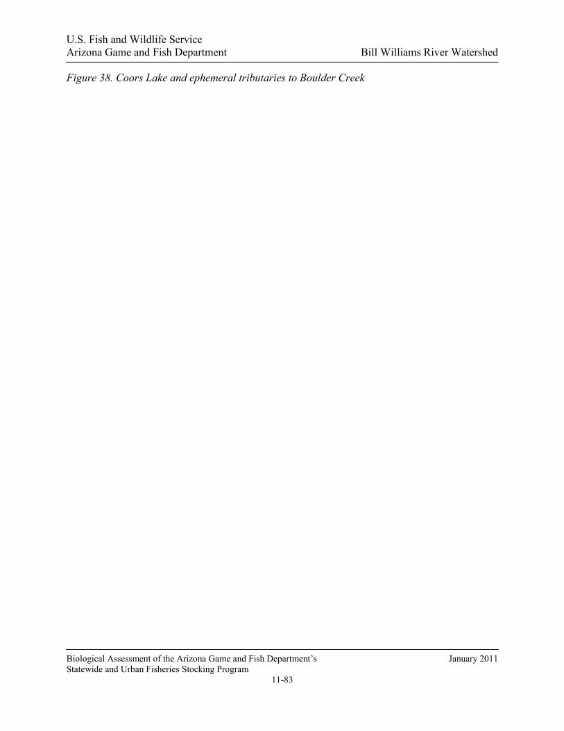
U.S. Fish and Wildlife Service Arizona Game and Fish Department Bill Williams River Watershed
Biological Assessment of the Arizona Game and Fish Department’s January 2011 Statewide and Urban Fisheries Stocking Program
11-83
Figure 38. Coors Lake and ephemeral tributaries to Boulder Creek
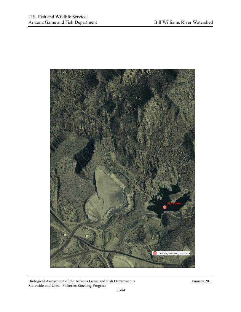
U.S. Fish and Wildlife Service Arizona Game and Fish Department Bill Williams River Watershed
Biological Assessment of the Arizona Game and Fish Department’s January 2011 Statewide and Urban Fisheries Stocking Program
11-84
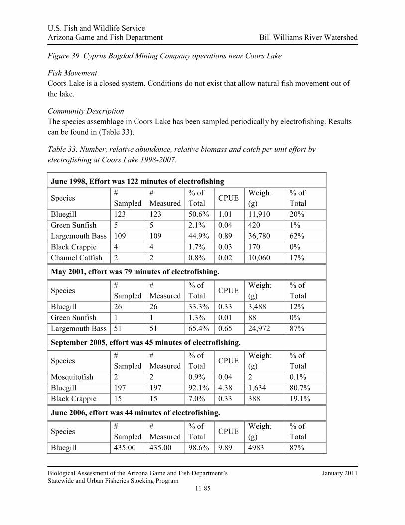
U.S. Fish and Wildlife Service Arizona Game and Fish Department Bill Williams River Watershed
Biological Assessment of the Arizona Game and Fish Department’s January 2011 Statewide and Urban Fisheries Stocking Program
11-85
Figure 39. Cyprus Bagdad Mining Company operations near Coors Lake
Fish Movement Coors Lake is a closed system. Conditions do not exist that allow natural fish movement out of the lake.
Community Description The species assemblage in Coors Lake has been sampled periodically by electrofishing. Results can be found in (Table 33).
Table 33. Number, relative abundance, relative biomass and catch per unit effort by electrofishing at Coors Lake 1998-2007.
June 1998, Effort was 122 minutes of electrofishing
Species # Sampled
# Measured
% of Total
CPUE Weight (g)
% of Total
Bluegill 123 123 50.6% 1.01 11,910 20% Green Sunfish 5 5 2.1% 0.04 420 1% Largemouth Bass 109 109 44.9% 0.89 36,780 62% Black Crappie 4 4 1.7% 0.03 170 0% Channel Catfish 2 2 0.8% 0.02 10,060 17%
May 2001, effort was 79 minutes of electrofishing.
Species # Sampled
# Measured
% of Total
CPUE Weight (g)
% of Total
Bluegill 26 26 33.3% 0.33 3,488 12% Green Sunfish 1 1 1.3% 0.01 88 0% Largemouth Bass 51 51 65.4% 0.65 24,972 87%
September 2005, effort was 45 minutes of electrofishing.
Species # Sampled
# Measured
% of Total
CPUE Weight (g)
% of Total
Mosquitofish 2 2 0.9% 0.04 2 0.1% Bluegill 197 197 92.1% 4.38 1,634 80.7% Black Crappie 15 15 7.0% 0.33 388 19.1%
June 2006, effort was 44 minutes of electrofishing.
Species # Sampled
# Measured
% of Total
CPUE Weight (g)
% of Total
Bluegill 435.00 435.00 98.6% 9.89 4983 87%

U.S. Fish and Wildlife Service Arizona Game and Fish Department Bill Williams River Watershed
Biological Assessment of the Arizona Game and Fish Department’s January 2011 Statewide and Urban Fisheries Stocking Program
11-86
Green Sunfish 1.00 1.00 0.2% 0.02 88 2% Black Crappie 5.00 5.00 1.1% 0.11 660 12%
May 2007, effort was 45 minutes of electrofishing.
Species # Sampled
# Measured
% of Total
CPUE Weight (g)
% of Total
Bluegill 415 415 90.0% 9.22 6132 47% Green Sunfish 28 28 6.1% 0.62 3058 23% Largemouth Bass 8 8 1.7% 0.18 2461 19% Black Crappie 10 10 2.2% 0.22 1405 11%
Other species that have been recorded from the lake are red shiner, fathead minnow, and mosquitofish, presumably by anglers releasing unused bait. Red eared slider turtles have also been recorded from the site.
Consultation Species or Critical Habitat Bald Eagle are discussed below. No aquatic species are known to be in the localized area. Roundtail chub are discussed in the Burro Creek Complex Analysis as they are found downstream within Burro Creek.
Bald Eagle Burro Creek Breeding Area is approximately 14.7 miles from Coors Lake and is within the Sonoran Desert Bald Eagle DPS. The eagles were first observed at the breeding area in 2007 and were last observed at the breeding area in 2008. Nest watchers have not been present at the breeding area so the prey base specifics are largely unknown. Burro Creek Breeding Area productivity data shows that the nest failed in 2007, and was occupied in 2008 before the nest fell and has since not been rebuilt (McCarty pers. Comm.). The breeding area was unoccupied in 2009 (Jacobson et al. 2007; McCarty and Jacobson 2008, 2009) and in 2010.
Potential Impacts Nesting bald eagles are known to occur in the vicinity of this stocking site all year. Human disturbance and monofilament line/fishing tackle disposal are issues for this site. It is unknown if Coors Lake has monofilament bins present
BURRO CREEK COMPLEX ANALYSIS Water distribution and connectivity, fish movement and community descriptions were previously discussed for Carter, Antelope, Harmon #2, Bar 37, Little Antelope, McElhaney, Harmon,

U.S. Fish and Wildlife Service Arizona Game and Fish Department Bill Williams River Watershed
Biological Assessment of the Arizona Game and Fish Department’s January 2011 Statewide and Urban Fisheries Stocking Program
11-87
Stubb’s tanks and Coors Lake up to the point where they flow into Burro Creek. Downstream connectivity for Burro Creek into the Big Sandy River is discussed below.
Water Connectivity / Distribution In summary, nearly all of the associated tributaries flowing into Burro Creek are ephemeral/intermittent in nature and are subject to flash flooding events that could potentially connect them for a short duration to Burro Creek. Conger Creek, Francis Creek and Pine Creek have short perennial reaches (Pine Creek with the confluence of Burro Creek and Middle Conger Creek).
Fish Movement Fish movement out of the tanks within Pine Creek are not known nor documented to have occurred. Small and medium sized tanks often dry periodically, and none of the tanks have known barriers to downstream fish movement if spillage should occur. There is little to no opportunity for fishes to move upstream from the tanks as little or no riparian or aquatic habitat exists. In addition, there is at least one 80-feet drop exists between the proposed stocking sites on Pine Creek and Burro Creek (Figure 40).
No barriers to downstream fish movement are known below Little Antelope Tank or in Conger Creek. There is very little opportunity for fishes to move upstream out of Little Antelope Tank due to slope and lack of aquatic habitat upstream.
Within the Boulder Creek tanks, there would be very little opportunity for fishes to move upstream out of the tanks due to lack of aquatic habitat upstream. In addition, Connell Gulch runs through the headquarters of the Yolo Ranch. A privately owned pond exists at the headquarters that contains resident largemouth bass, bluegill and fathead minnow. The pond is not in the floodplain but is situated between two drainages feeding Connell Gulch in closer proximity to the drainage that could flow into Burro Creek, providing another source for non native fish if fish escaped during a spill event. It was known to spill in September 2004 (A. Clark pers. comm.)
In summary, these flash flooding conditions within the entire watershed, can create increased sediment loads, high turbidity, rapid currents, alteration of habitat conditions, increased stress levels of organisms in transport, altering of fish behavior and causing mortality limiting the ability of survival during transport.
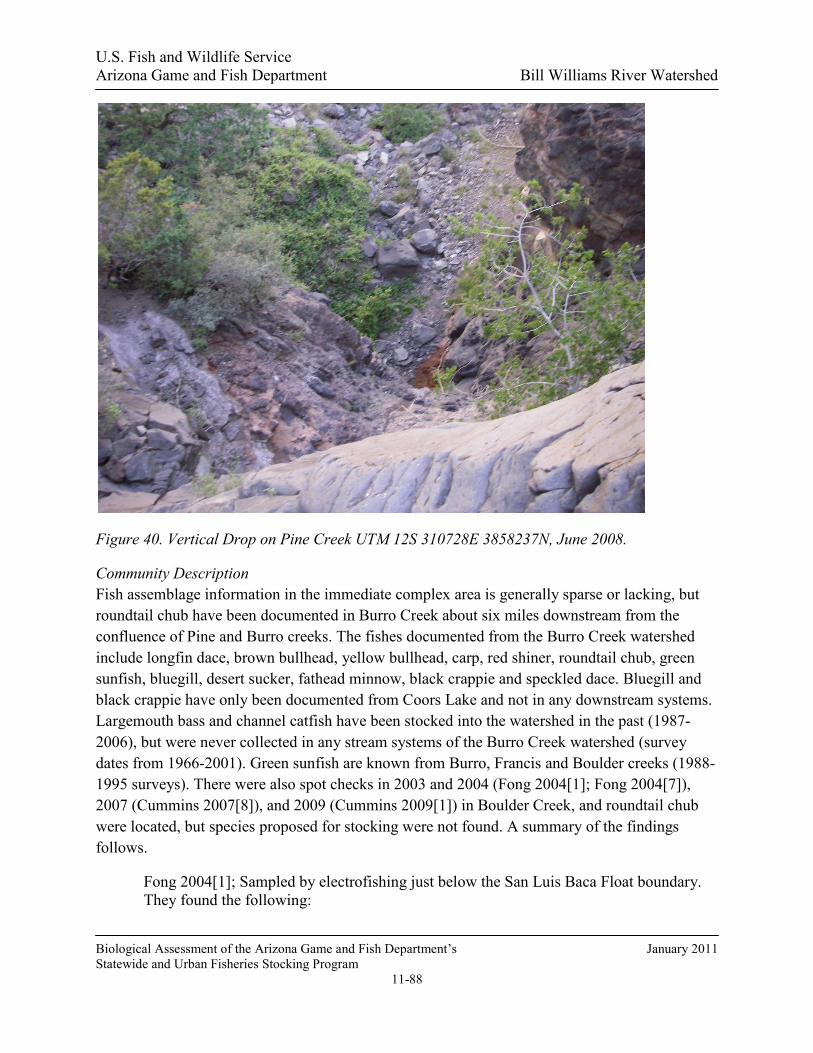
U.S. Fish and Wildlife Service Arizona Game and Fish Department Bill Williams River Watershed
Biological Assessment of the Arizona Game and Fish Department’s January 2011 Statewide and Urban Fisheries Stocking Program
11-88
Figure 40. Vertical Drop on Pine Creek UTM 12S 310728E 3858237N, June 2008.
Community Description Fish assemblage information in the immediate complex area is generally sparse or lacking, but roundtail chub have been documented in Burro Creek about six miles downstream from the confluence of Pine and Burro creeks. The fishes documented from the Burro Creek watershed include longfin dace, brown bullhead, yellow bullhead, carp, red shiner, roundtail chub, green sunfish, bluegill, desert sucker, fathead minnow, black crappie and speckled dace. Bluegill and black crappie have only been documented from Coors Lake and not in any downstream systems. Largemouth bass and channel catfish have been stocked into the watershed in the past (1987-2006), but were never collected in any stream systems of the Burro Creek watershed (survey dates from 1966-2001). Green sunfish are known from Burro, Francis and Boulder creeks (1988-1995 surveys). There were also spot checks in 2003 and 2004 (Fong 2004[1]; Fong 2004[7]), 2007 (Cummins 2007[8]), and 2009 (Cummins 2009[1]) in Boulder Creek, and roundtail chub were located, but species proposed for stocking were not found. A summary of the findings follows.
Fong 2004[1]; Sampled by electrofishing just below the San Luis Baca Float boundary. They found the following:

U.S. Fish and Wildlife Service Arizona Game and Fish Department Bill Williams River Watershed
Biological Assessment of the Arizona Game and Fish Department’s January 2011 Statewide and Urban Fisheries Stocking Program
11-89
6 desert suckers 4 speckled dace 15 roundtail chub ranging from 65mm to 155mm.
Fong 2004(7): Seined in Apache Creek just below Forest Road 93 and found 18 speckled dace on 5/12/2004. They also seined in Upper Boulder Creek at Connell Gulch and pulled in 58 fathead minnows.
Cummins 2007 4/2-3/07: The sampling effort started approximately 3.5 miles upstream of the confluence of Francis and Burro Creeks at UTM 12S 0298635E 3851130N (NAD 27). Visual searching and netting was used. No native fish were netted but visual identification was made for two roundtail chubs. Non-native fish included yellow bullhead and green sunfish. The ending point was at UTM 12S 0299386E 3852262N. The total distance on the upper end of the creek covered 1.2 miles. The second day was spent electrofishing at the confluence of Burro and Francis Creeks. Non-native fish included yellow bullhead, green sunfish and one common carp.
Cummins 2009 4/13-14/09: They electrofish sampled at (UTM 12S 0297256 3834349 NAD 27) for 1,019 seconds and produced no fish. This site was downstream of the Hillside Mine. The second site was upstream from the Hillside Mine at (UTM 12S 0298039 3835112) and ended at (UTM 12S 0298038 3835239). The site used 1,215 seconds and produced:
3 roundtail chub with an average length of 173 mm 1 desert sucker 6 longfin dace The third (UTM 12S 0313126 3841741) and fourth (UTM 12S 0308392 385929) electrofishing sites produced only fathead minnows.
4/13/09: Nets were set in three positions (UTM 12S 0308319 3836132) (UTM 12S 03313349 3842261) (UTM 12S 0313109 3841898). The nets were set in the late afternoon and pulled in the morning and produced no fish. Small bodied fish, possibly longfin dace were present at site two but too small to be caught. One mosquito fish was observed at site three.
Though drainages such as Boulder and Francis have historically held viable native fish populations, recent investigations of these creeks found much less water and more dominance by non-native fish species (Fong 2004 (2), Cummins 2007(8)). Within the drainage complex, non-native fish species are present including green sunfish, yellow bullhead, common carp, red shiner, fathead minnow and mosquitofish. Conger Creek maintains an all native species assemblage in the middle reaches. Pine Creek does not provide adequate aquatic habitats and has not been known to harbor fishes historically.
All the proposed waters have been in existence a minimum of 20 years with some having stocking and/or survey records dating back 25 years while others were only recently stocked

U.S. Fish and Wildlife Service Arizona Game and Fish Department Bill Williams River Watershed
Biological Assessment of the Arizona Game and Fish Department’s January 2011 Statewide and Urban Fisheries Stocking Program
11-90
according to Department records. It would not be unusual for other undocumented stockings to have occurred in tanks prior to the 1970’s, though. The exception is redear sunfish which is a new proposed species in the Burro Creek Complex. General persistence of fish species proposed for this stocking period have been documented in each of the proposed waters, with occasional extirpations due to drying/drought.
Consultation Species or Critical Habitat Roundtail chub are downstream within Burro Creek and the Santa Maria River and are discussed below.
Potential impacts from the proposed action to candidate and listed species are described below. Please refer to Chapter 4 for a detailed description of the nature of the impacts (which may include predation, competition for space and food, and hybridization etc.).Subsequent responses (resulting from the frequency, magnitude and duration of the impacts) between proposed stocked and candidate and listed species, and any site or complex factors that provide context for determining the meaningfulness of the impacts, are discussed below. Impacts from the proposed action resulting from angler related recreation and/or potential introduction of disease, pathogen or invasive species are evaluated at a broad scale for the entire action area and are described in Chapter 4. If potential impacts specific to a stocking site or complex have been identified they are discussed below.
Roundtail Chub There are collection records of roundtail chub in Burro Creek and the Santa Maria River, however, the current status of roundtail chub in the Santa Maria River is unknown (See Santa Maria Complex).
Roundtail chub is currently the only fish species of concern in these two systems. Roundtail chub tend to do well in desert stream systems in which they evolved, provided periodic flooding occurs to ensure habitat for their young (Rinne 1996). Burro Creek shows frequent high flow events suggesting roundtail chub may persist better in this creek when compared to others in the Complex (Table 34). Burro Creek also has the most perennial and ephemeral/interrupted perennial areas in the Bill Williams system that would allow fish to survive. Fish surveys in Burro Creek will be performed every other year over 6 years for a total of 3 surveys. If largemouth bass, bluegill or redear sunfish are discovered in these streams, stockings would be halted and consultation re-initiated.
Table 34. Peak stream flow for USGS 09424447 Burro Creek at old US 93 bridge near Bagdad, Az.
Water Year Date Stream-flow (cfs) 1980 Feb. 14, 1980 47,400

U.S. Fish and Wildlife Service Arizona Game and Fish Department Bill Williams River Watershed
Biological Assessment of the Arizona Game and Fish Department’s January 2011 Statewide and Urban Fisheries Stocking Program
11-91
1981 Sep. 05, 1981 728 1982 Feb. 11, 1982 5,400 1983 Mar. 03, 1983 30,600 1984 Aug. 24, 1984 3,950 1985 Dec. 27, 1984 12,400 1986 Nov. 30, 1985 6,210 1987 Mar. 05, 1987 565 1988 Aug. 27, 1988 6,410 1989 Jan. 05, 1989 798 1990 Sep. 18, 1990 1,410 1991 Mar. 01, 1991 29,900 1992 Feb. 13, 1992 12,300 1993 Feb. 08, 1993 55,300 2004 Sep. 19, 2004 21,200 2005 Feb. 11, 2005 44,600 2006 Sep. 09, 2006 1,510 2007 Sep. 22, 2007 5,700
Potential Impacts Largemouth bass, channel catfish, bluegill and redear sunfish are proposed to be stocked over a 10-year period in waters within the Burro Creek Complex. Of the four species, largemouth bass and channel catfish would be the two species that have the potential to negatively impact native fish populations in downstream portions of the Complex. Three of the four proposed species (excluding redear sunfish) have been present in both drainages since at least 1988 when records of species occurrence in area tanks began. To date, data collections from these drainages have recorded one occurrence of largemouth bass, one confirmed bluegill and one suspect bluegill in the neighboring Santa Maria River (See Santa Maria Complex discussion) and no largemouth bass or bluegill have been documented within the Burro Creek drainage stream channels (Kansas Aquatic GAP database spanning 1947-2003 and 478 species/location combinations). Channel catfish and redear have not been sampled in either Burro Creek or the Santa Maria River (Kansas Aquatic GAP accessed 2009). Largemouth bass characteristically become most abundant in lentic waters, i.e. lakes, ponds, reservoirs, and in slow–moving, downstream portions of larger streams (Minckley 1973). Burro Creek cannot be classified as a slow-moving, larger river. Burro is a “flashy” type desert stream prone to prolonged dry periods followed by extreme high water events that transport large amounts of sedimentary materials (Kepner 1980). These events are believed to remove suitable habitats for all the proposed species. It is possible that largemouth bass could find refuge in permanent pools in the river if they were not swept downstream beyond
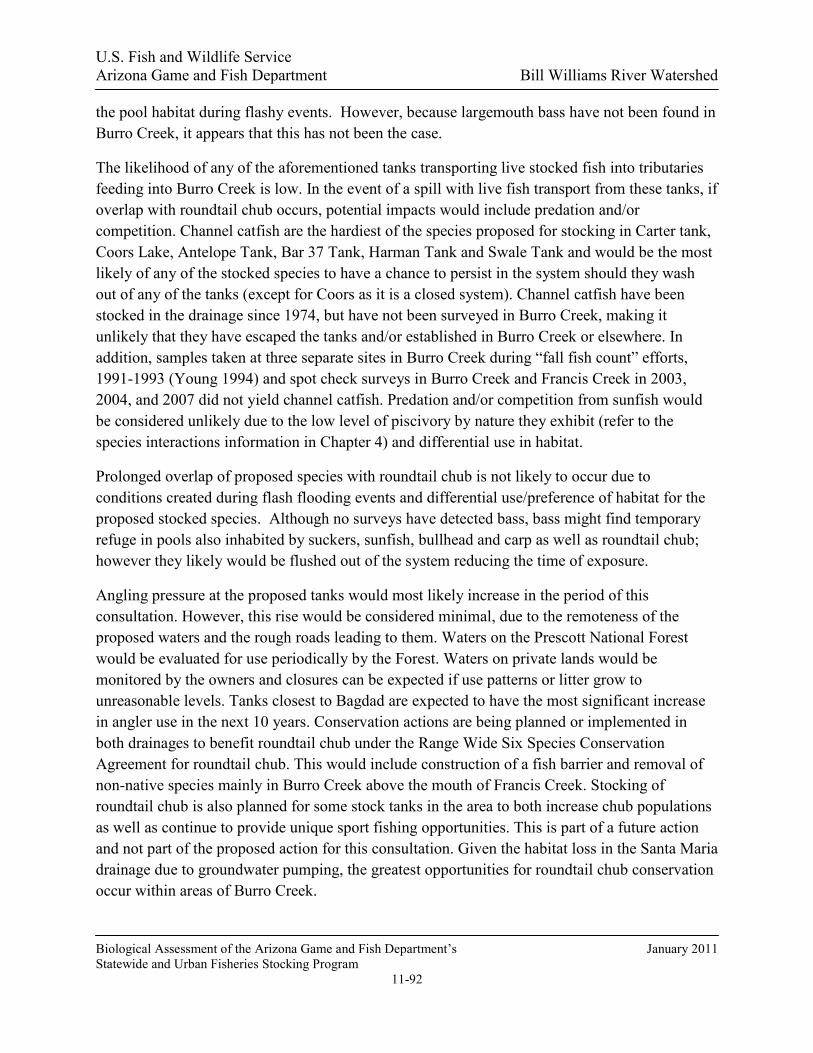
U.S. Fish and Wildlife Service Arizona Game and Fish Department Bill Williams River Watershed
Biological Assessment of the Arizona Game and Fish Department’s January 2011 Statewide and Urban Fisheries Stocking Program
11-92
the pool habitat during flashy events. However, because largemouth bass have not been found in Burro Creek, it appears that this has not been the case.
The likelihood of any of the aforementioned tanks transporting live stocked fish into tributaries feeding into Burro Creek is low. In the event of a spill with live fish transport from these tanks, if overlap with roundtail chub occurs, potential impacts would include predation and/or competition. Channel catfish are the hardiest of the species proposed for stocking in Carter tank, Coors Lake, Antelope Tank, Bar 37 Tank, Harman Tank and Swale Tank and would be the most likely of any of the stocked species to have a chance to persist in the system should they wash out of any of the tanks (except for Coors as it is a closed system). Channel catfish have been stocked in the drainage since 1974, but have not been surveyed in Burro Creek, making it unlikely that they have escaped the tanks and/or established in Burro Creek or elsewhere. In addition, samples taken at three separate sites in Burro Creek during “fall fish count” efforts, 1991-1993 (Young 1994) and spot check surveys in Burro Creek and Francis Creek in 2003, 2004, and 2007 did not yield channel catfish. Predation and/or competition from sunfish would be considered unlikely due to the low level of piscivory by nature they exhibit (refer to the species interactions information in Chapter 4) and differential use in habitat.
Prolonged overlap of proposed species with roundtail chub is not likely to occur due to conditions created during flash flooding events and differential use/preference of habitat for the proposed stocked species. Although no surveys have detected bass, bass might find temporary refuge in pools also inhabited by suckers, sunfish, bullhead and carp as well as roundtail chub; however they likely would be flushed out of the system reducing the time of exposure.
Angling pressure at the proposed tanks would most likely increase in the period of this consultation. However, this rise would be considered minimal, due to the remoteness of the proposed waters and the rough roads leading to them. Waters on the Prescott National Forest would be evaluated for use periodically by the Forest. Waters on private lands would be monitored by the owners and closures can be expected if use patterns or litter grow to unreasonable levels. Tanks closest to Bagdad are expected to have the most significant increase in angler use in the next 10 years. Conservation actions are being planned or implemented in both drainages to benefit roundtail chub under the Range Wide Six Species Conservation Agreement for roundtail chub. This would include construction of a fish barrier and removal of non-native species mainly in Burro Creek above the mouth of Francis Creek. Stocking of roundtail chub is also planned for some stock tanks in the area to both increase chub populations as well as continue to provide unique sport fishing opportunities. This is part of a future action and not part of the proposed action for this consultation. Given the habitat loss in the Santa Maria drainage due to groundwater pumping, the greatest opportunities for roundtail chub conservation occur within areas of Burro Creek.

U.S. Fish and Wildlife Service Arizona Game and Fish Department Bill Williams River Watershed
Biological Assessment of the Arizona Game and Fish Department’s January 2011 Statewide and Urban Fisheries Stocking Program
11-93
BILL WILLIAMS RIVER WATERSHED ANALYSIS Water distribution and connectivity, fish movement and community descriptions were previously discussed for the Santa Maria and Burro complexes above Alamo Lake. Downstream connectivity and potential for impacts below Alamo Dam are discussed below.
Water Connectivity / Distribution Proposed stocking sites in the watershed above Alamo Lake have the potential to contribute stocked fishes into the stream systems and for potential transport into Alamo Lake.
The intake elevation for the outlet works of Alamo Dam is located at 990 feet. The bottom of spillway is located at 1235 feet. Alamo Dam has never reached the spillway level (Figure 41). All releases have occurred through the three tandem slide gates (max discharge of 8715 cfs) or the low-flow bypass butterfly valve (max discharge of 112 cfs). That releases from Alamo Dam have never occurred through the spillway is supported by USGS gauge data from below Alamo Dam that show a discharge maximum at 7230 cfs in 2005 (Figure 42).
Between Alamo Dam and Lake Havasu, the Bill Williams is usually an interrupted perennial stream, containing dry reaches through the summers of many years. After wet winters with high releases from Alamo Dam, Planet Valley alluvium becomes saturated and the channel may remain wetted throughout the summer.
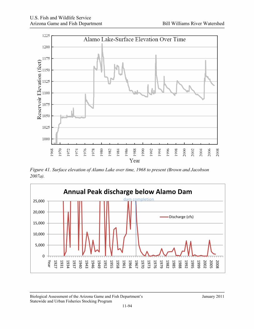
U.S. Fish and Wildlife Service Arizona Game and Fish Department Bill Williams River Watershed
Biological Assessment of the Arizona Game and Fish Department’s January 2011 Statewide and Urban Fisheries Stocking Program
11-94
Figure 41. Surface elevation of Alamo Lake over time, 1968 to present (Brown and Jacobson 2007a).
0
5,000
10,000
15,000
20,000
25,000Year
1927
1931
1934
1937
1940
1943
1946
1949
1952
1955
1958
1961
1964
1967
1970
1973
1976
1979
1982
1985
1988
1992
1995
1999
2002
2005
2008
Annual Peak discharge below Alamo Dam
Discharge (cfs)
dam completion
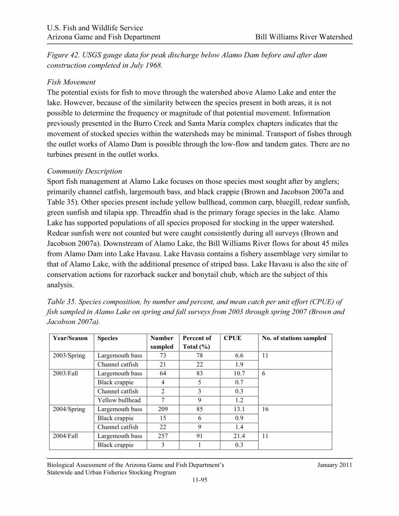
U.S. Fish and Wildlife Service Arizona Game and Fish Department Bill Williams River Watershed
Biological Assessment of the Arizona Game and Fish Department’s January 2011 Statewide and Urban Fisheries Stocking Program
11-95
Figure 42. USGS gauge data for peak discharge below Alamo Dam before and after dam construction completed in July 1968.
Fish Movement The potential exists for fish to move through the watershed above Alamo Lake and enter the lake. However, because of the similarity between the species present in both areas, it is not possible to determine the frequency or magnitude of that potential movement. Information previously presented in the Burro Creek and Santa Maria complex chapters indicates that the movement of stocked species within the watersheds may be minimal. Transport of fishes through the outlet works of Alamo Dam is possible through the low-flow and tandem gates. There are no turbines present in the outlet works.
Community Description Sport fish management at Alamo Lake focuses on those species most sought after by anglers; primarily channel catfish, largemouth bass, and black crappie (Brown and Jacobson 2007a and Table 35). Other species present include yellow bullhead, common carp, bluegill, redear sunfish, green sunfish and tilapia spp. Threadfin shad is the primary forage species in the lake. Alamo Lake has supported populations of all species proposed for stocking in the upper watershed. Redear sunfish were not counted but were caught consistently during all surveys (Brown and Jacobson 2007a). Downstream of Alamo Lake, the Bill Williams River flows for about 45 miles from Alamo Dam into Lake Havasu. Lake Havasu contains a fishery assemblage very similar to that of Alamo Lake, with the additional presence of striped bass. Lake Havasu is also the site of conservation actions for razorback sucker and bonytail chub, which are the subject of this analysis.
Table 35. Species composition, by number and percent, and mean catch per unit effort (CPUE) of fish sampled in Alamo Lake on spring and fall surveys from 2003 through spring 2007 (Brown and Jacobson 2007a).
Year/Season Species Number sampled
Percent of Total (%)
CPUE No. of stations sampled
2003/Spring
Largemouth bass 73 78 6.6 11 Channel catfish 21 22 1.9
2003/Fall
Largemouth bass 64 83 10.7 6 Black crappie 4 5 0.7 Channel catfish 2 3 0.3 Yellow bullhead 7 9 1.2
2004/Spring
Largemouth bass 209 85 13.1 16 Black crappie 15 6 0.9 Channel catfish 22 9 1.4
2004/Fall
Largemouth bass 257 91 21.4 11 Black crappie 3 1 0.3

U.S. Fish and Wildlife Service Arizona Game and Fish Department Bill Williams River Watershed
Biological Assessment of the Arizona Game and Fish Department’s January 2011 Statewide and Urban Fisheries Stocking Program
11-96
Year/Season Species Number sampled
Percent of Total (%)
CPUE No. of stations sampled
Channel catfish 21 7 1.8 2005/Spring
Largemouth bass 114 71 10.4 11 Black crappie 42 26 3.8 Channel catfish 4 3 0.4
2005/Fall
Largemouth bass 139 91 13.9 10 Black crappie 6 4 0.6 Channel catfish 7 5 0.7
2006/Spring
Largemouth bass 252 81 21.0 12 Black crappie 40 13 3.3 Channel catfish 21 7 1.8
2006/Fall
Largemouth bass 268 96 14.9 18 Black crappie 1 0 0.1 Channel catfish 7 3 0.4 Yellow bullhead 3 1 0.2
2007/Spring
Largemouth bass 272 82 20.9 13 Black crappie 20 6 1.5 Channel catfish 40 12 3.1 Yellow bullhead 1 0 0.1
Data available indicate the following species have been collected in the river below Alamo Dam since its construction: longfin dace, yellow bullhead, carp, red shiner, mosquitofish, roundtail chub, channel catfish, green sunfish, bluegill, redear sunfish and largemouth bass (AGFD data and Kansas State GAP data). However, roundtail chub and longfin dace have not been collected since before 1980.
Lake Havasu has produced the following species during past surveys according to the Kansas State Aquatic GAP database: brown bullhead, yellow bullhead, carp, threadfin shad, mosquitofish, bonytail, channel catfish, green sunfish, bluegill, redear sunfish, smallmouth bass, largemouth bass, striped bass, rainbow trout, white crappie, black crappie, Colorado pikeminnow (now extirpated), flathead catfish and razorback sucker. Brown and Jacobson (2007b; Table 36) provide more recent information on electrofishing surveys in Lake Havasu.
Table 36. Species composition, by number and percent, and mean catch per unit effort (CPUE), of fish sampled by electrofishing in Lake Havasu from fall 2003 through fall 2006. One unit of effort is 900 seconds of electrofishing (Brown and Jacobson 2007b).
Season-Year Species Number
sampled Percent of Total (%)
CPUE No. of stations sampled
Fall-2003 Largemouth bass 94 86 7.8 12

U.S. Fish and Wildlife Service Arizona Game and Fish Department Bill Williams River Watershed
Biological Assessment of the Arizona Game and Fish Department’s January 2011 Statewide and Urban Fisheries Stocking Program
11-97
Season-Year Species Number sampled
Percent of Total (%)
CPUE No. of stations sampled
Smallmouth bass 13 12 1.9 Bonytail chub 2 2 0.1
Spring-2005
Largemouth bass 156 10 2.9 54 Bluegill 390 24 7.2 Redear sunfish 403 25 7.5 Green sunfish 282 17 5.2 Warmouth 3 0 0.1 Channel catfish 17 1 0.3 Flathead catfish 13 1 0.2 Striped bass 187 12 3.5 Carp 89 6 1.6 Goldfish 8 0 0.1 Yellow bullhead 3 0 0.1 Smallmouth bass 64 4 1.2
Fall-2005
Largemouth bass 139 37 3.9 36 (Striped bass collected at only 18 stations) Channel catfish 28 7 0.8
Flathead catfish 1 0 0.03 Striped bass 128 34 7.1 Smallmouth bass 82 22 2.3
Spring -2006
Channel catfish 2 12 0.2 10 Flathead catfish 15 88 1.5
Fall-2006
Largemouth bass 141 20 3.9 36 Black crappie 1 0 0.03 Channel catfish 11 2 0.3 Flathead catfish 9 1 0.3 Striped bass 492 70 13.7 Smallmouth bass 52 7 1.4
Consultation Species or Critical Habitat Potential impacts from the proposed action to candidate and listed species are described below. Please refer to Chapter 4 for a detailed description of the nature of the impacts (which may include predation, competition for space and food, and hybridization etc.). Subsequent responses (resulting from the frequency, magnitude and duration of the impacts) between proposed stocked and candidate and listed species, and any site or complex factors that provide context for determining the meaningfulness of the impacts, are discussed below. Impacts from the proposed action resulting from angler related recreation and/or potential introduction of disease, pathogen or invasive species are evaluated at a broad scale for the entire action area and are described in Chapter 4. If potential impacts specific to a stocking site or complex have been identified they are discussed below.
Razorback sucker

U.S. Fish and Wildlife Service Arizona Game and Fish Department Bill Williams River Watershed
Biological Assessment of the Arizona Game and Fish Department’s January 2011 Statewide and Urban Fisheries Stocking Program
11-98
Razorback sucker are currently stocked directly into Lake Havasu as part of the Lower Colorado River MSCP. They are found periodically throughout the reservoir, including the Bill Williams River arm and inflow area.
Potential Impacts
If fishes stocked in the watershed upstream of Alamo Lake are able to traverse (in one flow event or through periodic and episodic events) the distance to Alamo Lake, they become indistinguishable from the existing populations of those species resident in the lake. Their incremental addition to the assemblage is not likely to contribute to the existing assemblage in any meaningful way because the warm water assemblage that exists in Alamo Lake is already self sustaining and not dependent upon the addition of fish from upstream.
If water releases through the outlet works of Alamo Dam allow stocked fish or their progeny to pass through, they could traverse the 45 miles of river channel into Lake Havasu, where they would be indistinguishable from the existing populations of those species resident in that lake . The incremental increase to the already present assemblage would not have a meaningful impact because the warm water assemblage that exists in Lake Havasu is already self sustaining and not dependent upon the addition of fish from upstream. The Bill Williams River is not perennial between the dam and Lake Havasu, generally drying in the Planet Valley most summers. The stocking of razorback sucker into Lake Havasu is an ongoing conservation action taken with the fore-knowledge that it is occupied by a diverse, abundant and thriving community of non-native predatory and competitor fishes. Any potential impact from stocking in the upstream watershed would not be measurable or meaningfully detectable.
Bonytail chub Bonytail chub are currently stocked directly into Lake Havasu as part of the Lower Colorado River MSCP. They are found periodically throughout the reservoir, including the Bill Williams arm and inflow area.
Potential Impacts
If fishes stocked in the watershed upstream of Alamo Lake are able to traverse (in one flow event or through periodic and episodic events) the distance to Alamo Lake, they become indistinguishable from the existing populations of those species resident in the lake and their incremental addition to the assemblage is not likely to contribute to the existing assemblage in any meaningful way because the warm water assemblage that exists in Alamo Lake is already self sustaining and not dependent upon the addition of fish from upstream.
If water releases through the outlet works of Alamo Dam allow stocked fish or their progeny to pass through, they could traverse the 45 miles of river channel into Lake Havasu, where they
U.S. Fish and Wildlife Service Arizona Game and Fish Department Bill Williams River Watershed
Biological Assessment of the Arizona Game and Fish Department’s January 2011 Statewide and Urban Fisheries Stocking Program
11-99
would be indistinguishable from the existing populations of those species resident in that lake . The incremental increase to the already present assemblage would not have a meaningful impact because the warm water assemblage that exists in Lake Havasu is already self sustaining and not dependent upon the addition of fish from upstream. The Bill Williams River is not perennial between the dam and Lake Havasu, generally drying in the Planet Valley most summers. The stocking of bonytail chub into Lake Havasu is an ongoing conservation action taken with the fore-knowledge that it is occupied by a diverse, abundant and thriving community of non-native predatory and competitor fishes. Any potential impact from stocking in the upstream watershed would not be measurable or meaningfully detectable.