Chapter 11 Airports, Routes, and Practice Areas Table of ... · Aviation Operations Manual 10/2013...
10
Aviation Operations Manual 10/2013 (REV V) Chapter 11 Airports, Routes, and Practice Areas 1 For Training Purposes Only Chapter 11 Airports, Routes, and Practice Areas Table of Contents New Bedford Approved Training Airports ......................................................................................2 Airports less than 50 NM from New Bedford Regional ..................................................................3 Airports greater than 50 NM but less than 100 NM from New Bedford Regional .........................4 Airports greater than 100 NM but less than 250 NM from New Bedford Regional .......................5 Airports greater than 250 NM from New Bedford Regional ...........................................................7 Approved Refueling Stations ...........................................................................................................8 Practice Areas ..................................................................................................................................8 Practice Area Diagram .....................................................................................................................9 Position Reporting Points ..............................................................................................................10
Transcript of Chapter 11 Airports, Routes, and Practice Areas Table of ... · Aviation Operations Manual 10/2013...

Aviation Operations Manual
10/2013 (REV V) Chapter 11 Airports, Routes, and Practice Areas 1
For Training Purposes Only
Chapter 11
Airports, Routes, and Practice Areas
Table of Contents
New Bedford Approved Training Airports ......................................................................................2
Airports less than 50 NM from New Bedford Regional ..................................................................3
Airports greater than 50 NM but less than 100 NM from New Bedford Regional .........................4
Airports greater than 100 NM but less than 250 NM from New Bedford Regional .......................5
Airports greater than 250 NM from New Bedford Regional ...........................................................7
Approved Refueling Stations ...........................................................................................................8
Practice Areas ..................................................................................................................................8
Practice Area Diagram .....................................................................................................................9
Position Reporting Points ..............................................................................................................10

Aviation Operations Manual
10/2013 (REV V) Chapter 11 Airports, Routes and Practice Areas 2
For Training Purposes Only
New Bedford
Approved Training Airports
Bridgewater State University aircraft may only operate to/from airports approved by the Director
of Operations in consultation with the Chief Instructor.
The following lists contain approved airports located at distances:
Less than 50nm from New Bedford Regional
Greater than 50nm, but less than 100nm from New Bedford Regional
Greater than 100nm, but less than 250nm from New Bedford Regional
Greater than 250nm from New Bedford Regional
Information is included to assist pilots in effectively planning for each required cross-country.
Information is presented in the following areas:
City.
Airport.
Identifier.
Distance (in nautical miles).
IAP (Instrument Approach Procedure availability, by type).
Determination of approved airports is based on the following criteria:
Runway condition known to be good or better.
Runway surface paved (solo flights), grass or soft surface (dual flights only).
Open for public use, with no known restrictions for small GA aircraft operations.
Full service fueling available, at least one FBO available at the airport.
NOTE
BSU pilots must receive prior authorization for flights greater than 400 NM from KEWB.

Aviation Operations Manual
10/2013 (REV V) Chapter 11 Airports, Routes, and Practice Areas 3
For Training Purposes Only
AIRPORTS LESS THAN 50 NM FROM NEW BEDFORD REGIONAL
CITY AIRPORT IDENT DIST IAP
Taunton, MA Taunton Municipal (TAN) 12NM NP, G
Newport, RI Newport State (UUU) 16NM NP, G
Plymouth, MA Plymouth Municipal (PYM) 17NM P, NP, G
Warwick, RI TF Green State (PVD) 21NM P, NP, G
North Kingstown, RI Quonset State (OQU) 21NM P, NP, G
Mansfield, MA Mansfield Municipal (1B9) 22NM NP, G
Vineyard Haven, MA Martha’s Vineyard (MVY) 22NM P, NP, G
Marshfield, MA Marshfield Muni/G. Harlowe (GHG) 28NM NP, G
Smithfield, RI North Central State (SFZ) 28NM NP, G
Hyannis, MA Barnstable Municipal (HYA) 30NM P, NP, G
Norwood, MA Norwood Memorial (OWD) 32NM NP, G
Provincetown, MA Provincetown Municipal (PVC)~ 40NM P, NP, G
Boston, MA Gen. Lawrence Logan Intl. (BOS) 41NM NP, P, G
Westerly, RI Westerly State (WST) 42NM NP, G
Chatham, MA Chatham Municipal (CQX)~ 43NM NP, G
Nantucket, MA Nantucket Memorial (ACK) 47NM P, NP, G
Bedford, MA Laurence G Hanscom Field (BED) 49NM P, NP, G
KEY
* Use of TRSA services recommended.
~ Aircraft must stay within power-off gliding distance of shore while enroute to this airport.
NP Non-Precision Approach Available
P Precision Approach Available
G GPS Approach Available
NA No Instrument Approach Procedures Available

Aviation Operations Manual
10/2013 (REV V) Chapter 11 Airports, Routes and Practice Areas 4
For Training Purposes Only
AIRPORTS GREATER THAN 50 NM BUT LESS THAN 100 NM
FROM NEW BEDFORD REGIONAL
CITY AIRPORT IDENT DIST IAP
Groton, CT Groton New-London (GON) 53NM P, NP, G
Worcester, MA Worcester Regional (ORH) 54NM P, NP, G
Beverly, MA Beverly Municipal (BVY) 54NM NP, G
Southbridge, MA Southbridge Municipal (3B0) 54NM NP, G
Willimantic, CT Windham (IJD) 54NM NP, G
Lawrence, MA Lawrence Municipal (LWM) 62NM P, NP, G
Fitchburg, MA Fitchburg Municipal (FIT) 63NM NP, G
Nashua, NH Boire Field (ASH) 70NM P, NP, G
East Hampton, NY East Hampton (HTO)~ 72NM NP, G
Hartford, CT Hartford-Brainard (HFD) 75NM NP, G
Springfield, MA Westover ARB/Metropolitan (CEF) 77NM P, NP
Manchester, NH Manchester (MHT) 78NM P, NP, G
Westfield, MA Barnes Municipal (BAF) 83NM P, NP, G
Portsmouth, NH Pease Intl. Tradeport (PSM) 84NM P, NP, G
Plainville, CT Robertson Field (4B8) 85NM NA
New Haven, CT Tweed - New Haven (HVN) 90NM P, NP, G
Westhmptn Bch, NY Francis S Gabreski (FOK) 90NM P, NP, G
Keene, NH Dillant-Hopkins (EEN) 93NM P, NP, G
Concord, NH Concord Municipal (CON) 94NM P, NP, G
Oxford, CT Waterbury-Oxford (OXC) 98NM P, NP, G
Shirley, NY Brookhaven (HWV) 100NM P, NP, G
KEY
* Use of TRSA services recommended.
~ Aircraft must stay within power-off gliding distance of shore while enroute to this airport.
NP Non-Precision Approach Available
P Precision Approach Available
G GPS Approach Available
NA No Instrument Approach Procedures Available

Aviation Operations Manual
10/2013 (REV V) Chapter 11 Airports, Routes, and Practice Areas 5
For Training Purposes Only
AIRPORTS GREATER THAN 100 NM BUT LESS THAN 250 NM
FROM NEW BEDFORD REGIONAL
CITY AIRPORT IDENT DIST IAP Bridgeport, CT Igor I Sikorsky Memorial (BDR) 102NM P, NP, G
Sanford, ME Sanford Regional (SFM) 103NM P, NP, G
Islip, NY Long Island MacArthur (ISP) 110NM P, NP, G
Danbury, CT Danbury Municipal (DXR) 114NM NP, G
Portland, ME Portland Intl. (PWM) 121NM P, NP, G
Farmingdale, NY Republic (FRG) 124NM P, NP, G
Hudson, NY Columbia County (1B1) 128NM NP, G
White Plains, NY Westchester County (HPN) 129NM P, NP, G
Lebanon, NH Lebanon Municipal (LEB) 131NM P, NP, G
Poughkeepsie, NY Dutchess County (POU) 131NM P, NP, G
Newburgh, NY Stewart Intl. (SWF) 141NM P, NP, G
Rutland, VT Rutland-Southern VT Reg. (RUT) 141NM NP, G
Albany, NY Albany Intl. (ALB) 141NM P, NP, G
Auburn, ME Auburn/Lewiston Muni. (LEW) 145NM P, NP, G
Teterboro, NJ Teterboro (TEB) 148NM P, NP, G
Montgomery, NY Orange County (MGJ) 148NM P, NP, G
Schenectady, NY Schenectady County (SCH) 149NM P, NP, G
Saratoga Springs, NY Saratoga County (5B2) 152NM NP, G
Glens Falls, NY Floyd Bennett Memorial (GFL) 154NM P, G
Caldwell, NJ Essex County (CDW) 157NM NP, G
Morristown, NJ Morristown Municipal (MMU) 164NM P, NP, G
Monticello, NY Sullivan County Intl (MSV) 172NM P, NP, G
Burlington, VT Burlington Intl (BTV) 193NM P, NP, G
Lake Placid, NY Lake Placid (LKP) 203NM G
Philadelphia, PA Northeast Philadelphia (PNE) 207NM P, NP, G
Bangor, ME Bangor Intl. (BGR) 209NM P, NP, G
Allentown, PA Lehigh Valley Intl. (ABE) 211NM P, NP, G
Atlantic City, NJ Atlantic City Intl. (ACY) 212NM P, NP, G
Wilkes-Barre, PA Wilkes-Barre Intl (AVP)* 215NM P, NP, G

Aviation Operations Manual
10/2013 (REV V) Chapter 11 Airports, Routes and Practice Areas 6
For Training Purposes Only
AIRPORTS GREATER THAN 100 NM BUT LESS THAN 250 NM
FROM NEW BEDFORD REGIONAL, CONTINUED
CITY AIRPORT IDENT DIST IAP
Allentown, PA Allentown Queen City Muni. (XLL) 215NM NP, G
Philadelphia, PA Wings Field (LOM) 216NM G
Hamilton, NY Hamilton Municipal (VGC) 216NM NP, G
Ithaca, NY Ithaca Tompkins Regional (ITH) 249NM P, NP, G
Saranac Lake, NY Adirondack Regional (SLK) 216NM P, NP, G
Binghamton, NY Greater Binghamton (BGM)* 226NM P, NP, G
Millville, NJ Millville Municipal (MIV) 233NM P, NP, G
Reading, PA Reading Regional (RDG) 239NM P, NP, G
Wilmington, DE New Castle (ILG) 243NM P, NP, G
Syracuse, NY Syracuse Hancock Intl. (SYR) 243NM P, NP, G
Coatesville, PA Chester Co GO Carlson (MQS) 245NM P, NP, G
KEY
* Use of TRSA services recommended.
~ Aircraft must stay within power-off gliding distance of shore while enroute to this airport.
NP Non-Precision Approach Available
P Precision Approach Available
G GPS Approach Available
NA No Instrument Approach Procedures Available

Aviation Operations Manual
10/2013 (REV V) Chapter 11 Airports, Routes, and Practice Areas 7
For Training Purposes Only
AIRPORTS GREATER THAN 250 NM FROM
NEW BEDFORD REGIONAL
CITY AIRPORT IDENT DIST IAP
Pottsville, Pa Schuylkill County (ZER) 251NM NP, G
Middletown, DE Summit (EVY) 252NM NP, G
Massena, NY Massena Intl. (MSS) 258NM P, NP, G
Lancaster, PA Lancaster (LNS) 259NM P, NP, G
Watertown, NY Watertown Intl (ART) 262NM P, NP, G
Elmira/Corning, NY Elmira/Corning Regional (ELM) 266NM P, NP, G
Ogdensburg, NY Ogdensburg Intl (OGS) 267NM NP, G
Williamsport, PA Williamsport Regional (IPT) 269NM P only
Georgetown, DE Sussex County (GED) 269NM NP, G
Selinsgrove, PA Penn Valley (SEG) 271NM NP, G
Penn Yan, NY Penn Yan (PEO) 277NM NP, G
Ocean City, MD Ocean City Municipal (OXB) 278NM NP, G
Harrisburg, PA Capitol City (CXY)* 281NM P, NP, G
Easton, MD Easton/Newnam Field (ESN) 290NM P, NP, G
Canandaigua, NY Canandaigua (D38) 291NM NP, G
Cambridge, MD Cambridge-Dorchester (CGE) 299NM NP, G
KEY
* Use of TRSA services recommended.
~ Aircraft must stay within power-off gliding distance of shore while enroute to this airport.
NP Non-Precision Approach Available
P Precision Approach Available
G GPS Approach Available
NA No Instrument Approach Procedures Available

Aviation Operations Manual
10/2013 (REV V) Chapter 11 Airports, Routes and Practice Areas 8
For Training Purposes Only
Approved Refueling Stations BSU pilots may purchase fuel from any Fixed Base Operator (FBO) that will accept the BSU
credit card used for this purpose. As an element of their pre-flight planning, pilots are
responsible for determining available refueling stops and FBO hours of operation along their
intended route. Pilots attempting to refuel at any location other than New Bedford Regional
Airport must present a proper Bridgewater State University photo identification, and must retain
the fuel receipt. Any and all fuel receipt(s) must be turned over to BSU Dispatch upon return to
the BSU Aviation Training Center.
WARNING
BSU aircraft may aircraft may NOT exceed 3.0 HOBBS time between refueling.
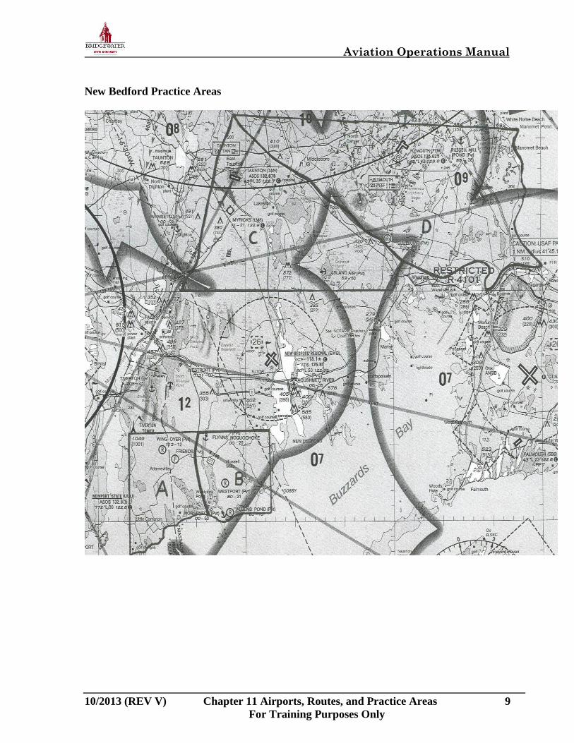
Practice Areas
Flight training lessons will normally take place within the boundaries of the, ALPHA, BRAVO,
CHARLIE, and DELTA practice areas (see Practice Areas chart on following page).
CAUTION
ALPHA and BRAVO practice area operations below 1,500’ AGL are PROHIBITED.
Aviation Operations Manual
10/2013 (REV V) Chapter 11 Airports, Routes, and Practice Areas 9
For Training Purposes Only
New Bedford Practice Areas

Aviation Operations Manual
10/2013 (REV V) Chapter 11 Airports, Routes and Practice Areas 10
For Training Purposes Only
Prominent Position Reporting Points
ALPHA Practice Area
Tiverton Tower
West Branch Westport River
Sakonnet Point
Intersection of Horseneck Beach and Route-88
Little Compton
BRAVO Practice Area
East Branch Westport River
Slocums River (north)
Slocums River (south)
Apponagansett Bay (west shoreline)
Westport Airfield
CHARLIE Practice Area
Fall River
Long Pond
Taunton (includes Taunton Airport)
Intersection of Route 24 & I-495
Snipatuit Pond
DELTA Practice Area
I-495 (report north or south of)
Manomet Point
Plymouth (includes Plymouth Airport)
Cape Cod Canal
Intersection of I-195 & I-495
Sample Position Report:
“CHARLIE practice area, N407BW is over 140 south of Taunton; 3000 ft., maneuvers.”
CAUTION
Pilots shall use frequency 123.50 MHz, if appropriate, while in the practice areas.
WARNING
PILOTS ARE ALWAYS RESPONSIBLE FOR EXERCISING
COLLISION AVOIDANCE PROCEDURES.