CHAPTER 10: TRANSPORTATION - Home - County … · CHAPTER 10: TRANSPORTATION Adopted August 11,...
34
Adopted August 11, 2009 Henrico County Vision 2026 Comprehensive Plan | 203 CHAPTER 10: TRANSPORTATION OVERVIEW A good county transportation network plays a critical role in the ability to travel in a safe manner, promoting the local economy and minimizing traffic congestion. A good transportation network also offers multiple modes or options for transportation including, but not limited to, walking, bicycling, bus services and automotive travel. Henrico County’s transportation system is proactively planned, and improvements typically are timed to occur as land development creates the need for increased access and mobility. System management of the supply and demand for transportation is essential. This chapter addresses travel by automobile, walking, cycling, bus, train and airplane. The public rights-of-way within the county’s road network are shared by motorists, pedestrians, cyclists and bus riders. Henrico County is responsible for the roadways within its jurisdiction with the exception of State routes and interstates. As a result, the county’s Department of Public Works oversees that all engineering, construction and maintenance of roads, sidewalks and transit service adheres to the acceptable standards with the efficient use of capital expenditures. This chapter provides general guidance for decisions affecting the county’s transportation system and resources and briefly details the county’s new regional travel demand model developed as part of the Comprehensive Plan. TRAVEL MODES The following section describes the travel modes in Henrico County and provides policy guidance for future decisions. PEDESTRIANS Safe pedestrian facilities are an important component to the county’s overall transportation network. Within developed areas, residents use existing sidewalks and trails for recreation and travel. The recommendations contained in Chapter 5: Land Use encourage the development of Mixed-Use town centers and other forms of Mixed-Use development which promote pedestrian movement. Pedestrian activity typically is greater in these types of developments because distances between origins and destinations tend to be shorter. The Zoning and Subdivision Ordinances will be amended to promote high-quality, diverse land use patterns including Mixed-Use town centers, Traditional Neighborhood Developments (TND), and villages, all of which are pedestrian-friendly. The 2004 Richmond Regional Bicycle and Pedestrian Plan, a VDOT-funded regional study of potential bicycle and pedestrian routes, demonstrated strong public interest in walking in Henrico County.
Transcript of CHAPTER 10: TRANSPORTATION - Home - County … · CHAPTER 10: TRANSPORTATION Adopted August 11,...

Adopted August 11, 2009 Henrico County Vision 2026 Comprehensive Plan | 203
CHAPTER 10: TRANSPORTATION
OVERVIEW A good county transportation network plays a critical role in the ability to travel in a safe manner, promoting the local economy and minimizing traffic congestion. A good transportation network also offers multiple modes or options for transportation including, but not limited to, walking, bicycling, bus services and automotive travel. Henrico County’s transportation system is proactively planned, and improvements typically are timed to occur as land development creates the need for increased access and mobility. System management of the supply and demand for transportation is essential.
This chapter addresses travel by automobile, walking, cycling, bus, train and airplane. The public rights-of-way within the county’s road network are shared by motorists, pedestrians, cyclists and bus riders. Henrico County is responsible for the roadways within its jurisdiction with the exception of State routes and interstates. As a result, the county’s Department of Public Works oversees that all engineering, construction and maintenance of roads, sidewalks and transit service adheres to the acceptable standards with the efficient use of capital expenditures. This chapter provides general guidance for decisions affecting the county’s transportation system and resources and briefly details the county’s new regional travel demand model developed as part of the Comprehensive Plan.
TRAVEL MODES The following section describes the travel modes in Henrico County and provides policy guidance for future decisions.
PEDESTRIANS Safe pedestrian facilities are an important component to the county’s overall transportation network. Within developed areas, residents use existing sidewalks and trails for recreation and travel. The recommendations contained in Chapter 5: Land Use encourage the development of Mixed-Use town centers and other forms of Mixed-Use development which promote pedestrian movement. Pedestrian activity typically is greater in these types of developments because distances between origins and destinations tend to be shorter. The Zoning and Subdivision Ordinances will be amended to promote high-quality, diverse land use patterns including Mixed-Use town centers, Traditional Neighborhood Developments (TND), and villages, all of which are pedestrian-friendly. The 2004 Richmond Regional Bicycle and Pedestrian Plan, a VDOT-funded regional study of potential bicycle and pedestrian routes, demonstrated strong public interest in walking in Henrico County.

CHAPTER 10: TRANSPORTATION
Adopted August 11, 2009 Henrico County Vision 2026 Comprehensive Plan | 204
Pedestrian Facility Policies The following policies should guide the provision of pedestrian travel:
1. Encourage new developments to install sidewalks and other pedestrian facilities. Connections to other neighborhoods and key destinations such as schools, libraries, parks, etc., are also encouraged.
2. Require sidewalks and other pedestrian pathways along all new and reconstructed major thoroughfares (see Major Thoroughfare Plan Map) excluding interstate highways and other controlled-access roads.
BICYCLES The 2004 Richmond Regional Bicycle and Pedestrian Plan demonstrated strong public interest in bicycling in Henrico County. A variety of facility types to accommodate bicycle traffic were highlighted, ranging from wider lanes on roadways to striped bicycle lanes and off-road trails and bikeways. The location of signed bike routes and the proposed Capital to Capital Trail are shown on the Bicycle Map. It is recognized that the county’s four-lane, median-divided roads can be used by advanced bicyclists adept at riding with vehicular traffic; however, less experienced cyclists may find these roadways difficult to travel. The county’s extensive recreation and parks areas may be appropriate for less experienced bicyclists including families with children. Serving citizens with intermediate bicycling capabilities and providing routes for alternative modes of travel should be examined by the county.
Bicycle Facility Policies The following Policies should guide the provision of bicycle facilities in the county.
1. Facilitate bicycle travel along all planned and existing designated, long-distance bicycle routes in the county (Rtes 1, 76 and VA Capital to Capital Trail) through use of signage, shared lanes, bike lanes and shared use paths.
2. Consider the accommodation of bicycles in the planning and design of all major road projects where feasible.
3. Encourage bicycle accommodations in conjunction with new development.
4. Consider the development of a county-wide bicycle plan in order to
identify and evaluate potential locations for bicycle facilities.

CHAPTER 10: TRANSPORTATION
Adopted August 11, 2009 Henrico County Vision 2026 Comprehensive Plan | 205
BICYCLE ROUTES MAP

CHAPTER 10: TRANSPORTATION
Adopted August 11, 2009 Henrico County Vision 2026 Comprehensive Plan | 206

CHAPTER 10: TRANSPORTATION
Adopted August 11, 2009 Henrico County Vision 2026 Comprehensive Plan | 207
BUS SERVICE Public transportation in Henrico County is provided by the Greater Richmond Transit Company (GRTC) which has regularly scheduled stops along major routes. GRTC also provides express service for commuters into and out of Richmond. County services operate Monday through Friday 6:00 a.m. to 7:00 p.m. GRTC’s specialized transportation for the disabled provides curb-to-curb service from 6:00 a.m. to 11:30 p.m., seven (7) days a week.
GRTC operates nine (9) local routes in Henrico County, and provides access to the City of Richmond. The bus system includes:
• The two (2) Orange Routes generally follow W. Broad Street west from Richmond City Hall to Pemberton and Staples Mill Roads. One route ends at Westpark Shopping Center and the other near Parham Road at the Henrico Government Center.
• The Black Route, north of Richmond, offers access from central Richmond via Hermitage and Brook Roads and Chamberlayne Avenue to Grammarcy Circle and Azalea Avenue to Pony Farm Drive.
• The four (4) Purple Routes, serving the eastern portion of the county, generally follow Nine Mile Road to the Airport and Williamsburg and Darbytown Roads as well as the Mechanicsville Turnpike/Central Gardens area and Laburnum Avenue.
• The two (2) Blue Routes serve the western areas of the county, generally following Three Chopt Road to Regency Square Mall and Monument Avenue to St. Mary’s Hospital.
• Additional Blue and Green Routes serve the central Richmond area and south of the James River.
• Express buses serve four (4) park-and-ride facilities and provide peak hour transit service for commuters to and from downtown Richmond. Curb-to-curb para-transit service is also provided for qualified county residents who are unable to use the fixed-route services. The Bus Service and Park-and-Ride Facilities Map illustrates the current bus routes and park-and-ride facilities.
Bus Service Policies The following policy should guide the provision of bus service in the county.
1. Continue to monitor citizen satisfaction with GRTC service and ensure a bus system that provides adequate service to the residents of the county.

CHAPTER 10: TRANSPORTATION
Adopted August 11, 2009 Henrico County Vision 2026 Comprehensive Plan | 208

CHAPTER 10: TRANSPORTATION
Adopted August 11, 2009 Henrico County Vision 2026 Comprehensive Plan | 209
BUS SERVICE & PARK AND RIDE FACILITIES MAP

CHAPTER 10: TRANSPORTATION
Adopted August 11, 2009 Henrico County Vision 2026 Comprehensive Plan | 210

CHAPTER 10: TRANSPORTATION
Adopted August 11, 2009 Henrico County Vision 2026 Comprehensive Plan | 211
PASSENGER TRAIN SERVICE The Staples Mill Amtrak station is located about a quarter of a mile north of the intersection of Glenside Drive and Staples Mill Road and is one (1) of three (3) stations serving the Richmond metropolitan area, providing access to the national Amtrak network.
A study of alternatives and the environmental consequences of implementing passenger light rail transit service in an exclusive right-of-way in the Richmond region was completed in June 2003 by the Richmond Metropolitan Planning Organization (MPO). Candidate corridors favored by a regional transit study group included two (2) routes, which could be combined into one interlined transit route. These are:
1. Short Pump Route – Using either (or both) W. Broad Street or the edge of I-64, passenger rail service would travel about fourteen (14) miles to connect the Short Pump area near the interchange of I-64 and I-295 with downtown Richmond’s Main Street Station and points in between. Envisioned to serve growth around and west of Short Pump, it is possible the true benefit could be realized along the W. Broad Street areas of the City of Richmond and Henrico County. This route would support redevelopment of properties as private property owners compete with newer commercial and Mixed-Use developments in outlying areas. The study forecasted ridership of more than 30,000 people per weekday.
2. Airport Route – Using one (1) of four (4) alternate routes, passenger rail service would travel about seven (7) miles to connect Main Street Station in downtown Richmond with Richmond International Airport. The potential exists to serve Henrico neighborhoods that lie between the airport and downtown; however, the primary objective of moving airport passengers to and from downtown rapidly would be diminished with each additional train stop. Alternate alignments studied included the use of the following general corridors: Nine Mile Road, Williamsburg Road and the CSX railroad just south of the airport property.
Passenger Train Service Policies The following policies should guide the provision of rail services in the county.
1. Participate in regional efforts to monitor and evaluate the potential demand for passenger train and light rail service within the county pursuant to regional studies and encourage service that benefits the general welfare of county residents and businesses.
2. Consider potential station locations in the design of Mixed-Use developments particularly in areas where preferred routes have been identified.
CHAPTER 10: TRANSPORTATION
Adopted August 11, 2009 Henrico County Vision 2026 Comprehensive Plan | 212
RAIL CARGO SERVICE Two (2) major railroad companies operate in Henrico County: CSX and Norfolk Southern (NS). CSX maintains Acca Yard as its primary facility with approximately twenty (20) tracks providing such freight services as classification, bulk transfer, rail car maintenance, industrial switching and staging. Many of the rail shipments along the Acca Yard rail lines are coal, which is primarily moving through the region and is not an origin or destination commodity.
Acca Yard is physically constrained and expansion would be costly. A regional need has been identified for an intermodal (rail-truck) transfer facility in the Richmond Area Metropolitan Planning Organization’s 2026 Long-Range Transportation Plan (LRTP). Acca Yard was one (1) of seven (7) sites considered for an intermodal transfer facility, but the cost to obtain the necessary land for expansion was prohibitively high. In addition, Acca Yard is one of the most congested facilities on the east coast and Norfolk Southern does not operate at the yard.
CSX also has rail sidings and spurs at the Richmond International Airport. Generally, CSX operations are intended to serve north-south corridors while Norfolk Southern services east-west corridors.
Rail Cargo Service Policies The following policy should guide the provision of cargo rail service in the county.
1. Continue to participate in regional efforts to evaluate potential investments of State and Federal funds to improve rail cargo facilities in the region and encourage service that benefits the general welfare of county residents and businesses.
AIR TRAVEL SERVICE Richmond International Airport (RIC) is located in eastern Henrico County and serves Central Virginia's air transportation needs by providing passenger and air cargo service. The airport’s location is easily accessible via I-64, I-295 and Route 60 with future plans to provide more direct access to Route 895.
The airport is owned and operated by the Capital Region Airport Commission, a political subdivision of the Commonwealth of Virginia, whose governing board consists of fourteen (14) members appointed by the City of Richmond and the Counties of Henrico, Chesterfield and Hanover. The airport master plan was amended in 1999, and is currently in the process of being updated. This facility can accommodate additional commercial airline operations with available gates, ticketing areas and airfield capacity.
The airport has recently completed a major capital improvement program which included: a concourse expansion; the addition of ten (10) new airline gates; the construction of a two-level terminal curbside and the renovation of the terminal building to provide for separate arrival and departure levels; the construction of a new Federal Aviation Administration (FAA) air traffic control tower; and the construction of additional parking facilities, including garages. Construction is currently underway to improve Airport Drive to a four (4) lane divided roadway on airport property from Clarkson Road

CHAPTER 10: TRANSPORTATION
Adopted August 11, 2009 Henrico County Vision 2026 Comprehensive Plan | 213
to Charles City Road in addition to providing improved access to the terminal building from Airport Drive.
RIC is the gateway for Virginia’s Capital Region, with annual passenger traffic volume exceeding 3.6 million in 2007. Nine (9) airlines offer approximately two-hundred (200) daily non-stop flights between Richmond and twenty-two (22) domestic destinations.
Air Travel Service Policies The following policies should guide the provision of air travel service in the county.
1. Continue to have representation on the Capital Region Airport Commission.
2. Monitor and regulate land use and zoning in areas near the airport for compatibility in order to support current and future operations.
ROAD FACILITIES The Department of Public Works currently maintains eighty percent (80%) of the county’s roadway lane-miles, while the Virginia Department of Transportation (VDOT) maintains the other twenty percent (20%). With such a high percentage of roads under its management, the county recognizes its responsibility to efficiently move large volumes of traffic and provide integrated inter-county and intra-county mobility. This responsibility provides opportunities to create a well-designed road network contributing to the county’s identity and high quality of life. The county also seeks to protect valuable historic, natural and cultural resources from incompatible transportation improvements through sensitive project design that respects or incorporates the resources responsibly.
Henrico County uses a variety of techniques to successfully manage both safety and efficiency along high-volume, multi-lane roads. These techniques include: the strategic review of driveway locations; frequent use of raised-curb medians; and a traffic monitoring approach that measures congestion, referred to as level of service. The county also intends to improve traffic flow along select arterials through the implementation of coordinated signal timings.
The careful placement of raised-curb medians is the most common method used in the county to support optimal signal timing and reduce unnecessary traffic flow interruptions from left turn queues or driveways sited at less than ideal locations. Medians may limit direct access to some properties along a corridor, so median placement should be carefully considered. The county will continue to include raised-curb medians and other alternatives in arterial street design and construction, because of safety and road capacity advantages. However, consideration will be given to allowing right-in/right-out only driveways at strategic locations in order to lessen the side-street traffic demand at nearby major intersections. In addition, the county will continue to place an emphasis on the use of shared driveways and inter-parcel connections for developments in order to manage access along its thoroughfares and promote internal capture of trips in Mixed-Use developments.

CHAPTER 10: TRANSPORTATION
Adopted August 11, 2009 Henrico County Vision 2026 Comprehensive Plan | 214
Road Facility Policies The following policies should guide the provision of road facilities:
1. Monitor levels of service to identify changes in traffic congestion and evaluate alternative counter-measures to maintain or improve traffic conditions in the county.
2. Consider right-in/right-out only driveways at strategic locations for their potential to lessen traffic volumes and improve levels of service at nearby critical intersections.
3. Continue to coordinate traffic signal timing plans along strategic corridors. State and Federal transportation funds are available for signal coordination upgrades because of demonstrated benefits to motorists and the general public through air quality improvements. The corridors should continue to be evaluated as dictated by changes in background traffic volumes and traffic generated by new development.
Additional policies associated with the roadway network are included as part of this chapter under Land Use and Transportation Coordination.
EXISTING ROAD CONDITIONS Existing base year (2004) and future year (2026) roadway network link levels of service were evaluated using the Richmond/Tri-Cities MPO Travel Demand Model. Under the existing scenario, the major thoroughfares within the county’s network generally operate at acceptable levels of service across a majority of the network. Even in the western portion of the county, where development is more intense, deficient levels of service along roadway links are rare, although congestion at signalized intersections is more prevalent.
Table T-1: Base Year Deficiencies contains a list of county roadway segments which were found to be operating at deficient levels of service (D or worse) in the 2004 base year.
TABLE T-1: BASE YEAR DEFICIENCIES
Facility From To E. Williamsburg Road * Elko Road New Kent County Line Darbytown Road Oakland Road East of S. Laburnum Avenue New Market Road * Osborne Turnpike I-295 River Road Sleepy Hollow Road East of Chippenham Parkway Derbyshire Road Gaskins Road Sleepy Hollow Road Pouncey Tract Road * Shady Grove Road W. Broad Street
Nuckols Road I-295 West of Shady Grove Road
* Indicates roads maintained by VDOT.

CHAPTER 10: TRANSPORTATION
Adopted August 11, 2009 Henrico County Vision 2026 Comprehensive Plan | 215
The Department of Public Works has identified various locations throughout the county for spot improvements at intersection or interchange locations and at locations where opportunities exist to improve a roadway’s alignment. This information can be found in Table T-2: Alignment Improvements.
The improvement locations are shown on the Henrico County 2026 Major Thoroughfare Plan Map included later in this chapter. Improvements to the locations listed below may be made as development occurs, through public-private partnerships, or through funding provided by the county or State/Federal agencies. County staff also has identified the following signalized intersections which currently rank among the most congested in the county:
• W. Broad Street and Pouncey Tract Road/Pump Road * • W. Broad Street and Glenside Drive * • E. Parham Road and Brook Road * • Parham Road and Patterson Avenue * • S. Laburnum Avenue and Williamsburg Road * • S. Laburnum Avenue and Gay Avenue • E. Parham Road and Staples Mill Road * • Laburnum Avenue and Mechanicsville Turnpike * • W. Broad Street and Parham Road * * Indicates intersections maintained by VDOT.
TABLE T-2: ALIGNMENT IMPROVEMENTS
Location Opportunity N. Gayton Road and I-64 New Interchange N. Parham Road and Patterson Avenue New Interchange Route 895 and Wilton Road New Interchange I-295 and Portugee Road New Interchange E. Williamsburg Road and Technology Boulevard Intersection Improvement E. Williamsburg Road and Memorial Drive Intersection Improvement New Market Road and Concept Road 192-1 Intersection Improvement New Market Road and Doran Road Intersection Improvement New Market Road and Turner Road Intersection Improvement New Market Road and Kingsland Road Intersection Improvement New Market Road and Long Bridge Road Intersection Improvement New Market Road and Concept Road 2026-24 Intersection Improvement New Market Road and Concept Road 2026-21 Intersection Improvement New Market Road and Concept Road 2026-26 Intersection Improvement New Market Road and Concept Road 2026-22 Intersection Improvement New Market Road and Concept Road 2026-19 Intersection Improvement Carters Mill Road and Long Bridge Drive Intersection Improvement Charles City Road and Darbytown Road Intersection Improvement Carters Mill Road – North of Charles City County Line Alignment Improvement Charles City Road – West of Hines Road Alignment Improvement

CHAPTER 10: TRANSPORTATION
Adopted August 11, 2009 Henrico County Vision 2026 Comprehensive Plan | 216
2026 FUTURE DEVELOPMENT SCENARIO As part of the development of the Plan, a travel demand model has been developed to assist in the analysis of the transportation system for the county. The model has been developed by building upon the existing transportation network and assuming reasonably restrained conditions from the 2026 Richmond MPO’s Long Range Transportation Plan, the proposed Henrico County 2026 Major Thoroughfare Plan as well as projects in the current County Capital Improvement Program and VDOT’s Six Year Improvement Program. Some minor facilities in the above-referenced documents were not included because the regional scale of the travel demand model is built at a regional scale. Their exclusion, however, does not have a significant effect on the overall model output.
A future year deficiency analysis was conducted using the county’s projected 2026 land use as shown in Chapter 5: Land Use. The recommended roadway improvements generated by the model analysis are listed in Table T-3: 2026 Recommendations for Roadway Widening.
TABLE T-3: 2026 RECOMMENDATIONS FOR ROADWAY WIDENING
Facility From To Recommended Cross-Section
New Market Road Richmond City Line Bradbury Road 6 lane divided
Osborne Turnpike County Line N. of Route 895 4 lane divided
S. Laburnum Avenue Route 895 Carolina Avenue 6 lane divided
Charles City Road S. Airport Drive Gill Dale Road 4 lane divided
E. Williamsburg Road New Kent County Line Beulah Road 4 lane divided
E. Williamsburg Road Beulah Road Richmond City Line 6 lane divided
Memorial Drive Turner Road Technology Boulevard 4 lane divided
Elko Road White Oak Road Meadow Road 6 lane divided
Elko Tract Road Technology Boulevard Elko Road 4 lane divided
Darbytown Road Richmond City Line Doran Road 4 lane divided
Beulah Road Whiteside Road Charles City Road 4 lane divided
Willis Church Road New Market Road Carters Mill Road 4 lane divided
Bradbury Road New Market Road Long Bridge Road 4 lane divided
Seven Hills Road S. Laburnum Avenue Charles City Road 4 lane divided
Strath Road New Market Road Darbytown Road 4 lane divided Pouncey Tract Road Shady Grove Road W. Broad Street 4 lane divided
Nuckols Road Shady Grove Road Springfield Road 6 lane divided
Cox Road Nuckols Road W. Broad Street 4 lane divided
Greenwood Road Mountain Road Mill Road 4 lane undivided
River Road Gaskins Road Willey Bridge 4 lane divided
N. Gayton Road Pouncey Tract Road Lauderdale Drive 4 lane divided
Woodman Road Hungary Road Mountain Road 4 lane divided

CHAPTER 10: TRANSPORTATION
Adopted August 11, 2009 Henrico County Vision 2026 Comprehensive Plan | 217
LAND USE AND TRANSPORTATION COORDINATION Transportation projects are envisioned to support the Land Use Chapter. Locations of projected new residential and nonresidential areas are shown on the Future Land Use Map in Chapter 5: Land Use. The regional travel demand model maintained by the Richmond/Tri-Cities MPO was used to assess roadway capacity needs based on population and employment forecasts. (A complete description of the regional travel demand model methodology utilized in the transportation planning process is contained in Appendix D.) Reliance on existing roads to support the new growth is unreasonable; therefore, construction of new roads is anticipated and key in supporting Henrico County’s future growth. The location and spacing of new roads is directly related to the anticipated density of new development; that is, closer spacing of new roads is expected in areas of higher development density. The relationship between development density and average roadway spacing is shown in Table T-4: Roadway Spacing Guide.
TABLE T-4: ROADWAY SPACING GUIDE
Development Density Average Roadway Spacing Needs
Residential Less than 2 dwelling units per acre 3,000 to 6,000 feet apart
Residential 2 to 4 dwelling units per acre 1,500 to 3,000 feet apart
Residential More than 4 dwelling units per acre 750 to 1,500 feet apart
Village or Town Center Mixed-Use residential and nonresidential 400 to 1,500 feet apart
Transportation-Related Land Use Policies The following policies, as iterated in Chapter 5: Land Use, should guide the provision of transportation facilities and services in the county.
1. Consider the roadway spacing guide presented in Table T-4: Roadway Spacing Guide as the county evaluates applications for new development.
2. Ensure public facilities are in place or planned to be available to adequately serve and support new development. Only approve new development upon demonstration that adequate public facilities, as established in this Plan, are or will be available at the time of completion to maintain desired levels of service.
3. Design new development to provide interconnectivity with existing and future developments through the use of stub streets.
4. Discourage strip development along existing or new thoroughfares. This practice creates an undesirable development pattern and causes traffic and access issues, as well as preventing access from major corridors to large tracts of land that may be developed at a later time.
Source: Independent research conducted by Kimley-Horn and Associates, Inc.

CHAPTER 10: TRANSPORTATION
Adopted August 11, 2009 Henrico County Vision 2026 Comprehensive Plan | 218
5. Promote high-quality development through compliance with site plan review and the Design Guidelines Manual, particularly related to landscaping, traffic and pedestrian circulation, signage, building design, placement and orientation.
6. Focus on promoting a high quality of life for residents by providing safety and stability within neighborhoods.
7. Use the road network on Residential areas to promote safety and connectivity with existing and future development. Rather than focusing traffic on a few arterial or collector streets, more “through streets” are encouraged to disperse traffic and to reduce isolated impacts at certain points.
8. Encourage pedestrian orientation as the emphasis of Mixed-Use developments when designing buildings and public space. Discourage the accommodation of the automobile as a prominent land use or dominant visual feature. Promote structured parking to preserve land area within Mixed-Use developments for open space or more economically beneficial uses.
9. Promote the careful planning and management of traffic circulation and access so each Mixed-Use development operates as a coordinated circulation system. A strong interconnected street network is essential to the function of Mixed-Use areas. These systems need not be a typical grid but may retain some curvilinear character with sufficient crossroads and access locations to promote adequate levels of service as specified in this Plan.
10. Provide convenient access to, and when possible, visibility from the regional transportation systems including highways, airport and rail for Office/Service/Industrial areas. Vehicular access should be designed to maximize efficiency and minimize negative levels of service impacts on the surrounding road network.
11. Discourage and avoid the strip development of major thoroughfares with new Retail/Commercial development. Promote concentrations of Retail/Commercial uses in well-designed centers that apply appropriate access management techniques as the preferred configuration.
12. Encourage access management for the success of Retail/Commercial uses. Access points should be designed to provide adequate visibility for businesses while mitigating negative impact on the levels of service on the roadways.
13. Give special attention to access management and site configuration when existing Retail/Commercial areas are redeveloped to minimize traffic impacts often associated with strip development.

CHAPTER 10: TRANSPORTATION
Adopted August 11, 2009 Henrico County Vision 2026 Comprehensive Plan | 219
THE MAJOR THOROUGHFARE PLAN The depiction of new roadway corridors is intended solely to connect origins and destinations, not suggest precise lines where new roads must be built. Efforts were made to show new roadway corridors in areas likely to develop while avoiding or minimizing the extent of new roadways in areas that are environmentally, historically or culturally sensitive. Where practical, existing corridors are emphasized and, in some cases, used more efficiently by showing extensions and new connections to other major roads. The county intends to promote the implementation of interconnected roads as a means of spreading traffic demand across multiple corridors and shortening trip length for citizens.
The 2026 Major Thoroughfare Plan Map illustrates existing and proposed county roadways having a designated functional classification. Descriptions of each of the county’s functional classifications are provided in the following section.
ROAD CLASSIFICATIONS A classification system communicates the role of each road in the county’s network. Henrico County has an established classification system that defines roads according to jurisdiction, function, and degree to which roadway access is managed.
Jurisdictional Class Henrico County records show the county has jurisdiction over eighty percent (80%) of the lane-miles of roadways, with the remaining twenty percent (20%) under the jurisdiction of the Commonwealth of Virginia. The individual roadways maintained by VDOT are listed in Table T-5: VDOT Maintained Roadways and illustrated on the VDOT Maintained Roadway Map.
Functional Class The functional class hierarchy of roads varies. The highest priority is on vehicular mobility and throughput on “controlled access” highways. The lowest priority is vehicular mobility on local streets. Major and minor arterials and major and minor collector streets fall in the middle of the hierarchy.

CHAPTER 10: TRANSPORTATION
Adopted August 11, 2009 Henrico County Vision 2026 Comprehensive Plan | 220

CHAPTER 10: TRANSPORTATION
Adopted August 11, 2009 Henrico County Vision 2026 Comprehensive Plan | 221
2026 MAJOR THOROUGHFARE PLAN MAP

CHAPTER 10: TRANSPORTATION
Adopted August 11, 2009 Henrico County Vision 2026 Comprehensive Plan | 222
CHAPTER 10: TRANSPORTATION
Adopted August 11, 2009 Henrico County Vision 2026 Comprehensive Plan | 223
VDOT MAINTAINED ROADWAY MAP

CHAPTER 10: TRANSPORTATION
Adopted August 11, 2009 Henrico County Vision 2026 Comprehensive Plan | 224

CHAPTER 10: TRANSPORTATION
Adopted August 11, 2009 Henrico County Vision 2026 Comprehensive Plan | 225
TABLE T-5: VDOT MAINTAINED ROADWAYS
Route # Name of Facility Beginning End
Controlled Access Facilities 64 Interstate 64 Entire Length 95 Interstate 95 Entire Length 195 Interstate 195 Entire Length 295 Interstate 295 Entire Length 895 Pocohontas Parkway Entire Length
Non-Controlled Access Facilities US 1 Brook Road Entire Length Route 2 / US 301 Chamberlayne Road Entire Length
Route 5 Old Osborne Turnpike/New Market Road
Entire Length
Route New Market Road Charles City County Line Route 5 Route 6 Patterson Avenue Entire Length US 33 Staples Mill Road Entire Length US 33 Nine Mile Road Richmond City Line North Airport Drive (Rte. 156) US 33 / 60 E. Williamsburg Road Williamsburg Road (US 60) New Kent County Line US 60 Williamsburg Road Richmond City Line E. Nine Mile Road Route 73 E. Parham Road Brook Road (US 1) I-95 Route 147 Huguenot Road Huguenot Memorial Bridge River Road Route 147 River Road Huguenot Road Richmond City Line Route 150 Chippenham Parkway Parham Road / River Road Richmond City Line Route 156 Airport Drive Hanover County Line Williamsburg Road (US 60) Route 156 / US Williamsburg Road Airport Drive Elko Road Route 156 Elko Road E. Williamsburg Road (US 60) Charles City Road Route 156 Charles City Road Elko Road Willis Church Road Route 156 Willis Church Road Charles City Road New Market Road (Route 5) Route 157 Gaskins Road Patterson Avenue (Route 6) Quioccasin Road Route 157 Quioccasin Road Gaskins Road Pemberton Road Route 157 Pemberton Road Quioccasin Road W. Broad Street (US 250) Route 157 Springfield Road W. Broad Street Staples Mill Road (US 33) Route 161 Lakeside Avenue Richmond City Line Hilliard Road (Route 356) Route 161 Hilliard Road Lakeside Avenue Brook Road (US 1) Route 197 Westwood Avenue Entire Length US 250 W. Broad Street Entire Length Route 271 Pouncey Tract Road W. Broad Street (US 250) Goochland County Line Route 301 Access Road FR-653 / US 301 / I95 US 301 Upham Drive Route 356 Hilliard Road Staples Mill Road (US 33) Lakeside Avenue US 360 Mechanicsville Turnpike Entire Length
Controlled Access Roads
Vehicle access is allowed only at designated interchanges. Trip lengths on a controlled access facility are longer. With the exception of certain rush hour periods, these roads primarily are for inter-city travel.
The function of controlled access roads is to move large volumes of traffic through the metropolitan area, and to serve major population centers and civil defense activities with full control of access. Controlled access roads will:
CHAPTER 10: TRANSPORTATION
Adopted August 11, 2009 Henrico County Vision 2026 Comprehensive Plan | 226
• Not have direct access (driveways) to abutting properties.
• Relieve existing major arterial streets of excessive traffic.
• Provide interchanges with appropriate arterial highways.
• Provide rapid public and private service between large Residential areas, employment centers and the central business district.
The controlled access roads in the county are Interstate Highways 64, 95, 195, 295 and Route 895.
Major Arterials These roads connect major centers of activity within the metropolitan area. Next to controlled access roads, major arterials are the highest traffic volume corridors and are designed to accommodate the longest trips within the area. These roads should carry a large portion of the total area traffic on a minimum of road mileage. Service to abutting land should be secondary to the provision of mobility for major traffic movements.
The function of major arterials is to provide high traffic volume and maximum travel service to and between regional centers of activity. Major arterials will:
• Create an integrated network providing both inter-county/city and intra-county service.
• Control entrances and encourage joint entrances to abutting property to ensure free-flowing, uninterrupted movement serving the highest traffic volumes while (secondarily) providing land access.
• Be located so all developed areas are within a reasonable distance from, and access is available to, the collector road system.
• Require a non-access strip for residential development along the road.
• Allocate land use activities to effectively distribute intensity along the road.
CHAPTER 10: TRANSPORTATION
Adopted August 11, 2009 Henrico County Vision 2026 Comprehensive Plan | 227
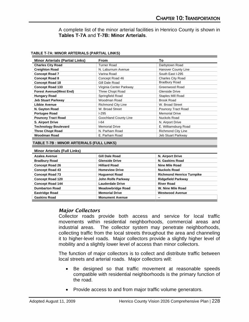
A complete list of the major arterial facilities in Henrico County is shown in Tables T-6A and T-6B: Major Arterials.
TABLE T-6A: MAJOR ARTERIALS (PARTIAL LINKS)
Major Arterials (Partial Links) From To Charles City Road Williamsburg Road Turner Road Charles City Road Darbytown Road Charles City County Line Concept Road 48 Charles City Place Concept Road 8 Old Osborne Turnpike Richmond City Line New Market Road S. Airport Drive Concept Road Airport Access I-64 Turner Road Charles City Road Memorial Drive
TABLE T-6B: MAJOR ARTERIALS (FULL LINKS)
Major Arterials (Full Links) Brook Road E. Parham Road Patterson Avenue Chamberlayne Road Mechanicsville Turnpike S. Laburnum Avenue Chippenham Parkway N. Laburnum Avenue Staples Mill Road Concept Road 70 N. Parham Road W. Laburnum Avenue Darbytown Road New Market Road Williamsburg Road E. Laburnum Avenue Parham Road --
Minor Arterials
These roads augment the higher road classifications and they should not penetrate identifiable neighborhoods. Because of mobility and safety concerns for longer-distance trips, adequate access is provided through the use of turning lanes and signalization. These roads place more emphasis on land access and offer a lower level of traffic mobility than major arterials.
The function of minor arterials is to interconnect with and augment the major arterial system. Minor arterials will:
• Create an integrated network providing both inter-county and intra-county service.
• Be located so all developed areas are within a reasonable distance from, and access is available to, the collector road system.
• Control entrances and encourage joint entrances to abutting properties to assure free-flowing, uninterrupted movement serving the highest traffic volumes while (secondarily) providing land access.
• Require a non-access strip for residential development along the road.
• Control balanced land use activities to distribute intensity along the road.
CHAPTER 10: TRANSPORTATION
Adopted August 11, 2009 Henrico County Vision 2026 Comprehensive Plan | 228
A complete list of the minor arterial facilities in Henrico County is shown in Tables T-7A and T-7B: Minor Arterials.
TABLE T-7A: MINOR ARTERIALS (PARTIAL LINKS)
Minor Arterials (Partial Links) From To Charles City Road Turner Road Darbytown Road Creighton Road N. Laburnum Avenue Hanover County Line Concept Road 7 Varina Road South East I-295 Concept Road 8 Concept Road 46 Charles City Road Concept Road 18 Gill Dale Road Bradbury Road Concept Road 133 Virginia Center Parkway Greenwood Road Forest Avenue(West End) Three Chopt Road Glenside Drive Hungary Road Springfield Road Staples Mill Road Jeb Stuart Parkway Woodman Road Brook Road Libbie Avenue Richmond City Line W. Broad Street N. Gayton Road W. Broad Street Pouncey Tract Road Portugee Road I-295 Memorial Drive Pouncey Tract Road Goochland County Line Nuckols Road S. Airport Drive I-64 N. Airport Drive Technology Boulevard Memorial Drive E. Williamsburg Road Three Chopt Road N. Parham Road Richmond City Line Woodman Road E. Parham Road Jeb Stuart Parkway
TABLE T-7B : MINOR ARTERIALS (FULL LINKS)
Minor Arterials (Full Links) Azalea Avenue Gill Dale Road N. Airport Drive Bradbury Road Glenside Drive N. Gaskins Road Concept Road 26 Hilliard Road Nine Mile Road Concept Road 43 Homeview Drive Nuckols Road Concept Road 73 Huguenot Road Richmond Henrico Turnpike Concept Road 120 John Rolfe Parkway Ridgefield Parkway Concept Road 144 Lauderdale Drive River Road Dumbarton Road Meadowbridge Road W. Nine Mile Road Eastridge Road Memorial Drive Westwood Avenue Gaskins Road Monument Avenue --
Major Collectors
Collector roads provide both access and service for local traffic movements within residential neighborhoods, commercial areas and industrial areas. The collector system may penetrate neighborhoods, collecting traffic from the local streets throughout the area and channeling it to higher-level roads. Major collectors provide a slightly higher level of mobility and a slightly lower level of access than minor collectors.
The function of major collectors is to collect and distribute traffic between local streets and arterial roads. Major collectors will:
• Be designed so that traffic movement at reasonable speeds compatible with residential neighborhoods is the primary function of the road.
• Provide access to and from major traffic volume generators.
CHAPTER 10: TRANSPORTATION
Adopted August 11, 2009 Henrico County Vision 2026 Comprehensive Plan | 229
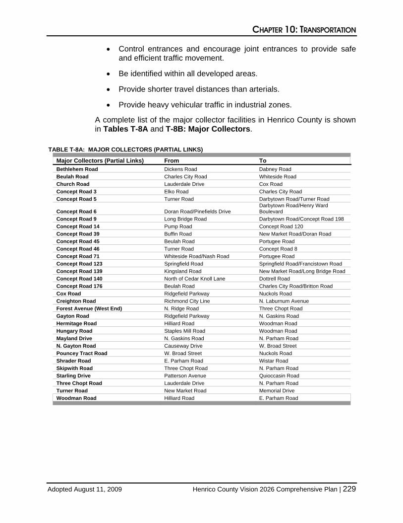
• Control entrances and encourage joint entrances to provide safe and efficient traffic movement.
• Be identified within all developed areas.
• Provide shorter travel distances than arterials.
• Provide heavy vehicular traffic in industrial zones.
A complete list of the major collector facilities in Henrico County is shown in Tables T-8A and T-8B: Major Collectors.
TABLE T-8A: MAJOR COLLECTORS (PARTIAL LINKS)
Major Collectors (Partial Links) From To Bethlehem Road Dickens Road Dabney Road Beulah Road Charles City Road Whiteside Road Church Road Lauderdale Drive Cox Road Concept Road 3 Elko Road Charles City Road Concept Road 5 Turner Road Darbytown Road/Turner Road
Concept Road 6 Doran Road/Pinefields Drive Darbytown Road/Henry Ward Boulevard
Concept Road 9 Long Bridge Road Darbytown Road/Concept Road 198 Concept Road 14 Pump Road Concept Road 120 Concept Road 39 Buffin Road New Market Road/Doran Road Concept Road 45 Beulah Road Portugee Road Concept Road 46 Turner Road Concept Road 8 Concept Road 71 Whiteside Road/Nash Road Portugee Road Concept Road 123 Springfield Road Springfield Road/Francistown Road Concept Road 139 Kingsland Road New Market Road/Long Bridge Road Concept Road 140 North of Cedar Knoll Lane Dottrell Road Concept Road 176 Beulah Road Charles City Road/Britton Road Cox Road Ridgefield Parkway Nuckols Road Creighton Road Richmond City Line N. Laburnum Avenue Forest Avenue (West End) N. Ridge Road Three Chopt Road Gayton Road Ridgefield Parkway N. Gaskins Road Hermitage Road Hilliard Road Woodman Road Hungary Road Staples Mill Road Woodman Road Mayland Drive N. Gaskins Road N. Parham Road N. Gayton Road Causeway Drive W. Broad Street Pouncey Tract Road W. Broad Street Nuckols Road Shrader Road E. Parham Road Wistar Road Skipwith Road Three Chopt Road N. Parham Road Starling Drive Patterson Avenue Quioccasin Road Three Chopt Road Lauderdale Drive N. Parham Road Turner Road New Market Road Memorial Drive Woodman Road Hilliard Road E. Parham Road

CHAPTER 10: TRANSPORTATION
Adopted August 11, 2009 Henrico County Vision 2026 Comprehensive Plan | 230
TABLE T-8B: MAJOR COLLECTORS (FULL LINKS)
MAJOR COLLECTORS (FULL LINKS) Basie Road Concept Road 31 Midview Road Bremner Boulevard Concept Road 32 Mountain Road Brittles Lane Concept Road 38 N. Holly Avenue Britton Road Concept Road 52 Oakland Road Bunche Street Concept Road 99 Oakleys Lane Carolina Avenue Concept Road 180 Twin Hickory Lake Drive Concept Road 1 Concept Road 184 Twin Hickory Road Concept Road 19 Concept Road 198 White Oak Road Concept Road 20 Dabney Road Whiteside Road Concept Road 25 Derbyshire Road Wilkinson Road Concept Road 27 Long Bridge Road Willis Church Road Concept Road 28 Masonic Home Lane Willson Road Concept Road 29 Meadow Road Yahley Mill Road
Minor Collectors
These roads generally provide the same service as major collector roadways; however, minor collectors provide for a slightly lower level of mobility and a slightly higher level of access than major collectors.
The function of minor collectors is to collect and distribute traffic between local streets and arterial roads. Minor collectors will:
• Provide for shorter travel distances than arterials.
• Provide access to abutting property.
• Discourage “through” traffic on local streets.
• Encourage lower speeds on local streets.
• Control entrances to provide safe and efficient local traffic movement between local streets and the arterial system.
A complete list of the minor collector facilities in Henrico County is shown in Tables T-9A and T-9B: Minor Collectors.

CHAPTER 10: TRANSPORTATION
Adopted August 11, 2009 Henrico County Vision 2026 Comprehensive Plan | 231
TABLE T-9A: MINOR COLLECTORS (PARTIAL LINKS)
Minor Collectors (Partial Links) From To Antigo Road Colwyck Drive Oakleys Lane Bethlehem Road Basie Road Dickens Road Beulah Road Whiteside Road W. Williamsburg Road Church Road Causeway Drive Lauderdale Drive Comet Road Mayland Drive Mayland Drive Concept Road 4 Hines Road Elko Road Concept Road 12 Carters Mill Road Long Bridge Road Concept Road 13 Warriner Road Warriner Road Concept Road 15 Sadler Road/Ireland Lane Sadler Grove Road/Sadler Road Concept Road 21 Curles Neck Road Turkey Island Road Concept Road 22 Curles Neck Road Concept Road 206 Concept Road 37 Twin Hickory Lane Holman Ridge Road Concept Road 50 Beulah Road Concept Road 71 Concept Road 58 Holman Ridge Road Concept Road 135 Concept Road 61 Concept Road 150 Yarnell Road Concept Road 63 Shady Grove Road Holman Ridge Road Concept Road 65 Woodside Street Woodside Street Concept Road 69 Rasmussen Drive Elko Road Concept Road 86 Treva Road Whiteside Road Concept Road 91 Meadow Road Dilworth Circle Concept Road 95 Sanburne Parkway Audubon Drive Concept Road 98 Graves Road Pondorosa Drive Concept Road 105 Meadowview Lane Cedar Fork Road Concept Road 131 Kain Road Perrywinkle Road Concept Road 136 Colfax Road Mill Road Concept Road 137 Grey Oaks Park Drive Nuckols Road Concept Road 138 Willis Church Road Warriner Road Concept Road 165 Osborne Turnpike Hickory Avenue Concept Road 204 Bacova Drive Concept Road 132 Concept Road 205 Curles Neck Road New Market Road Concept Road 207 Woodside Street Burning Tree Road Concept Road 209 Curles Neck Road Concept Road 23 Gayton Road Lauderdale Drive Ridgefield Parkway Hermitage Road Staples Mill Road Woodman Road Hungary Road Woodman Road E. Parham Road Impala Drive Dumbarton Road Glenside Drive Jeb Stuart Parkway Brook Road Virginia Center Parkway Lakeside Avenue Glenside Drive Brook Road Mayland Drive N. Parham Road Skipwith Road N. Gayton Road Causeway Drive Lauderdale Drive Old Williamsburg Road Old Whiteside Road Dry Bridge Road Shrader Road End E. Parham Road Skipwith Road N. Parham Road W. Broad Street Starling Drive Quioccasin Road Fargo Road Westmoreland Street City of Richmond Line Thalbro Street

CHAPTER 10: TRANSPORTATION
Adopted August 11, 2009 Henrico County Vision 2026 Comprehensive Plan | 232
TABLE T-9B: MINOR COLLECTORS (FULL LINKS)
Minor Collectors (Full Links) 25th Street Concept Road 107 Fargo Road Michael Road Sanburne Parkway
Access Road Concept Road 126 Evergreen Road Mill Road Sandy Lane
Ackley Avenue Concept Road 132 Falconbridge Drive Messer Road Sleepy Hollow Road
Anoka Road Concept Road 135 Falmouth Street Miller Road Southbury Avenue
Antioch Road Concept Road 146 Farmington Drive Millers Lane Springdale Road
Antionette Drive Concept Road 149 Finlay Street Monaco Drive St Charles Road
Appling Road Concept Road 150 Fitzhugh Avenue Monahan Road Stoneleigh Road
Arrowdel Road Concept Road 154 Fordson Road Montclair Road Stoney Run Parkway
Audubon Drive Concept Road 157 Forest Avenue (East End) Montpelier Street Telegraph Road
Austin Avenue Concept Road 167 Fox Downs Drive N. Midview Road Thalbro Street
Bacova Drive Concept Road 168 Francis Road N. Mooreland Road Treva Road
Besler Lane Concept Road 169 Francistown Road N. Washington Street Tuckernuck Drive
Betty Lane Concept Road 171 Gay Avenue Naglee Avenue Turkey Island Road
Bickerstaff Road Concept Road 172 Glen Gary Drive Neale Street Twin Hickory Lane
Blue Jay Lane Concept Road 199 Glendale Drive New Osborne Turnpike Twin Hickory Road
Bremo Road Concept Road 200 Gordon Lane Newbridge Road Twin Pine Road
Broad Meadows Road Concept Road 201 Grapevine Road North Run Road University Boulevard
Bronwood Road Concept Road 202 Graves Road Northbury Avenue University Drive
Brookmont Drive Concept Road 203 Gray Oaks Park Drive Oakleys Lane Upham Drive
Buckingham Avenue Concept Road 206 Hanover Road Old Hanover Road Varina Road
Buffin Road Concept Road 208 Hart Street Old Nuckols Road Villa Park Drive
Burning Tree Road Concept Road 210 Harvie Road Old Springfield Road Virginia Center Parkway
Cambridge Drive Cool Lane Hickory Avenue Old Washington Highway W. Broad Street Connector
Carters Mill Road Copper Creek Lane Hickory Bend Drive Old Whiteside Road W. Washington Street
Causeway Drive Copperas Lane Hickory Park Drive Old Wyndham Drive Walsing Drive
Cedar Fork Road Courtney Road Hines Road Oregon Avenue Waltham Drive
Charles Street Crowncrest Drive Hughes Road Oronoco Avenue Warren Road
Chauncey Lane Curles Neck Road Hunton Park Boulevard Park Terrace Drive Warriner Road
Church Run Parkway Dabbs House Road Huron Avenue Penick Road Warwick Park Road
Cleveland Street Dan Street Indale Road Pepper Avenue Watts Lane
Cloister Drive Deep Bottom Road Jacque Street Perrywinkle Road West Club Lane
Cloverdale Street Denham Road Kain Road Pilots Lane West End Drive
Colfax Road Diane Lane Kinvan Road Pleasant Street Westerre Parkway
College Road Dill Avenue Kirkwood Street Pondorosa Drive Westham Parkway
Colwyck Drive Dilworth Circle Klockner Drive Purcell Road Westham Station Road
Concept Road 10 Dogwood Oaks Drive La France Road Quarter Mill Road Whitfield Avenue
Concept Road 11 Dominion Boulevard Lanier Avenue Raintree Drive Wilmer Avenue
Concept Road 17 Dominion Club Drive Lee Avenue Ralston Road Wilton Road
Concept Road 23 Donora Drive Lewis Road Rasmussen Drive Winesap Drive
Concept Road 30 E. Cedar Fork Road Library Road Reynolds Road Wistar Road
Concept Road 34 E. Washington Street Lindsay Drive Richmond Road Wistar Village Drive
Concept Road 53 Eanes Lane Locust Street Roslyn Hills Drive Woodside Street
Concept Road 68 Edenbrook Drive Lourdes Road Ryandale Road Woodview Drive
Concept Road 74 Edgefield Street Lydell Drive S. Gaskins Road Wyndham Lake Drive
Concept Road 100 Eisenhower Drive Maplewood Road S. Mooreland Road Wyndham Park Drive
Concept Road 101 Eubank Road Maybeury Drive S. Ridge Road Yarnell Road
Concept Road 104 Eunice Drive Meredith Woods Road Sadler Road --
CHAPTER 10: TRANSPORTATION
Adopted August 11, 2009 Henrico County Vision 2026 Comprehensive Plan | 233
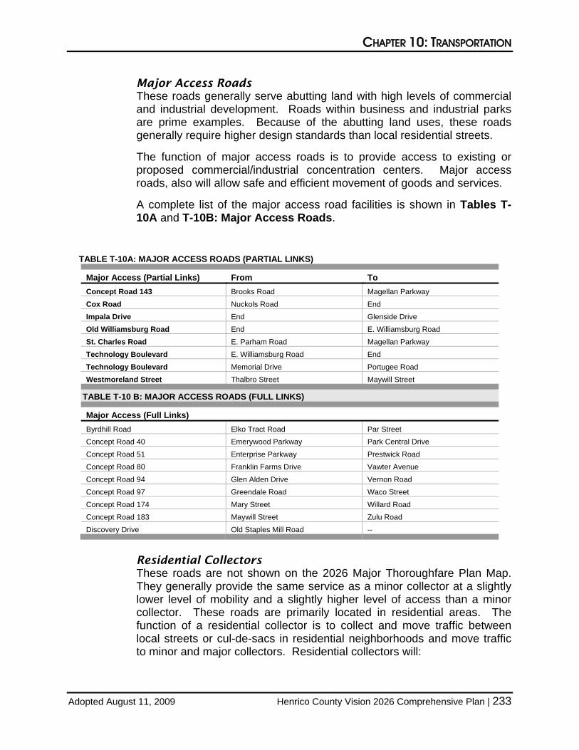
Major Access Roads
These roads generally serve abutting land with high levels of commercial and industrial development. Roads within business and industrial parks are prime examples. Because of the abutting land uses, these roads generally require higher design standards than local residential streets.
The function of major access roads is to provide access to existing or proposed commercial/industrial concentration centers. Major access roads, also will allow safe and efficient movement of goods and services.
A complete list of the major access road facilities is shown in Tables T-10A and T-10B: Major Access Roads.
TABLE T-10A: MAJOR ACCESS ROADS (PARTIAL LINKS)
Major Access (Partial Links) From To Concept Road 143 Brooks Road Magellan Parkway Cox Road Nuckols Road End Impala Drive End Glenside Drive Old Williamsburg Road End E. Williamsburg Road St. Charles Road E. Parham Road Magellan Parkway Technology Boulevard E. Williamsburg Road End Technology Boulevard Memorial Drive Portugee Road Westmoreland Street Thalbro Street Maywill Street
TABLE T-10 B: MAJOR ACCESS ROADS (FULL LINKS)
Major Access (Full Links) Byrdhill Road Elko Tract Road Par Street Concept Road 40 Emerywood Parkway Park Central Drive Concept Road 51 Enterprise Parkway Prestwick Road Concept Road 80 Franklin Farms Drive Vawter Avenue Concept Road 94 Glen Alden Drive Vernon Road Concept Road 97 Greendale Road Waco Street Concept Road 174 Mary Street Willard Road Concept Road 183 Maywill Street Zulu Road Discovery Drive Old Staples Mill Road --
Residential Collectors
These roads are not shown on the 2026 Major Thoroughfare Plan Map. They generally provide the same service as a minor collector at a slightly lower level of mobility and a slightly higher level of access than a minor collector. These roads are primarily located in residential areas. The function of a residential collector is to collect and move traffic between local streets or cul-de-sacs in residential neighborhoods and move traffic to minor and major collectors. Residential collectors will:

CHAPTER 10: TRANSPORTATION
Adopted August 11, 2009 Henrico County Vision 2026 Comprehensive Plan | 234
• Provide for longer travel distances than local streets within residential neighborhoods.
• Provide “through” access to abutting property.
• Discourage “through” traffic on local streets.
• Encourage lower speeds on local streets.
• Control entrances to provide safe and efficient local traffic movement between local streets and the arterial system.
Local Streets
These roads are also not shown on the 2026 Major Thoroughfare Plan Map. The function of a local street is to provide direct access to abutting land and to the collector system. Local streets will:
• Serve shorter travel needs.
• Provide direct access to abutting properties.
• Give priority to local traffic and pedestrians through a design that encourages low-speed operation.
• Require off-street parking, loading, unloading and access service.
• Require proper location and design of driveways, entrances and exits to ensure safe and efficient ingress and egress.
• Provide a local road network that supports low traffic volumes.
• Discourage connection with streets that serve a function higher than a minor collector.
TRANSPORTATION SYSTEM MANAGEMENT As part of this Plan, a Transportation System Management Manual (TSM Manual) was prepared to address roadway design solutions that will reduce congestion on the county’s road network. This manual is included as Appendix E to this Plan. The TSM Manual details general practices to reduce and manage congestion, including specific improvement recommendations for seven (7) county corridors. The techniques for congestion management covered in the manual include:
• Traffic signal coordination • On-site traffic signal circulation • Non-traversable median treatments • Median U-turn treatment • Advanced left turn treatment • Consolidated driveways • Relocated driveways

CHAPTER 10: TRANSPORTATION
Adopted August 11, 2009 Henrico County Vision 2026 Comprehensive Plan | 235
• Improved intersection turning radii at intersections/driveways • Left turn storage bays at major driveways • Exclusive left turn lanes on minor approach and • Emergency vehicle preemption
The manual also assesses and presents recommendations for improvements along the following corridors:
• Laburnum Avenue • W. Broad Street • Gaskins Road • Parham Road • Brook Road • Woodman Road and • Nuckols Road
Each of these congested corridors was found to be operating below an acceptable level of service with expectations of additional growth and congestion within the corridor. It was found that the opportunity to widen these roads to increase capacity was significantly limited due to surrounding land use, existing terrain or expectations of funding.
PROJECT TIMING The timing of transportation improvements depends on many factors including the availability of funds, governmental and environmental permits, and project needs compared to priorities. The county will encourage orderly new growth and development in coordination with the provision of public services and facilities. To the extent practical, new roads and widening projects will be timed to coincide with the extension of development, public services and utilities. Furthermore, the county will distribute investments within the transportation system in a fair and equitable manner.

CHAPTER 10: TRANSPORTATION
Adopted August 11, 2009 Henrico County Vision 2026 Comprehensive Plan | 236