Chapter 1 The Tools of History
9
4.5 million B.C. First hominids appear. ▲ (footprint of a hominid) 1.6 million B.C. Homo erectus appears. Chapter 1 The Tools of History German scientist Alfred Wegener proposed the continental drift theory in 1912. He claimed that more than 200 million years ago Earth was a single mass of land called Pangaea, meaning “all Earth.” Eventually, the mass split apart, and its pieces have been moving ever since. You’ll learn how this movement has affected Earth and its people in Chapter 1. Integrated Technology • Interactive Maps • Interactive Visuals • Starting with a Story INTERNET RESOURCES • WebQuest • Homework Helper • Research Links • Internet Activities • Quizzes • Maps • Test Practice • Current Events Go to ClassZone.com for Before You Read: Knowledge Rating Recognizing what you already know about each of these terms can help you understand the chapter. hominid artifact fossil In your notebook, rate how well you know each term. 3 = I know what this word means. 2 = I’ve seen this word before, but I don’t know what it means. 1 = I’ve never seen this word before. Define each term in your notebook as you read. Big Ideas About the Tools of History Science and Technology New scientific discoveries change human understanding of the world. Geographers look for new ways to help us understand our place in the world. Archaeologists make discoveries that tell us about our earliest ancestors. Their findings answer questions about the past and provide insight into our lives today. 2.5 million B.C. Paleolithic Age begins. ▲ (Paleolithic hand ax) 4
Transcript of Chapter 1 The Tools of History

4.5 million B.C.First hominids appear.▲
(footprint of a hominid) 1.6 million B.C.Homo erectus appears.
Chapter
1The Tools of History
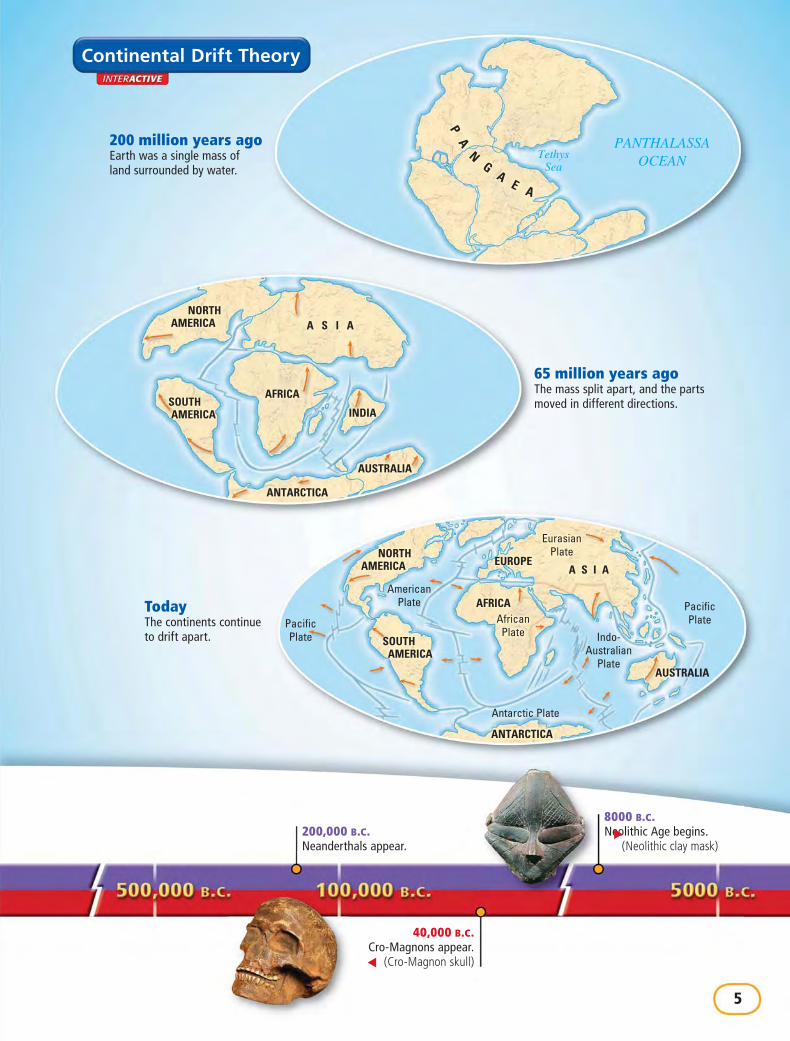
German scientist Alfred Wegener proposed the continental drift theory in 1912. He claimed that more than 200 million years ago Earth was a single mass of land called Pangaea, meaning “all Earth.” Eventually, the mass split apart, and its pieces have been moving ever since. You’ll learn how this movement has affected Earth and its people in Chapter 1.
Integrated Technology
• Interactive Maps• Interactive Visuals• Starting with a Story
INTERNET RESOURCES
• WebQuest• Homework Helper• Research Links• Internet Activities
• Quizzes• Maps• Test Practice• Current Events
Go to ClassZone.com for
Before You Read: Knowledge RatingRecognizing what you already know about each of these terms can help you understand the chapter.
hominid artifact fossil
In your notebook, rate how well you know each term.
3 = I know what this word means.2 = I’ve seen this word before, but I don’t know what it means.1 = I’ve never seen this word before.
Define each term in your notebook as you read.
Big Ideas About the Tools of HistoryScience and Technology New scientific discoveries change human understanding of the world.
Geographers look for new ways to help us understand our place in the world. Archaeologists make discoveries that tell us about our earliest ancestors. Their findings answer questions about the past and provide insight into our lives today.
2.5 million B.C.Paleolithic Age begins.▲
(Paleolithic hand ax)
4
TethysSea
PANTHALASSAOCEAN
PA
NG
AE A
NORTHAMERICA A S I A
AFRICASOUTHAMERICA INDIA
AUSTRALIA
ANTARCTICA
AmericanPlate
PacificPlate
PacificPlate
EurasianPlate
AfricanPlate Indo-
AustralianPlate
Antarctic Plate
ANTARCTICA
NORTHAMERICA A S I A
AFRICA
SOUTHAMERICA
AUSTRALIA
EUROPE
40,000 B.C.Cro-Magnons appear.
▲ (Cro-Magnon skull)
200 million years agoEarth was a single mass of land surrounded by water.
200,000 B.C.Neanderthals appear.
8000 B.C.Neolithic Age begins.▲
(Neolithic clay mask)
65 million years agoThe mass split apart, and the parts moved in different directions.
TodayThe continents continue to drift apart.
Continental Drift Theory
5

Background: On September 12, 1940, fourteenage boys explored a cave in the Frenchcountryside. It looked as if no one else had been therefor years. But the walls were covered with strangepaintings of animals in vivid colors of red, yellow, andbrown. The boys had stumbled across a cave filled withmasterpieces by prehistoric artists.
Now step inside the Lascaux (la•SKOH) Cave anddiscover the paintings with the teenage explorers.
Painting in the Lascaux Cave
▲
6 • Chapter 1

n September 8, Marcel went on a treasure hunt. For years, peoplehad talked about a secret underground passage in the countrysidearound their French village. They said that the passage led to
hidden treasure. The French teenager thought he had found it whenhe discovered the opening to a long vertical shaft. Four days later, onSeptember 12, Marcel and three of his friends returned to explore it.
This time, Marcel brought an oil lamp to light the way. One after theother, the boys wriggled down the long passageway. Finally, they tumbledinto a huge cavern, and Marcel held up the lamp. By its flickering light,they noticed a narrow, high passage. The friends entered the passage,and Marcel shone the light on its walls. What the French teenagers sawamazed them.
Herds of horses, oxen, and deer stampeded across the curving cavewall. The colorful animals seemed to leap off the walls. Excitedly, theteenagers ran through the cave and found room after room of paintings.They had found the real treasure of Lascaux.
At first the four teenagers promised to keep their great discovery asecret. But this secret was too hard to keep. They told their teacher, whocontacted an expert. The expert said that the boys were probably the firstmodern people to lay eyes on this art. The paintings had been sealed inthe Lascaux Cave for at least 17,000 years.
The cave walls are covered with more than 1,500 pictures of animals.Many of the animals include those that the early people of Lascaux hunted.Historians believe that the people told stories about the animals and sang asthe artists painted them. But these oral stories are lost forever.
What do these cave paintings tell you aboutthe people who painted them?
Starting with a Story
1. READING: Speaker This story is told by a third-personnarrator. How would the story be different if Marcel orone of his friends told it?
2. WRITING: Explanation Research to find out what hashappened to the Lascaux Cave, and write a paragraphexplaining your findings.
7

Lesson
1MAIN IDEAS
Geography Continents, landforms, and bodiesof water shape our planet.
Geography Geographers organize informationinto five themes.
Geography Where people live has an impacton how they live.
TAKING NOTES
Reading Skill: SummarizingWhen you summarize, you supply only main ideasand important details. Identify the main ideas andimportant details in each section of Lesson 1. Thenput them in your own words and record them in adiagram like the one below.
Skillbuilder Handbook, page R3
▲ Earth This “blue marble”image of Earth was put togetherusing a collection of satellitepictures taken in 2001. It is themost detailed true-color imageever produced of Earth.
Looking at Earth
detaildetail
Main Idea
8 • Chapter 1
Words to KnowUnderstanding the following words will help you read this lesson:
theme topics ofdiscussion (page 11)
The themes studentsaddressed in their firstclass were all related togeography.
precise very definite orexact (page 11)
She used a special map toidentify the precise locationof the valley.
interaction when twoor more things affect eachother (page 11)
Clothing styles sometimesreflect the interactionbetween humans and theirenvironment.
influence to havean effect or impact onsomething (page 12)
The climate influenced thetypes of shelters people built.

INDIANOCEAN
ATLANTICOCEAN
PACIFICOCEAN
PACIFICOCEAN
ARCTIC OCEAN
SOUTHAMERICA
AFRICA
ANTARCTICA
EUROPE ASIA
AUSTRALIA
NORTHAMERICA
90°W 60°W 30°W 0° 30°E 60°E 90°E 120°E 150°E
Antarctic Circle
120°W150°W
60°S
30°S
Tropic of Capricorn
Equator
Tropic of Cancer
Arctic Circle
0°
30°N
60°N
N
S
EW
TERMS & NAMES
geography
continent
landform
climate
vegetation
The World’s GeographyBuild on What You Know How would you describe your town? Is the land flat or hilly? Does a river run nearby? Who lives in your town? When you answer these questions, you describe your town’s geography. Your town is part of the world’s geography.
Looking at EarthESSENTIAL QUESTION What do geographers study?
Scientists study the land and water that cover Earth. They also study how people live on Earth. The study of Earth and its people is called geographygeography.
Continents Earth is divided into seven large landmasses called continentscontinents. You can see the continents on the map below. From largest to smallest, the continents are Asia, Africa, North America, South America, Antarctica, Europe, and Australia.
Continents of the World
The Tools of History • 9

Shifting Plates Scientists believe that the continents lie on large moving plates. Plate movements form mountains and volcanoes and cause earthquakes. The movements slowly but continually reshape Earth. (You can learn more about the plate movements that cause earthquakes in the Geography feature above.)
Landforms and Bodies of Water Two continents—Australia and Antarctica—are islands. An island is a landformlandform, or naturally formed feature on Earth’s surface. Mountains are also landforms. Other landforms include plateaus, which are high, flat areas, and plains, which are large, level areas of grassland.
Although Earth has many kinds of landforms, water covers about three-fourths of our planet. The largest bodies of water on Earth are called oceans. The four major oceans are the Pacific Ocean, the Atlantic Ocean, the Indian Ocean, and the Arctic Ocean. Smaller bodies of water include rivers and lakes.
What are Earth’s largest landmasses and bodies of water called?
1Plate A
2Plate B3Fault Line
EarthquakesAt about 5:12 A.M. on April 18, 1906, the ground shook along the west coast of the United States. The earthquake was centered around San Francisco and destroyed much of the city, as shown in the photograph on the upper right. The San Francisco earthquake was caused by plates sliding along a fault line, or break in Earth’s crust. The diagram on the lower right shows their movement.
1 Plate A slides in one direction.
2 Plate B slides in the opposite direction.
3 The plates move past each other at the fault line, causing an earthquake.
GEOGRAPHY SKILLBUILDERINTERPRETING VISUALS Human-Environment Interaction Based on the photograph above, what are some of the effects of earthquakes?
10 • Chapter 1

Themes of GeographyESSENTIAL QUESTION What are the five themes of geography?
Geographers use five themes of geography to describe Earth. The five themes help us understand our world and how we fit into it.
• Location The geographic question, Where is it? refers to location. Location can identify a precise spot or tell where one place is in relation to another.
• Place The question, What is it like? refers to place. Place includes physical characteristics as well as human ones, like language, religion, and politics.
• Region The question, How are places similar or different? refers to region. Region compares physical and human characteristics.
• Movement The question, How do people, goods, and ideas move from one location to another? refers to movement.
• Human-Environment Interaction The question, How do people relate to the physical world? refers to human-environment interaction. People learn to use and change what the environment offers them.
Which two geographic themes are most concerned with people?
How Environment Affects PeopleESSENTIAL QUESTION How does climate affect people’s lives?
You probably wear a coat in cold weather and dress in light clothing in warmer weather. Of course, different people may develop different ways of adapting to the same area. But your environment—particularly its climate—has a big impact on the way you live.
Connect to Today
Hurricanes Natural disasters have a great impact on people and their homes. This photograph shows people fleeing during a 1998 hurricane in Florida. ▼
11

Homework Helper
Climate Weather refers to the temperature and conditions in aparticular place at a particular time. ClimateClimate, on the other hand,describes the weather conditions in a place over a long period oftime. Climate can influence where people live. For example, theharsh conditions of a cold, wet climate may prevent people fromsettling in that region.
Climate also has a big impact on the type of vegetationvegetation, orplant life, that grows in a location. For instance, thick junglevegetation grows well in a tropical climate with heavy rainfall,while crops may be difficult to grow in a hot, dry climate.
How does environment affect people?
Lesson Summary• Earth’s largest landmasses, called continents, are
surrounded by oceans.• The five themes of geography help us explain our
place in the world.• Climate can affect how and where people live.
Why It Matters Now . . .Geography helps us learn more about our neighbors and theways we affect the world we share.
1Terms & Names1. Explain the importance of
geography landform vegetationcontinent climate
Using Your NotesSummarizing Use your completed diagram toanswer the following question:2. What are Earth’s main geographic features?
Main Ideas3. Name three examples of landforms and three
examples of bodies of water.4. How do the five themes of geography help
geographers?5. How does the climate where you live affect
your life?
Critical Thinking6. Understanding Cause and Effect What might
be the result if the climate of a region suddenlybecame much colder?
7. Making Inferences Since more people live onAsia than on any other continent, what can youinfer about Asia’s environment?
Planning a Mural Work with a group of classmates to plan a mural that represents the physicalfeatures, climate, and vegetation in your town.
ClassZone.com
Looking at Earth
detaildetail
Main Idea
12 • Chapter 1