
Challenges in the Development of Ocean Coupled, Operational Hurricane Forecast Model at National...
17
Challenges in the Development of Ocean Coupled, Operational Hurricane Forecast Model at National Weather Service (NWS) Hyun-Sook Kim Environmental Modeling Center (EMC) National Centers for Environmental Prediction (NCEP) National Weather Service (NWS) NOAA College Park, MD 20740 Friday April 10, 2015 1
-
Upload
kathryn-casey -
Category
Documents
-
view
215 -
download
0
Transcript of Challenges in the Development of Ocean Coupled, Operational Hurricane Forecast Model at National...
Challenges in the Development of Ocean Coupled, Operational Hurricane Forecast
Model at National Weather Service (NWS)
Hyun-Sook Kim
Environmental Modeling Center (EMC)National Centers for Environmental Prediction
(NCEP)National Weather Service (NWS)
NOAACollege Park, MD 20740
Friday April 10, 2015
1
2
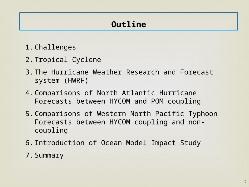
Outline
1. Challenges
2. Tropical Cyclone
3. The Hurricane Weather Research and Forecast system (HWRF)
4. Comparisons of North Atlantic Hurricane Forecasts between HYCOM and POM coupling
5. Comparisons of Western North Pacific Typhoon Forecasts between HYCOM coupling and non-coupling
6. Introduction of Ocean Model Impact Study
7. Summary

3
Challenges
Current operational Hurricane Weather Research and Forecast System (HWRF) coupled to POM (since 2007)
HYCOM (experimental) to be in the operational in 2016
Generate 5-day numerical guidance products on time, 4 times per a day, for NHC/JTWC/CPHC forecasters
In 2015, expanding to Indian Ocean and Southern Hemisphere Triple nested, w/ model grid resolution, 18-6-2 km; 61 levels Numerical Integration step, 30 sec. 7 storms at maximum per cycle.
Ocean Model: 1/12-degree, 42 levels
Computer resources (competing with 25 other operational models)
Goal is to produce robust and skillful model guidance.However, conflicts exist between having right physics (including ocean) and producing on-time better guidance.

Called by Hurricane/Typhoon/Cyclone
Characteristics Multi-scale processes in spatial and time, ranging from the
environmental O(km)/O(decadal) to the microphysical scale O(µm)/O(second), interacting independently and/or collectively.
The importance of air-sea interactions.
4
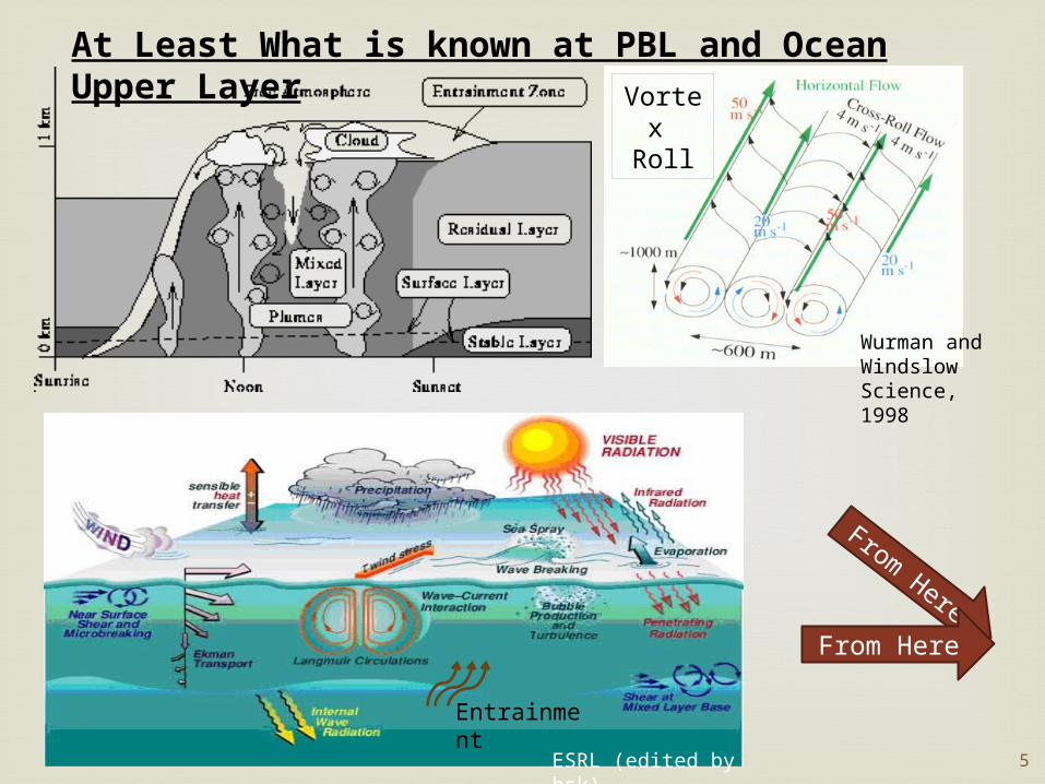
PBL height
Edited by hsk
Tropical Cyclone
From Here
ESRL (edited by hsk)
Entrainment
At Least What is known at PBL and Ocean Upper Layer
5
From Here
Wurman and WindslowScience, 1998
Vortex Roll
6
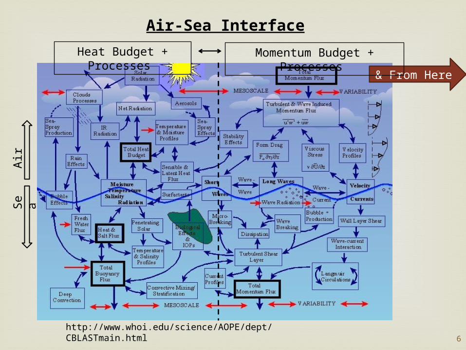
Air-Sea Interface
http://www.whoi.edu/science/AOPE/dept/CBLASTmain.html
Se
aA
ir
& From Here
Heat Budget + Processes
Momentum Budget + Processes
7
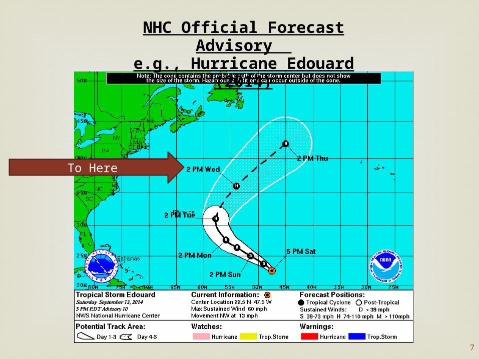
NHC Official Forecast Advisory
e.g., Hurricane Edouard (2014)
To Here

8
The Hurricane Weather Research and Forecast System (HWRF)
Ocean Component in HWRF:North Atlantic – 3D POM since 2007Eastern North Pacific – non-coupling before 1D POM (2011), 3D POM (2012 -)Western North Pacific – non-coupling (2012 - )

9
HYCOM coupling vs. POM coupling2008 and 2009 North Atlantic Hurricane Forecast Comparisons
HYCOM coupling Reduced intensity error by ~13%, and bias by ~43%
(Kim et al. 2014)
10
Ve
rific
atio
n
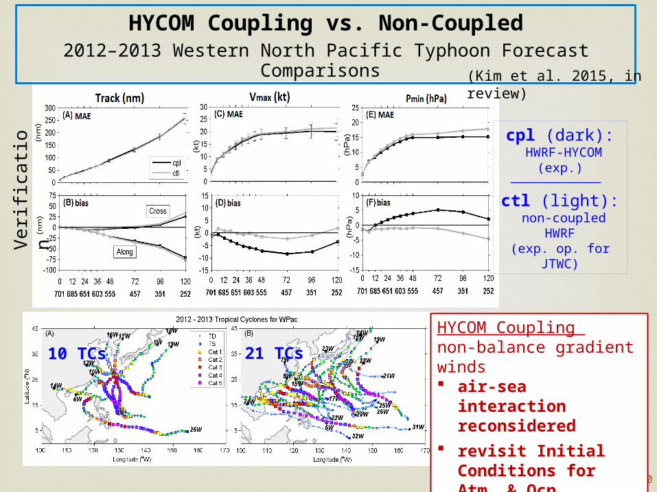
21 TCs10 TCs
cpl (dark): HWRF-HYCOM
(exp.)
ctl (light): non-coupled HWRF(exp. op. for JTWC)
HYCOM Coupling vs. Non-Coupled2012–2013 Western North Pacific Typhoon Forecast Comparisons
(Kim et al. 2015, in review)
HYCOM Coupling non-balance gradient winds air-sea interaction
reconsidered revisit Initial
Conditions for Atm. & Ocn.

11
Comparisons of ForecastsExample: Soulik (07W) July 7 to 13, 2013
IC=2013/07/10 00Z
Landfall
HYCOM coupling
Track – similar/slightly better
Intensity – reduced by <20 kt
12
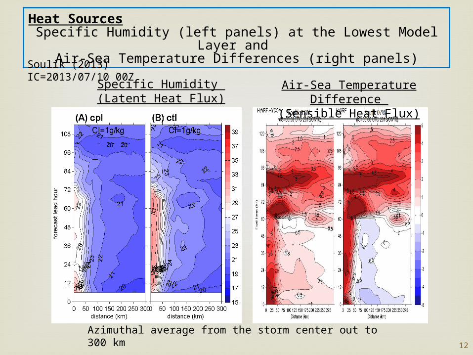
Heat SourcesSpecific Humidity (left panels) at the Lowest Model Layer and
Air-Sea Temperature Differences (right panels)
Azimuthal average from the storm center out to 300 km
Soulik (2013) IC=2013/07/10 00Z
Specific Humidity (Latent Heat Flux)
Air-Sea Temperature Difference
(Sensible Heat Flux)
13
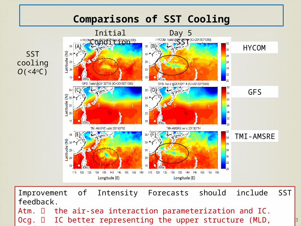
SST cooling O(<4oC)
Improvement of Intensity Forecasts should include SST feedback.Atm. the air-sea interaction parameterization and IC.Ocg. IC better representing the upper structure (MLD, dT/dZ, mixing physics).
Comparisons of SST Cooling
HYCOM
GFS
TMI-AMSRE
Initial Condition Day 5 SST
14
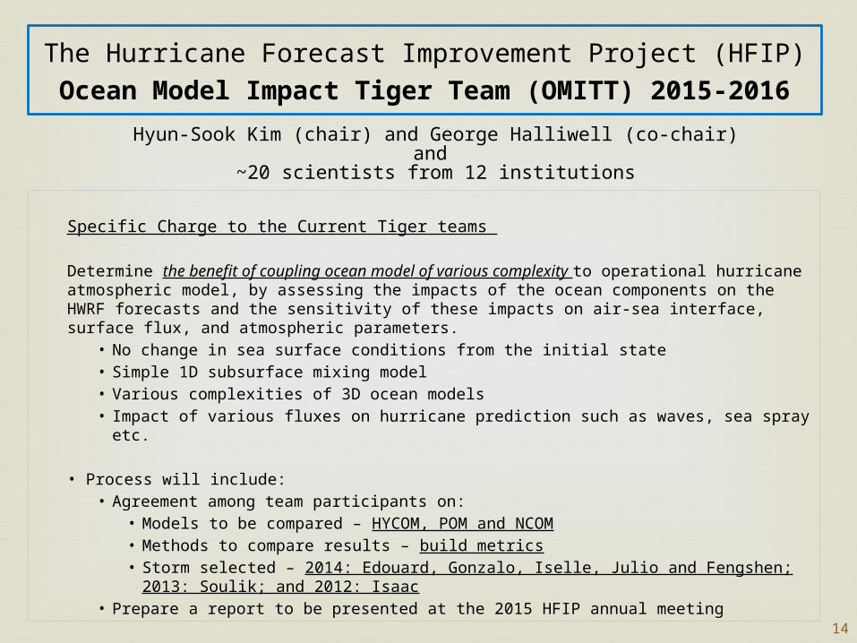
The Hurricane Forecast Improvement Project (HFIP)Ocean Model Impact Tiger Team (OMITT) 2015-2016
Specific Charge to the Current Tiger teams
Determine the benefit of coupling ocean model of various complexity to operational hurricane atmospheric model, by assessing the impacts of the ocean components on the HWRF forecasts and the sensitivity of these impacts on air-sea interface, surface flux, and atmospheric parameters.
• No change in sea surface conditions from the initial state• Simple 1D subsurface mixing model• Various complexities of 3D ocean models• Impact of various fluxes on hurricane prediction such as waves, sea spray etc.
• Process will include:• Agreement among team participants on:
• Models to be compared – HYCOM, POM and NCOM• Methods to compare results – build metrics• Storm selected – 2014: Edouard, Gonzalo, Iselle, Julio and Fengshen; 2013: Soulik;
and 2012: Isaac• Prepare a report to be presented at the 2015 HFIP annual meeting
Hyun-Sook Kim (chair) and George Halliwell (co-chair)and
~20 scientists from 12 institutions
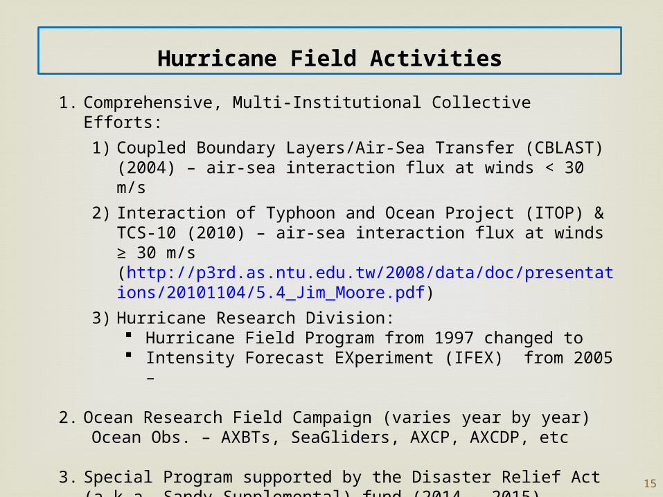
1. Comprehensive, Multi-Institutional Collective Efforts:
1) Coupled Boundary Layers/Air-Sea Transfer (CBLAST) (2004) – air-sea interaction flux at winds < 30 m/s
2) Interaction of Typhoon and Ocean Project (ITOP) & TCS-10 (2010) – air-sea interaction flux at winds ≥ 30 m/s (http://p3rd.as.ntu.edu.tw/2008/data/doc/presentations/20101104/5.4_Jim_Moore.pdf)
3) Hurricane Research Division: Hurricane Field Program from 1997 changed to Intensity Forecast EXperiment (IFEX) from 2005 –
2. Ocean Research Field Campaign (varies year by year) Ocean Obs. – AXBTs, SeaGliders, AXCP, AXCDP, etc
3. Special Program supported by the Disaster Relief Act (a.k.a. Sandy Supplemental) fund (2014 – 2015).
15
Hurricane Field Activities

16
Summary1. Lack of
a. Research Air-sea parameters, in particular, are heavily tuned to non-coupling. HWRF IC/BC are provided from GFS whose SST is non-eddy
resolving and persistent per a 24-h period (no diurnal variation).b. Validation Activityc. Observations for Validationd. Computation Power as higher resolution, multi-moving nest domains,
and expanding to global application.
2. Focusing on Developing/Updating Model Each Year Requests from NHC
a) Better forecast products – Competing against implementing right physics
b) Labor intense a) Tests & Experiments for upcoming version (yearly)
e.g., O(2000 cases) were simulated, which cover the 2011-2014 seasons
b) Real-time exercise in parallel w/ operational and experimental systems.
17
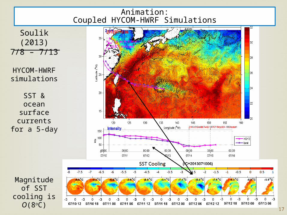
Soulik (2013)7/8 – 7/13
HYCOM-HWRF simulations
SST &ocean surface
currentsfor a 5-day
Magnitude of SST cooling is
O(8oC)
Animation:Coupled HYCOM-HWRF Simulations