Kajian Semiotik Sajak Kupu Malam Dan Biniku Karya Chairil Anwar
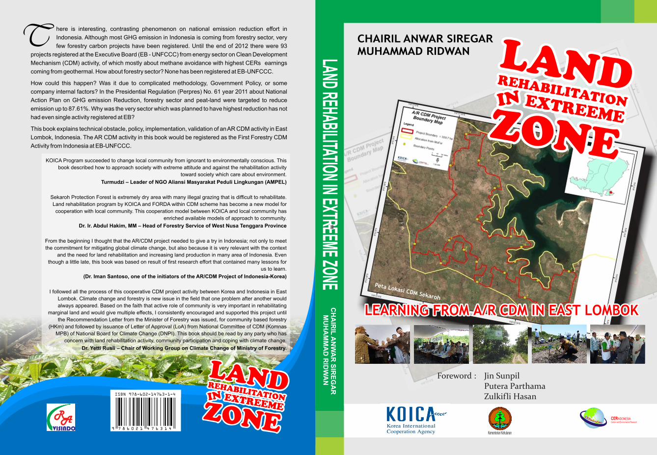
Peta Lokasi CDM Sekaroh
CHAIRIL ANWAR SIREGARMUHAMMAD RIDWAN
LEARNING FROM A/R CDM IN EAST LOMBOKLEARNING FROM A/R CDM IN EAST LOMBOK
LAND REHABILITATION IN EXTREEME ZONE C
HA
IRIL
AN
WA
R S
IRE
GA
R
MU
HA
MM
AD
RID
WA
N
CERINDONESIACarbon and Environmental Research
Kementerian Kehutanan
here is interesting, contrasting phenomenon on national emission reduction effort in
Indonesia. Although most GHG emission in Indonesia is coming from forestry sector, very
few forestry carbon projects have been registered. Until the end of 2012 there were 93
projects registered at the Executive Board (EB - UNFCCC) from energy sector on Clean Development
Mechanism (CDM) activity, of which mostly about methane avoidance with highest CERs earnings
coming from geothermal. How about forestry sector? None has been registered at EB-UNFCCC.
How could this happen? Was it due to complicated methodology, Government Policy, or some
company internal factors? In the Presidential Regulation (Perpres) No. 61 year 2011 about National
Action Plan on GHG emission Reduction, forestry sector and peat-land were targeted to reduce
emission up to 87.61%. Why was the very sector which was planned to have highest reduction has not
had even single activity registered at EB?
This book explains technical obstacle, policy, implementation, validation of an AR CDM activity in East
Lombok, Indonesia. The AR CDM activity in this book would be registered as the First Forestry CDM
Activity from Indonesia at EB-UNFCCC.
Foreword : Jin SunpilPutera ParthamaZulkifli Hasan
KOICA Program succeeded to change local community from ignorant to environmentally conscious. This
book described how to approach society with extreme attitude and against the rehabilitation activity
toward society which care about environment.
Turmudzi – Leader of NGO Aliansi Masyarakat Peduli Lingkungan (AMPEL)
Sekaroh Protection Forest is extremely dry area with many illegal grazing that is difficult to rehabilitate.
Land rehabilitation program by KOICA and FORDA within CDM scheme has become a new model for
cooperation with local community. This cooperation model between KOICA and local community has
enriched available models of approach to community.
Dr. Ir. Abdul Hakim, MM – Head of Forestry Service of West Nusa Tenggara Province
From the beginning I thought that the AR/CDM project needed to give a try in Indonesia; not only to meet
the commitment for mitigating global climate change, but also because it is very relevant with the context
and the need for land rehabilitation and increasing land production in many area of Indonesia. Even
though a little late, this book was based on result of first research effort that contained many lessons for
us to learn.
(Dr. Iman Santoso, one of the initiators of the AR/CDM Project of Indonesia-Korea)
I followed all the process of this cooperative CDM project activity between Korea and Indonesia in East
Lombok. Climate change and forestry is new issue in the field that one problem after another would
always appeared. Based on the faith that active role of community is very important in rehabilitating
marginal land and would give multiple effects, I consistently encouraged and supported this project until
the Recommendation Letter from the Minister of Forestry was issued, for community based forestry
(HKm) and followed by issuance of Letter of Approval (LoA) from National Committee of CDM (Komnas
MPB) of National Board for Climate Change (DNPI). This book should be read by any party who has
concern with land rehabilitation activity, community participation and coping with climate change.
Dr. Yetti Rusli – Chair of Working Group on Climate Change of Ministry of Forestry.
T
9 7 8 6 0 2 1 4 7 6 3 1 4
I S B N 6 0 2 - 1 4 7 6 3 - 1 - X
9 7 8 6 0 2 1 4 7 6 3 1 4
I S B N 6 0 2 - 1 4 7 6 3 - 1 - XISBN 978-602-14763-1-4
LAND REHABILITATIONIN EXTREEME ZONE
Chairil Anwar Siregar
Muhammad Ridwan
Learning from A/R CDM in East Lombok
LAND REHABILITATION IN EXTREEME ZONE
Learning from A/R CDM in East Lombok
Foreword:
Jin Sunpil
Putera Parthama
Zulkifli Hasan
Authors:
Chairil Anwar Siregar
Muhammad Ridwan
Translator:
Dr. Ir. Ulfah J. Siregar, M. Agr.
Editor:
Ari Suharto
Cover Design:
Ma'sum and Ari Suharto
Published in cooperation between:
Korea International Cooperation Agency (KOICA)
6th Floor, Block 7, Gedung Manggala Wanabakti
Jl. Gatot Subroto, Senayan, Jakarta Pusat, Indonesia
And
Forestry Research and Development Agency, Ministry of Forestry
9th Floor, Block 1, Gedung Manggala Wanabakti
Jl. Jenderal Gatot Subroto Jakarta 10270
CER Indonesia,
Jl. Arya Widura VIII No. 2
Arya Widura Residence, Bogor, 16152
RA Visindo
Jl. Taweuran IV. No. 25 Perumnas Bantarjati Bogor. 16152
email: [email protected]
March 2014
ISBN: 978-602-14763-1-4
Copyrights reserved
IIITable of Contents
Contents .................................................................................... III
List of Tables .............................................................................. VIII
List of Figures ............................................................................. IX
Foreword by the KOICA Representative ..................................... XI
Foreword by the DG of FORDA ................................................. XIII
Foreword by the Minister of Forestry .......................................... XV
Preface ....................................................................................... XVII
CHAPTER I ON INDONESIA A/R CDM ............................ 1
Since Kyoto Protocol .................................... 1
Kyoto Protocol Ratification ........................... 3
National Policy on Carbon Trading ............... 4
Example of A/R CDM Study in Indonesia...... 7
CHAPTER II COOPERATION WITH KOREA..................... 9
History of Cooperation with KOICA.............. 9
Selecting the Location ................................... 11
Land Suitability ............................................ 12
TABLE OF CONTENTS
IV Land Rehabilitation in Extreeme Zone
CHAPTER III LAND CONDITIONS OF SEKAROH
PROTECTION FOREST ................................ 17
Land Status .................................................. 17
Real Condition of the Land ........................... 18
Land Occupation by Local Community ........ 19
Permissiveness by Government Officials ........ 20
CHAPTER IV SOCIAL CONDITION OF THE LOCAL
COMMUNITY................................................ 23
Information on Land Clearing and Utilization 23
Economic Conditions .................................... 24
Condition of Education ................................. 34
Raskin (Rice for the Poor) for Everybody ...... 34
Would the Condition Persist? ........................ 34
CHAPTER V KOICA A/R CDM ACTIVITY .......................... 37
Agreement on Site Determination ................. 37
Plant Species Selection ................................. 38
Site Suitability ............................................... 39
CHAPTER VI PROCESS OF ADVOCACY........................... 43
Advocacy by Local Technical Implementation
Unit (UPTD) ................................................. 43
Trust Based Advocacy ................................... 44
Cooperation with Gapoktan (Farmers
Group Association) ....................................... 45
Working with Stakeholders ............................ 47
Advocacy by AMPEL NGO........................... 48
CHAPTER VII SOCIALIZATION PROCESS .......................... 51
The objectives of Sekaroh Village Orientation 51
Outputs of Sekaroh Village Orientation ......... 52
Target of Sekaroh Village Orientation Activity 53
Techniques of Sekaroh Village Orientation .... 53
VTable of Contents
Stages of Sekaroh Village Orientation ........... 54
Visiting Influential Figure Tuan Guru ............. 55
Prime Planting .............................................. 56
Group Socialization ...................................... 59
Hidden Problem Needs to Be solved............. 59
CHAPTER VIII LAND REHABILITATION PROCESS............. 61
Community Based Land Preparation ............ 61
Technological Input (Hydrogel & Compost) .. 63
Collaborative Planting ................................... 64
Replanting .................................................... 64
Maintenance ................................................. 67
CHAPTER IX BASELINE ESTABLISHMENT ...................... 69
Above ground ............................................... 70
Below ground ............................................... 70
CHAPTER X PLANT CENSUS ........................................... 73
Socialization on Census ................................ 73
The Importance of Census ............................ 73
Census Method ............................................. 74
Census Results .............................................. 75
Response to the Census ................................ 77
Lesson Learned from the Census .................. 77
CHAPTER XI COMMUNITY BASED A/R CDM ................... 79
Why It Has to Be Community Based? ........... 79
Socialization Process to the Community ........ 80
Technical and Non-Technical Aspects ............ 82
Issuance of License for Designated Working
Area .............................................................. 86
East Lombok Regent Community Based
Forest Utilization License (IUPHHKm) ........... 87
VI Land Rehabilitation in Extreeme Zone
CHAPTER XII CARBON POTENTIAL OF SEKAROH .......... 89
Breakthrough on Plants Species Composition 89
Forest Tree Species ........................................ 90
Fruit Tree Species .......................................... 96
Total Carbon ................................................. 103
CHAPTER XIII VALIDATION ACTIVITY................................ 105
Brief information about JACO CDM ............. 105
Things Questioned By Validator .................... 106
Local Stakeholders Discussion ...................... 109
Central Stakeholders Discussion .................... 110
Lessons From The Validator .......................... 111
CHAPTER XIV OBSTACLE/EXPERIENCE FROM INITIAL
30 HA PLANTATION..................................... 115
Experience from Initial 30 ha Plantation ....... 115
Social Obstacles ............................................ 116
Policy ............................................................ 118
Technical and Institutional Issues ................... 119
CHAPTER XV PRESENTATION AT THE NATIONAL
COMMITTEE OF CDM.................................. 123
Presentation Contents ................................... 123
Sustainable National Development ............... 124
The presentation ........................................... 125
CHAPTER XVI STAKEHOLDERS COMMENTS .................... 129
Community Still Needs NGO Advocacy ........ 129
Gapoktan Would Continue Maintaining
the Trees ....................................................... 130
Need More Water Resources ......................... 130
KOICA Made Next Rehabilitation Program
Easier ........................................................... 132
VIITable of Contents
Society Believe That They Can Increase
Their Income ................................................ 133
Hoping That This Program Will
be Continued ................................................ 135
It Has Long and Short Term Benefits ............ 136
Hoping KOICA Keep Maintaining Plantation
until Their Third Years ................................... 137
REFERENCES ........................................................................... 139
ATTACHMENTS ........................................................................ 143
ABOUT AUTHORS.................................................................... 191
VIII Land Rehabilitation in Extreeme Zone
LIST OF TABLES
Table 1. Legal frameworks in Indonesia related to forestry
carbon activities ........................................................ 5
Table 2. Estimation of potential area for carbon project in
Indonesia .................................................................. 7
Table 3. Some plant species found around Sekaroh Protection
Forest ........................................................................ 40
Table 4. Name of farmers involved in the first planting phase . 65
Table 5. Plant species selected for the first planting phase ....... 66
Table 6. Summary of soil carbon conserved on the study area 71
Table 7. Survival percentage and replanting intensity .............. 76
Table 8. Meeting Schedule of JACO CDM team with
Stakeholders ............................................................. 111
Table 9. Types, numbers and potential income of fruit tree
Species ..................................................................... 118
IXTable of Contents
LIST OF FIGURES
Figure 1. Location of Sekaroh Protection Forest, which was
degraded before 1990 ............................................... 11
Figure 2. Degraded area with < 30% of forest cover ............... 14
Figure 3. Occupied land with maize as community's main crop 19
Figure 4. Number of family member at Sekaroh ....................... 24
Figure 5. The loss suffered by farmers at Sekaroh in 2010 ........ 25
Figure 6. Width of farm land of each farmer at Sekaroh
protection Forest ....................................................... 26
Figure 7. Income of Sekaroh farmers in 2009-2010 ................. 27
Figure 8. Total farming cost of each individual farmer
in the community ...................................................... 28
Figure 9. Main and additional income of local community ....... 29
Figure 10. Early survey to figure out local community
perception on Sekaroh Protection Forest ................... 32
Figure 11. Getting to know village figures by discussion
with Sekaroh Village Officers ..................................... 54
Figure 12. Meeting with Tuan Guru Sibawaihi and Tuan Guru
Abdullah Nuh............................................................ 56
Figure 13. Vice Governor of West Nusa Tenggara Province
motivated local people in Sekaroh village
to rehabilitate the land and support the AR CDM
program .................................................................... 57
Figure 14. Korean Program Manager of the AR CDM Program,
Mr. Lee planted a tree at the prime planting............... 58
Figure 15. Layout and spacing of planting agreed by local
people ....................................................................... 62
Figure 16. Mahogany trees planted for the CDM activity
in Sekaroh Protection Forest ...................................... 91
Figure 17. Trembesi tree in Sekaroh Protection Forest ................ 93
Figure 18. Mimba tree is suitable and grow well in Sekaroh
Protection Forest ....................................................... 94
X Land Rehabilitation in Extreeme Zone
Figure 19. Carbon Potential of the Four Forest Tree Species ....... 95
Figure 20. Jackfruit tree grows well in Sekaroh Protection
Forest ........................................................................ 97
Figure 21. Tamarind grows well in Sekaroh Protection Forest ..... 98
Figure 22. Srikaya grows and produces fruit well in Sekaroh
Protection Forest ....................................................... 99
Figure 23. Mango tree grows well in Sekaroh Protection Forest .. 101
Figure 24. Carbon potential of each fruit tree for 30 years .......... 102
Figure 25. Total Carbon Potential in 309 Ha Area of Sekaroh
Protection Forest ....................................................... 102
Figure 26. JACO CDM team held a discussion with Jerowaru
Head District, Dishutbun East Lombok, Sekaroh
Village Chief, and Gapoktan Sekaroh Maju ............... 109
Figure 27. JACO CDM team taking photo together with West
Nusa Tenggara Provincial Forestry Agency, KOICA,
FORDA, and CER Indonesia ..................................... 110
Figure 28. Meeting between JACO Team with Chairman of
the Working Group on Climate Change of Ministry
of Forestry, Dr. Yetti Rusli .......................................... 112
Figure 29. Hermanto - Head of Blok II ....................................... 129
Figure 30. Budi Mulyawan - Chairman of Gapoktan Sekaroh
Maju ......................................................................... 130
Figure 31. Sirajun Nasihin - Religious Leader ............................ 131
Figure 32. Turmudzi - Chairman of AMPEL NGO ...................... 132
Figure 33. Drs. Purnama Hadi, MH - Head of Jerowaru District . 133
Figure 34. Marjahan - Chairman of Ampibi East Lombok
Regency .................................................................... 135
Figure 35. Ir. Sahri - Forest and Agriculture Service of East
Lombok Regency ...................................................... 136
Figure 36. Dr. Ir. Abdul Hakim, MM - Head of Forest Service
of West Nusa Tenggara Province ............................... 137
XILand Rehabilitation in Extreeme Zone
FOREWORDBY KOICA REPRESENTATIVE
Indonesia and Korea are two friendly countries which need each
other and have been collaborated in many sectors. Climate change is a
global issue that captures great attention from many countries, including
Korea and Indonesia. Therefore, as two friendly countries Indonesia and
Korea since 2006 have communicated intensively to conduct researches
and pilot projects in ordert to participate in global emission reduction.
The Clean Development Mechanism (CDM) activity which was
implemented in Sekaroh Protection Forest, East Lombok Timur Regency,
West Nusa Tenggara Province was one of commitments in the cooperation
between Indonesia and Korea to follow up climate change issue. Since
then many people said that conducting CDM is very complicated which
made activities on forestry CDM less developed in Indonesia. Many people
do not know, however which part or stage, precisely, that is complicated,
and what kind of step necessary to sove such problem.
The AR CDM activity in Sekaroh had tried to see through the
complexity and find solution to overcome any obstacles. We, from Korea
was very happy to be able to collaborate with Indonesia in Sekaroh
Protection Forest, as we somehow could tackle many problems. This
land rehabilitation program within the CDM framework has potential to
increase local community income.
XII Land Rehabilitation in Extreeme Zone
In the early process of the AR CDM in East Lombok, everything
looked difficult, but somehow every obstacles could be overcome. Local
community who formerly rejected this land rehabilitation program, in
the end could embrace the idea and willing to cooperate in planting and
maintenace of the trees.
This book entitled “Land Rehabilitation in the Extreme Zones”
tells the story of how the AR CDM activity in Sekaroh Protection Forest
was implemented in an easy language. We believe that this book would
bring many valuable benefits to those other parties who concerned with
land rehabilitation issue and community empowerment. I could say this
because this book explains detailed process in the field, the downward
experience and triumphant moment when receiving support from
stakeholders.
Finally I congratulate Prof. Dr. Ir.Chairil Anwar Siregar, M.Sc. and
Muhammad Ridwan, S.Hut. who have spent their time compiling the
AR CDM activity in Sekaroh into one interesting book. I hope this book
brings many valuable insights.
Jakarta, December 2013
Project Manager of KOICA
Dr. Jin Sunpil
XIIILand Rehabilitation in Extreeme Zone
The result of COP 3 (Conference of Parties 3) in Japan at 1997,
which is known as Kyoto Protocol consisted three schemes for emission
reduction, i.e. Joint Implementation (JI), Emission Trading (ET) and Clean
Development Mechanism (CDM). Out of this three schemes Indonesia
could only participate through CDM, while in the case of JI and ET the
participation was intended for among developed countries.
Indonesia which was following climate change issue from the
beginning, including CDM activities, has been continuously conducting
various activities which aimed at reducing emission. After COP 3 in Japan,
various preparations for CDM projects emerged and developed in
Indonesia.
According to the results of a national strategic research in 2002 it
was estimated that Indonesia has big potentials to participate in the CDM
projects. The estimation showed that Indonesia could potentially absorb
carbon market from two sectors, i.e. energy and forestry, which accounted
for 36 million ton CO2 equivalent annually or about 6% of total world
carbon market. With the amount of 36 million ton Indonesia should be
able to generate high number of CDM projects with big amount of money.
However, until 2012 there was not even a single forestry CDM project,
which was approved by the National Commission on Clean Development
Mechanism (Komnas MPB).
FOREWORDBY THE DIRECTOR GENERAL
OF FORESTRY RESEARCH ANDDEVELOPMENT AGENCY
XIV Land Rehabilitation in Extreeme Zone
This low achievement was because of many obstacles hampered,
of which both technical and non technical in nature. For forestry CDM
project, which is known as Afforestation and Reforestation under Clean
Development Mechanism (AR CDM), several factors which are considered
as obstacles, among others are low knowledge on CDM, complicated
methodology, unclear carbon market and supporting regulation which is
in need for improvement.
The CDM Project at Sekaroh Protection Forest is the first CDM
project on community forestry in Indonesia. Surely it is important that
the experience conducting Sekaroh CDM is shared and disseminated,
especially to many parties concerned with climate change issue. Upon
the acquiring of recommendation from the Minister of Forestry and
successful presentation in front of Komnas MPB, there must be many
important information which could be share to other stakeholders
concerned with activities on land rehabilitation in Indonesia.
I heartily welcome the publication of the book on Land
Rehabilitation in the Extreme Zones, which was written by Prof.Dr.Ir.
Chairil Anwar Siregar and Muhammad Ridwan. Both writers were
involved from the beginning in the CDM activity at Sekaroh Protection
Forest, that they know very well the bio-physical condition of the land,
characteristic of the local community and other challenging obstacles in
the field. Congratulations for the published book. Good luck.
Jakarta, December 2013
Director General of Forestry Research
and Development Agency,
Putera Parthama, Ph.D
XVLand Rehabilitation in Extreeme Zone
Issue on climate change has been much discussed in the last two
decades by all parties, at all levels, and related to all sectors. It is
understandable because climate change impact has been realized beyond
an imaginative theory. Rising sea level, changes in the dry and wet
seasons, emergence of new pest and disease are among direct impacts
that affect human being.
Clean Development Mechanism (CDM) is one of mechanisms
offered in the Kyoto Protocol in 1997 to reduce global greenhouse gasses
and helps developing countries to reach their sustainable development
goals. In this mechanism developed countries or industrial countries
could earn credits for emission reduction, i.e. CER (Certified Emission
Reduction) while developing countries, which conducting project activities
would obtain fund from selling the CER apart of the main result of the
project.
Indonesia is very much concern with the climate change issue. In
2004 Indonesia produces Law No. 17/ 2004 which ratifying Kyoto
Protocol of the UNFCCC. As evidence of Indonesia commitment to
carbon trade, besides issuing regulations related to climate change,
Indonesia is also reviewing every released regulation for revision. The
newest regulation produced, which was aimed at answering some
questions not accommodated in the previous regulations is the Ministry
FOREWORDBY THE MINISTER OF FORESTRY
XVI Land Rehabilitation in Extreeme Zone
of Forestry Regulation No. 20/2012. This regulation was produced
because the previous Ministry of Forestry Regulation No. 14/2004 was
not containing substance related to conservation and requirement for
obtaining license of PES (Payment for Environmental Service) which is
embedded in CDM activity.
The Ministry of Forestry supports all parties who propose emission
reduction activities, included in CDM scheme. In the case of CDM activities
at Sekaroh Protection Forest, East Lombok, West Nusa Tenggara, the
Minister of Forestry has issued the Ministry of Forestry Decision No. 356/
2011 about Establishment of Working Area for Community Forest
covering 1450 Ha in East Lombok Regency. Later in order to fulfill the
requirement stated in the Ministry of Forestry No.14/2004, the Minister
of Forestry issued a recommendation letter for CDM activity at Sekaroh
Protection Forest on June 10 th, 2013. This letter was the first
recommendation letter ever given by the Minister of Forestry for forestry
CDM activity in Indonesia.
I appreciated very much the publication of this book on Land
Rehabilitation in the Extreme Zones written by Prof.Dr.Ir. Chairil Anwar
Siregar and Muhammad Ridwan. This book was written by two persons
who really involved in the CDM activity at Sekaroh Protection Forest
from the beginning. As such this book reflected the real condition in the
field and would become excellent reference for anyone who would like
to conduct rehabilitation activity on extreme land. Congratulations to
both writers and good luck.
Jakarta, December 2013
Minister of Forestry of Republic of Indonesia
Zulkifli Hasan
XVIILand Rehabilitation in Extreeme Zone
Alhamdulillah, finally this book on Land Rehabilitation in the
Extreme Zones could be published as expected. This book elaborates
the process of Clean Development Mechanism (CDM) Activity in forestry
sector at Sekaroh Protection Forest, East Lombok Regency, West Nusa
Tenggara Province.
Activity of CDM has been publicly discussed since 2000. From
2000 – 2007 enthusiasm of various stakeholders in forestry had been
very high as apparent from the existing high numbers of research on
forestry CDM. However within 2007 – 2012 practically there was not
any progress on forestry CDM, due to various obstacles. As such,
completion of this reported CDM Project Design Document (PDD)
followed by validation activity by validator from JACO CDM, Japan,
has become an important event in the history of Indonesia forestry CDM.
This book was about that event, which was the first community based
forestry CDM in Indonesia.
In the writing process we had received many helps from many
colleagues and friends, without which this book would never materialized.
First we would like to express our deep gratitude to KOICA, especially
DR. Jin Sunpil who had facilitated publication of this book. We are also
grateful to DR. Yetti Rusli, Chairman of The Working Group on Climate
Change of Ministry of Forestry, who had assisted in the issuance of
ACKNOWLEDGEMENT
XVIII Land Rehabilitation in Extreeme Zone
Recommendation Letter by the Minister of Forestry for the AR CDM
activity at Sekaroh Protection Forest.
High appreciation is also given to the team who prepared PDD,
i.e. Prof. Dr. Rizaldi Boer, Han Ki Joo, Jin Sunpil, Delon Marthinus,
Syahrina D. Anggraini and Ari Suharto, who have become important
resource persons for writing this book. Many thanks to Mita Ramayanti,
staff of KOICA management and Ari Suharto of CER Indonesia who
provided many necessary documents and comments needed for this
book.
We had received valuable support and collaboration from various
stakeholders in West Nusa Tenggara Province. High appreciation goes
to Ir. Abdul Hakim, MM – Head of Forest Service of West Nusa Tenggara
Province, Ir. Sahri – Forest and Plantation Service of East Lombok
Regency, Marjahan – Chairman of NGO Amphibi of East Lombok Timur
Regency, Drs. Purnama Hadi, MH – Head of Jerowaru District, Mansur
– Head of Sekaroh Village, Turmudzi – Chairman of NGO AMPEL, Sirajun
Nasihin – Religious Leader, Budi Mulyawan – Chairman of Gapoktan
Sekaroh Maju, Hermanto – Head of Block II and all people at Sekaroh
Village who had participated in the AR CDM activity at Sekaroh Protection
Forest. We are thankful to DR. Ulfah J. Siregar and Monica Ade Ayu for
their help in the English translation. Many thanks also to those who
involved and helped in the process of preparing the draft and publishing,
which we have not mentioned individually.
I hope this book could provide necessary information to those
who have concern about climate change. Happy reading.
Jakarta, December 2013
Authors,
Chairil Anwar Siregar
Muhammad Ridwan
1On Indonesia A/R CDM
CHAPTER I.
ON INDONESIA A/R CDM
Indonesia has made considerable effort in decreasing national
emission rate. It is interesting to note, however, that in contrast to non-
forestry sector the effort to reduce national emission rate was less profound
in the forestry sector. Until the end of 2012 the number of CDM activities
from Indonesia, which were recorded at the Executive Board (EB) has
reached 93 projects, which were coming from energy and industry sector
with highest number of methane avoidance, while highest CER obtained
was from geothermal. How about the forestry sector? It turns out that
none of CDM forestry has ever recorded at the EB. How this could have
happened? Was this due to complicated methodology or some internal
factor of the company?
Since Kyoto Protocol
Climate change issue within last two decades has become topics
of discussion among different stakeholders at all levels and was related
to all sectors. This is understandable because climate change impact is
not just theory and has been experienced by all. Rising sea level due to
rising global temperature, shifting cycle of wet and dry season, emergence
of new pests and diseases are among impacts which have affected all
people.
2 Land Rehabilitation in Extreeme Zone
Industrial revolution was pointed out as the starting point of global
environment pollution which leads to climate change. When the industrial
revolution was started in 1850 the concentration of the most important
GHG, which is CO2 in the atmosphere was only 290 ppmv (part per
million by volume). At the moment after 150 years the concentration
has reached 350 ppmv. If the pattern of consumption, life style and
population growth remains the same, 100 years later the CO2
concentration is predicted to increase up to 580 ppmv, or even doubled
as compared to pre-industrial age. Consequently within the next 100
years time the global temperature will increase on average 4,5 o C, together
with its huge impact on various sectors of human life (Murdiyarso, 2003).
In order to reduce the climate change impact, which is still and
will be happening all countries in the world have responded by conducting
series of international meetings, started with June 1992 at Rio de Janeiro,
Brazil. This event was known as Earth Summit held by UN, entitled The
United Nations Conference on Environment and Development (UNCED).
With the spirit of unity all 179 participated countries in the summit declare,
that economic, social and environmental development should not be
separated and should be integrated into one developmental program.
One of the famous results from the Earth Summit in 1992 was the
emergence of United Nations Framework Convention on Climate Change
(UNFCCC). In this framework any issue on global warming, climate
change and impacts of climate change are worked out intensively.
Indonesian Government has actively participated in the
preparation process of any UNCED conferences, in the formulation and
preparation of the Global Agenda 21, as well as other products which
will be ratified in those conferences. In those conferences, Indonesia has
ratified several agreements on:
1. Rio declaration on environment and development
2. Statement on forestry principles
3. Convention on climate change
4. Convention on biodiversity
5. Document on Global Agenda 21 (Ministry of Environment, 1997).
3On Indonesia A/R CDM
Those international political commitments have been followed up
with the meeting of the Conference of Stakeholders (CoP 1) in Berlin,
which is well known as Berlin Mandate in 1995, then continued in 1996
with the CoP 2 in Genewa, Switzerland, which is known as Ministerial
Declaration. The culmination of global plan in the effort of reducing global
emission was achieved in 1997 at the Cop 3 in Kyoto, Japan with its
result known as Kyoto Protocol. At that conference a consensus was
reached, called Decision 1/CP.3, to adopt a protocol as a basis to legally
bind industrial or developed countries to reduce their collective GHG
emissions at least 5 % of their emission level in 1990 for a period of 2008
– 2012 (Murdiyarso, 2003).
After Kyoto Protocol a new era of international negotiation on
global emission reduction was begin. All community levels, both
government and non-government organizations of any country started
strong campaigns and discussions to reduce GHG emission, especially
CO2 .
Kyoto Protocol Ratification
Result of CoP 3 in Japan, in 1997 which is known as Kyoto
Protocol consists of three schemes to reduce emission, which are joint
implementation (JI), Emission Trading (ET) and Clean Development
Mechanism (CDM). Out of those three schemes, Indonesia could only
participate in the CDM. Others, i.e. JI and ET are only applicable among
developed countries.
Indonesia is one country which actively involves in managing the
green house effects, for example by preparing Law No. 17/2004, which
was used to ratify the Kyoto Protocol (KP), and by forming a National
Committee on Clean Development. The KP itself has been effectively
implemented, after ratification by many developed countries, which
requires GHG emission reduction up to 55% of total global GHG
emission. With the adoption of Kyoto Protocol ultimately Indonesia could
participate through CDM, especially through forestry sector by establishing
projects on carbon sink or carbon sequestration (Boer, 2004).
4 Land Rehabilitation in Extreeme Zone
Since its early commitment on climate change issue Indonesia
has conducted various activities, which aimed at reducing emission. Since
then many CDM projects were developed in Indonesia. Until Mei 31st
2012 there have been 76 CDM projects in Indonesia registered at the
Executive Board (Iges, 2012). Out of those 76 projects, mostly are about
biogas (26 projects), preventing release of methane are 10 projects, 7
projects on biomass, 7 projects on recovery and utilization of methane
gas, hydro power 6 projects, renewable energy 5 projects, cement 5
projects and some other CDM activities on energy saving. What striking
is up to December 2012 none of Afforestation/Reforestation (A/R) CDM
project has been registered at the Executive Board from Indonesia.
Indonesia has seriously made effort to participate in the CDM
activity, including the forestry sector. It turned out that it was not as easy
as expected before. Some issues such as baseline, additionality, and
leakage are known as the most technical obstacles for the realization of
CDM activity in the forestry sector (Ridwan, 2012).
Apart of those technical problems mentioned earlier other
constraint identified was funding. According to present standard
procedures in order to obtain a transaction on carbon trading it is required
to prepare a Project Design Document (PDD), followed by the document
validation and verification activities. According to the Ministry of Forestry
Regulation (Permenhut) No 36/2009 it is stated that budget required for
validation activity is about US$ 5.000 – 12.500, while for verification is
US$ 15.000 – 30.000. In reality the budget needed for developing a
PDD ranges between US$ 40.000 – 60.000 (Ridwan, 2012). The
expensive budget has proven as preventing some stakeholder to
participate in the activity, notably local community.
National Policy on Carbon Trading
Indonesia has been very concern with climate change issue, as
could be seen from various regulations, which were made by the
Government, both at the ministerial and presidential levels, even law
level. Those laws and regulations have reflected Indonesia high and
serious commitments in the efforts to reduce GHG emission. The President
5On Indonesia A/R CDM
No National Laws/Regulations
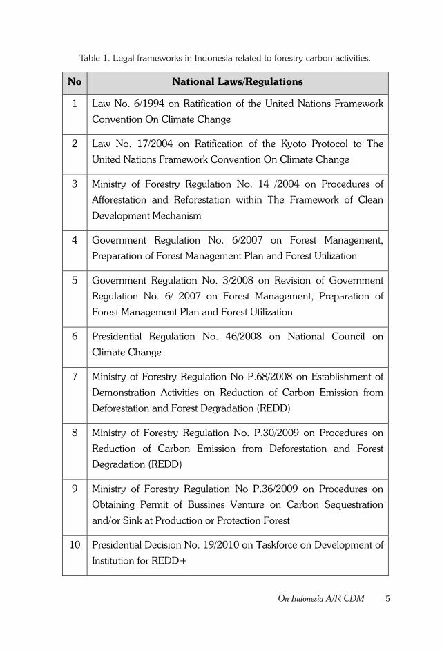
1 Law No. 6/1994 on Ratification of the United Nations Framework
Convention On Climate Change
2 Law No. 17/2004 on Ratification of the Kyoto Protocol to The
United Nations Framework Convention On Climate Change
3 Ministry of Forestry Regulation No. 14 /2004 on Procedures of
Afforestation and Reforestation within The Framework of Clean
Development Mechanism
4 Government Regulation No. 6/2007 on Forest Management,
Preparation of Forest Management Plan and Forest Utilization
5 Government Regulation No. 3/2008 on Revision of Government
Regulation No. 6/ 2007 on Forest Management, Preparation of
Forest Management Plan and Forest Utilization
6 Presidential Regulation No. 46/2008 on National Council on
Climate Change
7 Ministry of Forestry Regulation No P.68/2008 on Establishment of
Demonstration Activities on Reduction of Carbon Emission from
Deforestation and Forest Degradation (REDD)
8 Ministry of Forestry Regulation No. P.30/2009 on Procedures on
Reduction of Carbon Emission from Deforestation and Forest
Degradation (REDD)
9 Ministry of Forestry Regulation No P.36/2009 on Procedures on
Obtaining Permit of Bussines Venture on Carbon Sequestration
and/or Sink at Production or Protection Forest
10 Presidential Decision No. 19/2010 on Taskforce on Development of
Institution for REDD+
Table 1. Legal frameworks in Indonesia related to forestry carbon activities.
6 Land Rehabilitation in Extreeme Zone
of the Republic of Indonesia at 25th September, 2009 in Pittsburgh, USA
declared that Indonesia will reduce its emission as much as 26 %, self-
funded by the Indonesian Government, and if supported by foreign fund
Indonesia promised to reduce even further up to 41%. Some legal
frameworks related to issue on emission reduction in Indonesia can be
viewed in Table 1.
As proofs of Indonesia commitment to carbon trading, aside from
releasing regulations concerning climate change, every regulation that
was issued have been reviewed and re-evaluated for improvement. For
example, newer regulation that was released recently, i.e. Ministerial
Regulation No. 20/2012 was meant to answer some questions, which
was not accommodated in the previous rules. This regulation was issued
because the Ministerial Regulation No. 14/2004 did not include regulation
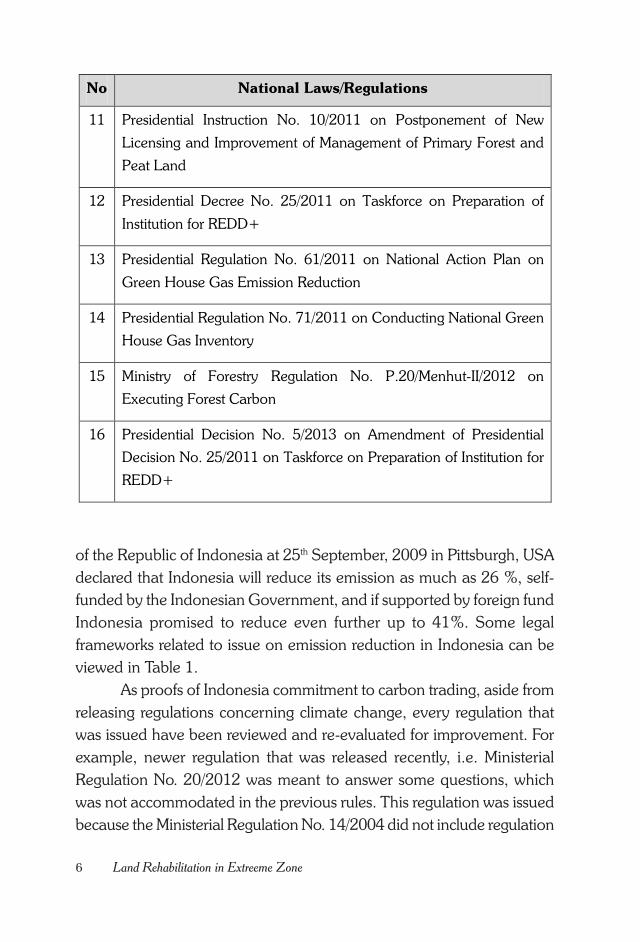
No National Laws/Regulations
11 Presidential Instruction No. 10/2011 on Postponement of New
Licensing and Improvement of Management of Primary Forest and
Peat Land
12 Presidential Decree No. 25/2011 on Taskforce on Preparation of
Institution for REDD+
13 Presidential Regulation No. 61/2011 on National Action Plan on
Green House Gas Emission Reduction
14 Presidential Regulation No. 71/2011 on Conducting National Green
House Gas Inventory
15 Ministry of Forestry Regulation No. P.20/Menhut-II/2012 on
Executing Forest Carbon
16 Presidential Decision No. 5/2013 on Amendment of Presidential
Decision No. 25/2011 on Taskforce on Preparation of Institution for
REDD+
7On Indonesia A/R CDM
for conservation forest and obligation for environmental service business
license of area outside forest region.
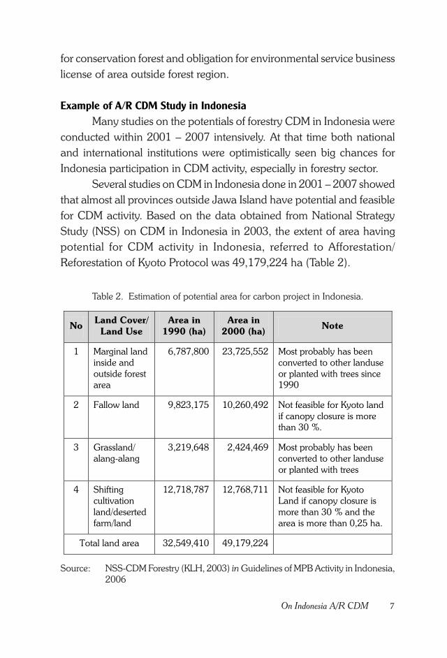
Example of A/R CDM Study in Indonesia
Many studies on the potentials of forestry CDM in Indonesia were
conducted within 2001 – 2007 intensively. At that time both national
and international institutions were optimistically seen big chances for
Indonesia participation in CDM activity, especially in forestry sector.
Several studies on CDM in Indonesia done in 2001 – 2007 showed
that almost all provinces outside Jawa Island have potential and feasible
for CDM activity. Based on the data obtained from National Strategy
Study (NSS) on CDM in Indonesia in 2003, the extent of area having
potential for CDM activity in Indonesia, referred to Afforestation/
Reforestation of Kyoto Protocol was 49,179,224 ha (Table 2).
Table 2. Estimation of potential area for carbon project in Indonesia.
No Land Cover/
Land Use
Area in
1990 (ha)
Area in
2000 (ha) Note
1 Marginal land inside and outside forest area
6,787,800 23,725,552 Most probably has been converted to other landuse or planted with trees since 1990
2 Fallow land 9,823,175 10,260,492 Not feasible for Kyoto land if canopy closure is more than 30 %.
3 Grassland/ alang-alang
3,219,648 2,424,469 Most probably has been converted to other landuse or planted with trees
4 Shifting cultivation land/deserted farm/land
12,718,787 12,768,711 Not feasible for Kyoto Land if canopy closure is more than 30 % and the area is more than 0,25 ha.
Total land area 32,549,410 49,179,224
Source: NSS-CDM Forestry (KLH, 2003) in Guidelines of MPB Activity in Indonesia,2006
8 Land Rehabilitation in Extreeme Zone
Distribution of area (province) which is suitable for CDM has been
identified in several studies. However, the following up CDM activity,
especially in forestry sector were very few. Many stakeholders feel
pessimistic with the continuation of CDM activity in the forestry sector,
due to technical aspects, such as methodology, leakage, transaction cost,
carbon price, policy and market option.
Huge obstacle of CDM activity in Indonesia has made Ministry of
Forestry of the Republic of Korea interested in looking deeper into the
obstacle of CDM activity in Indonesia, whether it is due to technical factor
or non-technical factor, such as policy or social and society.
9Cooperation with Korea
CHAPTER II.
COOPERATION WITH KOREA
History of Cooperation with KOICA
In August 2006 Indonesia and Korea signed a Memorandum of
Understanding/MoU through Korean Ministry of Forestry and Indonesian
Ministry of Forestry, regarding joint investment in forest plantation and
A/R CDM in Indonesia. The MOU covered three important points, i.e.
(1) Both stakeholders will cooperate in following up Kyoto Protocol by
conducting an A/R CDM in Indonesia, (2) Establishing an effective
cooperation between forestry institutions in both countries within the
framework of capacity building, research and development, survey on
land availability to support A/R CDM project, (3) Indonesia will facilitate
by providing suitable land area for establishing forest plantation and A/R
CDM project at the maximum 500,000 Ha (KOICA – FORDA, 2013).
In the following December 2006 another MOU was signed between
Korean Ministry of Forestry and Indonesian Ministry of Forestry concerning
development of a forestry forum. This development was recognized by
the Presidents of both countries as necessitates in establishing strategic
partnership. The MOU consisted of three points of establishments of three
organization committees, i.e. (1) Committee for Forest Plantation and A/
R CDM, whose task is to push and support Korea investment on forest
plantation and A/R CDM project in Indonesia, (2) Committee for Forest
Protection and Conservation, whose task is providing suitable land area
10 Land Rehabilitation in Extreeme Zone
for forest plantation and implementation of the first A/R CDM project,
(3) Committee for Forestry Research and Development, whose task is
formulating collaborative research agendas on forest plantation and A/R
CDM, forest conservation and development of bioenergy.
In June 2007, the Committee for Forestry Research and
Development reported results from the first meeting of Korea-Indonesia
Forestry Forum. At that meeting Indonesia representative pointed out
requirement of deeper research on forest plantation, forest product
technology and REDD. Indonesian Ministry of Forestry proposed four
(4) Project Plan Documents (Dokumen Rancangan Proyek/DRP) for 9
(nine) proposed locations. Both stakeholders agreed to develop a
collaborative research on REDD.
The next MOU was signed by both stakeholders in July 2007.
The MOU was about collaborative adaptation and mitigation of climate
change in forestry sector through A/R CDM and other related mechanisms.
The scope of collaborative activity was collaborative research and
implementation of the first A/R CDM and REDD project in Indonesia,
including feasibility valuation for monitoring, methodology, transaction
cost, incentive mechanism and distribution. The MOU also explained
the role and contribution of each stakeholder, of which the Republic of
Korea will secure funding sources by pushing the potential investor to
conduct A/R CDM and REDD project in Indonesia. Meanwhile the
Republic of Indonesia will provide potential land and related information
for collaborative research and implementation of A/R CDM and REDD
in Indonesia.
In the subsequent development of the cooperation starting
January, May, September and December 2008 it was decided to start
implementing A/R CDM activity in Indonesia, of which the KOICA (Korea
International Cooperation Agency) sent a team of field surveyor; held a
discussion between KOICA and Indonesian Ministry of Forestry on the
project; drawing conclusion from ROD (Record of Discussion) between
KOICA and Indonesian Ministry of Forestry; and KOICA would decide
on the implemented forestry research project.
11Cooperation with Korea
The cooperative activity between the Republic of Korea and the
Republic of Indonesia through their respective Ministry of Forestry was
named “The Korea-Indonesia Joint Project for Adaptation and Mitigation
of Climate Change in Forestry through A/R CDM and REDD in Indonesia
(KIPCCF)”. Period of the joint activity stands for five years starting 2008
until 2013. About implementing agency it was decided that the Republic
of Korea would assign KOICA through KIPCCF, while the Republic of
Indonesia assigned Indonesian Ministry of Forestry through Forest
Research and Development Agency (FORDA). Later in March 2009,
Indonesian Ministry of Forestry prepared information on the location of
the proposed project of A/R CDM and REDD.
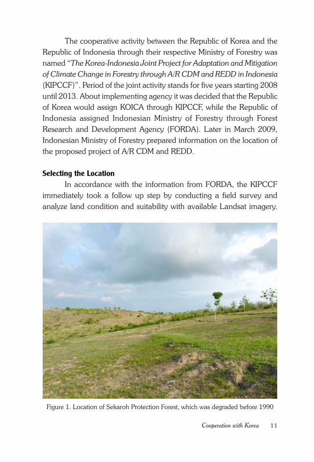
Selecting the Location
In accordance with the information from FORDA, the KIPCCF
immediately took a follow up step by conducting a field survey and
analyze land condition and suitability with available Landsat imagery.
Figure 1. Location of Sekaroh Protection Forest, which was degraded before 1990
12 Land Rehabilitation in Extreeme Zone
Activity of analyzing Landsat imagery and field survey on land suitability
were conducted by a consultant UBIS. From UBIS analysis it was
concluded that the area of Sekaroh Protection Forest is suitable based
on technical requirement for CDM. Requirement stated in the Kyoto
Protocol is that the land for A/R CDM should have been degraded or
deforested before 1st January 1990. Based on the analysis of Landsat
imagery of Sekaroh Protection Forest area, also result of discussion with
local community it was found out that the land had been degraded before
1990. Thus the area is suitable for AR CDM activity from the technical
point of view of base year.
Land Suitability
Climate. Recorded climate data in the Meteorological Station at
Selaparang, Mataram for 10 years (2000 – 2009) shows that the location
for A/R CDM activity has average yearly rainfall at 1,539.3 mm with 4
dry months, of which could be longer up to 6 months. For large scale
plant cultivation the climate factor is the limiting factor which could not
be altered (Prima Kelola, 2010).
Effective Soil Depth. Effective soil depth would affect root
development of a plant. Perennial crops have deep root system, which
requires a deep effective soil depth. Some perennial crops could have
short roots that deep solum is not necessary. The location for A/R CDM
activity has various effective soil depths, i.e. 80-120 cm of SMU (Soil
Mapping Unit) 1, 50-100 cm of SMU 2, 40 - 80 cm of SMU 3, dan 20 -
40 cm of SMU 4 (Prima Kelola, 2010).
Level of Soil Fertility. Soil at the location of A/R CDM activity
is categorized as slightly basic in nature (pH 7,5-8,5) with moderate level
of fertility according to criteria from Soil Research Center (Pusat Penelitian
Tanah 1983). However, C-organic content and the amount of N, which
indicate content of organic matter in the soil, are categorized as very low
to low (Prima Kelola, 2010).
13Cooperation with Korea
Results of Evaluation on Land Suitability
The location of A/R CDM activity in East Lombok could be utilized
for both tree planting and cultivation of annual crop. Other than tree
species, analysis on land suitability was also done for hazelnut (kemiri),
cashew nut, peanut, green bean, soybean, corn and chilli pepper. Species
selection was done considering the experience of local farmers. Result of
evaluation on land suitability using criteria from Ministry of Agriculture
(1997) showed that the research site could be categorized into 3 (three)
classes of land suitability, i.e. relatively suitable (S2), mostly suitable (S3)
and not suitable (N), with the main limiting factors consist of low rainfall
with long period of dry month (w), shallow solum (r) and nutrient retention
due to slightly basic pH (n). Srikaya and other tree species which has
been cultivated at most of the study area seemed suitable. In order to
increase the land suitability class and increase land fertility at the study
site, addition of organic matter either in the form of compost, plant litter
or manure is necessary.
Feasibility of the Land as A/R CDM Site
Land feasibility was assessed using “Procedure for Assessing Land
Feasibility for Activity on Afforestation and Reforestation CDM Project”.
Proposed land was not forested at the beginning of the project.
Field survey was done to give evidence that the proposed land was not
covered by forest. Result showed that most of the land has been utilized
for agricultural activity by local community. Most of the study area has
been cultivated with food crops such as corn, green bean, chili pepper,
banana, and tobacco. Sekaroh Protection Forest Land according to base
year of Kyoto Protocol is suitable for forestry activity because it was not
covered by forest since 1st Januari 1990. Forest cover of selected land
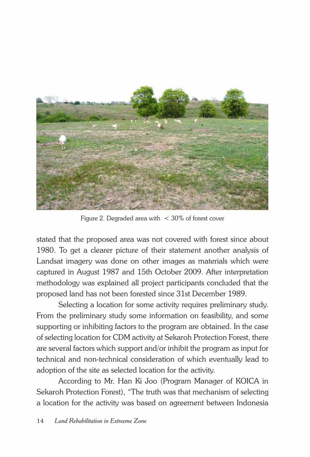
was < 30% (Figure 2).
Analysis of Landsat imagery is used as evidence that the proposed
area is not covered with forest. Proposed CDM activity consisted of
regreening activity which was proved by strong approach integrating result
of interview and Landsat imagery analysis. Based on interviews with
local community who inhabited the surrounding proposed area, they
14 Land Rehabilitation in Extreeme Zone
Figure 2. Degraded area with < 30% of forest cover
stated that the proposed area was not covered with forest since about
1980. To get a clearer picture of their statement another analysis of
Landsat imagery was done on other images as materials which were
captured in August 1987 and 15th October 2009. After interpretation
methodology was explained all project participants concluded that the
proposed land has not been forested since 31st December 1989.
Selecting a location for some activity requires preliminary study.
From the preliminary study some information on feasibility, and some
supporting or inhibiting factors to the program are obtained. In the case
of selecting location for CDM activity at Sekaroh Protection Forest, there
are several factors which support and/or inhibit the program as input for
technical and non-technical consideration of which eventually lead to
adoption of the site as selected location for the activity.
According to Mr. Han Ki Joo (Program Manager of KOICA in
Sekaroh Protection Forest), “The truth was that mechanism of selecting
a location for the activity was based on agreement between Indonesia
15Cooperation with Korea
Government and Korea Government. Indonesia Government through
Ministry of Forestry had recommended East Lombok Province, while
other candidate than East Lombok was Bandung, West Jawa”.
Based on data from Central Bureau of Statistic, Korea and
Indonesia joint team knew that East Lombok has low income or
considered as economically marginal. Korea Government strongly
committed to give support to developing countries. The location, East
Lombok, which has low infrastructure, was considered as suitable with
this program objectives, of which full funding was provided by KOICA.
Through CDM program Sekaroh would be supported for its rehabilitation
activity. Those were the cause why Korea had selected Sekaroh, East
Lombok than other site (Majalah Tropis, 2011).

16 Land Rehabilitation in Extreeme Zone
17Conditions of Sekaroh Protection Forest Land
CHAPTER III.
CONDITIONS OFSEKAROH PROTECTION FOREST LAND
Land Status
Sekaroh Protection Forest Group is located at ° 31’ 22" – 08° 37"
05" SL and 116° 27’ – 116 36’ 33" EL. Historically this land was originally
a Ground Government, and due to its condition, such as the existing
bushes, degraded forest, and ex-shifting cultivation, the land needs to be
maintained as forested area. Furthermore, there was an agreement by
Eastern Lombok Regency Government that has been included in the
Forest Land Use scheme with the decree issued by the Ministry of
Agriculture of Republic of Indonesia No 756/Kpts/Um/10/1982 on October
12th 1982 which determined Sekaroh into Protected Forest Area of 3.000
hectares. On July 10th until August 17th 1983 measurement and installation
of definitive boundary marks have been assembled by the Boundary
Committee. The results of these boundary marks was agreed by the
Boundary Committee and then decided by the Minister of Forestry No:
8214/Kpts-II/2002, which determined Sekaroh Forest Group of 2.834,20
Hectares as permanent forest area with protection function.
In further development the Ministry of Forestry issued Decree
Number 337/menhut-VII/2009 stating that Sekaroh Protection Forest will
be maintained under a forest management scheme called FMU (Forest
Management Unit).

18 Land Rehabilitation in Extreeme Zone
Real Condition of the Land
Based on Technical Plan of Forest and Land Rehabilitation
(RTKRHL) of Watershed Management Agency (BPDAS DMS), the
location of A/R CDM belonged to priority 2 (second priority), SWP
Dodokan management area, covering 4 watersheds, i.e. Kenyaru,
Lendang Lobok, Teluk Sunut, and Tanjung Ambitmaling. In this case
priority 1 (First priority) refers to areas with highly marginal, and marginal
lands, while priority 2 (second priority) refers to areas with less marginal,
or potentially marginal lands.
From the discussions with local community in formerly Persiapan
Sekaroh Village and now Sekaroh Village, the location of Protected Forest
where this CDM activity will be implemented had been degraded before
1990 in the form of bush land and shifting cultivation area. This
information was supported by satellite imagery obtained, which showed
that the location had become bush land before 1990 and was suitable
for CDM activity.
Sekaroh Protection Forest Area formed one stretch of landscape
at Persiapan Sekaroh Village, in which location the 300 Hectares AR
CDM activity was including 3 hamlets. Local community has been
practicing agriculture in all the designated CDM area. The dominant crops
are corns, beans, chili, and others.
The local community has already known agroforestry system, and
familiar with reforestation activity. In addition to agriculture, the local
community also actively performs animal husbandry. The livestock is
grazed by herdsman, and some others let their livestock graze in the
forest but still under control of the owner.
Several rehabilitation activities have been done in Sekaroh
Protection Forest Area, namely GNRHL or Gerakan Nasional Rehabilitasi
Hutan dan Lahan (National Action for Forest and Land Rehabilitation)
conducted by the Forest Service as well as reforestation conducted by
JIFPRO together with the Ministry of Forestry of Republic of Indonesia.
Some of these activities are considered successful, and some are less
successful. The cause of failure of the reforestation activity was
inappropriate timing of seeds arrival, which affected planting time. In
19Conditions of Sekaroh Protection Forest Land
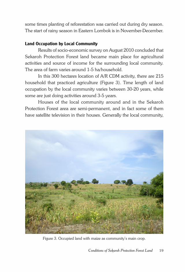
Figure 3. Occupied land with maize as community’s main crop.
some times planting of reforestation was carried out during dry season.
The start of rainy season in Eastern Lombok is in November-December.
Land Occupation by Local Community
Results of socio-economic survey on August 2010 concluded that
Sekaroh Protection Forest land became main place for agricultural
activities and source of income for the surrounding local community.
The area of farm varies around 1-5 ha/household.
In this 300 hectares location of A/R CDM activity, there are 215
household that practiced agriculture (Figure 3). Time length of land
occupation by the local community varies between 30-20 years, while
some are just doing activities around 3-5 years.
Houses of the local community around and in the Sekaroh
Protection Forest area are semi-permanent, and in fact some of them
have satellite television in their houses. Generally the local community,
20 Land Rehabilitation in Extreeme Zone
who have lived there for more than 10 years would have permanent
house already.
Fresh water source for local community needs is located between
100 - 1000 meters distance. In 2010 total freshwater ponds in Sekaroh
Protection Forest area are 26 ponds.
Permissiveness of Government Officials
Southern Lombok local community has rather strong characteristic
as influenced by geographic and climatic conditions that are relatively
hotter than the other areas. This area is also called the rain-fed farm
(embung bangket) or dry land agriculture. Agriculture activity in this area
relies on rain water, as water availability is very little in the dry months
(March-October).
Local community of Eastern Lombok, especially those who settled
around Sekaroh Protection Forest Area usually lives and cultivates to
generate income solely on the land at that area. The activity eventually
affects the number of trees presence in the Sekaroh Protection Forest.
The more agricultural activities being done, the more trees population
would be reduced because of less competitive with agricultural crops.
No matter how many forest rangers and guards deployed, without
awareness from the local community, it would be difficult to maintain
sustainable forest. Thus, partnership with the local community would
have to be build in order to promote sustainable forestry.
The Extension Agency (Bapeluh) which is combined extension
agencies from agriculture, horticulture, and forestry sectors has not been
effective in raising people awareness, despite of already established since
2009. In practice, extension will become effective if the officer is respected
and has influence to the local community. On the contrary, extension
won’t be effective if the officer do not master their field, do not have
persuasive communication skills, and indecisive on illegal activity.
The permissive behavior from the forest officer was apparent from
the beginning, since local community occupied Sekaroh Protection Forest
Region by project, such as GNRHL and JIFFPRO. Ideally after
transplanted trees were grown, the people were expected also to take
21Conditions of Sekaroh Protection Forest Land
care of them and no longer cultivate crops, which needs more than 60%
sun light.
Conflict of interests between local community leaders contributes
to the permissiveness of farming activity on Sekaroh Protection Forest
Area. In fact, often in the event of local politics like village leader election,
some public figure would lure local people to vote for him with a prize of
a Certificate of Land Property Rights in Sekaroh Protection Forest.
The presence of awig-awig or local local community rules that is
usually obeyed by the local community has almost forgotten. In this case
awig-awig existence needs to be fostered and promoted again among
local community in order to support successful land rehabilitation.
While launching this CDM program in several meetings efforts
had been made to explore local knowledge, especially about awig-aiwg,
which has been forgotten. Local knowledge needs to be revived; also
environmental awareness of the forest officers needs to be raised in order
to erase permissive behavior on forest degradation.

22 Land Rehabilitation in Extreeme Zone
23Social Condition of the Local Community
CHAPTER IV.
SOCIAL CONDITION OFTHE LOCAL COMMUNITY
Information on Land Clearing and Utilization
Local community started farming in Sekaroh Protection Forest
Area around 1960 - 2005. From totally 30 respondents, 14% cleared
forest and used the land in 1960-1970. Land clearing between year 1971
- 1980 was about 7%. Most land clearing activity done by local community
in Sekaroh Protection Forest Area was happened in 1981-1990, which
made up 46%. Surprisingly this later period was the time when Sekaroh
area was determined to become a Protected Forest based on Decision
Letter of the Ministry of Agriculture of the Republic of Indonesia No.
756/Kpts/Um/10/1982 dating 12 October 1982. Between years 1991 -
2000 there were still many local people cleared forest for agricultural
lands, which was about 25%. After 2001 about 7% of additional land
was cleared.
Forest clearing for agriculture in Sekaroh Protection Forest Area
by local community was done with help from their own family without
cost. Main motivation of these land clearings was economical motivation,
and some of them were influenced by friends, relatives, or parents. There
was neither permit to clear forest from the authority nor distinct prohibition
to these activities.
24 Land Rehabilitation in Extreeme Zone
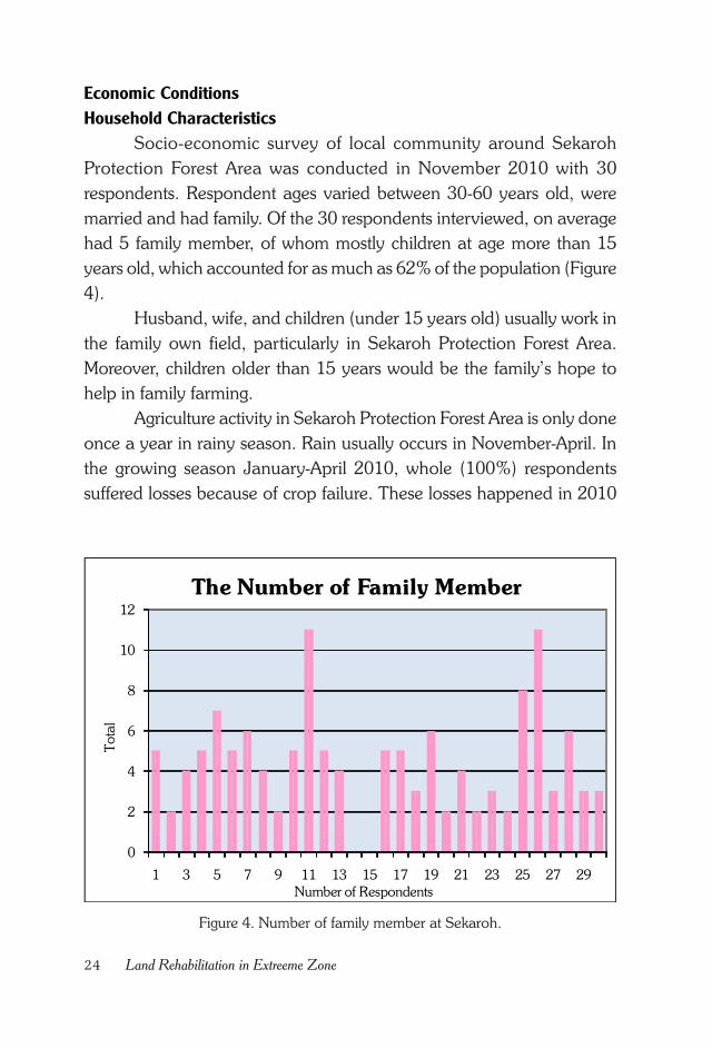
Figure 4. Number of family member at Sekaroh.
Economic Conditions
Household Characteristics
Socio-economic survey of local community around Sekaroh
Protection Forest Area was conducted in November 2010 with 30
respondents. Respondent ages varied between 30-60 years old, were
married and had family. Of the 30 respondents interviewed, on average
had 5 family member, of whom mostly children at age more than 15
years old, which accounted for as much as 62% of the population (Figure
4).
Husband, wife, and children (under 15 years old) usually work in
the family own field, particularly in Sekaroh Protection Forest Area.
Moreover, children older than 15 years would be the family’s hope to
help in family farming.
Agriculture activity in Sekaroh Protection Forest Area is only done
once a year in rainy season. Rain usually occurs in November-April. In
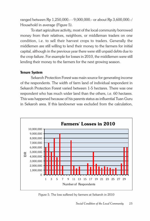
the growing season January-April 2010, whole (100%) respondents
suffered losses because of crop failure. These losses happened in 2010
0
2
4
6
8
10
12
1 3 5 7 9 11 13 15 17 19 21 23 25 27 29
Total
The Number of Family Member
Number of Respondents
25Social Condition of the Local Community
Figure 5. The loss suffered by farmers at Sekaroh in 2010
ranged between Rp 1,250,000.- - 9,000,000.- or about Rp 3,600,000.-/
Household in average (Figure 5).
To start agriculture activity, most of the local community borrowed
money from their relatives, neighbors, or middleman traders on one
condition, i.e. to sell their harvest crops to traders. Generally the
middlemen are still willing to lend their money to the farmers for initial
capital, although in the previous year there were still unpaid debts due to
the crop failure. For example for losses in 2010, the middlemen were still
lending their money to the farmers for the next growing season.
Tenure System
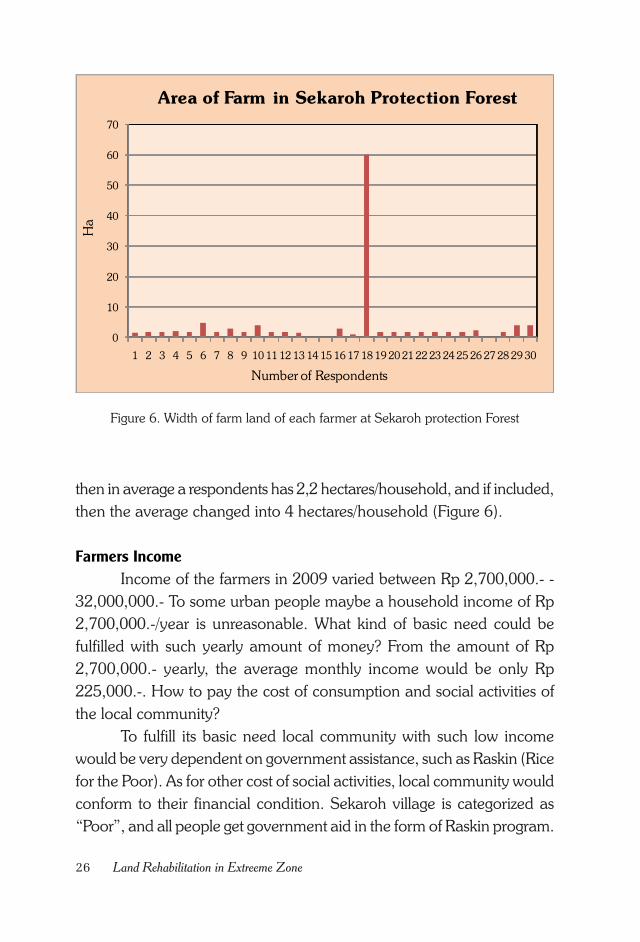
Sekaroh Protection Forest was main source for generating income
of the respondents. The width of farm land of individual respondent in
Sekaroh Protection Forest varied between 1-5 hectares. There was one
respondent who has much wider land than the others, i.e. 60 hectares.
This was happened because of his parents status as influential Tuan Guru
in Sekaroh area. If this landowner was excluded from the calculation,
0
1,000,000
2,000,000
3,000,000
4,000,000
5,000,000
6,000,000
7,000,000
8,000,000
9,000,000
10,000,000
1 3 5 7 9 11 13 15 17 19 21 23 25 27 29
IDR
Number of Respondents
Farmers' Losses in 2010
26 Land Rehabilitation in Extreeme Zone
Figure 6. Width of farm land of each farmer at Sekaroh protection Forest
then in average a respondents has 2,2 hectares/household, and if included,
then the average changed into 4 hectares/household (Figure 6).
Farmers Income
Income of the farmers in 2009 varied between Rp 2,700,000.- -
32,000,000.- To some urban people maybe a household income of Rp
2,700,000.-/year is unreasonable. What kind of basic need could be
fulfilled with such yearly amount of money? From the amount of Rp
2,700,000.- yearly, the average monthly income would be only Rp
225,000.-. How to pay the cost of consumption and social activities of
the local community?
To fulfill its basic need local community with such low income
would be very dependent on government assistance, such as Raskin (Rice
for the Poor). As for other cost of social activities, local community would
conform to their financial condition. Sekaroh village is categorized as
“Poor”, and all people get government aid in the form of Raskin program.
0
10
20
30
40
50
60
70
1 2 3 4 5 6 7 8 9 10 11 12 13 14 15 16 17 18 19 20 21 22 23 24 25 26 27 28 29 30
Area of Farm in Sekaroh Protection Forest
Number of Respondents
Ha
27Social Condition of the Local Community
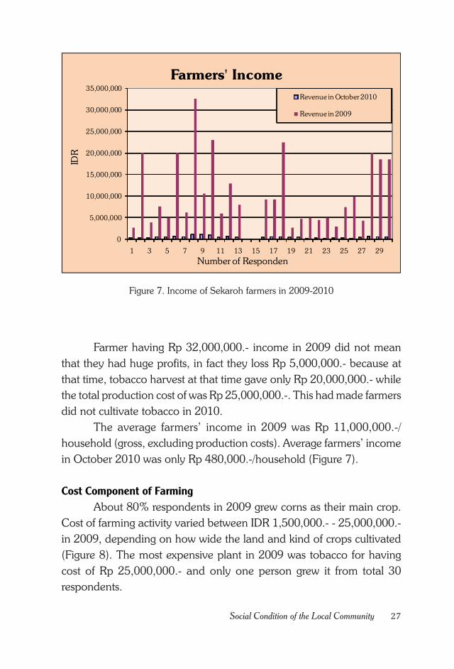
Figure 7. Income of Sekaroh farmers in 2009-2010
Farmer having Rp 32,000,000.- income in 2009 did not mean
that they had huge profits, in fact they loss Rp 5,000,000.- because at
that time, tobacco harvest at that time gave only Rp 20,000,000.- while
the total production cost of was Rp 25,000,000.-. This had made farmers
did not cultivate tobacco in 2010.
The average farmers’ income in 2009 was Rp 11,000,000.-/
household (gross, excluding production costs). Average farmers’ income
in October 2010 was only Rp 480,000.-/household (Figure 7).
Cost Component of Farming
About 80% respondents in 2009 grew corns as their main crop.
Cost of farming activity varied between IDR 1,500,000.- - 25,000,000.-
in 2009, depending on how wide the land and kind of crops cultivated
(Figure 8). The most expensive plant in 2009 was tobacco for having
cost of Rp 25,000,000.- and only one person grew it from total 30
respondents.
0
5,000,000
10,000,000
15,000,000
20,000,000
25,000,000
30,000,000
35,000,000
1 3 5 7 9 11 13 15 17 19 21 23 25 27 29
Farmers' Income
Revenue in October 2010
Revenue in 2009
IDR
Number of Responden
28 Land Rehabilitation in Extreeme Zone
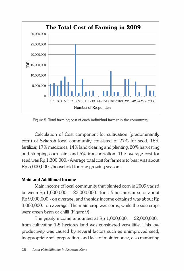
Figure 8. Total farming cost of each individual farmer in the community
Calculation of Cost component for cultivation (predominantly
corn) of Sekaroh local community consisted of 27% for seed, 16%
fertilizer, 17% medicines, 14% land clearing and planting, 20% harvesting
and stripping corn skin, and 5% transportation. The average cost for
seed was Rp 1,300,000.- Average total cost for farmers to bear was about
Rp 5,000,000.-/household for one growing season.
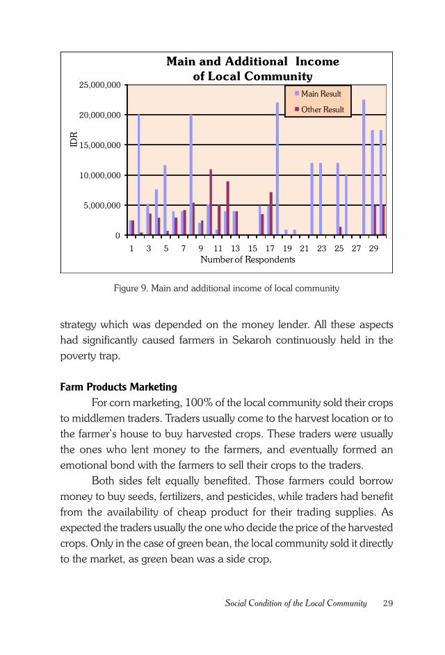
Main and Additional Income
Main income of local community that planted corn in 2009 varied
between Rp 1,000,000.- - 22,000,000.- for 1-5 hectares area, or about
Rp 9,000,000.- on average, and the side income obtained was about Rp
3,000,000.- on average. The main crop was corns, while the side crops
were green bean or chilli (Figure 9).
The yearly income amounted at Rp 1,000,000.- - 22,000,000.-
from cultivating 1-5 hectares land was considered very little. This low
productivity was caused by several factors such as unimproved seed,
inappropriate soil preparation, and lack of maintenance, also marketing
0
5,000,000
10,000,000
15,000,000
20,000,000
25,000,000
30,000,000
1 2 3 4 5 6 7 8 9 101112131415161718192021222324252627282930
The Total Cost of Farming in 2009ID
R
Number of Responden
29Social Condition of the Local Community
Figure 9. Main and additional income of local community
strategy which was depended on the money lender. All these aspects
had significantly caused farmers in Sekaroh continuously held in the
poverty trap.
Farm Products Marketing
For corn marketing, 100% of the local community sold their crops
to middlemen traders. Traders usually come to the harvest location or to
the farmer’s house to buy harvested crops. These traders were usually
the ones who lent money to the farmers, and eventually formed an
emotional bond with the farmers to sell their crops to the traders.
Both sides felt equally benefited. Those farmers could borrow
money to buy seeds, fertilizers, and pesticides, while traders had benefit
from the availability of cheap product for their trading supplies. As
expected the traders usually the one who decide the price of the harvested
crops. Only in the case of green bean, the local community sold it directly
to the market, as green bean was a side crop.
0
5,000,000
10,000,000
15,000,000
20,000,000
25,000,000
1 3 5 7 9 11 13 15 17 19 21 23 25 27 29
Main and Additional Income
of Local Community
Main Result
Other Result
IDR
Number of Respondents
30 Land Rehabilitation in Extreeme Zone
Local Community Interaction with the Protection Forest
The local community can access very easily the protection forest,
because of very close distance (100-200 meters) from their home, also
due to their dependency on Sekaroh Protection Forest. There are several
purposes to enter Sekaroh Protection Forest as if it were their own garden,
i.e. gathering firewoods, while some of them even live in the Sekaroh
Protection Forest. The road entering the forest is good, accessible by
motorcycles and cars, made local community entering to Sekaroh
Protection Forest with various reasons.
Sekaroh Protection Forest is also served as an entry gate to the
sea for some local community. Sekaroh Protection Forest which is located
at coast line plays important role for many people. From the
environmental view, Sekaroh Protection Forest is very important to
maintain optimum micro climate, and as a buffer for agriculture crops
from the sea breeze. For some local community, Sekaroh Protection Forest
functioned as an income source for the family, while some others utilize
Sekaroh Protection Forest as a recreation spot, because Sekaroh
Protection Forest has a beautiful forest and beach around it.
Preferred Plant Species and Information on Climate Change
Generally, local community has already familiar with planting trees,
whether planting it around their houses or to join government planting
programs, such as GNRHL activity or reforestation. Some of forest trees
preferred by the local community are imba, sonokeling, sengon,
mahogany, teak, and turi. While MPTS plant species selected by the local
community are mango, srikaya, kapuk, asam, jambu, sawo, jackfruit,
soursop, and orange. Among all plant species listed above, two most
preferred trees by local community are srikaya and mango. These two
species are also the most planted by local community around their houses.
Most local community has never heard and does not know about
climate change. Somehow from their daily activity of planting and farming
they have felt direct impact of climate change. Local community often
experienced crop failure and could not predict the rainy and dry season
cycle as important information for agricultural activities.
31Social Condition of the Local Community
Information on Utilization of Unproductive Land
One hundred percent of local community does not have deserted
land. All arable lands have already managed by the local community.
Currently (November 2010) there wasn’t new land clearing, because there
wasn’t any left, and they can’t clear a new land in Sekaroh Protection
Forest, because it’s prohibited by the Forestry Service. Before 2005, there
were still local community who cleared up new land in Sekaroh Protection
Forest; nowadays there are employees who take care of Sekaroh
Protection Forest territory.
Information on the Potential of Household Industry
It is interesting that from the point of view of land productivity the
crop productions activity which is only done once a year has high chance
of failure. However most of the local community (54%) doesn’t have
initiative to open a new business venture to increase the income. Was it
due to no other idea, not enough information, or was it because they
have already surrendered to the existing condition?
Approximately 46% of the local community wished to open a
new business, i.e. to sell daily goods, petrol, buying a car for timber
transportation, selling cold drinks, tofu productions, and raising livestock.
The obstacles in initiating these new businesses were limited capital and
lack of information access.
Social Interaction
Most of the local community (64%) is still practicing traditional
culture of mutual cooperation. It can be seen from how they always help
each other out when their neighbors or other famers opening new
farmland, maintaining and harvesting crops, or making a public road.
Most of the local community (60%) believes on the presence of
dominant social status in the local society itself. In this case, the most
respected status is Tuan Guru. The respected public figures from the local
community are Tuan Guru, village chief, and hamlet chief. About 50%
believes that Tuan Guru is the most respected figure in the local society
(Figure 10).
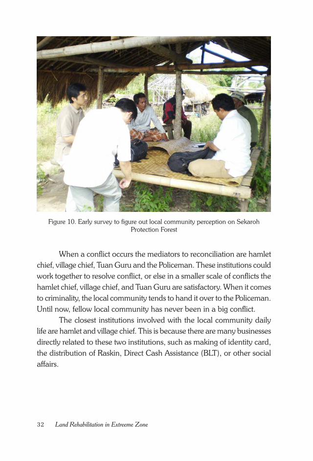
32 Land Rehabilitation in Extreeme Zone
Figure 10. Early survey to figure out local community perception on SekarohProtection Forest
When a conflict occurs the mediators to reconciliation are hamlet
chief, village chief, Tuan Guru and the Policeman. These institutions could
work together to resolve conflict, or else in a smaller scale of conflicts the
hamlet chief, village chief, and Tuan Guru are satisfactory. When it comes
to criminality, the local community tends to hand it over to the Policeman.
Until now, fellow local community has never been in a big conflict.
The closest institutions involved with the local community daily
life are hamlet and village chief. This is because there are many businesses
directly related to these two institutions, such as making of identity card,
the distribution of Raskin, Direct Cash Assistance (BLT), or other social
affairs.
33Social Condition of the Local Community
Institution of CDM Program and Obstacles
All respondents agreed to tree plantation program in Sekaroh
Protection Forest. Some obstacles that may exist in land rehabilitation
activities in Sekaroh included strong weather, grazing and some negative
attitude from local community towards the program. All of these obstacles
could be overcome by tree species selection and better socialization
method.
Institutions which are willing to collaborate in addressing this issues
are Tuan Guru, NGOs, Chief Village, LKMD (village social security),
hamlet Chief and Youth Institution. According to the local community
necessary collaboration for land rehabilitation could be initiated with
institutions such as local Forest Service, Tuan Guru, Village Chief, and
local social security. Somehow the local people still do not know what
kind of role each institution would play and how the benefit sharing of
this activity in the future.
Experience from Former Rehabilitation and Reforestation
Implementation
About 77% of the public is aware of the rehabilitation activities
that have been done around Sekaroh Protection Forest. Some previous
activities known by local community are: reforestation, Gerhan (national
movement for land rehabilitation), HKM (social forestry) and JIFPRO.
The success rate of these rehabilitation programs according to the
community varies between 25-70%. However there was no supporting
data available. About 10% of people said they know that the data on
previous rehabilitation activity in Sekaroh Protection Forest was saved
by UPTD (management unit) of the Ministry of Forestry.
The greatest obstacle to this program according to local community
was lack of community involvement in the program, so that the
community did not have sense of belonging toward the program, also
the absence of good network between local communities with local NGOs.
34 Land Rehabilitation in Extreeme Zone
Condition of Education
Education level of most people around the Sekaroh Protection
Forest is elementary school graduates. Apart from economic factors low
levels of people education was caused by lack of family motivation to
pursue school further. Most local community still thought that after
finishing school everybody would also work in the field anyway, so that
they prefer to encourage their children to the farming fields.
Raskin (Rice for the Poor) for Everybody
This is indisputable evidence. Sekaroh Chief Village also stated
that 100% Sekaroh people get rice-for-the-poor (Raskin) from the
government. Based on this observation it’s easy to guess what the
economic level of Sekaroh villagers is.
The poor condition was in fact the main driving reason for the
implementation of AR CDM by KOICA in Sekaroh Protection Forest.
Apart from the technical factors, such as land suitability for CDM, the
economic condition of the local community which is below the poverty
line was the main consideration. Existence of AR CDM program was
expected enabling transfer of information and technology to the local
community, so that the AR CDM is not only benefit the environment but
also build community capacity to increase income.
Would the Condition Persist?
Apparent from the discussion with local community was general
people recognition that the way of their agricultural practices would not
change their life for better. This fact has been realized by local community.
But it just seemed there was no other choice than usual agricultural
activities.
If other activities or business choices are available with more
economic returns, people are willing to change their way of life. However,
people need concrete example. Otherwise people would keep planting
corn despite of frequent loss, since these activities are familiar to most
people and easy to do.
35Social Condition of the Local Community
The task of various stakeholders involved here is to help people
make a change by providing input of technology, information and
marketing systems of agricultural products. Without technological
innovation, new public information and marketing strategy, the economic
condition will likely stay in the poverty line. Would this kind of condition
be kept? People said that they want to improve the economy and their
family livelihood. How would they do that? It’s everybody responsibility
to think about it. FORDA and KOICA had actively been trying to find a
way that can boost the economy of the community with the AR CDM
activity, but for just once program certainly would not be enough to
make change. Changes in the local community economy require
simultaneous and continuous efforts.

36 Land Rehabilitation in Extreeme Zone
37KOICA A/R CDM Activity
CHAPTER V.
KOICA A/R CDM ACTIVITY
Agreement on Site Determination
Any decision related to field activities of the AR CDM program at
Sekaroh Protection Forest always came from a consensus. The
stakeholders, such as KOICA, FORDA Representative, East Lombok
District Forestry Service, Jerowaru District Government, Sekaroh Village
Chief, Farmers Group Association (Gapoktan) Sekaroh Maju and local
public figures always held a discussion first before making a decision.
That same process was done when deciding the exact location of
the project in the field. Out of several hamlets in the Sekaroh Village,
representative hamlets, of which community social capital are more
conducive for the activity were selected for CDM pilot project.
Determination of field location was carried out jointly by all stakeholders.
Requirements for determination of planting location were following
criteria:
• Recommended by local community leaders
• Local people agreed upon their location to be used as the CDM
activity site
• Bio-physical condition of the field was suitable with the planned
plants species
• Condition of the location fulfill the technical requirements of A/R
CDM
38 Land Rehabilitation in Extreeme Zone
Based on all the agreed terms several hamlets, i.e.Pongoros, Ujung
Gon and Pada Kelawe were selected. This agreement was socialized again
by local public figures and Committee of Gapoktan Sekaroh Maju to the
people who will be involved in CDM activities. By this agreement it was
expected that any activities carried out would work properly.
Plant Species Selection
Species selection is one of the most important things in land
rehabilitation involving local community. Ideally, the species selected
satisfy the following criteria:
• Suitable to bio-physical land condition
• High economic value
• Favored by local community
After discussions with the local community and local public figure,
an agreement was reached on species that will be planted on the site.
The tree species consisted of two groups, i.e. forestry species and MPTS
(multi-purpose tree or fruit tree species).
Selected forestry species were:
• Imbe/mimba (Azadirachta indica)
• Mahogany (Swietenia macrophylla)
• Trembesi (Albizia saman (Jacq.))
• Khaya (Khaya anthotheca)
Selected MPTS or fruit trees were :
• Srikaya (Annona Squamosa)
• Mango (Mangifera indica)
• Jackfruit (Artocarpus heterophyllus)
• Asam/tamarind (Tamarindus indica)
The ratio between forestry tree and MPTS or fruit tree species
were 50%: 50%. This equal percentage between forestry trees and MPTS
or fruit tree species were a breakthrough in rehabilitation activities in
39KOICA A/R CDM Activity
Indonesia. Usually in a rehabilitation activity of certain forest areas the
percentage is 70% of forest tree and 30% of MPTS or fruit tree species
(Ministerial Regulation No 22/2007).
The equal percentage between forestry tree and MPTS or fruit
tree species was an effort to improve farmer’s income that eventually
alleviates their social and economic livelihood. With this strategy it was
expected that the local community would maintain well the planted trees
in order to make Sekaroh Protection Forest returned back to its normal
condition and later becoming attraction site for tourism development as
planned by local government.
From the cost point of view the 50%:50% ratio of forest tree and
MPTS or fruit tree species had increased the cost. All stakeholders knew
that the price of fruit tree seedlings was more expensive than forest tree
seedlings. KOICA and the FORDA were also aware of the impact of
50%:50% choice would increase the cost. On the other hand, all
stakeholders’ decision should form the basis to implement this first AR
CDM program in Indonesia.
Site Suitability
Suitability between the plant species and the planting site was the
most important factors for successful program. Not all species could be
grown in any place. For example, plants grown up on the coast generally
do not grow well in mountainous areas, and vice versa.
Related to determination of site suitability for forest tree species,
before the project started KOICA had conducted survey plant and site
suitability with IPB in 2010. From the study it was found out that there
are about 20 plant species which are grown well around Sekaroh
Protection Forest. These plant species are shown in Table 3.
As seen in Table 3. neem (mimba) was found at stage of seedling,
sapling, pole and tree. Srikaya was found in stage of sapling and pole.
Tamarind (Tamarindus) was found at tree stage. Decision to select
mahogany, trembesi and khaya for planting activities was done based
on site planting suitability. For mango and jackfruit, which were not listed
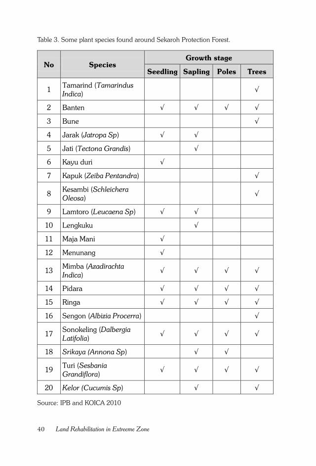
40 Land Rehabilitation in Extreeme Zone
Table 3. Some plant species found around Sekaroh Protection Forest.
Source: IPB and KOICA 2010
No Species Growth stage
Seedling Sapling Poles Trees
1 Tamarind (Tamarindus
Indica) √
2 Banten √ √ √ √
3 Bune √
4 Jarak (Jatropa Sp) √ √
5 Jati (Tectona Grandis) √
6 Kayu duri √
7 Kapuk (Zeiba Pentandra) √
8 Kesambi (Schleichera
Oleosa) √
9 Lamtoro (Leucaena Sp) √ √
10 Lengkuku √
11 Maja Mani √
12 Menunang √
13 Mimba (Azadirachta
Indica) √ √ √ √
14 Pidara √ √ √ √
15 Ringa √ √ √ √
16 Sengon (Albizia Procerra) √
17 Sonokeling (Dalbergia
Latifolia) √ √ √ √
18 Srikaya (Annona Sp) √ √
19 Turi (Sesbania Grandiflora)
√ √ √ √
20 Kelor (Cucumis Sp) √ √
41KOICA A/R CDM Activity
in the IPB Survey Report year 2010, were included based on input from
local community, also these species were found growing well in Sekaroh
Protection Forest area.

42 Land Rehabilitation in Extreeme Zone
43Process of Advocacy Activities
CHAPTER VI.
PROCESS OF ADVOCACY ACTIVITIES
Advocacy by Local Technical Implementation Unit (UPTD)
Trend of changes in carbon sink at above ground is almost similar
to the below ground, however decreasing level of above ground would
be more drastic when forest is converted to shifting cultivation and shifting
cultivation is converted into settled agriculture (Mulyoutami et al, 2010).
General condition of Sekaroh Protection Forest before arrival of the AR
CDM KOICA planting activity was encroached forest which was converted
to settled agriculture by local community. In order to bring back the forest
function as before, extension and facilitation activities which could be
accepted by local community were needed.
Ideally in the first phase of land rehabilitation activities any agency
should be accompanied by local agency which is familiar with the bio-
physical condition of the land, social capital of the society and have
good relationship with both local governmental and non-governmental
institutions. This strategy was used in implementing AR CDM activity at
Sekaroh Protection Forests by appointing Regional Technical Task Force
Unit (UPTD) as an implementing partner.
In the initial phase, all activities work properly. However, within
few months after planting programs, advocacy by forestry UPTD did not
work optimally. This was understood as logical consequences of UPTD
officers’ lack of time. The UPTD main job was not just taking care of one
44 Land Rehabilitation in Extreeme Zone
activity, instead it covered wide area, many issues, while less manpower
and competency in advocacy were in need for improvement.
Many complaints from the public were submitted to the FORDA
team, such as minimum supervision from UPTD and ineffective
communication style which tend to be one-way communication from
UPTD to the local community. UPTD manpower tended to give instruction
to local community due to their limited time available, rather than
intensively communicating an issue. The local community considered
the way as less appropriate.
On the other hand the UPTD officers also felt the heavy workload
by adding this CDM activity to their main task. Serving as extension aid
for communication between local community and the KOICA, UPTD
officers often were also asked to advocate the community. Advocacy is
very much different from giving extension about silvicultural techniques.
Advocacy required much time allocation listening to people concerns
and then providing rapid response for each dynamic event in the local
community. One of the key is a long time allocation to stay with the
people. This kind of task was not necessarily couldn’t be done by UPTD,
only long time allocation was not possible for UPTD because of the time
constraint and limited resources. Therefore, it was agreed that UPTD
would only supervise the AR CDM implementation in Sekaroh Protection
Forest.
Trust Based Advocacy
The main point of advocacy was building trust, where the
facilitators believe in local community and the local community trust in
the individual facilitator. When the trust is gained by both stakeholders
then the field activities will work properly. To gain confidence and mutual
trust, however were not a simple job. To get the trust needed mutual
understanding and great patience, especially from the facilitators.
Besides the patience to listen to the problems and grievances, it
also takes a sufficient time allocation. Many people might have the capacity
to facilitate; both in terms of experience, patience, attitude, good
45Process of Advocacy Activities
communication skills, but maybe only few had a lot of time allocation to
assist the communities.
The stakeholders who have concerns for environmental
sustainability and Sekaroh Protection Forest conditions were quite a lot,
both from government, local public figure, NGOs and other professional
individuals. Communications about AR CDM in Sekaroh Protection Forest
were always performed with various stakeholders to get support.
Eventually all stakeholders supported the AR CDM program in Sekaroh
Protection Forest and hope for its success. Various stakeholders gave
trust and wanted to participate for the successful AR CDM program in
Sekaroh Protection Forest. Various visits and input from local institutions
and community has also been received to the program. As limited time
could be spent with local community those input, views and visits from
various stakeholders was highly appreciated to help convincing and
encouraging local community to participate in successful AR CDM
program in Sekaroh Protection Forest.
Cooperation with Gapoktan (Farmers Group Association)
Farmers Group Association (Gapoktan) is an institution in the
village that bridging inter-group relations and had direct contact with
farmers. Gapoktan usually consists of 20 -30 farmer groups that exist in
one village.
In the Sekaroh village there is also a Gapoktan namely Gapoktan
Sekaroh Maju. Gapoktan Sekaroh Maju was established on June 2, 2010
with Notarial Deed No. 10 of Fanniyah, S.H., having existence in East
Lombok Regency. Members of Gapoktan Sekaroh Maju are all farmers
in the Sekaroh Village.
The Organization Structure of Gapoktan Sekaroh Maju as stated
in its Notarial Deed was including a Board of Trustees above the structural
committee. Board of Trustees members consist of the Sekaroh
Foundation Village Chief (now the Sekaroh Village) and Head of
Agricultural Extension, Fisheries and Forestry extension agency (BP3K)
Jerowaru District. Committee structure consisted of a chairman, a
secretary, a treasurer and chairman of several sections.
46 Land Rehabilitation in Extreeme Zone
From this structure it was apparent that there was strong intention
in the establishment of Gapoktan Sekaroh Maju to have good term
structurally with village government and technically with Agriculture,
Fisheries and Forestry Extension Agency (BP3K) Jerowaru. This structure
also showed the serious intention of its committee to increase capacity of
the people or majority of its members which are farmers.
In the early presence of the CDM program at the Sekaroh
Protection Forest, main board members of Gapoktan Sekaroh Maju had
rejected this KOICA program. Gapoktan Sekaroh Maju at that time
assumed that the presence of KOICA (Korea) had only profit oriented
business and would make the local community even more miserable.
The emerging negative perception and suspicious attitude from
local people toward the AR CDM program, which was actually
collaboration between the Indonesian and Korean Government, were
caused by lack of information and communication with the local
community. To decrease suspicions from Gapoktan Sekaroh Maju
committee and Sekaroh local community in general, team of FORDA
had intensive consultation with all members of local community, including
the committee of Gapoktan Sekaroh Maju.
Eventually, the committee of Gapoktan Sekaroh Maju understood
the purpose of the AR CDM program that will rehabilitate the land and
intend to increase income communities. Nowadays, the committee of
Gapoktan Sekaroh Maju became the main partner of CDM
implementation in Sekaroh Protection Forest.
The effort of Gapoktan Sekaroh Maju Committee members to
convince their farmer members to support the AR CDM program was
also difficult. There was a time when some board member was considered
as a betrayer. This was understood because in the beginning the
committee members also refused the program, although at the end they
eventually supported the AR CDM program.
After all committee members were convinced it was the
committee’s turn to convince all farmer members to have similar view
and perception that the AR CDM program aims for better environment
and increase income of local community of Sekaroh village. It was not
47Process of Advocacy Activities
easy for the committee of Gapoktan Sekaroh Maju to change farmers
way of life who have for decades experienced planting corn and have
settled market (with middleman traders) who are ready to buy the crop
at every harvesting season. The AR CDM program was a new program
with agroforestry setting, long-lived plants, and do not have confirmed
buyers for the harvested fruits as opposite of corn does.
Local community has a simple principle in agricultural life. Farmers
will readily follow some successful example of particular
commodity. Farmers usually would be hard to adopt some new initiative
in the absence of successful examples of new commodities or types of
business. As for now is the time to wait for the agroforestry fruit
harvest, during this period, farmers were still unsure whether the fruits
from agroforestry would bring a benefit to the local community, or to the
contrary bring loss to the local community. Would the harvested fruit of
AR CDM program have a settled market? This was homework for
Gapoktan Sekaroh Maju and other stakeholders who concerned with
environment integrity and welfare of Sekaroh villagers to continuously
give effort convincing people to maintain agroforestry plants until harvest
time comes.
Working with Stakeholders
After all communication steps were done with all stakeholders the
AR CDM program eventually could collaborate with all stakeholders. In
addition to collaboration with government agencies, such as the Local
Forest Service, District Chief, Village Chief, and LKMD, the CDM team
also worked with Gapoktan Sekaroh Maju, Tuan Guru and local public
figures. Planting as main activity was conducted with all society
constituents and witnessed by local public figures.
Some of the AR CDM plantation area in the Sekaroh Protection
Forest was monitored under Gapoktan while some other part was
monitored by Tuan Guru. The monitoring task division was agreed by
local stakeholders as part of their participation in the AR CDM activity.
For KOICA and FORDA team the more stakeholders involved
and gave attention to this program, the better the result. It was anticipated
48 Land Rehabilitation in Extreeme Zone
that some kind of competition would emerge from these groups showing
which one have higher success rate.
Challenges for the program success were surviving hot and dry
microclimate in Sekaroh Protection Forest; and equally important was to
convince local people that agroforestry plantation would benefit them.
Only few people believed agroforestry plantation is more profitable than
annual horticultural crops they cultivated. Although they know that corn
and other crops cultivation could not improve their living standard, local
people was guaranteed of corn market. On the other hand middleman
traders might also still want local community to cultivate corn in order to
save their business.
This was the crucial point. Which stakeholder would be able to
convince farmers, whether the middleman trader who had long
cooperated with the people or the local public figures that also had some
influence to local community?
Advocacy by AMPEL NGO
In order to strengthen network and intensify communication with
local people KOICA and FORDA team had also collaboration with one
NGO, i.e. AMPEL (Aliansi Masyarakat Peduli Lingkungan). AMPEL NGO
has had long experience facilitating local community in East Lombok
Regency, including Sekaroh Protection Forest. The NGO has wide
knowledge about Sekaroh Protection Forest and Sekaroh local community
from several previous advocacy programs on land rehabilitation in and
around Sekaroh Protection Forest.
Involvement of NGO AMPEL as facilitator in the advocacy
program had helped local community to understand and believe in the
objectives of this AR CDM program. Formerly being doubtful and
indifferent, after continuous facilitation by AMPEL NGO the local
community had started paying attention and maintaining planted trees.
Changes in local community perception towards supportive
attitude by AMPEL NGO facilitation was due to personal approach taken
by NGO, as they paid visit to each of planted farm or farmer house. The
AMPEL NGO presence to local people houses had built their sense as
49Process of Advocacy Activities
being taken care; there was information and technological transfer from
AMPEL NGO personnel to local people. After involvement of NGO
AMPEL the social condition was much better that any objection from
local community was almost not seen any longer. The facilitation however,
should be kept as long as possible and never be terminated until local
community is ready, otherwise some other stakeholder would take
chances to change back community perception by giving undesirable
information.

50 Land Rehabilitation in Extreeme Zone
51Socialization Process
CHAPTER VII.
SOCIALIZATION PROCESS
Before the main activities of planting or rehabilitation were
implemented, an orientation about Sekaroh Village was done. This first
activity was conducted long before planting time. This activity was carried
out together by KOICA consultants, FORDA, consultants of UBIS and
CER Indonesia. Orientation activities were conducted several times in a
relaxed atmosphere.
Sekaroh Village orientation was a process of getting to know the
village in the early stages of AR CDM program implementation. This
activity included observation on the state of the environment and natural
resources, identification of stakeholders that play important role in natural
resource management, recognizing values accepted by local community,
the pattern of inter-relations in the society, relationship between local
people with existing forest resources (Yayasan Alamanda and Lestari
Hutan Indonesia 2003).
The objectives of Sekaroh Village Orientation
The orientation activities were conducted at several places in
accordance to the needs and places recommended by local community
and local public figure. The meetings in the orientation phase could be at
the Preparation Village Office of Sekaroh, at local community house, in
a people farms or gardens and also been conducted at the Jerowaru
District Office.
52 Land Rehabilitation in Extreeme Zone
Orientation was done in a relaxed atmosphere. All stakeholders
should discuss and give opinions. In general, the goal of Sekaroh Village
orientation was to open up communication, knowing the general state
of a rural area and know the key figure in the Sekaroh Village. In detail,
orientation Sekaroh Village aimed to:
• Build trust, openness, and a familiar atmosphere so that all ele-
ments of the local community and stakeholders in the Sekaroh
Village were able to accept the presence of CDM activities in
Sekaroh Protection Forest.
• Identify the relationship and influencing power of stakeholder in
the Sekaroh Village and mapping it as the preparation for the next
activity.
• Recognize the conditions of Sekaroh Forest resource and the proper
management system especially related to the CDM.
• Recognize the social and cultural characteristics of the local com-
munity and stakeholders in Sekaroh Village in order to build a
bottom-up process.
• Growing confidence of the public towards CDM activities in pro-
tected forests and get input on Sekaroh public perception on CDM
activity plan.
• Minimize the risk of failure, as well as facilitate the implementa-
tion of assistance, planting and monitoring activities.
• Starting the processes of building partnership between the local
community and other stakeholders in Sekaroh Village.
Outputs of Sekaroh Village Orientation
The expected results from Sekaroh Village orientation process were:
1. Planned activities could be delivered to the local people and get feed-
back from them
2. Early identification of the most influential stakeholders
3. KOICA and FORDA team got general idea of the rural situation,
relationship between stakeholders in the village, local community in-
teraction with natural resources
53Socialization Process
4. Opening up people minds to the AR CDM plans; familiarize indi-
vidual team members of KOICA, FORDA and other agencies, i.e.
CER Indonesia and East Lombok Regency Forest Service Office.
Target of Sekaroh Village Orientation Activity
The target of Sekaroh Village orientation was all constituents of
local community and stakeholders in Sekaroh Village. Each stakeholder
involved or being influential should be identified regardless of their
religion, political stakeholder, race, customs, education, economic level
and others. As for religion, a hundred percent of the Sekaroh village
population is Muslim. In this orientation it was also important to identify
some figures or to map possible conflicting rival community groups in
order to avoid partisanship of the AR CDM program on one group. This
activity was expected to benefit all stakeholders, that neither stakeholder
felt marginalized by the AR CDM program. The AR CDM activity In
Sekaroh Protection Forest worked its best to avoid being caught in a
conflict between individuals or community groups.
Another target of orientation activities was getting to know general
state of the village related to its natural resource, management conflict,
relationship pattern of local people with natural resources, tenure system,
land use and others (Yayasan Alamanda and Lestari Hutan Indonesia,
2003).
Techniques of Sekaroh Village Orientation
Sekaroh Village Orientation was done by socialization gathering,
sudden visits, and participation in the existing group activities. All
processes were done in a relaxed and informal situation. In an effort to
find out the natural resource condition in Sekaroh Protection Forests,
team of KOICA, FORDA or CER Indonesia usually worked together with
the people or local public figure to see the real nature setting and discuss
about it directly. At this stage the KOICA and FORDA team listened
carefully and took information from the people rather than giving their
own opinion, because it was still in the orientation phase.
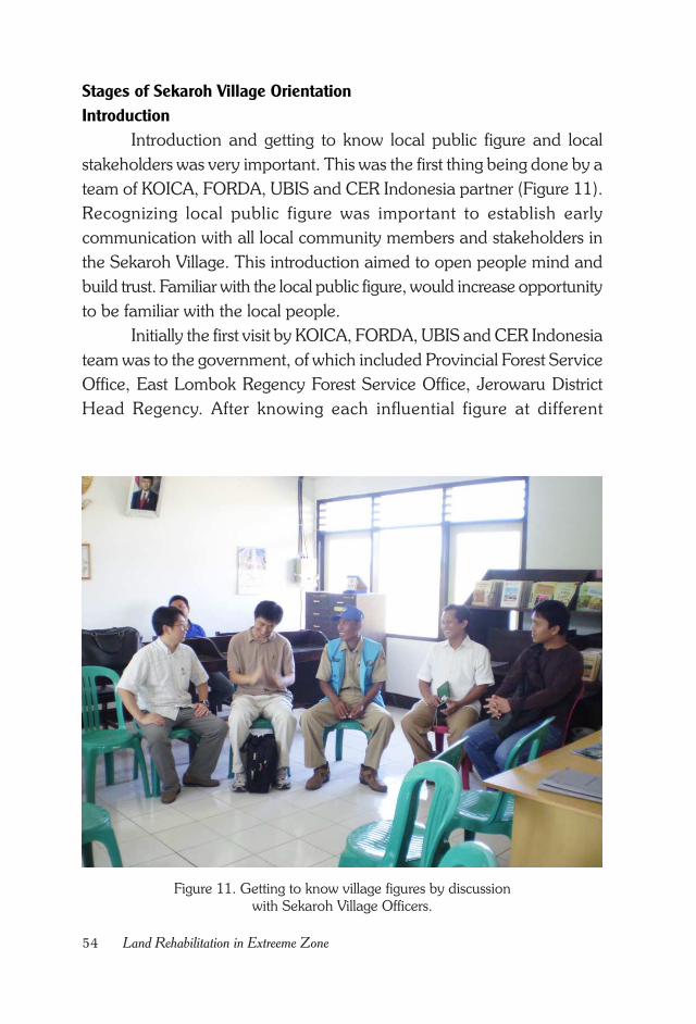
54 Land Rehabilitation in Extreeme Zone
Figure 11. Getting to know village figures by discussion
with Sekaroh Village Officers.
Stages of Sekaroh Village Orientation
Introduction
Introduction and getting to know local public figure and local
stakeholders was very important. This was the first thing being done by a
team of KOICA, FORDA, UBIS and CER Indonesia partner (Figure 11).
Recognizing local public figure was important to establish early
communication with all local community members and stakeholders in
the Sekaroh Village. This introduction aimed to open people mind and
build trust. Familiar with the local public figure, would increase opportunity
to be familiar with the local people.
Initially the first visit by KOICA, FORDA, UBIS and CER Indonesia
team was to the government, of which included Provincial Forest Service
Office, East Lombok Regency Forest Service Office, Jerowaru District
Head Regency. After knowing each influential figure at different
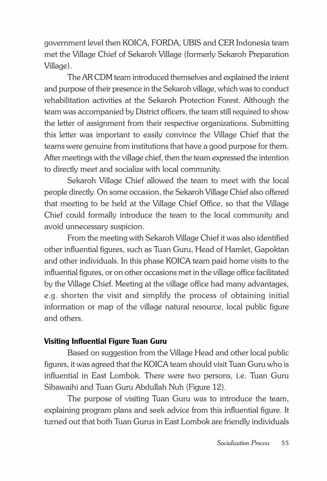
55Socialization Process
government level then KOICA, FORDA, UBIS and CER Indonesia team
met the Village Chief of Sekaroh Village (formerly Sekaroh Preparation
Village).
The AR CDM team introduced themselves and explained the intent
and purpose of their presence in the Sekaroh village, which was to conduct
rehabilitation activities at the Sekaroh Protection Forest. Although the
team was accompanied by District officers, the team still required to show
the letter of assignment from their respective organizations. Submitting
this letter was important to easily convince the Village Chief that the
teams were genuine from institutions that have a good purpose for them.
After meetings with the village chief, then the team expressed the intention
to directly meet and socialize with local community.
Sekaroh Village Chief allowed the team to meet with the local
people directly. On some occasion, the Sekaroh Village Chief also offered
that meeting to be held at the Village Chief Office, so that the Village
Chief could formally introduce the team to the local community and
avoid unnecessary suspicion.
From the meeting with Sekaroh Village Chief it was also identified
other influential figures, such as Tuan Guru, Head of Hamlet, Gapoktan
and other individuals. In this phase KOICA team paid home visits to the
influential figures, or on other occasions met in the village office facilitated
by the Village Chief. Meeting at the village office had many advantages,
e.g. shorten the visit and simplify the process of obtaining initial
information or map of the village natural resource, local public figure
and others.
Visiting Influential Figure Tuan Guru
Based on suggestion from the Village Head and other local public
figures, it was agreed that the KOICA team should visit Tuan Guru who is
influential in East Lombok. There were two persons, i.e. Tuan Guru
Sibawaihi and Tuan Guru Abdullah Nuh (Figure 12).
The purpose of visiting Tuan Guru was to introduce the team,
explaining program plans and seek advice from this influential figure. It
turned out that both Tuan Gurus in East Lombok are friendly individuals
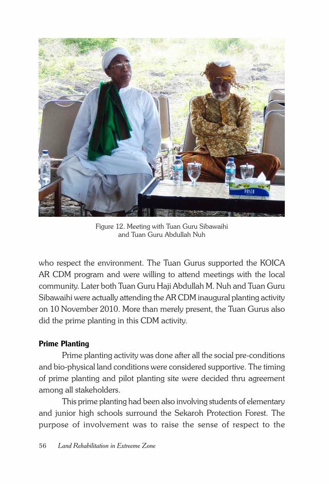
56 Land Rehabilitation in Extreeme Zone
Figure 12. Meeting with Tuan Guru Sibawaihi
and Tuan Guru Abdullah Nuh
who respect the environment. The Tuan Gurus supported the KOICA
AR CDM program and were willing to attend meetings with the local
community. Later both Tuan Guru Haji Abdullah M. Nuh and Tuan Guru
Sibawaihi were actually attending the AR CDM inaugural planting activity
on 10 November 2010. More than merely present, the Tuan Gurus also
did the prime planting in this CDM activity.
Prime Planting
Prime planting activity was done after all the social pre-conditions
and bio-physical land conditions were considered supportive. The timing
of prime planting and pilot planting site were decided thru agreement
among all stakeholders.
This prime planting had been also involving students of elementary
and junior high schools surround the Sekaroh Protection Forest. The
purpose of involvement was to raise the sense of respect to the
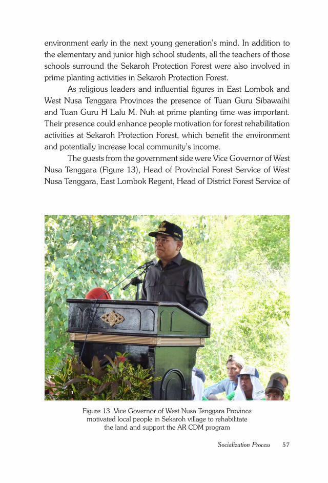
57Socialization Process
environment early in the next young generation’s mind. In addition to
the elementary and junior high school students, all the teachers of those
schools surround the Sekaroh Protection Forest were also involved in
prime planting activities in Sekaroh Protection Forest.
As religious leaders and influential figures in East Lombok and
West Nusa Tenggara Provinces the presence of Tuan Guru Sibawaihi
and Tuan Guru H Lalu M. Nuh at prime planting time was important.
Their presence could enhance people motivation for forest rehabilitation
activities at Sekaroh Protection Forest, which benefit the environment
and potentially increase local community’s income.
The guests from the government side were Vice Governor of West
Nusa Tenggara (Figure 13), Head of Provincial Forest Service of West
Nusa Tenggara, East Lombok Regent, Head of District Forest Service of
Figure 13. Vice Governor of West Nusa Tenggara Province
motivated local people in Sekaroh village to rehabilitate
the land and support the AR CDM program
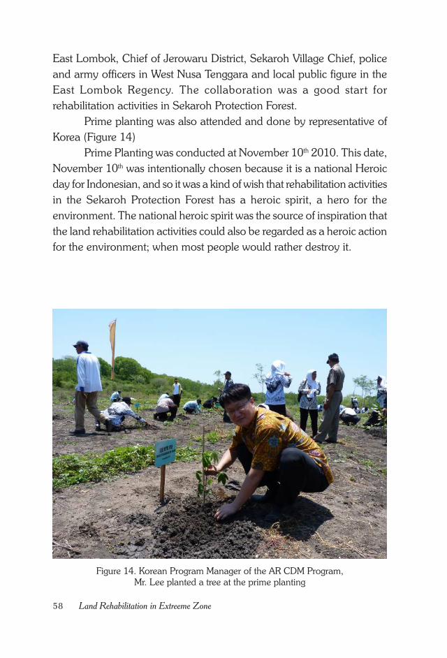
58 Land Rehabilitation in Extreeme Zone
Figure 14. Korean Program Manager of the AR CDM Program,
Mr. Lee planted a tree at the prime planting
East Lombok, Chief of Jerowaru District, Sekaroh Village Chief, police
and army officers in West Nusa Tenggara and local public figure in the
East Lombok Regency. The collaboration was a good start for
rehabilitation activities in Sekaroh Protection Forest.
Prime planting was also attended and done by representative of
Korea (Figure 14)
Prime Planting was conducted at November 10th 2010. This date,
November 10th was intentionally chosen because it is a national Heroic
day for Indonesian, and so it was a kind of wish that rehabilitation activities
in the Sekaroh Protection Forest has a heroic spirit, a hero for the
environment. The national heroic spirit was the source of inspiration that
the land rehabilitation activities could also be regarded as a heroic action
for the environment; when most people would rather destroy it.
59Socialization Process
Group Socialization
After the Prime Planting activity at November 10th 2010, all
stakeholders started an intensive socialization to the local community.
Socialization process had actually been done several times, such as by
home visits, meetings at the Village Chief Office or other informal
meetings, however after the prime planting, socialization activities became
more intensive.
That was necessary because the local community would be the
main actor of the planting and maintenance of the AR CDM plantation.
Consultation with local community was also conducted on planned
activity in their farmland. Although people had been reassured several
times, some of them were still doubtful, whether they would be asked to
leave their assigned farmland after planting mixed species of forest and
fruits trees. The issue was critical for some of the people because to some
of them those farmlands were the only land available for them for
cultivation to earn for a living.
Hidden Problem Needs to Be Solved.
Working out a rehabilitation activity with local community was
full of dynamics. Often some earlier first hand information obtained from
various stakeholders was not valid the next day. Many factors caused
these information discrepancies, such as local community vague fear of
intimidation from some irresponsible parties.
As the activities approved by local community would take place
on areas, which might have conflicting economic interest with other
stakeholder, in such case the AR CDM team must consider managing
opposition from other stakeholders towards the on-going activity. All those
problems had necessitated an intensive communication and engagement
with local stakeholders, particularly people who were directly involved in
the activity.
During implementation of the AR CDM program in East Lombok,
sometimes previously agreed agenda by all stakeholders, including local
community, turned out differently in practice. What’s the problem? Was
this due to stakeholders’ inconsistencies towards agreed agenda? Or was
60 Land Rehabilitation in Extreeme Zone
it merely dynamics of working with diverse communities and stakeholders
with various motivations that resulted in dynamic changes?
Apparently there was still unknown and hidden problem that had
not been addressed in the previous meetings. Who could unwind the
problems that still a mystery? KOICA and FORDA team was demanded
to hold more intensive communication with all levels of local community,
especially involved farmers.
61Land Rehabilitation Process
CHAPTER VIII.
LAND REHABILITATION PROCESS
Community Based Land Preparation
Negotiation on climate change is not entirely about reduction of
GHG emission. In the Article 2 of the UNFCC it was stated that the
ultimate objective of the convention was to stabilize GHG concentration,
as well as ensuring food security and sustainable development (Brown,
Seymour dan Peskett, 2010). The essence of global climate change
mitigation is planting and plant maintenance.
After the prime planting which was attended by all stakeholders
and people around the forest, the actual rehabilitation activity was started.
The area for prime planting was only about 1 ha, whereas all AR CDM
program area covered †300 ha, as agreed by Korean Government and
Indonesia Government.
It was agreed at the time of orientation activities, as well as in the
subsequent meetings, that all stakeholders and local community would
be committed and being involved in all phases of activity, starting from
planning to implementation in the field. This commitment was very
important for the sustainability of the program.
Subsequently all stakeholders agreed that plantings of AR CDM
project area was started at Pongoros, Ujung Gon and Pada Kelawe
hamlets. The width of this first planting phase was 30 ha involving 20
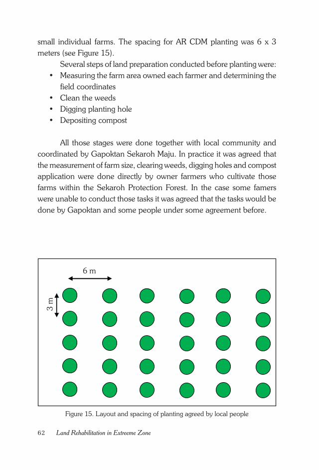
62 Land Rehabilitation in Extreeme Zone
Figure 15. Layout and spacing of planting agreed by local people
6 m
3 m
small individual farms. The spacing for AR CDM planting was 6 x 3
meters (see Figure 15).
Several steps of land preparation conducted before planting were:
• Measuring the farm area owned each farmer and determining the
field coordinates
• Clean the weeds
• Digging planting hole
• Depositing compost
All those stages were done together with local community and
coordinated by Gapoktan Sekaroh Maju. In practice it was agreed that
the measurement of farm size, clearing weeds, digging holes and compost
application were done directly by owner farmers who cultivate those
farms within the Sekaroh Protection Forest. In the case some famers
were unable to conduct those tasks it was agreed that the tasks would be
done by Gapoktan and some people under some agreement before.
63Land Rehabilitation Process
Monitoring of land preparation was be done by UPTD along with
Gapoktan Sekaroh Maju. All implementation process showed
collaboration with local community starting from planning.
Technological Input (Hydrogel & Compost)
Sekaroh Protection Forest area is famous for its very high
temperature that people usually say that ‘there are two suns’ at Sekaroh,
which makes the air very hot. Farming system has adapted to this high
temperature. Farmers usually begin field work at 07.00 in the morning,
and then go home at 11:00 before noon time. They take a break for a
while, and back to work again in the field after 14.00. Time at 11:00 to
14:00 is the heat peak at Sekaroh, particularly in the area of Sekaroh
Protection Forest.
The hot air caused relatively small plant survival compared to other
cooler area. The effect was harsher if planting were late, i.e. was not
done at the beginning of a rainy season. The crop survival will be even
smaller. Therefore in order to increase plant survival on this extreme area,
the KOICA AR CDM program provided hydrogel for each planting hole.
The addition of hydrogel aimed at maintaining soil moisture in
the planting hole. It was expected that adding hydrogel would keep
enough soil moisture for newly planted seedlings that eventually would
increase the plant survivals.
The application of hydrogel in land rehabilitation activity was a
new practice for local community. This was part of information and
technology transfer from the AR CDM project to surrounding local
community, which was expected, could help drawing local people
attention to the AR CDM activity.
Logically addition of hydrogel affected the project cost. Activities
cost would increase accordingly, however, because this AR CDM activity
was a pilot project for local community, the risk of increased cost was
considered as inevitable.
64 Land Rehabilitation in Extreeme Zone
Collaborative Planting
Planting activity is actually the beginning of real work in a land
rehabilitation project. After orientation activities, exhausted discussions,
plant species selection, planting site selection, land preparation and
preparing planting hole with all the people, now it is the time to plant.
The plan for first planting phase covered 30 ha area, of which involved
20 farmers. However, exact measurement, which was done
collaboratively, showed that the area was only 26.75 ha (Table 4).
Similar to land preparation, planting was also supposed to be done
by farmers. That way a sense of belonging and responsibility to the
plantation would grow. Most farmers had planted each of their area
according to the agreed schedule.
The number of plant species selected for the first phase of this trial
planting was 14 species, consisted of fruits and forest trees, e.g. imbe,
mahogany, khaya, rosewood (sonokeling), mango, jackfruit and sawo
(Table 5).
This first phase activity was a field implementation try-out of various
pre-conditions that had been prepared before. All stages were performed
together with the local community. Selected plant species was a result of
people’s choice and based on its suitability to biophysical land condition.
For the whole plantation area of 300 ha, the number of selected plant
species would be reduced upon agreement with local people. It would
be difficult to supply too many species seed or seedlings.
Agreed plant spacing was 6 x 3 meters. This wide spacing would
allow local people to plant corn or other horticultural crops until the
planted trees reach 5 years age. Started at 5 years old the fruit trees were
expected to give economic return to local community already. Meanwhile
before fruiting age the farmers could still grow horticultural crops to meet
their economic needs.
Replanting
Replanting dead seedlings of the AR CDM program in Sekaroh
Protection Forest had been planned since the beginning. Replanting dead
or less survive seedlings in the field is common practice in forestry, in
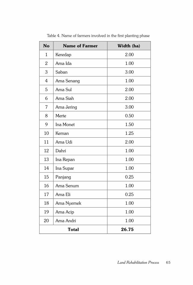
65Land Rehabilitation Process
Table 4. Name of farmers involved in the first planting phase
No Name of Farmer Width (ha)
1 Keredap 2.00
2 Ama Ida 1.00
3 Saban 3.00
4 Ama Senang 1.00
5 Ama Sul 2.00
6 Ama Siah 2.00
7 Ama Jering 3.00
8 Merte 0.50
9 Ina Monet 1.50
10 Keman 1.25
11 Ama Udi 2.00
12 Dahri 1.00
13 Ina Repan 1.00
14 Ina Supar 1.00
15 Panjang 0.25
16 Ama Senum 1.00
17 Ama Eli 0.25
18 Ama Nyemek 1.00
19 Ama Acip 1.00
20 Ama Andri 1.00
Total 26.75
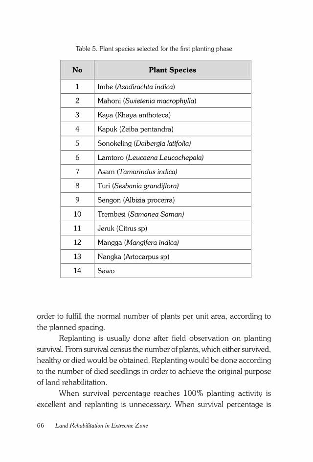
66 Land Rehabilitation in Extreeme Zone
Table 5. Plant species selected for the first planting phase
No Plant Species
1 Imbe (Azadirachta indica)
2 Mahoni (Swietenia macrophylla)
3 Kaya (Khaya anthoteca)
4 Kapuk (Zeiba pentandra)
5 Sonokeling (Dalbergia latifolia)
6 Lamtoro (Leucaena Leucochepala)
7 Asam (Tamarindus indica)
8 Turi (Sesbania grandiflora)
9 Sengon (Albizia procerra)
10 Trembesi (Samanea Saman)
11 Jeruk (Citrus sp)
12 Mangga (Mangifera indica)
13 Nangka (Artocarpus sp)
14 Sawo
order to fulfill the normal number of plants per unit area, according to
the planned spacing.
Replanting is usually done after field observation on planting
survival. From survival census the number of plants, which either survived,
healthy or died would be obtained. Replanting would be done according
to the number of died seedlings in order to achieve the original purpose
of land rehabilitation.
When survival percentage reaches 100% planting activity is
excellent and replanting is unnecessary. When survival percentage is
67Land Rehabilitation Process
between 80-100% planting activity is good, as small number of replanting
is necessary (maximum 20%). A planting activity with 20% replanting is
considered as successful.
Replanting rate between 20-40% or plant survival percentage
between 60-80% means planting activity is moderate. In such case
replanting would be done intensively, maximum 40%. If survival
percentage were less than 60% the planting activity is considered
unsuccessful, and that would be similar with planting all over again. If
replanting rate is more than 40% it is necessary to know the cause of
high mortality of plants, whether due to natural factors, technical errors,
social issues or other matters.
Replanting has several objectives, as follow:
• To improve plant survival rate in a certain unit area
• To meet the desired number of plants per Ha according to spac-
ing planned.
• To increase land productivity
• Exclusively for AR CDM activities in Sekaroh Protection Forest,
replanting activities served as a mutual learning process for all
stakeholders that implementation should follow originally agreed
plan.
Maintenance
Plantation maintenance is commonly done in forestry to ensure
successful growth of desired quality of planted trees. Well maintenance
requires large investment, long time period and continuous activities.
The AR CDM program in Sekaroh Protection Forest requires collaborative
plant maintenance which was practically done by Gapoktan Sekaroh
Maju, Tuan Guru, a local stakeholder named Amphibi Group and local
community.
Theoretically maintenance defined as a bringing input in the form
of capital, labor and technology into a system to produce output with
desired quality and quantity. Plant maintenance is done because after
planting generally there will appear two issues, i.e. plant death at a young
age and undesirable plant growth which does not meet the expectation.
68 Land Rehabilitation in Extreeme Zone
Some factors that might cause early plant death in a plantation
are:
• Out-season planting time which does not follow silviculture guide-
lines, such as planting during the dry season
• Shallow planting hole which made seedling easily tumble down
• Changing weather conditions after planting
• Poor seedling condition at planting time due to transportation stress
• Animal disturbance
• Presence of weeds and insect pests
• In addition to the above technical factors, the most dangerous is
human disturbance.
Disturbances which came out of silviculture treatments and climate
factors were relatively easy to handle. The most difficult and strenuous
problem was certainly human factor, in which case a different kind of
care would be needed. To handle human disturbance a more intensive
approach, in a long time period would be necessary.
69Baseline Establishment
CHAPTER IX.
BASELINE ESTABLISHMENT
For a CDM project to be accepted, the project developer should
show that the poject activity has additionality from business as usual
scenario or baseline (APHI, 2011). For most CDM project developer
baseline data issue was a crucial problem. The reason why only minimum
number of forestry company interested in participating in carbon trading
was not only baseline issue. Other important issue is technical aspect of
methodology (Ridwan 2013). What is baseline ?
Baseline is one of terms used in AR CDM program. Baseline is the
initial state of carbon stocks, which would be projected in the future if no
action is taken. The objective of establishing a baseline is to prevent
claims of emission reduction or increase in actual carbon absorption which
could occur in the absence of AR CDM project. Thus baseline is a state
that most likely to occur if there is no project, referred as the reference
case (Boer, 2001).
Estimation of projected future changes in carbon stocks (reference
case) can be done using two approaches, i.e. static and dynamic
approaches. If the pattern of future carbon stock is not expected to
change the static approach is used. In this case it is assumed that factors
influencing carbon stock changes, both from inside and outside of the
project area, in the future are similar from starting or historical condition.
If the static approach is selected the project should provide strong
justification that the given assumption is correct (Boer, 2001).
70 Land Rehabilitation in Extreeme Zone
For the baseline of the AR CDM forestry activities in Sekaroh
Protection Forest it was assumed that without the AR CDM project the
area would remain as agricultural land; and static approach was adopted
to estimate carbon stocks changes. Before the AR CDM program was
introduced the site was local people farmland dominated by maize.
Above ground
In order to estimate the above ground biomass (carbon stock) per
unit area, the project proponent used non-destructive method utilizing
established allometric equations. Calculation of the potential carbon
content of a tree using allometric equation (Ketterings et al. 2001) is as
follows.
(Dry Biomass, kg) = 0.11 x ρ x D2.62
Which:
ρ = Wood density (kg/m3), based on ICRAF database
D = Diameter at breast high (cm).
Below ground
Referring to Table 3A. 1.8. in Appendix 3A.1., default biomass
table in Section 3.2., forest land category by IPCC (2006), West Nusa
Tenggara Province belongs to tropical rain forests category. Root shoot
ratio of tropical rain forest canopy in a secondary forest, according to
IPCC guidelines ranges from 0.14 to 0.83 with the average of 0.42.
Before plantation project was implemented, the original vegetation
already contained some amount of carbon, so called baseline (without
project scenario). In contrast, the amount of carbon in new plantations
is expected to be much greater than that of the baseline to obtain better
carbon conservation. On the 300 ha study area, 30 ha of it was then
spitted into four blocks and used for sampling purposes (Siregar et al.,
2012).
One block size approximately 7.5 ha consisted of 10 sampling
points, of which each square of 2 m x 2 m was scattered in each block
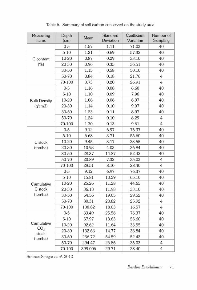
71Baseline Establishment
Table 6. Summary of soil carbon conserved on the study area
Measuring
Items
Depth
(cm) Mean
Standard
Deviation
Coefficient
Variation
Number of
Sampling
C content
(%)
0-5 1.57 1.11 71.03 40
5-10 1.21 0.69 57.32 40
10-20 0.87 0.29 33.10 40
20-30 0.96 0.35 36.51 40
30-50 1.15 0.58 50.10 40
50-70 0.84 0.18 21.76 4
70-100 0.73 0.20 26.91 4
Bulk Density
(g/cm3)
0-5 1.16 0.08 6.60 40
5-10 1.10 0.09 7.96 40
10-20 1.08 0.08 6.97 40
20-30 1.14 0.10 9.07 40
30-50 1.23 0.11 8.97 40
50-70 1.24 0.10 8.29 4
70-100 1.30 0.13 9.61 4
C stock
(ton/ha)
0-5 9.12 6.97 76.37 40
5-10 6.68 3.71 55.60 40
10-20 9.45 3.17 33.55 40
20-30 10.93 4.03 36.84 40
30-50 28.37 14.87 52.42 40
50-70 20.89 7.32 35.03 4
70-100 28.51 8.10 28.40 4
Cumulative
C stock
(ton/ha)
0-5 9.12 6.97 76.37 40
5-10 15.81 10.29 65.10 40
10-20 25.26 11.28 44.65 40
20-30 36.18 11.98 33.10 40
30-50 64.56 19.05 29.52 40
50-70 80.31 20.82 25.92 4
70-100 108.82 18.03 16.57 4
Cumulative
CO2
stock
(ton/ha)
0-5 33.49 25.58 76.37 40
5-10 57.97 13.63 55.60 40
10-20 92.62 11.64 33.55 40
20-30 132.66 14.77 36.84 40
30-50 236.72 54.59 52.42 40
50-70 294.47 26.86 35.03 4
70-100 399.006 29.71 28.40 4
Source: Siregar et al. 2012
72 Land Rehabilitation in Extreeme Zone
and was established in August 2011. Those blocks would represent the
existing sparsely grass vegetation grown naturally. Due to the fact that all
grasses vegetation is mostly homogenous in an open area (without
shading effect of a tree canopy) an edge effect, which caused either
underestimate or overestimate biomass was ignored. Accumulative soil
carbon in the study area is summarized in Table 8 (Siregar et al., 2012).
The soil carbon content of each soil layer ranges between 1.57 %,
which occurred at the soil surface of 0-5 cm depth and 0.73 %, which
occurred at the soil layer of 70-100 cm depth. In general, the magnitude
of soil carbon content decreases with soil depth (Siregar et al., 2012).
Soil bulk density in most cases increases with soil depth and the
value ranges from 1.08 to 1.30 gr/cm3. The increase of soil bulk density
in nature is well understood due to the increase in clay particle of the soil
profile from the upper layer to the lower layer (illuviation) (Siregar et al.,
2012).
Carbon stock conserved on each soil layer is affected by level of
soil carbon content, average value of soil bulk density, and thickness of
soil layer per hectare. Average cumulative carbon conserved in terms of
carbon dioxide from soil surface to 100 cm soil layer is almost 400 ton
per ha which is considerably high and thus provides significant information
in the realm of environmental conservation (Siregar et al., 2012).
73Plant Census
CHAPTER X.
PLANT CENSUS
Socialization on Census
Since planting activities started, KOICA and FORDA team had
informed local stakeholders and local community that there will be planted
tree census. Some people still thought that planted tree census is similar
to monitoring activities, of which only few cases are sampled and then
assessed their levels of success.
Several months prior to census, the team once again informed
stakeholders in Sekaroh Protection Forest that plant census would take
place. The date for census implementation was consulted with the East
Lombok Regency Forest Service, Gapoktan and local public figure. Later
Gapoktan Sekaroh Maju and Sekaroh village leaders explained the
planned plant census to local community, especially involved farmers.
The Importance of Census
Result of a census is very useful as representation of the real status
of an activity that is being or has been done. Census data would be used
for comprehensive evaluation on future strategy or even stop the program.
Evaluation process does not necessarily use census if the area is
vast while time is limited. Sampling method could also be applied to
obtain information on current conditions of certain activity. However,
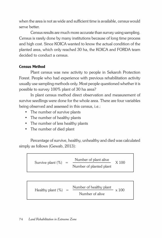
74 Land Rehabilitation in Extreeme Zone
when the area is not as wide and sufficient time is available, census would
serve better.
Census results are much more accurate than survey using sampling.
Census is rarely done by many institutions because of long time process
and high cost. Since KOICA wanted to know the actual condition of the
planted area, which only reached 30 ha, the KOICA and FORDA team
decided to conduct a census.
Census Method
Plant census was new activity to people in Sekaroh Protection
Forest. People who had experience with previous rehabilitation activity
usually use sampling methods only. Most people questioned whether it is
possible to survey 100% plant of 30 ha area?
In plant census method direct observation and measurement of
survive seedlings were done for the whole area. There are four variables
being observed and assessed in this census, i.e.:
• The number of survive plants
• The number of healthy plants
• The number of less healthy plants
• The number of died plant
Percentage of survive, healthy, unhealthy and died was calculated
simply as follows (Gewab, 2013):
Healthy plant (%) =Number of healthy plant
Number of alivex 100
Survive plant (%) =Number of plant alive
Number of planted plantX 100
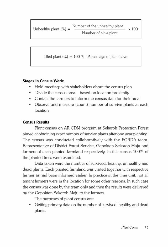
75Plant Census
Stages in Census Work:
• Hold meetings with stakeholders about the census plan
• Divide the census area based on location proximity
• Contact the farmers to inform the census date for their area
• Observe and measure (count) number of survive plants at each
location
Census Results
Plant census on AR CDM program at Sekaroh Protection Forest
aimed at obtaining exact number of survive plants after one year planting.
The census was conducted collaboratively with the FORDA team,
Representative of District Forest Service, Gapoktan Sekaroh Maju and
farmers of each planted farmland respectively. In this census 100% of
the planted trees were examined.
Data taken were the number of survived, healthy, unhealthy and
dead plants. Each planted farmland was visited together with respective
farmer as had been informed earlier. In practice at the time visit, not all
tenant farmers were in the location for some other reasons. In such case
the census was done by the team only and then the results were delivered
by the Gapoktan Sekaroh Maju to the farmers.
The purposes of plant census are:
• Getting primary data on the number of survived, healthy and dead
plants.
Unhealthy plant (%) =Number of the unhealthy plant
Number of alive plantx 100
Died plant (%) = 100 % - Percentage of plant alive
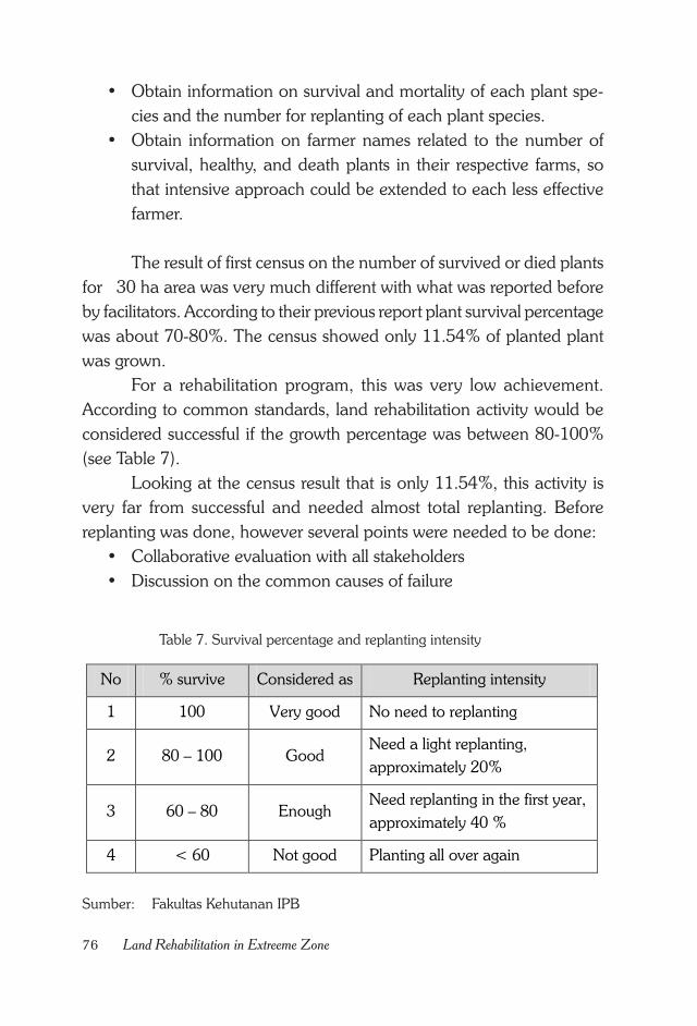
76 Land Rehabilitation in Extreeme Zone
Table 7. Survival percentage and replanting intensity
Sumber: Fakultas Kehutanan IPB
• Obtain information on survival and mortality of each plant spe-
cies and the number for replanting of each plant species.
• Obtain information on farmer names related to the number of
survival, healthy, and death plants in their respective farms, so
that intensive approach could be extended to each less effective
farmer.
The result of first census on the number of survived or died plants
for 30 ha area was very much different with what was reported before
by facilitators. According to their previous report plant survival percentage
was about 70-80%. The census showed only 11.54% of planted plant
was grown.
For a rehabilitation program, this was very low achievement.
According to common standards, land rehabilitation activity would be
considered successful if the growth percentage was between 80-100%
(see Table 7).
Looking at the census result that is only 11.54%, this activity is
very far from successful and needed almost total replanting. Before
replanting was done, however several points were needed to be done:
• Collaborative evaluation with all stakeholders
• Discussion on the common causes of failure
No % survive Considered as Replanting intensity
1 100 Very good No need to replanting
2 80 – 100 Good Need a light replanting,
approximately 20%
3 60 – 80 Enough Need replanting in the first year,
approximately 40 %
4 < 60 Not good Planting all over again
77Plant Census
• Planning the following replanting activities by setting a standard
of 80% minimum success.
Response to the Census
Result of AR CDM plant census in Sekaroh Protection Forest would
have different meaning for each stakeholder. Either each stakeholder
has the same or different, even contradictory perception towards a census
result.
For the KOICA and FORDA team, the result of plant census
although less satisfactory, nevertheless was still beneficial. The results
had reflected the real condition in the field and would be used as a basis
for mutual evaluation by all stakeholders. The KOICA and FORDA team
were disappointed with low level of 11.54% plant survival.
As KOICA and FORDA were large and famous institutions, the
disappointment did not halt effort to carry out the program. Indeed, the
failure had made KOICA and FORDA team more determined to achieve
better results. The failure was still happened even after all activities were
carefully planned and coordinated with all stakeholders, which was far
from expectation.
The KOICA and FORDA team was then decided to spend more
time preparing new strategy, investing more patience and doing more
careful implementation in the field. As planting was still covered 30 ha,
which was only about 10% of the total plan, the census results had become
important and positive lessons learnt. The next bigger planting activity
for the remaining 90% of total area and the additional replanting of the
previously 10% planted area would be done with the new strategy and
incorporating all stakeholders input, especially from local community.
Lesson Learned from the Census
The result of plant census was a fact, which reflected the activity
that had been done. The fact showed coordination effort so far. The fact
described result of a long continuous discussion. And lastly the fact
described a commitment made. The question was what kind of
commitment required for a successful rehabilitation program?
78 Land Rehabilitation in Extreeme Zone
What was needed to be done after this census? Were there
institutions that still need to be strengthened? Was there any
communication barrier between the various stakeholders that need to
be removed? Was there a miscommunication between stakeholders that
was not expected? Or was there any undetected important issue between
various stakeholders in AR CDM activities in Sekaroh Protection Forest?
Whatever the challenge was KOICA and FORDA team would not
retreat from the plan to reforest the Sekaroh Protection Forest. For more
than 25 years, Sekaroh Protection Forest has been devastated, degraded,
deforested and many stakeholders did not pay any attention. Would
such critically marginal land be abandoned forever?
Hadn’t been proved that mismanagement of this Sekaroh
Protection Forest has made surrounding people constantly in a poor state?
Almost 100% of the people were receiving government aid, i.e. rice for
the poor. This showed that poverty was deliberately maintained and
many stakeholders just accept the condition. Couldn’t this situation be
changed? If not now, then when?
Indeed rehabilitating a long time deforested land was not easy. If
this had been easy, then the Sekaroh Protection Forest would have been
green already long time ago. But the fact remained that Sekaroh Protection
Forest was disappearing. It’s time to wake up. It’s time to be more patient.
Although many stakeholders were pessimistic about the success of this
program, however without any action taken then it is doomed to fail. If
action was taken, there would be a chance for success.
79Community Based A/R CDM
CHAPTER XI.
COMMUNITY BASED A/R CDM
Why It Has to Be Community Based?
Different to common perception it is not easy to obtain business
license in forestry. The reason for the difficulty is the fact that a forest
often affects many people life and offers many interests for many
stakeholders (Hardiansyah and Ridwan, 2012). Obtaining license of social
or community forestry for then AR CDM in Sekaroh Protection Forest
also needed much effort.
According to the Minister of Forestry Regulation No P.37/Menhut-
II/2007, Article 1, Social/Community Based Forestry (HKm) is a forest
owned by the government, which is managed in order to empower local
communities without disturbing the main function of the forest itself. The
purpose of HKm establishment is to develop capacity and provide access
to the local communities in managing forests in a sustainable manner in
order to ensure employment for local people to solve economic and
social problems.
From the above definition and purpose of HKm it was contained
a main message about participation to increase community income
without necessarily destroying the forest function. This objective is suitable
for local community and environment at Sekaroh Protected Forest. As
described in the previous chapter local community around Sekaroh
Protected Forest up to this moment is still trapped in the low income and
has severe degraded environment.
80 Land Rehabilitation in Extreeme Zone
Selection of HKm as an entry strategy to local economy
empowerment and improvement of environmental conditions was
considered the right choice. It was expected that HKM model application
would improve ecological quality, local people’s economy, enhancing
social activities without damaging the local cultural practice.
HKm scheme was expected to make community members
collaboratively maintain the Sekaroh Protected Forest which at this point
had been deforested by human activity. In addition, a HKm shows that
anyone can participate in state forest management. There is common
impression that only big company could manage state forests, such as
Industrial Plantation Forest (HTI) and forest concessions (HPH). The HKm
activities could prove that local people were also able to manage the
forest.
Through HKm activities, utilization of Sekaroh Protected Forest
land by famers for cultivating annual crop, such as corn, which was not
environmentally friendly could be changed to other more environmentally
friendly activity, and still be able to provide better income. While previously
community activity in the Sekaroh Protected Forest area was considered
illegal and people feared being caught by the forest police officers, with
HKM scheme people would be more comfortable practicing the
agroforestry, because it was made legal.
Socialization Process to the Community
The socialization process of the AR CDM program to the
community was one of the most difficult phases in CDM activities. Most
farmers who cultivating and occupying Sekaroh Protected Forest land
wanted to own the land and obtain land certificate. This desire was driven
by some bad person or NGO who gave erroneous information that people
could obtain a land ownership certificate. There is no example that
anybody could own, lease and change the land use of a state forest area.
The desire to own the land made community members suspicious
to each other, because while some member wanted to own the other
land, some others recognized that they cultivated land that was not belong
to them. Consequently people were in a constant state of fear, feared
81Community Based A/R CDM
that any time they would be inspected and caught by forest police officer
or other authorities.
The process to select HKm as the management scheme for the
area which was occupied by community began with listing any possible
license types that could be obtained for an area in a protected forest.
After considering several possibilities such as Village Forests, Community
Forest Plantation and Social/Community Based Forestry (HKm), it was
then decided that the most appropriate with Sekaroh Protection Forest
condition was Community Based Forestry.
Since early 2011 the East Lombok District Forest Service, Jero
Waru District Officers, Sekaroh Village chiefs, Gapoktan Sekaroh Maju
and NGO AMPEL personnel either separately or collectively met
community public figure around Sekaroh Protection Forest. Meetings
were held in several stages, as follows:
• Meeting with local community public figure.
This meeting agenda usually was to reach similar perception and
deliver information on HKm and possibility of giving HKm license for
some farmland in Sekaroh Protected Forest. The meeting place was
usually at Sekaroh Village Office, Jerowaru District Office, or East
Lombok Regency Forest Service Office
• Direct meeting with the people.
This meeting agenda was to deliver information about the possibility
to get HKm license, draw public response and listen to people de-
mand. The meeting place was usually at the Sekaroh Village Office,
farmer’s houses or in middle of farms.
Sekaroh Village Chief, Gapoktan Sekaroh Maju, and NGO AMPEL
personnel never got tired to explain about HKm and the stepwise how to
get its license (IUPHHKm) to the people. Until 2012 resistance to the AR
CDM activities using HKM scheme license was still existed in the
community. In 2012 at one time Sekaroh Village Chief had been
threatened with a machete (traditional weapon) by some local community
because of the plan to transplant the AR CDM area.
82 Land Rehabilitation in Extreeme Zone
Erroneous information which circulated among community
members was that after the area became HKm area and planted with
forest or fruit trees, their farmland would be owned by KOICA and access
to the forest by people would be prohibited. Such issue was kept circulated
by irresponsible stakeholder although effort to correct the issue had been
done several times by Sekaroh Village officials, Gapoktan Sekaroh Maju
and NGO AMPEL, and some people saw the HKm scheme as a trick to
dissipate the community.
In principle any advocacy should be done continuously with a
clear agenda, until the society changes its paradigm. Otherwise other
party would be the one who facilitate community with their own different
interests.
Technical and Non-Technical Aspects
To get the Community Based Forest Utilization License
(IUPHHKm), some requirements and processing stages were required.
Local people couldn’t possibly pass through the various requirements
and processes on their own. In this case local community should be
facilitated, either by a competent individual or some agencies which know
well HKm.
In the Minister of Forestry Regulation No 37/2007 about HKm,
Article 8, the Stepwise Procedures to designate Working Area of
Community Based Forestry is as follows:
1. Local community groups submit application for license to:
a. Governor, for the community based forestry working area, which
cross different regencies/cities in the Governor’s jurisdiction area;
b. Regent/Mayor, for the community based forestry working area with
in the Mayor’s jurisdiction area.
2. Application referred to subsection (1) is accompanied with a sketch
of requested working area and Group Identity Letter containing basic
community group data from the chief of the village.
3. Sketch of the working area shall include information on the govern-
mental administrative area, the potential forest area, coordinates with
clear boundaries that indicate the width of the area.
83Community Based A/R CDM
4. Based on the application referred to paragraph (1) , then :
a. Governor or Regent/Mayor submits a proposal to determine the
community forest working area to the Minister after verification
by a team formulated by Governor or Regent/Mayor.
b. Verification guideline is established by the Governor or Regent /
Mayor no later than one month after this Ministrial Regulation is
issued.
5. Verification as described in paragraph ( 4 ) point (a ) shall be done as
follows :
a. Verification is done by a team consisted of representatives of the
Provincial Office or the District / City Office assigned to and re-
sponsible for forestry issue.
b. Team referred in item (a) can be accompanied by relevant stake-
holders especially NGOs who have a role as facilitators.
c. Verification is done based on and according to the management
plan that has been prepared by KPH (Forest Management Unit)
or an appointed official.
d. Team completes their verification with the community baseline
data and data on region potential
e. Verification includes: the validity of the Village Chief Letter and
land feasibility for the HKm activities.
6. Based on the verification results by Verification Team, the next steps
are:
a. Verification team can reject or accept all part or some part of an
application for determination of community forestry working area.
b. Rejected application as referred to point (a), the verification team
shall report it to the Governor or Regent / Mayor .
c. Accepted application to both all part, or some part in point (a)
verification team shall submit a recommendation to the Governor
and / or the Regent / Mayor.
7. Based on the results of the verification, the Governor or Regent /
Mayor submit a proposal to establish community forest working area
to the Minister of Forestry with a map of candidate location of the
Community Forest working area with at least 1 : 50,000 scale, based
84 Land Rehabilitation in Extreeme Zone
on the available base map (earth topography map), description of
the proposed area, such as physical condition of the area, socio-eco-
nomic data and forest area potential.
To meet these technical requirements local community should be
assisted. In a managerial sense local people needs facilitation to prepare
the technical requirements. Local people would become familiar with
institutional system. Fortunately, in Sekaroh village there is Gapoktan
Sekaroh Maju, which could be strengthened to facilitate local community.
Stages that would likely take a long time in establishing HKm
(Community Based Forestry) are decision on public land, area width,
location and name of the tenant farmer. All of this information should be
put in a map in accordance to the cartographic standard.
In preparation of mapping the location for each farmer working
area, all stakeholders in the region worked together laboriously. Several
stages of technical work, among others are:
• Identification of farmer whose farm was included in location of the
AR CDM area.
This activity was done by visiting directly each farm or farmer’s house
by the Sekaroh Village Officers, Gapoktan Sekaroh Maju, and NGOs
AMPEL .
• Participative Mapping in the Field
After all farmers were identified, then every farmer’s working area
was measured and mapped collaboratively. Obstacle in this case was
finding the right timing to meet up with the farmers. Sometimes, when
the team had come to the farm, the farmer was not present. A farmer’s
presence in the field was very important as it indicates a direct sup-
port from the involved farmer, and also it was needed to verify de-
tailed farm boundaries with other farmer. This activity was done by
the East Lombok Regency Forest service, officials of Jerowaru Dis-
trict, officials of Sekaroh Village, Gapoktan Sekaroh Maju and NGOs
AMPEL personnel.
85Community Based A/R CDM
Data Processing
Processing of data on farmer tenants, their farms boundaries and
width was done by the East Lombok Regency Forest Service and CER
Indonesia. The data obtained should be displayed in the form of a map
according to the requirements of the Ministry of Forestry Planning Agency.
License Application Process
The application process for license to the Governor of West Nusa
Tenggara and East Lombok Regent required documents and attachments
of a sketch map and applicant institution. To prepare all these documents
FORDA and KOICA worked together.
Each of those stages showed cooperation of many stakeholders
to prepare documents for submission to the Governor of West Nusa
Tenggara and East Lombok Regent. Without cooperation of all
stakeholders (people, Gapoktan Sekaroh Maju, NGOs AMPEL, Sekaroh
Village Chief, Jerowaru Head District, East Lombok Regency Forest
Service, West Nusa Tenggara Province Forest Service, FORDA and
KOICA), proposal documents would never be finished. From each phase
it was apparent that no institution could work alone, collaboration with
other institution would always required.
Besides technical aspects, it is also important to solve non-technical
aspects. Non-technical aspects included ensuring smooth process from
beginning of each phase and reminding all stakeholders to oversee any
obstacles. Otherwise the application documents addressed to the
Governor of West Nusa Tenggara and East Lombok Regent would be
stacked somewhere, because Regency Forest Service might be busy with
their own agendas and easily forget processing the documents and
marking boundaries of each farm area.
The role as a direct reminder to all stakeholders involved was taken
by KOICA and FORDA. KOICA and FORDA team would periodically
contact the Regency Forest Service to ask about the progress of the
activities. Beside KOICA, FORDA also directly control the progression
process by meeting any involved stakeholders. In such a way FORDA
could quickly decides the best action to counter any obstacles.
86 Land Rehabilitation in Extreeme Zone
As the proposal on determination of the community forest working
area was submitted by the Regent of East Lombok to the Minister of
Forestry, the hardest task was following up the proposal in the Ministry of
Forestry bureaucracy. Ministry of Forestry is super busy handling a national
scale activity. Therefore only passively waiting for the answer about issued
license on designated area would take very long time.
To oversee the process in the Ministry of Forestry, KOICA and
FORDA ask for help directly from the Chairman of the Working Group
on Climate Change, who is also the Minister of Forestry Advisory Member
for Environment and Climate Change, Dr. Yetty Rusli. She played an
enormous role in directing and pushing all the technical and non-technical
content of the proposal that eventually the Minister of Forestry signed
the document of proposed community forest working area.
This is what cooperation and collaboration is all about. All
stakeholders worked together, starting from the local community,
Gapoktan, NGOs, Village Chiefs, District Head, East Lombok Regency
Forest Service, West Nusa Tenggara Province Forest Service up until the
Advisory Member of the Minister of Forestry for Environment and Climate
Change. All stakeholders had big role in the issuance of the license for
Community based Forestry in Sekaroh Protection Forest.
Issuance of License for Designated Working Area
The long-awaited Letter for Designation of Community Forest
Working Area, covering 1,450 Ha in the Sekaroh Protection Forest, was
eventually issued. The Minister of Forestry issued this letter on Designated
Community Forest Working Area with Decree No 356/Menhut-II/2011
dated July 7th 2011 about the Designation of Community Forest Working
Area as much as 1,450 Ha in Sekaroh Protection Forest.
While the Decree from the Minister of Forestry granted area of
1,450 ha, the area for AR CDM activities was about 309.69 ha. This
letter from the Minister of Forestry provided much flexibility to stakeholders
to select the exact area in the field for the AR CDM activity. The amount
of 1,450 ha area also indicated that degraded land in Sekaroh Protection
Forest was actually much larger, but those which has potential for
87Community Based A/R CDM
becoming HKm area was 1,450 ha. Therefore, there is still wide chance
to any stakeholder other than KOICA to participate in reforestation
program in Sekaroh Protection Forest which was already deforested prior
to January 1st 1990.
This ministerial decree served as a basic reference for the Regent
of East Lombok when establishing a definitive location for HKm. The
decree also gave a time limit for the East Lombok Regent to immediately
issue the Community based Forest Utilization License (IUPHHKm) no
later than two years after the issuance of this decree by the Minister of
Forestry.
License of East Lombok Regent Community Based Forest Utilization
(IUPHHKm)
The struggle to obtain an IUPHHKm was not finished yet with the
issuance of the Decree of the Minister of Forestry. The Ministrial Decree
was only designating certain region for HKm. However, this designation
would serve as a sign for issuance of decree for HKm from East Lombok
Regent.
In order to get the decree from East Lombok Regent, a more
detailed map of the location and the list of people involved, who were
strictly only from the local community, were needed. In the Minister of
Forestry Regulation No 37 year 2007, Local Community is defined as a
social unity consisting of citizens of the Republic of Indonesia who live in
and/or around the forest, who stay in and/or around a forest area, who
have social community with common livelihoods that depend on the
forest and their activities can affect the forest ecosystem.
With the hard work of all stakeholders, within the next ten months
the East Lombok Regent Decree was issued, precisely on May 21st 2012,
entitled Decree No. 188.45 / 443 / HUTBUN/2012 on Community Based
Forest Utilization License (IUPHHKm) addressed to Gapoktan “Sekaroh
Maju” Sekaroh Village, Jerowaru District, East Lombok.

88 Land Rehabilitation in Extreeme Zone
89Carbon Potential of Sekaroh
CHAPTER XII.
CARBON POTENTIAL OF SEKAROH
Breakthrough on Plants Species Composition
In the Forestry Ministerial Decree No P. 22/Menhut-V/2007 about
Technical and Implementation Guidelines on the National Action for
Forest and Land Rehabilitation in 2007, species composition for
reforestation program of Protection Forest Area consists of at least 60%
of timber tree species and at the maximum 40% of MPTS (timber/sap
producing/fruit/skin harvested trees). The timber tree species in this case
is those which have long rotation.
According to the agreement with local community and public
figure, for land rehabilitation activities in Sekaroh Protection Forest in
form of HKm, there would be balance percentage between timber tree
and fruit (MPTS) tree species, which was 50% to 50% that would be
planted. The reason behind this decision was due to the biophysical
condition, i.e. extremely high temperature and in close proximity to the
sea, also because of low economy condition of the community.
With higher percentage of fruit tree species it was expected that
farmer who formerly cultivated annual crops, i.e. corn, would willingly
change to perennial commodity, such as fruits, which have annual harvest
and could potentially improve the environment and local economic
conditions. With this new composition, it is expected that local people
that previously refused rehabilitation program would accept it and like to
keep the transplanted plants.
90 Land Rehabilitation in Extreeme Zone
The adoption of equal 50%:50% percentages between forest and
fruits tree species was the first case implemented in Indonesia. If this
strategy succeeded to improve the vegetation cover in a marginal area
which has high conflict on it, this solution model could be applied to
other locations in Indonesia. This method was expected to have less
negative impact to various stakeholders, because the purpose of this
program was to improve local vegetation cover, economy condition of
local community, also to absorb greenhouse gas emissions, as Indonesia
contribution to mitigate global climate change.
Forest Tree Species
Selected forest tree species were those which had been proven
can grow and adapt to Sekaroh Protection Forest biophysical conditions.
The species were mahogany (Swietenia macrophylla), Imbe/ neem
(Azadirachta indica), trembesi (Albizia saman Jacq.) and khaya (Khaya
anthotheca).
Local communities were also already familiar with those species.
In previous rehabilitation activities of Sekaroh Protection Forest, all of
these species had been planted and grown well.
Mahogany
The mahogany (Swietenia macrophylla) was a broad-leaved
mahogany. This plant grows at altitude of 0-1500 m above sea level,
annual temperature of 11 - 36oC and annual rainfall of 1524-5085 mm
(BPT 1986). This tree is economically important, because the timber can
be used for building and utensils. Mahogany is one of the priority species
for commercial tree plantation and reforestation of production forest.
Mahogany is a large tree with the height reach 35-40m and diameter
reach 125 cm. The trunk has a straight cylindrical shape and has no
buttress (Figure 16). The outer skin has blackish brown color, shallow
grooved like scales, while the bark is grayish and smooth when its younger,
then turned dark brown, furrowed and flaked after it gets older (http://
iman56.blogspot.com ).
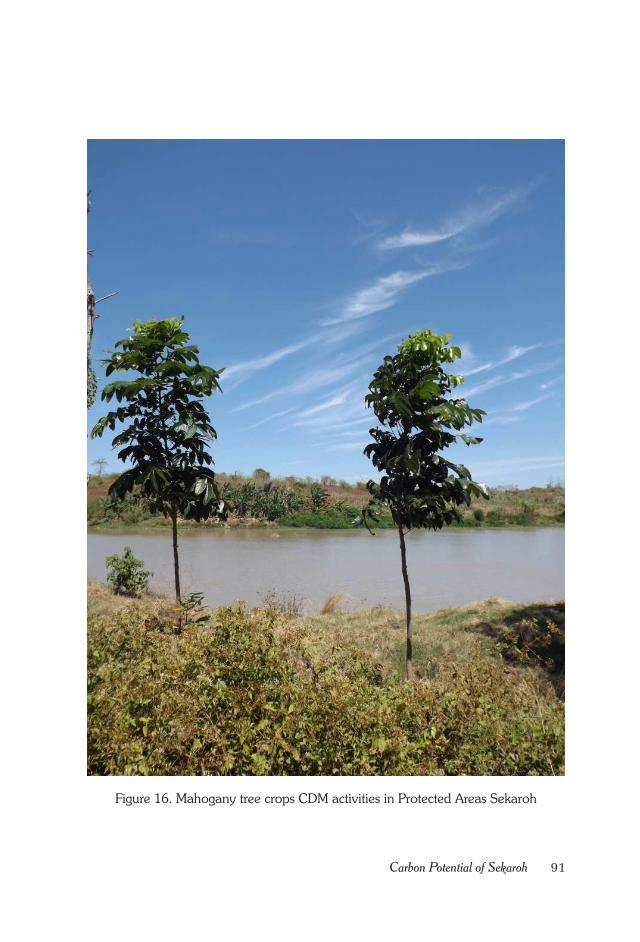
91Carbon Potential of Sekaroh
Figure 16. Mahogany tree crops CDM activities in Protected Areas Sekaroh
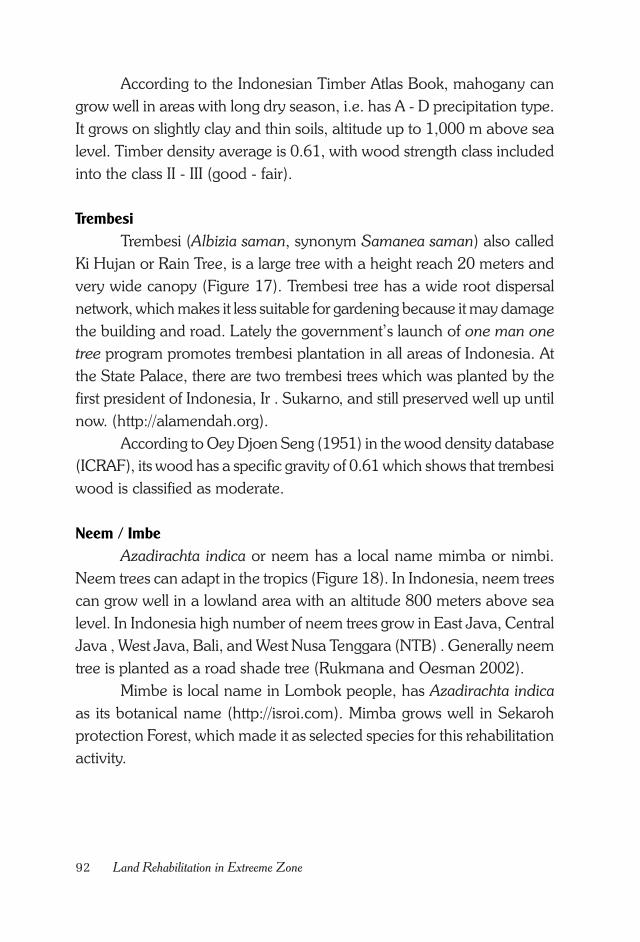
92 Land Rehabilitation in Extreeme Zone
According to the Indonesian Timber Atlas Book, mahogany can
grow well in areas with long dry season, i.e. has A - D precipitation type.
It grows on slightly clay and thin soils, altitude up to 1,000 m above sea
level. Timber density average is 0.61, with wood strength class included
into the class II - III (good - fair).
Trembesi
Trembesi (Albizia saman, synonym Samanea saman) also called
Ki Hujan or Rain Tree, is a large tree with a height reach 20 meters and
very wide canopy (Figure 17). Trembesi tree has a wide root dispersal
network, which makes it less suitable for gardening because it may damage
the building and road. Lately the government’s launch of one man one
tree program promotes trembesi plantation in all areas of Indonesia. At
the State Palace, there are two trembesi trees which was planted by the
first president of Indonesia, Ir . Sukarno, and still preserved well up until
now. (http://alamendah.org).
According to Oey Djoen Seng (1951) in the wood density database
(ICRAF), its wood has a specific gravity of 0.61 which shows that trembesi
wood is classified as moderate.
Neem / Imbe
Azadirachta indica or neem has a local name mimba or nimbi.
Neem trees can adapt in the tropics (Figure 18). In Indonesia, neem trees
can grow well in a lowland area with an altitude 800 meters above sea
level. In Indonesia high number of neem trees grow in East Java, Central
Java , West Java, Bali, and West Nusa Tenggara (NTB) . Generally neem
tree is planted as a road shade tree (Rukmana and Oesman 2002).
Mimbe is local name in Lombok people, has Azadirachta indica
as its botanical name (http://isroi.com). Mimba grows well in Sekaroh
protection Forest, which made it as selected species for this rehabilitation
activity.
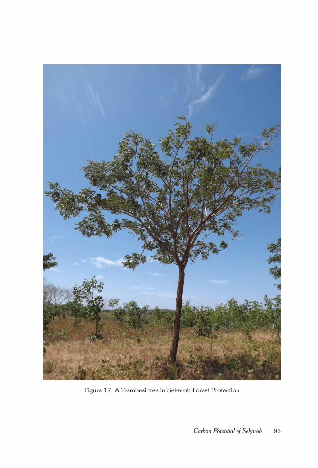
93Carbon Potential of Sekaroh
Figure 17. A Trembesi tree in Sekaroh Forest Protection
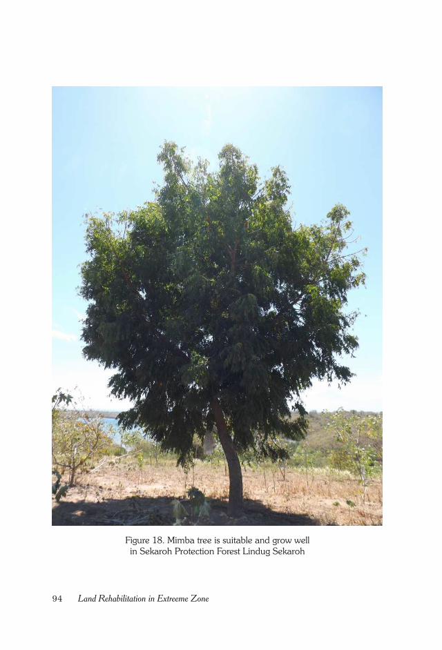
94 Land Rehabilitation in Extreeme Zone
Figure 18. Mimba tree is suitable and grow well
in Sekaroh Protection Forest Lindug Sekaroh
95Carbon Potential of Sekaroh
Khaya (Khaya anthotheca)
Another forest tree species which was transplanted at the AR CDM
activity of Sekaroh protection Forest was Khaya (Khaya anthotheca).
The species belongs to Meliaceae family. This is not indigenous species
in Indonesia. It naturally spreads out in tropical regions of Africa. In that
region the species is the main internationally traded timber species, known
as African-mahogany. The species is fast growing and have good prospect
for further larger scale development (Irwanto 2007).
The species could grow in dry area, with rainfall between 1500
mm to more than 3000 mm a year. In dry area (rainfall between 1500 –
2000 mm/year) it grows better. Average rainy days is between 70 to 190
days, and average temperature is between 20 o – 26.5o C, with average
humidity 72.88% (Irwanto 2007).
The highest carbon potential in 2020 among the four tree species
is mahogany (Swietenia macrophylla) which amounts as much as 14.946
tons CO2e. Second higher carbon potential after 20-year-old crop is
trembesi which has as much as 14.245 tons CO2e (see Figure 19).
Figure 19. Carbon potential of the four forest tree species.
-
2,000
4,000
6,000
8,000
10,000
12,000
14,000
16,000
1 3 5 7 9 11 13 15 17 19
ANGRS (t CO
2)
Age (Year)
Trembesi
Neem/Imbe
Khaya
Mahogany
96 Land Rehabilitation in Extreeme Zone
Fruit Tree Species
The selection of some fruit trees to be planted was not only because
of their suitability with the planting site, but also from public suggestion.
Based on public survey conducted in November 2010, main fruit trees
favored by majority of people were tamarind, srikaya , mango and nangka
(jackfruit ).
Nangka (Jackfruit)
Nangka (Artocarpus heterophyllus) is well known to Sekaroh
people. Actually it’s not indigenous species of Indonesia. Originally it
came from South India, then emigrated and distributed throughout the
world including Indonesia.
At Sekaroh Protection Forest nangka trees could be found in several
places, which had been planted by local people (Figure 20). This fruit
tree is tropical plant species, and so its distribution and development is
mostly happened in region with tropical climate. Indonesian people have
long been familiar with this species. Nangka fruit is available all the time,
regardless of season. In Indonesia this fruit tree could be found almost
everywhere, at the people farm or garden without serious maintenance
(www.deptan.go.id).
Asam (Tamarind)
Asam tree (Tamarindus indica) grows well around Sekaroh
Protection Forest and become source of income for Sekaroh people
(Figure 21). Asam tree usually bears fruit in dry season. This has become
a blessing for Sekaroh people, because during dry season corn is not
produced and instead tamarind is the source of income for local people.
Besides as source of additional income, asam tree also is useful
for shade tree along the road. Many house gardens are planted with
asam tree, because this tree is shady and suitable for dry area.
Srikaya
Srikaya (Annona squamosa) is relatively new introduced plant
species to Sekaroh people by the government (Figure 22). Srikaya was
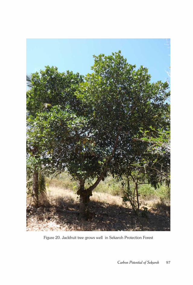
97Carbon Potential of Sekaroh
Figure 20. Jackfruit tree grows well in Sekaroh Protection Forest
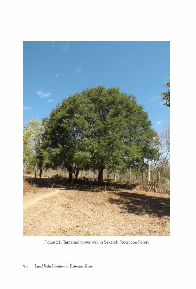
98 Land Rehabilitation in Extreeme Zone
Figure 21. Tamarind grows well in Sekaroh Protection Forest
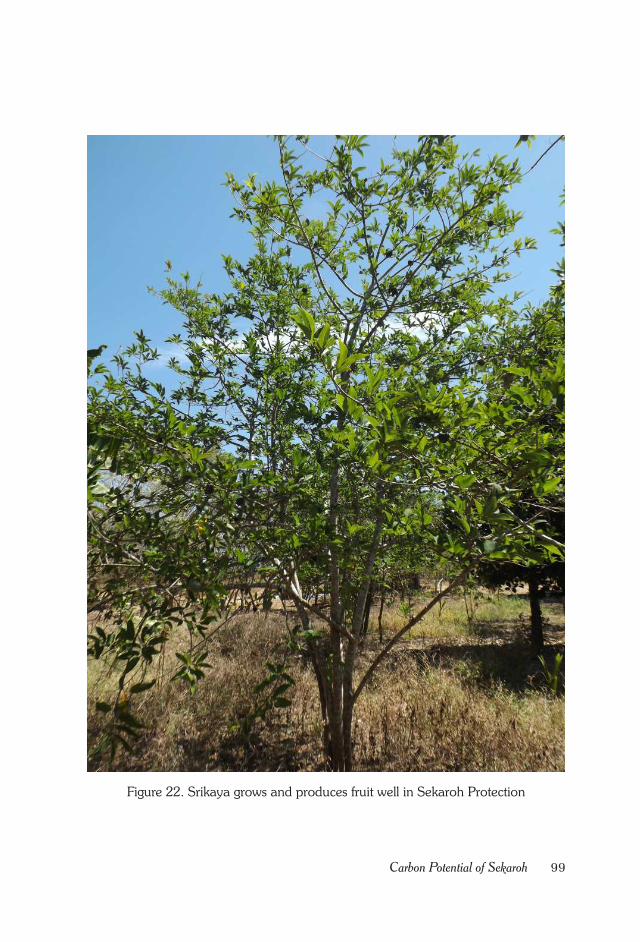
99Carbon Potential of Sekaroh
Figure 22. Srikaya grows and produces fruit well in Sekaroh Protection
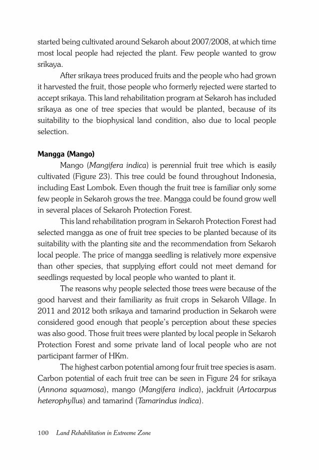
100 Land Rehabilitation in Extreeme Zone
started being cultivated around Sekaroh about 2007/2008, at which time
most local people had rejected the plant. Few people wanted to grow
srikaya.
After srikaya trees produced fruits and the people who had grown
it harvested the fruit, those people who formerly rejected were started to
accept srikaya. This land rehabilitation program at Sekaroh has included
srikaya as one of tree species that would be planted, because of its
suitability to the biophysical land condition, also due to local people
selection.
Mangga (Mango)
Mango (Mangifera indica) is perennial fruit tree which is easily
cultivated (Figure 23). This tree could be found throughout Indonesia,
including East Lombok. Even though the fruit tree is familiar only some
few people in Sekaroh grows the tree. Mangga could be found grow well
in several places of Sekaroh Protection Forest.
This land rehabilitation program in Sekaroh Protection Forest had
selected mangga as one of fruit tree species to be planted because of its
suitability with the planting site and the recommendation from Sekaroh
local people. The price of mangga seedling is relatively more expensive
than other species, that supplying effort could not meet demand for
seedlings requested by local people who wanted to plant it.
The reasons why people selected those trees were because of the
good harvest and their familiarity as fruit crops in Sekaroh Village. In
2011 and 2012 both srikaya and tamarind production in Sekaroh were
considered good enough that people’s perception about these species
was also good. Those fruit trees were planted by local people in Sekaroh
Protection Forest and some private land of local people who are not
participant farmer of HKm.
The highest carbon potential among four fruit tree species is asam.
Carbon potential of each fruit tree can be seen in Figure 24 for srikaya
(Annona squamosa), mango (Mangifera indica), jackfruit (Artocarpus
heterophyllus) and tamarind (Tamarindus indica).
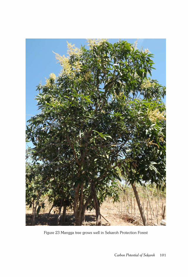
101Carbon Potential of Sekaroh
Figure 23 Mangga tree grows well in Sekaroh Protection Forest
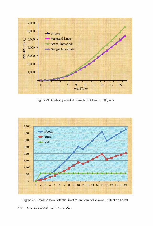
102 Land Rehabilitation in Extreeme Zone
Figure 25. Total Carbon Potential in 309 Ha Area of Sekaroh Protection Forest
Figure 24. Carbon potential of each fruit tree for 30 years
-
500
1,000
1,500
2,000
2,500
3,000
3,500
4,000
1 2 3 4 5 6 7 8 9 10 11 12 13 14 15 16 17 18 19 20
Woody
Fruits
Soil
-
1,000
2,000
3,000
4,000
5,000
6,000
7,000
1 3 5 7 9 11 13 15 17 19
ANGRS (t CO2)
Age (Year)
Srikaya
Mangga (Mango)
Asam (Tamarind)
Nangka (Jackfruit)
103Carbon Potential of Sekaroh
Total Carbon
Total carbon is the total sum up of the carbon potential of forest
and fruit tree species. Although the main purpose of this rehabilitation
was not really to get the value of carbon trading, but if that is possible,
then it would be done. Calculation on the carbon potential of the eight
tree species, which were transplanted together with the community, had
been done.
The amount of carbon of forest tree species at 20 years of age
would be 42.127 tons CO2e. While the potential of carbon of fruit tree
species at 20 years age would be 22.777 tons CO2e. This suggested that
carbon potential of forest tree species was 19.349 tons CO2e higher than
fruit tree species.
Total carbon sequestered by forest and fruit tree species after 20
years of age would be 64.904 tons CO2e. If added with an estimated soil
carbon potential, which would increase as much as 0.5 tons C per hectare/
year, then the total carbon in an area of 309 ha in the Sekaroh Protection
Forest would be 75.667 tons CO2e (see Figure 25).

104 Land Rehabilitation in Extreeme Zone
105Validation Activity
CHAPTER XIII.
VALIDATION ACTIVITY
Brief Information about JACO CDM
Validation is one of the stages in the MPB (AR CDM activities)
that must be conducted to earn Certified Emission Reduction (CER) from
the UNFCCC. Until the end of 2012, there is no institution which would
conduct validation activities in Indonesia.
Institution that performs validation on AR CDM activities in
Sekaroh Protection Forest, East Lombok was JACO CDM from Japan.
JACO CDM received CDM-AP indication letter dated February 5th 2005
for all sectors scope. This letter showed that the CDM-AP agreed for
JACO CDM to recommend Executive Board to accredit the applicant
institution.
UNFCCC CDM Executive Board accredited JACO CDM as
temporary Designated Operational Entity (DOE) to perform validation
for sector 1 (energy industry), 2 (energy distribution) and 3 (energy
demand) dated February 23th 2005 and sector14 (Afforestation/
Reforestation) on August, 2008 (ww.jaco-cdm.com). List of sectors in
the UNFCCC:
1. Energy industries (renewable-/non - renewable sources )
2. Energy distribution
3. Energy demand
4. Manufacturing industries
106 Land Rehabilitation in Extreeme Zone
5. Chemical industry
6. Construction
7. Transport
8. Mining/Mineral production
9. Metal production
10.Fugitive emissions from fuels (solid, oil and gas)
11.Fugitive emissions from production and consumption of halocar-
bons and sulfur hexafluoride
12.Solvents use
13.Waste handling and disposal
14.Afforestation and reforestation
15.Agriculture
KOICA choose JACO CDM as a validator for AR CDM activities
in East Lombok based on the JACO CDM track record which already
has conducted many validation activities. By selecting institution that
have been accredited by UNFCCC and has many experiences as a
validator, the validation process is expected to run smoothly and all
stakeholders in East Lombok and Indonesia could learn a good lesson
about validation process.
Things Questioned By Validator
Validation activity in the field was carried out by JACO CDM in
East Lombok on July 6th to 14th 2011. Things that were asked by JACO
CDM in its validation activities were those commonly asked at auditing.
For the AR CDM activity the questions were mostly about the AR CDM
methodology and activities in the field. In general, questions and field
inspection by validator were:
1. Argument for Methodology Selection
Project developer needs to explain in detail the reason for selecting a
methodology to the validator. One methodology was selected based
on land suitability out from the available methodologies. Methodol-
107Validation Activity
ogy for a forest area destined for timber production will be different
with methodology available for a protection forest. Similarly, for
peatland area will be different from an area with mineral soil.
The selected methodology for AR CDM activity in East Lombok
was initially methodology of Clean Development Mechanism Project
Design Document form For Small - Scale Afforestation and
Reforestation Project Activities (CDM-SSC-AR-PDD) Version 02. Later
after some changes in the UNFCCC methodology, this project
methodology was adjusted with the new changes which is AR -
AMS0007 methodology or Simplified Baseline And Monitoring
Methodologies For Small Scale CDM Afforestation And Reforestation
Project Activities Implemented A On Lands Other Than Wetlands.
2. Project Proponent
Project developer needs to explain to the validator about project pro-
ponent. The reasons why the institution A or B served as project
proponent. In the case of AR CDM activities in Sekaroh Protection
Forest the project proponents consists of several institutions, namely:
• Gapoktan Sekaroh Maju (IUPHHKm license Holder), as field ex-
ecutor.
• East Lombok Regency Forest Service (Dishutbun), as a facilitator
and monitoring field activities.
• West Nusa Tenggara Provincial Forest Service, as facilitator.
• Forest Research and Development Agency (FORDA), Ministry of
Forestry, as a facilitator and monitoring activities.
• Korea International Cooperation Agency (KOICA), as the fund-
ing donor.
3. Project Location Boundary
The project boundary would be asked and ground-checked by the
validator. The project boundary in the field must be in accordance
with what is scribed in the map.
4. Planted Tree Species
The reason for selecting the plant species needed to be explained.
Was selection of plant species based on land biophysical factor, com-
108 Land Rehabilitation in Extreeme Zone
munity perceptions or high carbon sequestration? Or was it due to
combination of all the factors above? Selection on plant species for
Sekaroh Protection Forest was based on their suitability to the plant-
ing site (land biophysical condition) and positive perception of the
community towards these trees.
5. Land biophysical conditions (soil type, temperature and precipita-
tion)
While conducting field survey the validator would also cross check
data in the PDD document. Usually validator also brings soil experts
to check whether the soil at the planting site is in accordance with the
type of soil in the PDD document.
6. Suitability of land with requirements for CDM (land cover < 30 %)
Besides using GIS, land cover could also be measured using
densiometer tool. Estimation of canopy closure could be done using
the approach of ‘Chart For Estimating Proportions Of Mottles And
Coarse Fragments’.
7. Stakeholders perceptions towards CDM activity
To know the stakeholders perception towards the AR CDM activity
on the ground, validator would communicate directly with the local
stakeholders. Communication with stakeholders was conducted by
JACO CDM with local people, Gapoktan Sekaroh Maju, Sekaroh
Village Chief, Jerowaru District Head, East Lombok Regency Forest
Service (Dishutbun) and West Nusa Tenggara Provincial Forest Ser-
vice, including facilitator NGO (AMPEL).
8. PDD contents and ground checks
In general the validator will question all the contents of the Project
Plan Document (PRD), and if ground check is needed, they will see
the field condition. Location, boundaries, type of plant, plant spac-
ing, soil type, seedling sources, involved stakeholders, and the others
mentioned in the PRD document will be ground checked.
For one week JACO CDM checked the PDD structures that must
match the selected methodology. As validator, JACO CDM questioned
the reasons for selecting the methodology and suitability between the
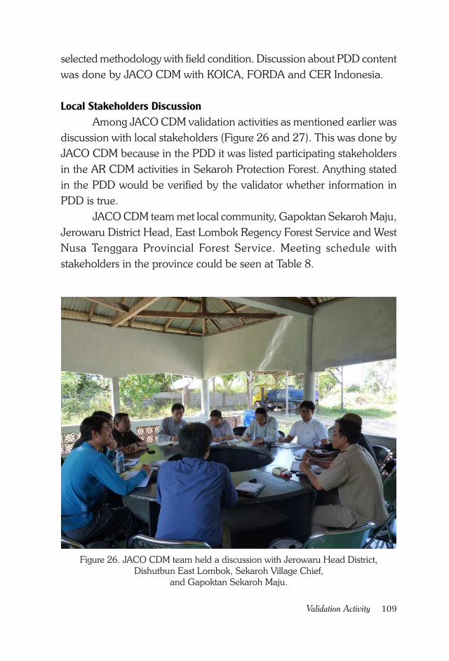
109Validation Activity
selected methodology with field condition. Discussion about PDD content
was done by JACO CDM with KOICA, FORDA and CER Indonesia.
Local Stakeholders Discussion
Among JACO CDM validation activities as mentioned earlier was
discussion with local stakeholders (Figure 26 and 27). This was done by
JACO CDM because in the PDD it was listed participating stakeholders
in the AR CDM activities in Sekaroh Protection Forest. Anything stated
in the PDD would be verified by the validator whether information in
PDD is true.
JACO CDM team met local community, Gapoktan Sekaroh Maju,
Jerowaru District Head, East Lombok Regency Forest Service and West
Nusa Tenggara Provincial Forest Service. Meeting schedule with
stakeholders in the province could be seen at Table 8.
Figure 26. JACO CDM team held a discussion with Jerowaru Head District,
Dishutbun East Lombok, Sekaroh Village Chief,
and Gapoktan Sekaroh Maju.
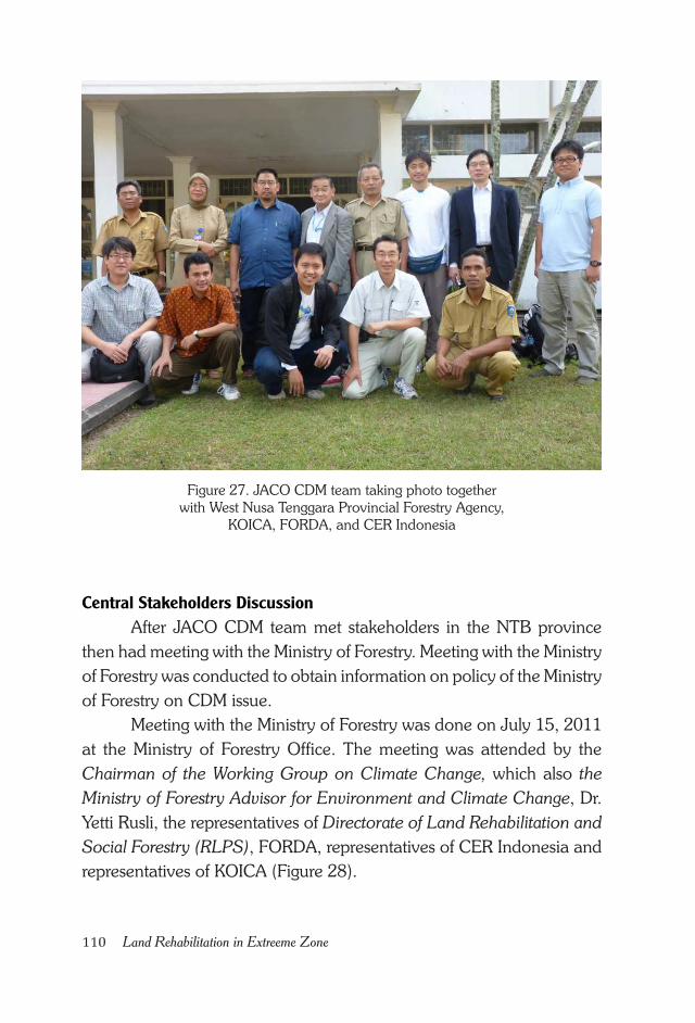
110 Land Rehabilitation in Extreeme Zone
Central Stakeholders Discussion
After JACO CDM team met stakeholders in the NTB province
then had meeting with the Ministry of Forestry. Meeting with the Ministry
of Forestry was conducted to obtain information on policy of the Ministry
of Forestry on CDM issue.
Meeting with the Ministry of Forestry was done on July 15, 2011
at the Ministry of Forestry Office. The meeting was attended by the
Chairman of the Working Group on Climate Change, which also the
Ministry of Forestry Advisor for Environment and Climate Change, Dr.
Yetti Rusli, the representatives of Directorate of Land Rehabilitation and
Social Forestry (RLPS), FORDA, representatives of CER Indonesia and
representatives of KOICA (Figure 28).
Figure 27. JACO CDM team taking photo together
with West Nusa Tenggara Provincial Forestry Agency,
KOICA, FORDA, and CER Indonesia
111Validation Activity
Table 8. Meeting Schedule of JACO CDM team with Stakeholders
In this meeting it was discussed about the License from the Minister
of Forestry on Allocated Area for HKm that had been issued and Letter
of Recommendation from the Minister of Forestry toward CDM activities
in Sekaroh Protection Forest. The Ministry of Forestry was very helpful in
this case and JACO CDM team response to the Ministry of Forestry
commitment was very positive.
Lessons From The Validator
Validator will validate the prepared PDD document. Validator in
principle will help the project proponent to endorse the document to the
UNFCCC.
No Date Location Stakeholders Agenda
1 July 12th
2011
Sekaroh
Protection Forest
Sekaroh
Citizen
Revealing community
perception.
2 July 12th
2011
Jerowaru District
Head Office
Gapoktan
Sekaroh Maju
Discover Gapoktan
perception about CDM
activities in Sekaroh
Protection Forest
3 July 12th
2011
Jerowaru District
Head Office
Jerowaru
District Head
Discover government
perception toward CDM
activities in Sekaroh
Protection Forest
4 July 12th
2011
Forest and
Agriculture Service
(Dishutbun) East
Lombok
Forest and
Agriculture
Service
(Dishutbun)
East Lombok
Discover Forest and
Agriculture Service
(Dishutbun) East
Lombok perception
about the CDM activities
in Sekaroh Protection
Forest
5 July 13th
2011
West Nusa
Tenggara
Provincial Forest
Service Office
West Nusa
Tenggara
Provincial
Forest Service
Gain information and
support from West Nusa
Tenggara Provincial
Forest Service toward
the CDM activities in
Sekaroh Protection
Forest
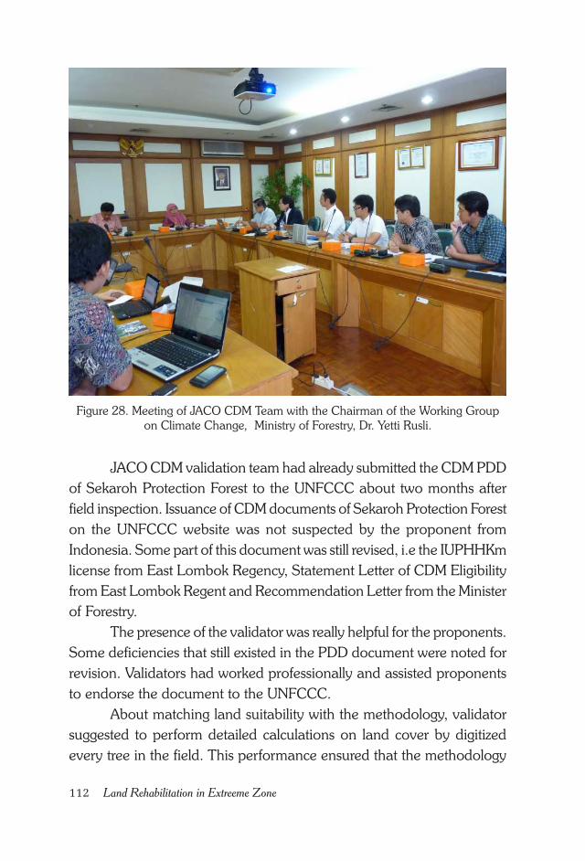
112 Land Rehabilitation in Extreeme Zone
Figure 28. Meeting of JACO CDM Team with the Chairman of the Working Group
on Climate Change, Ministry of Forestry, Dr. Yetti Rusli.
JACO CDM validation team had already submitted the CDM PDD
of Sekaroh Protection Forest to the UNFCCC about two months after
field inspection. Issuance of CDM documents of Sekaroh Protection Forest
on the UNFCCC website was not suspected by the proponent from
Indonesia. Some part of this document was still revised, i.e the IUPHHKm
license from East Lombok Regency, Statement Letter of CDM Eligibility
from East Lombok Regent and Recommendation Letter from the Minister
of Forestry.
The presence of the validator was really helpful for the proponents.
Some deficiencies that still existed in the PDD document were noted for
revision. Validators had worked professionally and assisted proponents
to endorse the document to the UNFCCC.
About matching land suitability with the methodology, validator
suggested to perform detailed calculations on land cover by digitized
every tree in the field. This performance ensured that the methodology
113Validation Activity
selection was correct. The validator team directly looked at the condition
of the soil and reminded to ensure suitability ofplant species with soil
conditions. The presence of validator team in principle had helped
proponent to improve documents that would be sent to the UNFCCC
Secretariat.

114 Land Rehabilitation in Extreeme Zone
115Obstacle/Experience from Initial 30 Ha Plantation
CHAPTER XIV.
OBSTACLE/EXPERIENCEFROM INITIAL 30 HA PLANTATION
Experience from Initial 30 Ha Plantation
Agriculture and agricultural development has been directly and
indirectly responsible for about 31% of global GHG emission (IPCC,
2007). Any effort to reduce the emission should be aware of continuous
people need for food, feed and fiber, also increasing demand of animal
protein among influential consumer groups, regardless of government
and other parties’ efforts to restrain it. To fulfill those competing demands
modern technology is needed to increase production from limited land
resource; and political solution which understands and resolve potential
conflicts on various contradictory land uses (Rudel, 2011). The existence
of conflict of interest was the main reason for CDM Program in East
Lombok to implement various strategies to achieve its main objective.
KOICA strategy to first plant approximately 10% of the plan which
was 30 ha was correct. The purposes were among others, to observe
support from the stakeholders, planting site suitability, also KOICA was
in the phase of nurseries establishment and other technical matters. By
planting 30 ha at the initial stage it was possible to evaluate any
unfavorable factors, any good result or the right approach model to be
performed.
From the evaluation of the initial 30 ha plantation area, it was
concluded that planting program was failed as indicated by survival
116 Land Rehabilitation in Extreeme Zone
percentage. The cause of failure was technical and non- technical factors.
Technical problems were low rainfall and extreme climate in Sekaroh
Protection Forest. To overcome this obstacle, an intensive maintenance
by watering crops during dry season is necessary.
Watering plants during the dry season has been done for an area
of 309.69 ha based on the evaluation of 30 ha plantation. Gapoktan
Sekaroh Maju was authorized to distribute water to the entire plantation
area. Source of water for irrigation was taken from an artificial pond and
the renewed and deepened pond owned by the Village Chief.
By adding a watering program, the number of died plant could
be reduced during dry season. The water availability in the ponds had
help local community also during dry season. KOICA had planned to
add the number of pond for communities in the Sekaroh Protection Forest.
Non-technical problem was local community suspicion about the
AR CDM activity, which might take their access rights and drive them out
from their farmlands. This information was very important, so that when
the time came to plant the entire area (309.69 ha), KOICA team, FORDA,
and Gapoktan Sekaroh Maju needed to make an intensive approach to
the people. In this case the team had thought of involving local NGO
AMPEL from Jerowaru, East Lombok to communicate intensively with
local people.
AMPEL approach was quite effective in reality. Equipped with
ability to speak local language and experience on advocacy, AMPEL
NGO could convince people who formerly refused the program into
participating, that slowly the survival of transplanted plants was improved.
Social Obstacles
Results and evaluation of initial 30 ha plantation was very
important as lesson learned for everybody, especially for this program.
Social barrier came from local people habit which is used to plant corn
and think that only corn could grow well in Sekaroh Protection Forest;
also the habit of livestock grazing in Sekaroh Protection Forest. Both
issues could seriously obstruct the plantation if it did not solve completely
and immediately.
117Obstacle/Experience from Initial 30 Ha Plantation
In order to overcome social barrier by changing local people
opinion that only corn could grow and give economic benefit in Sekaroh
Protercted Forest, the team taught local people calculating the economic
return of the other planted plants. This calculation was based on planted
trees NPV (net present value) and a simple calculation from local people
experiences around Sekaroh .
Some of local community around Sekaroh Protection Forest was
already grew tamarind, srikaya, mango and jackfruit. Some people had
three some others had up to seven trees of mango and tamarind. Fruit
production from the mango, tamarind, jackfruit and srikaya trees turned
out to be high enough.
Most people already knew that harvest from the mango, tamarind,
jackfruit and srikaya trees in Sekaroh was adequately high, but they had
not want to follow the example from their neighbor. The program team
tried to encourage people doing calculations based on the local harvest.
Extension program on calculating economic return of fruit trees was done
together with field facilitators, i.e. Chairman of Gapoktan (Budi
Mulyawan), Chairman of the Block II (Hermanto) and field facilitator of
AMPEL NGO, Turmuzi.
According to them the surrounding communities of Sekaroh who
had 5 -year -old srikaya would be able to earn Rp 200,000.-/tree. A 7-
year–old tamarind was able to gave Rp 1,000,000,-/tree. A 8 -year -old
jackfruit was able to gave Rp 350,000.-/tree. A 8 -year -old mango was
able to earn Rp 800,000.-/ tree. If simplified after 8 years program when
all planted trees could be harvested, assuming that each people have 30
trees, then each farmer would get approximately Rp 70,000,000.-/farmer/
year (see Table 9). Meanwhile the benefit from corn harvest was only
between Rp 500,000.- -5,500,000.-/ha per harvesting season.
To overcome the problem of cattle grazing in Sekaroh Protection
Forest, people had agreed to make awig awig (social norms in East
Lombok). Awig awig for HKm (community based forestry) in Sekaroh
Protection Forest has been established on March 20th 2013. The
agreement was signed by the Chairman and Secretary of Gapoktan
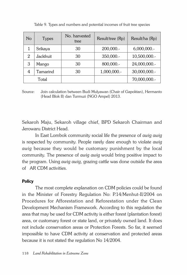
118 Land Rehabilitation in Extreeme Zone
Table 9. Types and numbers and potential incomes of fruit tree species
Sekaroh Maju, Sekaroh village chief, BPD Sekaroh Chairman and
Jerowaru District Head.
In East Lombok community social life the presence of awig awig
is respected by community. People rarely dare enough to violate awig
awig because they would be customary punishment by the local
community. The presence of awig awig would bring positive impact to
the program. Using awig awig, grazing cattle was done outside the area
of AR CDM activities.
Policy
The most complete explanation on CDM policies could be found
in the Minister of Forestry Regulation No: P.14/Menhut-II/2004 on
Procedures for Afforestation and Reforestation under the Clean
Development Mechanism Framework. According to this regulation the
area that may be used for CDM activity is either forest (plantation forest)
area, or customary forest or state land, or privately owned land. It does
not include conservation areas or Protection Forests. So far, it seemed
impossible to have CDM activity at conservation and protected areas
because it is not stated the regulation No 14/2004.
No Types No. harvested
tree Result/tree (Rp) Result/ha (Rp)
1 Srikaya 30 200,000.- 6,000,000.-
2 Jackfruit 30 350,000.- 10,500,000.-
3 Mango 30 800,000.- 24,000,000.-
4 Tamarind 30 1,000,000.- 30,000,000.-
Total 70,000,000.-
Source: Join calculation between Budi Mulyawan (Chair of Gapoktan), Hermanto
(Head Blok II) dan Turmuzi (NGO Ampel) 2013.
119Obstacle/Experience from Initial 30 Ha Plantation
In this Regulation P.14/2004 it is also mentioned about License
on Environment Services Utilization (IUPJL), of which the IUPJL has
been considered as one of the factors inhibiting A/R CDM activities in
Indonesia. For the A/R CDM projects implemented in National Parks,
the requirement of IUPJL becomes inhibiting factor because none
institution would like to take the license.
To correct those obstacles found in P.14/2012, the Ministry of
Forestry issued a Ministerial Regulation No P. 20/Menhut-II/2012 on
Implementation of the Forest Carbon. In this latest regulation it was stated
that implementation of forest carbon activities could be done in
production, protection, and conservation forest areas (Article 3, paragraph
3).
Chapter 6, verse 4 says “Executor of forest carbon derived from
implementation through demonstration activities and new implementation
without going through demonstration activities”, are as follow (point e),
Holders of License on Community Forest Utilization (HKm). Ministerial
Decree No. 356/Menhut-II/2011 on Designation of Community Forestry
Working Area Covering An Area of 1,450 ha in East Lombok, West
Nusa Tenggara Province, was followed by the Regent of East Lombok
Decree No. 188.45/443/HUTBUN/2012. In the HKm Decree the
Community Forest Utilization License includes activities such as (point
2); Environmental Services Utilization which includes: Utilization of water
services, eco-tourism, biodiversity protection, environmental protection
and carbon absorption and/or storage.
Technical and Institutional Issues
Each region has unique characteristic, which could also mean that
each area has a specific obstacle. Sekaroh Protection Forest, which is
referred by some as an extreme zone both from the point of view of its
regional condition and community character, the success of land
rehabilitation activities was rarely happened.
On the other hand, the local community institution is not developed
well. Existing formal institutions are already busy with their own problems.
One of the agencies that could be expected to focus on coordination
120 Land Rehabilitation in Extreeme Zone
with local society is Gapoktan Sekaroh Maju. As an institution that is
directly related to farmers, Gapoktan Sekaroh Maju should have a
structured program in accordance with institutional founding chapter (AD/
ART). Reality was this institution could not run effectively.
Gapoktan does not have a well-organized program yet. It was
difficult even to conduct monthly meetings.
The existence of the AR CDM program had already pushed
Gapoktan Sekaroh Maju personnel to work with farmer members,
especially those involved in the AR CDM activities. The coordinative
work between Gapoktan personnel and farmers mostly happened on
the ground field. Gapoktan personnel would routinely supervise farmers
on several planting phases, such as land-clearing, planting preparation,
planting, maintenance activities, and replanting.
After all trees were planted Gapoktan personnel was also actively
involved with farmers through watering activities and inspecting the
condition of the plant. Thus the local institutions slowly had started to
live.
The presence of AMPEL NGO in community facilitation had also
indirectly helped the local institution more alive. AMPEL NGO which
has a lot of advocating experience had provided transforming information
to the community and local public figure.
In the future Gapoktan institution needed to be strengthened
because Gapoktan is a local institution that has direct contact with the
farmers. Some remaining problem of Gapoktan was lack of facilities
capacity, that it was necessary to increase Human Resources (HR) capacity
and supplying equipments such as computers and printers. Until now
Gapoktan Sekaroh Maju does not have a computer and printer yet. This
is understandable because main infrastructure such as electrical source
to operate computer has not been stable yet.
Human resource development was still required for Gapoktan to
improve both institutional and administrative system. Increased ability
of institutional and administrative system would enable Gapoktan to take
better role in the improvement of society and the environment in Sekaroh.
121Obstacle/Experience from Initial 30 Ha Plantation
Any new stakeholders entering Sekaroh could strengthen Gapoktan
institution by increasing human resource development and provision of
facilities. As such future land rehabilitation activities in Sekaroh could
improve the quality of the environment, human resources and local
community incomes.

122 Land Rehabilitation in Extreeme Zone
123Presentation at the National Committee of CDM
CHAPTER XV.
PRESENTATION ATTHE NATIONAL COMMITTEE OF CDM
Presentation Contents
Presentation of project proponent in front of National Committee
of CDM (KOMNAS MPB) is one of stages in the AR CDM activity. The
objective of such presentation is to evaluate administrative and technical
conformity of the proposal document content to any national regulation.
Proponent team presentation had been done on 22 July 2013 at the
National Committee of CDM, and the Letter of Approval (LoA) for the
AR CDM activity had been issued on 7 October 2013 (see Attachment
11).
In order to make easy for project proponent to present their case,
the National Committee of CDM has prepared technical reference for
presentation. Points that should be delivered by project proponent in
their presentation are:
• Project title. Name of project developer and project location
• Scope of content. Contained parts of contents which will be deliv-
ered in the presentation
• Proponent (company) profile. Project proponent/developer has
to give date and year of company establishment, capital owner, man-
agement board, company location, number of companies, line of
business, capacity and amount of product/service, scope of market-
ing, company operational method and project contact person

124 Land Rehabilitation in Extreeme Zone
• Project design. In this part the proponent give information on: type
of project, date and year of project establishment, early project op-
eration, location, company’s interest to the project, incoming benefit
for the company, condition of company performance before the
project started, company condition after the project started, general
project design, and blueprint of the project design
• Project funding. In this case project proponent give information
on: funding scheme (self financing, loan, joint, grant etc), CER distri-
bution sheme among stakeholders (if any), and responsibility scheme
among stakeholders (if any)
• Technical project design. Proponent in this case give information
on:applied technology, raw material, amount of raw material and its
supply, project capacity, project utilization, amount of reduced CO2
and crediting period.
• Project methodology. In this case proponent has to give informa-
tion on: adopted methodology for the project, scope of sectors,
baseline methodology, monitoring and additionality.
• Criteria for sustainable development. In this case proponent
should give information on: criteria for sustainable environment,
economy, social and technology
• Conclusion and project time table. Proponent should give in-
formation on: estimated CER obtained, benefit for the company, sur-
rounding local community, environment and project time table.
Sustainable National Development
Any CDM activity should support sustainable national
development.CDM activity should not contradict the main objective of
national development. Participants in the meeting came from various
Ministries technically involved in CDM activity. In order to ensure the
activity conform with the objective of national development the
participants did not only inquire the technical detail of the activity, but
also and its relationship with sustainable national development.
125Presentation at the National Committee of CDM
There are four criteria for linking sustainable national development
with CDM program as follow:
1. Criteria for sustainable environment. There are four indicators need
to be shown, i.e.:
• The project should not disturb the sustainability of local ecologi-
cal function of soil, climate and hydrology
• The project meets environmental quality threshold and do not
generate more emission
• The project does not have the potential of disturbing the function
of biodiversity protection in the area and surrounding area, and
in accordance with the land use
• The project does not have the potential of disturbing human health
and safety, with documented effort for health and safety at work
2. Criteria for sustainable economy. The indicators are as follow:
• The project does not reduce local community income; with visible
effort to avoid such possibility; including possibility of lay off
• The project does not disturb public services such as water supply,
health and education quality, and electric supply
3. Criteria for social sustainability. Several indicators that should be shown
are:
• The project has been consulted to the authority with visible effort
to response on input from the authority
• The project does not disturb social integrity of local community
with visible effort to overcome any negative impact.
4. Criteria for sustainable technology. In this case proponent should
shown indicator for independence from foreign technology; applying
proven new technology; also increase local capacity.
The presentation
The presentation of the AR CDM activity in Sekaroh Protection
Forest, East Lombok at the National Committee of CDM (DNPI) was
done on 22 July 2013 at 13.30 – 14.30. Project proponent of the AR
CDM in Sekaroh Protection Forest, as stated in the PDD was Gapoktan
126 Land Rehabilitation in Extreeme Zone
Sekaroh Maju (Beholder of license for IUPHHKm) East Lombok Regency
Forest Service, NTB Province Forest Service, FORDA and KOICA.
The meeting was chaired by Dicky Edwin Hindarto, Coordinator
of Carbon Trade Division – National Committee for Climate Change/
Coordinator of National Committee of CDM Secretariat. Several questions
in this meeting came from DNPI, Ministry of Forestry, Ministry of
Agriculture, Ministry of Finance, and National Landuse Agency.
The AR CDM in Sekaroh Protection Forest is CDM activity in
forestry sector; therefore most questions came from the Ministry of Forestry
as technical ministry. The questions among others were:
• Relationship of the project with the Ministerial Regulation No.14
year 2004, especially on License for Environmental Service
• Allometric equation used for calculating carbon content
• Why proponent was still interested in CDM rather than REDD+?
• Was it possible to change this activity to other mechanism than
CDM?
To answer those questions proponent had explained that according
to Regulation No P.14/2004 the area for CDM activity is forest or plantation
forest area, customary forest, state land of privately owned land. It is not
conservation area or protection forest. The P.14/2004 also mentions about
license for environmental service utilization (IUPJL), of which has been
regarded as inhibiting establishment of AR CDM activity in Indonesia.
To correct those two obstacles found in P.14/2012, the Ministry of
Forestry issued a Ministerial Regulation No P. 20/Menhut-II/2012 on
Implementation of the Forest Carbon. In this latest regulation it was stated
that implementation of forest carbon activities could be done in
production, protection, and conservation forest areas (Article 3, paragraph
3). Chapter 6, verse 4 says “Executor of forest carbon derived from
implementation through demonstration activities and new implementation
without going through demonstration activities”, are as follow (point e),
Holders of License on Community Forest Utilization (HKm).
Ministerial Decree No. 356/Menhut-II/2011 on Designation of
Community Forestry Working Area Covering An Area of 1,450 ha in
127Presentation at the National Committee of CDM
East Lombok, West Nusa Tenggara Province, was followed by the Regent
of East Lombok Decree No. 188.45/443/HUTBUN/2012. In the HKm
Decree the Community Forest Utilization License includes activities such
as (point 2); Environmental Services Utilization which includes: Utilization
of water services, eco-tourism, biodiversity protection, environmental
protection and carbon absorption and/or storage.
The proponent also explained that the allometric equation used
was developed by Ketterings et al. (2001). Kettering method was used
because it differentiates each tree species based on its wood density. In
this AR CDM there were 8 different tree species planted. Each tree species
has different characteristic and wood density. Up to that point the team
had not found any allometric equation that match Sekaroh land
biophysical condition. There are many published allometric equations;
however none of them is for those tree species planted, except mahogany.
Most allometric equations do not differentiate species with respective
wood density, that equation from Kettering et al. (2001) was best applied
for this AR CDM activity. Other reason for using this equation was its
user-friendly, that it will be easily used by local community to monitor
increment of carbon potential.
The AR CDM project was implemented because that was the type
of activity which would be done by Korea. Compared to REDD+ the
CDM project activity was still in line with REDD+, which is reducing
deforestation by increasing carbon sink thru plantation. Changing the
project into REDD+ would require changing its methodology according
to suggested methodology for REDD+ activity. Carbon credit was not
the main focus of this project, because the main project objectives were
effort for land rehabilitation, increase local community welfare, transform
the mindset on forest function, and giving new information to local people
that they could get income not only from corn cultivation, but also from
planting fruit and forest trees. At the moment a change in mindset had
happened, that maintaining forest and fruit trees could give chances to
increase local community income.

128 Land Rehabilitation in Extreeme Zone
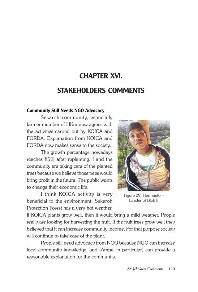
129Stakeholders Comments
CHAPTER XVI.
STAKEHOLDERS COMMENTS
Figure 29. Hermanto –
Leader of Blok II
Community Still Needs NGO Advocacy
Sekaroh community, especially
farmer member of HKm now agrees with
the activities carried out by KOICA and
FORDA. Explanation from KOICA and
FORDA now makes sense to the society.
The growth percentage nowadays
reaches 85% after replanting. I and the
community are taking care of the planted
trees because we believe those trees would
bring profit in the future. The public wants
to change their economic life.
I think KOICA activity is very
beneficial to the environment. Sekaroh
Protection Forest has a very hot weather,
if KOICA plants grow well, then it would bring a mild weather. People
really are looking for harvesting the fruit. If the fruit trees grow well they
believed that it can increase community income. For that purpose society
will continue to take care of the plant.
People still need advocacy from NGO because NGO can increase
local community knowledge, and (Ampel in particular) can provide a
reasonable explanation for the community.
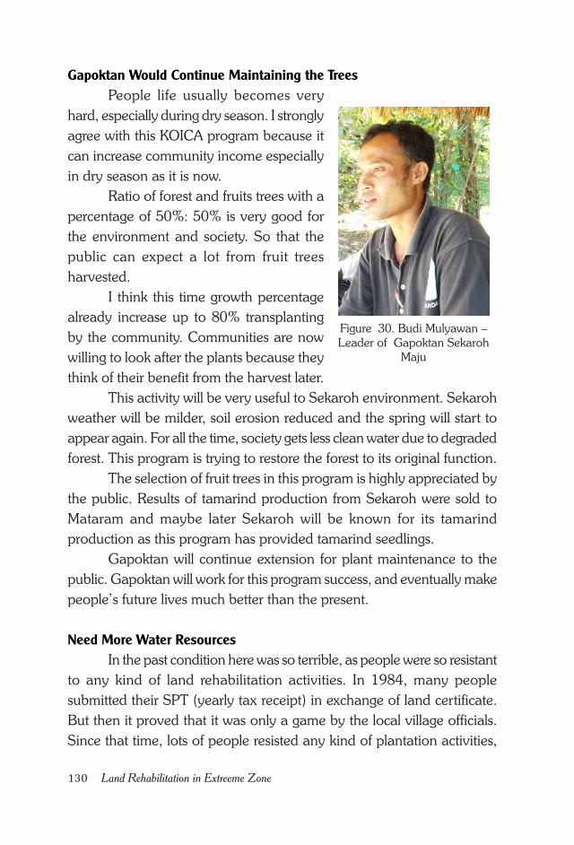
130 Land Rehabilitation in Extreeme Zone
Figure 30. Budi Mulyawan –
Leader of Gapoktan Sekaroh
Maju
Gapoktan Would Continue Maintaining the Trees
People life usually becomes very
hard, especially during dry season. I strongly
agree with this KOICA program because it
can increase community income especially
in dry season as it is now.
Ratio of forest and fruits trees with a
percentage of 50%: 50% is very good for
the environment and society. So that the
public can expect a lot from fruit trees
harvested.
I think this time growth percentage
already increase up to 80% transplanting
by the community. Communities are now
willing to look after the plants because they
think of their benefit from the harvest later.
This activity will be very useful to Sekaroh environment. Sekaroh
weather will be milder, soil erosion reduced and the spring will start to
appear again. For all the time, society gets less clean water due to degraded
forest. This program is trying to restore the forest to its original function.
The selection of fruit trees in this program is highly appreciated by
the public. Results of tamarind production from Sekaroh were sold to
Mataram and maybe later Sekaroh will be known for its tamarind
production as this program has provided tamarind seedlings.
Gapoktan will continue extension for plant maintenance to the
public. Gapoktan will work for this program success, and eventually make
people’s future lives much better than the present.
Need More Water Resources
In the past condition here was so terrible, as people were so resistant
to any kind of land rehabilitation activities. In 1984, many people
submitted their SPT (yearly tax receipt) in exchange of land certificate.
But then it proved that it was only a game by the local village officials.
Since that time, lots of people resisted any kind of plantation activities,
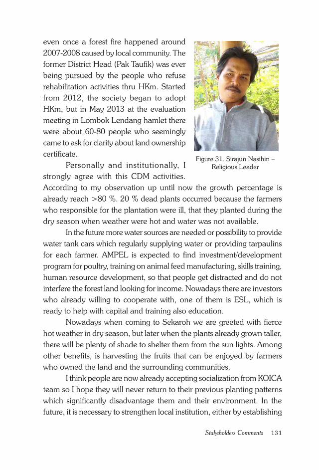
131Stakeholders Comments
Figure 31. Sirajun Nasihin –
Religious Leader
even once a forest fire happened around
2007-2008 caused by local community. The
former District Head (Pak Taufik) was ever
being pursued by the people who refuse
rehabilitation activities thru HKm. Started
from 2012, the society began to adopt
HKm, but in May 2013 at the evaluation
meeting in Lombok Lendang hamlet there
were about 60-80 people who seemingly
came to ask for clarity about land ownership
certificate.
Personally and institutionally, I
strongly agree with this CDM activities.
According to my observation up until now the growth percentage is
already reach >80 %. 20 % dead plants occurred because the farmers
who responsible for the plantation were ill, that they planted during the
dry season when weather were hot and water was not available.
In the future more water sources are needed or possibility to provide
water tank cars which regularly supplying water or providing tarpaulins
for each farmer. AMPEL is expected to find investment/development
program for poultry, training on animal feed manufacturing, skills training,
human resource development, so that people get distracted and do not
interfere the forest land looking for income. Nowadays there are investors
who already willing to cooperate with, one of them is ESL, which is
ready to help with capital and training also education.
Nowadays when coming to Sekaroh we are greeted with fierce
hot weather in dry season, but later when the plants already grown taller,
there will be plenty of shade to shelter them from the sun lights. Among
other benefits, is harvesting the fruits that can be enjoyed by farmers
who owned the land and the surrounding communities.
I think people are now already accepting socialization from KOICA
team so I hope they will never return to their previous planting patterns
which significantly disadvantage them and their environment. In the
future, it is necessary to strengthen local institution, either by establishing
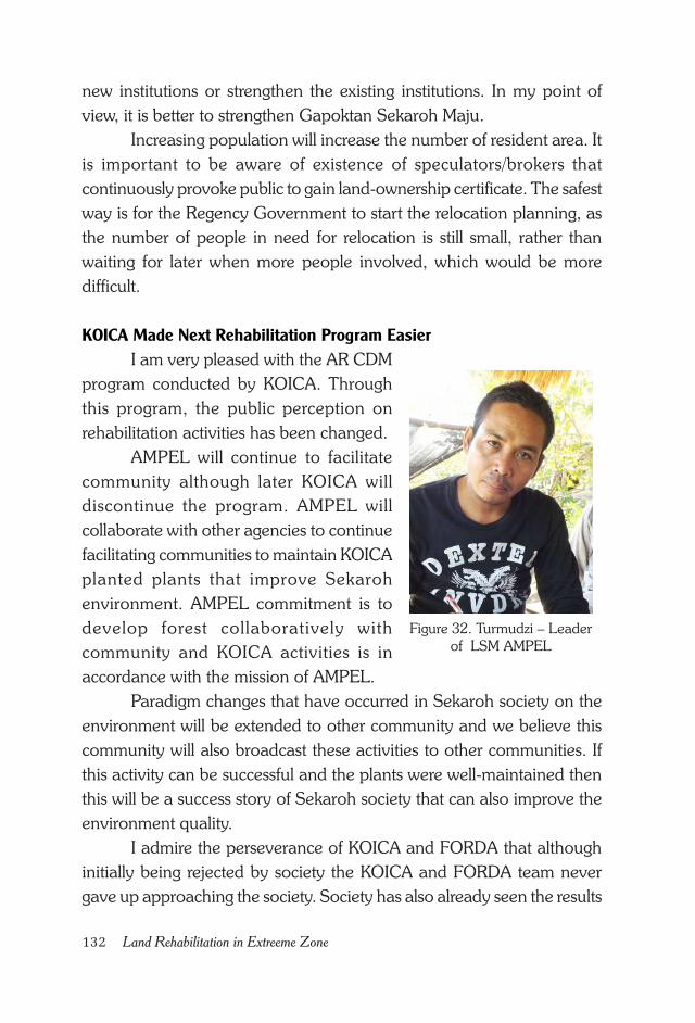
132 Land Rehabilitation in Extreeme Zone
Figure 32. Turmudzi – Leader
of LSM AMPEL
new institutions or strengthen the existing institutions. In my point of
view, it is better to strengthen Gapoktan Sekaroh Maju.
Increasing population will increase the number of resident area. It
is important to be aware of existence of speculators/brokers that
continuously provoke public to gain land-ownership certificate. The safest
way is for the Regency Government to start the relocation planning, as
the number of people in need for relocation is still small, rather than
waiting for later when more people involved, which would be more
difficult.
KOICA Made Next Rehabilitation Program Easier
I am very pleased with the AR CDM
program conducted by KOICA. Through
this program, the public perception on
rehabilitation activities has been changed.
AMPEL will continue to facilitate
community although later KOICA will
discontinue the program. AMPEL will
collaborate with other agencies to continue
facilitating communities to maintain KOICA
planted plants that improve Sekaroh
environment. AMPEL commitment is to
develop forest collaboratively with
community and KOICA activities is in
accordance with the mission of AMPEL.
Paradigm changes that have occurred in Sekaroh society on the
environment will be extended to other community and we believe this
community will also broadcast these activities to other communities. If
this activity can be successful and the plants were well-maintained then
this will be a success story of Sekaroh society that can also improve the
environment quality.
I admire the perseverance of KOICA and FORDA that although
initially being rejected by society the KOICA and FORDA team never
gave up approaching the society. Society has also already seen the results
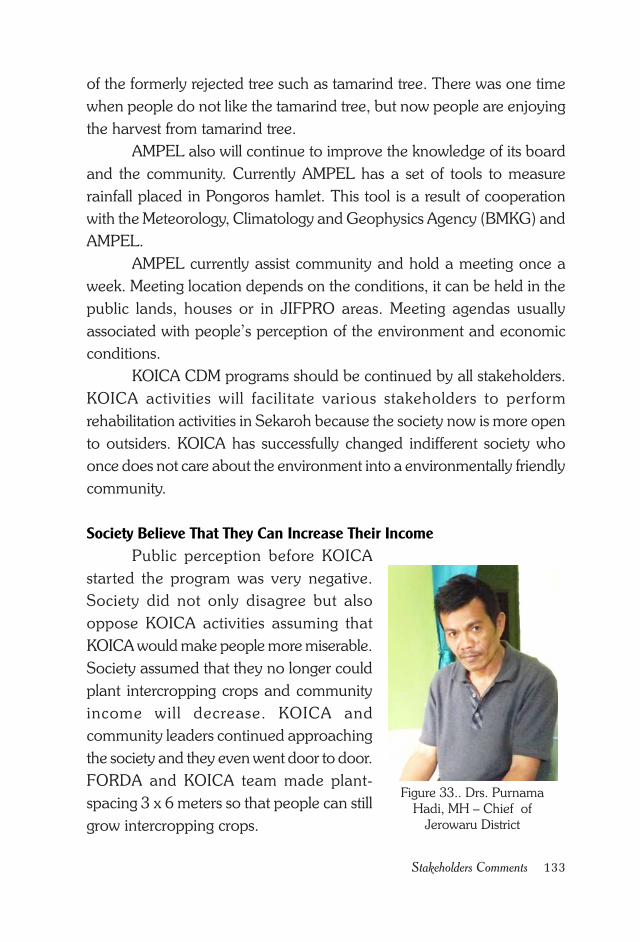
133Stakeholders Comments
of the formerly rejected tree such as tamarind tree. There was one time
when people do not like the tamarind tree, but now people are enjoying
the harvest from tamarind tree.
AMPEL also will continue to improve the knowledge of its board
and the community. Currently AMPEL has a set of tools to measure
rainfall placed in Pongoros hamlet. This tool is a result of cooperation
with the Meteorology, Climatology and Geophysics Agency (BMKG) and
AMPEL.
AMPEL currently assist community and hold a meeting once a
week. Meeting location depends on the conditions, it can be held in the
public lands, houses or in JIFPRO areas. Meeting agendas usually
associated with people’s perception of the environment and economic
conditions.
KOICA CDM programs should be continued by all stakeholders.
KOICA activities will facilitate various stakeholders to perform
rehabilitation activities in Sekaroh because the society now is more open
to outsiders. KOICA has successfully changed indifferent society who
once does not care about the environment into a environmentally friendly
community.
Society Believe That They Can Increase Their Income
Public perception before KOICA
started the program was very negative.
Society did not only disagree but also
oppose KOICA activities assuming that
KOICA would make people more miserable.
Society assumed that they no longer could
plant intercropping crops and community
income will decrease. KOICA and
community leaders continued approaching
the society and they even went door to door.
FORDA and KOICA team made plant-
spacing 3 x 6 meters so that people can still
grow intercropping crops.
Figure 33.. Drs. Purnama
Hadi, MH – Chief of
Jerowaru District
134 Land Rehabilitation in Extreeme Zone
From approximately 309 ha of plantation area, only 40 % which
is in a very good condition, especially in Rerangan and Lendang Lombok.
Other part grew moderately. The main problem is the fierce hot climate
and uncertain seasons. Currently the community has been supportive
and it does not matter anymore.
In this time, the plants need maintenance and the community is
willing to maintain the plant because it is considered beneficial. We, as
government representative, expect the KOICA is willing to continue this
program on the rest of community forest area that has been reserved by
the Ministry of Forestry. Reserved area for HKm from the Forestry Ministry
was 1450 ha and KOICA has planted 309 ha from the entire area,
meaning that the rest of the area left is still large.
I’m sure in the future rehabilitation activities will be more successful
because people already understood the purpose of this activity. Society
has changed, and KOICA and FORDA team has also been familiar with
the problems in the field that it is getting so much easier to handle.
KOICA activity is very beneficial to the Sekaroh environment and
also Indonesia. Forests as the lungs of the world need to be preserved.
Local community today has faith in the CDM program that has
potential to increase society’s income, especially if the fruit tree is already
producing fruit. Sekaroh village has several tourism sites, so that the
forestry and fruit plantation will increase the tourism potential and
community income. Planting the fruit trees was a correct thing to do.
Some tourism sites in the Sekaroh village include Pink Beach which
is cooperation with Sweden. Another is Gili Sunud which is collaboration
with Singapore. Gili Sunud is a good place for surfing, diving, with a
marine park. Other attraction in Sekaroh village is Tanjung Ringgit with a
very beautiful view of the sea. It is well known for the big wave , the
Japanese heritage site, Cave, Tanks, Cannons and a view of the sunset
and sunrise because it is placed on a high plateau.
HKm land in Sekaroh still needs several water ponds. Preferably
every 25 ha has a water reservoir so that people can easily water plants
especially in the dry season. In the future cooperation needs greater
involvement of village institutions, BPD, and empowering the Gapoktan.
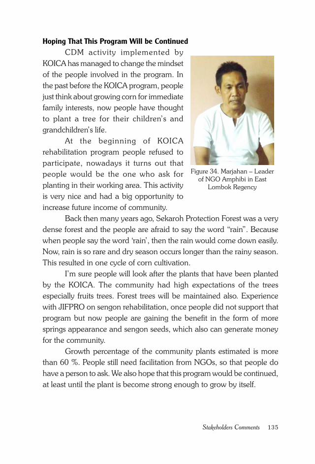
135Stakeholders Comments
Hoping That This Program Will be Continued
CDM activity implemented by
KOICA has managed to change the mindset
of the people involved in the program. In
the past before the KOICA program, people
just think about growing corn for immediate
family interests, now people have thought
to plant a tree for their children’s and
grandchildren’s life.
At the beginning of KOICA
rehabilitation program people refused to
participate, nowadays it turns out that
people would be the one who ask for
planting in their working area. This activity
is very nice and had a big opportunity to
increase future income of community.
Back then many years ago, Sekaroh Protection Forest was a very
dense forest and the people are afraid to say the word “rain”. Because
when people say the word ‘rain’, then the rain would come down easily.
Now, rain is so rare and dry season occurs longer than the rainy season.
This resulted in one cycle of corn cultivation.
I’m sure people will look after the plants that have been planted
by the KOICA. The community had high expectations of the trees
especially fruits trees. Forest trees will be maintained also. Experience
with JIFPRO on sengon rehabilitation, once people did not support that
program but now people are gaining the benefit in the form of more
springs appearance and sengon seeds, which also can generate money
for the community.
Growth percentage of the community plants estimated is more
than 60 %. People still need facilitation from NGOs, so that people do
have a person to ask. We also hope that this program would be continued,
at least until the plant is become strong enough to grow by itself.
Figure 34. Marjahan – Leader
of NGO Amphibi in East
Lombok Regency
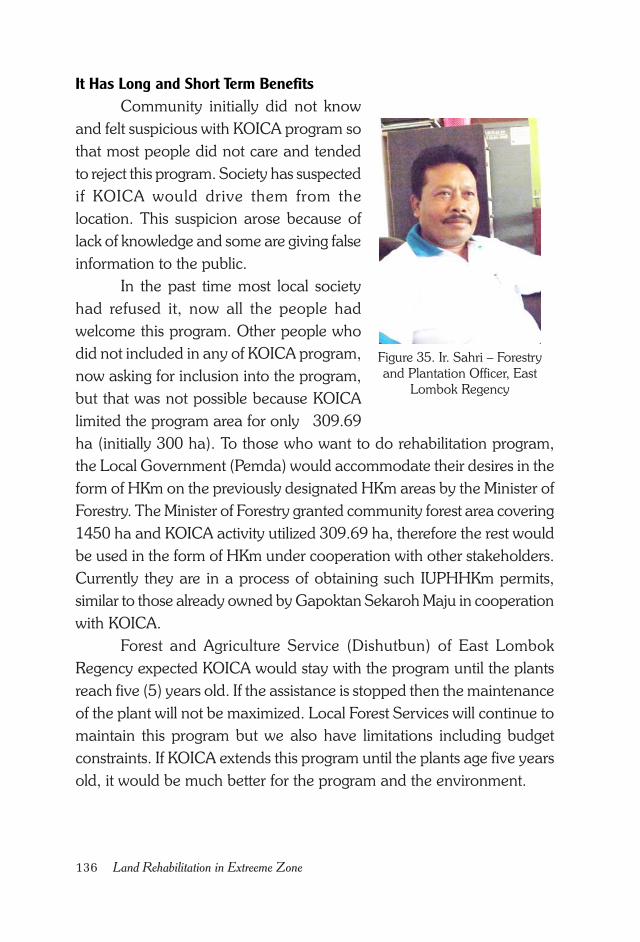
136 Land Rehabilitation in Extreeme Zone
Figure 35. Ir. Sahri – Forestry
and Plantation Officer, East
Lombok Regency
It Has Long and Short Term Benefits
Community initially did not know
and felt suspicious with KOICA program so
that most people did not care and tended
to reject this program. Society has suspected
if KOICA would drive them from the
location. This suspicion arose because of
lack of knowledge and some are giving false
information to the public.
In the past time most local society
had refused it, now all the people had
welcome this program. Other people who
did not included in any of KOICA program,
now asking for inclusion into the program,
but that was not possible because KOICA
limited the program area for only 309.69
ha (initially 300 ha). To those who want to do rehabilitation program,
the Local Government (Pemda) would accommodate their desires in the
form of HKm on the previously designated HKm areas by the Minister of
Forestry. The Minister of Forestry granted community forest area covering
1450 ha and KOICA activity utilized 309.69 ha, therefore the rest would
be used in the form of HKm under cooperation with other stakeholders.
Currently they are in a process of obtaining such IUPHHKm permits,
similar to those already owned by Gapoktan Sekaroh Maju in cooperation
with KOICA.
Forest and Agriculture Service (Dishutbun) of East Lombok
Regency expected KOICA would stay with the program until the plants
reach five (5) years old. If the assistance is stopped then the maintenance
of the plant will not be maximized. Local Forest Services will continue to
maintain this program but we also have limitations including budget
constraints. If KOICA extends this program until the plants age five years
old, it would be much better for the program and the environment.
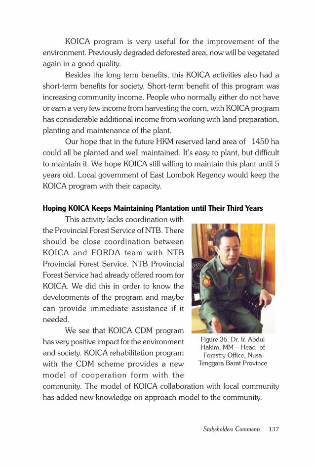
137Stakeholders Comments
KOICA program is very useful for the improvement of the
environment. Previously degraded deforested area, now will be vegetated
again in a good quality.
Besides the long term benefits, this KOICA activities also had a
short-term benefits for society. Short-term benefit of this program was
increasing community income. People who normally either do not have
or earn a very few income from harvesting the corn, with KOICA program
has considerable additional income from working with land preparation,
planting and maintenance of the plant.
Our hope that in the future HKM reserved land area of 1450 ha
could all be planted and well maintained. It’s easy to plant, but difficult
to maintain it. We hope KOICA still willing to maintain this plant until 5
years old. Local government of East Lombok Regency would keep the
KOICA program with their capacity.
Hoping KOICA Keeps Maintaining Plantation until Their Third Years
This activity lacks coordination with
the Provincial Forest Service of NTB. There
should be close coordination between
KOICA and FORDA team with NTB
Provincial Forest Service. NTB Provincial
Forest Service had already offered room for
KOICA. We did this in order to know the
developments of the program and maybe
can provide immediate assistance if it
needed.
We see that KOICA CDM program
has very positive impact for the environment
and society. KOICA rehabilitation program
with the CDM scheme provides a new
model of cooperation form with the
community. The model of KOICA collaboration with local community
has added new knowledge on approach model to the community.
Figure 36. Dr. Ir. Abdul
Hakim, MM – Head of
Forestry Office, Nusa
Tenggara Barat Province
138 Land Rehabilitation in Extreeme Zone
I think there was a change in the society mindset out there, and
that was KOICA success in engaging with the community. Sekaroh
Protection Forest is an extremely dry area and there are a lot of wild
grazing so that land rehabilitation is very difficult to be done if there is no
intensive maintenance and consistent approach to the community.
NTB Provincial Forest Service will continue the program that had
been made by KOICA with our capabilities. We expect a funding help
from the APBD or the APBN to continue the CDM program. It will be
such a waste if this program is discontinued as community mindset had
changed already. It is expected in the future rehabilitation programs and
community development would be linked to APBD, APBN and other
partners.
I saw local government leaders and the public figure enthusiastically
assisted this KOICA program. They often come to the field, both the East
Lombok Regency Forest and Agriculture Service (Dishutbun), Jerowaru
District Head and Sekaroh village chief and local community leaders
often come to the field.
Forest and fruit trees are long-lived plants species. It could not be
abandoned right about a year after plantation. We hope KOICA still assist
this program until the plants are three years old or in the other words the
program could be extended for two more years. At the age of three years,
the plant has already been strong enough to grow in the field and resistant
to extreme weather as in Sekaroh Protection Forest.
139References
REFERENCES
APHI dan CER Indonesia. 2011. Peluang dan Mekanisme Perdagangan
Karbon Hutan. Jakarta.
Boer, R. 2001. Opsi Mitigasi Perubahan Iklim Di Sektor Kehutanan Dan
Aspek Metodologi Proyek Karbon Kehutanan. Makalah dalam
Lokakarya Tindak Lanjut Konvensi Perubahan Iklim dan Kyoto
Protokol di Sektor Kehutanan, Gedung Manggala Wanabakti, 18
September 2001, Jakarta.
Boer, R. 2004. Aspek Teknis Penunjang Implementasi Protokol Kyoto Di
Indonesia: Sektor Kehutanan. Workshop ‘Tindak Lanjut Protokol
Kyoto’ tanggal 5 Agustus 2004 di Manggala Wanabakti. Jakarta.
Brown, D., Seymour, F. dan Peskett, L. 2010. Melangkah Maju dengan
REDD: Isu, Pilihan dan Implikasi. Cifor. Halaman 119 – 131.
Bogor, Indonesia.
Fakultas Kehutanan IPB. Praktek Pengelolaan Hutan Mahasiswa Faklutas
Kehutanan IPB. Bogor.
Gewab, A. F. 2013. Keberhasilan Tumbuh Tanaman Program
Rehabilitasi Hutan dan Lahan di Sundey Distrik Biak Timur
Kabupaten Biak Numfor. Jurusan Kehutanan, Fakultas Kehutanan,
Universitas Negeri Papua. Papua.
140 Land Rehabilitation in Extreeme Zone
Hardiansyah, G. dan Ridwan, M. 2012. REDD: Peluang HPH
Menurunkan Emisi Global. Untan Press. Pontianak, Kalimantan
Barat.
IGES. 2012. IGES Market Mechanisms Country Fact Sheet July 2012
Version. Information on Market Mechanism including CDM, GHG
Emissions and NAMAs for Each Country. Japan.
Irwanto. 2007. Budidaya Tanaman Kehutanan. Jogjakarta.
IPCC Good Practice Guidance for LULUCF. 2006. Annex 3A.1 Biomass
Default Tables for Section 3.2 Forest Land.
IPCC. 2007. IPCC Fourth Assessment Report. Report by Working
Group I, The Physical Science Basis. Cambridge University Press,
Cambridge, Inggris.
Kementerian Lingkungan Hidup. 1997. Agenda 21 Indonesia – Strategi
Nasional untuk Pembangunan Berkelanjutan. Kantor Kementerian
Negara Lingkungan Hidup. Jakarta.
Kementerian Lingkungan Hidup. 2006. Panduan Kegiatan MPB di
Indonesia. Edisi ke-2. Jakarta.
Ketterings, Q.M., Coe, R., Van Noordwijk, M., Ambagau, Y. and Palm,
C. 2001. Reducing Uncertainty in the use of Allometric Biomass
Equations for Predicting Above-Ground Tree Biomass in Mixed
Secondary Forest. Forest Ecology and Management 146: 199-
209.
KOICA dan Forestry Research and Development Agency (FORDA).
2013. Project Design Document (PDD) – Community Based
Reforestation on Degraded Lands in East Lombok. Jakarta,
Indonesia.
Martawijaya, A., Kartasijana, I., Kadir, K., dan Prawira, S. A. 1981.
Atlas Kayu Indonesia. Jilid I. Jakarta.
Martawijaya, A., Kartasijana, I., Kadir, K., dan Prawira, S. A. 1981.
Atlas Kayu Indonesia. Jilid II. Jakarta.
141References
Menteri Kehutanan. 2004. Permenhut No 14 tahun 2004 tentang Tata
Cara Aforestasi dan Reforestasi dalam Kerangka Mekanisme
Pembangunan Bersih. Jakarta.
Menteri kehutanan. 2007. Peraturan Menteri Kehutanan Nomor : P. 22/
Menhut-V/2007 tentang Pedoman Teknis dan Petunjuk
Pelaksanaan Kegiatan Gerakan Nasional Rehabilitasi Hutan dan
Lahan Tahun 2007. Jakarta.
Menteri Kehutanan. 2007. Peraturan Menteri Kehutanan Nomor : P.37/
Menhut-II/2007 tentang Hutan Kemasyarakatan. Jakarta.
Menteri Kehutanan. 2009. Peraturan Menteri Kehutanan No 36 tahun
2009 tentang Tata Cara Perizinan Usaha Pemanfaatan Penyerapan
dan/atau Penyimpanan Karbon pada Hutan Produksi dan Hutan
Lindung. Departemen Kehutanan. Jakarta.
Menteri Kehutanan. 2012. Peraturan Menteri Kehutanan Republik
Indonesia Nomor : P. 20/Menhut-II/2012 tentang Penyelenggaraan
Karbon Hutan.
Mulyoutami, E., Van Noordwijk, M., Sakuntaladewi, N. dan Agus, F.
2010. Perubahan Pola Perladangan: Pergeseran persepsi
mengenai para peladang di Indonesia. Bogor, Indonesia. World
Agroforestry Centre – ICRAF, Sea Regional Office.
Mudiyarso, D. 2003. Protokol Kyoto Implikasinya bagi negara
berkembang. Penerbit Buku Kompas. Jakarta.
PT. Prima Kelola – Institut Pertanian Bogor. 2010. Draft Report - Pre-
Assesment For AR CDM Plantation In Lombok. Bogor.
Ridwan, M. 2011. AR CDM Indonesia: Berjuang Maksimal Saat Injury
Time. Opini dalam Majalah Tropis, Edisi 05 tahun 2011. Halaman
54-57. Jakarta.
Ridwan, M. 2012. REDD+ dan Mahalnya Koordinasi. Opini dalam
Majalah Tropis, Edisi 01 tahun 2012. Halaman 52-54. Jakarta.
142 Land Rehabilitation in Extreeme Zone
Ridwan, M. 2013. Menyoal Peran Sektor Kehutanan. Opini dalam
Majalah Tropis, Edisi 4 tahun 2013. Halaman 52-55. Jakarta.
Rudel, T. 2011. Dalam Angelsen, A., Brockhaus, M., Kanninen, M.,
Sills, E., Sunderlin, W. D. dan Wertz-Kanounnikoff, S. (ed) 2011.
Mewujudkan REDD+: Strategi Nasional dan Berbagai Pilihan
Kebijakan. Halaman 193 – 202. Cifor, Bogor, Indonesia.
Rukmana, R. dan Oesman, Y. Y. 2002. Nimba Tanaman Penghasil
Pestisida Alami. Kanisius. Yogyakarta.
Siregar. C. A., Siregar. U. J., Lee. K. T., , S.P. Jin. S. P., and Han. K. J.
2013. Climate adaptation in East Lombok Island, Indonesia:
Lessons learnt from Korea-Indonesia Climate Joint Project. Paper
presented at the International Workshop, “Adaptation Futures 2012
International Conference on Climate Adaptation, 26-31 May 2012.
Arizona, USA.
Yayasan Alamanda dan Lestari Hutan Indonesia. 2003. Pendampingan
dan Penguatan Kelembagaan untuk Unit Bisnis di Kampung
Calobak dan Bobojong. Bogor.
http://balitbu.litbang.deptan.go.id/ind/index.php/publikasi-mainmenu-47/
92-petunjuk-teknis/172-budidaya-nangka
http://www.jaco-cdm.com
http://iman56.blogspot.com/2010/10/silvikultur-mahoni-swietenia.html
http://alamendah.org /2009/12/26/pohon-trembesi-ki-hujan-serap-28-
ton-co2/
http://isroi.com/2010/08/14/tanaman-pestisida-nabati-mimba-
azadirachta-indica-i/
http://www.worldagroforestry.org
ATTACHMENTS

144 Land Rehabilitation in Extreeme Zone
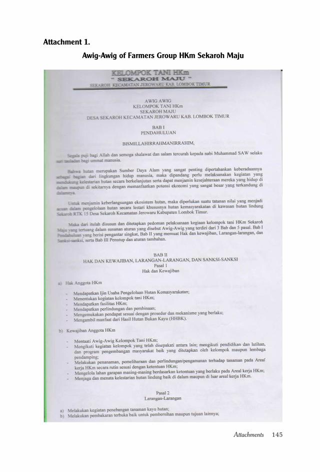
145Attachments
Awig-Awig of Farmers Group HKm Sekaroh Maju
Attachment 1.
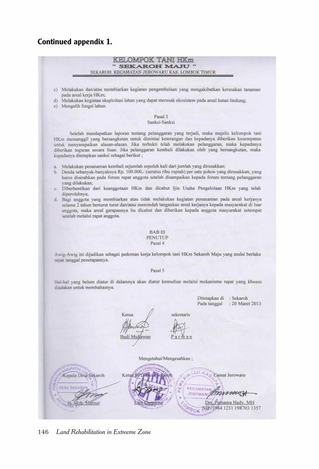
146 Land Rehabilitation in Extreeme Zone
Continued appendix 1.
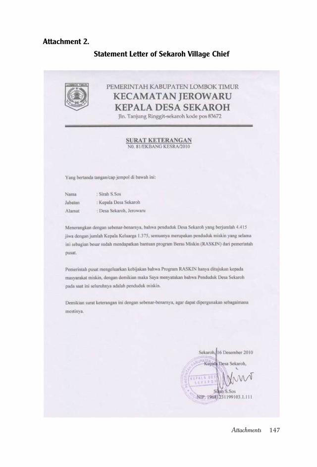
147Attachments
Attachment 2.
Statement Letter of Sekaroh Village Chief
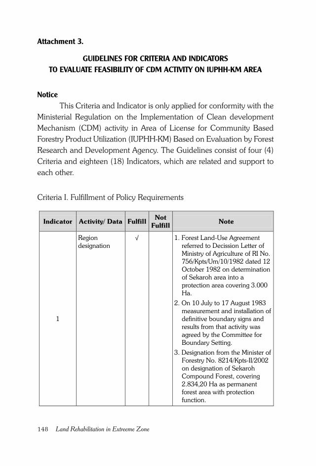
148 Land Rehabilitation in Extreeme Zone
Attachment 3.
GUIDELINES FOR CRITERIA AND INDICATORS
TO EVALUATE FEASIBILITY OF CDM ACTIVITY ON IUPHH-KM AREA
Notice
This Criteria and Indicator is only applied for conformity with the
Ministerial Regulation on the Implementation of Clean development
Mechanism (CDM) activity in Area of License for Community Based
Forestry Product Utilization (IUPHH-KM) Based on Evaluation by Forest
Research and Development Agency. The Guidelines consist of four (4)
Criteria and eighteen (18) Indicators, which are related and support to
each other.
Criteria I. Fulfillment of Policy Requirements
Indicator Activity/ Data Fulfill Not
Fulfill Note
1
Region
designation √ 1. Forest Land-Use Agreement
referred to Decission Letter of
Ministry of Agriculture of RI No.
756/Kpts/Um/10/1982 dated 12
October 1982 on determination
of Sekaroh area into a
protection area covering 3.000
Ha.
2. On 10 July to 17 August 1983
measurement and installation of
definitive boundary signs and
results from that activity was
agreed by the Committee for
Boundary Setting.
3. Designation from the Minister of
Forestry No. 8214/Kpts-II/2002
on designation of Sekaroh
Compound Forest, covering
2.834,20 Ha as permanent
forest area with protection
function.
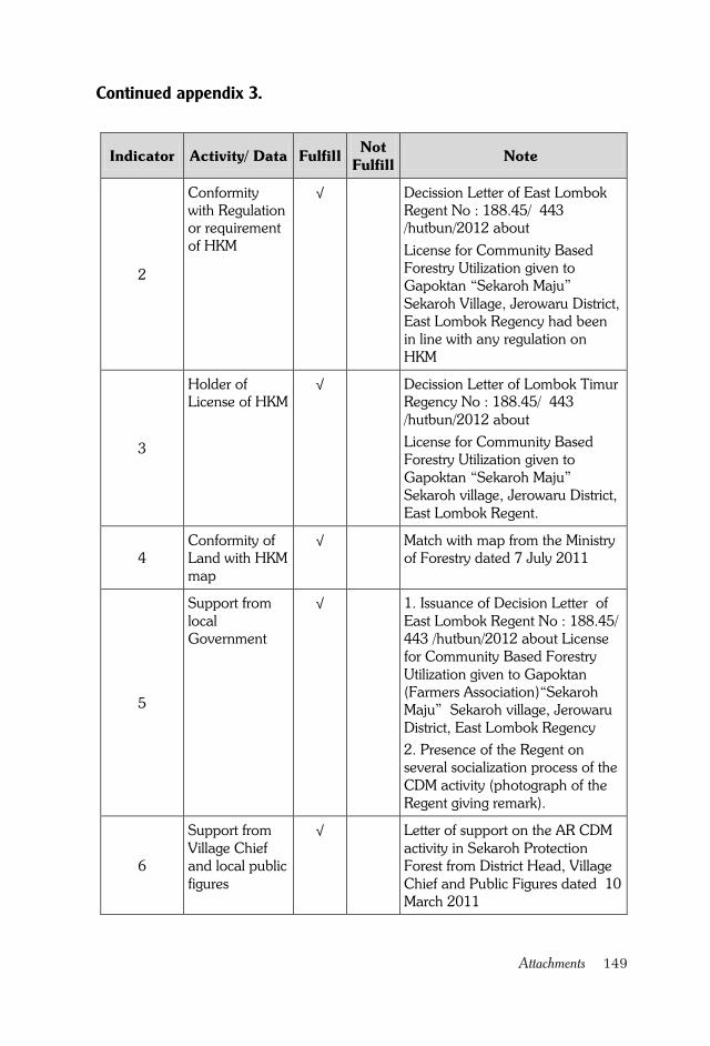
149Attachments
Indicator Activity/ Data Fulfill Not
Fulfill Note
2
Conformity
with Regulation
or requirement
of HKM
√ Decission Letter of East Lombok
Regent No : 188.45/ 443
/hutbun/2012 about
License for Community Based
Forestry Utilization given to
Gapoktan “Sekaroh Maju”
Sekaroh Village, Jerowaru District,
East Lombok Regency had been
in line with any regulation on
HKM
3
Holder of
License of HKM √ Decission Letter of Lombok Timur
Regency No : 188.45/ 443
/hutbun/2012 about
License for Community Based
Forestry Utilization given to
Gapoktan “Sekaroh Maju”
Sekaroh village, Jerowaru District,
East Lombok Regent.
4
Conformity of
Land with HKM
map
√ Match with map from the Ministry
of Forestry dated 7 July 2011
5
Support from
local
Government
√ 1. Issuance of Decision Letter of
East Lombok Regent No : 188.45/
443 /hutbun/2012 about License
for Community Based Forestry
Utilization given to Gapoktan
(Farmers Association)“Sekaroh
Maju” Sekaroh village, Jerowaru
District, East Lombok Regency
2. Presence of the Regent on
several socialization process of the
CDM activity (photograph of the
Regent giving remark).
6
Support from
Village Chief
and local public
figures
√ Letter of support on the AR CDM
activity in Sekaroh Protection
Forest from District Head, Village
Chief and Public Figures dated 10
March 2011
Continued appendix 3.
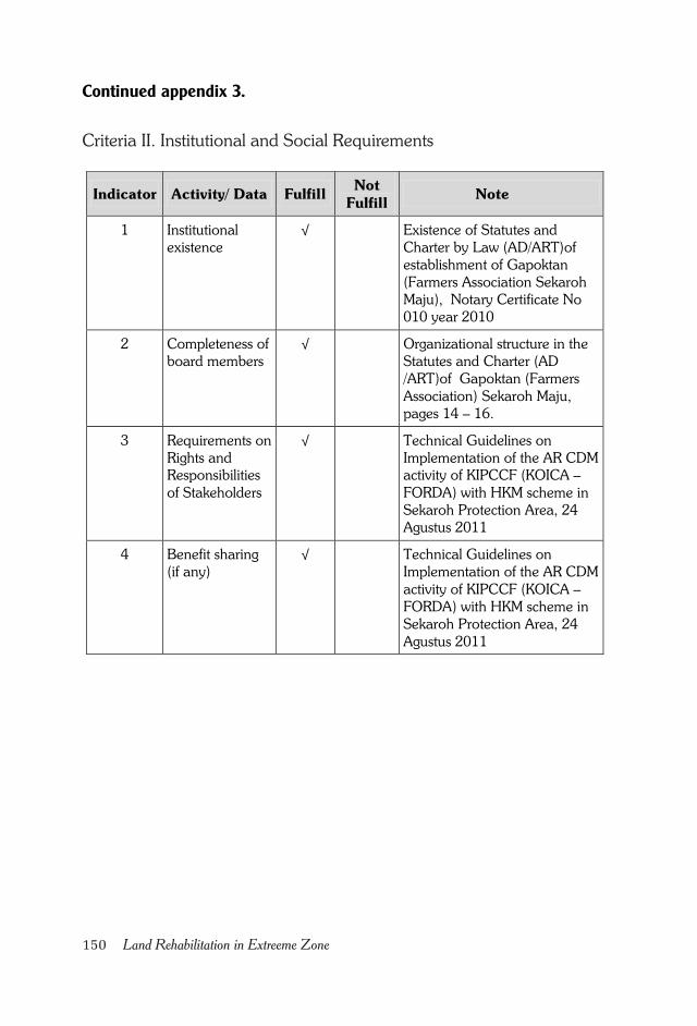
150 Land Rehabilitation in Extreeme Zone
Criteria II. Institutional and Social Requirements
Indicator Activity/ Data Fulfill Not
Fulfill Note
1 Institutional
existence √ Existence of Statutes and
Charter by Law (AD/ART)of
establishment of Gapoktan
(Farmers Association Sekaroh
Maju), Notary Certificate No
010 year 2010
2 Completeness of
board members √ Organizational structure in the
Statutes and Charter (AD
/ART)of Gapoktan (Farmers
Association) Sekaroh Maju,
pages 14 – 16.
3 Requirements on
Rights and
Responsibilities
of Stakeholders
√ Technical Guidelines on
Implementation of the AR CDM
activity of KIPCCF (KOICA –
FORDA) with HKM scheme in
Sekaroh Protection Area, 24
Agustus 2011
4 Benefit sharing
(if any) √ Technical Guidelines on
Implementation of the AR CDM
activity of KIPCCF (KOICA –
FORDA) with HKM scheme in
Sekaroh Protection Area, 24
Agustus 2011
Continued appendix 3.
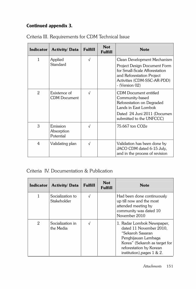
151Attachments
Criteria III. Requirements for CDM Technical Issue
Criteria IV. Documentation & Publication
Indicator Activity/ Data Fulfill Not
Fulfill Note
1 Applied
Standard √ Clean Development Mechanism
Project Design Document Form
for Small-Scale Afforestation
and Reforestation Project
Activities (CDM-SSC-AR-PDD)
- (Version 02)
2 Exixtence of
CDM Document √ CDM Document entitled
Community-based
Reforestation on Degraded
Lands in East Lombok
Dated 24 Juni 2011 (Documen
submitted to the UNFCCC)
3 Emission
Absorption
Potential
√ 75.667 ton CO2e
4 Validating plan √ Validation has been done by
JACO CDM dated 6-15 July,
and in the process of revision
Indicator Activity/ Data Fulfill Not
Fulfill Note
1 Socialization to
Stakeholder √ Had been done continuously
up till now and the most
attended meeting by
community was dated 10
November 2010
2 Socialization in
the Media √ 1. Radar Lombok Newspaper,
dated 11 November 2010,
“Sekaroh Sasaran
Penghijauan Lembaga
Korea” (Sekaroh as target for
reforestation by Korean
institution),pages 1 & 2.
17 di Durban (Will be
Continued appendix 3.
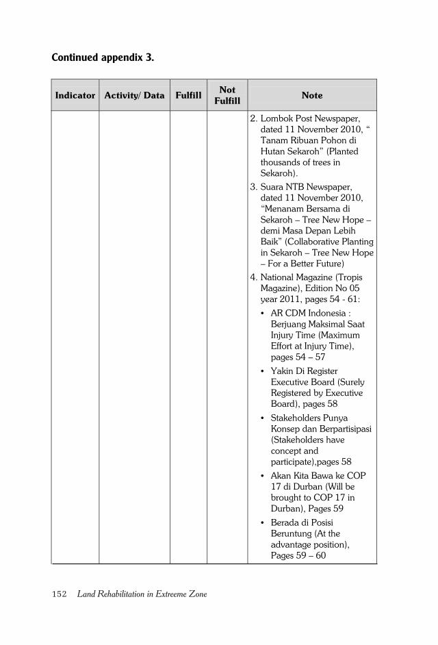
152 Land Rehabilitation in Extreeme Zone
2. Lombok Post Newspaper,
dated 11 November 2010, “
Tanam Ribuan Pohon di
Hutan Sekaroh” (Planted
thousands of trees in
Sekaroh).
3. Suara NTB Newspaper,
dated 11 November 2010,
“Menanam Bersama di
Sekaroh – Tree New Hope –
demi Masa Depan Lebih
Baik” (Collaborative Planting
in Sekaroh – Tree New Hope
– For a Better Future)
4. National Magazine (Tropis
Magazine), Edition No 05
year 2011, pages 54 - 61:
• AR CDM Indonesia :
Berjuang Maksimal Saat
Injury Time (Maximum
Effort at Injury Time),
pages 54 – 57
• Yakin Di Register
Executive Board (Surely
Registered by Executive
Board), pages 58
• Stakeholders Punya
Konsep dan Berpartisipasi
(Stakeholders have
concept and
participate),pages 58
• Akan Kita Bawa ke COP
17 di Durban (Will be
brought to COP 17 in
Durban), Pages 59
• Berada di Posisi
Beruntung (At the
advantage position),
Pages 59 – 60
• Terdaftar di UNFCCC &
Indicator Activity/ Data Fulfill Not
Fulfill Note
Continued appendix 3.
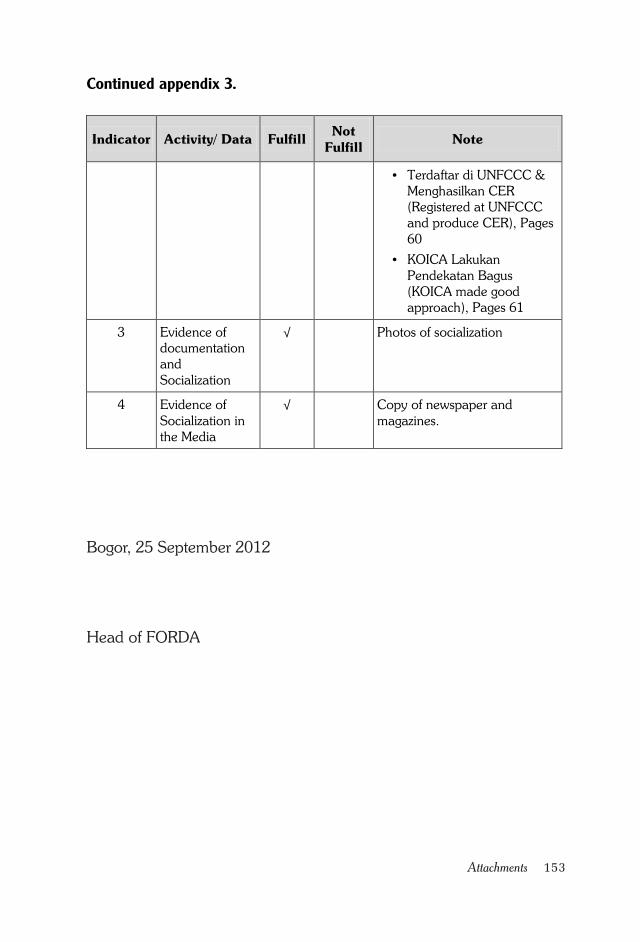
153Attachments
Indicator Activity/ Data Fulfill Not
Fulfill Note
• Terdaftar di UNFCCC &
Menghasilkan CER
(Registered at UNFCCC
and produce CER), Pages
60
• KOICA Lakukan
Pendekatan Bagus
(KOICA made good
approach), Pages 61
3 Evidence of
documentation
and
Socialization
√ Photos of socialization
4 Evidence of
Socialization in
the Media
√ Copy of newspaper and
magazines.
Bogor, 25 September 2012
Head of FORDA
Continued appendix 3.
154 Land Rehabilitation in Extreeme Zone
Attachment 4.
Support for Land Rehabilitation Activity
in Sekaroh Protection Forest
Nomor : Istimewa
Lampiran : -
Hal : Support for Land Rehabilitation in Sekaroh Protection For-
est
To.
The Regent of East Lombok
At Selong
Bismillahirrahmaanirrahiim
Assalamu'alaikum Wr. Wb.
Refer to our Statement of Conduct dated 11 November 2010 who
belong to Coalition of NGO Youth and Student Together for Jerowaru
(KLPM - JB) which consists of BPM, KPMK-J, FKKJ, FKBNPOM, FKM-
J, YUSRA, AMPEL, IP2SDAK; we wanted Sekaroh Protection Forest
remained functional as protection forest and support tree transplanting
activity (reboisasi). At the moment the Local Government of East Lombok
and Local Government of NTB in collaboration with the Ministry of
Forestry of the Republic of Indonesia and KOICA are conducting land
rehabilitation activity within the framework of A/R CDM (Aforestasi/
Reforestasi Clean Development Mechanism).
We thought the above mentioned activity had two main objectives,
i.e.:
1. Conduct activity of emission reduction through development of
agroforestry in collaboration with community at Sekaroh Protec-
tion Forest
155Attachments
2. Economiy capacity building thru diversifying local community
economic activity.
Based on the activity nature which oriented to rehabilitation for
better ecological condition and local community economy, with this we
state our support to the A/R CDM activity, which is done in the name of
collaboration between Local Government of East Lombok, Local
Government of NTB, the Ministry of Forestry RI and KOICA.
As such this Statement of Support for Land Rehabilitation activity
in Sekaroh Protection Forest was made for common knowledge of
stakeholders.
Billahitaufik Walhidayah. Wassalamu'alaikum Wr. Wb.
Jerowaru, 15 December 2010
COALITION OF NGO YOUTH AND STUDENT TOGETHER
FOR JEROWARU (KLPM-JB)
BPM
SUHARMAN, SH
Director
FKKJ
AHMAD TURMUZI
General Chairman
KPMK-J
L. KHAERUDDIN
General Chairman
FKBNPOM
H. MUHAIMIN YAHYA, S.Sos, SH
General Chairman
Continued appendix 4.
156 Land Rehabilitation in Extreeme Zone
YUSRA
M. NASRUDDIN, S.Kel
Director
AMPEL
SIRAJUNNASIHIN, S.Pd
General Chairman
FKM-J
KAMAL MUKHTAR
General Chairman
IP2SDAK
Shalahuddin Mukhlis
Director
Continued appendix 4.
157Attachments
Attachment 5.
TECHNICAL GUIDELINES FOR IMPLEMENTATION
AR CDM ACTIVITY
KIPCCF (KOICA - FORDA)
WITH COMMUNITY BASED FORESTRY (HKM)
AT SEKAROH PROTECTION FOREST
Sekaroh Community,
Gapoktan Sekaroh Maju, Government of Sekaroh Village,
Governemnt of Jerowaru District,
Forest and Agriculture Service of East Lombok Regency,
KIPCCF (KOICA - FORDA)
EAST LOMBOK
2011
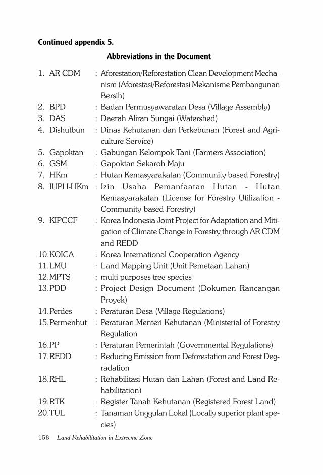
158 Land Rehabilitation in Extreeme Zone
Abbreviations in the Document
1. AR CDM : Aforestation/Reforestation Clean Development Mecha-
nism (Aforestasi/Reforestasi Mekanisme Pembangunan
Bersih)
2. BPD : Badan Permusyawaratan Desa (Village Assembly)
3. DAS : Daerah Aliran Sungai (Watershed)
4. Dishutbun : Dinas Kehutanan dan Perkebunan (Forest and Agri-
culture Service)
5. Gapoktan : Gabungan Kelompok Tani (Farmers Association)
6. GSM : Gapoktan Sekaroh Maju
7. HKm : Hutan Kemasyarakatan (Community based Forestry)
8. IUPH-HKm : Izin Usaha Pemanfaatan Hutan - Hutan
Kemasyarakatan (License for Forestry Utilization -
Community based Forestry)
9. KIPCCF : Korea Indonesia Joint Project for Adaptation and Miti-
gation of Climate Change in Forestry through AR CDM
and REDD
10.KOICA : Korea International Cooperation Agency
11.LMU : Land Mapping Unit (Unit Pemetaan Lahan)
12.MPTS : multi purposes tree species
13.PDD : Project Design Document (Dokumen Rancangan
Proyek)
14.Perdes : Peraturan Desa (Village Regulations)
15.Permenhut : Peraturan Menteri Kehutanan (Ministerial of Forestry
Regulation
16.PP : Peraturan Pemerintah (Governmental Regulations)
17.REDD : Reducing Emission from Deforestation and Forest Deg-
radation
18.RHL : Rehabilitasi Hutan dan Lahan (Forest and Land Re-
habilitation)
19.RTK : Register Tanah Kehutanan (Registered Forest Land)
20.TUL : Tanaman Unggulan Lokal (Locally superior plant spe-
cies)
Continued appendix 5.
159Attachments
TECHNICAL GUIDELINES FOR IMPLEMENTATION
OF AFORESTATION CDM KIPCCF (KOICA-FORDA)
WITH HKm SCHEME
1. Background
Degraded forest and land function which is identified as critical/
marginal land in Indonesia, according to the report on identification and
inventory of the Directorate General of Land Rehabilitation and Social
Forestry in 2009 is amounted to 71.535.937 Ha consisting of 30.869.752
Ha in Critical until Very Critical category and 40.666.185 Ha in Less
Critical category.
Destructed forests and land are scattered all over the region with
various functions, that it become serious threat to the carrying capacity
of the watershed (DAS), both as a life support zone and its hydro-urologic
function of watershed. Indicator of functionally degraded watershed is
indicated by the increasing number of natural disasters such as floods,
landslides and drought that hit most parts of Indonesia in recent decades.
In an effort to control deforestation and land degradation the
Government has issued Government Regulation No. 76 Year 2008 on
Forest Rehabilitation and Reclamation. This Regulation (PP) is guiding
implementation of forests rehabilitation and reclamation on all functional
forest and other land uses. This PP No. 76 of 2008 has arranged the
division of authority and responsibilities of government, local government
and regional license holders to undertake the implementation of Forest
and Land Rehabilitation (RHL) which includes the planning,
implementation and control.
CHAPTER 1INTRODUCTION
Continued appendix 5.
160 Land Rehabilitation in Extreeme Zone
The obligations to implement RHL on marginal lands in all
functional area requires all government, local government and regional
license holders allocate for RHL activities the budget from various sources
based on the rules in PP No. 76/2008.
Along with the growing phenomenon of global warming today,
the mitigation and adaptation activities should be increased both at the
site level and in terms of policy.
Each country or region which is able to maintain or improve the
condition of the forest environment as can be seen from the success of
plant growth and conservation of forest vegetation will be rewarded, of
which value will be assessed from the amount of carbon that can be
stored and absorbed by those forest vegetation. This mechanism is referred
to as a carbon trading mechanism which, among others, known as
Aforestation / Reforestation - Clean Development Mechanism (AR CDM)
and Reducing Emissions from Deforestation and Forest Degradation
(REDD).
Along with the things mentioned above, at the Sekaroh Protection
Forest Forest, Registered Forest Land (RTK) 15 an AR-CDM program
has been implemented in cooperation with KOICA, of which activities
will be directed towards effort of rehabilitating Sekaroh Protection Forest
areas through tree planting and maintenance.
2. Definition
1. Seed/seedling is plant material or parts of which is used to repro-
duce and or develop plant, which derived from generative or veg-
etative material.
2. Watershed (DAS) is an area of †land which forms one integral
part of the river and its tributaries/ creeks, which serves to accom-
modate, store, and drain water from rainfall to the lake or to the
sea naturally, of which boundary in the land becomes topographic
separator and its boundary in the sea covers the water area which
still affected by land-site activities.
Continued appendix 5.
161Attachments
3. Forest and Agriculture Services of Regency/City are technical of-
fices which entrusted with duties and responsibilities in the for-
estry sector in the Regency/City area.
4. Provincial Forest Service is technical office which entrusted with
duties and responsibilities in the forestry sector in the province
area.
5. A/R CDM is Aforestation/Reforestation Clean Development Mecha-
nism
6. KOICA is the abbreviation of the Korea International Coopera-
tion Agency
7. Tree is a woody perennial plant that has long age.
8. Endemic plant species is native plant species that grow in a par-
ticular area.
9. Versatile plant types (multi-purpose tree species / MPTS) is a type
of tree that produces timber and non-timber (fruits, sap, bark, etc..)
10.HKM is a Community based Forestry.
11.Local Superior Plant Type (TUL) is a native or exotic plant species
of which are preferred by the public because it produces certain
advantages such as wood products, fruit and sap having high eco-
nomic value.
12.Soil conservation is the placement of any soil part according to its
functional ability and managing it accordingly with the require-
ments necessary to avoid damaging the soil, so that it can support
sustainable living.
13.Degraded land is land which located inside and outside the forest
area of which function as an element of a production unit, also as
watershed water regulator has been decreased.
14.Land Mapping Unit (LMU) is the smallest land mapping unit which
has common biophysical condition such as the level of damage/
degradation, regional function and Watershed morphology (DAS).
15.Community empowerment is an attempt to improve the ability
and community independence by providing access to resources,
education, training and facilitation.
Continued appendix 5.
162 Land Rehabilitation in Extreeme Zone
16.Plant maintenance is the treatment to the plant and its environ-
ment in order to grow healthy and normally through hoeing, weed-
ing, replanting, fertilizing and controlling pest and disease.
17.Enrichment planting in reforestation is planting of forest trees in-
side forest area in order to increase the number of trees to in-
crease forest productivity.
18.Afforestation is tree-planting activities inside the forest area.
19.Forest and Land Rehabilitation (RHL) is an effort to restore, main-
tain and improve the forest and land function, so that their carry-
ing capacity, productivity and its role in supporting life system is
maintained.
20.Stripe line planting is a planting method by clearing land in stripe
line along planting path.
21.Cemplongan system is a planting method by clearing land around
the planting hole.
22.Intercropping system is cultivation pattern by planting annual crops
or intermediate plant in between the main woody tree (woody/
MPTS) species.
23.Water reservoir is a built pond shaped water reservoir that serves
to collect rain water/water runoff in dry-land area that is useful as
a source of water to supply water demand in the dry season.
24.Terrace is a built land conservation in the form of though, ridges
and water channels according to the direction of the soil contour.
Continued appendix 5.
163Attachments
1. Purpose
This technical guidelines for the implementation of AR CDM /KOICA
is intended to provide a reference to all stakeholders involved in the
implementation of AR CDM planting program with HKM scheme on
Sekaroh Protection Forest areas (Registered Forestry Land or RTK
15) so that the implementation activities of the planting program will
run well.
2. Objectives
• To preserve the environment of Sekaroh Protection Forest, par-
ticularly in the KIPCCF activities area of 300 ha, optimization of
land functions and benefits to increase the welfare of the surround-
ing community.
• Conducting rehabilitation activities of the AR CDM project (Affor-
estation / Reforestation Clean Development Mechanism) to in-
crease forest carbon stock (saving) of Sekaroh Protection Forest
• Served as an object for lesson learnt, research on tree cultivation
to those in need, with regard to the applicable rules and possibil-
ity of being used as a tourist attraction.
• To safeguard the assets of state-owned land that can be utilized
by the community at Sekaroh Protection Forest.
CHAPTER IIPURPOSE, OBJECTIVES AND TARGETS
Continued appendix 5.
164 Land Rehabilitation in Extreeme Zone
3. Target
Replanted Sekaroh Protection Forest areas that have been degraded
as much as 300 Ha area through AR CDM/KOICA with HKM scheme,
which covers planning, provision of seed/seedlings, forest and land
rehabilitation, soil conservation techniques, supportive activities, com-
munity participation, control and supervision of the Sekaroh Protec-
tion Forest, Sekaroh Village, Jerowaru District, East Lombok regency,
West Nusa Tenggara Province.
Continued appendix 5.
165Attachments
A. Source of Funds
Budget for AR CDM development activities through HKm scheme
came from cooperation fund between the South Korean Government
(KIPCCF) with the Government of the Republic of Indonesia (FORDA
of Ministry of Forestry) under project of Korea Indonesia Joint Project
for Adaptation and Mitigation of Climate Change in Forestry through
AR CDM and REDD (KIPCCF).
B Budget Management System
The entire management of the budget is done by KIPCCF.
C Executing Agencies
The executors of this activity is stakeholders that consists of KIPCCF,
Forest and Agriculture Service of East Lombok regency (Dishutbun
East Lombok), Local Government of Jerowaru District, and the Vil-
lage Government Sekaroh, Farmers Group Association (Gapoktan)
Sekaroh Maju (GSM).
CHAPTER IIIBUDGET
Continued appendix 5.
166 Land Rehabilitation in Extreeme Zone
A Planning
Planning of AR CDM activities was conducted by KPICCF involving
the Forest and Agriculture Service of East Lombok Regency, District
Government of Jerowaru, Village Government of Sekaroh and
Gapoktan Sekaroh Maju (GSM).
B Implementation
Activities that are included in the implementation activity consist of:
1. Socialization
Socialization is the process of transforming the goals and objec-
tives of the activities undertaken by KIPCCF to stakeholders in
Sekaroh Village, Jerowaru District, East Lombok Regency. Dis-
semination activities carried out in three stages, namely:
• The first step is building nurseries and planting preparation.
First stage socialization was conducted in three meetings, i.e.
one meeting when preparing nursery, and two meetings were
held in preparation for planting.
• The second phase at the planting time. This meeting was con-
ducted only once.
CHAPTER IVACTIVITIES
Continued appendix 5.
167Attachments
• The third stage is done for maintenance. The third phase of
socialization was done once at the current year, and twice in
the subsequent year.
2. Seed/Seedling Production
This activity is carried out by KIPCCF involving the local commu-
nity. There are two type of seed/seedlings, i.e. woody and fruit
trees (MPTS).
3. Planting
Planting activities was done by KIPCCF also involving local stake-
holders (Forest and Agriculture Service of East Lombok Regency,
District Government of Jerowaru, village government of Sekaroh,
Gapoktan Searoh Maju and the local community.
Technically this activity consists of:
• Division of crop plots. The planting plots were made with size
of 20 - 40 ha, marked with boundary signs.
• Cleaning bushes and shrubs without fire. This activity is car-
ried out by the farmer participants.
• The composition of the plant. Composition of woody plants
to fruit trees (MPTS) was 50: 50%.
• Spacing. The spacing in these activities is 6 meters x 3 meters,
marked by mounting stake.
• Cropping pattern. Cropping pattern in these activities is inter-
cropping.
• Planting hole. Planting hole was made 30 cm x 30 cm x 40 cm
(length x width x height).
• Planting. Planting was done by farmer participants.
• Fertilizers used. Fertilizer used is organic and inorganic fertil-
izer (if required).
• Watering. The activities were carried at the planting time and
maintenance (if needed).
Continued appendix 5.
168 Land Rehabilitation in Extreeme Zone
4. Maintenance
Maintenance activity in the field was technically carried out by the
local community under the supervision of Gapoktan that coordi-
nates with Sekaroh Village Chief. This activity consists of hoeing,
watering, weeding, replanting, and controlling pests and diseases.
5. Safeguarding
Safeguarding activities from the cattle disturbance, destruction by
human and fire were done by the farmers under supervision from
the Gapoktan, Sekaroh Village Government, Jerowaru District
Government and the Forest and Agriculture Service of East
Lombok Regency.
C. Monitoring and Evaluation
Monitoring activities were carried out in order to ensure the
activities will run as planned and carried out at each stage of the work
(land clearing, making plant hole, marker making, planting and
maintenance).
Activities evaluation was carried out by the KIPCCF and Forest
and Agriculture Service of East Lombok regency, Jerowaru District
Government, Sekaroh Village Government and Gapoktan Sekaroh
Maju every time one stage of the work is finished with a purpose to
accelerate a remedial action.
Continued appendix 5.
169Attachments
A. Obligations of the stakeholders
1. KIPCCF
a. Provide complete information about the purpose and benefits
of the activities to the stakeholders involved
b. Provide funding for tree cultivation such as land preparation,
planting hole making, planting and other parts of farming ac-
tivities.
c. Conduct regular monitoring of the progress of each phase of
activity.
2. Forest Service of East Lombok Regency
a. Provide technical guidelines for cultivation to the workers,
Farmers Group, Gapoktan and companion.
b. Conduct separation and marking field boundary clearly, espe-
cially for KIPCCF / KOICA activities, either well beyond the
borders or boundaries between farmers
c. Monitoring and evaluation of field activities for each phase of
activity.
d. Helping develop an awig awig of Gapoktan Sekaroh Maju
CHAPTER VRIGHTS AND OBLIGATIONS
OF STAKEHOLDERS
Continued appendix 5.
170 Land Rehabilitation in Extreeme Zone
3. District Head (District Government of Jerowaru)
a. Facilitating the meeting of the stakeholders, so that all stake-
holders can express their aspirations
b. Conduct intensive approach to farmer-members and Gapoktan
to maintain and ensure each fieldwork process can work well
c. To monitor and evaluate development of the implementation
activities, primarily related to social aspect - community
d. Assist the formation of awig awig and Village rules in Sekaroh
village.
4. Sekaroh Village Chief
a. Conduct intensive approach to Gapoktan and Farmers par-
ticipants and communicate intensively with the District Head
about particular progress of the program in the field
b. Provide insight to village communities, especially Sekaroh farm-
ers participants about the purpose of the rehabilitation pro-
gram in Sekaroh Protection Forest
c. Creating Village Rules with the Village Assembly Body (BPD)
on support for AR CDM activity so that rehabilitation activities
pogress as expected before
d. Together with the other stakeholders facilitated the formation
of awig awig Gapoktan Sekaroh Maju to succeed the rehabili-
tation program in the Sekaroh Protection Forest
e. Providing consideration of penalties for violation of awig awig.
5. Gapoktan Sekaroh Maju
a. Provide periodic reports on the progress of any field activities
to Dishutbun and KIPCCF
b. Provide facilitation and comprehension to the community so
that people know the purpose of the program
c. To monitor every process of cultivation as land clearance, mak-
ing holes, mounting stakes, planting and plant maintenance
Continued appendix 5.
171Attachments
d. Keeping the field stability conditions so that program objec-
tives can be achieved (the plants live and carbon sequestra-
tion could occur as expected)
e. Involve in the formation process of awig awig Gapoktan
Sekaroh Maju with the farmers for the success of the rehabili-
tation program in the Sekaroh Protection Forest
f. Keeping the implementation and give consideration as well as
to apply conviction for violations of awig awig.
g. Actively seeks to prevent the occurrence of forest disturbances
in and around the location of activities such as cattle grazing,
fires, logging the trees and destruction of crops.
h. Obliged to maintain the success of plant growth and develop-
ment at the site of AR CDM at least 90%.
6. Farmer Members
a. Perform all process of AR CDM plantation (land clearing, mak-
ing holes, mounting stakes, planting and maintenance).
b. Provide information/quickreports to Gapoktan / Village Head
/ District Head / East Lombok Regency Forest Service if there
is an indication of the emergence of disruption to each phase
of activity
c. Join the successful establishment of awig awig and execute it
together as a whole.
d. Each farmer is obliged to maintain the success of plant growth
at least 90%.
e. Actively seeks to prevent the occurrence of forest disturbances
in and around the location of activities such as cattle grazing,
fires, logging the trees and destruction of crops.
f. Willing to sign a statement of support for AR CDM activities in
order to be successful activities as expected by all stakehold-
ers.
Continued appendix 5.
172 Land Rehabilitation in Extreeme Zone
B. Rights of the Stakeholders
1. KIPCCF
a. Receive periodic report of each fieldwork progress
b. Obtain assurance from the Gapoktan Sekaroh Maju that ev-
ery process of plantation (land clearance, making planting holes,
mounting stakes, planting and maintenance) was done accord-
ing to technically correct procedure.
c. To be assured that the plant can grow and their carbon poten-
tial is as expected
d. Give warning to Gapoktan in case of irregularities or fraud
against a deal that is thought could reduce the success of the
program
e. Get the results if there is a result of carbon trading in accor-
dance to Project Design Document (PDD) KIPCCF or based
on Government Regulations (PP) of the Republic of Indonesia
(Ministry of Forestry Decree No. 36 year 2009)
f. If there is carbon trading results, then the benefit sharing for
the KIPCCF as stated in point ‘e’ will be given by KIPCCF to
the public (farmers involved) in this program.
2. Forest and Agriculture Service of East Lombok Regency
(DIshutbun)
a. Get progress reports in field from the Gapoktan Sekaroh Maju
b. East Lombok Local Governments through Dishutbun get the
benefit sharing if there is a result of carbon trading in accor-
dance to PDD KIPCCF or based on Government Regulations
(PP) of the Republic of Indonesia (Ministry of Forestry Decree
No. 36 year 2009)
c. Obtain information on the progress of PDD made by the
KIPCCF
d. Obtain information about relevant publications that carried the
AR CDM activities in Sekaroh Protection Forest
Continued appendix 5.
173Attachments
e. Getting new partners both from sub-district, district, provin-
cial, national and international
3. District Government of Jerowaru
a. Get each progress reports in the field from the Gapoktan
Sekaroh Maju
b. Obtain information on the progress of PDD made by KIPCCF
c. Obtain information about relevant publications on AR CDM
activities in Sekaroh Protection Forest
d. Getting new partners from both sub-district, district, provin-
cial, national and international
4. Village Government of Sekaroh
a. Get each progress reports in the field from Gapoktan Sekaroh
Maju
b. Get the benefit sharing of fruit crops in the program (it will be
regulated separately through the Village Regulations)
c. Obtain information on the progress of PDD made by the
KIPCCF
d. Obtain information about relevant publications on the AR CDM
activities in Sekaroh Protection Forest
e. Getting new partners from both sub-district, district, provin-
cial, national and international
5. Gapoktan Sekaroh Maju
a. Get the benefit sharing of fruit crops in the program by 5%
(this will be regulated separately in accordance with the agree-
ment between farmer groups incorporated in GSM)
b. Get the benefit sharing if there is a result of carbon trading in
accordance to PDD KIPCCF or based on Government Regu-
lations (PP) of the Republic of Indonesia (Ministry of Forestry
Decree No. 36 year 2009)
Continued appendix 5.

174 Land Rehabilitation in Extreeme Zone
c. Obtain information on the progress of PDD made by the
KIPCCF
d. Obtain information about relevant publications on the AR CDM
activities in Sekaroh Protection Forest
e. Getting new partners from both sub-district, district, provin-
cial, national and international
6. Farmer Members
a. Obtained the right of work in accordance to the rules set out in
IUPH-HKm (Forest Utilization License – Community based For-
est)
b. Getting results from the managed fruit trees by 90% (the per-
centage is according to agreements between farmer partici-
pants, Gapoktan and Village Government).
c. Getting the benefit sharing of carbon trading (if exists) accord-
ing to PDD KIPCCF or based on Government Regulations
(PP) of the Republic of Indonesia (Ministry of Forestry Decree
No. 36 year 2009)
d. Obtain information about relevant publications on the AR CDM
activities in Sekaroh Protection Forest
e. Getting new partners from both sub-district, district, provin-
cial, national and international.
Continued appendix 5.
175Attachments
Thus the Technical Guidelines for Implementation of AR CDM
activities KIPCCF with HKM scheme was made to be followed by all
stakeholders involved. If in the future there are things that need to be
improved then all stakeholders will discuss it together. Hopefully this
activity would run so well that there is an improvement in the
environmental conditions of Sekaroh Protection Forest and people's lives
could be better, ameen.
Decided in : Mataram
Pada Hari / Tanggal : 24 Agustus 2011
Dr. Chairil Anwar Siregar
Co-Project Manager
Drs. Purnama Hady, MH
Jerowaru District Head
Mr. Han Ki Joo
Co-Project Manager
Ir. Sahri
Forest and Agriculture Service
East Lombok Regency
H. Muh. Mansyur
Village Chief
Sekaroh
Budi Muliawan
Head of Gapoktan
Sekaroh Maju
Saharuddin
Secretary of Gapoktan
Sekaroh Maju
CHAPTER VICLOSING
Continued appendix 5.
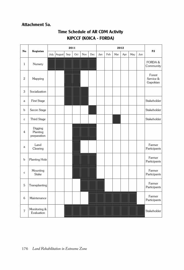
176 Land Rehabilitation in Extreeme Zone
Attachment 5a.
Time Schedule of AR CDM Activity
KIPCCF (KOICA - FORDA)
No Kegiatan
2011 2012
PJ
July August Sep Oct Nov Dec Jan Feb Mar Apr May Jun
1 Nursery FORDA &
Community
2 Mapping
Forest
Service &
Gapoktan
3 Socialization
a First Stage Stakeholder
b Secon Stage Stakeholder
c Third Stage Stakeholder
4
Digging
Planting
preparation
a Land
Clearing
Farmer
Participants
b Planting Hole Farmer
Participants
c Mounting
Stake
Farmer
Participants
5 Transplanting Farmer
Participants
6 Maintenance Farmer
Participants
7 Monitoring &
Evaluation Stakeholder
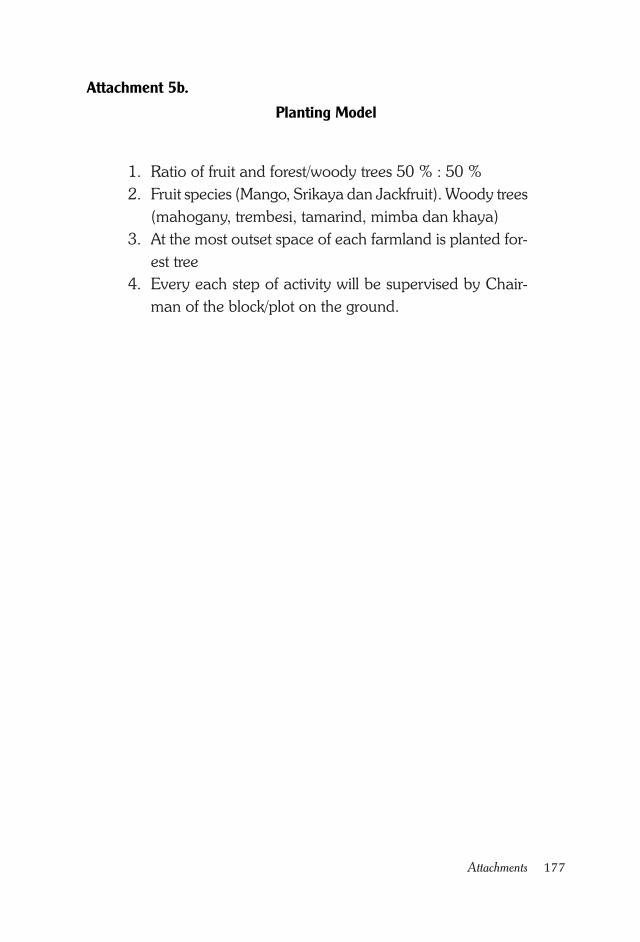
177Attachments
Attachment 5b.
Planting Model
1. Ratio of fruit and forest/woody trees 50 % : 50 %
2. Fruit species (Mango, Srikaya dan Jackfruit). Woody trees
(mahogany, trembesi, tamarind, mimba dan khaya)
3. At the most outset space of each farmland is planted for-
est tree
4. Every each step of activity will be supervised by Chair-
man of the block/plot on the ground.
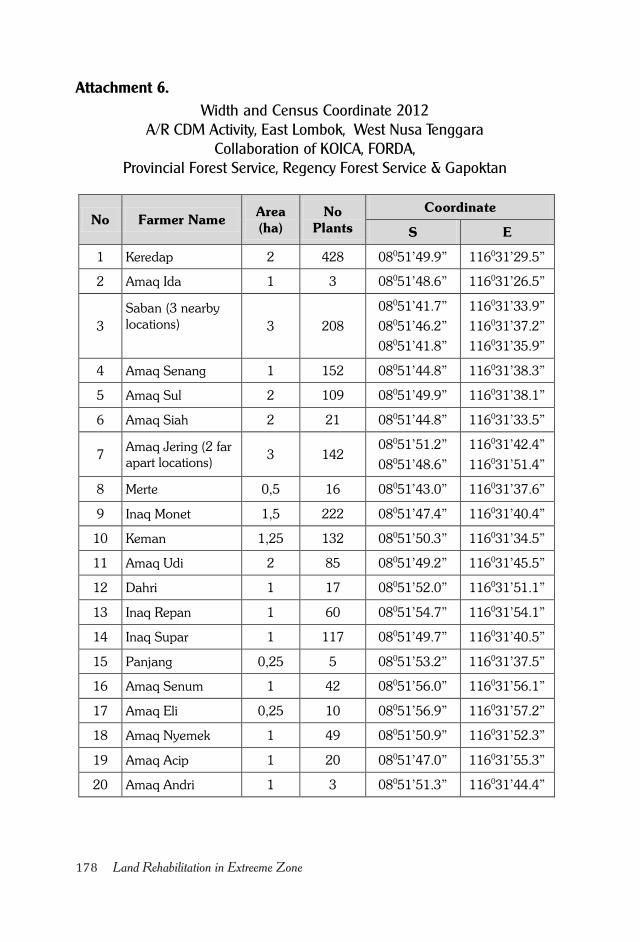
178 Land Rehabilitation in Extreeme Zone
Attachment 6.
Width and Census Coordinate 2012A/R CDM Activity, East Lombok, West Nusa Tenggara
Collaboration of KOICA, FORDA,Provincial Forest Service, Regency Forest Service & Gapoktan
No Farmer Name Area
(ha)
No
Plants
Coordinate
S E
1 Keredap 2 428 08051’49.9” 116031’29.5”
2 Amaq Ida 1 3 08051’48.6” 116031’26.5”
3
Saban (3 nearby
locations)
3 208
08051’41.7”
08051’46.2”
08051’41.8”
116031’33.9”
116031’37.2”
116031’35.9”
4 Amaq Senang 1 152 08051’44.8” 116031’38.3”
5 Amaq Sul 2 109 08051’49.9” 116031’38.1”
6 Amaq Siah 2 21 08051’44.8” 116031’33.5”
7 Amaq Jering (2 far
apart locations) 3 142
08051’51.2”
08051’48.6”
116031’42.4”
116031’51.4”
8 Merte 0,5 16 08051’43.0” 116031’37.6”
9 Inaq Monet 1,5 222 08051’47.4” 116031’40.4”
10 Keman 1,25 132 08051’50.3” 116031’34.5”
11 Amaq Udi 2 85 08051’49.2” 116031’45.5”
12 Dahri 1 17 08051’52.0” 116031’51.1”
13 Inaq Repan 1 60 08051’54.7” 116031’54.1”
14 Inaq Supar 1 117 08051’49.7” 116031’40.5”
15 Panjang 0,25 5 08051’53.2” 116031’37.5”
16 Amaq Senum 1 42 08051’56.0” 116031’56.1”
17 Amaq Eli 0,25 10 08051’56.9” 116031’57.2”
18 Amaq Nyemek 1 49 08051’50.9” 116031’52.3”
19 Amaq Acip 1 20 08051’47.0” 116031’55.3”
20 Amaq Andri 1 3 08051’51.3” 116031’44.4”
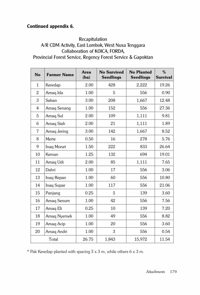
179Attachments
RecapitulationA/R CDM Activity, East Lombok, West Nusa Tenggara
Collaboration of KOICA, FORDA,Provincial Forest Service, Regency Forest Service & Gapoktan
* Pak Keredap planted with spacing 3 x 3 m, while others 6 x 3 m.
No Farmer Name Area
(ha)
No Survived
Seedlings
No Planted
Seedlings
%
Survival
1 Keredap 2.00 428 2,222 19.26
2 Amaq Ida 1.00 5 556 0.90
3 Saban 3.00 208 1,667 12.48
4 Amaq Senang 1.00 152 556 27.36
5 Amaq Sul 2.00 109 1,111 9.81
6 Amaq Siah 2.00 21 1,111 1.89
7 Amaq Jering 3.00 142 1,667 8.52
8 Merte 0.50 16 278 5.76
9 Inaq Monet 1.50 222 833 26.64
10 Keman 1.25 132 694 19.01
11 Amaq Udi 2.00 85 1,111 7.65
12 Dahri 1.00 17 556 3.06
13 Inaq Repan 1.00 60 556 10.80
14 Inaq Supar 1.00 117 556 21.06
15 Panjang 0.25 5 139 3.60
16 Amaq Senum 1.00 42 556 7.56
17 Amaq Eli 0.25 10 139 7.20
18 Amaq Nyemek 1.00 49 556 8.82
19 Amaq Acip 1.00 20 556 3.60
20 Amaq Andri 1.00 3 556 0.54
Total 26.75 1,843 15,972 11.54
Continued appendix 6.
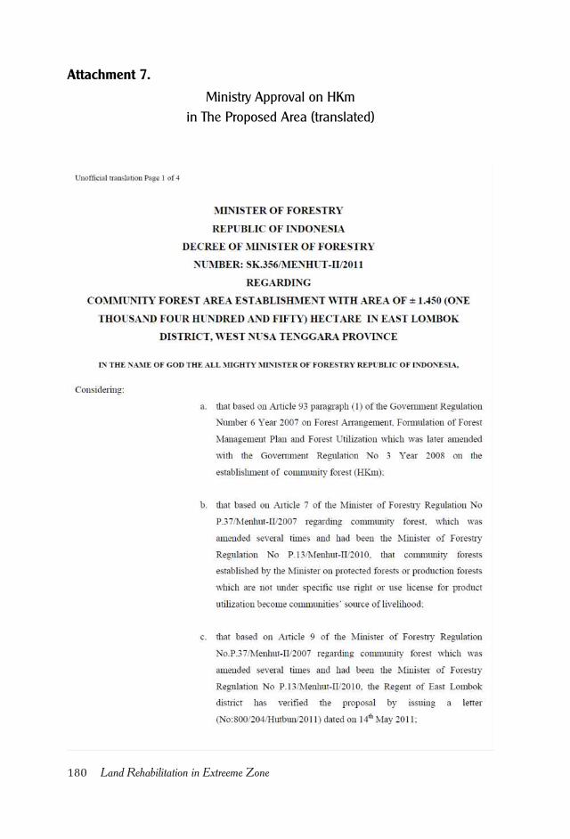
180 Land Rehabilitation in Extreeme Zone
Attachment 7.
Ministry Approval on HKm
in The Proposed Area (translated)
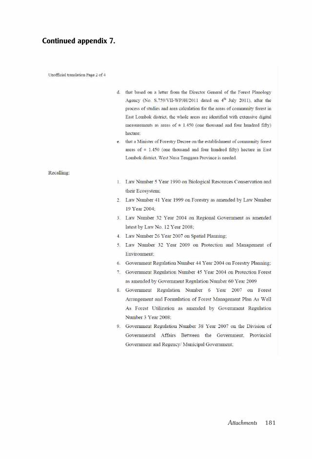
181Attachments
Continued appendix 7.
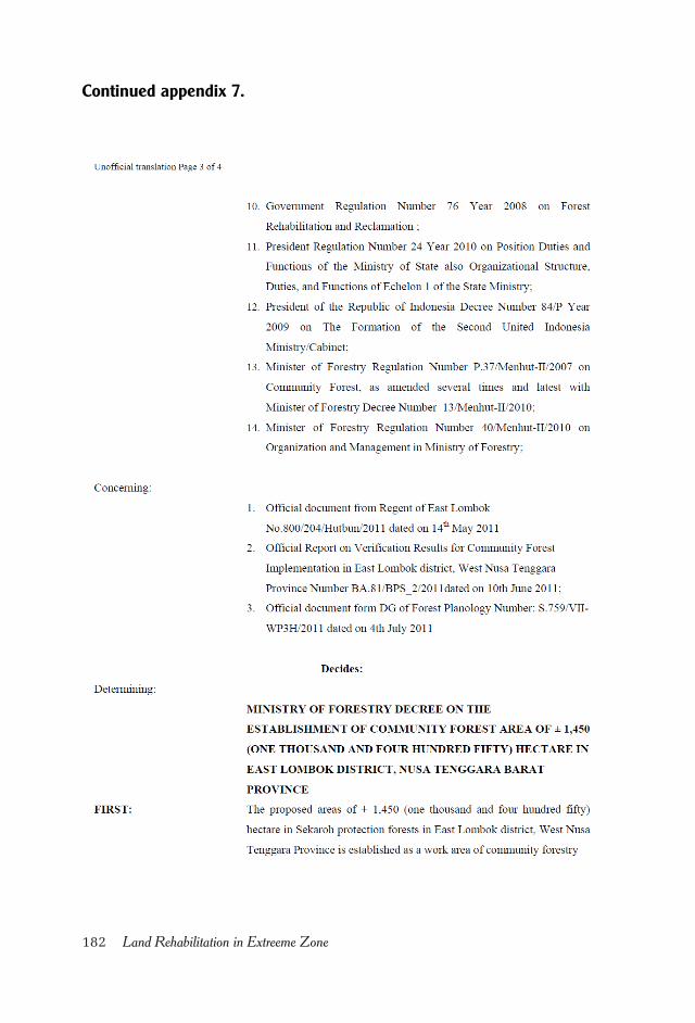
182 Land Rehabilitation in Extreeme Zone
Continued appendix 7.
183Attachments
Continued appendix 7.
184 Land Rehabilitation in Extreeme Zone
Attachment 8.
Decission Letter of IUPHHKm from East Lombok Regent
185Attachments
Continued appendix 8.
186 Land Rehabilitation in Extreeme Zone
Continued appendix 8.
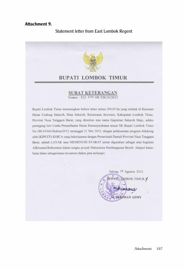
187Attachments
Attachment 9.
Statement letter from East Lombok Regent
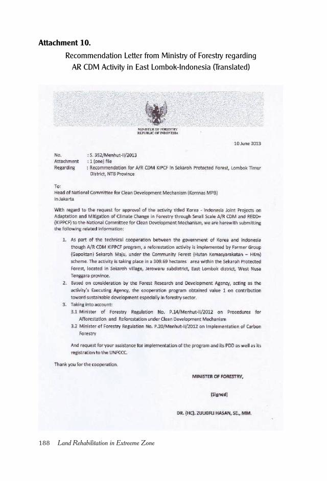
188 Land Rehabilitation in Extreeme Zone
Attachment 10.
Recommendation Letter from Ministry of Forestry regarding
AR CDM Activity in East Lombok-Indonesia (Translated)
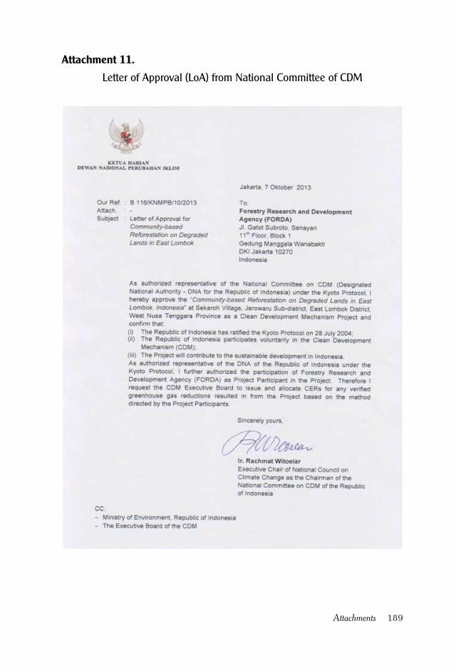
189Attachments
Attachment 11.
Letter of Approval (LoA) from National Committee of CDM

190 Land Rehabilitation in Extreeme Zone
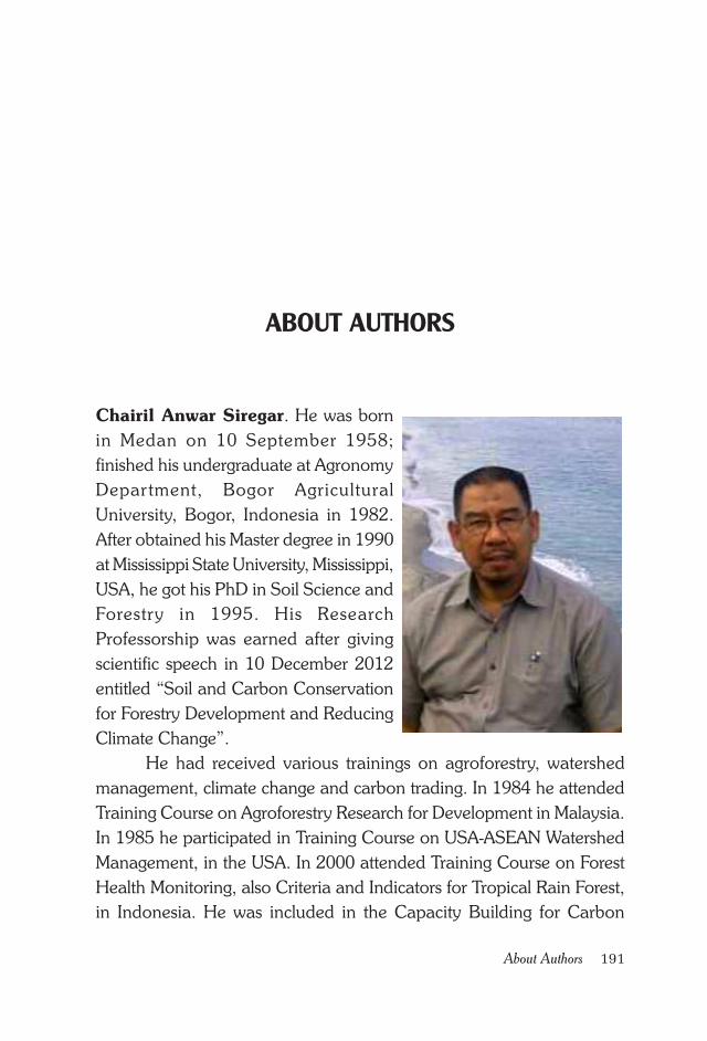
191About Authors
Chairil Anwar Siregar. He was born
in Medan on 10 September 1958;
finished his undergraduate at Agronomy
Department, Bogor Agricultural
University, Bogor, Indonesia in 1982.
After obtained his Master degree in 1990
at Mississippi State University, Mississippi,
USA, he got his PhD in Soil Science and
Forestry in 1995. His Research
Professorship was earned after giving
scientific speech in 10 December 2012
entitled “Soil and Carbon Conservation
for Forestry Development and Reducing
Climate Change”.
He had received various trainings on agroforestry, watershed
management, climate change and carbon trading. In 1984 he attended
Training Course on Agroforestry Research for Development in Malaysia.
In 1985 he participated in Training Course on USA-ASEAN Watershed
Management, in the USA. In 2000 attended Training Course on Forest
Health Monitoring, also Criteria and Indicators for Tropical Rain Forest,
in Indonesia. He was included in the Capacity Building for Carbon
ABOUT AUTHORS
192 Land Rehabilitation in Extreeme Zone
Accounting in Selected APEC Countries, in the Philippines in 2008. In
2009 he participated in the Strengthening Capacity Building for Climate
Change in Forestry, in South Korea.
He started his career in the early 1982 at Forestry Research and
Development Agency (FORDA) of Ministry of Forestry, becoming senior
researcher in 2006. He has written many scientific publications, of which
45 were published in Indonesian language, and 34 titles were written in
English. During his professional work he has collaborated with various
foreign agencies, such as Winrock, JICA, JIFPRO, Sumitomo, CIFOR,
ICRAF and KOICA. He can be contacted at [email protected]
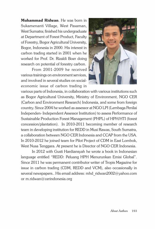
193About Authors
Muhammad Ridwan. He was born in
Sukamenanti Village, West Pasaman,
West Sumatra; finished his undergraduate
at Department of Forest Product, Faculty
of Forestry, Bogor Agricultural University,
Bogor, Indonesia in 2000. His interest in
carbon trading started in 2001 when he
worked for Prof. Dr. Rizaldi Boer doing
research on potential of forestry carbon.
From 2001-2009 he received
various trainings on environment services,
and involved in several studies on social-
economic issue of carbon trading in
various parts of Indonesia, in collaboration with various institutions such
as Bogor Agricultural University, Ministry of Environment, NGO CER
(Carbon and Environment Research) Indonesia, and some from foreign
country. Since 2004 he worked as assessor at NGO LPI (Lembaga Penilai
Independen- Independent Assessor Institution) to assess Performance of
Sustainable Production Forest Management (PHPL) of HPH/HTI (forest
concession/plantation). In 2010-2011 becoming member of research
team in developing institution for REDD in Musi Rawas, South Sumatra,
a collaboration between NGO CER Indonesia and CCAP from the USA.
In 2010-2012 he joined team for Pilot Project of CDM in East Lombok,
West Nusa Tenggara. At present he is Director of NGO CER Indonesia.
In 2012 with Gusti Hardiansyah he wrote a book in Indonesian
language entitled “REDD: Peluang HPH Menurunkan Emisi Global”.
Since 2011 he was permanent contributor writer of Tropis Magazine for
issue in carbon trading (CDM, REDD and VCM), also occasionally in
several newspapers.. His email address: [email protected]

194 Land Rehabilitation in Extreeme Zone