Central Valley Regional Data Center Field Data Entry Training.
30
Central Valley Regional Data Center Field Data Entry Training
-
Upload
felix-skinner -
Category
Documents
-
view
219 -
download
2
Transcript of Central Valley Regional Data Center Field Data Entry Training.

Central Valley Regional Data Center
Field Data Entry Training

Opening the Database
Always make a copy of your CV RDC database: CVRDC_v25_S063011_XXX
Please do not work on a server with the CVRDC
database. Work on the desktop.
Open the database and type in your username that was provided by the CV RDC and press ok.

For Access 2007 users you will need to click on the Options box at the top of the screen and mark
“Enable this content”, then click OK.


Entered in d-base (initial/date) double checker: Pg of Pgs
Dry Creek @ Wellsford Rd535XDCAWR DATE (mm/dd/yyyy): Agency: MLJ-LLC08ES5001 Protocol: MLJ-LLC FieldSOP 03/13/09
ESJ WQC_08Winter 2 2011 Purpose (Circle all that apply): WaterChem WaterTox Habitat FieldMeasure
Bank, Thalweg, Midchannel, Open Water
Details-WQ/Tox *GPS/DGPS Lat (dd.ddddd) Long (dd.ddddd)
Walk-in, Bridge, Other Target:
LB / RB/ NA *Actual: -Difference:
GPS Model: MLJ-LLC Garmin eTrex
None, Bridge, Pipes, Concrete Channel, Grade Control, Culvert, Other Datum: NAD 83
US / DS / NA
Lab Chem/Tox Method=Water_Grab Position in Water Column: Subsurface Depth: 0.1 m
Grab, Integrated
Indiv bottle by hand, By pole, UCD 3L PTFE, Other
Habitat Method: Not Applicable
None, Sulfides, Sewage, Petroleum, Mixed, Other
None, Sulfides, Sewage, Petroleum, Mixed, Other
None, Foggy, Drizzle, Rain, Snow
Concrete, Cobble, Gravel, Sand, Mud, Unk., Other
Clear (see bottom), Cloudy (>4" vis), Murky (<4" vis)
YES / NO
Calm, Light Breeze, Gusty
Colorless, Green, Yellow, Brown, Other
NA, Dry Waterbody Bed, No Observed Flow, Isolated Pool, 0.1 - 1cfs, 1 - 5 cfs, 5 - 20 cfs, 20 - 50 cfs, 50 - 200 cfs, >200cfs
circle direction in compass at right
Clear, Partly Cloudy, Overcast, Fog, Hazy
PICTURE NAME:
Unknown, <1", >1", None
Vascular, Nonvascular, OilySheen, Foam, Trash, None, Other
Samples Taken (# of Containers Filled) Field Dup: Yes / No
Samples Collected Analyte Container Number Notes
535XDCAWR-GR Tox tests: Acute FH Minnow & Ceriodaphnia, Chronic Selenastrum 1-Gal Amber Glass 5
535XDCAWR-GR Total Kjehldahl Nitrogen, Total Ammonia (as N), Total Phosphorus (as P), Nitrate + Nitrite (as N) 500-mL Plastic (w/H2SO4) 1
535XDCAWR-GR TOC 40-mL Glass Amber vial, set of 3 1
535XDCAWR-GR Carbamates, OCs, OPs, Herbicides, Group A Pesticides 1-L Amber Glass 5
535XDCAWR-GR Total Metals 500-mL Plastic (w/HNO3) 1
535XDCAWR-GR Dissolved Metals, hardness (as CaCO3) 500-mL Plastic (w/HNO3) 1 Filtered sample535XDCAWR-GR Glyphosate 40-mL Glass Amber vial 2
535XDCAWR-GR Paraquat 1-L Plastic 1
535XDCAWR-GR E. coli 100-mL Polyethylene 1
535XDCAWR-GR Turbidity, TDS, TSS, Soluble Orthophosphate (as P) 2-L Plastic Jug 1
Funding:PurposeFailure: SAMPLE TIME:
Project ID:
ESJWQC Field Data Sheet: Water Sampling (EventType = WQ)Station Name:
Arrival Time:StationID:
Field Results
Group:Departure Time:
SAMPLE LOCATION:
37.6602
Personnel:
Geometry Data
-120.8743OCCUPATION METHOD:
STARTING BANK:
Accuracy (ft / m):
HYDROMODLOC:
STREAM WIDTH (ft / m): WATER DEPTH (ft / m):
HYDRO-MODIFICATION:
SAMPLE TYPE:
DEVICE:Air Temp (Celsius):
DO (mg/L):
SC (uS/cm):
WATER ODOR:
WIND DIRECTION (from):
SKY CODE:
PICTURE NUMBER:
WIND:
SampleType=FieldMeasure; Method=Field
Depth: 0.1 m Position In Column: Subsurface
OBSERVED FLOW:
WATERCOLOR:
WADEABLE:
DOMINANT SUBSTRATE:
WATER CLARITY:
SITE ODOR:
PRECIPITATION:
Water Temp (Celsius):
PRECIPITATION (last 24 hrs):
OTHER PRESENCE:
pH:
TDS:
YSI Meter ID:
Stage:
Calculated Site Discharge:
N
S
EW

Sample Information
Add in Sample Information Event – WQ Protocol – refers to the SOP followed to collect the samples;
will be unique per QAPP Example: “MLJ-LLC FiledSOP_031309
Station ID – (3 digit HU, 6 characters) Example: 544XTTHWT Date – dd/mmm/yyyy Agency – Example: MLJ-LLC Project ID – Example: ILRP_SJCDWQ Sample comments: Specifically related to the sample collection.
Note this is the blank white section under project and agency.


Associated Sample Information
Add in sample information Funding – Example: 04SJ5001 GroupSample – Example: Irrigation 2 SamplePurposeCode –Example: WaterChem, WaterTox,
Habitat, FieldMeasure. (Put all that apply) PurposeFailure – Leave blank or “Dry Site” etc. Personnel – sampling crew, entered individually
Press the SAVE and then the EDIT button before moving on to location information


Entered in d-base (initial/date) double checker: Pg of Pgs
Dry Creek @ Wellsford Rd535XDCAWR DATE (mm/dd/yyyy): Agency: MLJ-LLC08ES5001 Protocol: MLJ-LLC FieldSOP 03/13/09
ESJ WQC_08Winter 2 2011 Purpose (Circle all that apply): WaterChem WaterTox Habitat FieldMeasure
Bank, Thalweg, Midchannel, Open Water
Details-WQ/Tox *GPS/DGPS Lat (dd.ddddd) Long (dd.ddddd)
Walk-in, Bridge, Other Target:
LB / RB/ NA *Actual: -Difference:
GPS Model: MLJ-LLC Garmin eTrex
None, Bridge, Pipes, Concrete Channel, Grade Control, Culvert, Other Datum: NAD 83
US / DS / NA
Lab Chem/Tox Method=Water_Grab Position in Water Column: Subsurface Depth: 0.1 m
Grab, Integrated
Indiv bottle by hand, By pole, UCD 3L PTFE, Other
Habitat Method: Not Applicable
None, Sulfides, Sewage, Petroleum, Mixed, Other
None, Sulfides, Sewage, Petroleum, Mixed, Other
None, Foggy, Drizzle, Rain, Snow
Concrete, Cobble, Gravel, Sand, Mud, Unk., Other
Clear (see bottom), Cloudy (>4" vis), Murky (<4" vis)
YES / NO
Calm, Light Breeze, Gusty
Colorless, Green, Yellow, Brown, Other
NA, Dry Waterbody Bed, No Observed Flow, Isolated Pool, 0.1 - 1cfs, 1 - 5 cfs, 5 - 20 cfs, 20 - 50 cfs, 50 - 200 cfs, >200cfs
circle direction in compass at right
Clear, Partly Cloudy, Overcast, Fog, Hazy
PICTURE NAME:
Unknown, <1", >1", None
Vascular, Nonvascular, OilySheen, Foam, Trash, None, Other
Samples Taken (# of Containers Filled) Field Dup: Yes / No
Samples Collected Analyte Container Number Notes
535XDCAWR-GR Tox tests: Acute FH Minnow & Ceriodaphnia, Chronic Selenastrum 1-Gal Amber Glass 5
535XDCAWR-GR Total Kjehldahl Nitrogen, Total Ammonia (as N), Total Phosphorus (as P), Nitrate + Nitrite (as N) 500-mL Plastic (w/H2SO4) 1
535XDCAWR-GR TOC 40-mL Glass Amber vial, set of 3 1
535XDCAWR-GR Carbamates, OCs, OPs, Herbicides, Group A Pesticides 1-L Amber Glass 5
535XDCAWR-GR Total Metals 500-mL Plastic (w/HNO3) 1
535XDCAWR-GR Dissolved Metals, hardness (as CaCO3) 500-mL Plastic (w/HNO3) 1 Filtered sample535XDCAWR-GR Glyphosate 40-mL Glass Amber vial 2
535XDCAWR-GR Paraquat 1-L Plastic 1
535XDCAWR-GR E. coli 100-mL Polyethylene 1
535XDCAWR-GR Turbidity, TDS, TSS, Soluble Orthophosphate (as P) 2-L Plastic Jug 1
Funding:PurposeFailure: SAMPLE TIME:
Project ID:
ESJWQC Field Data Sheet: Water Sampling (EventType = WQ)Station Name:
Arrival Time:StationID:
Field Results
Group:Departure Time:
SAMPLE LOCATION:
37.6602
Personnel:
Geometry Data
-120.8743OCCUPATION METHOD:
STARTING BANK:
Accuracy (ft / m):
HYDROMODLOC:
STREAM WIDTH (ft / m): WATER DEPTH (ft / m):
HYDRO-MODIFICATION:
SAMPLE TYPE:
DEVICE:Air Temp (Celsius):
DO (mg/L):
SC (uS/cm):
WATER ODOR:
WIND DIRECTION (from):
SKY CODE:
PICTURE NUMBER:
WIND:
SampleType=FieldMeasure; Method=Field
Depth: 0.1 m Position In Column: Subsurface
OBSERVED FLOW:
WATERCOLOR:
WADEABLE:
DOMINANT SUBSTRATE:
WATER CLARITY:
SITE ODOR:
PRECIPITATION:
Water Temp (Celsius):
PRECIPITATION (last 24 hrs):
OTHER PRESENCE:
pH:
TDS:
YSI Meter ID:
Stage:
Calculated Site Discharge:
N
S
EW

Location
Location refers to where the sample was collected
Midchannel, NearBank, Bank, Thalweg, etc. To enter in a new location , select location from
the drop down menu to the right (yellow shaded) Shape refers to the type of location: Example point
would represent an individual sample collected by hand; where as a net trawl would be a line.
Press the SAVE and then the EDIT button before moving on to the geometry data.


Entered in d-base (initial/date) double checker: Pg of Pgs
Dry Creek @ Wellsford Rd535XDCAWR DATE (mm/dd/yyyy): Agency: MLJ-LLC08ES5001 Protocol: MLJ-LLC FieldSOP 03/13/09
ESJ WQC_08Winter 2 2011 Purpose (Circle all that apply): WaterChem WaterTox Habitat FieldMeasure
Bank, Thalweg, Midchannel, Open Water
Details-WQ/Tox *GPS/DGPS Lat (dd.ddddd) Long (dd.ddddd)
Walk-in, Bridge, Other Target:
LB / RB/ NA *Actual: -Difference:
GPS Model: MLJ-LLC Garmin eTrex
None, Bridge, Pipes, Concrete Channel, Grade Control, Culvert, Other Datum: NAD 83
US / DS / NA
Lab Chem/Tox Method=Water_Grab Position in Water Column: Subsurface Depth: 0.1 m
Grab, Integrated
Indiv bottle by hand, By pole, UCD 3L PTFE, Other
Habitat Method: Not Applicable
None, Sulfides, Sewage, Petroleum, Mixed, Other
None, Sulfides, Sewage, Petroleum, Mixed, Other
None, Foggy, Drizzle, Rain, Snow
Concrete, Cobble, Gravel, Sand, Mud, Unk., Other
Clear (see bottom), Cloudy (>4" vis), Murky (<4" vis)
YES / NO
Calm, Light Breeze, Gusty
Colorless, Green, Yellow, Brown, Other
NA, Dry Waterbody Bed, No Observed Flow, Isolated Pool, 0.1 - 1cfs, 1 - 5 cfs, 5 - 20 cfs, 20 - 50 cfs, 50 - 200 cfs, >200cfs
circle direction in compass at right
Clear, Partly Cloudy, Overcast, Fog, Hazy
PICTURE NAME:
Unknown, <1", >1", None
Vascular, Nonvascular, OilySheen, Foam, Trash, None, Other
Samples Taken (# of Containers Filled) Field Dup: Yes / No
Samples Collected Analyte Container Number Notes
535XDCAWR-GR Tox tests: Acute FH Minnow & Ceriodaphnia, Chronic Selenastrum 1-Gal Amber Glass 5
535XDCAWR-GR Total Kjehldahl Nitrogen, Total Ammonia (as N), Total Phosphorus (as P), Nitrate + Nitrite (as N) 500-mL Plastic (w/H2SO4) 1
535XDCAWR-GR TOC 40-mL Glass Amber vial, set of 3 1
535XDCAWR-GR Carbamates, OCs, OPs, Herbicides, Group A Pesticides 1-L Amber Glass 5
535XDCAWR-GR Total Metals 500-mL Plastic (w/HNO3) 1
535XDCAWR-GR Dissolved Metals, hardness (as CaCO3) 500-mL Plastic (w/HNO3) 1 Filtered sample535XDCAWR-GR Glyphosate 40-mL Glass Amber vial 2
535XDCAWR-GR Paraquat 1-L Plastic 1
535XDCAWR-GR E. coli 100-mL Polyethylene 1
535XDCAWR-GR Turbidity, TDS, TSS, Soluble Orthophosphate (as P) 2-L Plastic Jug 1
Funding:PurposeFailure: SAMPLE TIME:
Project ID:
ESJWQC Field Data Sheet: Water Sampling (EventType = WQ)Station Name:
Arrival Time:StationID:
Field Results
Group:Departure Time:
SAMPLE LOCATION:
37.6602
Personnel:
Geometry Data
-120.8743OCCUPATION METHOD:
STARTING BANK:
Accuracy (ft / m):
HYDROMODLOC:
STREAM WIDTH (ft / m): WATER DEPTH (ft / m):
HYDRO-MODIFICATION:
SAMPLE TYPE:
DEVICE:Air Temp (Celsius):
DO (mg/L):
SC (uS/cm):
WATER ODOR:
WIND DIRECTION (from):
SKY CODE:
PICTURE NUMBER:
WIND:
SampleType=FieldMeasure; Method=Field
Depth: 0.1 m Position In Column: Subsurface
OBSERVED FLOW:
WATERCOLOR:
WADEABLE:
DOMINANT SUBSTRATE:
WATER CLARITY:
SITE ODOR:
PRECIPITATION:
Water Temp (Celsius):
PRECIPITATION (last 24 hrs):
OTHER PRESENCE:
pH:
TDS:
YSI Meter ID:
Stage:
Calculated Site Discharge:
N
S
EW

Geometry
Make sure to click the EDIT in upper right hand corner Select appropriate location from left drop down menu example “Bank”
Click RETRIEVE: all tabs below (on form) are now associated with the selected location
For each location there can be separate geometry AND sample collection information Geometry describes the area/point where the sample(s) were collected When the location is a point, only 1 geometry is recorded:
Source - Example: map, GPS Number - refers to the # of coordinates recorded for a location “1” Latitude - 5 decimal places Longitude - 5 decimal places Fix – Example: 3D GPS - Example: MLJ-LLC Garmin Etrex Accuracy/Units: accuracy of coordinates and associated units Within 10 second?: leave blank or select yes or no Datum - Example - Example: NAD83 Elev/Units: elevation and associated units Comments – comments related to the geometry data


Entered in d-base (initial/date) double checker: Pg of Pgs
Dry Creek @ Wellsford Rd535XDCAWR DATE (mm/dd/yyyy): Agency: MLJ-LLC08ES5001 Protocol: MLJ-LLC FieldSOP 03/13/09
ESJ WQC_08Winter 2 2011 Purpose (Circle all that apply): WaterChem WaterTox Habitat FieldMeasure
Bank, Thalweg, Midchannel, Open Water
Details-WQ/Tox *GPS/DGPS Lat (dd.ddddd) Long (dd.ddddd)
Walk-in, Bridge, Other Target:
LB / RB/ NA *Actual: -Difference:
GPS Model: MLJ-LLC Garmin eTrex
None, Bridge, Pipes, Concrete Channel, Grade Control, Culvert, Other Datum: NAD 83
US / DS / NA
Lab Chem/Tox Method=Water_Grab Position in Water Column: Subsurface Depth: 0.1 m
Grab, Integrated
Indiv bottle by hand, By pole, UCD 3L PTFE, Other
Habitat Method: Not Applicable
None, Sulfides, Sewage, Petroleum, Mixed, Other
None, Sulfides, Sewage, Petroleum, Mixed, Other
None, Foggy, Drizzle, Rain, Snow
Concrete, Cobble, Gravel, Sand, Mud, Unk., Other
Clear (see bottom), Cloudy (>4" vis), Murky (<4" vis)
YES / NO
Calm, Light Breeze, Gusty
Colorless, Green, Yellow, Brown, Other
NA, Dry Waterbody Bed, No Observed Flow, Isolated Pool, 0.1 - 1cfs, 1 - 5 cfs, 5 - 20 cfs, 20 - 50 cfs, 50 - 200 cfs, >200cfs
circle direction in compass at right
Clear, Partly Cloudy, Overcast, Fog, Hazy
PICTURE NAME:
Unknown, <1", >1", None
Vascular, Nonvascular, OilySheen, Foam, Trash, None, Other
Samples Taken (# of Containers Filled) Field Dup: Yes / No
Samples Collected Analyte Container Number Notes
535XDCAWR-GR Tox tests: Acute FH Minnow & Ceriodaphnia, Chronic Selenastrum 1-Gal Amber Glass 5
535XDCAWR-GR Total Kjehldahl Nitrogen, Total Ammonia (as N), Total Phosphorus (as P), Nitrate + Nitrite (as N) 500-mL Plastic (w/H2SO4) 1
535XDCAWR-GR TOC 40-mL Glass Amber vial, set of 3 1
535XDCAWR-GR Carbamates, OCs, OPs, Herbicides, Group A Pesticides 1-L Amber Glass 5
535XDCAWR-GR Total Metals 500-mL Plastic (w/HNO3) 1
535XDCAWR-GR Dissolved Metals, hardness (as CaCO3) 500-mL Plastic (w/HNO3) 1 Filtered sample535XDCAWR-GR Glyphosate 40-mL Glass Amber vial 2
535XDCAWR-GR Paraquat 1-L Plastic 1
535XDCAWR-GR E. coli 100-mL Polyethylene 1
535XDCAWR-GR Turbidity, TDS, TSS, Soluble Orthophosphate (as P) 2-L Plastic Jug 1
Funding:PurposeFailure: SAMPLE TIME:
Project ID:
ESJWQC Field Data Sheet: Water Sampling (EventType = WQ)Station Name:
Arrival Time:StationID:
Field Results
Group:Departure Time:
SAMPLE LOCATION:
37.6602
Personnel:
Geometry Data
-120.8743OCCUPATION METHOD:
STARTING BANK:
Accuracy (ft / m):
HYDROMODLOC:
STREAM WIDTH (ft / m): WATER DEPTH (ft / m):
HYDRO-MODIFICATION:
SAMPLE TYPE:
DEVICE:Air Temp (Celsius):
DO (mg/L):
SC (uS/cm):
WATER ODOR:
WIND DIRECTION (from):
SKY CODE:
PICTURE NUMBER:
WIND:
SampleType=FieldMeasure; Method=Field
Depth: 0.1 m Position In Column: Subsurface
OBSERVED FLOW:
WATERCOLOR:
WADEABLE:
DOMINANT SUBSTRATE:
WATER CLARITY:
SITE ODOR:
PRECIPITATION:
Water Temp (Celsius):
PRECIPITATION (last 24 hrs):
OTHER PRESENCE:
pH:
TDS:
YSI Meter ID:
Stage:
Calculated Site Discharge:
N
S
EW

Habitat
Select the tab next to Geometry labeled “Habitat”Habitat refers to the (weather, water color, site odor, etc)Enter Method : Not ApplicableSelect the analyte from the analyte pull-down menuSelect the Var Result from the pull-down menuEnter the QACode: None unless Dry Site or otherCollectionDeviceCode: NoneEnter any notes in the comments field and additional
resultsTab to move to the next recordClick the SAVE button in the middle right of the formClick the “Add New” button if any additional Habitat
data needs to be entered (additional Methods, Time, or Reps).


Entered in d-base (initial/date) double checker: Pg of Pgs
Dry Creek @ Wellsford Rd535XDCAWR DATE (mm/dd/yyyy): Agency: MLJ-LLC08ES5001 Protocol: MLJ-LLC FieldSOP 03/13/09
ESJ WQC_08Winter 2 2011 Purpose (Circle all that apply): WaterChem WaterTox Habitat FieldMeasure
Bank, Thalweg, Midchannel, Open Water
Details-WQ/Tox *GPS/DGPS Lat (dd.ddddd) Long (dd.ddddd)
Walk-in, Bridge, Other Target:
LB / RB/ NA *Actual: -Difference:
GPS Model: MLJ-LLC Garmin eTrex
None, Bridge, Pipes, Concrete Channel, Grade Control, Culvert, Other Datum: NAD 83
US / DS / NA
Lab Chem/Tox Method=Water_Grab Position in Water Column: Subsurface Depth: 0.1 m
Grab, Integrated
Indiv bottle by hand, By pole, UCD 3L PTFE, Other
Habitat Method: Not Applicable
None, Sulfides, Sewage, Petroleum, Mixed, Other
None, Sulfides, Sewage, Petroleum, Mixed, Other
None, Foggy, Drizzle, Rain, Snow
Concrete, Cobble, Gravel, Sand, Mud, Unk., Other
Clear (see bottom), Cloudy (>4" vis), Murky (<4" vis)
YES / NO
Calm, Light Breeze, Gusty
Colorless, Green, Yellow, Brown, Other
NA, Dry Waterbody Bed, No Observed Flow, Isolated Pool, 0.1 - 1cfs, 1 - 5 cfs, 5 - 20 cfs, 20 - 50 cfs, 50 - 200 cfs, >200cfs
circle direction in compass at right
Clear, Partly Cloudy, Overcast, Fog, Hazy
PICTURE NAME:
Unknown, <1", >1", None
Vascular, Nonvascular, OilySheen, Foam, Trash, None, Other
Samples Taken (# of Containers Filled) Field Dup: Yes / No
Samples Collected Analyte Container Number Notes
535XDCAWR-GR Tox tests: Acute FH Minnow & Ceriodaphnia, Chronic Selenastrum 1-Gal Amber Glass 5
535XDCAWR-GR Total Kjehldahl Nitrogen, Total Ammonia (as N), Total Phosphorus (as P), Nitrate + Nitrite (as N) 500-mL Plastic (w/H2SO4) 1
535XDCAWR-GR TOC 40-mL Glass Amber vial, set of 3 1
535XDCAWR-GR Carbamates, OCs, OPs, Herbicides, Group A Pesticides 1-L Amber Glass 5
535XDCAWR-GR Total Metals 500-mL Plastic (w/HNO3) 1
535XDCAWR-GR Dissolved Metals, hardness (as CaCO3) 500-mL Plastic (w/HNO3) 1 Filtered sample535XDCAWR-GR Glyphosate 40-mL Glass Amber vial 2
535XDCAWR-GR Paraquat 1-L Plastic 1
535XDCAWR-GR E. coli 100-mL Polyethylene 1
535XDCAWR-GR Turbidity, TDS, TSS, Soluble Orthophosphate (as P) 2-L Plastic Jug 1
Funding:PurposeFailure: SAMPLE TIME:
Project ID:
ESJWQC Field Data Sheet: Water Sampling (EventType = WQ)Station Name:
Arrival Time:StationID:
Field Results
Group:Departure Time:
SAMPLE LOCATION:
37.6602
Personnel:
Geometry Data
-120.8743OCCUPATION METHOD:
STARTING BANK:
Accuracy (ft / m):
HYDROMODLOC:
STREAM WIDTH (ft / m): WATER DEPTH (ft / m):
HYDRO-MODIFICATION:
SAMPLE TYPE:
DEVICE:Air Temp (Celsius):
DO (mg/L):
SC (uS/cm):
WATER ODOR:
WIND DIRECTION (from):
SKY CODE:
PICTURE NUMBER:
WIND:
SampleType=FieldMeasure; Method=Field
Depth: 0.1 m Position In Column: Subsurface
OBSERVED FLOW:
WATERCOLOR:
WADEABLE:
DOMINANT SUBSTRATE:
WATER CLARITY:
SITE ODOR:
PRECIPITATION:
Water Temp (Celsius):
PRECIPITATION (last 24 hrs):
OTHER PRESENCE:
pH:
TDS:
YSI Meter ID:
Stage:
Calculated Site Discharge:
N
S
EW

Details WQ/Tox
Details WQ/Tox records specific information about how the water quality and/or toxicity sample was collected: Occupation Method - Example: Walk-in, Bridge, Other Starting Bank - Example: RB, LB, NA Distance from Bank/Units Stream Width/Units Water Depth/Units Hydromodification - Example: Bridge, pipes etc Hydromodification Location - Example: upstream =US Comments: comments related to location detail. Put
additonal hydromodifications here.

Entered in d-base (initial/date) double checker: Pg of Pgs
Dry Creek @ Wellsford Rd535XDCAWR DATE (mm/dd/yyyy): Agency: MLJ-LLC08ES5001 Protocol: MLJ-LLC FieldSOP 03/13/09
ESJ WQC_08Winter 2 2011 Purpose (Circle all that apply): WaterChem WaterTox Habitat FieldMeasure
Bank, Thalweg, Midchannel, Open Water
Details-WQ/Tox *GPS/DGPS Lat (dd.ddddd) Long (dd.ddddd)
Walk-in, Bridge, Other Target:
LB / RB/ NA *Actual: -Difference:
GPS Model: MLJ-LLC Garmin eTrex
None, Bridge, Pipes, Concrete Channel, Grade Control, Culvert, Other Datum: NAD 83
US / DS / NA
Lab Chem/Tox Method=Water_Grab Position in Water Column: Subsurface Depth: 0.1 m
Grab, Integrated
Indiv bottle by hand, By pole, UCD 3L PTFE, Other
Habitat Method: Not Applicable
None, Sulfides, Sewage, Petroleum, Mixed, Other
None, Sulfides, Sewage, Petroleum, Mixed, Other
None, Foggy, Drizzle, Rain, Snow
Concrete, Cobble, Gravel, Sand, Mud, Unk., Other
Clear (see bottom), Cloudy (>4" vis), Murky (<4" vis)
YES / NO
Calm, Light Breeze, Gusty
Colorless, Green, Yellow, Brown, Other
NA, Dry Waterbody Bed, No Observed Flow, Isolated Pool, 0.1 - 1cfs, 1 - 5 cfs, 5 - 20 cfs, 20 - 50 cfs, 50 - 200 cfs, >200cfs
circle direction in compass at right
Clear, Partly Cloudy, Overcast, Fog, Hazy
PICTURE NAME:
Unknown, <1", >1", None
Vascular, Nonvascular, OilySheen, Foam, Trash, None, Other
Samples Taken (# of Containers Filled) Field Dup: Yes / No
Samples Collected Analyte Container Number Notes
535XDCAWR-GR Tox tests: Acute FH Minnow & Ceriodaphnia, Chronic Selenastrum 1-Gal Amber Glass 5
535XDCAWR-GR Total Kjehldahl Nitrogen, Total Ammonia (as N), Total Phosphorus (as P), Nitrate + Nitrite (as N) 500-mL Plastic (w/H2SO4) 1
535XDCAWR-GR TOC 40-mL Glass Amber vial, set of 3 1
535XDCAWR-GR Carbamates, OCs, OPs, Herbicides, Group A Pesticides 1-L Amber Glass 5
535XDCAWR-GR Total Metals 500-mL Plastic (w/HNO3) 1
535XDCAWR-GR Dissolved Metals, hardness (as CaCO3) 500-mL Plastic (w/HNO3) 1 Filtered sample535XDCAWR-GR Glyphosate 40-mL Glass Amber vial 2
535XDCAWR-GR Paraquat 1-L Plastic 1
535XDCAWR-GR E. coli 100-mL Polyethylene 1
535XDCAWR-GR Turbidity, TDS, TSS, Soluble Orthophosphate (as P) 2-L Plastic Jug 1
Funding:PurposeFailure: SAMPLE TIME:
Project ID:
ESJWQC Field Data Sheet: Water Sampling (EventType = WQ)Station Name:
Arrival Time:StationID:
Field Results
Group:Departure Time:
SAMPLE LOCATION:
37.6602
Personnel:
Geometry Data
-120.8743OCCUPATION METHOD:
STARTING BANK:
Accuracy (ft / m):
HYDROMODLOC:
STREAM WIDTH (ft / m): WATER DEPTH (ft / m):
HYDRO-MODIFICATION:
SAMPLE TYPE:
DEVICE:Air Temp (Celsius):
DO (mg/L):
SC (uS/cm):
WATER ODOR:
WIND DIRECTION (from):
SKY CODE:
PICTURE NUMBER:
WIND:
SampleType=FieldMeasure; Method=Field
Depth: 0.1 m Position In Column: Subsurface
OBSERVED FLOW:
WATERCOLOR:
WADEABLE:
DOMINANT SUBSTRATE:
WATER CLARITY:
SITE ODOR:
PRECIPITATION:
Water Temp (Celsius):
PRECIPITATION (last 24 hrs):
OTHER PRESENCE:
pH:
TDS:
YSI Meter ID:
Stage:
Calculated Site Discharge:
N
S
EW

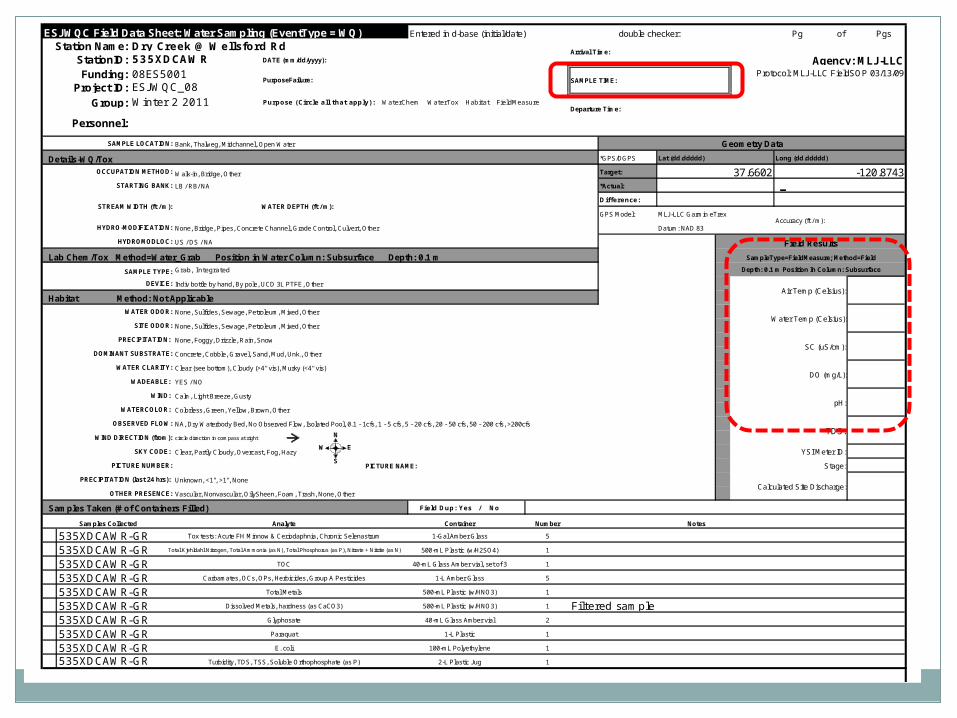
Field Results
Verify the appropriate “Location” is selectedSelect the tab “Field Results”Field results may be associated with a water or
sediment sample and include pH, SC, temperature, DO, and discharge Method - Field Time - time of sample collection Depth/Units – Example: subsurface = 0.1 m / integrated = -88
m Replicate: 1 Position Water Column: subsurface (sediment = Not Applicable) Comments – comments associated with field collection
If no results collected, move on to Lab Chem/Tox tabClick SAVE in middle right corner


Entered in d-base (initial/date) double checker: Pg of Pgs
Dry Creek @ Wellsford Rd535XDCAWR DATE (mm/dd/yyyy): Agency: MLJ-LLC08ES5001 Protocol: MLJ-LLC FieldSOP 03/13/09
ESJ WQC_08Winter 2 2011 Purpose (Circle all that apply): WaterChem WaterTox Habitat FieldMeasure
Bank, Thalweg, Midchannel, Open Water
Details-WQ/Tox *GPS/DGPS Lat (dd.ddddd) Long (dd.ddddd)
Walk-in, Bridge, Other Target:
LB / RB/ NA *Actual: -Difference:
GPS Model: MLJ-LLC Garmin eTrex
None, Bridge, Pipes, Concrete Channel, Grade Control, Culvert, Other Datum: NAD 83
US / DS / NA
Lab Chem/Tox Method=Water_Grab Position in Water Column: Subsurface Depth: 0.1 m
Grab, Integrated
Indiv bottle by hand, By pole, UCD 3L PTFE, Other
Habitat Method: Not Applicable
None, Sulfides, Sewage, Petroleum, Mixed, Other
None, Sulfides, Sewage, Petroleum, Mixed, Other
None, Foggy, Drizzle, Rain, Snow
Concrete, Cobble, Gravel, Sand, Mud, Unk., Other
Clear (see bottom), Cloudy (>4" vis), Murky (<4" vis)
YES / NO
Calm, Light Breeze, Gusty
Colorless, Green, Yellow, Brown, Other
NA, Dry Waterbody Bed, No Observed Flow, Isolated Pool, 0.1 - 1cfs, 1 - 5 cfs, 5 - 20 cfs, 20 - 50 cfs, 50 - 200 cfs, >200cfs
circle direction in compass at right
Clear, Partly Cloudy, Overcast, Fog, Hazy
PICTURE NAME:
Unknown, <1", >1", None
Vascular, Nonvascular, OilySheen, Foam, Trash, None, Other
Samples Taken (# of Containers Filled) Field Dup: Yes / No
Samples Collected Analyte Container Number Notes
535XDCAWR-GR Tox tests: Acute FH Minnow & Ceriodaphnia, Chronic Selenastrum 1-Gal Amber Glass 5
535XDCAWR-GR Total Kjehldahl Nitrogen, Total Ammonia (as N), Total Phosphorus (as P), Nitrate + Nitrite (as N) 500-mL Plastic (w/H2SO4) 1
535XDCAWR-GR TOC 40-mL Glass Amber vial, set of 3 1
535XDCAWR-GR Carbamates, OCs, OPs, Herbicides, Group A Pesticides 1-L Amber Glass 5
535XDCAWR-GR Total Metals 500-mL Plastic (w/HNO3) 1
535XDCAWR-GR Dissolved Metals, hardness (as CaCO3) 500-mL Plastic (w/HNO3) 1 Filtered sample535XDCAWR-GR Glyphosate 40-mL Glass Amber vial 2
535XDCAWR-GR Paraquat 1-L Plastic 1
535XDCAWR-GR E. coli 100-mL Polyethylene 1
535XDCAWR-GR Turbidity, TDS, TSS, Soluble Orthophosphate (as P) 2-L Plastic Jug 1
Funding:PurposeFailure: SAMPLE TIME:
Project ID:
ESJWQC Field Data Sheet: Water Sampling (EventType = WQ)Station Name:
Arrival Time:StationID:
Field Results
Group:Departure Time:
SAMPLE LOCATION:
37.6602
Personnel:
Geometry Data
-120.8743OCCUPATION METHOD:
STARTING BANK:
Accuracy (ft / m):
HYDROMODLOC:
STREAM WIDTH (ft / m): WATER DEPTH (ft / m):
HYDRO-MODIFICATION:
SAMPLE TYPE:
DEVICE:Air Temp (Celsius):
DO (mg/L):
SC (uS/cm):
WATER ODOR:
WIND DIRECTION (from):
SKY CODE:
PICTURE NUMBER:
WIND:
SampleType=FieldMeasure; Method=Field
Depth: 0.1 m Position In Column: Subsurface
OBSERVED FLOW:
WATERCOLOR:
WADEABLE:
DOMINANT SUBSTRATE:
WATER CLARITY:
SITE ODOR:
PRECIPITATION:
Water Temp (Celsius):
PRECIPITATION (last 24 hrs):
OTHER PRESENCE:
pH:
TDS:
YSI Meter ID:
Stage:
Calculated Site Discharge:
N
S
EW

Lab Chem/Tox
Prepares the database to house the chemistry and/or toxicity results (lab collection data)
Multiple entries can be recorded for different times/depths/sample types
If sediment is collected at a different “Location” you will need to select that location before adding in that lab collection data Method – Example: Water_Grab, Time: Sample Time Sample Type – Example: grab, integrated, field blank Depth / Unit – Example: subsurface = 0.1 m Rep: 1 (field duplicate samples are grab with a rep of 2) Device – Example: Individual Bottle by pole sampler Position in column – Example: subsurface Comments – refer to lab collection
Click the SAVE button in the middle right To add a second lab collection, click “Add New” and enter in the
information Click “Requery” to make sure that all lab collections were
recorded

Closing the Database
Click SAVE in the upper right hand corner to save the entire field entry
Select “Add New” to add additional field sheets into the database and repeat the entry steps
Close the database when all field data has been added and saved