CENTRAL GROUND WATER BOARDcgwb.gov.in/District_Profile/Gujarat/Dahod.pdf · 2 Table 01:...
25
For official use Technical Report Series GROUNDWATER BROCHURE DAHOD DISTRICT Compiled By K.M.NAYAK Asst. Hydrogeologist Government of India Ministry of Water Resources Central Ground Water Board West Central Region Ahmedabad May 2014
Transcript of CENTRAL GROUND WATER BOARDcgwb.gov.in/District_Profile/Gujarat/Dahod.pdf · 2 Table 01:...

For official use
Technical Report Series
GROUNDWATER BROCHURE
DAHOD DISTRICT
Compiled By
K.M.NAYAK
Asst. Hydrogeologist
Government of India
Ministry of Water Resources
Central Ground Water Board
West Central Region
Ahmedabad
May 2014

ii
PROFILE OF DAHOD DISTRICT SL
No.
Items Statistics
1 General Information
i) Geographical area as per state territory/as per village papers (Sq.
Km)
3655/3712
ii) Administrative Divisions (As on 3/2011)
Number of Talukas
Number of Villages
7
696
iii) Populations (As per 2011 census) 2126558
iv) Average Annual Rainfall (mm) 745
2. GEOMORPHOLOGY
Major Physiographic Units :
undulating plain, highly dissected plateau and hills
Major Drainages: Non-perenial river - Panam, Hadap, Goma, Kharod, Anas, Kali, Khan,
Machchhan and Chibota are tributary of Mahi river.
3. LAND USE (Sq. Km) (2006-07)
a) Forest area
b) Net area sown
c) Cultivable area
884
2145
3090
4. MAJOR SOIL TYPES: Sandy soils, Yellowish brown & black soils, Black cotton soils
5. AREA UNDER PRINCIPAL CROPS (Hectare) (2006-07)
Rice-47, Wheat-50, Maize-106, Cereals-204, Gram-49, Other Pulses-30, Total Pulses-78,
Total food grains-282, Ground Nut-2, Sesamum-1, total oil seeds-18.
6. IRRIGATION BY DIFFERENT SOURCES (Areas in Sq Km and numbers of structures)
Dug wells 471/38443
Tube wells/Bore wells 12/52
Tanks/Ponds/Water conservation structures 48
Canals 63
Other Sources 61
Net Irrigated area (sq. km.) (2006-07) 545
Gross Irrigated area (sq. km.) (2006-07) 594
7. NUMBERS OF GROUND WATER MONITORING WELLS OF
CGWB (As on 31-03-2011)
No of Dug Wells
No of Piezometers
23
17
6
8. PREDOMINANT GEOLOGICAL FORMATIONS: Phyllite, schist, meta-quartzite, dolomite,
granite, pegmatite, gneiss, ortho-quartzite, sandstone, limestone, Deccan trap basalt and
alluvium.
9. HYDROGEOLOGY
Major Water Bearing Formation: Groundwater occur in unconfined to semi-confinrd condition
in phyllite, schist & quartzite and under unconfined condition in deccan trap formation,
Granite and gneiss and alluvium along river courses, valley fills, flood plain & abandoned
Palaeochannel deposits occur under unconfined conditions.
Depth to water Level during 2011-12
Period Phreatic Aquifer (DTW) Semi-confined Aquifer (PZ head)
Min Max Min Max
Pre Monsoon 2.88
(Varamkheda)
14.09
(Fatehpur) NA NA
Post Monsoon 1.42
(Varamkheda)
10.72
(Khandania) NA NA
Long Term (10 Years) Water Level Trend (2003 to 2012)

iii
Trend Pre-Monsoon Post- Monsoon
Rise (m/Yr) 0.021 (Khandania) to
0.084 (Devgarhbaria)
0.0028 (Dadhela) to 0.106
(Devgadh Baria)
Fall (m/Yr) 0.018 (Jhalod) to 0.468 (Dhanpur) 0.0215 (Limkheda) to 0.4109
(Dhanpur)
10. GROUND WATER EXPLORATION BY CGWB (As on 31-03-2011)
No of wells drilled (EW, OW, Pz, SH, Total) EW :33,OW: 06, PZ:0, SH :0,
Total:39
Depth Range(m) 25-200
Discharge (Litres per minute) 60-300
11 GROUND WATER QUALITY
Presence of chemical constituents
(more than permissible limit)
Fluoride and Nitrate at few
locations
Type of water In general potable
12. DYNAMIC GROUND WATER RESOURCES (As on 2011)
Annual Replenishable Ground Water Resources (MCM) 372.54
Net Ground water Availability (MCM) 353.92
Projected Demand for Domestic and industrial Uses upto 2025
(MCM)
55.47
Stage of Ground Water Development (%) 49.87
13 AWARENESS AND TRAINING ACTIVITY (as on 3/2012)
Mass Awareness Programmes organized
No of Participants
Nil
Water Management Training Programmes organized
(No of Participants)
01
(30)
14 EFFORTS OF ARTIFICIAL RECHARGE & RAIN WATER HARVESTING (31-3-2011)
Projects completed by CGWB (No & Amount spent)
Projects under technical guidance of CGWB (Numbers)
15 GROUND WATER CONTROL AND REGULATION (3/2009)
Number of OE Blocks Nil
Number of Critical Blocks Nil
Number of Semi Critical Blocks Nil
Number of Safe Blocks 07
Number of Saline Blocks Nil
No. Of Blocks Notified by CGWA Nil
16 MAJOR GROUND WATER PROBLEMS AND ISSUES
i) Increasing depth of tube wells
ii) Increasing instances of high fluoride
iii) Groundwater contamination due to unplanned construction and poor technical
design of tube wells
iv) Awareness amongst villagers on water conservation techniques
v) Demand supply management

iv
Contents
Profile of the Dahod district ii
1. Introduction 01
1.1. Demography 01
1.2. Climate 01
1.3. Rainfall 03
1.4. Studies / activity by CGWB 03
2. Geomorphology 04
2.1. Physiography 04
2.2. Drainage 04
2.3. Surface Water Resources 04
2.4. Soils 05
2.5. Land use pattern 05
3. Hydrogeology 05
3.1. Geology 05
3.2. Occurrence of groundwater 07
3.3. Ground water regime monitoring 08
3.4. Ground water exploration 09
4. Hydrochemistry 09
4.1. Groundwater quality 10
4.2. Groundwater pollution 10
5. Groundwater resources 12
6. Mass awareness and Workshop Programme 12
7. Conclusion and Recommendations 12
Figures
1. Fig 01: Location Map of Dahod District.
2. Fig 02: Climatological data analysis of Dahod district
3. Fig 03: Geological map of Dahod district
4. Fig 04: DTW May 2012 map of Dahod district.
5. Fig 05: DTW November 2012 map of Dahod district.
6. Fig 06: Annual water level fluctuation May to November 2012 map.
7. Fig 07: Hydrogeological map of Dahod district
Tables
1. Table 01: Climatological Data
2. Table 02 - Statistical Analysis of Rainfall Data
3. Table 03: Stratigraphy of Dahod District
4. Table 04: Summarised chemical data of Dahod district
5. Table 05: Chemical quality of groundwater for drinking and domestic purpose
6. Table 06: Medium and large scale industry in Dahod district
7. Table 07: Taluka wise groundwater resources and development in Dahod
district(2011)

1
GROUNDWATER BROCHURE OF
DAHOD DISTRICT
1. INTRODUCTION
Dohad, situated in the eastern part of main peninsular shield of Indian subcontinent. It is the
most important district of Gujarat state. The area forms part of Mahi basin. The Mahi river is
one of main rivers of Guajrat state. The Mahi river is flowing due southwest. The district has
major occupation being agriculture and animal husbandry. The present report deals with the
salient features of hydrogeological conditions in the district and also outlines the ground
water development vis-à-vis the water requirements for irrigation and domestic needs. The
district is tribal and drought prone. Dohad district has a geographical area of about 3655
sq.km (as per state territory) and about 3712 sq. km as per village papers.
The location of Dohad district in Gujarat is shown in Figure 1. It is bounded by Madhya
pradesh state, Rajasthan state and other districts of Gujarat viz. Vadodara & Godhra. The
district has fairly good network of roads and all taluka head quarters are connected with all
weathered roads. The district headquarter, Dohad, is connected with Ahmedabad through a
state highway. Broad gauge railway line passes through the district (central railways).
The district was a part of Panchamahal district in 1999. The administrative divisions of the
district have been reconstituted recently. The district comprises of seven talukas viz. Devgad
Baria, Dhanpur, Dohad, Fatehpura, Garbada, Jhalod & Limkheda. The Fatehpura taluka is
created from Santrampur taluka. Jhalod taluka remained as such. The Dohad and Garbara
talukas are created from Dohad taluka. The Limkheda and Dhanpur talukas are created from
Limkheda taluka. The Devgad Baria taluka remained with reduced area and No. of villages.
Total No of villages of the district are 696. The map of Dohad district showing administrative
subdivisions is shown in Figure 1.
1.1. DEMOGRAPHY
According to the 2011 census, the total population of Dahod district is 21,26,558 persons.
The density of population is 582 souls per sq km. The district had a population of 16,35,374
in 2001 and decadal growth of district 2001 to 2011 is 29.95%. Dahod has a sex ratio of
986 females for every 1000 males and a literacy rate of 60.6%.
1.2. CLIMATE
Dahod district is located in east of Gujarat,comes under heavy rainfall areas in Gujarat,
having sub-tropical climate with moderately low humidity. The main seasons prevailing in
the district are (a) monsoon - mid of June to October, (b) winter - November to February, and
(c) summer – March to June.
The maximum daily temperature during the year ranges from 27.7 °C in January to 39.7 °C in
May while minimum temperature ranges from 11.9 °C in January to 25.6°C in May.
Maximum humidity ranges from 98.2 % to 79.6 % while minimum range is from 28 to 83.5
%. The wind speed ranges from 105.2 to 479.6 km/day, where as evapo - transpiration ranges
from 3.4 to 11.1 mm/day.

2
Table 01: Climatological Data
Station: Idar District: Panchmahal
Altitude:
m AMSL
HA 13 0.7187828
Latitude: 22°45'57" N
Longitude: 73°36'29" E
Month Max
Temp
(Deg.C)
Min
Temp
(Deg.C)
Humidity
(%)
Wind
Spd.
(Kmpd)
Sunshine
(Hours)
Solar Rad.
(MJ/m2/d)
Eto
(mm/d)
Rainfall
(mm)
January 27.7 11.7 41.0 138.0 9.6 17.7 3.8 0.0
February 30.6 14.1 33.5 169.1 10.2 20.6 5.2 0.0
March 35.0 19.1 27.5 220.8 9.3 21.8 7.1 0.0
April 38.6 23.7 28.0 293.3 10.0 24.5 9.3 0.0
May 39.7 25.6 38.0 438.2 10.6 25.9 11.1 0.0
June 35.8 24.8 60.5 479.6 8.8 23.2 8.4 0.0
July 30.8 23.6 79.0 405.4 4.6 16.8 4.7 168.0
August 28.9 22.7 83.5 351.9 4.3 16.0 3.9 637.0
September 30.6 22.2 75.0 265.7 6.7 18.5 4.7 136.0
October 33.7 20.0 50.5 132.8 9.5 20.4 4.9 0.0
November 31.6 16.2 42.5 105.2 9.7 18.3 3.9 0.0
December 28.7 12.9 44.0 112.1 9.5 16.8 3.4 0.0
Total - - - - - - - 941.0
Average 32.6 19.7 50.3 259.3 8.6 20.1 5.9 78.4
Fig 02: Climatological data analysis of Dahod district

3
1.3. Rainfall
Dahod district receives much of its rainfall from the south-west monsoon during the period
between June & October; its maximum intensity being in the month of July & August. Total
rainy days ranges from 30 to 40 days/year. Long term annual rainfall data of the district from
year 1982-2011 are statistically analyzed and the average annual rainfall is 745mm as
presented in table No 2. The distribution of annual rainfall over the Dahod district as given in
table 2.
Table 02 - Statistical Analysis of Rainfall Data (Rainfall in mm)
No of Years Average Annual RF
2004 1041
2005 560
2006 (Highest RF - Year) 1104
2007 872
2008 590
2009 (Lowest RF - Year) 377
2010 546
2011 575
2012 692
1982 – 2011 745
1.4. STUDIES / ACTIVITY BY CGWB
Systematic hydrogeological survey were carried out by different officers of CGWB between
1975 – 76 to 1980 – 81.
1. Doshi S.K. & Bhatnagar G.C. 1974 – 75
2. Bhatnagar G.C. 1975 – 76
3. Venkatraman S. 1976 – 77
4. Sharma V. 1977 – 78
5. Venkatraman S. 1978 – 79
6. Arun Kumar 1980 – 81
7. P.K.Jain, P.R.Gupte, A.B.Kawade 1988 – 89
The findings of the report during these investigations are summarised as follows:
a. Major part of the district is underlain by hard rocks.
b. Mainly the groundwater is developed by dugwells
c. The hard rock formation forms most extensive aquifers in the district.
d. The yield of the wells in the hard rock depends mainly on the thickness of weathered
mantle and degree of fracturing.
e. In isolated patches, particularly in the vicinity of the rivers, valley fills, palaeochannel
deposits forms potentials aquifers.
f. Later on groundwater exploration work also carried out as part of the AAP during
1985 – 86, 1987 – 88, 1988 – 89, 2002 – 03, 2003 – 04, 2007 – 08, 2008 – 09, 2009 –
10 and 2010 – 11.

4
2. Geomorphology
2.1. PHYSIOGRAPHY
Dohad district is situated in the western part of peninsular shield of Indian subcontinent. The
elevations in the district are more than 400m AMSL. The district has varied topography of
undulating plain to rugged topography of quartzite (above 400m amsl). Flat topped and
highly dissected plateau of Deccan trap basalt occurring in the central part and northern parts.
The development of geomorphic units is the manifestation of diverse geological processes,
may be structural, tectonic, erosion & denudation. The quartzite ridges occur in western part
of the district. The regional geomorphic units are pediplains and dissected hills of phyllites &
mica schists occur in the western and eastern part of the district and having gentle to
moderate slope. The curvilinear ridges of phyllite, schist and quartzite have steep slope one
side and gentle slope on the other side. The phyllite, schist and quartzite have identifiable
structural trends. Pediplain has cover of weathered, unconsolidated and medium to coarse-
grained material. Dissected hills of granite and gneiss occur in the southern part of the
district. The granitic and gneissic dissected hills have high relief and steep slopes. Scattered
alluvial deposits include flood plains, valley fills and abandoned river channel deposits occur
at many places in district. The alluvial deposits are composed of clay, silt, sand, gravel and
lime kankar & have gentle slope. The area has complex folding, faulting, tectonic history and
has large shear zones, quartz reefs and pegmatitic intrusives. The area has high altitudes in
western and southern part and low altitudes in eastern part. The surface water bodies have
topographic control. The high relief areas and low relief areas can be identified on toposheets.
2.2. DRAINAGE
The district is drained by main tributaries of Mahi river on left bank. They are Panam, Hadap,
Goma, Kharod, Anas, Kali, Khan, Machchhan and Chibota. Mahi river originates out side the
district and follows southwest course and enters adjoining Panchmahal district near Kadana.
Futher south-west it debauches in the Gulf of Khambhat. Mahi river is perennial and all its
tributaries are ephimeral in nature. The drainages are easterly and westerly flowing. The
dissected hills and moderately dissected plateau of Deccan Trap have identifiable drainage
pattern. The phyllitic and schistose pediplain also has identifiable drainage pattern. The
dissected hills of granitic and gneissic area in the south also have identifiable drainage
pattern. The regional fault pattern and local fault pattern also has identifiable drainage
pattern. The western hilly area has lithological and structural control over drainage. The
eastern low-lying area has lithological, structural and tectonic control over drainage. The
drainage in the area is sparsely developed. The surface water divide can be inferred from
topography and runs almost north to south. The flow of the water in the rivers is more during
the rainy season. The drainage is dendrite to sub-dendrite type.
2.3. SURFACE WATER RESOURCES
There is one major irrigation project on Mahi river, namely Kadana reservoir project
(Santrampur – Lunawada talukas) and medium projects such as (i) Machchan Nala project
(Jhalod) on Machchan Nala river, (ii) Palla dam project (Devgadh Baria) on Karod river, (iii)
Patadungri Tank project (Dahod) on Khan river, (iv) Walkeswar Project (Devgadh Baria) on
Walkeswar stream, a tributary of Panam river.

5
2.4. SOILS
The soil of the district can be divided broadly into three categories depending upon the source
rock, namely the phyllite, granites and basalts. The granite normally gives rise to sandy soil
but where weathering is intense, sandy loam is produced. The phyllite produced yellowish
brown light soils but where weathering is deep, black soil produced. The basaltic rock gives
rise to variegated soil depending upon the degree of weathering. The first stage of weathering
produce light soil with splinters of morum where as in the second stage medium soil od light
brown to brownish black colour are produced. These medium soils are more than a meter
depth. The black cotton soils produced by intense weathering of basalts are however deep,
heavy and become sticky when saturated. They have high fertility value.
2.5. LANDUSE PATTERN
The data on land utilisation and irrigated are shows that, the land brought under cultivation
and sowing in the Dahod district covers 3090 Ha, where area sown more than once covers
945 Ha. Forest area covers in the district about 884 Ha. The details Geographical area covers
3655 sq km where forest area cover 884 Ha. The Fallow land covers 72 Ha.
3. HYDROGEOLOGY
3.1. GEOLOGY
Geologically, Dahod district is the manifestation of diverse geological extension from
Archaeans to Recent with different rock types such as granitic to basalt and limestone to
alluvium. The stratigraphy of Dahod district is presented in table 9. The oldest formation in
the area is Archaean rock presenting Granite gneiss and biotite gneiss in the southern part of
the district. Aravallis Supergroup comprises of various meta-sediments belongs to Lower
Proterozoic. The post-Delhi intrusive, Godhra granite and gneisses were intruded into older
Archaeans. Both Aravallis and granite-gneiss have undergone many orogenic movement.
They are overlain at places by Lower cretaceous fluvial and marine sequences, namely Bagh
beds and Lametas. Lower Cretaceous rocks are overlain by Deccan basalts, extrusive rock
formation; occur as sporadic exposure in the form of cappings over older rocks. The youngest
formation is the alluvium; occur as pediments, sand dunes, valley fills and flood plain along
the river courses as isolated patches. (Fig 03: Geological map of Dahod district)
Archaeans: The oldest rock type comprises of Granite gneiss and biotite gneiss exposed in the
southern part of the district. The Archaeans Granite gneiss has been intruded by the Godhra
Granites as found in the southern part of the district.
Aravallis Supergroup: It comprises of meta sediments has been categorized under Lunawada
group.Lunawada group of rocks comprises of Phyllite, mica schist, metasubgraywacke,
chlorite schist, phyllite quartzite, protoquartzite and minor bands of dolomite cover maximum
parts of the districts. Infratrappean Bagh and Lameta group of rocks consisting of Limestone,
shale, sandstone and conglomerate, exhibit presence of marine and freshwater fossils.
Dinosaurian egg and bone fossils are found in the Lameta group.
Basalts and rhyolite comprises the Deccan volcanic exposed at central part in Dahod and
Jhalod taluka.

6
Table 03: Stratigraphy of Dahod District
Geological Age Supergroup Group Formation Lithology
Holocene
Alluvium - Sand, Kankar and Clay
Cretaceous to
Eocene
Deccan Traps
Basalts
Upper Cretaceous
Bagh/Lameta
Group
Infra - Trappeans - Lameta Beds, Limestone, Nodular marls and
Sand stones
Upper Proterozoic
Godhra
Granites Granite
Lower Proterozoic Aravallis Super
Group
Lunavada
Group
Phyllites, mica schist, metasubgraywacke and chlorite schist,
quartzite & Phylitic quartzite, quartz - mica schist,
protoquartzite, dolomite.
Archaean
Granite gneiss, biotite gneiss

7
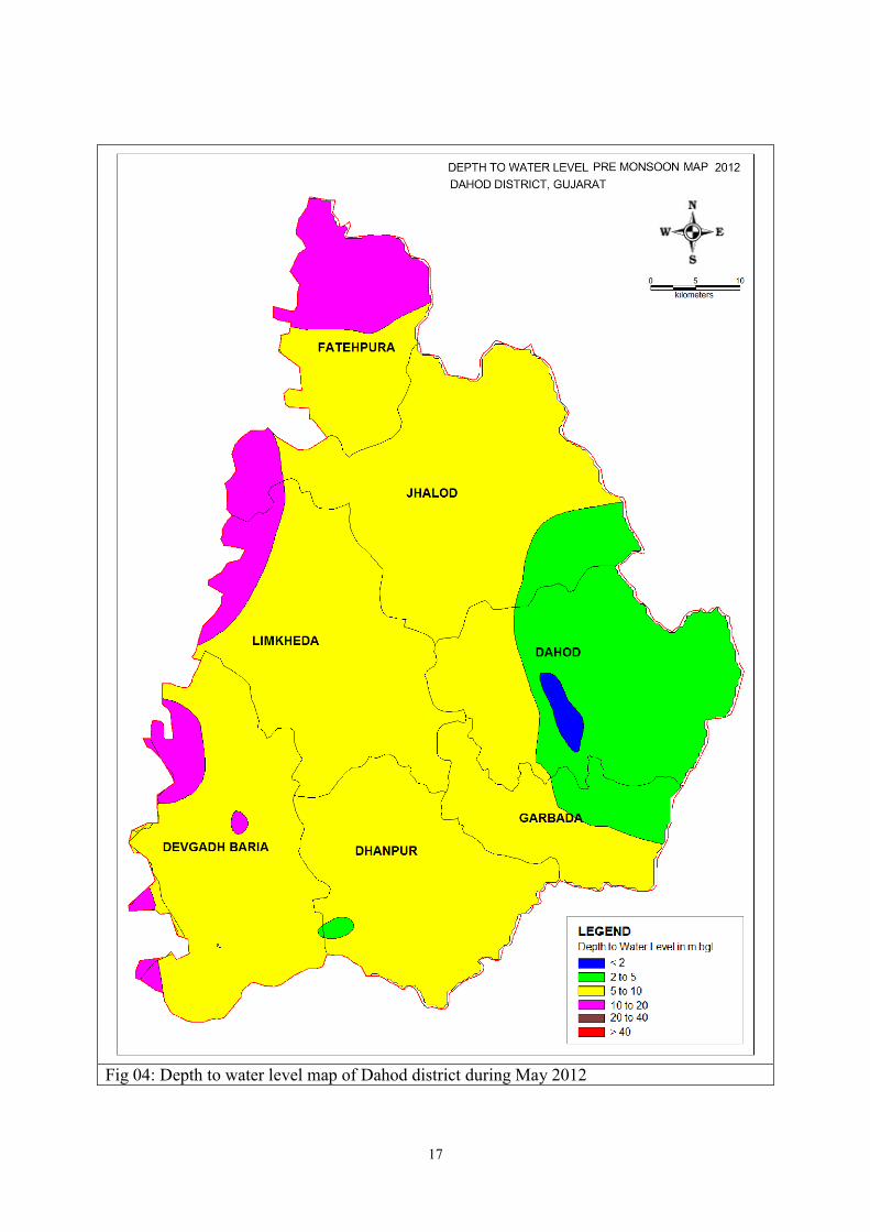
3.2. OCCURRENCE & DISTRIBUTION OF GROUND WATER
The groundwater in Dahod district occurs under confined and unconfined condition.
Unconsolidated shallow alluvium and weathered, jointed and fractured rock support
unconfined aquifers whereas interflow zones of basalts, inter trappean beds, encountered at
depth, deep seated fractures and shear zones give rise to confined conditions. All the
geological formations occurring in the district form aquifers, however, the phyllite, schist &
quartzite are the most extensive aquifers in the district. The deccan trap formation is second
most extensive aquifer in the district. Granite and gneiss also form aquifer in small area in the
south part of the district. Alluvium forms a potential but limited aquifer and occurs as
scattered isolated patches along river courses, valley fills, flood plain & abandoned
Palaeochannel deposits.
Generally, water level follows topographic configuration. As part of the hard rock, phyllites,
quartzites, schists, basalts, sandstone and limestones are forming aquifers. Alluvium and
valley fills materials form potential aquifers in the vicinity of rivers and piedmont zone but
their distribution is patchy with limited extension, rarely exceeding a few square kilometer in
area.
a) Phyllites, Schist and Quartzites as aquifer: Groundwater occurs under unconfined
conditions. The groundwater restricted to weather mantle and fractured/sheared zones.
Quartz veins act as good barriers and prevent groundwater subsurface flow. The depth
to weathering normally doesnot extend below 10m. The fracture and joints are wide
near surface or just below the weathered mantle and are effective as groundwater
conduits only for 0 to 20m below which they tend to be only like hair cracks. Intense
weathering of phyllites and schists results in production of impervious clayey matrix
where as quartzites produces sandy materials. However, weathering in quartzites is
very rare on account of their uniform and resistant nature. The discharge in the
exploratory wells varies from 0.1 to 3 lps with observed heavy drawdown. The depth
to water level vary with in 3 to 20m.
b) Basalts: The basalts form aquifer in the central part and northeastern part of the
district. Groundwater occurs under unconfined and confined condition in the
weathered mantle, joints, fractures and interflow zones. Inter trappean sediments often
carry granular sediments which form good aquifer locally. The water level vary with
in 4 to 13m with an discharge of 1 to 4 lps. The exploratory well at Rupapura have a
discharge of 4.4 lps.
c) Granite and gneisses: Groundwater occur under unconfined to confined condition.
The aquifer materials is weathered/fractured granite. The thicknesses of weathered
zone vary from 0 to 20m. Quartz and feldspar being major constituents, it produces
granular sandy materials. The depth of dugwell vary from 6 to 20m. The dug cum
borewells extended to a maximum depth of 26m. The gneisses form aquifer in the
south-western part of the Devgadh Baria taluka. The weathering nature of gneisses is
same as that of granite but the dark bands with mafic materials are prone to I intense
weathering and often produces less pervious materials. The depth wells vary from 10
to 17m. The water level in granitic area vary with in 3 to 15m with an discharge of 8
to 110 m3/day.

8
3.3. GROUNDWATER REGIME MONITORING
Ground water regime monitoring is the basic component of groundwater management and it
is carried out in parts of Dahod district through National Hydrograph Network Stations
(NHNS or NHS). NHSs are observation wells, comprising of dug wells and purpose built
bore wells – known as piezometers. There are 17 NHS and 6 piezometers as part of the NHS.
Depth to water level map of pre monsoon and post monsoon period and annual fluctuation of
water level are prepared with data of NHS for year 2012. With available data of systematic
and reappraisal hydrogeological surveys carried out in the district. The water level of the
district is described bellows. Figure 07: Hydrogeological map of Dahod district
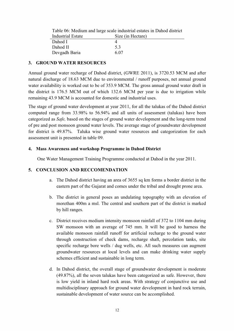
Depth to Water Level (May 2012)
The figure 04 shows depth to water level map of Dahod district, prepared on the basis of
NHS data of May 2012. In major part of the district, the water level ranged in between 5 to
10m, western part of the Limkheda, Jhalod and DEvgadh Baria taluka has the water level
range in between 10 to 20m. On the northern part, Fatehpura taluka also range in between 10
to 20 m bgl of water level. On the eastern part, water level range in between 2 to 5m bgl.
(Figure 04: DTW May 2012 map of Dahod district.)
Depth to Water Level (Nov 2012)
The figure 05 shows depth to water level map of November 2012. The major part of the
district have water level in range of 0 to 5m bgl while northern part of the Fatehpura taluka,
western part of Jhalod and Limkheda and Devgadh Baria talukas and southernpart of
Dhanpur taluka of the district ranged within 5 to 10m bgl. (Figure 05: DTW November 2012
map of Dahod district.)
Water Level Fluctuation (May - Nov 2012)
The figure 06 shows water level fluctuation map of the district for May- November 2012
period. In the fluctuation map, it shown rise in water level in all parts of the district in the
range of less than 2m to more than 4m. (Figure 06: Annual water level fluctuation May to
November 2012 map of Dahod district.)
Water Level Trend (2003 - 2011)
From the analysis of the water level trend of the Dahod district from 2003 to 2012, it is
observed that, during pre-monsoon, the water level has a rise of 0.0213 m/yr (Khandania) to
0.084 m/yr (Devgadh Baria) and also has a fall of 0.018 m/yr (Jhalod) to 0.4679 m/yr
(Dhanpur). Similarly from the analysis of the post-monsoon data of 2003 to 2012, the rise
shown by water level is vary from 0.0028 m/yr (Dadhela) to 0.1060 m/yr (Devgadh Baria)
and also has a fall of 0.0215 m/yr (Limkheda) to 0.4109 m/yr (Dhanpur). Hence, from the
analysis it is observed that, at Dhanpur, during both pre-monsoon and post-monsoon has a
trend of falling water level.

9
3.4. GROUNDWATER EXPLORATION
The boreholes drilled by CGWB as a part of Ground Water Exploration work, in various
parts of Dahod district have indicate that the sub surface geological formation in the district
comprises of layered sequences of Deccan Trap lava down to 250 m of explored depth. The
yield of bore wells varies widely from few lps to more than 20 lps. Overall, deep ground
water quality is suitable for both irrigation and domestic uses. Map showing location of
exploration is shown in figure 02 in Geological map of Dahod district.
The depth range of exploration varies from 38 to 295.15m. The minimum depth of drilling
38m at Fatehpura Karadiya of Fatehpur taluka and the maximum depth of drilling 295.15m at
Motibara of Fatehpur taluka. In total, from 1987 – 88 to 2009 – 10, 39 well drilled in the
districts.
The perusals of exploratory drillings data and hydrogeological sections reveal that, Aravalli
group of rocks form the basement in the area. Aravalli encountered at 15m at Chauki.
Both Aravallis and post-Delhi intrusive are overlain by Lower Cretaceous fluvial and marine
sequence namely Bagh beds and Lametas at Tarkhanda, Pavagadh and Chauki. They
comprises of a sequences of shale, sandstone and limestones. Shale vary in colour (buff white
to dark pink colour). Sandstone is medium to very coarse grained, conglomeratic at places
and in general cherty. The light pink shale formation, of this group is exposed around
Tarkhanda. The thickness of these groups varies from few meters to 42.5, as observed in
lithology of various bore holes.
Lower Cretaceous rocks are overlain by basalts. Basalts area observed as sporadic exposures
in the form of cappings. They interbedded by intertrappean sediments at some places.
Intertrappeans are of localized nature and have variable composition and thickness. Each
flow of basalts is separated by intertrappean sediments or red bole. Six flows of basalts were
recorded at Rupapura up to a depth of 79m while at Khajuri, three flows were recorded down
to a depth of 90m. The red bole bed represents zones of palaeo weathering and subsequent
baking of soil as formed.
4. HYDROCHEMISTRY
The Dahod district has mainly consisting of hard rock types hydrogeological provinces. In the
hard rock, it is constituted of granite and gneisses, meta sediments and Deccan traps.
Groundwater of the district originates as rainwater that infiltrates through soil into flow
system in the underlying geologic material. In Dahod district, higher plateau and hill zones of
central part and southern part constitute as recharge areas, which is underlain by deccan
basalts and granitic rocks. Major part of the area covered by meta sediments. As groundwater
moves along flowlines from recharge areas to discharge areas, the chemistry of groundwater
is altered by the effects of variety of geochemical processes. The range analytical result of
major ions of representative samples collected during various surveys and exploration works
along with NHS data are compiled and the range of major constituents and parameters are
given below in table 12.

10
Table 04: Summarised chemical data of Dahod district
Chemical Parameter Min Max Chemical Parameter Min Max
pH 7.6 8.02 F 0.6 6.7
EC 597 4430 Alk 240 590
TDS 400 2968 Ca 16 88
CO3 0 0 Mg 22 190
HCO3 293 720 TH 250 980
Cl 28 880 Na 43 572
NO3 2 430 K 1.2 33.7
SO4 7.26974 86.2605 Fe 0 7.7
*All values are in mg/l except pH and EC in µS/cm at 25°C
4.1. Ground Water Quality
Variation in chemical quality of ground water is due to hydrogeological factors controlled by
rock types, depicting aerial distribution of various water quality features. In terms of
electrical conductance (EC), measure of total dissolved salts in ground water is vary in
between 597 to 4430 µS/cm during May 2012. The chloride content of the district also vary
with in 28 to 880 mg/l. Nitrate content in the district is very high varying within 2 to 430
mg/l. At six places, namely Dahod (45mg/l), Dadhela (47 mg/l), Sukhsar (47 mg/l), Wadia
(85 mg/l), Dhanpur (100 mg/l), Garbara (430 mg/l), where found above 45 mg/l is unsuitable
drinking and domestic purpose. Similarly, fluoride content is varying within 0.6 to 6.7 mg/l.
At Khandania (1.5 mg/l), Dahod (2.5 mg/l) and Garbara (6.70 mg/l) are found above the
maximum permissible limit and not suitable for the drinking purpose. Iron is the heavy metal
that found in the groundwater of the district is varying from 0 to 7.7 mg/l. The maximum
value found at Jhalod is 7.70 mg/l and also found the maximum permissible limit, unsuitable
for drinking and domestic purpose (BIS 2012: IS10500). At Sukhsar (0.75 mg/l), Dhanpur
(0.88 mg/l) and Wadia (2.20 mg/l) are also found above the maximum permissible limit of
0.3 mg/l and unsuitable for drinking purpose comparing to BIS 2012: IS10500. In other
chemical ion, total hardness in terms of CaCO3, is found above the BIS maximum
permissible limit of 600 mg/l at Garbara (980 mg/l) found unsuitable for drinking and
domestic purpose. In other area, TH varies within 250 to 460 mg/l with a value of more than
200 mg/l found at 12 places.
2.1. WATER POLLUTION
Dahod district has a number of medium and small scale industries set up in the Dahod and
Devgadh Baria talukas focusing mainly on the agriculture and minerals industries. 4000
metric tonnes of quartz produces annually to support the ceramic, cement and glass
industries. Major small scale industries are deals in the sector such as rubber and plastic
products, food products, engineering, readymade garments and minerals. Dahod and Devgadh
Baria taluka have maximum number of industrial units in the district such as 875 and 541
units respectively. No major chemical quality problem reported so far, but looking at the
quality problems in other parts of the Gujarat due industrial set up, enforcing regulatory
measures mandatory before releasing of industrial effluents only after due treatment in ETPs
and solid waste disposal at designated sites.

11
Table 05: Chemical quality of groundwater for drinking and domestic purpose in Dahod district
Sl.No Chemical Parameter
BIS – 2012 (IS 10500)
Variation of
chemical data
during May
2012
No of sample
exceeding the
HDL
No of sample
exceeding the
MPL Highest
Desirable Limit
Maximum
Permissible Limit Min Max
1 pH 6.5 to 8.5 No Relaxation 7.6 8.02 Nil No Relaxation
2 Total Dissolved Solids 500 2000 400 2968 9 1
3 Total Hardness (as CaCO3) 200 600 250 980 12 1
4 Calcium 75 200 16 88 Nil Nil
5 Magnesium 30 200 22 190 11 Nil
6 Sodium - 200 43 572 - 2
7 Potassium - 12 1.2 33.7 - 1
8 Bicarbonate - - 293 720 - -
9 Chloride 250 1000 28 880 2 Nil
10 Sulphate 200 400 7.3 86.3 Nil Nil
11 Nitrate 45 No Relaxation 2 430 6 No Relaxation
12 Fluoride 1 1.5 0.6 6.7 3 3
13 Alkalinity 200 600 240 590 13 Nil
14 Iron as Fe (mg/l) 0.3 No Relaxation 0 7.7 4 No Relaxation
*Except pH all values are in mg/l
12
Table 06: Medium and large scale industrial estates in Dahod district
Industrial Estate Size (in Hectare)
Dahod I 4
Dahod II 5.3
Devgadh Baria 6.07
3. GROUND WATER RESOURCES
Annual ground water recharge of Dahod district, (GWRE 2011), is 3720.53 MCM and after
natural discharge of 18.63 MCM due to environmental / runoff purposes, net annual ground
water availability is worked out to be of 353.9 MCM. The gross annual ground water draft in
the district is 176.5 MCM out of which 132.6 MCM per year is due to irrigation while
remaining 43.9 MCM is accounted for domestic and industrial uses.
The stage of ground water development at year 2011, for all the talukas of the Dahod district
computed range from 33.98% to 56.94% and all units of assessment (talukas) have been
categorized as Safe, based on the stages of ground water development and the long-term trend
of pre and post monsoon ground water levels. The average stage of groundwater development
for district is 49.87%. Taluka wise ground water resources and categorization for each
assessment unit is presented in table 09.
4. Mass Awareness and workshop Programme in Dahod District
One Water Management Training Programme conducted at Dahod in the year 2011.
5. CONCLUSION AND RECCOMENDATION
a. The Dahod district having an area of 3655 sq km forms a border district in the
eastern part of the Gujarat and comes under the tribal and drought prone area.
b. The district in general poses an undulating topography with an elevation of
morethan 400m a msl. The central and southern part of the district is marked
by hill ranges.
c. District receives medium intensity monsoon rainfall of 372 to 1104 mm during
SW monsoon with an average of 745 mm. It will be good to harness the
available monsoon rainfall runoff for artificial recharge to the ground water
through construction of check dams, recharge shaft, percolation tanks, site
specific recharge bore wells / dug wells, etc. All such measures can augment
groundwater resources at local levels and can make drinking water supply
schemes efficient and sustainable in long term.
d. In Dahod district, the overall stage of groundwater development is moderate
(49.87%), all the seven talukas have been categorized as safe. However, there
is low yield in inland hard rock areas. With strategy of conjunctive use and
multidisciplinary approach for ground water development in hard rock terrain,
sustainable development of water source can be accomplished.

13
Table 07: Taluka wise groundwater development in Dahod district (2011)
Sl.No Talukas
Annual
Ground
Water
Recharge
Natural
Discharge
Net ground
Water
Availability
Annual Ground Water Draft Projected demand
for domestic &
industrial uses up
to 2025
Ground
Water
Availability
for future
irrigation
Stage of
Ground
Water
Development
Category Irrigation
Domestic
&
Industrial
uses
Total
1 Devgadh
Baria 55.17 2.76 52.41 22.5 6.3 28.8 8.39 21.52 54.95% Safe
2 Dhanpur 39.24 1.96 37.28 16.56 3.99 20.55 4.99 15.73 55.13% Safe
3 Dahod 49.46 2.47 46.99 15.42 6.97 22.39 8.72 22.85 47.65% Safe
4 Fatehpura 44.87 2.24 42.63 18.65 5.62 24.27 7.01 16.97 56.94% Safe
5 Garbada 32.4 1.62 30.78 6.16 4.3 10.46 5.39 19.23 33.98% Safe
6 Limkheda 64.32 3.22 61.10 23.98 7.24 31.22 9.06 28.06 51.09% Safe
7 Jhalod 87.07 4.35 82.72 29.28 9.53 38.81 11.91 41.53 46.92% Safe
District Total 372.53 18.63 353.90 132.55 43.95 176.5 55.47 165.88 49.87% Safe
Compute by RIF method
All values are in MCM except stage of GW development

14
e. Major part of the districts is underlain by hardrock formations of Aravalli
Super Group and Granie and Gneisses. Deccan trap and Infratrappean are also
observed at the central part and northern part. Hard rock formations in general
have vertical to sub-vertical joints. Alluvial deposits occur in the vicinity of
the river and in intermontane valleys. The thickness and extent of alluvial
formation is however very limited.
f. Sustainable groundwater management strategy to conserve existing resources
and preventive actions to control contamination of freshwater resources are
essential.
g. Strategy for regular monitoring for planned development and pollution control
with adequate enforcement directive is essential to prevent occurrence of
pollution incident in future.
h. The Dahod and Devgadh Baria talukas are highly industrialized. Periodic
monitoring of ground water along with quality should be mandatory.
i. The Central Ground Water Board has conducted only one ‘Water Management
Training Program’ in the district. Taking into consideration of tribal
domination and drought prone area, mass awareness programs in regular basis
can be arranged in the district for awareness on the depletion of groundwater
resources and quality problems.
j. Water Management Training Programme for capacity building measures for
technical officers / officials & Vos/NGOs working in the field of ground water
development and management may be trained to create awareness among the
people for consequent ground water resources depletion and quality problems.

15
Fig 01: Administrative map of the Dahod district

16
Fig 03: Geological map of Dahod district alongwith EW location.
17
Fig 04: Depth to water level map of Dahod district during May 2012

18
Fig 05: Depth to water level map of Dahod district during Nov 2012

19
Fig 06: Annual water level fluctuation map of Dahod district during May to Nov 2012
20
Legend
Rock type Wells
Feasible
Rigs
Suitable
Depth of
Well (m)
Discharg
e (lpm)
Artificial
Recharge
Structure
Suitable
Soft Rock
Aquifer
Dug Well Manual
10-25
200-300
Percolation
Tanks/
Ponds, Recharge
Wells,
Hard Rock
Aquifer
Dug Well
Borewell
Manual
Down the
Hole
Hammer
(DTH)
10-25
50-100
60-100
60-150
Percolation
Tanks/
Ponds, Recharge
Wells,
Check Dams,
Nalla Bunds.
Hard Rock
Aquifer
Dug Well
Borewell
Manual
Down the
Hole
Hammer
(DTH)
10-25
100-200
80-150
100-300
Percolation
Tanks/
Ponds, Recharge
Wells,
Check Dams,
Nalla Bunds.
Hilly Areas
Not Suitable
Check Dam,
Nalla Bund,
Gully Plug
Pre-monsoon Decadal
mean (1993-2000) Depth
to Water Level (mbgl)
Electrical Conductivity
(µS/cm at 25° C)
Fluoride > Maximum
Permissible Limit (1.5
mg/l)
Nitrate > Maximum
Permissible Limit (100 mg/l)
Drainage / District/Taluka HQ
Fig 07: Hydrogeological map of Dahod district
2020
00

21