
Celbridge - County Kildarekildare.ie/CountyCouncil/Planning/DevelopmentPlans/LocalAreaPlans... ·...
87
Celbridge Local Area Plan 2017-20 Dréachtphlean Ceantair Planning Department Kildare County Council September 2017 (Subject to Draft Minister Development Act, 2000 (as 023 r Áitiúil Cill Droichid rial Direction under Section 31 of the s amended)) e Planning &
Transcript of Celbridge - County Kildarekildare.ie/CountyCouncil/Planning/DevelopmentPlans/LocalAreaPlans... ·...

Celbridge
Local Area Plan 2017-2023
Dréachtphlean Ceantair Áitiúil Cill Droichid
Planning Department
Kildare County Council
September 2017
(Subject to Draft Ministerial Direction under Section 31 of the Planning &
Development Act, 2000 (as amended))
2023
Dréachtphlean Ceantair Áitiúil Cill Droichid
Ministerial Direction under Section 31 of the Planning &
Development Act, 2000 (as amended))
Ministerial Direction under Section 31 of the Planning &


Celbridge Local Area Plan 2017-2023
2
CONTENTS 1. Introduction ......................................................................................................................................... 6
1.1 LOCAL AREA PLAN STATUS AND PROCESS .................................................................................... 6
1.2 REQUIREMENT TO PREPARE LOCAL AREA PLAN ........................................................................... 6
1.3 FORM AND CONTENT OF THE LOCAL AREA PLAN ........................................................................ 6
1.4 PUBLIC CONSULTATION ................................................................................................................ 6
1.5 ENVIRONMENTAL REPORT ............................................................................................................ 7
1.6 PLANNING POLICY ......................................................................................................................... 7
2. Celbridge in Context ............................................................................................................................ 8
2.1 HISTORICAL DEVELOPMENT .......................................................................................................... 8
2.2 SPATIAL PLANNING CONTEXT ....................................................................................................... 8
3. Vision for Celbridge ........................................................................................................................... 10
3.1 STRATEGIC VISION ...................................................................................................................... 10
3.2 STRATEGIC OBJECTIVES ............................................................................................................... 10
4. Compliance with Core Strategy ........................................................................................................ 12
4.1 FUNCTION, POPULATION AND SCALE OF CELBRIDGE ................................................................. 12
4.2 RETAIL DEVELOPMENT ................................................................................................................ 14
4.3 EMPLOYMENT ............................................................................................................................. 14
4.4 INFRASTRUCTURE ....................................................................................................................... 15
4.5 ENVIRONMENT AND HERITAGE PROTECTION ............................................................................ 15
4.6 FUTURE DEVELOPMENT PRIORITIES ........................................................................................... 15
5. Urban Centres & Retailing ................................................................................................................ 17
5.1 TOWN CENTRE ............................................................................................................................ 17
5.2 TOWN CENTRE EXPANSION ........................................................................................................ 18
5.3 RETAILING ................................................................................................................................... 19
5.4 TOWN CENTRE PUBLIC REALM ................................................................................................... 21
5.5 SHOP FRONTS & ADVERTISING ................................................................................................... 22
5.6 UNDESIRABLE USES ..................................................................................................................... 22
6. Housing & Community ...................................................................................................................... 24
6.1. DEMOGRAPHIC PROFILE ............................................................................................................ 24
6.2 HOUSING STOCK ......................................................................................................................... 25
6.2.1 Residential Development: Capacity and Delivery ................................................................. 26
6.2.2 Residential Density, Mix and Design ..................................................................................... 27
6.3 COMMUNITY FACILITIES ............................................................................................................. 28

Celbridge Local Area Plan 2017-2023
3
6.3.1 Education .............................................................................................................................. 29
6.3.2 Early Childcare and Education .............................................................................................. 29
6.3.3 Healthcare ............................................................................................................................. 30
6.3.4 St John of God, Celbridge ...................................................................................................... 30
6.4 ADDITIONAL SOCIAL INFRASTRUCTURE ...................................................................................... 30
6.5 CELBRIDGE INTEGRATED SERVICES PROGRAMME ..................................................................... 31
7. Economic Development .................................................................................................................... 33
7.1 CONTEXT ..................................................................................................................................... 33
7.2 ECONOMIC PROFILE .................................................................................................................... 33
7.3 ECONOMIC DEVELOPMENT ........................................................................................................ 33
7.4 TOURISM ..................................................................................................................................... 34
7.5 DERELICT SITES AND VACANT SITES............................................................................................34
7.6 NON CONFORMING USES ........................................................................................................... 36
8. Movement & Transport .................................................................................................................... 37
8.1 WALKING AND CYCLING .............................................................................................................. 37
8.2 PUBLIC TRANSPORT .................................................................................................................... 39
8.3 ROADS AND STREET NETWORK .................................................................................................. 40
8.4 CAR PARKING .............................................................................................................................. 42
9. Infrastructure .................................................................................................................................... 43
9.1 WATER ......................................................................................................................................... 43
9.1.1 Water Supply ......................................................................................................................... 43
9.1.2 Wastewater ........................................................................................................................... 43
9.2 SURFACE WATER DRAINAGE ....................................................................................................... 44
9.3 FLOOD RISK MANAGEMENT ....................................................................................................... 44
9.4 ENERGY SUPPLY AND COMMUNICATIONS ................................................................................. 46
9.5 SOLID WASTE .............................................................................................................................. 47
10. Built & Natural Heritage .................................................................................................................. 48
10.1 HISTORICAL BACKGROUND ....................................................................................................... 48
10.2 ARCHAEOLOGICAL HERITAGE ................................................................................................... 48
10.3 ARCHITECTURAL HERITAGE....................................................................................................... 50
10.4 NATURAL HERITAGE .................................................................................................................. 55
11. Green Infrastructure & Strategic Open Spaces .............................................................................. 57
11.1 GREEN INFRASTRUCTURE ......................................................................................................... 57
11.2 HABITAT MAPPING ................................................................................................................... 57
11.3 OPEN SPACES ............................................................................................................................ 59

Celbridge Local Area Plan 2017-2023
4
12. Urban Design & Key Development Areas ....................................................................................... 61
12.1 URBAN DESIGN ......................................................................................................................... 61
12.2 KEY DEVELOPMENT AREAS - DESIGN CONCEPTS ...................................................................... 61
12.2.1 KDA 1 – St. Raphael’s (Oakley Park) ....................................................................................... 61
12.2.2 KDA 2 – Ballyoulster ............................................................................................................... 63
12.2.3 KDA 3 – Oldtown .................................................................................................................... 64
12.2.4 KDA 4 – Crodaun .................................................................................................................... 66
12.2.5 KDA 5 – Simmonstown ........................................................................................................... 67
13. Implementation ............................................................................................................................... 69
13.1 IMPLEMENTATION STRATEGY................................................................................................... 69
13.2 DEVELOPMENT MANAGEMENT ................................................................................................ 69
13.3 LAND USE ZONING OBJECTIVES ................................................................................................ 69
13.4 LAND USE ZONING MATRIX ...................................................................................................... 71
13.5 PHASING .................................................................................................................................... 72
13.5.1 Key Development Areas (KDAs) .......................................................................................... 72
Maps ...................................................................................................................................................... 75
Appendix 1 ............................................................................................................................................. 83

Celbridge Local Area Plan 2017-2023
5
LIST OF FIGURES Figure 2.1 Celbridge Figure 2.2 Kildare County Development Plan 2017-2023 Settlement Hierarchy Figure 4.1 Core Strategy Map Figure 5.1 Town Centre Extension Concept Figure 5.2 Celbridge Core Retail Area Figure 6.1 Celbridge Populations Figure 6.2 Household Size Celbridge and Kildare Figure 6.3 Spatial distribution of housing in Celbridge 1998 - 2016 Figure 6.4 Community Facility Distribution Figure 8.1 Cycle Network Plan for the GDA – Celbridge Figure 9.1 An Overview of the CFRAM flood zones and historical flood events in Celbridge Figure 9.2 Overhead Power line Network Figure 11.1 Habitat composition of Celbridge Figure 12.1 Design Concept for KDA 2 Ballyoulster Figure 12.2 Design Concept for KDA 3 Oldtown Figure 12.3 Design Concept for KDA 4 Crodaun Figure 12.4 Design Concept for KDA 5 Simmonstown
LIST OF TABLES Table 4.1 Estimated Residential Capacity Table 6.1 Population Profile Table 6.2 Community Facilities in Celbridge Table 7.1 Celbridge Labour Force breakdown 2011 Table 10.1 Recorded Monuments and Places Table 10.2 Record of Protected Structures Table 10.3 Scenic Routes and Protected Views Table 13.1 Land Use Zoning Objectives Table 13.2 Zoning Matrix – Definition of Terms Table 13.3 Land Use Zoning Matrix
LIST OF MAPS Map 8.1 Transport and Movement Map Map 9.1 Strategic Flood Risk Assessment Map Map 10.1 Natural & Archaeological Heritage Map Map 10.2 Built Heritage Map Map 10.2A Built Heritage Map Map 12.1 Key Development Areas Map 13.1 Land Use Zoning Objectives Map

Celbridge Local Area Plan 2017-2023
6
1. INTRODUCTION
1.1 LOCAL AREA PLAN STATUS AND PROCESS
The Celbridge Local Area Plan 2017-2023 (LAP) has been prepared in accordance with the requirements and provisions of the Planning and Development Act 2000 (as amended). It sets out an overall strategy for the proper planning and sustainable development of Celbridge in the context of the Kildare County Development Plan 2017-2023 (CDP) and the Regional Planning Guidelines (RPGs) for the Greater Dublin Area 2010-2022. It is informed by Ministerial Guidelines issued pursuant to Section 28 of the Planning and Development Act 2000, as amended, together with EU requirements regarding Strategic Environmental Assessment (SEA) and Appropriate Assessment (AA). The LAP replaces the Celbridge Local Area Plan 2010. It is a policy of the Kildare County Development Plan 2017-2023 (Policy PSO3) to extend the LAP boundary to incorporate the demesnes of Castletown, Donaghcumper and St. Wolstan’s as these historic landscapes form an integral part of the history of Celbridge, whilst also providing significant opportunities for the town.
1.2 REQUIREMENT TO PREPARE LOCAL AREA PLAN Sections 18 - 20 of the Planning and Development Act 2000, as amended, provide that a local area plan shall be made in respect of an area which:–
Is designated as a town in the most recent census of population, other than a town designated as a suburb or environs in that census;
Has a population in excess of 5,000; and
Is situated within the functional area of a planning authority, which is a County Council.
Census 2016 recorded a population of 20,288 persons in the town of Celbridge. A Local Area Plan is therefore a mandatory requirement.
The period of this plan shall be taken as being six years from the date of its adoption or until it is reviewed or another plan made, unless it is extended under section 19 (d) of the Planning and Development Act 2000 as amended. This LAP was adopted at a meeting of the Celbridge – Leixlip Municipal District on the 17th of August 2017. 1.3 FORM AND CONTENT OF THE LOCAL AREA PLAN The Plan consists of a written statement with accompanying maps. The written statement shall take precedence over the maps should any discrepancy arise between them. In the full interpretation of all objectives for Celbridge, it is essential that both the County Development Plan (CDP) and the Local Area Plan (LAP) are read in tandem. Where conflicting objectives arise between the CDP and the LAP, the objectives of the CDP shall take precedence. General development management standards are contained in the CDP, while policies and objectives that are specific to Celbridge are included in the LAP. 1.4 PUBLIC CONSULTATION The review of the Celbridge Local Area Plan 2010 commenced in February 2015. Kildare County Council published a background Issues Paper and invited submissions and observations from interested parties between 28th February 2015 and 31st March 2015. Submissions were received from residents, service providers, from local community and recreation groups, local representatives and from adjoining local authorities. A total of 33 submissions were received and the issues raised are summarised in the Chief Executive’s Report on Pre-Draft Consultation dated July 2016. A further phase of targeted stakeholder consultation was undertaken in July, August and September 2016 with

Celbridge Local Area Plan 2017-2023
7
local community groups, infrastructure providers, sectoral groups and statutory agencies. Both stages of consultation have informed the plan making process. 1.5 ENVIRONMENTAL REPORT The preparation of this Local Area Plan has been informed by the preparation of a Strategic Environmental Assessment (SEA) in accordance with the Planning and Development (Strategic Environmental Assessment) Regulations 2004, and a Stage One Appropriate Assessment Screening Report, pursuant to Article 6 of the Habitats Directive 94/42/EEC. Strategic Flood Risk Assessment and Habitat Reports have also informed the plan. 1.6 PLANNING POLICY The Plan has been prepared having regard to national, regional and local policy documents, including the following;
National Spatial Strategy 2002-2020
Building on Recovery: Infrastructure and Capital investment 2016-2021 (2014)
Our Sustainable Future: A framework for Sustainable Development for Ireland (2012)
Smarter Travel, A Sustainable Transport future 2009-2020 (2009)
Rebuilding Ireland - Action Plan for Housing and Homelessness
National Cycle Policy Framework
National Climate Change Adaptation Framework: Building Resilience to Climate Change (2012)
National Energy Efficiency Action plan 2009-2020 (2009)
National Renewable Energy Action Plan (2010)
Government Policy Statement on the Strategic Importance of Transmission and other Energy Infrastructure (2012)
Actions for Biodiversity – Irelands National Biodiversity Plan 2011-2016 (2011)
National Broadband Plan 2012
Water Services Strategic Plan: A Plan for the Future of Water Services
Regional Planning Guidelines for the greater Dublin Area (RPGs) 2010-2022 (2010)
Retail Strategy for the Greater Dublin Area 2008-2016 (2008)
Transport Strategy for the Greater Dublin Area 2016-2035
Eastern and South Eastern River Basin Management Plan (2009-2015)1
Water Supply Project Eastern & Midlands Region
Kildare County Development Plan 2017-2023
Kildare Local Economic & Community Plan (LECP) 2016-2021
Local Area Plans; Guidelines for Planning Authorities DECLG/DoAHG (2013)
Manual for Local Area Plans DECLG/DoAHG (2013)
ISP Celbridge Plan 2016-2020 - Integrated Services Programme
Celbridge Gateway to Ireland’s Ancient East - Heritage and Tourism Strategy 2016-2020
Designed Landscapes of Castletown, Celbridge and Adjacent Demesnes (2006)
Celbridge River Crossing Feasibility Report (2015)
Spatial Planning and National Roads Guidelines for Planning Authorities
1 Preparation of the second cycle of the River Basin Management Plans 2015-2021 is currently underway

Celbridge Local Area Plan 2017-2023
8
2. CELBRIDGE IN CONTEXT 2.1 HISTORICAL DEVELOPMENT
Celbridge was established beside the River Liffey and has grown around a crossing point on the river. The town has early Christian origins and may have existed as a monastic site from the 5th century. It later became an Anglo Norman borough. The town in its current form developed alongside Castletown Demesne from the early 18th century. The distinctive Georgian streetscape and tree-lined avenue that links the town to Castletown House developed from 1720. The existing bridge crossing of the River Liffey dates from between 1780 and 1820.
Figure 2.1 Celbridge (source; Open Street Map)
Located 23 kilometres west of Dublin, Celbridge is located in the Metropolitan area of Dublin and maintains strong economic and social links to Dublin2. The M4 motorway bounds the town to the north and the Dublin Cork rail line and the Grand Canal runs to the south.
Celbridge has grown rapidly over the past 60 years from a population of 567 persons in 1951 to a population of 20,288 persons in 2016. Expansion since the 1950s has taken a suburban form extending out from the historic core. Development has occurred to the north of the Liffey, between Main Street and the M4 Motorway. Development to the south of the Liffey is focused along the Hazelhatch and Ardclough Roads with development over the last ten years taking place in the south of the town, in the areas of Primrose Gate, St. Wolstan’s Abbey, and Hazelhatch Park. With the exception of the Crodaun and Castletown housing estates which were constructed in the mid-1970’s the historic demesnes of Castletown, Donaghcumper and St. Wolstan’s to the east of the town have remained free from development and retain their open landscape character.
2.2 SPATIAL PLANNING CONTEXT The County Development Plan sets out the overall strategy for the proper planning and sustainable development of County Kildare in accordance with national and regional policy. The RPGs for the
2 The Regional Planning Guidelines (RPGs) for the Greater Dublin Area (GDA), 2010 - 2022, distinguish between
the built up area of Dublin and its environs and the wider GDA by defining a Metropolitan Area and Hinterland Area. The Metropolitan area, as defined by the RPG’s, includes the towns of Celbridge, Leixlip, Maynooth and Kilcock.

Celbridge Local Area Plan 2017-2023
9
Greater Dublin Area, 2010 designate Leixlip, Maynooth, Naas, and Newbridge as Large Growth Towns and Athy, Celbridge, Kilcullen, Kildare, Kilcock and Monasterevin as Moderate Growth Towns. Small Towns and Villages are defined at County Level by the CDP. Celbridge is a Moderate Sustainable Growth Town in the Metropolitan area of Dublin. The RPGs state that Moderate Sustainable Growth Towns in the Metropolitan area are strong district service centres with high quality linkages. They will continue to have a strong role as commuter locations and growth needs to be based on and related to the capacity of high quality public transport connections and the capacity of social infrastructure.
Fig. 2.2 Kildare County Development Plan 2017‐2023 Settlement Hierarchy
Naas
Newbridge, Leixlip, Maynooth
Celbridge, Kilcock
Kildare Town, Monasterevin, Kilcullen, Athy
Clane, Rathangan, Derrinturn, Properous, Kill, Sallins, Athgarvan,
Castledermot
Villages
Rural Settlements
Rural nodes

Celbridge Local Area Plan 2017-2023
10
3. VISION FOR CELBRIDGE 3.1 STRATEGIC VISION The Local Area Plan for Celbridge is underpinned by a Strategic Vision which is intended to guide the future growth of Celbridge in a sustainable manner, recognising its assets, and enhancing the town’s character, heritage and amenities. The Strategic Vision is based on detailed analysis of the profile, functions and activities of Celbridge set against its position in the Regional and County Settlement Hierarchy as follows:
“To promote the sustainable growth of Celbridge as a Moderate Sustainable Growth Town, recognising its strategic position in North Kildare within the Metropolitan area of Dublin. In this context, the plan will seek to support population growth that is based on the capacity of physical and social infrastructure in a plan led approach; to support and enhance quality of life for existing and future populations; to protect and enhance the significant built and natural heritage assets of the town; to support economic development that is based on local strengths including heritage and tourism; to promote sustainable movement and identify opportunities to enhance connectivity; and to identify opportunities for the delivery of supporting infrastructure, facilities and amenities.”
The LAP seeks to strengthen Celbridge’s unique character and identity and to ensure that future growth has a positive impact on the town.
3.2 STRATEGIC OBJECTIVES The LAP and overall vision for Celbridge is underpinned by the following strategic aims:
To accommodate 10% of Kildare’s housing growth over the period 2017-2023 in accordance with the County Development Plan Core Strategy.
To enhance the quality, ambience and vitality of Celbridge Town Centre through renewal and extension and to promote its role as a vibrant retail, cultural and community centre that is integrated with the wider heritage assets of the town.
To support and facilitate the development of high quality, integrated residential neighbourhoods and deliver social and community infrastructure and facilities in tandem with new housing.
To promote and support economic development that is consistent with the role of Celbridge as a Moderate Sustainable Growth Town. The town’s location in the North Kildare Economic Cluster and its heritage and tourism assets are identified as key economic strengths.
To enhance the existing transport network by increasing permeability and connectivity for pedestrians, cyclists and vehicles, in order to enable access to key land uses such as community facilities, public transport nodes and the town centre, as well as the crossing of the River Liffey.
To phase future growth in line with the capacity of supporting physical infrastructure and to ensure that it occurs in accordance with proper planning and sustainable development.

Celbridge Local Area Plan 2017-2023
11
To protect and enhance the unique built and natural heritage as the defining character of Celbridge and a pillar for sustainable growth, by promoting the enhancement, management and understanding of these assets.
To protect and enhance Green Infrastructure assets and create an interconnected network of parks, open spaces, demesne lands and watercourses in Celbridge.
To ensure development proposals conform with best practice urban design principles on the
basis that well planned and integrated development will enhance the town and its environs
and improve the quality of life of its residents.
To phase new development to ensure that it occurs in an orderly and efficient manner in
accordance with proper planning and sustainable development.
The Strategic Vision and objectives are expanded upon in the policies, objectives and key actions contained within the remainder of this LAP. The policies and objectives of the LAP should be read in conjunction with the CDP.

Celbridge Local Area Plan 2017-2023
12
4. COMPLIANCE WITH CORE STRATEGY To accommodate 10% of Kildare’s housing growth over the period 2017-2023 in accordance with the County Development Plan Core Strategy.
4.1 FUNCTION, POPULATION AND SCALE OF CELBRIDGE Celbridge is situated in the Metropolitan area of Dublin and is identified as a Moderate Sustainable Growth Town, within the meaning of the RPGs and the County Settlement Hierarchy. The RPGs state that Moderate Sustainable Growth Towns in the Metropolitan area of Dublin are strong edge of Metropolitan Area district service centres with high quality linkages. They will continue to have a strong role as commuter locations and growth needs to be based on and related to the capacity of high quality public transport connections and the capacity of social infrastructure.
The Core Strategy of the CDP 2017-2023 allocates 10% of Kildare’s housing growth to Celbridge over the period 2017-2023, out of a total housing allocation of 32,497 units for the County. Table 3.3 of the CDP identifies a housing unit target of 10,333 units for Celbridge to the year 2023, through the addition of 3,250 housing units over the Plan period. This represents an overall target population for the town of 22,801 persons.
This LAP identifies 121.2 hectares of land with a residential or mixed use zoning (excluding proposed arterial roads). The housing capacity of zoned lands, including new residential zonings, mixed use zonings and of infill sites within the built up area is estimated to be 3,519 (approx.) residential units (Table 4.1 refers).
The scale and form of development envisaged in Celbridge under the LAP is consistent with the settlement and economic development aims of the Core Strategy. The LAP identifies five no. Key Development Areas (KDAs) with capacity to accommodate significant growth over the LAP period. KDA 1 is town centre expansion site that has the potential to accommodate a mix of retail, commercial, community and residential uses. KDA 2, KDA 3, KDA 4 and KDA 5 are greenfield sites at the edge of the existing built up area of the town that have the capacity to accommodate new housing and support physical and social infrastructure. Consolidation and infill development is also promoted on appropriately zoned land within the plan area. Table 4.1 sets out the size and estimated residential capacity for each area and Map 4.1 identifies the Key Development Areas.

Celbridge Local Area Plan 2017-2023
13
Location of Development Quantum of Land
for Housing (HA)
Estimated
Residential
Capacity*
Estimated
Density
KDA 1
St. Raphael’s
Town Centre Extension
9 100-150 Mixed Use Site
KDA2
Ballyoulster
New Residential Area
29.5 885 30
KDA 3
Oldtown
New Residential Area
13.7 411 30
KDA 4
Crodaun
New Residential Area
19.9 600 30
KDA 5
Simmonstown
New Residential Area
35 1050 30
Other Sites
14.1 423 Infill
Total
121.2 3519
Table 4.1 Estimated Residential Capacity
*Figures stated represent an estimate only. The density of development and number of units permissible will be determined at detailed design stage based on a full assessment of site characteristics and local sensitivities.
** Town Centre extension site – residential indicative only.
The Plan supports the achievement of the Core Strategy growth allocation of 3,250 units and incorporates a level of flexibility to meet demand over a 9 year horizon.

Celbridge Local Area Plan 2017-2023
14
Figure 4.1 Core Strategy Map
4.2 RETAIL DEVELOPMENT Celbridge is designated as a Tier 1 Level 3 Retail Centre in the Regional and County Retail Hierarchies. The policies and objectives of this LAP seek to strengthen the established retail function of Celbridge Town Centre by promoting renewal and appropriate infill development in the town centre and town centre expansion to identified opportunity sites to the south. Retail provision outside of the town centre will be limited to evolutionary renewal of established neighbourhood centres and to new residential districts. 4.3 EMPLOYMENT Celbridge is part of the North Kildare Economic Growth Cluster and linked to the Primary Economic Growth Towns of Maynooth and Leixlip. Celbridge will continue to benefit from its proximity to the Primary Economic Growth Towns and large employment sites in Leixlip and Maynooth. Economic development within the LAP area will focus on the potential of the town centre and the town’s significant heritage and tourism offer.

Celbridge Local Area Plan 2017-2023
15
4.4 INFRASTRUCTURE The realisation of the objectives contained in this LAP is dependent on supporting infrastructure. The capacity of the water supply and wastewater network will be a critical determinant for significant new development in Celbridge. The capacity of the transportation network will be a critical determinant for growth. In particular, a new vehicular crossing of the River Liffey is required to support the extent of development proposed.
It is proposed to prepare a Transport Management Plan (including Public Transport Accessibility Strategy) to support the sustainable growth and development of Celbridge. The proposed Transport Management Plan will include recommendations for the phasing of development on the basis of the timely delivery of strategic infrastructure. In the interim it is considered appropriate that KDA 5 Simmonstown be dependent on the delivery of the new vehicular bridge and that all other major development proposals will require a Traffic Impact Assessment to assess the capacity of the existing transport network to support the proposed development.
The Council will consider the feasibility of preparing a Special Development Contribution Scheme under Section 48 of the Planning and Development Act 2000 (as amended) to support the preparation and implementation of the Traffic Management Plan.
4.5 ENVIRONMENT AND HERITAGE PROTECTION The environmental sensitivities of the county identified through the SEA process for the County Development Plan have informed the development of the Core Strategy and the role it identifies for Celbridge. The LAP responds to environmental factors including wastewater infrastructure constraints and areas at risk of flooding. The LAP acknowledges the unique character and intrinsic value of the town centre, Castletown House and the linked demesnes in Celbridge and incorporates objectives for the conservation and enhancement of these areas. Additionally, the LAP has objectives relating to securing strategic open space and green infrastructure, particularly improving accessibility to the River Liffey. 4.6 FUTURE DEVELOPMENT PRIORITIES There will be a need over the lifetime of this LAP to consider the longer-term growth of Celbridge and in particular the potential of lands in the vicinity of Hazelhatch/Celbridge Rail Station. Key issues that will need to be considered include flood management; the potential of the public transport network should the DART network expansion programme proceed; and the potential for integrated development on adjoining lands in South County Dublin. It is envisaged that the potential of lands in the vicinity of Hazelhatch/Celbridge rail station will be explored during the life of this LAP.
Policy CS1 – Core Strategy It is the policy of the Council to support the sustainable long-term growth of Celbridge in accordance with the Core Strategy of the Kildare County Development Plan 2017-2013. Objectives It is an objective of the Council: CSO1.1: To support and facilitate sustainable intensification and consolidation in the town centre
and in established residential areas. CSO1.2: To support new residential development in Key Development Areas (KDAs) in tandem
with the delivery of supporting physical and social infrastructure. CSO1.3: To support economic and social development that is consistent with the role of Celbridge
as a Moderate Sustainable Growth Town. CSO1.4: To investigate options for the long-term development of Celbridge, and in particular the
potential of lands in the vicinity of Hazelhatch/Celbridge rail station for development, in

Celbridge Local Area Plan 2017-2023
16
consultation with the NTA, Irish Rail, South Dublin County Council, the OPW and other statutory agencies and stakeholders.
CSO1.5: To support and facilitate development on zoned lands based on the policies and objectives of the Kildare County Development Plan 2017-2023 and the Celbridge Local Area Plan 2017-2023.

Celbridge Local Area Plan 2017-2023
17
5. URBAN CENTRES & RETAILING To enhance the quality, ambience and vitality of Celbridge Town Centre through renewal and extension and to promote its role as a vibrant retail, cultural and community centre that is integrated with the wider heritage assets of the town.
5.1 TOWN CENTRE Celbridge town centre defines the character and attractiveness of the town. It has evolved since the early 18th century and remains the focus for a broad range of commercial and community activities. The mix of interdependent uses and a historic streetscape and landscape setting all contribute to its sense of place and identity. In recent years new retail developments on the periphery of the town centre, on the Maynooth Road (Tesco, Lidl and Aldi) and Dublin Road (Supervalu) have altered the dynamic of the town centre and drawn activity away from Main Street. This LAP seeks to support the primacy of the town centre as the focus for retail and commercial activity and community life and to attract activity back to the Main Street. In order to reinforce the town centre as a viable and vibrant centre, a mix of retail and commercial, civic, social and cultural uses, in addition to residential development will be encouraged.
Figure 5.1 Town Centre Extension Concept

Celbridge Local Area Plan 2017-2023
18
Key priorities during the LAP lifetime include:
Enhancement and improvement of the physical fabric and environment of the town centre;
Consolidation of development in the town centre area;
Expansion of the town centre to identified edge of centre sites;
Enhanced connectivity within the town centre;
Improved access from the town centre to the surrounding residential districts; and
Improved linkages from the town centre to heritage assets such as the river and historic demesnes.
Policy TC1 ‐ Town Centre It is the policy of the Council to protect and enhance the role of Celbridge Town Centre as a vibrant and attractive town centre that meets the retailing and service needs of the area in addition to harnessing its potential as a heritage and tourism destination within the region. Objectives It is an objective of the Council: TCO1.1: To protect and enhance the commercial and retail primacy and function of the town
centre and promote new development that consolidates the existing urban core through regeneration and infill.
TCO1.2: To protect the quality, ambience, vibrancy and vitality of Celbridge Town Centre by promoting an appropriate mix of day and night time uses.
TCO1.3: To support development that will strengthen the town centre and act as a catalyst for renewal.
TCO1.4: To promote a high standard of urban design in the town centre that contributes to the creation of safe and attractive streets and spaces and creates a desirable place in which to work, live and visit.
TCO1.5: To encourage and facilitate the re-use and regeneration of vacant or underused sites for appropriate town centre uses and encourage the full use of buildings and in particular, upper floors and back lands.
TCO1.6: To achieve greater economic use of town centre premises through encouraging residential uses above ground floor. The Council will actively encourage initiatives such as ‘living over the shop’ and other similar initiatives.
TCO1.7: To improve the accessibility of the town centre with particular emphasis on creating an environment that is accessible to pedestrians and cyclists.
TCO1.8: To support the continued use of the Mill Centre as an activity hub for the town and support improvement and intensification of activity at this location and to work to ensure that the Mill Centre is accessible for all.
Actions To work with relevant agencies and stakeholders to undertake a retail health check survey in the town centre and identify actions to support town centre regeneration.
5.2 TOWN CENTRE EXPANSION Celbridge Town Centre is focused around the historic core and has not expanded to any significant extent since the 18th Century, despite the wider growth of the town. New retail development to serve the growing population has occurred on the periphery of the town along the Maynooth Road and Dublin Road. This has drawn activity away from the town centre. Town centre expansion, on opportunity sites at the edge of the town centre presents an opportunity to strengthen the town centre and to provide for the retailing and service needs of the town’s growing population.

Celbridge Local Area Plan 2017-2023
19
An opportunity site is identified to the south of the Main Street at St Raphael’s (Oakley Park). This site has capacity to accommodate town centre development and to act as a catalyst for town centre regeneration.
St Raphael’s (Oakley Park), Celbridge is owned by the Saint John of God Trust, where it provides a range of day, educational, residential and respite services. The campus is located at the southern end of Celbridge Main Street within the historic walled demesne of ca. 10.3 hectares. This LAP supports the ongoing use of this site for community and educational purposes. The LAP also supports new retail, office, residential, community and amenity uses on the site, in conjunction with the consolidation of the community and educational uses on site.
Policy TCE 1 ‐ Town Centre Expansion It is the policy of the Council to reinforce the retail and services function of the town centre by ensuring that the expansion of the town centre occurs on appropriate edge of town centre sites. Objectives It is an objective of the Council: TCEO1.1: To support town centre uses on identified opportunity site to the south of Main Street at
St. Raphael’s (Oakley Park) subject to the protection of the architectural character of the area.
TCEO1.2: To support an appropriate mix of uses on town centre expansion sites such as retail, office, residential, community and amenity uses.
TCEO1.3: To ensure that town centre expansion sites are supported by direct walking and cycle links to the Main Street.
5.3 RETAILING Retail planning policy in Kildare is informed by retail guidance documents at national and regional level. These include the Guidelines for Planning Authorities: Retail Planning, DECLG (2012) and the Retail Strategy for the Greater Dublin Area 2008-2016 (2008). Celbridge (along with Maynooth) is designated as a Tier 1 Level 3 Town Centre in the GDA Retail Strategy and in the County Retail Hierarchy and provides a local retail and services function to serve daily needs. The future retail potential of Celbridge is influenced by its proximity to Maynooth and to regional scale shopping facilities (e.g. Liffey Valley). Similar to many traditional town centres, the role of the main street as the dominant location for convenience and comparison retail has been challenged by more recent retail developments outside of the historic core. However, the town centre continues to fulfil an important role as a public place, with a diversity of uses, and with opportunities to further diversify to serve the needs of a growing population and to realise the town’s heritage potential.
The Core Retail Area is based around Main Street, in a linear pattern (Fig. 5.2 refers). Retail provision on Main Street is small in scale with a Centra store providing the retail anchor. Larger convenience stores are located outside of the Core Retail Area on the Maynooth Road where Tesco, Lidl and Aldi are located and on the Dublin Road, where Supervalu is located. There are also a number of neighbourhood centres.

Celbridge Local Area Plan 2017-2023
20
Figure 5.2 Celbridge Core Retail Area as defined in Kildare County Development Plan 2017‐2023
The policies and objectives of this LAP seek to strengthen the established retail function of Celbridge Town Centre by promoting retail development along Main Street and on town centre expansion sites to the south of Main Street at St. Raphael’s (Oakley Park). The plan will seek to strengthen the established retail offer and support additional retail services that compliment the role of Celbridge as a heritage and tourism destination.
Given the compact nature of the town and the critical mass required to support a viable retail centre, it is the policy of the Council to focus new retail development into the town centre. Outside of the town centre, retail development will be limited to evolutionary renewal of established neighbourhood centres and to new residential districts.
When considering proposals for retail development, the Council will:
Require a sequential approach in the provision of new retail facilities i.e. new retail facilities will be required to locate on lands zoned for town centre uses unless it is demonstrated to the satisfaction of the Council that there are no suitable sites to facilitate the development within the town centre.
Promote the development of the town centre as a sustainable, multifaceted, mixed use centre.
Ensure that the scale and type of retail offer in the town centre is sufficient to serve the hinterland catchment area.

Celbridge Local Area Plan 2017-2023
21
Policy R1‐ Retailing It is the policy of the Council to support the Tier 1, Level 3 retail function of Celbridge and to consolidate retail development within the town centre. Objectives It is an objective of the Council: RO1.1: To protect the primacy of the town centre as the core retail area in Celbridge, through the
application of a sequential approach to retail development, in accordance with the Retail Planning Guidelines for Planning Authorities, DECLG (2012).
RO1.2: To support and facilitate the development of retail, retail services and niche retailing in the town centre area, including infill development and redevelopment of an appropriate scale subject to the preservation of architectural heritage and new development on town centre expansion sites.
RO1.3: To ensure that the scale and type of retail offer is appropriate to the Tier 1, Level 3 status of Celbridge and is sufficient to serve the local catchment without adversely impacting upon higher order retail centres.
RO1.4: To encourage the adaption of buildings in the core area to accommodate modern retail uses and services where this does not have a negative impact on architectural heritage.
RO1.5:To encourage and facilitate the re-use and regeneration of derelict and vacant land and buildings for retail and other town centre uses, subject to the protection of architectural heritage.
RO1.6: To support and facilitate convenience retailing and services of an appropriate scale at identified neighbourhood centre locations, and ensure that new development enhances the character of the area.
5.4 TOWN CENTRE PUBLIC REALM Public areas are an important part of the built environment that give a town its identity and provide space for people to move, rest and interact. The development of high quality public spaces in town centres are proven to enhance the setting of historic buildings and spaces, improve the image of a centre and to make the town a more attractive and vibrant place. This LAP seeks to support the regeneration of Main Street as Celbridge's principal public space and destination. A rebalancing of space in favour of pedestrians and cyclists and the provision of public spaces and landscaping along Main Street and on back lands adjacent to the River Liffey would enhance the attractiveness of the town centre. A series of incremental measures to improve access, shop front design, signage, paving materials, street furniture and building finishes will also yield significant improvements over time. Local retail centres have an equally important role in enhancing the character of suburban areas and in providing a focus for activity at a local level.
Policy PR1 – Public Realm It is the policy of the Council to actively encourage, support and facilitate environmental and public realm improvements in Celbridge Town Centre and at neighbourhood centres to address environmental quality, urban design, safety, identity and attractiveness. Objectives It is an objective of the Council: PRO1.1: To ensure that all new development in the town centre and in neighbourhood centres
contributes positively to and enhances the streetscape and public realm and presents a positive edge to streets and the public roadway.
Actions The Council will use enforcement powers prescribed under the Planning and Development Act 2000 (as amended) to address unauthorised signage in Celbridge.

Celbridge Local Area Plan 2017-2023
22
The Council will actively engage with the community, developers and other agencies to secure resources for the enhancement, renewal and regeneration of the public realm in Celbridge. Initiatives may include:
(i) The development of a public realm enhancement plan for Celbridge (ii) Improved paving, planting, lighting or street furniture in the town centre area
5.5 SHOP FRONTS & ADVERTISING While Celbridge retains much of its 18th century streetscape, inappropriate shop fronts and signage that are at odds with the historic character of the area are impacting on the ambiance and quality of the town centre. Main Street should be a vibrant, colourful and attractive place, reflecting its location in a busy metropolitan town. Proposals for new shop fronts and advertising signs should be sensitively designed to protect and retain the character of the town. Property owners, businesses and other stakeholders will also be encouraged to improve the visual appearance of existing shop fronts and signage.
Policy R2 – Shopfronts It is the policy of the Council to support the provision of high quality shop fronts and signage that contribute positively to and enhance the streetscape, and to seek to control and limit superfluous signage. Objectives It is an objective of the Council: RO2.1 To ensure that new shop front design contributes positively to and enhances the
streetscape, and is in accordance with the guidance set out in the County Kildare Shop Front Guidelines (Kildare County Council July 2013).
RO2.2 To ensure that new signage contributes positively to and enhances the streetscape in accordance with the guidance set out in the Kildare County Council Policy on Signage (April 2013).
Actions To encourage the renewal and upgrading of existing shop fronts and signage and continue the Kildare County Council Shop Front and Town Centre Improvement Grant Scheme. The Council will use, where appropriate, enforcement powers prescribed under the Planning and Development Act 2000 (as amended) to address unauthorised signage in Celbridge.
5.6 UNDESIRABLE USES This LAP seeks to encourage the diversity of uses and services available in the town centre. Uses such as fast food outlets, take aways, bookmakers, amusement arcades and off-licences, while having a role to play in meeting the needs of residents and visitors to the town, often have negative impacts on public realm and residential amenity, through noise, litter, traffic and anti-social behaviour. An excess of lower grade uses can also erode and undermine the retail function of town centres. Similarly an over concentration of financial and property services can detract from the vibrancy of a town centre. The Council will have regard to the need to protect the vibrancy of the town centre and its amenities and character in the assessment of all planning applications.
Policy UU1 – Undesirable Uses It is the policy of the Council to manage the provision of undesirable uses such as fast food outlets, take-aways, amusement arcades, betting offices and off-licences, and to manage the distribution of non-retail uses in the interest of protecting the vibrancy, residential amenity and public realm of Celbridge Town Centre.

Celbridge Local Area Plan 2017-2023
23
Objectives It is an objective of the Council: UUO1.1: To prevent an excessive concentration of fast food outlets, take-aways, betting offices,
amusement arcades and off-licences in Celbridge Town Centre. UUO1.2: To manage the distribution and concentration of non-retail uses in the town centre in
order to support active uses and activities that promote vibrancy and vitality in the town centre.

Celbridge Local Area Plan 2017-2023
24
6. HOUSING & COMMUNITY To support and facilitate the development of high quality, integrated residential neighbourhoods and deliver social and community infrastructure and facilities in tandem with new housing.
6.1. DEMOGRAPHIC PROFILE The population of Celbridge has increased from 567 persons in 1951 to 20,288 in 2016 (CSO Census). The 2016 Census indicates that the population of Celbridge has increased by 3.8% (739 people) between 2011 and 2016.
Figure 6.1 Celbridge Populations (Source: CSO 2016)
Census 2016 provides the most recent breakdown of population by age. The age profile of Celbridge includes a high percentage of children, young people and people in the working age cohorts. The 0-24 age cohort makes up 37% of the population relative to 33.2% nationally, while the 25-44 age cohorts make up 31% of the population compared to 29.5% nationally. In contrast, approx. 6.5% of the population is over 65 years compared to almost 13% nationally.
Age Bracket
Population
% of Total Population
National
Average %
0‐14 5057 24.92% 21.1%
15‐24 2504 12.34% 12.1%
25‐44 6375 31.42% 29.5%
45‐64 5039 24.83% 24%
65+ 1313 6.47% 13.3% Table 6.1 Population Profile (Source: CSO 2016)
The housing stock of Celbridge town was 6,544 units in 2016 Households in Celbridge have an occupancy rate of two to four persons predominantly, reflecting the high proportion of young families and is typical of the county average in 2016.
0
5000
10000
15000
20000
25000
1951 1956 1961 1966 1971 1976 1981 1986 1991 1996 2002 2006 2011 2016
Celbridge Population

Celbridge Local Area Plan 2017-2023
Figure 6.2 House
6.2 HOUSING STOCK Residential development in Celbridge predominantly comprises mediumdetached houses. Census 2016 indicates that houses represent 89% of the housing stock, while apartments represent 10.3%. Figure 6.3 tracks the physical growth of Celbridge over the periods 1998-2006, 2006-2011 and 2011
1998
0
5
10
15
20
25
30
Household Sizes
2023
25
Figure 6.2 Household Size Celbridge and Kildare (Source: CSO 2016)
Residential development in Celbridge predominantly comprises medium-density detached or semidetached houses. Census 2016 indicates that houses represent 89% of the housing stock, while
Figure 6.3 tracks the physical growth of Celbridge over the periods 2011 and 2011-2016.
2006
Household Sizes
Percentage Celbridge
Percentage Kildare
density detached or semi-detached houses. Census 2016 indicates that houses represent 89% of the housing stock, while
Figure 6.3 tracks the physical growth of Celbridge over the periods
Percentage Celbridge
Percentage Kildare

Celbridge Local Area Plan 2017-2023
2011
Figure 6.3 Spatial distribution of housing in Celbridge 1998
In 1998, the town was contained for the most part to the north of the River Liffey. Most development since 1998 has occurred to the west and south of the town, most of Oldtown, Primrose Gate, St. Wolstan’s Abbey, and Hazelhatch Park.
This Local Area Plan makes provision for new housing identification of Key Development Areas to high quality design and infrastructure provision.
6.2.1 Residential Development: Capacity and DThis LAP seeks to establish a framework for the provision of housing that takes account of the demographic profile of Celbridge and its position within Kildare and the Greater Dublin Area. This framework comprises two strands:
(i) Supporting intensification and consolidation in the existing built up area including redevelopment and infill o
(ii) Focusing new housing development into Key Development Areas (KDAs), based on design guidance for each area, Celbridge at appropriate locations having regard to potential for development, existing patterns of development and potential for connectivity.
Policy RD1 ‐ Residential DevelopmenIt is a policy of the Council to ensure that sufficient zoned land continues to be available at appropriate locations in Celbridge to satisfy the housing needs of the town and that each household has access to good quality housing Objectives It is an objective of the Council: RDO1.1: To promote and facilitate the phased development of identified Key
in accordance with the guidance set out in RDO1.2: To secure the provision of social infrastructure and community and recreational facilities
2023
26
2016
Figure 6.3 Spatial distribution of housing in Celbridge 1998 ‐ 2016 (Source; AIRO)
In 1998, the town was contained for the most part to the north of the River Liffey. Most development since 1998 has occurred to the west and south of the town, most recently
Primrose Gate, St. Wolstan’s Abbey, and Hazelhatch Park.
This Local Area Plan makes provision for new housing development in Celbridge identification of Key Development Areas that can accommodate new housing developmentto high quality design and infrastructure provision.
l Development: Capacity and Delivery This LAP seeks to establish a framework for the provision of housing that takes account of the demographic profile of Celbridge and its position within Kildare and the Greater Dublin Area. This
strands:
Supporting intensification and consolidation in the existing built up area including redevelopment and infill opportunities, where appropriate and Focusing new housing development into Key Development Areas (KDAs), based on
for each area, set out in Chapter 12. The KDAs extend the urban Celbridge at appropriate locations having regard to potential for development, existing patterns of development and potential for connectivity.
‐ Residential Development: Capacity and Delivery It is a policy of the Council to ensure that sufficient zoned land continues to be available at appropriate locations in Celbridge to satisfy the housing needs of the town and that each household has access to good quality housing that is appropriate to its circumstance.
promote and facilitate the phased development of identified Key Development Areas in accordance with the guidance set out in Chapter 12. To secure the provision of social infrastructure and community and recreational facilities
(Source; AIRO)
In 1998, the town was contained for the most part to the north of the River Liffey. Most recently, in the areas
development in Celbridge through the new housing development subject
This LAP seeks to establish a framework for the provision of housing that takes account of the demographic profile of Celbridge and its position within Kildare and the Greater Dublin Area. This
Supporting intensification and consolidation in the existing built up area including
Focusing new housing development into Key Development Areas (KDAs), based on the The KDAs extend the urban footprint of
Celbridge at appropriate locations having regard to potential for development, existing
It is a policy of the Council to ensure that sufficient zoned land continues to be available at appropriate locations in Celbridge to satisfy the housing needs of the town and that each
that is appropriate to its circumstance.
Development Areas
To secure the provision of social infrastructure and community and recreational facilities

Celbridge Local Area Plan 2017-2023
27
in tandem with residential development, in accordance with the implementation strategy described in Chapter 13.
RDO1.3: To encourage the appropriate redevelopment of brownfield and infill sites for residential uses within the LAP area subject to compliance with the relevant development management standards of the County Development Plan.
RDO1.4: To focus the majority of new housing in Celbridge within walking or cycling distance of a school cluster, the town centre, neighbourhood centre or transport routes.
RDO1.5: To manage the provision of one-off housing on lands zoned as ‘I: Agricultural’. Limited one-off housing will be permitted in this zone subject to compliance with the rural housing policy (Chapter 4) of the CDP. Documentary evidence of compliance with this policy must be submitted as part of the planning application, including a separate statement by the applicant on the need to reside in the area.
RDO1.6: To ensure that, notwithstanding compliance with policy RDO1.5, applicants comply with all other normal siting and design considerations.
6.2.2 Residential Density, Mix and Design The housing allocation for Celbridge is based on an average density of 30 (approx.) units per hectare, which is considered appropriate given the role of the town within the County Development Plan Settlement Hierarchy and the RPGs and the established character of Celbridge. In accordance with the Sustainable Residential Development in Urban Areas, Guidelines for Planning Authorities, DECLG (2009) higher densities will generally be considered in town centre infill locations and proximate to public transport, with medium to lower densities being considered at outer suburban sites. It is anticipated that an appropriate mix of house types and densities will emerge based on the locational characteristics of each site. Given the strategic location of Celbridge within commuting distance of Dublin and other employment centres in the region, it is anticipated that there will continue to be a strong demand for family housing. The need for smaller housing units and apartments should be considered within each of the Key Development Areas to contribute to the achievement of an appropriate housing mix and to address an emerging demand for smaller units.
Policy RD 2 ‐ Residential Density, Mix and Design It is the policy of the Council to require that all new residential development provides for a sustainable mix of house types, sizes and tenures and that new development complements the existing residential mix. Objectives It is an objective of the Council: RDO2.1: To require all new residential developments meet the standards and guidance set out in:
The Sustainable Residential Development in Urban Areas, Guidelines for Planning Authorities, DEHG (2009)
Sustainable Urban Housing: Design Standards for New Apartments, Guidelines for Planning Authorities (2015)
The Design Manual for Urban Roads and Streets, DTTS and DECLG (2013)
The policies, objectives and development management standards contained in this LAP and the Kildare County Development Plan
RDO2.2: To ensure that a good mix of housing types and sizes is provided in each Key Development Area to meet the future needs of the population of Celbridge.
RDO2.3: To require the submission of a Design Statement (CDP Section 17.3 refers) and Housing Mix Statement (CDP Section 17.4.3 refers) with applications for residential development in accordance with the provisions of the County Development Plan.
RDO2.4: To apply a 10% social housing requirement, pursuant to Part V of the Planning and Development Act 2000 (as amended) to all sites that are zoned solely for residential use or for a mixture of residential and other uses (save where the development is exempt from the provisions of Part V).

Celbridge Local Area Plan 2017-2023
28
6.3 COMMUNITY FACILITIES Celbridge has a wide variety of community facilities, services and active community groups spread throughout the town that provide an important support network to the residential population. Existing community facilities in Celbridge are identified in Table 6.1.
Figure 6.4 Community Facility Distribution
Category of Community Facilities
List of Existing Facilities
Education 3 Second Level Schools 8 Primary Schools
Childcare 13 no. full day care facilities, sessional, after-school, Montessori, Pre-School (Crèche) and Day Care facilities
Playgrounds 2 (Celbridge Abbey and Willowbrook)
Parks Castletown Demesne
Healthcare 5 No. Medical Centres (Private)
North Kildare Doctors on Call
Religious Facility
Christ Church
St Patrick’s Church
Celbridge Christian Church
Garda Station Maynooth Road

Celbridge Local Area Plan 2017-2023
29
Category of Community Facilities
List of Existing Facilities
Library Library with exhibition spaces
Sport facilities
Celbridge GAA
Ballyoulster AFC
Celbridge Town AFC
Celbridge Tennis Clubs
Elm Hall Golf Club
MU Barnhall Rugby Club.
Other Community Facilities and Organisations
Derrybeg Community Supported Farm
The Mill Community Centre
Slip Hall
The ACRE
Table 6.2 Community Facilities in Celbridge
6.3.1 Education Celbridge is served by three post primary schools and eight primary schools. Two of these schools, St. Patrick’s Primary School and Celbridge Community College, are currently operating in temporary buildings pending the identification of permanent school sites. Celbridge is expected to attract young families over the plan period and as such, it is necessary to provide for the further development of educational facilities in order to meet the needs of a growing population. Sites are identified for Community and Educational purposes in a number of Key Development Areas. The Council is also conscious that schools in Celbridge have catchment areas beyond the extent of Celbridge town. Kildare County Council will work with the Department of Education and Skills, under the nationally agreed Memorandum of Understanding on the provision of school sites, to support the Department’s Schools Building programme and to proactively identify and acquire appropriately located sites for new primary and post primary schools where the Department has identified a need.
6.3.2 Early Childcare and Education Early childhood education services are primarily delivered by the private sector within Celbridge. There is a variety of private childcare facilities including full day care facilities and sessional services (e.g. pre-school, crèche, Montessori and after school facilities) with 13 no. private sessional services in operation with an additional 7 no. full day care services. The availability of good quality and accessible early childcare and education facilities is important to support the development of sustainable communities and to support economic development. Any childcare facilities, which may be required over the plan period, should be based on the capacity of existing facilities and/or the needs arising as a result of new development within the LAP area.
It is considered that a rate of 20 childcare spaces per 150 dwellings represents an adequate level of provision in conjunction with new housing development. Planning applications for housing within Key Development Areas (KDA’s) will be required to outline proposals to meet childcare requirements on a pro-rata basis in accordance with the phasing strategy set out in Chapter 13 of the LAP. To ensure the optimal outcome it is considered that the pro-rata provision be provided at an onsite or off-site location that is proximate to the site. In the event that off-site provision is proposed the applicant will be required to outline proposals for the provision of childcare spaces in tandem with new residential development, to the satisfaction of the Planning Authority. The Planning Authority will require on-site provision where it is not satisfied that adequate provision will be provided off-site to meet the needs of the proposed development.
Celbridge Local Area Plan 2017-2023
30
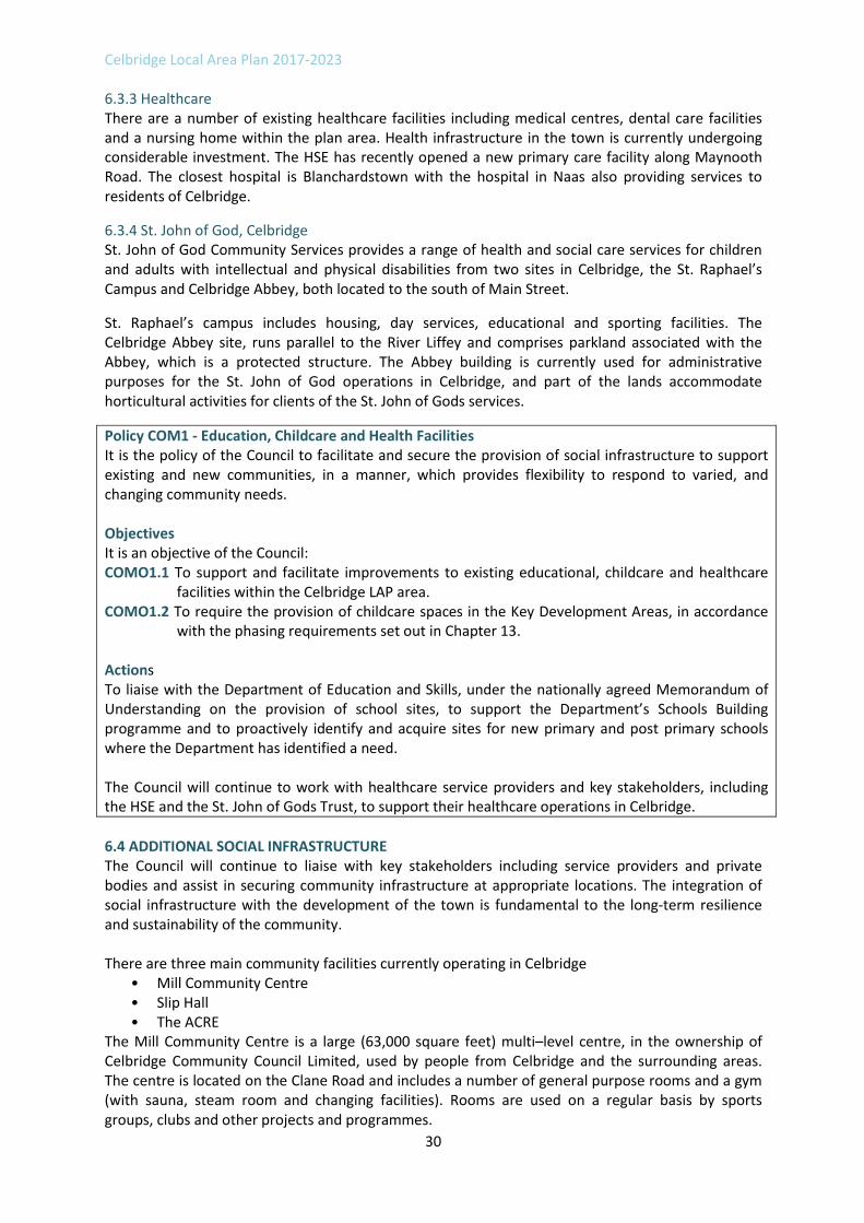
6.3.3 Healthcare There are a number of existing healthcare facilities including medical centres, dental care facilities and a nursing home within the plan area. Health infrastructure in the town is currently undergoing considerable investment. The HSE has recently opened a new primary care facility along Maynooth Road. The closest hospital is Blanchardstown with the hospital in Naas also providing services to residents of Celbridge.
6.3.4 St. John of God, Celbridge St. John of God Community Services provides a range of health and social care services for children and adults with intellectual and physical disabilities from two sites in Celbridge, the St. Raphael’s Campus and Celbridge Abbey, both located to the south of Main Street.
St. Raphael’s campus includes housing, day services, educational and sporting facilities. The Celbridge Abbey site, runs parallel to the River Liffey and comprises parkland associated with the Abbey, which is a protected structure. The Abbey building is currently used for administrative purposes for the St. John of God operations in Celbridge, and part of the lands accommodate horticultural activities for clients of the St. John of Gods services.
Policy COM1 ‐ Education, Childcare and Health Facilities It is the policy of the Council to facilitate and secure the provision of social infrastructure to support existing and new communities, in a manner, which provides flexibility to respond to varied, and changing community needs. Objectives It is an objective of the Council: COMO1.1 To support and facilitate improvements to existing educational, childcare and healthcare
facilities within the Celbridge LAP area. COMO1.2 To require the provision of childcare spaces in the Key Development Areas, in accordance
with the phasing requirements set out in Chapter 13. Actions To liaise with the Department of Education and Skills, under the nationally agreed Memorandum of Understanding on the provision of school sites, to support the Department’s Schools Building programme and to proactively identify and acquire sites for new primary and post primary schools where the Department has identified a need. The Council will continue to work with healthcare service providers and key stakeholders, including the HSE and the St. John of Gods Trust, to support their healthcare operations in Celbridge.
6.4 ADDITIONAL SOCIAL INFRASTRUCTURE The Council will continue to liaise with key stakeholders including service providers and private bodies and assist in securing community infrastructure at appropriate locations. The integration of social infrastructure with the development of the town is fundamental to the long-term resilience and sustainability of the community. There are three main community facilities currently operating in Celbridge
• Mill Community Centre • Slip Hall • The ACRE
The Mill Community Centre is a large (63,000 square feet) multi–level centre, in the ownership of Celbridge Community Council Limited, used by people from Celbridge and the surrounding areas. The centre is located on the Clane Road and includes a number of general purpose rooms and a gym (with sauna, steam room and changing facilities). Rooms are used on a regular basis by sports groups, clubs and other projects and programmes.

Celbridge Local Area Plan 2017-2023
31
The centre employs a full time manager and operates a FAS community employment scheme involving 25/26 staff to support the running/maintenance of the centre. The historic nature of Celbridge Mill Community Centre provides an important link between the town’s heritage and creates a more active and inviting town centre.
Slip Hall is owned by the Church of Ireland and is located at Castletown Gate. This historic building, which was refurbished in 2004, is used by a Montessori group, a scouts group, a camera club, a senior citizens group and for community meetings and can seat up to 90 people.
The ACRE project (‘A Community Rethinking Education’) is based in a standalone building on the Salesian College site, Maynooth Road. This is an eco-friendly community and horticultural project for the students of Salesian College and the local Celbridge/Straffan/Leixlip community. The main focus is a community garden project which offers a variety of programmes under FETAC and other part time courses.
Additional community facilities exist in Celbridge, which include a public library, sports clubs, two playgrounds and a public recreation area. This enables a reasonable level of community engagement, further education and recreation. This LAP will seek to support the continued operation of same and the development of new facilities.
Policy COM2 Community & Recreational Facilities It is the policy of the Council to facilitate and support a broad range of community and recreational facilities to serve the needs of the residents of Celbridge. Objectives It is an objective of the Council: COMO2.1: To support and facilitate the continued provision of multi-functional community
facilities to meet the needs of the population of Celbridge. COMO2.2: To ensure that adequate and safe amenity and recreational open spaces are available
for all groups of the population at a convenient distance from their homes and places of work.
COMO2.3: To support and facilitate the provision of play facilities in Celbridge, including playgrounds and a skate park, for children of all ages having regard to children with special needs.
6.5 CELBRIDGE INTEGRATED SERVICES PROGRAMME The Kildare Local Community Development Committee (LCDC) has prepared an Integrated Services Programme (ISP) Celbridge Plan 2016 to 2020. This is a new initiative, unique to County Kildare, which brings together local community, business, voluntary sector, state and local representatives. The ISP has analysed economic and social infrastructure in Celbridge and made recommendations for future measures to improve existing infrastructure and services. While many elements of the ISP will be implemented through complementary initiatives and programmes, it is important that the LAP recognises the ISP goals. In particular, the LAP will support the delivery of facilities for children and young people, and a service for older people, which the ISP has identified as being undersupplied in Celbridge.

Celbridge Local Area Plan 2017-2023
32
Policy COM3 Integrated Services Programme It is the policy of the Council to support the vision of the Celbridge Integrated Services Programme to encourage a sustainable and socially cohesive community, which meets the needs of all residents. Objectives It is an objective of the Council: COMO3.1: To promote and facilitate, where appropriate, the realisation of the goals and
objectives of the Celbridge Integrated Services Programme.

Celbridge Local Area Plan 2017-2023
33
7. ECONOMIC DEVELOPMENT To promote and support economic development that is consistent with the role of Celbridge as a Moderate Sustainable Growth Town. The town’s location in the North Kildare Economic Cluster and its heritage and tourism assets are identified as key economic strengths.
7.1 CONTEXT The Kildare County Development Plan 2017-2023 sets out an Economic Development Strategy for the County. The strategy is derived from the Regional Planning Guidelines for the Greater Dublin Area 2010-2022 and forms part of the Development Plan’s Core Strategy. Celbridge is part of the North Kildare Economic Growth Cluster and linked to the Primary Economic Growth Towns of Maynooth and Leixlip. The Economic Strategy envisages that clusters will develop in a mutually dependent way so that the amenities and economies of the whole cluster are greater than the sum of the individual parts. 7.2 ECONOMIC PROFILE The working population of Celbridge in 2011 was 9,917 persons and of these 8,813 were at work. Celbridge has relatively high numbers of people employed in managerial, technical, professional and non-manual services when compared to both the county and the State, which is reflective of the overall socio-economic profile of North Kildare. Commerce and trade is the largest sector of employment at 28.4%, followed by professional services at 25.2% (Table 7.1 refers). With relatively high participation in the “knowledge economy” workers tend to be drawn to the major employment clusters in Leixlip, Dublin and elsewhere in the region.
Commuting data from Census 2011 confirms that Celbridge is a commuter town serving Dublin and the wider region. The census indicates that 12% of the working population were employed in Celbridge, 60% worked outside of Celbridge and 15% worked elsewhere in Kildare.
Employment Type 2011 No. 2011% National Avg %
Agriculture, forestry and fishing (Total) 37 0.4% 5%
Building and construction (Total) 436 5.2% 5%
Manufacturing industries (Total) 985 11.7% 12%
Commerce and trade (Total) 2397 28.4% 25%
Transport and communications (Total) 839 9.9% 8%
Public administration (Total) 702 8.3% 6%
Professional services (Total) 2130 25.2% 24%
Other (Total) 910 10.8% 15%
Table 7.1 Celbridge Labour Force breakdown 2011
It is estimated that there are 2000+3 jobs in Celbridge, some in the education and health sector, others in the retail and services sectors. The Intel and Hewlett Packard campuses in Leixlip, nearby, employ circa 8,500 persons combined. The State Laboratory and Department of Agriculture at Backweston are also significant employers in the area. Other local employers include Maynooth University, the Maynooth Business Park and local schools, health and social care facilities, hotels, shops and services. 7.3 ECONOMIC DEVELOPMENT Celbridge is a Moderate Sustainable Growth Town within the Metropolitan area of Dublin and will continue to have a strong commuting role. While a high level of participation in sectors such as
3 ISP Celbridge Plan 2016-2020 – Kildare Integrated Services Programme.

Celbridge Local Area Plan 2017-2023
34
professional services, commerce and trade reinforce this pattern, local employment will also be necessary to support a vibrant, sustainable and attractive town. New employment opportunities are emerging across a range of sectors in the North Kildare Economic Cluster. Maynooth University has announced an investment plan to develop academic, research and residence facilities. The Draft Leixlip LAP 2017-2023 identifies a business and technology campus at Collinstown. The Rye River Brewing Company on the Dublin Road in Celbridge has received planning consent to develop a new brewery and visitor centre. Retailers are significant employers, and the M4 Business Park will also continue to support employment. In addition, the former Setanta Hotel on the Clane Road has reopened as the Celbridge Manor Hotel.
The LAP supports enterprise and employment development in Celbridge Town Centre and identifies a town centre expansion site at St. Raphael’s (Oakley Park) that offers significant potential for this type of development. Enterprise and employment uses such as professional services, public administration, research and development and other commercial activities have the potential to revitalise the town centre, as part of wider mixed-use developments. The LAP also identifies lands for industrial and warehousing development on the Maynooth Road.
Policy ED1 – Enterprise and Economic Development It is the policy of the Council to support sustainable economic development in Celbridge, optimising on the town’s location in the North Kildare Economic Cluster and the Metropolitan Area of Dublin and its potential as a heritage and tourism destination. Objectives It is an objective of the Council: EDO1.1: To ensure that there is a sufficient supply of zoned lands at suitable locations to
accommodate a range of enterprise and employment development types. EDO1.2: To promote and support enterprise and employment uses, including professional services,
public administration, research and development, knowledge – based/digital enterprise to support the tourism industry and other commercial activities, on town centre expansion sites.
EDO1.3: To promote linkages with major national institutions and companies such as Maynooth University, Intel and Hewlett Packard and the State Laboratories at Backweston.
EDO1.4: To support industrial and warehousing development on lands zoned for “Light Industry and Warehousing” development.
EDO1.5: To ensure that all business parks and industrial areas are designed to the highest architectural, environmental and landscaping standards.
7.4 TOURISM Heritage based tourism is recognised as a key economic driver for Celbridge that has the potential to generate employment across a number of sectors and to create a multiplier effect within the local economy. Celbridge is rich in history and heritage, both natural and built, and has a proud association with some of Ireland’s most important industrial and political history. It is the birthplace of Arthur Guinness, has the legacy and history of the Conolly family of Castletown, the Grattan family and Jonathan Swift. The major visitor attraction in Celbridge is Castletown House and Demense. This site had approximately 300,000 visitors in 20154 and the OPW is continuing to develop the attraction. Given the strong associations between Castletown House and Demense, the historic core of Celbridge and
4 Source: Celbridge Gateway to Ireland’s Ancient East, Tourism and Heritage Strategy 2016-2020.

Celbridge Local Area Plan 2017-2023
35
other demesnes along the Liffey, there are significant opportunities to extend the visitor experience and to develop Celbridge as a heritage destination. This LAP supports the development of infrastructure and facilities that extend the tourism and leisure offer in Celbridge. A number of commercial sites are identified outside of the town core that may have potential for tourism related diversification. In 2016, the Rye River Brewing Corporation announced plans to develop a new brewery and associated visitor centre on the Dublin Road. This will be the first commercial brewery in the area since Arthur Guinness moved his operations from Leixlip to St. James Gate in 1759. The Colour Trend Paint complex on the Maynooth Road is a working paint factory that incorporates an old Famine Workhouse. The Orchard is a retail complex contained within the Walled Gardens of St. Wolstan’s Demense that includes a home interiors section, garden centre, pet store and cafe. The Celbridge Manor Hotel is the former Collegiate School built in 1732 and designed by architect Thomas Burgh who also designed the Royal Barracks and the library building at Trinity College in Dublin. These sites, while outside of the historic core, have significant potential to support the development of a diverse tourism sector in Celbridge, through their links or associations with the rich heritage of the area.
Policy ED2 – Tourism It is a policy of the Council to promote the significant heritage and tourism potential of Celbridge and to support sustainable tourism development. Objectives It is an objective of the Council: EDO2.1: To support the development of tourism infrastructure, attractions and facilities at
appropriate locations subject to the protection of architectural heritage and natural amenities.
EDO2.2: To support the ongoing development of Castletown House and Demesne for leisure and tourism purposes, subject to the protection of architectural heritage and natural amenities.
EDO2.3: To support and facilitate the development of an integrated network of Greenways and Heritage Trails along suitable corridors in Celbridge, including pathways along the River Liffey corridor, subject to relevant environmental assessments.
EDO2.4: To support the development of outdoor leisure activities on lands that are designated as open space, subject to the protection of landscape character and natural heritage.
EDO2.5: To support the sensitive restoration of heritage buildings and sites and operate flexibly with regard to the use of converted buildings to facilitate heritage tourism.
EDO2.6: To support tourism projects that seek to showcase and promote cultural heritage including arts, music, aviation, history, Irish language, customs and ways of life.
EDO2.7: To facilitate tourism activities such as waterways activities, eco-tourism, niche retailing, food markets, local and other craft type activities so as to diversify the tourism product in Celbridge, subject to relevant environmental assessments.
EDO2.8: To promote and support tourism led diversification on sites that are zoned for “Commercial and Tourism” development.
EDO2.9: To support the development of standardised signage and interpretation for tourism facilities and tourist attractions throughout Celbridge.
EDO2.10: To support the development of linkages between historical sites within and around Celbridge.
EDO2.11: To investigate the feasibility of access to walkways and trails within the grounds of Celbridge Abbey including passage over the Rock Bridge to cross the River Liffey.

Celbridge Local Area Plan 2017-2023
36
7.5 DERELICT SITES AND VACANT SITES
Derelict and vacant sites can have a visual, economic, social and environmental impact on the surrounding area. Under the Derelict Sites Act 1990 the owner or occupier of land must ensure that the land or structures do not become or continue to be a derelict site. The Council has powers under the Derelict Sites Act 1990 to prevent and control derelict sites. One of the key provisions of the Urban Regeneration and Housing Act 2015 is the Vacant Site Levy. The Act was designed to incentivise urban regeneration and promote increased housing supply. Beginning on 1st January 2017, planning authorities are required to compile and maintain a register of vacant land in their functional areas and to apply a levy in respect of such sites. A targeted approach to this scheme will apply to Kildare, which will focus on the identified growth centres of Naas, Maynooth, Leixlip, Newbridge and Celbridge.
Policy DVS1 – Derelict Sites and Vacant Sites It is the policy of the Council to apply the provisions of the Derelict Sites Act 1990 and the Urban Regeneration and Housing Act 2015 in Celbridge. Objectives It is an objective of the Council: DVSO1.1: To apply the provisions of the Derelict Sites Act 1990 and the Urban Regeneration and
Housing Act 2015 in securing the regeneration of derelict and vacant sites which are detracting from the amenities of Celbridge.
DVSO1.2: To promote the sustainable development of vacant residential and regeneration sites in Celbridge through the application of the Urban Regeneration and Housing Act 2015, Vacant Site Levy, on lands zoned Town Centre and New Residential.
7.6 NON‐CONFORMING USES There are a number of non-conforming uses within the LAP area. The expansion of existing small commercial/employment uses will be permitted in principle where such uses contribute to the economic and social well-being of the area as a whole and do not inhibit the development of adjoining lands in conformance with the land use zoning objective. Where the continued expansion of operation of such uses is incompatible with the predominant land use zoning of the area, they will be encouraged to relocate to more suitably zoned land.
Policy ED3 – Non‐Conforming Uses It is the policy of the Council, where commercial and industrial enterprises exist as non-conforming but long established uses, to support their continued operation and reasonable expansion, in accordance with the proper planning and sustainable development of the area, save where such a use would impact negatively on the economic, environmental and social wellbeing of the area and inhibit development that is in conformance with the land use zoning objective. Objectives It is an objective of the Council: EDO3.1 To support the continued operation and reasonable expansion of existing non-
conforming uses, except in cases where same:
Result in loss of amenity to adjoining properties,
Cause adverse impact on the environment,
Cause adverse impact on the visual amenity or character of the area, or
Inhibit the development of adjoining land in conformance with its land use zoning objective

Celbridge Local Area Plan 2017-2023
37
8. MOVEMENT & TRANSPORT To enhance the existing transport network by increasing permeability and connectivity for pedestrians, cyclists and vehicles, in order to enable access to key land uses such as community facilities, public transport nodes and the town centre, as well as the crossing of the Liffey.
The transport and mobility policies for Celbridge are guided by a coordinated set of national and regional policy documents. National and regional policy recognises that current transport trends, and in particular the dominance of vehicular traffic, is unsustainable and that it is having a negative impact on the quality of our cities and towns.
This LAP recognises that one of the major challenges facing Celbridge during the period of the LAP will be the need to promote and provide for sustainable transport options in Celbridge, whilst also improving the effectiveness of the local transport network. A range of measures are proposed to improve connectivity and support a better balance between vehicular traffic and more sustainable modes such as walking, cycling and public transport.
8.1 WALKING AND CYCLING The overall permeability and connectivity of the pedestrian and cycle network in Celbridge is poor. In residential areas, severance has been built into the environment by high walls and a predominance of cul-de-sacs. The single crossing point over the River Liffey and pinch points within the historic core, such as the junction of Main Street and English Row, also restrict permeability and connectivity. This LAP supports improved connections throughout Celbridge particularly to and from areas of amenity, employment, schools and residential development. Opportunities for permeability improvements that have the potential to transform existing neighbourhoods into permeable ones, where people can walk or cycle safely and conveniently are identified on the Transport and Movement Map (Map 8.1 refers). New districts will be designed as permeable and connected areas with pedestrian and cyclist linkages being an important consideration. The Council will also support the development of a network of pedestrian and cycle routes along the River Liffey.
The pedestrian network in Celbridge has improved in recent years with the introduction of three Slí na Sláinte routes in and around the town. Currently these include: Celbridge Station - Hewlett Packard Campus via Primrose Hill (a 5.6km route); Celbridge - Hewlett Packard - Leixlip Slí (a 7km route linking Celbridge to Leixlip). These routes generally lead from Celbridge north-eastward along the Dublin Road, likely due to the adequate provision of pedestrian facilities on this route.
The Greater Dublin Area (GDA) Cycle Network Plan identifies a network of intra-urban and urban cycle routes across the GDA. Celbridge is located in the North Kildare Sector Town Cycle Network. The key routes proposed for this sector of relevance to Celbridge are:
Inter‐urban
K2 Celbridge to Maynooth along local road through Ballygoran south of the R405 and
K3 Celbridge to Clane via Straffan mostly avoiding the R403
Primary
C1 R405 Newcastle Road to Hazelhatch railway station and the Grand Canal Greenway.
C2 Clane Road to Main Street.
C3 Oldtown (Ring) Road to Church Road.
C4 R403 Clane Road and Oldtown Road to Maynooth Road.
C5 Willowbrook Road.
C6 R405 Maynooth Road.
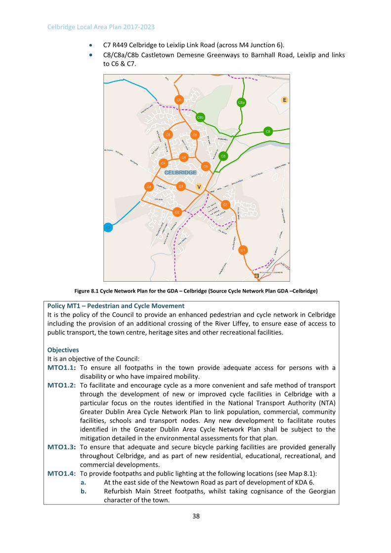
Celbridge Local Area Plan 2017-2023
38
C7 R449 Celbridge to Leixlip Link Road (across M4 Junction 6).
C8/C8a/C8b Castletown Demesne Greenways to Barnhall Road, Leixlip and links to C6 & C7.
Figure 8.1 Cycle Network Plan for the GDA – Celbridge (Source Cycle Network Plan GDA –Celbridge)
Policy MT1 – Pedestrian and Cycle Movement It is the policy of the Council to provide an enhanced pedestrian and cycle network in Celbridge including the provision of an additional crossing of the River Liffey, to ensure ease of access to public transport, the town centre, heritage sites and other recreational facilities. Objectives It is an objective of the Council: MTO1.1: To ensure all footpaths in the town provide adequate access for persons with a
disability or who have impaired mobility. MTO1.2: To facilitate and encourage cycle as a more convenient and safe method of transport
through the development of new or improved cycle facilities in Celbridge with a particular focus on the routes identified in the National Transport Authority (NTA) Greater Dublin Area Cycle Network Plan to link population, commercial, community facilities, schools and transport nodes. Any new development to facilitate routes identified in the Greater Dublin Area Cycle Network Plan shall be subject to the mitigation detailed in the environmental assessments for that plan.
MTO1.3: To ensure that adequate and secure bicycle parking facilities are provided generally throughout Celbridge, and as part of new residential, educational, recreational, and commercial developments.
MTO1.4: To provide footpaths and public lighting at the following locations (see Map 8.1): a. At the east side of the Newtown Road as part of development of KDA 6. b. Refurbish Main Street footpaths, whilst taking cognisance of the Georgian
character of the town.

Celbridge Local Area Plan 2017-2023
39
c. Resurface footpaths on the Dublin Road, where required. d. Full provision for pedestrians and cyclists, including public lighting, on
Loughlinstown Road as part of road objectives for KDA 3. e. Resurface footpaths on the Maynooth Road, where required, and upgrade
cycle facilities along this section of the primary cycle network. f. Full provision of facilities for pedestrians and cyclists on Hazelhatch Road to
the Railway Station and to housing estates. MTO1.5: To maintain the existing Slí na Sláinte routes and facilitate additional routes in and
around the Celbridge area, subject to relevant environmental assessments. MTO1.6: To facilitate a new pedestrian / cycling bridge across the Liffey linking to Celbridge
Town Centre, in conjunction with any new development at KDA2 – Donaghcumper and new residential areas to the south.
MTO1.7: To promote enhanced permeability for pedestrians and cyclists within the urban environment in order to improve access to local shops, schools, public transport services and other amenities, in accordance with NTA published ‘Permeability: Best Practice Guide (2015)’, or any successor to same, subject to local public consultation.
MTO1.8: To require new housing developments to deliver filtered or full permeability to adjoining development in so far as is possible and, in the case of adjoining greenfield sites, to ensure the potential for such provision is addressed.
MTO1.9: To upgrade existing pedestrian and cycle facilities across the River Liffey. Actions The Council will work with the National Transport Authority and other statutory agencies to provide for walking and cycling infrastructure including cycle parking, subject to relevant environmental assessments. The Council will investigate the feasibility of delivering local permeability improvements to maximise access to local shops, schools, public transport services and other amenities in consultation with the NTA and local stakeholders, subject to relevant environmental assessments. To engage with Celbridge Access Group, to work towards ensuring that Celbridge is accessible for all.
8.2 PUBLIC TRANSPORT Celbridge is served by Dublin Bus and Bus Éireann with connections to Dublin and other key destinations such as Newbridge, Edenderry, Clane and Maynooth.
Hazelhatch Train Station is located in the south of Celbridge and is served by the Portlaoise/Limerick, Kildare/Waterford and Galway services from Dublin. Although located outside the LAP boundary, it is a key piece of public transport infrastructure that is important to Celbridge and the surrounding hinterland. Currently a feeder bus runs to and from the town centre of Celbridge to Hazelhatch Train Station to connect with the Dublin rail services.
Policy MT2 – Public Transport It is the policy of the Council to support improvements to the public transport network serving Celbridge. Objectives It is an objective of the Council: MTO2.1: To create an interlinked public transport network that maximises the efficiency of
existing services, reduces overall journey times and facilitates easy exchanges between

Celbridge Local Area Plan 2017-2023
40
modes and/or routes. MTO2.2: To ensure where possible, that all public transport is accessible to the disabled and to
encourage retrofitting where same is possible and cost effective. MTO2.3: To support the enhancement of facilities at the Hazelhatch train station, in particular
secure cycle storage facilities. MTO2.4: To provide greater opportunities for modal shift to public transport through the
appropriate management of development particularly in lands to the south of Celbridge Town Centre.
MTO2.5: To work with all agencies to improve and develop public transport facilities in the area and to link such facilities with Celbridge Town Centre and other nearby towns and to ensure that developments are carried out in accordance with the requirements of this Plan and relevant legislation.
MTO2.6: To promote alternative routes of the bus service to Hazelhatch Train Station so that it serves Main Street, Maynooth Road, Shackleton Road and Clane Road.
Action To work with stakeholders and state agencies to encourage an increased frequency of bus services from Celbridge and adjacent population centres to Hazelhatch Train Station. To engage with the NTA, Dublin Bus, Irish Rail, Local Link and all other stakeholders, including representatives from the local community, to improve the provision of public transport in Celbridge.
8.3 ROADS AND STREET NETWORK Road infrastructure is being progressively improved throughout the town, but the bridge remains as a major cause of congestion to traffic flow in the town. Congestion is a significant problem in the town centre and one of the key priorities of this Plan is the provision for enhanced crossings of the River Liffey. The transportation objectives provide for the upgrade of the existing bridge for pedestrians and the possible construction of two5 new bridges in order to satisfy the need for a new river crossing. This would significantly relieve congestion issues, create improved connectivity within the urban environment and provide resilience for the town from a movement perspective.
In addition, there are requirements for additional roads infrastructure to serve the Key Development Areas identified in this plan that are described in Chapters 12 and 13 and on the Transport and Movement Map.
Policy MT3 – Roads It is the policy of the Council to support improvements to the road and street network in Celbridge in order to provide connectivity and permeability throughout the town, enable access to and from new communities and to reduce through-traffic in the town centre. Objectives It is an objective of the Council: MTO3.1: To seek to prepare, within 12 months of the date of the adoption of the Celbridge Local
Area Plan, a Transport Management Plan and Public Transport Strategy for Celbridge to support the sustainable growth and development of the town and to identify strategic connections for pedestrian, cyclist, bus, vehicle movement and links to the railway stations in consultation with statutory agencies, key stakeholders and the local community. Upon completion, the recommendations of the TMP shall be integrated into the LAP by way of a statutory amendment, where appropriate.
MTO3.2: To require all road development to be undertaken in accordance with ‘Principles of Road Development’ as set out in Section 5.8.3 of the Transport Strategy for the Greater Dublin Area 2016-2035.
5 1 no. pedestrian and cycle bridge and 1 no. vehicular bridge

Celbridge Local Area Plan 2017-2023
41
MTO3.3: To maintain, and improve as required, the local road network to ensure a high standard of road quality and safety in accordance with the requirements of this Plan and relevant legislation.
MTO3.4: To safeguard the capacity of the road network in Celbridge through the use of Intelligent Transport Systems.
MTO3.5: To secure the provision of the strategic road objectives identified on Map 8.1, which provides access to new communities and Key Development Areas within the town.
MTO3.6: To ensure that all significant development proposals for the KDAs are subject to a Traffic Impact Assessment (TIA), to be carried out in accordance with the Traffic and Transport Assessment Guidelines, NRA (2014). The requirement for TIA will be determined, by the Planning Authority, on a case-by-case basis.
MTO3.7: To require all new developments to comply with the requirements of the Kildare Local Authorities Noise Action Plan 2013 and any revisions of this plan (this may be viewed on the Kildare County Council website at the following address; www.kildarecoco.ie).
MTO3.8: To require all new developments to comply with the recommendations of the Design Manual for Urban Roads and Streets (DMURS) and National Cycle Manual, or any subsequent relevant publication.
MTO3.9: To facilitate the construction of a road from Hazelhatch Park to Newtown Road in tandem with development of KDA 5 and in the interim to protect this route from development.
MTO3.10: To facilitate the construction of a road from Primrose Hill to Loughlinstown Road in tandem with the development of KDA 2 and in the interim to protect this route from development.
MTO3.11: To explore by way of Feasibility Study the potential to construct a Western Link Road that will link Maynooth Road R405 with the Clane Road R403.
MTO3.12: To facilitate the construction of a new vehicular river crossing between the Clane Road and Newtown Road within either of the two protected corridors, as indicated on Map 8.1, subject to environmental assessment.
MTO3.13: To protect from development a route for a potential new road (including a new bridge over the River Liffey) between Clane Road (near the Celbridge North Kildare Educate Together School) and Hazelhatch Park.
MTO3.14: To carry out the following road improvements (See Map 8.1): a. Resurface and improve the Maynooth Road, where required. b. Improve the existing Liffey Bridge to better accommodate pedestrians and
cyclists. c. Improve and widen Newtown Road as part of the development of KDA 5. d. Reconstruct footpaths on Main Street. e. Resurface and improve the Hazelhatch Road between the railway station and
the town, including the provision of adequate pedestrian crossing facilities. f. Upgrade the Oldtown Road from Church Road to the town boundary. g. Upgrade the Loughlinstown Road in conjunction with road objectives for KDA 3.
MTO3.15: To provide passive traffic calming measures in Celbridge, where necessary and as funding allows.
MTO3.16: To improve junctions and to upgrade traffic signals where appropriate throughout the town.
MTO3.17: To promote the planting of native species when considering the landscaping requirements of new transport networks.
MTO3.18: To ensure insofar as possible that all transport facilities and services (including car parking) operational in the Celbridge area are accessible to people with mobility needs. Car parking shall generally be provided in accordance with “Buildings for Everyone: A Universal Design Approach” 2012 published by the National Disability Authority, or any subsequent relevant publication.

Celbridge Local Area Plan 2017-2023
42
Actions To work with stakeholders and State Agencies in preparing a Strategic Land Use and Transportation Study for North East Kildare.
To maximise the capacity of the local road network and reduce congestion by implementing a range of targeted actions to enhance the accessibility of key destinations in Celbridge (e.g. schools, shops and community facilities) by walking, cycling and public transport use.
8.4 CAR PARKING There are four privately operated car-parks in the town centre area of Celbridge and on-street parking on Main Street. The development management standards set out in Chapter 17 of the County Development Plan include parking standards for new development.
Policy MT4 – Car Parking It is the policy of the Council to manage the provision of parking to provide for the needs of residents, businesses and visitors to Celbridge town centre. Objectives It is an objective of the Council: MTO4.1:
a. To require parking provision for new development in accordance with the standards set out in the County Development Plan.
b. To investigate the rationalisation of car parking on the historic main street through the provision of additional off street public car parking in the town centre.
c. To ensure the provision of permanent durable surfaces to all public and private car-parking facilities.
Action To provide distinctly coloured disabled car parking spaces at appropriate locations throughout the town.

Celbridge Local Area Plan 2017-2023
43
9. INFRASTRUCTURE To phase future growth in line with the capacity of supporting physical infrastructure and to ensure that it occurs in accordance with proper planning and sustainable development.
The availability of high quality infrastructure networks and environmental services is critical to creating sustainable and attractive places, securing investment, ensuring health and wellbeing and safeguarding the environment. 9.1 WATER
Irish Water is responsible for the provision of water supply and wastewater services in Ireland. Kildare County Council retains a role in facilitating the provision of water services at a local level, in conjunction with Irish Water, through Service Level Agreements (SLAs). Kildare County Council will continue to support Irish Water in identifying the water services that are required to support planned development in Celbridge.
9.1.1 Water Supply Celbridge is connected to the water supply scheme servicing North Kildare. The water supply scheme is serviced by the Ballygoran Reservoir, which can be supplied by both the Ballymore Eustace and Leixlip Water Treatment Plants.
9.1.2 Wastewater Celbridge forms part of the Lower Liffey Valley Regional Sewerage Scheme (LLVRSS), which also serves Leixlip, Maynooth, Kilcock and Straffan. The Leixlip Waste Water Treatment Plant (WwTP) is currently being upgraded and will have a capacity of 150,000 population equivalent (PE) on completion of the upgrade.
Irish Water is in the process of preparing Drainage Area Plans (DAP) for the Lower Liffey Valley catchment to identify the interventions that are required in order to provide capacity in the local drainage networks over the medium and long term. The Celbridge drainage network drains to a pumping station at Castletown from where it is pumped to the Leixlip WwTP. There are identified constraints within the local network in Celbridge and at the Castletown pumping station. Irish Water is actively working to address these constraints.
Policy INF1 – Water Supply & Wastewater It is the policy of the Council to work with Irish Water to protect existing water and wastewater infrastructure in Celbridge, to maximise the potential of the existing network and to ensure that new or upgraded infrastructure is provided, to facilitate future growth. Objectives It is an objective of the Council: INFO1.1 To work with Irish Water to protect, manage and optimise water services infrastructure
in Celbridge.
INFO1.2 To work with Irish Water to promote the ongoing upgrade and expansion of water services networks, subject to relevant environmental assessments, to meet the future needs of Celbridge.
Actions The Council will encourage pre-planning application consultation with Irish Water.

Celbridge Local Area Plan 2017-2023
44
9.2 SURFACE WATER DRAINAGE The management of surface water is the responsibility of Kildare County Council. Adequate storm water drainage and retention facilities are necessary to accommodate surface water run-off resulting from current and future developments in Celbridge. The use of Sustainable Drainage Systems (SuDS) in new developments will contribute to surface water management and help to reduce and prevent flooding. The EU Water Framework Directive (WFD) seeks to protect and restore water quality, which is done through the implementation of River Basin Management Plans (RBMPs). Celbridge is located within the Eastern River Basin District. This Water Management Unit contains the River Liffey water bodies. The status of surface water ranges from “bad” to “moderate” and the objective is to “restore” and “protect”.
Policy INF2 – Surface Water It is the policy of the Council to maintain and enhance the existing surface water drainage systems in Celbridge and to protect surface and ground water quality in accordance with the Water Framework Directive.
Objectives It is an objective of the Council: INFO2.1 To carry out surface water infrastructure improvement works as required, subject to
relevant environmental assessments. INFO2.2 To require Sustainable Urban Drainage Systems (SUDS) as part of all plans and
development proposals in Celbridge. Proposals for KDAs should address the potential for SUDS at a local and district level to control surface water outfall and protect water quality.
INFO2.3 To maintain, improve and enhance the environmental and ecological quality of surface waters and groundwater in Celbridge in accordance with the Eastern River Basin District River Basin Management Plan and in conjunction with the EPA.
INFO2.4 To require applicants to demonstrate that proposals will not negatively impact on the status of a water body, in accordance with the requirements of the Water Framework Directive and associated River Basin Management Plans.
INFO2.5 To ensure that planning applications have regard to any existing groundwater protection schemes and/or the likely impacts that the development may have on groundwater, groundwater dependent terrestrial ecosystems (GWDTEs) and soils.
Actions To ensure that the surface water drains are regularly maintained to minimise the risk of flooding.
9.3 FLOOD RISK MANAGEMENT The OPW is the lead agency for flood risk management in Ireland. The coordination of Government Policy in terms of flood risk identification, assessment and management is the responsibility of the OPW and as such it is primarily charged with ensuring Ireland’s compliance with its obligations under the EU Floods Directive. There is a recognised history of flooding in Celbridge. Areas that may be susceptible to flooding are identified on Figure 9.1 Flood Risk Map. A number of flood alleviation schemes have been implemented in recent years, with the assistance of the Office of Public Works (OPW), including the Toni River Flood Alleviation Scheme and the Ardclough Flood Alleviation Scheme.
The Council is currently investigating an ongoing flood issue in the Hazelhatch area in consultation with the OPW. In line with the Planning System and Flood Risk Management Guidelines for Planning

Celbridge Local Area Plan 2017-2023
45
Authorities (2009), Strategic Flood Risk Assessment (SFRA) has informed the preparation of the LAP. The SFRA of the Plan is informed by the Catchment Flood Risk Assessment and Management (CFRAM) Programme, which, under the responsibility of the OPW, deals with fluvial flood risk.
Figure 9.1 An Overview of the CFRAM flood zones and historical flood events in Celbridge
The LAP avoids development in areas at risk of flooding and has substituted vulnerable land uses with a less vulnerable use where this is not possible in zoning lands in this Plan. Where neither is possible, mitigation and management of risks must be proposed. Justification tests6 were carried out on a number of sites in this regard and are outlined in the SFRA report accompanying this Plan. The SFRA has recommended that development proposals for a number of areas within the plan boundary should be the subject of site-specific flood risk assessment appropriate to the nature and scale of the development being proposed.
Policy INF3 – Flood Risk Management It is the policy of the Council to manage flood risk in Celbridge in conjunction with the OPW and in accordance with the requirements of the Planning System and Flood Risk Management Guidelines for Planning Authorities (2009) and Circular PL02/2014 (August 2014). Objectives It is an objective of the Council: INFO3.1 To manage flood risk in Celbridge in accordance with the requirements of the Planning
System and Flood Risk Management Guidelines for Planning Authorities, DECLG and OPW (2009) and Circular PL02/2014 (August 2014).
6 Justification tests are used to assess the appropriateness of developments in flood risk areas. See the SFRA,
which accompanies the LAP for further detail.

Celbridge Local Area Plan 2017-2023
INFO3.2 To ensure development proposalsthe subject of Site-Specific Flood Risk Assessment, appropriate to the nature and scale of the development being proposed.
INFO3.3 To support and co-operate with the OPW in delivering flood alleviation wEastern CFRAM Programme.
9.4 ENERGY SUPPLY AND COMMUNICATIONS Celbridge is traversed by high voltage liCelbridge town to the south of the Liffey, one of which is a 220kV line that ditown centre running south of Templemills and the other is a 110kV line that runs through Simmonstown. These overhead lines pass through residthe town there are two 38kV overhead lines and at Oldtown. There are also overhead surrounding lands. While the presence of the high voltage transmissionbe in a position to meet future electricity demands, such infrastructure has implications in terms of visual impact and land use compatibility.
Figure
Celbridge is connected to the natural gas network, supplied via a high pressure spur off the Cork Dublin high pressure gas transmission pipeline. Broadband is readily available in Celbridge. A number of telecoms providers have network infrastructure serving the area and provide various types of connectivity from fixed line to wireless and mobile broadband.
2023
46
ensure development proposals within the areas outlined on the Flood Risk Map are Specific Flood Risk Assessment, appropriate to the nature and scale of
the development being proposed. operate with the OPW in delivering flood alleviation w
Eastern CFRAM Programme.
MMUNICATIONS Celbridge is traversed by high voltage lines of the ESB Network. Two overhead lines pass through Celbridge town to the south of the Liffey, one of which is a 220kV line that ditown centre running south of Templemills and the other is a 110kV line that runs through Simmonstown. These overhead lines pass through residential and recreational lands. To
there are two 38kV overhead lines and an 110kV which line runs through residential lands at Oldtown. There are also overhead Medium and Low Voltage lines throughout Celbridge and the
While the presence of the high voltage transmission lines enables north Kildare to be in a position to meet future electricity demands, such infrastructure has implications in terms of visual impact and land use compatibility.
9.2 Overhead Power line Network (Source; EirGrid)
is connected to the natural gas network, supplied via a high pressure spur off the Cork Dublin high pressure gas transmission pipeline.
Broadband is readily available in Celbridge. A number of telecoms providers have network area and provide various types of connectivity from fixed line to wireless
Flood Risk Map are Specific Flood Risk Assessment, appropriate to the nature and scale of
operate with the OPW in delivering flood alleviation work under the
Two overhead lines pass through Celbridge town to the south of the Liffey, one of which is a 220kV line that diverts away from the town centre running south of Templemills and the other is a 110kV line that runs through
ential and recreational lands. To the north of through residential lands
lines throughout Celbridge and the enables north Kildare to
be in a position to meet future electricity demands, such infrastructure has implications in terms of
is connected to the natural gas network, supplied via a high pressure spur off the Cork –
Broadband is readily available in Celbridge. A number of telecoms providers have network area and provide various types of connectivity from fixed line to wireless

Celbridge Local Area Plan 2017-2023
47
Policy INF4 – Energy and Communications It is the policy of the Council to promote and facilitate the development and renewal of energy and communications networks in Celbridge, while protecting the amenities of the town. Objectives It is an objective of the Council: INFO4.1 To support the statutory providers of national grid infrastructure by safeguarding existing
infrastructure and strategic corridors from encroachment by development that might compromise the operation, maintenance and provision of energy networks.
INFO4.2 To support and facilitate the provision of telecommunications infrastructure, including broadband, in Celbridge, subject to safety, environmental and amenity requirements.
INFO4.3 To seek the undergrounding of all electricity, telephone and television cables in the town. INFO4.4 To discourage a proliferation of above ground utility boxes in the town and to seek
screening measures in conjunction with the provision of such structures. INFO4.5 To promote and encourage the use of renewable energy technologies in existing and
proposed building stock within the LAP area subject to consideration of environmental, conservation and visual requirements.
Actions To liaise with EirGrid in relation to the rationalisation of transmission infrastructure and/or underground routing of overhead power lines in Celbridge.
9.5 SOLID WASTE Refuse collection in Celbridge is currently carried out by a number of private contractors using waste collection permits issued by Kildare County Council. Recycling facilities for glass and cans are located at Tesco car park, Supervalu and Celbridge GAA Club. Other suitable sites will be identified over time. The Council will continue to encourage recycling and the minimisation of waste through its environmental education programme and the Green-Schools programme. At present, Kildare County Council operates two civic amenity sites (recycling centres), at Silliot Hill and Athy. A site is identified at a location that is south of the M4 Motorway and West of the R449 Regional Route, to the west of the M4 Exist 6 for the provision of a recycling centre to serve North Kildare. This location is central within the cluster of Celbridge, Leixlip, Maynooth and Kilcock.
As described in the Kildare Local Economic and Community Plan 2016 – 2021, Kildare has the fourth lowest number of civic amenity centres/bring banks in the country, therefore there is a need for continued investment in solid waste collection facilities.
Policy INF5 – Solid Waste It is the policy of the Council to protect environmental quality in Celbridge through the implementation of European, national and regional policy and legislation relating to air quality, light pollution, noise pollution and waste management. Objectives It is an objective of the Council: INFO4.1 To adequately maintain recycling facilities and to secure the provision of additional
facilities, as required, including in conjunction with new development. INFO4. 2 To provide a civic amenity site (recycling centre) in Celbridge on lands located south of
the M4 Motorway and north of the R449 Regional Route to the west of Exit 6.

Celbridge Local Area Plan 2017-2023
48
10. BUILT & NATURAL HERITAGE To protect, conserve and enhance the unique built and natural heritage of Celbridge, including the River Liffey, the architecture and streetscape of the historic town centre, and the houses and associated designed landscapes of the surrounding demesnes.
10.1 HISTORICAL BACKGROUND
Celbridge, or Kildrought as it was known up until the seventeenth century, has historically been defined by its position on the River Liffey and its proximity to major routes out of Dublin. The name Kildrought is derived from the Irish place name Cill Droichead, meaning 'the church of the bridge'. In early medieval times, a highway known as An Slí Mhór extended from Dublin Bay to Galway Bay and forded the River Liffey at Celbridge. A monastic site associated with St. Mochua was established here during the early Christian period and was most likely located on the site of the graveyard at Tea Lane as suggested by the pronounced curve of its eastern boundary. Nearby, an inscribed stone dated 1783 (now located on English Row) commemorated the site of St. Mochua's Well. Further evidence of early medieval settlement in the area includes the remains of enclosures in the townlands of Simmonstown, Griffinrath and Ballygoran. Following the Anglo-Norman invasion of 1169, the lands at Celbridge were granted by Strongbow to Adam de Hereford. During the centuries that followed a medieval borough was established which included a parish church, a mill and a number of houses fronting onto a linear street. There is also archaeological evidence for a tower house located to the north east of the borough in the townland of Castletown. To the east, a church at Donaghcumper and St. Wolstan's Abbey indicate a strong ecclesiastical presence in the area. Celbridge underwent significant change in the early eighteenth century when the House of Commons speaker, William Conolly, acquired the Dongan estate. During this time, Conolly built a Palladian styled mansion on a 550 acre demesne to the north east of the town whilst encouraging the development of several fine houses on Main Street. A town hall and a number of religious and educational buildings were also provided to serve the needs of the locality. Smaller demesnes developed on the outskirts of the town including Celbridge Abbey, Oakley Park, Donaghcumper and St. Wolstans. The industrial heritage of Celbridge includes the Celbridge Mill complex on Main Street and the Temple Mills further west along the River Liffey. These industries were important sources of local employment and contributed to the commercial development of the main street. A workhouse was built on the Maynooth Road in the nineteenth century with the purpose of providing relief to the Poor Law Union of Celbridge. A graveyard associated with the workhouse is located on the adjoining site to the north. It is unlikely that any significant development occurred in Celbridge during the decades that followed the Great Famine. During the early to mid twentieth century, local authority cottages and housing estates were constructed on Church Lane, Big Lane and at St. Patrick's Park and Ballyouster Park. A number of new schools were also established at various locations around the town as need arose. In the latter half of the twentieth century Celbridge experienced significant population growth due to its proximity to Dublin and improvements in the strategic road network. Large housing estates were developed on the north and south side of the River Liffey. These estates and the associated retail and commercial services they attracted characterise the outskirts of the town as we know it today.
10.2 ARCHAEOLOGICAL HERITAGE
Archaeological Heritage is protected by the National Monuments Acts 1930-2004. Known structures, features, objects or sites of archaeological heritage are listed in the Record of Monuments and Places (RMP), which is compiled by the National Monuments Services of the Department of Arts, Heritage, Regional, Rural and Gealtacht Affairs (DAHRRG). The archaeological heritage of Celbridge is rooted in the early Christian and late medieval periods. Its location at the crossing of an ancient

Celbridge Local Area Plan 2017-2023
49
highway over the River Liffey and the establishment of a monastic site suggest a place of importance. However, it is the later development of an Anglo-Norman borough with its burgage plots fronting onto a spine street that is most evident in the layout of the town today. For the purposes of the LAP Archaeological Heritage includes the following: National Monuments Archaeological and Architectural monuments / sites on the Record of Monuments and Places Monuments on the Register of Historic Monuments Zones of Archaeological Potential in Historic Towns Underwater Archaeological Heritage, including Historic Wrecks Previously unknown and unrecorded archaeological sites Potential sites located near large complexes of sites or monuments 10.2.1 Archaeological Sites The Record of Monuments and Places (RMP) lists archaeological sites and monuments dating from before 1700AD. Map 10.1 identifies the sites within the LAP area that are located on the Sites and Monuments Register (SMR). This map should be read in conjunction with Table 10.1.
Item (Description) Location (Townland) Reference
Bridge Site Parsonstown (Celbridge ED)/ Coneyburrow (Donaghcumper ED)/St. Wolstans
KD011-011
Town Castletown/Celbridge/Celbridge Abbey (Celbridge ED)/Oakleypark/ Donaghcumper
KD011-012001
Ecclesiastical enclosure Oakleypark KD011-012004
Church Oakleypark KD011-012005
Graveyard Oakleypark KD011-012006
Church Donaghcumper KD011-013
Graveyard Donaghcumper KD011-013001
Priory St. Wolstans KD011-014
Castle Simmonstown KD011-016
Tower House Site Newtown (Donaghcumper ED) KD011-019
Castle – Tower house Castletown KD011-023
Mansion Celbridge Abbey (Celbridge ED) KD011-026
Mansion St. Wolstans KD011-028
Enclosure Simmonstown KD011-029
Enclosure Simmonstown KD011-030
Mill Newtown (Donaghcumper ED) KD011-037
Kiln – corn drying Castletown KD011-042001
Burial Site Kilmacredock Upper KD011-057
Enclosure Simmonstown KD011-063
Pit burial Castletown KD011-060006 Table 10.1 Recorded Monuments and Places within the LAP boundary ‐ Extract from the Sites and Monuments Record
10.2.2 Zone of Archaeological Potential The County Kildare Urban Archaeological Survey (Bradley and King 1986) identifies a Zone of Archaeological Potential surrounding St. Mochua’s Church, Church Road, Celbridge Mill and the Main Street. This zone is shown on Map 10.1. Developments located within a Zone of Archaeological Potential and/or close to known archaeological monuments or sites, including site works that are extensive in terms of area (ground disturbance of half a hectare or more) or length (1 kilometre or more) and developments that require an Environmental Impact Statement will be required as part of the planning application process, or by condition of planning permission, to carry out archaeological assessment, monitoring, testing or excavation within the area either prior to the planning decision or prior to any

Celbridge Local Area Plan 2017-2023
50
development proceeding on site. The Council, as a condition on such developments, may consider the preservation of all or part of the archaeological remains in the area covered by that permission. The Council will consult with the Department of Arts, Heritage, Regional, Rural and Gaeltacht Affairs and other statutory consultees when considering applications for planning permission for development on or in the vicinity of archaeological sites and/or monuments.
Policy BH1 – Archaeological Heritage It is the policy of the Council to safeguard the archaeological heritage of the LAP area and avoid negative impacts on sites, monuments features or objects of significant historical or archaeological interest. Objectives It is an objective of the Council: BHO1.1: To protect and preserve those items of archaeological interest listed in Table 10.1 and
shown on the Map 10.1 from inappropriate development that would adversely affect and/or detract from the interpretation and setting of these sites.
BHO1.2: To protect the historic core of Celbridge Town and retain where possible the existing street layout, historic building lines and traditional plot widths where these derive from medieval origins.
BHO1.3: To ensure proposals contribute towards the protection and preservation of the archaeological value of sites including underwater sites associated with the River Liffey.
BHO1.4: To provide for the protection of historic burial grounds within Celbridge in co-operation with agencies such as the Office of Public Works and the National Monuments Section of the Department of the Arts, Heritage, Regional, Rural and Gaeltacht Affairs.
10.3 ARCHITECTURAL HERITAGE
The architectural heritage of Celbridge primarily comprises the eighteenth century houses of the gentry, the residential and commercial architecture of Main Street and its approach roads, a number of civic, religious and institutional buildings and the mill complexes associated with the River Liffey. 10.3.1 Record of Protected Structures The Planning & Development Acts 2000 (as amended), Part II, Section 10 places an obligation on all local authorities to include objectives for the protection of structures, or parts of structures, which are of special architectural, historical, archaeological, artistic, cultural, scientific, social or technical interest. Archaeological structures may, in some situations, be considered as architectural heritage and, therefore, may appear on both the Record of Monuments and Places (RMP) and the Record of Protected Structures (RPS). The Record of Protected Structures is contained within the County Development Plan. Table 10.2 is an extract from the Record of Protected Structures contained in the County Development Plan 2017-2023 and is reproduced here for information. Map 10.2 and Map 10.2A illustrate the location of these structures. The majority of these structures are identified in the National Inventory of Architectural Heritage (NIAH) as being of regional importance. The NIAH for Kildare was completed in 2003 and the Council completed a review of the RPS for the county, including Celbridge, in 2015. Castletown House is the most significant building in the area and is of national and European importance. Built between 1722 and 1729 for William Conolly, speaker of the Irish House of Commons, it is Ireland’s largest and earliest Palladian style house. A number of notable town houses are located in the vicinity of Castletown gates and include Jasamine House and Kildrought House. These houses reflect the growing prosperity of the town during the seventeenth and eighteenth century.

Celbridge Local Area Plan 2017-2023
51
At the opposite end of Main Street, Celbridge Abbey, Oakley Park and The Lodge are substantial eighteenth and nineteenth century houses that sit within their own grounds. Celbridge Abbey is of national importance due to its associations with Jonathan Swift and Henry Grattan. Notable civic and institutional buildings in the area include the former Town Hall, St. Patrick’s Roman Catholic Church, Christ Church, Celbridge Methodist Church and St. Brigid’s Convent. The former Collegiate School located on the Clane Road is another fine example of Palladian style architecture patronised by the Conolly family. The surviving buildings associated with the Celbridge and Temple Mills reflect the industrial heritage of the town and the importance of the River Liffey to the local economy. Equally, Celbridge workhouse, although modified in the early twentieth century to accommodate a paint factory, retains its administrative, accommodation and infirmary blocks and is a reminder of the hardship endured in the area during the nineteenth century. RPS No. NIAH Ref. Structure and Location Description
B11-02 Donaghcumper Medieval Church Ruins, Donaghcumper Medieval Church
B11-04 St. Wolstan's Abbey, St. Wolstan’s Abbey
B11-11 St. Wolstan's House, St. Wolstan’s House
B11-13 Castletown House, Temple, Batty Langley Lodge, Entrance Gates and avenue (and interiors), Castletown
House
B11-14 Castletown Walled Garden and pedimented arch and nearby temple, Castletown
Walled Garden and pedimented arch and nearby temple
B11-22 (old ref B04-26)
11901104 Former Collegiate School (Celbridge Manor Hotel), Clane Road, Celbridge
School (former)
B11-23 11805062 Kildrought House, Main Street, Celbridge House
B11-24 11805074 Celbridge Abbey, Clane Road, Celbridge Monastery
B11-24(a) 11805075 Celbridge Abbey, Clane Road, Celbridge Gates/railings/walls
B11-24(b) 11805076 Celbridge Abbey, Clane Road, Celbridge Gates/railings/walls
B11-24(c) 11805077 Celbridge Abbey, Clane Road, Celbridge Foot Bridge
B11-26 11805061 Francis & Margaret Finlay, Dublin Road, Donaghcumper House
B11-27 11805035 Main Street, Celbridge House
B11-34 11805044 Oakley Park, Celbridge House
B11-35 11805045 Celbridge Lodge, Church Rd, Celbridge House
B11-35(a) 11805026 Celbridge Lodge, Church Road, Celbridge, Co. Kildare Gate Lodge
B11-35(b) 11805027 Celbridge Lodge, Church Road, Celbridge, Co. Kildare Walls/gates/railings
B11-36 11805048 150 Church Rd, Celbridge House
B11-37 11805053 Abbey View, Church Rd, Celbridge House
B11-38 11805055 The Forge, Primrose Hill, Celbridge House
B11-39 11805003 Jassamine House, Main Street, Celbridge House/Guesthouse
B11-40 11805034 Landscape House, Main Street, Celbridge House
B11-53 11805073 Abbey National School (former), Celbridge School (former)
B11-54 Donaghcumper House, Donaghcumper House
B11-84 11805001 Castletown House, Celbridge, Co. Kildare Gate Lodge
B11-85 11805002 Round House (The), Main Street, Big Lane, Celbridge Gate Lodge
B11-86 11805004 Top of the Town Drycleaners /Murfish, Main St., Celbridge
Shop

Celbridge Local Area Plan 2017-2023
52
B11-88 11805005 Michelangelo, Main Street, Celbridge, Co. Kildare Restaurant
B11-89 11805022 Gogarty, Main Street, Celbridge, Co. Kildare Shop
B11-90 11805028 Lady Louisa Connolly School, Celbridge, Co. Kildare School (former)
11805029 Castletown School of Industry, Celbridge, Co. Kildare School (former)
B11-92 11805030 Christchurch, Celbridge, Co. Kildare Church
B11-93 11805031 Celbridge Parochial House, Main Street, Celbridge House
B11-94 11805033 Celbridge Town Hall (former), Main Street, Celbridge Shop
B11-95 11805036 Blake's Pharmacy, Main Street, Celbridge, Co. Kildare Shop
B11-96 11805037 Castletown Videos, Main Street, Celbridge, Co. Kildare Shop
B11-97 11805038 Finey House, Main Street, Celbridge, Co. Kildare House
B11-98 11805040 Main Street, Celbridge, Co. Kildare House
B11-99 11805042 Saint Patrick's Catholic Church, Main Street, Celbridge Church
B11-100 11805043 St. Brigid's (Holy Faith) Convent, Main Street (off), Celbridge
Convent
B11-101 11805047 Celbridge Methodist Church (former), Celbridge, Co. Kildare
Church
B11-102 11805051 Tea Lane Graveyard, Church Road, Celbridge Cemetery
B11-103 11805054 Celbridge Bridge, Celbridge, Co. Kildare Bridge
B11-104 11805056 The Mill Community Centre, Main Street, Celbridge Community Centre
B11-105 11805057 The Mill Community Centre, Main Street (off), Celbridge Community Centre
B11-106 11805058 The Mill Community Centre, Main Street (off), Celbridge Community Centre
B11-107 11805059 The Mill Community Centre, Main Street (off), Celbridge Community Centre
B11-108 11805063 Castletown House, Main Street, Celbridge, Co. Kildare Walls/gates/railings
B11-109 11805064 Main Street, Celbridge, Co. Kildare House
B11-110 11805078 Rock Bridge, Clane Road (off), Celbridge, Co. Kildare Foot Bridge
B11-111 11805079 Celbridge Abbey, Clane Road, Celbridge, Co. Kildare Foot Bridge
B11-112 11805080 Celbridge Abbey, Clane Road, Celbridge, Co. Kildare Sluice/Sluice Gate
B11-119 Gardeners House, Castletown Creche
B11-120 The Croft, Castletown House
Table 10.2 Record of Protected Structures – Extract from the County Development Plan 2017‐2023
Policy BH2 – Protected Structures It is the policy of the Council to preserve and enhance the buildings identified on the Record of Protected Structures and to carefully consider any proposals for development that would affect the special value of such structures, including their historic curtilage, both directly and indirectly. Objectives It is an objective of the Council: BHO2.1: To ensure the protection and preservation of all protected structures, (or parts of
structures) and their immediate surroundings including the curtilage and attendant grounds of structures contained in the Record of Protected Structures (refer to Table 10.2 and Map 10.2 and Map 10.2a).
BHO2.2: To support the sensitive restoration of protected structures and their attendant grounds and operate flexibility with regard to the use of these buildings to facilitate their ongoing use, with particular reference to St. Wolstan’s, Donaghcumper House and Celbridge Abbey, subject to good conservation principles.
BHO2.3: To raise awareness of the unique built heritage of Celbridge by facilitating research and interpretation projects.
BHO2.4: To address dereliction and vacancy in the town centre and promote appropriate uses and

Celbridge Local Area Plan 2017-2023
53
the sensitive restoration of historic buildings. BHO2.5: To support the implementation of the conservation and management plan for St. Mochua’s
Church and to carry out similar projects in Celbridge as opportunities arise. BHO2.6: To support the implementation of a conservation and management plan for Donaghcumper
Medieval Church Ruins. Actions To provide support to the owners of protected structures in undertaking repair and conservation works by providing advice and grant aid under the Building Heritage Investment Scheme or any successor to this scheme. To raise awareness of and promote best practice with regard to the maintenance and repair of historic buildings.
10.3.2 Architectural and Landscape Conservation The LAP area encompasses a composite landscape that is connected by the River Liffey. This landscape is made up of a number of character areas that respond to both their river setting and one another. The value of this landscape is much greater than the sum of its individual parts and warrants protection and preservation. The character areas can broadly be categorised as areas being of either architectural or landscape value. 10.3.2 (i) Proposed Architectural Conservation Areas In order to preserve the areas of architectural value, it is an objective of this plan to initiate the process of designating two Architectural Conservation Areas (ACA) in Celbridge. An ACA is a place, area, group of structures or townscape that is of special architectural, historical, archaeological, artistic, cultural, scientific, social or technical interest or value, or contributes to the appreciation of protected structures. It is considered appropriate to preserve the architectural value of the historic core through the designation of an ACA that encompasses Main Street, Celbridge Mill and surrounds, English Row, Tea Lane and Big Lane. It is also considered appropriate to preserve the architectural value of the Temple Mill buildings and associated workers cottages further south along the Liffey, through the designation of an ACA. The extent of the proposed ACAs is illustrated on Map 10.2. A description of the character areas that informed the identification of the proposed ACAs is given in Appendix 1. 10.3.2 (ii) Historic Landscape Areas The historic demesnes of Castletown, St. Wolstan’s and Donaghcumper to the east of the town centre comprise designed landscapes made up of parklands, river walks, ruins and structures which collectively form the landscape setting of Castletown House and its grounds. To the west of the town centre, the gardens and pleasure grounds of Celbridge Abbey and Oakley Park define the landscape setting of the River Liffey and the western edge of the town centre. These heavily landscaped areas and their associated boundary walls define and enhance the southern approach roads to the town. The demesnes described above are connected by the Main Street and the River Liffey, which unifies these areas so that they form a single landscape of heritage value. While the houses, their curtilage and associated structures are protected through inclusion on the RPS, the composite landscape setting of the historic houses, the town centre and the River Liffey warrants protection in its own right.
This LAP supports the preservation of the composite landscape identified on Map 13.1 (See HLA Specific Zoning Objective). While it is not intended to preclude development within the historic landscape areas, the LAP will seek to ensure that the landscape features, including the views and prospects that define the character of these areas, are preserved.

Celbridge Local Area Plan 2017-2023
54
Policy BH3 – Architectural Conservation Areas It is the policy of the Council to preserve the historic character of proposed Architectural Conservation Areas and to carefully consider any proposals for development that would affect the special value of these areas. Objectives It is an objective of the Council: BHO3.1: To initiate a process to designate two ACAs in Celbridge that encompasses (i) the Main
Street of Celbridge, Celbridge Mill and surrounds, English Row, Tea Lane and Big Lane; and (ii) the Temple Mill buildings and associated workers cottages.
BHO3.2: To prepare character statements and area specific policies and objectives for the proposed ACAs in Celbridge.
BHO3.3: To ensure that new development, including infill development, extensions and renovation works within or adjacent to the ACAs preserve and enhance the special character and visual setting of the ACA including views and vistas, streetscapes, building lines, fenestration patterns and architectural features.
BHO3.4: To have regard to the Kildare Shopfront Guidelines (2013) in the consideration of any proposals within the proposed ACA in the historic core, providing that they contribute to the established pattern, scale, materials and proportions of the buildings within the proposed ACA. Modern design that makes a positive contribution to this proposed ACA will also be considered.
BHO3.5: To support the retention, repair and re-use of materials which characterise the vernacular architecture of the proposed ACAs including stone, slate, timber windows and doors, and decorative render.
BHO3.6: To address dereliction and promote appropriate and sensitive reuse and renovation of buildings, building features and sites within the proposed ACAs.
BHO3.7: To reduce and prevent visual and urban clutter within the proposed ACAs including, where appropriate, traffic management structures, utility structures and all signage.
BHO3.8: To encourage the sensitive restoration and extension of cottages in accordance with the guidelines produced by Kildare County Council.
Actions The Council will work with and assist, where appropriate, owners of buildings within the proposed ACAs in their maintenance and repair of buildings through advice and grant aid from relevant sources.
Policy HLA1‐ Historic Landscapes Areas It is the policy of the Council to preserve the special landscape character of historic landscapes within Celbridge as set out on Map 13.1 Land Use Zoning. Objectives It is an objective of the Council: HLAO1.1: To protect the special landscape character of historic landscape areas and ensure that new
development enhances the special character and visual setting of the historic landscapes outlined on Map 13.17 and to prevent development that would have a negative impact on the character of the lands within the Historic Landscape Areas.
HLAO1.2: To support the preparation of Woodland Conservation and Management Plans for lands within the Historic Landscape Areas.
7 This will not preclude the development of lands for Town Centre Extension within KDA 2 – Donaghcumper as same were
considered to be outside of the ‘Designed’ areas of the landscape.

Celbridge Local Area Plan 2017-2023
55
10.3.2 (iii) Scenic Routes and Views The LAP area comprises scenic routes and views that significantly enhance the amenity value of the town’s landscape setting. The protection of these routes and views is provided for in the County Development Plan, which are listed in table 10.3 below and shown on Map 10.1 for convenience.
Scenic Routes Description Location
No. 31 Views within Castletown – Donaghcumper Rural Area; Views to the South and North from Castletown House, including axial views to Obelisk.
Castletown, Barrogstown, Barnhall, Rinawade, Cordaun
No. 32 Views of the River Liffey from the main avenue of Castletown House
Castletown
Views
RL 2 View of the River Liffey from New Bridge New Bridge, Coneyburrow
RL 3 View of the River Liffey from Celbridge Bridge Celbridge Bridge, Celbridge Table 10.3 Scenic Routes and Protected Views – Extract from the County Development Plan 2017‐2023
In addition to the above, it is also an objective of the current County Development Plan to protect the following views from Castletown House (Ref. Section 12.4.2 of the County Development Plan 2017-2023): • Axial views between the Castletown House and Conolly’s Folly • Views between Castletown House and the Wonderful Barn • Views from the House to the river and across the back parterre • Views across the river and to the linked demesnes of Donaghcumper and St. Wolstan’s • Views from the main avenue to the river towards Castletown, and up and down the river to Celbridge and New Bridges
Policy SRV1‐ Scenic Routes and Views It is the policy of the Council to ensure that the proposed location, siting and design of buildings and structures and any mitigation measures identified in the LAP, protect the special character of the identified scenic routes and protected views. Objectives It is an objective of the Council: SRVO1.1: To protect the visual amenity and character of scenic routes and views in Celbridge and
Castletown as identified in the County Development Plan. SRVO1.2: To require a Visual Impact Assessment of proposals for development that may impact the
special character and visual amenity of scenic routes and views as part of the planning application process.
Actions To review existing and potential new scenic routes and views worthy of protection in the course of preparing the proposed Architectural Conservation Area and Historic Landscape Area character statements.
10.4 NATURAL HERITAGE
The River Liffey, its landscape setting and associated eco systems are the principal natural heritage features of the LAP area. These features significantly enhance the landscape character and amenity value of the town centre and its surrounding demesnes. Historically, the River Liffey was also an important economic resource, powering a number of mills along its banks including Celbridge Mill and Temple Mills.

Celbridge Local Area Plan 2017-2023
56
10.4.1 Designated Sites
Special Areas of Conservation (SACs) and Special Protections Areas (SPAs) are legally protected under the EU Habitats Directives and are selected for the conservation of Annex 1 and Annex II species. There are no SACs or SPAs located within the plan area. The nearest SAC to Celbridge is the Rye Water Valley/Carton SAC (Site Code 002162) which lies 2km north of Celbridge. The River Liffey flows into Dublin Bay SAC and as such the potential for downstream effects from works or development needs to be considered. Natural Heritage Areas (pNHAs) are sites of significance for wildlife habitats and are protected under the Wildlife Amendment Act, 2000. There are no pNHAs within the plan area. The Royal Canal (Site Code 002103) and the Grand Canal (Site Code 002104) are located north and south of the plan area respectively.
Policy NH1 Natural Heritage It is the policy of the Council to support the protection of species and habitats that are designated under the Wildlife Acts 1976 and 2000, the Birds Directive 1979 and the Habitats Directive 1992 as well as areas of high local biodiversity value and to ensure development with potential to impact the integrity of the Natura 2000 network will be subject to Appropriate Assessment. Objectives It is an objective of the Council: NHO1.1: To ensure an Appropriate Assessment, in accordance with Article 6(3) and Article 6(4) of
the Habitats Directive and with DEHLG guidance (2009), is carried out in respect of any plan or project not directly connected with or necessary to the management of a Natura 2000 site to determine the likelihood of the plan or project having a significant effect on a Natura 2000 site, either individually or in combination with other plans or projects and to ensure that projects which may give rise to significant cumulative, direct, indirect or secondary impacts on Natura 2000 sites will not be permitted (either individually or in combination with other plans or projects) unless for reasons of overriding public interest.
NHO1.2: To identify, protect, conserve and enhance wherever possible, wildlife habitats and species of local importance, not otherwise protected by legislation. Such habitats would include woodland, river, grassland areas and field boundaries (hedgerows, stone walls and ditches). Such features form part of a network of habitats and corridors, which allow wildlife to exist and flourish and contribute to compliance with Article 10 of the Habitats Directive.
NHO1.3: To protect and conserve the integrity of soils that supports the rich biodiversity and ecological networks in Celbridge.

Celbridge Local Area Plan 2017-2023
57
11. Green Infrastructure & Strategic Open Spaces To protect and enhance green infrastructure assets and create an interconnected network of parks, open spaces, demesne lands and watercourses in Celbridge.
11.1 GREEN INFRASTRUCTURE The environmental and heritage resources of Celbridge can be described as its Green Infrastructure. The Green Infrastructure network is the network of natural and semi-natural areas that support the natural environment by providing habitats for wildlife, air and water filtration and surface water management, recreational and tourism opportunities and “greener” neighbourhoods. Green infrastructure networks include waterways, wetlands, woodlands, wildlife habitats, greenways, parks and conservation lands, forests and other open spaces that surround and thread through our towns and cities.
Celbridge benefits from a significant level of green infrastructure. The River Liffey is part of the Regional Green Infrastructure Network and links a number of historic demesne landscapes in Celbridge to form a strong network within the town. It will be important to establish a coherent, integrated and evolving network that extends from the Liffey and the demesnes.
11.2 HABITAT MAPPING Under Article 10 of the Habitats Directive planning and development policies must endeavour to conserve and manage sustainably corridors and stepping stone habitat features. In recognition of this the Kildare County Development Plan proposes actions to address biodiversity in County Kildare and to prepare a plan for its management at a local level. Kildare County Council commissioned habitat mapping for Celbridge to inform this LAP. This report identifies and maps the various habitats and green infrastructure areas in the town. These maps are a valuable tool in the future planning of the area and also provide information for the general public and community groups. The following provides details of the key elements of habitats in Celbridge:
Buildings and gardens These habitats were the most abundant group of habitats in Celbridge (Figure 11.1), covering nearly half (48.36%) of the study area. This group includes the habitat types such as buildings and artificial surfaces (BL3), as well as lawns (GA2), flowerbeds (BC4), ornamental shrubs (WS3) and other habitat types present in private gardens.
Agricultural land These habitats, which includes improved agricultural grassland (GA1) and tillage were not as abundant in Celbridge as other areas of the County but still accounted for 24.49% of the study area. However, these habitats were restricted to marginal areas adjoining the north, south and south-east of the study area.
Amenity grassland This occupies 11.64% of the Celbridge study area (Figure 11.1) and does not include the lawns of private houses, but does include public grassy spaces within estates, playing pitches, and larger lawns in institutions such as Celbridge Abbey, St John of God’s, and the various primary and secondary schools.
Other The remainder of the habitat groups each occupy less than 16% of the total study area. Woodland and scrub cover in Celbridge accounts for 9.55% of the study area. These are represented by the woodland habitats associated with Castletown Demesne, Killadoon Demesne, Donaghcumper House

Celbridge Local Area Plan 2017-2023
58
and those woodland areas adjoining the River Liffey. Disturbed ground accounts for 1.94% of the study area and are typically identified in areas where discontinued construction has created patches of bare and recolonising soil. Rivers and watercourses form 1.43% of the study area and features such as the River Liffey and its tributaries represents some of the most notable ecological features associated with Celbridge. High quality semi-natural wetland habitats such as marsh (GM1) and fen (PF) were not recorded within the Celbridge study area, although the Kilwogan wetlands are located in close proximity to the north-western boundary of the LAP boundary.
Figure 11.1 Habitat composition of Celbridge
The dominant habitats within Celbridge are intensive agriculture and urban built land. For this reason, it is important to ensure that local biodiversity areas, which form an important part of the county’s Green Infrastructure and support connectivity within the network are maintained, and given the opportunity to increase their distribution within the town. In addition, ‘Stepping Stone’ habitats including scattered trees and parkland as well as amenity areas within housing estates further enhance the connectivity of habitats, and in turn, promote biodiversity across Celbridge and County Kildare.
Policy GI 1 – Green Infrastructure It is the policy of the Council to protect, enhance and further develop the Green Infrastructure network in Celbridge and to strengthen links to the wider regional network.
Objectives It is the objective of the Council: GIO 1.1: To reduce and avoid fragmentation or deterioration of the Green Infrastructure network
and strengthen ecological links within Celbridge and to the wider regional network. GIO 1.2: To preserve, protect and augment trees, groups of trees, woodlands and hedgerows
within the town by increasing, where appropriate, tree canopy coverage using locally native species by incorporating them within design proposals and supporting their integration into the existing Green Infrastructure network.
GIO 1.3: To integrate Green Infrastructure as an essential component of all new developments and restrict development that would fragment or prejudice the Green Infrastructure network.
GIO 1.4: To ensure key hedgerows identified, and the linkages they provide to larger areas of Green Infrastructure and the wider countryside, are retained where appropriate and integrated into the design of new developments.
GIO 1.5: To promote a network of paths and cycle tracks to enhance accessibility to the Green Infrastructure network, while ensuring that the design and operation of the routes responds to the ecological protection needs of each site.

Celbridge Local Area Plan 2017-2023
59
GIO 1.6: To maintain a biodiversity protection zone of not less than 15 metres from the top bank of the River Liffey and of not less than 10 metres from the top bank of smaller watercourses in Celbridge, with the full extent of the protection zone to be determined on a case by case basis by the planning authority, based on site specific characteristics and sensitivities. Strategic green routes and trails will be open for consideration within the biodiversity protection zone, subject to appropriate safeguards and assessments.
GIO1.7: To promote best practice with respect to minimising the spread of, and eradicating, invasive species, in accordance with the provisions of Section 13.8.3 of the Kildare County Development Plan 2017-2023.
GIO1.8: To carry out, as resources allow, Habitat and Green Infrastructure Mapping for the areas included in the extended Celbridge Local Area Plan area (i.e. Castletown, St. Wolstans and Donaghcumper Demesnes).
Action: All proposals for developments will be required to demonstrate that the existing Green Infrastructure Network is protected, in so far as practicable, and that the development contributes positively to the development and protection of the overall Green Infrastructure assets of Celbridge.
11.3 OPEN SPACES While Celbridge has a significant amount of open space, it is not distributed evenly and access to some areas is limited. The parklands of Castletown, St. Wolstan's and Donaghcumper dominate the eastern edge of town, with little to the west. The areas of public open space within the various residential estates of the town largely are incidental areas with limited functionality. These spaces offer little in the way of support for recreation or biodiversity. Open space and parkland represents an important component of a sustainable town as they contribute to the amenity of the area, as well as providing for the health and well-being of residents and encouraging ecology. As Celbridge is a town with a particularly high population of families with children, open space is considered especially important, in relation to encouraging active lifestyles. In addition to the demesnes, the River Liffey provides a significant opportunity for Strategic Open Space that can connect into a wider regional network and support opportunities for strategic walking and cycling routes, in addition to ecology and biodiversity linkages. However, the river, at present is almost inaccessible at most points in the town, with the exception of a few areas where access is possible, though limited due to overgrowth along the banks. The strategy document Towards a Liffey Valley Park, was published in 2006 and represented the first comprehensive strategy for the Liffey between Chapelizod in Dublin and Celbridge in Co. Kildare. The plan identifies considerable opportunities for recreation, tourism, economic development and habitat creation along the Liffey Valley whilst protecting the historic links to the town and its evolution. The vision for the future is to maintain, and enhance the unique river valley as a natural asset whilst meeting the development and open space needs of the catchment population therein. The strategy reinforces this vision and as such the strategy will guide the administration, management, allocation of resources and development control functions of the Office of Public Works and the four Local Authorities in whom the future of the Liffey Valley is entrusted. Whilst the overarching objective is to maintain the integrity of the Liffey Valley and to provide essential recreational space for the wider region, sensitively designed and appropriate development in certain areas provide an opportunity to develop / improve access to amenity areas.
Map 13.1 Land Use Zoning identifies strategic open spaces along the Liffey Valley Corridor that seek to improve access to the river as well as protecting the historic designed landscapes of the adjoining

Celbridge Local Area Plan 2017-2023
60
demesnes. The Strategic Open Space zoning objective will ensure that these lands are protected to serve the future recreation needs of Celbridge and protect the amenity of the River Liffey.
Chapter 12 Urban Design and Key Development Areas and Chapter 13 Implementation provide further detail in relation to the integration of these areas into design concepts and land use proposals.
Policy OS1 ‐ Open Spaces It is the policy of the Council to provide for a hierarchy of high quality multi-functional public open spaces within Celbridge, and to preserve and protect such spaces through the appropriate zoning of lands.
Objectives It is an objective of the Council:
OSO1.1: To support and facilitate the provision of open spaces with ecological and recreational corridors to aid the movement of biodiversity and people, subject to appropriate environmental assessment.
OSO1.2: To protect lands zoned Open Space and Amenity and Strategic Open Space on Map 13.1 for a variety of passive and active uses.
OSO1.3: To provide a range of opportunities for active and passive recreation within public open spaces and to support ‘Edible Gardening’ community projects where appropriate.
OSO1.4: To pursue the creation of a Liffey Valley Regional Park together with Dublin City Council, Fingal and South Dublin County Councils and the OPW.
OSO1.5: To maintain and protect, from inappropriate development, the greenbelt between Leixlip, Celbridge and Maynooth.

Celbridge Local Area Plan 2017-2023
61
12. URBAN DESIGN & KEY DEVELOPMENT AREAS To ensure development proposals conform with best practice urban design principles on the basis
that well planned and integrated development will enhance the town and its environs and improve
the quality of life of its residents.
12.1 URBAN DESIGN This LAP seeks to establish a framework for the future development of Celbridge. It is proposed to consolidate growth within Key Development Areas that provide for the expansion of the town centre and the development of new residential neighbourhoods. The urban structure of a town is defined by a framework of routes and spaces that provide connections between various nodes such as the town centre, neighbourhoods, schools and parks. New development should be integrated into this framework whilst providing new districts that have their own unique character and a high quality environment. The established principles of good urban design should be applied to all new development in the LAP area and shall include those set out in the following policy documents and design manuals:
Retail Planning Guidelines for Planning Authorities (2012)
Retail Design Manual (2012)
Sustainable Residential Development in Urban Areas – Guidelines for Planning Authorities(2009)
Urban Design Manual; A Best Practice Guide (2009)
Design Manual for Urban Roads and Streets (DMURS) (2013) 12.2 KEY DEVELOPMENT AREAS ‐ DESIGN CONCEPTS Five Key Development Areas (KDAs) have been identified in Celbridge as follows:
KDA 1 St. Raphael’s (Oakley Park): Town Centre Expansion KDA 2 Ballyoulster: New Residential Area KDA 3 Oldtown: New Residential Area KDA 4 Crodaun: New Residential Area KDA 5 Simmonstown: New Residential Area
Each of the KDAs are identified in Map 12.1. Design briefs have been prepared to guide development in KDA’s 2, 3, 4 and 5. These design briefs set out broad parameters for the future development of these areas. The briefs are based on an appraisal of each area in relation to its urban and landscape setting. While principal access points and connections, key building frontages and public spaces should generally be regarded as fixed requirements, a degree of flexibility can apply. For example, access points from the main road network and key connections within the KDA will be required but the actual position of each connection could be altered subject to appropriate traffic safety considerations. Key building frontages may be varied where it is demonstrated that there is a strong urban design rationale and that passive supervision of public spaces is not compromised. The briefs will assist different parties involved in the planning process such as landowners, developers, design teams, residents and Kildare County Council in the preparation and assessment of detailed proposals. 12.2.1 KDA 1 – ST. RAPHAEL’S (OAKLEY PARK) This KDA is identified for the purposes of town centre expansion. KDA 1 is approximately 9 hectares in area and is located to the south-west of the town centre. It comprises the historic walled demesne of Oakley Park, which is now owned by the Saint John of God Trust, and accommodates a range of

Celbridge Local Area Plan 2017-2023
62
educational, residential and respite services. This LAP supports the continued use of this site for community and educational purposes. The LAP also supports new retail, office, residential, community and amenity uses at this location, in conjunction with the consolidation of the community and educational uses on site. Development in KDA 1 shall be supported by a Masterplan. The Masterplan will be required to address the following:
The safeguarding and preservation of the architectural and landscape character of the site and its environs. Sensitive landscape buffers should be maintained and reinforced where appropriate, around Oakley Park House and St. Mochua’s Church (given the potential for archaeology in this area) and key views and prospects should be protected.
The mix of uses to be accommodated within the site. In addition to the established community uses, a mix of uses to reflect the town centre designation (e.g. retail, office, residential and amenity uses), will be required in the longer-term.
The Masterplan shall investigate the feasibility of providing a swimming pool, 10% of housing specifically designed for older people, a women’s refuge to serve North Kildare, community/recreational/ cultural facilities for younger and older people.
Opportunities for movement into and through the site. The principal vehicular access shall be via the existing tree lined approach off the Clane Road, with potential for new access points off Church Road/Tea Lane. Pedestrian and cycle links should provide for obvious desire lines from the surrounding area including enhanced connections to the town centre. Existing openings in the demesne wall should be utilised where possible with new openings being kept to a minimum with careful design consideration being given to all interventions.
The provision of an urban park in the vicinity of Oakley Park House, to serve the wider town centre area.
Phasing and implementation of new development in association with the consolidation of the established community and educational uses on site.

Celbridge Local Area Plan 2017-2023
63
12.2.2 KDA 2 – BALLYOULSTER
The Ballyoulster KDA is located to the east of the town and is bound by the Dublin Road, Donaghcumper cemetery and the Ballyoulster Park housing estate to the north, the Willow housing estate and agricultural lands to the south, the Loughlinstown road to the east and the Shinkeen Road to the west. This KDA is approximately 40 hectares in area with a flat topography. The Shinkeen Stream flows through the lands towards the Donaghcumper Demense and the River Liffey.
Figure 12.1 Design Concept for KDA 2 Ballyoulster
Vision To provide for the development of a new residential neighbourhood, including primary and post primary schools and a local park that integrates with its surroundings whilst having its own unique character and a strong sense of place.
Connectivity/ Movement Vehicular access to this KDA should be provided from the Dublin Road, Shinkeen Road and the Loughlinstown Road and should provide for continuous routes through the KDA that connect to surrounding areas. Provision should be made for a road connection from the Loughlinstown Road to the R405/Hazelhatch Road, south of the Willows housing estate, in the longer term. A permeable network of pedestrian and cycle friendly streets and spaces that incorporate existing site features such as the Shinkeen stream and existing mature trees will be required.
Built Form The development of this KDA should reflect the established pattern of development in the area. Site layouts should seek to fully integrate the identified primary and post primary school sites. School buildings should be designed to front onto new streets and spaces so that they contribute to the streetscape and the character of this KDA. A mix of housing types that range from two to three storeys in height is encouraged. Landmark / feature buildings should be provided along prominent routes and at key junctions in order to provide for legibility and variety in the urban environment and to reinforce the proposed hierarchy of streets and spaces. This site will accommodate medium to low-density residential development in the order of 30 units per hectare.

Celbridge Local Area Plan 2017-2023
64
Landscape and Spaces The Shinkeen Stream should be incorporated into new developments as a landscape feature that includes a continuous pedestrian and cycle link along its bank. This green link should include natural landscaping that will enhance the ecological value of the stream. New residential areas should be structured around a variety of open spaces that provide for both active and passive recreation. Landscape proposals should provide for the retention of existing mature trees and the planting of new trees along the Ballyoulster/Loughlinstown townland boundary.
12.2.3 KDA 3 – OLDTOWN
The Oldtown KDA is located to the west of the town and is bound by the R403/Shackleton Road to the east, the Oldtown Road to the north and agricultural lands to the south and west. This KDA is approximately 15.7 hectares (including a 2ha site identified for Community and Educational Use) and is currently in agricultural use. An overhead power line traverses the southern portion of the KDA.
Figure 12.2 Design Concept for KDA 3 Oldtown
Vision A new residential area, that integrates with its surroundings whilst having its own unique character and a strong sense of place.
Connectivity/Movement Access to this KDA shall be from the Shackleton and Oldtown Road and should provide for an extension of the street network into lands west of this KDA in the long term. Streets and spaces should provide for a cycle and pedestrian friendly environment. The Oldtown Road also presents an opportunity to develop a connection back to the town centre that prioritises cycle and pedestrian movement. A permeable and integrated street network shall be a key requirement of development proposals.

Celbridge Local Area Plan 2017-2023
65
Built form The development of this KDA should reflect the established pattern of development in the area and should protect the amenity of adjoining residential estates. Where overhead transmission cables traverse the site, proposed layouts shall comply with the recommended clearance distances identified by the ESB (ref. Section 17.11.2 of the Kildare County Development Plan 2017-2023). Site layouts should seek to fully integrate the identified primary school site into the urban structure of the neighbourhood. School buildings should be designed to front onto new streets and spaces so that they contribute to the streetscape and the character of this KDA. A mix of housing types that range from two to three storeys in height is encouraged. Landmark /feature buildings should be provided along prominent routes and at key junctions to provide for legibility and variety in the urban environment and to reinforce the proposed hierarchy of streets and spaces. Development along the Shackleton Road and Oldtown Road should also provide for good road frontage and an appropriate set back. Innovative design solutions such as courtyard housing, duplex typologies and end of terrace units with frontage onto both a local street and Priory Square Road are encouraged. This site will accommodate a minimum density of 30 units per hectare.
Landscape and Open Spaces Neighbourhood parks can make a significant contribution to the amenity value and identity of a place. A minimum of 6 hectares of the Oldtown KDA lands shall be reserved for neighbourhood parks. At least one park should be provided on the lands to the north and the south of the Oldtown Road. These parks should provide for both passive and recreational activities and should be well integrated into the urban structure of the neighbourhood. Existing landscape features such as tree lines and streams should be integrated into open spaces. Open space networks that incorporate pedestrian and cycle routes, provide for passive and active recreation, promote ecology and integrate Sustainable Urban Drainage Systems are promoted.

Celbridge Local Area Plan 2017-2023
66
12.2.4 KDA 4 – CRODAUN
The Crodaun KDA comprises approximately 21.9 hectares of land on the northern outskirts of the town on both the east and west side of the Maynooth Road. The M4 Business Park and the Salesians secondary school are located to the north of the KDA. The Castle Village and Crodaun Forest Park housing estates are located to the south of these lands.
Figure 12.3 Design Concept for KDA 4 Crodaun
Vision A residential area and public park that consolidates development to the north of the town and presents a landscaped edge to the Maynooth Road.
Connectivity/ Movement The primary means of vehicular access to this KDA will be off the Maynooth Road. New streets and spaces should provide for a cycle and pedestrian friendly environment with connections to the Maynooth Road and Kilwogan Lane. A permeable and integrated street network shall be a key requirement of development proposals.
Built Form The development of this KDA should reflect the established pattern of development in the area and should protect the amenity of adjoining residential estates. A mix of housing types that range from two to three storeys in height is encouraged. Landmark / feature buildings should be provided along prominent routes and at key junctions to provide for variety and legibility in the urban environment and to reinforce a hierarchy of streets and spaces. This site will accommodate medium to low-density residential development in the order of 25 units per hectare. However, where the quality of the design and layout is particularly high, a maximum density of 30 units per hectare may be achievable.
Landscape and Spaces New residential areas at Crodaun should comprise a hierarchy of open spaces. Larger open spaces should provide a focus for the developments on both sides of the road with smaller areas of open space being utilised to provide a landscape buffer to the Maynooth Road and incidental open spaces within the site. Existing landscape features such as tree lines should be integrated into open spaces. Open space networks that incorporate pedestrian and cycle routes, provide for passive and active recreation, promote ecology and integrate Sustainable Urban Drainage Systems are promoted.

Celbridge Local Area Plan 2017-2023
67
12.2.5 KDA 5 – SIMMONSTOWN
The KDA at Simmonstown is located between Hazelhatch Park and Temple Manor residential estates to the north east and south west respectively. The lands measure approximately 35 ha in area and are currently in agricultural use. The lands are accessible from the Newtown / Ardclough Road. An overhead power line traverses the northern portion of the KDA. Development in KDA 5 Simmonstown shall be subject to a Masterplan, prepared prior to the commencement of any development. No development shall be permitted in the masterplan area until such times as the masterplan is agreed with the Planning Department. The Masterplan will be required to:
1. Set out a detailed roads and infrastructure strategy for the development as a whole to include upgrading of existing roads, the construction of new roads and any other traffic safety measures. This strategy will be informed by a detailed traffic assessment to ascertain the extent of development that could be supported by particular upgrading works.
2. Include detailed phasing proposals and an implementation strategy. 3. Have regard to Sustainable Residential Development in Urban Areas Guidelines of Planning
Authorities, DECLG (2009) and its companion document Urban Design Manual. 4. Include an appropriate level of community infrastructure to support development. 5. Provide public open space at a minimum rate of 15% of the total site area.
Figure 12.4 Design Concept for KDA 5 Simmonstown

Celbridge Local Area Plan 2017-2023
68
Vision A residential area including a primary school that consolidates the southern environs of Celbridge, establishes an attractive edge to the town and provides for improved access to the Hazelhatch Road and train station.
Connectivity/ Movement Vehicular access to this KDA should comprise a link street that connects the Newtown/Ardclough Road to the R405 (Hazelhatch Road) via Callenders Mill. A second point of access of the Newtown/ Ardclough Road is desirable. Provision should also be made for a road connection to the Newtown/Ardclough Road, south of the Chelmsford residential estate. New streets and spaces should provide for a cycle and pedestrian friendly environment with designated cycle routes along arterial streets. A permeable and integrated street network shall be a key requirement of development proposals. All roads and streets should be designed in accordance with DMURS.
Built Form The development of this KDA should reflect the established pattern of development in the area and should protect the amenity of adjoining residential estates. Development proposals shall safeguard the remains of discovered and undiscovered archaeology on the lands located within this KDA. Where overhead transmission cables traverse the site, proposed layouts shall comply with the recommended clearance distances identified by the ESB (ref. Section 17.11.2 of the Kildare County Development Plan 2017-2023). A primary school site shall be reserved to the centre of this KDA and should be integrated into the site layout of future development proposals. Design proposals for a new school should make a positive contribution to the character of this area. A mix of housing types that range from two to three storeys in height is encouraged. Landmark / feature buildings should be provided along prominent routes and at key junctions to provide for variety and legibility in the urban environment and to reinforce a hierarchy of streets and spaces. This site will accommodate medium to low-density residential development in the order of 30 units per hectare.
Landscape and Spaces It is a key requirement of this KDA that the site of the ringfort identified on the Record of Monuments and Places be integrated into a public open space and that an appropriate buffer is established around the ringfort (Department of Arts, Heritage, Rural, Regional and Gaeltacht Affairs will advise at detailed design stage). This space will provide a unique focus for this new residential area. Development proposals should maintain the established building set back on the Newtown / Ardclough Road with areas of public open space being provided to the front of the site. A landscaped edge should be provided to the south of the site with a view to integrating new development into the landscape. Existing landscape features such as tree lines should be incorporated into public open spaces. Open space networks that incorporate pedestrian and cycle routes, provide for passive and active recreation, promote ecology and integrate Sustainable Urban Drainage Systems are promoted.

Celbridge Local Area Plan 2017-2023
69
13. IMPLEMENTATION To phase new development to ensure that it occurs in an orderly and efficient manner in accordance with proper planning and sustainable development.
13.1 IMPLEMENTATION STRATEGY This LAP sets out a clear vision for Celbridge into the future. This vision is in accordance with the role identified for Celbridge at a local, county and regional context and seeks to make Celbridge a more attractive place to live, work and visit. In order to achieve the stated vision it is important that the individual measures put forward in this plan are delivered. 13.2 DEVELOPMENT MANAGEMENT This LAP outlines specific policies and objectives of the Council with regard to developing Celbridge. The overarching policies and objectives of the Kildare County Development Plan also apply, specifically the Development Management Standards set out in Chapter 17. Where conflict exists between the LAP and the CDP, the CDP will take precedence. 13.3 LAND USE ZONING OBJECTIVES Map 13.1 shows the land use zoning objectives for Celbridge and should be read in conjunction with Table 13.2 Definition of Terms and Table 13.1 Land Use Zoning Matrix below.
Ref Use Land‐Use Zoning Objectives
A Town Centre To protect, improve and provide for the future development of town centres.
B Existing Residential / Infill
To protect and enhance the amenity of established residential communities and promote sustainable intensification.
C New Residential To provide for new residential development.
E Community and Educational
To provide for education, recreation, community and health.
F Open Space and Amenity
To protect and provide for open space, amenity and recreation.
F2 Strategic Open Space
To preserve, provide for and improve recreational amenity, open space and green infrastructure networks.
H Light Industry and Warehousing
To provide for light industry, distribution and warehousing.
I Agricultural To retain and protect agricultural uses.
N Neighbourhood Centre
To provide for new/existing neighbourhood centres and associated facilities.
R Commercial and Tourism
To support established commercial uses and tourism / leisure related uses.
U Utilities and Services
To provide for and improve public utilities.
G Green Belt To protect the character of each town through the identification of a greenbelt which shall remain free from development.
Table 13.1: Land Use Zoning Objectives

Celbridge Local Area Plan 2017-2023
70
Permitted in Principle (Y)
Land uses designated under each zoning objectives as ‘Permitted in Principle’ are generally acceptable, subject to compliance with those objectives as set out in other chapters of this Plan.
Open for Consideration (O)
Land uses shown as ‘Open for Consideration’ are uses that are not considered acceptable in principle in all parts of the relevant use zone. However, such uses may be acceptable in circumstances where the Council is satisfied that the proposed used would not conflict with the general objectives for the zone and the permitted or existing uses as well as being in the interests of the proper planning and sustainable development of the area.
Not Permitted (N) Land uses which are indicated as ‘Not Permitted’ in the Land Use Zoning Matrix will not be permitted.
Other Uses Proposed land uses not listed in the matrix will be considered on the merits of the individual planning application, with reference to the most appropriate use of a similar nature indicated in the table and in relation to the general policies and zoning objectives for the area.
Non‐conforming uses Existing established uses that are inconsistent with the primary zoning objective where legally established by continuous use for the same purpose prior to 1st October 1964 or by planning permission, will not be subject to legal proceedings under the Act in respect of their continued use. Where extensions or improvements of premises accommodating these uses are proposed each shall be considered on its merits in accordance with the proper planning and sustainable development of the area.
Transitional Areas While the zoning objectives indicate the different uses permitted in each zone it is important to avoid abrupt transitions in scale and use at the boundary of adjoining land use zones. In these areas it is necessary to avoid developments that would be detrimental to amenity. In zones abutting residential areas, particular attention will be paid to the uses, scales, density and appearance of development proposals and to landscaping and screening proposals in order to protect the amenities of residential properties. Development abutting amenity and open space will generally facilitate the passive supervision of that space by fronting onto it where possible.
Table 13.2 Zoning Matrix – Definition of Terms

Celbridge Local Area Plan 2017-2023
71
13.4 LAND USE ZONING MATRIX The Zoning Matrix illustrates a range of land uses together with an indication of their broad acceptability in each of the land use zones.
Land Use
A –
To
wn
Cen
tre
B -
Exi
stin
g
Res
iden
tial
/ In
fill
C –
New
Res
iden
tial
E –
Co
mm
un
ity
and
Edu
cati
on
al
F –
Op
en
Sp
ace
and
Am
enit
y
F2 –
Str
ateg
ic O
pe
n
Spac
e
G -
Gre
en B
elt
N-
Nei
ghb
ou
rho
od
Cen
tre
H -
Lig
ht
Ind
ust
ry
and
War
eho
usi
ng
I - A
gric
ult
ura
l
R –
Co
mm
erci
al a
nd
Tou
rism
U –
Uti
litie
s an
d
Serv
ices
Amusement Arcade N N N N N N N N N N N N
Agricultural Buildings N N N N N N O N O Y N N
Car Park (other than ancillary car
parking)
Y N N O N N N O O N N O
Betting Office O N N N N N N O N N N N
Cemetery N N N Y O N N N N N N N
Community / Recreational/
Sports buildings
Y O O Y Y N N O N N O N
Crèche/Playschool Y O Y Y O N N O O N O N
Cultural Uses/Library Y O O Y O O N O N N N N
Dancehall/Disco O N N N N N N N N N N N
Dwelling Y Y Y O8 N N N Y N O
9 N N
Funeral Homes Y N N Y N N N O N N N N
Garage / Car Repairs N N N N N N N N Y N N N
Guest House/Hotel/Hostel Y O O Y N N N N N O10
Y N
Heavy Commercial Vehicle Park N N N N N N N N Y N N N
Hot Food take away O N N N N N N O N N N N
Light Industry O N N N N N N N Y N N N
Medical Consultancy/Health
Centre
Y O O Y N N N Y N N
N N
Motor Sales N N N N N N N N Y N N N
Nursing Home/Housing for the
Elderly
Y Y Y Y N N N O N O11
N N
Offices Y O12
O O N N N O N N O N
Park / Playground Y Y Y Y Y Y Y Y N O O N
Petrol Station N N O N N N N O Y N N N
Place of Worship Y O O Y N N N O N N N N
Playing Fields O O O Y Y Y Y O N O O N
Pub Y N O N N N N O N N N N
Restaurant Y O O N N N N O N N O N
School Y O O Y N N N N N N N N
Shop (Comparison) Y N N N N N N N N N O N
Shop (Convenience) Y O O N N N N Y N N O N
Utility Structures O O O O O O O O Y O O Y
8 Ancillary to health / community use to meet special accommodation needs
9 In accordance with the Rural Housing Policy set out in the County Development Plan save structures addressed under
BHO2.2 10
Proposals of this nature shall be restricted to restoration projects and/or reuse of historic buildings subject to compliance with Development Management Standards of the CDP 11
Proposals of this nature shall be restricted to restoration projects and/or reuse of existing buildings to accommodate such uses. 12
Proposals of this nature shall be restricted to circa 100sqm

Celbridge Local Area Plan 2017-2023
72
Land Use
A –
To
wn
Cen
tre
B -
Exi
stin
g
Res
iden
tial
/ In
fill
C –
New
Res
iden
tial
E –
Co
mm
un
ity
and
Edu
cati
on
al
F –
Op
en
Sp
ace
and
Am
enit
y
F2 –
Str
ateg
ic O
pe
n
Spac
e
G -
Gre
en B
elt
N-
Nei
ghb
ou
rho
od
Cen
tre
H -
Lig
ht
Ind
ust
ry
and
War
eho
usi
ng
I - A
gric
ult
ura
l
R –
Co
mm
erci
al a
nd
Tou
rism
U –
Uti
litie
s an
d
Serv
ices
Warehouse/Store13
/Depot N N N N N N N N Y N N
N
Workshops /Small Scale Craft O O N N N N N N Y O O Y
Table 13.3 Land Use Zoning Matrix
It is an objective of the Council to carry out its development management function in accordance with the matrix for each zone. Where the above matrix indicates that a proposal would be ‘permitted in principle’, it should not be taken to imply that a planning application would be successful on that basis alone. The matrix relates to land use only. Other factors including density, building height, design standards, traffic generation, environmental factors, impact on surrounding amenities, etc., are also relevant in establishing whether or not a development proposal would be acceptable. Uses other than the primary uses for which an area is zoned may be permitted provided they are not in conflict with the primary use zoning objective.
13.5 PHASING Design proposals in the Key Development Areas will be subject to a schedule of phasing. The purpose of the phasing is to ensure that infrastructure, facilities and amenities are provided together with new residential development. The proposed phasing schedule is based on the premise that the number of dwelling units that may be permitted in each phase of development is dependent on the provision of a pre-determined level of completed infrastructure, facilities and amenities to serve each phase. To provide flexibility, the proposed phasing schedule is sequential (linked to housing output) rather than time specific.
The key infrastructure to be phased in conjunction with housing input in Celbridge is roads infrastructure, water infrastructure, open space, recreational facilities and childcare provision. The phasing below is designed to ensure the delivery of priority infrastructure within each KDA in tandem with development.
13.5.1 Key Development Areas (KDAs) Each Key Development Area (KDA) is split into phases of development. While consent for the development in its entirety or for a subsequent phase of development may be granted prior to the completion of a previous phase, the previous phase must be completed in its entirety (including all predetermined infrastructure, facilities and amenities) prior to the commencement of development in a subsequent phase of development. A statement of compliance with the phasing requirements of the LAP shall be required with planning applications for new housing development in the Key Development Areas and compliance will be governed by condition of planning consent. Deviations from the phasing condition may be considered in exceptional circumstances where a case is made to the Planning Authority and any such deviations shall be subject to the prior written agreement of the Planning Authority. Infrastructure required to service future phases of development may be delivered upfront, prior to the completion of the earlier phases of development.
13
Storage, which is ancillary to a primary use, will be considered on a case by case basis having regard to the zoning objective pertaining to the area.

Celbridge Local Area Plan 2017-2023
73
KDA 1 – St Raphael’s Oakley Park Masterplan Area Development in KDA 1 St. Raphael’s/Oakley Park to be subject to a Masterplan. The requirement to prepare a Masterplan will not preclude consideration of applications that relate to the established community and educational use of the site.
KDA 2 – Ballyoulster Type of Infrastructure Description Phasing
Town Centre pedestrian / cycle link
New pedestrian and cycle link from Celbridge Main Street to Dublin Road including pedestrian and cycle bridge crossing of the River Liffey or improved pedestrian and cycle facilities on the existing Liffey Bridge.
To be completed prior to the occupation of dwelling units 351 in this KDA.
Childcare Compliance with objective CPFO 1 of the Kildare County Development Plan 2017 – 2023.
Pro-rata provision for dwellings 1-100 to be completed prior to the commencement of dwelling no. 101 in this KDA. Pro-rata provision for remainder to be completed prior to the completion of development in this KDA.
Open Space (Amenity and Recreation)
Local Park to include play areas, footpaths, green links and landscaping.
To be completed prior to the occupation of dwelling units 351 in this KDA.
KDA 3 ‐ Oldtown Type of Infrastructure
Description
Phasing
Childcare Compliance with objective CPFO 1
of the Kildare County Development Plan 2017 – 2023.
Pro-rata provision for dwellings 1-150 to be completed prior to the commencement of dwelling no. 150 in this KDA. Pro-rata provision for remainder to be completed prior to the completion of development in this KDA.
KDA 4 – Crodaun Type of Infrastructure
Description
Phasing
Childcare Compliance with objective CPFO 1
of the Kildare County Development Plan 2017 – 2023.
Pro-rata provision for dwellings 1-150 to be completed prior to the commencement of dwelling no. 151 in KDA5. Pro-rata provision for remainder to be completed prior to the completion of development in this KDA.
KDA 5 ‐ Simmonstown Type of Infrastructure
Description
Phasing
River Liffey Vehicular Bridge and link road.
New vehicular bridge over the River Liffey.
To be completed prior to the commencement of any development in this KDA.

Celbridge Local Area Plan 2017-2023
74
Childcare Compliance with objective CPFO 1 of the Kildare County Development Plan 2017 – 2023
Pro-rata provision for dwellings 1-100 to be completed prior to the commencement of dwelling no. 101 in KDA6. Pro-rata provision for remainder to be completed prior to the completion of development in this KDA.
Open Space (Amenity and Recreation)
Local Park including play areas, footpaths and landscaping.
To be completed prior to the commencement of dwelling no. 351 in this KDA.
Note: 1. All planning applications for development within KDA’s shall be accompanied by a detailed Traffic Impact Assessment. Identified pinch points in the network with limited capacity include the existing road bridge over the River Liffey and the junctions on the R405 (Maynooth Road) at Tesco and Aldi. While the Council will seek to maximise the capacity of the existing network in the short to medium term through active traffic management, new river crossings (pedestrian/cycle and vehicular) and a western link road to the north of Celbridge, will be required to accommodate growth in the longer term. 2. A minimum of 1 no. childcare facility shall be provided in KDA’s 2, 3 and 5. The Planning Authority will consider proposals for on-site or off-site childcare provision to satisfy the requirement for pro-rata childcare provision in other KDA’s and to meet additional requirements in KDA’s 2 and 3. In the event that off-site provision is proposed the applicant will be required to outline details of the off-site provision to the satisfaction of the Planning Authority and to demonstrate to the satisfaction of the Planning Authority that adequate provision will be made to cater for the proposed development.

Celbridge Local Area Plan 2017-2023
75
MAPS

Celbridge Local Area Plan 2017-2023
76

Celbridge Local Area Plan 2017-2023
77

Celbridge Local Area Plan 2017-2023
78

Celbridge Local Area Plan 2017-2023
79

Celbridge Local Area Plan 2017-2023
80

Celbridge Local Area Plan 2017-2023
81

Celbridge Local Area Plan 2017-2023
82

Celbridge Local Area Plan 2017-2023
83
APPENDIX 1

Celbridge Local Area Plan 2017-2023
84
Proposed Architectural Conservation Areas and Historic Landscape Areas – Character Appraisal
Architectural Conservation Areas ‐ Character Areas Historic Town Centre
Main Street The Main Street of Celbridge underwent significant change in the eighteenth century when William Conolly acquired the Dongan estate. In an effort to improve the character of the town, Conolly granted new leases on lands in Celbridge on the condition that ‘substantial stone houses with gable ends and two chimneys be built’. A number of fine houses were built in the area of Castletown Gate. Of note is the manner in which houses on the south side of the street, and Kildrought House in particular, respond to their setting on the banks of the River Liffey. These buildings were designed to address both the Main Street and their formal gardens which slope down to the River Liffey. Their contribution to the landscape setting of the River Liffey is as important as their relationship with the main street. The former Town Hall, the Round House and Jasamine House contribute to the eighteenth century character of the north end of the Main Street whilst Christ Church reinforces its identity as the less commercial end of the street. Development is more densely concentrated on both sides of the street between St. Patrick’s Church and Celbridge Mill. This end of the town historically comprised more commercial uses than the north end of the street and is more typical of nineteenth century Irish streetscapes.
Celbridge Mill and surrounds The Celbridge Mill, the adjoining road bridge and the buildings concentrated at the junction of the Dublin Road, Newtown Road and Primrose Hill define a gateway to the town centre focussed on the crossing of the River Liffey. The siting of the mill buildings on the River Liffey are of particular note, terminating views from the Dublin Road and signalling the entry point to the town centre.
English Row English Row, which is an extension of the Main Street, originally provided accommodation for the mill workers that arrived from Yorkshire in the early nineteenth century. These buildings have since been adapted to retail and commercial uses and now contribute to the commercial function of the town centre.
Tea Lane and Big Lane Tea Lane or Church Lane is of both archaeological and architectural interest. In early medieval times, this section of the road would have linked St. Mochua’s monastic site to the ford crossing the River Liffey and St. Mochua’s well. Like English Row, the north side of Tea Lane once comprised a terrace of houses built to accommodate the Celbridge Mill workers. The majority of these houses were cleared in the twentieth century to make way for local authority cottages. The character of Tea Lane is now defined by the following buildings and features:
Tea Lane graveyard and St. Mochua’s Church Demesne wall of Oakley Park Entrance gate and gate lodge associated with ‘The Lodge’ house Surviving nineteenth and twentieth century cottages and their front gardens Mature trees along the southern boundary of Oakley Park and the northern boundary of The
Lodge.
Big Lane Big Lane comprises the section of the Maynooth Road that extends from Elm Park to the Celbridge workhouse. It has a character similar to Tea Lane that is defined by nine pairs of early twentieth century local authority cottages on its southern boundary and the set back and landscaped areas to the front of buildings along its northern boundary.

Celbridge Local Area Plan 2017-2023
85
Temple Mills This character area comprises the surviving buildings and features associated with Temple Mills, Temple Mills House and the terraced cottages at Temple Place. The weir, mill race and sluice also add to the industrial heritage of the River Liffey. Collectively, these buildings and features define a complex that is of social, technical and architectural value. Historic Landscape Areas ‐ Character Areas Castletown House, St. Wolstans and Donaghcumper In 2006, the first phase of a Historic Landscape Study of Castletown was undertaken by Dr. Finola O’ Kane Crimmins and Dr. John Olley on behalf of Kildare County Council. This study identified the direct and indirect influence of the Conollys on the landscapes surrounding their demesne and the parklands of St. Wolstans and Donaghcumper in particular. The siting of Castletown House was undoubtedly influenced by its elevated location overlooking the River Liffey and the panoramic views of the surrounding countryside including the Wicklow Mountains. Under the supervision of Katherine Conolly, the lands surrounding the house were landscaped in the Baroque style popular at the time. The designed landscape included extensive woodlands to the north of the house, open parkland to the south and east of the house and a number of formal and informal approaches from the Dublin Road, the Main Street of Celbridge, Leixlip (via Easton) and the Maynooth Road. Functional areas such as the kitchen gardens and enclosed fields were located to the west of the house and screened from view. Visual connections between Castletown House and the wider landscape were established by developing vistas terminated by buildings and monuments. These vistas included views along defined axis between Castletown House and Conolly’s Obelisk to the north-west and the Wonderful Barn to the north-east. The Collegiate College on the Clane Road, the construction of which was patronised by the Conollys, is located on a third undefined axis to the south west of the house. William Conolly also encouraged the redevelopment of Celbridge’s Main Street which was laid out as an extension of the formal avenue that leads to the house from the south west. A view towards the house from the Dublin Road was established, as defined by the tree line that separates the Donaghcumper and St. Wolstan’s demesnes. When Lady Louisa Conolly took her place in Castletown in 1759, she focussed her attention on the parkland to the south of the house. A Gothic walk was developed along the banks of the River Liffey which was landscaped in the natural style that had become fashionable. Buildings and structures such as the gate lodge, a temple, a bath house, an ice house and a number of bridges were incorporated to add visual interest. Streams were manipulated and rapids created in the River Liffey to enhance the picturesque quality and atmosphere of the walk. This style of landscaping was also applied to the parklands at St. Wolstans and Donaghcumper on the opposite side of the Liffey. Paths were laid on circuitous routes that incorporated tree lines, woodlands, streams and existing and new structures such as the ruins of St. Wolstan’s Abbey and the walled gardens. As such, the success of the Gothic walk on the Castletown Estate relies heavily on the parklands and associated river walks on the adjoining demesnes of St. Wolstan’s and Donaghcumper. Oakley Park and Celbridge Abbey These substantial houses and their associated pleasure grounds are clustered at the southern end of the town. Collectively, they form a character area defined by landmark buildings, heavily planted landscapes and the River Liffey. Their demesne walls, tree lines and tree groups are attractive features on the approaches to the town.

Celbridge Local Area Plan 2017-2023
86
The grounds of Celbridge Abbey, which are located on both banks of the River Liffey, are of particular value given their historical associations as well as their contribution to the landscape setting of the river and the adjoining approach roads. The paths and associated foot bridges over the mill race and the River Liffey provide for attractive views up and down the river.


