Cefn Mawr and District: Understanding Urban Character
104
Cefn Mawr and District: Understanding Urban Character Cadw Welsh Government Plas Carew Unit 5/7 Cefn Coed Parc Nantgarw Cardiff CF15 7QQ Telephone: 01443 33 6000 Fax: 01443 33 6001 First published by Cadw in 2014 Print ISBN 978 1 85760 312 5 Digital ISBN 978 1 85760 314 9 © Crown Copyright 2014 WG19215 Cadw is the Welsh Government’s historic environment service, working for an accessible and well-protected historic environment for Wales.
Transcript of Cefn Mawr and District: Understanding Urban Character

Cefn Mawr and District: Understanding Urban Character
CadwWelsh GovernmentPlas CarewUnit 5/7 Cefn CoedParc NantgarwCardiff CF15 7QQ
Telephone: 01443 33 6000Fax: 01443 33 6001
First published by Cadw in 2014Print ISBN 978 1 85760 312 5Digital ISBN 978 1 85760 314 9© Crown Copyright 2014 WG19215
Cadw is the Welsh Government’s historic environment service, working for an accessible and well-protected historic environment for Wales.

Cadw is the Welsh Government’s historic environment service, working for an accessible and well-protected historic environment for Wales.
CadwWelsh GovernmentPlas CarewUnit 5/7 Cefn CoedParc NantgarwCardiff CF15 7QQ

1
Cefn Mawr and District: Understanding Urban Character

2
Acknowledgements
As part of this study, historical research and mapping was carried out by Govannon consultancy (Dr David Gwyn) under contract to Cadw. The Royal Commission on the Ancient and Historical Monuments of Wales provided the photography.

3
Contents
Introduction 5Aims of the Study 5
Natural Topography and Geology 6
Historical Background 8Industry 11 Iron 11 Sandstone 13 Limestone Quarrying and Burning 15 Coal Mining 16 Clay 18 The Chemical Industry 21Transport 23 Turnpikes and Laneways 23 Waterways 26 Railways 29 Early Railways and Mineral Lines 29 Locomotive Railways 30
Historical Topography 32
Settlement and Building 35The Character of Settlement 35Building Traditions 40
Character Areas 481. Cefn Mawr 482. The Flexsys Site 553. Rhosymedre 564. Cefn Bychan, Newbridge and Dolydd 605. Froncysyllte 636. Trevor and Tref y Nant 657. Acrefair 678. Plas Madoc 69
Statement of Significance 70 Selected Sources 71
Endnotes 74
Appendix 77 Desk-based Assessment of the
Archaeological Potential of the Flexsys Site
1. Historical Land Use
2. Chronology of Settlement
3. Transport Routes
4. Railways
5. The Flexsys Site
6. All Character Areas
7. All Character Areas with Historic Environment Designations
8. Cefn Mawr (1)
9. The Flexsys Site (2)
10. Rhosymedre (3)
11. Cefn Bychan, Newbridge and Dolydd (4)
12. Froncysyllte (5)
13. Trevor and Tref y Nant (6)
14. Acrefair (7)
15. Plas Madoc (8)
List of Maps pages 87–101

CEFN MAWR AND DISTRICT: UNDERSTANDING URBAN CHARACTER
44
CEFN MAWR AND DISTRICT: UNDERSTANDING URBAN CHARACTER
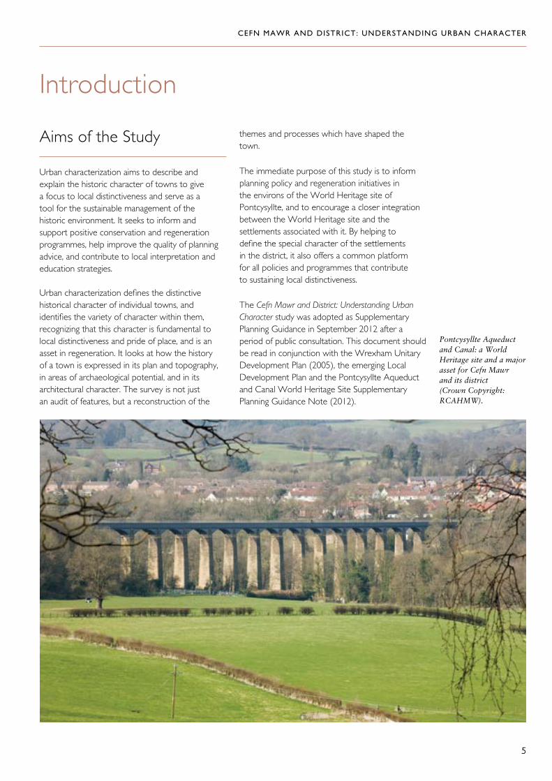
5
Aims of the Study
Urban characterization aims to describe and explain the historic character of towns to give a focus to local distinctiveness and serve as a tool for the sustainable management of the historic environment. It seeks to inform and support positive conservation and regeneration programmes, help improve the quality of planning advice, and contribute to local interpretation and education strategies.
Urban characterization defines the distinctive historical character of individual towns, and identifies the variety of character within them, recognizing that this character is fundamental to local distinctiveness and pride of place, and is an asset in regeneration. It looks at how the history of a town is expressed in its plan and topography, in areas of archaeological potential, and in its architectural character. The survey is not just an audit of features, but a reconstruction of the
themes and processes which have shaped the town.
The immediate purpose of this study is to inform planning policy and regeneration initiatives in the environs of the World Heritage site of Pontcysyllte, and to encourage a closer integration between the World Heritage site and the settlements associated with it. By helping to define the special character of the settlements in the district, it also offers a common platform for all policies and programmes that contribute to sustaining local distinctiveness.
The Cefn Mawr and District: Understanding Urban Character study was adopted as Supplementary Planning Guidance in September 2012 after a period of public consultation. This document should be read in conjunction with the Wrexham Unitary Development Plan (2005), the emerging Local Development Plan and the Pontcysyllte Aqueduct and Canal World Heritage Site Supplementary Planning Guidance Note (2012).
5
Introduction
Pontcysyllte Aqueduct and Canal: a World Heritage site and a major asset for Cefn Mawr and its district (Crown Copyright: RCAHMW).

The study area is located at the point where the east-flowing river Dee leaves the broad but high-sided valley it has occupied from its source, and flows into the flat lands of the Cheshire–Shropshire plain. The easternmost extent of the
ridge that defines this valley to the south is a limestone formation. On the north side of the river, the angle of slope eases around Trevor, only to be disrupted by a sandstone intrusion forming the Cefn Mawr and Cefn Bychan ridge to the east.
CEFN MAWR AND DISTRICT: UNDERSTANDING URBAN CHARACTER
6
Natural Topography and Geology
Cefn Mawr, dramatically sited on a ridge to the north of the river Dee (Crown Copyright: RCAHMW).
Cefn Bychan, at the end of the northern ridge (Crown Copyright: RCAHMW).

The southern ridge, which ends at Pen y Graig above the village of Froncysyllte, is made of limestone, which was profitably quarried from the late eighteenth to the twentieth century. To the north, Cefn Mawr is made up largely of quartzose sandstone, interspersed with thin seams of gritstone, ironstone, coal and clay,
in sequence below the sandstone, but still near the surface or outcropping. This concentration of accessible and valuable natural resources was the key to the industrial development of the area, which in turn profoundly influenced the distinctive form and appearance of its settlements.
CEFN MAWR AND DISTRICT: UNDERSTANDING URBAN CHARACTER
7
Froncysyllte, on the steep slopes of the southern ridge (Crown Copyright: RCAHMW).

CEFN MAWR AND DISTRICT: UNDERSTANDING URBAN CHARACTER
8
The extensive natural resources that were exploited during the nineteenth century had been known about in earlier periods and small-scale workings may long have been characteristic of the economy of the area, perhaps influencing the shape of early settlement as scattered smallholdings in a mesh of tracks and lanes. But it was investment in an industrial transport system — first the canal and then railways —that enabled more sustained growth in this area and supported the development of capitalized industries as well as the modern settlement pattern.
This pattern is characteristically informal, suggesting an almost casual and certainly scarcely controlled process. This was not a marginal area however: from the eighteenth century at least, it was an integral part of the holdings of several
Historical Background
The character of Cefn Mawr and the settlements around it reflects an industrial history based on exploitation of the abundant natural resources of the area. It is intimately linked to developments in transport and in particular to the construction of the Llangollen Canal, which crossed the Dee to reach Trevor on the Pontcysyllte Aqueduct in 1805. These developments took place in the context of land use that was originally agricultural. There is still abundant evidence of agriculture around the edge of the study area and on the valley floor, where ‘the Dee Valley broadens into green hedge-bordered water-meadows showing an industrial smudge only on the further side’,1 also in farms such as Ty Mawr, Cefn Bychan, and Dolydd to the north, Argoed and Ty Isa to the south. Industry, however, has been the dominant force in determining the present character of this landscape.
Pontcysyllte Aqueduct towers above the old bridge over the Dee in this depiction by John Warwick Smith (The National Library of Wales).

CEFN MAWR AND DISTRICT: UNDERSTANDING URBAN CHARACTER
9
Informal settlement patterns at Froncysyllte (Crown Copyright: RCAHMW).
A distinctive plot of land at Froncysyllte, with buildings along its boundary (Crown Copyright: RCAHMW).
estates and there was considerable activity in buying and selling land in the eighteenth and nineteenth centuries, partly in response to the commercial opportunities presented by the exploitation of mineral wealth.
The Wynnstay estate was the major landowner, and the boundary of its park marks an abrupt change in the character of the landscape to the east — industrial activity and settlement were largely excluded from its confines. Lands to the south of the Dee and a portion to the north belonged to the Chirk estate, whilst the Plas Madoc estate included much of the northern
part of the area. Originally the property of the Lloyd family, this estate came by marriage to John Rowland (died 1803), and was later in the possession of the Youde family until 1856. Lesser landowners included Sarah Jones, a widow, at Acrefair at the time of the tithe schedule in 1844. The Owen family, descended from the Kynastons, owned the Plas Kynaston estate until it was acquired by Wynnstay in 1813.
Plas Kynaston was an eighteenth-century house of some sophistication and, although the estate was probably of agricultural origin, its owner had been involved in coal mining on its land in the early

CEFN MAWR AND DISTRICT: UNDERSTANDING URBAN CHARACTER
10
eighteenth century. The house itself was leased to Exuperius Pickering and later to T.E. Ward, both of them entrepreneurs with interests in local mines and quarries. Pickering built the Kynaston branch of the canal from Trevor basin during the 1820s.
Some of these land owners were directly involved in the exploitation of resources on their land — for example, there was an ironworks at Plas Madoc by the seventeenth century, and later owners of this estate also invested in industrial development
on its land in the nineteenth century. Elsewhere, landowners seem to have been content to allow others to undertake development, benefiting from the enhanced rents this brought in. The British Iron Company, and its successor the New British Iron Company, became a significant local landowner in its own right, owning land in the vicinity of the works at the time of the tithe schedule of 1845, including lands in Acrefair where brick and tile works were later developed. Works on this scale required a significant land-take for the supply of raw materials and the dumping of waste.
Plas Kynaston (Crown Copyright: RCAHMW).

CEFN MAWR AND DISTRICT: UNDERSTANDING URBAN CHARACTER
11
Industry
From the late eighteenth century the area developed as a diverse industrial economy, characterized by many small-scale enterprises gradually giving way to larger, more highly capitalized concerns. North of the river, the primary extraction of iron ore, coal and clay, fed processing sites such as iron foundries, rolling-mills and brick works. But neither extraction nor processing formed discrete areas; rather they overlaid each other in complicated sequences of development and adaptation, and one site may have exploited several resources, either at the same time, or in sequence. For example, the British Ironworks at Acrefair had brick kilns as well as coking ovens, and the pits to the north of the Ruabon to Llangollen road worked both clay and coal, and were sunk in the immediate vicinity of brick works. South of the river a slightly simpler picture is presented, dominated by the quarrying of limestone and the production of lime. The only other significant industrial site to the south was the Pen y Bont Brick and Tile Works.
The small beginnings of some of these industries, especially coal mining, meant that for a time they could be accommodated within existing patterns of land use. Around Tref y Nant, for example, small coal shafts took up only limited space within an agricultural field pattern. As they expanded, however, all these local industries required a significant land-take, for extraction, processing and the disposal of waste. The field systems or open land on which they had originated were increasingly given over to the needs of industry, which created its own landscape. This was seen most graphically at the British Ironworks site, along with the chemical works which, as it expanded in the twentieth century, ruthlessly filled in a branch of the canal, realigned an existing road, and constructed culverts for the stream that had previously flowed through the site.
In addition, all of these industries, here considered individually by type, were dependent on a transport network for moving raw materials from source to processing plant, and for moving goods from production or processing sites towards their markets. These transport arteries also entailed considerable disruption to earlier land-use patterns, becoming major landscape elements
in their own right. Falling out of use, some have themselves been disrupted or lost, but many have been resilient components of the landscape as a framework for development.
Iron
‘Two enormous sheets of flame shot up high unto the air from ovens, illumining spectral chimneys as high as steeples, also smoky buildings, and grimy figures moving about. There was a clanging of engines, a noise of shovels and a falling of coals truly horrible.’ The New British Ironworks, as described by George Borrow, 1862.2
There are references to deposits of iron ore at Tref y Nant in the early nineteenth century,3 and shafts in several of the local coal mines passed through iron-ore strata. There were, therefore, many places where the raw material could be obtained locally, alongside coal to process it and, at Newbridge, water power to operate rolling mills for the production of wrought iron. Along with coal mining, iron working is probably the oldest-established industry in the district, and was a major player in its development during the nineteenth century.
Iron smelting and processing have been documented in the area since the seventeenth century at least. There was a charcoal-fired blast furnace at Plas Madoc in 1677–78, which had the substantial output of 300 tons (272.15 tonnes) per annum in 1711, and which may have been the site of experiments in coke smelting in 1757–61, or possibly earlier. The enterprise was developed by the Lloyd family of Plas Madoc, and a daughter of this family married John Rowland, who ‘devoted his long life to the accumulation of estates in Ruabon parish’, and who also developed the coal mines on his growing property in the late eighteenth and early nineteenth centuries.4 His son Edward established the Acrefair or New Ruabon Iron Works on the estate in about 1817, and also laid down a network of early railways to connect the coal pits to the ironworks. The works ceased production in 1822, by which time it had two blast furnaces, 18 puddling furnaces, a large double casting house and a Boulton and Watt type steam engine to power the blast. Its successor proved to be more enduring: the freehold was bought by the British Iron Company in 1825 (which became

CEFN MAWR AND DISTRICT: UNDERSTANDING URBAN CHARACTER
12
the New British Iron Company in 1843, and the New British Iron Company Ltd in 1886), and the works remained in production until 1887. It was succeeded by an engineering works, and from 1891 Messrs Hughes and Lancaster made ejectors, pumps, air compressors, and textile processing machinery. The works were acquired by the Butterley Company in 1951. Its successor on the site, Air Products, closed in 2009, and the site was cleared in 2010.
The ironworks was extensive by 1875, occupying a considerable acreage on both sides of the Ruabon–Llangollen road, with a complex internal railway network and links to the Vale of Llangollen Railway and the canal basin at Trevor. Physical remains associated with this major industrial site are scant, but the long retaining wall on the south side of the Ruabon–Llangollen road, east of its junction with King Street, Cefn Mawr, is a dominant feature, and clearance of modern buildings has exposed possible kilns in the bank below Lancaster Terrace at the rear of the site. There are also the remains of some coking furnaces in woodland behind Lancaster Terrace, whilst the derelict land to the north of the road (and north-east of Chapel Street) probably represents an area of extraction and tipping.
Meanwhile, the construction of the canal and aqueduct stimulated the development of engineering in its vicinity. The Plas Kynaston foundry, which survived until the 1930s when it was subsumed into the chemical works site, is thought to be where the parts for the aqueduct were cast.
Acrefair furnace in 1962 (Crown Copyright: RCAHMW).
The site of the British Ironworks in 2011 (Crown Copyright: RCAHMW).
This impressive retaining wall is an important legacy of the British Ironworks (Crown Copyright: RCAHMW).

CEFN MAWR AND DISTRICT: UNDERSTANDING URBAN CHARACTER
13
Iron-working slag used in walling is a lasting reminder of an important local industry (Crown Copyright: RCAHMW)
Remains of calcining kilns associated with the British Ironworks (Crown Copyright: RCAHMW).
The origins of this important foundry are unclear. William Hazledine, who was awarded the contract for supplying the castings for the aqueduct in 1802, and who ran the foundry until his death in 1840, may have bought the lease of an existing building, but no buildings are shown on an estate map of 1804,5 though coal pits are much in evidence. It is however hard to imagine that there was no means of casting components locally when work began on the aqueduct in 1795. Hazledine had operated foundries at Cole Hall in Shrewsbury from the 1780s, and made the acquaintance of Telford in 1789. In 1796 he established an ironworks at Longden Coleham near Shrewsbury. Telford referred to him as ‘the arch conjuror’ and awarded him the contract for the ironwork for the Pontcysyllte Aqueduct on 17 March 1802, to the disappointment of William Reynolds of Ketley and John Wilkinson of Hadley ironworks. Hazledine later operated the Calcutts ironworks in the Ironbridge Gorge in 1817 and the Llanymynech limeworks. He supplied the ironwork for many other important contracts from the Plas Kynaston foundry and from his other foundry at Longdon Coleham near Shrewsbury.6
Like other enterprises in the vicinity, the Plas Kynaston foundry benefited firstly from an early railway link to the canal basin at Trevor and, by about 1830, from the Kynaston arm of the canal.
At Newbridge, a rolling mill was in existence by 1808 and a furnace by 1820, when the lessees of Plas Isaf pit in Pen y Cae (to the north of, and outside the study area) were contracted to supply 200 tons (181.43 tonnes) of coal a week, by means of a branch railway from the Crane. The furnace was sold to the British Iron Company in 1825,7 and there is no reference in the Wynnstay rent-books to the branch railway after 1826.8 The tithe schedule of 1846 calls it ‘old furnace bank’, and by the time of the first edition only ‘Old Forge Row’ and the watercourse are shown. Grass-covered foundations and low walls survive close to the west bank of the river, east of Newbridge at NGR 32892 34144.
Sandstone
Sandstone quarries around Cefn Mawr have been exploited since medieval times, the stone being used in the churches at Wrexham and Gresford, but the sites of early quarries have not been identified. There is a tradition that the stone for the aqueduct also came from Cefn, but there is little to indicate where the major quarries of this period were located, nor how stone was transported from them.
There are several candidates for the source of the stone for the aqueduct. The surveyors’ drawings of the area from the 1830s identify ‘Chwarela’ (‘quarries’) to the west of Trevor basin (NGR 32696 34258), the name surviving at the junction of the Ruabon–Llangollen road and the road leading to the basin on the 1975 Ordnance Survey map. It is given as ‘Chwarel’ in the tithe schedule of 1838, when it was owned by one

CEFN MAWR AND DISTRICT: UNDERSTANDING URBAN CHARACTER
14
Thomas Lloyd esquire of Llys. A ‘cae open cut’ identified at SJ 2715 4284 may also have been a quarry.9 It is at least a possibility that these were the sources of the stone and that it was transported by horse and cart from here to the construction site.
Another possible source is implied in a study of 1879, which suggests, but does not explicitly state, that the ‘Aqueduct Grit’, of which the masonry components are built, was extracted at a large quarry at Tyfyn-uchaf (sic) and that there was another large quarry of aqueduct grit at ‘Australia’, near the former Trevor railway station, later worked for brick clay.10 The 1873 25-inch Ordnance Survey map shows a quarry here, immediately upslope of The Australia Arms, and Tddyn Uchaf (sic) is a farm below Ruabon mountain, about 1.24 miles (two kilometres) west of Pen y Cae, outside the study area to the north.
There is no evidence for large-scale quarrying in any of these locations, however, nor for transport systems associated with the movement of stone from them. It remains on balance much more likely that the outcrops of Cefn Mawr itself were the source of the aqueduct stone. Quarries here were certainly in lease by the 1820s,11 Cefn stone was extensively worked well into the twentieth century, and one working face is still exploited, behind High Street, Cefn (NGR 3279 3424). There were other substantial workings running up the ridge of Cefn to the east of High Street, and on the north-eastern edge of the settlement, on the north-west side of Well Street (NGR 3281 3425), and immediately to the west of Rhosymedre (NGR 3284 3431). These are first shown reliably on the 1873 25-inch Ordnance Survey map.
Quarries pock-mark the ridge of Cefn Mawr (Crown Copyright: RCAHMW).
Right: An old quarry face at Rock Croft, Cefn Mawr (Crown Copyright: RCAHMW).
Far right: The aptly named Rock Place, where houses coexist with former quarries at the top of the ridge of Cefn Mawr (Crown Copyright: RCAHMW).

CEFN MAWR AND DISTRICT: UNDERSTANDING URBAN CHARACTER
15
The line of Minshalls Croft was once an inclined plane connecting ridge-top quarries with an early railway (Crown Copyright: RCAHMW).
There is evidence of transport systems linked to several of these quarries. There are possible inclines running down from the quarrying area on the east of High Street to connect with the early railway on the line of King Street (sleeper blocks have been found in a disused track at NGR 3279 3424), and the lane angled down from High Street to King Street at Minshalls Croft could possibly have originated as an incline. The larger quarries on the east side of the ridge near Rhosymedre were linked by rail both to the Great Western Railway and to the canal basin at Trevor by a line parallel to and below Crane Street and King Street.
There is also evidence of small-scale quarrying at Cefn Bychan, presumably for local building stone.
Limestone Quarrying and Burning
Limestone had been quarried in the Ceiriog Valley since the sixteenth century at least, and probably also at Pen y Graig above Froncysyllte. The arrival of the canal enabled Pen y Graig to develop further. Kilns in the quarry are shown in a sketch of the aqueduct in 1809, and on an 1817 map of the Telford road.12 These quarry-sited kilns were soon supplemented by other developments alongside the canal and the A5, where four sets of kilns were built at various stages. In 1815, an incline running down what is now Woodlands Grove linked the quarry with a canal wharf and with two limekilns, parts of which survive. These are identified as the property of Frederick West of Quinta (who also owned the lower part of the quarry), and leased to Hazledine and Company in the tithe schedule of 1844.13 By 1817, a set of limekilns had been built on land
belonging to the Chirk Castle estate above the A5 road to the east of the present settlement, and were served by a ‘slope road’ from the upper quarry. This road was superseded by a railway and incline in the late 1830s or early 1840s, which may also be the date of an additional battery of six large limekilns built alongside the canal, these survive substantially intact.
There was another group of kilns at Trevor, established in the 1830s. These kilns were supplied from the south of the river by canal, via a branch from the Kynaston arm. Traces of these may survive in undergrowth on the north-east side of Queen Street at NGR 32745 34261.
Quarrying has had a major impact on the shape of the landscape and its development but, paradoxically perhaps, is not immediately visible because the sites are often derelict and inaccessible.
Left: The eastern limekiln bank at Froncysyllte (Crown Copyright: RCAHMW).
Far left: The western limekiln bank at Froncysyllte (Crown Copyright: RCAHMW).
CEFN MAWR AND DISTRICT: UNDERSTANDING URBAN CHARACTER
16
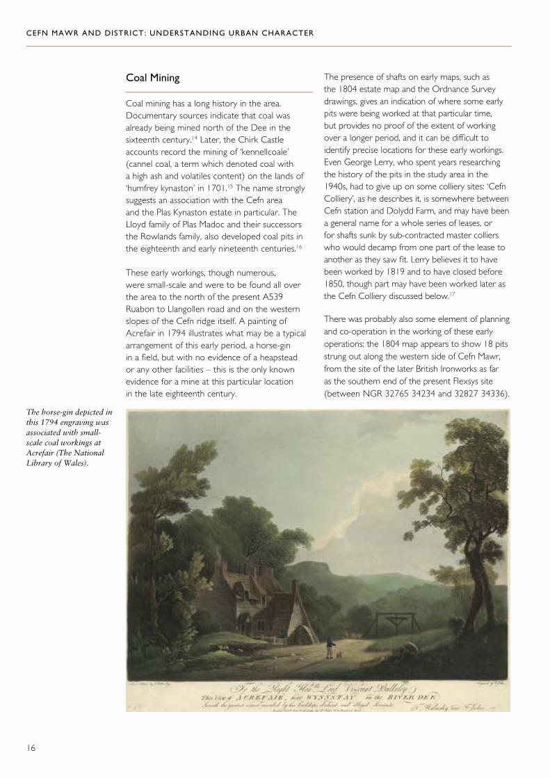
Coal Mining
Coal mining has a long history in the area. Documentary sources indicate that coal was already being mined north of the Dee in the sixteenth century.14 Later, the Chirk Castle accounts record the mining of ‘kennellcoale’ (cannel coal, a term which denoted coal with a high ash and volatiles content) on the lands of ‘humfrey kynaston’ in 1701.15 The name strongly suggests an association with the Cefn area and the Plas Kynaston estate in particular. The Lloyd family of Plas Madoc and their successors the Rowlands family, also developed coal pits in the eighteenth and early nineteenth centuries.16
These early workings, though numerous, were small-scale and were to be found all over the area to the north of the present A539 Ruabon to Llangollen road and on the western slopes of the Cefn ridge itself. A painting of Acrefair in 1794 illustrates what may be a typical arrangement of this early period, a horse-gin in a field, but with no evidence of a heapstead or any other facilities – this is the only known evidence for a mine at this particular location in the late eighteenth century.
The presence of shafts on early maps, such as the 1804 estate map and the Ordnance Survey drawings, gives an indication of where some early pits were being worked at that particular time, but provides no proof of the extent of working over a longer period, and it can be difficult to identify precise locations for these early workings. Even George Lerry, who spent years researching the history of the pits in the study area in the 1940s, had to give up on some colliery sites: ‘Cefn Colliery’, as he describes it, is somewhere between Cefn station and Dolydd Farm, and may have been a general name for a whole series of leases, or for shafts sunk by sub-contracted master colliers who would decamp from one part of the lease to another as they saw fit. Lerry believes it to have been worked by 1819 and to have closed before 1850, though part may have been worked later as the Cefn Colliery discussed below.17
There was probably also some element of planning and co-operation in the working of these early operations; the 1804 map appears to show 18 pits strung out along the western side of Cefn Mawr, from the site of the later British Ironworks as far as the southern end of the present Flexsys site (between NGR 32765 34234 and 32827 34336).
The horse-gin depicted in this 1794 engraving was associated with small-scale coal workings at Acrefair (The National Library of Wales).
CEFN MAWR AND DISTRICT: UNDERSTANDING URBAN CHARACTER
17
A common drainage level, which still survives, emerges at NGR 327654 342367. This feature suggests that the various collier lessees and the landowners had been able to co-operate on what would have been a very costly exercise.18
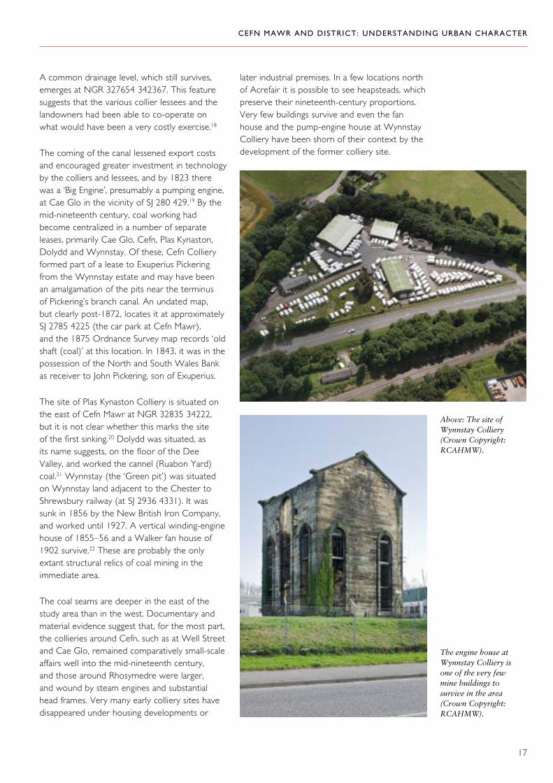
The coming of the canal lessened export costs and encouraged greater investment in technology by the colliers and lessees, and by 1823 there was a ‘Big Engine’, presumably a pumping engine, at Cae Glo in the vicinity of SJ 280 429.19 By the mid-nineteenth century, coal working had become centralized in a number of separate leases, primarily Cae Glo, Cefn, Plas Kynaston, Dolydd and Wynnstay. Of these, Cefn Colliery formed part of a lease to Exuperius Pickering from the Wynnstay estate and may have been an amalgamation of the pits near the terminus of Pickering’s branch canal. An undated map, but clearly post-1872, locates it at approximately SJ 2785 4225 (the car park at Cefn Mawr), and the 1875 Ordnance Survey map records ‘old shaft (coal)’ at this location. In 1843, it was in the possession of the North and South Wales Bank as receiver to John Pickering, son of Exuperius.
The site of Plas Kynaston Colliery is situated on the east of Cefn Mawr at NGR 32835 34222, but it is not clear whether this marks the site of the first sinking.20 Dolydd was situated, as its name suggests, on the floor of the Dee Valley, and worked the cannel (Ruabon Yard) coal.21 Wynnstay (the ‘Green pit’) was situated on Wynnstay land adjacent to the Chester to Shrewsbury railway (at SJ 2936 4331). It was sunk in 1856 by the New British Iron Company, and worked until 1927. A vertical winding-engine house of 1855–56 and a Walker fan house of 1902 survive.22 These are probably the only extant structural relics of coal mining in the immediate area.
The coal seams are deeper in the east of the study area than in the west. Documentary and material evidence suggest that, for the most part, the collieries around Cefn, such as at Well Street and Cae Glo, remained comparatively small-scale affairs well into the mid-nineteenth century, and those around Rhosymedre were larger, and wound by steam engines and substantial head frames. Very many early colliery sites have disappeared under housing developments or
later industrial premises. In a few locations north of Acrefair it is possible to see heapsteads, which preserve their nineteenth-century proportions. Very few buildings survive and even the fan house and the pump-engine house at Wynnstay Colliery have been shorn of their context by the development of the former colliery site.
Above: The site of Wynnstay Colliery (Crown Copyright: RCAHMW).
The engine house at Wynnstay Colliery is one of the very few mine buildings to survive in the area (Crown Copyright: RCAHMW).

CEFN MAWR AND DISTRICT: UNDERSTANDING URBAN CHARACTER
18
Small-scale early coal workings do not appear to have required significant transport infrastructure, but from the early nineteenth century, larger workings were increasingly linked into systems of transport, using local railways to connect to the canal, and later to main lines. The Ruabon Brook Railway was the first of these links, partly adapted for steam traction and partly abandoned in favour of a new railway in the period 1864 to 1873. The most significant change of this period was the abandonment of its sinuous route between Trevor basin and the British Ironworks for a more direct line. The old route survives as Oilworks Road in the Flexsys site, as Railway Road and as King Street north from the Crane to its junction with High Street.
The Ruabon Brook Railway served various industrial interests along its route in both its horse-drawn and locomotive-worked periods. The larger enterprises of the late nineteenth century sometimes created their own rail links. For example, the 1875 Ordnance Survey map shows that Plas Kynaston Colliery had sidings on the Great Western Railway (GWR), but was also linked by its own railway, presumably horse-worked, to the terminus of the Kynaston arm of the canal, crossing Queen Street near its junction with Dolydd Road. The line also served Dolydd Colliery. This line has completely disappeared. The Wynnstay Colliery was sited at the junction of the GWR (Chester–Shrewsbury line) and the Vale of Llangollen Railway as well as being served by a branch from the locomotive reincarnation of the Ruabon Brook Railway (the ‘Plasmadoc branch’).
Clay
Interspersed with coal seams in the sandstone geology was clay, and its exploitation made a strong contribution to the character of this area
(as to others further afield), through the export of building materials.
Exploitation of these clays seems not to have got under way until the 1850s, perhaps encouraged by good transport links both to the canal and the national railway network. A coarse-earthenware works at Cefn Mawr — Plas Kynaston Pottery — was developed adjacent to the terminus of the Kynaston arm of the canal from 1856. It specialized in small terracotta and earthenware products such as flowerpots and seed pans, but it was brick-making, worked with the red marls of upper coal measures, that had a particularly significant impact on the area. Bower’s Penbedw brick works were active by the 1850s and the Plas Isa works was in production by 1860. These sites covered a very wide area around Trevor and Acrefair.
Far right: The Acrefair brick and tile works, as recorded by Geoff Charles in 1939 (The National Library of Wales).
Far right: Clay workings near Cefn Mawr, 1950 (The National Library of Wales).
Clay workings associated with the Acrefair brick and tile works, 1939 (The National Library of Wales).

CEFN MAWR AND DISTRICT: UNDERSTANDING URBAN CHARACTER
19
The Pen y Bont works near Newbridge was established about 1865 and taken over by J. C. Edwards in about 1869. As the works expanded it was first connected to the canal by a horse-worked narrow-gauge line, then to the GWR main line by a standard-gauge locomotive-worked siding. J. C. Edwards had established works at Tref y Nant in 1866, which with the associated Tref y Nant fireclay works, was connected by a branch line to the Vale of Llangollen Railway. J. C. Edwards’ brick and tile manufacturing business included another works at Rhosllanerchcrugog, and became a limited company in 1903.23 The Trevor (Garth) silica brick works, also known as the Australia brick works (immediately north of the
These walls are an important relic of the Tref y Nant brick works, and a fine example of their products (Crown Copyright: RCAHMW).
junction of Llangollen Road and Garth Road) was operational by 1885, and was similarly connected by standard-gauge siding to the main line, which crossed the A539, the Ruabon to Llangollen road, near The Australia public house. Various smaller ventures were also established across the area (at NGR 3269 3431, 3277 3426, 3280 3422 and 3279 3423).
Brick production ceased within the study area in the 1960s, and astonishingly little survives of this industry above ground, despite the extensive scale and the many sites on which it operated. The entrance walls of the Tref y Nant works survive alongside the main road, and there may be some trace of structures on the site itself, which is heavily overgrown with woodland;

CEFN MAWR AND DISTRICT: UNDERSTANDING URBAN CHARACTER
20
there may also be structures associated with the Penbedw works in woodland to the east of Chapel Street, Acrefair. A housing estate has been built on the Trevor works site at Garth, and the Plas Isa site to the north of Acrefair is reclaimed land. At Pen y Bont, the pit and the once extensive kilns have been converted into a landfill site, and only an attractive gate lodge and four cottages survive. They were built around 1882, the work of George Canning Richardson, head of Edwards’ design department. The most eloquent material evidence is the use of the distinctive red brick and terracotta ornamentation in terraced houses, chapels and commercial buildings across the area. The products of these works were also widely distributed, and the character of many other towns in Wales and beyond owes much to the use of brick from this area.
Two of the many examples of the locally produced brick, which makes a strong contribution to the character of the area (Crown Copyright: RCAHMW).

CEFN MAWR AND DISTRICT: UNDERSTANDING URBAN CHARACTER
21
The Chemical Industry
In partnership with the Manchester lawyer, Timothy Crowther, the German chemist Graesser set up works at Cefn Mawr in 1867 to produce paraffin from colliery shale. Graesser had been educated at the mining academy at Chemnitz in Saxony, and made his career in the burgeoning chemical industry of Germany before coming to Wales. With the opening of the American oil-wells, the market collapsed and the partnership dissolved. Graesser then turned to the production of phenol from crude carbolic, which was produced by
the gas and tar industries, and he was producing half the world’s supply by 1910. Through family connections in Saxony, he produced synthetic dyes and picric acid for treating burns. In 1920 a half share was acquired by the Monsanto works of St Louis, Missouri (named after Olga Monsanto, the wife of the founder, John Francis Queeny), and the Cefn Mawr works went over to producing saccharin, vanillin, salicylic acid and aspirin. In 1928 the Graesser partnership ended, and from 1930 rubber chemicals were produced.24 As part of the Flexsys empire, the Cefn Mawr works remained in active production until the early twenty-first century.
The Monsanto Chemical Works in 1988 (Crown Copyright: RCAHMW).

CEFN MAWR AND DISTRICT: UNDERSTANDING URBAN CHARACTER
22
As the works expanded, it took over (and effectively destroyed) the sites previously occupied by small coal workings, the Kynaston foundry, and the Kynaston pottery. It made use of earlier transport links across the site (the Kynaston Canal, standard-gauge railway sidings) until they too were mainly obliterated by continued expansion in the second half of the twentieth century. Following the partial closure of the works, much of the site was cleared in 2010, leaving behind a mesh of retaining walls and footings. Part of a canal bridge, and a roof-truss from the foundry are amongst the few visible remains of the earlier land use.
Right: The Monsanto Chemical Works during demolition in 2007 (Crown Copyright: RCAHMW).
Below: The cleared site of the chemical works in 2009 (Crown Copyright: RCAHMW).

CEFN MAWR AND DISTRICT: UNDERSTANDING URBAN CHARACTER
23
Transport
As we have seen, the development of transport links played a vital part in the industrialization of the area after the construction of the canal first opened it up to wider markets. The shape of settlement has also been strongly influenced by networks of transport from all periods, as first the gaps between early laneways and roads were colonized, and turnpike roads, canals and railways provided an infrastructure for development.
Turnpikes and Laneways
The main road network formed links between the Dee Valley and its market town of Llangollen, with Chirk and Ruabon. The present A539 and A5 approximate to the routes of these earlier east–west routes, which were both established as turnpikes in the eighteenth century.25 The Ruabon to Llangollen road is depicted, in an engraving of 1794, as a winding country lane in the vicinity of Acrefair, and was improved at this point in 1818 (the stretch from Plas Madoc to Tref y Nant is notably straight).26 More significant was
the upgrading, and partial realignment, of the existing Chirk to Llangollen road to form part of Thomas Telford’s London to Holyhead turnpike. It ran along the southern side of the Dee Valley from 1817, which was when the contract for the stretch ‘Near Biddulph’s Lime Kilns, Chirk’ was awarded to one Thomas Evans, who was responsible for building several other parts of the road.27 Plans confirm that it was an upgrading of an existing road.
There are also two principal cross-routes connecting the northern and southern sides of the Dee Valley within the study area. One crosses the river by means of the three-arched Cysyllte bridge, built in 1697. Another such route runs
Pontcysyllte Aqueduct, towering over the old road bridge over the river Dee (The National Library of Wales).
Cysyllte bridge was built in 1697 (Crown Copyright: RCAHMW).
CEFN MAWR AND DISTRICT: UNDERSTANDING URBAN CHARACTER
24
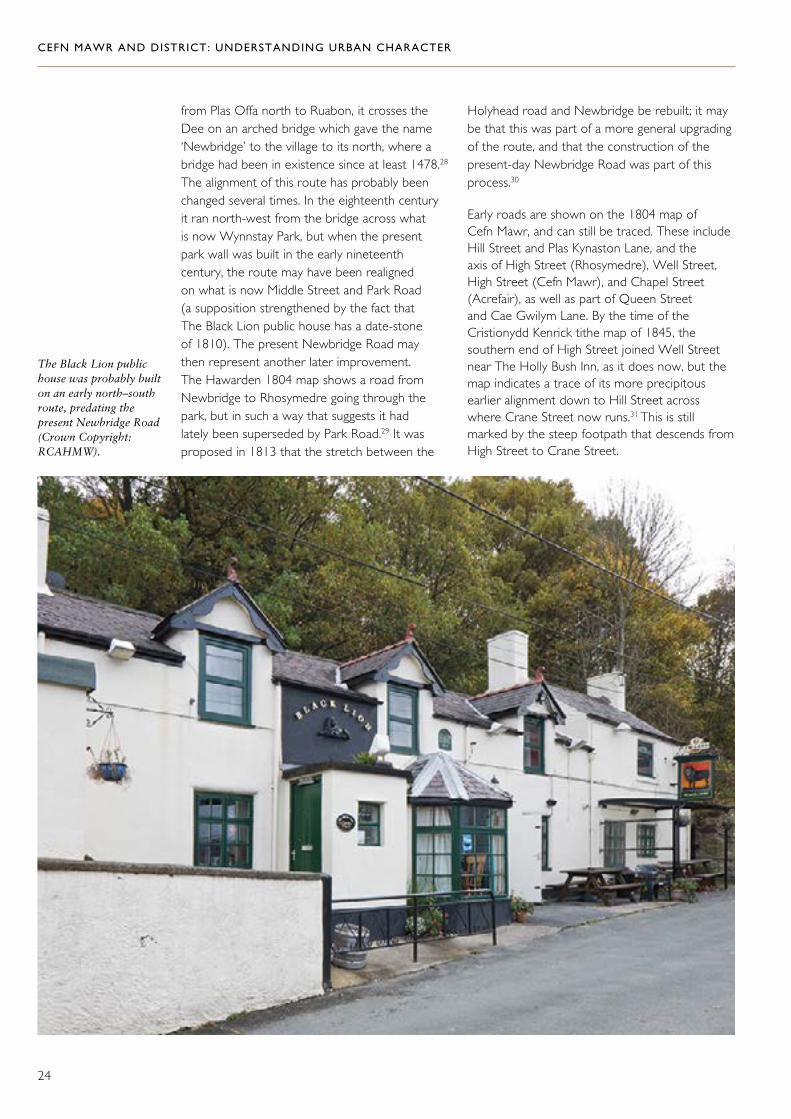
from Plas Offa north to Ruabon, it crosses the Dee on an arched bridge which gave the name ‘Newbridge’ to the village to its north, where a bridge had been in existence since at least 1478.28 The alignment of this route has probably been changed several times. In the eighteenth century it ran north-west from the bridge across what is now Wynnstay Park, but when the present park wall was built in the early nineteenth century, the route may have been realigned on what is now Middle Street and Park Road (a supposition strengthened by the fact that The Black Lion public house has a date-stone of 1810). The present Newbridge Road may then represent another later improvement. The Hawarden 1804 map shows a road from Newbridge to Rhosymedre going through the park, but in such a way that suggests it had lately been superseded by Park Road.29 It was proposed in 1813 that the stretch between the
The Black Lion public house was probably built on an early north–south route, predating the present Newbridge Road (Crown Copyright: RCAHMW).
Holyhead road and Newbridge be rebuilt; it may be that this was part of a more general upgrading of the route, and that the construction of the present-day Newbridge Road was part of this process.30
Early roads are shown on the 1804 map of Cefn Mawr, and can still be traced. These include Hill Street and Plas Kynaston Lane, and the axis of High Street (Rhosymedre), Well Street, High Street (Cefn Mawr), and Chapel Street (Acrefair), as well as part of Queen Street and Cae Gwilym Lane. By the time of the Cristionydd Kenrick tithe map of 1845, the southern end of High Street joined Well Street near The Holly Bush Inn, as it does now, but the map indicates a trace of its more precipitous earlier alignment down to Hill Street across where Crane Street now runs.31 This is still marked by the steep footpath that descends from High Street to Crane Street.

CEFN MAWR AND DISTRICT: UNDERSTANDING URBAN CHARACTER
25
A dense and irregular network of smaller laneways is a characteristic feature of the upper slopes of Cefn Mawr, above this early through-route, as well as on the slopes of Froncysyllte and Cefn Bychan. Lanes run between irregular plots of land and may either be the relics of earlier routes between small industrial workings, or the spaces left between haphazard plots of land taken from the commons for building. Many of these lanes and paths take a direct route up steep slopes, in contrast to railways and main routes, which followed the contours.
Small lanes, pathways and steps are a characteristic of the hillside settlements on both sides of the river Dee (Crown Copyright: RCAHMW).

CEFN MAWR AND DISTRICT: UNDERSTANDING URBAN CHARACTER
26
Waterways
The building of the Llangollen Canal through the study area from 1795 to 1805 had a profound impact on its landscape and settlement. The production of components for the aqueduct required the establishment of large-scale industrial manufactories, which were then able to reach regional and national markets using the canal to
Pontcysyllte Aqueduct proudly straddling the river Dee. (The National Library of Wales).
transport their products. Wharves were established for the export of limestone, burnt lime and Glyn Ceiriog slate at Froncysyllte, and for coal, engineering products, and cast- and wrought-iron products at Trevor, which was the principal canal basin. From here, goods were trans-shipped between the canal and the Ruabon Brook Railway and its successors. There was a modest amount of settlement associated with the basin, and clustered along the road from the old bridge.
Right: Pontcysyllte Aqueduct under construction. (The National Library of Wales).
Far right: Pontcysyllte Aqueduct from the south-east (Crown Copyright: RCAHMW).

CEFN MAWR AND DISTRICT: UNDERSTANDING URBAN CHARACTER
27
Canal boats on the wharf at Froncysyllte (Crown Copyright: RCAHMW).
Trevor basin (Crown Copyright: RCAHMW).
The former docking area at Trevor basin, where goods were transhipped from canal to railway (Crown Copyright: RCAHMW).

CEFN MAWR AND DISTRICT: UNDERSTANDING URBAN CHARACTER
28
line, but it has in turn been dismantled. Part of a stone-built bridge carrying a lane over the canal is its only visible remnant.32 The Kynaston Arm provided an effective link between the industries of Cefn Mawr and the main waterway network. Its loss — and the loss of the industries it was intended to serve — has made it more difficult to appreciate the industrial character of the Llangollen Canal, and has cut Cefn Mawr adrift from one of its principal historical supply-lines.
A short branch off this canal led to the Aber-nant limekilns near the north end of Queen Street (NGR 32745 34261). This is believed to have been constructed in 1838 or shortly thereafter.
Two branches led off the Llangollen Canal from the Trevor basin. One is the canal built by Exuperius Pickering to give access to the foundry and to the various coal shafts on what became the Flexsys site, and which ultimately also provided a canal outlet for Plas Kynaston colliery. This canal ran from Trevor basin through what later became the Flexsys site to a terminus behind Queen Street, Cefn Mawr at approximately NGR 32773 34230. This branch was proposed in 1820, incomplete (possibly still not started) in 1829 and in existence by 1835-36. Pickering’s canal was progressively dismantled from the 1950s onwards. The chemical works expanded over its
Trevor basin was an important interchange; the three arches of the bridge took the canal and horse-worked railways. (Crown Copyright: RCAHMW).
All that remains of the entrance to the former Kynaston Canal at Trevor basin (Crown Copyright: RCAHMW).

CEFN MAWR AND DISTRICT: UNDERSTANDING URBAN CHARACTER
29
Railways
From at least 1805 until the 1960s, the area was served by a dense and complex network of railways of different types. They were the arteries of industrial development, and also helped shape the form of settlement. For example, King Street in Cefn Mawr is on the line of the former Ruabon Brook Railway, in use from 1808 (if not 1805) until between 1864 and 1873, and Woodlands Grove in Froncysyllte was originally an incline. Even where railways and streets maintained separate rights of way, for many years the inhabitants of the area lived in grimy and perilous proximity to shunting locomotives and trains of wagons clattering over level crossings. The only operational railway within the study area now is the Chester to Shrewsbury main line, but the routes of many others survive in whole or part.
Early Railways and Mineral LinesThe most important early railway was the Ruabon Brook Railway. It was built under the auspices of the Ellesmere Canal Company from the Trevor basin to the Plas Kynaston foundry and adjacent pits in or by 1805 or 1808, and extended in stages to the Plas Madoc pit area, ultimately reaching the Pen y Cae and Rhosllanerchrugog areas by 1821. As industries developed and shafts were sunk along its route, it sent out branches and sidings to serve them. It functioned until the 1860s.33
In its first phase it is said to have run from the canal basin past Hazledine’s foundry to give access to Plas Kynaston pits 6 and 7 (in the region of NGR 32785 34279).34 By 1808 it had been extended to a ‘present terminus at Plas Madox colliery’ (NGR 3292 3435), and contractors were sought to extend it to the Afon Eitha, a stream also known as the Ruabon Brook, to the north (and outside the study area).35 By 1809 it extended to the Afon Eitha, whence a spur was built at the canal company’s expense, to reach the New Engine colliery.36 By 1830 it was described as a ‘double railway’ to ‘Ruabon Brook, a distance of about three miles’, and the engineers who constructed it are identified as John Duncombe, William Jessop and Telford.37 It was probably built as a plateway (L-section rails for flangeless wheels); a run of stone sleepers recently discovered and excavated near Cefn High Street38
with a single spike-hole in each one is easier to reconcile with a plateway, though this section of track may have belonged to a short unconnected length of stone quarry railway shown in a map of about 1840.39
Many aspects of its history and technology are unclear, including the supposed ‘crane’, which, if it ever existed, lay on the site of the junction between the original line of 1805 to Plas Kynaston colliery and the line to Plas Madoc colliery, and as such was in the region of the present Crane car park. It was reputedly constructed either to trans-ship long rigid loads (such as wrought-iron bars), which could not negotiate the sharp curve at the foot of King Street; or to connect incompatible track systems, such as an edge railway and a plateway. In this case it might date from between about 1817, when Acrefair ironworks went into production, and 1822 when it ceased to operate. Ifor Edwards suggests it transferred loads between carts and rail wagons. Yet another suggestion is that it was a winding drum to raise rail wagons up an incline on a branch railway to Lacon’s furnace and forge on the Dee at Newbridge. This railway was built in 1820 by the lessees of Plas Isaf pit (NGR 32809 34467) and lifted by 1845,40 its line survives as a footpath and as Bower’s Road, further south-east it is lost under the Dolydd housing estate. At the moment there is no firm evidence even to support the existence of a crane, let alone explain its purpose. There has also been a suggestion that the word ‘crane’ has nothing to do with the railway but is an Anglicization of a local Welsh dialect word, ‘craen’ or ‘y graen’, which means slope.
The Ruabon Brook Railway became part of the London and North Western Railway consortium when it took over the Ellesmere Canal Company lease from 1 July 1849. The first 25-inch Ordnance Survey maps of 1873 show this early railway system as largely superseded by later locomotive worked industrial railways, and part of the route already buried by the New British Iron Works.41
The route of this railway is represented by Oilworks Road in the Flexsys site, and as Railway Road and King Street north from the Crane to its junction with High Street. North of here its route has been obliterated by the Air Products

CEFN MAWR AND DISTRICT: UNDERSTANDING URBAN CHARACTER
30
works, though traces are evident as landscape features north of the A539 in Acrefair and towards Delph.
At Froncysyllte, an incline occupying the site of the present Woodlands Grove connected the limestone quarries to canal-side kilns and a wharf by 1815.42 A later incline was constructed 0.12 miles (200 metres) to the east (measured from the point where it passes under the A5); it was in existence by 1842.43 By 1954 the canal basin had been filled in and the kilns were out of use. The system operated as three counter-balanced inclines and a horse-drawn section across the road (at SJ 274 412) to a crusher and thence to a tarmac plant, the produce being removed by lorry. It operated until 1956.44
Locomotive RailwaysPublic and industrial railways worked by locomotives first appear within the study area with the opening of the still operational Shrewsbury and Chester Railway in 1848 (which includes the stone-arched Newbridge viaduct). Another system that served the area was the Vale of Llangollen
Railway from Ruabon through Llangollen and ultimately to Barmouth Junction. This opened in stages from 1859 onwards through Acrefair and Trevor, and closed down in stages in the 1960s. Both of these built their own branches to the canal. One of them was a steam-operated replacement for the Ruabon Brook Railway to Trevor basin, built between 1860 and 1865, virtually disused by 1945, and removed about 1953. This cut out the sinuous route along Railway Road and King Street. It survives as the substantial embankment that runs north-east from the canal basin, as well as the trace of a siding following the route of the Ruabon Brook Railway through the Flexsys site as far as the present Crane Street car park (where it served the colliery). It continues on to the south of Well Street to give access both to the Great Western Railway Chester–Shrewsbury line and to the sandstone quarries on the eastern side of Cefn Mawr. The other was a 0.74 mile (1.2 kilometre) long horse-drawn siding from the Shrewsbury to Chester main line immediately south of Robertson’s viaduct (SJ 286 408) at Pentre, to the Froncysyllte limekilns. This was operated by the Great Western Railway in conjunction with the Chirk estate until 1940.45 Much of the course survives.
The viaduct in 1850 (National Library of Wales).

CEFN MAWR AND DISTRICT: UNDERSTANDING URBAN CHARACTER
31
Many of these branch lines have disappeared with little trace, though surviving bridge parapets provide an important reminder of their existence.
The history of railways worked by locomotives in the study area is remarkably complicated. There were, in addition to the public railways, many locomotive-worked sidings connecting the Vale of Llangollen Railway with brick works, collieries, the Monsanto works and other undertakings. One of the most important of these in landscape terms was the ‘Cefn branch’, which partly superseded the first stage of the Ruabon Brook tramway, but which thereafter followed its own alignment from the Crane area and Cefn colliery (SJ 2785 4225) parallel to Crane Street, under Hill Street. It ultimately made its way both to the sandstone quarries on the eastern side of the Cefn ridge and to a junction with the Shrewsbury–Chester line just south of Rhosymedre.46 Other sidings served the British Ironworks at Acrefair. Here, as with earlier railways, there is evidence that their former courses dictated the pattern of settlement; Lancaster Terrace in Acrefair follows the course of the siding to the coke ovens at the British Ironworks, and the houses alongside are built on the edge of the coking bank.
The viaduct at Newbridge in 2007 (Crown Copyright: RCAHMW).
Lancaster Terrace, Acrefair, follows the former line of a railway siding that once served the coke ovens of the British Ironworks (Crown Copyright: RCAHMW).
CEFN MAWR AND DISTRICT: UNDERSTANDING URBAN CHARACTER
32
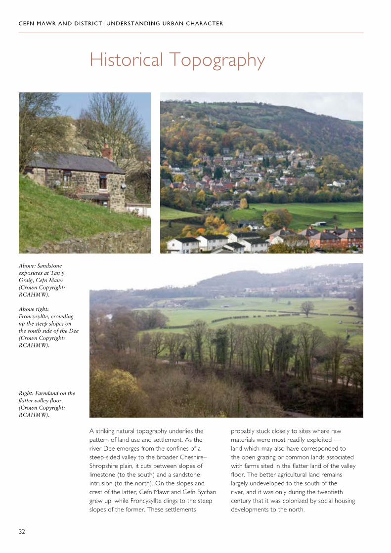
A striking natural topography underlies the pattern of land use and settlement. As the river Dee emerges from the confines of a steep-sided valley to the broader Cheshire–Shropshire plain, it cuts between slopes of limestone (to the south) and a sandstone intrusion (to the north). On the slopes and crest of the latter, Cefn Mawr and Cefn Bychan grew up; while Froncysyllte clings to the steep slopes of the former. These settlements
probably stuck closely to sites where raw materials were most readily exploited — land which may also have corresponded to the open grazing or common lands associated with farms sited in the flatter land of the valley floor. The better agricultural land remains largely undeveloped to the south of the river, and it was only during the twentieth century that it was colonized by social housing developments to the north.
Historical Topography
Above: Sandstone exposures at Tan y Graig, Cefn Mawr (Crown Copyright: RCAHMW).
Above right: Froncysyllte, crowding up the steep slopes on the south side of the Dee (Crown Copyright: RCAHMW).
Right: Farmland on the flatter valley floor (Crown Copyright: RCAHMW).

CEFN MAWR AND DISTRICT: UNDERSTANDING URBAN CHARACTER
33
Overlaid on this topography, a complicated network of transport routes charts the history and development of the area. The river Dee had been bridged at Newbridge since the fifteenth century, and at Cysyllte since the seventeenth century. But the construction of the aqueduct in 1805 reinforced the connection between its two banks and marked a dramatic intervention in the natural topography.
The canal in turn was linked deep into the area by the network of early railways that connected it to sites of extraction and processing, including the Ruabon Brook Railway, as well as other branches of the canal.
The development of the Flexsys site, with the loss of the canal’s continuation to its 1830’s terminus just below Cefn Mawr, has severed one of the most important connections made in the process of industrial development in the nineteenth century.
Although its sequence of development may be hard to determine, the road network in the area displays a clear hierarchy — ranging from the main east–west routes, which are both nineteenth-century turnpikes in their present form, to the web of smaller and purely local routes that criss-cross the slopes on either
side of the river. These latter probably grew up piecemeal in response to the working of mineral and other resources, and the subsequent growth of informal settlements associated with it. Between these extremes, there are also some smaller through-routes or rural lanes, including the axis of Cefn Bychan High Street, Well Street and Cefn Mawr High Street, which continues as Chapel Street, Acrefair, and wanders up into the agricultural landscape towards Ruabon mountain. Another early route may have been Cae Gwilym Lane from Cefn Bychan, via Queen Street to Tref y Nant, though the original line of Queen Street has been lost where it passes through the chemical works site. Both major and minor through-routes, and the network of smaller lanes and paths that threaded between them, provided a framework for settlement, which was characterized by a scatter of dwellings surviving from the early nineteenth century, often in strongly defined plots as well as in a more consistent linear development from later decades.
In more recent times, a secondary road network has been introduced, largely in association with the development of large-scale housing schemes on land that had previously been in agricultural use, for example at Dolydd, Cefn Bychan and Plas Madoc. Smaller housing developments have
Pontcysyllte Aqueduct, striding across the broad valley of the Dee, and connecting settlements to either side of the river (Crown Copyright: RCAHMW).

CEFN MAWR AND DISTRICT: UNDERSTANDING URBAN CHARACTER
34
of several estates, of which by far the most dominant was Wynnstay. In the westward extension of its park, the road from the river crossing at Newbridge to Ruabon was diverted, and the park wall remains a hard boundary to the west of the settlement of Rhosymedre and Cefn Bychan.
also colonized former industrial land, for example on the site of the British Ironworks at Lancaster Terrace and, more recently, on the site of the former Garth brick works at Trevor.
Industry was not the only agent shaping historical topography. The area fell to the ownership
The plot of land in which Cefn Kynaston sits is encircled by roads and paths (Crown Copyright: RCAHMW).
Cottages in Froncysyllte, built with their back walls right on the edge of a lane (Crown Copyright: RCAHMW).

CEFN MAWR AND DISTRICT: UNDERSTANDING URBAN CHARACTER
35
Settlement and Building
The Character of Settlement
Cefn Mawr and district is by no means a conventional industrial town. It is made up of several distinct settlements — Cefn Mawr, Rhosymedre, Cefn Bychan/Newbridge, Froncysyllte, Trevor, Acrefair and Plas Madoc — each of which has its own history and character. Just as there were characteristically many branches of industry operating at widely differing scales and levels of capitalization, so there were many agents involved in building. Just as industries tended to colonize and reoccupy the same areas of ground, so too did buildings very often replace earlier structures on the same site, so that relatively little survives from the very earliest phases of industrialization (and almost nothing from the pre-industrial period). The cottages identified on the tithe surveys are unlikely to
survive in any abundance now, their sites largely occupied by buildings of late nineteenth-century date. Chapels too are recorded as having been built on the site of old dwellings, and in 1965 it was recorded that stone-built dwellings at Newbridge were being pulled down to make way for bungalows.47 Early houses were often built on, or very near, mines and slag-banks, and were presumably closely associated with individual works. Old industrial sites were also exploited for building in more recent times: Bethel chapel at Acrefair, built in 1895, was constructed on a slag-heap.48 Lancaster Terrace (probably a 1950’s development) in Acrefair was built on the site of the British Ironworks coking ovens and the siding constructed to serve them.
If industrial developments exhibited a trend from small-scale workings scattered across the area to larger, more concentrated works, a similar trend can be traced in the development of settlement. The earliest surviving buildings (from the early
A row of cottages at Froncysyllte (Crown Copyright: RCAHMW).

CEFN MAWR AND DISTRICT: UNDERSTANDING URBAN CHARACTER
36
Typically, these are all developments of single cottages or very short rows and the irregular plots they occupy often have strongly-defined boundaries, which have sometimes determined the shapes of the buildings themselves.
decades of the nineteenth century) are dotted about the hillside of Cefn Mawr or dispersed along the axis of High Street; others are similarly loosely gathered in small plots of land or aligned with early roads and laneways at Froncysyllte and Cefn Bychan.
The siting of buildings, and even the alignment of their walls, reflects the shape of the plots of land on which they were built (Crown Copyright: RCAHMW).

CEFN MAWR AND DISTRICT: UNDERSTANDING URBAN CHARACTER
37
By the mid-nineteenth century, larger industrial concerns were being established (most notably the highly capitalized production of bricks and tiles), as well as expansion of the British Ironworks continuing, and larger collieries being created. This process was matched by more formal, larger-scale building patterns for housing. Though there are still many single dwellings from the second half of the nineteenth century, longer terraces are more typical, often firmly aligned with roads. In this period, too, there emerged a greater differentiation within the housing stock, marked by the size and elaboration of terraced housing, as well as by the presence of houses of higher status.
Routes and boundaries shape and contain the settlement, as here at Cae-glo (Crown Copyright: RCAHMW).
Long terraces of brick-built houses, characteristic of late nineteenth-century developments (Crown Copyright: RCAHMW).

CEFN MAWR AND DISTRICT: UNDERSTANDING URBAN CHARACTER
38
Right: This terrace at Rhosymedre is notable for its regularity, which contrasts with the more informal patterns of development of earlier periods (Crown Copyright: RCAHMW).
Below: Contrasting scales: Llangollen Road, Acrefair (Crown Copyright: RCAHMW).
Above right: Although terraced housing predominates, the south-facing slopes above the river were favoured for larger housing (Crown Copyright: RCAHMW).
Right: Larger detached houses were a feature of the greater differentiation in building stock by the late nineteenth century (Crown Copyright: RCAHMW).

CEFN MAWR AND DISTRICT: UNDERSTANDING URBAN CHARACTER
39
agent in this period was now no longer the private individual, but local government; the area has an impressive range of planned housing developments spanning from the 1920s to the 1970s, besides which speculative developments look small indeed.
In the twentieth century, still larger industrial enterprises (such as the Monsanto works and the Lancaster works) encouraged a continued expansion of settlement. There was a radical change in the scale of development, since the main
Public housing of the 1950s at Plas Madoc (Crown Copyright: RCAHMW).

CEFN MAWR AND DISTRICT: UNDERSTANDING URBAN CHARACTER
40
Building Traditions
The study area was generously endowed with raw materials for building, in the form of Cefn sandstone and Fron limestone, and during the second half of the nineteenth century it became a major supplier of manufactured materials — brick, tile and terracotta. Most buildings in the area erected before 1912 use one or other (or a mixture) of these as a walling material, and although most are roofed with slate either from north-west Wales or possibly from quarries nearer at hand in the Dee and Ceiriog valleys,
some locally produced roofing tiles were also used.
Until the mass production of brick was established in the area in the 1860s, stone predominated in local buildings, used close to its source in the sandstone and limestone quarries to north and south of the river. The different stones have different characteristics tending to distinctive treatment, with sandstone used as squared rubble or occasionally as freestone, and the limestone almost always used as rough rubble. Render may have been used where the stone construction was particularly roughly finished, and is commonest in the limestone area.
Right and far right: A mix of stone and brick for buildings in Cefn Mawr (Crown Copyright: RCAHMW).
Right: Sandstone as building material, Rhosymedre (Crown Copyright: RCAHMW).
Far right: The limestone used for building at Froncysyllte was often finished with render (Crown Copyright: RCAHMW).
CEFN MAWR AND DISTRICT: UNDERSTANDING URBAN CHARACTER
41
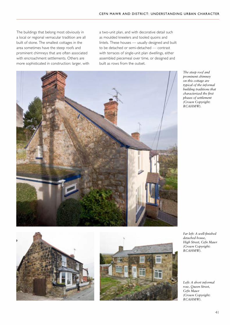
The buildings that belong most obviously in a local or regional vernacular tradition are all built of stone. The smallest cottages in the area sometimes have the steep roofs and prominent chimneys that are often associated with encroachment settlements. Others are more sophisticated in construction: larger, with
a two-unit plan, and with decorative detail such as moulded kneelers and tooled quoins and lintels. These houses — usually designed and built to be detached or semi-detached — contrast with terraces of single-unit plan dwellings, either assembled piecemeal over time, or designed and built as rows from the outset.
The steep roof and prominent chimney on this cottage are typical of the informal building traditions that characterized the first phases of settlement (Crown Copyright: RCAHMW).
Left: A short informal row, Queen Street, Cefn Mawr (Crown Copyright: RCAHMW).
Far left: A well-finished detached house, High Street, Cefn Mawr (Crown Copyright: RCAHMW).

CEFN MAWR AND DISTRICT: UNDERSTANDING URBAN CHARACTER
42
The combination of materials was also sometimes the result of a rebuild or extension — common practice in an area evolving as rapidly as this one.
Stone continued to be used even after the introduction of brick, but was often relegated to the back and side walls, allowing brick pride of place for architectural display.
Brick was effectively mass produced and extensively exported, and was often associated with building types and styles that had no traditional basis, but its local use is a major factor in local distinctiveness. Key to this character is firstly colour (the local brick is a very distinctive red, though buff brick was also produced); secondly the use of decorative ceramic and terracotta; and thirdly, an architectural language for its use, which was quick to be developed. The elements of this ranged from the use of facing brick to distinguish the main façade (sometimes combined with stone or even with non-traditional materials, such as highly glazed bricks in side and rear walls), to the use of terracotta detail to ornament a façade or articulate a terrace. There is a clear hierarchy in the use of this detail, which is one of the most important ways in which the status of original developments is denoted. Larger and more prominently sited houses, as well as commercial buildings, tended to make more of a conspicuous display — there was probably a sense in which they advertised local products.
Stone houses altered and enlarged with brick, Newbridge (Crown Copyright: RCAHMW).
Brick used to add height to a stone cottage at Trevor basin (Crown Copyright: RCAHMW).
A brick terrace built onto an earlier stone house, Newbridge (Crown Copyright: RCAHMW).

CEFN MAWR AND DISTRICT: UNDERSTANDING URBAN CHARACTER
43
Left and below: Brick and terracotta used in commercial buildings, Cefn Mawr (Crown Copyright: RCAHMW).
Far left and left: Brick and terracotta used for conspicuous display, Newbridge and Acrefair (Crown Copyright: RCAHMW).

CEFN MAWR AND DISTRICT: UNDERSTANDING URBAN CHARACTER
44
High-quality detailing on terraced houses (Crown Copyright: RCAHMW).

CEFN MAWR AND DISTRICT: UNDERSTANDING URBAN CHARACTER
45
This house on Chapel Street, Acrefair, has a nicely detailed brick façade; one gable wall is stone, but the other is built of a highly-glazed brick, also used in the boundary wall (Crown Copyright: RCAHMW).
Bright facing brick on terraced houses, Llangollen Road, Acrefair (Crown Copyright: RCAHMW).

CEFN MAWR AND DISTRICT: UNDERSTANDING URBAN CHARACTER
46
Boundary detail is an important aspect of the hierarchy of display, and many brick terraces, as well as individual houses, have brick and
terracotta boundary walls, often combined with high-quality ironwork railings — local products, perhaps.
Many houses have small front gardens, and boundary walls are an important feature (Crown Copyright: RCAHMW).

CEFN MAWR AND DISTRICT: UNDERSTANDING URBAN CHARACTER
47
Another valuable local tradition, which straddled the use of stone and brick from the early nineteenth century into the twentieth century, was the habit of incorporating a date-stone, often with an occupant’s name. The oldest identified is on The Black Lion public house on Park Road at Newbridge, dated 1810, and the earliest in a brick terrace dates from 1866, on Tower Hill, Acrefair.
In addition, house names or street names can provide evidence of probable dates of construction or upgrading. Alma Road in Froncysyllte appears to be the pre-Telford turnpike but was presumably upgraded or repaired during the Crimean War, even though the houses on it are later. Pretoria in Trevor probably recalls British successes of 1900 in the Boer War, whilst Allenby House in Newbridge presumably dates from shortly after British forces entered Jerusalem in December 1917.
Left and below: Date-stones are a common feature of the area (Crown Copyright: RCAHMW).
History in a name: Allenby House (Crown Copyright: RCAHMW).

CEFN MAWR AND DISTRICT: UNDERSTANDING URBAN CHARACTER
48
1. Cefn Mawr
Historical Background
‘70 or 80 years ago, the whole place was a common claimed by the freeholders for the use of their stock. Now the Cefn is full of strangers from all parts of the kingdom; crowded with shops, public houses and beerhouses.’ 49
Cefn Mawr grew as a nucleated industrial settlement from the early nineteenth century
Character Areas
to house workers employed in the industries served by the canal — coal pits, quarries and foundries — though there may have been small-scale settlement, accompanying minor industrial activity, before the nineteenth century. Until the twentieth century, the settlement was surrounded to the south and east by the remnants of enclosed agricultural land. The ridge itself may once have been open or common grazing associated with lowland farms, which were progressively colonized by mining and quarrying activity with associated dwellings, in a process of squatting.
Informal settlement patterns at Cefn Mawr (Crown Copyright: RCAHMW).

CEFN MAWR AND DISTRICT: UNDERSTANDING URBAN CHARACTER
49
Of pre-industrial houses in Cefn Mawr, Plas Kynaston is a rare survivor. It was the centrepiece of a small estate, and the house may date from the early eighteenth century, though remodelled to its present form about a century later. Later additions have since been removed leaving only the eighteenth-century main range. In the early nineteenth century, Plas Kynaston played its part in the industrialization of the area, it was the home of Exuperius Pickering the entrepreneur responsible for the canal extension.51
A map of 1804 in the Hawarden Record Office gives a sense of this settlement as it was in the very first period of industrialization. Essentially, it was still a rural area, with farms at Cefn, Dolydd and Ty Mawr, and with coal shafts sunk in what appear to be open fields. The map does not show the foundry, nor any rail links, or anything that can be identified as workers’ housing. Unfortunately the schedule attached to it is well-nigh illegible.50
Plas Kynaston was once the centrepiece of a small estate (Crown Copyright: RCAHMW).

CEFN MAWR AND DISTRICT: UNDERSTANDING URBAN CHARACTER
50
There is evidence that Cefn Mawr was being actively settled in the first and second decades of the nineteenth century, as in 1820 Sir Watkin Williams Wynn suspended presentments against ‘the poor of Cefn Mawr … for erecting and continuing houses’, presumably
a recognition on his part that the public interest, and his own, was served by allowing settlement through squatting rather than prohibiting it.52 Later accounts stress the conflict between chapel and the secular world in this early period, when Cefn was not only known for its faithful Baptists but was also notorious for its wrestling matches and bull-baiting.53 The 1838 one-inch Ordnance Survey map suggests that settlement was advanced, and the tithe map of 1845 shows much of the area of Cefn covered in ‘Cottages and Gardens’, as if the surveyor saw no reason to depict in detail what were presumably very small-scale and ad hoc settlements that were in any case probably not liable to tithe.54 A mid-nineteenth-century map of the Plas Kynaston estate shows that settlement was still sparse, but by the time of the first 25-inch edition of 1873, the settlement has reached more or less its present extent. The only significant expansion thereafter was the addition of the row of shops along the south of Crane Street, which appears between the first and second editions of the 25-inch Ordnance Survey maps in 1873 and 1899. Since the mid-twentieth century, there have been more losses than gains in the settlement pattern, resulting in an irregular pattern, particularly to either end of the main road through the settlement.
Although there may have been casual settlement over the ridge and clustering near the stream at the junction of Hill Street and Queen’s Road, an early through-route provided some structure for the emerging village. A pre-industrial lane ran from Rhosymedre, via the line of Well Street and High Street, to Chapel Street in Acrefair. It is along this axis that the few early nineteenth-century houses in the village are to be found.
Above and right: Cefn Mawr is characterized by piecemeal, casual development away from the main through routes, such as here at Brown’s Lane (Crown Copyright: RCAHMW).

CEFN MAWR AND DISTRICT: UNDERSTANDING URBAN CHARACTER
51
had become a road, and the railway from Trevor basin and the Plas Kynaston foundry to the Great Western Railway (GWR) ran immediately to its south, possibly on the course of an earlier horse-drawn railway. Crane Street and Well Street became the main focus of commercial development in the later nineteenth century, the period in which Cefn Mawr was established as the principal commercial centre of the district. Other railway-based routes are Railway Road and possibly Bowen’s Lane, which may approximate to the course of an incline and early railway to Newbridge.
A more amenable route between Acrefair and Rhosymedre was provided along the axis of King Street, which originated as part of the Ruabon Brook Railway, and became a public road when the track-bed was leased to the Wrexham District Highway Board.55 By 1873 the route had clearly been a focus for settlement for some time.
Crane Street is not shown on the 1845 tithe map but the through-route connecting Well Street with King Street is shown on a slightly later map. It is not clear if it was a railway or a road.56 By the 1860s it
Crane Street had become an important road and a focus for commercial development by the late nineteenth century (Crown Copyright: RCAHMW).

CEFN MAWR AND DISTRICT: UNDERSTANDING URBAN CHARACTER
52
which tend to be linear rather than dispersed. Units of development remained typically small — individual houses or commercial premises, or very short rows, and it was only with the social housing erected post-1947 that any consistent attempt was made at planned and regular settlement on a larger scale.
Buildings of the early nineteenth century are generally built in sandstone — surviving examples are small houses or substantial cottages that display a degree of refinement in their finish: if there ever were poor squatter dwellings here, they have long since been swept
The Character of Settlement
Cefn preserves many of the features of an early industrial settlement, such as a streetscape based partly on pre-industrial lanes (through-routes and local trackways), and partly on early rail systems. The informal character of settlement, in which dwellings are either free-standing or form part of very short rows, with no consistent orientation, is also typical of an early industrial settlement. There is a contrast between the haphazard character of settlement of the early and later nineteenth-century developments,
Houses crowded together on the steep slope above Crane Street (Crown Copyright: RCAHMW).

CEFN MAWR AND DISTRICT: UNDERSTANDING URBAN CHARACTER
53
away. Brick manufactured locally became the dominant material after about 1860, and some earlier houses were rebuilt or extended in it. It is an indication of the growing prosperity of the neighbourhood that several substantial villa dwellings were built towards the turn of the century, as well as a series of commercial premises, typically exploiting the decorative potential of locally made materials in striking new architectural forms, which contrast with the Georgian-based vernacular of the preceding period. These commercial buildings differentiate Cefn Mawr from neighbouring settlements and indicate its status as a local urban centre.
Well-built sandstone properties on High Street (Crown Copyright: RCAHMW).
Stone was eventually supplanted by brick as the main building material, but the mix of both is an important part of the character of the settlement (Crown Copyright: RCAHMW).

CEFN MAWR AND DISTRICT: UNDERSTANDING URBAN CHARACTER
54
Right and below: Brick was used to particularly good effect in commercial buildings on Crane Street and Well Street (Crown Copyright: RCAHMW).

CEFN MAWR AND DISTRICT: UNDERSTANDING URBAN CHARACTER
55
various industries that were developing across it. The canal continued to function alongside ramifying railways, but had fallen out of use by the mid-twentieth century, and was filled in as the chemical works continued to expand.
Notwithstanding the loss of a great deal of tangible evidence for its intricate history, the complexity of industrial activity and transport networks give this area a particular significance and pivotal role in understanding the dynamics of development in the area.
Topography and Building
The chemical works had expanded across the earlier industrial landscape, and had also encroached on former agricultural land to the south and west by the 1920s, in a mixture of buildings and plant. With the exception of several mid-twentieth-century buildings and some plant, much of the eastern area was cleared in 2010, leaving behind a complex legacy of retaining walls, probably of mid-nineteenth to early twentieth-century date, some of these incorporate features such as hearths, flues and
2. The Flexsys Site
Historical Background
The main part of the site to the east of Queen Street has had a concentration of uses, which encompass virtually all of the industries that have contributed to the development of the district. Coal was mined there, clay was worked, cast iron was manufactured. From the late nineteenth century these uses were gradually displaced by the expansion of the chemical works (founded here in 1867) and, by the early twentieth century, the chemical industry was the sole occupier of the site, across which it has gradually expanded, though is now in retreat.
As industrial activities proliferated here, so too did transport arrangements. From the early nineteenth century, the site was crossed by the Ruabon Brook Railway and its successors, linking it directly to the canal at Trevor basin. From the 1820s, an arm of the canal reached right into the site, directly serving the
The chemical works site in 2007 (Crown Copyright: RCAHMW).

CEFN MAWR AND DISTRICT: UNDERSTANDING URBAN CHARACTER
56
3. Rhosymedre
Historical Background
Encroachments on the common of Rhos y Medre are recorded in 1760, but at the beginning of the nineteenth century there were still no buildings recorded here.57 The 1845 tithe map indicates (but does not map) ‘Cottages and Gardens’ on the triangular street pattern.58 By the mid-1860s the area was being built up, and it is probable that the present row of small two-storey stone-built shops along High Street dates from this period.59
The history of the Independent Chapel at the junction of High Street and Park Road probably indicates the phases of development here: first built in 1836, rebuilt in 1858, and rebuilt again in 1883.60 The church dates from 1836–37 and was built with the patronage of the Wynnstay estate. It is associated with the Rev. John David Edwards, the ‘singing vicar’ of the parish, who composed the hymn tune ‘Rhosymedre’ here, one of the best-known pieces of music from the Anglican tradition in Wales, and the basis of the second movement of Vaughan-Williams’ ‘Three Preludes on Welsh Hymns’.
water pipes. They are the main archaeological evidence for historic chemical processing on the site, and the variety of their building materials is typical of the district.
Archaeological Potential
The continued development of the chemical works in the second half of the twentieth century introduced heavy plant with deep foundations and, for much of the area, this is likely to have destroyed information relating to previous land uses here. However, there may be potential for the recovery of archaeological information from the site of the Plas Kynaston foundry as it was never built on, indeed a roof truss from the foundry has already been recovered. The line of the canal (in so far as it can be determined) was partially built over, but may not have been subject to extensive disturbance. Part of an over-bridge survives and the area immediately south of the bridge offers the best potential for the recovery of information regarding the construction of the canal.
The church at Rhosymedre was built with the patronage of the Wynnstay estate in 1836–37 (Crown Copyright: RCAHMW).

CEFN MAWR AND DISTRICT: UNDERSTANDING URBAN CHARACTER
57
The Independent Chapel on High Street was first built in 1836 (Crown Copyright: RCAHMW).

CEFN MAWR AND DISTRICT: UNDERSTANDING URBAN CHARACTER
58
The Character of Building
The core of settlement at Rhosymedre is quite densely built up and linear, in contrast to the other settlements of the district. Its terraced rows have a greater formality than elsewhere, characterized by well-coursed stonework and sash windows (some of which survive). There are elements of an informal vernacular, perhaps preceding these developments, and several late nineteenth-century brick terraces. The settlement expanded considerably in the mid-twentieth century in a series of planned public housing developments off the Ruabon Road.
At Rhosymedre, some significant industrial/commercial developments of the early twentieth century have survived.
The terraced rows of Rhosymedre have a neat formality, with their well-coursed stonework and regular detail (Crown Copyright: RCAHMW).

CEFN MAWR AND DISTRICT: UNDERSTANDING URBAN CHARACTER
59
Contrasting scales and materials in early and late nineteenth-century houses (Crown Copyright: RCAHMW).
Distinctive detail in a commercial building (Crown Copyright: RCAHMW).

CEFN MAWR AND DISTRICT: UNDERSTANDING URBAN CHARACTER
60
immediately outside the boundary of the park, and on the periphery of farmland associated with the farms of Ty Mawr and Cefn Bychan (as shown on the Coed Christionydd tithe map of 1845). An early ironworks comprising blast furnace and rolling mill had probably fallen out of use by the mid-nineteenth century, but the slag wall that forms the boundary of the track to the railway viaduct from Cae Gwilym Lane, below Ty Mawr, may have been built from its waste.
Settlement was strongly influenced by the road pattern, and in 1845 there was already some linear settlement along the road to Ruabon, as well as following the line of Park Road, which may have been an earlier line of this road (whose original course was lost when the park was extended in the early nineteenth century).
4. Cefn Bychan, Newbridge and Dolydd
Historical background
Cefn Bychan and Newbridge lie on the periphery of the Wynnstay park, adjacent to its back entrance, close to a crossing of the Dee. Encroachments are recorded here in 1760 and, as at Cefn Mawr, this area was being actively settled by working families in the early years of the nineteenth century.61 Early encroachments may be encapsulated in the haphazard pattern of settlement around Park Road and Middle Road, where irregular plots are threaded by narrow lanes and footpaths. This settlement area lay
The viaduct at Newbridge, with the historical settlement skirting the park of Wynnstay, and twentieth-century housing developments at Cefn Bychan (Crown Copyright: RCAHMW).

CEFN MAWR AND DISTRICT: UNDERSTANDING URBAN CHARACTER
61
The early date of Newbridge Chapel (1825) is an indication that settlement here was well established by this time, and although later nineteenth-century houses are interspersed both along the main road and on the back lanes, the focus for development had shifted away from here by the mid-nineteenth century, leaving a characteristically haphazard pattern.
In the early twentieth century, the area between Ty Mawr and Dolydd Farms was acquired for housing development by the local council, and was laid out in a series of planned estates from the 1920s through to the 1950s.
The Character of Building
The earliest settlement is informally grouped across the hillside immediately outside the park wall. Here, single buildings or piecemeal terraces are typical, in a mix of materials reflecting different dates of building or alteration. The influence of the Wynnstay estate is occasionally apparent, for example in Waterloo Tower, built on an eminence in the park in 1815, and also in the agent’s house just outside the walls. In contrast to the haphazard development pattern of the earlier periods, the twentieth-century housing developments of Dolydd are formally and spaciously laid out. The various phases of development are distinguished by different styles: hipped-roofed brick pairs characteristic of the 1920s (others with picturesque advanced gables); and from the 1950s, a mix of semi-detached houses in painted render with prefabricated panel, and picturesque groupings of white rendered terraces, such as on Coronation Street.
Left: The chapel at Newbridge is dated 1825 (Crown Copyright: RCAHMW).
Left: Informal early settlement patterns close to the park wall (Crown Copyright: RCAHMW).
Left: Waterloo Tower (Crown Copyright: RCAHMW).
Far left: This house was built for the agent of the Wynnstay estate (Crown Copyright: RCAHMW).

CEFN MAWR AND DISTRICT: UNDERSTANDING URBAN CHARACTER
62
Right and below:Picturesque groupings of housing at Dolydd (Crown Copyright: RCAHMW).
Right: Distinctive mid-twentieth-century building, Dolydd (Crown Copyright: RCAHMW).

CEFN MAWR AND DISTRICT: UNDERSTANDING URBAN CHARACTER
63
akin to squatting, and it is characterized by its network of small lanes and paths running between irregular plots, which housed single buildings or short rows. By 1842 a scattered group of dwellings is evident in this area.62 The canal also provided a focal point for settlement clustered near the basin.
Although the area continued to develop in the later nineteenth century, the scale of building projects remained relatively small. There is a series of planned developments and social housing developments of the 1920s and 1950s around Woodlands Grove, which had originated as an incline linking the quarries with the canal.
5. Froncysyllte
Historical Background
A community at Froncysyllte probably came into existence in the early years of the nineteenth century following construction of the canal, and the opening up of Pen y Graig quarry, with its associated inclines and limekilns. By 1817, when the map of Telford’s new road was made, there was already a cluster of houses here. Away from the road, the settlement probably developed largely through an informal process
Left: Froncysyllte, on the steep slopes south of the Dee (Crown Copyright: RCAHMW).
Left and far left:The canal was an important focus for settlement (Crown Copyright: RCAHMW).
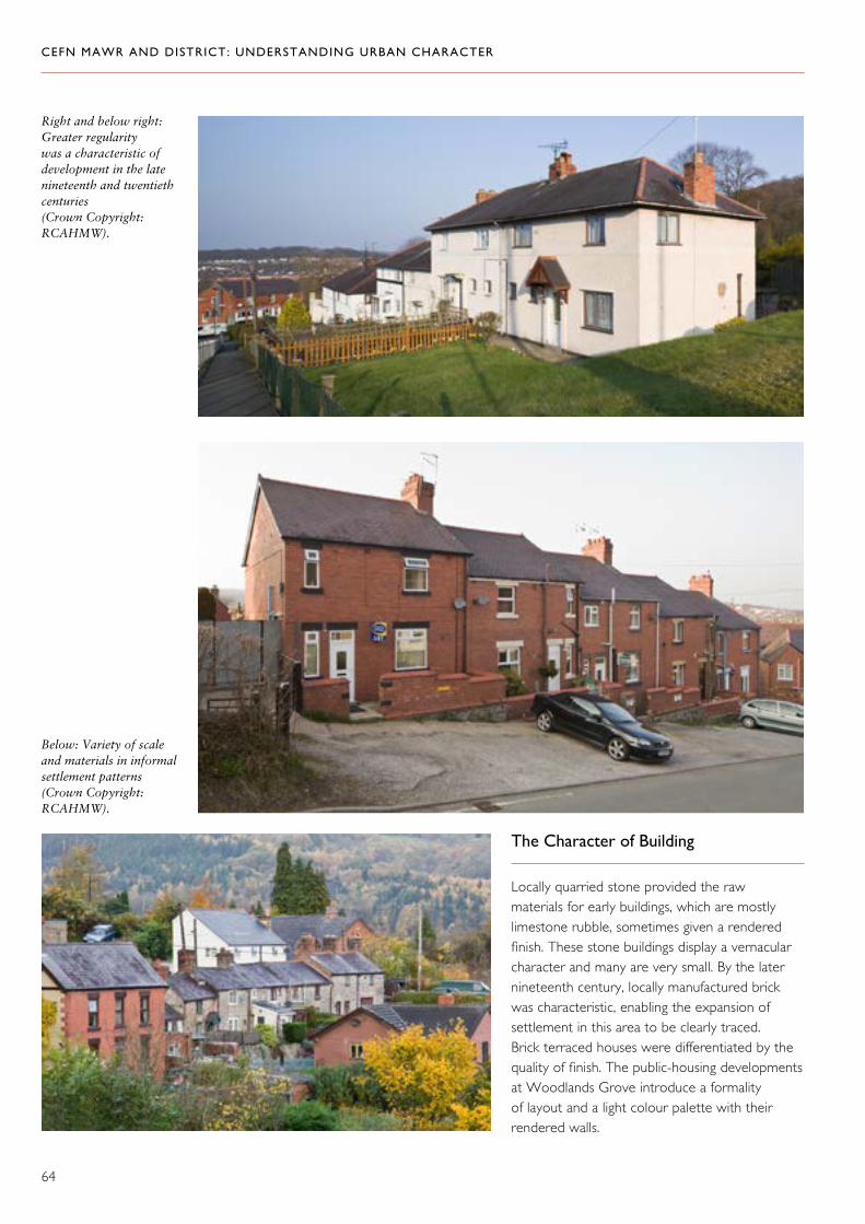
CEFN MAWR AND DISTRICT: UNDERSTANDING URBAN CHARACTER
64
The Character of Building
Locally quarried stone provided the raw materials for early buildings, which are mostly limestone rubble, sometimes given a rendered finish. These stone buildings display a vernacular character and many are very small. By the later nineteenth century, locally manufactured brick was characteristic, enabling the expansion of settlement in this area to be clearly traced. Brick terraced houses were differentiated by the quality of finish. The public-housing developments at Woodlands Grove introduce a formality of layout and a light colour palette with their rendered walls.
Right and below right: Greater regularity was a characteristic of development in the late nineteenth and twentieth centuries (Crown Copyright: RCAHMW).
Below: Variety of scale and materials in informal settlement patterns (Crown Copyright: RCAHMW).
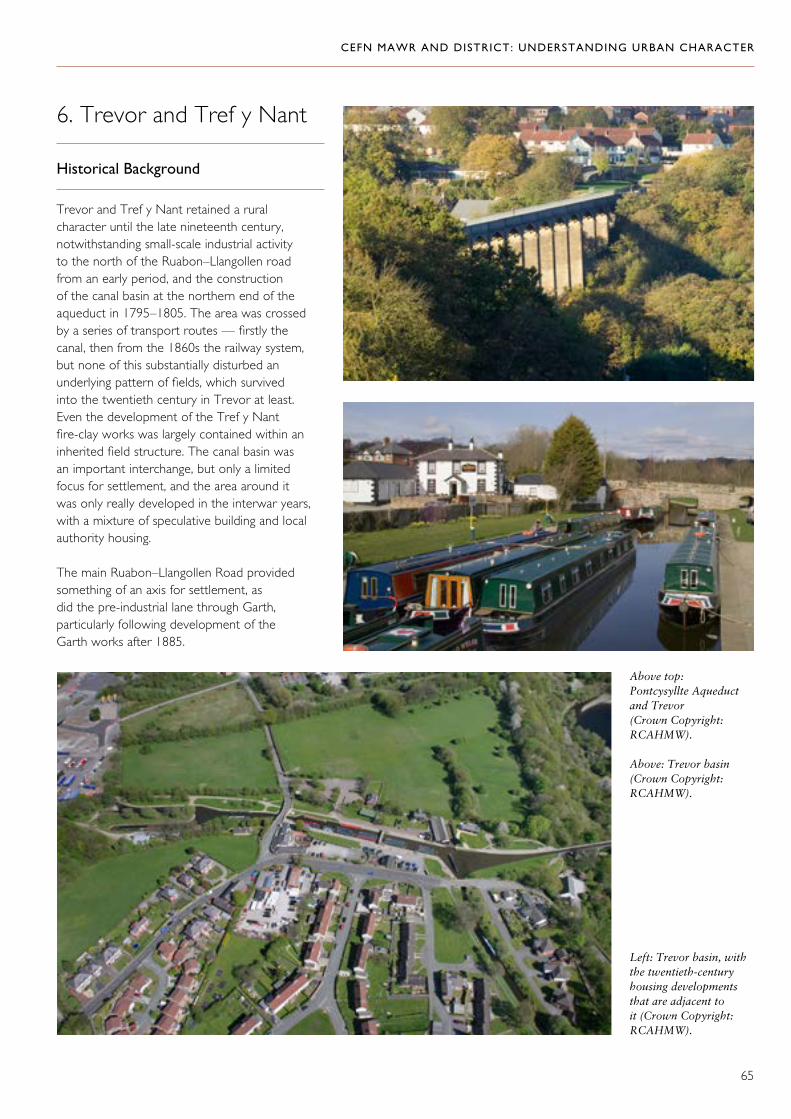
CEFN MAWR AND DISTRICT: UNDERSTANDING URBAN CHARACTER
65
6. Trevor and Tref y Nant
Historical Background
Trevor and Tref y Nant retained a rural character until the late nineteenth century, notwithstanding small-scale industrial activity to the north of the Ruabon–Llangollen road from an early period, and the construction of the canal basin at the northern end of the aqueduct in 1795–1805. The area was crossed by a series of transport routes — firstly the canal, then from the 1860s the railway system, but none of this substantially disturbed an underlying pattern of fields, which survived into the twentieth century in Trevor at least. Even the development of the Tref y Nant fire-clay works was largely contained within an inherited field structure. The canal basin was an important interchange, but only a limited focus for settlement, and the area around it was only really developed in the interwar years, with a mixture of speculative building and local authority housing.
The main Ruabon–Llangollen Road provided something of an axis for settlement, as did the pre-industrial lane through Garth, particularly following development of the Garth works after 1885.
Above top:Pontcysyllte Aqueduct and Trevor (Crown Copyright: RCAHMW).
Above: Trevor basin (Crown Copyright: RCAHMW).
Left: Trevor basin, with the twentieth-century housing developments that are adjacent to it (Crown Copyright: RCAHMW).

CEFN MAWR AND DISTRICT: UNDERSTANDING URBAN CHARACTER
66
The Character of Building
Isolated early nineteenth-century houses are stone-built, but the area is dominated by late nineteenth-century development along the Ruabon–Llangollen Road. These are mostly larger detached houses or short rows, many of which exploited the decorative potential of local brick and tile-work to striking effect. There was limited speculative building during the early twentieth century in a range of styles along the main road, and in more uniform small estates between the road and the canal.
Right and below right: Along the main road at Tref y Nant are some highly distinctive houses in a range of styles (Crown Copyright: RCAHMW).

CEFN MAWR AND DISTRICT: UNDERSTANDING URBAN CHARACTER
67
The Character of Building
Developments at Acrefair tend to be small-scale: short rows, pairs or detached houses. Vernacular origins are suggested in the occasional stone-built row or small cottage, but it is brick building that predominates. Most of this conforms to a standard late nineteenth-century design, though differentiated with an elaborate hierarchy of detail, including some good examples of highly-glazed brick used in gable walls and for boundaries. There is a small development of more consciously picturesque cottages close to the site of the British Ironworks, perhaps provided by the company.
Away from the main road, twentieth-century development also tends to be small-scale and haphazard, presumably occupying small plots and perhaps sometimes replacing earlier buildings.
7. Acrefair
Historical Background
Acrefair grew up both along the Ruabon–Llangollen road, and on the early rural lane (Chapel Street and Bower’s Road) that marked the continuation of a through-route from Rhosymedre towards Ruabon Mountain. There may have been small-scale settlement in the area in the early decades of the nineteenth century, but the growth, first of the British Ironworks, then of local brick, tile and clay works to the north of the area, provided the spur to more sustained building from the later nineteenth century. Residual traces of these industries may still be found to either side of the main road immediately east of King Street–Chapel Street, and in the woodland to the east of Bower’s Road.
Housing adhering to the edge of an early lane — Chapel Street, Acrefair (Crown Copyright: RCAHMW).
This composition of cottages may have been associated with the British Ironworks (Crown Copyright: RCAHMW).

CEFN MAWR AND DISTRICT: UNDERSTANDING URBAN CHARACTER
68
Glazed brick in the end wall of the last house in a short row on Llangollen Road (Crown Copyright: RCAHMW).
High-quality brickwork in terraced housing on Llangollen Road (Crown Copyright: RCAHMW).

CEFN MAWR AND DISTRICT: UNDERSTANDING URBAN CHARACTER
69
1808. The area now contains no surface trace of these industrial activities, or of the plas and the gardens associated with it. It is dominated by the leisure centre and the housing estate of 1968–70, both by Mervyn Edwards, Morton and Partners of Oswestry, which expands upon an earlier scheme of the 1950s.63
The Character of Building
The 1950s housing is consciously picturesque in its varied groupings along the contours of the hill. Later developments were more densely built, and owed more to modernism than tradition.
8. Plas Madoc
Historical Background
Plas Madoc was the centrepiece of an early estate, on which one of the first documented industries in the area was developed. There was a blast furnace here since the late seventeenth century at least, but the location of the furnace cannot now be identified. Mining was also recorded here, and there was a pit here by the early nineteenth century, linked to the canal basin at Trevor by the Ruabon Brook Railway since
Left, far left and below: The highly planned and formal layouts of the second phase of development at Plas Madoc (Crown Copyright: RCAHMW).
Left: The picturesque first phase of development at Plas Madoc (Crown Copyright: RCAHMW).

CEFN MAWR AND DISTRICT: UNDERSTANDING URBAN CHARACTER
70
The outstanding significance of the Pontcysyllte Aqueduct and Canal was acknowledged by its inscription as a World Heritage site in 2009. Included within the World Heritage site are the engineering features associated with the canal and the remains connected to its construction and use. Many other significant effects of its operation are to be seen in the areas that it directly served, or that were connected to it in the mesh of transport routes that came to cross the district. Cefn Mawr and its district were transformed in the century following the arrival of the canal, as the direct and indirect consequences of its construction played themselves out in the society and economy of the area.
The canal and aqueduct constitute a spectacular engineering achievement created on a monumental scale as a single enterprise. By contrast, the development of the district was characterized by many enterprises often on a small scale, and overlaid in complex sequences of use. Those larger industrial enterprises that did emerge have also in turn mainly disappeared, leaving a legacy that is either fragmentary or indirect. But across the district, the consequences of its industrial history are etched in the landscape, whether in the extraordinary network of routes (some of which are themselves broken or overlooked), in neglected pockets of land where elusive traces of previous use may still survive, or in the intricate pattern of settlement. Across the district there is a characteristic organization of space that is often haphazard and small-scale. It is threaded by a web of connections — surviving, damaged or lost, and containing a lively variety of building traditions using locally sourced or manufactured materials.
Maintaining and even reinforcing the distinctive character of this district means respecting the variety, informality and scale of its settlements, acknowledging the relict industrial sites that are interwoven with them, and recognizing the potential of historic routes to bind all these elements together.
Statement of Significance

CEFN MAWR AND DISTRICT: UNDERSTANDING URBAN CHARACTER
71
Not seen The following documents were considered by archive staff to be too fragile to produce: QSD/DC/11: Canal map from Pontcysyllte basin to Plas Kynaston Hall, 1829. QSD/DC/7: Plan of rail road through Cefn Mawr and Acrefair, 1803.
Hawarden Record Office D/DM/162/8: ‘Map of Plas Kynaston Estate and Colliery ... the property of William Owen Esquire ... 1804’, with schedule. D/DM/136/16: Mid-nineteenth-century map of Plas Kynaston estate. D/DM/162/16: Map of Cysyllte township, 1842. D/DM/162/17: 1818 road plan of Trevor Issa 14893/3: Plaskynaston Estate map c. 1847: Flintshire RO. CB/5/12: Mid-nineteenth-century map of Plas Kynaston estate. D/DM/370: Plan of Plas Kynaston colliery, 1829.
National Library of Wales Chirk tithe map and schedule, 1839. Christionydd Kenrick tithe map, 1845. Coed Christionydd tithe map, 1845, revised 1846. Cysyllte tithe map, tithe map of 1838, schedule 1840. Deposited plans of local railway systems (Denbighshire Railway, Llangollen Vale). Llangollen parish, Trevor Isaf township, tithe map and schedule. Llangollen tithe map, Cysyllte township, 1844. NLW drawing volumes 93, fol. 38, CRO: X/Plans/RD/2, map of road from Chirk to Bangor, 1817.
Waterways Trust Gloucester BW95/2/3: 1803 plan of proposed railway (supplied by Peter Brown).
Archival Sources
A.N. Palmer Centre Flexsys archive, currently in storage.
National Library of Wales Drawing volumes 93 and 109. Box 36, PA4011: 1794 view of Acrefair. Chirk Castle 6060 (1808). Chirk Castle manuscript 9629. Wynnstay RA39.
The National Archives, Kew Notes abstracted from The National Archives: RAIL 827/7 (Cefn Mawr canal, etc) by Dr D. Gwyn.
Cartographic Sources
Ordnance Survey 25-inch to one mile, surveys of 1873, 1899 and 1912.
British Library Surveyors’ drawings, Plan 340 (G), 1835–6 (Froncysyllte). Surveyors’ drawings, Plan 340 (d), 1832, 1835 and 1836 (Cefn Mawr, Acrefair, Trevor).
Ruthin Record Office QSD/DC/11: Proposed branch canal. QSD/DR/36: Birkenhead, Chester, Mold, Ruabon & Vale of Llangollen Railway, deposited plan and reference book, 1845. QSD/DR/43: Shrewsbury and Chester Railway, deposited plans. QSD/DR/47: Denbighshire Railway plans, 1852. QSD/DR/191: Birkenhead, North Wales & Stafford Railway, deposited plan and reference book, 1871. NTD/1184 (i): Map of Plas Kynaston estate, c. 1850 (photocopy of HRO: D/DM/136/16). DD/WY/5862: Plan of Newbridge, 1846.
Selected Sources

CEFN MAWR AND DISTRICT: UNDERSTANDING URBAN CHARACTER
72
A. H. Dodd, The Industrial Revolution in North Wales (Wrexham, 1990).
I. Edwards, ‘Collection of records from Messrs Longueville & Co., Oswestry’, Denbighshire Historical Society Transactions, 11 (1962).
I. Edwards, ‘Iron Production in North Wales: The Canal Era: 1795–1850’, Denbighshire Historical Society Transactions, 14 (1965).
I. Edwards, ‘History of the Monsanto chemical works site, Cefn Mawr, Wrexham’, Denbighshire Historical Society Transactions, 16 (1967).
I. Edwards, ‘Gazetteer of clayworks in the Wrexham and Ruabon districts’, Denbighshire Historical Society Transactions, 36 (1987).
D. Gwyn, “Best adapted to the general carriage”: railways of the Llangollen canal, their history and archaeology’, Patrimoine de l’Industrie: resources, pratiques, 18 (2008).
E. Hubbard, The Buildings of Wales: Clwyd (Denbighshire and Flintshire) (London, 1986).
S. Hughes, ‘Thomas Thomas, 1817–88: the first national architect of Wales’, Archaeologia Cambrensis, 152 (2003).
C. N. Hurdsman, A History of the Parish of Chirk (Wrexham, 1996).
C. N. Hurdsman, A History of the Parishes of St. Martin’s & Western Rhyn (Wrexham, 2003).
P. Thoresby Jones, Welsh Border Country (London, 1938).
G. G. Lerry, Collieries of Denbighshire (Wrexham, 1946).
G. G. Lerry, ‘The Industries of Denbighshire from Tudor times to the present Part III(a): more recent developments’, Denbighshire Historical Society Transactions, 8 (1959).
S. Lewis, Topographical Dictionary of Wales (London, 1838).
Resources in Private Hands
Biography of Benjamin Piercy by Stephen Hughes RCAHMW (transcript draft for Dictionary of National Biography)
Cefn Mawr tramroads by Peter Brown (transcript draft submitted to Journal of the Railway and Canal Historical Society, and used by permission of the author)
Online Resources
Royal Commission on the Ancient and Historical Monuments of Wales: Coflein
www.rcahmw.gov.ukwww.coflein.gov.uk
Published Sources
George Borrow, Wild Wales (London and Glasgow, 1955).
V. J. Bradley, Industrial Locomotives of North Wales (London, 1993).
W. J. Britnell, The Vale of Llangollen Historic Landscape Characterization (Welshpool, 2005).
P. Brown, ‘The Plas Kynaston Canal’, Journal of the Railway & Canal Historical Society (November 2010).
A. Connolly, Life in the Victorian brickyards of Flintshire and Denbighshire (Llanrwst, 2003).
E. Cooper, ‘Festiniog Railway Reminiscence’, Festiniog Railway Heritage Group Journal, 81 (2005).
D. Davies, Tafarnau Cefn Mawr (Wrexham, 1946).
W. Davies, General View of the Agriculture and Economy of North Wales (Board of Agriculture, 1910).
CEFN MAWR AND DISTRICT: UNDERSTANDING URBAN CHARACTER
73
R. Martin, ‘Changes in the Vale of Llangollen, 1790–1865’, Denbighshire Historical Society Transactions, 48 (1999).
G. H. Morton, The Carboniferous Limestone and Cefn y Fedw Sandstone of the Country between Llanymynech and Minera North Wales (London, 1879), pp. 49–50.
D. Pratt, ‘G.W.R., Pont Cysyllte Branch’, Denbighshire Historical Society Transactions, 32 (1983).
D. Pratt and A.G. Veysey, A Handlist of the Topographical Prints of Clwyd (Hawarden, 1977).
J. Quartermaine, B.Trinder and R.Turner, Thomas Telford’s Holyhead Road (York, 2003).
D. Morgan Rees, The Industrial Archaeology of Wales (Newton Abbott, 1975).
P. A. Riden, A Gazetteer of Charcoal-fired Blast Furnaces in Great Britain in use since 1660 (Cardiff, 1993).
E. Rogers: ‘Notes at random on eighteenth – century Denbighshire(I)’, Denbighshire Historical Society Transactions, 6 (1957).
A. Skempton and J. Thomas, Hanes y Methodistiaid Calfinaidd yn Acrefair, 1838–1901 (Rhosymedre, 1901).
B. Trinder, Robert Baugh’s Map of Shropshire (Shropshire Archaeological Society, 1983).

CEFN MAWR AND DISTRICT: UNDERSTANDING URBAN CHARACTER
74
14. E. Rogers, ‘Notes at random on eighteenth-century Denbighshire (I)’, Denbighshire Historical Society Transactions, 6 (1957), pp. 61–63 indicate coal-working at Coed y Delph tempore Edward VI and on the Kynaston estate 1693-1702.
15. G. G. Lerry, Collieries of Denbighshire (Wrexham, 1946), p. 132.
16. NLW: Box 36, PA4011: 1794 view of Acrefair.
17. G. G. Lerry, Collieries of Denbighshire (Wrexham, 1946), pp. 102–08.
18. I. Edwards, ‘Monsanto chemical works’, Denbighshire Historical Society Transactions, 16 (1967); map 1, from original HRO: D/DM/162/8.
19. G. Lerry, Collieries of Denbighshire (Wrexham, 1946), p. 106.
20. G. Lerry, Collieries of Denbighshire (Wrexham, 1946), 132.
21. G. Lerry, Collieries of Denbighshire (Wrexham, 1946), 117.
22. G. Lerry, Collieries of Denbighshire (Wrexham, 1946); RCAHMW Coflein.
23. A. Connolly, Life in the Victorian brickyards of Flintshire and Denbighshire (Llanrwst, 2003), pp. 271 and 276–78; www.archiveswales.org.uk.
24. Andrew Connolly, Life in the Victorian brickyards of Flintshire and Denbighshire (Llanrwst, 2003), pp. 29 & 54.
25. A. H. Dodd, The Industrial Revolution in North Wales (Wrexham, 1990), pp. 91–92.
26. NLW: Box 36, PA4011: 1794 view of Acrefair; HRO: D/DM/162/17: 1818 road plan of Trevor Issa.
1. P. Thoresby Jones, Welsh Border Country (London, 1938).
2. George Borrow, Wild Wales, (London and Glasgow, 1955).
3. NLW: Chirk Castle 6060 (1808).
4. A. H. Dodd, The Industrial Revolution in North Wales (Wrexham, 1990).
5. Map of Plas Kynaston Estate and Colliery … the property of William Owen esq … 1804, Hawarden Record Office (D/DM/162/8).
6. A. Skempton, Biographical Dictionary of Civil Engineers,Volume 1 1500–1830 (London, 2002), p.311.
7. G. G. Lerry, ‘The Industries of Denbighshire from Tudor times to the present, Part III(a): more recent developments’, Denbighshire Historical Society Transactions, 8 (1959), p. 131.
8. NLW: Wynnstay RA39.
9. NLW: Llangollen parish, Trevor Isaf township, tithe map and schedule.
10. G. H. Morton, The Carboniferous Limestone and Cefn y Fedw Sandstone of the Country between Llanymynech and Minera North Wales (London, 1879), pp. 49–50. The aqueduct grit forms the uppermost subdivision of the Upper Carboniferous Cefn y Fedw sandstone formation (sandstone with thin shales and seams of coal called the Cefn Coal and the Chwarele Coal).
11. NLW: Wynnstay RA39.
12. NLW drawing volumes 93, fol. 38, CRO: X/Plans/RD/2, map of road from Chirk to Bangor, 1817.
13. NLW: Llangollen tithe map, Cysyllte township, 1844.
Endnotes

CEFN MAWR AND DISTRICT: UNDERSTANDING URBAN CHARACTER
75
38. Approximately NGR 32797 34245.
39. Information from Peter Brown.
40. I. Edwards, ‘Collection of records from Messrs. Longueville & Co., Oswestry’, Denbighshire Historical Society Transactions, 11 (1962), RhRO: QSD/DR/36, Birkenhead, Chester, Mold, Ruabon & Vale of Llangollen Railway, deposited plan and reference book, 1845.
41. Ordnance Survey 25-inch Denbighshire series 1873, XXXV 9, 10, 13, 14.
42. Elton Collection volume AE 185.2294; see also Caernarfon Record Office X/Plans/RD/2.
43. HRO: D/DM/162/16. Map of Cysyllte township, 1842.
44. Comments by M. J. T Lewis on E. Cooper, ‘Festiniog Railway Reminiscence’, Festiniog Railway Heritage Group Journal, 81 (2005), p. 29.
45. V. J. Bradley, Industrial Locomotives of North Wales, (London, 1993), pp. 84–85.
46. It is not clear when this was constructed — perhaps the 1860s. To add to the complexity of the story, Ifor Edwards suggests that it was built on the site of a construction tramway from when the aqueduct was under construction.
47. G. Vernon Price, Servants of God: A History of the Baptists of Cefn Mawr and District, Denbighshire ; Their Ministers, People and Times (1964), pp. 2, 201.
48. G. Vernon Price, Servants of God: A History of the Baptists of Cefn Mawr and District, Denbighshire ; Their Ministers, People and Times (1964), p. 268.
49. A. Connolly, Life in the Victorian Brickyards of Flintshire and Denbighshire (Llanrwst, 2003); quoting The Wrexham Advertiser (1863).
27. J. Quartermaine, B.Trinder and R.Turner, Thomas Telford’s Holyhead Road (York, 2003), p. 149.
28. N. Hurdsman, A History of the Parish of Chirk (Wrexham, 1996), p. 39.
29. HRO: D/DM/162/8. Map of Plas Kynaston Estate
30. NLW: Chirk Castle mss 9629.
31. NLW: Cristionydd Kenrick tithe map.
32. NA: RAIL 826/4 p. 79, pp. 83-4, RAIL 826/2, p. 69, p. 89, RAIL 826/5 p. 48.
33. D. Pratt, ‘G.W.R., Pontcysyllte Branch’, Denbighshire Historical Society Transations, 31 (1982).
34. D. Pratt, ‘G.W.R., Pontcysyllte Branch’, Denbighshire Historical Society Transations, 31 (1982).
35. Shrewsbury Chronicle 19 Feb 1808. Walter Davies also refers mysteriously to it in his General View of the Agriculture and Domestic Economy of North Wales: (London, 1813), p. 381: ‘The main trunk [i.e. of the Ellesmere canal] – proceeds from Gwersyllt to Bersham Ironworks: and by a connection of iron rail-roads pervading the Ruabon collieries, it appears a second time upon the Dee at Pont-Cyssylltau.’
36. D. Pratt, ‘G.W.R., Pontcysyllte Branch’, Denbighshire Historical Society Transations, 31 (1982); also Shrewsbury Chronicle 3 August 1810.
37. Jessop had already largely built the Surrey Iron Railway (1801–1803), and between 1808 and 1811 was to go on to build the Kilmarnock and Troon Railway. Edinburgh Encyclopaedia, Vol. 15, pp. 246–47; and A. Skempton, Biographical Dictionary of Civil Engineers, Volume 1 1500–1830 (London, 2002), entries for Duncombe and Jessop.

CEFN MAWR AND DISTRICT: UNDERSTANDING URBAN CHARACTER
76
50. ‘Map of Plas Kynaston Estate and Colliery ... 1804, with schedule (D/DM/168/8).
51. E. Rogers: ‘Notes at Random on eighteenth-century Denbighshire’, Denbighshire Historical Society Transactions, 6 (1957).
52. NLW: ms 2048: ‘Form and manner of keeping the Leet Courts in the Lordships of Bromfield and Yale’.
53. G. Vernon Price, Servants of God: A History of the Baptists of Cefn Mawr and District, Denbighshire ; Their Ministers, People and Times (1964), pp. 90–93.
54. NLW: tithe map for Christionydd Kenrick.
55. Birkenhead, North Wales & Stafford Railway, deposited plan and reference book, 1871: DRO, QSD/DR/191.
56. HRO: D/DM/136/16. (Map of Plas Kynaston Estate).
57. E. Rogers: ‘Notes at Random on Eighteenth Century Denbighshire’, Denbighshire Historical Society Transactions, 6 (1957), p, 66; HRO: D/DM/162/8.
58. NLW: tithe map for Christionydd Kenrick.
59. HRO: CB/5/2. (Map of Plas Kynaston Estate).
60. SJ 2847 4254; RCAHMW Coflein.
61. Emlyn Rogers: ‘Notes at Random on eighteenth-century Denbighshire’, Denbighshire Historical Society Transactions, 6 (1957), p. 66.
62. HRO: D/DM/162/16. (Map of Cysyllte township, 1842).
63. E. Hubbard, The Buildings of Wales: Clwyd (Denbighshire and Flintshire) (London, 1986), p.117.

CEFN MAWR AND DISTRICT: UNDERSTANDING URBAN CHARACTER
77
Desk-based Assessment of The Archaeological Potential of the Flexsys Site
Introduction to the Present Desk-based Assessment
Govannon consultancy was commissioned by Cadw to undertake a desk-based assessment of the Flexsys site as part of the process of informing a programme of historic characterization of Cefn Mawr and the surrounding area. This was to include a walk-over of the site, study of existing sources and map regression analysis.
Aims and Objectives
The aims and objectives of the assessment were to identify archaeological potential within the site and to inform a process of urban characterization of the wider area.
Methodology
The methodology agreed with Cadw included a site visit and walk-over with Flexsys staff, and a study of relevant archival and secondary sources, including GIS map regression analysis. The 25-inch Ordnance Survey maps were digitized into a modern GIS system to enable the location of earlier features to be identified. Following discussion with Cadw, it was agreed that, given the very considerable extent of change on site from the early twentieth century onwards, and the likelihood of multi-phase building footprints and other features surviving below ground, the priority should be the identification of earlier industrial-era structures.
Findings of the Desk-based Assessment
LocationThe Flexsys site is situated at SJ 277 427 in the community of Cefn Mawr, in Wrexham County Borough. It is situated on the west-facing slopes of Cefn Mawr, overlooking the Pontcysyllte World Heritage site at Trevor basin, and extends down to the floor of the Aber-nant, a tributary of the Dee.
Sources and existing studiesThere is good map coverage of the site from 1804 to 1912. The site and its history have been extensively researched by Ifor Edwards; the results were published in the 1967 Denbighshire Historical Society Transactions. However, detailed plant sites are lacking, reflecting the recent running-down of Flexsys’ own activities on the site and security concerns that surround any chemical site. Flexsys’ own archive was recently deposited at the A. N. Palmer Centre (currently in temporary accommodation), following discussion with the author of the present report, and is in storage. It is understood to have been catalogued. Few archive photographs of the site have been identified. Wrexham archives DFL2/7/92 shows the site in about 1930.
History of the siteThe Flexsys site, so named from the company that currently operates there, has been exploited for the founding of cast-iron components; for the mining of coal; for the production of pottery; for the production of engineered products; and, more recently, for the production of chemicals. The original industrial focus for the site was the foundry, established in about 1804 towards the northern part. The southern part of the site was undeveloped, and is still shown as partly wooded on a mid-nineteenth century map (HRO: D/DM/136/16). The needs of the First World War caused it to expand to the south. The plans of the works published in Ifor Edwards (1967), as it was in 1914 and 1920–22, show very considerable changes, reflecting the needs of the ‘chemists’ war’, and the whole site saw further very considerable change after 1945. Chemical industries were vital to the production of fuel,
Appendix

CEFN MAWR AND DISTRICT: UNDERSTANDING URBAN CHARACTER
78
fabrics, explosives, fertilizer and rubber, as well as chemical weapons, during both world wars. The chemical works on the present Flexsys site produced essential ingredients for making rubber for tyred road vehicles from the 1950s.
FoundingThe Shrewsbury ironmaster William Hazeldine, having secured the contract for the ironwork for Pontcysyllte Aqueduct, established the foundry at Plas Kynaston in 1804 in the region of SJ 2767 4271. This development reflects both the need to provide specialist ironwork to the canal company, and the well-established regional tradition of iron working. Whilst foundries are common site-types for this period, the Plas Kynaston foundry is of particular significance as having provided some of the components for the revolutionary design of the Pontcysyllte Aqueduct.
CoalminingSeveral locations are identified as ‘Old Shaft (Coal)’ on the 25-inch Ordnance Surveys, suggesting that extraction had ended before 1873. With rail access to the site from its earliest period, coal could be brought in from the other pits of the immediate area.
PotteryThe substantial ‘Plas Kynaston pottery’ is shown on the first and second editions 25-inch Ordnance Survey maps of 1873 and 1899 at SJ 2768 4240. Samuel Rowley is understood to have established a pottery on site in or before 1818; it was described in 1842 as having ‘engines and machinery of every description’. The Plas Kynaston pottery is believed to have been established on the present Flexsys site by Thomas Edward Ward in 1824, manufacturing a coarse earthenware. It had been demolished by the time of the third 25-inch Ordnance Survey map of 1912.
EngineeringAlthough the Plas Kynaston foundry did not produce engineered machinery, it made possible the establishment within its immediate locality of a number of engineering workshops. These included the Plas Kynaston tube works (SJ 2774 4271 approx.), and the screw works, of which the location is unclear.
Production of chemicalsTwo principal chemical works operated on the site.
In partnership with the Manchester lawyer, Timothy Crowther, the German chemist Graesser set up works at Cefn Mawr in 1867 to produce paraffin from colliery shale. Graesser had been educated at the mining academy at Chemnitz in Saxony, and made his career in the burgeoning chemical industry of Germany before coming to Wales.
With the opening of the American oil wells, the market collapsed and the partnership dissolved. Crowther developed his works to the west of the Plas Kynaston canal and Graesser a works to the east. Crowther and his successors worked their site until about 1890, when it seems to have been taken over by Graesser, who in the meantime had turned to the production of phenol from crude carbolic produced by the gas and tar industries. His operations were producing half the world’s supply by 1910. Through family connections in Saxony, he produced synthetic dyes and picric acid for treating burns. In 1920 a half share was acquired by the Monsanto Works of St Louis, Missouri (named after Olga Monsanto, the wife of the founder, John Francis Queeny), producing saccharin, vanillin, salicylic acid, aspirin. In 1928 the Graesser partnership ended, and from 1930 rubber chemicals were produced. Solutia, the present owners of Flexsys Rubber Chemicals Limited, was formed on 1 September 1997 as a divestiture of Monsanto, focusing on the manufacture of highly specialized chemicals for the international rubber industry.
The site produces three rubber chemicals – vulcanization accelerator diphenyl guanidine (DPG); trimethylquinoline (TMQ), a UV stabiliser (an anti-degradant, which reduces the impact of sunlight on rubber); and N-cyclohexylthiophthalimide (CTP), a pre-vulcanization inhibitor. The site also offers continuous and batch production facilities for guest operators such as DuPont Air Products, which currently produces nanomaterials there. Flexsys’ rubber additives are supplied to major tyre manufacturers such as Michelin, Bridgestone and Goodyear, and general rubber goods producers.

CEFN MAWR AND DISTRICT: UNDERSTANDING URBAN CHARACTER
79
Significance: National, as part of the World Heritage Llangollen Canal network. Threat: Disturbance during demolition of site. Mitigation: Watching brief during redevelopment; retention and consolidation.
4 NPRN: 405834 – Plas Kynaston canalNGR: SJ 27255 42461
A canal built by Exuperius Pickering, from Trevor Basin to SJ 2773 4230, proposed in 1820, incomplete (possibly still not started) in 1829 and in existence by 1835–36. It ran from Trevor Basin to near The Queen’s public house, and gave access to Pickering’s enterprises on the present Flexsys site. Part of a stone-built bridge with a bricked-up arch survives at SJ 2770 4259 (3). A branch from the canal led to a bank of limekilns at SJ 2745 4261 (site 18); another feature was the wharf at SJ 2768 4265, which appears to have been rail-served in its early days and to have been used to load coal from the Cae Glo collieries. The canal was cleared in 1916 so that barges could reach the sodium nitrate store in the chemical works. However, it was progressively dismantled and filled in from the 1950s onwards.
It is noted here that the alignment of the canal is shown on all maps post-1873 as a single alignment with a short branch to 18, but is shown on earlier maps (for example, HRO: D/DM/136/16) as two parallel canals from Trevor basin as far as the limekilns. Brown (2010) discusses this apparent anomaly, suggesting that the parallel canals represent only a proposal reflecting an inability to compromise on the part of Pickering, as owner of the limekilns (and of the Plas Kynaston site), and Thomas Ward, who seems to have constructed the section through the present Flexsys site, and that they were persuaded to co-operate before it was built. This does not agree with the evidence of HRO: D/DM/136/16, which suggests that the parallel canals were actually constructed, and rebuilt before 1873. The sequence of events here, and the original courses or course of the canal remain unclear; for convenience’s sake, the post-1873 alignment is indicated on the map accompanying this report.
As part of the Flexsys empire, the Cefn Mawr works remains in production on a reduced scale, though it is anticipated that all work will cease within a short period of time.
Description of Sites
The Primary Reference Numbers given in the following entries refer to the regional Historic Environment Record held by Clwyd Powys Archaeological Trust.
1 PRN: none – Plas Abernant enclosed yard or gardenNGR: SJ 2767 4271
Identified on HRO: D/DM/136/16 and still evident on the third edition 25-inch Ordnance Survey map of 1912, an enclosed area adjacent to the foundry, apparently associated with the house (Plas) Aber-nant. The first edition 25-inch Ordnance Survey map (1873) suggests that it was an enclosed garden with a rectangular pattern of pathways, with the house at its northern perimeter. No trace noted. It is likely that later features will substantially have eradicated foundations.
Significance: National for its association with the foundry. Threat: Disturbance during demolition of site. Mitigation: Watching brief.
2 PRN: none – Pottery’s LaneNGR: SJ 2775 4276 and 2780 4264 to 2772 4228
A roadway leading across the site and crossing the course of the Plas Kynaston canal (4) on the bridge Identified on HRO: D/DM/136/16, part of the route is evident in the present landscape.
Significance: National as part of the transport system associated with the site and the broader landscape. Threat: Disturbance during demolition of site. Mitigation: Watching brief.
3 PRN: none – bridgeNGR: SJ 2770 4259.
Part of a stone-built bridge with a bricked-up arch survives at this point; it was built to carry Pottery’s Road over the canal.

CEFN MAWR AND DISTRICT: UNDERSTANDING URBAN CHARACTER
80
6 PRNs: 17065-8, 104387 – Plas Kynaston Pottery NGR: SJ 2768 4240
A substantial pottery complex; from the extent indicated on the first edition 25-inch Ordnance Survey of 1873, it included two kilns as well as other structures and an enclosed area. No trace noted; the complex had been demolished by the third 25-inch Ordnance Survey of 1912, and only a chimney is indicated. It is likely, from discussion with Flexsys staff, that the foundations of late twentieth-century chemical plant will have substantially destroyed any below-ground remains.
Significance: National. Threat: Disturbance of below-ground remains during demolition. Mitigation: Watching brief.
7 PRN: none – soap works NGR: SJ 2770 4242
A soap works is indicated here by Ifor Edwards. A small building is identified on the third 25-inch Ordnance Survey map of 1912.
Significance: Regional. Threat: Disturbance of below-ground remains during demolition. Mitigation: Watching brief.
8 Soak-away pitsNGR: 2766 4261
Features shown on 25-inch Ordnance Surveys, identified as soak-away pits by Ifor Edwards
Significance: Regional. Threat: Disturbance of below-ground remains during demolition. Mitigation: Watching brief.
9 PRN: 104388 – Plas Kynaston Iron Foundry NGR: SJ 2770 4274
The foundry building of 1804, which is orientated north-south. It is indicated on the mid-nineteenth-century map HRO: D/DM/136/16 as a rectangular structure with an addition or lean-to at the south-east corner. By the time of the first edition 25-inch Ordnance Survey map of 1873 additional extensions have been added.
Although filled in, the line of the canal (in so far as it can be accurately determined) was only partially built over, and may not have been subject to extensive disturbance. Part of an over-bridge survives.
Significance: National, as part of the World Heritage Llangollen Canal network Threat: Adaptive re-use of site and loss of line of route. Mitigation: Consideration of restoration of site as far as is possible, with appropriate materials and techniques.
It is highly likely that some below-ground elements of the canal will survive on site, and a watching brief should be maintained at all times during any redevelopment work to recover evidence for construction, use and alteration. The area immediately south of the partially surviving canal bridge offers the best potential for the recovery of information regarding the construction of the canal. Should the canal be reinstated, reinstatement should be driven as far as is practical on any recovered evidence for its construction and alignment.
5 PPRN: none – Ruabon Brook tramway/Oilworks RoadNGR: SJ 2783 4257
The course of the 1805 railway from Trevor basin to collieries and ironworks between Cefn Mawr and Rhosllanerchrugog, later converted to standard gauge, now surviving as Oilworks Road. Little is known of its technology, but it appears likely to have been built as a plateway. It is likely that it would have had siding access to the various parts of the site, and it is possible that evidence for this system could be recovered from any part of the site.
Significance: National, as part of the feeder system for the Llangollen Canal. Threat: Disturbance of below-ground remains during demolition. Mitigation: Watching brief for evidence of track, sleepers, etc. Recovery of artefacts will be sufficient to establish the technology of the period 1805-1860s, though attention should be paid to below-ground evidence of gauge.

CEFN MAWR AND DISTRICT: UNDERSTANDING URBAN CHARACTER
81
Significance: Regional. Threat: Disturbance during demolition of site. Mitigation: Watching brief.
12 PRN: none – tube worksNGR: SJ 2774 4271 approx.
The buildings identified here on the 25-inch Ordnance Survey of 1873 were considered by Ifor Edwards to represent this site. They had been substantially altered by the time of later surveys, and subsumed in, or replaced by, other structures. No trace noted. It is likely, from discussion with Flexsys staff, that the foundations of late twentieth-century chemical plant will have substantially destroyed the majority of below-ground remains, but it is possible that some of the retaining walls identified in 31 below may date from this period.
Significance: Regional. Threat: Disturbance during demolition of site. Mitigation: Watching brief.
13 PRN: none – Ward’s worksNGR: SJ 2775 4267 approx.
The buildings identified here on the 25-inch Ordnance Survey of 1873 were considered by Ifor Edwards to represent this site. They had been substantially altered by the time of later surveys, and subsumed in, or replaced by, other structures. No trace noted. It is likely, from discussion with Flexsys staff, that the foundations of late twentieth-century chemical plant will have substantially destroyed the majority of below-ground remains, but it is possible that some of the retaining walls identified in 31 below may date from this period.
Significance: Regional. Threat: Disturbance during demolition of site. Mitigation: Watching brief.
14 PRN: none – chemical worksNGR: SJ 2778 4261
The site of a chemical works, identified as Graesser’s by Ifor Edwards. The footprint of buildings identified here is as shown on the third edition 25-inch map of 1912. Buildings are evident here in 1873, on the evidence of the first 25-inch Ordnance Survey, and the site had evidently grown considerably by 1899. It is clear
It is believed to have survived into the twentieth century. No trace noted other than 10 below. It is possible that foundations may survive, as the site does not seem to have been entirely built on subsequently, and is now occupied by roads and by a traffic island.
Significance: National, as part of the landscape of iron-production associated with the World Heritage canal and aqueducts. Threat: Disturbance of below-ground remains during demolition. Mitigation: Full archaeological excavation
10 PRN: none – cast-iron archNGR: 2772 4276
A semi-circular cast-iron arch, believed to have been recovered from the foundry site (9), now plinthed.
Significance: National as within the first generation of cast-iron structures and for its association with the foundry. Threat: Disturbance during demolition of site or adaptive re-use. Mitigation: Preservation; safe storage; drawn record with background report.
11 PRN: none – chemical worksNGR: SJ 2770 4252
The Plas Kynaston chemical works, identified as such on the first edition 25-inch Ordnance Survey of 1873, which shows two contiguous units between Pottery’s Road and the canal, with what appears to be a rail access or possibly a pipe, to a structure west of Pottery’s Road. This was for a while a separate venture to the Graesser chemical works, being run at one time by Crowther and Company. By the time of the second edition 25-inch Ordnance Survey of 1899 the site had expanded, still more so by the edition of 1912, when it is shown enclosed by a yard; the 1912 boundaries are shown on the map accompanying the present report. No trace noted. It is likely, from discussion with Flexsys staff, that the foundations of late twentieth-century chemical plant will have substantially destroyed the majority of below-ground remains, but it is possible that some of the retaining walls identified in 31 below may date from this period.

CEFN MAWR AND DISTRICT: UNDERSTANDING URBAN CHARACTER
82
Significance: Regional. Threat: Disturbance during demolition of site. Mitigation: Watching brief.
18 PRN: none – limekilnsNGR: SJ 2745 4261
A multi-hole limekiln bank, served by the Plas Kynaston canal (4) and charged from a cart-track leading off Queen Street. It is evident on the mid-nineteenth-century Hawarden (Flintshire) Record Office map D/DM/136. Identified as ‘Old Limekiln’ on the second edition 25-inch Ordnance Survey, implying it fell out of use between 1873 and 1899. The site is now heavily wooded and overgrown; a number of bricks stamped ‘JCE’ were observed on site.
Significance: Regional. Threat: Disturbance during demolition of site. Mitigation: Watching brief.
19 PRN: none – Ward’s railwayNGR: SJ 2773 4232
A railway accessing the southern end of the Plas Kynaston Canal by means of a tunnel under Queen Street. It is shown on the first edition 25-inch Ordnance Survey of 1873, which shows a structure or device over the canal at the point where it debouches onto it, suggesting that it may have loaded barges by means of a tippler, or that it crossed the canal by means of a lifting bridge to give access to the shafts at SJ 2767 4249 and SJ 2767 4248 (16 and 17), and to provide the chemical works (11) with coal — or all or some of these possibilities. It was believed originally to have been built to provide a colliery at SJ 2781 4200 with access to the canal, though its origins are obscure and debated (see Brown, 2011). No trace is noted within the Flexsys area, though it is likely that the tunnel may survive in part and traces of the route are evident to the south of Queen Street.
Significance: Regional. Threat: Disturbance during demolition of site. Mitigation: Watching brief.
20 PRN: none – house and garden siteNGR: SJ 2749 4255
A house, or possibly houses, on Queen Street, with associated garden. No trace noted.
from map evidence that these buildings were associated with a travelling crane on the canal at SJ 2773 4257. From Edwards’ account it is also clear that this complex underwent further change by 1914 and expanded (presumably as a consequence of wartime needs) by 1920–21. By 1914 the southern part included various buildings associated with the making of refined phenol; and it is likely that the various circular features identified on the 1912 third edition 25-inch Ordnance Survey are distillation columns. The northern buildings included a Webb plant for the recovery of picric acid, facilities for the storage and crystallization of carbolic liquors, refrigeration machines and pumps, stores, and a boiler-house. By 1920–21 it had expanded to the south (not shown), to include facilities for the distillation of nitric acid and the concentration of sulphuric acid, plant for the making of chemicals for the rubber industry and a boiler-house and power house with a concrete chimney. It is likely that some of the retaining walls identified in 31 below may date from this period.
Significance: National. Threat: Disturbance during demolition of site. Mitigation: Watching brief; photographic record.
15 PRN: none – coal shaftNGR: SJ 2769 4260
Identified on first edition 25-inch Ordnance Survey of 1873. No trace noted.
Significance: Regional. Threat: Disturbance during demolition of site. Mitigation: Watching brief.
16 PRN: none – coal shaftNGR: SJ 2767 4249
Identified on first and second edition 25-inch Ordnance Survey of 1873 and 1899 as ‘Old Shaft (Coal)’. No trace noted.
Significance: Regional. Threat: Disturbance during demolition of site. Mitigation: Watching brief.
17 PRN: none – coal shaftNGR: SJ 2767 4248
Identified on first edition 25-inch Ordnance Survey of 1873. No trace noted.

CEFN MAWR AND DISTRICT: UNDERSTANDING URBAN CHARACTER
83
Significance: Regional. Threat: Disturbance during demolition of site. Mitigation: Watching brief.
24 PRN: none – buildings siteNGR: SJ 2773 4275 and 2772 4274
Buildings possibly associated with the foundry (9). Shown on the first, second and third edition 25-inch Ordnance Surveys of 1873, 1899 and 1912, though they had undergone some change from one survey to the next. No trace noted. It is likely that the foundations of later work will have substantially destroyed the majority of below-ground remains.
Significance: Regional. Threat: Disturbance during demolition of site. Mitigation: Watching brief.
25 PRN: none – early railway sidingsNGR: SJ 2767 4266
The approximate route of sidings from the Ruabon Brook railway through the site to a wharf on the Plas Kynaston Canal (4), at SJ 2767 4266 as depicted in Hawarden (Flintshire)| Record Office D/DM/136. These appear to have given the coal pits at Cae Glo direct access to the canal and to the foundry.
Significance: National. Threat: Disturbance during demolition of site. Mitigation: Watching brief for evidence of track, sleepers, etc.
26 PRN: none – foundry pond siteNGR: SJ 2766 4278
The site of the pond associated with (9), as identified on the 25-inch Ordnance Surveys, now buried by later features.
Significance: National as part of the foundry system. Threat: Disturbance to below-ground remains during demolition/redevelopment of site. Mitigation: Watching brief.
27 PRN: none – cemetery NGR: SJ 2748 4280
A cemetery, indicated on the 1872 25-inch Ordnance Survey.
Significance: Regional. Threat: Disturbance during demolition of site. Mitigation: Watching brief.
21 PRN: none – building, Ned Bowen’s farm siteNGR: SJ 2776 4239
A structure identified on HRO: D/DM/136/16, a map of the mid-nineteenth century, possibly on the draft one-inch Ordnance Survey of the 1830s, and which is still evident on the third 25-inch edition Ordnance Survey. Agricultural in origin – it is identified by Edwards (1967) as ‘Ned Bowen’s farm’. The buildings identified here on the 25-inch Ordnance Survey of 1873 were considered by Ifor Edwards possibly to represent Sylvester’s screw works, possibly an adaptation of existing buildings. They had been substantially altered by the time of later surveys, and subsumed in, or replaced by, other structures. No trace noted. It is likely that later works will have substantially destroyed the majority of below-ground remains.
Significance: Regional. Threat: Disturbance during demolition of site. Mitigation: Watching brief.
22 PRN: none – building, Ned Bowen’s farm siteNGR: SJ 2779 4239
A structure identified on HRO: D/DM/136/16, a map of the mid-nineteenth century, possibly on the draft one-inch Ordnance Survey of the 1830s, and which is still evident on the third 25-inch edition Ordnance Survey. Agricultural in origin – identified by Edwards as ‘Ned Bowen’s farm’ but considered by Ifor Edwards possibly to represent Sylvester’s screw works, possibly an adaptation of existing buildings. No trace noted. It is likely that later works will have substantially destroyed the majority of below-ground remains.
Significance: Regional. Threat: Disturbance during demolition of site. Mitigation: Watching brief.
23 PRN: none – coal shaftNGR: SJ 2762 4240
A coal shaft identified on the first edition 25-inch of 1873 and the second of 1899 as ‘Old Shaft (Coal)’. No trace noted.
CEFN MAWR AND DISTRICT: UNDERSTANDING URBAN CHARACTER
84
one unit operation to another. It has evolved out of the earlier Graesser plant but has undergone very significant changes; a photograph taken in the 1930s shows the site dominated by multi-storey buildings and by two brick chimneys, of which there is now no evident trace. Surviving features include impressive multi-phase retaining walls, which are probably of mid-nineteenth to early twentieth-century construction, using a variety of materials, including locally glazed brick such as at the eastern perimeter of this area, near the railway sidings (32). At various points features such as hearths, flues and water-pipes survive. These walls now provide the main archaeological evidence for historic chemical processing on site, and form impressive and attractive features in their own right.
Some buildings have been retained but much of the chemical plant has been demolished and removed, leaving an extensive area of brick and stone retaining walls.
Significance: National. Threat: Continued demolition. Mitigation: Detailed photographic record, particularly of retaining walls; process recording of surviving chemical operations; preservation of retaining walls if possible, with adaptation and consolidation where necessary; oral history project for site as a whole to ensure archaeological information from currently surviving structures is recovered and archived.
32 PRN: none – siding access from Great Western RailwayNGR: SJ 2783 4264
The site of sidings installed after 1912 — probably during the 1914–1918 war, as they are noted by Edwards (1967) as in existence by 1920–21, thereby replacing the earlier standard-gauge railway access (5) itself on the track of the horse-worked Ruabon Brook railway. The site survives as a noticeable ledge on the eastern perimeter of the site.
Significance: Regional. Threat: Disturbance during demolition of site. Mitigation: Watching brief for evidence of track location.
Significance: Regional. Threat: None identified. Mitigation: None.
28 PRN: none – housesNGR: SJ 2759 4286
A cluster of houses identified on the first, second and third edition 25-inch Ordnance Surveys, which underwent some change between 1873 and 1912. A two-storey dwelling of whitewashed brick with a slate roof survives at this point, inhabited.
Significance: Regional. Threat: None identified. Mitigation: None.
29 PRN: none – boiler houseNGR: SJ 2781 4269
A substantial post-1945 boiler house on the eastern perimeter of the site, of steel frame and brick construction, observed to be in the process of demolition, October 2010, and scheduled for final demolition in June or July 2011. This provided steam for facilitating and controlling the chemical processes in the reaction vessels.
Significance: Regional. Threat: Continued demolition. Mitigation: Photographic record.
30 PRN: none – office/administration blockNGR: SJ 2771 4278
A saw-tooth roof office/administration block, in use.
Significance: Regional. Threat: Continued demolition. Mitigation: Photographic record.
31 PRN: none – chemical plant and processing areaNGR: SJ 277 425 C
An extensive gravity-assisted area of chemical processing, now much reduced, which, until recently, involved an extensive area of separate units each dedicated to specific detailed methods interconnected by piping to carry material from

CEFN MAWR AND DISTRICT: UNDERSTANDING URBAN CHARACTER
85
demolition and during any process of recovery, rebuilding or landscaping, in addition to the specific mitigation recommended for individual sites.
The exception is the foundry building, which should be the subject of a full-scale archaeological excavation and survey.
It is also highly likely that some below-ground elements of the Kynaston Canal will survive on site, and targeted excavation in the area immediately south of the partially surviving over-bridge has high potential to yield information about the construction of the canal, which could be used to inform any future reconstruction. Elsewhere, a watching brief maintained at all times during any redevelopment work could recover evidence for construction, use and alteration.
Recommendations
It is recommended that:
• A watching brief be maintained on the site as a whole.
• Archaeological excavation be carried out at the site of the Plas Kynaston foundry and in a limited area on the line of the Kynaston canal.
• Identified features be retained, if possible, and appropriately consolidated.
• Future conservation be driven by the results of any archaeological excavation.
• The retaining walls that are now the main physical legacy of the chemical works be recorded.
• An oral history project be undertaken to inform archaeological understanding of the site and of the features that are retained during the development/regeneration process, and to encourage community pride in the history of the area.
• Any redevelopment on the site respects the alignments of the principal historical transport routes that once crossed the site, including the Kynaston Canal and the Ruabon Brook Railway.
33 PRN: none – office blockNGR: SJ 2765 4282
A large 1950’s brick office block in the modernist style, with more recent extension to the rear (south-west), in use.
Significance: Regional. Threat: Re-use demolition. Mitigation: Photographic record.
34 Other buried featuresIt is likely, given the nature of industrial exploitation in this area, that other features, particularly coal shafts, lengths of early railway, etc. remained unidentified, and an overall watching brief should be maintained at all stages of adaptation of this site.
Results of Map Regression Analysis
Map regression analysis has confirmed the location of the Plas Kynaston foundry and other early features on the site, but has also indicated the very substantial changes that the site has undergone since 1805 until the present day.
Development Impact
The impact of the continued demolition and re-use of the Flexsys site will have a considerable impact on the surviving surface archaeology. It is difficult to state to what extent buried artefacts are likely to add to an understanding of the site or of the process of industrialization within the region and nationally or internationally. However, removal into safe-keeping of the cast-iron arch and excavation of the foundry site should be a priority.
Conclusions: Archaeological Potential
It is concluded that, with one possible exception (the Plasy Kynaston foundry – site 9), there is little likelihood of archaeological excavation recovering information for nineteenth and early twentieth-century industrial features over the site as a whole, this is owing to the depth at which heavy late twentieth-century chemical plant has been sunk and the foundations necessary. A watching brief, however, should be maintained, both during the final period of

CEFN MAWR AND DISTRICT: UNDERSTANDING URBAN CHARACTER
86
Other cartographic sources
Ordnance Survey25-inch surveys of 1873, 1899 and 1912.
British LibrarySurveyors’ drawings, Plan 340 (d), 1832, 1835 and 1836 (Cefn Mawr, Acrefair, Trevor).
Historic Environment RecordClwyd–Powys Archaeological Trust, historic environment record.
Acknowledgements
The advice of Dr Ron Fitzgerald is gratefully acknowledged, as is the assistance of Mr Peter Brown and Flexsys staff particularly Simon Howarth and Vlad Jurkoic.
Bibliography
Published sourcesP. Brown, ‘The Plas Kynaston Canal’, Journal of the Railway and Canal Historical Society, 36 (2010).
P. Brown, ‘Ward’s tramroad’, Journal of the Railway and Canal Historical Society, 210 (2011).
I. Edwards, Collection of records from Messrs Longueville & Co., Oswestry, Denbighshire Historical Society Transactions, 11 (1962).
I. Edwards, ‘Iron Production in North Wales: The Canal Era: 1795–1850’, Denbighshire Historical Society Transactions, 14 (1965).
I. Edwards, ‘History of the Monsanto Chemical Works, Cefn Mawr, Wrexham’, Denbighshire Historical Society Transactions, 16 (1967).
I. Edwards, ‘Gazetteer of Clayworks in the Ruabon and Wrexham Districts’, Denbighshire Historical Society Transactions, 36, (1987).
Archival sources
Ruthin Record OfficeQSD/DC/11: Proposed branch canal. NTD/1184 (i): map of Plas Kynaston estate, c. 1850 (photocopy of HRO: D/DM/136/16).
Hawarden Record OfficeD/DM/162/8: ‘Map of Plas Kynaston Estate and Colliery ... the property of William Owen Esquire ... 1804’, with schedule. D/DM/136/16: mid-nineteenth century map of Plas Kynaston estate. 14893/3: Plaskynaston Estate map c. 1847. CB/5/12: mid-19th century map of Plas Kynaston estate. D/DM/370 (plan of Plas Kynaston colliery, 1829).
Waterways Trust Gloucester BW95/2/3: 1803 plan of proposed railway (supplied by Peter Brown).
A.N. Palmer CentreFlexsys archive, currently in storage.

CEFN MAWR AND DISTRICT: UNDERSTANDING URBAN CHARACTER
87
1 Historical Land Use

CEFN MAWR AND DISTRICT: UNDERSTANDING URBAN CHARACTER
88
2 Chronology of Settlement

CEFN MAWR AND DISTRICT: UNDERSTANDING URBAN CHARACTER
89
3 Transport Routes

CEFN MAWR AND DISTRICT: UNDERSTANDING URBAN CHARACTER
90
4 Railways

CEFN MAWR AND DISTRICT: UNDERSTANDING URBAN CHARACTER
91
5 The Flexsys Site

CEFN MAWR AND DISTRICT: UNDERSTANDING URBAN CHARACTER
92
6 All Character Areas
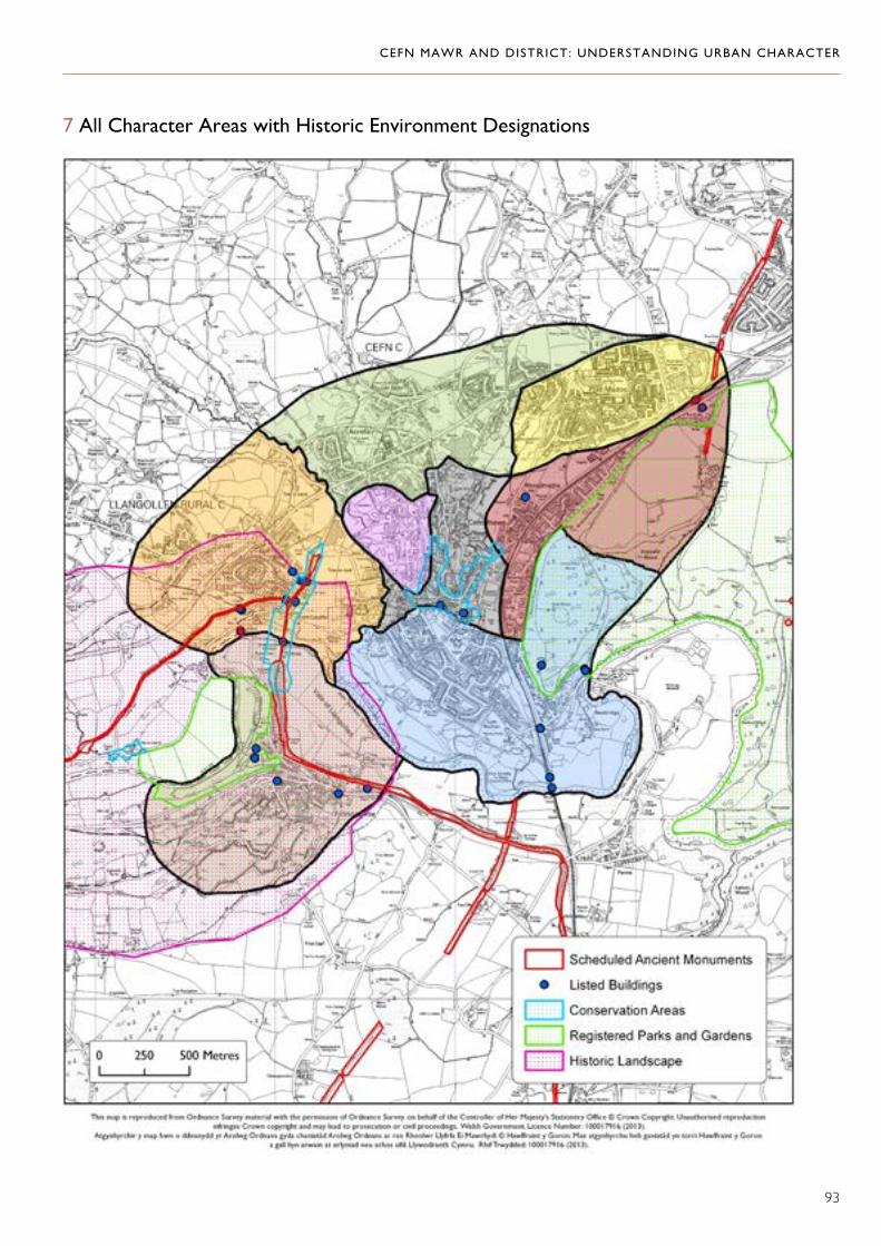
CEFN MAWR AND DISTRICT: UNDERSTANDING URBAN CHARACTER
93
7 All Character Areas with Historic Environment Designations

CEFN MAWR AND DISTRICT: UNDERSTANDING URBAN CHARACTER
94
8 Cefn Mawr (1)

CEFN MAWR AND DISTRICT: UNDERSTANDING URBAN CHARACTER
95
9 The Flexsys Site (2)

CEFN MAWR AND DISTRICT: UNDERSTANDING URBAN CHARACTER
96
10 Rhosymedre (3)

CEFN MAWR AND DISTRICT: UNDERSTANDING URBAN CHARACTER
97
11 Cefn Bychan, Newbridge and Dolydd (4)

CEFN MAWR AND DISTRICT: UNDERSTANDING URBAN CHARACTER
98
12 Froncysyllte (5)

CEFN MAWR AND DISTRICT: UNDERSTANDING URBAN CHARACTER
99
13 Trevor and Tref y Nant (6)

CEFN MAWR AND DISTRICT: UNDERSTANDING URBAN CHARACTER
100
14 Acrefair (7)

CEFN MAWR AND DISTRICT: UNDERSTANDING URBAN CHARACTER
101
15 Plas Madoc (8)

CEFN MAWR AND DISTRICT: UNDERSTANDING URBAN CHARACTER
102