Cebu Port Redevelopment
68
1 | Page Table of Contents Chapter 1 Introduction ............................................................................................................... 4 1.1 Background of the Study .................................................................................................. 4 1.2 Statement of the Problem ................................................................................................. 6 1.3 Project Goals & Objectives .............................................................................................. 7 1.4 Significance of the Project ............................................................................................... 8 1.5 Project Scope & Limitation .............................................................................................. 9 1.5.1 Cebu International Port and Cargo .......................................................................... 10 1.5.2 Cebu Baseport Domestic Zone ................................................................................ 10 1.5.3 Limitations ............................................................................................................... 10 1.6 Definition of Terms .................................................................................................... 11 Chapter 2 Review of Related Literature .................................................................................. 14 2.1 BOOKS .......................................................................................................................... 14 2.1.1 Information for the Background of the Study ......................................................... 14 2.1.2 Information about the Seaport Infrastructure .......................................................... 19 2.2 ARTICLES ..................................................................................................................... 26 2.2.1 Information for the Problem and Significance of the Project .................................. 26 2.2.2 Information for the Background of the Study ......................................................... 28 2.3 WEBSITE....................................................................................................................... 29 2.3.1 Information for Demographics ................................................................................ 29 2.3.2 Information for the Background of the Study ......................................................... 33
-
Upload
honie-castaneda -
Category
Documents
-
view
125 -
download
6
description
Architecture Thesis Book Chapters 1-4. It is about redevelopment of International Port of Cebu. It includes Introduction, Review of Related Literature, Methodology, and Site Analysis and Description.
Transcript of Cebu Port Redevelopment

1 | P a g e
Table of Contents
Chapter 1 Introduction ............................................................................................................... 4
1.1 Background of the Study .................................................................................................. 4
1.2 Statement of the Problem ................................................................................................. 6
1.3 Project Goals & Objectives .............................................................................................. 7
1.4 Significance of the Project ............................................................................................... 8
1.5 Project Scope & Limitation .............................................................................................. 9
1.5.1 Cebu International Port and Cargo .......................................................................... 10
1.5.2 Cebu Baseport Domestic Zone ................................................................................ 10
1.5.3 Limitations ............................................................................................................... 10
1.6 Definition of Terms .................................................................................................... 11
Chapter 2 Review of Related Literature .................................................................................. 14
2.1 BOOKS .......................................................................................................................... 14
2.1.1 Information for the Background of the Study ......................................................... 14
2.1.2 Information about the Seaport Infrastructure .......................................................... 19
2.2 ARTICLES ..................................................................................................................... 26
2.2.1 Information for the Problem and Significance of the Project .................................. 26
2.2.2 Information for the Background of the Study ......................................................... 28
2.3 WEBSITE....................................................................................................................... 29
2.3.1 Information for Demographics ................................................................................ 29
2.3.2 Information for the Background of the Study ......................................................... 33

2 | P a g e
2.4 VIDEO ........................................................................................................................... 35
2.4.1 Information for the Background of the Study ......................................................... 35
Chapter 3 Methodology ........................................................................................................... 36
Chapter 4: Site Profile and Analysis ........................................................................................ 39
4.1 Site Criteria .................................................................................................................... 39
4.2 Three Initial Sites ........................................................................................................... 39
4.2.1 The Port of Manila (Pantalan ng Maynila) .............................................................. 39
4.2.2 The Batangas International Seaport (Batangas Pier) ............................................... 41
4.2.3. The Port of Cebu..................................................................................................... 42
4.3 Final Site – The Port of Cebu ......................................................................................... 43
4.3.1 Macro Site Description ............................................................................................ 43
4.3.2 Micro Site Description............................................................................................. 64
Table of Figures and Tables
Figure Number Page Number
1 Map of Metro Cebu Cities and Municipalities 42
2 Vicinity Map of Metro Cebu 43
3 Age Sex Population Pyramid 48
4 Topographical Map of Cebu 51
5 Protected Area Management Zone 52
6 Existing Land Use Map 53
7 Cebu City Zoning Map 54
3 | P a g e
8 Geologic Map of Cebu 57
9 Elevation Map of Cebu 58
10 Land Classification Map of Cebu 59
11 Land Forms Map of Cebu 60
12 Slope Map of Cebu 61
13 Topographic Map of Cebu 62
14 Google Map of Cebu Baseport Area 63
15 Google Map of Cebu Seaport Complex 63
16 Map of Cebu Port System 65
Table Number Page Number
1 Population Chart of Metro Cebu 47
2 Average Household Size Chart 49
3.1 Number of Household by Barangay 50
3.2 Number of Household by Barangay 51
4 | P a g e
Chapter 1 Introduction
Our unique geography as an archipelagic nation should necessitate us to concede the
benefits and challenges that come with being a nation surrounded and convey together by the
water. The Philippines impends on seaports much more than countries with huge constant
landmass. With 7,107 islands and a land area of more than 300,000 square kilometers, the
Philippines lies at the heart of the globe.
If you look at the world map, it is not just a regular location, but in essence, a tactical
region that has accessibility to more than half of the world’s population. Since a high
percentage of domestic and international interchange and traverse is by sea, the effectiveness
of maritime transportation has become increasingly necessary to national competitiveness. It
is a vast market for the country’s economic production if we unravel and uncover it and use
this range to our advantage in the economy of distance and time.
1.1 Background of the Study
Maritime conveyance is the capital support of world-wide trade, with its capacity to
move abundant quantities of load over extended distances. The notion of marine
transportation rests on two major elements: ports and shipping networks. Ports are locations
where cargo and passengers can be transhipped to and from maritime modes. Shipping
networks are regular itineraries that draw arcs on the Earth’s water surface as intercontinental
maritime transference tries to maintain the immense circumference distance.
5 | P a g e
There is a long history of the necessity of the oceans for mercantile navigation, a
procedure associated to the establishment of world-wide trade, especially with the founding
and expansion of civilizations and empires. Maritime conveyance is a commercial activity
demanding a comprehensive arrangement of modes and infrastructures and is designed by the
marine geography of the Earth, principally the configuration of oceans, coasts, seas, lakes,
and rivers. Where possible, dredging and the construction of canals, channels, and locks have
been attempted to lessen distances, to facilitate maritime transmission, and to reform access
to port. This has diminished the discontinuity imposed by geography on world-wide trade.
Our coastline is almost double of that of the US, thus, making it beneficial not only
for global protection, but also for maritime-business projection. The record of the Philippine
Maritime History is, in a sense, the story of the country itself.
Before the arrival of the Spanish in the 16th century, the islands were sparingly
inhabited with well-established trading networks between the islands and wider regional
networks in Southeast Asia. In the mid-1500s, an expedition arrived in the Philippines to
explore of the legendary Spice Island. From the late 18th century social and economic
structures in the Philippines were transformed. The Philippines, along with the rest of
Southeast Asia, was drawn into the world trading system.

6 | P a g e
By the 19th century Anglo–American merchant houses dominated the blossom
exportation economy. The Philippines became a major maker of cash crops for international
traffic with the volume of international trade multiplying fifteen times between 1825 and
1875. In the 1890s, an increasing nationalist movement in the Philippines resulted in a
rebellion in 1896 against Spanish government. They destroyed a Spanish fleet in Manila Bay
and, support by Filipino insurgents under their commander Aguinaldo, they rapidly
conquered the islands.
1.2 Statement of the Problem
The quality of port infrastructure rank for the Philippines in the WEF Global
Competitive Report is the lowest among the ASEAN. As an archipelago with
a very abundant number of ports, the Philippines faces a challenge to
undertake reforms and huge investments to modernize as many ports as
possible.
The volume of international container shipments in the Philippines is small
compared to those in East Asia’s export economies.

7 | P a g e
Improvement of maritime safety is an important issue given the high loss of
life from negligence of ship owners and government agencies, terrorism, and
weather.
Philippine ports suffer from a structural regulatory problem. The DOTC has
restricted power over Special Economic Zone (SEZ).
Also, there is no consistent dispensation of RORO ports; some are under PPA,
while others are under LGUs, and fees are not uniform.
The high charge of domestic maritime transportation has long been disputed,
while the vast possibility for tourism both domestic and international is highly
influenced by the quality of seaports as well as airports.
1.3 Project Goals & Objectives
To provide an international port that will meet the demands of the global maritime industry
and improved inter-modal connectivity that has extensive connectivity with land and water
transport that will generate new economic and social benefits for the country.

8 | P a g e
To redevelop and bring change through technological advancements in the traditional
functions of seaports such as the traffic, merchant and industrial functions
To provide a connection between land and water transportation for the ease of
accessibility of the users
To provide facilities that will ensure the safety and security for seagoing vessels
entering, operation in and leaving the seaport
1.4 Significance of the Project
The project raises a multitude of solutions to the problem concerning inadequate
volume of trade, whole system of fees, high cost of transport and public awareness. The
Philippines is well-positioned to become a regional distribution center for goods destined for
global trade. It has relative benefit for storage and distribution of goods to separate parts of
the world.
The project promotes the effectiveness of marine conveyance through domestic and
international commerce and is critical to competitiveness. Transport costs in navigation are
high and are one of the considerations for the country’s low competitiveness.

9 | P a g e
Not only would it elevate our own economic advantage, it would also convey new
opportunities for the citizens and non-citizens to liberate investments in our country. This
would also lengthen the relationships the nation has with other countries that would be
mutually beneficial.
The project promotes the significance of marine conveyance for our agriculture. Key
domestic and international ports need bulk and break-bulk facilities. If the government
priority for agriculture and food security is serious, there is need for more bulk ports. If
mining is to take off, there must be bulk terminals. The country’s requirements for coal, LNG
and the like also call for bulk port handling facilities. Transport system issues highlight the
relationship between infrastructure and supply line.
1.5 Project Scope & Limitation
The Scope of the project is to promote the importance of the Port and Maritime
Transportation through redeveloping the Seaport focusing on improvement of the economy of
Cebu. The project only wishes to focus on developing certain key issues through specific
solution based into two major parts; Cebu International Port and Cebu Baseport Domestic
Zone.

10 | P a g e
1.5.1 Cebu International Port and Cargo
All needed infrastructure including container terminals, cranes, truck marshalling areas, and
weighing scales, which are not present at many ports and to include facilities to accommodate
bulk and break bulk cargoes.
1.5.2 Cebu Baseport Domestic Zone
pure containerized lift-on/lift-off (LOLO) shipping for long-haul routes between main
ports
large Roll-on/Roll-Off (RORO) ferries with passengers on long-haul routes
bulk (dry and wet), break bulk, and small container shipping
1.5.3 Limitations
Major ports should have modern passenger terminals with connected land transportation
terminals such as bus. Jeepney, and cab terminals but the project does not wish to dwell much
further on this part. There is a given structure for this area to show the connection of land and
water transport but not as detailed compared to others.

11 | P a g e
1.6 Definition of Terms
1. Break Bulk cargo - is a term that can be describe as goods that must be loaded
individually, and not in intermodal containers nor in bulk as with oil or grain. Break
bulk cargo is transported in bags, boxes, crates, drums, or barrels. Unit loads of items
secured to a pallet or skid are also used.
2. Marshalling areas – it is a location in the vicinity of a reception terminal orpre-
positioned equipment storage site where arriving unit personnel, equipment, materiel,
and accompanying supplies are reassembled, returned to the control of the unit
commander, and prepared for onward movement.
3. Berth – term used in ports and harbors for a designated location where a vessel may
be moored, usually for the purposes of loading and unloading. Berths are designated
by the management of a facility.
4. Anchorage – place for the privilege of anchoring to secure or stabilize the ship
5. Cargo-Handling - the activity of moving goods on and off ships, planes, trucks, etc.
6. Pilotage - is the use of fixed visual reference on the ground or sea by means of sight
or radar to guide oneself to a destination, sometimes with the help of a map or
nautical chart. People use pilotage for activities such as guiding vessels and aircraft,
hiking and scuba diving.
7. Bunkering - The act or process of supplying a ship with fuel.
8. Porterage - the work of carrying supplies, goods, etc, done by porters

12 | P a g e
9. Roll-On/Rolf-Off (RORO) – ships are vessels designed to carry wheeled cargo, such
as automobiles, trucks, semi-trailer trucks, trailers, and railroad cars, that are driven
on and off the ship on their own wheels.
10. Lift-on/Lift-off (LOLO) – Contrast to RORO, it is a containerized cargo ship which is
loaded and offloaded by a port's cranes and derricks
11. World Economic Forum (WEF) – is an independent international organization
committed to improving the state of the world by engaging business, political,
academic and other leaders of society to shape global, regional and industry agendas
12. Association of Southeast Asian Nations (ASEAN) - was formed in 1967 by Indonesia,
Malaysia, the Philippines, Singapore, and Thailand to promote political and economic
cooperation and regional stability
13. Department of Transportation and Communications (DOTC) – responsible for the
maintenance and expansion of viable, efficient, and dependable transportation and
communications systems as effective instruments for national recovery and economic
progress
14. Special economic zone (SEZ) – is a geographical region that is designed to export
goods and provide employment. SEZs are exempt from federal laws regarding taxes,
quotas, FDI-bans, labour laws and other restrictive laws in order to make the goods
manufactured in the SEZ at a globally competitive price

13 | P a g e
15. Local Government Units (LGU) - shall provide for a more responsive and accountable
local government structure instituted through a system of decentralization with
effective mechanisms among the different local government units their powers,
responsibilities, and resources
16. Bureau of Customs (BOC) – the agency of the Treasury Department that enforces
import tariffs
17. Phil. Export Zone Authority (PEZA) – Promotes the establishment of economic zones
in the Philippines for foreign investments. Includes registration procedures, forms,
zone facts and online reports.
18. Oriental Port and Allied Services Corporation (OPASCOR) – privatize non-
performing government owned and controlled corporations. The first cargo handler to
be fully owned and operated by its workers.
19. Cebu Port Authority (CPA) – was created through the enactment of Republic Act No.
7621 signed on June 26, 1992 to specifically administer all ports located in Cebu
Province
20. Philippine Ports Authority (PPA) – Government entity specially charged with the
financing, management and operations of public ports throughout the archipelago.

14 | P a g e
Chapter 2 Review of Related Literature
2.1 BOOKS
2.1.1 Information for the Background of the Study
2.1.1.1 “Rediscovery in Southern Cebu”
By Ramon Echevarri
Pages 17-33 Historical Perspectives; 34-40, 49-57 Archaeological
Record; 101-109 – New Perspectives
Local Book
The general topic of this book is about the rediscovery of the main economy of the
whole province even before the arrival of the Spaniards. The concern of the writer is why
cotton-growing and weaving that was once the major industry of Cebu eventually died out
following the Spanish Conquest. Throughout the book, he gathered a lot of different reports,
archaeological records, and documents from different people such as Priests, Chinese
Traders, and Spanish missionaries to support his hypothesis as to why the major industry died
out.
The relationship of this book to the researcher’s topic gives him a better
understanding about the province’s development of trade from the Pre-Spanish period up to
the modern era. It has a detailed process of trading system of the province with the other

15 | P a g e
islands as wells as the other countries nearby. The province of Cebu had commercial
relations with foreign lands even before the Spaniards have arrived.
With the writer’s gathered information, it has been stated that not only the cotton
weaving industry has been exported for local and overseas trade from the province but also
different potteries. By the year 1860, native weaving industry declined rapidly and corn crops
has been introduced by the Spaniards. At the end book, the writer expressed his thought that
Cebu still has the ability to revive its old trading industry. By reviving the old trading
industry and agriculture of Cebu, it would create a new personality for the place and open
new opportunities for the people of the place.
2.1.1.2 “Cebu: Prime Business and Tourism Haven in the South”
By Amada T. Valino
Pages 18-38, 45, 69-74, 77-88
Local Book
The general topic of this book is all about the Business and Tourism Industry of the
said province. It discusses the capacity and opportunity of Cebu in terms of Trade Industry. It
has a lot of technical information such as lot size of different cities that forms the province,
its population and such. Of course, the book has said a lot about the tourism of Cebu through
discussing each of the historical landmarks of the province.

16 | P a g e
In relation to researcher’s study, the book discussed a lot about the province’s
transportation which includes a detailed observation about the port and its importance in their
economy. It has a lot of technical information regarding exports and investments from
different companies. It is stated that Cebu leads in both traditional and non-traditional exports
and has the highest economic growth in the Philippines. Cebu exports comprise more than
95% of the total exports of Central Visayas.
In the last three decades, Cebu has led the country in economic growth, with rates
averaging 20% above the national figures. It has its own International Seaport, the busiest
outside Manila, with direct ports of call to Asian centers Hong Kong and Singapore. As the
country’s most popular tourist destination, the International Airport in Mactan handles 42
direct flights a week from Hong Kong, Singapore, Japan, Korea, Qatar, Taiwan, and
Malaysia. Long marketing itself abroad as an island in the Pacific, Cebu has managed to
institute itself from the political storms occasionally distracting Imperial Manila.
Throughout the book, there are lot of technical information being given regarding
trade industry of the province as well as comprehensive explanation of tourist attractions per
city. It highlights the Cebu’s competence through promoting investments in the province.
The writer believes that Cebu Island Republic is the culture of boom, stating that even before

17 | P a g e
the arrival of the Spaniards; Cebu’s market has been established with merchants from
Thailand, China and East Indies.
2.1.1.3 A History of Early Southeast Asia: Maritime Trade and Societal
Development
By Kenneth R. Hall
Pages 8-47, 59-82, 145-180
Foreign Book
This comprehensive history provides a new interpretation of Southeast Asia when
major social and economic developments foundational to modern societies took place on the
Burma, Thailand, Cambodia, and Vietnam between Indonesia, Malaysia, and the Philippines.
The book explores the dynamic era in detail through different accounts and reports from the
past in each said countries. It is has a notable explanation for internal adaptations of nearby
cultures through growing of external contacts. In the process, formerly local civilizations
became major participants in period's international trade networks.
Incorporating the latest archaeological evidence and international scholarship, the
writer enlarges upon prior histories of early Southeast Asia. In relation to researcher’s study,
it is an extension of the study of the established commercial industry before the Spanish Era,
thus giving the researcher an idea what are the ‘nearby countries’ that always been said but
never been discussed in other books regarding trade industry of Cebu.
18 | P a g e
The book was written for a wide audience of non-specialists, and it is an essential
reading material for all of those interested in Southeast Asian Maritime Industry. It also has
shown how hierarchical states have been formed from hunter-gatherer to agricultural
communities until they become part of the global trade networks. It has being discussed how
maritime trade improved the economic stand of each countries, giving the researcher a lot of
background information for the study.
2.1.1.3 Maritime Economics Second Edition
Martin Stopford
Foreign Book
This book starts with some thoughts on the return on capital in shipping and the
prediction of shipping cycles. It also discusses the costs and revenues of operating merchant
ships. Costs are divided into voyage costs and operating costs. Capital costs are also
discussed and the final section focuses on techniques for cash flow analysis.
In relation to my research this gives a comprehensive explanation about the Maritime
Economics which affects one of my project objectives for the research. It gave a review about
Trade Development Cycle and the relationship between sea trade and economic development.
It also discussed the organization of the liner system, the characteristics of demand and the

19 | P a g e
way the liner business deals with the complex economic framework to justify the significance
of the researcher’s project.
The aim of this book is to focus on the way designs have evolved to meet technical
and economic objectives. The book ends at the three objectives of ship design, efficient cargo
containment, operational efficiency, and cost. There follows a discussion of each of the main
categories of ship design: liner vessels, liquid bulk, dry bulk, specialist bulk, service vessels.
2.1.2 Information about the Seaport Infrastructure
2.1.2.1 Analytical Models for RORO and LOLO Terminals in
Multipurposes Port
F Russo & Ag Cartisano
Maritime Engineering and Ports.
Foreign Book
The authors wrote about the freight transport which plays an important role in the
transport system, as it is a fundamental element for the economic development of an area and
a country in general. It has been discussed that the ports are organized as freight interchange
centers. It has an introduction to shipping market economics. It aims to explain how the
shipping market is organized and to answer some basic questions about how it works.

20 | P a g e
Throughout the book, the authors explained comprehensively the elements that form
an integrated freight transport system, from multimodal to complex monomodal, intermodal
and also piggy- back transport. The book support an overview of the market covering the
transport system, the demand for sea transport, the merchant fleet, how transport is provided,
the role of ports, shipping company organization and political influences.
In relation to the researcher’s study, the book gives an elaborate explanation as to the
effect of the performance of the main hubs of the port depending on the integrated transport
system such as total reduction in costs, planning phase, cost and performance, and such.
Shipping market cycles dominate the industry’s economic thinking. The author gave a
discussion of shipping risk leads on to a review of how, over the last century, experts have
defined the shipping cycle. It took a more detailed look at the economic model of the
shipping market which underlies the cyclical nature of the business.
2.1.2.2. The Development of a Breakwater Design at Caleta La Mission
Port, Argentine
Maohammad & OJ Jensen
Foreign Book
The researchers’ plan stated throughout the book is to construct new marine
infrastructure on the east coast of Tierra del Fuego, to meet the future cargo transport needs
21 | P a g e
as well as for supporting industrial development in the province having offshore natural gas
resources. The researchers thought of using a new generation of concrete armouring units
with only a handful of breakwaters built.
Though it has also been said that there are however still many possibilities for the use
of the specific type of concrete said in the book in design to be covered and verified by
physical modelling. This work deals with design of the Caleta La Mision Breakwater,
Argentina, and presents the conclusions from the design process supported by extensive
physical model testing in both wave flume and basin for verification and optimisation.
In relation with the study, the research about the new type of concrete for the use of
Seaport Infrastructure could be use as the main material of choice for the project. A handful
of ideas were presented to the book about other possible uses of the material. There is a
physical dimension to shipping economics, so we must be aware of the geography of the
world in which trade takes place. Today’s trading world has evolved over many centuries and
history demonstrates that the regional centre of sea trade is constantly on the move.

22 | P a g e
2.1.2.3 Life Cycle Feasibility of a New Type of Container Handling
System
M.W. Ludema
Foreign Book
The book contains comprehensive information about container handling at container
terminals with the old and new types of container handling systems, like straddle carriers or
Automated Guided Vehicles and Automatic Stacking Cranes. It has a lot comparison with
different container handling system and shows the outcome of each type.
This study investigates the economic feasibility of the new system by comparing it
with the other two by means of a cost effectiveness analysis over a 20 year period. It was
found that the new system is a feasible alternative, so the development of this system should
be continued. There is a physical dimension to shipping economics, so we must be aware of
the geography of the world in which trade takes place. Today’s trading world has evolved
over many centuries and history demonstrates that the regional centre of sea trade is
constantly on the move.
In relation to the topic, one of the project objectives of the project is to improve the
logistic of the Maritime Industry through Seaport Infrastructure thus, giving the researcher an
idea as to how container handling system affects the logistics of the trade and industry.
Containerization of liner services is one of the great commercial innovations of the twentieth
century. Faster transport and lower costs have made it possible for businesses to source

23 | P a g e
materials and market their products almost anywhere in the world. This book discusses the
organization of the liner system, the characteristics of demand and the way the liner business
deals with the complex economic framework within which it operates.
2.1.2.4 Port Development: A Handbook for Planners for Developing
Countries
Unctad
Foreign Paper
The book specifically stated the need for national ports plan. Throughout the study,
technological improvement has been the subject of the research because of the essential plan
of the transportation system for developing countries. It has also been discussed that the
national ports authority should mandate different policy to create order in the system.
In relation to the study, the book guides planners of seaport infrastructures to create a
broad national strategy to create greater economic impact. It stated different kinds of planning
for the system from short-term improvement strategies to long-term improvement strategies
and maintaining the capacity of the structure.
In this book suggests that the transport industry has been one of the prime forces
responsible for shifting the world from an essentially national system to the global economy
that exists today. The progression from a world of isolated communities to an integrated

24 | P a g e
global community was made possible by shipping and sea trade, but this has been a two-way
exchange which has, in turn, forced major adjustment on the maritime industry itself. This
book proved to be a profound insight. Economic development has gone hand in hand with sea
trade.
2.1.2.5 Port Development Policy
Takeuchi Yoshio
Foreign Book
The book is about recognition of the maritime sector and it critical role in the
development of regional, national and global economies. This is in view of the growth-pole
potentials of ports and ancillary industries. It gave comparisons of different countries with
leading global power for its implications for public policy formulation and implementation.
This book attempts a comparison of the evolution and implementation of policies
relating to the development of ports, the mercantile marine and port industries in both
countries. Focusing on the roles of the government and the private sector, it locates the
discussion in a wider, global comparative context.
In relation to the research, this book gives comprehensive information about the
development of the policies of different countries in terms of the Seaport Infrastructures and
Maritime Industry which could be applied for the researcher’s project. The task in this book

25 | P a g e
is to understand the economics of the industry. In carrying out the economic analysis it did
not neglect the fact that the shipping market is a group of people—shipowners, brokers,
shipbuilders and bankers—who together carry out each year the Herculean task of
transporting cargo by sea and who may see shipping as much more than just a business.
2.1.2.6 A Practical Guide for a Sustainable Seaport
The World Association for Waterborne Transport Infrastructure
PIANC
2010
Foreign Book
The author tries to enlighten us about the different issues regarding Seaports.
Increasing environmental awareness create new challenges for the development of ports. In
addition, climate change calls for adaptation measures that aim at minimizing impacts of e.g.
rising sea levels and increased flood water heights but safeguard accessibility of ports and
waterways and also safeguard future sustainability for the social and natural environmental
conditions.
Throughout the book it explains International and national legislation for new ports or
extensions of existing ports are incorporating these said issues. New Seaports are
increasingly based on strict regulations aiming at creating designs with minimized
environmental impact and sustainable operations in the long-term.

26 | P a g e
In relation to the researcher’s study, it focuses mainly on ‘Green’ Port with a
comprehensive explanation of what it is and how it related to its stakeholders through the
collection of existing views and global trade and trends. It explained why Green Ports are
necessary and how to adopt a green ports philosophy.
More importantly, it includes the concept of Corporate Social Responsibility and port-
reconstruction or transformation phases and relevant aspects of port operations in the scope.
2.2 ARTICLES
2.2.1 Information for the Problem and Significance of the Project
2.2.1.1 Arangkada Philippines 2010: A Business Perspective
Infrastructure: Seaports
Local Advocacy Paper
Joint Foreign Chambers
The paper has reports and documents regarding the issues of Philippine’s Seaport
situation. Mainly, the paper stated the problems about volume of international container
shipments and connection of the country with the other nearby countries. In relation to the
study, the gathered documents gave an insight about the ranking of Philippine Seaports.
27 | P a g e
Shipping depends on trade, so we must understand why countries trade and why trading
patterns change.
This paper explains the impact of regulation on shipping economics. It identifies three
key regulatory institutions, the classification societies, the flag states and the coastal states.
Each plays a part in making the rules which govern the economic activities of ship owners.
The classification societies, through the authority of the class certificate, supervise the
technical safety of the merchant ships. The paper ends with some thoughts on the return on
capital in shipping and the prediction of shipping cycles.
2.2.1.2 Infrastructure & Logistics: Deficient but Critically Needed
CROSSROADS (Toward Philippine Economic and Social Progress)
By Gerardo P. Sicat (The Philippine Star)
March 20, 2013
Local Paper
The author tries to enlighten the readers about different problems of the Philippine’s
Maritime Industry as well as the government’s body to administrate the rules and policies
over the infrastructures. He stated as well, the economical statistic standing of the country
compared to other ASEAN country and that, the country placed last in ranking.
28 | P a g e
Throughout the article it was stated the countries that invest in infrastructure
sufficiently improve the flow of goods and services between users and suppliers. Logistics
was thoroughly explained and highlighted the connection between domestic and international
commerce.
In relation to the researcher’s study, this article explained that issues that the country
has been experiencing for the past decades regarding maritime commerce. The article has
showed the importance of Seaport Infrastructure to a countries economic growth. Thus, it
shows the significance of the researcher’s project to the country.
2.2.2 Information for the Background of the Study
2.2.2.1 An Early Age of Commerce in Southeast Asia 900 – 1300 CE
Geoff Wade
June 2009
Journal of Southeast Asian Studies
Foreign Paper
The author suggests that the age of commerce had its roots in changes which occurred
during the fifteenth century. The commercial boom and the emergence of port cities as hubs
of commerce, spurred the political, social and economic changes which marked the Age of
Commerce in the region, extending from the fifteenth to the seventeenth century.
29 | P a g e
The points to changes in the spice and aromatic wood trade, a trade boom beginning
sometime around 1400 and new systems of cash-cropping across the archipelago. With the
booming maritime trade came the emergence of the Southeast Asian increased
commercialisation and the growth of port cities.
In relation to the research topic, the article pointed out the effects of commerce within
the cities. It also has the background information about Southeast Asian Maritime History to
strengthen the credibility of the research.
2.3 WEBSITE
2.3.1 Information for Demographics
2.3.1.1 Cebu Port Authority
http://www.cpa.gov.ph/index.php
Local Government Owned Website
A port authority might be authorized to exercise licensing and regulatory functions
with respect to marine and port services and facilities. Regulation of marine activities is
related to the harbourmaster’s function, as well as to the transport of dangerous goods and
protection of the environment such as rules pertaining to discharge of ship wastes into port
30 | P a g e
waters, tank cleaning, and the use of port reception facilities. The licensing power of the port
authority with respect to port services can be extensive because it usually has the legal power
to revoke licenses for violations without administrative appeal.
The law may authorize the issuance of public licenses to operate terminals. Because
public licenses require extensive oversight by the port authority and reporting by the licensee,
their utility should be balanced against the bureaucratic burden for the port authority and the
port licensees. The same goals may be better achieved through concession or leasehold
contracts, as these are more flexible for both parties. However, in the event of inclusion of a
public license authority in a ports law, rules should be set for transfer, renewal, and
cancellation of a license. Unlike for a concession or lease, where breaches are matters of
contract and law, license breaches fall under administrative (or even criminal) processes for
their resolution.
The website has statistical reports on Port’s performance in each Port District Office
of the province of Cebu. Through the annual reports, biddings, port tariff, and port statistics,
the researcher has the information needed with the access of the internet that could be use to
strengthen the credibility of the study.
31 | P a g e
2.3.1.2 Philippine Ports Authority
http://www.ppa.com.ph/
Local Government Owned Website
The Philippine Ports Authority, in Filipino, Pangasiwaan ng mga Daungan ng
Pilipinas, abbreviated PPA, is a government-owned corporation under the Department of
Transportation and Communications as an attached agency. It is responsible for financing,
management and operations of public ports throughout the Philippines, except for the port of
Cebu, which is under the Cebu Ports Authority.
The range of permitted port authority activity may also be variously extended to
include airport, bridges, tunnels, commuter rail systems, inland river or shallow draft
terminals, industrial parks, foreign-trade zones, world trade centers, terminal or shoreline
railroads, shipyards, commercial vessels, dredges, marinas and other public recreational
facilities. Certain navigation districts are empowered to levy taxes. Many are given police
powers, at least to the extent of maintaining security and enforcing board approved
ordinances on properties owned by the port authorities. A few also exercise regulatory
powers, such as the licensing of stevedores, and enforcement of local or state environmental
and land-use regulation, and the management of submerged or tidal lands within the port’s
jurisdiction.
The law may authorize the issuance of public licenses to operate terminals. Because
public licenses require extensive oversight by the port authority and reporting by the licensee,

32 | P a g e
their utility should be balanced against the bureaucratic burden for the port authority and the
port licensees. The same goals may be better achieved through concession or leasehold
contracts, as these are more flexible for both parties. However, in the event of inclusion of a
public license authority in a ports law, rules should be set for transfer, renewal, and
cancellation of a license. Unlike for a concession or lease, where breaches are matters of
contract and law, license breaches fall under administrative or even criminal processes for
their resolution.
Marine management tasks form part of either a national maritime administration or of
a public port authority. Marine management, which is essentially a public safety task, should
be performed separately from a corporatized or privatized port authority to prevent a
conflicting mix of commercial and safety objectives. A ports law should make that separation
of objectives clear. Because of overriding safety concerns, which may run counter to the
profit-making objectives inherent under this type of port authority, combining marine
management tasks with managing a corporatized or privatized port may not be the best option
for managing navigational port safety.
The website has statistical reports on Port’s performance in each Port District Office
of the whole Philippines. Through the annual reports, biddings, port tariff, and port statistics,
the researcher has the information needed with the access of the internet that could be use to
strengthen the credibility of the study.

33 | P a g e
2.3.2 Information for the Background of the Study
2.3.2.1 The Maritime Heritage Project
http://www.maritimeheritage.org/ports/philippines
Foreign Organization Website
The site illustrates the importance of a global awareness; the health and wealth of
nations was formed by individuals who migrated, seeking refuge and opportunity. It also
illustrates the importance of maintaining all facets of our planet be it flora or fauna for the
sake of future generations.
In relation with the study, the website provides comprehensive information about the
world maritime history. The credibility of this website started as a historical research paper
and became an organizational website that is supported by the visitors who value the
information given by the said website.
2.3.2.2 Philippine Statistics Authority
http://www.maritimeheritage.org/ports/philippines
Local Government Owned Website
Based on the 2010 Census of Population and Housing (CPH), Cebu City, a highly
urbanized city in the province of Cebu, posted a total population of 866,171 persons as of

34 | P a g e
May 1, 2010. This is larger by 147,350 persons compared to its total population of 718,821
persons counted in the 2000 CPH. The increase in the population count from 2000 to 2010
translated to an average annual population growth rate (PGR) of 1.88 percent. This is higher
than the 1.65 percent annual PGR of the city between the census years 1990 and 2000.
If the average annual PGR recorded at 1.88 percent during the period 2000 to 2010
continues, the population of Cebu City would double in 37 years. In 1970, the population of
Cebu City was only 347,116 persons. This population size is two fifths of the population of
the city in the 2010 CPH.
An online information for the demographics of the Macro-Site Analysis. The 2000
Census of Population and Housing (Census 2000) results showed that Cebu with a total
population of 2,377,588 persons was the second most populated province in the Philippines,
next to the province of Pangasinan. It registered an increase of 313,487 persons from the
population recorded five years ago. This was translated to an average annual growth rate of
3.07 percent, higher than that of the 1990 to 1995 period (2.01 percent).

35 | P a g e
2.4 VIDEO
2.4.1 Information for the Background of the Study
2.4.1.1 “KABILIN: History of the Maritime Industry of Cebu”
By Subuanong Kabilin (In Visayan Dialect)
April 1, 2013 Local Video
Translated by: Helen Castaneda and Jay-R Linaza
The video is made into three parts. The whole video was almost about the tourism of
the province as the purpose of the material is to invite a lot of tourist though I doubt that they
would be able to understand it. The main reason for using the Visayan dialect is not because
the narrator couldn’t speak in other languages because there are times that he would speak in
English as well, but to encourage the people from his province to watch the documentary
video to acknowledge the culture that they have.
Throughout the video, each seaport infrastructure, landmarks, and body of water that
is related to the topic has its own story. In relation to the study, this documentary video
provides the researcher additional background information about the seaport infrastructures
around the province.

36 | P a g e
Chapter 3 Methodology
The research method used in this study is classified as Qualitative Research Method.
The research began with rough ideas that turned slowly into research questions. To answer
the researcher’s questions, literature review gradually build up knowledge about the research
ideas. Data Collection and Organization phase took place to properly analyze the data
gathered. These are difficult tasks, since the volume of data collected in qualitative research
can be enormous. The gathering of data as well is quite difficult as well.
The Analysis flows into three concurrent action such as data reduction which focuses,
simplifies and transforms raw data into more manageable forms, data display which presents
the data as organized and compressed assemblies of information that permit conclusions to be
analytically drawn, and verification where the researchers review and finalize the validity of
the information gathered. Usually after the typical Qualitative Research Approach,
Dissemination takes form of very well written and detailed documents, so that other
researchers can evaluate analysis and conclusions obtained and decide if they trust the results
and want to use them to feed their own research.
The focus of this preliminary study was primarily on researcher’s project about
redeveloping the International and Local Seaports of the province of Cebu. There is a wealth
of information for this review since there is a long history of Maritime Industry of the

37 | P a g e
Philippines that has been documented even before the Spanish Period. It was expected that
competency in World Maritime Trade of our country because of our strategic location. The
researcher is trying to associate the condition of the country’s seaport with its competence in
terms of Trade and Industry locally and internationally.
The methods for identifying and locating resources involved accessing different
universities Library’s online cataloguing system. Information related to the reviewed topics at
OPAC was discovered in selected books. In addition, EBSCO and Google Scholar™ were
heavily used to locate numerous online databases in order to find related scholarly articles.
These online databases included ERIC EBSOhost Academic Search Elite, EBSOhost
Professional Development Collection, and GALE Academic OneFile.
There have been few studies related about the different location of Philippine Seaports
such as Batangas and Subic Bay Seaport that are available from the libraries of Far Eastern
University and University of Santo Tomas. The Department of Tourism and National Library
has varieties of books and reports about the accounts and statistics of different Seaports.
There are a lot of countries trying to improve their Marine Ports as well and tried to share the
information gathered in the World Wide Web. A lot different case studies were gathered,
questionnaires were made, and other resources collected determining the issues regarding
seaports on different locations and different circumstances.
38 | P a g e
The primary rationale for selecting the sources described above was reliability. The
researcher recognized that he had access to human and electronic resources that would make
locating sources of information fairly easy. However, it was the researcher’s responsibility to
determine the credibility and the validity of the information to be referenced in this literature
review.
The second rationale for selecting the above sources is the researcher’s own interest in
the topic of seaport development and use of technology. The researcher intends to use this
literature review as a foundation for future research in Seaport development in the area of
Sustainable Architecture integration.
39 | P a g e
Chapter 4: Site Profile and Analysis
4.1 Site Criteria
The site must be well positioned for regional distribution of good (15%)
The site must be well allocated for global trade (15%)
Site must be a major port of the Philippines (10%)
Considered as the gateway of the region or city (5%)
Must have an accessibility of resources around the area (10%)
The port must have a lot of port infrastructure issues for the past years (20%)
The site won’t have any major changes for the next three years (5%)
The port must have a huge role regarding economic condition of the city (20%)
4.2 Three Initial Sites
4.2.1 The Port of Manila (Pantalan ng Maynila)
The largest seaport in the Philippines, and is the premier international shipping
gateway to the country.
The Port of Manila and the region dates back to Spanish and pre-Spanish government
of the Philippine Islands. It is documented that Manila and the Philippines had trade
interrelationship with most adjacent countries at least as far back as the 9th to 12th centuries.
Major trading participator included China and Japan, with ties to India through the areas that
are now Malaysia and Indonesia. The Spanish-controlled Port of Manila handled trade
primarily with China and other East Asian countries, with Mexico, with Arab countries, and
40 | P a g e
openly with Spain from the 16th to mid-19th century CE when the harbour was opened to all
trade ships.
The harbour was also the staging moment for the Manila galleons, a state-monopolist
navigation line running to Acapulco and back, which operated virtually continuously from
the 16th to the early 19th century CE. Manila Bay was the setting for the Battle of Manila
Bay in 1898 between United States and Spanish forces, and the encirclement of Corregidor
Island by invading Japanese forces in 1942.
The Port of Manila is made up of three areas: Manila North, Manila South, and
Manila. Manila North Harbor is located in the Tondo District of Manila which is the biggest
and primary port in the Philippines for domestic cargoes. The multi-purpose terminal in the
Port of Manila's North Harbour is used to handle general and containerized cargo and
passengers. Manila South Harbour is operated by Asian Terminals Inc. (ATI), a publicly-
listed port investor, operator, and developer in the Philippines. ATI operates the Port of
Manila South Harbour’s container and domestic terminals and provides general stevedoring
services. Located between the Port of Manila's North and South Harbours is the Manila
International Container Terminal (MICT) operated by International Container Terminal
Services, Inc. (ICTSI). The ICTSI was established in the Philippines in 1987 and has since
expanded to operate container terminals throughout the Philippines and worldwide. The
41 | P a g e
Asian Development Bank has recognized the ICTSI as one of the world's top five maritime
terminal operators.
4.2.2 The Batangas International Seaport (Batangas Pier)
It is the seaport which primarily serves the region CALABARZON. Situated 110
kilometres south of Metro Manila is the strategic and modern Port of Batangas which serves
as a corresponding gateway for the Port of Manila. The port is directly connected with the
major highways via modern infrastructure making it conveniently accessible to shippers,
truckers and passengers. It was declared as a national port in 1956. In the 90's it was the
second biggest port in the Philippines in terms of revenue, just behind the Port of Manila.
Though it has been declared as an “International Port of Batangas.”, for now,
Batangas Port is only operating domestically for its sea travel but its international container
port is in full operation. It is now a gateway for every tourist who wants to experience
paradise and discover the amazing underwater experience through diving and snorkling at
Puerto Galera and other nearby islands like the Isla Verde which was recently announced as
the center of the center of Marine biodiversity.
Batangas port is rapidly improving when it comes to facilities, services and operation
even in their security level for good and safe travel. Sea vessels increased their count as a
good sign of tourism and for the locals, franchises of different products appeared in port
because of the demands of the traveller.

42 | P a g e
4.2.3. The Port of Cebu
Metro Cebu's Port of Cebu is the busiest domestic seaport in the Philippines. Along
with the harbor areas of Mandaue and Lapu-Lapu, Cebu's "seaport complex" is considered as
the busiest harbor in the Philippines in expression of number of yearly passengers. It is also
the capital port of entry in the province of Cebu and Central Visayas Region. It act a vital role
in the Philippine's navigation industry with about 80 percent of the country's navigation
companies that are based here. The port is situated at the center of the province's east coast. It
is nestled in a natural harbour in the narrow strait between Cebu City and Mactan Island, the
latter providing a natural cover and breakwater, making the port one of the safest and
functional the whole year round.
Cebu International Port and Cebu Domestic Port serves container vessels and
wayfarer ships with destinations around the country and the world. Cebu International Port is
a multipurpose terminal covering an range of 10 hectares with 690 meters of berthing space
and a controlling draught of minus 8.5 meters at MLLW. The Cebu Baseport — Domestic
Zone is the scope for the domestic transactions of separate business approaching from and
departure to the different island of the archipelago. It is devoted to coastwise shipping with
3.5 kilometers of berthing space, 3 finger piers and 3 passenger terminals.

43 | P a g e
4.3 Final Site – The Port of Cebu
4.3.1 Macro Site Description
4.3.1.1 Profile of the City
Metro Cebu is the main urban center of the province of Cebu in the Philippines. Metro
Cebu is located along the central eastern portion of the island including the nearby island of
Mactan. It accounts for 20% of the land area and 60% of the population (2007 census) of the
entire province of Cebu. It is located in Cebu City, the capital of Cebu and the regional center
of Central Visayas with twelve surrounding cities and municipalities.
Figure 1 (Above) Map of Metro Cebu Cities and Municipalities

44 | P a g e
The Metropolitan Cebu Development Council (MCDC) is a body mandated to
formulate development plans for the Metro Cebu area and coordinate their implementation.
Unlike the Metropolitan Manila Development Authority, the MCDC does not have legal and
institutional powers. Cebu is the gateway to around two-thirds of the Philippine archipelago.
It is the primary destination of approximately 35% of the Philippines’ foreign visitors.
Superb destinations, low operating costs and excellent government administrative
support favor the development of new destinations which are serviced from Cebu. There are
opportunities for ocean and land recreation, transportation, marketing, and tourism-related
developments such as mountain resorts, hotels and golf courses. After their arrival, travellers
retrace historic journeys, play golf, hike mountain trails and laze on pristine white sands and
dive on exotic coral reefs that equal the very best of anywhere. Cebu’s attractions make it the
Philippines’ premier tourist destination.
Figure 2 (Left) Vicinity Map of Metro Cebu

45 | P a g e
The public administrators of the province have been known to be development-
oriented, steering Cebu to greater heights by putting in place infrastructure facilities needed
for economic growth. Cebu has at least nine economic zones that offer to cut bureaucratic red
tape by providing a much easier system for investors, plus incentives. It is number one
because of good fiscal management: it ranks highest among the country’s provinces in terms
of assets and cash in bank. Most importantly, Cebu ranks number one because of the current
unity that has never been seen before in any province: unity among elected officials, unity
among business groups, unity among its people, and unity between the private and public
sectors.
There are many universities and other educational institutions that serve as magnet to
students from other provinces, a major factor of a highly skilled and efficient workforce in
Cebu. Overall, Cebu continues to excel and investors are drawn to Cebu because of the
culture of professionalism and craftsmanship among its people, the vast highly skilled
manpower resources resilient amid trying times, its fair weather, relative peace and business-
friendly atmosphere.
46 | P a g e
4.3.1.2 Demographics
The Metropolitan Cebu Development Council was created by the RDC through
Resolution No.117 (1997) and was patterned after the Metropolitan Manila Development
Authority. It is mandated to formulate development plans, prepare programs and projects,
and coordinate/monitor the implementation of programs and projects that address problems
and concerns affecting Metro Cebu.
The MCDC is composed of the Provincial Governor of Cebu; the Mayors of the Cities
of Cebu, Mandaue, Lapulapu and Talisay; and the Mayors of the Municipalities of
Compostela, Liloan, Consolacion, Cordova, Minglanilla and Naga. The Governor of Cebu
acts as Interim Chairman of the Council.
In August 2005, the Regional Development Council (RDC 7) of Central Visayas,
composed of all the governors of Region VII, the Metropolitan Cebu Development Council
headed by the Cebu Provincial Governor and Local Government Units of Metro Cebu
expanded the definition of Metro Cebu to include the towns of San Fernando and Carcar in
the south and Danao City in the north.
Member-LGUs of the MCDC believe the commercial and industrial area of Cebu has
already expanded to the towns of San Fernando and Carcar and to Danao City. MCDC does
not have legal and institutional powers and resources like the Metropolitan Manila
Development Authority (MMDA). The MCDC defines the coverage of Metro Cebu for

47 | P a g e
planning purposes only. The Province of Cebu has proposed a bill to create a permanent
Metropolitan Cebu Development Authority (MCDA). This bill is still pending in both the
Congress and Senate.
Metro Cebu comprises seven cities and six municipalities. (2010 Census)
Local
government
unit
Population Area
(km²)
Pop.
Density
(per km²)
Carcar City 107,323 116.78 919.02
Cebu City 866,171 315.0 2,749.7
Compostela 42,574 53.90 789.87
Consolacion 106,649 147.20 724.518
Cordoba 50,353 17.15 2,936.0
Danao City 119,252 107.30 1,111.39
Lapu-Lapu City 350,467 58.10 6,032.1
Liloan 100,500 45.2 2,188.6
Mandaue City 331,320 25.18 13,158.1
Minglanilla 113,178 65.60 1,725.27
Naga City 101,571 101.97 996.09
San Fernando 60,970 69.39 878.66
Talisay City 200,772 39.87 5,035.7
Total 2,551,100 1163.36 2,192.87
Table 1. (Above) Population Chart of Metro Cebu
The provincial capitol, the central business district, major educational institutions and the
international port are all located in Cebu City while major industrial companies and factories

48 | P a g e
are located in Mandaue City. The international airport and the export processing zone are
located in Lapu-Lapu City in Mactan Island. Danao City is primarily a mining city while
Talisay City is a residential city with its income generated by small and medium sized
businesses.
The population of Cebu in 2010 was 2,619,362 persons. The three largest cities (Cebu
City, Lapu-Lapu, and Mandaue) had 866,171, 350,467, and 331,320 residents respectively.
Therefore there are a total of 4,167,320 people living on Cebu, with a population density of
780.1 persons per km2. The population of the Central Visayas is predominantly young with
about 37 percent of its population below 10 years old. This is very evident in the very broad
base of the population pyramid in the region which has prevailed since 1970 but at a
declining rate. A decline of 2.29 percentage points in the proportion of household population
below 15 years old was noted from 1980 to 1995. Conversely, an increase of 3.06 percentage
points was observed in the 15−64 age group during the same period.
The population of the region is evenly distributed between male and female.
However, the male population in the region has been increasing at a faster rate compared to
the female population. Male population outnumbered their female counterparts with a sex
ratio of 101 males for every 100 females. There were more males than females in the age
bracket 0 to 49 years. As the age advanced to 50 years onwards, however, the females
dominated their male counterparts.

49 | P a g e
Figure 3 Age Sex Population Pyramid
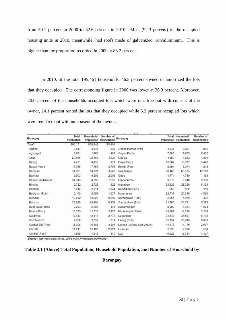
Average household size was 4.4 persons
The number of households in 2010 was recorded at 195,461, higher by 47,861 households
compared with the 147,600 households posted in 2000. The average household size in 2010
was 4.4 persons, lower than the average household size of 4.8 persons in 2000.
Table 2 Average Household Size
In 2010, 34.6 percent of the occupied housing units in the city had outer walls made
of concrete/brick/stone, up from 22.1 percent in 2000. Similarly, the proportion of occupied
housing units with outer walls made of half concrete/brick/stone and half wood increased
50 | P a g e
from 30.1 percent in 2000 to 32.6 percent in 2010. Most (92.3 percent) of the occupied
housing units in 2010, meanwhile, had roofs made of galvanized iron/aluminum. This is
higher than the proportion recorded in 2000 at 88.2 percent.
In 2010, of the total 195,461 households, 46.5 percent owned or amortized the lots
that they occupied. The corresponding figure in 2000 was lower at 36.9 percent. Moreover,
20.0 percent of the households occupied lots which were rent-free but with consent of the
owner, 24.1 percent rented the lots that they occupied while 6.2 percent occupied lots which
were rent-free but without consent of the owner.
Table 3.1 (Above) Total Population, Household Population, and Number of Household by
Barangay

51 | P a g e
Table 3.2 (Above) Total Population, Household Population, and Number of Household by
Barangay
4.3.1.3 Land Use & Zoning
Metro Cebu is located on the central eastern part of Cebu Province, an island at the
center of the Visayas in Southern Philippines. As defined by the Bureau of Land Location
Monument (BLLM) No. 1, Cebu Cadastral Survey, it is 10 degrees 17 minutes North
Latitude and 123 degrees 54 minutes East Longitude. It is bounded by Mandaue City in the
North and the City of Talisay in the South. On the East is Mactan Channel and on its West
are the Municipality of Balamban and the City of Toledo.

52 | P a g e
The increasing urbanization of the metropolitan now leads to the increasing use of its
land for housing, commercial, industrial, institutional and other related activities. Farmlands
remained only in the upland or hilly land areas of Metro Cebu. Presently the metro’s upland
areas and watersheds are mostly covered with grass and shrubs with patches of corn,
coconuts, bananas, cassava and vegetables. Fruit trees are also planted, notably the exotic
mango, which is an export product of Cebu. Very little (9.6%) of the natural forest are left in
the upland areas of the city. Even the city’s watersheds are lacking in trees that are necessary
for their protection.
Figure 4 (Above) Topographical Map of Cebu

53 | P a g e
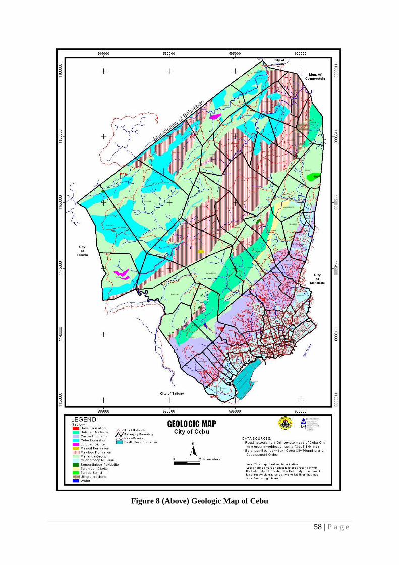
Metro Cebu is made up of structurally complex sedimentary and volcanic rocks that
have undergone various degrees of metamorphism. There are seven rock formations or
geological units in the city. Sedimentary rocks constitute 60 percent of the metro that include
the Cebu Coal Measure, Malubog Formation, Barili Limestone, Carcar Limestone and the
Recent Alluvium. The lowlands are generally located within elevations below 100 meters
while upland areas are in elevation between 100 and 900 meters above sea level.
Figure 5 (Above) Protected Area Management Zone

54 | P a g e
Figure 6 (Above) Existing Land Use Map

55 | P a g e
Figure 7 (Above) Cebu City Zoning Map

56 | P a g e
4.3.1.4 Geo – Technical Information
4.3.1.4.1 Geography
Cebu is located 365 miles south of Manila, the capital of Philippines. The province
belongs to the country’s Central Visayas Region. It can be reached in an hour by air travel or
22 hours by cruising the sea.
4.3.1.4.2 Topography
Its terrain is relatively flat on the coastal plain and becomes rolling and hilly at
elevations of 40 to 200 meters, then generally rugged and mountainous at elevation of 200 to
almost 800 meters above sea level. The slopes vary from 0 to 60 degrees. Its relatively flat
terrain is only approximately 15% of the total land area. The mountain areas have become
generally unproductive due to the adverse effects of deforestration and poor soil condition;
and, the inadequacy of feeder roads has limited the use of the land for agricultural purposes.
What may be called productive areas are planted either to corn, vegetables or fruits. In terms
of effective land use, Cebu City has very unfavorable topography, since 80% of its total land
area is mountainous. This situation also holds true for the adjoining municipalities, thereby
limiting growth to the linear or ribbon type of development along the coastal plains. Cebu
City's land poor is the rationale behind the reclamation of foreshore lands. Land use for the
relatively flat area of Cebu City, considered as the urban core within the Metropolitan Cebu
Area, is rapidly being intensified, with the old districts becoming high density areas including
the Central Business District (CBD).
57 | P a g e
Cebu is characterized by narrow coastlines, limestone plateaus, coastal plains but with
predominant rolling hills and rugged mountain ranges traversing the northern and southern
lengths of the island. Although Cebu’s steep mountains reach over 1,000 meters, the island
lacks substantial forest cover. In the towns of Bogo, San Remigio, Medellin, and
Daanbantayan at the northern tip of the province, considerable tracts of land are found. Of the
three biggest islands, Mactan and Bantayan are relatively flat while Camotes is hilly.
4.3.1.4.3 Climate
The Cebu Metropolitan Area has what is termed by the Weather Bureau as the third
type of climate in which there is no distinct wet or dry season. There is more rainfall during
the southeast monsoon seasons in the month of September. the summer heat which generally
come in March reaches its peak in April and May. Humidity is approximately 77%,
decreasing during the summer months and increasing during the rainy days by a few percent.
As per records of the Weather Bureau, the average temperature in Cebu City is 27.4 0C or
81.3 0F
Cebu’s weather is relatively moderate, having no distinct wet and dry season, the
perfect vacation spot for all seasons. One can bask under the sunshine the whole year through
since Cebu is blessed with tropical climate with generally fair temperature range of between
23 to 33 degrees Celsius or 73 to 91 degrees Farenheit. Coolest temperature can be felt in
January and warmest in May. The rainy season begins in July bringing torrential downpours
that would sometimes inhibit movement.
58 | P a g e
Figure 8 (Above) Geologic Map of Cebu

59 | P a g e
Figure 9 (Above) Elevation Map of Cebu
60 | P a g e
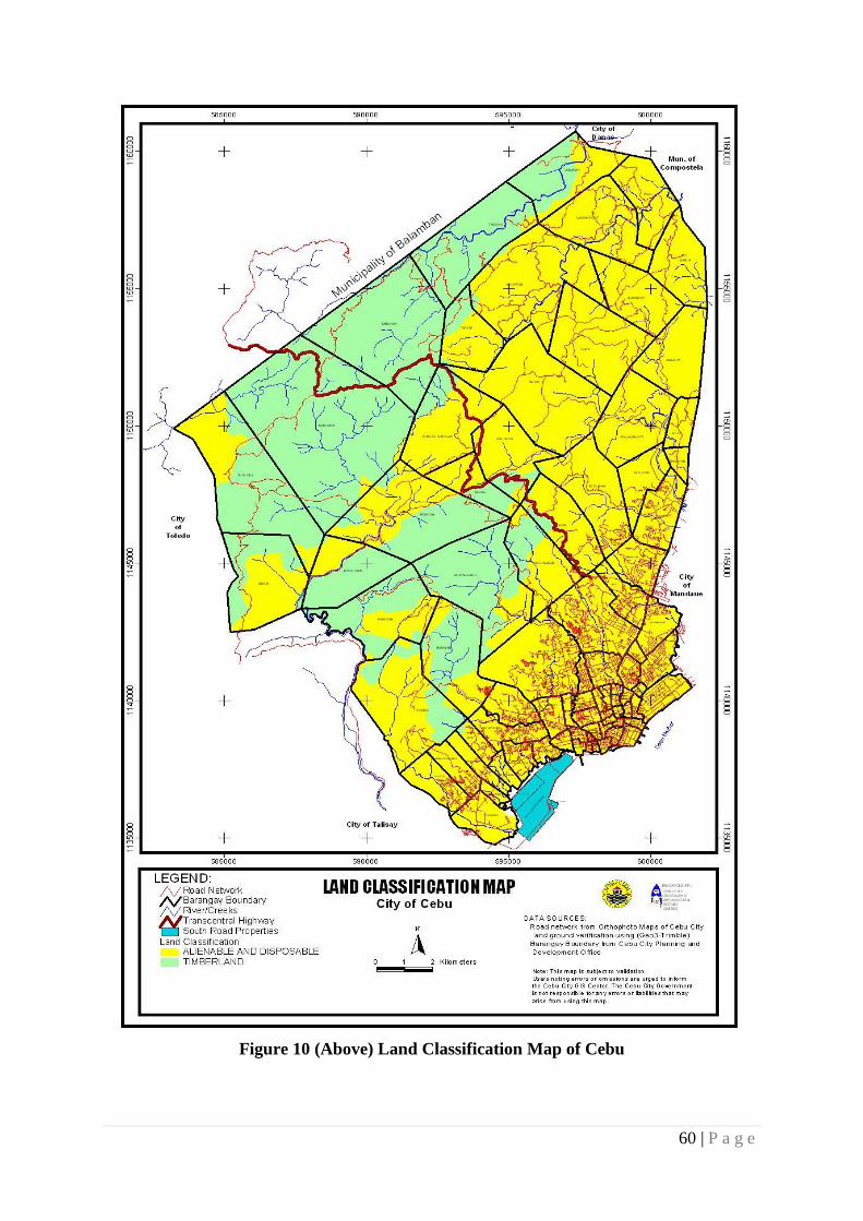
Figure 10 (Above) Land Classification Map of Cebu

61 | P a g e
Figure 11 (Above) Land Forms Map of Cebu

62 | P a g e
Figure 12 (Above) Slope Map of Cebu

63 | P a g e
Figure 13 (Above) Topographic Map of Cebu

64 | P a g e
4.3.2 Micro Site Description
4.3.2.1 Site Technical Condition
Figure 14 (Above) Google Map of Cebu Baseport Area
Cebu Baseport is 10 degrees 18’ Latitude, 123 degrees 53’ Longitude, suited at the
city frontage between Cebu and Mactan Island, the port runs a total length of 4,202 meters
from International to Domestic Zone. The international zone has a length of 690 meters and
the Domestic zone has 3,707 meters, located on the east coast of the Cebu Island at the
northern end of the Cebu strait.
Figure 15 (Above) Google Map of Cebu Seaport Complex
Port Limits
Cebu Harbor as that part of the Strait between Mactan Island and the island of Cebu
within the following boundaries: an imaginary line extending from Pangulan Point, Mactan

65 | P a g e
Island, Bagacay Point, Island of Cebu; and an imaginary line is extending from Lawis Ledge,
Mactan Island, to Lipata Point, Island of Cebu.
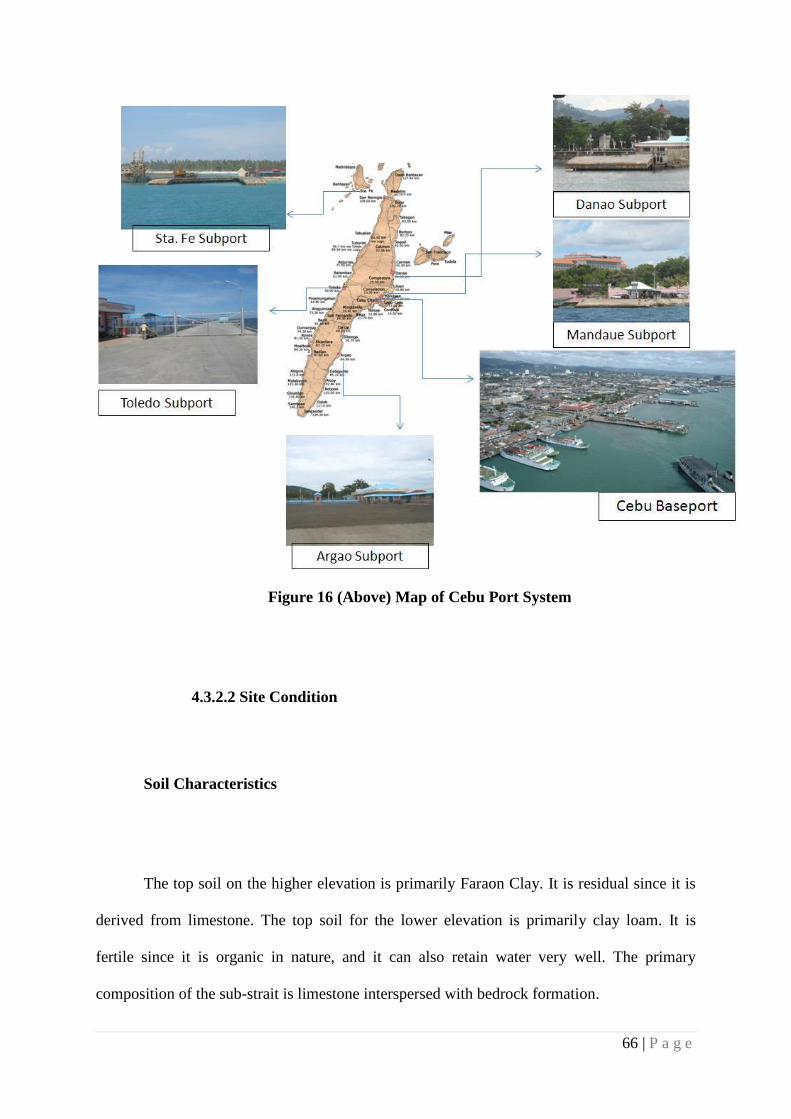
The Cebu Port System is composed of the Cebu Baseport and its subports which are
strategically located in different points of Cebu. The Cebu Baseport is composed of the Cebu
International Port and the Domestic Zone. There are five subports within the jurisdiction of
Cebu Port Authority, namely: Mandaue, Danao, Sta. Fe, Toledo and Argao. Each of the
subports is smaller ports that are essential to flow of domestic inter-island commerce.
I. CEBU BASEPORT
Cebu International Port
Cebu Baseport - Domestic Zone
II. SUBPORTS
A. Mandaue Subport
Port of Punta Engaño
Port of Sta. Rosa
B. Danao Subport
Port of Danao
Port of Poro Camotes
Port of Sogod
C. Sta. Fe Subport
Port of Sta. Fe
Port of Hagnaya
D. Toledo Subport
Port of Toledo
Port of Tangil, Dumanjug
E. Argao Subport
Port of Taloot, Argao
Port of Oslob
Port of Samboan
66 | P a g e
Figure 16 (Above) Map of Cebu Port System
4.3.2.2 Site Condition
Soil Characteristics
The top soil on the higher elevation is primarily Faraon Clay. It is residual since it is
derived from limestone. The top soil for the lower elevation is primarily clay loam. It is
fertile since it is organic in nature, and it can also retain water very well. The primary
composition of the sub-strait is limestone interspersed with bedrock formation.
67 | P a g e
Severe erosion has extremely exposed the limestone and rock foundation in some
areas. According to the Bureau of soiols , the type of soil common in the different districts of
the city and its environs are Faraon Clay, Mandaue Clay, and silt-loam, Baguio and Bolinao
Clay. These types are responsible for the production of different kinds of vegetables and root
crops, the ever popular Guadalupe mangoes, the much talked about grapes, sugar cane, corn
and other staple products.
4.3.2.3 SWOT Analysis
Strengths and Opportunities:
The proposed project site at Cebu Baseport – Domestic Zone at Cebu City has many
strengths and opportunities as listed below:
Proximity to the Metro Cebu and Island’s central area
Well adjusted location to near historical and interesting sites
A lot of Hotel beside the Pier Basilica cathedral and Museums Parks plaza Mall
Tourist Spots around the area
The Port of Cebu is a historical site itself
The area is well served by a number of port roads and has a direct link to major road
Sergio Osmena Boulevard
68 | P a g e
Weaknesses and Threats:
Lack of connection between water and land transport
The nearest Land Transportation Terminal is available at SM City Cebu PUJ Terminal
No place for the people to appreciate the beauty of the Bay and see the other side which
is composed of islands and mangroves
Lack of pedestrian linkages and walkways going inside and outside the harbour area and
to the bay front which restricts people for movement and activities
Lack of space for private vehicular parking