CE93007 FINAL Open House Meeting Minutes 08242010
49
Meeting: South Broadway, Arizona to Exposition & I-25 Interchange Open House Location: Design Center, Denver CO Meeting Date: August 24, 2010 Prepared by: Sarah Gohde, Regnier & Associates, Inc Attendees: Attendees List On File MEETING MINUTES Public Open House Summary: The South Broadway: Arizona to Exposition & I-25 Interchange Public Open House was held on Aug. 24, 2010 from 6 to 8:00 pm at the Denver Design Center located at 595 S. Broadway Denver, CO in the East Building Conference Room. A total of 34 members of the community were in attendance. The meeting was organized using a combination open house and presentation format. A facilitated Q&A discussion followed the presentation to enable in-depth discussion between the project team and members of the public. During the Open House, the public was invited to view display boards featuring: The Environmental Assessment Preferred Alternative Typical roadway sections for Broadway and Mississippi The project area neighborhoods Interstate I-25 access (existing and proposed) A visual simulation of pedestrian and bike origin and destination movements Sustainability Elements from Greenprint Denver Public Outreach: Ways for project stakeholders to stay informed A presentation lasting approximately thirty minutes was provided followed by an “open-microphone” facilitated discussion conducted by the project team to answer questions and gather additional public comment. The public was asked to fill out a survey form designed to allow the team to better understand how attendees accessed and traveled through the project area. Attendees could either complete surveys at the meeting and drop in comment/survey boxes distributed throughout the room or mail back to the project team by Aug. 30. Upon completion of the Q&A, the public was invited to speak one-on-one with project representatives and further examine display boards, project maps and pertinent study documents. Presentation Overview: The presentation began at approximately 6:15 p.m. with introductions by City and County of Denver Project Manager, Mike Harmer, PE. The presentation consisted of a PowerPoint presentation and included detailed information about the project. The presentation can be viewed in its entirety on the project website located at www.sobroi25.com under the Public Outreach – Meeting Materials. Mr. Harmer reviewed the purpose of the meeting, introduced the individual project consulting firms and reviewed the Preferred Alternative as outlined in the project Environmental Assessment. He also
Transcript of CE93007 FINAL Open House Meeting Minutes 08242010

Meeting: South Broadway, Arizona to Exposition & I-25 Interchange Open House
Location: Design Center, Denver CO
Meeting Date: August 24, 2010
Prepared by: Sarah Gohde, Regnier & Associates, Inc
Attendees: Attendees List On File
MEETING MINUTES Public Open House Summary:
The South Broadway: Arizona to Exposition & I-25 Interchange Public Open House was held on Aug. 24, 2010 from 6 to 8:00 pm at the Denver Design Center located at 595 S. Broadway Denver, CO in the East Building Conference Room. A total of 34 members of the community were in attendance.
The meeting was organized using a combination open house and presentation format. A facilitated Q&A discussion followed the presentation to enable in-depth discussion between the project team and members of the public.
During the Open House, the public was invited to view display boards featuring:
The Environmental Assessment Preferred Alternative Typical roadway sections for Broadway and Mississippi The project area neighborhoods Interstate I-25 access (existing and proposed) A visual simulation of pedestrian and bike origin and destination movements Sustainability Elements from Greenprint Denver Public Outreach: Ways for project stakeholders to stay informed
A presentation lasting approximately thirty minutes was provided followed by an “open-microphone” facilitated discussion conducted by the project team to answer questions and gather additional public comment. The public was asked to fill out a survey form designed to allow the team to better understand how attendees accessed and traveled through the project area. Attendees could either complete surveys at the meeting and drop in comment/survey boxes distributed throughout the room or mail back to the project team by Aug. 30.
Upon completion of the Q&A, the public was invited to speak one-on-one with project representatives and further examine display boards, project maps and pertinent study documents.
Presentation Overview:
The presentation began at approximately 6:15 p.m. with introductions by City and County of Denver Project Manager, Mike Harmer, PE. The presentation consisted of a PowerPoint presentation and included detailed information about the project. The presentation can be viewed in its entirety on the project website located at www.sobroi25.com under the Public Outreach – Meeting Materials.
Mr. Harmer reviewed the purpose of the meeting, introduced the individual project consulting firms and reviewed the Preferred Alternative as outlined in the project Environmental Assessment. He also

Meeting: South Broadway, Arizona to Exposition & I-25 Interchange Public Meeting
Meeting Date: August 24, 2010
Page 2 of 6 reviewed the coordinating agencies working on the project. Mr. Harmer then reviewed the adjacent on-going projects, including:
CCD Center Avenue Outfall (design) CCD South Broadway Iowa to Arizona (construction) CDOT I-25 Santa Fe / Alameda Interchange Stage 1.1(construction) CDOT I-25 Santa Fe / Alameda Interchange Stage 1.2/1.3 (design)
As well as general development plans for the area:
Denver Design Center – General Develop Plan (GDP) Cherokee GDP (Gates & Cherokee Denver Sites) Gates East GDP
Mr. Harmer then turned the presentation over to the Consultant Team Project Manager, Jeanne Sharps, PE. Ms. Sharps provided a list of studies and key provisions for future conditions, as well as a brief overview of comments provided to CCD during the Final Environmental Assessment were provided.
Ms. Sharps continued the meeting with a brief outline of project components, challenges and tasks to be performed by the Project Team. Additionally, she requested that attendees please fill out an open house survey form available throughout the room to further the team’s understanding of how the public travels through and around the project area.
Ms. Sharps then introduced Ms. Allyson Mendenhall. Ms. Mendenhall explained the components of Greenprint Denver adding that for this project, the Project Team would also focus on the additional element of “Art”, stating that it is important that the project address aesthetic components. She then reviewed some of the ways the Project Team would approach different aspects of sustainability under the various components found in Greenprint Denver, which can also be accessed though the project website at www.sobroi25.com.
Mr. Harmer reviewed the anticipated schedule and next steps; noting that, depending on funding strategies and availability, one or more phases of the project could be in final design by 2011 with the first phase of construction starting in 2012.
Councilman Chris Nevitt was recognized and asked to say a few words to the attendees. He thanked the participants for attending the meeting and for their support in making “a better Broadway.” He also reminded participants to complete a survey in order to help the Project Team understand their issues and concerns more clearly.
Questions, Comments and Responses
At the conclusion of the presentation, the audience was asked if they had any questions for the Project Team. Questions, comments and answers were noted on a flip chart and are summarized below in no particular order of importance. Please note that the following questions, comments and responses are summarized and not verbatim documentation.
Roadway/Transportation:
Exposition
Q: What will happen on Exposition? Are you planning on widening it?
A: Another aspect to this project is to evaluate what will happen on that roadway. We have several things to consider and are very aware of how narrow the existing configuration is. We will continue to review our opportunities there.

Meeting: South Broadway, Arizona to Exposition & I-25 Interchange Public Meeting
Meeting Date: August 24, 2010
Page 3 of 6 Q: Will buses be using Exposition?
A: Yes, Exposition will be used to provide the northern access for buses entering the Broadway and I-25 Light Rail Station. This wasn’t the solution that the advisory groups were looking for, however, it was understood that this route into the station area met travel distance requirements. In the EA, this alignment was part of the Preferred Alternate.
Q: On Exposition, we are very concerned about easements between the houses. If buses use that route, will we be risking our lives crossing between them and will access be improved?
A: Again, that is why we are here, to hear concerns. As the project proceeds we will be determining the street cross section that will be needed to accommodate access, vehicular and pedestrian traffic. We will know more at our next public open house, that should be sometime after the first of the year.
C: You should make two continuous lanes on Exposition.
Northbound I-25 Access
Q: How will the new northbound configuration work?
A: It will work similar to how it is configured now. The radius of the loop ramp will be increased to accommodate a higher travel speed.
Q: As part of the Alameda Station Plan, there was consideration of a southbound Broadway to northbound I-25 ramp. At the time, the numbers did not warrant that. Four years later, however, can that be considered as part of these improvements?
A: This alternative is being reviewed.
Ohio/Sherman/Grant
C: Sherman and Grant should be used for access to I-25. Ohio is six feet wider than Exposition; can Ohio become a one way street? I would like to see on-street parking maintained. If not, there is no place to park for those 18 townhomes.
Pedestrian/Bicycle Safety and Traffic Signals:
Q: When you talk about pedestrian traffic on Broadway, are you talking about north or south of I-25. Have there been any studies to support improved pedestrian access and safety? You are taking your life in your hands when you try to cross Broadway.
A: That is what we are looking at now, improving pedestrian access and safety.
Q: I am a cyclist and I have to take a very circuitous route to get to Santa Fe and the Platte River. Will this project get rid of those crazy routes?
A: Currently CCD is in the midst of conducting a study called Denver Moves, a collaborative effort between Parks and Recreation and the City’s Planning and Public Works Departments. We are looking to identify different routes from streets to trails as well as funding opportunities to make improvements. While this project does not include this investigation, all the info gathered for this project will be shared with Denver Moves, so please fill out the survey and let us know how you connect to your various destinations. Denver Moves can be accessed though the project website at www.sobroi25.com.
Q: Can you lengthen the signal timing to make it easier to cross both Lincoln and Broadway. It is very difficult to make it across in one cycle. It is really bad at the off ramp.
A: Something else we are reviewing is how to make it easier and safer to cross.

Meeting: South Broadway, Arizona to Exposition & I-25 Interchange Public Meeting
Meeting Date: August 24, 2010
Page 4 of 6 C: The “elephant walk” that runs in the east-west direction, located 1/3 of the way along the 700
block of Broadway and Lincoln should be used as the pedestrian route instead of Ohio. To make this work, mid block pedestrian signals would be needed.
Right of Way Acquisition:
Q: Will there be Eminent Domain proceedings a result of this project?
A: Part of our charge is to narrow down and refine right-of-way (ROW) requirements; however, we will not begin acquiring ROW until that is completed. Also, CCD does not go right into Eminent Domain. We will make a fair purchase price offer for the property and go from there, long before Eminent Domain enters into the mix. A fair price is determined with appraisals. Property owners have the right to are encouraged to obtain their own appraisals
Q: So, you don’t know what ROW will be required?
A: The Environmental Assessment identified 23 properties. Our task is to refine the project footprint to further identify what will actually be needed. As we move forward, ROW needs will be evaluated.
Q: When will you know?
A: We should have a better idea after the first part of next year, closer to the January/February time frame.
Q: Will there be any economic studies conducted?
A: The economic studies were conducted as part of the Environmental Assessment that was approved in March, 2008.
Q: The Design Center also owns the property that Quest Diagnostics is currently located on. As part of their lease agreement, they require use of the parking lot that will be impacted by the Exposition Extension. How will that parking be replaced? I ask that you take that into consideration as it presents a hardship if that lessee is lost.
A: We will remain mindful of your concerns.
Funding:
Q: What is TIGER funding?
A: TIGER stands for Transportation Investment Generating Economic Recovery. It is federal funding that will be appropriated in a similar fashion to how the American Recovery and Reinvestment Act of 2009 funding was appropriated.
Q: What will be built first?
A: There are many facets to what will get built and when. It has to be phased in a logical sequence first and foremost. Funding will also play large role in what phases get built and when. The worst case scenario is that we do not receive a TIGER grant and have to build the project using only City (FASTER) funding which would mean the last phases of project would be completed in 2023.
General Comments Expressed and Captured During Open House
General comments were received during the open house portion of the meeting as well as through other communication methods before and after the meeting. These comments included:
Will there be left turn restrictions at Mississippi?
Will there be an access to SB I25 from Mississippi?

Meeting: South Broadway, Arizona to Exposition & I-25 Interchange Public Meeting
Meeting Date: August 24, 2010
Page 5 of 6
Will there be improvements to access the Platte River trail?
Concern regarding access in and out of Griff’s Burgers with proposed painted splitter island on South Broadway in front of property.
Resident stated that he was happy with access to the I-25 & Broadway Station being moved to Exposition from Ohio, because it may alleviate the number of buses traveling on Lincoln adjacent to his residence.
An interest in future development was relayed to the Project Team.
Concern regarding the proposed vertical realignment of Kentucky Avenue tying into the future Acoma Street under the RTD LRT Bridge and adequate clearance.
Concern regarding additional signals along Broadway and resulting traffic delays.
Comments Submitted Prior to Open House
Citizen called Consultant Project Manager on Aug. 23: Was not able to attend meeting and wanted to express concern with traffic accidents on Lincoln at Dakota (north of the project area). There is no traffic light at Dakota & Lincoln and said there is a problem with vehicles traveling on Dakota, getting t-boned when crossing Lincoln.
Citizen commented via email to Councilman Nevitt’s office on Aug. 12: “Although the South Broadway/I-25 Interchange redesign has some positive and long-sought elements, much of the plan is hostile to pedestrians and the neighborhood, despite the literature's attestations to the contrary.
First the positive:
The traffic signal at Lincoln and Ohio -- this is currently a dangerous intersection for pedestrians and vehicles alike.
The traffic signals on Exposition and the Exposition extension -- these provide the much-desired pedestrian route from West Washington Park to the Broadway Light Rail station.
The negative:
The pinching of Kentucky and the I-25 southbound off-ramp is ridiculous and unnecessary. It eliminates a business, and worst of all, creates a gauntlet for pedestrians on the western sidewalk of Broadway-- a horridly long "crosswalk" that discourages pedestrians by saying "this area is for cars only."
The long detour for northbound Broadway traffic to get onto I-25 southbound. No one is going to take this detour. They'll just turn right on Mississippi and enter I-25 from Buchtel. Presumably the land surrounding Mississippi between Broadway and Logan is slated for mixed-use residential and commercial, possibly higher density, and routing thru highway traffic down the middle of it is incompatible with those uses. While the elimination of the left turn from southbound Broadway to southbound I-25 is nice, it's not worth the price of fouling access from northbound Broadway to I-25 southbound.
Widening Broadway from 100' to 140'. Once the streetcars were removed, Broadway became too wide as it is. Broadway should go on a Road Diet, not be widened.
Rebuilding the Lincoln St. ramp to I-25 northbound. Why is this necessary? 15 MPH is perfectly fine for an urban ramp. It's not necessary to take additional residences just for this.

Meeting: South Broadway, Arizona to Exposition & I-25 Interchange Public Meeting
Meeting Date: August 24, 2010
Page 6 of 6
While I would like to see the positive aspects of the proposal move forward, the overall feeling I get from the proposal as it stands is something that VDOT would design, such as at I-495 and Braddock Rd. -- just the very thing I was trying to escape by moving from Sprawl-fax County, Virginia to West Washington Park. As former president of the Kings Park Civic Association, I grew tired of battling these projects that over engineer vehicular capacity at the expense of pedestrian safety and the neighborhood.”
Comment received via traditional mail:
“The most useful improvements would be a direct bicycle connection from the Broadway Light Rail Station to the Platte River Bike trail, with over passes or tunnels as needed.”
“The proposed extension of Exposition goes through property owned by the Collection. It goes through the parking lot which is guaranteed parking for Quest in Quest’s lease. There has been no resolution to how this will be solved. There needs to be a land swap or something to replace the Quest parking. Quest is a large employer on this site. (This parking lot is just south of Well Music and the Quest Diagnostics Building.)”
Outreach Methods Used to Engage Public Participation:
May 18, 2010 – Project Team met with Councilman Chris Nevitt
July 15, 2010 – Project Team met with members of the West Washington Park Neighborhood Association - Land Use and Transportation Committee
July 19, 2010 – Project Team met with additional members of the West Washington Park Neighborhood Association - Land Use and Transportation Committee
July 28 and 29, 2010 – Project Team called all surrounding Neighborhood and Business Associations to inform them of the project, invite them the Aug. 24 Open House and ask to post the meeting announcement on website, add calendars and send to listserv, if any or all were available.
Aug. 3, 2010 – Emailed Open House Meeting Notice to all Neighborhood and Business Organizations within study area with attached PDF of announcement.
Aug. 9, 2010 – www.Sobroi25.com website went live and included Open House meeting announcement, PDF of the meeting notice and PDF of Newsletter No. 1 in addition to project background and history and links previous studies and decision documents.
Aug. 9, 2010 – Mailed Newsletter No. 1 to over 3,100 residents and property owners within the area bounded by W. Alameda and W. Florida (N/S) and S. Washington and S. Huron (E/W).
Aug. 9, 2010 – Distributed extra copies of Newsletter No. 1 to recreation centers in the project area.
Aug. 10, 2010 – Project Team met with neighbors of the Platt Park People’s Association.
Aug. 11, 2010 – Emailed Enews of Open House Meeting Announcement with attached PDF of Newsletter No. 1 to all valid email addresses in Trackvia database (99 Total).
Aug. 19, 20 and 23 – Advertised the Open House meeting notice in the Denver Daily Newspaper on Thursday and Friday the week prior to, and again on Monday the day prior to the Public Open House.

Open House Survey Form
August 24, 2010
You may fold and return this form by mail by August 30, 2010 CE93007 SOBROI25 – OPEN HOUSE AUG. 24, 2010
Name Organization
Address E-mail Address
City, State, Zip Phone Number
1. What is your personal connection to this project? Check all that apply.
Resident Bicyclist Business owner Public Agency Work in the area Other ________________________________ Commuter
2. If you live in the area, in what neighborhood do you live? ___________________________________
3. Did you participate in any past South Broadway Environmental Assessment (EA) public meetings/workshops? Yes No
If yes, what were the EA commitments you are most interested in?
4. What is your most frequent destination when you pass through the South Broadway/I-25 corridor?
Light Rail station Parks Broadway Retail South Platte River Trail Downtown Denver Other ________________________________
5. If you use public transportation (bus or Light Rail), how do you get to stops/stations in the South Broadway/I-25 corridor?
Mode of Transportation Most Frequent Point of Crossing
Car Broadway at Exposition Bike Broadway/Lincoln at Ohio Walk Broadway at Kentucky Other __________________ Broadway at Tennessee
Other ________________________________
6. When traveling by automobile through the South Broadway corridor, where do you experience the most traffic congestion?
7. What kinds of improvements would you like to see in the South Broadway corridor that would encourage you to use public transportation, walk or bike more often?

Place Stamp Here
Open House Survey Form
Regnier & Associates, Inc. c/o City and County of Denver 4409 S. Joplin Way Aurora, CO 80015
FOLD HERE Do you have any other general comments?

WELCOMEWELCOME
CITY AND COUNTY OF DENVER
BROADWAY ARIZONA TO EXPOSITION & BROADWAY ARIZONA TO EXPOSITION & II--25 INTERCHANGE25 INTERCHANGE
PUBLIC OPEN HOUSEAUGUST 24, 2010

Denver City Council President – Chris Nevitt
City Project Manager – Michael Harmer, PE
Consultant Team Project Manager – Jeanne Sharps, PE
City and County of Denver
201 W. Colfax Avenue
Denver, CO 80202
CITY AND COUNTY OF DENVERBROADWAY ARIZONA TO EXPOSITION BROADWAY ARIZONA TO EXPOSITION
& I& I--25 INTERCHANGE25 INTERCHANGE
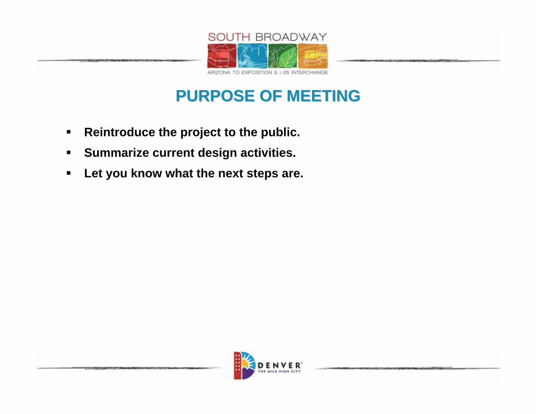
PURPOSE OF MEETINGPURPOSE OF MEETING
Reintroduce the project to the public.
Summarize current design activities.
Let you know what the next steps are.

Hermsen Consultants
CONSULTANT TEAMCONSULTANT TEAM

ENVIRONMENTAL ASSESSMENT PREFERRED ALTERNATIVEENVIRONMENTAL ASSESSMENT PREFERRED ALTERNATIVE

PROJECT PURPOSEPROJECT PURPOSE
The project purpose is to create a South Broadway Corridor that provides safe and efficient multi-modal mobility which:
1) Accommodates the transportation needs of the area neighborhoods, existing businesses, planned developments and the I-25 & Broadway Station area.
2) Promotes the development and use of transit-oriented, civic and neighborhood spaces.

PROJECT NEEDPROJECT NEED
The major needs of the South Broadway Corridor include:
1) The Corridor currently experiences peak hour congestion that is expected to worsen.
2) Projected regional and local traffic growth will result in increased congestion in the Corridor; this may increase the likelihood of traffic cutting though area neighborhoods.
3) Existing conditions lack connectivity and adequate width of bicycle and pedestrian facilities in the South Broadway Corridor.

Federal Highway Administration
Federal Transit Authority
Colorado Department of Transportation
Regional Transportation District
COORDINATING AGENCIESCOORDINATING AGENCIES

XCEL (gas & electric)
QWEST
Metro Wastewater Reclamation District
Denver Wastewater (storm and sanitary sewer)
Denver Water
UTILITY AGENCIES UTILITY AGENCIES
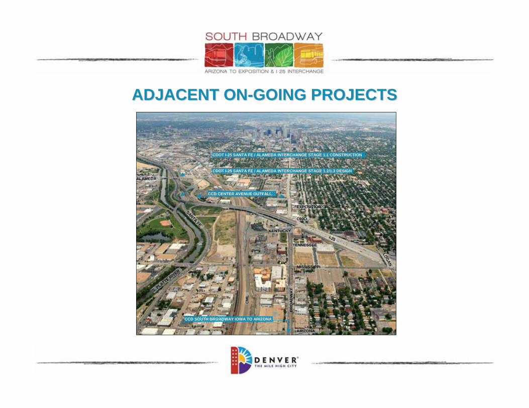
ADJACENT ONADJACENT ON--GOING PROJECTSGOING PROJECTS
CDOT I-25 SANTA FE / ALAMEDA INTERCHANGE STAGE 1.1 CONSTRUCTION
CDOT I-25 SANTA FE / ALAMEDA INTERCHANGE STAGE 1.2/1.3 DESIGN
BR
OA
DW
AY
LOG
AN
CM
LTENNESSEE
ARIZONA
MISSISSIPPI
KENTUCKY
S. PLATTE R
IVER
ALAMEDA
OHIO
EXPOSITION
I-25
SANTA FE
CCD CENTER AVENUE OUTFALL
CCD SOUTH BROADWAY IOWA TO ARIZONA

ADJACENT ONADJACENT ON--GOING PROJECTSGOING PROJECTS
CCD Center Avenue Outfall (design)

ADJACENT ONADJACENT ON--GOING PROJECTSGOING PROJECTS
CCD Center Avenue Outfall (design)
CCD South Broadway Iowa to Arizona (construction)

ADJACENT ONADJACENT ON--GOING PROJECTSGOING PROJECTS
CCD Center Avenue Outfall (design)
CCD South Broadway Iowa to Arizona (construction)
CDOT I-25 Santa Fe / Alameda Interchange Stage 1.1 (construction)

ADJACENT ONADJACENT ON--GOING PROJECTSGOING PROJECTS
CCD Center Avenue Outfall (design)
CCD South Broadway Iowa to Arizona (construction)
CDOT I-25 Santa Fe / Alameda Interchange Stage 1.1 (construction)
CDOT I-25 Santa Fe / Alameda Interchange Stage 1.2/1.3 (design)

Denver Design Center GDP
Cherokee GDP (Gates & Cherokee Denver Sites)
Gates East GDP
SOUTH BROADWAY EA PREFERRED ALTERNATIVE
GENERAL DEVELOPMENT PLANSGENERAL DEVELOPMENT PLANS

PREVIOUS STUDIESPREVIOUS STUDIES
South Broadway and I-25 System Level Study & Interstate Access Request(January 2008)
South Broadway Environmental Assessment & Section 4(f) Evaluation (March 2008)
South Broadway Finding of No Significant Impact(November 2008)
SOUTH BROADWAY EA PREFERRED ALTERNATIVE

CCD COMPLETED ENVIRONMETAL ASSESSMENTCCD COMPLETED ENVIRONMETAL ASSESSMENT& SECTION 4(f) EVALUATION& SECTION 4(f) EVALUATION
Used for planning of the infrastructure needs of the South Broadway Study Area
Followed National Environmental Policy Act (NEPA) Process
Characteristics of an EA include :
Screening of alternatives
Identification / mitigation of environmental impacts
Identification of historic features
Traffic impacts
Estimates of ROW requirements
SOUTH BROADWAY EA PREFERRED ALTERNATIVE
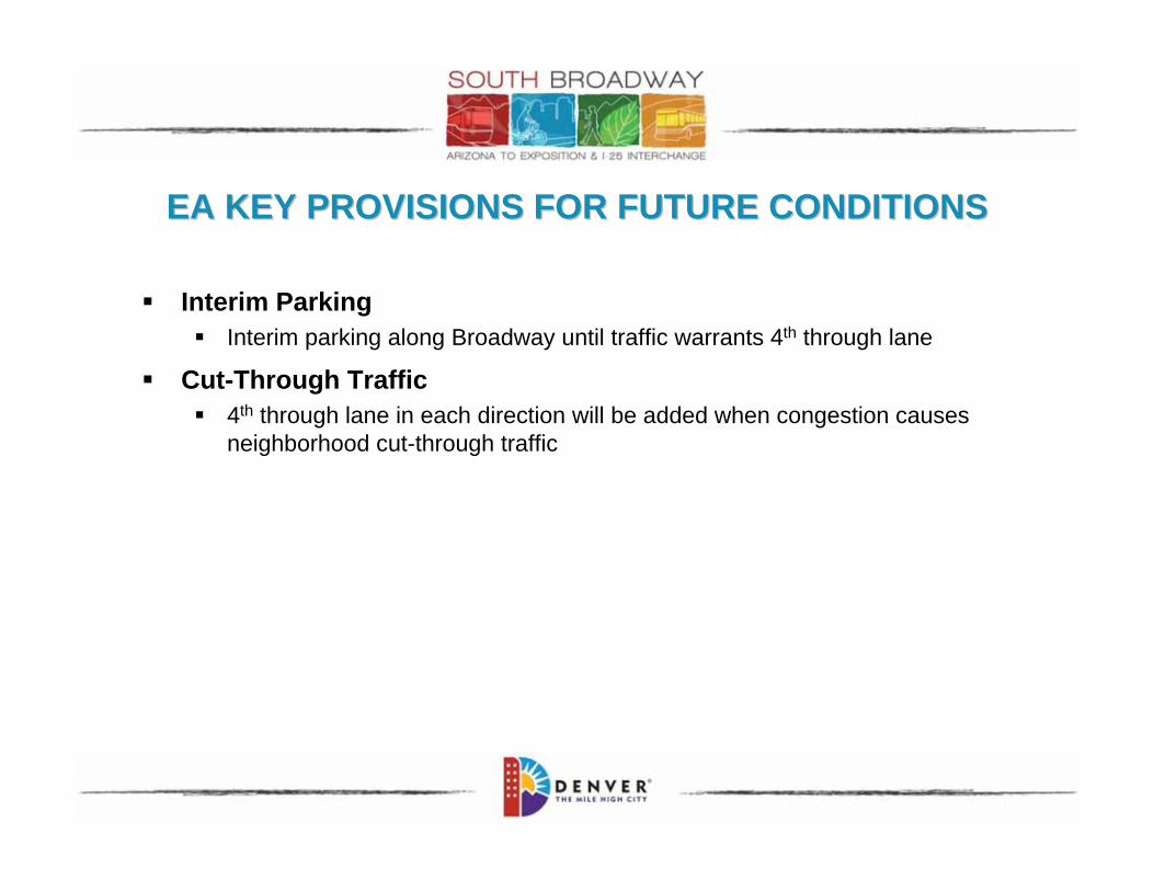
EA KEY PROVISIONS FOR FUTURE CONDITIONSEA KEY PROVISIONS FOR FUTURE CONDITIONS
Interim ParkingInterim parking along Broadway until traffic warrants 4th through lane
Cut-Through Traffic4th through lane in each direction will be added when congestion causes neighborhood cut-through traffic

EA COMMENTS & RESPONSESEA COMMENTS & RESPONSES
Comment: In section 4.3.1.3, the assessment reads: Channelization prevents westbound Ohio Avenue
access from the neighborhood street. Access to the interstate is from the arterials only. The
island barrier provides opportunity for ground level signs reinforcing the turn restriction.
WWPNA would prefer this read: Channelization prevents westbound Ohio Avenue access
from the neighborhood street. Access to the interstate is from the arterials only, by
preventing a left hand turn from westbound Ohio onto the NB I-25 onramp. The island
barrier provides opportunity for ground level signs reinforcing the turn restriction. (also on
page 2-38).
Response: This change to the text of the EA is acceptable and is addressed in Section 3.1
Clarifications to the Description of the Preferred Alternative of this FONSI.
Comment: The right yield turn from the NB I-25 off-ramp onto Ohio was to be removed, squaring the
intersection. This does not appear in the text or drawings (4.9).
Response: This change to the text modifying the EA is included in Section 3.1 Clarifications to
the Description of the Preferred Alternative of this FONSI.
EA COMMENTS & RESPONSESEA COMMENTS & RESPONSES
Comment: There should be a traffic signal at Ohio and the NB I-25 off-ramp.
Response: This signal is included in the list as the 6th bullet, “Ohio Avenue/ I-25 northbound
off/on-ramp.”
Comment: The VHEIS included provisions for nuisance noise mitigation on the Broadway Bridge. This
allowed CDOT to use the quiet pavement on the bridge surface and allowed for higher than
average jersey barriers which provided safety, given the level of truck traffic on I-25, plus
provided additional noise protection. We would like to see this incorporated into the NEPA
final report.
Response: The VHEIS included provisions for noise mitigation on the Broadway Bridge related
to the estimated future truck traffic associated with I-25 improvements not
implemented with the South Broadway EA. Therefore, noise mitigation on the I-25
bridge over Broadway would be constructed as part of the future Valley Highway
improvements along I-25.

EA COMMENTS & RESPONSESEA COMMENTS & RESPONSES
Comment: We included additional alternatives, such as an additional NB I-25 onramp on the west side
of Broadway for future contemplation without requiring another study. Where are these
identified in the document?
Response: These are included in Section 6.2.1 as items related to future conditions received
through the collaborative public and agency process that were not associated with
the project purpose and need.
Comment: As part of this project there was agreement by the City and County of Denver Public Works
(DPW) to alter the stop sign at Ohio and Grant to force traffic to stop on Grant St. versus
Ohio. Plus there would be the addition of a stop light at Ohio and Logan. Where are these
documented?
Response: As the project moves forward and is implemented, DPW agreed to consider
modifications to stop sign patterns and signalization. A signal was not agreed to as
the modeling for the South Broadway EA did not show the need for a signal at Ohio
and Logan. DPW would be willing to evaluate the need for a revised stop sign
pattern or for a signal in the future based on a typical City Traffic Investigation/
Warrant analysis.

EA COMMENTS & RESPONSESEA COMMENTS & RESPONSES
Comment: The “Yoga Ramp” configuration was not included in the document as an alternative that was
eliminated.
Response: The “Yoga ramp” is the Diverging Diamond interchange configuration and is listed as
Option 8 in Section 2.6.1 Interchange Screening Process.
Comment: On page 1-6 the table indicates the 2030 traffic projections for Broadway/Lincoln north of I-
25 as 57,700, while the Denver Regional Council of Governments (DRCOG) figure in the
appendix figure 4, page A-7 shows the corresponding traffic counts as 64,700. These
should match.
Response: The DRCOG model forecasts presented in the appendix are based on region wide
modeling, while the forecasts presented in Table 1-2 are based on updated traffic
counts, more specific operations, and more localized modeling techniques. Some
discrepancies are to be expected.

30% DESIGN PROJECT COMPONENTS30% DESIGN PROJECT COMPONENTS
Reconstruct Broadway from Arizona to Exposition
Reconstruct Mississippi between the CML and Logan
Reconstruct Ohio between Broadway and SB I-25 Off-Ramp
Extend Exposition
Realign SB I-25 On-Ramp
Modify NB I-25 On-Ramp
Modify NB I-25 Off-Ramp
RTD Broadway Station Access Modification
Widen Sidewalks and Multi-Use Trails
SOUTH BROADWAY EA PREFERRED ALTERNATIVE

30% DESIGN PROJECT TASKS30% DESIGN PROJECT TASKS
30% DesignRoadway, structures, lighting, streetscape, drainage, water quality, utilities
Topographical SurveyRight-of-entry letters sent to area property owners
ROW Refine impacts identified in the EA
Prepare plans identifying full and partial takes
Geotechnical & Environmental Subsurface Investigations
Utility Clearances & Agreements
Multi-Modal Connectivity Analysis & Recommendations

30% DESIGN PROJECT TASKS30% DESIGN PROJECT TASKS
Project Phasing Analysis & Recommendations
Logical construction sequencing
Independent utility
Multi-modal traffic operation improvements
Available funding

30% DESIGN PROJECT TASKS30% DESIGN PROJECT TASKS
Project Delivery Method Analysis & Recommendations
Design Bid Build
Alternative Bidding
Design Build
Construction Manager at Risk
Construction Manager / General Contractor
Public-Private Partnerships

DESIGN ALTERNATIVESDESIGN ALTERNATIVES
EA Design Refinement
Broadway / Mississippi
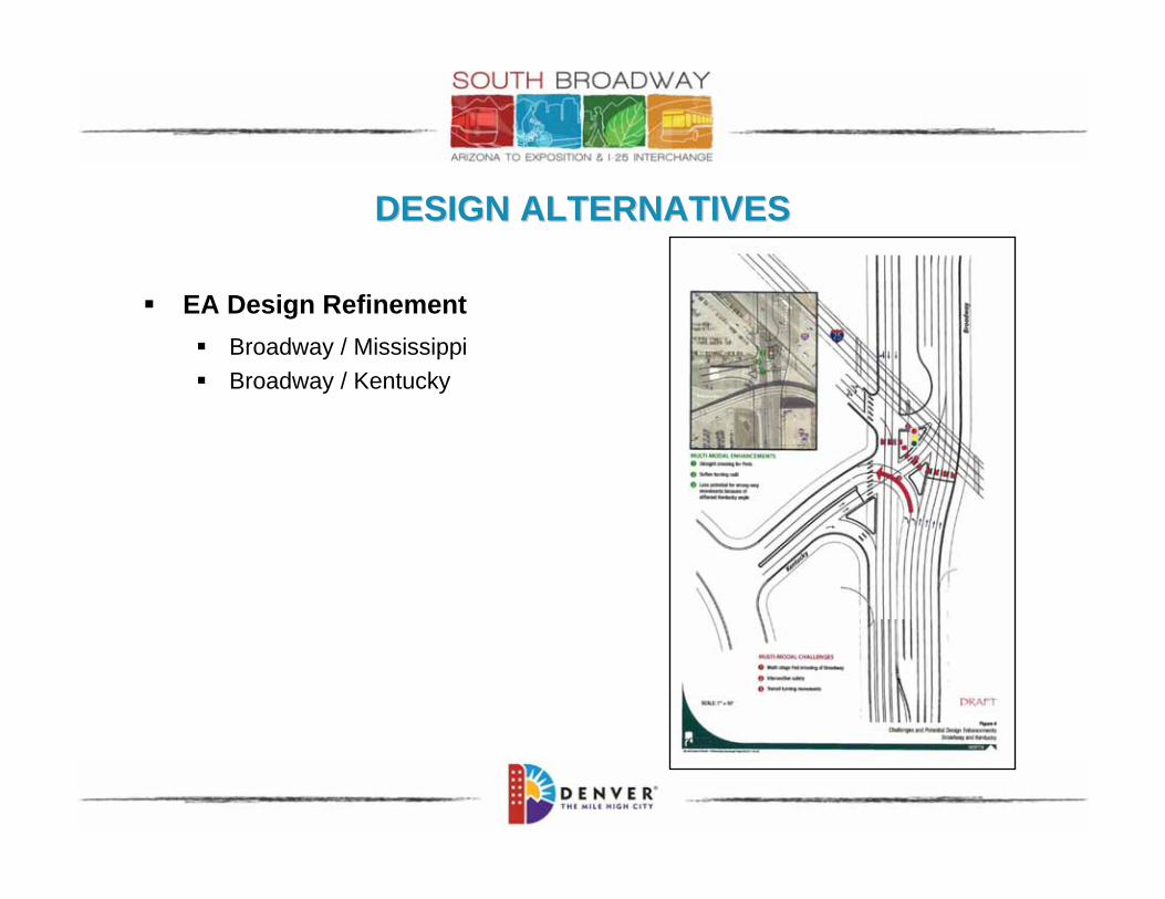
DESIGN ALTERNATIVESDESIGN ALTERNATIVES
EA Design Refinement
Broadway / Mississippi
Broadway / Kentucky

DESIGN ALTERNATIVESDESIGN ALTERNATIVES
EA Design Refinement
Broadway / Mississippi
Broadway / Kentucky
Ohio / Vehicles

DESIGN ALTERNATIVESDESIGN ALTERNATIVES
EA Design Refinement
Broadway / Mississippi
Broadway / Kentucky
Ohio / Vehicles
Ohio / Pedestrians / Bikes

DESIGN ALTERNATIVESDESIGN ALTERNATIVES
RoadwayAngled parking along Broadway
RTD I-25 & Broadway Station Alternative entrance at Tennessee
Alternative to Exposition extension bus only access road
Replacement parking / parking mitigation

OPEN HOUSE SURVEYOPEN HOUSE SURVEY
Help us understand:Your use of project area infrastructure
Modes of transportation you use to travel through the project area
Infrastructure improvements you would like to see to encourage use of alternate forms of transportation
Complete tonight or take home and mail back to team

SUSTAINABILITYSUSTAINABILITY
“Cities have a significant environmental footprint: They cover just two percent of the world’s surface, but they accommodate 50 percent of the world’s population and consume 75 percent of its resources.”
Greenprint Denver

Greenprint Denver sustainability areas:
EnergyAir and EmissionsWaterLandTransportationWaste Community+ Art
SUSTAINABILITYSUSTAINABILITY

SUSTAINABILITY SUSTAINABILITY –– SAMPLE PROJECT GOALSSAMPLE PROJECT GOALSGreenprint Denver Sustainability Area
Project Goal Strategies
Energy Reduce energy use Specify durable materials with a long life cycle
Utilize materials with low maintenance requirements
Air & Emissions Design and/or construct corridor and intersection facilities to accommodate multi-modal balance
Synchronize traffic signals and configure traffic lanes to reduce idling of vehicle engines
Improve sidewalk continuity and increase sidewalk and pedestrian refuge areas
Water Utilize alternative materials to decrease impervious surfaces within the project footprint
Where possible, use pervious surfaces such as porous pavements on low-volume roadways such as local streets, multi-use trails and sidewalks

SUSTAINABILITY SUSTAINABILITY –– SAMPLE PROJECT GOALSSAMPLE PROJECT GOALSGreenprint Denver Sustainability Area
Project Goal Strategies
Land Avoid remnant parcels. Modify intersection designs to minimize remnant parcels
Transportation / Community
Decrease cut through traffic in adjacent neighborhood.
Decrease cut through traffic by:
•Incorporation of signage
•Reconfiguration of westbound Ohio to not allow access onto northbound I-25 ramp
Waste Reduce the consultant team’s impact on the environment.
•Minimize use of paper
•Carpool to meetings
•Provide / use EcoPass
•Provide conference call alternatives to physically attending meetings
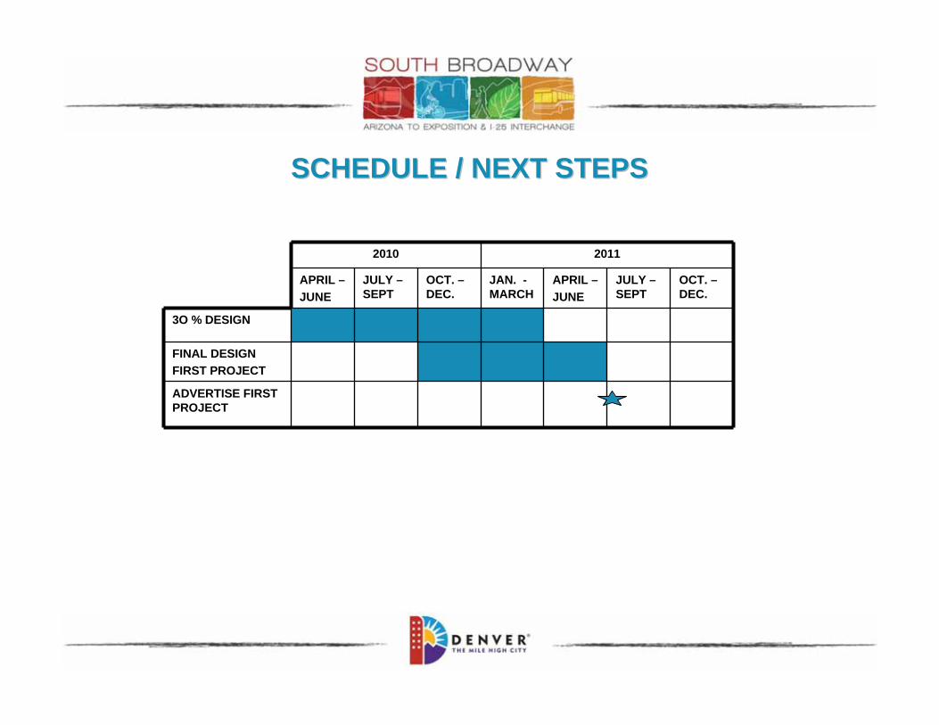
SCHEDULE / NEXT STEPSSCHEDULE / NEXT STEPS
2010 2011
APRIL –
JUNE
JULY –SEPT
OCT. –DEC.
JAN. -MARCH
APRIL –
JUNE
JULY –SEPT
OCT. –DEC.
3O % DESIGN
FINAL DESIGN
FIRST PROJECT
ADVERTISE FIRST PROJECT

QUESTIONSQUESTIONS

Michael Harmer, PECCD Project Manager
City and County of Denver
201 W. Colfax Avenue, Dept. 508
Denver, CO 80202
Phone: 720.913.4525
Email: [email protected]
Project Website: www.sobroi25.com
Jeanne Sharps, PEConsultant Project Manager
Felsburg Holt & Ullevig
6300 S. Syracuse Way, Suite 600
Centennial, CO 80111
Phone: 303.721.1440
Email: [email protected]
PROJECT CONTACT INFORMATIONPROJECT CONTACT INFORMATION

THANK YOUTHANK YOU
CITY AND COUNTY OF DENVER
BROADWAY ARIZONA TO EXPOSITION & BROADWAY ARIZONA TO EXPOSITION & II--25 INTERECHAGE25 INTERECHAGE
PUBLIC OPEN HOUSEAUGUST 24, 2010