CE6703 Water Resources and Irrigation Engineeringlibrary.bec.ac.in/kbc/NOTES BEC/CIVIL/7 SEM/CE6703...
141
Prepared By, Dr.R.Madheswaran Department of civil Engineering Bharathidasan Engineering College BHARATHIDASAN ENGINEERING COLLEGE NATTRAMPALLI Dr.R.Madheswaran Water Resources and Irrigation Engineering Department of civil Engineering CE6703 Water Resources and Irrigation Engineering TWO MARKS QUESTIONS 1. Define irrigation. (May/June 2012) 2. What is irrigation engineering? 3. What is the necessity of irrigation? (April/May10, Nov/Dec 06&12) 4. What are the benefits of irrigation? 5. What are the disadvantages of irrigation? 6. What is the purpose of irrigation? 7. What are the types of irrigation? 8. Define crop ratio. 9. What are kharif crops? 10. What are rabi crops? 11. What is meant by overlap allowance? 12. What is meant by consumptive use of water? 13. What are the factors affecting consumptive use of water? 14. Define duty. 15. Define delta. 16. Define base period. (Nov/Dec 09&11) 17. Define crop period. (Nov/Dec 09&11) 18. What is mean by crop rotation? (May/June 2011) 19. What are the factors affecting duty? (May/June 2012) 20. What are the methods for improving duty? 21. Define irrigation efficiency? 22. Write the types of irrigation efficiencies. (Nov/Dec 10) 23. What is meant by crop rotation and what is its advantage? (May/June 10)
Transcript of CE6703 Water Resources and Irrigation Engineeringlibrary.bec.ac.in/kbc/NOTES BEC/CIVIL/7 SEM/CE6703...

Prepared By, Dr.R.Madheswaran
Department of civil Engineering Bharathidasan Engineering College
BHARATHIDASAN ENGINEERING COLLEGE NATTRAMPALLI
Dr.R.Madheswaran
Water Resources and Irrigation Engineering Department of civil Engineering
CE6703 Water Resources and Irrigation Engineering TWO MARKS QUESTIONS
1. Define irrigation. (May/June 2012) 2. What is irrigation engineering? 3. What is the necessity of irrigation? (April/May10, Nov/Dec 06&12) 4. What are the benefits of irrigation? 5. What are the disadvantages of irrigation? 6. What is the purpose of irrigation? 7. What are the types of irrigation? 8. Define crop ratio. 9. What are kharif crops? 10. What are rabi crops? 11. What is meant by overlap allowance? 12. What is meant by consumptive use of water? 13. What are the factors affecting consumptive use of water? 14. Define duty. 15. Define delta. 16. Define base period. (Nov/Dec 09&11) 17. Define crop period. (Nov/Dec 09&11) 18. What is mean by crop rotation? (May/June 2011) 19. What are the factors affecting duty? (May/June 2012) 20. What are the methods for improving duty? 21. Define irrigation efficiency? 22. Write the types of irrigation efficiencies. (Nov/Dec 10) 23. What is meant by crop rotation and what is its advantage? (May/June 10)

Prepared By, Dr.R.Madheswaran
Department of civil Engineering Bharathidasan Engineering College
SIXTEEN MARK QUESTIONS 1. Explain the necessity and scope of irrigation.
2. Discuss in detail the benefits and ill-effects of irrigation. (May/ June 12 & 09 & 10)
3. Define duty and explain in detail the various factors affecting duty. How can duty be improved? Explain. (May/ June 11 & 10, Nov/Dec 10&12)
4. A watercourse has culturable command area of 2600 hectares, out of which the intensities of irrigation for perennial sugar-cane and rice crops are 20% and 40% respectively. The duty for these crops at the head of watercourse is 750 hectares/cumec and 1800 hectares/cumec respectively. Find the discharge required at the head of watercourse if the peak demand is 20% of the average requirement.
5. Explain irrigation efficiencies and its types. (May/ June 12 &11&10, Nov/Dec13&07&09)
6. How will you describe planning of irrigation projects? (May/June 2013)
UNIT-II
TWO MARKS QUESTIONS 1. What are the different classifications of method of irrigation? 2. What do you mean by flow irrigation? 3. Define lift irrigation. 4. Differentiate between lift and flow irrigation. (Nov/Dec 11) 5. Define perennial irrigation 6. Define direct irrigation. 7. What do you mean by uncontrolled and controlled flooding? 8. What are the basic requirements for adaptation of any irrigation method? 9. What do you mean by free flooding? 10. Write about the advantages of furrow irrigation. 11. Under which favorable conditions the sub-surface irrigation is practiced? 12. Where sprinkler irrigation is more useful? 13. Write about the advantages of sprinkler irrigation. 14. Write about the limitations of sprinkler irrigation.

Prepared By, Dr.R.Madheswaran
Department of civil Engineering Bharathidasan Engineering College
15. Write about the advantages of drip irrigation (May/June12) 16. Write about the disadvantages of drip irrigation 17. Write about the advantages of furrow irrigation. 18. Define Tank Irrigation (May/June12, Nov/Dec 06 & 10) 19. What are the different types of sprinkler systems? ( April/May10)
SIXTEEN MARK QUESTIONS
1. Write a note on sub-surface irrigation, state clearly the conditions under which this method is suitable. What are the essential requirements for a successful sub-surface irrigation?
2. Describe the various methods of surface and subsurface irrigation. (May/ June 10)
3. Describe border strip method of irrigation. Derive the expression for the time required to cover a given area by this method, for a given rate of discharge and the rate of infiltration of water in the soil.
4. Explain in detail about sprinkler method of irrigation and how far it is suitable in Indian conditions. (May/June 2013)
5. Write a note on drip irrigation. Write about the advantages and disadvantages of drip irrigation system. (May/June 2013)
6. Define surface irrigation. Why it is widely practiced method of irrigation? What are the advantages and disadvantages of the method?
7. Describe briefly the various flooding methods of irrigation, (May/June 11)
8. Write a note on free flooding. 9. Describe check flooding and basin flooding. 10. Describe furrow method of irrigation. 11. Describe about tank irrigation. (May/ June 10)
UNIT-III TWO MARK QUESTIONS
1. Define diversion headwork. 2. Write about the purposes of diversion headwork. 3. Define weir. 4. What are the component parts of diversion headwork? 5. Define dam.

Prepared By, Dr.R.Madheswaran
Department of civil Engineering Bharathidasan Engineering College
6. What are the types of dam? 7. Define gravity dam. 8. What are the forces acting on a gravity dam? 9. What is meant by arch dam? 10. What are the forces acting on arch dam? 11. What are the various types of earth dam? 12. What are the types of failure that occur during construction of earth dam? 13. Define tank. 14. Define tank sluice. 15. How will you select a site for a tank sluice? 16. Define spillway. 17. Write about the advantages of earth dam? 18. Write about the disadvantages of earth dam? 19. Write about the functions of scouring sluices. 20. Under what conditions gravity dam can be adopted?
SIXTEEN MARK QUESTIONS 1. Write in detail about the component parts of diversion works.
2. Write about the types of weirs on permeable foundation. 3. Write in detail about the tank surplus works.
4. What are the causes of failure of earth dams and its remedies? 5. Write about the factors affecting the selection of type of a dam. 6. Write about the favorable conditions, advantages,
disadvantages, pressure distribution and elementary profile of a masonry dam.
7. Write about the criteria for safe design of earth dam. 8. Describe the forces acting on a gravity dam. 9. What are the types of dams and what are the comparative
merits and demerits of various types of dams? UNIT-IV
CANAL IRRIGATION TWO MARKS QUESTIONS
1. Classify the rivers. 2. What are the causes of meandering? 3. What are the objectives of river training works?
Prepared By, Dr.R.Madheswaran
Department of civil Engineering Bharathidasan Engineering College
4. Classify the river training works. 5. Define groyne. 6. Classify the groynes. 7. Give an equation for silt factor. 8. Give Kennedy’s critical velocity equation. 9. Define critical velocity. 10. What is meant by regime channel? 11. What is meant by contour canal? 12. What is a ridge canal? 13. Give the Lacey’s equation for wetted perimeter. 14. Give the Lacey’s equation for bed slope of a canal. 15. Write about the significance of Lacey’s theory. 16. When the channel is said to be in regime?
SIXTEEN MARK QUESTIONS
1. How are canals classified? Describe them briefly 2. Explain the various considerations for alignment of a canal. 3. Why are canal falls necessary? Describe with sketch briefly the various
types of canal falls. 4. What are the types of cross drainage works? Describe them briefly with
sketches. 5. Define Lacey’s regime theory and its design procedure of channel. Also
list the defects in Lacey’s theory. 6. Write the design procedure for Kennedy’s theory for the channel. 7. Design an irrigation channel to carry 40 cumec of discharge with B / D
ratio as 2.5. The critical velocity ratio is 1.0. Assume suitable value of rugosity co-efficient and use Kennedy’s method.
8. Compare Kennedy and Lacey’s silt theories. 9. What is the necessity of river training works? Describe different types of
river training works. 10. What is meant by guide banks? What are their functions and effects?

Prepared By, Dr.R.Madheswaran
Department of civil Engineering Bharathidasan Engineering College
UNIT-V
IRRIGATION WATER MANAGEMENT TWO MARKS QUESTIONS
1. What is meant by Productivity? 2. Define equity. 3. Write about the conjunctive use of water. 4. What is meant by short – term stability? 5. Define long – term stability. 6. Write about the main components of soil reclamation. 7. Why a proper plan for operation & maintenance of irrigation system is
necessary? 8. What are the main objectives of canal lining?
9. What are the factors to be considered during the selection of particular type of lining?
10. How can the water losses be controlled? 11. What is meant by water logging? 12. State the effects of water logging? 13. Write the methods used for controlling water logging? 14. Define 0n-farm water management. 15. What do you meant by water user association (WUA)? 16. What are the problems of irrigation management without participatory
management?
SIXTEEN MARKS QUESTION 1. Discuss the inadequacies of present – day canal irrigation management in India. 2. Describe the common criteria for judging the performance of an irrigation system. 3. Describe the evaluation of performance of canal irrigation systems. 4. What are the methods adopted for improving canal irrigation management? Explain in detail.
5. Why should lining be provided in canals? What are the merits and demerits of canal lining?
Prepared By, Dr.R.Madheswaran
Department of civil Engineering Bharathidasan Engineering College
6. Write the different types of canal lining. Explain them. 7. How can water be lost from a reservoir? How can the losses be
controlled? 8. What kinds of participation are necessary for irrigation
management activities? 9. What is meant by percolation pond? Draw a neat sketch of a
percolation pond. 10. What is the need for WUA? 11. What is the need for optimization of water use? PART – A (10x2=20)
1. What are the benefits of irrigation?
Increase in yield and value of crops
Protection from famine by giving employment,
Cultivation of cash and commercial crops,
Addition to the wealth of the country
Generation of hydroelectric power.
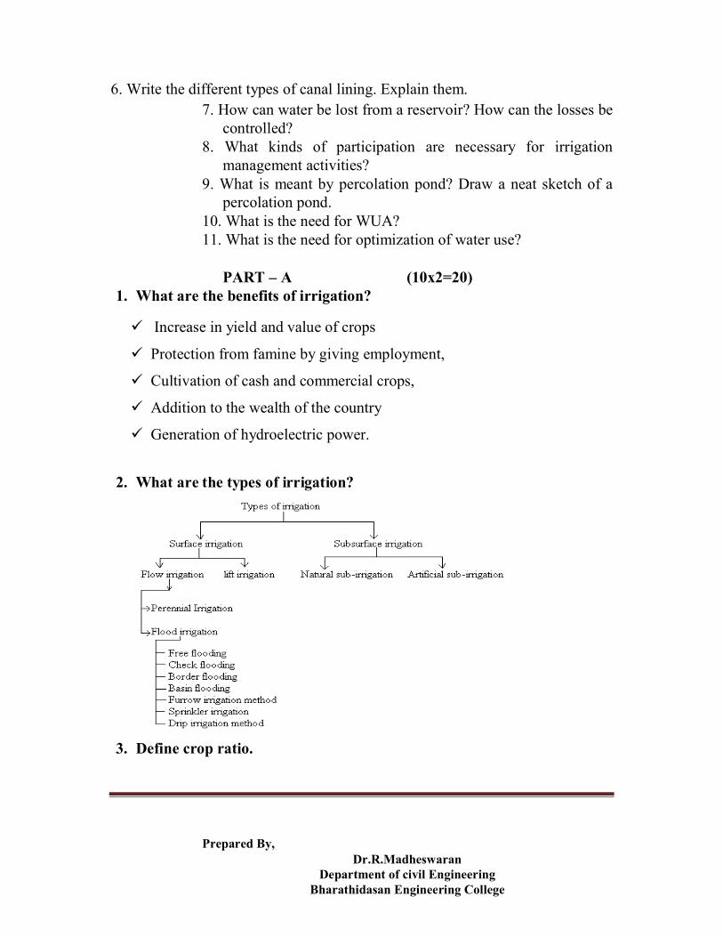
2. What are the types of irrigation?
3. Define crop ratio.

Prepared By, Dr.R.Madheswaran
Department of civil Engineering Bharathidasan Engineering College
It is the ratio of the area irrigated in Rabi season to the area irrigated in kharif season.
4. What is mean by crop rotation? When the same crop is grown again and again in the same filed the fertility of land gets reduced as the soil becomes deficient in plant floods favorable to that particular crop.
5. What do you mean by flow irrigation? Flow irrigation is the type of irrigation in which the supply of irrigation water available is at such a level that it is conveyed on to the land by the gravity flow.
6. What do you mean by uncontrolled and controlled flooding?
In the controlled flooding, water is spread over the land, with proper methods to control the depth of application.
In the uncontrolled flooding, water is spread of flooded on a rather smooth flat land, without much control or prior preparation.
7. Write about the advantages of furrow irrigation.
In the furrow irrigation, water contacts only 1/5 to ½ of the land surface, thereby reducing pudding and crusting of the soil. Evaporation losses are also reduced.
It is specially suitable for those crops (like maize) they are injured by contact with water.
Labour requirements in land preparation and irrigation are very much reduced.
There is no wastage of land in field ditches.
8. Define canal irrigation. An irrigation canal is a waterway, often man-made or enhanced, built for the purpose of carrying water from a source such as a lake, river, or stream, to soil used for farming or landscaping.
9. Define drip irrigation. Its also known as trickle irrigation or micro irrigation or localized irrigation, is an irrigation method that saves water and fertilizer by allowing water to drip slowly to the roots of plants, either onto the soil surface or directly onto the root zone, through a network of valves, pipes, tubing, and

Prepared By, Dr.R.Madheswaran
Department of civil Engineering Bharathidasan Engineering College
emitters. It is done through narrow tubes that deliver water directly to the base of the plant.
10. Define perennial irrigation. In this perennial irrigation system, the water required for irrigation is supplied in accordance with the crop requirements throughout the crop period.
PART – B (5x16=80)
11. a) i) what are the major problem occur in irrigation planning and developing.
ii) Explain duty, delta, base period, overlap allowance. Define delta. It is the total depth of water required by a crop during the
entire period the crop is in the field. Define duty.
Duty represents the irrigating capacity of a unit of water. It is
the relation between the area of a crop irrigated and the
quantity of irrigation water required during the entire period
of the growth of that crop.
Define base period.
Base period for a crop refers to the whole period of
cultivation from the time when irrigation water is first issued
for preparation of the ground for planting the crop, to its last
watering before harvesting.
What is meant by overlap allowance?

Prepared By, Dr.R.Madheswaran
Department of civil Engineering Bharathidasan Engineering College
The crops of some season may overlap some period of the
next crop season. When such overlapping takes place the
crops of both the season require water simultaneously.
or b) i).Explain advantages and disadvantages of
irrigation. Increase in yield and value of crops
Protection from famine by giving employment,
Cultivation of cash and commercial crops,
Addition to the wealth of the country
Generation of hydroelectric power.
Disadvantage Gives rise to disease like malaria
Excessive seepage causes water-logging and
The climate becomes cooler and makes the locality damp resulting ill-
health of the public.
ii) Explain types of irrigation with detail manner.
12 a) i) Describe the crop seasons in India and explain various
crop seasons.

Prepared By, Dr.R.Madheswaran
Department of civil Engineering Bharathidasan Engineering College
kharif
The kharif crops are rice,bajra,jawar,maize,cotton,tobacco,
groundnut,etc.
rabi
Rabi crops are wheat,barley,gram,linseed,mustard,potatoes,etc
Or ii) Explain consumptive use of water and factors
affecting consumptive use of water. Evapotranspiration or consumptive use of water by a crop is the
depth of the water consumed by evaporation and transpiration during the crop growth including the water consumed by the accompanying weed growth.
Factors affecting consumptive use of water.
Evaporation.
Mean monthly temperature.
Growing season of crop and cropping pattern.
Monthly precipitation in the area.
Soil and topography.
Wind velocity in the locality.
13 a) Explain about sprinkler irrigation and write advantage
and disadvantage about sprinkler irrigation. Sprinkler irrigation is a method of applying irrigation water
which is similar to natural rainfall. Water is distributed through a system of pipes usually by pumping. It is then sprayed into the air through sprinklers so that it breaks up into small water drops which fall to the ground. The pump supply

Prepared By, Dr.R.Madheswaran
Department of civil Engineering Bharathidasan Engineering College
system, sprinklers and operating conditions must be designed to enable a uniform application of water.
The land cannot be prepared for surface methods. Slopes are excessive Topography is irregular. Soil is erosive. Soil is excessively permeable or impermeable.
Advantages of sprinkler irrigation. Erosion can be controlled. Uniform application for water is possible. Irrigation is better controlled; light irrigation is possible for seedlings
and plants, which are young. Land preparation is not required. Crop damage from frost can be reduced. Can be applied to areas of variable topography. Suitable for most crops, not all, and are adaptable to most irrigable
soils. Flexibility is possible because sprinkler heads are available in a wide
range of discharge capacities. Water measurement is easier than surface irrigation system. Less interference with cultivation and less land loss. Higher application efficiency. High and frequent application can be effectively accomplished. Easy mechanization and automation. Chemical and fertilizer applications are easily used with sprinkler
systems. Water application efficiency under sprinkler irrigation is strongly
affected by wind.
Disadvantages Some crops are particularly sensitive and may suffer leaf scorch because
of the salts deposited on the leaves as the intercepted irrigation water evaporates.
Some crops are especially sensitive to fungal diseases, leaf scorch, or fruit damage, and tall crops may obstruct hand-move or side-roll portable systems.

Prepared By, Dr.R.Madheswaran
Department of civil Engineering Bharathidasan Engineering College
Falling drops on bare soil, causing slaking and surface sealing (crusting) which can be severe when the sodium ion predominates in the water affecting the soil’s clay fraction.
High maintenance requirements, constant and meticulous maintenance of sprinkle irrigation systems is crucial if these systems are to justify their costs.
High operating pressures The danger of system failure increases with technological complexity
and requirements of expertise and quick availability of spare parts. A malfunction of one of numerous parts can soon transform a working
marvel of technology into a standing monument of inefficiency. High initial cost. High operating cost. Wind drift. A stable water supply is needed. Saline water may cause problem. Water must be free from sand, debris and large amount of salt.
Or b) i) Write about canal irrigation structures .
An irrigation canal is a waterway, often man-made or enhanced, built for the purpose of carrying water from a source such as a lake, river, or stream, to soil used for farming or landscaping.
ii) Types of canal irrigation. Based on lined Lined canal Unlined canal
Based on excavation material Alluvial canal Non-alluvial canal

Prepared By, Dr.R.Madheswaran
Department of civil Engineering Bharathidasan Engineering College
14 a) Explain the types of surface irrigation.
Or b) Describe about free flooding, check flooding, basin
flooding and border flooding.

Prepared By, Dr.R.Madheswaran
Department of civil Engineering Bharathidasan Engineering College
Basin flooding 15 a ) Explain lift irrigation , flow irrigation ,Direct
irrigation and what do you meant by storage irrigation. Lift irrigation.
Prepared By, Dr.R.Madheswaran
Department of civil Engineering Bharathidasan Engineering College
Lift irrigation is practiced when the water supply is at too low a level to run by gravity on to the land. In such a circumstances water is lifted up by mechanical means.
Flow irrigation. Flow irrigation is the type of irrigation in which the supply of
irrigation water available is at such a level that it is conveyed on to the land by the gravity flow.
Direct irrigation In this system, water is directly diverted to the canal without
attempting to store the water. For such a system, a low diversion weir or diversion barrage is constructed across the river. Storage irrigation
In this system, a solid barrier, such as a dam or storage weir is constructed across the river and water is stored in the reservoir or lake so formed.
Or b) i) What are the basic requirements for adaption of any
irrigation method . The method should be such that uniform water distribution with as
small as 6 cm water depth applications can be made for light irrigations.
At the same time, it should afford heavy uniform application of 15 to 20 cm water depth.
It should allow the use of large concentrated water flows for reduction of conveyance losses, and labour cost.
It should be suitable for use with economic conveyance structure. ii) Write advantages of furrow irrigation.
In the furrow irrigation, water contacts only 1/5 to ½ of the land surface, thereby reducing pudding and crusting of the soil. Evaporation losses are also reduced.
It is specially suitable for those crops (like maize) they are injured by contact with water.
Labour requirements in land preparation and irrigation are very much reduced.
There is no wastage of land in field ditches.

Prepared By, Dr.R.Madheswaran
Department of civil Engineering Bharathidasan Engineering College
iii) Explain furrow irrigation.
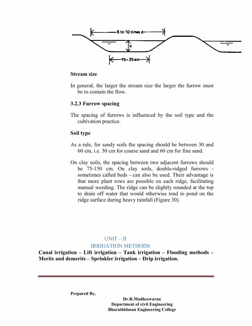
Furrow shape
The shape of furrows is influenced by the soil type and the stream size.
Soil type
In sandy soils, water moves faster vertically than sideways (= lateral). Narrow, deep V-shaped furrows are desirable to reduce the soil area through which water percolates (Figure 28). However, sandy soils are less stable, and tend to collapse, which may reduce the irrigation efficiency.
In clay soils, there is much more lateral movement of water and the infiltration rate is much less than for sandy soils. Thus a wide, shallow furrow is desirable to obtain a large wetted area (Figure 29) to encourage infiltration.
Figure 28 A deep, narrow furrow on a sandy soil
Figure 29 A wide, shallow furrow on a clay soil
Prepared By, Dr.R.Madheswaran
Department of civil Engineering Bharathidasan Engineering College
Stream size
In general, the larger the stream size the larger the furrow must be to contain the flow.
3.2.3 Furrow spacing
The spacing of furrows is influenced by the soil type and the cultivation practice.
Soil type
As a rule, for sandy soils the spacing should be between 30 and 60 cm, i.e. 30 cm for coarse sand and 60 cm for fine sand.
On clay soils, the spacing between two adjacent furrows should be 75-150 cm. On clay soils, double-ridged furrows - sometimes called beds - can also be used. Their advantage is that more plant rows are possible on each ridge, facilitating manual weeding. The ridge can be slightly rounded at the top to drain off water that would otherwise tend to pond on the ridge surface during heavy rainfall (Figure 30).
UNIT – II IRRIGATION METHODS
Canal irrigation – Lift irrigation – Tank irrigation – Flooding methods – Merits and demerits – Sprinkler irrigation – Drip irrigation.
Prepared By, Dr.R.Madheswaran
Department of civil Engineering Bharathidasan Engineering College
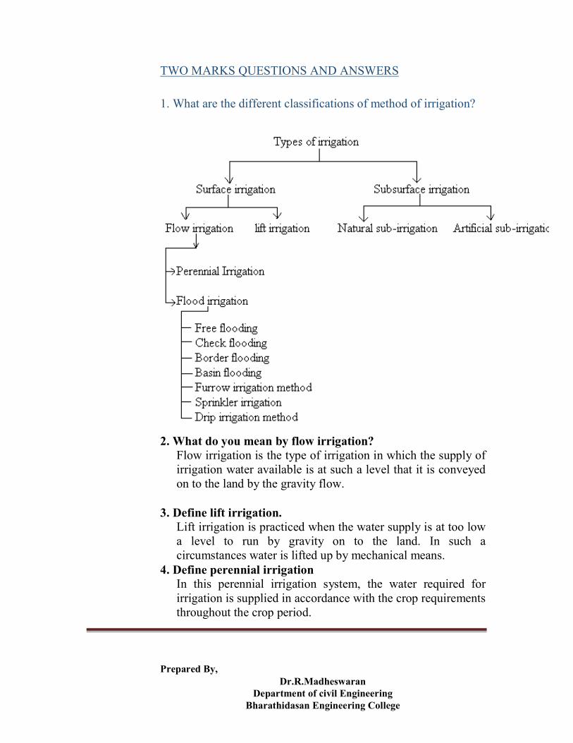
TWO MARKS QUESTIONS AND ANSWERS 1. What are the different classifications of method of irrigation?
2. What do you mean by flow irrigation? Flow irrigation is the type of irrigation in which the supply of
irrigation water available is at such a level that it is conveyed on to the land by the gravity flow.
3. Define lift irrigation. Lift irrigation is practiced when the water supply is at too low
a level to run by gravity on to the land. In such a circumstances water is lifted up by mechanical means.
4. Define perennial irrigation In this perennial irrigation system, the water required for
irrigation is supplied in accordance with the crop requirements throughout the crop period.

Prepared By, Dr.R.Madheswaran
Department of civil Engineering Bharathidasan Engineering College
5. Define direct irrigation. In this system, water is directly diverted to the canal without
attempting to store the water. For such a system, a low diversion weir or diversion barrage is constructed across the river. 6. What do you meant by storage irrigation?
In this system, a solid barrier, such as a dam or storage weir is constructed across the river and water is stored in the reservoir or lake so formed.
7. Define combined irrigation. In this system, the water is first stored in the reservoir
formed at the upstream side of the dam, and this water is used for power generation. The discharge from the powerhouse is fed back in to the river, to the downstream side of the dam. Thus, sufficient quantity of flow is again available in the river.
8. What do you mean by uncontrolled and controlled flooding? In the controlled flooding, water is spread over the land, with
proper methods to control the depth of application. In the uncontrolled flooding, water is spread of flooded on a rather
smooth flat land, without much control or prior preparation. 9. What are the basic requirements for adaptation of any
irrigation method? The method should be such that uniform water distribution with as
small as 6 cm water depth applications can be made for light irrigations.
At the same time, it should afford heavy uniform application of 15 to 20 cm water depth.
It should allow the use of large concentrated water flows for reduction of conveyance losses, and labour cost.
It should be suitable for use with economic conveyance structure. 10. What do you mean by free flooding? In free flooding method, the field is divided into a number of
small sized plots which are practically level. Water is admitted to these plots at the higher end and the supply is cut off as soon as the lower part of the plot has received the sufficient depth of water.

Prepared By, Dr.R.Madheswaran
Department of civil Engineering Bharathidasan Engineering College
11. Write about the advantages of furrow irrigation. In the furrow irrigation, water contacts only 1/5 to ½ of the land
surface, thereby reducing pudding and crusting of the soil. Evaporation losses are also reduced.
It is specially suitable for those crops (like maize) they are injured by contact with water.
Labour requirements in land preparation and irrigation are very much reduced.
There is no wastage of land in field ditches. 12. Under which favorable conditions the sub-surface
irrigation is practiced? Impervious sub-soil at reasonable depth (2 to 3 m) or higher water
table. Permanent soil such as loam or sandy loam in the root zone of the soil. Uniform topographic conditions. Moderate slopes. Good quality irrigation water.
13. Where sprinkler irrigation is more useful? The land cannot be prepared for surface methods. Slopes are excessive Topography is irregular. Soil is erosive. Soil is excessively permeable or impermeable.
14. Write about the advantages of sprinkler irrigation. Erosion can be controlled. Uniform application for water is possible. Irrigation is better controlled; light irrigation is possible for seedlings
and plants, which are young. Land preparation is not required. Crop damage from frost can be reduced.
15. Write about the limitations of sprinkler irrigation.
Wind may distort sprinkler pattern. A constant water supply is needed for commercial use of equipment. Water must be clean and free from sand. The power requirement is high.

Prepared By, Dr.R.Madheswaran
Department of civil Engineering Bharathidasan Engineering College
16. Write about the advantages of drip irrigation Less requirement of irrigation water. Water supply at optimum level. Water logging is avoided. High yield. Cultivation of cash crops.
17. Write about the disadvantages of drip irrigation High initial cost. Danger of blockade of nozzles. Change in spacing of nozzles due to change in the crops may result in
frequent replacement of trickle lines. Shallow root depth of the crops, especially for fruit trees may result in
instability of the crop or tree which may topple during high winds.
SIXTEEN MARK QUESTIONS
1. Write a note on sub-surface irrigation, state clearly the conditions under which this method is suitable. What are the essential requirements for a successful sub-surface irrigation? 2. Describe border strip method of irrigation. Derive the expression for the time required to cover a given area by this method, for a given rate of discharge and the rate of infiltration of water in the soil. 3. Explain in detail about sprinkler method of irrigation and how far it is suitable in Indian conditions. 4. Write a note on drip irrigation. Write about the advantages and disadvantages of drip irrigation system. 5. Define surface irrigation. Why it is widely practiced method of irrigation? What are the advantages and disadvantages of the method? 6. Write a note on free flooding. 7. Describe check flooding and basin flooding.
8. Describe furrow method of irrigation.
UNIT-III

Prepared By, Dr.R.Madheswaran
Department of civil Engineering Bharathidasan Engineering College
DIVERSION AND IMPOUNDING STRUCTURES Weirs – elementary profile of a weir – weirs on pervious
foundations - Types of impounding structures - Tanks, Sluices and Weirs – Gravity dams – Earth dams – Arch dams – Spillways – Factors affecting location and type of dams – Forces on a dam – Hydraulic design of dams.
TWO MARK QUESTIONS AND ANSWERS
1. Define diversion headwork.
Any hydraulic structure, which supplies water to the
off-taking canal, is called a headwork.
A diversion headwork serves to divert the required
supply in to the canal from the river.
2. Write about the purposes of diversion headwork.
It raises the water level in the river so that the commanded area can be
increased.
It regulates the intake of water in to the canal.
It controls the silt entry in to the canal.
It reduces fluctuations in the level of supply in the river.
It stores water for tiding over small periods of short supplies.
3. Define weir.
The weir is a solid obstruction put across the river to raise its
water level and divert the water in to the canal. If a weir also
stores water for tiding over small periods of short supplies, it is
called a storage weir.

Prepared By, Dr.R.Madheswaran
Department of civil Engineering Bharathidasan Engineering College
4. What are the component parts of diversion headwork?
Weir or barrage
Divide wall or divide groyne
Fish ladder
Head sluice or canal head regulator
Canal off-takes
Flood banks
River training works.
5. Define dam.
A dam is a hydraulic structure constructed across a river to
store the supply for a longer duration and release it through
designed outlets.
6. What are the types of dam?
Solid gravity dam (masonry, concrete, steel and timber)
Arch dams
Buttress dams
Earth dams
Rockfill dams
Combination of rockfill and earth dams
7. Define gravity dam.

Prepared By, Dr.R.Madheswaran
Department of civil Engineering Bharathidasan Engineering College
A gravity dam is a structure so proportioned that its own
weight resists the forces exerted upon it. It requires little
maintenance and it is most commonly used.
8. What are the forces acting on a gravity dam?
Water pressure
Weight of dam
Uplift pressure
Pressure due to earthquake
Ice pressure
Wave pressure
Silt pressure
9. What is meant by arch dam?
An arch dam is a dam curved in plan and carries a
major part of its water load horizontally to the abutments by
arch action. The part of the water load depends primarily upon
the amount of curvature. The balance of the water load is
transferred to the foundation by cantilever action.
10. What are the forces acting on arch dam?
Water pressure
Weight of dam
Uplift pressure (negligibly small)
Pressure due to earthquake

Prepared By, Dr.R.Madheswaran
Department of civil Engineering Bharathidasan Engineering College
Ice pressure
Silt pressure
11. What are the various types of earth dam?
Depending upon the method of construction, earth
dam can be divided into,
Rolled fill dam
Hydraulic fill dam
12. What are the types of failure that occur during
construction of earth dam?
Hydraulic failures : 40%
Seepage failure : 30%
Structural failure : 30%
13. Define tank.
They are small storage meant for irrigating the local
area. They may receive their supply from their own
catchments. They may also have supply from a nearby river.
14. Define tank sluice.
These are outlets that extend from the upstream face of a
bund to the downstream face. They are provided to discharge
the stored water either for irrigation or for any other purposes.
15. How will you select a site for a tank sluice?
The site to be selected should be such that,

Prepared By, Dr.R.Madheswaran
Department of civil Engineering Bharathidasan Engineering College
The sluice commands the ayacut.
The sill level of the sluice is above the bed level of existing canal.
Good natural ground is available at the sill level.
It involves minimum cutting
It ensures the safety of the dam itself.
16. Define spillway.
A spillway is the overflow portion of dam, over
which surplus discharge flows from the reservoir to the
downstream. A spillway is therefore called as surplussing
work, designed to carry this flood water not required to be
stored in the reservoir, safely to the river lower down.
17. Write about the advantages of earth dam?
They can be designed and constructed to suit the soil available in the locality
and the foundation conditions.
They can be constructed rapidly with relatively unskilled labour.
They are cheaper than other types.
They can be subsequently raised in height without much difficulty.
18. Write about the disadvantages of earth dam?
They are not suitable for greater heights.
They cannot be used as overflow dams.
They are not suitable for deep gorges.
They are not suitable in places of heavy rainfall.
They require heavy maintenance cost and constant supervision.

Prepared By, Dr.R.Madheswaran
Department of civil Engineering Bharathidasan Engineering College
19. Write about the functions of scouring sluices.
To preserve a clear and defined river channel approaching the
regulator.
To control the silt entry in to the canal.
To scour the silt deposited in the riverbed above the approach
channel.
To help in passing low floods without dropping the shutters of main
weir.
To provide additional waterway for floods, thus lowering the flood
levels.
20. Under what conditions gravity dam can be adopted?
Good rock is available for foundation.
A narrow gorge exists to reduce cost and length of dam.
Construction materials are available closely in plenty.
A good site for the surplus weir exists.
21. Define sluiceway. Pipe or tunnel provided for the withdrawal of water from the
dams is known as Sluiceway.
SIXTEEN MARK QUESTIONS
1. Write in detail about the component parts of diversion works.
2. Write about the types of weirs on permeable foundation.
3. Write in detail about the tank surplus works.

Prepared By, Dr.R.Madheswaran
Department of civil Engineering Bharathidasan Engineering College
4. What are the causes of failure of earth dams and its remedies?
5. Write about the factors affecting the selection of type of a dam.
6. Write about the favorable conditions, advantages,
disadvantages, pressure distribution and elementary profile of
a masonry dam.
7. Write about the criteria for safe design of earth dam.
8. Describe the forces acting on a gravity dam.
9. What are the types of dams and what are the comparative
merits and demerits of carious types of dams?
UNIT-IV
CANAL IRRIGATION
Alignment of canals – Classification of canals – Canal drops – Hydraulic
design of drops – Cross drainage works – Hydraulic design of cross
drainage works – Canal Head works – Canal regulators – River Training
works.

Prepared By, Dr.R.Madheswaran
Department of civil Engineering Bharathidasan Engineering College
TWO MARKS QUESTIONS AND ANSWERS
1. Classify the rivers.
According to the topography of river basin it is classified
as:
Upper reaches in the hilly region
Lower reaches in the alluvial plain
Rivers in alluvial plain are further classified as:
Meandering type
Aggrading type
Degrading type
2. What are the causes of meandering?
A primary cause of meandering is the excess of total charge
during floods, when excess of turbulence is developed.
It results from the local bank erosion and consequent over
loading deposition by the rivers of the heavier sediments
having along the bed.
3. What are the objectives of river training works?
High flood discharge may pass safely and quickly through the reach.
Sediment load including bed and suspended load may be transported
efficiently.
To make the river course stable and reduce the bank erosion to
minimum.
To provide a sufficient draft for navigation as well as good course for
it.
To fix direction of flow through certain defined reach.

Prepared By, Dr.R.Madheswaran
Department of civil Engineering Bharathidasan Engineering College
4. Classify the river training works.
High water training
Low water training
Mean water training
5. Define groyne.
Groynes are structures constructed transverse to the river flow
and extend from the bank in to the river up to a limit.
6. Classify the groynes.
Classification according to material of construction.
Permeable groyne
Solid impermeable groyne.
Classification according to its height below high water.
Submerged groyne.
Non-submerged groyne.
Classification according to the function it serves.
Attracting groyne.
Deflecting groyne.
Repelling groyne.
Sedimentary groyne.
7. Give an equation for silt factor.
f = 1.76 d
where, f = silt factor
d = mean particle diameter.
8. Give Kennedy’s critical velocity equation.
Prepared By, Dr.R.Madheswaran
Department of civil Engineering Bharathidasan Engineering College
Vo = 0.55 m D0.64
Where, Vo = critical velocity (m/s)
m = critical velocity ratio (C.V.R)
D = depth of water over bed portion of a channel
in meters.
9. Define critical velocity.
The critical velocity in a channel has the mean velocity, which
will just keep the channel free from silting or scouring.
10. What is meant by regime channel?
The channel will be in regime if it flows in coherent unlimited
alluvium of the same character as that transported and the silt
grade and silt charge are all constant.
11. What is meant by contour canal?
A channel aligned nearly parallel to the contours of the
country is called a contour canal. When the canal takes off
from a river in a hilly area, it is not possible to align the canal
on the watershed as the watershed on the top of the hill may
be very high and the areas that need irrigation are
concentrated in the valley. The canal is aligned roughly
parallel to the contours of the country.
12. What is a ridge canal?
A ridge canal or a watershed canal is aligned along a
watershed and runs for most of its length on a watershed.

Prepared By, Dr.R.Madheswaran
Department of civil Engineering Bharathidasan Engineering College
When the watershed takes a sharp loop, the canal should be
aligned straight to save considerable idle length.
13. Give the Lacey’s equation for wetted perimeter.
P = 4.75 Q
Where, P = Wetted perimeter. (m)
Q = Discharge (m3 / s)
14. Give the Lacey’s equation for bed slope of a canal.
S = f 5/3 / 3340 Q1/ 6
Where, S = Bed slope.
f = Silt factor
Q = Discharge (m3 / s)
15. Write about the significance of Lacey’s theory.
Lacey’s theory assumes that the velocity of flow depends on the
hydraulic mean depth, not on the depth.
For a given discharge and given silt charge bed width, depth of flow and
bed form is fixed.
For channel in final regime, velocity, hydraulic mean depth, wetted
perimeter, discharge, bed slope and N are closely related to one another.
There is only section and only one longitudinal bed slope at which the
channel will carry a particular discharge with particular silt grade.
The eddies generated from the sides are considered.
16. When the channel is said to be in regime?
The channel is said to be in regime, when the following
conditions are satisfied.
The channel is flowing in unlimited incoherent alluvium of the same
character as that transported.
Prepared By, Dr.R.Madheswaran
Department of civil Engineering Bharathidasan Engineering College
Silt grade and silt charge is constant.
Discharge is constant.
SIXTEEN MARK QUESTIONS
1. How are canals classified? Describe them briefly
2. Explain the various considerations for alignment of a canal.
3. Why are canal falls necessary? Describe with sketch briefly the various types
of canal falls.
4. What are the types of cross drainage works? Describe them
briefly with sketches.
5. Define Lacey’s regime theory and its design procedure of
channel. Also list the defects in Lacey’s theory.
6. Write the design procedure for Kennedy’s theory for the
channel.
7. Design an irrigation channel to carry 40 cumec of discharge
with B / D ratio as 2.5. The critical velocity ratio is 1.0.
Assume suitable value of rugosity co-efficient and use
Kennedy’s method.
8. Compare Kennedy and Lacey’s silt theories.
9. What is the necessity of river training works? Describe
different types of river training works.

Prepared By, Dr.R.Madheswaran
Department of civil Engineering Bharathidasan Engineering College
10. What is meant by guide banks? What are their functions and
effects?
UNIT-V
IRRIGATION WATER MANAGEMENT
Need for optimisation of water use – Minimising irrigation water losses – On farm development works - Participatory irrigation management – Water users associations – Changing paradigms in water management – Performance evaluation.
TWO MARKS QUESTIONS AND ANSWERS
1. What is meant by Productivity?
Productivity is defined as the ratio of output and input. The
output can be water delivered, area irrigated, yield, or income,
and the input can be water in the root zone, at the farm gate at
the outlet or at upstream points in the system including the
point of diversion or storage. Improved water supply
influences the adoption of high – yielding agricultural
practices by farmers, which justify the productivity criterion
of performance.
2. Define equity.
Equity in canal irrigation systems implies equality, fairness,
and even-handed dealing in matters of allocation and
appropriation of irrigation water. There can be several ways to
decide the equality of supplies to different farmers. Two of
Prepared By, Dr.R.Madheswaran
Department of civil Engineering Bharathidasan Engineering College
them, practiced throughout the world, are the methods of prior
appropriation and of proportionate equality.
3. Write about the conjunctive use of water.
Conjunctive use means the water lifted from below the ground
is used in conjunction with canal waters. It results in the
coordinated, combined, and creative exploitation of ground
water and surface water so as to minimize the dislocation
caused by nature’s inconsistent rainfall pattern. Such
coordinated use of surface and ground waters results in
increased amount of available water, smaller surface
distribution system, smaller drainage system, reduced canal
linings, greater flood control, and smaller evaporation losses.
4. What is meant by short – term stability?
The short – term or interseasonal stability refers to the
variations in productivity and equity between irrigation
seasons, and is a function of climate, water supply, storage
and control, system management, and other factors such as
pests, diseases, and availability of labour and other inputs. It
can be measured by comparing performance between seasons.
5. Define long – term stability.
The long – term stability is defined as “environmental
stability” and “durability” and refers to the prevention or
minimizing of adverse physical changes such as waterlogging,

Prepared By, Dr.R.Madheswaran
Department of civil Engineering Bharathidasan Engineering College
leaching of nutrients form soils, salinity, erosion, silting, the
‘mining’ of ground water, and infestations with weeds.
6. Write about the main components of soil reclamation.
The main components of soil reclamation works are as follows
Isolation of land areas according to their categorization and leveling and
bunding of the affected land as per the category.
Provision of drainage (surface or subsurface or vertical) network to
remove leaching water and to keep the water table to a safer level.
Breaking up of impervious subsoil layer in alkali soils by deep ploughing.
Adding suitable chemicals (such as gypsum, sulphur, etc.) depending
upon the results of chemical tests of the affected soil.
7. Why a proper plan for operation & maintenance of
irrigation system is necessary?
Achieve optimum use of canal water.
Provide detailed operation and maintenance guidelines during various
anticipated scenarios of water availability, including equitable water
distribution upto the tail-end of the system, and
Effect efficient coordination of staff, equipment, physical and financial
resources and related disciplines, active involvement of farmers etc.
Achieve stipulated levels of project services including maintenance at
minimum achievable cost.
8. What are the main objectives of canal lining?
The following are the main objectives of canal lining:
To canal seepage.
To prevent water-logging.

Prepared By, Dr.R.Madheswaran
Department of civil Engineering Bharathidasan Engineering College
To increase the capacity of canal.
To increase the command area.
To protect the canal from the damage by flood.
To control the growth of weeds.
9. What are the factors to be considered during the selection of particular
type of lining?
The selection of particular type of lining depends on the
following factors,
Imperviousness.
Smoothness.
Durability.
Economy.
Site condition.
Life of project.
Availability of construction materials.
10. How can the water losses be controlled?
The following are the measures that are generally taken to
control the water losses from the reservoir.
1. Measure to Reduce Evaporation Loss
a) The reservoir should be constructed of less surface area and more
depth.
b) Tall trees should be grown on the windward side of the reservoir
which act as wind breakers and hence the rate of evaporation will be
reduced.
c) The reservoir basin should be surrounded by plantation or forest area
so that cooler environment exists within the reservoir area.

Prepared By, Dr.R.Madheswaran
Department of civil Engineering Bharathidasan Engineering College
d) Certain chemical like cetyl alcohol is spread over the reservoir
surface. It forms a thin film on water surface reducing evaporation.
2. Measure to Reduce Absorption Loss
a) The weeds and plants at the periphery of the reservoir should be
removed completely.
b) The weeds from the surface of the reservoir should be removed.
3. Measure to Reduce Percolation Loss
a) Geological investigations should be carried out to locate the zones of
pervious formations, cracks and fissures in the bed and periphery of the
reservoir basin.
b) Suitable treatments should be adopted to stop the leakage of water
through these zones.
c) Soil stabilization methods should be adopted if the basin is composed of
permeable bed soil.
11. What is meant by water logging?
In agricultural land, when the soil pores within the root zone
of the crops get saturated with the subsoil water, the air
circulation within the soil pores gets totally stopped. This
phenomenon is termed as water logging. The water logging
makes the soil alkaline in character and the fertility of the land
is totally destroyed and the yield of crop is reduced.
12. State the effects of water logging?
The following are the effects of water logging:
Stabilization of soil
Prepared By, Dr.R.Madheswaran
Department of civil Engineering Bharathidasan Engineering College
Lack of aeration
Fall of soil temperature
Growth of weeds and aquatic plants
Diseases of crops
Difficulty in cultivation
Restriction of root growth
13. Write the methods used for controlling water logging?
The following measures may be taken to control water
logging:
Prevention of percolation from canals
Prevention of percolation from reservoirs
Control of intensity of irrigation
Economical use of water
Fixing of crop pattern
Providing drainage system
Improvement of natural drainage
Pumping of ground water
Construction of sump well
14. Define 0n-farm water management.
It can be defined as manipulation of water within the borders of an
individual farm, a farming plot or field.
Prepared By, Dr.R.Madheswaran
Department of civil Engineering Bharathidasan Engineering College
Example: in canal irrigation system, OFWM starts at the farm gate and ends at
the disposal point of the drainage water to a public watercourse, open drain or
sink.
15. What do you meant by water user association (WUA)?
It is a self-managing group of farmers working together to operate and
maintain their irrigation and drainage network, to ensure fair and equitable
water distribution, and to increase crop yield.
16. What are the problems of irrigation management without participatory
management?
Inadequate water availability at the lowest.
Poor condition / maintenance of the system.
Lack of measuring devices and control structures.
Inadequate allocation fro operation and maintenance.
Lack of incentives fro saving water.
Poor drainage.
SIXTEEN MARKS QUESTION
1. Discuss the inadequacies of present – day canal irrigation management in
India.
2. Describe the common criteria for judging the performance of an irrigation
system.
3. Describe the evaluation of performance of canal irrigation systems.

Prepared By, Dr.R.Madheswaran
Department of civil Engineering Bharathidasan Engineering College
4. What are the methods adopted for improving canal irrigation management?
Explain in detail.
5. Why should lining be provided in canals? What are the merits
and demerits of canal lining?
6. Write the different types of canal lining. Explain them.
7. How can water be lost from a reservoir? How can the losses be
controlled?
8. What kinds of participation are necessary for irrigation
management activities?
9. What is meant by percolation pond? Draw a neat sketch of a
percolation pond.
10. What is the need for WUA?
11. What is the need for optimization of water use?
CE 6703 WATER RESOURCES ENGINEERING
UNIT I
Water resources survey – Water resources of India and Tamilnadu –
Description of water resources planning – Economics of water resources planning, physical and socio economic

Prepared By, Dr.R.Madheswaran
Department of civil Engineering Bharathidasan Engineering College
data – National Water Policy – Collection of meteorological and hydrological data for water resources development.
Engineering economy in water resources planning:
All Water Resources projects have to be cost evaluated. This is an essential part of planning. Since, generally, such projects would be funded by the
respective State Governments, in which the project would be coming up it would be helpful for the State planners to collect the desired amount of money, like by issuing bonds to the public, taking loans from a bank, etc.
Since a project involves money, it is essential that the minimum amount is spent, under the given constraints of project construction.
Hence, a few feasible alternatives for a project are usually worked out. For example, a project involving a storage dam has to be located on a map of the river valley at more than one possible location, if the terrain permits.
In this instance, the dam would generally be located at the narrowest part of the river valley to reduce cost of dam construction, but also a couple of more alternatives would be selected since there would be other features of a dam whose cost would dictate the total cost of the project.
For example, the foundation could be weak for the first alternative and consequently require costly found treatment, raising thereby the total project cost.
At times, a economically lucrative project site may be causing submergence of a costly property, say an industry, whose relocation cost would offset the benefit of the alternative.
On the other hand, the beneficial returns may also vary. For example, the volume of water stored behind a dam for one
alternative of layout may not be the same as that behind another.
Hence, what is required is to evaluate the so-called Benefit-Cost Ratio defined as below:

Prepared By, Dr.R.Madheswaran
Department of civil Engineering Bharathidasan Engineering College
The annual cost and benefits are worked out as under. AnnualCost(C):
The investment for a project is done in the initial years during construction and then on operation and maintenance during the project's lifetime. The initial cost may be met by certain sources like borrowing, etc. but has to be repaid over a certain number of years, usually with an interest, to the lender. This is called the Annual Recovery Cost, which, together with the yearly maintenance cost would give the total Annual Costs. It must be noted that there are many nontangible costs, which arise due to the effect of the project on the environment that has to be quantified properly and included in the annual costs. water resourcesdevelopment.
Instructional Objectives On completion of this lesson, the student shall be able to know:
1. Principle of planning for water resource projects 2. Planning for prioritizing water resource projects 3. Concept of basin – wise project development 4. Demand of water within a basin 5. Structural construction for water projects 6. Concept of inter – basin water transfer project 7. Tasks for planning a water resources project
Introduction
Utilisation of available water of a region for use of a community has perhaps been practiced from the dawn of civilization. In India, since civilization flourished early, evidences of water utilization has also been found from ancient times. For example at Dholavira in Gujarat water harvesting and drainage systems have come to light which might had been constructed somewhere between 300-1500 BC that is at the time of the Indus valley civilization. In fact, the Harappa and Mohenjodaro excavations have also shown scientific developments of water utilization and disposal systems. They even developed an efficient system of irrigation using several

Prepared By, Dr.R.Madheswaran
Department of civil Engineering Bharathidasan Engineering College
large canals. It has also been discovered that the Harappan civilization made good use of groundwater by digging a large number of wells. Of other places around the world, the earliest dams to retain water in large quantities were constructed in Jawa (Jordan) at about 3000 BC and in WadiGarawi (Egypt) at about 2660 BC. The Roman engineers had built log water conveyance systems, many of which can still be seen today, Qanatsor underground canals that tap an alluvial fan on mountain slopes and carry it over large distances, were one of the most ingenious of ancient hydro-technical inventions, which originated in Armenia around 1000BC and were found in India since 300 BC.
Although many such developments had taken place in the field of water resources in earlier days they were mostly for satisfying drinking water and irrigation requirements. Modern day projects require a scientific planning strategy due to:
1. Gradual decrease of per capita available water on this planet and especially in our country.
2. Water being used for many purposes and the demands vary in time and space.
3. Water availability in a region – like county or state or watershed is not equally distributed.
4. The supply of water may be from rain, surface water bodies and ground water.
Water resources project planning The goals of water resources project planning may be by
the use of constructed facilities, or structural measures, or by management and legal techniques that do not require constructed facilities.
The latter are called non-structural measures and may include rules to limit or control water and land use which complement or substitute for constructed facilities.
A project may consist of one or more structural or non-structural resources.
Water resources planning techniques are used to determine what measures should be employed to meet water needs and to take advantage of opportunities for

Prepared By, Dr.R.Madheswaran
Department of civil Engineering Bharathidasan Engineering College
water resources development, and also to preserve and enhance natural water resources and related land resources.
The scientific and technological development has been conspicuously evident during the twentieth century in major fields of engineering.
But since water resources have been practiced for many centuries, the development in this field may not have been as spectacular as, say, for computer sciences.
However, with the rapid development of substantial computational power resulting reduced computation cost, the planning strategies have seen new directions in the last century which utilises the best of the computer resources.
Further, economic considerations used to be the guiding constraint for planning a water resources project.
But during the last couple of decades of the twentieth century there has been a growing awareness for environmental sustainability.
And now, environmental constrains find a significant place in the water resources project (or for that matter any developmental project) planning besides the usual economic and social constraints.

Prepared By, Dr.R.Madheswaran
Department of civil Engineering Bharathidasan Engineering College
Priorities for water resources planning Water resource projects are constructed to develop or manage
the available water resources for different purposes. According to the National Water Policy (2002), the water allocation priorities for planning and operation of water resource systems should broadly be as follows:
1. Domestic consumption This includes water requirements primarily for drinking,
cooking, bathing, washing of clothes and utensils and flushing of toilets.
2. Irrigation
Water required for growing crops in a systematic and scientific manner in areas even with deficit rainfall. 3. Hydropower
This is the generation of electricity by harnessing the power of flowing water. 4. Ecology / environment restoration
Water required for maintaining the environmental health of a region.
5. Industries
The industries require water for various purposes and that by thermal power stations is quite high. 6. Navigation
Navigation possibility in rivers may be enhanced by increasing the flow, thereby increasing the depth of water required to allow larger vessels to pass. 7. Other uses
Like entertainment of scenic natural view.
This course on Water Resources Engineering broadly discusses the facilities to be constructed / augmented to meet the demand for the above uses. Many a times, one project may serve more than one purpose of the above mentioned uses.

Prepared By, Dr.R.Madheswaran
Department of civil Engineering Bharathidasan Engineering College
Basin – wise water resource project development The total land area that contributes water to a river
is called a Watershed, also called differently as the Catchment, River basin, Drainage Basin, or simply a Basin.
A watershed may also be defined as a geographic area that drains to a common point, which makes it an attractive planning unit for technical efforts to conserve soil and maximize the utilization of surface and subsurface water for crop production.
Thus, it is generally considered that water resources development and management schemes should be planned for a hydrological unit such as a Drainage Basin as a whole or for a Sub-Basin, multi-sectorially, taking into account surface and ground water for sustainable use incorporating quantity and quality aspects as well as environmental considerations.
Let us look into the concept of watershed or basin-wise project development in some detail
The objective is to meet the demands of water within the Basin with the available water therein, which could be surface water, in the form of rivers, lakes, etc. or as groundwater
The source for all these water bodies is the rain occurring over the Watershed or perhaps the snowmelt of the glacier within it, and that varies both temporally and spatially.
Further due to the land surface variations the rain falling over land surface tries to follow the steepest gradient as overland flow and meets the rivers or drains into lakes and. ponds
The time for the overland flows to reach the rivers may be fast or slow depending on the obstructions and detentions it meet on the way.
Part of the water from either overland flow or from the rivers and lakes penetrates into the ground and recharge the ground water.
Prepared By, Dr.R.Madheswaran
Department of civil Engineering Bharathidasan Engineering College
Ground water is thus available almost throughout the watershed, in the underground aquifers. The variation of the water table is also fairly even, with some rise during rainfall and a gradual fall at other times.
The water in the rivers is mostly available during the rains. When the rain stops, part of the ground water comes out to recharge the rivers and that results in the dry season flows in rivers.
Surface and Ground Water Resources Instructional Objectives
After completion of this lesson, the student shall know about 1. Hydrologic cycle and its components 2. Distribution of earth‟s water resources 3. Distribution of fresh water on earth 4. Rainfall distribution in India 5. Major river basins of India 6. Land and water resources of India; water development
potential 7. Need for development of water resources
Introduction Water in our planet is available in the atmosphere, the oceans,
on land and within the soil and fractured rock of the earth‟s crust Water molecules from one location to another are driven by the solar energy. Moisture circulates from the earth into the atmosphere through evaporation and then back into the earth as precipitation. In going through this process, called the Hydrologic Cycle water is conserved – that is, it is neither created nor destroyed.It would perhaps be interesting to note that the knowledge of the hydrologic cycle was known at least by about 1000 BC by the people of the Indian Subcontinent. This is reflected by the fact that one verse of Chhandogya Upanishad (the Philosophical reflections of the Vedas)

Prepared By, Dr.R.Madheswaran
Department of civil Engineering Bharathidasan Engineering College
points to the following: “The rivers… all discharge their waters into the sea. They lead from sea to sea, the clouds raise them to the sky as vapour and release them in the form of rain…” The earth‟s total water content in the hydrologic cycle is not equally distributedThe oceans are the largest reservoirs of water, but since it is saline it is not readily usable for requirements of human survival.Again, the fresh water distribution is highly uneven, with most of the water locked in frozen polar ice caps. The hydrologic cycle consists of four key components
1. Precipitation 2. Runoff 3. Storage 4. Evapotranspiration These are described in the next sections.
Precipitation Precipitation occurs when atmospheric moisture
becomes too great to remain suspended in clouds. It denotes all forms of water that reach the earth from the
atmosphere, the usual forms being rainfall, snowfall, hail, frost and dew.
Once it reaches the earth‟s surface, precipitation can become surface water runoff, surface water storage, glacial ice, water for plants, groundwater, or may evaporate and return immediately to the atmosphere.
Ocean evaporation is the greatest source (about 90%) of precipitation.
Rainfall is the predominant form of precipitation and its distribution over the world and within a country. India has a typical monsoon climate.
At this time, the surface winds undergo a complete reversal from January to July, and cause two types of monsoon.
In winter dry and cold air from land in the northern latitudes flows southwest (northeast monsoon), while in summer warm and humid air originates over the ocean and flows in the opposite direction (southwest monsoon), accounting for some 70 to 95 percent of the annual rainfall.
Prepared By, Dr.R.Madheswaran
Department of civil Engineering Bharathidasan Engineering College
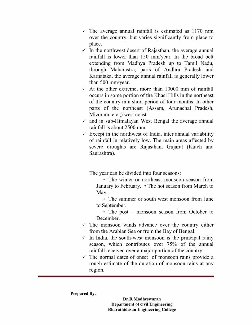
The average annual rainfall is estimated as 1170 mm over the country, but varies significantly from place to place.
In the northwest desert of Rajasthan, the average annual rainfall is lower than 150 mm/year. In the broad belt extending from Madhya Pradesh up to Tamil Nadu, through Maharastra, parts of Andhra Pradesh and Karnataka, the average annual rainfall is generally lower than 500 mm/year.
At the other extreme, more than 10000 mm of rainfall occurs in some portion of the Khasi Hills in the northeast of the country in a short period of four months. In other parts of the northeast (Assam, Arunachal Pradesh, Mizoram, etc.,) west coast
and in sub-Himalayan West Bengal the average annual rainfall is about 2500 mm.
Except in the northwest of India, inter annual variability of rainfall in relatively low. The main areas affected by severe droughts are Rajasthan, Gujarat (Kutch and Saurashtra).
The year can be divided into four seasons: • The winter or northeast monsoon season from
January to February. • The hot season from March to May.
• The summer or south west monsoon from June to September.
• The post – monsoon season from October to December.
The monsoon winds advance over the country either from the Arabian Sea or from the Bay of Bengal.
In India, the south-west monsoon is the principal rainy season, which contributes over 75% of the annual rainfall received over a major portion of the country.
The normal dates of onset of monsoon rains provide a rough estimate of the duration of monsoon rains at any region.
Prepared By, Dr.R.Madheswaran
Department of civil Engineering Bharathidasan Engineering College
Runoff Runoff is the water that flows across the land surface
after a storm event. As rain falls over land, part of that gets infiltrated the
surface as overland flow. As the flow bears down, it notches out rills and gullies
which combine to form channels. These combine further to form streams and rivers. The geographical area which contributes to the flow of a
river is called a river or a watershed. The following are the major river basins of our country,
and thecorresponding figures, as obtained from the web-site of the Ministry of Water Resources, Government of India is mentioned alongside each.
1. Indus 2. Ganges 3. Brahmaputra 4. Krishna 5. Godavari 6. Mahanandi 7. Sabarmati 8. Tapi 9. Brahmani-Baitarani 10. Narmada 11. Pennar 12. Mahi
Storage Portion of the precipitation falling on land surface
which does not flow out as runoff gets stored as either as surface water bodies like Lakes, Reservoirs and Wetlands or as sub-surface water body, usually called Ground water.
Ground water storage is the water infiltrating through the soil cover of a land surface and traveling further to reach the huge body of water underground.

Prepared By, Dr.R.Madheswaran
Department of civil Engineering Bharathidasan Engineering College
Asmentioned earlier, the amount of ground water storage is much greater than that of lakes and rivers.
However, it is not possible to extract the entire groundwater by practicable means. It is interesting to note that the groundwater also is in a state of continuous movement – flowing from regions of higher potential to lower.
The rate of movement, however, is exceptionally small compared to the surface water movement.
The following definitions may be useful:
Lakes: Large, naturally occurring inland body of water Reservoirs: Artificial or natural inland body of water used to
store water to meet various demands. Wet Lands: Natural or artificial areas of shallow water or saturated soils that contain or could support water–loving plants.
Evapotranspiration Evapotranspiration is actually the combination of two
terms – evaporation and transpiration. The first of these, that is, evaporation is the process of
liquid converting into vapour, through wind action and solar radiation and returning to the atmosphere.
Evaporation is the cause of loss of water from open bodies of water, such as lakes, rivers, the oceans and the land surface.
It is interesting to note that ocean evaporation provides approximately 90 percent of the earth‟s precipitation.
However, living near an ocean does not necessarily imply more rainfall as can be noted from the great difference in the amount of rain received between the east and west coasts of India

Prepared By, Dr.R.Madheswaran
Department of civil Engineering Bharathidasan Engineering College
Transpiration is the process by which water molecules leaves the body of a living plant and escapes to the atmosphere.
The water is drawn up by the plant root system and part of that is lost through the tissues of plant leaf (through the stomata).
In areas of abundant rainfall, transpiration is fairly constant with variations occurring primarily in the length of each plants growing season.
However, transpiration in dry areas varies greatly with the root depth.
Evapotranspiration, therefore, includes all evaporation from water and land surfaces, as well as transpiration from plants.
Water resources potential Surface water potential:
The average annual surface water flows in India has been estimated as 1869 cubic km.
This is the utilizable surface water potential in India. But the amount of water that can be actually put to
beneficial use is much less due to severe limitations posed by Physiography, topography, inter-state issues and the present state of technology to harness water resources economically.
The recent estimates made by the Central Water Commission, indicate that the water resources is utilizable through construction of structures is about 690 cubic km (about 36% of the total).
One reason for this vast difference is that not only does the whole rainfall occur in about four months a year but the spatial and temporal distribution of rainfall is too uneven due to which the annual average has very little significance for all practical purposes.
Monsoon rain is the main source of fresh water with 76% of the rainfall occurring between June and September under the influence of the southwest monsoon.

Prepared By, Dr.R.Madheswaran
Department of civil Engineering Bharathidasan Engineering College
The average annual precipitation in volumetric terms is 4000 cubic km.
The average annual surface flow out of this is 1869 cubic km, the rest being lost in infiltration and evaporation.
Ground water potential: The potential of dynamic or rechargeable ground water
resources of our country has been estimated by the Central Ground Water Board to be about 432 cubic km.
Ground water recharge is principally governed by the intensity of rainfall as also the soil and aquifer conditions.
This is a dynamic resource and is replenished every year from natural precipitation, seepage from surface water bodies and conveyance systems return flow from irrigation water, etc.
The highlighted terms are defined or explained as under: Utilizable surface water potential:
This is the amount of water that can be purpose fully used, without any wastage to the sea, if water storage and conveyance structures like dams, barrages, canals, etc. are suitably built at requisite sites.
Central Water Commission: Central Water Commission is an attached office of
Ministry of Water Resources with Head Quarters at New Delhi. It is a premier technical
organization in the country in the field of water resources since 1945.The commission is charged with the general responsibility of initiating, coordinating and furthering, in consultation with the State Governments concerned, schemes for control, conservation and utilization of water resources throughout the country, for purpose of flood control, irrigation, navigation, drinking water supply and water power development.
Central Ground Water Board:

Prepared By, Dr.R.Madheswaran
Department of civil Engineering Bharathidasan Engineering College
It is responsible for carrying out nation-wide surveys and assessment of groundwater resources and guiding the states appropriately in scientific and technical matters relating to groundwater.
The Central Ground Water Board has generated valuable scientific and technical data through regional hydro geological surveys, groundwater exploration, resource and water quality monitoring and research and development.
It assists the States in developing broad policy guidelines for development and management of groundwater resources including their conservation, augmentation and protection from pollution, regulation of extraction and conjunctive use of surface water and ground water resources.
The Central Ground Water Board organizes Mass Awareness Programmes to create awareness on various aspects of groundwater investigation, exploration, development and management.
Ground water recharge: Some of the water that precipitates, flows on ground
surface or seeps through soil first, then flows laterally and some continues to percolate deeper into the soil.
This body of water will eventually reach a saturated zone and replenish or recharge groundwater supply.
In other words, the recuperation of groundwater is called the groundwater recharge which is done to increase the groundwater table elevation.
This can be done by many artificial techniques, say, by constructing a detention dam called a water spreading dam or a dike, to store the flood waters and allow for subsequent seepage of water into the soil, so as to increase the groundwater table.
It can also be done by the method of rainwater harvesting in small scale, even at individual houses.
The all India figure for groundwater recharge volume is 418.5 cubic km and the per capita annual volume of groundwater recharge is 412.9 cubic m per person.

Prepared By, Dr.R.Madheswaran
Department of civil Engineering Bharathidasan Engineering College
Development of water resources Due to its multiple benefits and the problems
created by its excesses, shortages and quality deterioration, water as a resource requires special attention.
Requirement of technological/engineering intervention for development of water resources to meet the varied requirements of man or the human demand for water, which are also unevenly distributed, is hence essential.
The development of water resources, though a necessity, is now pertinent to be made sustainable.
The concept of sustainable development implies that development meets the needs of the present life, without compromising on the ability of the future generation to meet their own needs.
This is all the more important for a resource like water.
Sustainable development would ensure minimum adverse impacts on the quality of air, water and terrestrial environment.
The long term impacts of global climatic change on various components of hydrologic cycle are also important.
India has sizeable resources of water and a large cultivable land but also a large and growing population to feed.
Erratic distribution of rainfall in time and space leads to conditions of floods and droughts which may sometimes occur in the same region in the same year. India has about 16% of the world population as compared to only 4% of the average annual runoff in the rivers
With the present population of more than 1000 million, the per capita water availability comes to about 1170 m3 per person per year.

Prepared By, Dr.R.Madheswaran
Department of civil Engineering Bharathidasan Engineering College
Here, the average does not reflect the large disparities from region to region in different parts of the country. Against this background, the problems relating to water resources development and management have been receiving critical attention of the Government of India.
The country has prepared and adopted a comprehensive National Water Policy in the year 1987, revised in 2002 with a view to have a systematic and scientific development of it water resources. Some of the salient features of the National Water Policy (2002) are as follows:
Since the distribution of water is spatially uneven, for water scarce areas, local technologies like rain water harvesting in the domestic or community level has to be implemented.
Technology for/Artificial recharge of water has also to be bettered.
Desalination methods may be considered for water supply to coastal towns.
National Policy For Water Resources Development Instructional Objectives On completion of this lesson, the student shall be able to:
1. Appreciate the policy envisaged by the nation to develop water resources within the country
2. Conventional and non-conventional methods in planning water resources projects
3. Priorities in terms of allocation of water for various purposes 4. Planning strategies and alternatives that should be considered while developing a particular project
5. Management strategies for excess and deficit water imbalances
6. Guidelines for projects to supply water for drinking and irrigation
Prepared By, Dr.R.Madheswaran
Department of civil Engineering Bharathidasan Engineering College
7. Participatory approach to water management 8. Importance of monitoring and maintaining water
quality of surface and ground water sources. 9. Research and development which areas of water
resources engineering need active 10. Agencies responsible for implementing water
resources projects in our country 11. Constitutional provision guiding water resource
development in the county 12. Agencies responsible for monitoring the water
wealth of the country and plan scientific development based on the National Policy on water
Introduction Water, though commonly occurring in nature, is invaluable! It
supports all forms of life in conjunction with air. However, the demand of water for human use has been steadily increasing over the past few decades due to increase in population. In contrast, the total reserve of water cannot increase. Hence each nation, and especially those with rapidly increasing population like India, has to think ahead for future such that there is equitable water for all in the years to come. This is rather difficult to achieve as the water wealth varies widely within a country with vast geographical expanse, like India. Moreover, many rivers originate in India and flow through other nations (Pakistan and Bangladesh) andthe demands of water in those counties have to be honored before taking up a project on such a river. Similarly there are rivers which originate form other counties (Nepal, Bhutan and China) and flow through India. All these constraints have led to the formulation of the national water policy which was drafted in 1987 keeping in mind national perspective on water resource planning, development and management. The policy has been revised in 2002, keeping in mind latest objectives. It is important to know the essentials of the national policy as it has significant bearing on the technology or engineering that would be applied in developing and managing water resources projects. This section elucidates the broad guidelines laid own in the National Water Policy (2002) which should be kept in mind while planning any water resource project in our country.

Prepared By, Dr.R.Madheswaran
Department of civil Engineering Bharathidasan Engineering College
Water Resources Planning Water resources development and management will have to be
planned for a hydrological unit such as a drainage basin as a whole or a sub-basin. Apart from traditional methods, non-conventional methods for utilization of water should be considered, like
• Inter-basin transfer • Artificial recharge of ground water • Desalination of brackish sea water • Roof-top rain water harvesting
Inter-basin transfer: Basically, it's the movement of surface water from one river basin
into another. The actual transfer is the amount of water not returned to its source basin. The most typical situation occurs when a water system has an intake and wastewater discharge in different basins. But other situations also cause transfers. One is where a system's service area covers more than one basin. Any water used up or consumed in a portion of the service area outside of the source basin would be considered part of a transfer (e.g. watering your yard). Transfers can also occur between interconnected systems, where a system in one basin purchases water from a system in another basin.
Artificial recharge of ground water: Artificial recharge provides ground water users an opportunity
to increase the amount of water available during periods of high demand--typically summer months. Past interest in artificial recharge has focused on aquifers that have declined because of heavy use and from which existing users have been unable to obtain sufficient water to satisfy their needs. Desalination of brackish sea water:

Prepared By, Dr.R.Madheswaran
Department of civil Engineering Bharathidasan Engineering College
Water seems to be a superabundant natural resource on the planet earth. However, only 0.3 per cent of the world's total amount of water can be used as clean drinking water. Man requires huge amounts of drinking water every day and extracts it from nature for innumerable purposes. As natural fresh water resources are limited, sea water plays an important part as a source for drinking water as well. In order to use this water, it has to be desalinated. Reverse osmosis and electro dialysis is the preferred methods for desalination of brackish sea water. Roof-top rain water harvesting:
In urban areas, the roof top rain water can be conserved and used for recharge of ground water. This approach requires connecting the outlets pipe from roof top to divert the water to either existing well/tube wells/bore wells or specially designed wells/ structures. The Urban housing complexes or institutional buildings have large roof area and can be utilized for harvesting the roof top rain water to recharge aquifer in urban areas.
One important concept useful in water resources planning is
Conjunctive or combined use of both surface and ground water for a region has to be planned for sustainable development incorporating quantity and quality aspects as well as environmental considerations. Since there would be many factors influencing the decision of projects involving conjunctive use of surface and ground water, keeping in mind the underlying constraints, the entire system dynamics should be studied to as detail as practically possible.
The uncertainties of rainfall, the primary source of water, and its variability in space and time has to be borne in mind while deciding upon the planning alternatives. It is also important to pursue watershed management through
the following methodologies: Soil conservation
This includes a variety of methods used to reduce soil erosion, to prevent depletion of soil nutrients and soil moisture, and to enrich the nutrient status of a soil.

Prepared By, Dr.R.Madheswaran
Department of civil Engineering Bharathidasan Engineering College
Catchment area treatment Different methods like protection for degradation and treating
the degraded areas of the catchment areas, forestation of catchment area. Construction of check-dams
Check-dams are small barriers built across the direction of water flow on shallow rivers and streams for the purpose of water harvesting. The small dams retain excess water flow during monsoon rains in a small catchment area behind the structure. Pressure created in the catchment area helps force the impounded water into the ground. The major environmental benefit is the replenishment of nearby groundwater reserves and wells. The water entrapped by the dam, surface and subsurface, is primarily intended for use in irrigation during the monsoon and later during the dry season, but can also be used for livestock and domestic needs.
Water allocation priorities While planning and operation of water resource systems, water
allocation priorities should be broadly as follows: • Drinking water • Irrigation • Hydropower • Ecology • Industrial demand of water • Navigation
Drinking water: Adequate safe drinking water facilities should be provided to
the entire population both in urban and in rural areas. Irrigation and multipurpose projects should invariably include a drinking water component, wherever there is no alternative source of drinking water. Drinking water needs of human beings and animals should be the first charge on any available water. Irrigation:
Irrigation is the application of water to soil to assist in the production of crops. Irrigation water is supplied to supplement the

Prepared By, Dr.R.Madheswaran
Department of civil Engineering Bharathidasan Engineering College
water available from rainfall and ground water. In many areas of the world, the amount and timing of the rainfall are not adequate to meet the moisture requirements of crops. The pressure for survival and the need for additional food supplies are causing the rapid expansion of irrigation throughout the world. Hydropower:
Hydropower is a clean, renewable and reliable energy source that serves national environmental and energy policy objectives. Hydropower converts kinetic energy from falling water into electricity without consuming more water than is produced by nature. Ecology: The study of the factors that influence the distribution and
abundance of species. Industrial demand of water:
Industrial water consumption consists of a wide range of uses, including product-processing and small-scale equipment cooling, sanitation, and air conditioning. The presence of industries in or near the city has great impact on water demand. The quantity of water required depends on the type of the industry. For a city with moderate factories, a provision of 20 to 25 percent of per capita consumption may be made for this purpose. Navigation:
Navigation is the type of transportation of men and goods from one place to another place by means of water. The development of inland water transport or navigation is of crucial importance from the point of energy conservation as well.
Planning strategies for a particular project Water resource development projects should be planned
and developed (as far as possible) as multi-purpose projects .
The study of likely impact of a project during construction and later on human lives, settlements, socio-economic, environment, etc., has to be carried out before hand.
Planning of projects in the hilly areas should take into account the need to provide assured drinking water, possibilities of hydropower development and irrigation in such areas considering the physical features and

Prepared By, Dr.R.Madheswaran
Department of civil Engineering Bharathidasan Engineering College
constraints of the basin such as steep slopes, rapid runoff and possibility of soil erosion.
As for ground water development there should be a periodical reassessment of the ground water potential on a scientific basis, taking into consideration the quality of the water available and economic viability of its extraction.
Exploitation of ground water resources should be so regulated as not to exceed the recharging possibilities, as also to ensure social equity.
This engineering aspect of ground water development has been dealt
Planning at river basin level requires considering a complex large set of components and their interrelationship.
Mathematical modelling has become a widely used tool to handle such complexities for which simulations and optimization techniques are employed.
One of the public domain software programs available for carrying out such tasks is provided by the United States Geological Survey.
• Ground Water • Surface Water • Geochemical • General Use
• Statistics & Graphics
There are private companies who develop and sell software packages. Amongst these, the DHI of Denmark and Delft Hydraulics of Netherlands provide comprehensive packages for many water resources applications.

Prepared By, Dr.R.Madheswaran
Department of civil Engineering Bharathidasan Engineering College
Guidelines for drinking and irrigation water projects The general guidelines for water usage in different sectors are given
Drinking water Adequate safe drinking water facilities should be provided to
the entire population both in urban and rural areas. Irrigation and multi -purpose projects should invariably include a drinking water component wherever there is no alternative source of drinking water. Primarily, the water stored in a reservoir has to be extracted using a suitable pumping unit and then conveyed to a water treatment plant where the physical and chemical impurities are removed to the extent of human tolerance. The purified water is then pumped again to the demand area, that is, the urban or rural habitation clusters. The source of water, however, could as well be from ground water or directly from the river. The aspect of water withdrawal for drinking and its subsequent purification and distribution to households is dealt with under the course Water and Waste Water Engineering. The following books may be useful to consult. Irrigation
Irrigation planning either in an individual project or in a basin as whole should take into account the irrigability of land, cost of effective irrigation options possible from all available sources of water and appropriate irrigation techniques for optimizing water use efficiency. Irrigation intensity should be such as to extend the benefits of irrigation to as large as number of farm families as possible, keeping in view the need to maximize production. Water allocation in an irrigation system should be done with due regard to equity and social justice. Disparities in the availability of water between headreach and tail-end farms and (in respect of canal irrigation) between large and small farms should be obviated by adoption of a rotational water distribution system and supply of water on a volumetric basis subject to certain ceilings and rational water pricing.
Concerned efforts should be made to ensure that the irrigation potential created is fully utilized. For this purpose, the command area development approach should be adopted in all irrigation projects.

Prepared By, Dr.R.Madheswaran
Department of civil Engineering Bharathidasan Engineering College
Irrigation being the largest consumer of freshwater, the aim should be to get optimal productivity per unit of water. Scientific water management, farm practices and sprinkler and drip system of irrigation should be adopted wherever possible. Water allocation:
Research on institutional arrangements for water allocation covers three major types of water allocation: public allocation, user-based allocation, and market allocation. This work includes attention to water rights and to the organizations involved in water allocation and management, as well as a comparative study of the consequences of water reallocation from irrigation to other sectors. A key aspect of this research is the identification of different stakeholders' interests, and the consequences of alternative institutions for the livelihoods of the poor. Rotational water distribution system: Water allocated to the forms
one after the other in a repeated manner. Volumetric basis: Water allocated to each farm a specified volume based on the area of the farm, type of crop etc. Irrigation Potential:
Irrigation is the process by which water is diverted from a river or pumped from a well and used for the purpose of agricultural production. Areas under irrigation thus include areas equipped for full and partial control irrigation, spate irrigation areas, equipped wetland and inland valley bottoms, irrespective of their size or management type. It does not consider techniques related to on-farm water conservation like water harvesting. The area which can potentially be irrigated depends on the physical resources 'soil' and 'water', combined with the irrigation water requirements as determined by the cropping patterns and climate. However, environmental and socioeconomic constraintsalso have to be taken into consideration in order to guarantee a sustainable use of the available physical resources. This means that in most cases the possibilities for irrigation development would be less than the physical irrigation potential. Command area development:

Prepared By, Dr.R.Madheswaran
Department of civil Engineering Bharathidasan Engineering College
The command area development programme aims mainly at reducing the gap between the potential created for irrigation to achieve higher agriculture production thereof. This is to be achieved through the integrated development of irrigated tracks to ensure efficient soil land use and water management for ensuring planned increased productivity. Sprinkler irrigation:
Sprinkler irrigation offers a means of irrigating areas which are so irregular that they prevent use of any surface irrigation methods. By using a low supply rate, deep percolation or surface runoff and erosion can be minimized. Offsetting these advantages is the relatively high cost of the sprinkling equipment and the permanent installations necessary to supply water to the sprinkler lines. Very low delivery rates may also result in fairly high evaporation from the spray and the wetted vegetation. It is impossible to get completely uniform distribution of water around a sprinkler head and spacing of the heads must be planned to overlap spray areas so that distribution is essentially uniform. Drip:
The drip method of irrigation, also called trickle irrigation, originally developed in Israel, is becoming popular in areas having water scarcity and salt problems. The method is one of the most recent developments in irrigation. It involves slow and frequent application of water to the plant root zone and enables the application of water and fertilizer at optimum rates to the root system. It minimizes the loss of water by deep percolation below the root zone or by evaporation from the soil surface. Drip irrigation is not only economical in water use but also gives higher yields with poor quality water.
Participatory approach to water resource management Management of water resources for diverse uses should
incorporate a participatory approach; by involving not only the various government agencies but also the users and other stakeholders in various aspects of planning, design, development and management of the water resources schemes. Even private sector participation should be encouraged, wherever feasible.
In fact, private participation has grown rapidly in many sectors in the recent years due to government encouragement. The concept of

Prepared By, Dr.R.Madheswaran
Department of civil Engineering Bharathidasan Engineering College
“Build-OwnTransfer (BOT)” has been popularized and shown promising results. The same concept may be actively propagated in water resources sector too. For example, in water scarce regions, recycling of waste water or desalinization of brackish water, which aremore capital intensive (due to costly technological input), may be handed over to private entrepreneurs on BOT basis.
Water quality The following points should be kept in mind regarding the quality
of water: Both surface water and ground water should be
regularly monitored for quality. Effluents should be treated to acceptable levels and
standards before discharging them into natural steams. Minimum flow should be ensured in the perennial
streams for maintaining ecology and social considerations.
Since each of these aspects form an important segment of water resources engineering, this has been dealt separately in course under water and waste water engineering.
The technical aspects of water quality monitoring and remediation are dealt with in the course of Water and Waste – Water Engineering.
Knowledge of it is essential for the water resources engineer to know the issues involved since, even polluted water returns to global or national water content.
Monitoring of surface and ground water quality is routinely done by the Central and State Pollution Control Boards.
Normally the physical, chemical and biological parameters are checked which gives an indication towards the acceptability of the water for drinking or irrigation.
Unacceptable pollutants may require remediation, provided it is cost effective.
Else, a separate source may have to be investigated.

Prepared By, Dr.R.Madheswaran
Department of civil Engineering Bharathidasan Engineering College
Even industrial water also require a standard to be met, for example, in order to avoid scale formation within boilers in thermal power projects hard water sources are avoided.
The requirement of effluent treatment lies with the users of water and they should ensure that the waste water discharged back to the natural streams should be within acceptable limits.
It must be remembered that the same river may act as source of drinking water for the inhabitants located down the river.
The following case study may provoke some soul searching in terms of the peoples‟ responsibility towards preserving the quality of water, in our country:
Under the Ganga Action Plan (GAP) initiated by the government to clean the heavily polluted river, number of Sewage Treatment Plants (STPs) have been constructed all along the river Ganga.
The government is also laying the main sewer lines within towns that discharge effluents into the river.
It is up to the individual house holders to connect their residence sewer lines up to the trunksewer, at some places with government subsidy. However, public apathy in many places has resulted in only a fraction of the houses being connected to the trunk sewer line which has resulted in the STPs being run much below their capacity.
Lastly, it must be appreciated that a minimum flow in the rivers and streams, even during the low rainfall periods is essential to maintain the ecology of the river and its surrounding as well as the demands of the inhabitants located on the downstream.
It is a fact that excessive and indiscriminate withdrawal of water has been the cause of drying up of many hill streams, as for example, in the Mussourie area.

Prepared By, Dr.R.Madheswaran
Department of civil Engineering Bharathidasan Engineering College
It is essential that the decision makers on water usage should ensure that the present usage should not be at the cost of a future sacrifice. Hence, the policy should be towards a sustainable water resource development. Flood control and management
There should be a master plan for flood control and management for each flood prone basin.
Adequate flood-cushioning should be provided in water storage projects, wherever feasible, to facilitate better flood management.
While physical flood protection works like embankments and dykes will continue to be necessary, increased emphasis should be laid on non-structural measures such as flood forecasting and warning, flood plain zoning, and flood proofing for minimization of losses and to reduce the recurring expenditure on flood relief. Drought prone area development
Drought-prone areas should be made less vulnerable to
drought associated problems through soil conservation measures, water harvesting practices, minimization of evaporation losses, and development of ground water potential including recharging and transfer of surface water from surplus areas where feasible and appropriate.
Flood cushioning: The reservoirs created behind dams may be emptied to some extent, depending on the forecast of impending flood, so that as and when the flood arrives, some of the water gets stored in the reservoir, thus reducing the severity of the flood.
Embankments and dykes: Embankments & dykes also known as levees are earthen banks constructed parallel to the course of river to confine it to a fixed course and limited cross-sectional width. The heights of levees will be higher than the design flood level with sufficient free board. The confinement of the river to a fixed path frees large tracts of land from inundation and consequent damage.

Prepared By, Dr.R.Madheswaran
Department of civil Engineering Bharathidasan Engineering College
Flood forecast and warning: Forecasting of floods in advance enables a warning to be given to the people likely to be affected and further enables civil-defence measures to be organized. It thus forms a very important and relatively inexpensive nonstructural flood-control measure. However, it must be realized that a flood warning is meaningful if it is given sufficiently in advance. Also, erroneous warnings will cause the populace to loose faith in the system. Thus the dual requirements of reliability and advance notice are the essential ingredients of a flood-forecasting system.
Flood plain zoning: One of the best ways to prevent trouble is to avoid it and one of the best ways to avoid flood damage is to stay out of the flood plain of streams. One of the forms of the zoning is to control the type, construction and use of buildings within their limits by zoning ordinances. Similar ordinances might prescribe areas within which structures which would suffer from floods may not be built. An indirect form of zoning is the creation of parks along streams where frequent flooding makes other uses impracticable.
Flood proofing: In instances where only isolated units of high value are threatened by flooding, they may sometimes by individually flood proofed. An industrial plant comprising buildings, storage yards, roads, etc., may be protected by a ring levee or flood wall. Individual buildings sufficiently strong to resist the dynamic forces of the flood water are sometimes protected by building the lower stories (below the expected high-water mark) without windows and providing some means of watertight closure for the doors. Thus, even though the building may be surrounded by water, the property within it is protected from damage and many normal functions may be carried on.
Soil conservation measures: Soil conservation measures in the catchment when properly planned and

Prepared By, Dr.R.Madheswaran
Department of civil Engineering Bharathidasan Engineering College
effected lead to an all-round improvement in the catchment characteristics affecting abstractions. Increased infiltration, greater evapotranspiration and reduced soil erosion are some of its easily identifiable results. It is believed that while small and medium floods are reduced by soil
conservation measures, the magnitude of extreme floods are unlikely to be affected by these measures.
Water harvesting practices:
Technically speaking, water harvesting means capturing the rain where it falls, or capturing the run-off in one‟s own village or town. Experts suggest various ways of harvesting water:
Capturing run-off from rooftops; Capturing run-off from local catchments; Capturing seasonal flood water from local streams; and
Conserving water through watershed management.
Apart from increasing the availability of water, local water harvesting systems developed by local communities and households can reduce the pressure on the state to provide all the financial resources needed for water supply. Also, involving people will give them a sense of ownership and reduce the burden on government funds.
Minimization of evaporation losses: The rate of evaporation is dependent on the vapour pressures at the water surface and air above, air and water temperatures, wind speed, atmospheric pressure, quality of water, and size of the water body. Evaporation losses can be minimized by constructing deep reservoirs, growing tall trees on the windward side of the reservoir, plantation in the area adjoining the reservoir, removing weeds and water plants from the reservoir periphery and surface, releasing warm water and spraying chemicals or fatty acids over the water surface.
Prepared By, Dr.R.Madheswaran
Department of civil Engineering Bharathidasan Engineering College
Development of groundwater potential: A precise quantitative inventory regarding the ground-water reserves is not available. Organization such as the Geographical Survey of India, the Central Ground-Water Board and the State Tube-Wells and the GroundWater Boards are engaged in this task. It has been estimated by the Central Ground-Water Board that the total ground water reserves are on the order of 55,000,000 million cubic meters out of which 425,740 million cubic meters have been assessed as the annual recharge from rain and canal seepage. The Task Force on Ground-Water Reserves of the Planning Commission has also endorsed these estimates. All recharge to the ground-water is not available for withdrawal, since part of it is lost as sub-surface flow. After accounting from these losses, the gross available groundwater recharge is about 269,960 million cubic meters per annum. A part of this recharge (2,460 million cubic meters) is in the saline regions of the country and is unsuitable for use in agriculture owing to its poor quality. The net recharge available for ground-water development in India, therefore, is of the magnitude of about 267,500 million cubic meters per annum. The Working Group of the Planning Commission Task Force Ground-Water Reserves estimated that the usable ground-water potential would be only 75 to 80 per cent of the net ground-water recharge available and recommended a figure of 203,600 million cubic
meters per annum as the long-term potential for ground-water development in India.
Recharging: Artificial recharge provides ground water users an opportunity to increase the amount of water available during periods of high demand--typically summer months. Past interest in artificial recharge has focused on aquifers that have declined because of heavy use and from which existing users have been unable to obtain sufficient water to satisfy their needs.

Prepared By, Dr.R.Madheswaran
Department of civil Engineering Bharathidasan Engineering College
Transfer of surface water: Basically, it's the movement of surface water from one river basin into another. The actual transfer is the amount of water not returned to its source basin. The most typical situation occurs when a water system has an intake and wastewater discharge in different basins. But other situations also cause transfers. One is where a system's service area covers more than one basin. Any water used up or consumed in a portion of the service area outside of the source basin would be considered part of a transfer (e.g. watering your yard). Transfers can also occur between interconnected systems, where a system in one basin purchases water from a system in another basin.
Implementation of water resources projects Water being a state subject, the state governments has
primary responsibility for use and control of this resource.
The administrative control and responsibility for development of water rests with the various state departments and corporations.
Major and medium irrigation is handled by the irrigation / water resources departments.
Minor irrigation is looked after partly by water resources department, minor irrigation corporations and zillaparishads / panchayats and by other departments such as agriculture.
Urban water supply is generally the responsibility of public health departments and panchayatas take care of rural water supply.

Prepared By, Dr.R.Madheswaran
Department of civil Engineering Bharathidasan Engineering College
Government tube-wells are constructed and managed by the irrigation/water resources department or by the tube-well corporations set up for the purpose.
Hydropower is the responsibility of the state electricity boards.
Due to the shared responsibilities, as mentioned above, for the development of water resources projects there have been instances of conflicting interests amongst various state holders.
Central agencies in water resources sector Some of the important offices working under the Ministry of
Water Resources, Government of India which plays key role in assessing, planning and developing the water resources of the country are as follows:
• Central Water Commission (CWC) • Central Ground Water Board (CGWB) • National Water Development Agency (NWDA) • Brahmaputra Board • Central Water and Power Research Station (CWPRS) • Central Soil and Materials Research Station (CSMRS) • National Institute of Hydrology (NIH) • Ganga Flood Control Commission (GFCC) • Water and Power Consultancy Services (India) ltd
(WAPCOS) • National Projects Construction Corporation ltd (NPCC)
.
Precipitation And Evapotranspiration Instructional Objectives
On completion of this lesson, the student shall learn: 1. The role of precipitation and evapotranspiration with
the hydrologic cycle. 2. The factors that cause precipitation. 3. The means of measuring rainfall. 4. The way rain varies in time and space.

Prepared By, Dr.R.Madheswaran
Department of civil Engineering Bharathidasan Engineering College
5. The methods to calculate average rainfall over an area. 6. What are Depth – Area – Duration curves. 7. What are the Intensity – Duration – Frequency curves. 8. The causes of anomalous rainfall record and its
connective measures. 9. What are Probable Maximum Precipitation (PMP) and
Standard Project Storm (SPS). 10. What are Actual and Potential
evapotranspiration. 11. How can direct measurement of
evapotranspiration be made. 12. How can evapotranspiration be estimated based
on climatological data.
Introduction Precipitation is any form of solid or liquid water that falls from
the atmosphere to the earth‟s surface. Rain, drizzle, hail and snow are examples of precipitation. In India, rain is the most common form of precipitation. Evapotranspiration is the process which returns water to the atmosphere and thus completes the hydrologic cycle. Evapotranspiration consists of two parts, Evaporation and Transpiration. Evaporation is the loss of water molecules from soil masses and water bodies. Transpiration is the loss of water from plants in the form of vapour. We proceed on to discuss precipitation, and its most important component in India context, the rainfall.
Causes of precipitation For the formation of clouds and subsequent precipitation, it is for
necessary that the moist air masses to cool in order to condense. This is generally accomplished by adiabatic cooling of moist air through a process of being lifted to higher altitudes. The precipitation types can be categorized as.
Frontal precipitation
This is the precipitation that is caused by the expansion of air on ascent along or near a frontal surface.
Prepared By, Dr.R.Madheswaran
Department of civil Engineering Bharathidasan Engineering College
Convective precipitation Precipitation caused by the upward movement of air which is warmer than its surroundings. This precipitation is generally showery nature with rapid changes of intensities.
Orographic precipitation Precipitation caused by the air masses which strike the mountain barriers and rise up, causing condensation and precipitation. The greatest amount of precipitation will fall on the windward side of the barrier and little amount of precipitation will fall on leave ward side.
For the Indian climate, the south-west monsoon is the principal
rainy season when over 75% of the annual rainfall is received over a major portion of the country. Excepting the south-eastern part of the Indian peninsula and Jammu and Kashmir, for the rest of the country the south-west monsoon is the principal source of rain.
From the point of view of water resources engineering, it is essential to quantify rainfall over space and time and extract necessary analytical information.
Measurement of rainfall One can measure the rain falling at a place by placing a
measuring cylinder graduated in a length scale, commonly in mm.
In this way, we are not measuring the volume of water that is stored in the cylinder, but the „depth‟ of rainfall.
The cylinder can be of any diameter, and we would expect the same „depth‟ even for large diameter cylinders provided the rain that is falling is uniformly distributed in space. Now think of a cylinder with a diameter as large as a town, or a district or a catchment of a river.
Naturally, the rain falling on the entire area at any time would not be the same and what one would get would be an „average depth‟.
Hence, to record the spatial variation of rain falling over an area, it is better to record the rain at a point using a standard sized measuring cylinder.

Prepared By, Dr.R.Madheswaran
Department of civil Engineering Bharathidasan Engineering College
In practice, rain is mostly measured with the standard non-recording rain gauge the details of which are given in Bureau of Indian Standards code IS 4989: 2002.
The rainfall variation at a point with time is measured with a recording rain-gauge, the details of which may be found in IS 8389: 2003.
Modern technology has helped to develop Radars, which measures rainfall over an entire region. However, this method is rather costly compared to the
conventional recording and non-recording rain gauges which can be monitored easily with cheap labour.
Variation of rainfall Rainfall measurement is commonly used to estimate the
amount of water falling over the land surface, part of which infiltrates into the soil and part of which flows down to a stream or river.
For a scientific study of the hydrologic cycle, a correlation is sought, between the amount of water falling within a catchment, the portion of which that adds to the ground water and the part that appears as streamflow.
Some of the water that has fallen would evaporate or be extracted from the ground by plants.
CE 6703 WATER RESOURCES ENGINEERING
UNIT III WATER RESOURCE NEEDS Consumptive and non-consumptive water use - Estimation of
water requirements for irrigation, for drinking and navigation - Water characteristics and quality – Scope and

Prepared By, Dr.R.Madheswaran
Department of civil Engineering Bharathidasan Engineering College
aims of master plan - Concept of basin as a unit for development - Water budget and development plan.
Consumptive water use:
Consumptive water use is water removed from available supplies without return to a water resource system (e.g., water used in manufacturing, agriculture, and food preparation that is not returned to a stream, river, or water treatment plant).
Evaporation from the surface of the earth into clouds of water in the air which then falls to the ground as "rain" is excluded from this model.
Crop consumptive water use is the amount of water transpired during plant growth plus what evaporates from the soil surface and foliage in the crop area.
The portion of water consumed in crop production depends on many factors, especially the irrigation technology.
Non-consumptive water use: Non consumptive water use includes water withdrawn for use that is not
consumed, for example, water withdrawn for purposes such as hydropower generation.
This also includes uses such as boating or fishing where the water is still available for other uses at the same site.
The terms Consumptive Use and Non consumptive Use are traditionally associated with water rights and water use studies, but they are not completely definitive.
No typical consumptive use is 100 percent efficient; there is always some return flow associated with such use either in the form of a return to surface flows or as a ground water recharge.
Nor are typically non consumptive uses of water entirely non consumptive.
There are evaporation losses, for instance, associated with maintaining a reservoir at a specified elevation to support fish, recreation, or hydro-power, and there are conveyance losses associated with maintaining a minimum stream flow in a river, canal, or ditch

Prepared By, Dr.R.Madheswaran
Department of civil Engineering Bharathidasan Engineering College
Irrigation Water Requirements
Introduction Irrigated agriculture is facing new challenges that require refined
management and innovative design. Formerly, emphasis centered on project design; however,current issues
involve limited water supplies with several competing users, the threat of water quality degradation through excess irrigation, and narrow economic margins.
Meeting these challenges requires improved prediction of irrigation water requirements.
Irrigation water requirements can be defined as the quantity, or depth, of irrigation water in addition to precipitation required to produce the desired crop yield and quality and to maintain an acceptable salt balance in the root zone.
This quantity of water must be determined for such uses as irrigation scheduling for a specific field and seasonal water needs for planning, management, and development of irrigation projects.
The amount and timing of precipitation strongly influence irrigation water requirements. In arid areas, annual precipitation is generally less than 10 inches and irrigation is necessary to successfully grow farm crops.
In semiarid areas (those typically receiving between 15 to 20 inches of annual precipitation), crops can be grown without irrigation, but are subject to droughts that reduce crop yields and can result in crop failure in extreme drought conditions.
Subhumid areas, which receive from 20 to 30 inches of annual precipitation, are typically characterized by short, dry periods.
Depending on the available water storage capacity of soils and the crop rooting depth, irrigation may be needed for short periods during the growing season in these areas.
In humid areas, those receiving more than 30 inches of annual precipitation, the amount of precipitation normally exceeds evapotranspiration throughout most of the year.

Prepared By, Dr.R.Madheswaran
Department of civil Engineering Bharathidasan Engineering College
However, drought periods sometimes occur, which reduce yield and impair quality, especiallyfor crops grown on shallow, sandy soils or that have a shallow root system.
Irrigation is not needed to produce a crop in most years, but may be needed to protect against an occasional crop failure and to maintain product quality.
Irrigation requirements
The primary objective of irrigation is to provide plants with sufficient water to obtain optimum yields and a high quality harvested product.
The required timing and amount of applied water is determined by the prevailing climatic conditions, the crop and its stage of growth, soil properties (such as water holding capacity), and the extent of root development.
Water within the crop root zone is the source of water for crop evapotranspiration.
Thus, it is important to consider the field water balance to determine the irrigation water requirements.
Plant roots require moisture and oxygen to live. Where either is out of balance, root functions are slowed and crop growth
reduced. All crops have critical growth periods when even small moisture stress
can significantly impact crop yields and quality. Critical water needs periods vary crop by crop. Soil moisture during the critical water periods should be maintained at
sufficient levels to ensure the plant does not stress from lack of water.
The calculation of irrigation water requirements
Delineation of major irrigation cropping pattern zones. These zones are considered homogeneous in terms of types of irrigated
crops grown, crop calendar, cropping intensity and gross irrigation efficiency.
Represented on the map of Africa, they should be viewed as regions where some homogeneity can be found in terms of irrigated crops.
The cropping pattern proposed for the zone should be viewed as representative of an 'average' rather than a 'typical' irrigation scheme.

Prepared By, Dr.R.Madheswaran
Department of civil Engineering Bharathidasan Engineering College
Definition of the area of influence of the climate stations (in GIS) and quality check on the climate data.
Combination of the irrigation cropping pattern zones with the climate stations' zones (in GIS) to obtain basic mapping units.
Calculation of net and gross irrigation water requirements for different scenarios. Comparison with existing data and final adjustment.
Delineation of irrigation cropping pattern zones
The criteria used for the delineation of the irrigation cropping pattern zones were, in order of decreasing importance: distribution of irrigated crops, average rainfall trends and patterns, topographic gradients, presence of large river valleys (Nile, Niger, Senegal), presence of extensive wetlands (the Sudd in Sudan), population pressure, technological differences and crop calendar above and below the equator (Zaire).
The starting point was the type of irrigated crops currently grown in Africa.
This resulted in 18 zones. From these zones, sub-zones showing a different cropping intensity or a
different crop calendar were defied. This resulted in a total of 24 irrigation pattern zones which are considered
to be homogeneous for:
• crops currently grown; • crop calendar; • cropping intensity.
Only the main crops currently grown, those occupying at least 85% of the irrigated area, were considered.
Land occupation of the remaining 15 % by secondary crops was assigned to the main crops.
An 'average' typical monthly crop calendar was assigned to each zone, based on work done by FAO's global information and early warning system, and on information from the reference library of FAO's agro-meteorology group, AQUASTAT and, for eastern Africa, from the IGADD crop production system zones inventory.

Prepared By, Dr.R.Madheswaran
Department of civil Engineering Bharathidasan Engineering College
For each crop the actual cropping intensity was derived from national crop production and land use figures extracted from the FAO AGROSTAT [6] and AQUASTAT [21a] databases.
It ranges from 100 to 200%, according to the crop calendar. The cropping intensity to be used in this study of irrigation potential
('potential' scenario) was generally estimated by increasing current values by 10 to 20%, but it was assumed that because of market limitations the current high intensity (in relative terms) of vegetables in certain parts of the continent would not be found in the potential scenario.
Therefore, intensities of cereal crops are higher in the potential scenario than in the actual situation.
Water characteristics and quality: Physical characteristics Chemical characteristics Biological characteristics
Physical characteristics
Turbidity
the clarity of water Transparency of natural water bodies is affected by human activity, decaying plant matter, algal blooms, suspended sediments, and plant nutrients
Turbidity provides an inexpensive estimate of total suspended solids TSS concentration Turbidity has little meaning except in relatively clear
waters but is useful in defining drinking-water quality in water treatment measures how deep a person can see into the water
Total Solids (TS) - the total of all solids in a water sample Total Suspended Solids (TSS) - the amount of filterable solids in a water sample, filters are dried and weighed Total Dissolved Solids (TDS) - Non filterable solids that pass through a filter with a pore size of 2.0 micron, after filtration the liquid is dried and residue is weighed EPA Secondary Drinking Water Recommendation is for TDS of less than 500mg/L
Prepared By, Dr.R.Madheswaran
Department of civil Engineering Bharathidasan Engineering College
Volatile Solids (VS) - Volatile solids are those solids lost on heating to 500 degrees C - rough approximation of the amount of organic matter present in the solid fraction of wastewater
CHEMICAL CHARACTERISTICS Commonly measured chemical parameters are:
– pH – Alkalinity – Hardness – Nitrates, Nitrites, & Ammonia – Phosphates – Dissolved Oxygen & Biochemical Oxygen Demand
pH: The pH of water determines the solubility of many ions
and biological availability of chemical constituents such as nutrients (phosphorus, nitrogen, and carbon) an heavy metals (lead, copper, cadmium)
Hardness Hard water is found in about 85% of USA. Prevents lathering/sudsing - hotter water and extra rinse cycles may be
required Fabric appearance declines & life may be reduced Minerals may clog pipes & cause excessive wear on moving parts
Solutions: – Distill water to remove the calcium and magnesium – Soften the Water - Replaces calcium and magnesium ions with sodium or potassium ions
Cation exchange
Strong adsorption » » » Weak adsorption Al+3 > Ca+2 > Mg+2 > K + = NH4+ > Na + >H +
Nitrogen Nitrogen gas (N2) makes up 78.1% of the Earth’s atmosphere An essential nutrient required by all plants and animals for formation
of amino acids (the molecular units that make up protein) N must be

Prepared By, Dr.R.Madheswaran
Department of civil Engineering Bharathidasan Engineering College
"fixed" (combined) in the form of ammonia (NH3) or nitrate (NO3) to be used for growth
– N2 + 8H+ + bacteria = 2NH3 + H2 – NH3 + O2 + bacteria = NO2- + 3H+ + 2e- – NO2- + H2O + bacteria = NO3- + 2H+ +2e-
Ammonia NH3 (extremely toxic) continually changes to ammonium NH4 + (relatively harmless) and vice versa, relative concentration depends on temperature & pH At higher temperatures and pH, more N is in the ammonia form
Maximum Contaminant Level (MCL): nitrite-N :
1 mg/L nitrate-N : 10 mg/L nitrite + nitrate (as N) : 10 mg/L Sources:
Fertilized areas; Sewage disposal; Feed lots; N cycle
PHOSPHATES Secondary Drinking Water Standard EPA recommendation– total
phosphate should be <0.05 mg/L (as phosphorus) in a stream where it enters a lake or reservoir
total phosphate should not exceed 0.1 mg/L in streams that do not discharge directly into lakes or reservoirs Sources:
Erosion; Fertilizer; Sewage; Feed lots; Detergents
Dissolved Oxygen Dissolved Oxygen DO mg/L – only gas routinely measured in water
samples (depends on temperature, salinity, and pressure) Analysis should be performed on site immediately after sampling Oxygen enters the water by photosynthesis of aquatic biota transfer
across the air-water interface DO < 5mg/L stresses aquatic life (the lower the concentration, the
greater the stress)
Biological Characteristics Harmless bacteria ~ present in large numbers in feces and intestinal tracts of humans and other warm-blooded animals Environmental Impact indicator of contamination with human or animal fecal material

Prepared By, Dr.R.Madheswaran
Department of civil Engineering Bharathidasan Engineering College
may indicate contamination by pathogens or disease producing bacteria or viruses Criteria Swimming ~ fewer than 200 colonies/100 mL Fishing and boating ~ fewer than 1000 colonies/100 mL Domestic water supply ~ fewer than 2000 colonies/100 mL Drinking water 0 colonies/100mL
Biological Oxygen Demand Biological Oxygen Demand is a measure of oxygen used by
microorganisms to decompose organic waste (add a microorganism seed to all samples seal sample dead plants, leaves, samples, from air, store in dark to prevent photosynthesis, subtract seeded control, measure decrease in DO)
Nitrates & phosphates are plant nutrients so may contribute to high BOD levels When BOD levels are high, dissolved oxygen decreases ⇒ fish and other grass clippings, manure, sewage, or
food waste aquatic organisms may not survive An index of the degree of organic pollution in water
BOD level of 1-2 ppm - very good BOD level of 3-5 ppm - moderately clean BOD level of 6-9 ppm - somewhat polluted
Concepts for Planning Water Resources Development
Instructional Objectives On completion of this lesson, the student shall be able to know:
1. Principle of planning for water resource projects 2. Planning for prioritizing water resource projects 3. Concept of basin – wise project development 4. Demand of water within a basin 5. Structural construction for water projects 6. Concept of inter – basin water transfer project 7. Tasks for planning a water resources project
Introduction Utilization of available water of a region for use of a community has
perhaps been practiced from the dawn of civilization.

Prepared By, Dr.R.Madheswaran
Department of civil Engineering Bharathidasan Engineering College
In India, since civilization flourished early, evidences of water utilization has also been found from ancient times.
For example at Dholavira in Gujarat water harvesting and drainage systems have come to light which might had been constructed somewhere between 300 1500 BC that is at the time of the Indus valley civilization.
In fact, the Harappa and Mohenjodaro excavations have also shown scientific developments of water utilization and disposal systems.
They even developed an efficient system of irrigation using several large canals. It has also been discovered that the Harappan civilization made good use of groundwater by digging a large number of wells.
Of other places around the world, the earliest dams to retain water in large quantities were constructed in Jawa (Jordan) at about 3000 BC and in Wadi Garawi (Egypt) at about 2660 BC.
The Roman engineers had built log water conveyance systems, many of which can still be seen today, Qanats or underground canals that tap an alluvial fan on mountain slopes and carry it over large distances, were one of the most ingenious of ancient hydro-technical inventions, which originated in Armenia around 1000BC and were found in India since 300 BC.
Although many such developments had taken place in the field of water resources in earlier days they were mostly for satisfying drinking water and irrigation requirements.
Modern day projects require a scientific planning strategy due to: o Gradual decrease of per capita available water on this planet and
especially in our country. o Water being used for many purposes and the demands vary in time
and space. o Water availability in a region – like county or state or watershed is not equally distributed.
o The supply of water may be from rain, surface water bodies and ground water.
Water resources project planning
The goals of water resources project planning may be by the use of constructed facilities, or structural measures, or by management and legal techniques that do not require constructed facilities.
The latter are called non-structural measures and may include rules to limit or control water and land use which complement or substitute for constructed facilities.

Prepared By, Dr.R.Madheswaran
Department of civil Engineering Bharathidasan Engineering College
A project may consist of one or more structural or non-structural resources. Water resources planning techniques are used to determine what measures should be employed to meet water needs and to take advantage of opportunities for water resources development, and also to preserve and enhance natural water resources and related land resources.
The scientific and technological development has been conspicuously evident during the twentieth century in major fields of engineering.
But since water resources have been practiced for many centuries, the development in this field may not have been as spectacular as, say, for computer sciences.
However, with the rapid development of substantial computational power resulting reduced computation cost, the planning strategies have seen new directions in the last century which utilises the best of the computer resources.
Further, economic considerations used to be the guiding constraint for planning a water resources project.
But during the last couple of decades of the twentieth century there has been a growing awareness for environmental sustainability. And now, environmental constrains find a significant place in the water resources project (or for that matter any developmental project) planning besides the usual economic and social constraints.
Priorities for water resources planning Water resource projects are constructed to develop or manage the
available water resources for different purposes. According to the National Water Policy (2002), the water allocation
priorities for planning and operation of water resource systems should broadly be as follows:
Domestic consumption This includes water requirements primarily for drinking, cooking, bathing, washing of clothes and utensils and flushing of toilets. Irrigation Water required for growing crops in a systematic and scientific manner in areas even with deficit rainfall. Hydropower This is the generation of electricity by harnessing the power of flowing water. Ecology / environment restoration

Prepared By, Dr.R.Madheswaran
Department of civil Engineering Bharathidasan Engineering College
Water required for maintaining the environmental health of a region. Industries The industries require water for various purposes and that by thermal power stations is quite high. Navigation Navigation possibility in rivers may be enhanced by increasing the flow, thereby increasing the depth of water required to allow larger vessels to pass. Other uses Like entertainment of scenic natural view.
Water budget and development plan.
A ground-water system consists of a mass of water flowing through the pores or cracks below the Earth's surface.
This mass of water is in motion. Water is constantly added to the system by recharge from
precipitation, and water is constantly leaving the system as discharge to surface water and as evapotranspiration.
Each ground-water system is unique in that the source and amount of water flowing through the system is dependent upon external factors such as rate of precipitation, location of streams and other surface-water bodies, and rate of evapotranspiration.
The one common factor for all ground-water systems, however, is that the total amount of water entering, leaving, and being stored in the system must be conserved.
An accounting of all the inflows, outflows, and changes in storage is called a water budget.

Prepared By, Dr.R.Madheswaran
Department of civil Engineering Bharathidasan Engineering College
Human activities, such as ground-water withdrawals and irrigation, change the natural flow patterns, and these changes must be accounted for in the calculation of the water budget.
Because any water that is used must come from somewhere, human activities affect the amount and rate of movement of water in the system, entering the system, and leaving the system.
Some hydrologists believe that a pre-development water budget for a ground-water system (that is, a water budget for the natural conditions before humans used the water) can be used to calculate the amount of water available for consumption (or the safe yield).
In this case, the development of a ground-water system is considered to be "safe" if the rate of ground-water withdrawal does not exceed the rate of natural recharge.
This concept has been referred to as the "Water-Budget Myth" (Bredehoeft and others, 1982). It is a myth because it is an oversimplification of the information that is needed to understand the effects of developing a ground-water system.
As human activities change the system, the components of the water budget (inflows, outflows, and changes in storage) also will change and must be accounted for in any management decision.
Understanding water budgets and how they change in response to human activities is an important aspect of ground-water hydrology; however, as we shall see, a predevelopment water budget by itself is of limited value in determining the amount of ground water that can be withdrawn on a sustained basis.
Ground-Water Budgets
Under predevelopment conditions, the ground-water system is in long-term equilibrium.
That is, averaged over some period of time, the amount of water entering or recharging the system is approximately equal to the amount of water leaving or discharging from the system.
Because the system is in equilibrium, the quantity of water stored in the system is constant or varies about some average condition in response to annual or longer-term climatic variations.
This predevelopment water budget is shown schematically
Prepared By, Dr.R.Madheswaran
Department of civil Engineering Bharathidasan Engineering College
We also can write an equation that describes the water budget of the predevelopment system as:
Recharge (water entering) = Discharge (water leaving)
Humans change the natural or predevelopment flow system by withdrawing (pumping) water for use, changing recharge patterns by irrigation and urban development, changing the type of vegetation, and other activities.
Focusing our attention on the effects of withdrawing ground water, we can conclude that the source of water for pumpage must be supplied by
(1) more water entering the ground-water system (increased recharge),
(2) less water leaving the system (decreased discharge),
(3) removal of water that was stored in the system, or some combination of these three.
Pumpage = Increased recharge + Water removed from storage + Decreased discharge.
It is the changes in the system that allow water to be withdrawn. That is, the water pumped must come from some change of flows and
from removal of water stored in the predevelopment system (Theis, 1940; Lohman, 1972).
The predevelopment water budget does not provide information on where the water will come from to supply the amount withdrawn.
Furthermore, the predevelopment water budget only indirectly provides information on the amount of water perennially available, in that it can only indicate the magnitude of the original discharge that can be decreased (captured) under possible, usually extreme, development alternatives at possible significant expense to the environment.

Prepared By, Dr.R.Madheswaran
Department of civil Engineering Bharathidasan Engineering College
Ground-Water Systems Change in Response to Pumping
Consider a ground-water system in which the only natural source of inflow is areal recharge from precipitation.
The amount of inflow is thus relatively fixed. Further consider that the primary sources of any water pumped from
this ground-water system are removal from storage, decreased discharge to streams, and decreased transpiration by plants rooted near the water table.
If the above-described ground-water system can come to a new equilibrium after a period of removing water from storage, the amount of water consumed is balanced by less water flowing to surface-water bodies, and perhaps, less water available for transpiration by vegetation as the water table declines.
If the consumptive use is so large that a new equilibrium cannot be achieved, water would continue to be removed from storage. In either case, less water will be available to surface-water users and the ecological resources dependent on stream flow.
Depending upon the location of the water withdrawals, the headwaters of streams may begin to go dry. If the vegetation receives less water, the vegetative character of the area also might change.
These various effects illustrate how the societal issue of what constitutes an undesired result enters into the determination of ground-water sustainability.
The tradeoff between water for consumption and the effects of withdrawals on the environment often become the driving force in determining a good management scheme.
In most situations, withdrawals from ground-water systems are derived primarily from decreased ground-water discharge and decreased groundwater storage.
These sources of water were thus emphasized in the previous example. Two special situations in which increased recharge can occur in response to ground-water withdrawals are noted here.
Pumping ground water can increase recharge by inducing flow from a stream into the ground-water system.
When streams flowing across ground-water systems originate in areas outside these systems, the source of water being discharged by

Prepared By, Dr.R.Madheswaran
Department of civil Engineering Bharathidasan Engineering College
pumpage can be supplied in part by streamflow that originates upstream from the ground-water basin.
In this case, the predevelopment water budget of the ground-water system does not account for a source of water outside the ground-water system that is potentially available as recharge from the stream.
Another potential source of increased recharge is the capture of recharge that was originally rejected because water levels were at or near land surface.
As the water table declines in response to pumping, a storage capacity for infiltration of water becomes available in the unsaturated zone. As a result, some water that previously was rejected as surface runoff can recharge the aquifer and cause a net increase in recharge.
This source of water to pumping wells is usually negligible, however, compared to other sources.
HIGH PLAINS AQUIFER
The High Plains is a 174,000-square-mile area of flat to gently rolling terrain that includes parts of Colorado, Kansas, Nebraska, New Mexico, Oklahoma, South Dakota, Texas, and Wyoming.
The area is characterized by moderate precipitation but generally has a low natural recharge rate to the ground-water system.
Unconsolidated alluvial deposits that form a water-table aquifer called the High Plains aquifer (consisting largely of the Ogallala aquifer) underlie the region.
Irrigation water pumped from the aquifer has made the High Plains one of the Nation's most important agricultural areas.
During the late 1800's, settlers and speculators moved to the plains, and farming became the major activity in the area.
The drought of the 1930's gave rise to the use of irrigation and improved farming practices in the High Plains (Gutentag and others, 1984).
Around 1940, a rapid expansion in the use of ground water for irrigation began. In 1949, about 480 million cubic feet per day of ground water was used for irrigation.
By 1980, the use had more than quadrupled to about 2,150 million cubic feet per day (U.S. Geological Survey, 1984).

Prepared By, Dr.R.Madheswaran
Department of civil Engineering Bharathidasan Engineering College
Subsequently, it declined to about 1,870 million cubic feet per day in 1990 (McGuire and Sharpe, 1997).
Not all of the water pumped for irrigation is consumed as evapotranspiration by crops; some seeps back into the ground and recharges the aquifer.
Nevertheless, this intense use of ground water has caused major waterlevel declines and decreased the saturated thickness of the aquifer significantly in some areas
These changes are particularly evident in the central and southern parts of the High Plains.
Scope and aims of master plan
Virtually everything that society does, and has done, on the surface of the land has impacted our water resources.
Water and community are linked and interdependent elements that combined have shaped the landscape of Prince George’s County.
Historically, the natural waters of the county have stimulated growth and economic development and have influenced the evolution of our communities and neighborhoods.
Similarly, the advancement and expansion of society has impacted and affected natural waters in numerous respects.
Today it is attainable and necessary to maintain the growth and vitality of our county, while sustaining the integrity of the natural water resources that support our existence.
The natural environment of Prince George’s County is rich in diversity and provides economic and social, as well as environmental, resources.
The county has large and small rivers; streams and tributaries; mature woods; farmland; floodplains; tidal and nontidal wetlands; habitats of rare, threatened, and endangered species; and steep and gentle slopes that make up its physical form.
This natural landscape sustains the hydrologic system that provides drinking water, absorbs waste, and manages stormwater consumed and produced by our land uses.
Preservation of the natural, environmental, and water resources of
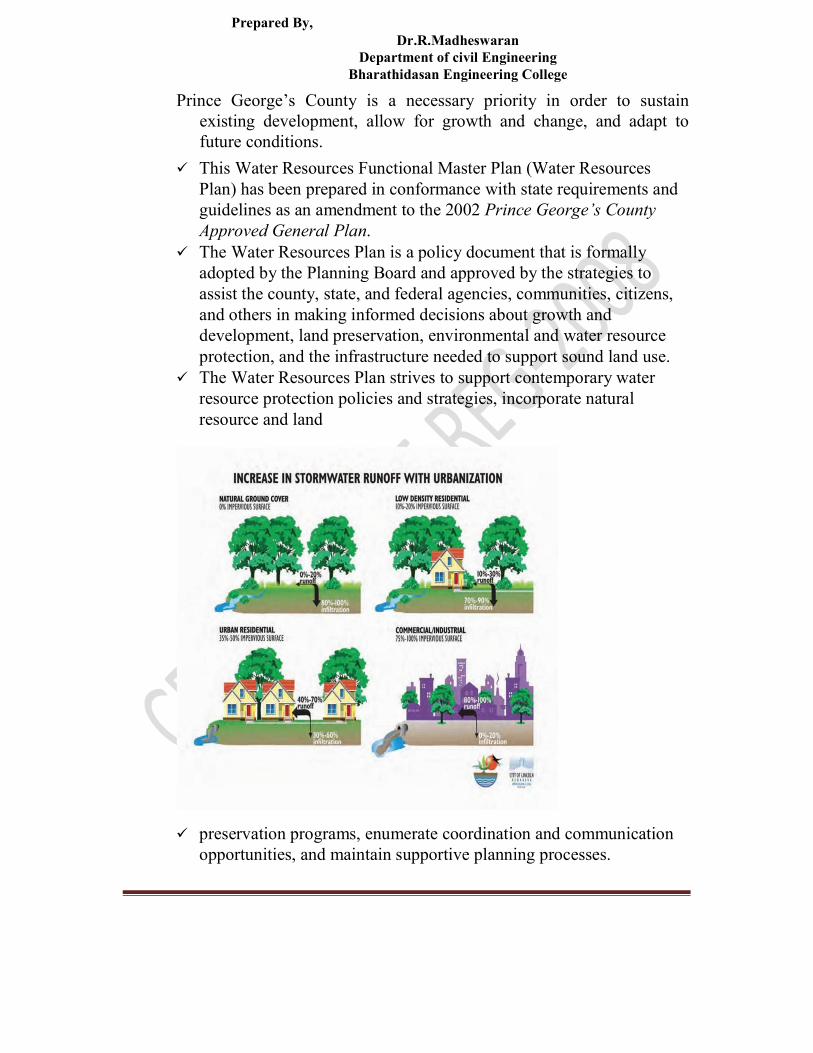
Prepared By, Dr.R.Madheswaran
Department of civil Engineering Bharathidasan Engineering College
Prince George’s County is a necessary priority in order to sustain existing development, allow for growth and change, and adapt to future conditions.
This Water Resources Functional Master Plan (Water Resources Plan) has been prepared in conformance with state requirements and guidelines as an amendment to the 2002 Prince George’s County Approved General Plan.
The Water Resources Plan is a policy document that is formally adopted by the Planning Board and approved by the strategies to assist the county, state, and federal agencies, communities, citizens, and others in making informed decisions about growth and development, land preservation, environmental and water resource protection, and the infrastructure needed to support sound land use.
The Water Resources Plan strives to support contemporary water resource protection policies and strategies, incorporate natural resource and land
preservation programs, enumerate coordination and communication opportunities, and maintain supportive planning processes.

Prepared By, Dr.R.Madheswaran
Department of civil Engineering Bharathidasan Engineering College
The plan was assembled to provide an assessment of the impacts of existing and future land use on county water resources, including drinking

Prepared By, Dr.R.Madheswaran Department of Civil Engineering Bharathidasan Engineering College
water and wastewater supply and demand capacities, and point source and nonpoint source impacts to streams and local tributaries.
Multiple resources were consulted including studies, research, and reports produced by federal, state, local, and nonprofit agencies that address water resource protection as policy, planning, programs, and partnerships.
The task of creating sustainable communities is daunting but achievable.
This plan organizes an approach to water resource sustainability that clarifies the county’s intent to prioritize water resource protection, identifies issues and regulations critical to water resource preservation and restoration, and provide a framework for establishing the criteria necessary to achieve and evaluate our success toward meeting this objective.
Community engagement reflected the draft proposed goals, concepts, and guidelines and the public participation program established at the initiation of the Water Resources Functional Master Plan by the County Planning Board and County Council in September and October 2008.
The public outreach process began with a countywide public forum on November 20, 2008, and culminated in a final public presentation on March 18, 2009.
Comments on, and inputs to, the draft plan recommendations were also received through focus groups, telephone surveys, and web page e-mails and surveys.
Public comment was summarized in writing and evaluated by staff to establish priority goals and plan recommendations.

Prepared By, Dr.R.Madheswaran Department of Civil Engineering Bharathidasan Engineering College
The Water Resources Plan has incorporated differing growth and
development directives into modeling scenarios to determine water quality impacts associated with development patterns. An ideal growth pattern was based on state smart growth policies, the county priority funding areas and proposed priority preservation areas.
The modeling decisions for the ideal growth pattern regarding land preservation, conservation, and growth boundaries reflect the policies of the Approved Countywide Green Infrastructure Plan and the 2008 Water and Sewer Plan.
The Water Resources Plan is intended to help inform planners, plan reviewers, permitting and implementation agencies, the county citizenry,
Prepared By, Dr.R.Madheswaran Department of Civil Engineering Bharathidasan Engineering College
and the development community to achieve and maintain healthy water resources for the current and future citizens of Prince George’s County.
It is the intent of this plan to advocate for smart growth strategies, to establish development capacities, to incorporate environmental site design, and preservation, conservation, and restoration programs into countywide growth policies in the interest of maintaining healthy and sufficient water resources for the county and its municipalities.
The Water Resources Plan broadly supports the General Plan, and its core policies and recommendations for the county to guide decisions about growth and development.
The Water Resources Plan promotes source and receiving water
protection and use and demand management of water resources.
Through conservation and efficiency recommendations, this plan
establishes achievable sustainability goals for water resources in Prince
George’s County.
Public drinking water availability has been

Prepared By, Dr.R.Madheswaran Department of Civil Engineering Bharathidasan Engineering College
PLAN PURPOSE The purpose of the Water Resources Plan is to evaluate existing
growth and anticipated future development and consider any impacts to, and demands on, water resources, drinking water, wastewater, and stormwater.
The Water Resources Plan provides growth guidance expressed as goals, policies, and strategies to address water quality impacts associated with land use in the county.
The creation of this Water Resources Plan will assure that the Prince George’s County’s General Plan fully integrates water resource issues
and planning solutions into its overall mission and addresses the relationship between planned growth and the area’s water resource demands and capacities.

Prepared By, Dr.R.Madheswaran Department of Civil Engineering Bharathidasan Engineering College
This Water Resources Plan shows how drinking water supplies,
wastewater effluents, and stormwater runoff can be anticipated and
managed to support planned and existing growth.
Water resource limitations include finite source water supplies and
thresholds on wastewater and stormwater discharge based on the
assimilative capacity of the receiving watersheds.
The identification of limitations and/or opportunities in the planning
process ensures that the Water Resources Plan is realistic and
environmentally
The purpose of the Water Resources Plan is to: Ensure a safe and ample supply of drinking water from both surface
and groundwater sources and adequate treatment of wastewater. Minimize the nutrient loading impacts to our groundwater, streams,
rivers, and the Chesapeake Bay from the uses we employ on our land. Improve data collection and promote a watershed planning process to
achieve a desirable balance of sustainable growth and preservation of the Chesapeake Bay.
Provide water resources data that can be transparently interpreted to establish growth area boundaries, inform land-use recommendations, and target preservation/ conservation/restoration areas.
Drinking Water Supply—Production capacity of drinking water supply facilities; protection of source waters, headwaters, aquifers, and the quality and quantity of receiving waters; water appropriation permit limits; and drinking water resource availability during drought.
Wastewater Treatment—Treatment and allowable discharge capacity of wastewater systems; wastewater management through alternate distribution technologies; inspection and maintenance of existing and proposed public and private wastewater systems; location and implementation of advanced wastewater treatment septic systems; expansion or restriction of public sewer systems; and prevention of public sewer overflows and wastewater treatment system failures.
Stormwater Management—Current and proposed stormwater management systems and practices; water quality protection in receiving waters, headwaters, wetlands, aquifers and groundwater; stream morphology, ecosystems, woodlands and tree canopy preservation and restoration; policy support and implementation
Prepared By, Dr.R.Madheswaran Department of Civil Engineering Bharathidasan Engineering College
strategies for environmental site design; support for conservation, preservation, and restoration programs; and community engagement and education to maintain and/or improve water quality.
CE 6703 WATER RESOURCES ENGINEERING UNIT IV RESERVOIR PLANNING AND MANAGEMENT
Reservoir - Single and multipurpose – Multi objective - Fixation of Storage capacity Strategies for reservoir operation - Sedimentation of reservoirs - Design flood-levees and flood walls - Channel improvement.
Reservoir
INTRODUCTION In the process of illustrating the primary functions of a
reservoir engineer, namely, the estimation of hydrocarbons in place, the calculation of a recovery factor and the attachment of a time scale to the recovery; this chapter introduces many of the fundamental concepts in reservoir engineering.
The description of the calculation of oil in place concentrates largely on the determination of fluid pressure regimes and the problem of locating fluid contacts in the reservoir.
Primary recovery is described in general terms by considering the significance of the isothermal compressibility of the reservoir fluids; while the determination of the recovery factor and attachment of a time scale are illustrated by describing volumetric gas reservoir engineering.
The chapter finishes with a brief quantitative account of the phase behavior of multi-component hydrocarbon systems.
Operation of system of reservoirs

Prepared By, Dr.R.Madheswaran Department of Civil Engineering Bharathidasan Engineering College
It is not very uncommon to find a group or „system‟ of reservoirs either in a single river or in a river and its tributaries. An example of the former are the dams proposed on the river Narmada (Figure 7) and an example of the latter are the dams of the Dam odor Valley project (Figure 8).
In case of system of reservoirs, it is necessary to adopt a strategy for integrated operated of reservoirs to achieve optimum utilization of the water resources available and to benefit the best out of the reservoir system.
In the preparation of regulation plans for an integrated operation of system of reservoirs, principles applicable to separate units are first applied to the individual reservoirs.
Modifications of schedule so developed should then be considered by working out several alternative plans. In these studies optimization and simulation techniques
may be extensively used with the application of computers in water resources

Prepared By, Dr.R.Madheswaran Department of Civil Engineering Bharathidasan Engineering College
VOLUMETRIC GAS RESERVOIR ENGINEERING
Volumetric gas reservoir engineering is introduced at this
early stage in the book because of the relative simplicity of the subject.
lt will therefore be used to illustrate how a recovery factor can be determined and a time scale attached to the recovery.
The reason for the simplicity is because gas is one of the few substances whose state,
development

Prepared By, Dr.R.Madheswaran Department of Civil Engineering Bharathidasan Engineering College
as defined by pressure, volume and temperature (PVT), can be described by a
simple relation involving all three parameters. One other such substance is saturated steam, but for oil containing dissolved gas, for instance, no such relation exists and, as shown in Chapter 2, PVT parameters must be empirically derived which serve the purpose of defining the state of the mixture.
RESERVOIR DRIVE MECHANISMS If none of the terms in the material balance equation can be
neglected, then the reservoir can be described as having a combination drive in which all possible
sources of energy contribute a significant part in producing the reservoir fluids and
determining the primary recovery factor.
In many cases, however, reservoirs can be singled out as having predominantly one main type of drive mechanism in comparison to which all other mechanisms have a negligible effect.
In the following sections, such reservoirs will be described in order to isolate and study the contribution of the individual components in the material balance in influencing the recovery factor and determining the production policy of the field.
The mechanisms which will be studied are: - solution gas drive - gas cap drive - natural water drive - compaction drive
And these individual reservoir drive mechanisms will be investigated in terms of:
reducing the material balance to a compact form, in many cases using the technique of Helena and Odeh, in order to quantify reservoir performance
MATERIAL BALANCE APPLIED TO OIL RESERVOIRS
Prepared By, Dr.R.Madheswaran Department of Civil Engineering Bharathidasan Engineering College
- determining the main producing characteristics, the producing gas oil ratio and water cut
- determining the pressure decline in the reservoir - estimating the primary recovery factor - investigating the possibilities of increasing the primary
recovery. Single Purpose Reservoirs
The common principles of single purpose reservoir operation are given below:
a) Flood control- Operation of flood control reservoirs is primarily governed by the available flood storage capacity of damage centers to be protected, flood characteristics, ability and accuracy of flood/ storm forecast and size of the uncontrolled drainage area. A regulation plan to cover all the complicated situations may be difficult to evolve, but generally it should be possible according to one of the following principles:
1) Effective use of available flood control storage: Operation under this principle aims at reducing flood damages of the locations to be protected to the maximum extent possible, by effective use of flood event. Since the release under this plan would obviously be lower than those required for controlling the reservoir design flood, there is distinct possibility of having a portion of the flood control space occupied during the occurrence of a subsequent heavy flood. In order to reduce this element of risk, maintenance of an adequate network of flood forecasting stations both in the upstream and down stream areas would be absolutely necessary.
2) Control of reservoir design flood: According to this principle, releases from flood control reservoirs operated on this concept are made on the same hypothesis as adopted for controlling the reservoir design flood, that is the full storage capacity would be utilized only when the flood develops into the reservoir design flood. However, as the design flood is usually an extreme event, regulation of minor and major floods, which occur more often, is less satisfactory when this method is applied.
3) Combination of principle (1) and (2): In this method, a combination of the principles (1) and (2) is followed. The principle (1) is followed for the lower portion of the flood reserve to achieve the maximum benefits by controlling the earlier part of the flood. Thereafter releases are made as scheduled for the reservoir design flood as in

Prepared By, Dr.R.Madheswaran Department of Civil Engineering Bharathidasan Engineering College
principle (2). In most cases this plan will result in the best overall regulation, as it combines the good points of both the methods.
4) Flood control in emergencies: It is advisable to prepare an emergency release schedule that uses information on reservoir data immediately available to the operator. Such schedule should be available with the operator to enable him to comply with necessary precautions under extreme flood conditions.
b) Conservation: Reservoirs meant for augmentation of supplies during lean period should usually be operated to fill as early as possible during filling period, while meeting the requirements. All water in excess of the requirements of the filling period shall be impounded. No spilling of water over the spillway will normally be permitted until the FRL is reached. Should any flood occur when the reservoir is at or near the FRL, release of flood waters should be affected, so as not to exceed the discharge that would have occurred had there been no reservoir. In case the year happens to be dry, the draft for filling period should be curtailed by applying suitable factors. The depletion period should begin thereafter. However, in case the reservoir is planned with carry-over capacity, it is necessary to ensure that the regulation will provide the required carry-over capacity at the end of the depletion period.
Operation of multi purpose reservoirs: The general principles of operation of reservoirs with these multiple storage spaces are described below:
1. Separate allocation of capacities- When separate allocations of capacity have been made for each of the conservational uses, in addition to that required for flood control, operation for each of the function shall follow the principles of respective functions. The storage available for flood control could, however be utilized for generation of secondary power to the extent possible. Allocation of specific storage space to several purposes with the conservation zone may some times be impossible or very costly to provide water for the various purposes in the quantities needed and at the time they are needed.
2. Joint use of storage space- In multi-purpose reservoir where joint use of some of the storage space or storage water has been envisaged, operation becomes complicated due to competing and conflicting demands. While flood control requires low reservoir level, conservation interests require as high a level as is attainable. Thus, the objectives of these functions are not compatible and a compromise will have to be
Prepared By, Dr.R.Madheswaran Department of Civil Engineering Bharathidasan Engineering College
effected in flood control operations by sacrificing the requirements of these functions. In some cases parts of the conservational storage space is utilized for flood moderation, during the earlier stages of the monsoon. This space has to be filled up for conservation purpose towards the end of monsoon progressively, as it might not be possible to fill up this space during the post-monsoon periods, when the flows are insufficient even to meet the current requirements. This will naturally involve some sacrifice of the flood control interests towards the end of the monsoon
Multipurpose reservoirs
Water supply Flood control Soil erosion Environmental management
Hydroelectric power generation Navigation Recreation
Irrigation
The multipurpose nature of these facilities dictates that the agencies which manage them are responsible for balancing competing demands.
For example, managers responsible for hydroelectric power generation often want to keep lake levels as high as possible, since the water stored in the reservoir serves as a kind of "fuel" for their generators.
However, managers responsible for flood control often want to keep lake levels as low as possible to provide the maximum amount of storage capacity for rainwater runoff.
Water supply Water supply is the provision of water by public utilities,
commercial organizations, community endeavors or by individuals, usually via a system of pumps and pipes.
Prepared By, Dr.R.Madheswaran Department of Civil Engineering Bharathidasan Engineering College
Irrigation is covered separately.
Flood control
Floods are caused by many factors: heavy rainfall, highly
accelerated snowmelt, severe winds over water, unusual high
tides, tsunamis, or failure of dams, levees, retention ponds, or
other structures that retained the water.
Flooding can be exacerbated by increased amounts of
impervious surface or by other natural hazards such as
wildfires, which reduce the supply of vegetation that can absorb
rainfall.
Periodic floods occur on many rivers, forming a surrounding
region known as the flood plain.
During times of rain, some of the water is retained in ponds or
soil, some is absorbed by grass and vegetation, some
evaporates, and the rest travels over the land as surface runoff.
Floods occur when ponds, lakes, riverbeds, soil, and vegetation
cannot absorb all the water. Water then runs off the land in
quantities that cannot be carried within stream channels or
retained in natural ponds, lakes, and man-made reservoirs.
About 30 percent of all precipitation becomes runoff and that
amount might be increased by water from melting snow.
River flooding is often caused by heavy rain, sometimes increased by melting snow.
A flood that rises rapidly, with little or no advance warning, is called a flash flood.
Flash usually result from intense rainfall over a relatively small
area, or if the area was already saturated from previous
precipitation.
Soil erosion

Prepared By, Dr.R.Madheswaran Department of Civil Engineering Bharathidasan Engineering College
In geomorphology and geology, erosion refers to the actions of
exogamic processes (such as water flow or wind) which remove
soil and rock from one location on the Earth's crust, then
transport it to another location where it is deposited.
Eroded sediment may be transported just a few millimeters, or
for thousands of kilometers.
While erosion is a natural process, human activities have
increased by 10-40 times the rate at which erosion is occurring
globally.
Excessive (or accelerated) erosion causes both 'on-site' and 'off-site' problems.
On-site impacts include decreases in agricultural and (on
natural landscapes) ecological collapse, both because of loss of
the nutrient-rich upper soil layers. In some cases, the eventual
end result is desertification.
Off-site effects include sedimentation of waterways and
eutrophication of water bodies, as well as sediment-related
damage to roads and houses.
Water and wind erosion are now the two primary causes of land
degradation; combined, they are responsible for about 84% of
the global extent of degraded, making excessive erosion one of
the most significant environmental problems worldwide.
Intensive agriculture, deforestation, roads, anthropogenic
climate change and urban sprawl are amongst the most
significant human activities in regard to their effect on
stimulating erosion.
However, there are many remediation practices that can curtail
or limit erosion of vulnerable soils.
Environmental resource management

Prepared By, Dr.R.Madheswaran Department of Civil Engineering Bharathidasan Engineering College
Environmental resource management is the management of the
interaction and impact of human societies on the environment.
It is not, as the phrase might suggest, the management of the environment itself.
Environmental resources management aims to ensure that
ecosystem services are protected and maintained for future
human generations, and also maintain ecosystem integrity
through considering ethical, economic, and scientific
(ecological) variables.
Environmental resource management tries to identify factors
affected by conflicts that rise between meeting needs and
protecting resources.
It is thus linked to protection and sustainability.
Hydroelectricity
Hydroelectricity is the term referring to electricity generated by
hydropower; the production of electrical power through the use
of the gravitational force of falling or flowing water.
It is the most widely used form of renewable, accounting for 16
percent of global electricity generation – 3,427 terawatt-hours
of electricity production in 2010, and is expected to increase
about 3.1% each year for the next 25 years.
Hydropower is produced in 150 countries, with the Asia-Pacific
region generating 32 percent of global hydropower in 2010.
China is the largest hydroelectricity producer, with 721
terawatt-hours of production in 2010, representing around 17
percent of domestic electricity use.
There are now four hydroelectricity plants larger than 10 GW: the Three
Gorges Dam and Xiluodu Dam in China, Itapúa Dam across the

Prepared By, Dr.R.Madheswaran Department of Civil Engineering Bharathidasan Engineering College
Brazil/Paraguay border, and Guru Dam in Venezuela.[1]
The cost of hydroelectricity is relatively low, making it a
competitive source of renewable electricity.
The average cost of electricity from a hydro plant larger than 10 megawatts is
3 to 5 U.S. cents per kilowatt-hour. It is also a flexible source of electricity
since the amount produced by the plant can be changed up
or down very quickly to adapt to changing energy
demands.
However, damming interrupts the flow of rivers and can harm
local ecosystems, and building large dams and reservoirs often
involves displacing people and wildlife.
Once a hydroelectric complex is constructed, the project
produces no direct waste, and has a considerably lower output
level of the greenhouse gas carbon dioxide (CO
2) than fossil fuel powered energy plants.
Navigation
Navigation is a field of study that focuses on the process of
monitoring and controlling the movement of a craft or vehicle
from one place to another.
The field of navigation includes four general categories: land
navigation, marine navigation, aeronautic navigation, and space
navigation.
It is also the term of art used for the specialized knowledge used
by navigators to perform navigation tasks.
All navigational techniques involve locating the navigator's
position compared to known locations or patterns.
Navigation, in a broader sense, can refer to any skill or study
that involves the determination of position and direction.

Prepared By, Dr.R.Madheswaran Department of Civil Engineering Bharathidasan Engineering College
In this sense, navigation includes orienteering and pedestrian navigation.
For information about different navigation strategies that people
use, visit human navigation.
Irrigation
Irrigation is the artificial application of water to the land or soil.
It is used to assist in the growing of agricultural crops,
maintenance of landscapes, and re-vegetation of disturbed soils
in dry areas and during periods of inadequate rainfall.
Additionally, irrigation also has a few other uses in crop
production, which include protecting plants against frost,
suppressing weed growth in grain fields and preventing soil
consolidation.
In contrast, agriculture that relies only on direct rainfall is
referred to as rainfed or dry land farming.
Irrigation systems are also used for dust suppression, disposal
of sewage, and in mining.
Irrigation is often studied together with drainage, which is the
natural or artificial removal of surface and sub-surface water
from a given area.
Irrigation has been a central feature of agriculture for over 5000
years, and was the basis of the economy and society of
numerous societies, ranging from Asia to Arizona.
Channel improvement.
At the diversion structure, a headwork regulates the flow into a canal.
This canal, which takes its supplies directly from the river, is called the main canal and usually direct irrigation from the waters of this canal is not carried out.

Prepared By, Dr.R.Madheswaran Department of Civil Engineering Bharathidasan Engineering College
This acts as a feeder channel to the branch canals, or branches.
3
Branch canals generally carry a discharge higher than 5 m /s and acts as feeder
3 channel for major distributaries which, in turn carry 0.25 to 5 m /s of discharge.
The major distributaries either feed the water courses or the minor distributaries,
3 which generally carry discharge less than 0.25 m /s.
Though irrigation canals may be constructed in natural or compacted earth, these suffer from certain disadvantages, like the following
• Maximum velocity limited to prevent erosion • Seepage of water into the ground • Possibility of vegetation growth in banks, leading to
increased friction • Possibility of bank failure, either due to erosion or
activities of burrowing animals
All these reasons lead to adoption of lining of canals, though the cost may be prohibitive.
Hence, before suggesting a possible lining for a canal, it is necessary to evaluate the cost vis-à-vis the savings due to reduction in water loss through seepage.
Apart from avoiding all the disadvantages of an unlined canal, a lined canal also has the advantage of giving low resistance and thus reducing the frictional loss and maintaining the energy and water surface slopes for the canal as less as possible. This is advantageous as it means that the canal slope may also be smaller, to maintain the same discharge than for a canal with higher friction loss. A smaller canal slope means a larger command area.

Prepared By, Dr.R.Madheswaran Department of Civil Engineering Bharathidasan Engineering College
Fixation of Storage capacity
Instructional objectives On completion of this lesson, the student shall learn:
1. The usual classification of the zones of a reservoir 2. The primary types of reservoirs and their functions 3. The steps for planning reservoirs 4. Effect of sedimentation in reservoirs 5. What are the geological explorations required to be
carried out for reservoirs 6. How to determine the capacities of reservoirs 7. How to determine the dead, live and flood storages of
reservoirs 8. How to reduce the loss of water from reservoirs 9. How to control sedimentation of reservoirs 10. The principles to be followed for reservoir operations
Introduction

Prepared By, Dr.R.Madheswaran Department of Civil Engineering Bharathidasan Engineering College
Water storage reservoirs may be created by constructing a dam across a river, along with suitable appurtenant structures. How ever, in that lesson not much was discussed about fixing the size of reservoir based on the demand for which it is being constructed.
Further, reservoirs are also meant to absorb a part of flood water and the excess is discharged through a spillway.
It is also essential to study the relation between flood discharge, reservoirs capacity and spillway size in order to propose an economic solution to the whole project.
These and topics on reservoir sedimentation have been discussed in this lesson which shall give an idea as to how a reservoir should be built and optimally operated.
Fundamentally, a reservoir serves to store water and the size of the reservoir is governed by the volume of the water that must be stored, which in turn is affected by the variability of the inflow available for the reservoir.
Reservoirs are of two main categories: (a) Impounding reservoirs into which a river flows naturally, and (b) Service or balancing reservoirs receiving supplies that are pumped or channeled into them artificially.
In general, service or balancing reservoirs are required to balance supply with demand. Reservoirs of the second type are relatively small in volume because the storage required by them is to balance flows for a few hours or a few days at the most.
Impounding or storage reservoirs are intended to accumulate a part of the flood flow of the river for use during the non-flood months.
In this lesson, our discussions would be centered on these types of reservoirs
Reservoir storage zone and uses of reservoir The storage capacity in a reservoir is nationally divided into three or four parts (Figure 1) distinguished by corresponding levels.

Prepared By, Dr.R.Madheswaran Department of Civil Engineering Bharathidasan Engineering College
Full Reservoir Level (FRL): It is the level corresponding to the storage which includes both inactive and active storages and also the flood storage, if provided for. In fact, this is the highest reservoir level that can be maintained without spillway discharge or without passing water downstream through sluice ways.
Minimum Drawdown Level (MDDL): It is the level below which the reservoir will not be drawn down so as to maintain a minimum head required in power projects.
Dead Storage Level (DSL): Below the level, there are no outlets to drain the water in the reservoir by gravity.
Maximum Water Level (MWL): This id the water level that is ever likely to be attained during the passage of the design flood. It depends upon the specified initial reservoir level and the spillway gate operation rule. This level is also called sometimes as the Highest Reservoir Level or the Highest Flood Level.
Live storage: This is the storage available for the intended purpose between Full Supply Level and the Invert Level of the lowest discharge outlet. The Full Supply Level is normally that level above which over spill to waste

Prepared By, Dr.R.Madheswaran Department of Civil Engineering Bharathidasan Engineering College
would take place. The minimum operating level must be sufficiently above the lowest discharge outlet to avoid vortex formation and air entrainment. This may also be termed as the volume of water actually available at any time between the Dead Storage Level and the lower of the actual water level and Full Reservoir Level. Dead storage: It is the total storage below the invert level of the lowest discharge outlet from the reservoir. It may be available to contain sedimentation, provided the sediment does not adversely affect the lowest discharge.
Outlet Surcharge or Flood storage: This is required as a reserve between Full Reservoir Level and the Maximum Water level to contain the peaks of floods that might occur when there is insufficient storage capacity for them below Full Reservoir Level.
Some other terms related to reservoirs are defined as follows: Buffer Storage: This is the space located just above the Dead Storage Level
up to Minimum Drawdown Level. As the name implies, this zone is a buffer between the active and dead storage zones and releases from this zone are made in dry situations to cater for essential requirements only. Dead Storage and Buffer Storage together is called Interactive Storage.
Within-the-Year Storage: This term is used to denote the storage of a reservoir meant for meeting the demands of a specific hydrologic year used for planning the project.
Carry-Over Storage: When the entire water stored in a reservoir is not used up in a year, the unused water is stored as carry-over storage for use in subsequent years.
Silt / Sedimentation zones: The space occupied by the sediment in the reservoir can be divided into separate zones. A schematic diagram showing these zones is illustrated in Figure 2 (as defined in IS: 5477).

Prepared By, Dr.R.Madheswaran Department of Civil Engineering Bharathidasan Engineering College
Freeboard: It is the margin kept for safety between the level at which the
dam would be overtopped and the maximum still water level. This is required to allow for settlement of the dam, for wave run up above still water level and for unforeseen rises in water level, because of surges resulting from landslides into the reservoir from the peripheral hills, earthquakes or unforeseen floods or operational deficiencies.
The functions of reservoirs are to provide water for one or more of the following purposes. Reservoirs that provide water for a combination of these purpose, are termed as „Multi Purpose‟ reservoirs.
Human consumption and/or industrial use:
• Irrigation: usually to supplement insufficient rainfall.
• Hydropower: to generate power and energy whenever water is available or to provide reliable supplies of power and energy at all times when needed to meet demand.
• Pumped storage hydropower schemes: in which the water flows
from an upper to a lower reservoir, generating power and energy at times of high demand through turbines, which may be reversible,
Prepared By, Dr.R.Madheswaran Department of Civil Engineering Bharathidasan Engineering College
and the water is pumped back to the upper reservoir when surplus energy is available. The cycle is usually daily or twice daily to meet peak demands. Inflow to such a reservoir is not essential, provided it is required to replace water losses through leakage and evaporation or to generate additional electricity. In such facilities, the power stations, conduits and either or both of the reservoirs could be constructed underground if it was found to do so.
• Flood control: storage capacity is required to be maintained to
absorb foreseeable flood inflows to the reservoirs, so far as they would cause excess of acceptable discharge spillway opening. Storage allows future use of the flood water retained.
• Amenity use: this may include provision for boating, water sports,
fishing, sight seeing. Formally, the Bureau of Indian Standards code IS: 4410 (part 6)1983
“Glossary of terms relating to river valley projects -Reservoirs" defines the following types of reservoirs:
• Auxiliary or Compensatory Reservoir: A reservoir which supplements and absorbed the spill of a main reservoir.
• Balancing Reservoirs: A reservoir downstream of the main reservoir for holding water let down from the main reservoir in excess of that required for irrigation, power generation or other purposes.
• Conservation Reservoir: A reservoir impounding water for useful purposes, such as irrigation, power generation, recreation, domestic, industrial and municipal supply etc.
• Detention Reservoir: A reservoir where in water is stored for a relatively brief period of time, past of it being retained until the stream can safely carry the ordinary flow plus the released water. Such reservoirs usually have outlets without control gates and are used for flood regulation. These reservoirs are also called as the Flood Control Reservoir or Retarding Reservoir.
• Distribution Reservoir: A reservoir connected with distribution system a water supply project, used primarily to care for fluctuations in demand which occur over short periods and as local storage in case of emergency such as a break in a main supply line failure of a pumping plant.
• Impounding or Storage Reservoir: A reservoir with gate-controlled outlets wherein surface water may be retained for a considerable
Prepared By, Dr.R.Madheswaran Department of Civil Engineering Bharathidasan Engineering College
period of time and released for use at a time when the normal flow of the stream is in sufficient to satisfy requirements.
• Multipurpose Reservoir: A reservoir constructed and equipped to provide storage and
release of water for two or more purposes such as irrigation, flood control, power generation, navigation, pollution abatement, domestic and industrial water supply, fish culture, recreation, etc.
It may be observed that some of these objectives may be incompatible in combination.
For example, water may has to be released for irrigation to suit crop growing seasons, while water releases for hydropower are required to suit the time of public and industrial demands.
The latter will be affected not only by variations in economic conditions but also by variations over a day and night cycle.
Compatibility between irrigation demand and flood control strategy in operating a reservoir is even more difficult for a reservoir which intends to serve both, like the Hirakud Dam reservoir on the river Mahanadi.
Flood wave moderation requires that the reservoir be emptied as much as possible so that it may absorb any incoming flood peak.
However, this decision means reducing the water stored for irrigation. Usually, such a reservoir would be gradually emptied just before the arrival of monsoon rains, anticipating a certain flood and hoping that the reservoir would be filled to the brim at the end of the flood season.
However, this anticipation may not hold good for all years and the reservoir does not get filled up to the optimal height. On the other hand, if the reservoir is not depleted sufficiently well, and actually a flood of high magnitude arrives, then the situation may lead to the flood inundations on the downstream.
Sedimentation of reservoirs

Prepared By, Dr.R.Madheswaran Department of Civil Engineering Bharathidasan Engineering College
It is important to note that storage reservoirs built across rivers and streams loose their capacity on account of deposition of sediment.
This deposition which takes place progressively in time reduces the active capacity of the reservoir to provide the outputs of water through passage of time.
In this regard, the Bureau of Indian Standard code IS: 12182 - 1987 “Guidelines for determination of effects of sedimentation in planning and performance of reservoir” is an important document which discusses some of the aspects of sedimentation that have to be considered while planning reservoirs.
Some of the important points from the code are as follows: While planning a reservoir, the degree of seriousness and the
effect of sedimentation at the proposed location has to be judged from studies, which normally combination consists of:
1. Performance Assessment (Simulation) Studies with varying rate of sedimentation.
2. Likely effects of sedimentation at dam face.
In special cases, where the effects of sedimentation on backwater levels are likely to be significant, backwater studies would be useful to understand the size of river water levels.
Similarly, special studies to bring out delta formation region changes may be of interest. The steps to be followed for performance assessment studies with varying rates of sedimentation are as follows:
a. Estimation of annual sediment yields into the reservoir or the average annual sediment yield and of trap efficiency expected.
b. Distribution of sediment within reservoir to obtain a sediment elevation and capacity curve at any appropriate time.
c. Simulation studies with varying rates of sedimentation. d. Assessment of effect of sedimentation.
In general, the performance assessment of reservoir projects has to
be done for varying hydrologic inputs to meet varying demands.

Prepared By, Dr.R.Madheswaran Department of Civil Engineering Bharathidasan Engineering College
Although analytical probability based methods are available to some extent, simulation of the reservoir system is the standard method.
The method is also known as the working tables or sequential routing. In this method, the water balance of the reservoir s and of other specific locations of water use and constraints in the systems are considered.
All inflows to and outflows from the reservoirs are worked out to decide the changed storage during the period.
In simulation studies, the inflows to be used may be either historical inflow series, adjusted for future up stream water use changes or an adjusted synthetically generated series.
Control of sedimentation in reservoirs Sedimentation of a reservoir is a natural phenomenon and is a
matter of vital concern for storage projects in meeting various demands, like irrigation, hydroelectric power, flood control, etc.
Since it affects the useful capacity of the reservoir based on which projects are expected to be productive for a design period.
Further, the deposited sediment adds to the forces on structures in dams, spillways, etc.
The rate of sedimentation will depend largely on the annual sediment load carried by the stream and the extent to which the same will be retained in the reservoir.
This, in turn, depends upon a number of factors such as the area and nature of the catchment, level use pattern (cultivation practices, grazing, logging, construction activities and conservation practices), rainfall pattern, storage capacity, period of storage in relation to the sediment load of the stream, particle size distribution in the suspended sediment, channel hydraulics, location and size of sluices, outlet works, configuration of the reservoir, and the method and purpose of releases through the dam.
Therefore, attention is required to each one of these factors for the efficient control of sedimentation of reservoirs with a view to enhancing their useful life and some of these methods are discussed in the Bureau of Indian Standard code IS: 6518-1992 “Code of practice for control of sediment in reservoirs”.
In this section, these factors are briefly discussed.

Prepared By, Dr.R.Madheswaran Department of Civil Engineering Bharathidasan Engineering College
There are different techniques of controlling sedimentation in reservoirs which may broadly be classified as follows:
• Adequate design of reservoir • Control of sediment inflow • Control of sediment deposition • Removal of deposited sediment. Strategies for reservoir
operation The flow in the river changes seasonally and from year to year, due
to temporal and spatial variation in precipitation.
Thus, the water available abundantly during monsoon season
becomes scarce during the non-monsoon season, when it is most needed.
The traditional method followed commonly for meeting the needs of water during the scarce period is construction of storage reservoir on
the river course.
The excess water during the monsoon season is stored in such reservoirs for eventual use in lean period.
Construction of storages will also help in control of flood, as well as generation of electricity power.
To meet the objective set forth in planning a reservoir or a group of reservoirs and to achieve maximum benefits out of the storage created, it is imperative to evolve guidelines for operation of reservoirs.
Without proper regulation schedules, the reservoir may not meet the full objective for which it was planned and may also pose danger to the structure itself.
Control of flood is better achieved if the reservoir level is kept low in the early stages of the monsoon season.
However, at a later stage, if the anticipated inflows do not result the reservoir may not get filled up to FRL in the early stages of monsoon, to avoid the risk of reservoir remaining unfilled at later stage, there may be problem of accommodating high floods occurring at later stage.

Prepared By, Dr.R.Madheswaran Department of Civil Engineering Bharathidasan Engineering College
In some cases while planning reservoirs, social and other considerations occasionally result in adoption of a plan that may not be economically the best. Levees and Floodwalls
Levees and floodwalls are barriers that hold back floodwaters. A levee is constructed of compacted soil and requires more land
area. Floodwalls are built of manmade materials, such as concrete and
masonry. These structures may completely surround the building or may tie
into high ground at each end. If openings are left for the driveway and/or sidewalk, closures must be installed to seal these access points prior to a flood.
Applicability Because levees and floodwalls are located away from the structure or area to
be protected, they provide flood protection without altering the building.
Flood hazard:
Although levees and floodwalls can be built to any height, they are usually limited to four feet for floodwalls and six feet for levees (due to cost, aesthetics, access, water pressure, and space).
The structure should be built at least one foot higher than the anticipated flood depth (freeboard protection).
No matter how high the barrier is, it can always be overtopped by a larger flood, which would cause as much damage as if no
protection were provided (or more). In areas with high velocity flow, erosion protection may be necessary to protect an earthen
levee or prevent undermining of a floodwall. Flash flooding precludes the use of closures that require
human intervention to install. If flooding lasts more than 3 to 4 days, seepage is more likely to pose problems.
Site requirements:
A levee or floodwall is not feasible if it would impede flow or block natural drainage in amanner that results in damage to surrounding property.

Prepared By, Dr.R.Madheswaran Department of Civil Engineering Bharathidasan Engineering College
Considerable horizontal space is required for levees; floodwalls are generally more appropriate for small sites.
The underlying soil must support the levee or floodwall and resist seepage of water under the structure.
Building characteristics:
A house with a basement can still experience flood damage even if a levee or floodwater protects the structure from surface water.
Saturated soil can exert hydrostatic pressure on basement walls, causing them to crack, buckle, or event collapse.
Access:
Access to the structure can be enabled by providing a means of crossing over a levee or floodwall, such as a ramp or stairway.
If this is not feasible, it may be necessary to design openings at driveways, sidewalks, or other entrances and a mechanism for closing all such openings.
Designs that do not require human intervention are preferable. If a closure requires manual installation, the effectiveness of the flood protection system depends on the availability of a capable person who is aware of the flood threat and has sufficient time to install closures and make certain they are properly sealed.
Aesthetics:
The rounded outlines of an earthen levee can be shaped to blend into the natural landscape.
Floodwalls can be designed as attractive features by incorporating them into the landscape design and utilizing decorative bricks or blocks (although this will generally increase the cost).
Regulations: A levee or floodwall cannot be used to bring a substantially damaged or
substantially improved structure into compliance with current floodplain development standards.
Costs Depending on the availability of suitable local soil, levees may be
less expensive than other flood proofing options. However, if suitable fill material is not locally available, the
expense of transporting proper material to the site can be significant.

Prepared By, Dr.R.Madheswaran Department of Civil Engineering Bharathidasan Engineering College
The cost of floodwalls is usually greater than that of levees. Technique
s Leve
es: To be effective, a levee must be constructed with compacted,
impervious soils. The practice of piling stream sediment on the bank does not provide flood protection. The embankment slopes must be gentle (usually a ratio of one vertical to two or three horizontal) to provide adequate stability and minimize erosion.
The levee‟s width will thus be several times its height. Floodwalls:
Floodwalls are generally constructed of solid concrete (alone or in combination with masonry).
They must be designed to withstand water pressure without overturning or displacement.
Closures:
Mechanisms for closing access openings in a levee or floodwall include automated systems (usually expensive) or manually operated
flood gates, stop logs, or panels. There are often hinges or sliding mechanisms for installation. If the closure is not permanently attached, it must be stored in a
readily accessible location.
Any sewers or drain pipes passing through or under a floodwall or levee require closure valves to prevent backup and flooding inside the building and protected area.
Interior drainage:
Rain, snow melt, and seepage water must be removed from the protected side of a levee or floodwall using drains (with flap valves to prevent backflow during a flood) and a sump pump.
An emergency power source for the electric sump pump enables operation during a power outage.
Maintenance:

Prepared By, Dr.R.Madheswaran Department of Civil Engineering Bharathidasan Engineering College
Routine inspection enables identification and repair of problems while they are still minor.
Levees should be checked for signs of erosion, settlement, loss of vegetation, animal burrows, and trees.
Inspect floodwalls for cracking, spelling, or scour. Routine maintenance is needed to make sure that sump pumps,
valves, drain pipes, and closures operate properly. Advantages and Disadvantages of Levees and Floodwalls
Advantages Levees and floodwalls can protect a building and the surrounding
area from inundation without significant changes to the structure if the design flood level is not exceeded.
There is no pressure from floodwater to cause structural damage to the building.
These barriers are usually less expensive than elevating or relocating the structure.
Occupants do not have to leave the structure during construction. Disadvantages
This technique cannot be used to bring a substantially damaged or improved structure into compliance with floodplain development standards.
May violate floodplain development standards, particularly in floodway locations, by causing obstructed flow or in increased flood heights.
Failure or overtopping of a levee or floodwall results in as much damage as if there was no protection (or more).
May restrict access to the structure. If human intervention is required for closures, there must be adequate warning time.
May be expensive. For buildings with basements, hydrostatic pressure from
groundwater may still cause damage. Local drainage can be affected, possibly creating water problems
for others. Interior drainage must be provided. Levees require considerable land area. Require periodic maintenance. No reduction in flood insurance premiums. Do not eliminate the need to evacuate during floods.
Prepared By, Dr.R.Madheswaran Department of Civil Engineering Bharathidasan Engineering College
UNIT – 1 2 MARK QUESTIONS
1) Define irrigation?
2) What is the necessity of irrigation?
3) What is irrigation engineering?
4) What are the advantages of irrigation?
5) What are the disadvantages of irrigation?
6) What is the purpose of irrigation?
7) Define crop ratio?
8) What is meant by overlap allowance?
9) What are the types of irrigation?
10) What are the techniques of water distribution in the farms?
11) What is arid region?
12) Define wilting coefficient?
13) What is semi-arid region?

Prepared By, Dr.R.Madheswaran Department of Civil Engineering Bharathidasan Engineering College
14) What is crop period?
15) What is base period?
16) What is rotation period?
17) Define duty?
18) Define delta of a crop?
19) What are the factors on which duty depends?
20) Define irrigation efficiency?
21) What are the methods for improving duty?
22) What are kharif crops?
23) What are rabi crops?
24) What is called effective rainfall?
25) Define consumptive use of Water?
26) What are the Factors Affecting consumptive uses of water?
27) What is the gross command area and culturable command area?
28) What are the methods to measure the consumptive use of water?
29) Write some major irrigation projects in India?
30) Define saturation capacity and field capacity?
1
16 MARK QUESTIONS
1) Define Irrigation? What are the merits and demerits of irrigation?
2) Explain the Necessity and scope of Irrigation in India and List out some of the major water resources in India?
3) Define Duty? What are the factors affecting duty? How to improve duty?
4) Briefly explain about irrigation efficiencies?
5) Define consumptive use of water? Explain the Factors affecting consumptive use of Water?

Prepared By, Dr.R.Madheswaran Department of Civil Engineering Bharathidasan Engineering College
6) Explain the methods to measure the consumptive use of water?
7) With a neat sketch, explain the modes of applying water to Crops?
8) Explain the different types of flooding methods with a neat sketch?
9) Write a short note and factors affecting Duty, Delta and Base period?
10) Briefly explain about planning and development of irrigation project?
11) A water course has a culturable commanded area of 1200 hectares. The intensity of irrigation for crop A is 40% and for B is 35%, both the crops being Rabi crops. Crop A has a Kor period of 20 days and crop B has Kor period of 15 days. Calculate the discharge of the water if the depth for crop A is 10 cm and for B it is 16 cm.
12) Define the following:
G.C.A., C.C.A., Kor depth, kor period, outlet factor, capacity factor, nominal duty, open discharge, rabi and kharif crops.
2
UNIT – 2 IRRIGATION METHOD 2 MARK QUESTIONS 1) List some types of irrigation? 2) What do you mean by flow irrigation?

Prepared By, Dr.R.Madheswaran Department of Civil Engineering Bharathidasan Engineering College
3) Define lift irrigation. 4) Define perennial irrigation 5) Define inundation irrigation 6) Define direct
irrigation. 7) What do you meant by storage irrigation? 8) Define combined irrigation. 9) What are the types of canals? 10) What are the alignment canals? 11) Define tank irrigation? 12) What are the distribution systems of canal irrigation? 13) Define tank banks? 14) What is called alluvial soil? 15) What is called non-alluvial soil? 16) What is called watershed canal? 17) What is the other name for drip irrigation? 18) What is called sprinkler irrigation
system? 19) What is called borders? 20) What do you mean by uncontrolled and controlled flooding? 21) What are the basic requirements for adaptation of any irrigation method? 22) What do you mean by free flooding? 23) Where contour laterals are applicable? 24) Write about the advantages of furrow irrigation. 25) Under which favourable conditions the sub-surface irrigation is practiced? 26) Where sprinkler irrigation is more useful? 27) Write about the advantages of sprinkler irrigation. 28) What are the types of sprinkler system? 29) Write about the limitations of sprinkler irrigation. 30) Write about the
advantages of drip irrigation 31) Write about the disadvantages of drip irrigation
16 MARK QUESTIONS
1) Explain Canal Irrigation? What are the classifications of canal?
2) Why should lining be provided in canals? What are the merits and demerits of canal lining?
3) Write the different types of canal lining? Explain them? 4) Write a short note on Lift irrigation? Explain the pumps used for Lift irrigation?

Prepared By, Dr.R.Madheswaran Department of Civil Engineering Bharathidasan Engineering College
5) Write a short note on Tank irrigation and explain its type? 6) Explain the different types of flooding methods? 7) Explain in detail about sprinkler method of irrigation and how far it is suitable in
Indian conditions. 8) Write a note on drip irrigation? Explain the components of drip irrigation
system? 9) Write about the merits and demerits of Canal irrigation? 10) Write about the merits and demerits of tank irrigation? 11) Write about the merits and demerits of lift Irrigation? 12) Write about the advantages and disadvantages of drip irrigation system? 13) Write about the advantages and disadvantages of Sprinkler System? 14) Define surface irrigation. Why it is widely practiced method of irrigation? What
are the advantages and disadvantages of the method? 15) Compare drip irrigation and Sprinkler irrigation? UNIT-III
DIVERSION AND IMPOUNDING STRUCTURES 2 MARK QUESTIONS
1) Define diversion headwork. 2) Write about the purposes of diversion headwork. 3) Define weir.

Prepared By, Dr.R.Madheswaran Department of Civil Engineering Bharathidasan Engineering College
4) Define barrage. 5) What are the component parts of diversion headwork? 6) What is meant by canal escape? 7) Define dam. 8) Define stream line. 9) What are the types of dam? 10) Define gravity dam. 11) What are the forces acting on a gravity dam? (or) arch dam? 12) What is meant by arch dam? 13) What are the various types of earth dam? 14) What are the types of failure that occur during construction of earth dam? 15) Define tank. 16) Define tank sluice. 17) Define Percolation pond? 18) How will you select a site for a tank sluice? 19) Define spillway. 20) State diff types of spillways. 21) Limitations of blighs creep theory. 22) Write about the advantages of earth dam? 23) Write about the disadvantages of earth dam? 24) Write about the functions of scouring sluices. 25) What are the modes of failure in gravity dams? 26) Under what conditions gravity dam can be adopted?
16 MARK QUESTIONS
1) Write in detail about the component parts of diversion works.
2) Write about the types of weirs and Explain various components of weir? 3) Explain the causes of Failure in weir on permeable foundation and how to
overcome that? 4) Write in detail about the tank surplus works. 5) What are the causes of failure of Earth dam, Gravity dam and Earth dam and its
remedies? 6) Write about the factors affecting the selection of type of a dam.

Prepared By, Dr.R.Madheswaran Department of Civil Engineering Bharathidasan Engineering College
7) Write about the criteria for safe design of earth dam. 8) Describe the forces acting on a gravity dam. 9) Describe the forces acting on a arch dam? 10) What are the forces acting on a earth dam? 11) What are the types of dams and what are the comparative merits and demerits of
various types of dams? 12) Explain various types of spillways and types of gates used in spillways? 13) Explain in detail about Percolation pond and factors to be considered for a
percolation pond? UNIT – 4
CANAL IRRIGATION 2 MARK QUESTIONS
1. Classify the rivers. 2. What are the causes of meandering?
3. What are the objectives of river training works? 4. Classify the river training works.
5. Define groyne.
6. Classify the groynes.
7. Give an equation for silt factor.
8. Define critical velocity.
9. What is meant by regime channel?
10. What is meant by contour canal?
11. What is a ridge canal?
12. What are the classifications of canal alignment?
13. What is the need of canal drop?
14. What is the need of cross drainage work?
15. Differentiate aqueduct and canal siphon?

Prepared By, Dr.R.Madheswaran Department of Civil Engineering Bharathidasan Engineering College
16. What is super passage? 17. What is level crossing?
18. What is canal head work?
19. What is canal regulator?
20. What is river training works?
21. What is meandering of rivers?
1 16 MARK QUESTIONS
1. How are canals generally classified? Describe them briefly?
2. Explain the various considerations for alignment of a canal.
3. Why are canal falls necessary? Describe with sketch briefly the various types of
canal falls.
4. What are the types of cross drainage works? Describe them briefly with sketches.
5. What is the necessity of river training works? Describe different types of river training works?
6. What is meant by guide banks? What are their functions and effects?
7. Explain the methods to improve canal irrigation system?
Prepared By, Dr.R.Madheswaran Department of Civil Engineering Bharathidasan Engineering College
8. Explain briefly about the hydraulic design of cross drainage works?
9. Explain briefly about the hydraulic design of canal drops?
10. State the factors to be considered for the choice of a suitable type of cross drainage work?
2 UNIT – 5
IRRIGATION WATER MANAGEMENT 2 MARK QUESTIONS
1. What is meant by Productivity?
2. Define equity.
3. Write about the conjunctive use of water.
4. What is meant by short – term stability?

Prepared By, Dr.R.Madheswaran Department of Civil Engineering Bharathidasan Engineering College
5. Define long – term stability.
6. Write about the main components of soil reclamation.
7. Why a proper plan for operation & maintenance of irrigation system is necessary?
8. What is meant by water logging?
9. Write the methods used for controlling water logging?
10. Define 0n-farm water management.
11. What do you meant by water user association (WUA)?
12. What are the problems of irrigation management without participatory management?
13. What are the needs of optimization of irrigation water management?
14. How to minimize irrigation loss?
15. What is participatory irrigation system?
16. What are the factors to be considered during the selection of particular type of lining?
17. What are the main objectives of canal lining?
18. How can the water losses are controlled?
19. State the effects of water logging?
20. What are the benefits of Water use association?
Prepared By, Dr.R.Madheswaran Department of Civil Engineering Bharathidasan Engineering College
1 16 MARK QUESTIONS
1. Discuss the inadequacies of present – day canal irrigation management in India.
2. Describe the common criteria for judging the performance of an irrigation system.
3. Describe the evaluation of performance of canal irrigation systems.
4. What are the methods adopted for improving canal irrigation management? Explain in detail.
5. Briefly explain about on farm development works?
6. What are the various ways of ‘minimizing irrigation water losses’?
7. What kinds of participation are necessary for irrigation management activities?
8. What is the need for WUA?
9. What is the need for optimization of water use?
10. What is the need of water user’s association?

Prepared By, Dr.R.Madheswaran Department of Civil Engineering Bharathidasan Engineering College
DEPARTMENT OF CIVIL ENGINEERING
CE6703 - IRRIGATION ENGINEERING
PART A
1. Define the term Irrigation.
2. What is the necessity of irrigation?
3. Enumerate the possible disadvantages of irrigation.
4. What are the different types of duty and their units?
5. Define application efficiency. What is the major loss accounted for here?
6. What is base period?
7. How do you classify irrigation projects?
8. Define Field Capacity.
9. Distinguish between surface and subsurface irrigation.
10. What are the methods of irrigation?
PART B
1. Define irrigation. What is the necessity for irrigation and what are the advantages of direct and indirect benefits of irrigation?
2. Derive the relationship between ‘duty’, ‘delta’ and ‘base period’. What are the factors affecting duty?
3. Define consumptive use of water. How to estimate the consumptive use of water and explain two methods.
4. Explain in detail about Lift irrigation and Tank irrigation.

Prepared By, Dr.R.Madheswaran Department of Civil Engineering Bharathidasan Engineering College
5. Briefly explain about canal irrigation? Explain the distribution system of canal irrigation.