Catskill Forest Preserve Public Access Plan · the Catskill Parle, proposing opportunities to...
109
Catsldll· ,... New Department Environmental · . '· ·· · · · :E; Pataki, · . - John J.>. CahiUi CommJssioner \ : . . In Cooperation with New York State Department. of Transportation· ·
Transcript of Catskill Forest Preserve Public Access Plan · the Catskill Parle, proposing opportunities to...

Catsldll·
,... .~,.~~
New Yotk:Stat~ Department ~f Environmental Co~serirati.on · . '· ·· · · · :G~~ge :E; Pataki, Gov~mo:r· · . -
John J.>. CahiUi CommJssioner \ :
. .
In Cooperation with New York State Department. of Transportation· ·

atskill Forest r serve
Pub Ii ccess Plan
August 1999
New Yo:rk State Department of Environmental Conservation George E. Pataki, Governor John P. Cahill, Commissioner ·-~-
Cooperation with New Yo:rk State Department of Transportation
GEORGE E. PATAKI
GOVERNOR STATE Of' NEW YORK
IDll!:i"'A11'11TMIENT Oil" IENVllllONMll!:NTAL CONSl!!:lllVATION
ALllllAN'f, NEW YO~K, 12233-101 0
To Friends of the Catskill Forest Preserve
.JOHN P. CAHILL COMMDSSIONER
I am pleased to provide you with a oopy of The Catskill Forest Preserve fublic Access Plan .. This plan sets forth a new vision for the management of nearly 300,000 acres of public land within the Catskill Parle, proposing opportunities to strengthen the connection between the Forest Preserve and local communities, improving the public's understanding of and access to the Forest Preserve, and creating a "Sense of Park" for residents and visitors alike.
The Catskill Forest Preserve Public Access Plan has been developed with extensive input from ordinary citizens, Forest Preserve user groups, environmental groups, business leaders, local government officials and other state agencies including the Department of Transportation.
The Plan is premised on the idea that the magnificent natural resources of the Catskill Forest Preserve a.re a crucial ingredient in efforts to improve the quality of life and economic vitality of the region in the 21ai century. By coming together to develop this plan, this broad and diverse group has demonstrated the value of a grass roots, consensus ,. driven planning process.
Under Governor Pataki's leadership, the State is spending unprecedented amounts to improve the stewardship of its lands and facilities, including the Department's extensive holdings in the Catskills. The Governor recognizes, as does this Plan, that our extensive natural and recreational assets in the Catskills can contribute greatly to a better future for Catskill communities. The Plan provides a useful blueprint to improve those assets and to extend the public's ability to use and enjoy these resources, for outdoor recreation, tourism and economic opportunity.
We look forward to building on the partnerships that developed during the development of this plan and to implement the plan for the benefit of all those who use and enjoy the Catskill Forest Preserve.
Sincerely,

Acknowledgments
This plan was prepared for New York State Department of Environmental Conservation by Bethia Waterman, with support and assistance from DEC staff in all program areas active in the Catskill Park, as well as representatives of New York State Department of Transportation and other state agencies, local government, sportsmen, environmental organizations, outdoor recreation groups, businesses and chambers of commerce, and private citizens.
Artwork by:
Marlena Marallo, Artistic Director Arm of the Sea Theater PO Box 175 Malden-on-Hudson, NY 12453
For additional copies, or further information, contact one of the following DEC offices:
NYS DEC Region 3 2 I South Putt Comers Road New Paltz, NY 12561 (914) 256-3082 or 3083
NYS DEC Region 4 Rte. 10 .... Stamford, NY 12167 (607) 652-7365
NYS DEC Region 4 1150 North Westcott Road Schenectady, NY 12306 (518) 357-2066
NYS DEC Central Office Bureau of Public Lands 50 Wolf Road· Albany, NY 12233 (518) 457-7433

Catsldll Forest Preserve Public Access Plan
Table of Contents
A Vision for the Catskill Forest Preserve . . . . . . . . . . . . . . . . . . . . . . . . . . . . . . . . . . . . . . . . . . . . . . . . . I Goals of the Public Access Plan .................................................... 2 Planning Process for the Public Access Plan . . . . . . . . . . . . . . . . . . . . . . . . . . . . . . . . . . . . . . . . . . . 3 Implementation--Opportunities and Challenges . . . . . . . . . . . . . . . . . . . . . . . . . . . . . . . . . . . . . . . . 5
Background . . . . . . . . . . . . . . . . . . . . . . . . . . . . . . . . . . . . . . . . . . . . . . . . . . . . . . . . . . . . . . . . . . . . . . . . 8 The Catskill Forest Preserve ....................................................... 8 The Catskill Park ................................................................ 8 New York City Watershed Agreement ............................................... 9 NYS Scenic Byways Program . . . . . . . . . . . . . . . . . . . . . . . . . . . . . . . . . . . . . . . . . . . . . . . . . . . . . 11 DEC Management of the Catskill Forest Preserve ..................................... 14 Existing and Potential Demand for Use . . . . . . . . . . . . . . . . . . . . . . . . . . . . . . . . . . . . . . . . . . . . . . 16 Estimates of Potential Demand and Concern for Overuse . . . . . . . . . . . . . . . . . . . . . . . . . . . . . . . 20
Key Issues and Actions . . . . . . . . . . . . . . . . . . . . . . . . . . . . . . . . . . . . . . . . . . . . . . . . . . . . . . . . . . . . . . 22 Enhance Scenic Travel Corridors . . . . . . . . . . . . . . . . . . . . . . . . . . . . . . . . . . . . . . . . . . . . . . . . . . 24
Develop gateway information centers on major highways entering Catskill Park . . . . . 25 Develop new "Entering Catskill Park" signs at gateways . . . . . . . . . . . . . . . . . . . . . . . . 25 Implement DOT's Guidelines for the Catskill Park, a set of standards for the state highways
in the Catskill Park . . . . . . . . . . . . . . . . . . . . . . . . . . . . . . . . . . . . . . . . . . . . . . . . . . 26 Produce a scenic highways and byways driving pamphlet for the Catskill Park . . . . . . . 26 Institute regular DEC/DOT/NYC DEP/county/local government regional communication
and coordination meetings . . . . . . . . . . . . . . . . . . . . . . . . . . . . . . . . . . . . . . . . . . . . 28 Develop a comprehensive plan for DEC signs and structures . . . . . . . . . . . . . . . . . . . . . 29 Implement use of international icons for recreation uses along state highways . . . . . . . 30 Amend the DEC sign law to allow businesses to advertise at up to four intersections . . 31
Information and Interpretation . . . . . . . . . . . . . . . . . . . . . . . . . . . . . . . . . . . . . . . . . . . . . . . . . . . . . 34 Publications . . . . . . . . . . . . . . . . . . . . . . . . . . . . . . . . . . . . . . . . . . . . . . . . . . . . . . . . . . . . . . . 35
. Reprint Catskill Forest Preserve map and guide ............................... 35 Print recreation theme brochures for forest preserve activities . . . . . . . . . . . . . . . . . . . . 36 Print maps showing public fishing rights ..................................... 37 Encourage regional tourism agents to integrate forest preserve information into local
community, county, and regional tourism publications, as well as other media. . . 38 Interpretation and Education . . . . . . . . . . . . . . . . . . . . . . . . . . . . . . . . . . . . . . . . . . . . . . . . . . 39
Expand Catskill environmental education initiative . . . . . . . . . . . . . . . . . . . . . . . . . . . . 39 Restore Catskill Forest Preserve fire towers .................................. 39 Build forest preserve volunteer network ............ : . . . . . . . . . . . . . . . . . . . . . . . . 40 Establish a central library and research data base . . . . . . . . . . . . . . . . . . . . . . . . . . . . . . 41
Distribution of Information . . . . . . . . . . . . . . . . . . . . . . . . . . . . . . . . . . . . . . . . . . . . . . . . . . . 42 Pursue Catskill Interpretive Center Initiative . . . . . . . . . . . . . . . . . . . . . . . . . . . . . . . . . . 42
m

Develop a coordinated DEC information distribution strategy . . . . . . . . . . . . . . . . . . . . 43 Establish a network of local forest preserve information stations . . . . . . . . . . . . . . . . . . 43 Contract professional advertising . . . . . . . . . . . . . . . . . . . . . . . . . . . . . . . . . . . . . . . . . . . 44
DEC Public Outreach . . . . . . . . . . . . . . . . . . . . . . . . . . . . . . . . . . . . . . . . . . . . . . . . . . . . . . . . 45 Publish a DEC Catskill regional personnel directory . . . . . . . . . . . . . . . . . . . . . . . . . . . 45 Conduct training and familiarization workshops, field trips, and other public presentations
................................................................. 45 Recreation Access and Development . . . . . . . . . . . . . . . . . . . . . . . . . . . . . . . . . . . . . . . . . . . . . . . . 4 7
Existing Conditions of Physical Access . . . . . . . . . . . . . . . . . . . . . . . . . . . . . . . . . . . . . . . . . . 4 7 Hiking .................................................................... 48 Cross-country skiing . . . . . . . . . . . . . . . . . . . . . . . . . . . . . . . . . . . . . . . . . . . . . . . . . . . . . . . . 48 Snowmobiling . . . . . . . . . . . . . . . . . . . . . . . . . . . . . . . . . . . . . . . . . . . . . . . . . . . . . . . . . . . . . 48 Horseback riding . . . . . . . . . . . . . . . . . . . . . . . . . . . . . . . . . . . . . . . . . . . . . . . . . . . . . . . . . . . 48 Bicycling .................... ·. . . . . . . . . . . . . . . . . . . . . . . . . . . . . . . . . . . . . . . . . . . . . 49 Access for people with mobility impairments . . . . . . . . . . . . . . . . . . . . . . . . . . . . . . . . . . . . . 49 Interpretive Nature Trails . . . . . . . . . . . . . . . . . . . . . . . . . . . . . . . . . . . . . . . . . . . . . . . . . . . . . 49 Parking ................................................................... 49 Fishing.Access . . . . . . . . . . . . . . . . . . . . . . . . . . . . . . . . . . . . . . . . . . . . . . . . . . . . . . . . . . . . . 53 Hunting and Trapping Access . . . . . . . . . . . . . . . . . . . . . . . . . . . . . . . . . . . . . . . . . . . . . . . . . 53 Camping Access . . . . . . . . . . . . . . . . . . . . . . . . . . . . . . . . . . . . . . . . . . . . . . . . . . . . . . . . . . . . 54 Swimming Access . . . . . . . . . . . . . . . . . . . . . . . . . . . . . . . . . . . . . . . .. . . . . . . . . . . . . . . . . . . 56 Boating Access ............................................................. 57 New Physical Access Initiatives . . . . . . . . . . . . . . . . . . . . . . . . . . . . . . . . . . . . . . . . . . . . . . . 58
Improve and complete Catskill Forest Preserve trail system ...................... 58 Develop "mies of the trail" procedures and education strategy . . . . . . . . . . . . . . . . . . . . 61 Improve public access to water-based recreation in the Catskill Park ............... 62 Undertake a universal trail assessment of Catskill Forest Preserve trails . . . . . . . . . . . . 63 Build easy access fishing sites and sites accessible to people with disabilities . . . . . . . . 63
Linking the Fore st Preserve with the Catskill Region . . . . . . . . . . . . . . . . . . . . . . . . . . . . . . . 64 Develop inn-to-inn trail systems ........................................... 64 Pursue trail linkages between communities and the forest preserve along Catskill railroad
corridors . . . . . . . . . . . . . . . . . . . . . . . . . . . . . . . . . . . . . . . . . . . . . . . . . . . . . . . . . . 64 Pursue linkages to New York City's watershed lands ........................... 65
Visitor Management . . . . . . . . . . . . . . . . . . . . . . . . . . . . . . . . . . . . . . . . . . . . . . . . . . . . . . . . . 65 Conduct a visitor census, use and economic impact survey . . . . . . . . . . . . . . . . . . . . . . 65 Monitor use and establish baselines . . . . . . . . . . . . . . . . . . . . . . . . . . . . . . . . . . . . . . . . . 66 Enhance year-round recreation . . . . . . . . . . . . . . . . . . . . . . . . . . . . . . . . . . . . . . . . . . . . 66
Implementation . . . . . . . . . . . . . . . . . . . . . . . . . . . . . . . . . . . . . . . . . . . . . . . . . . . . . . . . . . . . . . . . 68 Strategies . . . . . . . . . . . . . . . . . . . . . . . . . . . . . . . . . . . . . . . . . . . . . . . . . . . . . . . . . . . . . . . . . 68
Establish a DEC Catskill coordinator position . . . . . . . . . . . . . . . . . . . . . . . . . . . . . . . . . 68 Pilot Projects . . . . . . . . . . . . . . . . . . . . . . . . . . . . . . . . . . . . . . . . . . . . . . . . . . . . . . . . . . . . . . 69 Sources of Funding . . . . . . . . . . . . . . . . . . . . . . . . . . . . . . . . . . . . . . . . . . . . . . . . . . . . . . . . . 71
Appendices: . Appendix A: Article XIV of the New York State Constitution ................................ 75 Appendix B. Public Access Plan Participants . . . . . . . . . . . . . . . . . . . . . . . . . . . . . . . . . . . . . . . . . . . . . 76 Appendix C: Catskill Forest Preserve Chronology ......................................... 78

Appendix F. Catskill Sign Law ........................................................ 83 Appendix G. List of Acronyms ........................................................ 88 Appendix H. DEC Media Products about the Catskill Forest Preserve and Catskill Park ........... 89 Appendix I. Catskill Forest Preserve Public Recreation Opportunities ......................... 90 Appendix J. Responsiveness Summary .................................................. 91 Appendix K. List of References . . . . . . . . . . . . . . . . . . . . . . . . . . . . . . . . . . . . . . . . . . . . . . . . . . . . . . . 95 Appendix L. Implementation Strategy . . . . . . . . . . . . . . . . . . . . . . . . . . . . . . . . . . . . . . . . . . . . . . . . . . 97
Maps: Map 1. Catskill Park and Catskill Forest Preserve . . . . . . . . . . . . . . . . . . . . . . . . . . . . . . . . . . . . . . . . . . 7 Map 2. New York City's Catskill/Delaware Watersheds .... · ................................ 10 Map 3. Catskill Park Designated Scenic Byways . . . . . . . . . . . . . . . . . . . . . . . . . . . . . . . . . . . . . . . . . . 13 Map 4. Major Gateways and Information Services ......................................... 27 Map 5. Special Use Trails ............................................................ 51 Map 6. Easy Access Fishing Sites ...................................................... 55
Tables: Table 1. Catskill Park Designated Scenic Byways . . . . . . . . . . . . . . . . . . . . . . . . . . . . . . . . . . . . . . . . . 11 Table 2. Estimated Annual Visitation to the Catskill Forest Preserve, 1990-1998 . . . . . . . . . . . . . . . . . 17 Table 3. 1988 Angler Effort and Expenditures by County . . . . . . . . . . . . . . . . . . . . . . . . . . . . . . . . . . . 18 Table 4. 1988 Angler Effort and Expenditures by Region . . . . . . . . . . . . . . . . . . . . . . . . . . . . . . . . . . . 19 Table 5. 1996 Angler Effort and Expenditures by Region ................................... · 19 Table 6. Fur Harvest in WMU 11 for 1996-97 Season . . . . . . . . . . . . . . . . . . . . . . . . . . . . . . . . . . . . . . 20 Table 7. 1998 Annual Average Daily Traffic . . . . . . . . . . . . . . . . . . . . . . . . . . . . . . . . . . . . . . . . . . . . . 24 Table 8. Catskill Forest Preserve Trails Marked for Special Uses ............................. 52 Table 9. 1998 Catskill Park Public Fishing Rights . . . . . . . . . . . . . . . . . . . . . . . . . . . . . . . . . . . . . . . . . 54 Table 10. "Easy Access" Fishing Sites in the Catskill Forest Preserve . . . . . . . . . . . . . . . . . . . . . . . . . 56 Table 11. Boating Access in the Catskill Forest Preserve . . . . . . . . . . . . . . . . . . . . . . . . . . . . . . . . . . . . 57
v

Catsl<lll Forest Preserve Public Access Plan
A Vision for the Catsl<lll Forest Preserve
The quality and character of the lives of the people of New York depend upon the quality and character of the natural resources which support our lives. The Catskill Forest Preserve is one of New York's great natural resources. The forest preserve plays an important role in the towns and villages of the Catskill region for residents and visitors alike. The 300,000 acres of "forever wild" public lands receive more than a half million visitors a year who drive the scenic highways of the region on their way to hike, bike, canoe, hunt, fish, camp, and study nature. Surrounding communities depend heavily on access to forest preserve lands as a naturebased tourism attraction that can be the cornerstone of sustainable economic development for the region.
The biological and economic value of the forest preserve is rooted in the quality of its natural resources--clean water,
land and air-and the inestimable beauty of the landscape. More than 9,000,000 New Yorkers depend on the pristine Catskill environment for their drinking water. The same picturesque mountains and sparkling streams that inspired Thomas Cole and John Burroughs in the last century remain wild today, a source of inspiration, pleasure, and spiritual enrichment to new generations of explorers.
The forest preserve attracts people with a broad spectrum of interests throughout the seasons. Automobile travelers come to enjoy the breathtaking panoramic views throughout the Catskill Park. The views from the roadways, spectacular at any time of the year, are especially brilliant in the fall when the leaves are changing colors. Those who enjoy outdoor recreation find exciting challenges and rewards in the large tracts of undisturbed forest that make up the Preserve. For more than a century and a half Catskill streams have lured anglers in pursuit of world-class fishing for rainbow, brown, and native brook trout. Bountiful deer and bear, as well as turkey and other small game, draw hunters to the forest preserve. Skiing, ice fishing, snowmobiling, ice climbing and other cold weather sports delight winter visitors.
The forest preserve supports a wide array of wild animals which provide a great many recreational opportunities. Article XIV, § 1, the "Forever Wild" section of New York State's constitution, guarantees the protection of the forest preserve as an important component of the array of habitats that support the great diversity of plant and animal communities across the state. It states that:
The. lands of the state, now owned or hereafter acquired, constituting the forest preserve as now fixed by law, shall be forever kept as wild forest lands. They shall not be leased, sold or exchanged, or be taken by any corporation, public or private, nor shall the timber thereon be sold, removed or destroyed. ( See Appendix A. for additional relevant text from Article XIV, §I.)
The New York State Department of Environmental Conservation (DEC) is responsible for the care and management of the forest preserve. DEC has a two~tiered system for management planning. The
Catskill Park State Land Master Plan (CPSLMP) provides the overriding policy and guidelines for all the lands in the forest preserve. Unit management plans (UMPs) refine and apply the criteria in the master plan to specific areas and conditions at a level of detail appropriate to administration and management.
New York State Department of Transportation (DOT) has responsibility for the state highways throughout the region. DOT has interagency guidelines and recommended procedures specific to the highways and maintenance facilities in the Catskill Park.
DEC provides some information about forest preserve lands to the public through publications and personal contact with regional staff. Brochures about campgrounds, Belleayre Mountain Ski Center, and brochures and maps for specific locations and recreational activities are available. However, existing information and interpretive programs do not reach enough visitors, particularly family automobile travelers not experienced in backcountry use, about how to use and enjoy the forest preserve. Unlike virtually all other parks of the scale and character of the Catskill Forest Preserve, there is no park-wide system of information points, no interpretive or visitors center, no telephone number to call for consistent information, no park-wide system of natural or historic interpretation, no standardized trailhead information systems, and a lack of consistent information about specific outdoor activities. Privately produced guides and maps are available to visitors at book or sporting goods stores, but these reach only a small proportion of visitors.
Although the forest preserve is governed by the "Forever Wild" constitutional protections, the Catskill Park State Land Master Plan, and the detailed management objectives contained in unit management plans, there is not a plan with the perspective of the forest preserve as a whole that addresses the need for balanced recreational use and information for all forest preserve "users." The existing information and methods of distribution are incomplete and inconsistent, especially in terms of the identification of forest preserve lands and access points from the highway system. Recreational opportunities need to be identified and enhanced to ensure access for a broad range of users, particularly families and people with disabilities.
The Catskill Forest Preserve Public Access Plan identifies deficiencies that hamper public use and the delivery of information about the forest preserve and recommends ways to fill these gaps in order to better meet the needs of visitors, residents, and highway travelers for access to these lands. While recognizing the need to protect the wild character of forest preserve lands, this plan seeks to raise the profile of the Catskill Forest Preserve and expand the vision for stewardship to assure that these lands will continue to support and enhance the lives of future generations in compliance with the "Forever Wild" clause while, at the same time, contributing to a robust economy throughout the Catskill Park.
Goals of the Public Access Plan
The goals of the Public Access Plan are:
®I' To enhance the experiences of Catskill highway travelers by increasing their understanding and appreciation of the forest preserve and its unique resources and improving the scenic qualities of Cats.kill highway corridors;
®I To identify opportunities to enhance the quality and enjoyment of the forest preserve experience for Catskill Park residents and visitors;
Ii! To encourage cooperation between the public and private sectors in enhancing the use, enjoyment and protection of the forest preserve;
2 ~ Catskill Forest Preserve Public Access Plan

~ To support and encourage forest preserve uses that contribute to the economies of local communities in a manner consistent with the Catskill Park State Land Master Plan and Article XIV of the New York State Constitution which declares the forest preserve 'Forever Wild'; and
~ To provide additional guidance for forest preserve planning by taking a Preserve-wide perspective on the management of public use and natural resources.
The Catskill Forest Preserve Public Access Plan treats, for the first time, the many parcels of state land within the Catskill Park as parts of a single Catskill Forest Preserve and recommends a series of actions to achieve the following objectives:
I. A balanced approach to the development of appropriate access and recreational opportunities on the forest preserve for the full spectrum of forest preserve visitors that focuses on families, older people and others who are not inclined to travel into the back country.
2. A system of information about the natural, cultural, educational, and economic values of the Catskill Forest Preserve, as well as the full spectrum ofrecreational and traditional sporting opportunities available on forest preserve lands.
3. . The creation of new recreational opportunities and programs of public education and interpretation in accordance with objectives I and 2 above in a way that will enhance and protect the scenic travel corridors of the Catskill Park and take advantage of opportunities to form partnerships with Catskill governments, communities, and businesses.
Access in this plan is broadly defined as the ability of the public to gain entry to the natural or cultural resources in the Catskill Forest Preserve. Three types of access are addressed:
Visual access - the scenic character of the highways and byways, the forest preserve and surrounding landscape;
Physical access - the opportunity for a diverse public, from the rugged backcountry backpackers to families and people with disabilities, to have a satisfying experience suited to their abilities;
Informational access .: traditional and new systems, such as the internet, brochures, maps, and signs, to inform the public about the opportunities that are available on forest preserve lands and to highlight the need for stewardship to care for the natural resources.
The geographic scope of the Public Access Plan is the highway system of the Catskill Park and the forest preserve. In addition, discussions of fishing interests involve not only the streams located on forest preserve lands, but also those private lands with easements granting public fishing rights on streams or rivers that are within the park.
Plann-"ing Process for the Public Access Plan
To gain public input for this plan, work groups were convened around four major subject areas: scenic byways, tourism enhancement, information and interpretation systems, and recreational opportunities. These work groups included staff from DEC, other state agencies and the New York City Department of Environmental Protection (NYC DEP), as well as representatives of local government,
A Vision for the Catskill Forest Preserve ~ 3

private groups, organizations, and interested individuals. Representatives of county and local highway departments, and the NYS DOT were active in the scenic byways work group. County tourism agents and a representative of Empire State Development Corporation in the Division of Tourism participated in the tourism work group. The information and interpretation systems and recreational opportunity work groups included representatives from a broad range of outdoor recreation interests, chambers of commerce, people with disabilities and others.
Each of the four work groups met three times bet'.veen January and March 1997. The members of these work groups were charged with soliciting ideas and opinions from others in their community, organization or interest group and bringing back detailed proposals and recommendations. In all twelve meetings a total of about 100 stakeholders participated. Meetings were held at various locations throughout the Catskill Park. A complete list of the participants appears in Appendix B. Others who were not able to attend the meetings submitted written comments. At the final meetings the representatives submitted recommendations for action which have been incorporated in the plan.
The objectives of the four work groups were defined as follows:
Scenic Byways
® Recommend ways to provide information and improve access to the forest preserve that enhance existing and prospective Scenic Byways to community residents and highway travelers, such as information kiosks and directional signs.
~ Recommend ways to develop a stronger "sense of place" or a consistent identity within the Catskill Park.
® Consider additions to the NYS Scenic Byway system in the Catskill Park.
Tourism Enhancement
® Create a system for developing and distributing information to Catskill Park residents and visitors about what activities are possible and desirable throughout the forest preserve.
® Recommend ways to contribute to the economies of local communities consistent with maintaining the natural, scenic, historic, cultural and biological resource values of the forest preserve.
®. Build links between DEC and the forest preserve resources to existing tourism efforts locally, countywide and statewide.
® Identify target audience, regional promotion and marketing strategies.
Information and Interpretation Systems
~ Develop systems for explaining to residents and visitors the natural and cultural resources of the Catskill Forest Preserve and what activities are possible and desirable.
® Recommend ways of distributing this information
Recreational Opportunities
® Recommend ways to provide and improve access to the forest preserve, particularly for families, elderly users, and people with mobility impairments.
• Suggest a framework for providing balanced and appropriate use and access to the forest preserve for all people with detailed proposals.

Common Objectives Shared by all Four Groups
~ Form partnerships with Catskill governments, communities, and businesses. ® Create a strategy to implement the recommendations of the plan, identify sources of funding. ~ Work together with other state agencies to build synergistic relationships.
The draft Catskill Forest Preserve Public Access Plan was issued in December 1998 for public comment. Three public meetings were held in January and February 1999 and substantial public comment was received some of which resulted in changes to the plan. These comments are incorporated into a responsiveness summary in Appendix J.
Implementation-Opportunities and Challenges
Throughout the planning process an interdisciplinary project team of DEC staff met regularly with the project coordinator to review information developed by the work groups and to assemble a list of recommendations to incorporate into the plan. This project team included representatives of DEC's Central Office, Region 3 and Region 4 in various program areas with responsibilities within the Catskill Park.
The Public Access Plan contains a broad spectrum of key issues and actions that were identified in the planning process by work groups and the DEC project team to fulfill the goals and objectives. The plan's goals and objectives were tailored to be reasonable and attainable within the next five to ten years. The issues and actions reflect opinions from representatives from local government, chambers of commerce, environmental organizations and outdoor enthusiasts, sportsmen, other state agencies, DEC staff, and private citizens, bringing together a broad range of interests and diverse areas of expertise.
A significant element of the visitor experiences to the Catskill Park and the Catskill Forest Preserve is the character of the highway corridors of the region. The gateway entrances to the park and the scenic quality of the roads within the park are central to the visitor's visual appreciation of the corridor landscape and the towns, villages and hamlets that create its unique character. The beauty of Catskill scenic highway corridors must be enhanced, maintained and preserved for tourism within the park to thrive. If the transportation system does not support the high quality of visual experience, the Catskill Forest Preserve will not be an effective tourism asset to the region.
Another important characteristic of the visitors' experiences is that they are not packaged and programmed like some other recreational experiences. An essential ingredient to the public access strategy for the forest preserve is providing information without intruding on the character of the forest preserve or interfering with those who wish to discover things for themselves, while, at the same time, providing enough information about the Preserve and recreational opportunities to ensure visitor safety and a satisfying experience to a broad range of people.
- For the plan to succeed in raising the profile of the forest preserve to benefit the local economies . within the Catskill Park from nature-based tourism, new partnerships and alliances will be necessary. The
Public Access Plan introduces an array of opportunities in hopes of stiO?ulating creative partnerships, innovative problem-solving, and future dialogue throughout the Catskill region. The challenge of implementing these recommendations is shared by the citizens and local governments within the park, as well as DEC and other governmental agencies active in the Catskill region.
Funding to implement the plan is, of course, a key ingredient to its success. Funds to implement some of these recommended actions can be found by reorienting existing resources and priorities within DEC or
A Vision for the Catskill Forest Preserve + 5

other state agencies. Some actions can only be accomplished through new cooperative efforts, while others will require additional resources. Potential sources of future state investment in the forest preserve include two major environmental funding initiatives. The Environmental Protection Fund (EPF) was established in 1993 to provide a stable dedicated source of funding for a variety of state and local environmental programs. EPF funds could be made available for forest preserve stewardship projects. In addition, the 1996 Clean Water/Clean Air Bond Act provides substantial resources for water quality protection, as well as projects to improve public access to lakes and streams. In 1998, Govem~r Pataki directed that $530,000 from the bond act be used to protect water quality through improvements to Catskill Forest Preserve campgrounds and trails. $380,000 will go toward improvin$ campground sewage systems, while $150,000 will be used to repair and improve hiking, horse, and ski trails. A focus of the trail rehabilitation work will be the five fire towers being restored through a cooperative effort involving DEC, volunteer groups, and the Catskill Center for Conservation and Development.
The Catskill Forest Preserve is an invaluable asset to the quality of life and the economic vitality of the Catskill region. In order to maximize this asset, the forest preserve must be managed and maintained with vision that balances the needs of future generations for recreational access with the preservation of the forest preserve's ecological and physical infrastructure.
6 ~ Catskill Forest Preserve Public Access Plan
>-< c;;· 25· ::;
O' "4 -::r ~
() ~ ,..,. "' ~
'Tl 0 ..., ~
"' -"'Cl "4 ~
"' ~ ~ ~
~
--l
i I : _ _c__J
~~~ ~
... FOREST PRESERVE - WILDERNESS
... FOREST PRESERVE· WILD FOREST
~ ... N.Y.S. D.E.C. CAM.PG.ROUNDS
~ . . . B.ELLEAY.RE SID CENT.ER
. . . INTENSIVE USE A.REA
/
l SULLIVAN
I .
l~
.30 I
I
I
52
" "
,./ r
~ . -/"'
GREENE
§ Q.
Background
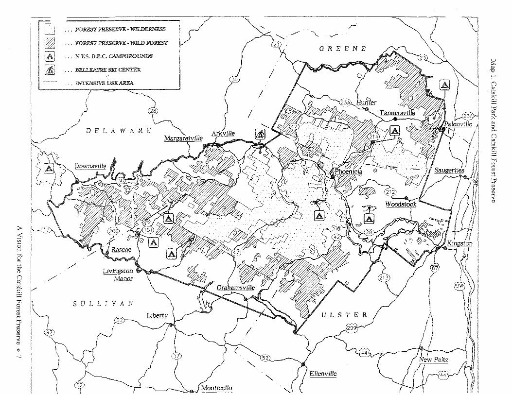
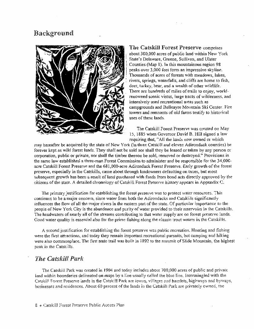
The Catskill Forest Preserve comprises about 300,000 acres of public land within New York State's Delaware, Greene, Sullivan, and Ulster Counties (Map l ). In this mountainous region 98 peaks over 3,000 feet form an impressive skyline. Thousands of acres of forests with meadows, lakes, rivers, springs, waterfalls, and cliffs are home to fish, deer, turkey, bear, and a wealth of other wildlife. There are hundreds of miles of trails to enjoy, worldrenowned scenic vistas, large tracts of wilderness, and intensively used recreational areas such as campgrounds and Belleayre Mountain Ski Center. Fire towers and remnants of old fanns testify to historical uses of these lands.
The Catskill Forest Preserve was created on May 15, 1885 when Governor David B. Hill signed a law requiring that, "All the lands now owned or which
may hereafter be acquired by the state of New York (in three Catskill and eleven Adirondack counties) be forever kept as wild forest lands. They shall not be sold nor shall they be leased or taken by any person or corporation, public or private, nor shall the timber thereon be sold, removed or destroyed." Provisions in the same law established a three-man Forest Commission to administer and be responsible for the 34,000-acre Catskill Forest Preserve and the 681,000-acre Adirondack Forest Preserve. Early growth of the forest preserve, especially in the Catskills, came about through landowners defaulting on taxes, but most subsequent growth has been a result of land purchased with fonds from bond acts directly approved by the citizens of the state. A detailed chronology of Catskill Forest Preserve history appears in Appendix C.
The primary justification for establishing the forest preserve was to protect water resources. This continues to be a major concern, since water from both the Adirondacks and Catskills significantly influences the flow of all the major rivers in the eastern part of the state. Of particular importance to the people of New York City is the abundance and purity of water provided to their reservoirs in the Catskills. The headwaters of nearly all of the streams contributing to that water supply are on forest preserve lands. Good water quality is essential also for the prime fishing along the classic trout waters in the Catskills.
A second justification for establishing the forest preserve was public recreation. Hunting and fishing were the first attractions, and today they remain important recreational pursuits, but camping and hiking were also commonplace. The first state trail was built in 1892 to the summit of Slide Mountain, the highest peak in the Catskllls.
The Catskill Park
The Catskill Park was created in 1904 and today includes about 700,000 acres of public and private land within boundaries delineated on maps by a line usually called the blue line. Intermingled with the Catskill Forest Preserve lands in the Catskill Park are tov1ns, vi!lages and hamlets, highvv'ays and b:y,.\vays, businesses and residences. About 60 percent of the lands in the Catskill Park are privately owned, the
8 ~ Catskill Forest Preserve Public Access Plan

home of approximately 50,000 year-round residents. See Appendix E for statistics about the Catskill Park and Catskill Forest Preserve.
The purpose of creating the Catskill Park was to identify a boundary within which lands deemed most suitable for acquisition by New York state would be designated as forest preserve lands. The only stateimposed land use regulation that affects private lands within the blue line is the Catskill sign law which imposes restrictions on the location, number, size and appearance of off-premise signs. About 6,500 acres of Catskill Forest Preserve lands lie outside the blue line.
Aside from lands under the jurisdiction of DEC, other state-owned lands within the park include Department of Mental Health lands, and the state highways, storage areas and maintenance facilities under the jurisdiction of the Department of Transportation.
New York City's west-of-Hudson watershed is the source of90 percent of the city's drinking water supply. Its boundaries include parts of five counties and total about 1900 square miles or l million acres. About 51.6 percent lies in Delaware County, 4.1 percent is in Schoharie County, 18.6 percent is in Greene County, 21.5 percent is in Ulster County and 4.2 percent is in Sullivan County. The city presently owns about 56,000 acres in the west-of-Hudson watershed of which approximately 40 percent lies within the Catskill Park. Roughly half of these acres are underwater. Map 2 shows the location ofNYC's Catskill and Delaware watershed lands.
New York City Watershed Agreement
The 1997 New York City Watershed Agreement lays the foundation for cooperation in a program to protect New York City's water supply that involves, among other elements, a major land acquisition effort. DEC has issued the city a I 0-year "Land Acquisition Permit" renewable for an additional 5 years. The permit authorizes New York City to acquire from willing sellers additional lands to ensure long-term protection for its water supply. The city has committed $250 million to solicit up to 355,000 acres in the Catskill and Delaware watersheds. If determined necessary, the city will invest an additional $50 million for land acquisition in this region. Whereas it is uncertain how much land the city will acquire in the future, if it succeeds in purchasing 30 percent of the land being considered (a conservative estimate), the city will add more than 100,000 acres to its current holdings. Fair market value will be paid for all property and the city will continue to pay property taxes. No property will be acquired by eminent domain.
Prior to acquiring any land under the land acquisition program the city will consult with the Town or Village in which the parcel is located. The consultation will ensure that the city is aware of and considers the Town's or Village's interests and that the terms of the land acquisition program agreed to by the parties are complied with.
The Watershed Agreement specifies that recreational uses of the newly acquired property will be determined by the city in consultation with DEC, EPA, the appropriate local governments, and the regional Sporting Advisory Committee. In consultation with these parties, the city undertook a comprehensive review of existing and potential recreational uses on currently owned city property. In January 1999 NYC DEP rel~~sed a Preliminary Report on Recreational Use of New York City Water Supply Lands. The report allows recreation (hiking, bird watching, roller blading, fishing, boating, ice-fishing, skiing, snowshoeing,
Background ~ 9

0
~
()
~ ~ 'Tl 0 @ ~ '"O -. (!) <fl (1)
~ (l)
'"" c er ;:;·
> .() () (I) <fl <fl
~ p:! ::!
Catskill l Delaware Watersheds
New York Gty Department of Environmental Protection
Watershed Area. Rivers and Reservoirs Catskill Aqueduct and Tmmels Delawai'eAq1.1edud and Tum~els
- - - Col.inly Borders T1r»wnship Borders
s:: ~ N
()
~ ;§ (!)
i ~ ~ Ui ::r (!) Off)
educational programs, and hunting) in limited or specified areas subject to a proposed watershed lands access permit program. The following activities are not likely to be allowed on city property even if the
-- - property was historically used for these purposes: boating (other than for permitted fishing by boat); snowmobiling; camping; motorized vehicles; swimming and wading; mountain bicycling; and horseback riding. No other recreational pursuits will be considered.
The 1997 Watershed Agreement also provided funds to develop exhibits for a regional watershed museum. The Town of Shandaken has initiated the process of establishing the museum off Route 28 near Belleayre Ski Center and is currently working with the Catskill Watershed Corporation on designing exhibits.
NYS Scenic Byways Program
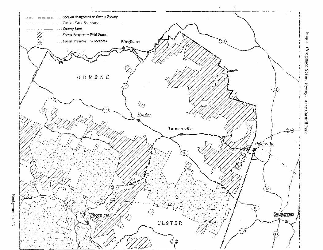
In 1992 the New York state legislature created the state's Scenic Byways Program. This program grew out of the National Scenic Highway Program of 1974 (and its predecessor, the Federal Highway Beautification Act of 1965) and DEC's Scenic Roads program which was established in 1982. The Scenic Byways system includes transportation corridors that contain particular scenic, natural, recreational, cultural, historic, or archaeological features of statewide or regional significance. These corridors are managed to protect these outstanding features and to encourage economic development through tourism and recreation. The DOT has produced a handbook that outlines the designation criteria and nomination process. Nomination to the Scenic Byways Program starts with a "bottom-up" approach. Communities along these corridors must take the initiative by gathering local support to sponsor the application and by preparing a corridor management plan that provides for the conservation and enhancement of the byway's underlying resources, as well as for promotion of tourism and economic development.
Table 1. Catskill Park Designated Scenic Byways
Road Name and Description County Town
NYS Route 23A Greene Hunter 3.5 miles from the boundary between the Town of Hunter and Town of Catskill, westerly to its intersection with Twilight Park Access Road.
NYS Route 214, Stony Clove Road Greene Hunter 6.8 miles from the intersection ofNYS Route 23A southward to the DOT road marker 214-130 102.2 which is two miles north of the boundary between the Town of Hunter and County of Ulster.
Platte Clove Road, County Route 16 Greene Hunter 2.2 miles from its intersection with Josh Road southerly to the Town of Hunter boundary with the County of Ulster
During the ten years that DEC administered the Scenic Roads Program, three small sections of roads in the Catskill Park were designated as "scenic roads" and these have been adopted by DOT as official "scenic byways." They are listed in Table 1 and shown on Map 3.
Background + 11

NYS DEC's Temporary Study Commission produced a report in 1976 titled, Towards a Scenic Roads Program for the Catskills. The Temporary Study Commission convened a task force that analyzed the scenic roads program which was initially proposed in 1966 by New York's Natural Beauty Commission, and evaluated the roads within the Catskill Park for their inclusion in the program. The report gives detailed recommendations for corridor protection and improvement along Routes 28 and 23A, and other suggestions related to creating a scenic byways network, but the recommendations in this report were never implemented. Although some information contained in the report is no longer current, such as local zoning ordinances, much of the content of this report would be a good background and foundation for future scenic byway nomination applications.
The benefits of designation of Scenic Byways are primarily economic. Once DOT approves the designation, fonding may be available to assist communities with improvements to their designated scenic byway. Currently publications promoting New York State scenic byways include a nationwide brochure that features the Seaway Trail along Lake Ontario and an Adirondack Scenic Byway map, describing driving tours of eleven trails covering more than 1,200 miles.
12 + Catskill Forest Preserve Public Access Plan
w ~ ,,..
(JO ..., 0 i:: ::i 0..
+ w
~ ___ ., -
=~-= I
.. . :•
·.···
... Section designated as Scenic Byway
... Catsklll Park Boundary
... County Line
... Forest ~ve - Wild Forest
... Forest Preserve - Wilderness
w
GREENE
... -.-~·.·.·· ... -.. • .. · ... ,·. ··-·· .··
) .. · . ...
•.· ·.· .
... · ..... ····
I ! .: ..•.
w
:::i
, .
-~~ :· ... ~~-~ ~, ·'
ULSTER

DEC Management of the Catskill Forest Preserve
The mission of DEC is "to conserve, improve and protect New York's natural resources and environment and control water, land and air pollution, in order to enhance the health, safety, and welfare of the people of the state and their overall economic and social well-being." Within this context, DEC manages the Catskill Forest Preserve as a watershed, wildland recreation area, and ecological and scenic reserve.
New York's Adirondack and Catskill Forest Preserves are protected by Article 14, § 1, of the constitution from encroachment through sale, lease or gift, and guaranteed to be "Forever Wild." Public access to these lands for recreation is guaranteed by Environmental Conservation Law section 9-0301 ( l ).
DEC has two regional offices with responsibility for the Catskill Forest Preserve. Region 3, headquartered in New Paltz, is responsible for forest preserve lands in Ulster and Sullivan Counties; Region 4, with offices in Schenectady and Stamford, manages lands in Greene and Delaware Counties.
Six DEC Divisions have authority within the Catskill Forest Preserve:
l. Within the Division of Lands and Forests, the Bureau of Public Lands has lead responsibility for the development of policies and plans for management. Foresters in Regions 3 and 4 oversee the day-to-day operation of the preserve.
2. The Division of Public Protection's Ranger Captains in Regions 3 and 4 supervise Forest Rangers' operations within their regions. Forest rangers are responsible for forest fire protection, search and rescue, public information, enforcing rules and regulations, and monitoring the condition of the Preserve. Assistant forest Rangers are hired on a seasonal basis to provide information and guidance to backcountry users and to assist in user safety activities.
3. Fish and wildlife resources are managed through the Division of Fish, Wildlife and Marine Resources. Program activities include habitat protection, stocking of ponds and streams with gamefish, acquisition and maintenance of public fishing rights, setting limits and designating special conditions for the taking of fish and wildlife (i.e. catch and release areas, season and bag limits), restoration of species, monitoring of species' health and abundance, and dealing with animal nuisance problems.
4. The Division of Operations manages Belleayre Mountain Ski Center, DEC campgrounds and day use areas and undertakes construction and maintenance of infrastructure and other facilities such as trails, leantos and parking areas. Seasonal employees are hired to staff campgrounds and related facilities.
5. The Division cf La\v Enforcement provides fish and wildlife and other enforcement services through the work of the Environmental Conservation Officers assigned to duty within the Catskill Park.
! 4 + Catskill Forest Preserve Public Access Plan

6. The Division of Public Affairs offers environmental education and interpretive programs for the public and assists other divisions in developing their own public programs and information services.
Catskill Pa:rk State Land Master Phm
The Catskill Park State Land Master Plan (CPSLMP) sets forth management guidelines for the forest preserve lands within the Catskill Park. Written in 1985, this plan is currently in the process of being revised. The CPSLMP establishes a broad framework of geographic management units and classifies each unit based on the area's characteristics and capacity to withstand use. It further directs DEC to develop detailed unit management plans (UMPs) for each unit that conform to the guidelines for each area's land classification. All activities on forest preserve lands including those recommended in this Public Access Plan are subject to the master plan.
The three main classifications in the Catskill Forest Preserve are wilderness, wild forest, and intensive use. The wilderness classification is the most restrictive and seeks to minimize evidence of human impact and to provide maximum opportunities for solitude. Motorized use, for example, is prohibited in wilderness areas. In wild forest, higher levels of recreational use are allowed, as well as types of use that are not permitted in wilderness areas. Activities such as snowmobiling, mountain bicycling and group camping are considered appropriate in wild forest areas as long as they will not adversely impact the natural resources. The intensive use areas include campgrounds and Belleayre Mountain Ski Center where the infrastructure and additional staff can accommodate larger groups of visitors while maintaining the integrity of the resource.
Unit management plans (UMPs) contain detailed proposals for the use, management and other policies to be carried out within individual management units. UMPs determine the locations of new trails, parking lots, or structures such as lean-tos, bridges, and information boards. In addition, UMPs describe the historical and natural resources of the unit and any outstanding issues or problems. The UMPs are usually written by a planning coordinator from the Division of Lands and Forests with the assistance of an interdisciplinary team of DEC program managers from other divisions.
UMPs have been completed for 16 of the 20 wild forest and wilderness units in the Catskill Forest Preserve, as well as for all of the seven campgrounds and for Belleayre Mountain Ski Center. Many of the recommendations in the Public Access Plan are subject to the UMP process and will be implemented when UMPs are written or revised. ·
Public participation is a vital part of DEC's management and planning. Informal public meetings and formal hearings are held to hear public comments throughout the decision-making process to ensure that the citizens of the state have the opportunity to play a part in planning for management of these public lands.
Management Partnerships
DEC.relies heavily on cooperation with private non-profit organizations to assist in management of the trail system. Volunteers from the New York-New Jersey Trail Conference have assisted DEC with trail maintenance for many years. Initial efforts were generally limited to construction and maintenance of the Long Path. However, in 1989 DEC asked them to consider expanding their trail maintenance role in the Catskills. In 1990 DEC and the NY-NJ Trail Conference signed a Memorandum of Understanding (MOU) which created a volunteer "Adopt-A-Trail" Program for the routine maintenance of Catskill Trails. Over
Background ~ 15

170 miles have since been adopted by the Trail Conference. In 1993 the MOU was expanded to include an Adopt-A-Lean-To program as well. The routine maintenance of over 20 lean-tos is now undertaken by Trail Conference volunteers. Groups or individuals who are interested in volunteering for trail maintenance, or adopting a trail or lean-to should contact the NY-NJ Trail Conference.
DEC has developed similar cooperative trail maintenance agreements with several other forest preserve user groups. The Finger Lakes Trail Conference has adopted over 20 miles of trail which serve as a route for the Finger Lakes Trail in the Catskills. The Paul A. Nickle Memorial Trail Crew of Mt. Tremper maintains 7.5 miles of foot trail over Panther Mountain. The Sullivan County Trails Association maintains over 28 miles of snowmobile trail in the Willowemoc Wild Forest. Volunteers from the Adirondack Mountain Club began providing assistance in 1992. In 1995 after 12 successive years of partnership with DEC building major new trails and maintaining existing trails in the forest preserve, the Appalachian Mountain Club redirected their efforts to provide more support for a growing program in the Delaware Water Gap. Other volunteers from horse clubs and bicycle clubs, the Forest Fire Lookout Association and other groups also provide trail maintenance and development assistance in the forest preserve.
Acquisition of Land by New York State
All lands purchased by New York state for addition to the Catskill Forest Preserve will be guided by the language of the funding authorization, and "Conserving Open Space in New York State," known as the "Open Space Plan." The latest edition of the Open Space Plan was approved by Governor Pataki in April, 1998. UMPs also may include acquisition priorities. Currently, the chief sources of funding for acquisitions are the Environmental Protection Fund (EPF) and the 1996 Clean Water/Clean Air Bond Act.
The Open Space Plan requires that a less than full fee title purchase, such as a conservation easement or other interest, be considered where practicable. Conservation easements (an interest in land other than full title, such as development rights, farming or timber rights) may be purchased by the state, or retained by the land owner, or a third party, such as a conservation organization or land trust. A fee title acquisition conveys all the rights to use a parcel of land.
When purchasing either land or easements, the state will, in accordance with the enabling legislation, pursue acquisitions through voluntary agreement. If an acquisition is to be funded through the EPF or the Clean Water/Clean Air Bond Act, the cost of the preparation of a management plan may be included in the total cost of the project.
From time to time, other sources may provide funding for conservation easements or land acquisitions, including the forest preserve expansion fund, federal outdoor recreation fund, and public fishing rights program. The state may also accept gifts of lands or easements which meet program goals.
Existing and Potential Demand for Use
While-no overall census of visitor use of Catskill Forest Preserve recreational facilities has ever been undertaken, a substantial amount of information exists. Only the revenue producing facilities in the intensive use areas-the campgrounds, day use areas, and Belleayre Mountain Ski Center-are able to keep accurate records of visitor numbers. In wilderness and wild forest areas, the annual number of visitors per year is derived by extrapolating from the numbers taken from trail register sign-in sheets.
16 ~ Catskill Forest Preserve Public Access Plan
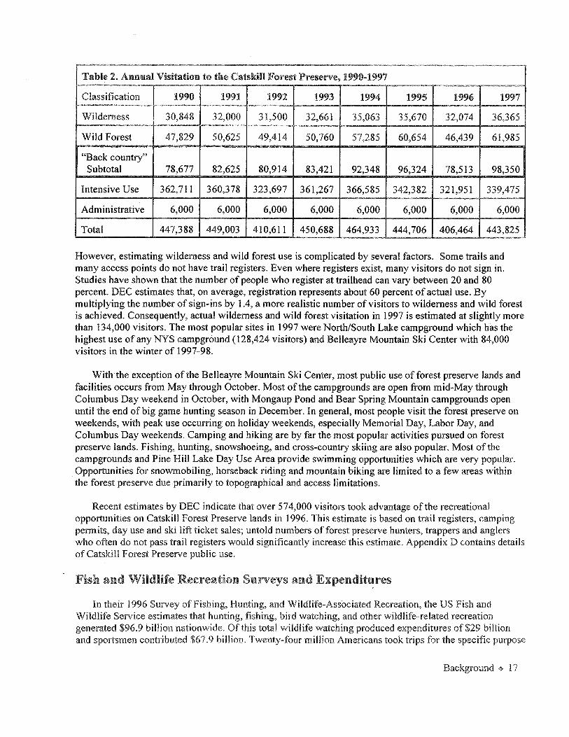
Table 2. Ammal Visitation to the Catskill Forest Preserve, 1990-1997
Classification 1990 1991 1992 1993 1994 1995 1996 1997
Wilderness 30,848 32,000 31,500 32,661 35,063 35,670 32,074 36,365
Wild Forest 47,829 50,625 49,414 50,760 57,285 60,654 46,439 61,985
"Back country" Subtotal 78,677 82,625 80,914 83,421 92,348 96,324 78,513 98,350
Intensive Use 362,711 360,378 323,697 361,267 366,585 342,382 321,951 339,475
Administrative 6,000 6,000 6,000 6,000 6,000 6,000 6,000 6,000
Total 447,388 449,003 410,611 450,688 464,933 444,706 406,464 443,825
However, estimating wilderness and wild forest use is complicated by several factors. Some trails and many access points do not have trail registers. Even where registers exist, many visitors do not sign in. Studies have shown that the number of people who register at trailhead can vary between 20 and 80 percent. DEC estimates that, on average, registration represents about 60 percent of actual use. By multiplying the number of sign-ins by 1.4, a more realistic number of visitors to wilderness and wild forest is achieved. Consequently, actual wilderness and wild forest visitation in 1997 is estimated at slightly more than 134,000 visitors. The most popular sites in 1997 were North/South Lake campground which has the highest use of any NYS campground (128,424 visitors) and Belleayre Mountain Ski Center with 84,000 visitors in the winter of 1997-98.
Withthe exception of the Belleayre Mountain Ski Center, most public use of forest preserve lands and facilities occurs from May through October. Most of the campgrounds are open from mid-May through Columbus Day weekend in October, with Mongaup Pond and Bear Spring Mountain campgrounds open until the end of big game hunting season in December. In general, most people visit the forest preserve on weekends, with peak use occurring on holiday weekends, especially Memorial Day, Labor Day, and Columbus Day weekends. Camping and hiking are by far the most popular activities pursued on forest preserve lands. Fishing, hunting, snowshoeing, and cross-country skiing are also popular. Most of the campgrounds and Pine Hill Lake Day Use Area provide swimming opportunities which are very popular. Opportunities for snowmobiling, horseback riding and mountain biking are limited to a few areas within the forest preserve due primarily to topographical and access limitations.
Recent estimates by DEC indicate that over 574,000 visitors took advantage of the recreational opportunities on Catskill Forest Preserve lands in 1996. This estimate is based on trail registers, camping permits, day use and ski lift ticket sales; untold numbers of forest preserve hunters, trappers and anglers who often do not pass trail registers would significantly increase this estimate. Appendix D contains details of Catskill Forest Preserve public use.
Fish a.nd Wildlife Recreation Surveys and Expenditures
In their 1996 Survey of Fishing, Hunting, and Wildlife-Associated Recreation, the US Fish and Wildlife Service estimates that hunting, fishing, bird watching, and other wildlife-related recreation generated $96.9 billion nationwide. Of this total wildlife watching produced expenditures of $29 billion and sportsmen contributed $67.9 billion. Twenty-four million Americans took trips for the specific purpose
Background + l 7

of observing, photographing, or feeding wildlife in 1996, while 61 million enjoyed these nonconsumptive wildlife-related recreational activities around their homes. The study showed that 18 percent of the population 16 and older fished during 1996, 7 percent hunted, and 31 percent participated in nonconsumptive wildlife-related recreation. Information from this survey specific to New York state is not yet available.
DEC does not have survey data that present a comprehensive look at the numbers of hunters, trappers, anglers or wildlife observers using the Catskill Park, but some estimates of the economic value of wildlifebased recreation in the park can be derived from survey and harvest data. Information on the economic value of non-consumptive wildlife recreation in the park is more difficult to obtain.
DEC fisheries bureau conducts aerial overflight angler surveys four times a month between April and November at selected sites, mainly larger water bodies. Creel surveys are conducted on selected waters and these occurred in 1986 on the Willowemoc, 1992-93 on the Esopus, and 1996 on the Neversink River tailwaters (waters below the dam). Creel surveys along the East Branch Delaware River have been conducted every year since 1988. A statewide survey of licensed anglers was conducted in 1988 and 1996. These surveys asked anglers how many times they fished and fishing locations, as well as a number of socio-economic questions.
The 1988 survey reported the results shown in Table 3 for annual angler effort and expenditures in the four counties in which the forest preserve is located. The numbers in parentheses represent confidence limits. Table 4 shows the 1988 survey results by region.
Table 3. 1988 Angler Effort and Expenditures by County
County Anglers Angler-Days Expenditures
Delaware Co. 32,450 (±3,960) 298,550 (±42,950) $ 4,420,060 ($±946,520)
Greene Co. 13,760 (±2,600) 119,590 (±25,640) $ 1,469,200 ($±620, 120)
Sullivan Co. 57,100 (±5,180) 631,710 (±67,770) $10,159,290 ($±1,388,390)
Ulster Co. 27,380 (±3,640) 397,470 (±±63,920) $ 4,264,420 ($±905,400)
Annual angler effort and expenditures were only broken down by region in the 1996 survey report. Table 5 gives the results for the two Catskill Forest Preserve regions. Again, the numbers in parentheses re_present confidence limits.
As the tables show, the 1996 statewide survey documented a substantial reduction in fishing activity from the"'I988 estimates. A private survey conducted in 1994 by Trout µnlimited on the Beaver Kill and Willowemoc River indicated that the "BeaMoc" trout fishery supported over 90,200 angler-days in 1994 compared to 161, 700 angler-days reported for 1988. This decline in fishing effort is consistent with data collected in DEC aerial surveys of angler use. Total angler expenditures were estimated at $9.1 million based on the angler intercept survey. A survey of area businesses confirmed this estimate, with anglerrelated revenues in 1994 estimated to be $10. l million in the Town of Rockland, Sullivan County.
18 '* Catskill Forest Preserve Public Access Plan
~ -··- - - -- -~
Table 4. 1988 Angler Effort and Expem.Htames by Region
Region Anglers Angler-Days Expenditures
3 (Sullivan, Ulster, Dutchess, 142,950 (±7,940) 2,419,600 (±207,940) $25,306,350 Orange, Putnam, Rockland, and (±2,114,290) Westchester Counties)
4 (Montgomery, Otsego, Schoharie, 120,440 (±7,160) 1,570,330 (± 159,030) $14,270,690 Schenectady, Albany, Rensselaer, (±1,805,750) Delaware, Greene, and Columbia Counties)
Table 5. 1996 Angler Effort and Expenditures by Region
Region Anglers Angler-Days Expenditures
3 (Sullivan, Ulster, Dutchess, 124,710 (±7,330) 2,033,540 (±163,400) $20,522,410 Orange, Putnam, Rockland, and (±2,149,580) Westchester Counties)
4 (Montgomery, Otsego, 106,550 (±6,850) 1,404,410 (±142,750) $16,594,350 Schoharie, Schenectady, Albany, (±2,120,770) Rensselaer, Delaware, Greene, and Columbia Counties)
A rough guide to the amount of hunter use is derived from the annual buck harvest in wildlife management units 1
• Biologists estimate the hunter success rate at 15 percent. For example, in WMU 3a, which occupies 614 square miles of forest preserve in Ulster, Sullivan and Greene Counties, the estimated harvest in 1997of1,057 bucks indicates that approximately 7,000 hunters went afield. The origin of these hunters was 48 percent from the Catskills and Hudson Valley and 52 percent from outside the local area. The United States Fish and Wildlife Service estimates that big game hunters in southern New York spend about $485 per year on gas, licenses, targets, bullets, food and club dues. According to these estimates, the annual economic gain from the local hunters would be $1,630,000. Hunters from outside the area would contribute $1, 765,000, bringing an annual total of $3,395,000.
Information on the economic impact of trapping is available from the total forbearer harvest in former wildlife management unit 11 2
, which constituted about 1,316 square miles, an area larger than, but inclusive of the Catskill Park and Catskill Forest Preserve. The fur harvest in 1996-1997 based on an average dollar per pelt resulted in a total economic value of $53,674.13 as detailed in Table 6.
1Formerly deer management units. Beginning in 1998, the use of deer management units was discontinued.
2In 1998 WMU 11 was broken down into eight smaller WMUs.
Background + 19

Table 6. Fur Harvest in WMU 11 for 1996-97 Season
Species Harvest Average Total Total v~due/pelt
Beaver 977 $24.13 $23,575.01
Bobcat 86 $25.50 $2,193.00
Coyote 180 $20.59 $3,706.20
Fisher 6 $38.70 $232.20
Otter 43 $40.42 $1,738.06
Mink 173 $18.63 $3,222.99
Raccoon 398 $15.39 $6,125.22
Skunk 77 $3.67 $282.59
Opossum 116 $2.01 $233.16
Muskrat 1977 $5.48 $10,833.96
Red fox 29 $18.62 $539.98
Gray fox 77 $12.88 $991.76
Total Economic Value $53,674.13
Estimates of Potential Demand and Concern for Overuse
It is often quoted that 20 million residents of New York and New Jersey live within a 2.5 hour drive of the Catskill Park. In the broadest sense this suggests larger potential demand for use of the highways and byways, trails, campsites and other facilities of the forest preserve and park than those facilities could accommodate. It is possible over the Jong run that so many people will want to visit the preserve that care must be taken to manage visitorship to prevent damage to the natural resources and protect the quality of visitor experience.
DEC program staff and members of the Public Access Plan work groups share a common concern for changes that might result from increased use. Deterioration of trails, natural resources, or infrastructure, as well as overcrowding or user conflicts would be undesirable consequences to be avoided wherever possible. Monitoring the condition of trails and parking areas and early detection of changes as they occur are currently conducted by rangers and foresters. If they feel the impacts are too great they can close trails at certain seasons to prevent erosion, re-route trails, require permits for large parties, and employ other management strategies to maintain the quality of the resource and the re.creational environment, Within these management guidelines, it is the responsibility of DEC to provide balanced and appropriate access
20 '*'Catskill Forest Preserve Public Access Plan
to all forest preserve users. A variety of interests, activities and levels of ability must be considered and their impacts weighed. Some uses of the forest preserve are self-limiting because geology, geography, or legal constraints make their practice difficult, dangerous or illegal. However, balanced and appropriate access for all-hikers, sportsmen, cross-country skiers, equestrians, mountain bikers, snowmobilers, wildlife observers, people with disabilities and other groups that use the forest preserve land for recreation and pleasure-is the aim of DEC's management policies.
Background + 21

Key Issues and Actions
The Catskill Forest Preserve Public Access Plan addresses key issues and proposes actions that were raised by the public during the twelve meetings of the work groups, plus those that originated in discussions with individuals, groups, organizations, and DEC staff. The Plan includes actions that can be implemented in the next three years by DEC, DOT and other state agencies with existing staff and budgets, actions that will require new or additional funds, as well as actions beyond the scope of DEC's mission that will require financial assistance and cooperation in the form of partnerships with local communities, municipalities, and/or private businesses.
The key issues and actions contained in the plan are summarized below. Each of these actions is discussed more fully-how it was
identified, why it is needed, and how it will be carried out-in ensuing pages.
Summary of Key Issues and Actions Page
Enhance Scenic Travel Corridors . . . . . . . . . . . . . . . . . . . . . . . . . . . . . . . . . . . . . . . . . . . . . . . . . . . 24 I. Develop gateway information centers on major highways entering Catskill Park. 2. Develop new "Entering Catskill Park" signs at gateways. 3. Implement DOT's Guidelines for the Catskill Park. 4. Produce a Catskill Park scenic highways and byways driving pamphlet. 5. Institute regular DEC/DOT!NYC DEP/county/local government regional communication and coordination meetings. 6. Develop a comprehensive plan for DEC signs and structures. 7. Implement use of international icons for recreation uses along highways. 8. Amend the DEC Sign Law to allow businesses to advertise at up to four intersections.
Information and Interpretation ................................................. 34 Publications
9. Reprint full color Catskill Forest Preserve map and guide. I 0. Print recreation theme brochures for forest preserve Activities. 11. Print maps showing public fishing rights. 12. Encourage regional tourism agents to integrate forest preserve information into local community, county, and regional tourism publications.
Interpretation and Education 13. Expand Catskill environmental education initiative. 14. Restore Catskill Forest Preserve fire towers.
'15. Build forest preserve volunteer network. 16. Establish a central library and research data base.
'*Catskill Preserve Public Access Plan

Distribution of Information 17. Pursue Catskill Interpretive Center initiative 18. Develop a coordinated DEC information distribution strategy. 19. Establish network of local forest preserve information stations. 20. Contract professional advertising.
DEC Public Outreach · 21. Publish a DEC Catskill regional personnel directory. 22. Conduct training and familiarization workshops, field trips, and other public presentations.
Recreation Access and Development ............................................. 4 7 New Physical Access Initiatives
23. Improve and complete Catskill Forest Preserve trail system. 24. Improve public access to water-based recreation in the Catskill Park. 25. Develop "rules-of-the-trail" procedures and education strategy.
Access for People with Disabilities 26. Undertake a universal trail assessment of forest preserve trails. 27. Build easy access fishing sites and sites accessible to people with disabilities.
Linking the Forest Preserve with the Catskill Region 28. Develop inn-to-inn trail systems. 29. Pursue trail linkages and access possibilities with Catskill railroads. 30. Pursue linkages to New York City's watershed lands.
Visitor Management 31. Conduct a visitor census, use and economic impact survey. 32. Monitor use and establish baselines. 33. Enhance year-round recreation at the Belleayre Mountain Ski Center.
Implement the Public Access Plan . . . . . . . . . . . . . . . . . . . . . . . . . . . . . . . . . . . . . . . . . . . . . . . . . . 68 34. Establish a DEC Catskill Coordinator position.
Key Issues and Actions ~ 23

Key Issues and Actionse Enhance Scenic Travel Corridors
Most visitors to the Catskill Park form their first impressions of the region from the visual experience they perceive from the windows of their cars as they travel on the major highways. The concern for the visual qualities of the roadside landscape of the Catskill Park has long been a subject of interest to planners, developers and environmental activists in the region. The Public Access Plan seeks to address the issue of how to inform highway travelers about the forest preserve and how to Work with the DOT, local and county governments to create a visually pleasing and cohesive park identity.
Road signs that provide clear directions to visitors without compromising the scenic qualities of the travel corridors are necessary for those seeking both active and passive recreation. Many visitors to the region come throughout the seasons to see the magnificent views of the mountains and valleys without setting foot on a trail. Others come to hike, hunt or fish on forest preserve land and may not find road signs directing them toward the activities they seek.
Highway Use Information
A substantial number of highway travelers visit the Catskills throughout the year. The Department of Transportation publishes annual traffic reports that give the traffic volume on roads throughout the state. Traffic counts are made using portable counters. Actual traffic counts are converted to estimate the average daily traffic (ADT). Table 7 provides the ADT volumes of many of the state highways in and around the Catskill Park.
Table 7. 1998 Average Annual Daily Traffic
Route Location A verngc Daily Traffic (ADT)
Route 17 East Branch 6,350
Route 17 Livingston Manor 7,400
. Route 28 Route 28A at Stony Hollow 18,605
Route 28 At Delaware County Line 3,000
Route 23 Route 23A 3,300
Route 23 Windham 3,300
24 4 Catskill Forest Preserve Public Access Plan

Table 7. 1998 Average Annual Daily Traffic
Route Location Average Daily Traffic (ADT)
Route 55 Napanoch 2,000
Route 206/30 OLP Downsville 1,800
Route 212 Route 375 12,165
Route 212 Route 32 OLP 9,950
Traffic ADT reflect most current estimates at time of pubhcat10n.
Making the experience of the highway traveler more pleasurable and informative is one of the goals of this plan that was addressed by the scenic byways work group. The group offered the following recommended actions.
ction: Develop gateway information centers on major highways entering Catskill Park
Visitors to the region, whether highway travelers, families looking for a day hike, or seasoned back country hikers, would all benefit from gateway information centers at the major entrances to the Catskill Park. At these locations, not unlike National Park Service Visitor Centers, interpretive programming, exhibits and printed information would orient them to the region and direct them to their desired destinations. At present there is only one information center that welcomes visitors to the Catskill Park year-round. Located at the thruway exit at Catskill, the center is staffed by Greene County public information staff and offers personal assistance as well as brochures, maps and guides. There is also a lack of Catskill area and regional information offered at state rest areas located along major highways to the Catskill Park.
Establishment of gateway centers on major highways entering the region must be a coordinated effort by state, county and local government, and local chambers of commerce. DOT is planning to construct "class A" rest areas (heated buildings with public rest rooms) in the next five years at several locations in the Catskills region. Construction of such a facility might offer an opportunity for partnership with DEC and local communities for distribution of information and interpretive materials about the forest preserve and local attractions. It was suggested that the site of the proposed Catskill Interpretive Center on Route 28 might be a possible location for a "class A" rest area .
. ction: Develop new "Entering Catskill Park" signs at gateways
The brown wooden signs with yellow lettering at the entrances to the Catskill Park that read "Entering-Catskill Park" give no descriptive information about the Catskill Park to travelers as they enter. Because the Catskill Park is a mosaic of public and private land, a better explanation would help visitors know what to expect within the park.
Major gateways to the Catskill Park occur on the east at the NYS Thruway exit in Kingston, on Route 23A & 32A at Palenville, and on Route 212 in Woodstock, along Route 17 to the south, at Margaretville on Routes 28 & 30, and near Prattsville at the intersections of Routes 23 and 23A. (See map 4) The
Key Issues and Actions: Enhance Scenic Travel Corridors $ 25

workgroup recommends at these iocations that DEC consider replacing the existing wooden signs at these locations with a new sign, that is more visible and symbolic of the Catskill Mountains. The signs would most likely be constructed of natural materials that would exhibit a more dramatic entrance to the park. This and the use of rustic guide rail and signs within the Park will significantly improve an awareness of entering the Park. On the reverse of these signs the words "Leaving Catskill Park" might be added.
The DEC and the DOT will work with local communities to develop an appropriate sign motif for the park. Their input will aiso be used to determine appropriate iocations for signs. Less elaborate signs will also be developed for low volume highways and local roads that enter the park, including signs for leaving the park.
ction: Implement DOT's Guidelines for the Catskill Park, a set of standards fo:r the state highways in the Catskill Pa:rk
The Catskill Park is divided between three of the DOT' s eleven Regions. During the process of gathering information for the Public Access Plan, many issues were raised about consistent treatments of highways within the Park, and the necessity for extensive coordination between the three DOT regions. The more significant issues raised included the establishment of a sense of identity, concerns over peripheral highways that weave in and out of the park boundary, the promotion of multi-modal use of state highways, consistent and appropriate treatments of the roadside to keep the park- like appearance and scenic beauty of the region intact, and the. importance of signing (particularly to the forest preserve lands area attractions).
The DOT addressed this concern by publishing a document titled "New York State Department of Transportation Guidelines for Highways in the Catskill Park". The guidelines include standards and aesthetic treatments taken from various manuals and DOT guidelines that will be compiled into a single document as an inter-agency document for the three DOT regions. A similar set of guidelines has been established for the Adirondack Park by the DOT.
The guidelines include a regional policy for establishing a rustic setting for highways in the park. It also establishes soft boundaries for the various highways that border the park. Other guidance is intended to preserve and enhance the scenic beauty of the Catskill Mountains and the communities within, and to promote a park like atmosphere. The guidelines also address signing to attractions and the forest preserve lands, as well as promoting use of the highways by both motorized and non-motorized forms of transportation. A system of scenic overlooks and parking areas or rest areas will also be investigated. Though the guidelines are intended for use on state highways, the DOT is taking a leadership role in promoting the use of the guidelines by other transportation jurisdictions to promote a sense of place within the entire Catskill Park.
ction: Produce a scenic highways and byways driving pamphlet for the Catskill Park
There are presently only three segments of highways that are formally designated as State Scenic Byways. The scenic byways work group concluded that since the State Scenic Byways program is a grass roots effort, neither the DOT nor the DEC could nominate highways for inclusion in the program. The group did recognize, however that a!mosta!l of the highv,rays in the park and for that matter, the Catskill's
26 ~Catskill Forest Preserve Public Access.Plan
~ (\)
'-< -(/} ;:; (ii
"' p.i ::; 0..
> 0 ,..,. 0 ::; (,fl
rn ::l ~
• • . CATS1ill..L PARK SIGN
... SA.n:u.rr.E IMDRMA'flON STATION
~ __/- -----~
) '
... IN.FORMATION BOA.RD
DELAWARE
~ :;!
g I / C/'.l ~ I / :::i
0
-1 ,_, p.i
< (\)
0 0 ,_, ..., a: 0 ;;; ¢
N --l
.\ ,...-"'.
,--../ . _,./
GREENE
-!:>.
"-..

region are very scenic and that attribute alone is the reason for many visitors to come to the Catskills. There is also significant interest in the establishment of historic trails across the Catskills by various interest groups, as well as promoting points of interest that reflect on the history and culture of the region. The group discussed the benefits of a touring brochure with detailed maps and narratives identifying scenic routes. The brochure would be looked upon as an important element in promoting tourism in the region and the economic benefits tourism produces.
The basis for the beginning of the scenic road network wouid be the existing scenic byways and those highways identified in the Temporary Study Commission Report. A narrative would be provided for each trail or route including the natural and cultural history, landmarks and other interpretive information.
Implementation of a project of this scale would require a coalition of representatives of the four county highway departments, county planners, county tourism promotion agents, DEC, DOT, historic sites and other nonprofits, as well as private enterprise to obtain funding and print such a brochure. The advantage to the local communities of identifying and interpreting scenic driving tours would be to promote the scenic beauty of the region, to improve the quality of experience for highway travelers, and to stimulate regional tourism.
ction: Institute regular DEC/DOT/NYC DEP/county/local government regional communication and coordination meetings
DEC and the DOT share responsibility for the maintenance and conservation of the visual, natural and cultural resources of the region. In the work group meetings, both DOT and DEC recognized the benefits of improved communication, and the need for coordination and cooperation that will bond partnerships with all Catskill stakeholders.
An example of a need for better coordination between DEC and DOT is the public access to Kaaterskill Falls along the designated stretch of scenic byway on Route 23A. DEC. and DOT land managers, landscape architects, and engineers need to cooperatively design a safe pedestrian passage from the Molly Smith parking area to the trailhead that is consistent with the aesthetic values and legal constraints within the scenic byway designation and forest preserve regulations.
In order to meet this goal, DEC and DOT agree to meet semi-annually to discuss issues that must be addressed and develop strategies that include participation by the locals and other involved agencies. The Catskill Park Coordinator position will strengthen their working relationship, and bring matters of importance to the attention of the involved regions and central office parties responsible for decision making. The New York City DEP will be encouraged to join this partnership and attend these meetings. The focus of the meetings will be not to establish a bureaucracy over communities and interest groups, but to seek their participation also as stakeholders.
Signs and Structures
Highway travelers need clear and visible signs that direct them to forest preserve access opportunities. The design and placement of these signs should contribute to the scenic quality of the roadways and the aesthetic character of the Catskill Park. The work group meetings identified many actions to enhance the travel corridors and to help define a sense of place by improving existing signage. DOT is presently examining their sign manual and taking steps to incorporate new signs to trail head parking areas and trails,
* Catskill Forest Preserve Public Access Plan
and to identify natural features such as streams or landmarks. DOT also has an attractions sign program to identify other public attractions, such as museums, parks, public buildings and facilities, etc.
ction: Develop a comprehensive pbm for DEC signs and structures
DEC staff recognize the need for a comprehensive plan to create standards for the design and location of information boards, trailhead structures, bulletin boards, signs and other infrastructure on forest preserve land and along highways in the Catskill Park. Although DEC manuals exist, they are out of date and do not include all the signs that are currently in use on the for:est preserve. In cooperation with the Adirondack Forest Preserve (to maintain consistency between both parks), the development of a manual specific to the forest preserve would make it easier for staff to select signs and ensure that common standards are being employed on lands managed by different regions and divisions within DEC. The DEC signage task force will be composed of staff from the various programs active within the forest preserve: lands and forests, fish and wildlife, operations, forest rangers, environmental conservation officers, and public affairs.
An initial list of the contents of a signs and structures plan includes:
.. A thorough needs assessment • Inventory of the signs currently in use
Recommendation for designs oftrailhead structures depending on level of use Basic instructions for how and what information is presented at the trailheads
" A manual of detailed drawings specifying sizes of lettering, materials and color for all signs " A map with locations of information boards along major corridors and gateways to the park
Two common structures DEC uses to present information in the forest preserve are information boards (also called kiosks), and sign-in boxes. DEC has installed information boards in three communities in the Catskill region under the auspices of an !STEA grant through DOT. The information boards are located in the villages of Phoenicia, Margaretville, and soon, Delhi, where residents and visitors can learn about the forest preserve and nearby access points, as well as community services and events. The design and locations for these structures were determined through a community participation and planning process. Information boards also exist on forest preserve access points such as Slide Mountain, Kanape and Mt. Tremper trailhead parking lots, and Woodland Valley campground. DEC is planning information boards for all major trailheads.
These information boards are a good first step toward providing better information about forest preserve access and developing stronger relationships with local communities, but information boards are necessary at other locations, particularly along the major scenic travel corridors and gateways to the park, in order to enhance the experience of highway travelers and those seeking outdoor activities on the forest preserve. Several locations suggested for future information boards are listed below. They and future information boards will be considered in the context of this comprehensive plan for DEC signs and structures. Decisions relating to locations and designs must have the approval and support of the local communities and DOT for non-forest preserve locations, such as highw<;lys and towns.
Region 3 0 Entrance to Onteora Lake in Bluestone Wild Forest on Route 28, unless a DOT information kiosk is erected one-half mile east in 1999-2000. "Site of the proposed Catskill Interpretive Center on Route 28 "Pine Hill Lake Day Use Area
Key Issues and Actions: Enhance Scenic Travel Corridors + 29
e Route 55, Grahamsville .. Livingston Manor gateway entrance " Route 212 Saugerties/Woodstock gateway entrance "Kingston, gateway entrance (in cooperation with the Thruway Authority, Ulster Public Information, and
Kingston Chamber of Commerce).
Region 4 " Village of Hunter .. Molly Smith parking lot on Route 23A access point to Kaaterskill Falls trail "Windham High Peaks trailhead in East Windham on Route 23 ., Route 23A, Palenville gateway entrance " Prattsville, gateway entrance
DEC has a policy that classifies trailheads in the forest preserve and provides for consistency in their location and development. The policy defines three levels of trailheads at the starting or termination point of one or more designated trails at an access point to state land.
Class I TraHhead is a major trailhead at the entrance to a high-use trunk trail or trail system with parking for eleven or more vehicles and frequently located along a major highway.
Class II Trailbead is a trailhead at the entrance to a less-used trail system with parking for up to ten vehicles.
Class III Trailbead is a trailhead at the entrance to one or more less-used or dead-end trails or paths with parking for up to three vehicles.
The comprehensive plan would define the signs and structures at each of the three classes of trailheads and determine what information is presented at each and how that information is presented so that the trailheads are consistent throughout the forest preserve and present a unified appearance and message. The signs and information presented at trailheads need to communicate positive messages about what is allowed, as well as what is prohibited.
ction: Implement use of internatiomd icons for recreation uses along state highways.
Most trailheads are located off the main highways on back roads where travelers unfamiliar with the region who do not have a set of detailed trail maps have a difficult challenge finding them. For example, at the intersection of Route 28 and county Route 47 there is no indication that hiking opportunities are available, even though Route 47 (Oliverea Road) leads to Slide Mountain, Biscuit Brook, Lost Clove, McKinley Hollow, and Giant Ledge trailheads. It has been suggested that the use of a reflective highway sign with an international symbol of a hiker would help direct prospective users to access points.
Fishilig access sites that are located off the main highways might also benefit from similar signs with an international fishing symbol where distance or the configuration of the road prevents the driver from seeing the DEC signs or the parking area.
Green and white signs with internationai icons are aiready in use on Route 28 for ski areas; brown and yellow signs with campground icons are also found on Route 28. At present DOT does not include a hiking or fishing symbol in their manual of traffic control devices. DEC will submit these symbols to DOT
30 +Catskill Forest Preserve Public Access Plan

for special authorization and evaluate the need for others at access points for snowmobiling, biking, crosscountry skiing or horseback riding. The colors for these signs will follow the recommendations in DOT's Guidelines for the Catskill Park.
The use of international icons will be considered for the following locations:
Symbol: Hiker
Intersection of County Route 47 and Route 28 (trailheads mentioned above) Intersection of Route 28 and 28A (Peekamoose Valley)
• Intersection of Route 28 and Fox Follow Road Intersection of Route 28 and Woodland Valley Road (campground) Intersection of Rte. 23 and Cross Road Rte. 23A in vicinity of Kaaterskill Falls Trail Intersection of the Long Path and Route 23A near Palenville Intersection of Route 214 and Diamond Notch Road Intersection of Route 214 and Devil's Path Intersection of Route 206 and Campbell Mountain trail
Symbol: Fishing IP' ~
J ~
I!!.. A
Intersection of Mt. Pleasant Rd. and Route 28 in Mt. Tremper Intersections of old Route 28 with County Route 42 and Route 28 in Big Indian (2 fishing access parking areas) Intersection of Route 28 and Woodland Valley Road (3 fishing access parking areas) Intersection of County Route 42 and Spruceton Road Intersection of Route 23A and Route 42
ction: Amend the DEC sign law to allow businesses to advertise at up to four intersections
"In order to conserve the natural beauty of the Adirondack and Catskill parks, to preserve and regulate the said parks for public uses for the resort of the public for recreation, pleasure, air, light and
Key Issues and Actions: Enhance Scenic Travel Corridors • 31
enjoyment, to keep them open, safe, clean and in good order for the welfare of society, and to protect and conserve the investment of the state in forest lands, campsites and other interests in real property in said parks, no person shall erect or maintain within the boundaries thereof any advertising sign, advertising structure or device of any kind, except under written permit from the department."
So begins section 9-0305 of the New York State's Environmental Conservation Law (ECL) that governs signs within the Catskill and Adirondack Parks. Only off-premise advertising signs are subject to this law. Signs advertising a business on a parcei ofreal estate which is the principal location of that business, or signs in an incorporated village are exempt. Further details on the classification and size limitations of authorized signs, materials, design, color and text, location, illumination, maintenance and how to apply for a sign permit are spelled out in par1 195 of the ECL rules and regulations. The sign law appears in Appendix F.
In the meetings for the Public Access Plan there was widespread dissatisfaction with a particular requirement of the regulations which restricts businesses from erecting signs at more than one intersection from their location. For businesses located well off the main highway directional signs clearly directing the visitor to outlying locations are not allowed under the current regulations. The work groups felt that enforcement of the sign law was necessary to prevent the proliferation of signs and degradation of the scenic values of Catskill Park highways and byways, but in situations where a business is located two or more intersections from the main road, that business should have the opportunity to direct travelers with signs at as many intersections as necessary to reach their premises. The current permit system would still be required for these signs and they would not be exempt from other requirements of the law or regulations.
Legislation has been introduced in the New York State Senate proposing an amendment to the ECL that would allow any one business up to four directional signs. The signs would be of a size and shape approved by DEC and would give directions for reaching a business. They would be erected and maintained at intersection locations approv~d by the department. A legislative action could change the sign law, but another strategy would be to amend DEC's rules and regulations which would effect the same result without requiring a legislative change. DEC will investigate amending the rules and regulations to replace the current regulations that state that only two intersections are allowed with allowances for signs at up to four intersections.
In certain locations this proposed modification to the sign law and/or rules and regulations will produce more signs at intersections than are currently in use. However, clear directional signs will benefit travelers seeking the services provided by local businesses off the main highways and help foster sustainable economic development of the communities within the Catskill Park.
In accord with DOT guidelines that recommend brown signs with a yellow legend for use on state highways within the park, the sign law regulations which currently allow three choices of color (yellow leµering on brown background, black lettering on white background, or white lettering on green background) might be revised to specify yellow lettering on brown background in order to maintain a consistent practice within the park.
Further consideration should be given to temporary signs for yard sales, bake sales, church socials, and other events. If located off-premise these signs are illegal under the current regulations. Allowances for short-term signs advertising local events that conform to the other requirements of the sign law should be incorporated into the reguiations inciuding requirements for removal after the event. These modifications would benefit both the public and the rangers who are charged with the enforcement of the sign law.
32 ¢> Catskill Forest Preserve Public Access Plan

Consideration of modifications to the law or regulations will be part of an organized process seeking public participation and input.
Key Issues and Actions: Enhance Scenic Travel Corridors + 33

Key Issues and Actions: Information and Interpretation
New Yo:rk State :residents and visitors see the Catskill Forest Preserve in a
' variety of ways. Although most people are aware of the Catskill Mountains as the scenic backdrop of Catskill highways and communities and know something of their history as a setting for large vacation resorts, relatively few have a clear idea of what the forest preserve is or how forest preserve lands intermingle with private lands and communities to form the unique relationship that characterizes the Catskill Park. Even the hundreds of thousands of people each year who stay at forest preserve campgrounds or travel the trails are not fully aware of its rich history, natural
, resource values, recreational opportunities, or the importance of the forest preserve to the economy of the Catskill region.
DEC produces a variety of publications about the forest preserve at different scales and levels of detail including maps of individual units, parkwide, and region-wide materials, but there is no consistent plan for their distribution or comprehensive plan for future production.
Recently printed materials have been designed with a "common look" intended to project an easily identifiable image of forest preserve materials, but publications are few and do not portray the broad array of forest preserve activities. Many subjects of interest to the pub I ic, such as a map and brochure of the forest preserve, or guides to specific recreational activities are not represented, are outdated, or out of print
Lack of funding is the biggest obstacle to producing and distributing interpretive and informational materials. Often when a source of funds is found for an initial printing, there are no funds available to reprint the brochures, maps or guides when supplies are exhausted.
To better serve the interests of New Yorkers, with particular attention to the residents of the Catskill Park, DEC recognizes the critical need to create systems to produce better information and interpretation about the forest preserve and to distribute it effectively. By encouraging visitors to discover less wellknown recreational opportunities, educating them about the proper use of forest preserve lands, and e~hancing their experience as they tour the scenic travel corridors, their appreciation of the forest preserve and respect for the resource will grow.
; :'·~·
The Public Access Plan information and interpretation systems work group considered the broad topic of providing access, information, and identified a series of actions related to the foJlowing subjects: publications, interpretation and stewardship, distribution of information, and public outreach. The purpose of these information and interpretation actions is to increase pubiic understanding and enjoyment of the forest preserve while contributing to the protection of its natural resources for future generations and enhancing the economies of Catskill communities.
~ Catskill forest Preserve Public Access Plan

Publications
There are many useful privately produced guides, maps and publications about the Catskill Forest Preserve, Catskill Park, and Catskill region. The New York/New Jersey Trail Conference sells a waterproof, tear-resistant five-map set titled, "Catskill Trails" that is an invaluable guide to the trail system. The Catskill Center for Conservation and Development produces a seven-county regional road map showing forest preserve lands and other natural and cultural features. Purple Mountain Press, in Fleischmanns, NY, features a broad selection of maps and guides as well as books of regional interest. Other Catskill maps and guides are published by the Adirondack Mountain Club and Walking News.
In addition, each county tourism office provides detailed road maps available free on request. DOT is in the process of producing and selling county base maps showing state and municipal lands. One has been completed for Sullivan County. Topographical maps are available from United States Geologic Survey and retail sales outlets throughout the region.
In fall of 1997 DEC published a full color forest preserve map and guide. This publication fills a longstanding need and serves to orient visitors to the park and the forest preserve, as well as to illustrate the major trails and parking areas. Other current DEC brochures about the Catskill Forest Preserve feature the eight campgrounds, Willowemoc Wild Forest, Big Indian Wilderness, Slide Mountain Wilderness, Balsam Lake Mountain Wild Forest, Bluestone Wild Forest, Belleayre Mountain Ski Center, Day Hikes at NorthSouth Lake and Catskill Adventure hikes. The "Catskills Fishing Guide," a regional full color brochure that was first produced ten years ago by DEC with help from "I Love NY" funds, has just been reprinted by the Bureau of Fisheries through a cooperative effort between DEC's Albany, region 3, and region 4 offices. A similar effort by the Bureau of Public Lands has produced a new brochure specifically geared to families titled "Catskill Adventure - Day Hikes and Paddles for Families." This brochure identifies eighteen short day hikes or canoe paddles in the forest preserve distinguished by interesting features such as waterfalls, scenic views, or opportunities to observe wildlife. The distance and ascent for each location are listed and several trails or locations are suitable for children under five. The majority of these DEC brochures have been produced by private contractors with support from advertisers. A complete list of current DEC media products appears in Appendix H.
ction: Reprint Catskm Forest Preserve map and guide
The single greatest need identified in all four work groups was for the publication of a full color map and guide to orient visitors and highway travelers and introduce them to the Catskill Forest Preserve and Catskill Park, show trails, access points and boundaries, communicate the natural beauty and magnitude of the forest preserve, and include highlights of the rich cultural history of the Catskill Park. A full color brochure titled, "Catskill Forest Preserve - Official Map and Guide," has recently been printed and copies are available. Because of the size of the map and the scale of the forest preserve, this map cannot show the level of detail that those seeking outdoor recreation might require, but it is an invaluable tobl to introduce visitors to the region.
Fedei:-.al I STEA funds were used to print the first edition of this brochure. DEC is reprinting it with advertising to offset the cost. In order to meet the continuing need for a ·steady supply of publications like this map and guide and the Catskills Fishing Guide, DEC will work with sponsors or advertising contractors who wish to reprint and distribute future editions of these brochures.
Key Issues and Actions: Information and Interpretation '*' 35
ction: Print recreation theme brochures for forest preserve activities
Detailed infonnation about opportunities within the Catskill Park for hiking, hunting and trapping, fishing, biking, snowmobiling, cross-country skiing, horseback riding, car-top boating access, and wildlife observation, is lacking and cannot be easily condensed into a single publication because of the need for variable scales and the sheer volume and diversity of infonnation. Work groups recommended that a coordinated series of sport-specific or theme brochures that identify locations and access points on the forest preserve where these sports or activities are possible and desirable, and where these activities are wheelchair accessible, would be a major benefit to forest preserve users and to the communities within the Catskill Park.
Making these recreational opportunities more accessible through a series of sport or theme related brochures is an important aspect of public access to the forest preserve and a sustainable economic development to the surrounding communities that provide services to these visitors. Partnership with private industry might be possible and desirable as, for example, in the case of cross-country skiing.(More information on these trails is included on page 47 and on Map 5.)
Hiking
A question most commonly asked of DEC staff and of county tourism offices about the forest preserve is, "Where can I hike?" Currently DEC does not have an up~to-date comprehensive publication that shows the locations of trailheads, parking areas or the trails themselves. "Catskill Trails," a co-publication of DEC Regions 3 and 4, was last printed in 1985. Revising and reprinting the "Catskill Trails" hiking guide was strongly recommended by several work groups as a valuable guide to hiking in the forest preserve.
Snowmobiling
Snowmobilers and horseback riders have areas of designated trail for these activities in the Catskill Forest Preserve and some of these trails are suitable for other sports as well. More than 76 miles of snowmobile trails have been built in the Forest preserve with the assistance of local snowmobile clubs, but no single publication exists that shows these trails.
Horseback Riding
Horseback riding is permitted on snowmobile trails once the snow has melted; otherwise horseback riding is permitted throughout the forest preserve, but not on marked foot trails. Currently trails suitable for horseback riding, old woods trails and other opportunities exist for horseback riding, which, along with parking areas suited for horse trailers could be shown on a theme brochure.
Mountain Biking
Mourifain bikers at present have unrestricted access to forest preserve trails although mountain biking regulations may be modified after the next revision of the Catskill Park State Land Master Plan. Bike trails are currently being developed at Jockey Hill in Bluestone Wild Forest and there is a six mile trail at Wilson campground.
36 + Catskill Forest Preserve Public Access Plan

Cross~country Skiing
Cross-country skiing opportunities exist in many locations throughout the forest preserve including an extensive system which has been developed at Belleayre Mt. Ski Center. A brochure illustrating these opportunities would be an asset. A guide could be produced in cooperation with private operators that would list recommended routes on forest preserve lands as well as private facilities, like Frost Valley YMCA, that maintain cross-country ski trails within the Catskill Park.
Hunting and Trapping
Sportsmen in work groups for the Public Access Plan reported that better information is needed about hunting and trapping opportunities in the forest preserve. The word "Preserve" discourages some prospective hunters who mistake it to mean a game preserve where hunting is not allowed. They also said that the boundaries in the statewide hunting and trapping guide are not at a large enough scale to clearly distinguish public and private lands.
A brochure and map about hunting and trapping in the forest preserve would help sportsmen find access points, improve understanding of the wide variety of opportunities present for trapping, small and big game hunting, and help prevent unintentional trespass.
Wildlife Observation
An interpretive pamphlet or guide to wildlife observation in the forest preserve would help people observe and study wildlife as a source of enjoyment. Wildlife means fish, amphibians, reptiles, butterflies, etc., as well as birds and mammals. DEC's wildlife observation program identifies observation sites and provides resources to make wildlife observation available to the public through the production of guides, or by developing facilities such as towers or viewing platforms. A Catskill Forest Preserve wildlife viewing guide would foster general awareness, understanding and appreciation of wildlife and of the importance of the forest preserve as habitat for wildlife.
The National Watchable Wildlife Program in partnership with Defender's of Wildlife, DEC, DOT, and other state and federal agencies and private organizations published the New York Wildlife Viewing Guide. The guide identifies the 75 best places in the state to see wildlife in their natural habitat. In the forest preserve, North/South Lake campground was selected for its lakes and forest with deer, bears, squirrels, bats, loons (migrating), Canada geese, ducks, hawks, owls, turkey, ruffed grouse, warblers, songbirds and sunfish.
ction: Print maps showing public fishing rights
Similarly, anglers express the need for better and more detailed information about the locations of fishing access parking lots and boundaries of the permanent easements on private land known as public fishing rights (PFR). Maps showing PFR boundaries as well as other fishing opportunities on forest preserve'fimds with interpretive text about what fish are present and thefr natural history would improve understanding of the forest preserve and access to fishing opportunities. Production of maps showing boundaries of public fishing rights would be a very useful complement to the full color Catskills fishing brochure.
Key Issues and Actions: Information and Interpretation ~ 37

ction: Encourage regional tourism agents to integrate forest preserve information into local community, county, and regional tourism publications, as well as other media.
One of the issues identified in the work group discussions was the need to integrate information about the forest preserve into a broad spectrum of publications about the Catskills. Tourism promotion agents in Delaware, Greene, Sullivan, and Ulster counties produce annuai visitor guides for their counties, and in addition, print two Catskills Region guides each year supported by Empire State Development "I Love NY" matching funds. Some local communities and chambers of commerce in the Catskill Park also publish visitor guides.
In order to encourage local communities or counties to benefit from the economic value of the forest preserve lands as a nature-based tourism attraction, DEC will provide maps, information about public access and recreational opportunities, locations of trailheads, parking, etc., to any group or government entity for inclusion in their publications.
38 + Catskill Forest Preserve Public Access Plan

Key Issues and Actions.· Interpretation and Education
Public interest surrounding the proposed interpretive center for the Catskill region led DEC's Division of
. Public Affairs and Environmental Education to establish the position ' of Catskill Forest Preserve environmental educator in 1996. Operating
out of Belleayre Mountain Ski Center, the educator offers a year-round series of programs for families, school classes, youth groups, and civic organizations interpreting the natural and human history and ecology of
: the Catskills. These programs include guided hikes, hands-on-activities for school classes, teacher workshops, and slide lectures. The educator has written an interpretive booklet for the old field trail at the day use area on the proposed Catskill Interpretive Center site and a similar booklet for Kenneth Wilson campground nature trail. An Interpreter
Activity Program has been offered in some campgrounds since 1982. In 1997, the Bureau of Recreation inaugurated an Interpretive Activities Program in the campgrounds. Also that year, a Jtinior Naturalist Program was conducted for children between 5 and 12 years old. The program was available in five of the eight campgrounds in the Catskills.
Action: Expand Catskill environmental education initiative
Work groups strongly supported the expansion of the current environmental education initiative to help build appreciation and stewardship of the forest preserve. The following are a few examples of new opportunities for such expansion.
• Establish a network of interpreted (self-guiding) trails at various locations within the forest preserve, including at least one trail at each DEC campground in the Catskill Forest Preserve;
• Design, construct, and install interpretive exhibits about the forest preserve at Belleayre Mountain Ski Center, the DEC Region 3 office in New Paltz, and the Region4 Suboffice in Stamford. Seasonal (outdoor) exhibit panels should also be mounted at each DEC campground;
•Expand the Junior Naturalist children's program to all Catskill campgrounds; and
•Offer a full program of fall, winter, and spring outdoor ecology lessons for school classes at Belleayre Mountain Ski Center, taught by DEC permanent and seasonal staff, interns, and volunteer docents.
ction: Restore Catskill Forest Preserve fi:re towers
The first forest fire observation station in New York state was established on the summit of Balsam Lake Mountain in 1887. Today's steel tower dates back to 1930. The steel towers at Hunter Mountain, Tremper Mountain, Red Hill and Overlook were installed in 1917, 19(7, 1920 and 1950 respectively. An analysis of towers was done for review by the State Historic Preservation Officer and in 1994 a letter of resolution was negotiated between DEC and the Office of Parks, Recreation and Historic Preservation pursuant to the New York Historic Preservation Act of 1980. This agreement identified four fire towers within the Catskill Forest Preserve as being eligible for inclusion in the State and National Registers of
Key Issues and Actions: Information and Interpretation ~ 39

Historic Places: Balsam Lake Mountain, Hunter Mountain, Red Hill and Tremper Mountain. The fire tower on Overlook Mountain will be eligible for inclusion in 2000.
Fire towers are considered significant because of their association with the history and development of the forest preserve as well as because of the architectural tradition they represent. Specific plans for the management and preservation of the four fire towers designated as eligible for the State and National Registers have been developed in the context of unit management planning for the forest preserve units in which they are located. A unit management plan for the fifth tower on Overlook Mountain is in the process of development.
DEC is currently seeking support for the restoration of the Catskill Forest Preserve fire towers. Restoration of these fire towers will accomplish several goals compatible with those of the public access plan:
• Creation of destinations with unparalleled views * Preservation of historic structures • Development of interpretative programs about forest preserve resource values and stewardship • Economic stimulus to local communities through increased access to the forest preserve • Establishment of partnerships for forest preserve management e A destination with a view for hikers to lesser peaks that would help distribute use away from the most heavily used areas.
The reconstruction will include the replacement of the wooden stair treads and some steel members, the restoration of the observer's cabins (with the exception of Tremper Mountain which was removed), and a privy or port-a-potty. Project funds will be dedicated for long-tenn maintenance as welt In a similar effort in the Adirondacks, experience has shown that local grassroots support is the key to successful restoration of fire towers.
Funds for the Catskill Fire Tower Restoration Project are being raised by individuals, businesses and non-profits, and through the sale of patches, T-shirts and postcards. Local groups, recognizing that the creation of a popular tourist destination will benefit the economy of their community, have organized around each fire tower to address the details, special local concerns, and to help raise awareness and support for the fire towers. Since February, 1997, the Catskill Center for Conservation and Development and five fire tower committees have been working with DEC to help organize support and raise funds.
ction: Build forest preserve volunteer network
The need for development of a broader constituency to advocate for forest preserve issues and to build awareness and support for the management, maintenance and stewardship of these valuable natural resources was mentioned by representatives of several work groups. Work group discussions proposed the development of a network of volunteers to assist with production and distribute information about the forest preserve, interpretive programming, environmental education, and improved outreach, among other activities, ..
A volunteer network could serve in many aspects of forest preserve management, such as:
e interpreters answering questions and leading hikes • assistants to the DEC environmental educator •"eyes and ears" of the forest reporting on natural events and monitoring human'""''""''~'·"
40 4> Catskill Forest Preserve Public Access Plan

Many local groups already provide these services as trail maintainers, or leaders of hikes for groups and organizations, but better coordination between these groups as well as the expansion of the volunteer network would bring more residents of local communities and visitors to an understanding and appreciation of the importance of conservation and preservation of natural resources as well as the beauty and grandeur of the forest preserve. The production of a forest preserve newsletter and a formal organization, "Friends of the Catskill Forest Preserve" were also discussed as possible outgrowths of volunteer activities and commitment.
An example of a nucleus of active volunteers engaged in forest preserve education and interpretation is the Olive Natural Heritage Society's Catskill flora project. The Society has undertaken to publish a book on Catskill flora which will be a guide to understanding the typical plant communities of the Catskills and the regional ecology. Following in the pioneering work begun by Karl Brooks, they propose to identify representative plant communities at locations with easy access and safe parking on forest preserve lands. The plants at these sites will be carefully documented, described and illustrated in their publication.
The goal of the Olive Natural Heritage Society in writing this book is to encourage the public to search out and visit these sites in order to study the typical plant communities. They plan to link their typical sites with the locations in the Catskill Adventure hiking brochure where possible. The society's scientific expertise and research skill was demonstrated in their previous book, The Ashokan Catskills, published in 1995. Their commitment to this project fills a much needed gap. DEC does not have the staff or resources to assume such a project, nor does the agency have the resources to produce a publication of this nature. The Natural Heritage Program within DEC conducts inventories, but their resources are limited and primarily focused on rare, threatened or endangered plants and animals.
Action: Establish a central library and research data base
The need to establish a central library and research data base for the Catskill region has been recognized by a group of scientists, environmentalists, educators and others who have joined to establish the Catskill Institute for the Environment (CIE). The CIE will provide a central source for information on environmental issues, education, and research in the Catskills region. The center will integrate human and natural sciences and establish a comprehensive repository of information and research performed by all those who are active in the region including DEC, other state and federal agencies, universities, and private researchers. The CIE is made up of four basic units: data management, distance learning, outreach, and research. The institute will be linked on-line to affiliated institutions and via the Internet to users of the world wide web.
DEC supports the work of the CIE and will cooperate to the extent possible in sharing information and offering other appropriate types of assistance. A clearinghouse of organized information about the Catskill region will be a substantial benefit not only to researchers and government agencies, but for the future needs of anyone interested in conservation and development.
Key Issues and Actions: Information and Interpretation q, 41
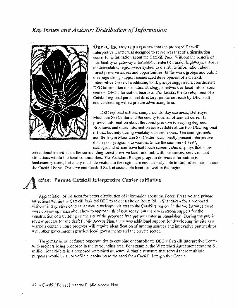
Key Issues and Actions: Distribution of Information
One of the main purposes that the proposed Catskill Interpretive Center was designed to serve was that of a distribution center for information about the Catskill Park. Without the benefit of this facility or gateway information centers on major highways, there is no dependable, region-wide system to distribute information about forest preserve access and opportunities. In the work groups and public meetings strong support encouraged development of a Catskill Interpretive Center. In addition, work groups suggested a coordinated DEC information distribution strategy, a network of local information centers, DEC information boards and/or kiosks, the development of a Catskill regional personnel directory, public outreach by DEC staff, and contracting with a private advertising firm.
DEC regional offices, campgrounds, day use areas, Belleayre Mountain Ski Center and the county tourism offices all currently provide information about the forest preserve to varying degrees. Brochures and other information are available at the two DEC regional offices, but only during weekday business hours. The campgrounds and Belleayre Mountain Ski Center occasionally present interpretive displays or programs to visitors. Since the summer of 1997, campground offices have had touch screen video displays that show
recreational activities on the surrounding forest preserve lands and link with businesses, services, and attractions within the local communities. The Assistant Ranger program delivers information to backcountry users, but many roadside visitors to the region are not currently able to find information about the Catskill Forest Preserve and Catskill Park at accessible locations within the region.
ction: Pursue Catskill Interpretive Center Initiative
Appreciation of the need for better distribution of information about the Forest Preserve and private attractions within the Catskill Park led DEC to select a site on Route 28 in Shandaken for a proposed visitors' interpretive center that would welcome visitors to the Catskills region. In the workgroups there were diverse opinions about how to approach this issue today, but there was strong support for the construction of a building on the site of the proposed interpretive center in Shandaken. During the public review process for the draft Public Access Plan, there was additional support for developing the site as a visitor's center. Future progress will require identification of funding sources and innovative partnerships with other government agencies, local governments and the private sector.
There may be other future opportunities to combine or consolidate DEC's Catskill Interpretive Center with projects being proposed in the surrounding area. For example, the Watershed Agreement contains $1 million for exhibits in a proposed watershed museum. A single structure that served these multiple purposes would be a cost-efficient solution to the need for a Catskill Interpretive Center.
42 * Catskill Forest Preserve Public Access Plan
ction: Develop a coordinated DEC information distribution strategy
Whether it be completing a unit management plan, publication of a brochure, progress with trail building, building a parking lot, new initiatives, special events, or the many other day-to-day incremental accomplishments, DEC's work throughout the forest preserve often goes unnoticed by the public because it is not publicly announced. The development of an information distribution strategy for the four counties in the Catskill Park will establish a coordinated mechanism for DEC to communicate information that currently is not well distributed. This strategy will use various forms of media and distribution systems, such as, press releases, links to internet sites, direct mailings, the use of brochure distribution companies, and forwarding information to the editors of various constituent newsletters. The advantages of such a strategy will be to build support for the forest preserve and heighten awareness of DEC activities through increased public awareness and participation.
DEC Regions 3 and 4 staff from all programs active within the forest preserve will develop a mailing list of individuals and groups who wish to receive information about the forest preserve. The list will include recreational and environmental organizations, interested individuals, elected officials, media, other state agencies, historical and cultural organizations, educational facilities, businesses, chambers of commerce, libraries, and others. Another suggestion was to develop a forest preserve newsletter or annual report to the community that would communicate information about projects completed and the status of those underway.
DEC has a web site (www.dec.state.ny.us) which presents a new opportunity for relatively easy distribution of information such as maps, brochures, press releases, and etc. Links between DEC's web site and other Catskill web sites are encouraged, and as brochures and maps are produced or revised, they will be added and updated on these internet sites.
The work groups also suggested free public service announcements on television and radio, as well as a Catskill Park radio station similar to the 530 am station broadcast at the Kingston New York State Thruway ex.it 19. Video tapes featuring specific outdoor activities were also proposed as an effective way to inform a broader public about recreational opportunities.
Development of this coordinated DEC information strategy will be done by a team of DEC regional and central office staff representing the various programs active within the forest preserve.
ction: Establish a network of local forest preserve information stations
In the course of the public meetings for this plan, there was strong support for the creation of a network of local information centers distributed throughout the Catskill Park both at DEC and other public sector facilities, and at private locations. In contrast to the gateway centers, these information stations would be located along the highway system within the park in existing businesses or non-profit organizations that are already magnets for visitors and are equipped to offer services to tourists. These information stations will be designated by a brown and yellow outdoor sign with a question mark designed in a style--compatible with DEC's wooden forest preserve signs. Inside,,an interior sign and brochure rack will display DEC publications about recreational opportunities and forest preserve stewardship. The staff at these locations will be trained by DEC staff to answer questions, to direct visitors to appropriate activities in their area, and will be supplied with publications as supplies warrant. A DEC staff person will be appointed to maintain and monitor each "Information Station" to keep abreast of their needs.
Key Issues and Actions: Information and Interpretation• 43

Several locations that have expressed an interest in participating in the network of infonnation centers are listed below.
" Catskill Corners, Shandaken, NY " Point Lookout Mountain hm, E. Windham, NY " Catskill Flyfishing Center and Museum, Livingston Manor, NY .. Kenco, Kingston, NY ., Margaretville Department Store, Margaretville, NY " Big Indian Trading Post, Big Indian, NY .. Twilight Groceries, Haines Falls, NY
ction: Contract professional advertising
Independent advertising agencies are currently contracted by the state to promote and market Catskill Forest Preserve attractions at Belleayre Mountain Ski Center and the summer activities at the campgrounds. An interdisciplinary effort by a professional advertising contractor that spans the various DEC programs (lands and forests, operations, wildlife, education, rangers, etc.) will facilitate the development of a consistent message about the use and possible overuse of the natural resources in the CatskHI Forest Preserve.
In the Adirondacks, a fund raising campaign has been initiated by the Adirondack Regional Tourism Council to create a series of television commercials, print advertising and a twenty-eight page guide called Adirondack Great Walks and Day Hikes. This is a fully coordinated educational campaign designed to promote tourism throughout the region by heightening awareness about the diversity of outdoor recreational opportunities while instilling a strong sense of stewardship and distributing use into less wellknown areas.
Whether through DEC, the Empire State Development Corporation, a private consortium, or a public private partnership of all three, a professional approach to the promotion of wise use and sustainable development from nature-based tourism in the forest preserve will benefit local communities and state agencies.
44 ~ Catskill Preserve Public Access Plan
Key Issues and Actions: DEC Public Outreach
Better communication between DEC regional staff and the public was a common request in the work group meetings. Local chambers of commerce, county tourism promotion agents, as well as visitors and residents need access to DEC staff for information on hiking, fishing, hunting, skiing, biking, snowmobiling, camping and other pursuits on the forest preserve. No single person can answer questions on all these subjects since they are managed by separate programs and regions within DEC.
Action: Publish a DEC Catskill regional personnel directory
Finding out who to contact at DEC on a particular subject can be a difficult and frustrating experience. Work groups recommended DEC publish an inter-regional telephone directory for DEC staff in Regions 3 and 4 who have responsibilities within the forest preserve. This directory could be distributed to the public, local municipalities, and other state agencies. ~
Currently DEC Region 3 maintains a recorded telephone message about hiking and backpacking (914-256-3188 x 4083) and another message on trail conditions (914-256-3188 x 4182). Both of these messages are accessible twenty- four hours a day by touch tone phone. In addition, Forest Rangers answer calls about trail conditions and other questions, but visitors may not know which ranger to call or their telephone number.
On a broader scale, there is a need for a Catskill regional directory that includes the names and numbers of other state agencies in addition to DEC, local and county government offices, and groups and organizations active within the environmental, historic, academic, and not-for-profit communities throughout the Catskill region. The work of designing and producing a regional directory is outside the scope of DEC's mission, but if it were done by a private entity, such a directory would be a benefit to people throughout the region. The Upper Delaware Scenic & Recreational River Interagency Resource Impacts Directory was proposed as a good model.
ction: Conduct training and familiarization workshops, field trips, and other public presentations
DEG·staff recognize the benefit of improved communications with the public and acknowledge their responsibility to inform local chambers of commerce, tourism professionals, and other interested parties to promote public understanding and appreciation of forest preserve values and opportunities. By educating local businesses, tourism professionals, and others about forest preserve resources and values, they will become "front line marketers" who will more effectively transmit this information to their clients.
Key Issues and Actions: Information and Interpretation 4' 45
DEC staff will increase their availability whenever possible to meet regularly with local chambers, tourism professionals, and others who are in the business of answering questions and providing information to visitors. On an annual basis DEC will conduct field trips, one in each county, with representatives of the tourism promotion community to acquaint them with forest preserve attractions throughout the Catskill Park.
46 <& Catskill Forest Preserve Public Access Plan

Key Issues and Actions: Recreation Access and Development
; Recreation, travel, tourism and the enjoyment of nature bring visitors to the Catskill Park. The communities within the park depend heavily on the attraction of the forest preserve as a backdrop for the scenic byways and as a destination for nature-based tourism. The development and maintenance of forest preserve access and facilities are critical to the economic
I well-being of the region. ! .
I A major motivation behind the Access Plan was a . recognition by DEC that the recreational opportunities I available on the forest preserve had developed largely as a result of isolated, localized efforts and not from a comprehensive, preserve-wide perspective. While there is an extensive system of long-distance hiking trails, opportunities for other trail uses, such as horseback riding and snowmobiling, are more localized. People interested in relatively short, easy walks, like parents with children or older people, find only a few places to go. Characteristics such as land classification, topography, and the presence of intervening private lands can limit the potential for access in some areas. Nevertheless, DEC intends to pursue a balanced distribution of recreational
/ opportunities across the Catskill Forest Preserve.
The Recreational Opportunities work group was composed of representatives from a variety of interests: sportsmen and outdoor recreationists, chambers of commerce, county tourism offices, businesses, nonprofits, and people with disabilities. They were charged with the task of recommending actions that would develop balanced, appropriate access and recreational opportunities on the forest preserve for the full spectrum of visitors. This work group considered what types of recreational opportunities need to be developed on forest preserve lands with particular attention to the needs of families and people with disabilities.
Knowing what present opportunities exist in the forest preserve is a necessary background for understanding the recommended new recreation access and development actions. The following section, Existing Conditions of Public Access, describes the present physical access to the forest preserve: hiking, cross-country skiing, mountain biking, snowmobiling, horseback riding, interpretive nature trails, fishing, hunting and trapping, camping, swimming and boating access. The recommendations of the recreational opportunities work group start on page 57.
Key Issues and Actions: Recreation Access and Development + 47
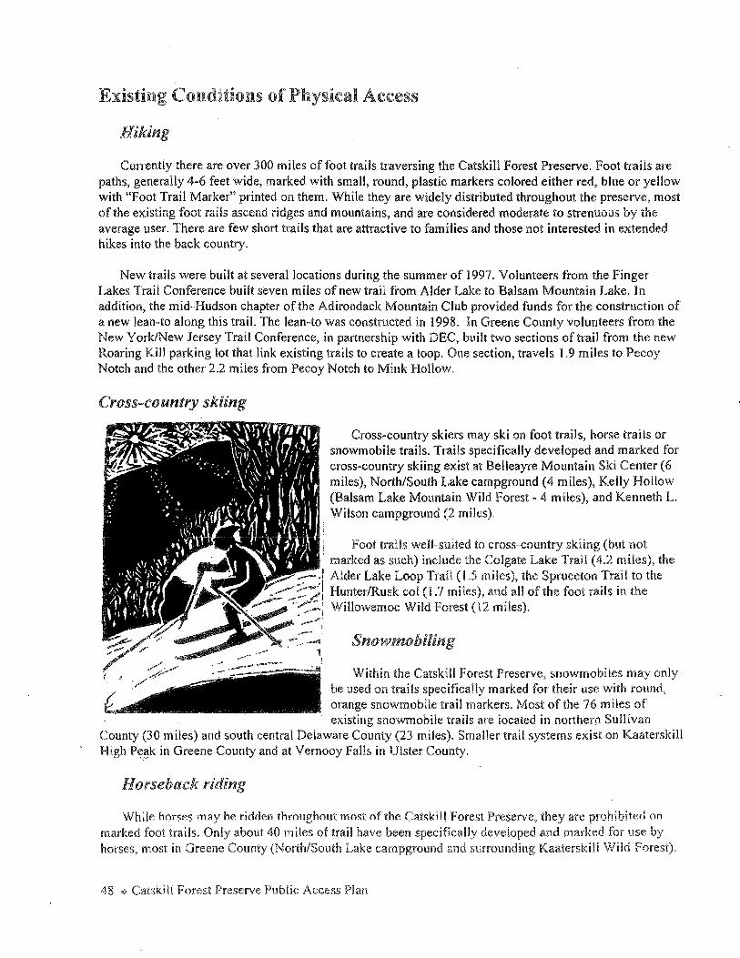
Existing Conditions of Physical Access
Hiking
Currently there are over 300 miles of foot trails traversing the Catskill Forest Preserve. Foot trails are paths, generally 4-6 feet wide, marked with small, round, plastic markers colored either red, blue or yellow with "Foot Trail Marker" printed on them. While they are widely distributed throughout the preserve, most of the existing foot rails ascend ridges and mountains, and are considered moderate to strenuous by the average user. There are few short trails that are attractive to families and those not interested in extended hikes into the back country.
New trails were built at several locations during the summer of 1997. Volunteers from the Finger Lakes Trail Conference built seven miles of new trail from Alder Lake to Balsam Mountain Lake. In addition, the mid-Hudson chapter of the Adirondack Mountain Club provided funds for the construction of a new lean-to along this trail. The lean-to was constructed in 1998. In Greene County volunteers from the New York/New Jersey Trail Conference, in partnership with DEC, built two sections of trail from the new Roaring Kill parking lot that link existing trails to create a loop. One section, travels 1.9 miles to Pecoy Notch and the other 2.2 miles from Pecoy Notch to Mink Hollow.
Cross-country skiing
Cross-country skiers may ski on foot trails, horse trails or snowmobile trails. Trails specifically developed and marked for cross-country skiing exist at Belleayre Mountain Ski Center (6 miles), North/South Lake campground (4 miles), Kelly Hollow (Balsam Lake Mountain Wild Forest - 4 miles), and Kenneth L.
, Wilson campground (2 miles).
! Foot trails well-suited to cross-country skiing (but not . ~ marked as such) include the Colgate Lake Trail (4.2 miles), the ~-::---:I Alder Lake Loop Trail ( l .5 miles), the Spruceton Trail to the ~~~1 Hunter/Rusk col (1.7 miles), and all of the foot rails in the
_:...--- -~:·i Willowemoc Wild Forest (12 miles) . .,.........,,
-·· Snowmobiling
; , Within the Catskill Forest Preserve, snowmobiles may only be used on trails specifically marked for their use with round, orange snowmobile trail markers. Most of the 76 miles of existing snowmobile trails are located in northern Sullivan
County (30 miles) and south central Delaware County (23 miles). Smaller trail systems exist on Kaaterskill High P~~k in Greene County and at Vemooy Falls in Ulster County.
Horseback riding
While horses may be ridden throughout most of the Catskill Forest Preserve, they are prohibited on marked foot trails. Only about 40 miles of trail have been specifically developed and marked for use by horses, most in Greene County (North/South Lake campground and surrounding Kaaterskiii Wiid Forest).
48 ~ Catskill Forest Preserve Public Access Plan
Recently the 3.6-mile Spruceton trail ascending Hunter Mountain was marked with horse trail markers, as was the 1.6-mile Diamond Notch Trail from Spruceton to the Diamond Notch lean-to. A 24-mile horse trail system can be found at the Bear Spring campground and Wildlife Management Area, just outside the Catskill Park in Delaware County. Snowmobile and cross-country ski trails are legally open to use by horses when not covered with snow or ice. (Horses are not allowed on snowmobile and cross-country ski trails if they are also marked as foot trails.) However, little has been done to encourage equestrian use of this trail system.
Bicycling
All-terrain bicycling, or mountain biking, is a relatively new recreational pursuit within the forest preserve and very few trails systems have been developed specifically for this use. A 6-mile trail at Wilson campground and a 2-mile trail in the Bluestone Wild Forest are the only existing designated bicycle trails in the preserve. However, at present there are no rules or regulations restricting the use of bicycles, and they may be ridden throughout the Catskill Forest Preserve. Possible restrictions on their use in wilderness areas are under consideration in the revised version of the CPSLMP.
Most of the existing snowmobile trail system is well suited to bicycling, as is the cross-country ski trail system at the Belleayre Mountain Ski Center. While most foot trails traverse terrain unsuitable for the average bicycle rider, or would present an unacceptable conflict with hikers, there are some wood roads which could provide an adventurous bicycling opportunity.
Access for people with mobility impairments
While all trails throughout the forest preserve are legally open to wheelchair use, none has been improved to the standards necessary for access by a wheelchair.
DEC's 1997 policy CP-3, ''Motor Vehicle Access to State Lands Under Jurisdiction of DEC for People with Disabilities" sets guidelines for affording people with mobility impairments additional opportunities for motor vehicle access to roads on DEC lands. Although there are a number of opportunities under the policy on DEC lands across the state, at present there are no available roads on Catskill Forest Preserve lands.
Interpretive Nature Trails
Self-guided interpretive nature trails have been developed at Route 28 day use area (site of the proposed Catskill Interpretive Center), and for Kenneth Wilson campground. At these sites interpretive booklets explain the natural and cultural history and the ecology of these areas. At North/South Lake campground, interpretive panels about the cultural history of the grand hotels, such as the Catskill Mountain House, have been installed.
Parking
A critical part of making forest preserve lands accessible from Catskill highways is providing sufficient parking. Parking areas at trailheads, fishing access sites and general access parking areas constitute the major access points throughout the forest preserve. While there is room for parking at most access points, at some locations there is no parking or inadequate parking available for existing trails. There are some cases where access to trails is limited by the lack of highway access due to land ownership, easements, and/or topography.
Key Issues and Actions: Recreation Access and Development ~ 49
Where possible, parking needs are identified in UMPs with recommended solutions. Occasionally, parking problems are resolved through partnerships. For example, a new Roaring Kill parking area, off Elka Park Road, was built in the summer of 1997 in cooperation with the Town of Hunter Highway Department.
Where parking areas do exist, maintenance-especially snow plowing-is an issue that affects users and the local communities in which these parking areas are located. DEC operations staff plow parking areas, but may not be able to remove snow from ali of them throughout the forest preserve in time to prevent drivers from parking their vehicles on roads, thereby hampering snow plowing and creating traffic hazards. Some town highway departments, recognizing the safety considerations and the benefit to their communities that winter tourists provide, volunteer to assist DEC by plowing access roads and parking areas. These cooperative partnerships between DEC and local governments are invaluable to maintain adequate, safe vehicle access in the forest preserve.
50 ~ Catskill Forest Preserve Public Access Plan

-"' "' c (1)
"' ~ :::i 0..
> &. 0 :::;
"' ;;o (1) () ...., (1)
~. 0 :::i
~ 0 (1)
"' "' ~ ::s 0..
v (1)
< (!>
0 "O a (D ::J ,..,.
* Vl
/
DELAWARE
Livingsto_IJ ~ Manor
SULLIVAN
"
c: "' ('lJ
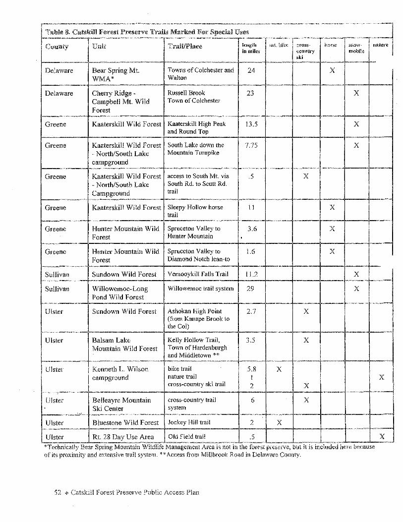
Table 8. Catskill Forest Preserve Trails Marked For Special Uses I I I !e11gtli I I. 1 Comllty Unit Trail/Place mt. bike CIFOS§· noirse Sil OW- ilil&W•e
in miles cmmtry mobile ski
Delaware Bear Spring Mt. Towns of Colchester and 24 x WMA* Walton
Delaware Cherry Ridge - Russell Brook 23 x Campbell Mt. Wild Town of Colchester
Forest
Greene Kaaterskill Wild Forest Kaaterskill High Peak 13.5 x and Round Top
Greene Kaaterskill Wild Forest South Lake down the 7.75 x - North/South Lake Mountain Turnpike
campground
Greene Kaaterskill Wild Forest access to South Mt. via .5 x - North/South Lake South Rd. to Scutt Rd.
Campground trail
Greene Kaaterskill Wild Forest Sleepy Hollow horse 11 x trail
Greene Hunter Mountain Wild Spruceton Valley to 3.6 x Forest Hunter Mountain .
Greene Hunter Mountain Wild Spruceton Valley to l.6 x Forest Diamond Notch lean-to
Sullivan Sundown Wild Forest Vemooykill Falls Trail 11.2 x Sullivan Willowemoc-Long Willowemoc trail system 29 x
Pond Wild Forest
Ulster Sundown Wild Forest Ashokan High Point 2.7 x (from Kanape Brook to the Col)
Ulster Balsam Lake Kelly Hollow Trail, 3.5 x Mountain Wild Forest Town of Hardenburgh
and Middletown ** ~
Ulster Kenneth L. Wilson bike trail 5.8 x campground nature trail 1
cross-country ski trail 2 x Ulster Belleayre Mountain cross-country trail 6 x . Ski Center system
. ...
Ulster Bluestone Wild Forest Jockey Hill trail 2 x Ulster Rt. 28 Day Use Area Old Field trail .5 *Technically Bear Spring i\1ountain \1/ild!ife l\-1anagemcnt Area is not in the forest preserve, but it is included here because of its proximity and extensive trail system. **Access from Millbrook Road in Delaware County.
Plan
x
x
l
I

Fishing Access
Fishing is allowed in season and with a license in all waters in the forest preserve. During free-fishing days, usually the last weekend in June, the license requirements are suspended. Licenses are not required for children under the age of 16. Free licenses are offered to the blind, to native Americans, and to active members of US armed forces stationed in New York state.
Public Fishing Rights
Since 1936 DEC has purchased 1200 equivalent miles of public fishing rights on streams throughout the state. An equivalent mile is one mile on both stream banks. These 33-foot wide perpetual easements along stream beds and banks allow the public to walk on the stream bed and banks for the purpose of fishing only. "Public
• Fishing Area" signs along the stream bank mark : easement locations. DEC has purchased small i properties (generally less than an acre in size) i within the park, specifically to provide parking I access to the public fishing rights. Table 9 lists I public fishing rights in the Catskill Park. l l ':Fishing Access for People with Disabilities I I In the Catskill Forest Preserve there are two ·;wheelchair accessible fishing piers located at Mongaup Pond and Little Pond campgrounds and
a wheelchair accessible fishing platform at Hazel Bridge Pool, Hazel Road, on the Willowemoc. "Easy access" sites defined as low-gradient, hardened trails from parking lots to fishing spots are available at several locations in the park. The locations of these sites are listed in Table 10 and shown on Map 6.
Hunting and Trapping Access
Nearly the entire forest preserve and its trail system are open to licensed hunters and trappers in season. Hunting is prohibited in posted safety zones around the DEC's developed campgrounds and other facilities·:·Licenses are available for sale from town clerks and sporting. goods stores throughout the region. Whether hunting for big game, small game, or trapping, DEC's Hunting and Trapping Regulations Guide, available where licenses are sold, contains details of the seasons for each species, license requirements and other pertinent information essential to the sport. New York state does not allow shooting from a vehicle and/or road under any circumstances. Certain allowances are made .for handicapped hunters to shoot from "off-road vehicles'', off the road.
Key Issues and Actions: Recreation Access and Development + 53
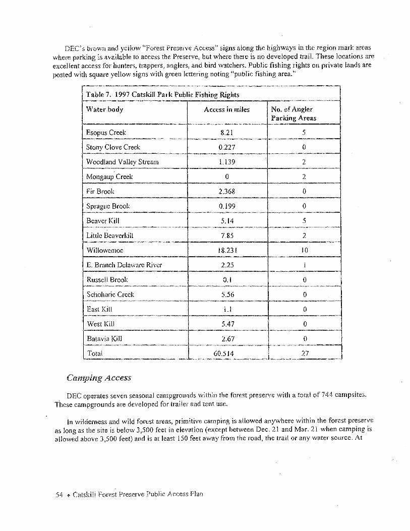
brown and yellow ''Forest Preserve Access" signs along the highways in the region mark areas where parking is available to access the Preserve, but where there is no developed trail. These locations are excellent access for hunters, trappers, anglers, and bird watchers. Public fishing rights on private lands are posted with square yellow signs with green lettering noting "public fishing area."
Table 7. 1997 Catskill Park Public Fishing Rights
Water body Access in miles No. of Angler Parking Areas
Esopus Creek 8.21 5
Stony Clove Creek 0.227 0
Woodland Valley Stream l.139 2
Mongaup Creek 0 2
Fir Brook 2.368 0
Sprague Brook 0.199 0
Beaver Kill 5.14 5
Little Bcavcrkill 7.85 2
Willowemoc 18.23 l 10
E. Branch Delaware River 2.25 I
· Russell Brook O. l 0
Schoharie Creek 5.56 0
East Kill LI 0
West Kill 5.47 0
Batavia Kill 2.67 0
Total 60.514 27
Camping Access
DEC operates seven seasonal campgrounds within the forest preserve with a total of 744 campsites. These campgrounds are developed for trailer and tent use.
In wiiderness and wild forest areas, primitive camping is allowed anywhere within the forest preserve as long as the site is below 3,500 feet in elevation (except between Dec. 21 and Mar. 21 when camping is allowed above 3,500 feet) and is at least 150 feet away from the road, the trail or any water source. At
54 + Catskill Forest Preserve Public Access Plan

Map 6. Easy Access Fishing Sites
* PROJECT ACCESS: Easy Access Sites
r """'"""' ""' "" .... °" .. ., .. ~ " ...... - .. = ....... "'" .. "".,..,." ...
: Luru: Special Fishing Area ·
: Llmil:
Artlnclal !urea only, Use ol bait. dead or allve prohib<lec:!. An 11out shall b<I lmmodialoly returned 10
lkie water wilhoul unnece slary Injury.
\'! ll l 0 \'/EM 0 C CREEK
Roscoe to Livingston Manor
' Season: All year.
0 Rhodendron Pool
le:J Sue k Eddy
lQ [QJ
[]
Wegman·s Pool
Hazol Sridgo Pool
Troslle Pool
THE BEAVERKILL
~ Pork Eddy
fD Elk Brook Run
Baxter"s Pool
Add Factory Run
Cemetory Pool
0 School House Pool
~ [)
Wagon Tracks Pool
Cairn's Pool
~ Horse Brook Run ,
~.Hendrick.son's Pool
Painter's Bend !2J Barnhart's Pool
p.olll e' _ 7 .... '-......_ ·-.
0 L_ __ _._ __ ___,
CFFC Pari<in9 lo• '.*just uos1ream or ' bric:!Qe
Fishorm.,n·s Parltin9 jusl uosirnm of CFFC
l
Lower Mounl:iin Pool EJ F1rn::!on's Pool SPEC!AL FISHING AREA SPECIAL FISHING AREA
Mountain Pool !;J) Junction Pool
Trosile Pool
n,.,H mop1 counuy of 1h., N.,w Yoek Stole D•rrx:irtment or En ... ironm<inlol Coruervolion.
Re::i"Odve:ed from th.,, li";"gilon Monor • Rozcoe-Roe:klond Vizilor'z Guid,
J.,nct"1n Pool
Key Issues and Actions: Recreation Access and Development + 55

locations closer than 150 feet from roads, trails, and water, primitive camping is only allowed at designated sites marked with round, yellow, DEC markers. Fires are never permitted above 3,500 feet, except in an emergency. A camping permit is required for stays of more than three consecutive nights at the same place or for groups of ten or more.
Table 10. "Easy Access" Fishing Sites in the Catskill Forest Preserve
Cmmty Location
Delaware Big Pond Launt Pond at Bear Spring Mountain Campground Beaver Kill at Cairn's Pool
Greene North South Lake Colgate Lake
sumvan Beaver Kill at Ferdon's Pool, approximately 3/4 mile upstream from its confluence with the Willowemoc
Willowemoc River at: a. Covered Bridge Pool, Covered Bridge Road b. Catskill Fly Fishing Center, Old Route 17
Ulster Onteora Lake K. Wilson Campground Pine Hill Lake Day Use Area
Primitive campsites have no vehicle access, no running water, no garbage pick-up, and no picnic tables. Fire rings are provided at some sites to minimize the impact of campfires. A total of 187 designated primitive campsites are located in the forest preserve at Alder Lake, Peekamoose Valley, Allaben, on Frost Valley Road, Huggins Lake, Big Pond, Trout Pond, Russell Brook, Echo Lake and various remote interior locations. Camping permits are available from regional offices or from local forest rangers.
There are 32 back country lean-tos in the forest preserve. They are generally located in the interior along hiking trails. Their locations are shown on DEC brochures for the Slide Mountain Wilderness, Big Indian Wilderness and Balsam Lake Mountain and Willowemoc Wild Forest and on the New York/New Jersey Trail Conference maps.
Swimming Access
Swimming is unrestricted except at beaches at campgrounds and day use areas where a life guard is present. At these revenue producing locations, swimming is only permitted within the protected swimming
· area and;:_vhen guards are on duty. There is no swimming allowed when the life guards are off duty or the swimming area is closed.
56 + Catskill Forest Preserve Public Access Plan
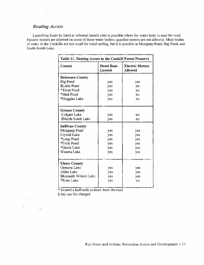
Boating Access
Launching boats by hand at informal launch sites is possible where the water body is near the road. Electric motors are allowed on some of these water bodies; gasoline motors are not allowed. Most bodies of water in the Catskills are too small for wind surfing, but it is possible at Mongaup Pond, Big Pond, and North-South Lake.
Table 11. Boating Access in the Catskill Forest Preserve
County Hand Boat Launch
Delaware County Big Pond yes $Little Pond yes *Trout Pond yes *Mud Pond yes *Huggins Lake yes
Greene County Colgate Lake yes $North-South Lake yes
Sullivan County Mongaup Pond yes Crystal Lake yes *Long Pond yes *Frick Pond yes *Quick Lake yes Waneta Lake yes
Ulster County Onteora Lake yes Alder Lake yes $Kenneth Wilson Lake yes *Echo Lake yes
* located a half-mile or more from the road $ day use fee charged
Electric Motors Allowed
yes no no no no
no no
yes yes yes yes yes yes
yes yes yes no
Key Issues and Actions: Recreation Access and Development ~ 57

New Physical Access Initiatives
ction: Improve and complete Catskill Forest Preserve trail system
The identification and construction of new trails is done in the unit management planning process where detailed investigation by DEC program staff and extensive public involvement guide the recommendations contained in these plans. In the course of the meetings for the Public Access Pian some general and specific guidelines were recommended for consideration by DEC staff in developing or revising unit management plans.
1. Old Roads: Identify, inventory and map fire roads and abandoned town roads or rail beds with potential for use by horses, bikes, people with disabilities, snowmobiles and others. DEC and towns should determine the status of these roads to see if they are eligible for snowmobile trails or disabled motor vehicle access.
2. Interpretive Trails: Increase opportunities for families, people with disabilities and other casual users by creating short, loop interpretive nature trails and trails for biking and hiking at campgrounds where opportunities exist. The campgrounds already provide handicapped accessible rest rooms and other amenities. They are staffed with personnel who can provide information to highway travelers and several campgrounds offer interpretive programs.
3. Longer Loop Trails: Where new trails are to be developed, consider the possibility of longer loop trails (20~30 miles) for cyclists, snowmobilers and horseback riders.
4. Family Trails: Identify or develop "family trails," trails that would be relatively short, lead to interesting destinations, and receive a higher level of maintenance. Trails accessible from the major highways of the Catskill Park would take priority. The Catskill Adventure brochure has identified some existing opportunities, but future UMP development should address the need for additional family trails where appropriate.
5. Mark all snowmobile trails for horseback riding as appropriate. Where snowmobile trails are suitable for horseback riding in other seasons, mark them for this use.
6. Mark Trails Suitable for Mountain Bike Use. Mountain bikes are currently allowed on any trail throughout the Forest Preserve. However, some trails are not suitable for bicycle use due to hazardous conditions, the potential for erosion, or conflicts with other users. DEC will clearly identify appropriate bicycle opportunities by marking the at trail heads.
7. Improve Parking at Trailheads aHBd Other Access Points. At horse and snowmobile trailheads, the sp~ce requirements for parking, turning and unloading vehicles with trailers need to be considered in UMP planning. These locations also need to be made more accessible to highway travelers through clear and consistent signage. Develop maintenance agreements with local governments to assist with snow plowing and other·custodial work.
8. Develop Links in the Trail System between Delaware County wild forest areas managed by DEC Region 4 and Sullivan County wild forest areas managed by DEC Region 3 for all uses through land acquisition, conservation easements, or landowner agreements.
+ Catskill Forest Preserve Public Access Plan

9. Multiple Use Trails: Develop true multiple use or multi-purpose trails where appropriate. New trails suitable for horses, bikes, and snowmobiles are required to provide balanced recreational access in the forest preserve.
10. Community Links: Pursue trail linkages from communities to forest preserve lands.
Following are more specific proposals to fill gaps in the forest preserve-wide picture of recreational access. They will be considered in the development of UMPs.
Hiking
Units holding promise for additional hiking opportunities include:
.. Indian Head-Plateau Mountain Wilderness and Hunter Mountain Wild Forest Units (both in Greene County), for linkages for the Long Path which will eliminate "road walks"
.. Blackhead Range Wild Forest, in the vicinity of Colgate Lake
Specific hiking trail opportunities that should be investigated are:
• An east-west hiking trail from the Big Indian Wilderness Area to the Slide Mountain Wilderness Area trail system
.. A northerly trail from Terrace Mountain to Phoenicia, Slide Mountain Wilderness Area
.. A trail from Phoenicia to Mt. Tremper, Phoenicia-Mt. Tobias Wild Forest
.. In the Phoenicia-Mt. Tobias Wild Forest, complete the trail north to the Indian Head Wilderness Area
Family Trails
Some locations with opportunities for the development of family trails are Colgate Lake in Greene County, Rochester Hollow in the Shandaken Wild Forest, Kelly Hollow in the Balsam Lake Mountain Wild Forest, Onteora Lake in the Bluestone Wild Forest, Denman Mountain in the Sundown Wild Forest, and Frick Pond in the Willowemoc Wild Forest.
Interpretive Nature. Trails
The locations listed above as family trail opportunities also have potential for the development of interpretive trails. Fire tower trails would also make good candidates for interpretative efforts.
Cross-country Skiing
There is potential for the development of cross-country ski trails in the following areas:
Blackhead Range Wild Forest in the vicinity of Colgate Lake " Shal'l"daken Wild Forest at Rochester Hollow - old roads, new loop trail " Balsam Lake Mountain Wild Forest
Bluestone Wild Forest
Key Issues and Actions: Recreation Access and Development + 59
Snowmobiling
In general, snowmobile trail development should focus on wild forest lands where the relatively gentle terrain, the presence of old roads, and light use by hikers makes them well-suited for this use. Significant opportunities may be found in Delaware and Sullivan counties. The Office of Parks, Recreation and Historic Preservation has developed a statewide Snowmobile Trail Master Plan which proposed the development and maintenance of a cohesive statewide trail system. The plan proposes a corridor trail (trail #2) through southeastern portion of New York State, passing through the Catskill Park from Pine Plains to Binghamton. The exact route for such a trail would be discussed and analyzed through a public process.
Horseback Riding
Opportunities for new horse trails and horse camping might be realized in:
Cherry Ridge-Campbell Mountain Wild Forest Colgate Lake, on the Blackhead Range Wild Forest
0 Phoenicia-Mt. Tremper Wild Forest (connect to private lands) Slide Mountain Wilderness (Centennial addition near Mt. Pleasant - extensive old logging and quarry roads available, will need short connectors to be added) Sundown Wild Forest - expand existing trail use Bluestone Wild Forest
0 Willowemoc Wild Forest - Promote extensive old road system ° Kaaterskill Wild Forest
Bicycling
In general, as for snowmobiles, opportunities for future bicycle trail development should be investigated on wild forest lands with relatively gentle terrain, an abundance of old roads, and light use by hikers. Attention should be focused on wild forest areas in Delaware and Sullivan Counties, where significant opportunities may be found.
Areas where new bicycle trails might be designated include:
Cherry Ridge-Campbell Mountain Wild Forest Colgate Lake, on the Blackhead Range Wild Forest
0 Bluestone Wild Forest - Old quarry roads and new connectors could be used to create loops. 0 Willowemoc Wild Forest - Frick Pond trail system, existing wide trails on wood roads
Sundown Wild Forest - Existing trails on old roads near Vernooy Kill Falls 0 Overlook Mountain trail
Shared Use Trails
0 Denman Mountain in the Sundown Wild Forest - May be suitable for bikes, horses, snowmobiles, and as an interpretive trail
. Onteora Lake in the Bluestone Wild Forest - May be suitable for hiking, skiing, bikes, and an interpretive trail
60 + Catskill Forest Preserve Public Access Plan

Parking
Needs for new parking areas at the following locations have been identified and if land is acquired or leased by agreement, parking areas will be built. Parking areas will be expanded to accommodate snowmobiles and horse trailers where possible.
Prediger Road Platte Clove Stork's Nest Road Bamwn Road Jessup Road in Willow
Action: Develop "rules of the trail" procedures and education strategy
The steep topography and rough trail surface in Ulster and Greene Counties where most hiking occurs may reduce the potential for conflict between users. Biking on these trails is difficult, if not impossible. The western Catskills in Delaware and Sullivan Counties are little used by hikers and most of these trails are old roads crossing rolling hills which naturally lend themselves to biking. The present level of use has not caused serious conflicts to arise, but as use increases with greater awareness of the opportunities available, conflict among users, particularly bikers and hikers, may increase accordingly.
Trail etiquette and education are important tools to ease these conflicts. Knowing the basics of trail etiquette allows hikers, bikers, horseback riders and others to share the trail peacefully. Descriptions of responsible use and courteous behavior should be posted at trailheads. A good example is the international yield symbol of the International Mountain Biking Association (IMBA) and their "Rules of the Trail":
o Ride On Open Trails Only o Leave No Trace o Control Your Bicycle
TRAIL COURTESY
Cl • o Always Yield Trail o Never Scare Animals o PlanAhead
The NYS Horse Council recommends "wheels yield to heels yield to horses," which means that horses should be given the right-of-way at all times when on marked horse trails. Further, they recommend to their members the following twelve tips:
Be visible W car your helmet Be audible Be friendly and helpful Pass with care Read tli~ signs
Stay on the trail Pick up manure Be a responsible trail user No smoking Hold your horses Don't tic your horse to live trees
Organized clubs can promote conflict avoidance by self-policing their members and encouraging environmentally sound and socially responsible use. Forums for discussion and cooperative trail maintenance help encourage understanding, cooperntion and respect an1ong diverse groups.
Key Issues and Actions: Recreation Access and Development ¢ 6 l
ction: Improve public access to water=based recreation in the Catskill Park.
Public Fishing Rights
DEC will continue to pursue the purchase of public fishing rights along rivers and streams in the Catskill Park. The 1996 Clean Water/ Clean Air Bond Act included $1 million to continue to purchase these public fishing rights.
Rivers and streams within and adjacent to the Catskill Park where the acquisition of public fishing rights will be pursued include:
Willowemoc Creek and tributaries • Esopus Creek and tributaries
Neversink River and tributaries • Beaver Kill and tributaries
Schoharie Creek and tributaries East Branch Delaware River
• West Branch Delaware River
Access for People with Disabilities
Over the years, an extensive network of trails and several campgrounds have been developed on the lands of the Catskill Forest Preserve to provide recreational opportunities for the public. However, because of its management as an undeveloped natural area and its rugged terrain, the interior of the forest preserve has been largely inaccessible to people with disabilities. The need to protect the wild character of forest preserve lands sets limits on the degree of physical modification that can be undertaken to increase their accessibility, especially in wilderness and wild forest areas, Nevertheless, DEC intends to pursue appropriate access opportunities. The federal Americans with Disabilities Act of 1990 (ADA) obligates DEC to provide access to the outdoor recreation facilities under its authority, to the extent that access measures will not degrade the fundamental nature of a facility's recreational environment. DEC is committed to meeting the requirements of the ADA and will conduct assessments of all components of the forest preserve. In determining what measures to increase accessibility are appropriate in terms of the "fundamental nature" of each forest preserve management unit, DEC managers will refer to the New York State Constitution and the Catskill Park State Land Master Plan guidelines that apply to the land classification of the unit.
For many wilderness and wild forest areas, improving access might take the form of providing information to visitors about existing recreational opportunities and their physical characteristics. For instance, a trailhead sign would present information about trail length, width, surface type, average grade, maximum grade, average cross slope, and hazards such as rocks, ruts, and roots that might be encountered on the trail. Information could also be provided in a simple pocket guide with a map showing the trail and the locations of obstacles. Providing information about trail accessibility would allow a visitor to decide whether he or she could enjoy the trail. In addition, certain appropriate types of physical modification to increase accessibility in wilderness and wild forest areas will be made. For instance, parking areas, bridge surfaces and approaches, privies and other structures will be designed for use by people with disabilities,
The intensive use classification is given to areas that are managed to provide an array of outdoor recreational opportunities for people with a multitude of interests and abilities. Because most structures and improvements can easily be reached by automobile, intensive use areas are the most accessible parts of the forest preserve. The guidelines for the management of intensive use areas provide the greatest flexibility in improving accessibility through physical modifications to the land. Therefore, initial efforts to provide new opportunities for people with disabilities should focus on intensive use areas. In campgrounds, DEC already has made a number of improvements. Rest rooms, camping and picnic areas, fishing access sites and other structures have been designed for accessibility. Numerous boat launches also have been made accessible. Nevertheless, there may be places in individual intensive use areas whose accessibility can be increased.
Accessibility will become an integral part of forest preserve planning. Each unit management plan will contain an assessment of accessibility that includes the identification of accessible recreational opportunities. Actions to improve existing opportunities and create new ones where appropriate will be proposed. To assure that DEC's management efforts will effectively meet accessibility guidelines and recommendations while conforming with the legal and natural resource constraints that affect the management of forest preserve lands, DEC managers will involve experts in universal design and representatives of the community of people with disabilities in the preparation of unit management plans.
ction: Undertake a universal trail assessment of Catskill Forest Preserve trails
A first step in providing access to forest preserve trails for people with mobility impairments is to undertake a universal trail assessment of each trail. The results of the assessment then would be provided to potential users via brochures, trailhead signs, and other media. An objective trail assessment will provide valuable information such as average grade, maximum grade, average cross slope, type and magnitude of obstacles and surface characteristics which can be critical to a wheelchair-bound user, but equally useful to all visitors regardless of their abilities. Simply providing this information may allow people to use the trail who would otherwise not attempt it for fear of the unknown.
A second step will be to analyze the assessment to see what changes to the trail would be necessary to make the trail more accessible. Where simple changes such as removing a few large rocks or hardening a soft, muddy section of the trail could be done with no significant change in the environmental setting, those changes should be made.
DEC staff and volunteers will conduct assessments of existing trails throughout the preserve, at campgrounds and fishing access sites to make objective trail assessment information available to all users. Because of the magnitude of this project, DEC will work with user groups, especially those which represent people with disabilities, to develop a priority list of trails to be assessed, selected from existing trails that have known characteristics which make them potentially attractive opportunities for people with disabilities.
cti<Jn: Build. easy access fishing sites and sites accessible to people with disabilities
Making the world-class fishing in the Catskills region more accessible to people with disabilities is a goal of the DEC Fisheries Bureau. Opportunities to expand fishing accessibility have been investigated and identified at several locations within the park. An easy access site has been constructed on the Beaver
Key Issues and Actions: Recreation Access and Development ~ 63
Kill at Cairn's Pool. Additional fishing access sites to be made for people with disabilities are under consideration at the following water bodies:
Kenneth L. Wilson campground " Alder Lake " East Branch of the Delaware near Margaretville " Neversink River just outside the park at Hasbrouck Bridge .. Beaverkil! campground.
Support from interested parties such as Trout Unlimited chapters, Theodore Gordon Flyfishers, and organizations representing people with disabilities could help make these opportunities a reality in partnership with DEC operations staff.
Linking the Forest Preserve with the Catskill Region
The development of partnerships and links between the Catskill Forest Preserve and the local communities and governments within the Catskill Park is a goal of this plan. DEC is willing to assist local businesses to create new opportunities within the guidelines of the CPSLMP to facilitate development of new initiatives linked to the Forest Preserve. The development of the Catskill Interpretive Center would establish a headquarters for information exchange and visitor orientation to the Forest Preserve and Catskill businesses and attractions.
ction: Develop inn-to-inn trail systems
In several European countries and in the White Mountains of New Hampshire, hiking trails intersect overnight accommodations with varying degrees of comfort and elegance. The creation of a similar inn-to-inn or town-to-town network in the Catskill Park could be achieved by identifying and, where necessary, developing a network of trails for hiking, biking, and/or cross-country skiing that link communities and private business offering overnight accommodations and meals. The development of the "inn-to-inn" concept and its implementation would require a partnership between DEC, local governments, and the private sector including the hiking and biking clubs, tourism promotion agents, lodging bureaus, chambers of commerce, and environmental organizations active in the Catskill region.
DEC and the Catskill Center for Conservation and Development have agreed to take the lead to bring together members of the private sector who are interested in developing an "inn-to-inn" trail network and initiate discussion to see what opportunities exist or how future facilities can be developed throughout the Catskill Park.
ction: Pursue trail linkages between communities and the forest preserve 'along Catskill :railroad corridors
Railr6ads penetrated the heart of the Catskill Mountains in the last half of the nineteenth century. Today, two seasonal tourist railroads operate within the Catskill Park on the tracks of the former Ulster and Delaware Railroad which once ran from Kingston to Oneonta-the Delaware and Ulster Rail Ride in Delaware County, and the Catskill Mountain Railroad in Ulster County. Other lines, notably the former Stony Clove Railroad and its branches, have ceased operation. Opportunities to pursue trail linkages and new access possibilities may exist along these railroad corridors.
64 + Catskill Forest Preserve Public Access Plan

One example of a possible long distance trail link is the abandoned railway bed of the former Stony Clove Railroad along Route 214 from Phoenicia to Hunter and Tannersville. The northern and southern ends of the rail bed are not in forest preserve, but the center portion does traverse forest preserve lands near Devil's Tombstone campground and Notch Lake. Although it would require a major public/private partnership to contact the owners for permission and obtain easements to permit access, the abandoned rail bed offers an unusual opportunity to create a long distance trail linking towns and villages along the route.
The thirty-three mile former Ulster and Delaware right-of-way is owned by Ulster County and leased to the Catskill Mountain Railroad. This trackage passes through forest preserve lands that are difficult to access through other means and there is the prospect of connecting service by railroad to the Visitor Interpretive Center in Shandaken and on to Arkville. The railroad would provide an opportunity for visitors to enjoy the scenery, access the forest preserve and view the New York City reservoirs along the right-of-way.
The abandoned Ulster and Delaware Railroad between Kingston and Oneonta could make an excellent connection between Kingston and Onteora Lake in the Bluestone Wild Forest. The hiking and biking trail system, hunting and fishing opportunities in this Wild Forest could accommodate relatively high numbers of visitors from the nearby urban areas.
The Delaware and Ulster Rail Ride operates out of Arkville and travels east to Highmount at the foot of Belleayre Mountain Ski Center. This service presents opportunities to connect with the ski center and the summer concert series for special events.
Action: Pursue linkages to New York City's watershed lands.
NYC DEP's land acquisition program (described on page 9) offers substantial access possibilities. In the course of the work group discussions, there was strong support for close coordination between DEC and DEP to maintain existing uses, to create links to current state trail systems and state lands where possible, and to allow recreational access to existing watershed property.
New York City is considering the possible construction of scenic overlooks at selected highway pull off locations to afford scenic views. These locations would offer an opportunity to inform the public about New York City's watershed, reservoir system, and the forest preserve through wayside exhibits.
Visitor Management
ction: Conduct a visitor census, use and economic impact survey
. A thorough study of visitor profiles, economic impacts, and use of forest preserve lands would be a valuable tool for DEC land managers and economic development planners throughout the region. Increased interest in the outdoors, new recreation technology, and changing user behavior pose challenges for the future management of the Preserve. In order to maintain safety, protect the natural resources and provide for a high-quality visitor experience, a better understanding of the current use and projections of future use of the forest preserve would be helpful for DEC managers. Understanding the demographics of forest preserve users and their expenditures would be beneficial for the regional planners and businesses in surrounding communities as well. Whereas under present circumstances DEC does not have the resources to conduct such a study, if another state agency, university, regional planning organization, private
Key Issues and Actions: Recreation Access and Development * 65
contractor, or other coalition or partnership undertook such a study, DEC would cooperate and offer assistance to the extent possible.
Over the years DEC has conducted user surveys on a small scale designed to seek information related to particular management issues in the forest preserve. A questionnaire was distributed to a limited number of users during the fall of 1996 which sought information about the demographics of visitors, how they found out about and used the forest preserve, and the economic value of their visit to the local economy. Although not large enough to be statistically significant, the results from this survey demonstrate the importance of the forest preserve as a destination tourist attraction and as an economic benefit for the region.
ction: Monitor use and establish baselines
Planning for management of the forest preserve is difficult because of the lack both of reliable data about use and consistent information about the status of the Preserve's plant, animal, and physical resources.
Grants and/or partnerships with other organizations or institutions should be pursued to support a major monitoring project in the near future. The project would make extensive use of researchers, interns and volunteers to (1) record numbers of users representative of the full spectrum of forest preserve activities at key locations; and (2) record and photograph the condition of the Preserve at key heavy use locations. Three years after the establishment of the baseline, the same stations should be inspected for use impacts.
ction: Enhance yea:r-:round recreation at the Belleayre Mountain Ski Center
Created through an amendment to the New York State Constitution in 194 7, Belleayre Mountain Ski Center is operated by DEC on 2,211 acres of forest preserve land, in the Town of Shandaken, Ulster County. Belleayre Mountain has a summit elevation of 3,429 feet, a base lodge elevation of2,541 feet and a lower lodge elevation of 2,025 feet. The ski center has 31 slopes and trails over its 1,404 foot vertical surface. The ski center has 14.3 miles of ski trails, major ski lifts with snow making presently covering 91 percent of the total trail surface, a ski school, equipment rentals and approximately 6 miles of cross-country ski trails. The ski center provided recreation for more than 84,000 persons in 1998-9 and employs about 250 persons annually.
The Catskill Park State Land Master Plan designates the Belleayre Mountain Ski Center as an intensive use area (like the campgrounds). A wider variety of activities is allowed in intensive use areas than is permitted on wilderness or wild forest lands. With its ski trails, access roads and well-developed infrastructure such as the parking areas and lodges, Belleayre offers a wide array of opportunities for the expansion of year-round activities that would provide substantial economic benefit to the surrounding communities.
In ac~ordance with DEC's policy to create unit management plans for the wise management of public lands, Belleayre Mountain prepared a UMP in 1985 which identified a series of management objectives. Legislative budget appropriations in the mid- l 980s resulted in the enhancement of snow making facilities, the expansion of the lodges, improvements to the parking lots, and installation of new ski lifts. However, with the exception of annual lift maintenance, capital appropriations to maintain and upgrade these facilities were limited from that time until 1998; when Governor Pataki announced a $5 million investment
66 ~ Catskill Forest Preserve Public Access Plan

in Belleayre. The new funding will be used to replace and extend two ski lifts, build a new downhill ski trail, increase snow- making capacity, expand the Overlook Lodge, and rehabilitate roads and parking areas. An additional $1.5 million from the Clean Water/Clean Air Bond Act was earmarked to construct a 4,000-foot pipeline to connect the septic systems at Belleayre to the Pine Hill Sewage Treatment Plant operated by the City of New York. These and a number of additional objectives for improving Belleayre as a year-round recreation facility were identified in a new UMP adopted in May, 1998.
Currently there is limited use of Belleayre Mountain during the off-season for hiking, picnicking and hunting. A mountain bike race is held annually, organized by Fats in the Cats Bike Club. DEC's Catskill environmental education program offers interpretive nature programs throughout the year. The lodges are available for rental for weddings, parties, dinners, meetings and other events. In 1998 more than forty events were scheduled including the annual two-day fall festival organized by the ski center. The Belleayre Conservatory, a private non-profit cultural organization, has presented an annual summer eleven-concert series at the ski center since 1992. In 1997 these concerts attracted an estimated 8,500 people to hear concerts presenting a wide selection of musical styles in an outdoor setting. The new UMP calls for efforts to expand off-season recreation, including a 60-foot high observation deck on the mountain summit to be reached by summer and autumn operation of a chair lift, a potential link with the Delaware and Ulster Rail Ride that would allow tourists to ride the train and take the chairlift to the summit, a new interpretive trail focusing on the history of the ski center and the surrounding forest preserve, and a new parking area for the Cathedral Glen and Pine Hill-Eagle Mountain trails.
Future expansion of off-season recreation must be considered in the context of the unit management planning process. Hiking, biking, horseback riding, family trails and access for persons with disabilities are recreational activities that could be developed on the trail systems at Belleayre. Wayside exhibits, brochures and maps interpreting the forest preserve could be developed. A program of fall, winter, and spring outdoor ecology lessons for school classes could be established. Lessons could be taught by DEC staff, interns, and volunteer docents. All of these proposed developments could be undertaken through a combination of additional state fiscal resources and volunteer assistance.
In 1993 DEC constructed the Pine Hill Lake Day-Use Area at Belleayre Mountain. Like other state operated day use areas, Pine Hill charges a daily fee for access to the lake, swimming beach, pavilion, parking and rest rooms between Memorial Day and Labor Day. In the summer of 1998, 14,347 people visited the facility. The area is open off-season to other recreational pursuits. This site would be an excellent location for interpretive displays about the ski center and the forest preserve.
Key Issues and Actions: Recreation Access and Development + 67
Implementation
Strategies
A fundamental strategy recommended by the work groups for the successful implementation of the Public Access Plan is the creation of the position of Catskill coordinator.
ction: Establish a DEC Catskill coordinator position
The Catskill coordinator will seek funding for, track and facilitate the actions identified in the plan. In implementing these actions, the coordinator will build partnerships between DEC, other state agencies, municipal governments, businesses and nonprofits that will develop a community-based tourism strategy for the forest preserve to help fortify the regional economy. Without the coordinator's position, there is no one in DEC to carry out the vision for the Catskill Forest Preserve set forth in this plan. Creation of such a position is critical to coordinate the diversity of public and private concerns and the ecological and natural resource management issues on an ecosystem-wide basis in the Catskill region.
A Catskill coordinator will:
Be responsible for implementation of the Public Access Plan; Enhance DEC's ability to respond to the needs of the public on a timely basis; Coordinate complex management issues and facilitate improved communication between programs within DEC Regions 3 & 4 and between regions and central office staff in Albany; Seek funding for and track implementation of the Public Access Plan, as well as UMPs; Provide continuity with future planning within DEC and with other state agencies including the Catskill Association for Tourism Services; Maintain a tracking system for DEC program activities including facility development and resource management plan preparation and implementation for the Catskill region; Provide for improved DEC communications with the public and build constituency support for DEC initiatives that benefit the Catskill region.
' In all of the work groups for the Public Access Plan, the participants felt that the communication and
collaboration that occurred between government agencies and representatives of environmental groups, sportsmen, outdoor recreation enthusiasts, and the private sector in the series of work group meetings must be conti'nued. The creation of a Catskill Forest Preserve coordinator position is proposed to create an ongoing mechanism that will ensure continued interaction and the development of future coordination and partnerships to address natural resource concerns throughout the Catskill ecosystem. Regular meetings with groups and organizations to discuss issues relating to public access and stewardship of the forest preserve and to take the pulse of public concerns will be a valuable asset for all parties. A primary role of the coordinator will be to schedule and organize these forums, and follow up, as appropriate, on future recommendations, actions and/or concerns.
68 + Catskill Forest Preserve Public Access Plan

The New York City Watershed Agreement, the Public Access Plan, the Clean Water/Clean Air Bond Act and other DEC programs in the Catskills all have a common interest in com~unity development, land acquisition and recreational access, concern for the abundance and purity of water, and coordination with other DEC activities within the watershed. The DEC watershed coordinator is responsible for the monumental task of overseeing the implementation of all state partnership programs embodied in the l 997 New York City Watershed Agreement. The new position would complement the role of the watershed coordinator by integrating those activities directly related to the watershed agreement with all other DEC program interests. The benefit of an ecosystem-wide coordinator has been successfully demonstrated in the Hudson River estuary, Adirondacks, and Salmon River corridor; a similar position will ensure integration and balance in DEC's current and future initiatives affecting the natural, social and economic resources in the Catskill Region.
Pilot Projects
Some Access Plan actions are possible to carry out within existing DEC resources; indeed, some are already in the initial stages. Other actions depend on the allocation of additional funds in DEC's annual budget, partnership with other state agencies, groups and organizations, funding from outside sources, or a combination of the above. Some specific pilot projects have been identified as concrete ways in which DEC can begin to implement the Public Access Plan in the near future with existing resources. Examples of the key issues and actions and corresponding pilot projects are listed below. However, these are preliminary suggestions and will only be implemented if they are included in final unit management plans and if funding and staff time are available.
Key Issues and Actions
Enhance Scenic Travel Corridors
Improve public awareness of forest preserve access points
Improve distribution of DEC materials about the forest preserve
Expand Catskill environmental education initiative
Improve DEC Public Outreach
Pilot Projects
Improve and enhance DEC signage through the Catskill Park, with DOT.
Initiate process with DOT to install recreational icons along the highways indicating forest preserve activities.
Implement the establishment of satellite information centers. Catskill Comers, Shandaken, NY, Kenco, Twilight Groceries, and Point Lookout Mountain Inn, E. Windham, NY are the first of these centers distributing information about the forest preserve.
Support the restoration of the fire towers in the Catskill Park. Once restored, these structures will be used as focal points around which an education/interpretive program can be built.
Create a DEC Catskill Forest Preserve personnel directory.
Implementation ~ 69
Complete and improve Catskill Forest Preserve trail system
Improve access for people with disabilities
Undertake a universal trail assessment of Catskill Forest Preserve trails
70 '% Catskill Forest Preserve Public Access Plan
Produce an annual report to the community noting projects completed and the status of those underway. Include those projects called for in approved UMPs. Coordinate with other public, private and nonprofit organizations for their input
Establish a toil-free phone number that wili provide information on Catskill Forest Preserve trail conditions, seasonal hiking and camping tips.
DEC will perform training and familiarization workshops twice a year or as needed to better inform county tourism promotion agents and others about forest preserve access and opportunities.
Develop family interpretive trails at suitable locations such as Kelly Hollow, Rochester Hollow, Colgate Lake, Denman Mountain, Onteora Lake and the campgrounds.
On the trail to Kaaterskill Falls, construct a safe observation platform to view the falls from below with interpretive signs containing information about area geology, cultural history, wildlife and ecology. Construct a safe observation platform at the level of the first pool with interpretive signs. Convene an inter-agency task force with DOT to design a safe pedestrian walkway to the Kaaterskill Falls trailhead from the Molly Smith parking area on Route 23A.
Build accessible fishing sites. Fishing sites to be made accessible to people with disabilities are under consideration by DEC with help from Trout Unlimited and Theodore Gordon Fly Fishers at K. Wilson campground, Alder Lake, along the Delaware east branch near Margaretville, Colgate Lake, and on the Neversink River just outside the Catskill Park at Hasbrouck Brldge.
DEC staff will coordinate a trail assessment with volunteers and representatives of people with disabilities. The nature traii at Wiison State Park will be assessed by a combination of DEC staff,
Develop inn-to-inn trail systems
Sources of Funding
volunteers, and representatives of people with disabilities as the first assessment project.
The Catskill Center for Conservation and Development has agreed to take the lead in coordinating the development of inn-to-inn trail systems with DEC and local businesses and chambers of commerce. There is the potential in Greene County to legitimize existing trails that originate on the privately owned Winter Clove Resort and cross onto the lands of the North Mountain Wild Forest. Such an arrangement could benefit both the business and public forest preserve access. In Ulster County, a trail connection from the village of Phoenicia to the Tremper Mountain trail should be pursued.
Listed below are some possible sources of funding that could be used to implement the actions recommended in the plan. This list is by no means exhaustive. Many other potential sources of funding exist through foundations, corporate support, and other public and private sponsors.
State Programs
•New York State General Fund
Tax revenues in the state budget for basic maintenance and operation of DEC programs.
0 New York State Conservation Fund
Funds in the state budget from license sales and fines from violations of the Environmental Conservation Law designated for use in fish and wildlife related programs.
0 New York City Watershed Agreement
The newly created Catskill Watershed Corporation has the responsibility for the disbursement of funds received as a result of the signing of the 1997 NYC Watershed Agreement. The Catskill Fund for the Future provides $59.9 million to be used to provide loans and grants for responsible, environmentally sound development and the goals of watershed protection and job growth in the Catskill/Delaware watershed. Two million dollars are available for public education on the nature and importance of the city's water supply system and the critical role of watershed residents as stewards of water quality.
In addition, funds are available for the support of responsible, environmentally sensitive economic development projects through the use of existing NYSDED economic development information centers, a regional development program to promote regional economic development interests, a public relations and tourism development program to target the special programs and resources in the watershed, and the use of the existing industrial productivity program to help increase efficiency of new or existing watershed businesses.
Implementation+ 71

® 1996 Clean Water/Clean Air Bond Act
Local Parks, Historic & Heritage Area Preservation Grants totaling $50 million to help municipalities provide access to water bodies, promote water=based recreation and enhance natural, cultural or historical aspects of water bodies. An additional $50 million is set aside in the State Park Infrastructure Fund to provide capital funds for improvements to state parks, campgrounds and trails. In 1998, $530,000 from the bond act was designated for use in the improvement of CatskiH Forest Preserve campgrounds and trails.
eEnvironmental Protection Fund
A legislatively designated long=term source ofrevenues available to meet the pressing environmental needs of the state in the fields of open space conservation, municipal park, historic preservation and heritage area projects, farmland protection, biodiversity, nonpoint source water pollution abatement and control, local waterfront revitalization programs, coastal rehabilitation projects and planning assistance. Funding for the stewardship of state parks and forest preserve lands is also available from the EPF.
0 Biodiversity Stewardship and Research Fund
A legislatively designated vehicle to receive funds from a variety of sources, federal, state and private, to support biodiversity stewardship, research and education in New York state.
®Land Acquisition Funding
The Forest Preserve Expansion· Fund is derived from the sale of detached forest preserve parcels and is available only for the purchase of other forest preserve lands. EPF funds and Clean Water/Clean Air Bond Act funds may also be used for land acquisition in conformance with their guidelines. For instance, the public fishing rights program is funded by the Bond Act.
0 State Snowmobiling Funds
NYS Office of Parks, Recreation and Historic Places, Bureau of Marine and Recreational Vehicles, provides funding to both NYS DEC and local municipalities for the development and maintenance of snowmobile trails open to the public. Funds are derived from snowmobile registration fees.
Federal Programs
eNational Hudson River Valley Heritage Area Designation
The designation of the National Hudson River Valley Heritage Area applies to those ten counties along the Hudson River estuary. These counties, including the portion of the Catskill Park and Catskill Forest Preserve in Ulster County, are eligible for fonding under this program which will provide $15 million in federal support over the next 15 years to enhance the area's historical, recreational and tourism=based activities. The administrator of these funds will be the Greenway Conservancy for the Hudson River Valley.
wTransportation Equity Act for the 21st Century (TEA~21)
72 ~ Catskill Forest Preserve Public Access Plan

TEA-21 is the 1998 reauthorization of the Intermodal Surface Transportation Efficiency Act of 1991. IS TEA grants were used for a number of transportation enhancement and scenic byways projects in the Catskill region, including this plan. TEA-21 authorizes major funding for the next six years for numerous categories of surface transportation projects, including transportation enhancements, bicycle transportation and pedestrian walkways, recreational trails, and scenic byways.
•EPA Sustainable Development Challenge Grant Program
This program initiated in 1996 is designed to encourage people, organizations, business, and government to work together in their communities to improve their environment while maintaining a healthy economy and a sense of community well-being. Potential eligible activities include: demonstrating integrated approaches for protection and restoration of ecological, human and economic health; demonstrating pollution prevention across multiple sectors of the community; community cooperation among residents, businesses, non-profit organizations, education institutions, and governments; and community awareness to publicize the principles of stewardship, ecosystem management and sustainability.
•Land and Water Conservation Fund
Federal monies provided to state and local governments from this fond on a 50-50 matching basis for land acquisition and development of outdoor recreation. Since 1965, New York has received more than $191 million from this fund, but in recent years the federal government has cut back on funding authorization.
•Pitman-Robertson
Federal monies from the Federal Aid in Wildlife Restoration Act, apportioned to the states for wildlife conservation and hunter education.
•Wallup Breaux
Federal monies from the Federal Aid in Fish Restoration Act, apportioned to the states for fisheries management.
•National Park Service Rivers, Trails and Conservation Assistance Program
This program provides the expertise of National Park Staff to assist communities with developing projects such as constructing new trails, conducting inventories of abandoned railroads, or simply bringing interested parties together to move a project forward.
Private Programs
•The Catskill Watershed Corporation
A not-for-profit corporation established under the New York City Watershed Agreement to administer numerous programs and fonds, including the $60 million Catskill Fund for the Future. Funding administered by the Catskill Watershed Corporation will be available for economic development, and educational and other programs relating to water quality New York City's west of Hudson watershed.
Implementation + 73
*Furthermore, the publications program of the JM Kaplan Fund
0 Rural New York Grant Program
Four grant programs focus on the following subjects: Environmental Action, Land Conservation, Historic Preservation, and Planning.
e RED Recreation and Conservation Grant Program
0 American Green ways Dupont A wards Program
., Trout Unlimited, Theodore Gordon Fly Fishers
., The O'Connor Foundation
., Private sector donations, including those from hiking groups such as the New York/New Jersey Trail Conference, Adirondack Mountain Club, Appalachian Mountain Club, mid-Hudson chapter of the Sierra Club, to name a few .
. ., Volunteers-individuals and/or clubs
74 ~ Catskill

Appendix A: Article XIV of the New York State Constitution
Section 1. The lands of the state, now owned or hereafter acquired, constituting the forest preserve as now fixed by law, shall be forever kept as wild forest lands. They shall not be leased, sold or exchanged, or be taken by any corporation, public or private, nor shall the timber thereon be sold, removed or destroyed.
Nothing herein contained shall prevent the state from constructing, completing and maintaining any highway heretofore specifically authorized by constitutional amendment, ...
. . . nor from constructing and maintaining not more than twenty-five miles of ski trails thirty to two hundred feet wide, together with appurtenances thereto, provided that no more than two miles of such trails shall be in excess of one hundred twenty feet wide, on the slopes of Belleayre Mountain in Ulster and Delaware counties ... (1947.farther amended 1987)
... nor from relocating, reconstructing and maintaining a total of not more than fifty miles of existing state highways for the purpose of eliminating the hazards of dangerous curves and grades, provided a total of no more than four hundred acres of forest preserve land shall be used for such purpose and that no single relocated portion of any highway shall exceed one mile in length . .. (1957)
Section 3.2 As to any other lands of the state, now owned or hereafter acquired, constituting the forest preserve referred to in section one of this article, but outside the Adirondack and Catskill parks as now fixed by law, and consisting in any case of not more than one hundred contiguous acres entirely separated from any other portion of the forest preserve, the legislature may by appropriate legislation, notwithstanding the provisions of section one of this article, authorize: (a) the dedication (hereof for the practice of forest or wildlife conservation; or (b) the use thereof for public recreational or other state purposed or the sale, exchange, or other disposition thereof; provided, however, that all moneys derived from the sale or other disposition of any such lands shall be paid into a special fund of the treasury and be expended only for the acquisition of additional lands for such forest preserve within either such Adirondack or Catskill park. (Formerly§ 16 of Art. 7. Renumbered and amended by Constitutional Convention of 1938 and approved by vote of the people November 8, 1938;.further amended by vote of the people November 5, 1957; November 6, 1973.)
Appendices + 75

Appendix B. Public Access Plan Participants
Attendees at Scenic Byways Work Grmip Meetings:
David Fasser, DOT, Albany Don Robertson, DOT, Region l John Ryan, DOT, Region l Dan Hitt, DOT, Region I Rick Sullivan, DOT, Region I Russell Robbins, DOT, Region 8 Lisa Weiss, DOT, Region 8 Joel Robinson, DOT, Region 9 Jim Donohue, Ulster Co. Highway Dept. Joe Nalepa, Ulster Co. Highway Dept. William Reich, Greene Co. Highway Dept. Ed Legg, DOT, Ulster Co. Brad Jenkins, Lexington Highway Dept. Wes Warren, Delaware Co. Highway Dept. David Tobias, NYC DEP Matthew Schwab, NYC DEP Dennis Doyle, Ulster County Planning Dept.
Attendees at Tourism Wo:rk G:roup Meetings:
Janine Lounsbery, Delaware Co. Tourism Steve Fabrykiewicz, Oquago Retreat Center Joe Munster, Catskill Assoc. For Tourism Services Gene Lomoriello, Sullivan Co. Tourism Hope Petkus, Sullivan Co. Tourism Carol Clement, Artemesia, Inc. Lisa Lyons, Catskill Fly Fishing Center & Museum D. Halbe Brown, Frost Valley YMCA Camp Carol O'Beirne, Frost Valley YMCA Camp Dave Collins, Sullivan County Trail Assoc. Evelyn Haas, Sullivan Co. Bd. Of Realtors Marguerite Illing, NYS Horse Council Elton Harris, Supervisor, Town of Rockland Howard Hadley, journalist
Ronald Roth, Greene County Planning Dept. Ward Todd, Ulster County Legislator Justine Hommel, Mountain Top Historical Society Sherret S. Chase, Catskill Center for Conservation &
Development Rosemary Jensen, Pt. Lookout Mountain Inn Deborah Dewan, planner and consultant to AFPA John Doyle, consultant Rick Fenton, DEC, Albany Chuck Frederickson, DEC, Albany John Renkavinsky, DEC, Region 4 Art Johnsen, DEC, Region 4 Walt Keller, DEC, Region 4 Darwin Roosa, DEC Region 4 Paul Trotta, DEC, Region 4 Bill Rudge, DEC, Region 3 Beth Waterman, DEC project coordinator
Ward Todd, Ulster Co. Legislator Denise Cooper, Belleayre Conservatory Karen Harris, Margaretville Telephone Co. Rick Fenton, DEC, Albany Art Johnsen, DEC, Region 4 Darwin Roosa, DEC, Region 4 Bill Rudge, DEC, Region 3 Pat Vissering, DEC, Region 3 Mike Cavanaugh, DEC, Albany Carl Wiedemann, DEC, Albany Walt Keller, DEC, Region 4 Peter Innes, DEC, Region 4 Beth Waterman, DEC project coordinator
Attendees at Information and Interpretation Systems Work Group Meetings:
Helen Budrock, Catskill Center for Conservation & Development
Carol O'Beirne, Frost Valley YMCA Camp Dale Hughes, CIC Advisory Committee Chet Karwatowski, Catskills Chp.Trout Unlimited Tom Emerick, Catskills Chp. Trout Unlimited Paul Robilotti, Catskills Chp. Trout Unlimited Bert Darrow, Fly Fishing with Bert & Karen Delia Adams, Olive Natural Heritage Society Dexter Jeannotte, Olive Natural Heritage Soc. Karen Harris, Margaretville Telephone Ian l\1oar, Roxbury Bob Conklin, Ulster Co. Federation of Sportsmen
~ Catskill Forest Public Plan
Charles Fischer, Resource Center for Accessible Living Don La Valley, Reg. 4 FWMA Carleton Hatch, NYS Conservation Council Deborah De Wan, Assoc. for the Protection of the
Adirondacks Jim Mays, Atlantic Chp. Sierra Club Rick Fenton, DEC, Albany Walt Keller, DEC, Region 4 1 .. en Bouren~ DEC, Region 3 George Profous, DEC, Region 3 Charlie Platt, DEC Region 3 Rich Parisio, DEC, Catskills

Beth Waterman, DEC project coordinator
Attendees at Recreational Opportunities meetings:
Dave Tobias, NYC DEP Ik Icard, Catskill Center for Cons. & Dev. Phil Davenport, Frost Valley YMCA Camp Lisa Lyons, Catskill Fly Fishing Center & Mus. Tim Quilty, Fats in the Cats Bicycle Club Tom Schneller, Fats in the Cats Bicycle Club Neil Woodworth, Adirondack Mountain Club Tom Maines, Americans with Disabilities Charles Fischer, Resource Center for Accessible Living Gene Lomoriello, Sullivan Co. Promotion and Public
Information Bill Smith, Ulster County Federation of Sportsmen Harold Palmer, Region 4, FWMA Jay Martin, Ulster Co. Federation of Sportsmen Evelyn Haas, Sullivan Co. Bd. of Realtors Ed Diamante, Greene County Planning Dept. Dave Collins, Sullivan County Trails Nick Bove, Windham, bicyclist W. S. Burgess, Phoenicia Fish & Game Marguerite and Henry Illing, NYS Horse Council Mark Byer, horseman
':··
Lenny Millen, Trout Unlimited Rose Kelly Halvorsen, Wanderlust Franciska Rauch, AMC mountaineering guide Gene Gormley, horse trail rider Les Risley, horse trail rider Ed Legg, Hunter snowmobile trails Robert Dadrus, Liberty Chamber of Commerce Ray Phillips, horseman Dan Seginak, cross-country skier Robert Monteleone, Greene Co. Sportsmens Clubs Bob Conklin, Ulster County Federation of Sportsmen Rick Fenton, DEC Albany Mike Cavanaugh, DEC Albany Paul Trotta, DEC, Region 4 Walt Keller, DEC, Region 4 Tom Folts, DEC, Region 4 Fred Gerty, DEC, Region 3 Bill Rudge, DEC, Region 3 Leslie Surprenant, DEC, Region 3 Don Seacord, DEC, Region 4 Charlie Platt, DEC Region 3 Beth Waterman, DEC project coordinator
Appendices ~ 77

Appendix Catskm Forest Preserve Chronology
The following chronology lists, by date, some of the most important developments in the history of the Catskill Forest Preserve.
1885: Catskill Forest Preserve created on May 15, when Governor David B. Hill signed legislation requiring that "all lands now owned or which may hereafter be acquired by the State of New York ... in eleven Adirondack and three Catskill counties ... be forever kept as wild forest lands. They shall not be sold nor shall they be leased or taken by any person or corporation, public or private." A three-man forest commission was also created to administer the then 681,000-acre Adirondack Forest Preserve and the 33,384-acre Catskill Forest Preserve.
1887: A log observatory tower erected on the summit of Balsam Lake Mountain by the Balsam Lake Club.
1888: Delaware County added to the three counties where state lands constituted the Catskill Forest Preserve. The same four counties-Delaware, Greene, Sullivan and Ulster-still make up the Preserve.
1890: First specific appropriation for acquisition of land to increase and expand the forest preserve provided $25,000 to " ... purchase lands so located within such counties as include the forest preserve ... "
1892: First fiscal allocation ($250) made to construct a "public path" in the forest preserve to the summit of Slide Mountain, the highest in the Catskills. From this path has evolved a major recreational trail network of foot, horse, ski and snowmobile trails.
1895: On January 1 the "Forever Wild" clause was added to the constitution.
1904: Catskill Park created by Chapter 233 of the Laws of 1904, encompassing 576, l 20 acres. New park boundaries were delineated on a map by a blue line---<::ontinuing a tradition begun with establishment of the Adirondack Park in l 892, that these boundaries be generally shown on official state maps in this manner. Catskill Forest Preserve expanded to 92,708 acres through land purchases and tax sale acquisitions.
1905: First Forest Fire Observation Station in New York State established on the summit of Balsam Lake Mountain.
78 ~Catskill
1909: Two more Forest fire observation stations are established in the Catskills. On Belleayre Mountain an 85 foot high steel observatory was erected by the summer resort owners of the region. On Hunter Mountain a tower was erected by the state at a cost of $100.
1912: Description of the Catskill Park revised to include all lands within the blue line in the Park designation, instead of just state lands. A forest fire observation station was established on Slide Mountain.
1916: $7.5 million bond issue to acquire and add lands to the Catskill (and Adirondack) Forest Preserves approved at the General Election, adding nearly 49,000 acres to the Catskill Forest Preserve over the next ten years.
1917: Mt. Tremper fire observation tower erected.
1920: Red Hill fire observation tower erected.
1924: $15 million bond issue expanding state parks approved at the General Election and $5 million allocated to acquire lands for the forest preserve in the Adirondack and Catskill Parks. Funds provided for addition of 72,000 acres to the Catskill Forest Preserve over the next 20 years. 1926-31: First public campsites (now called public "campgrounds") established in the Catskill Forest Preserve with a campsite ranger on the premises to manage each of them (1929).
Devil's Tombstone in Greene County (1926) Woodland Valley in Ulster County (1926) Beaver Kill in Sullivan County (l 928)
• . North Lake in Greene County (193 l)
1928: First edit.ion ofrecreation circular #9, Catskill Trail§ published by the Conservation Department.
1933: Newly formed Civilian Conservation Corps (CCC) provided an enthusiastic workforce and undertook various conservation projects, including construction of many campground facilities. Nevv York State had 67 CCC camps, several located in the Catskills.
1947: Constitutional amendment authorized the purchase of lands and the use of some existing forest preserve in Ulster and Delaware Counties for a ski center on Belleayre Mountain.
1950: Overlook Mountain fire observation tower erected.
1957: Catskill Park enlarged eastward to include the Ashokan Reservoir and to the south to include additional areas of Sullivan and Delaware Counties-a total of 705,000 acres.
1960: Joint Legislative Committee on Natural Resources, asked in 1952 to recommend solutions to problems affecting the Adirondack and Catskill Forest Preserves, began studying the possibility of designating certain parts as wilderness areas. A year later, the committee recommended establishing four such areas within the Catskill Forest Preserve.
A $75 million Park and Recreation Land Acquisition Bond Act approved at the 1960 General Election. This funding and a supplemental $25 million approved in 1962 set aside $451,000 to acquire 12,000 acres for the Catskill Forest Preserve.
1967: Mongaup Pond Campground in the Town of Rockland, Sullivan County established. On premises is a 122-acre lake, the largest body of water .in the Catskill Park other than New York City's reservoirs.
1968: Little Pond Campground in Delaware County opened, providing additional opportunities for camping, swimming and boating.
1971: Temporary State Commission to Study the Catskills created by the Legislature and charged with studying" ... the necessity of strengthening policy regarding management, acquisition and use of public land ... "
1975: Temporary State Commission to Study the Catskills submitted its final report. Commission recommended that forest preserve lands in the Catskill Park be classified into acres of wilderness, wild forest, and intensive use according to their charactetistics and capacity to withstand such uses. They specifically urged establishing four wilderness areas identified in 1961 by the Joint Legislative Committee.
l 979: DEC opened a seventh Catskill campground, the Kenneth L. Wilson Park Campground in the Town of Woodstock, Ulster County.
1985: DEC completed a Catskill Park State Land Master Plan implementing the Catskill Study Commission recommendations.
1986: EQBA funds used to acquire more than 3,490 acres of Catskill Forest Preserve land, as well as 5 l 4 acres of use easements.
1987: Constitutional amendment to widen and increase the mileage of the ski trails at Belleayre Mountain was approved.
1990: State Legislature authorized development of New York State's first Open Space Conservation Plan.
1992: Working together, DEC and OPRHP along with nine regional citizen advisory committees, completed the first Open Space Plan. The plan proposed which open space should be saved for New York State's future and described how open space resources can be conserved and managed in a sensible, affordable way. It also identified the forest preserve as a major resource category, and set a mechanism for adding Catskill Forest Preserve lands and acquiring conservation easements within the Park. It specifically proposed a dedicated funding source to implement many of the plan's recommendations.
1993: The Governor and Legislature worked together on passage of the Environmental Protection Act, which established the Environmental Protection Fund (EPF) for State Open Space Conservation Projects; continued municipal park, historic preservation and Urban Cultural Park matching grants program; established county-based farmland protection matching grants; funded biodiversity research and identification; promoted local waterfront revitalization plans and coastal rehabilitation projects.
1995: Governor approved a revised Open Space Plan.
1996: A $1.75 billion Clean Water/Clean Air Bond Act approved at the 1996 general election. Funding available for open space protection and numerous water quality protection projects throughout the state, including Catsk;ill Forest Preserve campgrounds and trails.
1997: New York State, New York City, the United States Environmental Protection Agency, the Coalition of Watershed Towns, and members of the environmental community signed the New York City Watershed Agreement. The Agreement included
Appendices 4> 79

numerous measures to protect water quality within the New York City Watershed, including a major land acquisition program.
1998: Governor approved a revised Open Space Plan.
The Attorney Generai and the Courts have strictly construed Article XIV, and have restricted public use and department management to recreation that is compatible with preserving the land as wild forest. Since 1895, nearly 2009 amendments to Article XIV have been introduce in the Legislature. Only 29 of these actually have been presented to the state's voters, and only 20 amend.-rients have been approved.
Over a long period, as a result of public demand, the types of uses pennitted have increased considerably and the number of people taking advantage of these recreational uses has multiplied many times. It appears that these demands and pressures will continue to increase and, if accommodated without careful planning, could drastically erode the existing character of the land.

Appendix D. Catskill t<un.-::n ca..,.,,,.,.,,c Public Use
MANAGEMENT UNIT 1 I I -,, I
1990 1991
Big Indian Wilderness 3,132 3,207 3,215 3,465 3,861 4,028 3,558 4,316 4,50~
Indian Head Wilderness 7,130 7,325 7,181 6,861 8,185 8,071 6,787 8,672 7,032
Slide Mountain Wilderness 18,704 19,493 19,544 20,538 21,353 22,281 20,473 21,896 23,278
Westkill Wilderness 1,882 1,975 1,560 1,797 1,664 1,290 1,256 1,481 1,792
Wilderness Subtotal 30,848 32,000 31,500 32,661 35,063 35,670 32,074 36,365 36,605
Balsam Lake Mountain Wild Forest 2,077 2,910 2,302 2,911 3,734 4,205 3,462 4,037 5,243
Blackhead Range Wild Forest 2,836 3,010 4,033 3,533 3,904 4,440 2,983 3,943 6,346
BluestoneWild Forest 500 500 500 500 500 500 600 700 1,000
Delaware Wild Forest 3,200 3,200 3,500 3,639 2,828 3,729 3,379 4,445 4,663
Dry Brook Ridge Wild Forest 124 125 125 298 147 237 573 448 1,687
Colgate Lake Wild Forest 570 620 683 721 646 787 932 896 1,177
Halcott Mountain Wild Forest 200 200 200 200 200 200 200 200 200
Hunter Mountain Wild Forest 4,895 5,650 4,921 4,693 5,579 5,751 2,856 6,030 6,112
Kaaterskill Wild Forest 20,093 18,529 18,923 18,825 20,552 21,088 12,815 19,902 20,293
Overlook Mountain Wild Forest 2,583 4.030 2,993 3,251 5,256 4,876 5,005 6,392 6,869
Phoenicia-Mt. Tobias Wild Forest 1,487 1,528 1,465 1,427 1,523 1,763 1,142 1,445 2,068
Shandaken Wild Forest 300 300 300 300 300 300 300 300 300
Sundown Wild Forest 5,200 5.389 4,900 5,219 5,592 5,212 5,221 5,783 4,446
Willowemoc Wild Forest 411 564 841 1,198 1,909 2,479 2,245 2,730 2,961
Windham High Peak Wild Forest 3,353 4,070 3,728 4,045 4,615 5,087 4,726 4,734 3,781
Wild Forest Subtotal 47,829 50,625 49,414 50760 57,285 60,654 46,439 61,985 67,146
Beaverkill Campground 21,258 19,796 20,441 16,913 17~37 11,465 13,685
Devil's Tombstone Campground 5,640 5,276 6,104 5,574 ~ 91 5,273 5,003
Little Pond Campground 20,636 20,938 18,423 20,043 20,822 19,890 17.257 20,312 19,470
, . - - und 38,437 - . ,784 42,369 45,425 46,359 43,393 40,649 49,966 - . -North-South Lake Campground 120,825 133,761 111.260 123,533 122,809 120,997 118,358 128,424 114,922
Wilson Campground 39,763 39,680 36,100 38,441 35,485 43,010 27,385 40,491 36
Woodland Valley Campground 20,208 20,363 17,428 16,557 18,405 12,528 10,585 12,445 12,526
Pine Hill Lake Day Use Area 4,678 ~7,987 7,556 9;207 14,347
Belleayre Mountain Ski Center 95,944 77,422 76,151 ~5,l::J~ 0;247 8!,489 71 - ~ - -II
Subtotal 362,
Administrative Areas 6,000 6.--~ ,,,. ,...,..,..,... /' .-. .......... r AAA r AAA
r 000 6,000 6,000
GRAND TOTAL 447,388 449,003 410,611 450,688 464,933 444,706 406,464 443,825 460,607
Appendices + 81
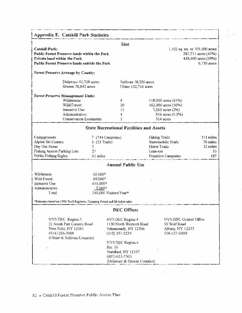
Catskill Parle Public Forest Preserve lands within the Park Private land within the Park Public Forest Preserve lamls outside the Park
Forest Preserve Acreage by County:
Size I, I 02 sq. mi. or 705,500 acres
287,711 acres (41%) 418,400 acres (59%)
6,730 acres
Delaware 4 l ,708 acres Greene 78,842 acres
Suilivan 18,320 acres Ulster 152, 716 acres
Forest Preserve Management Units: Wilderness: Wild Forest: Intensive Use: Administrative: Conservation Easements:
4 20 I I 4 3
118,000 acres (41 %) 162,000 acres (56%)
5,265 acres (2%) 816 acres (0.3%) 514 acres
State Rec:reatiomd Fadlities and Assets
Campgrounds Alpine Ski Centers Day Use Areas Fishing Access Parking Lots Public Fishing Rights
Wilderness Wild Forest Intensive Use Administrative
Total
7 (744 Campsites) I (33 Trails) 2 27 61 miles
Annual Public Use
45,000* 69,000* 455,000*
5,000* 540,000 Visitors/Year*
*Estimates based on 1998 Trail Registers, Camping Permit and lift ticket sales
NYS DEC Region 3 21 South Putt Comers Road New Paltz, NY 12561 (914) 256-3000 (Ulster & Sullivan Counties)
DEC Offices
NYS DEC Region 4 I 150 North Westcott Road Schenectady, NY 12306 (518) 357-2234
NYS DEC Region 4 Rte. 10 Stamford, NY 12167 (607) 652-7365
Hiking Trails Snowmobile Trails Horse Trails Lean-tos Primitive Campsites
311 miles 76 miles 32 mile's
33 187
NYS-DEC Central Office 50 Wolf Road Albany, NY 12233 518-457-5400
(Delaware & Greene Counties)
82 4> Catskill

Appendix F. Catskill Sign Law
; ... -
Sec. 9-0301. 9-0303. 9-0305. 9-0307.
TITLE 3-USE OF LANDS AND FORESTS
Use and diminution of Adirondack and Catskill parks. Restrictions oo use of state lands. Sigos and advertising in Adirondack. and Catskill parks. Forest preserve lands; detached parcels outside Adirondack and Catskill parks.
§9-0301. Use and diminution of Adirondack and Catskill parks. 1. All lands in the Catskill park and in the Adirondack park, except
those lying within the town of Dannemora. now owned or which may hereafter be acquired by the state, shall be forever reserved and maintained for the free use of all the people, except that nothing herein shall prohibit the charging of a fee for services rendered or facilities provided.
2. No law diminishing the area of the Adirondack and Catskill parks, as defined in section 9-0101 hereof, shall be effective unless enacted by the legislature at two successive regular sessions.
§9-0303. Restrictions on use of state lands. In order to protect the state lands described in this article the
following provisions shall apply: 1. Trees or timber. Except as provided in subdivision 2 of section
9-0107 and in sections 9-0501through9-0507 of this article no person shall cut, remove, injure or destroy any trees or timber or other property thereon or enter upon such lands with intent to do so.
2. Structures. No building shall be erected, used or maintained upon state lands except under permits from the department.
3. Agricultural use. No person shall use any portion of the forest preserve for agricultural purposes, nor shall cattle or domestic animals of any kind be permitted to graze thereon.
4. Deposit :rubbish. No person shall deposit or leave on state lands any rubbish or other waste material.
5. Transfer or lease. No person shall lease, transfer or accept any lease or transfer of any lands in the forest preserve or of any improvements thereon.
6. Disposal of improvements. The department may dispose of any improvements upon state lands under such conditions as it deems to be to the public interest..
7. Removal of materials generally. No person shall remove any material belonging to the state from the state lands without the authorization of the department.
Appendices+ 83
§9-0305. Signs and advertising in Adirondack and Catskill parks. 1. In order to conserve the natural beauty of the Adirondack and
Catskill parks, to preserve and regulate the said parks for public uses for the ·resort of the public for recreation, pleasure, air, light and enjoyment, to keep them open, safe, clean, and in good order for the welfare of society, and to protect and conserve the investment of the state in forest lands, campsites and other interests in :real property in said parks, no person shall erect or maintain within the boundaries thereof any advertising sign, advertising structure or device of any kind, except under written permit from the department. The provisions of this section shall not apply to signs erected or maintained upon a pa.reel of real property in eormection with the principal business or principal businesses conducted thereon and which advertise such business or businesses only, or to signs within the limits of an incorporated village.
As to signs, structures or devices existing within the Catskill park on May 26, 1969, and which require a permit pursuant to this section, the same may continue to be maintained without permit until January l, 1976 provided that the property owner or owner of such sign, structure or devi~ registers the same with the department on or before January 1, 1972.
As to signs, structures or devices existing on May 31, 1972 in those portions of the Adirondack park added thereto by eh.apter six hundred sixty-six of the laws ofnineteen hundred seventy-two, and which require a permit pursuant to this section, the same may continue to be maintained without permit until January 1, 1978, provided that the property owner or owner of such sign, structure or device :registers the same with the department on or before January 1, 1975.
2. Whenever a sign, structure or device has been erected or is being maintained in violation of the provisions of subdivision one of this section, the commissioner shall cause a notice ofsueh violation, specifying as nearly as may be the nature and location of such sign, structure or device, to be personally served upon the owner of record of the real property upon which the same is located, hereinafter referred to as the property owner. In addition, a copy of such notice sh.all be personally served upon the owner of such sign, structure or device, if his name and address and the fact that he is the owner is clearly indicated thereon.
3. The property owner or the owner of such sign, structure or device shall remove the same within ten days from the date of the last service of such notice or copy thereof as hereinabove specified. In the event of the failure of the property owner or the owner to remove such sign, structu:re or device within such ten day period, the commissioner may cause an agent or employee of the department to enter upon the property where such sign, structure or device is located and to remove the same.
4. No action for trespass or damages shall lie on accountofentryupon private property by an authorized agent or employee of the department engaged in carrying out any of the provisions of this section.
84 ~ Catskill Forest Preserve Public Access Plan
CHAPTER ll LA'\IDS AND FORESTS § 195.3
PART 195 PERMITS FOR THE ERECTION AND MAINTENANCE OF SIGNS,
ADVERTISING STRUCTURES AND DEVICES IN THE ADIRONDACK AND CATSKILL PARKS
(Statutory authority: Environmental Conservation Law.§ 9-0305)
Sec. 195.l Definitions 195.2 Applications for pennits 195.3 Classification and size limitations of authorized signs 195 .4 Material. design, color combination, and text for authorized signs 195.5 Illumination of authorized signs 195.6 Locations for authorized signs 195.7 Multiple authorized signs at same location 195.8 :Maintenance of authorized signs 195.9 Permits for authorized signs
Historical Note Part filed April 28, 1972: arnd. filed July 23, 1982 eff. July 23, 1982. Amended statutory
authority.
§ 195. i Definitions.
(a) Awhorized sign shall mean a sign which is or may be erected and maintained with.in the Adirondack or Catskill Park pursuant to a written permit required by section 9-0305 of the Environmental Conservation Law and issued by the Department of Environmental Conservation.
(b) Depanmenr shall mean the Department of Environmental Conservation of the State of New York.
Historical Note Sec. filed April 28, 1972; amds. filed: Sept 26, 1977; July 23, 1982 eff. July 23. 1982.
Amended (a).
§ 195.2 Applications for perm.its.
(a) All applications for permits for authorized signs shall be on standard forms provided by the department. All applications shall be filed with the Regional Forester of the Subdivision of Forest Resources of the department in the district where such sign is to be located, or with the Diiector, Subdivision of Forest Resources, Department of Environmental Conservation, Albany, N.Y.
(b) Each application shall have attached thereto a sketch of the proposed sign showing its dimensions, shape, wording and structural details.
(c) Each application shall contain or have attached thereto a sketch showing the location of the proposed sign. road system and place of business.
( d) Each application shall show the name or names and address of the owner or owners of the land upon which the proposed sign is to be erected.
Historial Note Sec. filed April 28, 1972; a.rod. filed Sept.. 26, 1977 eff. 30 days after filing. Amended (a).
§ 195.3 Classification and si.u l.i.mitatioru; of authorized signs.
Authorized signs shall be classified and limited in size according to the outside height and width or the total area of one side thereof, exch1sive of the necessary supporting structure, as follows:
(a) Standard small: a sign one foot high by three feet wide.
(b) Small: a sign not exceeding three square feet in area.
1-1-95 (Reissued 7 /95) 587 Conservation
Appendices + 85
§ 195.3 TITLE 6 El'MRONMENT AL CONSERVATION
(c) Standard medium: a sign 2 lh feet high by four feet wide.
(d) Medium: a sign not exceeding 10 square feet in area.
Note: Authorized signs may be lettered on both sides.
Historiral Note Sec. filed April 28, 1972 eff. May 1. 1972.
§ 195.4 Materials, design, color combilwticms ruid text for authorized signs.
(a) Construction material. Such sign shall be constructed of wood, meta.I or other durable material approved by the departroenL
(b) Design. Such sign shall be of a rustic or other design which will be attractive and suitable for its proposed location.
(c) Colors. Such sign shall be painted or stained in one of the following color combina-tions:
(l) yellow leuering on brown background;
(2) black lettering on white background.; or
(3) white lettering on green background.
(d) Text on authorized signs. The text on such sign must be approved by the department and shall be limited to:
( 1) name or asswned business name of permittee;
(2) kind of business;
(3) directional arrow;
( 4) distance from sign to place of business; and
(5) name and address of owner if different from permittee.
Historiral Note Sec. filed April 28. 1972 eff. May I, 1972.
§ 195.5 lliuntlm:ation of authorized signs.
(a) Only white artificial lighting shall be l.l.$ed to illwninate such sign.
(b) No flashing, intermittent m: moving light or lights shall constirute a part of or be used to illuminate such sign.
Hmorial Note Sec. filed April 28 •. 1972 eff. May 1, 1972..
§ 195.6 Loaltfom for ~mt.homed signs.
Permits will be issued for authorized signs to be erected or maintained at the following locations only:
(a) at the junction of numbered State highways when one such highway terminates in a dead end within the boundaries of the Adirondack or Catskill Park;
(b) at the junction of a numbered State highway and a secondary road, when the business to be advertised is located on such secondary road;
( c) at the junction of secondary roads, where the business to be advertised is located on one of such roads;
(d) at the junction of a private road and a public highway when the sign directs, via the private road, w a place of business not abutting such public highway.
Hirulriw Note Sec. filed April 28, 1972: amd. filed Sept. 26. 1977 eff. JO days after filing.
86 + Catskill Forest Public Access Plan
CHAPTER IT LA.i'IDS A.'-'D FORESTS § 195.10
§ 195.7 Multiple authorized signs at same location.
The department may require authorized signs at the same location to be erected or maintained contiguous to each other, in a cluster, on a common supporting structure or in such other manner as the department may approve.
Historical Note Sec. filed April 28, 1972 eff. May l, 1972.
§ 195.8 Maintenance of authorized signs.
Each authorized sign shall be maintained in a neat and attractive condition by the permittee.
Historical Note Sec. filed April 28. 1972 eff. May l, 1972.
§ 195.9 Penni.ts for authorized signs.
(a) Permits shall be on standard forms provided by the department.
(b) All permits shall be subject to review and may be revoked by the department whenever, pursuant to such pennit. a sign, structure or device has been erected or is being maintained in violation of this Part.
Historical Note Sec. filed April 28. 1972 eff. May I, 1972.
§ 195.10
Historical Note Sec. filed April 28. 1972; repealed, filed SepL 26, l m eff. 30 days after filing.
1-1-95 (Reissued 7195) 589 Conservation
Appendices • 87

Appendix
ADA ADK AMC ATV CIC CIE CPSLMP DEC DED DMU DOT ECL EPA EPF ESDC IMBA I STEA MOU NYCDEP OLP OPRHP PFR SUNY UMP WMA WMU
List of Acronyms
Americans with Disabilities Act Adirondack Mountain Club Appalachian Mountain Club All Terrain Vehicle Catskill Interpretive Center Catskili Institute for the Environment Catskill Park State Land Master Plan Department of Environmental Conservation Department of Economic Development Deer Management Unit Department of Transportation Environmental Conservation Law Environmental Protection Agency Environmental Protection Fund Empire State Development Corporation International Mountain Biking Association Intermodal Surface Transportation Efficiency Act Memorandum of Understanding New York City Department of Environmental Protection Overlap where two or more touring routes have the same alignment Office of Parks, Recreation, and Historic Preservation Public Fishing Rights State University of New York Unit Management Plan Wildlife Management Area Wildlife Management Unit
~ Catskill Forest Preserve Public Access Plan
Appendix H. DEC Media Products about the Catskill Fo:rest Preserve and Catskill Park
Catskill Forest Preserve Official Map and Guide Catskill Fishing - full color map and guide Balsam Lake Mountain Wild Forest - official map and guide Bluestone Wild Forest - official map and guide Big Indian Wilderness - official map and guide Slide Mountain Wilderness - official map and guide Willowemoc Wild Forest - official map and guide DEC Campground brochures
Devil's Tombstone Bear Spring Mountain (technically outside Catskill Forest Preserve) Little Pond North/South Lake Kenneth L. Wilson Beaverkill Mongaup Pond Woodland Valley
Day Hikes at North-South Lake Catskill Forest Preserve: Forever Wild (general information brochure) Belleayre Mountain Ski Center Primitive Camping Peekamoose Valley Wild Forest Catskill Adventure - day hikes and paddles for families
Other DEC Statewide Publications
Camping in the New York State Forest Preserve Safeguarding New York's Forest Preserves Horse Trails in New York State Nordic Skiing Trails in New York State Snowmobiling in New York State Opening the Outdoors to People with Disabilities Tips for Using State Land NYS Fishing Regulations Guide NYS Hunting and Trapping Regulations Guide 5 Rules for Survival and Enjoyment of Wilderness Recreation Use ofNew York State's Public Forest Lands EXPLORE DEC Environmental Education Summer Camps Leaming About NYS's Environment
DEC In.tern.et Sites
DEC web site: www.dec.state.ny.us Belleayre Mountain web site: www.belleayre.com DEC campgrounds web site: www.parknet.com
Appendices <@> 89

Appendix Catskill Forest Preserve Public Recreation Opportunities
Outdoor Forest Preserve Land Classification Recreational (287,000 acres of state owned land within the 705,000 acre Catskill Park)
Activity Wilderness Wild Forest Intensive Use (118,000 acres, 41 %>) (162,000 acres, 56°/o) (5,265 acres, 2%)
Hiking Allowed Allowed Allowed
Camping* Allowed Allowed Allowed, for a fee
Cross-Country Allowed Allowed Allowed Skiing
Horseback Riding Allowed except on Allowed except on Prohibited except marked hiking trails. marked hiking trails. on marked horse
trails.
Snowmobiling Prohibited Only on marked Only on marked ·snowmobile trails snowmobile trails
Bicycling Allowed Allowed Allowed
Hunting Allowed Allowed Prohibited
Fishing Allowed Allowed Allowed '~ ., - "~
Trapping Allowed Allowed Allowed
Boating (Gasoline Hand Boat Launch, Hand Boat Launch, Hand Boat Launch, motors are Non-motorized only. electric motors electric motors prohibited allowed on most, allowed on some,
throughout the forest but not all water but not all water preserve.) bodies. bodies.
Downhm Skiing No No Only at the Belleayre Mtn. Ski Center.
Swimming Allowed Allowed Only at designated beach with a lifeguard on duty.
*Camping is prohibited within 150 feet oftrnil, road or water, except at sites designated by the DEC, throughout the forest preserve. Camping is also prohibited above 3500 feet in elevation from March 22nd to December 21" each year to protect the fragile high elevation environment.
Approximately 500,000 visitors recreate on forest preserve lands in the Catskill Park each yeaL
90 + Catskill Public

Appendix J: Responsiveness Summary
The draft Catskill Forest Preserve Public Access Plan was released on January 8, 1999 for public comment through March 12, 1999. At the request of the public, the period was extended until March 19, 1999. During the public comment period DEC and DOT held three public meetings which took place at Belleayre, Liberty and Guilderland. In addition DEC was invited to present the plan to Greene County Planning Board and the Land Committee of the Catskill Watershed Corporation. The plan received substantial public comment and press coverage. The final plan will include this responsiveness summary, a reply to the public comment DEC received, as an appendix. In addition a copy of the responsiveness summary will be mailed to each respondent and posted on DEC's web site.
The plan represents a new vision for comprehensive management of the Catskill Forest Preserve. It provides recommendations on improving public access to the Forest Preserve and forging stronger relationships between the Forest Preserve and the local communities in the Catskill Park. It does not, however, replace or preclude DEC's current management plans or processes which are determined by the Catskill Park State Land Master Plan (Master Plan) and Unit Management Plans (UMPs). Public meetings are held to solicit participation and stimulate discussion in the creation and revision of both of these management tools - the Catskill Park State Land Master Plan and UMPs. Public support is essential before management decisions or recommendations are adopted.
The Master Plan divides the lands into geographical management units. These units are classified according to the following categories: wilderness, wild forest, intensive use, and administrative areas. The Master Plan governs the uses within each of these areas and establishes policy guidelines for the Forest Preserve as a whole. The current plan, written in 1985, is in the process of being revised. The Master Plan directs the DEC to develop individual unit management plans for each geographical management unit. These UMPs provide detailed information on the facilities, natural characteristics and public use of the unit, as well as specific management objectives and a schedule of actions needed to meet those objectives.
Some of the comments received during the public comment period for the Public Access Plan relate to Master Plan or UMP issues and are valuable for future development of these plans. An example of suggestions relating to UMP planning efforts are those comments recommending or opposing locations of future trails, parking lots or other facilities. Other comments, for instance, whether bicycling should be allowed on marked foot trails, relate to the Master Plan and will be considered in its revision. Where appropriate comments have been added to the text in the Public Access Plan; other comments have been referred to the regional staff responsible for UMPs and will be reviewed when specific UMPs are written and/or revised.
The Public Access Plan recognizes that the Catskill Forest Preserve is an invaluable asset to the quality of life and the economic vitality of the Catskill Region It recommends new ways DEC and DOT can cooperate and collaborate with the residents and visitors to the Catskill Park to fulfill the recreational, scenic and economicu,otential of the Catskill Forest Preserve.
Volume of Public Comment
There was enthusiastic approval for the plan itself and substantial support for many of the recommendations within the plan. In addition to the public comment received at the well-attended public meetings, DEC received more than 150 individual letters or emails and petitions signed by 300 individuals. Numerous
Appendices~ 91
newspaper articles and editorials endorsed the plan. In addition, comments were received from the following groups and organizations active in the region:
Adirondack Mountain Club ADK ~ Mohican, Mid Hudson and Schenectady Chapters Association for the Protection of the Adirondacks Catskill Center for Conservation and Development Catskill Mountain Railroad Catskill Watershed Corporation Catskill 3500 Club Empire State Railway Museum Fats in the Cats Finger Lakes Trail Conference Greene Co.and Sullivan Co. tourism offices NYC Department of Environmental Protection, Bureau of Water Supply, Quality and Protection NY Mountain Bicycling Coalition NY NJ Trail Conference NYS Horse Council Olive Natural Heritage Society Sullivan County Legislature Sullivan Co. Trails Association Thornapple Pony Club
Legislative support for the plan included Senator John Bonacic, Assemblyman John Faso, and Raymond Pomeroy, Chairman, Sullivan County Legislature.
Content of Public Comments and Responses
There was substantial support for the following recommendations proposed in the Public Access Plan:
" Establishment of a Catskill Coordinator within DEC.
"' Construction of a facility on the site of the proposed Catskill Interpretive Center .
"Development of trails specific to horses, snowmobiles and mountain bikes
"Creation ofDOT's handbook with guidelines to improve the appearance of major highways in the region.
" Reprinting Catskill Forest Preserve Map and Guide and other recreational brochures.
The following comments advocate changes to actions recommended in the plan. These have been summarized and addressed as follows:
Comment! Support for the construction of a facility that would orient visitors to the Catskill Park at the site of the proposed Catskill Interpretive Center.
Response: DEC received substantial comment in favor of development of a visitor's center at the site on Route 28 in Shandaken. DEC is committed to working with other government agencies, local governments and the private sector to identify funding sources and to seek innovative partnerships to achieve the goal of having a central facility for visitor's information.
Comment: DEC received considerable support for and opposition to the use of mountain bikes on marked foot trails. We also received comments supporting and opposing use of bicycles in wilderness above 2700'. (The current 1985 Catskill Park State Land Master Plan treats wild forest lands above 2700' as wilderness.)
Response: Because the use of bicycles is not addressed in the current Catskill Park State Land Master Plan, bicycling within the Catskill Forest Preserve is presently unrestricted, but it is an issue under consideration in the revision to the Master Plan. The parallel plan in the Adirondack Forest Preserve, the Adirondack Park State Land Master Plan, prohibits bicycles in wilderness.
The scope of the Public Access Plan is to look for appropriate opportunities for recreation within the context of uses allowed in the Master Plan. This issue, bicycle use in the Forest Preserve, will be addressed in the upcoming revision to the Master Plan. Once the decision on bicycle use is made in the revised Master Plan, the Access Plan will direct the DEC to identify these opportunities with appropriate signage at trail heads.
Comment: DEC received considerable support for and opposition to future snowmobile trail development on Forest Preserve lands.
Response: DEC received strong opposition to text in the draft plan that suggested areas where new snowmobile trails might be developed. The text has been amended to reflect the purpose of the Office of Parks, Recreation and Historic Preservation Statewide Snowmobile Trail Master Plan. This plan, completed in 1989, is intended to guide the development and maintenance of a cohesive statewide snowmobile trail system. The Public Access Plan advocates completion of corridor trail #2 which passes through the Catskill Forest Preserve, but the exact route for such a trail would be the subject of a public process of discussion and analysis in the context of a unit management plan. '
Comment: Approval for and opposition to proposed changes to DEC sign law.
Response: DEC received a modest amount of support for and opposition to changes in DEC's sign law. DEC will pursue a change to allow signs to direct the public to businesses at up to four intersections. Changes to the sign law will require SEQR review with public comment and meetings before any change will be effected.
Comment: Local chambers of commerce request the ability to post community information at DEC's campgrounds.
Response: DEC's current policy allows campground bulletin boards to post information relating to community events, local church services, and boat and canoe livery information. Upon request the campground staff will place one descriptive brochure or pamphlet describing private campgrounds, special events, or key attractions on the bulletin board. They will also keep a reasonable supply of such literature in th~ booth for distribution upon request. However, advertisements for real estate, boats, vehicles, household items, commercial services, and local businesses may not be posted because of space limitations. In addition, chambers of commerce are encouraged to post notices in the DEC information kiosks in Phoenicia;·-Margaretville, and new proposed kiosks in Delhi and on Route 28 in the Town of Ulster.
Comment: Restore historic names on Catskill highways such as Mohican Trail, Rip Van Winkle Trail, and Ashokan or Onteora Trail.
Response: The restoration of historic names on Catskill highways can be accomplished through the Scenic Byway process, or through a partnership with involved groups. DOT will address this issue as an opportunity in its proposed guidelines for the Catskill Park.
Appendices ~ 93
Comment: DEC needs to improve communications with the public.
Respmm~: Improved communications is one of the goals of the Public Access Plan to which DEC is committed. The recommendation to establish a Catskill Coordinator is a critical element to achieve this goal. The creation of a DEC personnel directory will also assist in this process.
Comment: Increased fonding is necessary to implement the Catskill Forest Preserve Public Access Plan.
Response: The Public Access Plan proposes a broad range of actions some of which can be implemented within DEC's existing resources. Many actions will require partnerships. A few of the actions will require legislative or interagency cooperation, or identification of other funding sources outside the DEC budget process.
Comment: The Public Access Plan will encourage additional use which may increase trail erosion, litter, and other problems.
Response: The Public Access Plan is intended to inform the public of appropriate places to pursue recreational opportunities which will better distribute use of the Forest Preserve and encourage stewardship and awareness of the natural resources. DEC is aware that some overuse could occur and will monitor and address these problems if they arise. The goal of the plan is not to attract additional use, but to better educate existing visitors to the region.
~Catskill Preserve

Appendix K. List of References
Berg, Tricia, Natasha Harmon, Maureen Mullaney, and Whitty Sanford. Catskills Access: A~ of Accessibility !Q State F9rest Preserve Lands and to Recreational and Water Resources .AJQng ~ 28. Catskill Center for Conservation and Development, l 991.
Bierhorst, John and the Olive Natural Heritage Society. The Ashokan Catskills: A Natural History. Purple Mountain Press, Fleischmanns, New York, 1995.
Brown, Eleanor. ~ ~Preserve Qf .NIDY Turk~ Adirondack Mountain Club, Inc., 1985.
Evers, Alf. Illi;. Catskills.:: Er.Qm Wilderness 1Q Woodstock, 1972.
Knight, Frank . .NIDY .Ym:.k Wildlife Viewing .Y:l,llik. In cooperation with Defenders of Wildlife. Falcon Publishing. 1998.
Kudish, Michael, Ph.D. VegetatiQnal History Qf 1M Catskill High~. State University of New York College of Environmental Science and Forestry, Ph.D., 1971.
McAllister, Lee and Myron Steven Och.man, Hiking 1M Catskills. New York - New Jersey Trail Conference; 1989.
New York - New Jersey Trail Conference. Catskill Irail.s... 6th edition, New York, New York, 1998.
NYC DEP. A Preliminary Report .Qil Recreational~ Qf .NIDY Turk .city~ Su,gply Lallil.s., 1999.
NYS DEC. Catskill fark ~ Lfill.d Master £.I.an.. Albany, New York, 1985.
NYS DEC. Conservationist, Special Issue Celebrating 100 years of the Forest Preserve, May-June 1985.
NYS DEC. Einfil Generic Unit Management £lan and Environmental Impact Statement fur Campgrounds and Day-Use ~Division of Operations, Bureau of Recreation, Albany, New York, 1990.
NYS DEC and OPR,HP. Conserving~~ in~ Y.Qik ~. November, 1998.
NYS DOT. Guidelines fur 1M Adirondack fark. second edition. June 1996.
NYS DOT. Illi;. Nfil¥. Y.Qik ~~Byways Program. January 1997 .
. NYS OPRHP, ~ .Qf New York Snowmobile Trail .El.an.. Albany, New York, 1989.
NYS OPRHP, People Resources. Recreation: 12.24 Statewide .Comprehensive OutdQQr RecreatiQn £1filL. Albany, New York, 1994.
Recreation Access Advisory Committee. Recommendations fur Accessibilitx Guidelines: Recreational Facilities .anQ Outdoor Devcloped ~,U.S. Government Printing Office, Washington, D.C. 1994.
95 + Catskill Forest Preserve Public Access Plan

Temporary State Commission w Study the Catskills. filru£ LaruI Master~ - Catskill Region. NYS DEC, September, 1976.
Van Valkenburgh, Norman. ~~Preserve Qf Nfily Yru:k filru£ in~ Adirondack ruld Catskill Mountains; A Shml History, Purple Mountain Press, Fleischmanns, New York, 1996.
Van Valkenburgh, Norman. ~History Qf ~Catskill~ Preserve. The Catskill Center for Conservation and Development, Inc., December, 1982.
Wadsworth, Bruce. ~ .tQ Catskill .Irail£. Adirondack Mountain Club, Inc., 1994.
96 ~ Catskill Forest Preserve Public Access
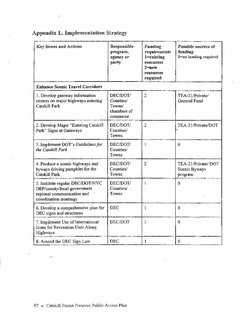
Appendix L. Implementation Strategy
Key Issues and Actions Responsible Funding Possible sources of program, requirements funding agency or l=existing O=no funding required party resources
2=new resources required
Enhance Scenic Travel Corridors
I. Develop gateway information DEC/DOT/ 2 TEA-21/Private/ centers on major highways entering Counties/ General Fund Catskill Park Towns/
chambers of commerce
2. Develop Major "Entering Catskill DEC/DOT/ 2 TEA-21/Private/DOT Park" Signs at Gateways Counties/ .
Towns
3. Implement DOT's Guidelines for DEC/DOT/ l 0 the Catskill Park Counties/
Towns
4. Produce a scenic highways and DEC/DOT/ 2 TEA-21/Private/ DOT byways driving pamphlet for the Counties/ Scenic Byways Catskill Park Towns program
5. Institute regular DEC/DOT/NYC DEC/DOT/ 1 0 DEP/county/local government Counties/ regional communication and Towns coordination meetings
6. Develop a comprehensive plan for DEC 1 0 · DEC signs and structures
7. Implement Use oflntemational DEC/DOT 1 0 Icons for Recreation Uses Along Highways
8. Amend the DEC Sign Law DEC 1 IO
97 ~ Catskill Forest Preserve Public Access Plan
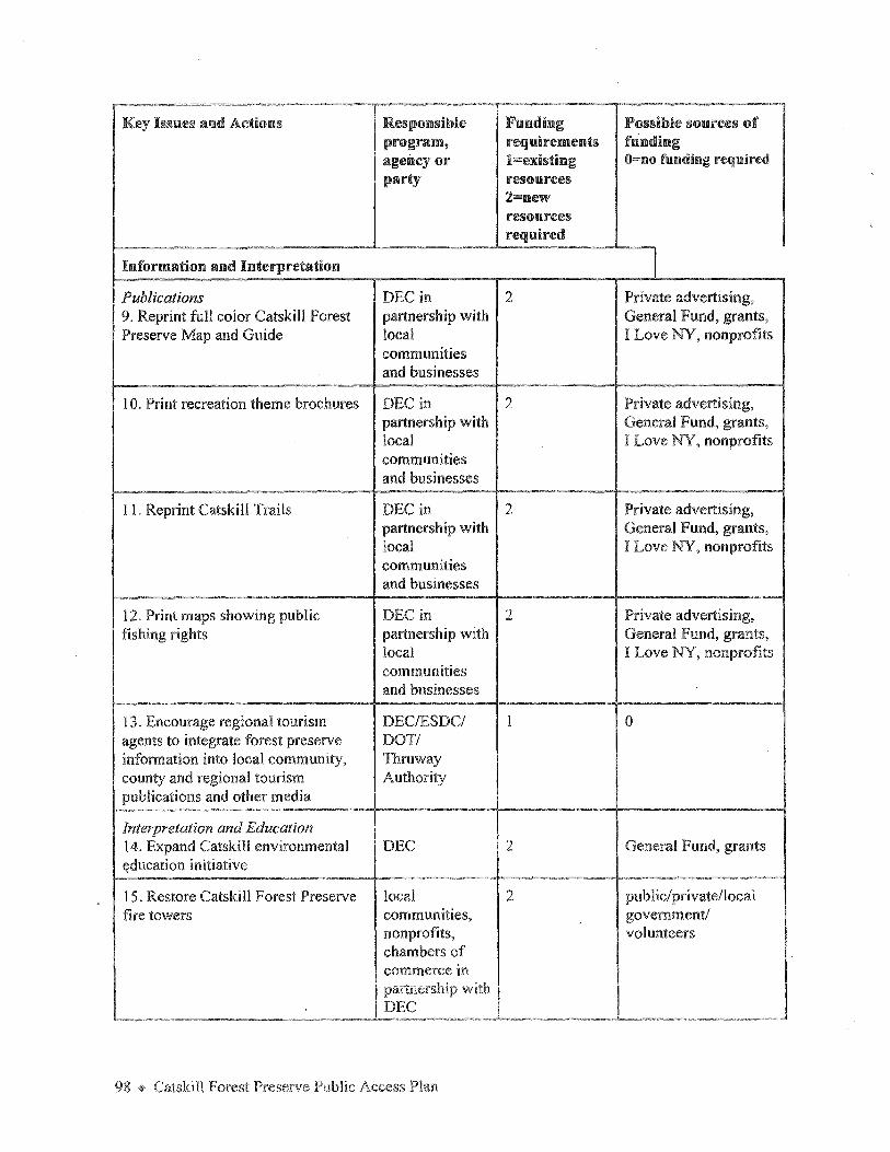
"" ____ Key Issues and Adicms Responsible Fumding Possible sources of
program, requirements funding agency or l=existing O=no funding required party resources
2=new resources required
Information and Interpretation I Publications DEC in 2 Private advertising, 9. Reprint full color Catskill Forest partnership with General Fund, grants, Preserve Map and Guide local I Love NY, nonprofits
communities and businesses
10. Print recreation theme brochures DEC in 2 Private advertising, partnership with General Fund, grants, local I Love NY, nonprofits communities and businesses
1 I. Reprint Catskill Trails DEC in 2 Private advertising, partnership with General Fund, grants, local I Love NY, nonprofits communities and businesses
12. Print maps showing public DEC in 2 Private advertising, fishing rights partnership with General Fund, grants,
local I Love NY, nonprofits communities and businesses
13. Encourage regional tourism DEC/ES DC/ 1 0 agents to integrate forest preserve DOTI information into local community, Thruway county and regional tourism Authority publications and other media
Interpretation and Education 14. Expand Catskill environmental DEC 2 General Fund, grants ~ducation initiative
15. Restore Catskill Fore st Preserve local 2 pub lie/private/local fire towers communities, government/
nonprofits, volunteers chambers of commerce in partnership with DEC

-- -- - ---·- '" - ~-. --
Key Issues and Actions Responsible Funding Possible sources of program, requirements funding agency or !=existing O=no fumding required party rescm,rces
l=new resources required
16. Build forest preserve volunteer nonprofits, 2 private/grants/ network hiking clubs, volunteers
sportsmen, DEC
17. Establish a central library and nonprofits, 2 private/public/grants research data base colleges and volunteers
universities in partnership with DEC
Distribution of Information DEC 1 0 18. Develop a coordinated DEC information distribution strategy
19. Establish a network of forest DEC in I 0 preserve information stations partnership with
local communities and businesses
20. Contract professional advertising DEC, ESDC, 2 Public/Private/I Love County tourism NY agents, local chambers of commerce, private businesses
DEC Public Outreach DEC l 0 21. Publish a DEC Catskill regional personnel directory
22. Conduct training and DEC l 0 familiarization workshops, field trips and other public presentations
Recreation Access and Development
23. Improve and complete forest DEC in 1and2 private/local preserve trail system partnership with governments
clubs and General volunteers Fund/donations
99 ~ Catskill Forest Preserve Public Access Plan

Key bsues and Actions Responsible Funding Possible sources of program, requirements funding agency or !=existing 0=110 fl.mdi11g required party resources
2=new
I resources I required
24. Improve public access to water- DEC 1and2 General Fund, EPF, based recreation in the Catskill Park Clean Water/Clean Air
Bond Act
25. Develop "rules-of-the-trail" DEC 1 0 procedures and education strategy
Access for People with Disabilities DEC in 1and2 grants 26. Undertake a universal trail partnership with assessment of Catskill Forest independent Preserve trails living centers
and volunteers
27. Build accessible fishing sites DEC/Trout 2 Conservation Fund, Unlimited/ grants, private Theodore Gordon Fly Fishers and others
Linking the Forest Preserve with Local I and 2 public/private/local Catskill Communities communities, government, 28. Develop inn-to-inn trail systems business, volunteers, nonprofits
nonprofits in partnership with DEC
29. Pursue trail linkages and access DEC, local 1aPd2 TEA-21 grants possibilities with Catskill railroads governments
and private enterprise
30. Pursue linkages with NYC DEP DEC/DEP/ I and 2 General Fund/Local watershed lands local Governments/Private
governments/ interest groups
,.,.
Visitor Management 2 US Forest Service 3 1 . Conduct a visitor census, use and Private grants economic impact survey consultant/
Coiieges or I Universities in pai tHc;1:;, with i

Key Issues and Actions Responsible Famding Possible sources of program, requirements fmndillg agency or 1=existing O=no funding required party resources
2=new resources required
32. Monitor use and establish DEC in I and 2 grants baselines partnership with
volunteers and interns
33. Enhance year-round recreation at DEC 1and2 General Fund/ Belleayre Mountain Ski Center Belleayre
Conservatory/ donations
Implement the Public Access Plan
34. Establish a DEC Catskill Forest DEC 2 General Fund Preserve coordinator position
101 ~ Catskill Forest Preserve Public Access Plan