Casey Jones State Trail Master...
104
DRAFT DRAFT DRAFT DRAFT DRAFT DRAFT DRAFT DRAFT Casey Jones State Trail Master Plan Master Plan prepared by: Minnesota Department of Natural Resources Division of Trails & Waterways 500 Lafayette Road Box 52 St. Paul, MN 55155 May 2005 Equal opportunity to participate in and benefit from programs of the Minnesota Department of Natural Resources is available to all individuals regardless of race, color, creed, religion, national origin, sex, marital status, status with regard to public assistance, age, sexual orientation, membership or activity in a local commission, or disability. Discrimination inquiries should be sent to MN-DNR, 500 Lafayette Road, St. Paul, MN 55155-4031; or the Equal Opportunity Office, Department of the Interior, Washington, DC 20240. This document is available in alternative formats to individuals with disabilities by calling TTY 651-296-5484 (Metro Area) or 1-800-657-3929. © 2005, State of Minnesota, Department of Natural Resources.
Transcript of Casey Jones State Trail Master...

DRAFT DRAFT DRAFT DRAFT DRAFT DRAFT DRAFT DRAFT
Casey Jones State Trail
Master Plan
Master Plan prepared by: Minnesota Department of Natural Resources
Division of Trails & Waterways 500 Lafayette Road Box 52
St. Paul, MN 55155
May 2005
Equal opportunity to participate in and benefit from programs of the Minnesota Department of Natural Resources is available to all individuals regardless of race, color, creed, religion, national origin, sex, marital status, status with regard to public assistance, age, sexual orientation, membership or activity in a local commission, or disability. Discrimination inquiries should be sent to MN-DNR, 500 Lafayette Road, St. Paul, MN 55155-4031; or the Equal Opportunity Office, Department of the Interior, Washington, DC 20240. This document is available in alternative formats to individuals with disabilities by calling TTY 651-296-5484 (Metro Area) or 1-800-657-3929. © 2005, State of Minnesota, Department of Natural Resources.

DRAFT DRAFT DRAFT DRAFT DRAFT DRAFT DRAFT DRAFT
The Casey Jones State Trail, the first abandoned railroad grade acquired by the state, was named after the legendary engineer, Casey Jones, immortalized in ballad. Casey Jones, an Illinois Central engineer was killed in a wreck at Vaughn, Mississippi on April 30, 1900.
Casey Jones
Come all you rounders if you want to hear The story told of a brave engineer; Casey Jones was the rounder’s name A high right wheeler of mighty fame. Caller called Casey about half past four; He kissed his wife at the station door Climbed into the cab with the orders in his hand, Says, “This is my trip to that promised land.” Through South Memphis yards on the fly, He heard the fireman say, “You got a white eye.” All the switchmen knew by the engine’s moan That the man at the throttle was Casey Jones. It had been raining for more than a week’ The railroad track was like the bed of a creek. They rated him down to a thiry ile gait- Threw the southbound mail about eight hours late. Fireman says, “Casey you’re running too fast. You ran the block board the last station we passed.” Casey says, “Yes I believe well make it through, For she steams better than ever I knew.” Casey says, “Fireman, don’t you fret. Keep knocking at the fire door; don’t give up yet. I’m going to run her till she leaves the rail Or make it on time with the southern mail.” Around the curve and down the dump, Two locomotives were bound to bump Fireman hollered, “Casey, it’s just ahead! We might jump and make it but we’ll all be dead.” T’was round his curve he saw a passenger train. Rousing his engine, he caused the bell to ring. Fireman jumped off, but Casey stayed on. He’s a good engineer, But he’s dead and gone.
Poor Casey Jones was all right, For he stuck to his duty both day and night. They loved to hear the whistle of old No.3 As he came into Memphis on the old I.C. Headaches and heartaches and all kinds of pain Are not apart from a railroad train Tale that are earnest, noble and grand Belong to the life of a railroad man.

DRAFT DRAFT DRAFT DRAFT DRAFT DRAFT DRAFT DRAFT
Table of Contents Chapter 1: Executive Summary ...........................................................................................................3 Chapter 2: Planning Purpose and Scope.............................................................................................7
Planning History ..........................................................................................................................7 Goals and Objectives of the Planning Process ..........................................................................9 Planning Process..........................................................................................................................9 Compliance with Legislative Authorization ............................................................................12 Vision Statement and Goals......................................................................................................16
Chapter 3: Trail Uses and Trail User Groups....................................................................................21 Chapter 4: Potential Alignments........................................................................................................27
Overview of the Trail Alignment .............................................................................................27 Segment 1: Split Rock Creek State Park to Pipestone...........................................................29
Split Rock Creek State Park .........................................................................................33 Pipestone........................................................................................................................37
Segment 2: Pipestone to Lake Wilson.....................................................................................40 Lake Wilson...................................................................................................................42
Segment 3: Lake Wilson to Slayton........................................................................................44 Hadley ............................................................................................................................48 Slayton ...........................................................................................................................50
Segment 4: Slayton to Lake Shetek State Park.......................................................................52 Lake Shetek State Park .................................................................................................56 Currie .............................................................................................................................58
Segment 5: Lake Shetek State Park to Walnut Grove............................................................60 Walnut Grove ................................................................................................................64
Chapter 5: Trail Management ...........................................................................................................69
Projected Trail Use ....................................................................................................................69 Trail Maintenance......................................................................................................................71 Information and Education........................................................................................................73 Enforcement...............................................................................................................................76
Chapter 6: Natural and Cultural Resources.......................................................................................81
Ecological Classification System .............................................................................................81 Climate .......................................................................................................................................83 Hydrology/Water resources ......................................................................................................84 Geology/topography/physiographical features ........................................................................86 Soils ............................................................................................................................................87 Vegetation ..................................................................................................................................88

DRAFT DRAFT DRAFT DRAFT DRAFT DRAFT DRAFT DRAFT
Wildlife.......................................................................................................................................91 Historical and Cultural Resources ............................................................................................93 Early exploration .......................................................................................................................94 Settlement and agricultural development.................................................................................96 Railroads and Agriculture .........................................................................................................97 Windfarms..................................................................................................................................98 References................................................................................................................................100

Executive Summary

DRAFT DRAFT 2

DRAFT DRAFT 3
Executive Summary Trail Alignment For purposes of planning, the trail has been divided into five segments: 1. Split Rock Creek State Park to Pipestone 2. Pipestone to Lake Wilson 3. Lake Wilson to Slayton 4. Slayton to Lake Shetek State Park 5. Lake Shetek State Park to Walnut Grove A specific alignment has not been determined for the trail except for two segments currently in public ownership: • The existing six-mile loop trail between Lake Shetek State Park and Currie • The 14 ½ miles of former railroad grade currently in state ownership (13 miles from Pipestone to the Pipestone/Murray county line, and 1 ½ miles from Lake Wilson west). Development recommendations for this segment include:
• Acquire a trail alignment to close the gap between the Pipestone/Murray County line and two miles west of Lake Wilson • Develop an asphalt bike trail on the grade • Develop a parallel treadway for horseback riding and snowmobiling • In segments where the grade is elevated – allow snowmobiling both on the asphalt and on the parallel treadway below the elevated grade, depending on the snow depth. • Develop two bridges over the Rock River and Little Rock River • Develop an interpretive spur walking trail through a prairie area. • Develop a rest area where the right-of-way widens in the East Branch of the Rock River area
The following criteria were identified to guide the location of future segments • Work with willing landowners and road authorities to acquire right-of-way that showcases features of the landscape • Acquire a right-of-way wide enough to accommodate two treadways • Minimize trail user exposure to vehicular traffic • Avoid acquisition of high quality agricultural lands • Minimize impact on wetlands • Avoid negative impacts on rare and endangered species, and avoid fragmentation or disturbance of significant native plant communities identified by the Minnesota County Biological Survey Recommended/Allowable Uses The Casey Jones State Trail will be a multi-use, dual treadway trail. Following are the recommended trail uses: Snowmobiling, bicycling, hiking and walking, horseback riding, running/jogging, in-line skating/skate skiing, access for fishing, environmental education/interpretation, cross-country skiing. Hunting is allowed, except where discharge of

DRAFT DRAFT 4
firearms is regulated by community ordinance or state park rules and regulations. Trail development will be accessible to people with disabilities wherever possible. Trail Management The plan contains recommendations for maintenance, enforcement, and interpretation of natural and cultural resources. The plan recommends that an adequate level of enforcement be provided via a multifaceted approach to help maintain a safe and secure trail environment and to encourage trail users to understand and obey trail rules and respect other trail users and adjoining properties. Natural and Cultural Resources The ecological value of the trail corridor will be enhanced wherever possible through intensive resource management. The existing prairie communities along the trail will be managed primarily through prescribed burning and spot spraying of existing invasive non-native species such as thistles, leafy spurge, spotted knapweed, wild parsnip with selective herbicides timed to have the most detrimental effect on the species.
Planning Purposeand Scope

DRAFT DRAFT 6

DRAFT DRAFT 7
The Casey Jones State Trail Master Plan was prepared by the Minnesota Department of Natural Resources, with assistance from the National Park Service (Rivers, Trails and Conservation Assistance), the Friends of the Casey Jones Trail, and the Center for Urban and Regional Affairs at the University of Minnesota. Planning History The Casey Jones State Trail was one of the first state trails authorized by the Minnesota Legislature when it adopted new legislation (Minnesota Statues 85.015) in the late 1960s to provide for authorization of state trails. The designated route was from Lake Shetek State Park, then southwesterly to Slayton, then westerly to the point of intersection with the eastern terminus of a state-owned abandoned railroad right-of-way known as the Casey Jones unit, and then westerly along the Casey Jones unit to the City of Pipestone. In the mid-1970s, the Department of Natural Resources opened a 13-mile stretch of the abandoned railroad right-of-way as a hiking and equestrian trail. In later years, that same portion was placed in use as part of the Casey Jones Snowmobile Trail, expanding it for multi-seasonal use. The Department of Natural Resources also owned a 1½-mile abandoned railroad right-of-way from a point ½ mile west of Lake Wilson to a point two miles west of Lake Wilson. In the years to follow, no additional land was acquired, and no further development of the trail took place. In 1993, Murray County successfully applied for federal Intermodal Surface Transportation Enhancement Act (ISTEA) funding and built a 6-mile loop trail connecting Lake Shetek State Park with the End-O-Line Railroad Park and Museum in Currie. The trail is hard-surfaced to accommodate bicycles, and was completed in 1996. In 1997, a local group acquired a half-mile long portion of abandoned railroad right-of-way between Lake Wilson and the eastern end of the 1½ mile strip owned by DNR. With local funds, a grant from DNR, and additional support from DNR, this two-mile stretch of the trail was opened for hiking. Because of the success of the loop trail at Lake Shetek, as well as a resurgence of general interest in trails as recreational amenities, a group of local citizens met in early 1999 to discuss the need for trail development in Southwest Minnesota. This meeting prompted the Southwest Regional Development Commission (SRDC) to establish a committee to prepare a nine-county trails plan, the Southwest Minnesota Regional Trails Plan. Following the release of this plan, a group of local citizens and public officials from Murray, Pipestone and Redwood Counties established the Southwest Minnesota Multi-Use Trail Development Advisory Board. The goal of this group was to expand the authorization for the Casey Jones State Trail and to promote its development as a multi-use, multi-seasonal trail. In 2000 a graduate student at the University of Minnesota was hired through the Community Assistance Program of the Center for Urban and Regional Affairs (CAP-CURA) to disseminate information about the Casey Jones State Trail and to assess local public support for the project. The Southwest Minnesota Trails Advisory Board hosted three community meetings (in Pipestone, Slayton, and Currie) in February and March of 2001. Attendance at

DRAFT DRAFT 8
the listening sessions covered a wide spectrum of users and interested parties. Bikers, joggers, walkers, horseback riders, cross-country skiers, snowmobilers, a state park manager, a city administrator, county commissioners, and DNR staff from the Divisons of Wildlife and Trails and Waterways represented the interests of their groups and/or communities. Meeting organizers asked residents to answer four questions: what points of interest should be connected and by what alignment; how would communities benefit from a multi-use trail; what areas should the alignment avoid or use; and what are some of the barriers to such a trail? In August 2001, the Friends of the Casey Jones Trail met with state legislators to prepare for the 2002 session, in which two bills were then introduced. The first, which was successful, expanded the trail authorization by 30 miles, connecting it to Split Rock Creek State Park to the southwest and Walnut Grove to the northeast. The second bill requested a $4.2 million appropriation for planning, land acquisition, and some construction, but did not pass, due to the fiscal challenges posed by the state budget. Although $500,000 was appropriated for DNR for the Casey Jones Trail in the bonding bill, it was eliminated by a line-item veto by the governor. In early August of 2002, a non-profit corporation, the Friends of the Casey Jones Trail Association (the Friends), was formed to replace the advisory committee. The Friends successfully applied that same month for planning assistance from the Rivers, Trails and Conservation Assistance unit of the National Park Service. The state trails designation requires DNR to produce a master plan for the trail before any development can occur. In 2003, with the assistance of the National Park Service, the Friends applied for assistance from the Center for Urban and Regional Affairs (CURA), enabling a graduate student to begin work on the Master Plan. The Minnesota Department of Natural Resources agreed to provide resources as well, including oversight of the planning process; the supply of available data; production of maps; and assistance with natural resources assessment. DNR staff took over full responsibility for completing the Master Plan in November 2003, when the CURA grant was complete. On September 4, 2003, the Friends held a workshop to create a vision statement for the plan (see Vision Statement and Goals section below). On November 4, 2003 public workshops were held in Lake Wilson and Pipestone. The same type of meeting was held in Currie on December 2, 2003. The purpose of the workshops was to obtain input for the Master Plan and to answer questions regarding the trail and the plan. In addition to these public workshops, four community meetings were held to discuss the interrelationship of the trail with the community including identifying alternative location for trailheads, rest areas, and trail alignments through the community. A draft plan was written and a 30 day public review period scheduled for review and comment on the draft plan. The draft plan was also posted on the DNR website. Three final public workshops were held to receive comments on the plan.

DRAFT DRAFT 9
Goals and Objectives of the Planning Process The goals and objectives of the master planning process are: Goal 1: to develop a unified, coordinated vision for the trail to serve as a blueprint to guide the development of the trail through the processes of right-of-way acquisition, development and maintenance. This goal will be achieved through the following objectives:
• Identify potential interpretive themes; • Outline basic design concept; and • Identify allowed trail uses and user groups.
Goal 2: to identify opportunities and constraints for the trail and to address any potential conflicts or problems through an open, fair, public participation process. This goal will be achieved through the following objectives:
• Hold public meetings, circulate copies of the draft plan, and solicit comments from potential trail users, residents of the communities it crosses, landowners, and government officials;
• Assess the impacts of the trail in order to inform the decision-making process; and • Support outreach efforts, partnerships, and processes that will help to carry out the
plan. Goal 3: to inventory and to organize information on existing conditions on and around the trail area to help trail supporters make the project a reality. This inventory includes the following components:
• Natural, cultural, and historical resources; • Demographic information relating to potential user groups; • Demographic information relating to economic development and tourism; • Potential for connections to other recreational opportunities, present and future; and • Integration into the communities crossed by the trail.

DRAFT DRAFT 10
Goal 4: to identify potential alignments so that the process of securing land control can begin. This goal will be achieved through the following objective:
• Using aerial photography provided by the Department of Natural Resources, along with property ownership information, field visits, community meetings, and public workshops, identify potential corridors and/or alignments for each segment, outlining the benefits and limitations of each.
Goal 5: to provide a clear, compelling rationale for funding and constructing the trail. This goal will be achieved through the following objectives:
• Explain how the Casey Jones Trail meets the criteria for trails outlined in Minnesota Statutes 86A.05, Subdivision 4;
• Provide accurate and timely information to project stakeholders and decision-makers;

DRAFT DRAFT 11
Planning Process
Steps in the Process Collect resource data; identify issues; identify user groups Formulate vision, goals and design concepts Formulate trail development and management recommendations Write draft plan Review draft plan Solicit public comments Revise plan according to public input Review of revised plan DNR approval of revised plan Public workshops on finalized alignments Evaluation and adjustment
DRAFT DRAFT 12
Compliance with Legislative Authorization The Casey Jones State Trail was legislatively authorized in 1971. “a) The trail shall originate in Lake Shetek state park, Murray county, and from there trail southwesterly to Slayton, Minnesota; thence westerly to the point of intersection with the most easterly terminus of the state-owned abandoned railroad right of way, commonly known as the Casey Jones unit; thence westerly along said Casey Jones unit to Pipestone, Minnesota, in Pipestone county, and there terminate.
b) The trail shall be developed primarily for riding and hiking. Nothing herein shall abrogate the purpose for which the Casey Jones unit was originally established, and the use thereof shall be concurrent.”
An expanded conceptual alignment was authorized in 2002 to add a segment that would connect Pipestone to Split Rock Creek State Park and connect Lake Shetek State Park to Walnut Grove. (Minnesota Statutes 2002, Chapter 85.015, Subdivision 2.) The expanded alignment is as follows: “a) The trail shall originate in Lake Shetek state park in Murray county and include the six-mile loop between Currie in Murray county and Lake Shetek state park. From there, the first half of the trail shall trail southwesterly to Slayton in Murray county; thence westerly to the point of intersection with the most easterly terminus of the state-owned abandoned railroad right-of-way, commonly known as the Casey Jones unit; thence westerly along said Casey Jones unit to Pipestone in Pipestone county; thence southwesterly to Split Rock Creek state park in Pipestone county, and there terminate. The second half of the trail shall commence in Lake Shetek state park in Murray county and trail northeasterly to Walnut Grove in Redwood county and there terminate. b) The trail shall be developed as a multiuse, multiseasonal, dual treadway trail. Nothing herein shall abrogate the purpose for which the Casey Jones unit was originally established, and the use thereof shall be concurrent State trails are one unit of Minnesota’s outdoor recreation system established by the Legislature. In 1975, the Legislature enacted the Outdoor Recreation Act (ORA; Minnesota Statutes Chapter 86A.05, Subdivision 4, and Chapter 85.015). This act established an outdoor recreation system classifying all state-managed recreation lands into eleven components or “units.” The ORA requires that the managing agency prepare a master plan for the establishment and development of each unit. This master plan fulfills that mandate. The Casey Jones State Trail satisfies all of the criteria set forth by the Legislature in Minnesota Statutes Chapter 86A.05, Subdivision 4. These criteria include: l. Permits travel along a route which connects areas or points of natural, scientific, cultural and historical interest;

DRAFT DRAFT 13

DRAFT DRAFT 14
The Casey Jones StateTrail connects points of natural interest such as the Coteau Moraines and Inner Coteau landscapes, remnants of tallgrass prairie, wooded ravines and Lake Shetek and the sloughs around it, which are remnants of the glacial landscape that once covered southwestern Minnesota. Historical and cultural sites include the sites associated with Laura Ingalls Wilder in Walnut Grove, the railroad artifacts in Currie and Tracy, and the pipestone quarries in Pipestone National Monument. Communities connected by the trail are home to historical museums and other historical resources. 2. Permits travel through an area which possesses outstanding scenic beauty; The Casey Jones State Trail is situated in the rolling vastness of the agricultural landscape that characterizes the upper Great Plains, with individual homesteads appearing like islands in a sea of corn and soybeans. This landscape is truly the “heartland” of America, and its seeming infinity and openness to the sky are unique features of the surroundings of this trail. 3. Permits travel over a route designated to enhance and utilize the unique qualities of a particular manner of travel in harmony with the natural environment; The design guidelines of this plan were developed with slower modes of travel (walking, cycling, jogging, in-line skating, horseback riding, snowmobiling, etc.) in mind. Features such as carefully designed vistas and views, variations in horizontal and vertical alignment, and attention to trailscape detailing will all be incorporated to enhance the trail user’s interaction with the natural environment. 4. Permits travel along a route which is historically significant as a route of migration, commerce or communication; Much of the Casey Jones State Trail is located along railroad corridors that brought the communities along it into being in the late 1800s, bringing settlers to the area and bringing the products of their agricultural endeavors eastward to markets. The Casey Jones State Trail also crosses Buffalo Ridge, a corridor that had religious significance to native peoples and that today serves as the focus for the growing industry of wind power. 5. Travel between units of the state outdoor recreation system or the national trail system; The Casey Jones State Trail will connect two state parks: Split Rock Creek State Park and Lake Shetek State Park.
6. Utilizes to the greatest extent possible consistent with the purposes of this subdivision, public lands, rights-of-way, and the like; A large portion of the trail will be built on existing right-of-way owned by DNR, from Pipestone to Lake Wilson. The six-mile loop trail between Lake Shetek State Park and Currie was acquired by Murray County and became part of the Casey Jones State Trail in 2002. Township and county road rights-of-way may also be used.

DRAFT DRAFT 15
7. Provides maximum potential for the appreciation, conservation and enjoyment of significant scenic, historical, natural or cultural qualities of the areas through which the trail may pass; The research conducted for the inventory sections of this plan is the basis for the development of the design guidelines and interpretive themes that will ensure that overlooks, trailheads and other features of the trail enhance understanding and appreciation of the natural, scenic, and cultural features along the route. Habitat restoration projects and development of learning stations are projects that will benefit trail users and student visitors. 8. Takes into consideration predicted public demand and future use. This plan evaluates and uses current research about trends of existing trail use, demand for trail opportunities, and demographic data. In particular, employment centers are important in providing daytime recreational opportunities for significant numbers of users. Information gathered at public meetings is also considered.

DRAFT DRAFT 16
Vision Statement and Goals The Vision: the Casey Jones State Trail will be a greenway over the ridge and along the prairie lakes and streams of southwestern Minnesota, connecting people to the history and nature of the wind-swept places of the prairie. This vision will be achieved through the following goals for the trail. The trail: …will serve many different types of users throughout all seasons of the year; …will increase awareness of the unique natural features of the southwestern Minnesota landscape, including bird populations and other wildlife; the tallgrass prairie; the prairie lakes and wetlands; and the coteau and other geological formations such as Sioux quartzite and pipestone; …will preserve and protect these environmental resources; …will promote economic growth in the three county-area by increasing tourism, attracting and retaining businesses, and linking tourist attractions; …will provide a fun, safe, recreational resource for residents of all ages and interests, thereby benefiting their health and improving their quality of life; …will serve as an alternate means of transportation in the region, connecting rural areas to town centers, commercial districts, parks, and schools, and reducing vehicle trips, thereby improving the environment; …will connect to the existing and future trail network, will provide a new link between cities and townships, and will connect local, county and state parks and conservation areas; and …will showcase the unique cultural themes of southwestern Minnesota history, including settlement history, the stories of American Indians, technological innovation (such as windpower) and agricultural innovation.

DRAFT DRAFT 17
There are five segments that comprise the trail:
1. Split Rock Creek State Park to Pipestone 2. Pipestone to Lake Wilson 3. Lake Wilson to Slayton 4. Slayton to Lake Shetek State Park 5. Lake Shetek State Park to Walnut Grove
Because this is such a large project, the planning and development process for the trail has been prioritized as follows:
• Priority 1: Acquire the “missing links” in order to complete a continuous right-of-way from Pipestone to Lake Wilson;
• Priority 2: Identify alignments for the other four segments of the trail, and begin to work on land acquisition or easements;
• Priority 2: Design and construct the dual treadway trail on the Pipestone to Lake Wilson segment;
• Priority 3: Design and construct the trail from Lake Shetek to Walnut Grove; • Priority 4: Design and construct the trail from Lake Wilson to Currie; and • Priority 5: Design and construct the trail from Pipestone to Split Rock State Park.

DRAFT DRAFT 18

Trail Uses

DRAFT DRAFT 20

DRAFT DRAFT 21
Recommended Trail Uses The Casey Jones State Trail will be a multi-use, multi-seasonal, dual-treadway trail. In selected areas where the width of the right-of-way is limited, not all uses will be able to be accommodated. The trail is intended for pedestrian, equestrian, and non-motorized vehicle use only, except for snowmobiles in winter. The trail and its supporting facilities will be universally accessible to the greatest extent possible, as required by the Americans with Disabilities Act. Bicycling. The length of the trail, the relative flatness of the alignment, the expanse of agricultural landscapes, and the connections to tourist attractions make this trail ideal for recreational and touring cyclists of all ages and abilities. This trail will add approximately70 miles to the state inventory of 350 miles of paved state trails. Bicycling is recommended as a use along the entire length of the trail. During the design phase of the project, it will be important to build in elements (e.g., changes in horizontal and vertical alignments, obstructions to the unimpeded view; trees and other masses of vegetation near the paved surface) that will naturally reduce cycling speeds along the trail. This has two purposes: first, it will improve the visual experience for cyclists; and second, the trail will be more appealing to slower-moving users if cyclists do not whiz by at top speed, mitigating user conflicts as noted above. Hiking and Walking. On state trails, hiking or walking is second only to cycling in numbers of summer users. Pushing strollers is also a popular use on state trails. The relative flatness of the alignment of the Casey Jones State Trail makes it ideal for walkers of all ages and abilities. The relative straightness of the railroad grade alignment suggests that care should be taken during design to incorporate curves in the alignment and features of visual interest to make the trail more appealing at walking or hiking speeds. Care should also be taken to integrate the trail into city neighborhoods to encourage local residents to incorporate it into their daily routines. Hiking and walking are recommended as uses along the entire length of the trail. Dog walking. Dog walking is a recommended use for the trail as long as dogs are leashed and owners properly dispose of pet wastes. State trail rules require all pets to be restrained by leashes not more than six feet in length. Dog walking is a recommended use along the entire length of the trail. Running/Jogging. This use accommodates local users, and is recommended along the entire length of the trail. Care should also be taken to integrate the trail into residential areas and into places where joggers work (or go to school) to encourage local residents to incorporate it into their daily routines. In-Line Skating, Skate skiing. These uses accommodate local users, athletes in training from the region, and recreationally-based tourists. These users need a smooth, wide surface (such as asphalt) that is well-maintained (free from twigs and stones and other debris, and free of
DRAFT DRAFT 22
cracks or breakages in the paved surface). These uses are recommended on the entire length of the trail. Horseback Riding. Southwestern Minnesota has a significant number of owners of horses, and several active and organized riding clubs. Where the width and grade of the alignment permits a dual treadway, horseback riding is a use that should be permitted. Care should be given during the alignment planning phase to coordinate the location of supporting facilities with the locations of the dual treadway to serve this use, such as parking lots with parking spaces and travel ways large enough to accommodate trailers. Special consideration should be given to connections to existing facilities for horseback riding. Snowmobiling. Snowmobile use is recommended along the entire trail. Extension of the existing Casey Jones State Trail provides the opportunity to secure a permanent snowmobile corridor. Minnesota has over 20,000 miles of public snowmobile trail, serving more than 268,988 registered snowmobiles (2004 data). There are active and organized snowmobile groups in southwestern Minnesota. Local snowmobile clubs maintain the existing trail right-of-way from Pipestone to its terminus west of Lake Wilson for snowmobile use. In addition to this trail network, snowmobilers can legally ride in the right-of-way of public roads unless prohibited by local ordinance, and on frozen public waters. Hunting. Current state trail regulations allow hunting within the trail right-of-way, except where restricted by local ordinance. The regulation states, “No firearm or bow and arrow shall be discharged within the trail at any time, except for the purpose of lawful hunting during the period from September 15 to March 30 only. No rifle, shotgun with slug, or bow and arrow shall be discharged upon, over, or across the trail treadway at any time.” ( A treadway is the actual surface on which users travel. The right-of-way includes all the land owned by the state in the trail corridor. For example, the right-of-way might be 100 feet wide and the trail treadway a 10 foot asphalt surface.) If communities restrict firearms or bow and arrow discharge or trapping by ordinance, these ordinances take precedent over state trail regulations. Fishing. Fishing is a popular activity at the dam at the Des Moines River in Currie (adjacent to the existing loop trail), and in Lake Shetek in general. Other possible opportunities for accommodating fishing spots include Summit Lake at Hadley, Plum Creek and Willow Creek northwest of Currie and Beaver Creek between Currie and Slayton. Lake Wilson provides fishing opportunities and so does the Split Rock Reservoir and Split Rock Creek. Environmental Education and Nature Study. Use of the trail for environmental education and nature study, whether for individual trail users or for groups, is encouraged. Nature photography is also a popular activity. The Vision and Goals Statement of this plan highlights the uniqueness of the natural resources on and surrounding the trail and the importance of preserving and protecting them. In particular, tallgrass prairie remnants, wet prairies, bottomland floodplains, and the Upland Coteau are signature features of this landscape that should be featured in interpretive sites or panels.

DRAFT DRAFT 23
Cross-country skiing. Although prohibiting this use is not recommended, the lack of consistent snow cover and wind drifting make cross-country skiing a less likely use. In addition, there is some perceived incompatibility of cross-country skiing with snowmobiles, which have greater popularity in this region.

DRAFT DRAFT 24

Trail Alignmentand Development

DRAFT DRAFT 26

DRAFT DRAFT 27
Overview of the Trail Alignment The location of the Casey Jones State Trail is defined in statute as follows: “The trail shall originate in Lake Shetek state park in Murray county and include the six-mile loop between Currie in Murray county and Lake Shetek state park. From there, the first half of the trail shall trail southwesterly to Slayton in Murray county; thence westerly to the point of intersection with the most easterly terminus of the state-owned abandoned railroad right-of-way, commonly known as the Casey Jones unit; thence westerly along said Casey Jones unit to Pipestone in Pipestone county; thence southwesterly to Split Rock Creek state park in Pipestone county, and there terminate. The second half of the trail shall commence in Lake Shetek state park in Murray county and trail northeasterly to Walnut Grove in Redwood county and there terminate.” (Minnesota Statutes 2002, Chapter 85.015, Subdivision 2). The map on the next page shows the conceptual corridor for the future trail. No specific alignment has been determined except for the state-owned railroad grade located between Pipestone and Lake Wilson. There is a four-mile gap between a point 2 miles west of Lake Wilson to a point four miles west of Lake Wilson. . The Friends of the Casey Jones Trail and DNR will work to acquire an alignment from willing sellers and by working with road authorities when using road rights-of-way. The picture below illustrates a trail alignment acquired for the Harmony Preston Valley State Trail. A corridor was purchased along boundary lines from private landowners.

DRAFT DRAFT 28

DRAFT DRAFT 29
Split Rock Creek State Park to Pipestone Description of the trail environment Two separate trail alignments are proposed between Split Rock Creek State Park and Pipestone – a paved trail alignment for bicyclists and walkers and a natural surface trail for horseback riders. The proposed paved trail would enter the park at the northwest and the horse trail would enter from the south. Trail users will have views of the rural, agricultural landscape as they travel between Pipestone and Split Rock Creek State Park. The small town of Ihlen is located on the northern boundary of the state park. There are no services available for trail users here, with the exception of a restaurant. Split Rock Creek State Park offers scenic and recreational amenities including a campground, picnic area, swimming beach, hiking, and prairie landscape. The community of Pipestone offers numerous services, cultural resources and points of interest. A variety of options for food and lodging exist. Camping is available at the state park and a private RV campground. Historic downtown (a historic walking tour of downtown Pipestone has been developed), the Pipestone County Museum, Performing Arts Center, Keepers of the Sacred Tradition of Pipemakers, and Little Feather Indian Center are other cultural amenities. The water tower is a historic structure. Three large boulders located near the entrance to Pipestone National Monument are known as the “Three Maidens”. They are glacial erratics carried by glaciers for hundreds of miles. Fort Pipestone, a private enterprise, is a replica of a Minnesota fort and located near the entrance to the Monument. The Hiawatha Pageant based on the famous poem “Song of Hiawatha” written in 1855 by Henry Wadsworth Longfellow is performed annually the last two weekends of July and the first weekend of August. Pipestone quarries, American Indian culture, and tallgrass prairie are hallmarks of Pipestone National Monument located just to the north of Pipestone. The Casey Jones State Trail will connect to Pipestone National Monument. The trail will end at the entrance to the Monument and trail users can access the visitor center on the existing entrance road by foot, bicycle or automobile. Criteria for location of the trail • Work with willing landowners to acquire right-of-way that showcases features of the landscape. • Minimize trail user exposure to vehicular traffic. • Avoid acquisition of high quality agricultural lands. • Minimize impact on wetlands. • Avoid negative impacts on rare and endangered species, and avoid fragmentation or disturbance of significant native plant communities identified by the Minnesota County Biological Survey.

DRAFT DRAFT 30
Horse trail • Avoid siting the horse trail adjacent to an active railroad or busy highway. • To provide a satisfactory opportunity, a 10 – 12 mile loop is needed (a 15-20 mile loop is more desireable). • Connect to the existing Casey Jones State Trail. • A variety of horseback riders will take advantage of the horse trail development in this area. Some will be adjacent landowners who access the trail by horse from the surrounding area. Some will trailer their horses and are looking for short outings based from a camping area. Others trailer their horses and want long rides. The need for a 15 – 20 acre site to accommodate parking for a wagon train was expressed. Bicycle/pedestrian trail • Minimize the proximity of the alignment to road rights-of-way by detouring away from the road and following edges and property lines, when possible. Default to the right-of-way when necessary. • Connect the existing state owned railroad grade to Pipestone National Monument. • Provide access to downtown Pipestone. • Design and develop a safe crossing of Highway 75 and Highway 23. • Design and develop a safe crossing of Highway 30. Alternative corridors for future trail alignment Two separate trail corridors are envisioned for this segment – a natural surfaced horse trail alignment and a paved trail for bicyclists and walkers. Alternative corridors for horse trail alignment include: • A corridor traveling southeast from the existing Casey Jones State Trail to Twp 101 to 21st Street (Twp. 7) to Split Rock Creek State Park). • Township road rights-of-way. • Edges and boundary lines. • A combination of above. Alternative corridors for bicycle/pedestrian trail alignment include • Highway 23. • County Road 56 right-of-way. • Abandoned railroad grade paralleling Highway 75. • Highway 75. • Township road rights-of-way. • Edges and boundary lines. • A combination of above.

DRAFT DRAFT 31

DRAFT DRAFT 32
Trail access and parking areas, rest areas and interpretive sites Pipestone trail access and parking/rest area Moore Park has been identified as a potential trailhead. Amenities at this site include restrooms, water, and a shelter. Development of a kiosk with trail orientation and interpretive information is recommended for this access/rest area. Split Rock Creek State Park trail access and parking/rest area Split Rock Creek State Park will serve as a trail access and rest area. The park will serve as a major trailhead for horseback riders. A campground for horses and riders is proposed in the southern part of the park. The existing campground will serve bicyclists and pedestrians. Water and restroom facilities are also available. Additional scenic and recreational opportunities include picnicking, hiking, wildlife observation and swimming. Prairie restoration is occurring in the park and is another interpretive opportunity. A park permit is required for motor vehicles to enter the park, but not for pedestrians, horseback riders, or bicyclists to enter the park. Future Trail Connections • Split Rock Creek State Park to Jasper. Jasper is located four miles south of the state park. • Blue Mounds State Park.

DRAFT DRAFT 33
Casey Jones State Trail and Split Rock Creek State Park Park Highlights Split Rock Lake, the largest body of water in Pipestone County, is one of the most significant features of this state park. There are 1,303 acres within the statutory boundary of the park and 950 acres in state ownership. A dam constructed by the Works Progress Administration (WPA) in 1938 holds back waters of Split Rock Creek to form the lake. A swimming beach, picnic area, fishing pier, and boat access provide opportunities for park visitors to enjoy this water resource. A hiking trail parallels the lakeshore on three sides. A 28 drive-in site campground is also located in this park. There are also six walk-in sites and a group camp. Prairie is another significant resource of the park. Old agricultural fields are being restored to prairie and existing prairie is being managed. Wildlife observation is another important opportunity the park provides. Waterfowl such as snow geese can be seen during migration times. Spring is also a great time to view neo tropical birds. Beaver, white-tailed deer and jack rabbits are mammals that can be seen in the park. Role of the Park Split Rock Creek State Park will serve as a trailhead for users of the Casey Jones State Trail. The existing picnic area parking lot will serve as the trailhead for bicyclists and pedestrians. Trail users can park here, use the trail, and leave their car overnight. Overnight parking for trail users should be identified. The existing picnic area will also serve as a rest area. Currently, parking, rest rooms, water, and picnic tables are available. Trail orientation information should be provided here. A vehicle permit is required for vehicles entering the park, but a permit is not required for bicyclists, horseback riders or walkers entering the park. The normal hours of park operation are from 8:00 a.m. to 10:00 p.m. The Split Rock Creek State Park Management Plan recommends the development of a horse trail system, a horse trailhead, and a horse campground in the park in the future. These three recommendations from the management plan are listed below.
“Action #22 Develop a horse trail system A horse trail system will be developed that provides a high quality recreational experience that can be maintained without adversely affecting the restoration of the prairie environments. A series of loop trails that are primarily on the uplands, with good views of Split Rock Creek and the surrounding countryside will be developed. This would be a maximum of 6.5 miles of trail. This trail system will provide a good opportunity to experience and learn about the prairie environment. It will be designed to be a safe trail system that can be enjoyed by both novice and experienced riders. The Division of Parks and Recreation does not have the authority to build trails outside of the Split Rock Creek State Park statutory boundary. There is not enough room within Split Rock Creek State Park to provide for a day long horse ride experience. The

DRAFT DRAFT 34
park trails will have to be used in conjunction with adjacent county or township roads for an entire day of riding. There is the potential to develop a trail connection from Split Rock Creek State Park to the Casey Jones StateTrail that would provide a diversity of off-road riding experiences. For this connection to be implemented, it would have to be pursued by the MNDNR Division of Trails and Waterways with the support of local citizens.
Action #23 Develop a horse campground The horse campground will be built south of Split Rock Lake. This site has suitable soils for this development, is not very visible except in distant views from the rest of the park, is in an area which does not have high quality prairie, provides good access to the future trail system is in an area where trees and shade will be suitable. The vision for the land west of County Road 20 will be restored prairie while this atmosphere is appropriate for trail use, the campground and trailhead will be much more comfortable for visitors if it is shaded. The area in the vicinity of Split Rock Lake (not a natural feature) can appropriately be managed for recreational use and visitor comfort. To protect Split Rock Creek shoreline from erosion, the horse campground will be designed so day use visitors can enjoy the park without imposing on campers.
Action #24 Develop a horse trailhead The horse rider trailhead will be developed near, but separated from the horse campground. The trailhead will have a parking lot, unloading ramp, tie rails, and potable water. It will provide for day use access to the trail system. Some facilities may be shared with the campground, but it will be designed so day use visitors can enjoy the park without imposing on campers.”
Criteria for location of the trail alignment The following criteria were identified to guide the location of the trail alignment through the park. • Provide access to the park; its resources and recreational opportunities. • Provide access to the contact station/interpretive center (for horseback riders, or just bicyclists). • Provide a trailhead at the existing picnic area parking lot. • Provide a connection to the campground. • Use existing corridors where possible. • Protect sensitive plant species and communities. • Protect archaeological resources. • Provide a satisfying trail experience. • Avoid prairie fragmentation.

DRAFT DRAFT 35

DRAFT DRAFT 36
Trail alignment Bicycle/pedestrian trail The bicycle/pedestrian trail is planned to enter the park in the northwestern corner. One alternative for the paved trail alignment is to use the westernmost existing hiking trail in the park that parallels CSAH 20 to the dam. The Split Rock Creek State Park Management Plan does not address this trail alignment. Modification of the plan would be necessary in order to allow trail development. Horse trail The Casey Jones State Trail horse trail alignment would enter the park at the southern boundary (along the CSAH 7 corridor) and proceed to the horse trailhead/campground.
DRAFT DRAFT 37
Casey Jones State Trail and Pipestone History Pipestone is named for the red pipestone quarried in the area by American Indians. The quarry is located one mile north of downtown Pipestone in Pipestone National Monument. The soft red stone found here was and continues to be carved by American Indians for pipes and other objects. The city of Pipestone was established in 1876 and incorporated as a village in 1891. The town’s founders were Charles Bennett and Daniel Sweet. Four rail lines served the community by 1890 and Pipestone was a thriving commercial and retail center. Community Today Pipestone is the largest community along the Casey Jones State Trail with a population of 4,284. Food, lodging, cultural amenities, and recreational opportunities are available for trail users in Pipestone. Restaurants, groceries, hotels and camping provide basic services. The historical resources of this community are highlights. The Pipestone County Museum located downtown Pipestone houses exhibits on local history including pre-history, fur trade, exploration, and pioneer life. Downtown Pipestone is on the National Register of Historic Places. Beautiful Sioux Quartzite stone buildings constructed between 1880 and 1900 are town treasures. A historic walking tour of the Pipestone Historic District has been developed and brochures are available with information about these historic buildings. At one time, four depots were located in Pipestone. The Rock Island Depot is the community’s only remaining depot. The building is now owned by Keepers of the Sacred Tradition of Pipemakers and houses a gift shop and gallery featuring American Indian arts and crafts. Another cultural amenity is the Little Feather Indian Center. The Hiawatha Pageant is performed the last two weekends of July and the first weekend of August. The pageant is based on the poem “Song of Hiawatha” written in 1855 by Henry Wadsworth Longfellow. The pageant grounds are located in the northern part of Pipestone. Other recreational amenities include five city parks. Harmon Park in the southeast part of the community is the largest. The family aquatic center is located here and tennis, volleyball, a picnic shelter, softball, and horseshoes are available. Westview Park includes walking trails, a baseball diamond, sand volleyball, playground, restrooms, and a picnic shelter. Moore Park includes playground equipment, softball fields, picnic shelter, and a skate park. Ericson Park hosts a playground. Southwest Playfield includes a picnic area, playground, softball field, volleyball court and basketball court. There is a one mile paved trail from Good Samaritan Village south. Other community attractions are the Ewert Recreation Center, the Performing Arts Center and a golf course. The Ewert Recreation Center is a multipurpose activity center that includes tennis and sand volleyball courts, a swimming pool, exercise room, racquetball, handball

DRAFT DRAFT 38
court, and gymnasium. Several theatrical productions are presented annually at The Performing Arts Center. Trail Alignment The existing Casey Jones State Trail begins just south of the intersection of TH 75 and TH 23 and travels east for 13 miles. This trail was developed on an abandoned railroad grade acquired by the state in 1967. A small parking area is located at this location. The recommendation of this plan is for three separate trail segments to converge at this point in the future. The proposed three trail segments are:
1. A paved trail segment connecting to Pipestone National Monument. 2. A paved trail segment from the south connecting Split Rock Creek State Park and
Pipestone. 3. An unpaved trail segment from the south for horseback riding connecting to Split
Rock Creek State Park. 1. A paved trail segment connecting to Pipestone National Monument This trail segment will cross TH 75 and proceed west to Hiawatha Avenue. In general, the trail will follow the 4th street corridor to Hiawatha. The trail will then connect to the historic depot, pageant grounds, and National Monument. This segment will end at the entrance to Pipestone National Monument. 2. A paved trail segment from the south connecting Split Rock Creek State Park and Pipestone This segment of trail will travel south and connect to Split Rock Creek State Park. Alternatives identified for this segment are the TH 23 corridor, the CSAH 56 corridor, or the TH 75 corridor. The specific alignment of this segment through Pipestone will depend on the alternative selected. If the trail follows TH 23, the trail could follow the existing railroad right of way NE to intersect the existing trail. If TH 75 is the route selected, the abandoned railroad grade north and south of TH 30 could be used. 3. An unpaved trail segment from the south for horseback riding connecting to Split Rock Creek State Park A corridor traveling southeast from the existing Casey Jones State Trail to Twp 101 to 21st Street (Twp. 7) to Split Rock Creek State Park) Moore Park has been identified as a potential trailhead in Pipestone.

IAIAÝ
Ý
Ý
Ý
Ý
T106N R46W
1314
11 12
T107N R46W
T106N R46W
12
35 36
T106N
R45WR46W1 6
712
T106N
R46W R45W13 18
1924
T106N R45W
7 8
1718
PIPESTONEPIPESTONE COUNTY
POP. 4280
T107N
T106N
R45WR46W1 6
3136
67
67
67
67
677030
30
30
30
30
15
15
1533 33
29
29
36
36
2727
2626
23
23
23
23
23
30
30
3030
75
75
75
75
75
7th
7th
7th
7th
7 th
7th
7th7th
8th
8th
8th
8th
8th
8th
8th
8 th
6th
6th
6th
6 th
6th
5th5th
5th
5th
5th5th
5th
5 th
6 th
6th
4th4th
4th
4th
4th4th
4th
4th
3 rd
3rd
3rd
3rd
3rd3rd
2nd2nd
2nd
2nd
2nd2nd
2nd
2nd
2 nd
ST.
ST.
ST.
ST.
ST.
ST.
ST.
ST.
ST.
ST.
ST.
ST.
ST.
ST.
ST.
ST.
ST.
ST.
ST.
ST.
ST.
ST.
ST.
ST.
ST.
ST.
ST.
AVE
.
AVE
.
AVE
.
AVE
.
A VE
.
AVE
.
A VE
.
AVE
.
AVE
.
AVE
.
A VE
.
AVE
.
AVE
. AVE
.
AVE
.
AVE
.
AVE
.
AVE
.
AVE
.
AVE
.
AVE
.
AVE
.
AVE
.
AVE
.
AVE
.
AVE
.
A VE
.
A VE
.
AVE
.
AVE
.
A VE
.
AVE
.
AVE
.
A VE
.
AVE
.
A VE
.
AVE
.
AVE
.
A VE
.
AVE
.
AVE
.
N.W.
N.W.
N.W
.
N.W
.
N. W
.
N.W
.
N. W
.
N.W
.
N.W
.
N.W.
N.W
.
N. W
.
N.W
.
N.W.N.E.
N.E.
N.E.
N.E.
N.E.
N.E
.
N.E
.
N.E
.
N.E.
N.E
.
S.E.
S.E.
S.E.
S.E.
S.E.
S.E.
S.E.
S.E
.
S. E
.
S.E
.
S.E
.
S.E
.
S.E
.
S.E
.
S.E
.
S.E
.
S.E
.
S.E
.
S.E
.
S.E
.
S.E
.
S.W.
S.W.
S.W.
S.W.
S.W.
S.W.
S.W.
S.W
.
S.W
.
S.W
.
S. W
.
S. W
.
S. W
.
S. W
.
S.W.
S.W.
S.W.
S.W.
3rd
4 th
5 th
6 th
7th
56
56
56
56
13th
EL BON DR.
11th
ST. S.W.10th
9th
6th ST. S.W.
9th
9th
10th
11t h
12t h
9th ST. S.W.
PAR
KD
R.
A VE
.
N.E
.
N.E
.
N.E
.
N.E
.
7th
T106N R46W
12
11 12
S.W
.
HIA
WAT
HA
HIA
WA T
HA
AVE
.A V
E.
W.E.
MAINMAIN
ST.
ST.
29
S.
40
34
34
31
37
38
39
32
35
35
8th
AVE
.S
. E.
121st ST.
116th ST.
ST.111th
ST. N.W.
N.W
.
3rd
N.
ST. S.W.14th
111th ST.
ST. N.E.9th
9th
10t h
6th ST. S.E.
2nd ST. S.E.
FAIR
WAY
DR
.S
. E.
RD.
RD.WINNEBAGO
SIOU
X
DR
.
DR
.A
PAC
HE
9 0t h
A VE
.
91st ST.
FOR MAN
IND
US
TRIA
LR
D.
SOUTH
EA
ST
RD
.
ST.
Pipestone
Municipal
Airport
TrailerCourt
30
PIPESTONENATIONALMONUMENT
TrailerCourt
ST.
10th
ST. S.E.
13th ST. S.E.5th
A VE
.
9 th
AVE
.9 t
hA V
E.
N. W
.
14th ST.
11th ST. N.E.
75
23
IndianLake
6th
A VE
.
28 28
15
Creek
Pipestone
Creek
B. N. S. F.
B. N
. S. F
.
0 0.25 0.5Miles
® Pipestone
Existing Casey Jones State Trail
Legend
Casey Jones State Trail
IA Existing Parking
IA Proposed Parking
Ý City Parks

DRAFT DRAFT 40
Pipestone to Lake Wilson Description of the trail environment Fourteen and one half miles of former railroad grade are currently in state ownership in this segment (13 miles from Pipestone to the Pipestone/Murray county line, and two miles from Lake Wilson west). There is a four-mile gap in ownership between these two segments. Most of the right-of-way is 100 feet wide, but there are a few sections where the trail right-of-way is 300 feet wide. Adjacent land is predominately agricultural. Trail users will experience vistas of rural farmland from the trail. Views of wind towers dominate the agricultural landscape. There are areas of high quality prairie in the right-of-way in some segments. Other segments are predominately brome grass. Windbreaks of pine and spruce were planted in the 1970s after state acquisition. In some sections, the grade is elevated and slopes away sharply to the adjacent farmland below. The trail begins in Pipestone and travels east through the small community of Woodstock. A restaurant is located in Woodstock and a community park could serve as a rest area. Services in Lake Wilson include a restaurants and a convenience store/service station. A community park and Lake Wilson are other highlights of the community. Recommendations: • Acquire a trail alignment to close the gap between the Pipestone/Murray County line and two miles west of Lake Wilson. • Develop an asphalt bike trail on the grade. • Develop a parallel treadway for horseback riding and snowmobiling. • In segments where the grade is elevated – allow snowmobiling both on the asphalt and on the parallel treadway below the elevated grade, depending on the snow depth. • Develop two bridges over the Rock River and Little Rock River. • Develop an interpretive spur walking trail through a prairie area. • Develop a rest area where the right-of-way widens in the East Branch of the Rock River area. • Avoid negative impacts on rare and endangered species, and avoid fragmentation or disturbance of significant native plant communities. Trail access and parking areas, rest areas and interpretive sites Woodstock trail access/rest area The community park in Woodstock provides a pleasant rest stop for trail users. Lake Wilson trail access/rest area The community park in Lake Wilson will serve as a trail access and rest area. Prairie interpretive loop A short, walking trail loop off the asphalt trail interpreting the prairie should be developed. Wind towers and wind power Interpretive signs about the surrounding wind towers and wind power should be developed in this segment.

DRAFT DRAFT 41

DRAFT DRAFT 42
Lake Wilson and the Casey Jones State Trail History The community of Lake Wilson was established in 1883 as a railroad town on the Chicago, St. Paul, Minneapolis, and Omaha Railway. The lake and the town were named after Jonathan E. Wilson, the town’s promoter. The village was incorporated in June 1900. The Community Today Lake Wilson is a small agricultural service center. Elevators and other agribusinesses serve surrounding farmers. Restaurants and a gas station/convenience store provide services for trail users. Trail Alignment A two mile segment of the Casey Jones State Trail begins at the western border of Lake Wilson and travels west. There is a four-mile severance in the trail, then the trail continues from the Murray County Pipestone Line to Pipestone. No specific alignment has been determined for the Casey Jones State Trail through the community of Lake Wilson. One alternative identified in the planning process is for the trail to travel north along a corridor west of Lake Wilson to CSAH 27, parallel 27 to the community park and then continue east. A small trail head/rest area is proposed at the community park. Currently ballfields and restrooms are located here. Development of a kiosk with trail orientation and interpretive information is recommended for this site.

#
#
#
#
#
#
#
#
#
#
#
91
91
91
30
27
27
27
MINNESOTA
MINNESOTA
CARRIE
CENTER
PRAIRIE
PAULLAKEVIEW
RAILROAD
1st2nd
WEST
BRO
AD
WA
YA
VE
.
AV
E.
AVE.
AVE.
AVE.AVE.
AVE.
AVE.
AVE
.E
LIZA
BE
TH
ST.
ST.
ST.
ST.
ST.N.
N.E
STH
ER
NO
RM
AL
CO
LLE
GE
AV
E.
AVE.
AVE.
ROO
SEVELT
T106N R43W
11 12
14 13
T106N R43W
12
11 12
VE.
AC
OLN
LIN
Lake Wilson
R43W12
13 18
7
T106N
R42W
3091
Lake Wilson
0.25 0 0.25 0.5 Miles
N
EW
S
»m»k
»m»k
Existing Parking
Existing Rest Area

DRAFT DRAFT 44
Lake Wilson to Slayton Description of the trail environment No specific alignment has been determined for this segment. The trail will travel east from Lake Wilson to Hadley and continue east to Slayton. The surrounding land is predominately agricultural. Birdwatching is a highlight of this segment. Summit Lake in Hadley is a scenic and recreational amenity. There are plans for development of a boat access on the north end of Summit Lake. A trailhead for the Casey Jones that would include overnight parking, a picnic area, restrooms, and trail orientation information could be incorporated into this site. Slayton is the second largest community along the Casey Jones State Trail and is the Murray County seat. Food and lodging are available for future trail users in Slayton. Recreational amenities in the community include three parks and Slaytona Beach West Aquatic Center. A future walking trail around Lake Elsie will provide another recreational opportunity in the community. The Murray County Museum is another highlight. Development of a trailhead is envisioned somewhere in the northern part of Slayton. Criteria for location of the trail • Work with willing landowners to acquire right-of-way that showcases features of the landscape. • Acquire a right of way wide enough to accommodate two treadways. • Minimize trail user exposure to vehicular traffic. • Avoid acquisition of high quality agricultural lands. • Minimize impact on wetlands. • Avoid negative impacts on rare and endangered species, and avoid fragmentation or disturbance of significant native plant communities identified by the Minnesota County Biological Survey. • Connect to Summit Lake. • Connect to Hadley. • Provide access to downtown Slayton. • Minimize use of the Highway 30 corridor. Alternative corridors for future trail alignment • Highway 30 • Old railroad grade • Township road rights-of-way • Edges and boundary lines • Beaver Creek corridor • A combination of above

DRAFT DRAFT 45

DRAFT DRAFT 46
Trail access and parking areas, rest areas and interpretive sites Summit Lake trail parking/access/ rest area This area should include parking, rest rooms, water, and interpretive and trail orientation information. Slayton trail parking/access/rest area The community of Slayton is searching for a site to serve as the trailhead north of Highway 30 for the Casey Jones State Trail. This site should accommodate overnight parking for trail users, water, restrooms, picnic area, bike racks, and trail interpretation and orientation information.

DRAFT DRAFT 47
This page left intentionally blank.
DRAFT DRAFT 48
Hadley and the Casey Jones State Trail The Community Today Named after a railway village in Leeds, England, Hadley is the smallest community along the Casey Jones State Trail, with a population of 65. Summit Lake is a highlight of the community. The lake is the highest elevation lake in the state of Minnesota. It is approximately 80 acres in size and spring fed. Trail Alignment A specific alignment to and through Hadley has not been determined. The concept that has emerged from the planning process thus far is for the trail to approach the community from the west and connect to the north end of Summit Lake. A trail head/rest area is proposed for at the north shore of Summit Lake. This trailhead/rest area could be developed in cooperation with the proposed lake access and fishing pier. This site is one of three locations along the Casey Jones State Trail where trail users will have access to a lake (Lake Shetek State Park and Split Rock Creek State Park are the other locations). A connection to the city park should be made. The park could also be an alternative location for a trailhead. A specific location has not been determined for the trail as it travels east from this point, but in general, the trail will continue east paralleling the north side of TH 30 to Slayton.

#
#
#
#
#
#
#
#
#
#
#
#
SummitLake
3030
29
29
29
8686
MA
IN
1st
1st
1st
2nd
2nd
3rd
4th
AVE.
AVE.
AVE.
AVE.S
T.
ST.
ST.
ST.
E.
E.
W.
15 14
10
T106N R42W
11
T106NR42W
11
Hadley
0.25 0 0.25 Miles
N
EW
S
Proposed Parking
Proposed Rest Area
»m»k
#
»m
#
»k
Ý
Ý City Park

DRAFT DRAFT 50
Slayton and the Casey Jones State Trail History Slayton was established as a train station for the St. Paul and Sioux City Railroad Company in 1881. The community was founded by and named after Charles Wesley Slayton, a land agent for the railroad company. It was platted in 1881 and incorporated in 1887. In 1889 it became the county seat because of its central location in the county. The Community Today County government offices, court administration offices, and law enforcement offices are located in Slayton. The Murray County Memorial Hospital and Clinic provide medical services for the area. The county fairgrounds located here are home to the historic 4-H Round Barn Built in 1936-37 this historic structure was a joint effort between the Murray County 4-H program and the Works Progress Administration (WPA). This two-story structure served a dual purpose by providing a show place for livestock on the main level while serving as a housing unit for the 4-H kids in the upper section. The structure is in the process of being listed on the National Register of Historic Places. Other historic buildings constructed by the WPA are also located on the fairgrounds.
Trail users will find a variety of food options available in town. A unique coffee shop in a historic downtown building is located on the main street of downtown (Broadway Avenue). Slayton also boasts a variety of retail opportunities including antique shops, gift shops and a flower shop. Lodging facilities are also available in town. There are no camping opportunities available in or near town.
Recreational amenities include city parks and the aquatic center, Slaytona Beach West. The features of the aquatic center include a zero depth beach, lap swim area, flume slide, drop slide, and diving board. Four parks provide recreational opportunities. Bi-Centennial Park includes softball fields, a playground, picnic shelter and restrooms. Lighted basketball and tennis courts, horseshoe pits, a band shell, three picnic shelters and restrooms are located at Gullord Park. Rupp Park has basketball and tennis courts, a sand volleyball court and a playground. The future walking trail around Lake Elsie will provide a great opportunity for birdwatching. A 9-hole golf course located in the northern part of the community open to the public. The Murray County Historical Museum consists of three buildings: the museum proper, the Sierk Building and an 1872 log cabin. These buildings contain over 10,000 artifacts, documents and photographs that tell the story of Murray County. The museum also has a family history research center. The Sierk Building contains antique and vintage agricultural machinery and equipment. The Museum is open from February through December. Trail Alignment A specific trail alignment has not been determined between Hadley and Slayton or through Slayton. It is anticipated that the future trail corridor will be located north of TH 30, so it will be approaching the northern part of the community. An alignment through the northern part of the city connecting with the Beaver Creek corridor needs to be determined. The concept is for the trail to then follow the Beaver Creek corridor to Currie. A trailhead and rest area will be located in Slayton. The community has not determined the best location for a trailhead.

#
#
#
#
#
#
#
#
#
#
#
#
#
#
#
#
#
#
##
#
#
#
#
#
#
#
#
#
#
#
#
#
#
#
#
#
#
#
#
#
#
#
#
#
#
#
#
#
#
#
#
#
#
#
34th
31st
31st
30th
30th
29th
28th
27th
26th
ST.
ST.
ST.
ST.
ST.
ST.
ST.
ST.
ST.
JUN
IPE
R
KIN
G
LIN
DEN
MA
P LE
NO
RW
OO
D
OA
K
PIN
E
RED
WO
OD
SP
RU
CE
TAM
A RAC
KA
VE
.
AV
E.
AV
E.AV
E .
AV
E.
AV
E.
AV
E.
AV
E .
AV
E .
AV
E.
AV
E.
7
7
32
32
32
32
32
88
33
33
8 8
95
3030
30
30
30
59
59
59
59
20th
21st
SUNSET
LA.
22nd23rd
23rd
24thFRONT
ST.25th
25th
FO
RE S
TA
VE
.
PA
RK
DR
.G
AR
NE T
HO
LLY
AV
E.
ER
LAN
DS
ON
ENGEBRETSON
AV
E .
ST.
T106N R41W
9 10
1516
T106N R41W
1516
21 22
T106N R41W
1415
22 23
BR
OA
DW
AY
T106N R41W
34
9 10
T106N R41W
10 11
15 14
Beaver
Cre
ek
15th ST.
ST.
ST.
ST.
ST.
ST.A
VE.
OA
KA
VE
.
QU
EEN
AV
E.
MAPLE
RD.
COURT
ST.
IRO
NW
OO
DA
VE.
AV
E.
FO
RES
TA
VE.
GA
RN
ETD
R.
N.
TAM
AR
ACK
DR
.
ST.
ST.
CT.
CHAMP RD.
IRO
NW
OO
DLA
.
HO
LLY
AV
E .
HOLLY
NO
RW
OO
DA
VE
.D
R.
NO
RW
OO
D
22
22
nd
th
ST.
ST.
NO
RW
OO
D
32
MU
RR
AY
AV
E.
NO
RTH
OA
KA
VE
.
TOMA CT.
ST.
Slayton
0.25 0 0.25 0.5 Miles
N
EW
S
»m»k
Proposed Parking location to be determined
Proposed Rest Arealocation to be determined
Ý City Parks
Ý
Ý Ý
DRAFT DRAFT 52
Slayton to Lake Shetek State Park Description of the trail environment No specific alignment has been determined for this segment, except for the paved six-mile loop between Lake Shetek State Park and End-O-Line Park in Currie. It is recommended that from Slayton, the trail go north using the Beaver Creek corridor, to the extent possible, and connect to Currie. Three state wildlife management areas are located in the segment between Slayton and Currie. Two are located along Beaver Creek. The wooded Beaver Creek corridor is scenic and provides excellent wildlife habitat including turkey habitat. The community of Currie provides services for trail users and other amenities. Four restaurants are located here. The End-O-Line Railroad Park and Museum includes railroad buildings and artifacts and other historical structures (school, general store and gristmill). It is also an excellent place to bird watch. A Visitors Center houses information about the railroad history of the area, the Dakota Conflict, and pioneer days. The display is open from Memorial Day to Labor Day. The existing paved six-mile loop trail connects Currie to Lake Shetek State Park. This 1,108 acre state park is located on the largest lake in southwest Minnesota. Lake Shetek State Park offers a variety of recreational opportunities including camping, swimming, fishing, hiking, and boating. There are a variety of significant natural and historical resources in the park as well. Loon Island is a bird sanctuary. The Koch cabin and monument to the pioneer settlers are significant historical resources. There are a variety of services around Lake Shetek including resorts, restaurants, and a private campground. Criteria for location of the trail • Work with willing landowners to acquire right-of-way that showcases features of the landscape. • Acquire a right-of-way wide enough to accommodate two treadways. • Minimize trail user exposure to vehicular traffic. • Avoid acquisition of high quality agricultural lands. • Minimize impact on wetlands. • Avoid negative impacts on rare and endangered species, and avoid fragmentation or disturbance of significant native plant communities identified by the Minnesota County Biological Survey. • Avoid siting the trail through wildlife management areas. • Consider siting the trail adjacent to wildlife management areas to take advantage of the scenic wooded corridor and to provide additional buffer for the wildlife management areas. • Township road rights-of-way. • Edges and boundary lines. • A combination of above.

DRAFT DRAFT 53

DRAFT DRAFT 54
Alternative corridors for future trail alignment • The most desirable corridor for a trail would parallel Beaver Creek. • Township road rights-of-way. • Edges and boundary lines. • A combination of above. • Explore the feasibility of using an alignment close to the old railroad right-of-way. Trail access and parking areas, rest areas and interpretive sites Lake Shetek State Park trail access and rest area Lake Shetek will serve as a trail access and rest area for trail users. The picnic area, campground, beach, and opportunities for nature observation and natural resources education will be major attractions for trail users. Slaughter Slough Interpretive Site Slaughter Slough is a 640 acre Waterfowl Production area managed by the U.S. Fish and Wildlife Service. It is an excellent place for birdwatching. It is also significant in the Dakota Conflict story as casualties occurred on both sides at this site. Interpretive information about the history and natural resources of this site should be developed. End-O-Line Railroad Park and Museum The End-O-Line Railroad Park and Museum is currently serving as a trailhead for the six-mile loop trail from Currie to Lake Shetek State Park. This site serves as an excellent trailhead because it has restroom facilities, information about the area and parking. Currie Dam Originally constructed of Sioux Quartzite, the dam was reconstructed with concrete and is a favorite area fishing spot. Lake Shetek Lake Shetek is the headwaters of the Des Moines River and significant water resource. .

DRAFT DRAFT 55
This page left intentionally blank

DRAFT DRAFT 56
Lake Shetek State Park and the Casey Jones State Trail Park Highlights Lake Shetek is the key feature of this 1,108 acre state park located on the southeastern shore of the lake. Park facilities, including a swimming beach, boat access, boat rental, campground, picnic area, and trails provide visitors the opportunity to enjoy the lake. Two smaller lakes and two fishing ponds are also located within the park. Fishing is a popular activity in the park as well as camping and hiking. A six mile paved loop trail connects Lake Shetek State Park to Currie. The authorizing legislation for the Casey Jones State Trail includes this loop as part of the Casey Jones State Trail. A variety of natural environments including wetlands, prairie, and woodland makes wildlife and wildflower observation a rewarding activity. A spotting scope and interpretive signs at Eastlick Marsh allow visitors to observe and identify coots, grebes, ducks, herons, and pelicans. The historical resources of the park are also significant and learning about the history of the area contributes to an understanding of our state history. A monument in remembrance of the Dakota Conflict of 1862 and a historic cabin are located in the park. Role of the Park The park will serve as a trailhead for the Casey Jones State Trail. The concept that emerged during the trail planning process was for the paved trail to branch north from an intersection with the existing paved loop trail, exiting the park in the northeastern corner. Using the existing Bluebird Trail was suggested. The Casey Jones State Trail is not addressed in the Lake Shetek Management Plan. Before a specific alignment through the park can be determined, the master plan for Lake Shetek State Park must be revised to include the trail alignment and trailhead. Criteria for Location of the Trail Alignment The following objectives were identified to guide the location of the trail alignment through the park: Provide a paved corridor north branching off from the existing paved six-mile loop trail. Provide parking for trail users. Provide a rest area for trail users. Provide trail and park orientation information. Provide a connection to the campground. Provide access to the visitor center. Protect archaeologic resources. Minimize impact to wetlands. Use existing corridors where possible. Avoid severing plant communities.

DRAFT DRAFT 57

DRAFT DRAFT 58
Currie and the Casey Jones State Trail History Currie is named after Archibald Currie and his son Neil, founders of the town and prominent businessmen. They built a flour mill one mile from Lake Shetek on the Des Moines River. Archibald Currie was county treasurer from 1879-1883. Neil Currie built the first store in 1872, was a bank founder in 1874, served as postmaster from 1872 to 1890, and clerk of court from 1874 to1887. He died in 1904. Currie was the first county seat from 1872 to 1889, when it was moved to Slayton. The Community Today Currie, population 210, is home of the End-O-Line Railroad Park and gateway to Lake Shetek. End-O-Line Railroad Park and Museum houses railroad artifacts and buildings from the railroad history of the area. Visitors to the park can see a section foreman’s house relocated from Comfrey, a diesel switcher and caboose, a coal bunker building, a manual operated turntable, a restored depot, and the Great Northern #102 steam engine. Other historic buildings located on the grounds include a replica of Lake Shetek Mills, the first general store in the county, and the Sunrise school. A visitor center provides information about the area and houses a gift shop. Recreational amenities include a playground, nature trails, birding areas, and picnic area. The existing six-mile loop of the Casey Jones State Trail can be accessed here. Lake Shetek is a major attraction in the area. Lake Shetek State Park is located on the southeastern shore of the lake. Seasonal homes, resorts and campgrounds are located along the lake. There are restaurants in town, but no lodging facilities. There are lodging facilities a short distance away on Lake Shetek. Trail Alignment A specific alignment has not been determined between Slayton and Currie. The concept that was identified in the planning process was for the trail to follow the Beaver Creek corridor to Currie. This alignment will depend on where a contiguous corridor can be put together from willing sellers. At Currie, the alignment will connect to the existing six mile loop trail connecting Currie to Lake Shetek State Park. End-O-Line Railroad Park will serve as a trailhead. It currently serves that purpose for trail users accessing the six-mile loop trail connecting Currie to Lake Shetek State Park. Rest rooms, parking, and picnic facilities are located at this park.

#
#
#
#
#
#
#
#
#
#
#
#
#
#
#
#
35
38
38
38
38
30
3030
ST.
SWEETMANOLI
VE
PA
RK
ST
.
EV
ER
ET
T
MY
ER
S S
T.
MIL
L
ST
.M
OIN
OLI
VE
ST
.
ST
.
ST
.
ST
.ST.
ST.
ST.
CH
UR
CH
ST
.S
T.
ST.1st
2nd
3rd
4th
MA
IN
WestDes
RiverFork es
17 16
T107N R40W
20 21
DE
SE
S
Mo in
T107N R40W
17
»m»k
Currie
0.25 0 0.25 Miles
N
EW
S
#
End-O-LineCounty Park
»m»k
Existing Parking
Existing Rest Area
DRAFT DRAFT 60
Lake Shetek State Park to Walnut Grove Description of the trail environment The trail will exit Lake Shetek State Park to the north and head northeast to Walnut Grove. Both a paved trail and a natural surfaced trail for horseback riding are envisioned through the park and on to Walnut Grove. After leaving the park, the trail will meander towards Plum Creek along existing rights-of-ways or boundaries and edges as willing landowners, land managers and road authorities agree to. A private campground to the north of Lake Shetek State Park provides camping opportunities and access to Lake Shetek. Plans are for this campground to develop facilities for horseback riders in the future. The Plum Creek corridor is a desirable trail corridor because of its scenic quality - wooded bluffs, varied terrain and the creek. Walnut Grove provides services for trail users – food and lodging and cultural amenities. Laura Ingalls Wilder lived near Walnut Grove and her book “On the Banks of Plum Creek” is set in this area. The site of her sod house described in the book is located 1½ miles north of Walnut Grove. The site is privately owned, but the owner allows the public to view the site. The owner has also restored prairie on the site. The Laura Ingalls Wilder Museum in Walnut Grove is a popular destination. A pageant performed outdoors three weekends in July is based on the life of Laura Ingalls Wilder in Walnut Grove. Plum Creek County Park provides camping, swimming, picnicking, hiking, and a Frisbee disc course. Wetlands, prairie and forest areas are included in this 205 acre park. A variety of special events, such as black powder shoots and horse shows are held at the The Plum Creek Rodeo Grounds. Criteria for location of the trail • Work with willing landowners to acquire right-of-way that showcases features of the landscape. • Minimize trail user exposure to vehicular traffic. • Avoid acquisition of high quality agricultural lands. • Minimize impact on wetlands. • Avoid negative impacts on rare and endangered species, and avoid fragmentation or disturbance of significant native plant communities identified by the Minnesota County Biological Survey. • Connect to Plum Creek Park. • Connect to Laura Ingalls Wilder Pageant Site. • Connect to Laura Ingalls Wilder dugout homestead site.

DRAFT DRAFT 61

DRAFT DRAFT 62
Alternative corridors for future trail alignment • Plum Creek corridor southwest to a corridor that would take the trail to west to Lake Shetek State Park. Alternative corridors west include:
♦County Road 17 ♦County Road 42 ♦County Road 38 ♦County Road 15 ♦181st Street (County Road 14)
• Township road rights-of-way • Edges and boundary lines • A combination of above Trail access and parking areas, rest areas and interpretive sites Walnut Grove trail access parking area Parking is envisioned in the northwest corner of the city near the museum. Laura Ingalls Wilder dugout homestead site The site of the dugout homestead, home to the Ingalls family in the book On the Banks of Plum Creek is located here. Plum Creek Park Camping, swimming, hiking, and picnicking are available here. Future Trail Connections Connect to the future Minnesota River Trail at Redwood Falls, located to the north. Connect to Tracy

DRAFT DRAFT 63
This page left intentionally blank
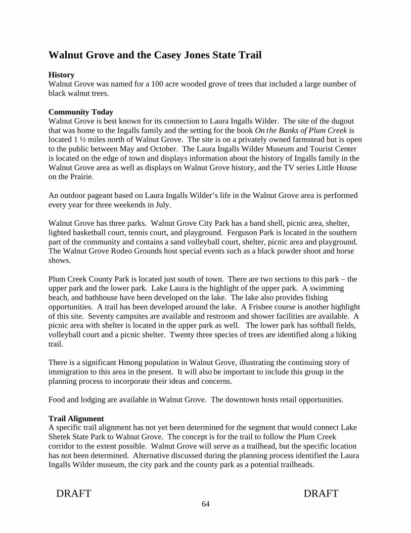
DRAFT DRAFT 64
Walnut Grove and the Casey Jones State Trail History Walnut Grove was named for a 100 acre wooded grove of trees that included a large number of black walnut trees. Community Today Walnut Grove is best known for its connection to Laura Ingalls Wilder. The site of the dugout that was home to the Ingalls family and the setting for the book On the Banks of Plum Creek is located 1 ½ miles north of Walnut Grove. The site is on a privately owned farmstead but is open to the public between May and October. The Laura Ingalls Wilder Museum and Tourist Center is located on the edge of town and displays information about the history of Ingalls family in the Walnut Grove area as well as displays on Walnut Grove history, and the TV series Little House on the Prairie. An outdoor pageant based on Laura Ingalls Wilder’s life in the Walnut Grove area is performed every year for three weekends in July. Walnut Grove has three parks. Walnut Grove City Park has a band shell, picnic area, shelter, lighted basketball court, tennis court, and playground. Ferguson Park is located in the southern part of the community and contains a sand volleyball court, shelter, picnic area and playground. The Walnut Grove Rodeo Grounds host special events such as a black powder shoot and horse shows. Plum Creek County Park is located just south of town. There are two sections to this park – the upper park and the lower park. Lake Laura is the highlight of the upper park. A swimming beach, and bathhouse have been developed on the lake. The lake also provides fishing opportunities. A trail has been developed around the lake. A Frisbee course is another highlight of this site. Seventy campsites are available and restroom and shower facilities are available. A picnic area with shelter is located in the upper park as well. The lower park has softball fields, volleyball court and a picnic shelter. Twenty three species of trees are identified along a hiking trail. There is a significant Hmong population in Walnut Grove, illustrating the continuing story of immigration to this area in the present. It will also be important to include this group in the planning process to incorporate their ideas and concerns. Food and lodging are available in Walnut Grove. The downtown hosts retail opportunities. Trail Alignment A specific trail alignment has not yet been determined for the segment that would connect Lake Shetek State Park to Walnut Grove. The concept is for the trail to follow the Plum Creek corridor to the extent possible. Walnut Grove will serve as a trailhead, but the specific location has not been determined. Alternative discussed during the planning process identified the Laura Ingalls Wilder museum, the city park and the county park as a potential trailheads.
14
14
14
2020
5
5
5
105
80
80105
105
1st
2nd
3rd
4th
5 th
6th
7 th
8 th
9 th
ST.
ST.
ST.
ST.
ST.
ST.
ST.
ST.
ST .
DU
NC
AN
DE
LBY
MAIN ST.
WIGGINS
PARK
5th
4th
ST.
ST .
BEDAL
WASHINGTON
LEE
CLARK
ST.
ST.
ST.ST.
ST.
ST.
DEW EY AVE.
AVE
.
AVE
.
19 20
2930
T109N R38W
T109NR38W
30
T109N
R38WR39W19
30
24
25
T109N R39W
24
PlumCreek
REDWOOD COUNTY
POP. 709
WALNUT GROVE
D. M. & E. R.R.
Walnut Grove
km Proposed Parking
location to be determined
Proposed Rest Arealocation to be determined

DRAFT DRAFT 66
This page left intentionally blank

Trail Management

DRAFT DRAFT 68

DRAFT DRAFT 69
Projected Trail Use State Trail Use As an Indicator of Future Use It is anticipated that the number of trail users and pattern of use will be similar to what is occurring on other state trails. The following table summarizes the summer use (Memorial Day to Labor Day) for the other asphalt trails in the state system. Use is measured in user hours. (A trail user spending one hour on the trail is a user hour). Trail User Hours
Total Seasonal User Hours
Miles of Trail in Survey
User Hours per Trail Mile
High Local Use Douglas - Summer 1997 42,910 12.5 3,433 Gateway - Summer 1997 181,952 18.5 9,835 Luce Line - Summer 1998 65,120 29.0 2,246 High Tourist Use Heartland - Summer 1998 125,381 27.0 4,644 Paul Bunyan - Summer 1996 155,268 46.4 3,346 Root River - Summer 1997 178,761 40.8 4,381 Mix Local/Tourist Use Glacial Lakes - Summer 1998 33,858 18.0 1,881 Paul Bunyan segment, near Lake Bemidji State Park - Summer 1998 17,488 5.3 3,300
Sakatah Singing Hills - Summer 1998 95,634 38.0 2,517 All Trails 896,373 236 3,806
It is anticipated that the Casey Jones State Trail will receive use similar to the Sakatah Singing Hills. This trail receives a mixed tourist and local use.

DRAFT DRAFT 70
0102030
405060
708090
100
All
Tra
ils
Dou
glas
- 1
997
Gat
eway
- 1
997
Luce
Lin
e -
1998
Hea
rtlan
d -
1998
Pau
l Bun
yan
- 19
96
Roo
t Riv
er -
199
7
Gla
cial
Lak
es -
199
8
Pau
l Bun
yan
segm
ent,
near
Lak
eB
emid
ji S
P -
199
8
Sak
atah
Sin
ging
Hill
s -
1998
All Other
Running
Walking
Skating
Biking
Trail Activities
Percent ofUser Hours
Potential Trail Use By Trail Activity The use pattern observed on other state trails can also provide insight into the mix of trail activities that can be expected. As the table below illustrates, bicycling will most likely be the predominant activity, followed by walking, then in-line skating.
26

DRAFT DRAFT 71
Trail Maintenance Adequate maintenance of the Casey Jones State Trail is critical to provide and sustain the experience trail users appreciate. Maintenance activities are numerous and diverse, as the following list illustrates. Specifically, maintaining the Casey Jones State Trail will include:
• Monitoring trail conditions, which includes scheduling and documentation of inspections; monitoring the condition of railings, bridges, trail surfaces, and signage; hazard tree inspection; and removal of debris such as downed trees
• Scheduling of maintenance tasks
• Mowing of vegetation: shoulders, rest areas, and parking lots
• Winter grooming and plowing
• Tree and shrub pruning
• Trash removal
• Trail repair – fixing washouts and controlling erosion are examples
• Maintaining bridge decking and railings
• Trail drainage control
• Trail surface maintenance
• Repair of animal damage to trail or facilities
• Checking and repairing fence lines and gates
• Mowing and brushing farm crossings
• Cleaning out ditches and culverts, replacing failing culverts
• Controlling noxious weeds
• Maintaining equipment
• Painting posts and picnic tables
• Graffiti control and vandalism repair, especially to signs
• Maintaining boundary signs, and working to resolve encroachment issues
• Coordination of volunteer efforts
• Training and supervision of employees, Minnesota Conservation Corps, or Sentence to Service crews
• Sweeping the asphalt surface

DRAFT DRAFT 72
Maintenance Recommendations
Recommendation 1: Additional maintenance funds will be required to maintain the trail after it is developed. Recommendation 2: The Division of Trails and Waterways is responsible for maintenance and management of designated state trails. However a portion of this trail will be located in Split Rock Creek State Park and Lake Shetek State Park, managed by the Division of Parks and Recreation. To assure appropriate protection of state park resources, viewsheds and facilities immediately adjacent to the trail, trail managers will work with park staff to establish standards and parameters for maintenance activities on state trails within or segments of state trails passing through the state park. Local trail mangers will plan, schedule, and coordinate maintenance activities following these guidelines with the appropriate park manager. Recommendation 3: The trail should be seal coated approximately six years after initial development. Research shows that this will prolong the life of the trail.

DRAFT DRAFT 73
Information and Education Trail User Orientation Trail users must have good information about the trail system so they can make choices about destinations appropriate for their time frame, skill level, need for services such as food and lodging, and the type of scenery and other recreational opportunities available along the route. This type of information should be displayed on information boards at parking areas, in communities and at trail junctions. It should be available on maps, and on the DNR Website. It should include distances between communities, options for other trail connections and locations of services. If any significant deviation from the typical trail design occurs resulting in a change in user experience, it should be noted on the informational kiosks to assist trail users in understanding what the trail experience will be, e.g. if there is a change when the trail enters a community.
Trail orientation signs such as this one located on the Luce Line State Trail will be developed for the Casey Jones State Trail

DRAFT DRAFT 74
Identification of Services Trail users benefit from knowing where they can obtain services (medical assistance, telephones, gasoline, food, lodging, rest rooms, campgrounds, repair facilities, or other retail) and local businesses benefit from an increase in customers. A listing of the services available in each community developed, maintained and updated by the community could be displayed on information boards at parking areas in each community.
Trail Rules and Regulations and Trail Courtesies Trail courtesy and safety display boards aimed at educating trail users about appropriate behavior, promoting safe trail use, and protecting the quality of the trail environment should be developed. These user-friendly versions of the rules applying to state trails should be posted at information kiosks along the trail and included in trail maps. Volunteer patrols could be used to distribute information on appropriate trail behavior and etiquette relative to specific problems such as unleashed dogs, or all trail users keeping to the right and warning others when passing. Interpretation of Natural and Cultural Resources There are many natural and cultural resources of significance and interest along the trail. These include the vegetation and wildlife of the Prairie Coteau landscape. In addition, there are several places that tell the history of this region. Providing information about these resources can add enjoyment to the trail experience. An interpretive theme is identified for state trails during the planning process. The interpretive theme helps tie together spatially separated interpretive sites and provides a continuity in the messages. Agriculture is the dominant activity in the region influencing land, water, economics, social lives, etc. The recommended interpretive theme for the Casey Jones State Trail is: How the natural resources of the Prairie Coteau Landscape has affected land use over time, specifically tieing in the history of the area. Other interpretive elements include: Geology, wind power, plant communities and plant species found in and adjacent to the corridor, wildlife species likely to be observed by trail users, and the Laura Ingalls Wilder story. Interpretive signs will be developed in consultation with other DNR divisions and the Minnesota Historical Society (MHS). Some initial ideas are listed in the development summary. Additional sites will be interpreted over time.

DRAFT DRAFT 75
Each state park has interpretive themes, programs, and signs for interpreting its cultural and natural resource setting covering the themes identified for the state trail as well as others. Coordination between the Division of Parks and Recreation and Division of Trails and Waterways in developing interpretive displays and programming will benefit park visitors and trail users Information and Education Recommendations Recommendation 1: Develop a kiosk and trail logo design that reflects the interpretive theme for the trail that can be used in communities and at rest areas along the trail. Recommendation 2: Community services information, trail orientation, and trail rule and trail courtesy information should be developed and installed on a kiosk at the same time the trail is developed. Recommendation 3: Trails and Waterways should cooperate with schools to use the trail for environmental education purposes. Recommendation 4: Interpret the natural and cultural features along the trail. Include information on the fishing opportunities of the trail. The Division of Fisheries local offices and MinnAqua staff should be consulted as resources.
DRAFT DRAFT 76
Enforcement Enforcement activities are a vital aspect of maintaining a safe and secure trail environment. Enforcement of state trails rules and regulations, information and education, trail design, trail maintenance of the mix of trail uses are all factors that contribute to the maintenance of a safe, secure trail environment. DNR has the primary responsibility for law enforcement on DNR-owned and operated recreation areas. Adequate enforcement was cited by participants of the planning process as a way of resolving potential problems and addressing concerns. User conflicts, unauthorized use of the trail, and trail users leaving the treadway designated for their use, were among the concerns identified during the planning process as likely areas where enforcement attention would be needed. Funding for law enforcement on state trails has not kept pace with the need created by new trail development. As miles have been added to the state trail system, funds needed for additional law enforcement have not been appropriated. Sufficient law enforcement promotes public safety and natural resource enhancement. Enforcement Recommendations Recommendation 1: Provide an adequate level of enforcement via a multifaceted approach, to help maintain a safe and secure trail environment, and to encourage trail users to understand and obey trail rules, and respect other trail users and adjoining properties. Recommendation 2: Develop on-site information that targets important trail courtesies and rules necessary for a safe a d enjoyable experience, specific to uses of a particular segment and problems and conflicts occurring there. Recommendation 3: Use increased visibility of Trails and Waterways staff during peak use times for an enforcement effect. Recommendation 4: Additional enforcement officers are required to address the enforcement need of the expanding trail system. Recommendation 5: Trails and Waterways will include the cost of enforcement when providing information about the cost of the trail when communicating with legislators trail advocates, and local government officials. Recommendation 6: Trails and Waterways will work with state park staff to coordinate enforcement and oversight of other trail related activities so that the safety of trail users and successful operation of the state trial will be ensured. This will be addressed in the operational memorandum of understanding between the Division of Trails and Waterways and the Division of Parks and Recreation.

DRAFT DRAFT 77
Adjacent Landowners A goal for the Casey Jones State Trail is to work with adjacent landowners to address their concerns. Primary concerns of adjacent landowners to proposed trails are trespass, vandalism, litter, crime, and loss of privacy. Liability is another frequently voiced concern. Several studies have shown that trespass, vandalism, litter, crime, and invasion of privacy have not been problems experienced after trail development. “A 1988 survey of greenways in several states has found that such parks typically have not experienced serious problems regarding vandalism, crime, trespass, or invasion of privacy. Prior to developing park facilities, these concerns were strongly voiced in opposition to proposed trails. After park development, however, it was found that fears did not materialize. Concerns expressed by the neighbors opposed have not proven to be a post-development problem in any of the parks surveyed. (“A Feasibility Study for Proposed Linear Park,” Oregon Department of Transportation, Parks and Recreation Division, May 1988.) According to surveys on the Root River State Trail and Douglas State Trail taken before and after trail construction, perception of potential problems by adjoining residents exceeded actual problems by wide margins. There are other studies that document similar findings. DNR Trails and Waterways will work with adjacent landowners to address their issues and concerns. Strategies that can be used to address concerns include trail design details, screening (fencing and vegetation), enforcement of state trail rules and regulations, and trail user education. For example, the placement of the trail treadway within the right-of-way, development of cattle passes, and grading are strategies that have been used to address landowner concerns. Fencing and vegetative screening can be used to address privacy issues. Citations are issued when state trail rules and regulations are violated, such as when unauthorized use of the trail occurs. Trail user education that emphasizes respecting adjacent landowner’s property is also emphasized. DNR Trails and Waterways strives to be a good neighbor and resolve concerns promptly. Trails and Waterways staff who manage the trail will work with adjoining landowners to prevent or correct problems.

DRAFT DRAFT 78
This page left intentionally blank

Natural and CulturalResources

DRAFT DRAFT 80

DRAFT DRAFT 81
Prairie Coteau Landscape The Ecological Classification System (ECS) is part of a nationwide mapping system set up to assist with management of natural resources in a sustainable fashion. The ECS is a method to classify regions based on climatic, geologic, hydrologic, topographic, soil and vegetation data. The ECS is hierarchical and has six tiers: province, section, subsection, land type association, land type, and community. All of western Minnesota is within the Prairie Parkland Province, which also extends west to the Dakotas and south to Iowa. Southwestern Minnesota is within the North Central Plains Section, which is further divided into three subsections: the Minnesota River Prairie; the Coteau Moraines; and the Inner Coteau. The Casey Jones Trail is located entirely within these last two subsections. See the map on the next page. The Coteau Moraines Subsection is a broad swath running northwest to southeast through parts of Lincoln, Lyon, Murray, Cottonwood, Nobles and Jackson counties. It is a landform created by glacial action and topped by the Buffalo Ridge (1995 feet above sea level). This high elevation is caused by thick deposits of pre-Wisconsin-age glacial till as much as 800 feet deep. There are two distinct landforms in the subsection. The middle Coteau is a landscape of rolling moraine ridges of late-Wisconsin drift mantled with loess one to three feet thick. The outer Coteau, a series of terminal and end moraines separated by ground moraines, ranges from gently undulant to steeply rolling and hilly. The Inner Coteau Subsection runs through Pipestone and Rock counties and parts of Lincoln, Murray and Nobles counties. Its boundary with the Coteau Moraines Subsection marks the highest point of the coteau complex. The Inner Coteau consists of highly dissected moraines of pre-Wisconsin drift, capped by thick loess deposits six to fifteen feet deep. This topography is described in this master plan because it represents the composite ecological features that are important to interpret along the trail and to protect during trail development and operations.

DRAFT DRAFT 82

DRAFT DRAFT 83
Climate Southwestern Minnesota is subject to the state’s strong continental weather patterns, which are influenced by cold Arctic air masses in winter, and hot Gulf of Mexico air masses in summer. Prevailing winds are from the north or northwest from November to April, and from the south or southwest from May through October. The annual precipitation in the Casey Jones State Trail area ranges from 24 inches in the west to 27 inches in the east, of which 11-12 inches falls during the growing season. The average growing season is 145-150 days (Albert 1993). Windy conditions in this region are common, and this natural resource has led to the recent development of wind farms along Buffalo Ridge. Where previously wind farming was not believed to be economically viable (Baker 1983), turbines have proliferated in the last several years as technology has become more sophisticated and energy companies have been required to invest in alternative forms of energy generation. While the number of wind turbines continues to increase in eastern Pipestone County and western Murray County, it is unclear how much more growth the industry will sustain. Rapson noted that in 2003 Minnesota reached 1,000 megawatts of power generated by wind, which was enough power to power the entire residential component of the Twin Cities. Windpower represents $1 billion in equipment investment, 3100 jobs, $4 million in royalty payments to farmers, and $3.6 million in real estate taxes (Rapson 2003). The benefits of windpower are not only environmental but are also economic: payments to farmers; business for local banks; and opportunities for local people to invest. Component manufacturing also is a potential source of economic growth for the region: equipment sales are expected to grow to $24 billion worldwide by 2013. The construction of wind turbines throughout the Coteau landscape has a number of implications for the development of the Casey Jones Trail.
• Visual implications. Some have called the wind turbines a blight on the landscape, but others find them interesting and unique features in otherwise homogeneous terrain.
• Trail alignment implications. Development of utility easements may be both an opportunity for acquiring rights for the trail, and a constraint due to power poles on the side of the road where the trail would ideally be located.
• Interpretation implications. The windy uplands of the coteau were important landscapes for American Indians. They are now symbols of how nature is being harnessed to serve human needs through innovative technology and complex networks.
DRAFT DRAFT 84
Hydrology/Water Resources The Casey Jones State Trail falls within three river basins: the Rock River basin (a tributary of the Missouri River) west of Buffalo Ridge; the Des Moines River basin around Lake Shetek, and the Minnesota River basin (via Plum Creek and the Cottonwood River) west of Walnut Grove. In the Missouri River watershed, there are few lakes and a well-established, dendritic drainage network. This is due in large part to the erosional patterns incised in the bedrock and the thinness of the overlying glacial sediments (Ojakangas and Matsch 223). In places such as Winnewissa Falls in the Pipestone National Monument, the erosional action of Pipestone Creek has carried away the glacial till, revealing the quartzite bedrock below. By contrast, the Des Moines watershed has poorly developed drainage patterns, as evidenced by streams with few tributaries and by depressions and lakes with no outlets (Lake Shetek is the notable exception; many other lakes were drained in the early twentieth century). This is the “prairie pothole” landscape, a swath of land running northwest to southeast in which hundreds of thousands of acres of lakes and wetlands were drained from 1905 to 1925. This landscape of hummocks and isolated depressions is the legacy of the stalled glacial movement that formed the Altamont Moraine (see geology section below). Massive drainage projects promoted and funded by the federal, state and county governments sought to increase the amount of arable land, increase the efficiency of cultivation, and reduce pests and disease thought to originate in wetlands. Water resources along the trail in this watershed include Lake Shetek and the smaller lakes and wetlands that surround it; Lake Sarah; Lake Wilson, and a multitude of creeks and drainage ditches. The four lakes (Bear, Rush, Crooked and Great Oasis Lakes) that comprised the Great Oasis and its woods were tributary to Lake Shetek, and fur traders in the early 1800s were able to ship goods from the Great Oasis to Mendota by the Des Moines and Wantonwan Rivers. An early map of the Minnesota Territory (1849) shows the band of lakes that were created by the Altamont Moraine prior to their destruction in the early twentieth century. The Minnesota River watershed in northeastern Murray County and southwestern Redwood County is characterized by well-defined drainage channels incised deeply into the landforms. Major streams include Plum Creek and its tributary Willow Creek, both tributaries of the Cottonwood River, and Pell Creek. These diverse water features, as well as the wildlife they harbor, make them an important asset in developing visual variety and interest along the Casey Jones State Trail.

DRAFT DRAFT 85
Water Resources Recommendations Recommendation 1: Minimize trail development and maintenance impacts to water resources through the use of mulching, geo-textiles, silt screens, and seeding to establish vegetation. Appropriate erosion control measures should be taken to minimize the potential impacts on adjacent water resources. Recommendation 2: Strive to limit water crossings and obtain permits for crossings. Bridges should be designed for conveyance of flood flows. Attention should be given to providing for any needed navigational clearance to accommodate existing or future surface water recreation. Bridges also require a permits.

DRAFT DRAFT 86
Geology, topography, and physiographical features The most prominent geological feature of the trail area is Buffalo Ridge, called by early French explorers the Coteau des Prairies (“highland of the prairies”), which runs from South Dakota across southwestern Minnesota into northern Iowa. Although shaped on the surface by glacial processes and wind-driven soil deposits, the Coteau owes its prominence and extent to the underlying bedrock. This bedrock is composed not only of Cretaceous sediments formed by the weathering of the Precambrian rock during periods in which the climate was semitropical and humid, but also of Sioux quartzite, which is a Precambrian metamorphic sandstone colored with varying amounts of iron oxides. Layered within the quartzite are thin bands of pipestone (also called catlinite, after the early explorer George Catlin), a soft red metamorphic stone of clay origin that American Indians have used for religious and ceremonial purposes for centuries. The most celebrated location of pipestone is within the Pipestone National Monument, owned and managed by the National Park Service, where American Indians still quarry and carve pipestone by traditional methods. Although outcrops of Sioux quartzite can be seen in Pipestone and in a 30-foot cliff running northward from Luverne to the Rock County line (Sansome 111), most of the underlying bedrock is covered with a thick mantle of glacial drift. Two parallel belts of glacially-deposited material run northwest to southeast; they are the end moraines from the Des Moines lobe of the last glacier to cover this area. The western moraine is the Bemis Moraine, which is the highest ridge along the Coteau. This ridge is the dividing point between watersheds of the Missouri and Minnesota Rivers. The Bemis Moraine is breached by gorges at Lake Shaokatan, Lake Benton, and Chandler, where ancient streams overtopped the dam created by the materials of the moraine. The eastern moraine, the Altamont Moraine, indicates a “fine example” of stalled movement of the glacier thousands of years ago; the resulting melting of dirty ice formed a hummocky terrain, with lots of lakes and pronounced topographical relief. These glacial deposits are bounded by the moraine-edge of the Coteau des Prairies on the west and the rock-bottomed river valley of the Minnesota River on the north (Sansome 110). The southwestern half of Pipestone County is a gently rolling plain covered with wind-deposited silt (Ojakangas and Matsch 223), materials which come from earlier glacial advances of unkown date (Ojakangas and Matsch 224). The Coteau des Prairies, a flat-topped highland, formed as the region between two river basins, and split glacial sheets into the James River lobe west and the Des Moines River lobe east. The glacial erratics called the “Three Maidens” at the Pipestone National Monument are thought to have originated in the granite from the Millbank, South Dakota area. Another set of glacial boulders is found at Blue Mounds State Park in Luverne, where a 1,250-foot long line of rocks is aligned with the sunrise and sunset on the first day of spring and the first day of fall. It remains a mystery as to who constructed this astronomical feature, and why. The underlying bedrock of this area is exposed in several places throughout the region. Quartzite can be seen at Split Rock State Park, where the Split Rock Creek has cut a gorge

DRAFT DRAFT 87
through the rock; at Winnewissa Falls in the Pipestone National Monument; in quarrying operations near Jasper; and on the mesa at Blue Mounds State Park. Soils The soils of the Coteau Moraines and Inner Coteau Subsections are loamy and well drained, with thick dark surface horizons. The soils are primarily Mollisols (Aquolls and Udolls) with some Borolls and Ustolls. Cummins and Grigal (1981) have mapped both dry prairie and moist prairie soils, with most of the dry prairie soils occurring on dissected or eroded topography. Moister prairie soils occur on rolling end moraines with variable local relief (the outer Coteau).

DRAFT DRAFT 88
Vegetation F.J. Marschner, a researcher with the USDA, compiled a map titled “The Original Vegetation of Minnesota” in 1929-30 based on records from the US General Land Office Survey Notes (Coffin 1988). Marschner based his compilation on plat maps and field notes of General Land Office surveyors who marked the corners of sections and quarter sections prior to initial public land offerings (Cunfer and Guse 2001). The Casey Jones State Trail is located in the southwestern corner of the state, the Inner Coteau and Couteau Moraines subsections of the Ecological Classification System. (see ECS subsections map). Tall grass prairie covered virtually most of both landscapes at the time of European settlement. Wet prairie was restricted to narrow stream margins. Forest was similarly restricted to ravines along a few streams, such as the Redwood River. Prairies in the Inner Coteau were drier, accounting for a prevalence of prairie plants characteristic of midgrass prairies to the west (Albert 1993. These were especially common in Pipestone and Rock Counties, where soils are shallow over bedrock (Becker, 1986). Today less than 1% of original tallgrass prairie remains in Minnesota, due to extensive agriculture in most of the Prairie Parkland Province, which extends from southern Minnesota into the Red River Valley. Fire and drought were the dominant causes of natural disturbance. Fires were very common before Euro-American settlement, and were caused by lightning or sometimes set by Indians to reduce cover and attract buffalo to the tender grasses that emerged after the fire. Fires and drought also prevented the emergence of substantial woodlands, except in islands within lakes or wetlands, where the surface water provided a natural firebreak (the former Great Oasis, in central Murray County, about four square miles in size, was one such example of a wooded island. It was a huge "prairie shallow lake/wetland" complex that covered hundreds of acres. It was drained by open ditching in the 1930's. Agriculture is the primary land use in the region. There are few remnants of presettlement vegetation left. Several linear prairie remnants exist along the railroad right-of-way segment of the Casey Jones State Trail between Pipestone and Woodstock. (see the map on page ). These remnants, once part of a larger area, most likely persisted because of their location. They may have been disturbed during railroad construction but have successfully recolonized because back then, adjacent land was still mostly prairie. These right-of-way communities were not plowed up and benefited from occasional burns during the railroad era when sparks from trains ignited adjacent vegetation. During DNR Wildlife ownership of the right-of-way, infrequent prescribed burns were conducted. While some of the remnants show good diversity and abundance of native grasses and forbs, others have been invaded by smooth brome. Some of the sites are dry hill prairies where the right-of-way grade is depressed while others are mesic swales along an elevated grade. An example of a hillside prairie community is west of 140th Street. The following species were identified walking through the site in August of 2004: Little bluestem, prairie
DRAFT DRAFT 89
dropseed, sideoats grama, Indian grass, pale purple coneflower, thimbleweed, silky aster, birdsfoot violet, leadplant, purple prairie clover, white upland aster, prairie onion, prairie phlox, rough blazing star, palmate coreopsis, silvery scurf pea, asters and goldenrods. The Natural Heritage and Nongame Research Program unit of DNR in September 2003 identified prairie remnants in certain sections between Lake Shetek and Walnut Grove, and along the DM&E railroad right-of-way, within a one-mile radius of the schematic alignment. Further investigations will be required to more carefully assess prairie remnants along the trail, and to select an alignment that avoids impacts to these sensitive areas. Prairie remnants also exist at the Prairie Coteau Scientific and Natural Area (SNA), the Lundblad Prairie area between Slayton and Fulda, and the Wahpeton Prairie five miles northeast of Walnut Grove. If spurs to the Casey Jones Trail were developed in the future, some connection to these areas would be desirable. Likewise, if the Casey Jones extends in the future beyond Split Rock Creek State Park, a connection to Blue Mounds State Park, where there is native prairie, would be desirable. A prairie restoration project is also underway at the Pipestone National Monument site, where the land was never plowed, only grazed. Over 300 native plant species have been identified within the Monument bounds. Reconstruction efforts include prescribed burns (for the last 31 years), mechanical control of non-native plants, and reseeding. Fires, regardless of their origin, reduce the buildup of organic materials; encourage growth of native grasses; suppress growth of trees and shrubs; recycle nutrients; and decrease competition from exotic species. Prairie restoration is also occurring at the two state parks. Vegetation Management Recommendations Recommendation 1: Revegetate areas disturbed by construction or in need of rehabilitation with plant species native to the area by collecting seeds from remnant prairie communities or by purchasing local genotype seed from a certified vendor. Native shrubs and trees should be used in landscaping trail access sites and waysides. Recommendation 2: Efforts will be made to avoid impacting wetlands. Wetlands will be inventoried and a wetland mitigation plan will be prepared to address any identified impacted wetlands. Recommendation 3: Manage and improve existing prairie communities primarily through prescribed burning and spot spraying of existing invasive non-native species such as thistles, leafy spurge, spotted knapweed, wild parsnip with selective herbicides timed to have the most detrimental effect on the species. Recommendation 4: Complete a comprehensive inventory of the vegetation along the existing state owned trail.

DRAFT DRAFT 90
Recommendation 5: Develop a vegetation management plan for the trail including plans for future prairie management, restoration, and management of the overgrown windbreaks. Recommendation 6: Avoid planting and control any of the plants listed below; all of these plants are invasive non-native plants; most will diminish the health of native plant communities. .
Carduus nutans (Musk thistle) Elaeagnus angustfolia (Russian olive) Centaurea maculosa (Spotted knapweed) Elaeagnus umbellata (Autumn olive) Cirsium arvense (Canada thistle) Glechoma hederacea (Creeping Charlie) Cirsium vulgare (Bull thistle) Hieracium aurantiacum (Orange hawkweed) Euphorbia esula (Leafy spurge) Lonicera tartarica (Tartarian honeysuckle) Lythrum salicaria (Purple loosestrife) Lotus corniculatus (Birdsfoot trefoil) Rhamnus cathartica (Common buckthorn) Melilotus alba (White sweet clover) Rhamnus frangula (Glossy or Alder buckthorn)
Melilotus officinalis (Yellow sweet clover)
Robinia pseudoacacia (Black locust) Digitalis lanata (Grecian foxglove) Sonchus arvensis (Sow thistle) Morus alba (Mulberry) Acer ginnala (Amur maple) Phalaris arundinacea (Reed canary grass) Acer platanoides (Norway maple) Iris pseudacorus (Yellow iris) Berberis thunbergii (Japanese barberry) Linaria vulgaris (Common toadflax) Bromus inermis (Smooth brome grass) Pastinaca sativa (Wild parsnip) Cannabis sativa (Hemp or Marijuana) Polygonum cuspidatum (Japanese knotweed) Chrysanthemum leucanthemum (Oxeye daisy) Tanacetum vulgare (Common tansy) Caragana arborescens (Siberian peashrub) Taraxacum officinale (Dandelion) Convolvulus arvensis (Field bindweed) Ulmus pumila (Siberian elm) Alliaria petiolata (Garlic mustard) Vicia cracca &Vicia villosa (Cow & Hairy vetch) Berteroa incana (Hoary alyssum) Coronilla varia (Crown vetch) Butomus umbellatus (Flowering rush) Miscanthus sacchariflorus (Amur silver grass) Daucus carota (Queen Ann’s lace)
Recommendation 7: Avoid negative impacts on rare and endangered species, and avoid fragmentation or disturbance of significant native plant communities identified by the Minnesota County Biological Survey.

DRAFT DRAFT 91
Wildlife The DNR, through the Natural Heritage and Nongame Research Program unit, has reviewed the Minnesota Natural Heritage database for rare plant or animal species within a one-mile radius of the schematic trail alignment. This review documented occurrences of several rare butterfly species, including Dakota Skipper (Hesperia dacotae), Regal Frittilary (Spereria idalia), and Powesheik Skipper (Oarisma powesheik) between Pipestone and Split Rock Creek State Park within prairie remnants in the area between Highway 23 and the railroad right-of-way. Topeka shiners (Notropis topeka) are state-listed as of special concern and federal-listed as endangered. These are documented in the Rock River, and any trail development in this area must minimize sedimentation, dredging or filling, dewatering, impoundment, eutrophication, channelization, or other adverse effects on water quality. Fifty-two other known rare species or natural communities are listed in the project review, but are not anticipated to be affected by trail development. Further information on these species and communities and their locations is available from DNR. The Minnesota Ornithologists Union has recorded 264 species of birds in Murray County alone, but loss of habitat has resulted in fewer species and smaller populations. The numbers of waterfowl that once thronged the wet prairies, whether permanent residents or migratory birds, declined with drainage projects in the early part of the century, and more species were lost with the rise of agricultural pesticides and herbicides in the 1960s and 1970s. However, cooperative efforts between DNR, the US Fish and Wildlife Service, and private organizations such as Ducks Unlimited and Wildlife Forever have restored habitat and avian populations in such areas as the Big Slough south of Slayton. Despite their pre-settlement abundance, upland birds such as the prairie chicken have been absent from these three counties for many decades (Timmerman 92-93). Likewise, raptor and songbird populations have also declined, due to continued loss of habitat. Management practices such as leaving roadside rights-of-way unmowed, allowing tall grasses to grow up along fence lines, planting hedgerows, restoring prairie vegetation, and installing nest boxes are all methods to reverse the decline in bird populations, and these techniques should be used where possible along the right-of-way for the Casey Jones State Trail. Fishing has long been a popular sport at Lake Shetek. Because the lake is shallow and was estimated to freeze solid once every seven years on average, an aeration system was installed in 1974, and the lake depth was raised, through improvements to the Currie Dam, in 1995. The DNR began to stock the lake in 1987 with walleye, northern pike, yellow perch, crappie, sunfish and black bass (Spieles 118).

DRAFT DRAFT 92
Wildlife Management Recommendations Recommendation 1: Create angling and education opportunities where the trail intersects fishing opportunities. Recommendation 2: Trails and Waterways will work with the Division of Fisheries in the design of the trail where the trail and river connect to ensure both fisheries needs and trail user needs are met. Recommendation 3: Assess the trail-river connections as to their suitability for development of “fishing pads” which promote the use of the river for fishing by people with mobility impairments. Recommendation 4: Trail construction at water crossings should not occur between October 15th and April 15th so that it does not coincide with spawning or migration of fish species. Silt plumes that may result can negatively affect fish spawning and habitat, or native mussel species. Recommendation 5: Apply the best management practices for Topeka Shiner Habitat Protection where the trail crosses the Rock River.

DRAFT DRAFT 93
Historical and Cultural Resources This section discusses the historical and cultural resources of the region, and is organized thematically rather than geographically, according to these four broad interpretive themes:
• Presettlement • Exploration of the territory • Settlement and agricultural development • The railroad age and modern industry
Presettlement American Indians occupied this region for hundreds of years before the coming of the European settlers. Although evidence of their settlements disappeared long ago, several sites associated with gatherings and rituals have survived. The most notable physiographic feature of the region, Buffalo Ridge, was well known by the Dakota Indians, and was most likely a place of religious significance. Early explorers discovered several rock outlines that had been made there by the American Indians. Near the summit of the ridge was once an American Indian cemetery that was scattered over a mile of ground. At the very tip there still remains an American Indian Smoke Pit. Better known as a spiritual gathering place is the quarry site at Pipestone National Monument. This 282-acre site outside the City of Pipestone is a unit of the National Park Service, attracting more than 84,000 visitors in FY 2002. Ninety five percent of the visitation occurs from April through October. Pipestone is extracted by American Indians from 57 annually permitted quarries. The visitor center orientation program explains the purpose and significance of the monument and exhibits explain the process of quarrying and shaping the stone. The art of carving pipestone is demonstrated at the visitor center by American Indians from April through October. The National Park Service is currently preparing a general management plan (GMP) for the Monument. Public review of the draft GMP is planned for the fall of 2005. A loop road surrounding the monument on the east, north, and west may be used to provide pull-offs with interpretive wayside exhibits. Stone pipes were long known among the prehistoric peoples of North America; specimens from 2,000 years ago have been found at Mound City in present-day Ohio. Digging at this Minnesota quarry likely began in the 17th century, a time that coincided with the acquisition of metal tools from European traders. Pipestone was found either when the quartzite above and around it was eroded by the Pipestone Creek, or by buffaloes wearing away the surface and exposing the bedrock. It is a metamorphic rock formed originally from clay sediments that were deposited 1.6 billion years ago. Pipestone (catlinite – mostly silica and alumina) has a hardness of 2.5 (the same as a fingernail) and is readily carved. The pipestone is in 1-3 inch thick beds that dip to the east, requiring deeper and deeper quarries to reach the stone. Quarrying is done in late summer and fall, when the water in the quarries is lowest in the pits.

DRAFT DRAFT 94
Carvers prized this durable yet relatively soft stone, which ranged from mottled pink to brick red. By all accounts this location came to be the preferred source of pipestone among the Plains tribes. By about 1700, though, the Dakota controlled the quarries and distributed the stone only through trade. Ceremonial smoking marked the activities of the Plains people: rallying forces for warfare; trading goods and hostages; ritual dancing; and medicine ceremonies. Bowls, stems, and tobacco were stored in animal-skin pouches or in bundles with other sacred objects. Ashes were disposed of only in special places. Ornamental pipes were often valued possessions buried with the dead. There were as many variations in pipe design as there were makers. A popular pipe form was the T-shaped calumet. Calumets became widely known as peace pipes because they were the pipes Europeans usually encountered at treaty ceremonies. The first European to record a trip to the quarries was fur trader Philander Prescott in 1831. Noted artist and writer George Catlin visited the site in 1836. By sketching the site and collecting some of the legends surrounding it, he did much to make the quarries known around the world. Two years later cartographer Joseph N. Nicollet literally put the site on the map. Although he never visited the site, Henry Wadsworth Longfellow was inspired to write of the area in his well-known poem, "Song of Hiawatha." Across the Great Plains, the stories of the pipestone differ from Dakota to Crow, from Blackfoot to Pawnee. Variation is one indication of the geographical extent to which the red stone and pipes were used and traded. The reverence with which the stories are passed down through generations is testimony to their importance. But all variations share common themes: the pipestone was a gift from the Great Spirit and the site at which it is found is sacred; no weapons must be used or brought upon it. These quarries have been a neutral sanctuary for at least a thousand years, where all tribal people (even enemies) could come in peace and gather the special stone that is used for making pipes as well as many other articles that they desired for personal use and trade without paying homage to or asking permission of any tribe or other group of people.
As America grew westward in the 19th century, pipes found their way into society through trade. Increasing contact between settlers and American Indians inspired new subject matter for carvers. Sometimes these effigies honored politicians and explorers; sometimes the images were caricatures far from flattering. Pipes became a source of income for their makers, thus significant beyond religious use. To protect their source, the Yankton Dakota secured free and unrestricted access by an 1858 treaty. Even as the quarry became increasingly lucrative, American settlement threatened to consume the square-mile American Indian claim. Outsiders were digging new pits and extracting the sacred stone. The federal government took the land for an American Indian School which was authorized in 1892 and constructed in 1893 on the premise that it would benefit American Indian children. The Yankton refused to give it up and contested it over the course of 36 years. The case ultimately ended up in the Supreme Court. It was finally decided in 1926 that the Yankton would be reimbursed for the land and in 1928 were paid $338,558.90. This ended their legal claim to the land including all rights to the pipestone. Pipestone National Monument was created on August 25, 1937 with the specific provision that “The

DRAFT DRAFT 95
quarrying of the red pipestone in the lands described in section 1 is hereby expressly reserved to Indians of all tribes, under regulation s to be prescribed by the Secretary of the Interior.” Additional school lands were added to the Monument in 1956 after the closing of the school.
The heritage of pipestone is kept alive by the Keepers of the Sacred Tradition of Pipemakers, headquartered in the former Rock Island Railroad depot. They organize powwows and other gatherings and workshops, run a gift shop at the depot, and are organized to protect the quarries from exploitation or ownership by any one specific tribe or group of people. The Little Feathers Center provides education and knowledge regarding the purpose of the quarries.
Just south of the National Monument are the grounds of the “Song of Hiawatha Pageant,” an outdoor amphitheater where Henry Wadsworth Longfellow's poem "Hiawatha” is performed annually during the final two weekends in July and the first weekend in August in an original production of American Indian songs and lighting. The pageant has been staged since 1949 with volunteer-only local actors, against the backdrop of a water-filled pipestone quarry and the “Three Maidens”(massive glacial boulders), and draws 15-20,000 thousand visitors each summer.
Two other sites in the region (although not adjacent to the Casey Jones State Trail) are resources worthy of linkage in future spur trails. The astronomical arrangement of boulders at Blue Mounds State Park was mentioned in Chapter 5. The second site, the Jeffers Petroglyphs, is located east of the Casey Jones Trail in Cottonwood County. On glacier-scarred bedrock, this historic site contains thousands of ancient rock carvings. This site has been used for more than 5,000 years by American Indian tribes, and is still a place for prayer for their descendents.
Early Exploration
The first European Americans came to this area in the 1830s. Philander Prescott, a trader stopping at Bear Lake in 1831, was the first visitor to write about what he considered the greatest resource of the area, the Great Oasis. In 1833, the American Fur Company established a trading post nearby on the east edge of Bear Lake. One of the best-known traders during the post's regime was Joseph Laframboise. Painter George Catlin was Laframboise’s guest, staying with the trader as he traveled to visit the Pipestone Quarries.
In 1838, French scientist and explorer Joseph Nicollet led a government expedition through the area to explore the Minnesota and Missouri Rivers. Their party spent three days at LaFramboise’s post. In his journal, Nicollet mentioned an area called "Lost Timber," a hidden wooded area near Chandler. The Sioux had named this area, "Tchan-na tambe," which can be translated to "hidden woods,” the origin of the current-day township name Chanarambie. Nicollet’s descriptions of Buffalo Ridge and Lost Timber were later compiled and published.

DRAFT DRAFT 96
Nothing remains of the post, but the foot trail used by Indians and fur traders leading from Sleepy Eye to Pipestone via Lake Shetek and the Great Oasis (the Great Oasis was a huge "prairie shallow lake/wetland" complex that covered hundreds of acres. It was drained by open ditching in the 1930's).
Settlement and agricultural development
By the 1850s, farming families had begun to settle in the region, led onward by the U.S. government’s relocation and resettlement of American Indians onto reservations. Throughout the 1850s, relations between the American Indians and the government continued to deteriorate. Living in confined areas, deprived of their livelihoods, the American Indians awaited the provisions promised by the government. After months of waiting, the food finally came. It was spoiled.
While the exact details of what happened differ, tensions between the American Indians and the whites had reached a boiling point. On August 20, 1862, Lean Bear and White Lodge, two Dakota Indians, led 100 warriors on a raid against the Lake Shetek settlement. The thirty-four settlers hastened for sanctuary in New Ulm, but were attacked about one mile from their homes. Fourteen were killed and twelve were taken captive but later released. An obelisk sits at the entrance of the Lake Shetek State Park, a monument to the settlers killed in the encounter. Their mass grave near Lake Shetek is marked as well.
Attacks continued through August and September 1862; the American Indians surrendered in late September and thirty-eight Sioux were executed in Mankato in December in retaliation for the deaths of the European settlers. Elsewhere in the region, historical resources highlight the physical difficulties, not the personal dangers, of the early settlers. The cluster of museums and attractions around Walnut Grove are themed around the life of Laura Ingalls Wilder (1867-1957) and her family. Although the Wilders lived in the area only from 1874 to 1879, Mrs. Wilder used her childhood experiences here as a basis for On the Banks of Plum Creek, and a lively tourist industry has sprung up to capitalize on her fame, centering around prairie life in the 1870s. The Laura Ingalls Wilder Museum and Information Center is a seven-building complex of exhibits and simulations of life on the prairie, including a church and a schoolhouse (built by high school shop classes) and pioneer homes. The museum includes artifacts from the “Little House on the Prairie” television series as well as personal belongings from and exhibits about the Ingalls family. The Ingalls Homestead Site is 1.5 miles north of Walnut Grove on County Road 5. This 30-acre site is an undisturbed, unreconstructed area on the Gordon farm with an indentation on the creek where the Ingalls’ dugout house was, as well as other interpretive signs at key landmarks from the book. The Laura Ingalls Wilder Historic Monument is just north of the Gordon farm, 1.6 miles north of Walnut Grove, on County Road 5.

DRAFT DRAFT 97
The City of Walnut Grove hosts the Wilder Pageant and associated events during the last three weekends in July each summer. The pageant is an outdoor amphitheater presentation of life in the 1870s, with special lighting, sound, and effects, which stars locals in the roles of the Ingalls family members and their neighbors. Other events include the Wilder Festival, the Black Powder Shoot, a parade, a look-alike contest, and bus tours. Nearby in Sanborn, the Sod House provides a hands-on experience of the first type of dwellings built by the pioneers. Visitors can tour the sod house, stay in a sod house B&B, wear replica clothing, and enjoy a pioneer-style breakfast. The railroad age and modern industry
Throughout the 1870s and 1880s, towns throughout Murray and Pipestone Counties began to be founded and settled. One of the first was Currie, platted in 1872 when the Currie brothers settled in the area and built a gristmill on the Des Moines River. Currie experienced some decline when the county seat moved to Slayton in 1889, but rebounded with the construction of a railroad branch line from Bingham Lake.
This railroad terminus has since become the location of the End-O-Line Railroad Park and Museum. One of the most significant features of the park is the operating turntable located here, which is on the National Register of Historic Places. Began in 1972 as a 4H cleanup project, the park has since expanded to include the depot building (which was purchased and moved to its present location) and other buildings, including a country store and one-room district schoolhouse, as well as rolling stock. The purpose of the park and museum is to document how the railroads helped pioneers by bringing in all kinds of supplies like the mail, milk, coal, farm implements, canned goods, dry goods, etc. The museum has a model of the original Currie train yard in HO scale, and a highlight of the property is a working turntable in the yard. The museum and park is also a trailhead for the Lake Shetek loop trail and is within walking distance of the Des Moines River dam.
There is also a railroad museum in Tracy, the Wheels across the Prairie Railroad Museum, which has rolling stock and a small-scale village.
The railroads were one of the great achievements in transportation of the machine age, allowing for the expansion and growth of the Upper Midwest. Throughout this time period, little communities sprang up about seven miles apart on the railroad lines. Like many towns, Chandler got its start with the coming of the railroad. The Southern Minnesota Railroad completed a line through the area in 1880. A windmill was built there and for years it was the lone edifice on the eastern end of the Chanarambie Valley. Then, in 1886, G.W. Smith surveyed the plat for the town site and a railroad station was built the same year. The early settlers of Chandler were predominantly Scandinavian, most of them coming from Fillmore County, Minnesota and the regions around Decorah and New Hampton, Iowa. Around 1908, settlers from the Netherlands began to arrive.
Train service was essential for community growth and prosperity. The City of Pipestone was founded in 1876 by Charles Bennett and Daniel Sweet. Despite blizzards, prairie fires,

DRAFT DRAFT 98
droughts and grasshoppers, the young village survived. In 1879, 22 businesses were operating in Pipestone, and by the following year that number had grown to 53. Pipestone incorporated as a village in 1881 and for the next 20 years was a "boom town" by virtue of having train service on four different rail lines and successful land promotional efforts by the South Minnesota Land Company.
The Pipestone Commercial Historic District harkens back to this period. It is comprised of approximately thirty commercial buildings located in a two-block area of downtown Pipestone. The character of the district is derived from the exclusive use of Sioux quartzite as a building material in seventeen of the buildings, making it the largest concentration of Sioux quartzite buildings in the state. Most of the buildings were built in the 1890s and relate visually to each other in height, scale and vernacular style, sharing a common texture and color of building materials. Although most of the pivotal buildings are in the vernacular style, there are examples of the Richardsonian Romanesque, Neoclassical and Italianate styles as well.
The City of Pipestone has worked hard to make the most of its cultural and architectural assets. The Pipestone Performing Arts Center has been in operation since 1994 and provides entertainment, drama, comedy, musicals and concerts to the region in a 300-seat newly renovated theater space. It is located in the heart of the Historic District, in a Sioux quartzite building that dates back to 1897.
Sioux quartzite was also employed elsewhere in the region as a durable, signature building material. Both the bridge and the dam at Split Rock Creek State Park were built of Sioux quartzite, in the 1930s, by the Works Project Administration. The dam has since been rebuilt. Stone was first quarried in Jasper in the 1880s by the Dell Rapids Granite Co. They used the railroad (first service November 1, 1888) to ship stone, especially paving blocks. Today the stone is used in industrial processes and cemetery monuments. No quarries are open for tours although there are three (Jasper Stone Quarry (formerly the Poorbaugh Quarry), North Sioux Falls Quarry, and Staples Quarry). Jasper Stone Quarry is the only one still operating (about 100 acres), now with new modern wire-cutting equipment. The newest industry in southwestern Minnesota is windfarming. The closest wind towers to the Casey Jones State Trail are located on Buffalo Ridge in Murray and Pipestone counties. Windpower began in Pipestone County in 1997 when Lake Benton Power Partners, a subsidiary of the former Enron Corporation, signed a contract with Northern States Power Company (NSP) to supply wind-generated electricity. As of early 2003, there were 291 total wind turbines generating a total of 211 MW, enough to service 90,000 homes, built by Enron Wind. There are two components, Lake Benton I (107 MW, completed in 1998) and 104 MW Lake Benton 2, completed in 1999. This is the second largest wind farm in the world; the largest is in Iowa, also along the Buffalo Ridge near Storm Lake.

DRAFT DRAFT 99
Each turbine stands 257 feet tall with a blade span of 165 feet, weighs almost 200,000 pounds, and can supply the annual power needs for 250 homes. The turbines operate at variable wind speeds of 9 to 65 miles per hour to maximize efficiency. Footings for the posts of the turbines use 450 tons of concrete which are placed on a 15.5 x 15.5 foot pad and rest on a 37x37x3 foot foundation. A pair of turbines cost approximately $1.5 million to purchase and install. Wind energy was the fastest-growing energy source in the 1990s, at over 25% per year. A federal government study estimates that wind in the 12-state Midwest region could generate 10 trillion KW hours annually, or more than 3 times the current U.S. electrical usage. This would equate to 16 billion barrels of oil, or 60% of total world oil production. Navitas Energy operates a visitor center on windpower north of Lake Benton. In addition to the museums and historical sites described above, the area also includes the following general-interest local history museums:
• The Pipestone County Historical Society. Founded in 1880. Collections include archives such as marriage records, census data, land sale records, photographs, and cemetery inventories.
• Murray County Museum, Slayton.

DRAFT DRAFT 100
References Coffin, B. 1988. “The Natural Vegetation of Minnesota at the Time of the Public Land Survey 1847-1907” (map). Biological Report No. 1. St. Paul: Minnesota Natural Heritage Program. Cummins and Grigal (1981) soils Cunfer, G. and D. Guse. 2001. “Ditches.” In Draining the Great Oasis: An Environmental History of Murray County, Minnesota, A.J. Amato, J. Timmerman, and J. A. Amato, eds. Marshall, MN: Crossings Press, pp. 143-158. DNR endangered species review letter. Hoover, H.T. “The Yankton Sioux Tribal Claims Against the United States, 1917-1975 Western Historical Quarterly 7 (2): April 1976. Ojakangas, R.W. and C.L. Matsch. Minnesota’s Geology. Minneapolis: U Minnesota P, 1982. Rapson, R. “Wind power as economic engine,” Minneapolis Star Tribune 8/31/03, page D4. Sansome, C.J. Minnesota Underfoot: a Field Guide to the State’s Outstanding Geological Features. Bloomington, MN: Voyageur Press, 1983. Smith, D.S. and P.C. Hellmund, eds. Ecology of Greenways. Minneapolis: U of Minnesota P, 1993. Southwest Regional Trails Planning Committee. Southwest Regional Trails Plan Draft. Circa 2000. Spieles, B.A. 2001. “Lake Shetek.” In Draining the Great Oasis: An Environmental History of Murray County, Minnesota, A.J. Amato, J. Timmerman, and J. A. Amato, eds. Marshall, MN: Crossings Press, pp. 113-124. Timmerman, J. 2001. “Birds.” In Draining the Great Oasis: An Environmental History of Murray County, Minnesota, A.J. Amato, J. Timmerman, and J. A. Amato, eds. Marshall, MN: Crossings Press, pp. 87-100.