Case Study of County of Grande Prairie No.1, Alberta
37
Agricultural Land Use Planning in Canada Case Study of County of Grande Prairie No.1, Alberta FINAL REPORT Katelan Eistetter MA Student, Natural Resource and Environmental Studies University of Northern British Columbia Dr. David J. Connell Associate Professor University of Northern British Columbia With contributions from Aimee Benoit, Tom Johnston, and Jana Mackenzie July, 2015
Transcript of Case Study of County of Grande Prairie No.1, Alberta
Agricultural Land Use Planning in Canada
Case Study of County of Grande Prairie No.1,
Alberta
FINAL REPORT
Katelan Eistetter MA Student, Natural Resource and Environmental Studies
University of Northern British Columbia
Dr. David J. Connell Associate Professor
University of Northern British Columbia
With contributions from Aimee Benoit, Tom Johnston, and Jana Mackenzie
July, 2015

Agricultural Land Use Planning in Canada FINAL REPORT: COUNTY OF GRANDE PRAIRIE NO. 1
i
Executive Summary In this report we present the results of a case study of agricultural land use planning for the County of Grande Prairie No. 1, in northwestern Alberta. The case study involved an assessment of the breadth and quality of the legislative framework that governs agricultural land use planning, including policies, legislation, and governance. The case study also involved an assessment of the political context within which agricultural land use planning takes place and decisions are made. This part of the assessment included documentation and analysis of three policy regimes: farmland preservation, global competitiveness, and food sovereignty. A policy regime refers to the combination of issues, ideas, interests, actors, and institutions that are involved in formulating policy and for governing once policies are devised.
The aim of the case study is to contribute to three areas of knowledge. The case study lends insight to the state of agricultural land use planning in the County of Grande Prairie. It contributes to an understanding of the state of agricultural land use planning in Alberta. Finally, the case study is part of a broader national project to identify principles and beneficial practices that represent land use planning solutions that protect farmland.
Overall, the legislative framework for protecting farmland within the County of Grande Prairie is weak. In part, the weakness at the local level reflects the absence of strong provincial practices for regional land use planning and a lack of a provincial priority for protecting farmland through legislation. With regard for the stability of the local legislative framework, the Municipal Development Plan for the County sets out the policies for agricultural land uses, but does not include clear language or a strong commitment to protecting farmland. The focus of local land use planning is on growth management for increasing urbanisation. Its position is to restrict uses of the better agricultural lands to extensive farming and ranching. These qualities reflect a low level of stability for farmland protection. The local framework also includes a low level of integration with provincial legislation. It is noted in the Plan that the County has very limited influence over natural resource development uses of rural lands. Although the framework does a good job to minimise uncertainty by detailing non-agricultural uses and subdivision of agricultural lands, the high level of and reliance upon flexibility within the framework – in the absence of stable policy for farmland protection – increases the level of uncertainty about the future of agricultural lands. Concerns about fragmentation of farmland and conversion to non-agricultural uses are evident in other elements of the framework, which are consistent with province-wide concerns.
There is little evidence of influence of the three policy regimes within the local legislative framework. Only farmland preservation appears, with few references in two aspirational documents.
Looking ahead, a regional land use plan developed under the provincial Land-use Framework for the Upper Peace Region will provide a valuable opportunity for the County of Grande Prairie to re-visit its agricultural land use planning and farmland protection policies. Should the County choose to move toward greater levels of protection, the regional planning process will provide an opportunity to do so in collaboration with its neighbouring municipalities.

Agricultural Land Use Planning in Canada FINAL REPORT: COUNTY OF GRANDE PRAIRIE
ii
Table of contents Executive Summary .................................................................................................................... i Abbreviations ............................................................................................................................ iii About the project....................................................................................................................... iv
Principles for guiding agricultural land use planning ...............................................................v Maximise stability ............................................................................................................. vi Minimise uncertainty ......................................................................................................... vi Integrate across jurisdictions.............................................................................................. vi Accommodate flexibility ................................................................................................... vi
Strength of Alberta’s provincial legislative framework ......................................................... vii Political context and policy regimes ........................................................................................x
Global competitiveness........................................................................................................x Food sovereignty .............................................................................................................. xii Farmland preservation ...................................................................................................... xii
Introduction ................................................................................................................................1 Purpose and scope of case study ..............................................................................................1
Methods ..............................................................................................................................1 Overview of site ......................................................................................................................2 Agricultural profile ..................................................................................................................2 State of agricultural land use planning .....................................................................................1 Legislative framework .............................................................................................................2 Content analysis of documents ................................................................................................3 Policy regimes .........................................................................................................................8
Discussion ................................................................................................................................. 10 Maximise stability ................................................................................................................. 10 Minimise uncertainty ............................................................................................................. 10 Integrate public priorities across jurisdictions ........................................................................ 11 Accommodate flexibility ....................................................................................................... 11 Influence of policy regimes ................................................................................................... 11 Farmland fragmentation ........................................................................................................ 12
Conclusion ................................................................................................................................ 13 References ................................................................................................................................ 14 Appendix: Glossary .................................................................................................................. 16 Appendix: Criteria for Evaluating Content of Legislative Framework ...................................... 17 Appendix: Criteria for determining level of influence of policy regimes ................................... 19

Agricultural Land Use Planning in Canada FINAL REPORT: COUNTY OF GRANDE PRAIRIE NO. 1
iii
Abbreviations ASB Agricultural Service Board ALSA Alberta Land Stewardship Act AOP Agricultural Operations Act ARECA Agricultural Research and Extension Council of Alberta CGA Canadian Gas Association CLI Canada Land Inventory Scale DPA Development Permit Areas GF2 Growing Forward 2 GPC Grande Prairie County ICSP Integrated Community Sustainability Plan MDP Municipal Development Plan MGA Municipal Government Act NRCB Natural Resources Conservation Board SC Act Soil Conservation Act

Agricultural Land Use Planning in Canada FINAL REPORT: COUNTY OF GRANDE PRAIRIE
iv
About the project The national project is a three-year study to identify principles and beneficial practices that represent integrated land use planning solutions that protect farmland in Canada. We have three objectives related to this purpose:
1. To undertake case studies to fill strategic gaps in our understanding of how agricultural land use planning policies and processes at a local level protect farmland while also integrating public priorities across jurisdictions.
2. To analyse three inter-related policy regimes within Canada’s agri-food system: the long-standing policy regimes of global competitiveness and farmland preservation; and the nascent regime of food sovereignty. The aim is to understand how these three policy regimes influence agricultural land use planning at local, provincial, and national levels of policy. A policy regime and its changes refer to the combination of issues, ideas, interests, actors and institutions that are involved.
3. To mobilise knowledge gained from the research by hosting a series of regional workshops across Canada. Workshop results will culminate in a national forum to formulate policy recommendations for protecting farmland.
The relation between agriculture, food, and social priorities is connected to the society we want and the place of food and farmers within it. Historically, the decline in the economic and social role of agriculture has accompanied a significant loss and degradation of the agricultural land base. This trend appears to be reversing. The growth of the local food movement, as evident by the increasing number of farmers markets and citizen-based initiatives like community gardens and local food councils, has been the forerunner of recent calls at the national level for a Canada-wide food policy. Although drastic policy changes are not likely to happen immediately at the national level, changes are already occurring at local and regional levels, with all of Canada’s major metropolitan regions having launched food plans and policy councils (Vancouver, Calgary, Toronto, Ottawa and Montreal). These changes suggest that the place of agriculture and food within Canadian society has shifted to be much more aligned with public priorities.
Sorting out relations between agriculture, food, and society falls, in part, within the domain of land use planning because every act of producing and consuming food has impacts on the land base. Yet, in spite of forty years of farmland protection policies, the agricultural land base still faces growing pressures from urban development and the pursuit of other economic priorities, with few indications that this trend will be significantly curtailed. Will this trend be halted if Canada adopts a national food policy that gave citizens more influence over domestic food supplies? If Canada adopted such a policy, do governments have the ability to protect the agricultural land base in order to support these new public priorities?
Unlike the urban centres of BC where the greatest pressures on farmland are from urban development, some pressure on agricultural lands in northern BC comes from the development of natural resources, such as forestry and oil and gas. The Site C dam is another source of pressure. Likewise, most of the studies to examine the effectiveness of farmland protection policies have focussed on the pressures from urban development. Recognising that the results of these studies are not fully transferable to northern BC, this project aims to assess the state of agricultural land use planning in this area of the province.

Agricultural Land Use Planning in Canada FINAL REPORT: COUNTY OF GRANDE PRAIRIE NO. 1
v
We anticipate that the greatest potential benefit of the research is to make a positive contribution to the development of agricultural land use plans, planning processes, and policies in northern BC to protect farmland and promote farming as the highest and best use of these lands. Our assessment will be of benefit to land use decision makers, planning practitioners, to non-government organisations, industry groups, farmer organisations, farmers, and the general public.
For more information about the project, please visit the project website or contact Dr. David J. Connell, University of Northern British Columbia. Phone: (250) 960 5835 Email: [email protected] Website: http://blogs.unbc.ca/agplanning/
Principles for guiding agricultural land use planning An agricultural land use planning legislative framework provides the context and constraints for what local governments must and can do to protect its agricultural lands. An effective framework of policies, legislation, and governance structures presents an opportunity for local governments, which can then choose how much it wants to take advantage of this opportunity. Within this context it is helpful to be able to assess the quality of an agricultural land use planning framework and understand how well it works and why. For this purpose we have identified the following four principles, which are described below:
- Maximise stability - Minimise uncertainty - Integrate across jurisdictions - Accommodate flexibility The concepts of stability and uncertainty must be understood with a view of the world as
unpredictable and essentially unknowable. This contrasts with a rationale view of the world as something that we can understand fully – if only we had all of the right data and the ability to process the information. This worldview of an open future presents challenges because planning, by its very function, is focussed on making a desirable future a visible part of today’s land use decision-making processes (Connell, 2009). The aim of planning is not to predict the future or claim to be all-knowing but to envision a desirable future with the information available. The functions of planning are to maximise what we can know about the future and to minimise what we do not know, thereby establishing a domain of understanding within which to make the best possible land use decisions in the present. This leads to the first two principles of agricultural land use planning.

Agricultural Land Use Planning in Canada FINAL REPORT: COUNTY OF GRANDE PRAIRIE NO. 1
vi
Maximise stability Something that is stable is difficult to topple; it stands strong and cannot be easily moved. Likewise, a stable legislative framework for protecting farmland is one that is not easily changed at the whim of shifting political interests; it is well-entrenched in acts of legislation, policy, and governance structures that are based on clear, concise language, and can hold up to court challenge. It is something that people can count on to secure the land base for agriculture and to know what the rules are. In this sense, a measure of stability is a measure of the thing itself – the legislative framework – as it is written in its present form. Thus, stability is a critical measure of the strength of an agricultural land use planning framework. Minimise uncertainty In addition to maximising the stability of a legislative framework through clear rules and regulations we must also consider how the framework will be implemented and applied to land use decisions. People want to know they can rely on these rules and regulations to be applied consistently and to know how it will be applied under different circumstances. In this sense, people want not only a stable land base for agriculture but also a legislative framework that provides some certainty about how it will be used to make agricultural land use decisions. However, what we do not know is boundless so we must accept that we cannot eliminate uncertainty. What governments can do is to minimise uncertainty by eliminating loop-holes, ambiguous language, and open-ended conditions. Perhaps more importantly, uncertainty can be minimised through consistent interpretations and applications of the legislative framework. In this sense, a measure of uncertainty is a future-oriented measure of expectations about how the legislative framework will be applied to land use decisions. Thus, the presence of uncertainty is a critical measure of the weakness of an agricultural land use planning framework. Integrate across jurisdictions Integrating policies and priorities across jurisdictions is a foundation for building cohesion across provincial, regional, and local governments. This principle of integration can be viewed as a “policy thread” that weaves together traditional areas of responsibility (Smith, 1998). One can also think of integration as a formal “linkage” between policies that provides consistency among them. Such formal linkages can come in the form of a provincial policy that requires a lower-level policy “to be consistent with” provincial statements. The aim of such vertical mechanisms is to ensure that lower-level policies are set within the context of broader public priorities. The same principle of integration applies horizontally, too, so that plans and strategies are co-ordinated and consistent across local governments. In order to successfully integrate policies across jurisdictions there must be sufficient details about the legislative context that guides and constrains local government plans and strategies. Accommodate flexibility Creating an effective legislative framework is an act of balance without being too stable so that it cannot be changed when needed or too strict so that it cannot be applied in a range of

Agricultural Land Use Planning in Canada FINAL REPORT: COUNTY OF GRANDE PRAIRIE NO. 1
vii
circumstances. Thus, flexibility is necessary in order to moderate the restrictive effects of maximising stability and minimising uncertainty. The principle is to enable decision-makers to accommodate a controlled level of flexibility without compromising the primary functions of the legislative framework to provide stability and reduce uncertainty. The means to accommodate flexibility is typically done through governance mechanisms, such as quasi-judicial provincial commissions, advisory committees, and application processes.
Strength of Alberta’s provincial legislative framework Contributed by Aimee Benoit, Tom Johnston, and Jana Mackenzie. Alberta became a province on September 1, 1905, and as observed by Climenhaga (1997, p. 19), “officials of the new province showed an early interest in town planning, setting out their first town planning regulations in 1906, establishing a municipal affairs department in 1911 and enacting the province’s first planning legislation in 1913”. By the early 1950s, regional scale planning was formalized with the establishment of two regional planning bodies; the first one was in Edmonton (1951) and then in 1952 in Calgary. Regional Planning Districts, as they were first called, became Regional Planning Commissions during the 1960s and in 1963 the Planning Act was amended to require the preparation of regional plans. By the late 1960s subdivision authority had been delegated from the Province to the Regional Planning Commissions and legislation also required that land-use plans developed by lower-tier municipalities were to be consistent with the broader-scale plans developed by the Regional Planning Commissions. According the recent report prepared by the Alberta Professional Planners Institute (2014) the Regional Planning Commissions, and the legislative framework within which they operated, were reasonably effective in dealing with the growth pressures stemming from Alberta’s OPEC embargo inspired oil boom of the 1970s. However, as the economy slowed during the 1980s, regional planning bodies, and indeed the very idea of regional planning itself, came under mounting criticism. Much of this criticism was expressed by rural municipalities, striving to gain greater control over planning and the subdivision of land in their jurisdictions.
At the political level, the Provincial Government, which was led by Ralph Klein at the time and which also derived considerable support from rural parts of the province, was sympathetic to these concerns. In 1994, as part of a sweeping package of policy changes, the Municipal Government Act was passed. The MGA subsumed the 1977 Planning Act in Part 17, abolished regional planning commissions and devolved responsibility for land-use decisions to municipalities. With these changes, local governments became responsible for enacting and maintaining regulations for protecting agricultural land (Kaplinsky & Percy, 2014).
Having taken a very large step away from the idea that local-scale plans should be compelled to take into account broader considerations, some of which may be provincial in scale, the Provincial government attempted to fill the void with the adoption in 1996, by way of an Order in Council and pursuant to Section 622 of the MGA, a document entitled “Land Use Policies”. The document’s intent was to enunciate the Province’s perspective on a wide range of planning and resource management matters. Under the section dealing with agriculture (Section 6.1), the stated goal of the policy is to “contribute to the maintenance and diversification of Alberta’s agricultural industry (Alberta Municipal Affairs, 1996, p. 9). The 1996 provincial Land Use Policies or “Policy Statement”, as it is widely known, is written using relatively weak language. For instance, municipalities are “encouraged” to address various concerns, rather

Agricultural Land Use Planning in Canada FINAL REPORT: COUNTY OF GRANDE PRAIRIE NO. 1
viii
directed to do so. Similarly, the policy assigns to municipalities the responsibility to “interpret and apply the Land Use Policies” in a “locally meaningful and appropriated fashion” (Alberta Municipal Affairs, 1996, p. 3). And finally, neither the 1996 Policy Statement nor the MGA contain provisions stipulating or even making possible provincial approval of statutory plans. Elimination of the regional planning commissions and the near total erosion of regional planning resulted in an increase in intermunicipal disputes, especially in the rural-urban fringe, a functional region well known as a zone with a complex of land-use conflicts and disputes (Furuseth & Lapping, 1999; Beesley, 2010). To address such situations another statutory instrument was introduced by the Province: intermunicipal development plans (IDP). According to the Alberta Professional Planners Institute (2014, p.4), “many of the first generation on IDPs were weak policy documents,” although “some workable examples did emerge, but only after years of protracted conflict.”
The next major change to the legislative framework pursuant to agricultural land-use planning came in 2002 when the development control authority for livestock feeding operations was transferred from municipalities to the Natural Resources Conservation Board (NRCB), a quasi-judicial board established in 1991. Oversight responsibility for confined feeding operations (CFO’s), which falls under the Agricultural Practices Operations Act (AOPA), was assigned to the NRBC at the same time. Concomitant with these changes, was the establishment of province-wide regulations focused primarily on manure management, one of the key issues that prompted a review of the existing legislation in the first place. The rationale for these changes was grounded in the view that a growing number of municipalities were adopting planning policies and regulations that were regarded in some quarters as restricting expansion of the intensive livestock feeding sector.
The most recent change to the institutional arrangements pursuant to land-use planning occurred in 2008 when the Government of Alberta released a Land Use Framework (2008), given legal effect through the Alberta Land Stewardship Act (ALSA) in 2009, to manage the cumulative effects of recent unprecedented growth in the province and to help achieve long-term economic, social and environmental goals for land and natural resources. The Act establishes a province-wide mandate for protecting agricultural land through conservation and stewardship strategies, and through policies to prevent the fragmentation and conversion of agricultural land. It also provides for a stronger level of provincial oversight through the creation of seven statutory regional land-use plans. Two of these regional plans have now been released, including the South Saskatchewan Regional Plan (Government of Alberta, 2014), which covers much of southern Alberta. Planning and development decisions are still made at the municipal level; however local policies are now required to align with the regional plan to achieve regional outcomes. Thus the new Land Use Framework introduces a more coherent planning hierarchy and a more centralized way of managing and monitoring both public and private land use.
Despite the intent of the South Saskatchewan Regional Plan, however, there are limitations that undermine its stability. A significant contextual factor is the highly contentious issue of landowners’ property rights in the province. The regional plans authorized by the ALSA are legally binding on private lands and every land use authority in the province. So long as a reasonable use of the land is left to the property owner when the Province imposes land-use restrictions, no compensation is required, except where a “conservation directive” is employed to enhance conservation, scenic or agricultural values (Kaplinsky & Percy, 2014). Because of strong public opposition, the Alberta Government amended the ALSA in 2011 to allow for

Agricultural Land Use Planning in Canada FINAL REPORT: COUNTY OF GRANDE PRAIRIE NO. 1
ix
greater compensation to landowners (see Section 19.1) and initiated a Property Rights Task Force that same year. In its report the task force noted that “rather than establishing greater certainty about how land and resources are managed, the new legislation and processes have generated confusion and concern” (Government of Alberta, 2012, p.15). Many Albertans agreed with the need for regional planning as a way to protect prime agricultural land, but felt the approach was too “heavy-handed and restrictive” (p.15). Ultimately the report noted property owners’ desire for a more comprehensive compensation framework when land rights were appropriated for the public good, and a clear definition of property rights that was enshrined in legislation. These concerns are reflected in the final version of the South Saskatchewan Regional Plan, released in September 2014 after three phases of public consultation. The plan includes no legally binding regulations for agricultural land protection and is thus considerably watered down from the original intent of the Land Use Framework.
Key informants generally agree that the South Saskatchewan Regional Plan represents a beneficial document for agricultural land management and introduces greater stability than the prior provincial policies. However, the lack of enforceability perpetuates uncertainty in the local land-use decision process, particularly in areas experiencing diverse development pressures. One Rocky View County representative commented that,
The South Sask Plan I think is a great document. The only thing that is missing is that link to require compliance. […] The Provincial policy needs to be there. Whether it’s weak – weakly enforceable or not, at least it is there and so at the staff level we can keep holding up this provincial policy […] as we develop things (Rocky View County Stakeholder 2). Municipalities continue to have authority for land-use planning and development decisions on all lands within their boundaries, so long as they comply with the regional plan where required. Key informants generally agree that this local control is a beneficial aspect of Alberta’s Land Use Framework, given that municipalities have an in-depth knowledge of their immediate context and needs and can therefore make decisions that make sense locally (Rocky View County Stakeholders 1 & 5; External Stakeholder 1). However, land uses set out in municipal planning policies are often discretionary and open to interpretation by local development authorities and councils. Therefore some informants feel that stronger provincial leadership is required in order to make it easier for the municipality to turn down applications that are unsympathetic with County plans. As one stakeholder commented,
There’s plus’s and minus’s on the local control, because you do have a better overall perspective on the immediate area in question. But it’s sometimes harder to say no to local demands. […] So when you have a higher provincial level they’re sometimes – they’re sometimes – able to make harder decisions that wouldn’t be made at the local level (Rocky View County Stakeholder 1).
Some further uncertainty exists at the provincial level because the legislative framework lacks a certain level of horizontal integration; as the SSRP notes, planning and decision-making in Alberta are carried out under various provincial legislation and policies, applied by a range of decision-makers (Government of Alberta, 2014). As of May 24, 2015, when Alberta’s new cabinet was sworn in and several ministries were reorganized, the Land Use Framework and Water for Life will be managed by Alberta Environment, formerly the Ministry of Environment and Sustainable Resource Development. The Agricultural Operations Practices Act will continue to be the responsibility of the Natural Resources Conservation Board, which now falls under the Ministry of Agriculture and Forestry. It is noted that rural development has not been
Agricultural Land Use Planning in Canada FINAL REPORT: COUNTY OF GRANDE PRAIRIE NO. 1
x
retained in the name of the latter ministry; whether this signals a change in the ministry’s mandate remains to be seen. One could argue that many of the policies and programmes pursued in the name of rural development in the past related either directly or indirectly to the international competitiveness and food sovereignty policy regimes.
One area of the framework that has had stronger provincial oversight and a higher level of stability since 2002 is confined feeding operations (CFOs), which are exempt from municipal planning approval. To help site large-scale intensive livestock operations and to minimize conflicts between these operations and other non-agricultural land uses, the province introduced the Agricultural Operations Practices Act (AOPA) in 2001. Under the current system, the Natural Resources Conservation Board is responsible for approving, subject to among other things an approved manure management plan, and monitoring CFOs; the AOPA also sets minimum distance separation zones and serves as Alberta’s right-to-farm legislation. Because primary responsibility for CFOs rests with the NRCB, which follows a process supported by strong and clear regulations, and which places tight constraints around the appeal process, this aspect of the legislative framework is much more stable and less subject to political influence than others.
As of May 2015, the status of the agricultural land-use framework in Alberta is in flux as a result of a major change in government. After more than four decades in power, the PCs were recently defeated by the NDP, led by Premier Rachel Notley, with the Wildrose Party making up Alberta’s Official Opposition. The future policy direction for agricultural land-use planning remains to be seen. Political context and policy regimes To understand how political contexts and multiple public priorities influence agricultural land use planning in Canada, and to what extent it has already had an impact, we will examine the interaction of three current policy regimes: global competitiveness, farmland preservation, and food sovereignty. A policy regime and its changes refer to the combination of issues, ideas, interests, actors and institutions that are involved. Actors of agricultural policy regimes include a wide range of interests represented by citizens, all levels of government, local organisations, professional organisations representing producers, farmers and ranchers themselves, unions, industry trade associations and environmental groups, among others. In Canada, the two policy regimes of global competitiveness and farmland preservation have influenced policies for several decades. The recent emergence of food sovereignty as a policy regime reflects growing public concerns about the security and safety of Canada’s domestic food supply, and may have significant implications for Canada’s global competitiveness and the conservation and use of agricultural land. In this section we described each of these three policy regimes. A description of the criteria we used to determine the level of influence of each policy regime is provided in the appendix. Global competitiveness A policy regime of global competitiveness has strengthened over the past forty years at both the national and provincial levels, usually in the context of pressures on industry viability in the face of freer trade. An interest in global competitiveness often requires policies and strategies to

Agricultural Land Use Planning in Canada FINAL REPORT: COUNTY OF GRANDE PRAIRIE NO. 1
xi
successfully integrate into the global economy. A recent report on competitiveness by the House of Commons Standing Committee on Agriculture and Agri-Food focussed on access to new markets, barriers to trade, food safety and product labelling, and market concentration within sectors. Input to this report was provided by national and regional commodity trade associations, meat and other food processors, transportation associations, and policy institutes, among others. Scholars in this field, such as Grace Skogstad, have noted that, although the membership of the agri-food policy community in Canada is strong individually, the community is nationally fragmented and organisationally divided, as national policies do not always serve all members or geographic regions equally. For example, export-oriented policies may promote the export of raw food products at the risk of higher prices for domestic food processors. Such policies also have regional differences, where policies may benefit one region (food processing in central Canada) to the disadvantage of food producers in another region (food producers in the prairies). Notwithstanding these internal challenges, the competitiveness policy regime continues to strengthen, as evident in the Growing Forward 2 (GF2) policy framework announced on September 14, 2012.
Key ideas from GF2: - Competitiveness and Market Growth: The sector needs to continually increase
productivity, to reduce costs and to respond to consumer demands, such as for high-value products with specific attributes. Competitiveness also means increasing our share of domestic and international markets.
- The key drivers are: o Innovation: The sector adopts and implements new technologies and innovations,
creating and using knowledge to develop new products, technologies and business management practices that drive down costs, increase productivity and respond to consumer demands.
o Institutional and Physical Infrastructure: Effective rules, regulations, standards, organizations, and physical infrastructure allow firms to operate and markets to function efficiently for a profitable sector and the well-being of Canadians.
- Competing on cost: One factor in assessing the competitiveness of Canadian agriculture and agri-food sector is how cost-efficient Canadian agricultural producers, manufacturers and exporters are in relation to competitor suppliers. This is influenced by a number of factors, including natural resource availability and use, input prices, labour availability and cost, and scale of operation.
- Innovation is critical for improved cost competitiveness. Innovation can lead to improved productivity and reduced costs. However, despite significant agricultural research, the sector could be more effective in applying knowledge and innovating along the supply chain.
- Focus on the role of innovation for productivity growth and the ongoing efforts to access emerging growth markets.
- Continual innovation and adaptation has contributed to increased yields and the creation of new products and production methods
- Increased trade, globalization of supply chains, and more exacting consumer demands have increased the importance of rules, regulations, and other market infrastructure
Agricultural Land Use Planning in Canada FINAL REPORT: COUNTY OF GRANDE PRAIRIE NO. 1
xii
- Additional industry capacity and infrastructure investments, such as information and communication technologies, will be required to enable producers, processors, buyers, and government agencies to adjust effectively to new food safety regulations and buyer assurance standards.
- Bilateral and multilateral trade agreements and trade promotion efforts are essential. Food sovereignty For our purposes, food sovereignty is a broad term that focusses on the right of citizens to have greater control over its food supply. The term encompasses food security and food safety. Food security is concerned about the availability, accessibility, and affordability of food. While the control of food supplies were among the earliest drivers of nation-building and human settlements, food sovereignty, as defined by the International Planning Committee for Food Sovereignty, is about the right of peoples to define, protect and regulate domestic agricultural production and land policies that promote safe, healthy and ecologically sustainable food production that is culturally appropriate. Within Canada, the growth of the local food movement, as evident by the increasing number of farmers markets and citizen-based initiatives like community gardens and local food councils, has been the forerunner of recent calls for citizens having greater control over national agri-food policies. The National Farmers Union, Canadian Federation of Agriculture, and Food Secure Canada are some of the national actors calling for changes. Adopting agri-food policies that promote greater food sovereignty could easily reach into people’s daily lives, with economic, social and environmental implications, both positive and negative. Such policy will be regarded quite differently depending on a person’s values and priorities, and where agriculture fits among them. Farmland preservation Different terms are used in this policy regime including farmland conservation, farmland preservation, and farmland protection. For our project we will use farmland protection and farmland preservation in two specific ways:
Farmland protection: a narrower term that we will use to refer specifically to land use planning policies that aim to protect farmland so that it is available for farm uses; we will use farmland protection in relation to the contents of a legislative framework.
Farmland preservation: is a broader term that concerns all aspects of policies related to farmland including policies that not only protect farmland but are also concerned with soil and landscape conservation, etc.; can be synonymously with farmland conservation; we will refer to all that is related to farmland preservation as a policy regime.
As a policy regime, preserving farmland first garnered serious public attention in Canada in the early 1970s with most provincial and local jurisdictions having some form of legislation or guidelines in place by the end of the 1970s. The historical development of farmland policies in Canada were accompanied by a wide range of economic, environmental, and social issues that were associated with and re-inforced tensions among different land uses, such as residential, commercial, industrial, and natural resource development.

Agricultural Land Use Planning in Canada FINAL REPORT: COUNTY OF GRANDE PRAIRIE NO. 1
xiii
Correspondingly, motivations for preserving farmland are influenced by factors such as food production, market value for land, environmental issues, amenity of rural landscapes, agrarian ideals and land use conflicts on the urban fringe. In spite of efforts over the past forty years, Canada has experienced a continual loss of prime farmland across the country. The issue is especially acute in Ontario, which contains the country’s largest supply of prime agricultural lands, but concerns for the preservation of farmland exist across the country, albeit to varying degrees. But is also acute in other jurisdictions due to a much more limited and declining agricultural land base, such as in British Columbia and Quebec.
Concern about the loss and fragmentation (parcelisation) of farmland continues to be an issue in the face of continued urban sprawl and alienation of farmland (i.e., farmland that is not being farmed or no longer suitable for farming). These issues often lead to further problems, such as conflicts or tension with residential, recreational, infrastructure, and industrial land uses. Loss of farmland is often associated with concerns about the supply of local food and, increasingly, it is concerned with “land grabbing” through foreign or out-of-province ownership of land.
Agricultural Land Use Planning in Canada FINAL REPORT: COUNTY OF GRANDE PRAIRIE NO. 1
1
Introduction Purpose and scope of case study In this report we present the results of a case study of agricultural land use planning in the County of Grande Prairie No. 1, Alberta. This case study contributes to three areas of knowledge. The case study is part of a national project to identify principles and beneficial practices that represent land use planning solutions that protect farmland. For our purposes, the case study contributes to an understanding of the state of agricultural land use planning in northern British Columbia, where farmland protection faces particular pressures from natural resource developments. Finally, the case study lends insight to the state of agricultural land use planning in the County of Grande Prairie.
The case study of the County of Grande Prairie involved an assessment of the breadth and quality of the legislative framework that governs agricultural land use planning, including the documentation of policies, legislation, and governance structures and a detailed analysis of the contents of these documents. The case study also involved an assessment of the political context within which agricultural land use planning processes are completed and decisions are made. Our assessment of the political context included documentation and analysis of three policy regimes: farmland preservation, global competitiveness, and food sovereignty (see the appendix for a description of each policy regime). Methods Legislative framework: The methods used to complete the assessment involved several activities: Document agricultural land use planning legislative framework:
The legislative framework consists of policies, legislation (and by-laws), and governance structures related to agricultural land use planning at local, regional (or upper-tier), and provincial levels of government. The policies and legislation were identified as enforceable, aspirational, or enabling. Refer to the appendix for definitions of these and other terms.
Content analysis of legislative framework documents: After identifying the relevant documents the next step was to analyse the level of detail of each document’s contents. The aim of the content analysis is to assess the breadth and quality of the legislative framework.
Political context: Policy regimes
We analysed the contents of documents with regard for the presence and importance of policy regimes. The documents included those identified in the legislative framework. The aim is to assess the extent to which agricultural land use planning accommodates the three

Agricultural Land Use Planning in Canada FINAL REPORT: COUNTY OF GRANDE PRAIRIE NO. 1
2
policy regimes, influences land use decisions, and encompasses a comprehensive view of food systems planning, activities, and issues.
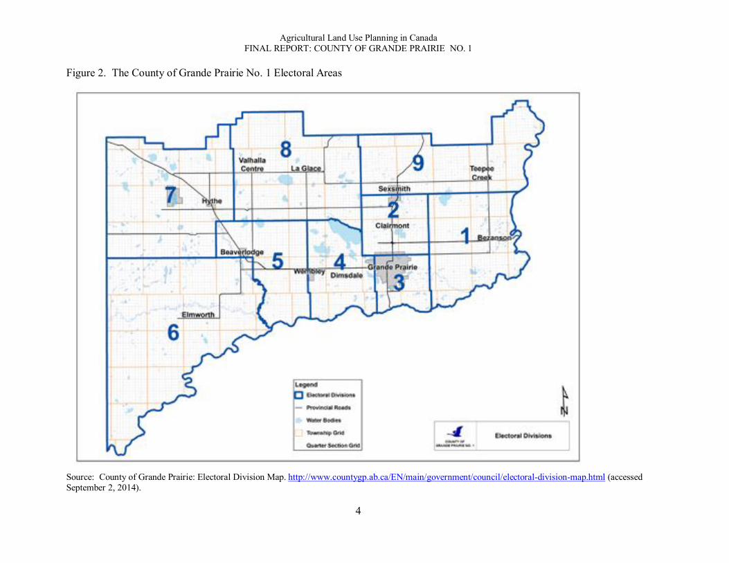
Overview of site The County of Grande Prairie No. 1, Alberta, is located in the Upper Peace River region of northwestern Alberta (Figure 1), which is within the Canadian Boreal Interior Plains east of the Rocky Mountains and along the border with British Columbia. The Peace River region of Alberta and British Columbia is the northernmost farming and agricultural region in North America. The County includes nine electoral areas (Figure 2) with a land base of 557,002 hectares and a population of 75,379 (Census Canada, 2011).
The main drivers of the economy are oil and gas exploration and extraction, agriculture, and forestry. Although oil and gas exploration and extraction have been occurring in northern Alberta for over 60 years, it did not begin to take place on a large scale until the 1970s. Alberta is located on top of the third largest crude oil reserve in the world next to Venezuela and Saudi Arabia, with proven reserves of over 170 billion barrels (Alberta, Oil and Gas: About the Industry, 2014, p.1). Correspondingly, there are many provincial regulations and legislative practices regarding the extraction of oil, from maintaining environmental standards to ensuring that the industry remains fair and competitive.
The recent growth of natural resource developments, primarily oil and gas, have led to a double-threat to agricultural lands. There is a direct impact of the physical activities on the rural land base and ancillary services. As well, there is an increasing demand for agricultural lands in and surrounding settlement areas, which is contributing to rapid urbanisation of the region.
Agricultural profile The Peace River region is facing changes in an agricultural similar to other parts of Canada: an ageing and declining rural population and increasing numbers of larger, centralised farms Mackenzie Municipal Services Agency, 2012). According to the 2011 Canadian Farm Census, there were a total of 1,206 farms in County of Grande Prairie, covering approximately 422,927 hectares (Statistics Canada, 2011). Of this, there were a total of 193 beef and cattle farms, and 110 farms for horse and other equine production. Livestock, beef and cattle, and other equine production is also prevalent, as well as bee keeping and honey production. The most prevailing forage production consists of oilseed, hay and other fodder crops, oats, barely, canola, dry field peas, alfalfa, wheat and other grains. The quality of agricultural land in Alberta is based on the Canada Land Inventory (CLI) rating as well as the Farmland Assessment Rating. The County of Grande Prairie, as well as the entire Peace River Region of Alberta, has a high quality of soil and agricultural capability (Government of Canada: Agriculture and Agri-Foods Canada).

Agricultural Land Use Planning in Canada FINAL REPORT: COUNTY OF GRANDE PRAIRIE NO. 1
3
Figure 1. The County of Grande Prairie No. 1
Source: County of Grande Prairie (2011).
Agricultural Land Use Planning in Canada FINAL REPORT: COUNTY OF GRANDE PRAIRIE NO. 1
4
Figure 2. The County of Grande Prairie No. 1 Electoral Areas
Source: County of Grande Prairie: Electoral Division Map. http://www.countygp.ab.ca/EN/main/government/council/electoral-division-map.html (accessed September 2, 2014).
Agricultural Land Use Planning in Canada FINAL REPORT: COUNTY OF GRANDE PRAIRIE NO. 1
1
Results In this section we present the results for the case study of the County of Grande Prairie No. 1. We begin with the results of our assessment of the legislative framework of the case study site within the context of regional and provincial policies and legislation. We then present the results of the content analyses of local government policies and legislation followed by the results of the political context, which includes our assessment of the influence of the three policy regimes (farmland preservation, food sovereignty, and global competitiveness). We discuss the significance of these results in the next section. State of agricultural land use planning Within this region there are many competing land use pressures including agriculture, industrial development, oil and gas activities, and municipal development. Oil and gas exploration and extraction pose increasing threats to agriculture and farmland. The importance of preventing non-agricultural uses on highly fertile agricultural land is becoming recognised as a growing problem.
In 2008, the Government of Alberta recognised increasing land use pressures throughout the province and implemented the new Land-use Framework (Ministry of Environment and Sustainable Resource Development, 2008). Rapid population growth and economic activities, such as oil and gas, forestry and mining, agriculture, recreation, housing, and infrastructure, are placing unprecedented and competitive pressures on the Alberta land base. Within the new Land-use Framework, the government plans to manage economic and urban growth, thus sustaining the economy, while still addressing important environmental goals.
Regarding agriculture, the Land-use Framework identifies two policy areas of provincial interest: fragmentation and conversion of agricultural land. Addressing these two areas is a “key consideration.”
While the amount of land used for agriculture has been relatively stable across the province, agricultural land, particularly in areas like the Edmonton-Calgary corridor, Grande Prairie, and Lethbridge, has been increasingly divided into parcels too small to farm or ranch (i.e., fragmentation). Rural and urban growth has resulted in the loss or conversion of some of the province’s most productive farm and ranch lands to other uses. (p. 13)
The Government identified market-based incentives, transfer of development credits, agricultural and conservation easements, and smart growth planning as possible tools to reduce fragmentation and conversion. There is no mention of using provincial policy statements or legislation to protect agricultural land. Under the direction of the Land-use Framework, regional land use plans for the seven sub-regions of the province are now at various stages of development. The County of Grande Prairie No. 1 falls within the Upper Peace Regional Plan, which has not started.
In 2012, the municipalities in the Upper Peace and Lower Peace Regions of northern Alberta and the Mackenzie Municipal Services Agency worked together to prepare a report on

Agricultural Land Use Planning in Canada FINAL REPORT: COUNTY OF GRANDE PRAIRIE NO. 1
2
the regional land-use planning framework, Municipal Perspectives of the Land Use Framework: A Position Paper for the Upper and Lower Peace Regions (Mackenzie Municipal Services Agency, 2012). The aim of the report was to determine the most pressing matters among the area’s twenty-eight municipalities and villages. Land use, farmland fragmentation, conversion of agricultural lands to non-agricultural uses, and the growing demand for residential uses were some of the most prominent concerns. The position paper represents the perspectives of most of the Peace Region’s municipalities on the provincial Land-use Framework with the aim to prioritise land use issues, although the County of Grande Prairie is not listed among them. Regarding agriculture, the report states:
“...[O]ne of the main considerations of the Framework is to reduce the fragmentation and conversion of agricultural land to noncompatible uses. It is anticipated that the policies that will be developed through the Land-use Framework will represent the strongest policy shift affecting the industry in twenty years (p. 43).
Correspondingly, the position paper also identified the need to minimise the negative effects of large-lot residential development. Degradation of agricultural land was also identified. The County of Grande Prairie was not listed among the municipalities that expressed concern for these issues.
The County’s Integrated Community Sustainability Plan (County of Grande Prairie, 2008) identifies the importance of identifying areas of high quality agricultural soil, and minimizing non-agricultural development on these lands. However, there is no agricultural plan for the area.
Legislative framework The legislative framework consists of policies, regulations, and governance structures related to agricultural land use planning at local, regional, and provincial levels of government. Policy documents were identified as enforceable, aspirational, or enabling (refer to the appended glossary for definitions of these and other terms). One of our first steps was to document the legislative framework for each case study site. The framework consists of policies, legislation (and by-laws), and governance structures related to agricultural land use planning at local, regional (or upper-tier), and provincial levels of government. Policy documents were identified as enforceable, aspirational, or enabling (refer to the appended glossary for definitions of these and other terms).
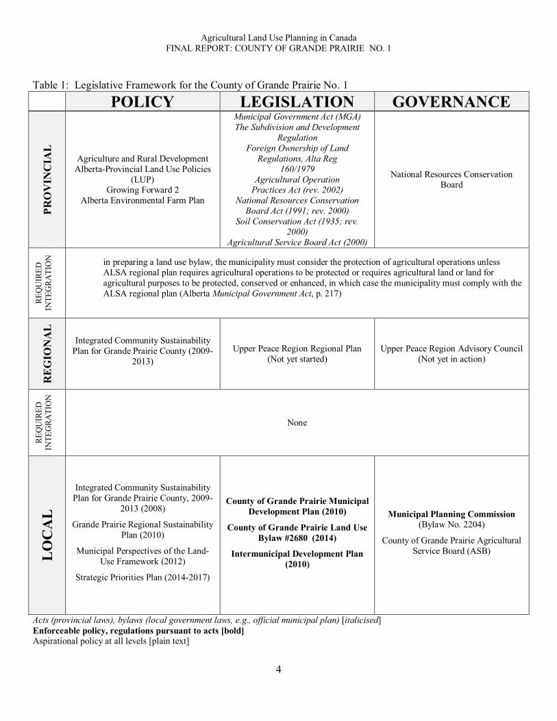
The County of Grande Prairie is covered by a variety of land use planning policy and legislation documents within its legislative framework at the provincial and regional levels (Table 1). The provincial policy documents include Land-use Framework (LUF), the Environmental Farm Plan, and Canada’s Growing Forward 2. The provincial legislative documents consist of the Municipal Government Act, the Agricultural Operations Practices Act (which covers Confined Feeding Operations), Alberta Land Stewardship Act, and the Soil Conservation Act. The Upper Peace Region Regional Plan is under development, and the Upper Peace Region Advisory Council is not yet in place.
At a local level, the legislative framework consists of several policy and legislation documents. The County of Grande Prairie No. 1 has several relevant legislation documents. The most influential regulations are the County of Grande Prairie Municipal Development Plan (2010), the County of Grande Prairie Intermunicipal Development Plan (2010), and the County

Agricultural Land Use Planning in Canada FINAL REPORT: COUNTY OF GRANDE PRAIRIE NO. 1
3
of Grande Prairie Land Use Bylaw No. 2680 (2014). The Intermunicipal Development Plan applies to the City of Grande Prairie as well as approximately 135 square kilometers of adjacent land in the County.
Foreign ownership of agricultural land is controlled via the Foreign Ownership of Land Regulations, Alta Reg 160/. The general rule is that foreign ownership of land is not permitted for two or more parcels that, in aggregate, exceed 20 acres. The regulations permit a range of non-farm uses of these lands by foreign owners, but there are also stipulations that the ownership is divested within three years. The regulations also cover what defines foreign ownership and the percentages of ownership.
The policy documents consist of the Grande Prairie Strategic Priorities Plan (2014-2017), the Grande Prairie Regional Sustainability Plan (2012), and the Municipal Perspectives of the Land-use Framework: A Position Paper for the Upper Peace and Lower Peace Regions (2012).
The Integrated Community Sustainability Plan (ICSP) (County of Grande Prairie, 2008) is a long-range (30 years) plan that presents a vision of what a sustainable County looks like with key goals and strategies to achieve its vision. Key goals include managing economic development, encouraging community development, provide quality services and infrastructure, and think regionally, which are supported by 21 strategies. The purpose of the Regional Sustainability Plan was to guide future decisions about the growth and development of the region. The Plan includes 21 goals and actions covering social, culture, economic, environment, and governance issues.
Governance at the local level consists of the Municipal Planning Commission and the Agricultural Service Board (ASB). The Commission, appointed by County Council, makes decisions regarding applications for development permits specified under any land use bylaw, as well as makes decisions concerning all subdivision applications. The purpose of the ASB is to increase awareness on agricultural issues within the County; it is also responsible for enforcing the Weed Control Act, the Agricultural Pests Act, the Animal Health Act, and the Soil Conservation Act. The mission of the ASB is “to foster our Vision by demonstrating proactive leadership, environmental stewardship and co-operation with stakeholders and other agencies pursuing innovative, effective solutions and programs” (County of Grande Prairie: Agriculture, 2012). In this capacity, the ASB may have some influence over agricultural land use planning decisions.
Content analysis of documents After documenting the legislative framework we assessed the contents of the documents. The results of this content analysis reflect the breadth and quality of the legislative framework. For this we used a three-point (check mark) scale indicating different levels of detail from minimal () to moderate () to high (). The criteria we used for this part of the assessment are included in Appendix: Criteria for Evaluating Content of Legislative Framework.
Agricultural Land Use Planning in Canada FINAL REPORT: COUNTY OF GRANDE PRAIRIE NO. 1
4
Table 1: Legislative Framework for the County of Grande Prairie No. 1
PRO
VIN
CIA
L
Agriculture and Rural Development Alberta-Provincial Land Use Policies
(LUP) Growing Forward 2
Alberta Environmental Farm Plan
Municipal Government Act (MGA) The Subdivision and Development
Regulation Foreign Ownership of Land
Regulations, Alta Reg 160/1979
Agricultural Operation Practices Act (rev. 2002)
National Resources Conservation Board Act (1991; rev. 2000)
Soil Conservation Act (1935; rev. 2000)
Agricultural Service Board Act (2000)
National Resources Conservation Board
REQ
UIR
ED
INTE
GR
ATI
ON
in preparing a land use bylaw, the municipality must consider the protection of agricultural operations unless ALSA regional plan requires agricultural operations to be protected or requires agricultural land or land for agricultural purposes to be protected, conserved or enhanced, in which case the municipality must comply with the ALSA regional plan (Alberta Municipal Government Act, p. 217)
REG
ION
AL
Integrated Community Sustainability
Plan for Grande Prairie County (2009-2013)
Upper Peace Region Regional Plan (Not yet started)
Upper Peace Region Advisory Council (Not yet in action)
REQ
UIR
ED
INTE
GR
ATI
ON
None
LO
CA
L
Integrated Community Sustainability Plan for Grande Prairie County, 2009-
2013 (2008)
Grande Prairie Regional Sustainability Plan (2010)
Municipal Perspectives of the Land-Use Framework (2012)
Strategic Priorities Plan (2014-2017)
County of Grande Prairie Municipal Development Plan (2010)
County of Grande Prairie Land Use Bylaw #2680 (2014)
Intermunicipal Development Plan (2010)
Municipal Planning Commission (Bylaw No. 2204)
County of Grande Prairie Agricultural Service Board (ASB)
Acts (provincial laws), bylaws (local government laws, e.g., official municipal plan) [italicised] Enforceable policy, regulations pursuant to acts [bold] Aspirational policy at all levels [plain text]
POLICY LEGISLATION GOVERNANCE

Agricultural Land Use Planning in Canada FINAL REPORT: COUNTY OF GRANDE PRAIRIE NO. 1
5
Local government legislation documents The County of Grande Prairie Municipal Development Plan (2011) is the most important land use planning legislative document for the area, as reflected in Tables 2 and 3, which illustrate the contents of the various documents in the local legislative framework. The main aim of the Municipal Development Plan is to minimise conflicts with agriculture with a significant emphasis on planning for and managing Confined Feeding Operations (CFOs), as regulated under the Agricultural Operations Practices Act. There is no specific land designation for agriculture in the Municipal Development Plan; instead, agricultural land is covered under Rural. This section states, “The overall intent in the rural area is to recognize agriculture as the predominant land use. At the same time there needs to be a recognition that many different competing uses will also occur in the rural area. The overall goal is to minimize conflicts” (p. 15). In order to minimise conflicts with non-agricultural uses in Rural areas, that Plan states that the policies reflect “a cautious and prudent approach” (p. 15). The Rural land designation has a comprehensive set of 28 policies, including permitted non-farm uses and various options for subdivision. Eight of the policies are related to CFOs. Minimum lot size for any use in Rural areas is 160 acres with a maximum parcel size of six hectares (15 acres) for a farmstead operation, which is land subdivided to accommodate an existing, habitable residence for a retiring farmer. Additional lot sizes are set for other uses. The land designations of Country Residential and Hamlets/Rural Residential are intended to manage non-agricultural development in what are predominantly agricultural areas. The Municipal Development Plan also identifies the need for a strategy for dealing with farm-based industries. The Plan includes map of farmland assessment lands in the County and of areas where CFOs are excluded. There is no map that shows conflicts between agricultural and other uses such as country residential and hamlets. The Municipal Development Plan contains no statements about protecting agricultural lands. By contrast, there is a statement about protecting urban areas from incompatible rural development, which, one would assume, includes farming. The closest statement to farmland protection is related to restricting uses of better agricultural lands (defined as having a Rural Farmland Assessment rating of 35% or better) and directing non-agricultural development to other, poorer agricultural lands.
The fringe area surrounding the City of Grande Prairie is recognised in the County’s Municipal Development Plan and addressed directly through the Intermunicipal Development Plan (IDP) (2010). The IDP is an enforceable joint land use plan between the County and the City of Grande Prairie. The IDP focusses on accommodating growth and managing the industrial tax base, including short- and long-term annexation areas. There is no mention of agricultural land among the identified needs for the plan or among its goals and objectives. The Plan includes five policy recommendations outlined under section 6.3, ‘Agricultural Uses’, but only three of these recommendations refer to agricultural land use planning, and the first policy recommendation does not support farmland protection. The IDP states (p. 15-16),
[I]t is recognized that extensive agricultural operations exist and will continue to exist within the Plan area. These operations will eventually be phased out in favour of urban or more intense development. The transition from agriculture to some other land use shall be done within the policies provided in this Plan.

Agricultural Land Use Planning in Canada FINAL REPORT: COUNTY OF GRANDE PRAIRIE NO. 1
6
Rather than encourage urban and industrial developmental projects to locate to more favourable areas to carry out development, the IDP recognises that “in areas where agricultural operations abut urban development, the municipalities shall send information to the urban landowners advising of the possible nuisances arising from the agricultural operation on the urban landscape” (IDP, p. 16). The County’s Land Use Bylaw (Bylaw #2680) sets out the district zoning for agricultural uses (AG), which regulates permitted agricultural uses and discretionary uses. The AG district includes regulations for farmstead lot sizes (min: 2 ha; max. 6 ha). The minimum lot area of other uses is 58 ha. One subdivision of a quarter section is permitted for the following reasons: farmsteads, abandoned farmsteads, and fragmented parcels.
Two of the local documents refer to provincial legislative acts: the Municipal Development Plan (2009) and the County of Grande Prairie Municipal Commission Bylaw. These documents refer to the Municipal Government Act, which states:
in preparing a land use bylaw, the municipality must consider the protection of agricultural operations unless ALSA regional plan requires agricultural operations to be protected or requires agricultural land or land for agricultural purposes to be protected, conserved or enhanced, in which case the municipality must comply with the ALSA regional plan (Municipal Government Act, p. 217)
Local government policy documents The local policy documents for the County of Grande Prairie also lack depth and context for agricultural land use planning and farmland protection, as reflected in the results of our analysis (Table 4). The ICSP, under its goal to encourage community development, aims to concentrate growth and higher densities in its urbanised areas in order to support the preservation of rural areas for rural-based land uses. One strategy (#9) is directed at maintaining and promoting “viable agricultural communities across the County.” This strategy includes supporting the ASB, investing in support programs, supporting environmentally sustainable agricultural practices, and working with the industry. The Regional Sustainability Plan presents an action to preserve agricultural land; however, this statement appears to be limited to the agricultural lands in the fringe area of the City of Grande Prairie, which the IDP identifies as areas for future non-agricultural development. The recently completed report, Municipal Perspectives of the Land Use Framework: A Position Paper for the Upper Peace and Lower Peace Regions (2012), has an extensive contextual background and map; however, it does not have adequate references to provincial legislation, policy recommendations, or regulations. Fragmentation and degradation of farmland are identified as key issues, as is large-lot residential development. However, these concerns appear to be more important for the other municipalities in the region, but not the County of Grande Prairie. The Upper Peace Region Regional Plan is currently under development, and has the potential to improve the legislative framework for the County of Grande Prairie.

Agricultural Land Use Planning in Canada FINAL REPORT: COUNTY OF GRANDE PRAIRIE NO. 1
7
Table 2. Contents of local agricultural land use legislative documents
Name of document
Legislative Context
(Provincial) Background
Vision, Goals, Objectives,
Recommendations
Regulations (enforceable
policies, procedures) Maps
County of Grande Prairie Municipal Development Plan (2011)
County of Grande Prairie Intermunicipal Development Plan (2010)
County of Grande Prairie Land Use Bylaw No. 2680 (2014)
County of Grande Prairie Municipal Planning Commission Bylaw No. 2204
Table 3. Breadth and depth of legislative context
Table 4. Contents of local land use policy documents
Name of document Legislative Context
(Provincial) Background
Vision, Goals, Objectives,
Recommendations
Regulations (enforceable
policies, procedures) Maps
Grande Prairie Regional Sustainability Plan Integrated Community Sustainability Plan for Grande Prairie County, 2008 (2009-2013)
Strategic Priorities Plan (2014-2017) Summary Document Municipal Perspectives of the Land Use Framework- A Position Paper for the Upper Peace and Lower Peace Regions (2012)
Name of Document
Legislative context (legislation and policies) Governance
MG Act CFO
(AOPA) SC Act Sub/Dev
Reg
ALSA LU
Policy ASB NRCB County of Grande Prairie Municipal Development Plan (2011)
County of Grande Prairie Intermunicipal Development Plan (2010)
County of Grande Prairie Land Use Bylaw No. 2680 (2014) County of Grande Prairie Municipal Planning Commission Bylaw No. 2204

Agricultural Land Use Planning in Canada FINAL REPORT: COUNTY OF GRANDE PRAIRIE NO. 1
8
Policy regimes The two policy regimes of farmland preservation and global competitiveness have influenced agricultural land use policy and legislation for over forty years. Food sovereignty, and its associated concerns with food security and demand for local food, is a nascent policy regime that is influencing agricultural land use planning. Within this context, the aim of our analysis was to assess how issues, ideas, interests/actors and institutions associated with the three policy regimes influence local agricultural planning processes, including decisions about zoning, official plans, boundary adjustments, land division and servicing, and, as well, to assess the extent to which agricultural land use planning encompasses a comprehensive view of food systems planning, activities, and issues. To complete the assessment of the presence and importance of the policy regimes we examined the documents that comprise the legislative framework. Presence and importance were measured as a function of both the level of influence of words, concepts, and statements that appear in the documents and of the placement of these words, concepts, and statements within each document. The criteria for measuring the policy regime statements are presented in Appendix: Criteria for determining level of influence of policy regimes.
Very few of the local policy and legislation documents contain any references to the defined policy regimes. The only documents containing references to any of the policy regimes are the County’s ICSP, Regional Sustainability Plan, and the position paper on the Land-use Framework prepared by the Mackenzie Municipal Services Agency (Table 5). These documents referred to the farmland preservation policy regime. Neither global competitiveness nor food sovereignty is referenced within the documents, and appear to have little to no formal influence over the land use planning process within the region. The relevant statements are shown in Table 6. The ICSP recognises the importance of identifying areas of high quality agricultural land and minimising non-agricultural development on these lands. The position paper on the Land-use Framework focus on fragmentation and conversion, as identified in the Framework as key issues.

Agricultural Land Use Planning in Canada FINAL REPORT: COUNTY OF GRANDE PRAIRIE NO. 1
9
Table 5. Analytical framework for policy regimes at local level: documents FARMLAND PRESERVATION
Vision, Goals, Objectives, Recommendations Driving Issues, Concerns Regulations Action Items
Lev
el o
f Inf
luen
ce
High Influence Position Paper on LUF
Medium Influence Position Paper on LUF
Low Influence ICSP Position Paper on LUF Regional Sustainability Plan
Table 6. Analytical framework for policy regime at local level: statements FARMLAND PRESERVATION
Vision, Goals, Objectives, Recommendations Driving Issues, Concerns Regulations Action Items
Lev
el o
f Inf
luen
ce
High Influence Reduce the fragmentation and
conversion of agricultural land to non-compatible uses
Medium Influence
Ensure a co-ordinated approach to preserve agricultural lands Stop subsidizing water and sewer systems that encourage sprawl and further fragment the agricultural land base Encourage intensification and infill development Large lot development should be limited to areas where agriculture is not viable
Low Influence
Identify areas of high agricultural land quality and minimize non-agricultural development By concentrating growth in these areas, the County encourages the preservation of rural areas for rural based land uses.
Minimising the amount of land that is taken from undeveloped or extensive agricultural use
Encouraging high density where redevelopment occurs
Create policies to preserve forest and agricultural land as identified in the IDP
Agricultural Land Use Planning in Canada FINAL REPORT: COUNTY OF GRANDE PRAIRIE NO. 1
10
Discussion Our overall aim for the project is to identify principles and beneficial practices that represent land use planning solutions that protect farmland. As a step toward this final aim we identified four principles that guided our analysis: maximise stability, minimise uncertainty, integrate across jurisdictions; and accommodate flexibility. In this section we discuss the strength of the legislative framework for the County of Grande Prairie No. 1. Maximise stability A stable legislative framework for protecting farmland is one that is not easily changed at the whim of shifting political interests; it is well-entrenched in acts of legislation, policy, and governance structures that are based on clear, concise language, and can hold up to court challenge. A key element of stability is a clear statement of purpose regarding farmland protection among the primary goals and objectives within each enforceable document. Thus, stability is a critical measure of the strength of an agricultural land use planning framework. The County of Grande Prairie’s legislative framework for the protection of agricultural land lacks stability. Although the County’s Municipal Development Plan has enforceable legislative documents for general land use planning for agricultural lands, there is no stated commitment to farmland protection. The closest statement to farmland protection is to direct non-agricultural development away from better agricultural lands. At the same time, the legislative documents set out a number of permitted uses and subdivisions. There is no plan specifically for agriculture. Minimise uncertainty The presence of uncertainty, typically introduced via ambiguous language, exceptions or gaps, is a critical measure of the weakness of an agricultural land use planning framework. Thus, in addition to maximising the stability of a legislative framework through enforceable policies, people want to know they can rely on these rules and regulations to be applied consistently under different circumstances. The current legislative framework for the protection of agricultural land in the County of Grande Prairie contributes to uncertainty. The most influential documents within the legislative framework lack substantial references to agricultural land protection. The Intermunicipal Development Plan recognises that “[extensive agricultural operations] will eventually be phased out in favour of urban or more intense development. The transition from agriculture to some other land use shall be done within policies provided in this Plan” (p. 16). These statements increase the uncertainty about the future of agricultural lands. The absence of a completed agricultural plan is significant in this regard. Although there is not an explicit commitment to protecting farmland, the designations of Country Residential and Hamlet/Rural Residential uses help to minimise uncertainty by stating where non-agricultural developments are preferred. Similarly, the Municipal Development Plan helps to minimise uncertainty by providing detailed criteria to guide applications for development in these areas.
Agricultural Land Use Planning in Canada FINAL REPORT: COUNTY OF GRANDE PRAIRIE NO. 1
11
Integrate public priorities across jurisdictions Integrating policies and priorities across jurisdictions is a foundation for building cohesion across provincial, regional, and local governments. One can also think of integration as a formal “linkage” that provides consistency among them. In order to successfully integrate policies across jurisdictions there must be sufficient details about the legislative context that guides and constrains local government plans and strategies. By this measure of integration, we found that the level of integration is poor. From the provincial perspective, the 1996 provincial Land Use Policies has relatively weak language; municipalities are “encouraged” to address various concerns, rather directed to do so. Similarly, the policy assigns to municipalities the responsibility to “interpret and apply the Land Use Policies” in a “locally meaningful and appropriated fashion” (Alberta Municipal Affairs, 1996, p. 3). Thus, the requirements for integrating with provincial priorities are limited. Within the local legislative framework, there are minimal references to provincial legislation and priorities. There is a high level of horizontal integration in the Intermunicipal Development Plan, which is its purpose; the IDP is designed to remove agricultural uses from the fringe area. The County’s limited ability to exercise authority over some land uses also limits its ability to integrate with provincial priorities. Accommodate flexibility Creating an effective legislative framework is an act of balance, without being too stable so that it cannot be changed when needed or too strict so that it cannot be applied in a range of circumstances. Thus, flexibility is necessary in order to moderate the restrictive effects of maximising stability and minimising uncertainty. The means to accommodate flexibility is typically done through governance mechanisms. However, in the absence of a high level of stability and integration, flexibility can be problematic because the effect is not to accommodate but to introduce uncertainty. This appears to be the case for the County of Grande Prairie. As noted above, the local legislative framework for farmland protection in the County lacks stability and has a low level of integration with provincial legislation. Although the Municipal Development Plan has policy to restrict uses of better agricultural land, it also permits a number of non-farm uses and options for subdivision, while also accommodating a higher level of flexibility on other agricultural lands. As stated, “On lands not considered to be better land, there will be more flexibility to develop nonagricultural uses” (MDP, p. 15; emphasis added). In order to minimise the level of uncertainty introduced by this policy objective, the Plan sets out the criteria that will be considered. The extent of the criteria, however, may give an overall impression that the government is open to a wide range of non-agricultural uses, which undermines the interest in restricting uses on better agricultural lands and may contribute to uncertainty. Influence of policy regimes The three policy regimes appear to have little influence on the legislative framework for the County of Grande Prairie, as reflected in the documents themselves. Only farmland preservation is identified among the documents, but references are limited to two aspirational documents. There are no references to the policy regimes of food sovereignty and global competitiveness. Although

Agricultural Land Use Planning in Canada FINAL REPORT: COUNTY OF GRANDE PRAIRIE NO. 1
12
the policy regime of global competitiveness is not evident within the local documents of the legislative framework, given the exposure of the region to the global economy through agriculture and energy it is likely that global competitiveness plays a dominant role in policy discussions and public debate. Farmland fragmentation The primary land use planning tool for preventing fragmentation is large minimum lot sizes. Thus, sub-dividing into smaller lots is in direct conflict with the over-riding goal to not fragment the land base. As stated in the County’s Municipal Development Plan (6.1), “extensive agriculture will have preference over other land uses” in Rural areas and the minimum size for any use in the County, unless otherwise specified, is 160 acres. By these policies, the preference for large lots in the County is consistent with regional and province-wide concerns for fragmentation of the farm land base. In other jurisdictions in Canada, policies to maintain large lots for agriculture are a source of concern for people promoting small-lot agriculture, which is often associated with food security. This source of tension is not evident in the local legislative framework in the County of Grande Prairie. Natural resource developments The state of agricultural land use planning is assessed most often within the context of urban development. In Alberta, pressures also come from natural resource developments, such as forestry, oil and gas, and mining. As stated in the Municipal Development Plan (p. 25),
Other industries, particularly those directly related to the natural resources in the area, locate in close proximity to the resources the industry services. For the most part, the ability of the County to influence the locations is limited. Gas plants, pulp mills and other large resource uses require Provincial Government approval. Once approved by the government, the County must rezone the land to accommodate the use. Therefore the role of the County is limited to commenting to the relevant Provincial agencies. The plan will outline the County policies regarding major resource development which will become the basis for making comments to the Province.
Thus, while natural resource developments have a significant presence in the region, it appears that municipal governments have little influence over land use decisions that are affected directly by these developments.

Agricultural Land Use Planning in Canada FINAL REPORT: COUNTY OF GRANDE PRAIRIE NO. 1
13
Conclusion Overall, the County of Grande Prairie No. 1 has a weak legislative framework for the protection of agricultural land. The local legislative documents provide a minimum level of stability for agricultural land use planning. However, due to the absence of a stated commitment to protecting farmland, there is a high level of uncertainty about the future of agricultural lands. This weak position is reinforced by a lack of vertical integration with provincial policies, except for Confined Feeding Operations.
The Government of Alberta has been implementing its Land Use Framework since 2008. Although the Upper Peace Region Regional Plan has not yet been started, this plan has the potential to change and strengthen agricultural land use planning and farmland protection in the region.
Agricultural Land Use Planning in Canada FINAL REPORT: COUNTY OF GRANDE PRAIRIE NO. 1
14
References Agricultural Service Board Homepage, 2011-2014. http://www1.agric.gov.ab.ca/$department/deptdocs.nsf/all/rsv13511 Alberta, Canada. Oil and Gas: About the Industry, June 2014. http://www.albertacanada.com/business/industries/og-about-the-industry.aspx (accessed September 6, 2014). Alberta: Environment and Sustainable Resource Development https://landuse.alberta.ca/PlanforAlberta/LandUsePlanning/Pages/default.aspx Agriculture Service Board [ASB], 2013. Orientation Manual for Members. On-line: http://www1.agric.gov.ab.ca/$Department/deptdocs.nsf/all/rsv13511/$FILE/orientation-manual.pdf. Connell, D. J. (2009). Planning and Its Orientation to the Future. International Planning Studies, 14(1), 85-98. County of Grande Prairie No. 1., 2008. Integrated Community Sustainability Plan for County of Grande Prairie. Grande Prairie, AB: County of Grande Prairie. On-line: http://www.countygp.ab.ca/assets/Departments/Planning~Development~Services/Docs/integrated-community-sustainability-plan.pdf County of Grande Prairie No. 1., 2010a. County of Grande Prairie Municipal Development Plan. Grande Prairie, AB: County of Grande Prairie. On-line: http://www.countygp.ab.ca/assets/Departments/Planning~Development~Services/Docs/municipal-development-plan.pdf County of Grande Prairie No. 1., 2010b. Intermunicipal Development Plan. Grande Prairie, AB: County of Grande Prairie. On-line: http://www.countygp.ab.ca/assets/Departments/Planning~Development~Services/Docs/intermunicipal-development-plan.pdf County of Grande Prairie No. 1., 2011. Municipal Development Plan. Grande Prairie, AB: County of Grande Prairie. On-line: http://www.countygp.ab.ca/assets/Departments/Planning~Development~Services/Docs/municipal-development-plan.pdf County of Grande Prairie No. 1., 2014. Strategic Priorities (2014-2017) Summary Document. Grande Prairie, AB: County of Grande Prairie. On-line: http://www.countygp.ab.ca/assets/Government/Docs/Strategic%20Plan%20Overview%202014-2017.pdf
Agricultural Land Use Planning in Canada FINAL REPORT: COUNTY OF GRANDE PRAIRIE NO. 1
15
County of Grande Prairie No. 1, 2012. County Releases Population Estimates. Media release, November 5, 2012. http://www.countygp.ab.ca/assets/News/2012/2012Nov5_County%20Releases%20Population%20Estimates.pdf. County of Grande Prairie No. 1., 2015. Agriculture. On-line: http://www.countygp.ab.ca/EN/main/departments/agriculture.html . Canadian Soil Information Service, 2015. Soil Capability for Agriculture- Grande Prairie, June 25, 2013. Government of Canada. Agriculture and Agri-Food Canada. On-line: http://sis.agr.gc.ca/cansis/publications/maps/cli/250k/agr/cli_250k_agr_83m.jpg. Mackenzie Municipal Services Agency, 2012. Municipal Perspectives of the Land-use Framework: A Position Paper for the Upper and Lower Peace Regions (Draft for Municipal Review). Mackenzie Municipal Services Agency. On-line: http://www.clearhillscounty.ab.ca/cms/doc_view/374-042412-landuseframework. Ministry of Environment and Sustainable Resource Development, 2008. Land-use Framework. Edmonton, AB: Government of Alberta. On-line: https://landuse.alberta.ca/LandUse%20Documents/LUF%20Annual%20Progress%20Report%202013.pdf. Runka, G., 2006. “BC’s Agricultural Land Reserve – Its Historical Roots.” Seminar presented at Planning for Food, World Planners Congress, Vancouver, BC, June 21, 2006. Smith, B., 1998. Planning for Agriculture. Victoria, BC: Agricultural Planning Commission. Statistics Canada, 2011. Census of Agriculture, Farm and Farm Operator Data, catalogue no. 95-640-XWE. http://www29.statcan.gc.ca/ceag-web/eng/community-agriculture-profile-profil-agricole.action?geoId=487019006&dataType=1 . Statistics Canada. 2012. Grande Prairie County No. 1, Alberta (Code 4819006) and Division No. 19, Alberta (Code 4819) (table). Census Profile. 2011 Census. Statistics Canada Catalogue no. 98-316-XWE. Ottawa. Released October 24, 2012. http://www12.statcan.gc.ca/census-recensement/2011/dp-pd/prof/index.cfm?Lang=E.
Agricultural Land Use Planning in Canada FINAL REPORT: COUNTY OF GRANDE PRAIRIE NO. 1
16
Appendix: Glossary Policy:
A formal statement of intent; principles, rules, or guidelines that are designed to determine or influence major decisions or actions and all activities that fall within the domain of the policy.
Enforceable policy:
Policy with clear statements of intent to enforce (often with penalty for failing to follow the policy)
Aspirational policy:
Policy without clear statements of intent to enforce (often with penalty for failing to follow the policy); a broad statement about desired outcomes, objectives, or activities
Enabling policy:
Policy with clear statements of intent to implement a policy (e.g., provide resources)
Policy regime:
A policy regime and its changes refer to the combination of issues, ideas, interests, actors and institutions that are involved.
Legislation: A law (or Order in Council) enacted by a legislature or governing body; can have many purposes: to regulate, to authorize, to proscribe, to provide (funds), to sanction, to grant, to declare or to restrict. By-law (bylaw):
Local laws established by municipalities as regulated by the provincial government. Note: for our purposes, a by-law is considered part of legislation.
Regulation (pursuant to Act):
Is a form of legislation (law) designed with the intent to regulate; a rule or law designed to control or govern conduct; creates, limits, constrains a right, creates or limits a duty, or allocates a responsibility.
Governance:
Methods, systems, or processes of governing; the act of implementing policy and legislation. For our purposes we are concerned with groups (e.g., commissions, advisory committees) that have the authority to apply, review, or enforce policy and legislation specific to agricultural land use planning.

Agricultural Land Use Planning in Canada FINAL REPORT: COUNTY OF GRANDE PRAIRIE NO. 1
17
Appendix: Criteria for Evaluating Content of Legislative Framework Legislation documents
Legislative Context (Provincial) Background Vision, Goals, Objectives Local policies Maps
0 None None None None None
Brief statements that include at least one reference to the main provincial legislation or policy related to agricultural land use planning. Little too context provided other than perhaps a statement that acknowledges the local governments duty to uphold these acts and policies.
Very brief description of agriculture background. This may include a minimal section or statistics on historical context, background and issues, and demographics on agriculture/farming.
Includes a vision, goal, or objective for agriculture but with minimal explanation or rationale.
One or two brief statements about agricultural land use policies, perhaps with little context.
Provides at least one (1) general land use map(s) with agricultural land use shown.
Expanded statements that reference more than one of the main provincial legislation and policies and provides added context to the above. Multiple statements that outline how provincial legislation and policies “fit” in the local context.
Includes multiple sections dedicated to information and statistics about agricultural background. May also reference an agricultural plan or report.
Includes a vision, goal, and objective for agriculture with a statement of explanation and some action items.
Several statements (three to five) about agricultural land use policy presented within local context. May also reference an agricultural plan.
Provides at least one (1) general land use map(s) showing agricultural land uses and at least one (1) agriculture specific map showing designated agricultural land.
Comprehensive that outlines how provincial legislation and policies “fit” in the local context.. May include diagrams to help establish thread of consistency among different levels of government.
Comprehensive account of agricultural background . May also reference an agricultural plan or report.
Includes a detailed section on vision, goals, and objectives for agriculture that outlines a rationale and action items. May also document relations with other land uses and local priorities.
Detailed section of agricultural land use policy statements (more than five) or agricultural sub-area plan adopted as by-law. May also reference an agricultural plan.
Provides two (2) or more agricultural land use maps including a map showing designated agricultural land. May also include Other maps to illustrate specific issues or policies (future areas of study, development permit areas, current land tenure).

Agricultural Land Use Planning in Canada FINAL REPORT: COUNTY OF GRANDE PRAIRIE NO. 1
18
Policy documents
Legislative Context (Provincial) Background Vision, Goals, Objectives Local Policies Maps
Same as above Same as above Same as above Different Same as above
0 None None None None None
Brief statements that include at least one reference to the main provincial legislation or policy related to agricultural land use planning. Little to no context provided other than perhaps a statement that acknowledges the local governments duty to uphold these acts and policies.
Very brief description of agriculture background. This may include a minimal section or statistics on historical context, background and issues, and demographics on agriculture/farming.
Includes a vision, goal, or objective for agriculture but with minimal explanation or rationale.
Several statements (three to five) about agricultural land use policy presented within local context.
Provides at least one (1) general land use map(s) with agricultural land use shown.
Expanded statements that references more than one of the main and policies and provides added context to the above. Multiple statements that outline how provincial legislation and policies “fit” in the local context.
Includes multiple sections dedicated to information and statistics about agricultural background. May also reference an agricultural plan or report.
Includes a goof presentation of vision, goal, and objective for agriculture with a statement of explanation, a few recommendation items, and some action items.
Comprehensive section of agricultural land use policy statements (more than five).
Provides at least one (1) general land use map(s) showing agricultural land uses and at least one (1) agriculture specific map showing designated agricultural land.
Comprehensive that outlines how provincial legislation and policies “fit” in the local context.. May include diagrams to help establish thread of consistency among different levels of government.
Comprehensive account of agricultural background. May also reference an agricultural plan or report.
Includes a detailed section on vision, goals, and objectives for agriculture with an extensive and detailed list of recommendations and/or action items.
Comprehensive agricultural plan. May also refer to background report.
Provides two (2) or more agricultural land use maps including a map showing designated agricultural land. May also include Other maps to illustrate specific issues or policies (future areas of study, development permit areas, current land tenure).

Agricultural Land Use Planning in Canada FINAL REPORT: COUNTY OF GRANDE PRAIRIE NO. 1
19
Appendix: Criteria for determining level of influence of policy regimes
Placement (significance) within Document
Aims, Goals, Objectives
Mission, Vision, Mandate, Purpose Driving issues, concerns Action items
Leve
l of i
nflu
ence
High influence
A clear, explicit statement as part of a short list (three to
five) of items in an enforceable policy or
regulation
A clear, explicit statement at the highest level of an enforceable policy or
regulation
Medium influence A clear, explicit statement as part of a short list (three to
five) of items in an aspirational policy
A clear, explicit statement at the highest level of an
aspirational policy
A clear, explicit statement as part of a short list (three to
five) items in a policy
A clear, explicit statement as part of a short list (three to five) of items in a policy
Low influence A clear, explicit statement as part of a long list of items in
an aspirational policy
A clear, explicit statement as part of a long list of items in
an aspirational policy
A clear, explicit statement as part of a long list of items in a
policy