CARTE DES SOLS ET DE LA VEGETATION DU CONGO...
28
PUBLICATIONS DE L'INSTITUT NATIONAL POUR L'ETUDE AGRONOMIQUE DU CONGO BELGE (INEAC) CARTE DES SOLS ET DE LA VEGETATION DU CONGO BELGE ET DU RUANDA-URUNDI 4. - NIOKA (Ituri) , 0.-GEOMORPHOLOGIE GEOLOGY OF THE SOILS OF THE NIOKA-ITURI AREA, BELGIAN CONGO .. by ROBERT V. RUHE Geomorphologist BRUXELLES 1954
Transcript of CARTE DES SOLS ET DE LA VEGETATION DU CONGO...

PUBLICATIONS DE L'INSTITUT NATIONALPOUR L'ETUDE AGRONOMIQUE DU CONGO BELGE
(INEAC)
CARTE DES SOLS ET DE LA VEGETATIONDU CONGO BELGE ET DU RUANDA-URUNDI
4. - NIOKA (Ituri) ,
0.-GEOMORPHOLOGIE
GEOLOGY OF THE SOILS
OF THE NIOKA-ITURI AREA,
BELGIAN CONGO
. . byROBERT V. RUHEGeomorphologist
BRUXELLES1954
INSTITUT NATIONAL POUR L'ETUDE AGRONOMIQUE DU CONGO BELGEINEAC
(A. R. du 22-12-33 et du 21-12-39).
L'INEAC, créé pour promouvoir le développement scientifique de l'agri-culture au Congo belge, exerce les attributions suivantes :
1. Administration de stations de recherches dont la gestion lui est confiéepar le Ministère des Colonies.
2. Organisation de missions d'études agronomiques et formation d'experts- et de spécialistes.
, 3. Etudes, recherches, expérimentation et, en général, tous travaux quel-conques se rapportant à son objet.
ADMINISTRATION:A. - COMMISSION.
Président :t M. GODDING, R., ancien Ministre des Colonies.
Vice-Président :M. JURION, F., Directeur général de l'INEAC. . , '
Secrétaire ; ,M. LEBRUN, J., Secrétaire général de l'INEAC
Membres : -MM. BOUILLENNE, R., Membre de l'Académie Royale des Sciences, des Lettres
et des Beaux-Arts de Belgique;BRIEN, P., Membre de l'Institut Royal Colonial Belge; ,DEBAUCHE, H., Professeur à l'Institut Agronomique de Louvain;DE WILDE, L., Professeur à l'Institut Agronomique de l'Etat, à Gand;DUBOIS, A., Directeur à l'Institut de Médecine Tropicale « Prince
Leopold >và Anvers;DUMON, A-, Professeur à l'Institut Agronomique de l'Université Catholi-
% . que de Louvain;GEURDEN, L., Professeur à l'Ecole de Médecine Vétérinaire de l'Etat,
à Gand; •GILLIEAUX, P., Membre du Comité Cotonnier Congolais;GUILLAUME, A., Secrétaire généraldu Comité Spécial du Katanga;HARROY, J.-P-, Secrétaire généra! de i'insnrur pour la Recherche Scïenti-
. fique en Afrique Centrale;HELBIG DE BALZAC, L., Président du Comité National du Kivu; ^ •HENRARD, J., Directeur du Service de l'Agriculture, des Forêts, de
l'Elevage et de la Colonisation, au Ministère des Colonnes;HOMES, M., Professeur à l'Université Libre de Bruxelles;LAUDE, N., Directeur de l'Institut Universitaire des Territoires d'Outre-Mer,
à Anvers; .MAYNÉ, R.,. Professeur à l'Institut Agronomique de l'Etat, à Gembloux;OPSOMER, J., Professeur à l'Institut Agronomique de Louvain;PEETERS, G., Professeur à l'Université de Gand; .PONCELET, L, Météorologiste à l'Institut Royal Météorologique, à Uccle;ROBYNS, W., Membre de l'Académie Royale Flamande des Sciences, des
Lettres èf des Beaux-Arts de Belgique;SCHOENAERS, F., Professeur à l'Ecole de Médecine Vétérinaire de l'Etat,
à Cureghem;

Scanned from original by ISRIC - World Soil Information, as ICSUWorld Data Centre for Soils. The purpose is to make a safedepository for endangered documents and to make the accruedinformation available for consultation, following Fair UseGuidelines. Every effort is taken to respect Copyright of thematerials within the archives where the identification of theCopyright holder is clear and, where feasible, to contact theoriginators. For questions please contact soil.isric(5>wur.nlindicating the item reference number concerned. I
GEOLOGY OF THE SOILS
OF THE NIOKA-ITURI AREA,
BELGIAN CONGO
lioG

PUBLICATIONS DE L'INSTITUT NATIONAL
POUR L'ETUDE AGRONOMIQUE DU CONGO BELGE
(I.N.E.A.C.)
CARTE DES SOLS ET DE LA VEGETATIONDU CONGO BELGE ET DU RUANDA-URUNDI
4. - NIOKA ( I tu r i )
D . - GEOMORPHOLOGIE
GEOLOGY OF THE SOILS
OF THE NIOKA-ITURI AREA,
BELGIAN CONGO
by
ROBERT V. RUHEGeomorphologist
BRUXELLES1954
ACKNOWLEDGMENTS
The writer expresses his gratitude to Mr F. JURION, Directeur général de l'INEAC t1),
and Dr J. LEBRUN, Secrétaire général de l'INEAC, for the opportunity to undertake the
soil-geological study in the Belgian Congo under the auspices of INEAC. Mr M. LECOMTE,
Directeur général de l'INEAC en Afrique, and Mr A. FOCAN, Division d'Agrologie de
l'INEAC en Afrique, aided greatly in the writer's carrying out the field work in Africa.
Mr F. SMEYERS, assistant à l'INEAC, Nioka, cooperated in the field studies for which
appreciation is expressed. Thanks are accorded INEAC collaborators I. DENISOFF,
L ÜBEN, and P. GiLSON of the Mission Pédo-botanique à Nioka and American colleagues
of the ECA (2) - INEAC Mission, Belgian Congo, Drs G. A. BOURBEAU, J. G. CADY,
N. HOLOWAYCHUK, and T. M. SPERRY.
Ames, Iowa, U.S.A.
March, 1953.
(') Institut National pour l'Etude Agronomique du Congo Belge.(2) Economic Cooperation Administration (Mutual Security Agency), United States of America.
INTRODUCTION
PROGRAM
Geological work in the Nioka-lturi area was conducted in three phases : (1) a semi-detailed study of the area bounded on the west by the road Nioka-Golu, on the north bythe parallel of latitude Golu-Uganda frontier, on the east by the meridian from the Ugandafrontier to the Nioka-Mahagi road; (2) a detailed study of the upper Loluda River basin,bounded on the west by the Avu-Loluda River bridge road, on the north and east by theRona-Gote road, and on the south by the Gote-Avu road; and (3) a generalized reconnais-sance study of the geomorphology of the area Nioka-Lake Albert, parts of Uganda, theRuanda-Urundi, the Belgian Congo adjacent to and west of the Tanganyika-Albertine RiftValley, and the eastern Kibali-lturi District of the Belgian Congo.
Nioka-lturi, Belgian Congo is located at approximately 30°40' E longitude, 2°10' Nlatitude. Phase (1) of the program includes an area of approximately 100,000 hectares.The field study was completed during the period June 18, 1951 to March 24, 1952. Thearea of phase (2) is approximately 7,500 hectares. The study was completed during theperiod March 25 to April 17 and May 11 to June 11, 1952. In phase (3) approximately6,500 kilometers were traversed. The latter studies were completed throughout the tenureof work in the Belgian Congo that culminated on July 28, 1952.
CONCEPT OF SOIL GEOLOGY
Current opinion among soil scientists is that soil is a natural body occurring on theearth's surface that is dependent upon the soil forming factors, parent material, topogra-phy, time, climate, and biologic activity. Three of these factors, parent material,topography, and time, are geological in nature and require evaluation by application ofthe principles of geology.
The problems requiring evaluation are threefold : (1) to map and interpret the rocksand sediments that constitute the parent material in which soils have developed, (2) to mapand interpret the landforms on which soils have developed, and (3) to map and interpretthe age relationship of one mass of rock or sediment in contrast to another, or the agerelationship of a part of or of one landform in contrast to another. Thus, the end resultof a soil-geological study may be presented graphically on three maps : (1) a geologicalmap showing the bedrock distribution, (2) a map of the surficial deposits, and (3) ageomorphological map showing the distribution of landforms.
Soils within an area may show variable relationships to bedrock distribution. There-fore a geological map may or may not depict the distribution of parent materials of soils.In all cases, however, a map of the surficial deposits is a map of soil parent materials.A geomorphological map is of value in that the map not only evaluates topography buttime relationships of topographic units upon which the soil parent materials are distributed.

GEOLOGY
BEDROCK
Three major rock associations occur in the Nioka-lturi area (See plate 1). West of aline that extends northeastward from Gote to Luga, northwestward to the threefold junctionof the Vida River and its tributaries, and northward in a somewhat sinuous course, parallelto but approximately two and a half kilometers east of Zeu road, is a complex of granitoidrocks.
Characteristic of the granitoid rock is a prominent flow structure evidenced by align-ment of feldspar or biotite grains that trend generally slightly west or north. The flowstructure has been observed and mapped throughout the area of study. Areal occurrenceof the structure suggests that erosion has bared only the roof zone of an igneous intrusiveof massive proportions. Other lines of evidence that support this interpretation are: (1)observed sections where inclusions of meta-sediments occur in the granitoid rock, (2) suitesof metamorphic minerals that occur in thin deposits of translocated sediments that overliethe granitoid rock ('), (3) the thin mantle of metamorphic rocks that overlies the granitoidrocks in the eastern part of the area and in the Shari basin, and (4) small remnants ofmetamorphic rocks that overlie the granitoid rocks in the Rona area; (5) in the easternpart of the area between Tshambe road and Djoda River, small cupolas of granitoid rockoutcrop that are completely surrounded by metamorphic rocks, mainly mica schists. Thegranitoid rock outcrops as a topographic high whereas the schistose rock outcrops loweron the flanks of the topographic highs. Flow structure in the granitoid rock and schistosityof the superadjacent country rock are of parallel strike.
The regional strike of flow structures in the Nioka-lturi area is in agreement withpreviously published observations of the Geological Survey of Uganda in the West NileDistrict, Uganda and in the region east of Lake Albert (WAYLÀND, 1929). A comparison ofthe Tectonic Map of Uganda (1929) and the Provisional Geological Map of Uganda(DAVIES and BlSSETT, 1947) shows a regional strike in the Basement Complex of the Ugandaregions that parallels observed regional strike in the Nioka-lturi area. The BasementComplexof Uganda is considered to be pre-Cambrian in age.
The second major rock association, of metamorphic rocks, occurs mainly in the easternpart of the area to the east of the contact delineated above. Varieties of rocks wereobserved and mapped, such as sericite and mica schist (muscovite to biotite), quartzite,quartzitic schist, amphibole schist, and gneiss. The quartzites vary from well-indurated tofriable. For example, the mountains, Akara and Ota are composed of very resistantquartzite, but the quartzite at Talla is friable and crumbles easily when rubbed betweenthe fingers. Schists also overlie granitoid rock in the Shari basin.
(') Communication from Dr John G. Cady, Mineralogist, ECA-INEAC Mission.
The metamorphic rocks east of the granitoid complex and west of the Akara-Otomountain front are thin. Throughout this area, outcrops of schists and quartzites are foundon the crests and shoulders of hills, but in the adjacent valleys, granitoid rocks are exposed.For example, at the falls of the Vida River, south and west of Tshambe forest, mica schistis exposed on the northwest valley slope at 1645 meters elevation. In the stream bottomat 1632 meters, granite outcrops.
The third major rock association is the rock of the basic dikes that traverse the area.The largest dike outcrops discontinuously from the guest-house hill at Gote north andnorthwesterly to the Rona-Luga road intersection, to the village of Bara near Zeu road,and to the village of Mazu near the Omi River at the northern limit of the area. West ofZeu road and north of the Vencken and Decock farms, the dike becomes a complex withmultiple and parallel outcrops that extend transverse to regional strike to a point westof the village of Djabate on the Zeu road.
Basic dikes of smaller outcrop occur at Golu, one kilometer northwest of Loluda Riveron the Rona road, along a tributary of the Loluda River on the north side of the Nioka-Goteroad across from the Van Thielen ranch, along the Vida River at Lake Vida, in the areabetween the Zeu road and the Vida River, and one kilometer west of Djumali on theINEAC reserve. Basic dikes can be expected to occur throughout the Nioka area.
Megascopically rock of the dikes appears to vary from dolerite to gabbro. In mostcases, the dikes occur as topographic highs and stand appreciably above the adjacentterrain. As a result, erosional processes have removed and transported and are removingand transporting debris of basic nature into adjacent areas that are granitoid or ofmetamorphic character. Detailed survey will probably show basic sediments at conside-rable distances from the dikes proper.
A fourth rock type of minor distribution but of major importance in the geomorphologyof the Nioka area is the laterite of the Shari-Omi Rivers divide at the hills Munzi and Alu,and the laterite of the Shari and Omi basins and a correlative small remnant at Gabu.These two distributions appear to be of different ages. The divide laterite is a red, well-indurated, ferruginous rock that contains abundant mechanically entrapped quartz. Thebasin laterites are a red to yellow rock, are soft, friable, and contain lesser amounts ofmechanically entrapped quartz. In relation to the distribution of erosion surfaces in thearea, the divide laterite, that occurs as a crust capping the hills, is found on the oldesterosion surface. The basin laterite occurs on slopes and at the heads of drainageways ona younger erosion surface: DU PREEZ (1948, pp. 58-63) described similar occurrences ofAfrican laterites related to erosion surfaces, peneplain and etch plain-pediplain.
All rocks are intruded by numerous quartz veins and small pegmatite dikes. The quartzveins are of particular importance in that this resistant material forms an importantconstituent of the basal gravel of the surficial deposits that overlie the bedrock.
The age of the bedrock of the Nioka area is not known with certainty. The CarteGéologique du Congo Belge (1933, feuille 14, Watsa) considers the metamorphic andgranitoid complexes to be «terrains anciens». On the Watsa sheet, a small outcrop ofbeds of the Groupe du Kibali is noted to occur in the vicinity of the INEAC New Post.Whether the very localized talc schists of New Post are a part of the Groupe du Kibali ishighly speculative. It is more likely that the schists represent a local zonation of talcitizationin the granitoid basement caused by shearing along the Rona fault.
10
FOURMARIER (1948, pp. 119-120, 136) classified the granitic, metamorphic, and basicrocks of the north oriental region of the Belgian Congo as the « Complexe de Base »,and dated both the Complexe de Base and the Groupe du Kibali as pre-Cambrian in age.
CAHENand LEPERSONNE (1951, pp. 10-11, carte géologique) mapped the granitic andbasic rocks of the Nioka-lturi area as ancient eruptive rocks, and the metamorphic rocksas a « complexe indifférencié ». All associations were considered as « terrains pré-Karroo ».
SURFICIAL DEPOSITS
The whole of the Nioka area is mantled by translocated sediments (See plate II).Nowhere within the area was a rock material found at the surface that had weathered inplace. Translocated materials occur on all summits, slopes, and bottomlands. This factmust be accepted by every scientist conducting soil studies in this part of the Ituri District.KELLOGG (1949, pp. 9, 47) recognized the reworked nature of parent materials of soils inthis area. As a result of translocation, surficial deposits are of heterogeneous compositionand may not be related, in the composition sense, to the local bedrock that they overlie.However, a definite correlation exists between the composition of the surficial sedimentsand the major rock associations and the various erosion surfaces.
A common characteristic of the surficial sediments on all erosion surfaces and on alltopographic positions whether summit, slope, or bottomland, is the basal gravel I1).Composition of the basal gravel may vary from complete heterogeneity, e.g., a mixture ofdetrital laterite, basic rock, granitoid rock, metamorphic rock, and vein quartz to almostcomplete homogeneity, e.g., a composition solely of vein quartz.
A second common characteristic of the surficial sediments regardless of erosion surfaceor topographic position is the degree of roundness of particles in the basal gravel. Thecomplete sequence, rounded to sub-rounded to sub-angular to angular, may occur in onesection, or there may be a complete dominance of one member of the sequence. Forexample, well rounded gravel occurs on the highest summits of the high erosion surface.In most cases the well rounded gravel was derived from the quartz of veins. Degree ofrounding of vein quartz material, thit in situ is angular, implies fluvial transportation.Thus, on the highest summits of the oldest erosion surface, fluvial gravel occurs. The originof the basal gravel, therefore, is in part fluvial. On steep slopes the basal gravel isgenerally angular. In such cases the composition is dominantly vein quartz derived locallyby the headword cutting of streams into weathered bedrock, or by simple mass movementunder certain conditions of moisture. The basal gravel, therefore, is in part of colluvialorigin.
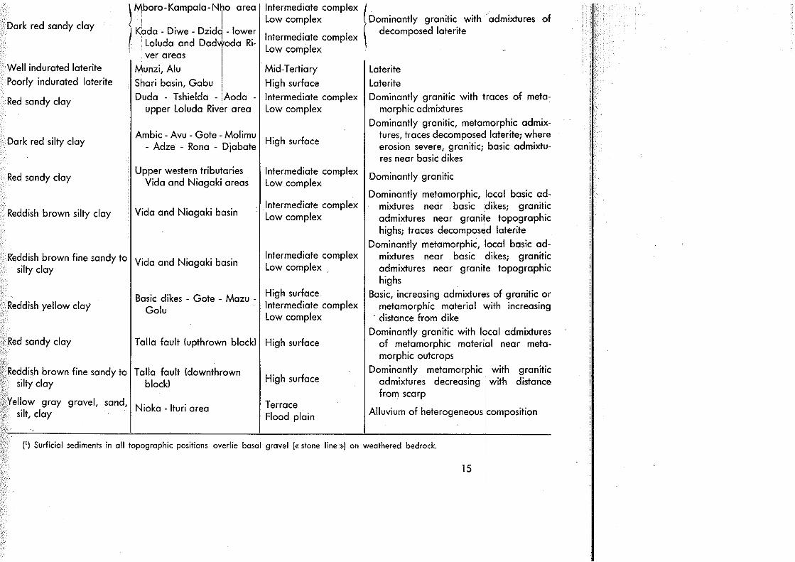
Texture and composition of the surficial sediments overlying the basal gravel are givenin table 1.
Thickness of the surficial deposits is variable on all erosion surfaces in all geomorpho-logical units in the area. In the Shari basin, however, a more uniform thickness occurs.Typical deep borings in the Shari area penetrated five and a half to eight meters of finermaterial overlying the basal gravel that is composed almost entirely of detrital laterite.The basal gravel, in turn, rests upon either weathered schist or granitoid rock. On the high
(') The basal gravel is commonly known in the north-eastern Belgian Congo as the « stone line ».
11

erosion surface in the Avu-Gote-Rona area, borings penetrated three and a half to sevenmeters of surficial sediments with the basal gravel overlying weathered granitoid rock.However, on the same surface, in places where erosion has been severe, the basal gravel isexposed at the surface.
In several places, for example, the brick pit at INEAC New Post, two basal gravels areexposed in a deep cut. Multiplicity of basal gravels (or «stone lines») is to be expectedin an area that has been subjected to multiple erosion cycles. Where conditions fordeposition have been favorable and where subsequent erosion has not occurred, sedimentsderived from the various cycles of erosion may be deposited in vertical sequence.
STRUCTURE
Two major faults traverse the Nioka area. The Talla fault crosses the Nioka-Mahagiroad, with a well developed but somewhat eroded scarp, at Talla Mission. The fault andscarp trend northeasterly along the Mount Ota-Akara front and continue into Uganda.Evidence that proves faulting are: (1) the well developed scarp, and (2) stratigraphieupthrow of the bedrock east of the fault line. For example, at Talla, quartzite overliesgranite at an elevation of 1879 meters. West of the fault line along the upper Ayoda River,mica schist outcrops at 1816 meters on a summit, and the underlying granite is exposed inan adjacent valley at 1765 meters. Upthrow east of the Talla fault approximates 110 to115 meters.
The Rona fault is best developed in the scarp at the Belot farm on the Rona-Golu road.Northward the fault line passes under the junction of the Omi and Nzoboda Rivers andleaves the area at a point approximately two kilometers east of Mazu. Southwesterly fromRona, the fault passes under the lower Loluda River at the offset in the stream course,continues to Mount Djo, to the sericite and chlorite schist in the granite at the Korda Riverbridge on INEAC reserve, to the talc schist in granite at INEAC NewPost,and south to BlenaMission, Nioka at the southern limit of the area. Evidences of faulting are : (1) Rona scarp,(2) stratigraphie upthrow of bedrock east of the scarp at Rona; mica schist overlies graniteat Pegno at 1721 meters, and west of the scarp at the Van Thielen ranch, mica schistoverlies granite at 1676 meters; upthrow east of the fault approximates 45 to 50 meters,(3) horizontal offset of the lower Loluda River, (4) sericitization, chloritization, talcitizationzones in granite at the Korda River bridge and New Post. Lineation of the Rona fault iswell displayed on the contact aerial photographs when laid out in mosaic coverage of thearea along the traverse described above.
Minor faults have been observed in the area. From the village immediately east ofMount Avu and extending northeast to Mount Sosa, is a remnantal ridge of the high erosionsurface. Along the west edge of this ridge, many side valleys normal to the ridge axis hangwell above the main tributary of the Loluda River. For example, one side valley hangs40 meters above the main tributary.
All tectonic effects in the Nioka area are clearly correlative of the Albertine Rift. TheTalla and Rona faults, as well as the minor faults, trend parallel to the strike of the LakeAlbert and Niarembe faults, which respectively form the first and second escarpments westof Lake Albert and are the boundaries of the Albertine Rift Valley.
Dating of the faults of the Nioka area is possible by noting the relationships of faultsand erosion surfaces. Erosion surfaces of the Nioka area are correlative of those of the
12
type region of Uganda where dating of surfaces and faults have been determined previous-ly. The high erosion surface of the Nioka area is correlative of the end-Tertiary peneplainof Uganda. In the Nioka area the high erosion surface is downthrown along the Shari-Omi divide west of the Rona fault and is upthrown east of the fault. Along the Talla faultthe end-Tertiary erosion surface is downthrown west of the fault and upthrown east of thefault. These relationships are shown in plate V. Eastward toward Lake Albert, the end-Tertiary surface is downthrown east of the Niarembe escarpment, and is downthrown andprobably buried under Lake Albert sediments east of the Albert escarpment. LEPERSONNE(1949, pp. 20-21, 46, 59) demonstrated in the area of southern Lake Albert, the SemlikiValley, and Lake Edward that the basal beds of the Rift Valley, Kaiso series, rest on alateritic surface. LEPERSONNE (p. 56) believed that the laterite surface is remnantal of apeneplain surface. The present writer believes the downfaulted erosion surface to be theend-Tertiary surface. Fault-erosion surface relationships in the Nioka-Lake Albert areaare shown on plate V.
1800
ccUIu
1700
W BRANCHiBRANCH
- BRANCH
4OOm
4O0m
,"? >:^.. ! / IX ff // / N
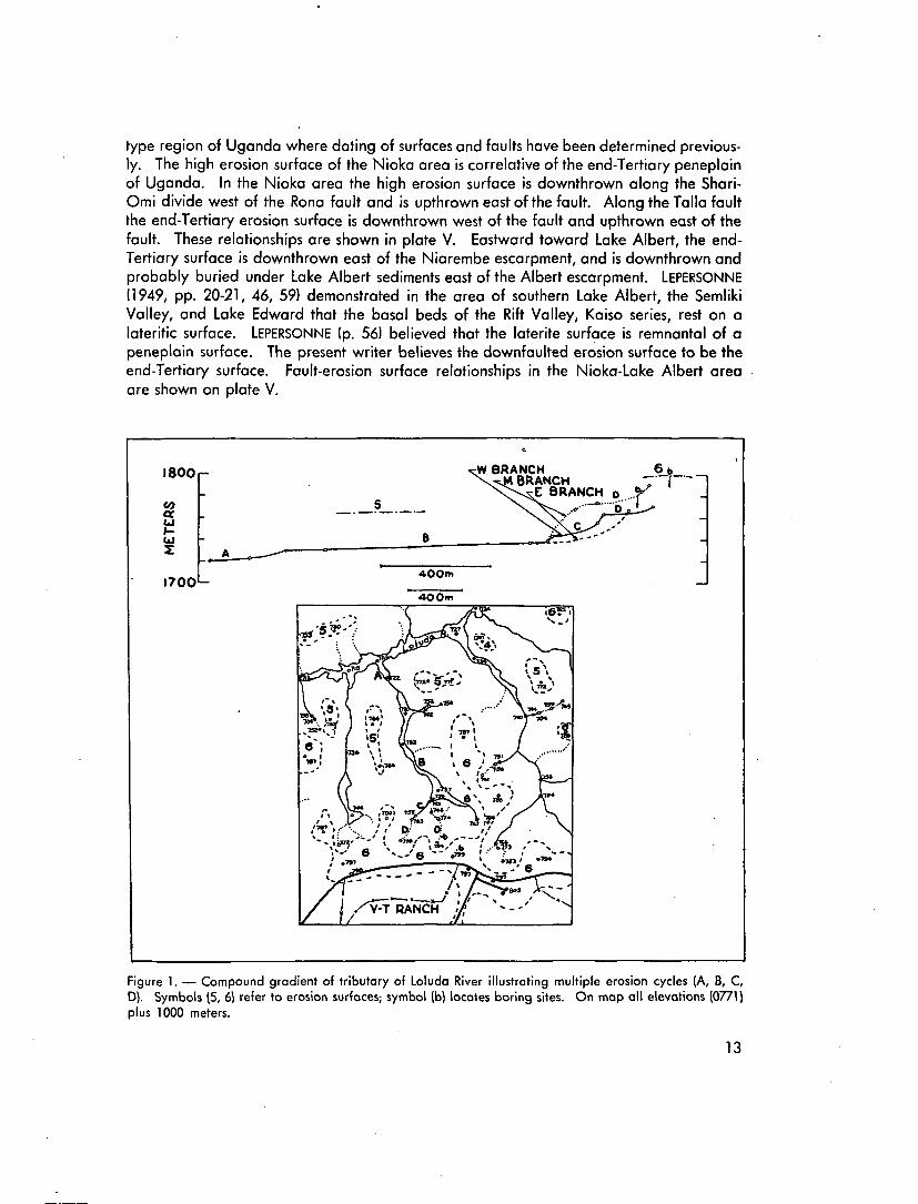
Figure 1. — Compound gradient of tributary of Loluda River illustrating multiple erosion cycles (A, B, C,D). Symbols (5, 6) refer to erosion surfaces; symbol (b) locates boring sites. On map all elevations (0771)plus 1000 meters.
13

Field evidence points to recurrence of movement on the faults during Pleistocene andvery recent times. This evidence is also relative to the erosion surfaces of the Nioka areaand to the Albertine Rift Valley. In the Nioka area four erosion surfaces and an extensiveterrace along the major drainages occur below the end-Tertiary erosion surface. Streamsthat extend headward into the various post end-Tertiary surfaces have as many as twoscarplets or nickpoints in their channels near their heads. The nickpoints have beenobserved in stream channels that are encroaching on the end-Tertiary surface (6), and thePleistocene surfaces (5), (4), (3), and (2) ('). The terrace (1) has been breached bystreams which have developed a nickpoint in their upper reaches above the terrace.Nickpoint relationship to erosion surfaces is shown in figure 1.
The geologic evidence suggests that stream adjustment to tectonic movement hasoccurred. Base level has been lowered downstream. Headward extension of streamsin a previously cut channel has not completely obliterated older stream gradients in theupper reaches of the stream courses. Nickpoints occur at the points of cessation of head-ward extension, and the older gradients are preserved above the nickpoints.
Evidence has been found in the Albert-Semliki-Edward Rift Valley to indicate recurren-ce of tectonic movement during the Pleistocene. DIXEY (1946, p. 361) reported that alongthe southeast shoreline of Lake Albert, Pleistocene sediments have been faulted and dis-placed to an extent of 1000 feet. LEPERSONNE (op. cit., pp. 77-78) concluded that twomajor movements, post Kaiso-pre-Semliki, and post Semliki,occurred during the Pleistocene.The earlier tectonics were dated as the end of the middle Pleistocene, and the latermovements as the end of the Pleistocene.
Evidence that adjustment continues on the faults to the present is found in the seismicactivity recorded in the Nioka area. During 1951-52, three earthquakes were recorded,the last of which on June 30, 1952 had a duration of three minutes.
(') Numbers (5), etc. are erosion surface designations; see plate IV and profiles, plate VI.
14
GEOMORPHOLOGY
In the Nioka area is evidence of seven surfaces of erosion. Six of the surfaces arebest displayed in the upper Loluda River basin where the writer conducted detailed fieldstudies. In plate VI, the erosion surface relationships are shown across the Loluda basin.Multiplicity of the erosion surfaces from the vicinity of Nioka across the Aoda, Korda, andLoluda Rivers to Rona and northward is shown on plate V.
The end-Tertiary surface displaced along the Rona fault is shown on plate V. On theShari-Omi divide, two hills, Munzi and Alu that are capped by hard, well indurated,ferruginous laterite, stand 20 meters above the end-Tertiary surface. The Munzi and Alucaps are remnantal soils developed on an erosion surface that stood above the presentend-Tertiary surface of the Shari-Omi divide. The laterite surface is the seventh erosionsurface of the sequence of the Nioka area.
In semi-detailed studies, demarkation of all surfaces could not be accomplishedduring the time alloted for study. As a result, erosion-surface complexes were mapped.Correlation of the complexes and the surfaces of the Loluda River basin detailed studyis given in table 2.
7ab/e 2.
Correlation of the Erosion Surfaces of the Nioka-lturi Area with Loluda River Basin.
Nioka-lturi Area
Flood plain
Terrace
Low complex
Intermediate complex
High surface
Munzi laterite surface (7)
Loluda River Basin
o1
} 4
6
Absent
Age
Quaternary
End-Tertiary
Mid-Tertiary
17

Dating of the erosion surfaces was accomplished by tracing the high erosion surfaceof the Nioka area (surface 6 of the Loluda basin) eastward to Mahagi, Mahagi Port, acrossLake Albert and into Uganda, which is generally recognized as the type locality of centralAfrican geomorphology.
In Uganda, WAYLAND (1934) and his associates of the Geological Survey recognizedthree major erosion surfaces designated as P-l, P-ll, and P—111_ Subsequent work of WAYLANDand others (') throughout central, east, south, and west Africa has led to the generalconclusion that the ages of the three major erosion surfaces are :
P-l Jurassic (2) or Cretaceous
P-ll mid-Tertiary or Miocene
P-lll end-Tertiary or Pliocene
There is reason to doubt the existence of surface P-l described by WAYLAND andA. D. COMBE in the Ankole District, Uganda. The present writer suggests, based onreconnaissance studies in the area, that the surface P-l may be the surface P-ll upwarpedand faulted by Rift Valley tectonics.
In the Bunyoro, Mengo, Busoga, and Mbale Districts, Uganda, two distincts erosionsurfaces occur. The higher surface in the Mengo District has been recognized as themid-Tertiary peneplain (3). This surface is generally capped by a well-indurated, lateritecrust. Standing 400-500 feet below the higher surface is an extensive surface that consti-tutes the main erosion surface in the vicinity of Lake Kyoga (4). The lower surface hasbeen recognized as the end-Tertiary surface. Distributed rather abundantly on the lowersurface is detritus derived from the laterite of the higher mid-Tertiary surface. Locally thedetritus is recemented to form a secondary laterite crust. Topographic relationships ofthe erosion surfaces in the Uganda districts are discernible on the Map of Uganda Protec-torate (1948).
The end-Tertiary surface of the Lake Kyoga area is traceable westward to the scarpabove Butiaba on Lake Albert. Remnants of the mid-Tertiary surface stand above thegeneral surface of the plain. On the west side of Lake Albert, above the Albert scarp atMahagi Port, Belgian Congo, an erosion surface, the Ishwa Plain, extends westward to thefoot of the Niarembe scarp. Standing above the Ishwa Plain are flat-topped erosiona!remnants, such as Mount Nilia, that are cut in steeply dipping gneissic and schistose rock.
(') For example, Davies (1934), Veatch (1935), Dixey (1946a, 1946b, 1948), Shackleton (1951).
(2) Wil l is (1936, p. 31) recognized only two major surfaces in Africa, a Miocene peneplain, and aJurassic peneplain.
(3) Known also as the Miocene peneplain, the Buganda surface, or the Uganda peneplain.
(4) Pallister (1951) has demonstrated in the Mengo District, Uganda, that relief on the laterite crustof the mid-Tertiary surface ranges up to 200 to 300 feet, and that the mid-Tertiary laterite is in placethroughout the range of relief and on slopes 'of 15 to 20 percent. This evidence indicates that conside-rable relief occurred on the mid-Tertiary surface during the long period of laterization. Secondly, presentlocal relief between the mid- and end-Tertiary surfaces may be of the magnitude of only 50 to 100 feet.
18
Above the Niarembe scarp, a surface extends westward to Mahagi and Nioka. This surfaceis warped and faulted (See plate V). Distributed abundantly on this surface throughout thetraverse is detrital laterite. At Rona (plate V) the same surface is downthrown west of Ronafault, and constitutes the divide between the Shari and Omi drainages. *
Standing above the Shari-Omi divide are the hills Munzi and Alu. Both have flatsummits and are capped by well indurated laterite that is one and a half to two metersthick. Detritus from the laterite is distributed on the flanks of the hills and is buried underfive and a half to seven meters of dusky red sandy clay on the Shari-Omi divide.
Thus, the two major surfaces of Uganda, the mid-Tertiary with indurated laterite, andthe end-Tertiary with detrital laterite, may be traced across Lake Albert and into the Ituriof the Belgian Congo. Correlations between the type area of Uganda and the Ituri havebeen established on this basis, direct tracing, and similar topographical and lithologica!relationships between erosion surfaces. Dating of key topographical surfaces in the Niokaarea, high surface (6) and Munzi laterite surface (7), are established as end-Tertiary andmid-Tertiary respectively.
There is lack of agreement in the identification of the erosion surfaces, Nioka to LakeAlbert, of the present writer (plate V) and that of LEPERSONNE (1948, p. 11, fig. 2).
The present writer's projection in reconnaissance of the Ituri surfaces to Irumu andthe vicinity of Stanleyville is not in agreement with the conclusions of de HEINZELIN (1952,pp. 110-111, fig. 50). These problems will be discussed by the present writer in a futurepaper.
A lithological criterion of the end-Tertiary surface that is constant throughout theNioka area is the detrital laterite in the basal gravel of the surficial sediments. The fieldinvestigator must use caution, however, in application of this criterion. On the high surfacewhere subsequent erosion has been severe, the basal detrital laterite gravel may havebeen stripped such that only materials of the local bedrock occur. In the Shari and Omiareas where severe erosion has been prevented due to downfaulting, post end-Tertiaryerosion has resulted only in the shifting of detrital laterite from one surface to the adjacentlower surface. As a result, detrital laterite occurs in the basal gravel of all surfaces.On the upthrown block of the Rona fault, e.g., the Loluda basin, erosion has been severeand during the cutting of Quaternary erosion surfaces, the detrital laterite has beenswept entirely out of the area.
The erosion surfaces of the Loluda River basin have been cut into and below the end-Tertiary surface. Thus, the surfaces must be of Quaternary (Pleistocene) age. Six surfacesor erosional cycles are identified and in increasing age are: flood plain (0), terrace (1),and the erosion surfaces (2), (3), (4), and (5). In no manner whatsoever are these surfacesto be construed as « peneplains ». If terminology must be applied, etch-plains (WAYLAND,1934) or pediplains (KING, 1949, pp. 440-442) would be more apropos. The mechanics ofQuaternary erosion surface development is beyond the scope of this preliminary note, butthe subject will be treated fully in a subsequent paper. Suffice it to say that initiation ofcycles of erosion within the Quaternary in the Nioka area probably was caused by adjust-ments due to Albertine Rift Valley tectonics. No evidence of Pleistocene pluvials, a possiblecause of erosion surface cutting, was found in the area.
19

APPLICATION OF GEOLOGY TO SOILS
FUNDAMENTAL GEOLOGICAL EVIDENCES
(1) Granitoid rock constitutes the basement of the geological succession in the Niokaarea. (2) A metamorphic complex of rocks mantled the granitoid rock throughout the area.(3) The mid-Tertiary laterite crust developed on a contemporaneous erosion surface inthe region. (4) A second cycle of erosion, the end-Tertiary, breached the mid-Tertiarylaterite and distributed its detritus widely on the end-Tertiary surface. (5) End-Tertiaryerosion stripped not only the laterite but also the metamorphic complex of rocks from thegranitoid rock in the western part of the Nioka area; however, vestiges of metamorphicrocks have been preserved. (6) Albertine Rift Valley tectonics, and possible Pleistocenepluvials, caused the cutting of multiple erosion surfaces below the end-Tertiary surface.
PARENT MATERIALS OF SOILS ,
Distribution of the parent materials of the soils is shown on plate II, and describedbriefly in table 1.
Two remnants of the mid-Tertiary laterite occur at Munzi and Alu and are the parentmaterial and soil in these localities.
LATERITE ( M I O -MUNZI /TERTIARY SURFACE)
END-TERTIARYSURFACE
6m50 SANDV
END-TERTIARYSEDIMENT
END-TERTIARYCOLLUVIATION SEDIMENT
Figure 2. — Chrono-lithosequences of soil parent materials.
21
In the Shari basin and western Omi basin, a dusky red sandy clay overlies the basaldetrital laterite gravel. From the foot of Munzi where six and a half meters of the sandyclay mantle the basal laterite gravel, the sequence clay/gravel can be traced up the slopeof Munzi to the laterite outcrop where the basal gravel merges with the decomposedmargin of the laterite. The sandy clay parent material must be in the main decomposedlaterite. This parent rests on the end-Tertiary erosion surface (See figure 2a). Wherelocal highs of granitoid or metamorphic rock occur, admixtures of granitoid or metamorphicmaterial are found in the dusky red sandy clay.
The Shari and Omi areas are on the downthrown block of the Rona fault and havenot been affected by exaggeration of stream gradients necessary for vigorous erosion.During erosion cycles subsequent to faulting, surficial material has not been stripped andswept out of the area as on the upthrown block, but has merely shifted from higher toadjacent lower erosion surfaces. Thus on all erosion surfaces in the Shari basin, decom-posed lateritic material (dusky red sandy clay) overlies the basal laterite gravel.
On the end-Tertiary erosion surface, exclusive of the Shari and west Omi areas, arefound remnants of a thick, thoroughly weathered material that megascopically is identifiedas :
(1) In the Loluda River basin margin, Rona, Djabate and the upthrown block of Tallafault : dominantly granitic with admixtures of metamorphic materials and traces ofdecomposed laterite; basic admixtures near basic dikes.
(2) In the Vida and Niagaki basins and on the downthrown block of Talla fault :dominantly metamorphic with local admixtures of basic material near basic dikesand granitic admixtures near granitic topographic highs.
Erosion cycles of post end-Tertiary age have brought soil parent material into moreharmony with bedrock distribution. In the Loluda basin where six post end-Tertiary cyclesare in evidence, cutting of the lower surfaces has resulted in complete removal of themetamorphic complex, the laterite of the mid-Tertiary surface, and the laterite detritusof the end-Tertiary surface. The surficial sediments that now mantle the Quaternaryerosion surfaces are of granitic composition and are derived locally from the granitoidbedrock. The basal gravel of the surficial deposits is composed entirely of vein quartz orgraniquartz pebbles. Parent materials of this nature are distributed in :
(1) Upper Loluda River basin.(2) Duda, Tshielda, Aoda drainage basins.In the Vida and Niagaki basins, Quaternary erosion has stripped all laterite and
detritus. The surfaces are cut in metamorphic rock. The surficial sediments are dominantlyof metamorphic provenance. Where iocai granite highs occur, downslope admixtures ofgranitic materials are found in the surficial deposits.
Basic nature surficial sediments occur in the basic dikes in the Nioka area. Althoughthe dikes are small in transverse outcrop, their influence in adjacent sediments is important.Basic rock of the dikes is more resistant to erosion than adjacent granitoid and metamorphicrock. As a result, the dikes now are topographic highs and were so through several erosioncycles. Material has been and is now being transported onto adjacent granitoid andmetamorphic rock. Influence of the basic material in the soil parent material decreaseswith increasing distance from the dikes.
Local variations of parent material are to be expected. On the end-Tertiary surfaceof the Loluda area, for example, thick thoroughly weathered sediments occur on summits.Headword extension of streams has stripped the sediments from summit shoulders and has
22
exposed granite bedrock which has served as a local source of sediment. Thus on thesummit there may be end-Tertiary sediment of mixed provenance whereas on the shoulderof the landform, the sediment may be of granitic composition. This litho-chronosequenceis shown in figure 2(b).
In other localities, mass movement of materials downslope has resulted in transloca-tion of the thoroughly weathered materials to footslope positions whereas the shoulder andsummit may be dominantly of granitic composition. This inverted chrono-lithosequence isshown in figure 2(c).
These geological phenomena are a few examples of the areal and local varieties ofsoil parent materials in the Nioka area. The principles are applicable to all major parentmaterial associations regardless of erosion surface.
TOPOGRAPHY
The preceding discussion of parent materials of soils discloses the close associationthat may exist between topographic position, both from the macro- and micro-standpoint,and parent material identity.
Secondly, the topographic expression of the individual landforms bears directly upondevelopment of a particular soil type or phase. Slope is one control, for example, of theerodibility, the exposure, or water regime of a soil. Topographic expression of the empla-ced soil must be related to the parent material. The same percent slope of soils in differentparent materials generally results in different soil characteristics.
Thirdly, the major topographic features, the erosion surfaces, are possible indicatorsof another factor necessary for soil evaluation, age.
AGE
Age relationships of the major topographic units are illustrated on plate V showingthe end- and mid-Tertiary surfaces, and on plate VI showing the end-Tertiary and Quater-nary surfaces. These are the macroage relations in the Nioka area.
Microage relationships are illustrated in the succession of scarplets in figure 1. Ageincreases with each successive nickpoint. Soils related to any one cycle may differ fromthose relative to another cycle.
On any individual landform, age may vary in short landscape distances. In figures2(b) and (c), a microage relationship is illustrated. In figure 2lb), the end-Tertiary sedimentmay have superimposed a soil profile that has developed since end-Tertiary time.However, on the shoulder of the slope where, as an example, erosion of the last cycle (0)has been active, fresh materials have been exposed. The profile developed on the shouldermay be of the age, cycle (0). In figure 2(c), shifting of old sediments to footslope positionsby colluvial processes has resulted in age inversion. Younger materials have been exposedon the summits; the soil is of an age of a cycle subsequent to the age of the level of theerosion surface. Although soil development has progressed in the material of the footslopesince depositional time, for example (1), the material assumed characteristics caused byweathering on the summit position during previous cycles. Thus the soil may showcharacteristics of greater maturity or age than the modal of its cycle.
23
REGIONAL PROFILE OF SUBSOIL DARK HORIZON
In the Nioka-lturi block and adjacent area, a characteristic regional soil profile occurs.The subsoil or B horizon of this profile is darker in color than the overlying A3 horizon orunderlying C horizon. In figure 3, a typical soil profile is illustrated. This type occurs on
2LJ
roUJ
•i
ICI
u.aw
ooaLJCD
GEOLOGICAL - PEDOLOGICAL
lm
REDSILTYCLAY 3m
3m
'STONE LINE"
WEATHERED4m
GRANITE
C
ÛiîiàÛùD
REDDISH BLACK (IOR2/\)TRANSITIONDARK RED (3/e)TRANSITION
DUSKY RED (3/3)
TRANSITION
REO (4/6)
TRANSITION
UNCONFORMITY
RE 0-YEULOW-WHITE
Fig. 3. — Profile of subsoil dark horizon (B horizon) illustratinggeological and pedological relationships.
the end-Tertiary erosion surface across the Nioka road from the Van Thielen ranch at Gore.The A3 horizon is dark red (10R3/6, Munsell color notation). The B2 horizon is dusky red(10R3/3). A change in color is noted of three units of chroma. The C horizon is red(10R4/6). This change in color is three units of chroma and one unit of value. Similarcolor differences exist in all soil profiles in this region, i.e., a light A3 horizon, dark B2horizon, light C horizon. The B horizon of this profile in the Nioka area has been calledgenerally, the subsoil dark horizon.
There is apparently no geological control of dark horizon development, it occurs intranslocated sediments of granitic, metamorphic, basic, and lateritic composition, and inweathered bedrock of the same compositions where surficial sediments are thin. There isalso apparently no geomorphological control of dark horizon development. The profileoccurs on all erosion surfaces exclusive of the flood plains where hydromorphic soil typesare dominant. Topography has no apparent effect on development of the dark horizon.It was observed on flat summits as well as on slopes of 15 to 20 percent. Regional distribu-tion of the dark horizon profile is independent of climatic control, assuming, for example,that although climatic belt shifts occurred during the Pleistocene, relative climatic zoneswould have existed in the region of profile distribution. In the modern climatic regime(ROBERT, 1946, pp. 246-285), distribution of the dark horizon profile ranges through totalannual rainfall zones of 1000 to 2200 mm, and through zones of dry season duration ofone to three months.
24

The subsoil dark horizon was observed under various vegetation associations. Fromthe standpoint of broad classification, the profile was observed under tropical rain forest,e.g., Djugu Forest, and woodland savanna (Soudan). In savanna the dark horizon soiltransgresses grass associations, and was observed under both a Loudetia association anda Hyparrhenia association.
Here then is a soil type that develops or developed on a landscape where each soilforming factor is extremely variable. Parent material, topography, age, climate, and thebiologic factor all vary, yet the essential characteristics of the soil profile remain the same.
However, preliminary field studies in the Nioka area suggest that variations in themorphology of the dark horizon profile may exist. A comparison of profiles on the various-erosion surfaces showed :
Depth to
Thickness
B horizon
of B horizon
End-Tertiary
Surface
Greater
Greater
QuaternarySurface
Less
Less
Within the sequence of Quaternary erosion surfaces, there may be a diminishinggradation of the dark horizon profile characteristics, depth and thickness, from older toyounger surfaces. These morphological variations may be a reflection of differences insoil age, and are worthy of further investigation.
The dark color of the B2 horizon is attributable to organic matter contained therein (').The systematic occurrence of organic matter in a horizon may lead to the question whetherthe dark horizon may not be the A horizon of a buried soil. Geomorphological evidenceprecludes such an interpretation. Where surficial sediments are thick (as in figure 3), thedark horizon occurs above the basal gravel, «stone l ine». Where surficial sediments aresomewhat thinner, the basal gravel may be found within the dark horizon. In this case, thedark horizon is developed in two parent materials, the surficial sediments and the weatheredbedrock. Where surficial sediments are very thin, the dark horizon occurs in weatheredbedrock below the basal gravel of the surficial sediments. Thus, the dark horizon of theregional profile is a genetic characteristic of soil development and not an A horizon of aburied soil.
(') Communication from Mr J. D'Hoore, INEAC, Yangambi.
25
LITERATURE CITED
CAHEN, L. and LEPERSONNE, J. — Notice de la carte géologique du Congo Belge et duRuanda Urundi, Atlas général du Congo: Inst. Roy. Col. Belge, 1951.Carte géologique du Congo Belge, Région de Watsa (feuille 14) : Royaume de Belgi-que, Ministère des Colonies, 1933.
DAVIES, K. A. — The age of Mount Elgon and events in the Tertiary history of Bugishu :Geo/. Survey Uganda, Annual Report, pp. 69-71, 1934.
— and BlSSETT, C. B. — The geology and mineral deposits in Uganda : Imp. Inst. Bull.,vol. 45, pp. 161-180, 1947.
DE HEINZELIN, J. — Sols, paléosols, et désertifications anciennes dans le secteur nord-oriental du bassin du Congo: Publ. de l'INEAC, Bruxelles, 1952.
DlXEY, F. — Erosion and tectonics in the East African Rift system : Geo/. Soc. LondonQuart. Jour., vol. 102, pp. 339-379, 1946a.The relation of the main peneplain of central Africa to sediments of lower Mioceneage : Geo/. Soc. London Quart. Jour., vol. 101, pp. 243-148, 1946b.Geol. of northern Kenya : Geo/. Survey Kenya, report 15, 1948.
DU PREEZ, J. W. — Laterite : a general discussion with a description of Nigerian occurren-ces : Bull. Agricole du Congo Belge, vol. 40, pp. 53-66, 1948.
FOURMARIER, P. — Vue d'ensemble sur la géologie du Congo Belge : IRSAC, Ier rapportannuel, pp. 97-152, 1948.
KELLOGG, C. E. and DAVOL, F. D. — An exploratory study of soil groups in the BelgianCongo : Publ. de l'INEAC, sér. sei. 46, Bruxelles, 1949.
KING, L. C. — On the ages of African land-surfaces: Geol. Soc. London Quart. Jour.,vol. 104, pp. 439-453, 1949.
LEPERSONNE, J. — Le fosse tectonique Lac Albert - Semliki - Lac Edouard : Ann. Soc. Géo/.de Belgique, t. 72, pp. 3-88, 1949.
Map of Uganda Protectorate : Survey, Land and Mines Dept., Uganda, réf. A1005, 1948.PALLISTER, J. W. — Occurrences of laterite in southern Buganda : Geo/. Survey Uganda,
unpublished manuscript, 1951.
ROBERT, M. — Le Congo physique, 3e éd. et complément, Vaillant-Carmanne, Liège, 1946,1948.
SHACKLETON, R. M. — A contribution to the geology of ihe Kavirondo Rift Valley : Geol.Soc. London Quorf. Jour., vol. 106, pp. 345-389, 1951.,
VEATCH, A. C. — Evolution of the Congo Basin : Geol. Soc. America, Memoir 3, 1935.
WAYLAND, E. J. — Rift valleys and Lake Victoria (Tectonic map of Uganda, provisional is-sue) : 15e Cong. géol. internat, compte rendu, vol. 2, pp. 323-353, 1929.Peneplains and some other erosional platforms : Geol. Survey Uganda, AnnualReport, pp. 77-79, 1934. -
WILLIS, B. — East African plateaus and rift valleys : Carnegie Inst. Washington Pub. 470,1936.
27
SIMONART, P., Professeur à l'Université Catholique de Louvain;STANER, P., Inspecteur Royal des Colonies;STOFFELS, E., Professeur à l'Institut Agronomique de Gembloux;TULIPPE, O., Professeur à l'Université de Liège;VAN DE PUTTE, M., Membre du Conseil Colonial; .VAN STRAELEN, V., Président de l'Institut des Parcs Nationaux du Congo
Belge;WILLEMS, J., Administrateur-Directeur du Fonds National de la Recherche
-Scientifique. . .
B. - COMITE DE DIRECTION.
"Président: , -M. JURION, F., Directeur général de l'INEAC.
Secrétaire:M . L E B R U N , J . , S e c r é t a i r e g é n é r a l d e l ' I N E A C , . ; /
Membres : -MM. GILLIEAUX, P., Membre du Comité Cotonnier Congolais;
HENRARD, J.,. Directeur du Service de l'Agriculture, des Forêts, de- l'Elevage et de la Colonisation, au Ministère des Colonies;
HOMES, M., Professeur à l'Université Libre de Bruxelles; ,OPSOMER, J.,/Prpfesseur à l'Institut Agronomique de Louvain;STOFFELS, E., Professeur à l'Institut Agronomique de Gembloux;VAN STRAELEN, V., Président de l'Institut des Parcs Nationaux du Congo
; Belge- - ^
Représentant du Ministre des Colonies :
M. STANER, P., Inspecteur Royal des Colonies;
. C. - DIRECTEUR GENERAL.
M. JURION, F. X \ -1