Carroll County Comprehensive Plan July 2008 · The State of Indiana, ... and Subdivision Control...
85
Comprehensive Plan Carroll County, IN Review Draft July 2008
-
Upload
trinhnguyet -
Category
Documents
-
view
219 -
download
1
Transcript of Carroll County Comprehensive Plan July 2008 · The State of Indiana, ... and Subdivision Control...

Comprehensive Plan Carroll County, IN
Review Draft July 2008

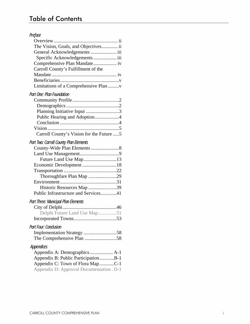
Table of Contents
CARROLL COUNTY COMPREHENSIVE PLAN i
Preface Overview .................................................... ii The Vision, Goals, and Objectives ............. ii General Acknowledgements ..................... iii Specific Acknowledgements ................... iii Comprehensive Plan Mandate ................... iv Carroll County’s Fulfillment of the Mandate ..................................................... iv Beneficiaries ................................................v Limitations of a Comprehensive Plan .........v
Part One: Plan Foundation Community Profile ......................................2
Demographics ...........................................2 Planning Initiative Input ...........................3 Public Hearing and Adoption ....................4 Conclusion ................................................4
Vision ..........................................................5 Carroll County’s Vision for the Future .....5
Part Two: Carroll County Plan Elements County-Wide Plan Elements .......................8 Land Use Management ................................9 Future Land Use Map ...........................13 Economic Development ............................18 Transportation ...........................................22 Thoroughfare Plan Map .......................29 Environment ..............................................31 Historic Resources Map .......................39 Public Infrastructure and Services .............41
Part Three: Municipal Plan Elements City of Delphi ............................................46 Delphi Future Land Use Map ...............51 Incorporated Towns ...................................53
Part Four: Conclusion Implementation Strategy ...........................58 The Comprehensive Plan ..........................58
Appendices Appendix A: Demographics ................... A-1 Appendix B: Public Participation ............B-1 Appendix C: Town of Flora Map ............C-1 Appendix D: Approval Documentation . D-1
Preface
CARROLL COUNTY COMPREHENSIVE PLAN ii
Overview Carroll County undertook this comprehensive planning process as a continuing step toward creating a better future. The existing Carroll County Comprehensive Plan was adopted in 1968 and updated in 2001. However, the existing plan has become outdated and underutilized because of its age, applicability, and limited content.
The Carroll County Comprehensive Planning Initiative started in the spring of 2007. The County sought broad public input through interest group meetings and public workshops. Also, citizens were surveyed and asked to participate in roundtable discussions.
The evolving goals and objectives for Carroll County’s future emerged through various meetings and workshops and from an extensive study of the County by the planning consultant. The goals and objectives, however, are also based on several planning documents, studies, and processes conducted by Carroll County and the City of Delphi. Several of the studies and processes were conducted by Purdue University who maintains a strong connection to Carroll County and to the City of Delphi.
During the Comprehensive Planning process, drafts were reviewed by a steering committee made up of a diverse group of citizens and County leaders. The plan was also made available for review by interest groups, county boards and commissions, and the general public. The final outcome of the Carroll County Planning Initiative is a user-friendly plan that is full of attainable goals and objectives that were significantly influenced by the residents of Carroll County.
Although this plan reflects the current vision for the County, all plans are intended to be reviewed, evaluated, and updated to reflect changing trends, outlooks and thinking. Only through revisions will it remain a relevant guide to the future growth and development in Carroll County.
The Vision, Goals, and Objectives This plan is divided into four (4) parts. Part 1: Plan Foundation communicates the base information used to draft the plan. It includes a brief demographic analysis and synopsis of input from County leaders, interest groups, and the public. Part 1: Plan Foundation concludes by identifying the key issues that will influence the growth and development of Carroll County and outlines the County’s vision. This vision also takes into account and is sensitive to the vision developed during the 2005 Carroll County at the Crossroads strategic planning sessions.
Part 2: Carroll County Plan Elements identifies general themes that are applicable to all jurisdictional areas of the Carroll County Area Plan Commission, and then dedicates a section to each issue. Those issues include: land use management; economic development; transportation; environment; and public infrastructure and services.
Part 3: Municipal Plan Elements looks specifically at the City of Delphi and goals and objectives that are vital to the City’s future growth and development. Part 3: Municipal Plan Elements also presents information regarding the other incorporated towns that are a part of Carroll County’s Area Plan Commission jurisdiction including: Burlington, Camden, and Yeoman.
Part 4: Conclusion summarizes the plan and discusses the implementation of the plan.
The appendices to the plan provide additional details regarding the County’s demographic characteristics and input received during the leadership, interest group, and public workshops.
Preface
CARROLL COUNTY COMPREHENSIVE PLAN iii iii
General Acknowledgements Many people participated in the Carroll County Planning Initiative and worked hard to develop the Comprehensive Plan.
Carroll County wishes to thank the businesses and residents that participated in the public workshops and interest group meetings. The collective input was integral in establishing the plan’s vision, and the goals and objectives which will help advance the community as a whole.
SPECIFIC ACKNOWLEDGEMENTS The County would like to thank the following people who provided significant support and time to this project.
Carroll County Loren Hylton, County Commissioner William R. Brown, County Commissioner George Mears, County Commissioner Robert C. Baker, County Council Carl Abbott, County Council Steve Ashby, County Council Ann Brown, County Council Nancy Cripe, County Council Jerry Hendress, County Council Ron Slavens, County Council
City of Delphi Randy Strasser, Mayor Janice Roe, Clerk-Treasurer Carolyn Pearson, Council President Kyle Germond, Common Council Nelson Smith, Common Council Dan Sterrett, Common Council
Town of Burlington Stan Moore, President Town Council Teddy Huffer, Town Council Joe Armstrong, Town Council
Town of Camden Peter Wagoner, President Town Council Richard Fite, Vice President Town Council Andy Kelly, Town Council
Town of Yeoman Shirley Larson, Town Council Thomas Lucas, Town Council Marion Minnick, Town Council
Area Plan Commission J. Robert McCain, Chairman Wayne Chapman John Hampton Paul Marcelino Stan Moore Nelson Smith Peter F. Wagoner Fred Wise Jon Zink Kathy Mylet, Zoning Administrator (March 2008) and Secretary Dale Huffer, Zoning Administrator (through February 2008)
Area Board of Zoning Appeals Pat Baker, President Harry Jones, Vice President J. Robert McCain
Legal Counsel Cynthia Harmon
Steering Committee Janet Ayres Judy Berkshire Dick Bradshaw Pat Casserly Sam Deiwert Dan McCain Elaine McCain Stan Moore Joe O’Donnell Bret Rinehart Miriam Robeson Daryl Smith Larry Trapp Anita Werling
Consulting Planning Assistance
Preface
CARROLL COUNTY COMPREHENSIVE PLAN iv
Comprehensive Plan Mandate The State of Indiana, through Indiana Statutes, Title 36, Article 7, as amended, empowers communities to plan with the purpose of improving “the health, safety, convenience, and welfare of the citizens and to plan for the future development of their communities to the end:
1. That highway systems (and road systems) be carefully planned;
2. That new communities grow only with adequate public way, utility, health, educational, and recreational facilities;
3. That the needs of agriculture, industry, and business be recognized in future growth;
4. That residential areas provide healthful surroundings for family life; and
5. That the growth of the community is commensurate with and promotive of the efficient and economical use of public funds” [IC 36-7-4-201].
Indiana Statutes state that counties may establish planning and zoning entities to fulfill that purpose [IC 36-7-4-201]. The Plan Commission is the body responsible for maintaining a comprehensive plan, which is required by state law to be developed and maintained [IC 36-7-4-501] if the community wishes to exercise the power of zoning.
Indiana Code 36-7-4-502 and 503 state the required and permissible contents of a comprehensive plan. The required plan elements are listed below.
1. A statement of objectives for the future development of the jurisdiction.
2. A statement of policy for the land use development of the jurisdiction.
3. A statement of policy for the development of public ways, public places, public lands, public structures, and public utilities.
Carroll County’s Fulfillment of the Mandate Throughout the planning process and within the Comprehensive Plan, all State of Indiana minimum requirements have been met or exceeded. Some of the highlights include:
The Carroll County Comprehensive Plan exhibits analysis of the community, existing land uses, development trends, land use suitability, economic feasibility and natural land features.
Public involvement provided the foundation for this Comprehensive Plan. This public input exceeded the criteria required by the State by providing several opportunities for people to provide input. The input is woven into the content of this document with specific results presented in Appendix B.
The Carroll County Comprehensive Plan has an overall theme of improving the health, safety, and welfare of residents and includes the State required elements in the sections that follow.
The Carroll County Comprehensive Plan presents components that exceed those required by the State. For instance, the plan includes sections on economic development, and the environment.
Preface
CARROLL COUNTY COMPREHENSIVE PLAN v v
Beneficiaries The Carroll County Comprehensive Plan is designed to benefit the community as a whole, as opposed to a single property owner or single municipality. As a result, from time to time, implementing this plan may adversely affect a single property owner or a small group of property owners. However difficult or controversial, the greater good of the community will be served through the implementation of this plan. No community has ever substantially improved itself without some controversy, opposition, or effects on small numbers of property owners.
The County has committed to implement, to the extent possible, this plan with the greater good of the community in mind. As an assurance, each project, program, or policy that results from this plan first will be evaluated to ensure that the end result will positively move the community forward. Unforeseen conditions and situations must be considered in respect to where the community is at the specific time of implementation.
Limitations of a Comprehensive Plan It is important to keep in mind that this plan is not enforceable in itself and should not be mistaken for a zoning ordinance or as a substitute for other regulatory ordinances. This Comprehensive Plan has been designed to serve as a guideline for Carroll County. The County will utilize its Zoning Ordinance and Subdivision Control Ordinance as the primary means of implementation and will update them periodically to improve successful implementation of the Comprehensive Plan. The County will also use department policies, along with its capital, intellectual, political, and staff resources to help achieve the vision, goals, and objectives of this plan.


Part One
Plan Foundation
Community Profile
CARROLL COUNTY COMPREHENSIVE PLAN 2
Demographics The U.S. Constitution requires the federal government to administer a census every ten (10) years to allocate the number of U.S. Representatives to each state. Governments and private agencies also use the data gathered from the census to evaluate demographic changes in towns, cities, counties, states, and the country as a whole. The demographic data collected by the census may be used to help understand a community’s past and where that community is today. The same data can also be analyzed to create estimates and projections to help predict the future of the community.
The information and statistics that follow are from the U.S. Census Bureau (www.census.gov) and the Indiana University Kelley School of Business’s Indiana Business Research Center website (www.stats.indiana.edu). All data is rounded to the nearest unit of hundreds for actual numbers or whole numbers for percentages.
According to the 2000 Census, Carroll County’s population was 20,200. It is estimated that the population has increased to 20,500 in 2006. The 2006 estimates indicate around thirty percent (30%) of the Carroll County population - just over 6,300 people - live in Carroll County’s incorporated cities and towns including the City of Delphi, Town of Burlington, Town of Camden, Town of Flora, and Town of Yeoman.
Between 1990 and 2000, Carroll County experienced a seven and two-tenths (7.2%) increase in population. This increase was similar to the increases experienced by surrounding counties and slightly lower than the population growth rate for the State of Indiana.
Commuting patterns in and out of Carroll County have stayed fairly consistent from 2000 to 2005. The number of Carroll County residents leaving Carroll County to go to work
was 5,700 in 2005; only 1,300 people commuted into Carroll County to work in 2005.
Carroll County’s median household income has increased from $28,500 in 1990 to $42,700 in 2000. This fifty percent (50%) increase is greater than the increases in Howard County and Tippecanoe County, but less than the increases in Cass County, Clinton County, and White County. The fifty percent (50%) increase in Carroll County’s median household income is greater than the State’s increase of forty-four percent (44%).
Carroll County’s unemployment rate was four and six-tenths percent (4.6%) in 2006. This rate was lower than the State of Indiana’s unemployment rate of five percent (5%) for that same period.
Approximately eighty-three percent (83%) of Carroll County residents age twenty-five (25) and over have attained a high school diploma or higher. Thirteen percent (13%) have attained a bachelor’s degree or higher. These figures for the State of Indiana are eighty-two percent (82%) and nineteen percent (19%), respectively.
The median home value in 2000 for homes in Carroll County was $86,600. This is less than the State of Indiana’s 2000 median home value of $92,500.
Additional demographic information, including data, charts, graphs, descriptions and sources of the data may be found in Appendix A.
Community Profile
CARROLL COUNTY COMPREHENSIVE PLAN 3
Planning Initiative Input Various input opportunities were offered to residents and employees of Carroll County. Meetings geared to obtain input from the County leadership, interest groups, and general public were held during the first phase of the project. A summary of each of these input opportunities follows.
COMMUNITY LEADER WORKSHOP The first input opportunity was designed for County leaders. The leadership was first asked to complete a “Community Values Survey.” Upon completion of the survey, the leadership was given a brief overview of the comprehensive planning process and asked to share their experiences of working, recreating and living in the County. They were asked to identify Carroll County’s assets, liabilities, and needs. County leaders were given the opportunity to describe perceived trends within the community and the surrounding region. Finally, the County leadership was encouraged to share their advice to the consultant on the preparation of the Comprehensive Plan.
INTEREST GROUP INTERVIEWS Various interest groups were identified in the County. The interest groups were made up of people with interests in tourism, economic growth, agriculture, industry, real estate, building and development, transportation, airport, emergency services, utilities, education, social services and the environment. The interest groups met independently to insure adequate attention was given to each specific area of interest.
Each interest group was asked to complete a “Community Values Survey” and upon its completion was given a brief overview of the scope of the project. Next they were asked to identify Carroll County’s assets, liabilities and needs. Interest group participants were given the opportunity to identify or explain any interest group-specific issues.
PUBLIC WORKSHOPS The third opportunity for input involved public workshops aimed to gather information from the general public. The public workshops were scheduled in the evening to improve the opportunity for people to attend.
Public workshop participants were first asked to complete a “Community Values Survey” that encouraged them to think about issues that may influence a community’s values. They were asked to rate their opinions on topics such as farmland protection, property rights, the location of new development, local employment and services. Results of the Community Values Survey are referenced throughout this document and summarized in Appendix B.
The second part of the public workshops required participants to identify Carroll County’s liabilities, assets, needs, and dreams. Their comments were recorded and at the conclusion, they were asked to vote on the needs they believed were most important for the future of Carroll County. The following needs (in no particular order) rated highest among all participants:
Identification of Major Needs for Carroll County Attracting jobs Proactively encourage new and appropriate development
Transportation improvements Preserving farmland Planning for Hoosier Heartland Highway Corridor
Proactively implementing infrastructure improvements necessary for growth
Stabilizing and improving the County Creating a “Brand” for Carroll County
For a complete list of the needs identified during the public workshops, as well as a listing of the liabilities, assets, and dreams, refer to Appendix B.
Community Profile
CARROLL COUNTY COMPREHENSIVE PLAN 4
Public Hearing and Adoption PUBLIC REVIEW AND MEETINGS To be completed.
PUBLIC HEARING The Carroll County Area Plan Commission held a legally notified public hearing on DATE. The public was offered the opportunity to ask questions and offer comments. The Area Plan Commission certified the Comprehensive Plan in compliance with Indiana State Statutes.
Conclusion Based on demographic research and input from County leadership, local interest groups and Carroll County residents, the primary community issues in Carroll County include:
Balancing agricultural heritage, rural character, and the agricultural industry with new development;
Providing opportunities for the municipalities to thrive and express their unique characteristics;
Improving infrastructure systems: roads and municipal utility systems;
Increasing the quantity of quality, high-paying employment opportunities;
Promoting economic development in appropriate places;
Protecting natural and historic resources, and environmentally sensitive areas;
Capitalizing in on the Hoosier Heartland Highway Corridor; and
• “Branding” Carroll County.
The remainder of the Comprehensive Plan addresses these important issues by describing a community vision, and goals, objectives, and implementation measures (or strategies) for long-range planning and implementation.
Vision
CARROLL COUNTY COMPREHENSIVE PLAN 5
Carroll County’s Vision for the Future A vision is the manner in which one sees or conceives of something in the future. In 2005, Carroll County leaders and residents participated in a series of strategic planning meetings known as “Carroll County at the Crossroads.” One of the outcomes of these strategic meetings was a vision statement. This Comprehensive Plan not only supports the vision, but has adopted it as published.
The vision for Carroll County is as written:
“Carroll County is a vibrant, exciting place to be. Young people and families choose to reside here. Businesses locate and invest their capital and resources here, creating more job opportunities. Visitors come here to enjoy the cultural and recreational amenities which are offered.
Attention to quality infrastructure, including the Hoosier Heartland Highway, and proactive development strategies bring many new economic opportunities to the county. This economic foundation provides a population and tax base necessary to support superior schools, parks, recreation, and healthcare. Economic growth and prosperity are fundamental goals that are balanced with the protection of the unique natural, historical, and cultural assets of the county.
Education is critical to the county’s economy and quality of life. Maintaining strong family values and outstanding educational opportunities for children and adults is a priority.
Carroll County’s communities and people are diverse, yet united in working together to address the continual changes that face the county. Building a promising future for all generations, we take as our guide our past, our dreams, our values and our faith in God.”
Although the vision statement is inclusive of many ideas, a few additional general themes arose from the input sessions for the Comprehensive Plan that complement the vision statement. They are (in no particular order):
Preservation or enhancement of the rural character.
An increase in the overall quality of life for residents.
Orderly and high quality physical developments: residential, commercial, and industrial.
Emergence of local entrepreneurs and small businesses.
Survival of various scale agricultural operations and the opportunities for these operations to thrive.
Conservation of environmentally sensitive areas.
Better quality infrastructure systems including municipal utilities and roads.

Part Two Carroll County Plan Elements
County-Wide Plan Elements
CARROLL COUNTY COMPREHENSIVE PLAN 8
Introduction The Carroll County Area Plan Commission serves all of the cities, towns, and unincorporated areas of Carroll County with the exception of the Town of Flora. Flora has its own Advisory Plan Commission.
The following pages list and describe Carroll County’s broad goals that address community-wide issues. The goals, objectives, and implementation measures (strategies) contained in this part of the document are applicable to unincorporated Carroll County, the City of Delphi, Town of Burlington, Town of Camden, and Town of Yeoman and the incorporated villages served by the Carroll County Area Plan Commission.
There is an entire section dedicated to each of the following broad topics:
Land Use Management Economic Development Transportation Environment Public Infrastructure and Services
Part 3: Municipal Plan Elements provides further information regarding the City of Delphi, and the towns of Burlington, Camden and Yeoman.
COMPREHENSIVE PLAN (CP) IMPLEMENTATION STRATEGIES Carroll County has identified several growth management strategies that will help Carroll County utilize its comprehensive plan and related supporting regulations (ordinances) to guide and manage growth throughout the county.
CP 1.1 Utilize the Comprehensive Plan and Future Land Use Map when making land use decisions (i.e. rezoning).
CP 1.2 Maintain and update the Carroll County Comprehensive Plan, Zoning Ordinance, Subdivision Control Ordinance and other related documents and ordinances.
CP 1.3 Utilize and enforce the Carroll County Zoning Ordinance, Subdivision Control Ordinance, and other applicable ordinances.
CP 1.4 Ensure adequate and suitable land exists for desired and necessary land uses.
CP 1.5 Encourage the development of uses in areas planned for such land uses and discourage the same uses from occurring where they are not planned.
CP 1.6 Recognize that small deviations from the Comprehensive Plan and the Future Land Use Map can accumulate and have detrimental impacts on the County’s future. The County should review this plan frequently and update it every 5 years to assure it is up to date and meeting the community’s needs and values.
Land Use Management (LU)
CARROLL COUNTY COMPREHENSIVE PLAN 9
Introduction Land use management is a core component of the Comprehensive Plan, partially because the Indiana State Statutes require the plan to include a land use policy, but also because the manner in which land is used can have a great positive (or negative) impact on a community over time. Promoting the right land use pattern and interconnectivity of uses is an essential part of improving a community.
Land use management has two primary purposes. The first purpose is to protect established or stable areas from encroachment of incompatible land uses that might cause an undesirable impact. The second purpose is to encourage new growth and development in areas appropriate for each type of land use. Ultimately, the land use management strategy should promote growth in appropriate areas for residents of Carroll County to live, work, shop, and recreate.
A land use management strategy works best if it is revised periodically. As the population of Carroll County grows, as the composition of that population changes, and as land is consumed, the areas needing protection and the lands best suited for new growth will change. The best practice is to review the land use management strategy annually and to make small adjustments as necessary. A more comprehensive review and revision should be considered on a five-year cycle.
Carroll County’s focus regarding land use management at the time of plan preparation includes the protection of the county’s prime agricultural lands and rural character.
Throughout plan preparation, it was evident that it is essential for Carroll County to ensure that new development proposals are fiscally responsible and do not burden the county’s limited resources. The primary means of achieving these protections is to focus development where existing infrastructure can support new uses, primarily, in existing
municipalities or in close proximity to existing utilities. By focusing growth in or near cities and towns, the cost of providing services will decrease for both municipalities and the County. Objectives and implementation measures related to this need are found in the Economic Development, Environment, and Public Infrastructure and Services sections of the Comprehensive Plan. Additionally, related goals, objectives and strategies are included in the Municipal Plan Elements sections of Part 3.
Carroll County also enjoys an important and rich cultural heritage present in an abundance of historic buildings, bridges and other landmarks throughout the County. A discussion regarding protection and preservation of historical and cultural resources, and a map of these features are presented in the Environment section of the Comprehensive Plan.
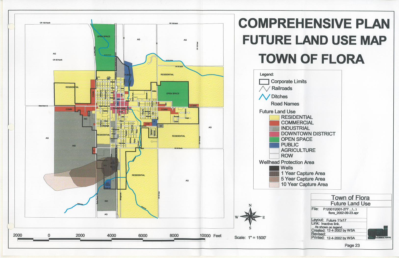
The scope of Carroll County planning efforts includes all of the unincorporated area of the county as well as the City of Delphi and the incorporated towns of Burlington, Camden and Yeoman. The Town of Flora has its own zoning commission and adopted its own comprehensive plan in 2002. Flora’s future land use plans are reflected within this Comprehensive Plan, including the Future Land Use Map. The Town of Flora future land use map is included in Appendix C.
The following section includes the Future Land Use Map and describes the land use categories and descriptions. The County’s Land Use Management goal, objectives, and implementation measures follow presentation of the map.
Future Land Use Map Category Descriptions This section establishes land use categories and descriptions and assigns them to the County’s planning jurisdiction. Specifically, this Comprehensive Plan divides land uses into the following broad categories:
Land Use Management (LU)
CARROLL COUNTY COMPREHENSIVE PLAN 10
Agricultural Residential Commercial Industrial Recreation or Open Space Environmentally Managed Land
The following factors have been used to assign each area of the County with a specific future land use category:
Existing and adjacent land use; Suitability of land (topography, drainage, soil stability, vegetation and wildlife);
Accessibility and quality of roads; Proximity to a municipality or highway; Environmental conditions; Land use trends; Quality of life desires of the public; and Protection of the health, safety and welfare of the community as a whole.
The Carroll County Future Land Use Map (page 12) shows a distribution of the primary land uses identified above. It is a conceptual depiction of the desired County land uses. All current and future land use decisions of the County shall utilize this map and the text of the Comprehensive Plan for reference and guidance.
Land use management in a comprehensive plan, however, should not be confused with zoning regulations. The comprehensive plan may indicate a piece of property should be a specific land use, while the zoning ordinance may currently allow something different. A more specific example is a property used for agricultural crops. Its future land use may be indicated in the comprehensive plan as “industrial,” but it may be zoned as an “agricultural” district today.
LAND USE DESCRIPTIONS Below is a brief description of terms used on the future land use map to describe land use categories.
Environmentally Managed Land: This land use description and depiction on the Future Land Use map includes land in close proximity to surface water and identifies a buffer area to recognize the potential environmental and aesthetic value of these lands. Development may occur within this land use category.
The buffer widths depicted on the map include: primary river – 3,170 feet; large tributary streams – 2,110 feet; and creeks and smaller tributaries – 1,060 feet.
These areas include land used or designated for agricultural uses, hobby farms or rural residential low density development.
The intent of this designation is not to prohibit future development, but rather to identify for decision-makers areas to consider low to moderate intensity development utilizing additional caution or measures to protect the natural environment.
General Agriculture: Land used or designated for agricultural operations such as crop production, livestock production, equestrian facilities, tree farms, vineyards, confined feeding operations, farm buildings, farm houses, and the like.
Parks and Recreation: Land used or designated for private or public parks, recreation or open space, including commercial recreational facilities, RV parks, golf courses and nature areas with trails.
Low Density Residential: Land used or designated for single-family detached housing including estates, conservation subdivisions, and large lot subdivisions with a density greater than or equal to one dwelling unit per acre. In some cases, hobby farms may be compatible land uses.
Medium Density Residential: Land used or designated for single-family detached subdivisions with two to four dwelling units per acre.
Land Use Management (LU)
CARROLL COUNTY COMPREHENSIVE PLAN 11
Lake Residential: Land used or designated for housing around lakes or along primary rivers. Typically, lake residential includes year-round single-family detached homes and seasonal cottages. These areas are unique from traditional subdivision development.
High Density Residential: Land used or designated for single-family detached subdivisions with four to eight dwelling units per acre or multiple family developments (duplexes, townhomes, apartments and condominiums) with six to twelve units per acre.
Government/Institutional: Land used or designated for public services, government operations and government facilities. This category also includes uses commonly associated with public and private institutions like schools, churches, libraries and large cemeteries.
Downtown Commercial: Land used or designated for downtown commercial uses that accommodate a wide variety of small scale commercial uses and may include mixed residential uses. Typically, this category is for small towns, rural unincorporated towns, and lake communities to provide local goods, services and restaurants to nearby and within neighborhoods.
General Commercial: Land used or designated for commercial land uses that accommodates a wide variety of small to large scale commercial uses. These uses can include professional offices, hospitals, institutions, commercial services, general offices, retail, services, entertainment, restaurants, gas stations, and hotels.
Highway Commercial: This category includes commercial uses that cater to vehicular traffic with high visibility from major roadways including restaurants, gas stations, retail, hotels, motels, and related services.
Business Park: Land used or designated for low impact industrial, flex space, distribution,
warehousing, office and logistics operations. Environmental sensitivity and aesthetic expectations are higher in comparison to industrial areas.
Industrial: Land used or designated for a variety of industrial uses including manufacturing, distribution, assembly, warehousing and the like.
Proposed Industrial/Flex Option: Land used or designated primarily for future industrial land uses. Development of commercial, business park, or residential land uses also may be considered.
Mineral Resources: Land used or designated for the extraction/processing of mineral resources including limestone and gravels.
Airport Hazard Zone: A region around the airport where development is limited in order to protect the airspace and long-term operations of the airport. This area also is applied to discourage or prohibit uses that would be adversely affected by noise from aircraft.
Land Use Management (LU)
CARROLL COUNTY COMPREHENSIVE PLAN 12
This page intentionally left blank.
KnopLake
Eller PondWetlandConservationArea
French PostPark
Sodhouse
X
Historic Canal Lock #32
BurlingtonPark
Burlington-Wildcat Creek Public Access Site
Deer Creek Park
KnopLake
Delphi Municipal Airport
Flora Municipal Airport
Burrows
Yeoman
Deer Creek
Ockley
Delphi
Rockfield
Burlington
Bringhurst
Flora
Camden
Radnor
Cutler
Adam’s Mill
Pittsburg
Owasco
Carrollton
Sharon
Wheeling
Pyrmont
Lockport
Fishe
r St.
Linco
ln St
.
575 W
575 W
762 W
WILD
WOO
D RD
560 W
575 S
420 S
825 W
825 W
585 W
585 W
580 W
415 S
565 W
270 S
265 S
260 S
255 S
Lakview Dr.
575 E
Washington St.
Indiana St.
Jackson St.
8th St.
7th St.
Wild
cat R
iver W
ay
9th St.
10th St.
6th St.
4th St.
5th St.5th St.
Westview Dr.
Valle
y View
Poin
t
Woo
dland
Way
562 E
College St.
Stockton St.
Michigan St.
Arvin Dr.
Mill Rd.
Loyd
Ave.
Zook Ln.
Richard Ave.
730 E
740 E
675 E
McDonald Dr.
Prather St.
50 N
49 N
705 E
Fourth St.
445 N
725 E
460 N
710 E
715 E
470 N
475 N
480 N
720 E
Wate
r St.
Main St.
450 N
450 N
Washington St.
Cumberland St.
Cemetery St.
Sand
erso
n St.
Union
St.
Chur
ch S
t.
Monr
oe S
t. James St.
Arms
trong
Av
e. Ohio
St.
Indian
a St.
Illino
is St
.
Lee S
t.
260 N
500 N
468 N
488 N
450 W
375 N
475 W
Ande
rson D
r.
252 N
Crestwoo
d Dr.
Commercial Dr.
Camden Rd.
900 W
900 W
800 W
Water St.
Monroe St.
Ohio St.
Indiana St.
Illinois St.
Illinois St.
Third
St.
Walnut St.
Vine St.
Columbia St.
Prince William Rd.
Hami
lton S
t.
Hamilton St.
North St.
Bicycle Bridge Rd.
Franklin St.South Rd.
Tenth
St.
Wabash St.
Front St.
Cook St.
Garfield Rd.
Riley Park
Dr.
Market St.
Maso
nic S
t.
Summit S
t.
Tally Ho Dr. Tally Ho Ct.
Deer Mead
ows R
d.
Deer mead
ows R
d.
132 N
Wilson St.
Bicycle Bluffs Ln.
Sue L
n.
Shirl Ct.
905 W
Mill St.
Sixth
St.
Polk St.
Howard St.
Madison St.
Patty Ln.
Diana St.
Bowen Dr.
Clyde St.Bowen Ct.
Mill D
r.
Lafayette St.
Connelly St.
Bicycle Bluff Dr.
Eigh
th St
.
Seve
nth S
t.
Cottage St.
Rhinehart St.
Union St.
Riley Rd.
Wabash St.Market St.
Terrace Ln.
Armory Rd.
Heritage Dr.Herita
ge N
W
300 N
Main St.
Four
th St
.
Washington St.Union St.
Monroe St.
Harrison St.
Elizabeth St.
Adams St.
100 N
Columbia St.
Frank
lin St.
South Rd.
Pearl St.
Heritage NE
310 N
930 W
930 W
285 N
290 N
Ninth
St.
Clay St.
Howard St.Stoney Creek Rd.
High St.
Dodge St.
Fifth
St.
Pack
ett Av
e.
Crest Dr.
Whitem
an D
r.
Deer
Cree
k Dr.
300 N
700 W
Main St
.Washington St.
Riley
Mea
dow
Dr.
325 N
Brew
er A
ve.
Kerlin
Ave
.
Dreif
ers A
ve.
Smith Ave.
Ruffin
g Ave
.
Well
s St.
Belt Line Ave.
Char
les S
t.
358 N
Robin
son S
t.
Chamber Estates Dr.
Arno
ld St
.
Railroad Av.e.
Gosle
e St.
Forest St.
Parso
nage
St.
South St.
Baum
St.
690 N
990 W
680 N 980 W
Alco Way
Bradford Dr.
1132
W
Tippecanoe Ranch Rd.
Lakeside Cabin Rd.
Grav
el Pi
t Rd.
Troy
Ave
.
Misty
Ln.
Char
lais C
ir
Tippecanoe Ranch Rd. Ranch Ln.
Tecum
seh Bend
Rd.
Equestrian Rd.
Archery Rd.
Sharon Chapel Rd.
Lane Rd.
Main Camp Loop
Oregon Rd.
Stables Rd.
Rodg
ers L
n.
1215
W
Jerse
y Dr
925 W
310 N
935 W
910 W
905 W
320 N
330 N
900 N
1175
W
1150
W
1132
W
850 N
Home
rs Dr
.
Calve
rts D
r.
820 N
Fraz
oer B
each
Rd.
800 N
750 N
1175
W
775 N
Sandy Beach Dr.
1250
W
Twin Pine Dr.
Poplar Hills Dr.
Crest Dr.
Hambridge Dr.
Upper Hambridge
1190
W
Oakdale Dr.
1180
W
Grantham Ln.
1185
W
Cedar Dr.
Cedar Circle Dr.
Bridg
e Dr.
1175 W
Bree
zy P
oint D
r.
Breezy Point Ln.
1150
W
1152 W
950 N
1128
W
916 N
Paradise Beach Dr.
Paradise Rd.
Pirates
Roost R
d.
Lazy Ln.
Whit
e Oak
s Dr.
Key D
r. Whiteview Dr.
Reunion Point Rd.
1164
W
1200 N
1100 N
1100 N
1225
W
Orchard Dr.
Conrad Ct.
Uppe
r Lak
e Sho
re D
r.
Upper Lake Shore Dr.Lookout Dr.
Freeman Ln.
Fairw
ay
Ln.
Holiday
Briarwood Dr.
Shaffer
Dr.
1172 N
1182 N
1158 N
Von L
n.
1154 N
Von Hollow Dr.
1175
W
Smith Ridge Ct.
Land
ing Rd
.
Quiet
Wate
r Cir.
Quiet W
ater R
d.
Sugar Bluff Rd.
Linton Ln.
Lower L
akesho
re Dr.
Briarwood Ct.
Visata Dr.
1200
W
Lake Bluff Rd.
Winsor Rd. Ravin
ia Bl
.
Kenilworth Ln.
Drur
y Ln.
Fields
tone C
t.
Lakeshore Dr.
Woodbine Rd.Circle Dr.
Shad
y Ln.
C an
d C B
each
Dr.
Lake
view
Dr.
Corley Dr.
Earl A
v.
Haven Rd.
1200
W
680 N
CD R
d.
625 N
Sleepy Hollow Rd.
Sleepy Hollow Rd.
Hodges Dr.
100 E
374 W
380 W
414 W
863 N
68 E
871 N
90 E
95 E
876 N
884 N
East Rock
field R
d.
250 W
285 W
280 W
255 W
645 N
630 N
270 W
265 W
635 N
655 N640 N
260 W
208 E
150 E
400 E
375 E
480 S
450 E
525 S
190 E
620 S
Merid
ian R
d.
Fourt
h St.
480 S
490 S
5 E
485 S
15 W
20 W
10 E
95 E
175 W
275 W
Four
th St
.
155 S
140 S
150 S
6 W4 W
145 S
9 E
Bring
hurst
Rd.
Bring
hurst
Rd.
Main St.
Four
th St
.
Washington Blvd.
Elizabeth St.
Harm
on S
t.
Kenr
ick S
t.
Adams St.
Way
ne S
t.
Jackson St.
Seco
nd S
t.
First
St.
Camaro Ct.
Camaro Ct.Mano
r Dr.
S. Circle Dr.
Sunset Dr.
Third
St.
5th S
t
Moha
wk D
r.
Julius Dr.
Mead
ow Ln
.
Green Acres Dr.
South St.
Monr
oe S
t.
Cente
r S
t.
Divis
ion S
t.
50 S
Harrison St.
Cleveland St.
Hoop St.
Catherine St. Roos
evelt
St.
Easy
St.
Elizabeth St.
Clem St. Clem St.
Jeffe
rson
St.
Little St.
Brookview Ln.
Capitol St.
Howa
rd D
r.
Main St.
Was
hingto
n S
t.
Cente
r St.
Divis
ion S
t.
Jeffe
rson S
t.
Willo
w St
.
Walnut St.
Elm St.
Vine St.
Maple St.
Brigh
t St.
WES
TWOO
D DR
GABLE DR
EVERGREEN DR
Oak St.
Horseshoe Bend Rd.
Ross
etter
Ln.
1180
WJos
eph Ln
.
Horseshoe Ln. 1217
W
532 N
1145 W
1000 N1000 N
750 N
750 N
750 N
900 N
1300 N1300 N
1250 N1250 N
975 W
1200 N1200 N1200 N
1100 N1100 N 1100 N
950 W
900 W
800 W
800 W
1000
W
1125
W
1025
W
1050
W 300 W
400 W
350 W
250 W
200 W
1150 N
Towpa
th Rd.
Towpath Rd.
100 W
150 W
150 W
500 W
600 W
700 W
700 W
1050 N1050 N
950 N
875 N
625 W
825 N 825 N
175 W
75 W
425 W
775 N
600 N
650 N
1000 N
900 N
1250 N
875 W
900 W
850 W
300 W
300 W
400 W
350 W 100 W
50 W
50 W
500 W
1050 N
275 W
850 N
425 W
700 N
850 N
725 N
Sprin
gbor
o Rd.
925 W
1150
W
650 W
725 N
500 S
500 S
900 W
800 W
800 W
200 W
500 W
500 W
600 W
700 W
650 W
400 S400 S
550 S
550 S600 S
700 S
900 W
800 W
400 W
350 W
100 W50
0 W
600 W
700 W
450 W
800 S800 S
650 S
750 S750 S
550 W
575 S
775 S
725 S
700 S
500 S
350 W
350 W
250 W
250 W
100 W
150 W
75 W
150 E
100 E
300 E50 E
150 S 150 S
50 S
200 S 200 S
250 S
200 E
400 S
300 S 300 S
100 S
75 E
375 S
700 S
100 E
100 E
300 E
225 E
225 E
400 E
500 E
500 E
550 E
350 E
350 E 50 S
800 S
550 S
475 E
650 S
750 S
600 S
475 S
600 E
800 S
750 S
150 S
200 S
100 S
Division Line Rd.
600 E
700 S
400 E
500 E
575 E
250 S
300 S300 S
350 S
325 S 750 E
625 E
200 E
500 S
300 N
150 W
550 N
200 N
150 N
300 W
250 W
200 W
275 W
175 W
150 E
100 E
225 W
500 N
450 N
200 E
325 E
250 N
175 N
200 W
75 W
50 E
250 E
50 N 50 N
25 E
125 W
350 N
150 N
300 N
400 E
600 E
100 N
525 E
325 N
750 N
200 N
300 E
700 N
600 N
500 N
550 N
450 N
575 E
575 N
475 N 350 E
100 N
800 E
400 N
250 N
350 N
800 N
750 N
100 E
300 E
700 N
600 N
25 W
550 N
50 E
225 E
500 N
650 N
450 E
800 N
400 E
500 E
700 N
775 N
550 E
600 E
925 N
1000 N
Merid
ian R
d.Me
ridian
Rd.
Merid
ian R
d.
150 E
100 E
300 E
225 E
400 E
500 E
900 N
1000 N
900 N
200 N
300 N
1025
W
1225
W
600 W
700 W
1150
W
625 W
625 W
700 N
600 N
675 N675 N
500 N 500 N 500 N
525 W
650 N
585 N
550 N
450 N
Milk Hous
e Rd.
450 W
575 W
100 N100 N
550 W
550 W
Bicycle Bridge Rd.
400 N
250 N
624 N
1275
W
200 N
1000
W
1050 W
1200
W
400 W
600 N
550 N
484 N
400 N
525 N
650 W
525 W
Division Line Rd.
750 W
425 N
1275
W
Bicycle Bridge Rd.
925 W
150 S 150 S
200 S
250 S 250 S
300 S
100 S 100 S
Prince Williams Rd.
Prince Williams Rd.
225 W
S.R. 218
S.R. 218
S.R. 18
U.S.
421
U.S.
421
U.S. 421
U.S. 421
S.R. 18 S.R. 18
S. R. 2
5
US 421
S.R.
75 S.R.
29
S.R. 25
S.R. 25
S.R.
29
S.R. 18
Future Land Use MapCarroll County, Indiana
DRAFT - July 2008
MAP LEGEND
Environmentally Managed LandGeneral AgricultureParks and RecreationLow Density ResidentialMedium Density ResidentialLake ResidentialHigh Density ResidentialInstitutionalDowntown MixedGeneral CommercialHighway CommercialBusiness ParkIndustrial
Environmentally Managed Land
1 MILE 2 MILES 3 MILES
New Road Segment
Limited Access Highway
Proposed Intersection
Hoosier Heartland Highway
Proposed Overpass
Proposed Interchange
Mineral ResourcesCorporate LimitsAirport Hazard AreaLakeRiver/Stream
County Line
RailroadTrail Route
Proposed Industrial/Flex Option
Development may occur in Environmentally Managed Land. This land use includes land in close proximity to surface water and identifies a buffer area to recognize the environmental and aesthetic value of these lands. The buffer widths include:
Primary river - 3,170 feet Large tributary streams - 2,110 feet Creeks and smaller tributaries - 1,060 feet
These areas include land used or designated for agricultural uses, hobby farms or rural residential low density development. The intent of this designation is not to prohibit future development, but rather to identify for decision-makers areas to consider low to moderate intensity development utilizing additional caution or measures to protect the natural environment.
Land Use Management (LU)
CARROLL COUNTY COMPREHENSIVE PLAN 15
Land Use Management The key land use topics related to the County’s Land Use Management goal, objectives and implementation measures are discussed below. The goal, objectives and implementation measures follow the discussion.
AGRICULTURAL LAND Agriculture is the most significant land use in Carroll County when considering acreage, and therefore, lends itself as a dominant factor in the community’s character and heritage. Carroll County residents recognize the importance of both large and small farming operations. As a result, the County seeks to protect and allow the expansion of existing agricultural uses and encourage and support all agricultural operations from large facilities to small-scale, niche, and boutique farming operations.
Three (3) key agricultural issues surfaced during the Carroll County Planning Initiative efforts:
1. Negative impacts to the agricultural community resulting from residential development in the County,
2. The impact of industrializing agricultural practices on neighboring properties, and
3. The desire to balance the protection of farmland from development while preserving the right of a farmer to sell his/her farmland for development.
The County plans to address these issues in a proactive and positive manner. This comprehensive plan includes implementation measures to reduce the potential for impacts on the agricultural industry that can occur when residential development is permitted to occur nearby. One proactive and effective means of reducing the potential for these land use conflicts to occur is by locating residential growth near cities and towns and away from
productive agricultural areas. In the future, when the County approves development of new homes, it should consider the likelihood or potential for the eventual expansion of existing agricultural operations in its decision-making process. Additionally, the County can adopt zoning regulations designed to minimize conflicts. For example, regulations requiring large buffer areas with dense plantings can reduce the extent of impacts due to noise and windblown dust from fields. Larger setbacks for structures and even non-structural items (e.g., gardens) can serve to reduce some of the potential conflicts between agricultural and residential land uses.
Like other industries in America, the agricultural industry continues to develop methods and practices that improve efficiency and increase productivity levels. Sometimes, these more industrialized agricultural practices – that are so beneficial to the Carroll County economy – can conflict with adjacent properties and environmental systems.
Because of the strength of the agricultural industry in Carroll County, the County should strive to be on the cutting edge by being aware of new technologies and methods that may be applicable to operations within the county. This awareness or knowledge enables the County to make well-informed, solid decisions regarding the use of new agricultural practices before large capital investments are made, either by the county or its citizens. The County can achieve positive results in supporting and enhancing agricultural practices by incorporating modern and industrialized methods, when appropriate. Further, implementation of proper permitting and enforcement procedures by the County can ensure any potential issues are addressed or mitigated.
Additionally, in its efforts to protect prime agriculture, the County will consider development of a “voluntary” conservation agricultural zoning district. As part of this
Land Use Management (LU)
CARROLL COUNTY COMPREHENSIVE PLAN 16
program, the County would need to establish specific criteria defining eligibility for application of this zoning district. For example, the criteria might require parcels to be at least eighty (80) acres in size; or located a minimum distance from a city or town; or must produce certain yields or have certain soil quality. If an interested landowner’s property meets the prerequisite criteria, then the property could become part of a conservation agricultural zoning district. This would enable the landowner to “volunteer” his or her property to be zoned “conservation agriculture” thereby conserving agricultural land. Additionally, the County may adopt a process that includes additional criteria, approvals or other special considerations that could apply to the future development of land zoned “conservation agriculture.”
OTHER LAND USES – RESIDENTIAL, COMMERCIAL, INDUSTRIAL DEVELOPMENT The County will promote all new residential, commercial and industrial land development in or near existing cities and towns, in proximity to existing infrastructure and services (sewer, water, storm drain capacity, flood plain considerations), roadway and other transportation (railway, airport) access considerations specific to the use, and in areas currently specifically designated for those uses within the County.
Policy objectives and implementation measures related to future growth and land development decision-making are included in the Environment section of this plan. These measures include recommendations that the County carefully review any development proposals to limit the potential for land use conflicts to the extent possible. Additionally, the Comprehensive Plan suggests that Carroll County encourage the reuse and revitalization of existing commercial properties that are abandoned or rundown before considering rezoning or reclassifying land for commercial use.
These efforts also include limiting or restricting new development in areas without access to sanitary sewers to better protect the environment, keep farmland from being consumed, and protect existing agricultural operations.
Land Use Management (LU)
CARROLL COUNTY COMPREHENSIVE PLAN 17
Land Use Management Goal Provide opportunities for growth and
development that enhance quality of life and economic vitality while preserving the
County’s rural character, agricultural industry, and environmentally sensitive
areas.
Land Use Management (LU) Objectives and Implementation Measures
Objective 1: Minimize Land Use Conflicts - Agricultural and Industrial Uses LU 1.1 Buffer residential and other sensitive
land uses from confined feeding operations, new commercial and industrial development, and registered organic or transitional to organic land.
LU 1.2 Buffer confined feeding operations and new commercial and industrial development from residential and other sensitive land uses, thereby protecting land uses from the encroachment of incompatible development.
Objective 2: Protect prime agricultural land because of its importance to the economy and to the character of Carroll County LU 2.1 Modify existing agricultural zoning
district to better protect prime agricultural land from development and/or the impacts of development.
LU 2.2 Recognize and accommodate the industrialization and evolution of agricultural practices through reevaluating and modifying applicable regulations.
LU 2.3 Incorporate non-remonstrance covenants into the rezoning and subdivision approval process in order to allow farmers to continue best management practices.
LU 2.4 Consider the development of a voluntary conservation agricultural zoning district that would allow farmers to “volunteer” land to be “conserved” for agricultural uses.
Economic Development (ED)
CARROLL COUNTY COMPREHENSIVE PLAN 18
Introduction Successful economic development efforts provide opportunities for expanding and balancing the tax base for communities. Such efforts may include quality of life factors, diversification of business and employment opportunities and retention of existing businesses.
Carroll County and the Carroll County Economic Development Corporation (EDC) actively pursue avenues to maintain existing businesses and attract new diverse businesses to the area. These entities strive to create job opportunities for residents of Carroll County and to develop a tax base to support a high quality of life. The EDC is a county-wide effort that has developed and is implementing a formal, cohesive, and comprehensive approach to economic development for all of Carroll County.
This section of the comprehensive plan is concerned with Economic Development in Carroll County and addresses several concepts for the County to consider including:
• Expansion and retention of existing businesses,
• Attracting new businesses,
• Diversification of businesses, and
• Quality of life/family related topics.
EXPANSION AND RETENTION Carroll County considers the expansion and retention of existing businesses and industries a top priority. The County can further these efforts by working with the EDC to build relationships and become even better informed about existing businesses in the County. One means of accomplishing this outreach effort includes conducting an inventory to learn: What businesses are out there? Who are they? What do they do or produce? Where are they located? How many do they employ?
The EDC, partnering with County leaders and representatives from the communities in Carroll County, should continue to work with existing businesses and industries and develop further understanding of the current and anticipated business climate. Questions to ask include: What issues do local companies face? Who are their suppliers? Who are their buyers? Are there issues with labor unions?
Understanding local businesses and building upon these relationships increases the County’s awareness of the pressures faced by local businesses and enables the County to deal directly with issues before they become “deal-breakers.” Often, the result of understanding local business and industry and building a relationship creates a partnership that enables involved parties to better capitalize on opportunities.
The County should assess current policies and programs to ensure they support the retention and expansion of existing businesses. This effort should include input from the business community; the recommendations from this assessment would aid the business community and help sustain and enhance the quality of life in Carroll County. Additionally, these efforts can potentially have an indirect effect of attracting new businesses. The County should strive to retain all existing businesses and when able, provide incentives, partnerships or other assistance to assure their success.
NEW ECONOMIC GROWTH Just like a new company that carefully determines its optimal location, a community should be selective when it pursues new businesses and industries. Carroll County should determine the businesses and industries necessary to diversify its economic base.
After becoming familiar with existing industry, Carroll County can also target spin-off businesses that find value in being located
Economic Development (ED)
CARROLL COUNTY COMPREHENSIVE PLAN 19
close to facilities that already exist in Carroll County.
Through its investment in the Carroll County EDC, Carroll County has already invested in economic development. However, it is critical that the County, and other local governments within the County, continue to set aside funds for future economic development transactions. This “economic development savings account” could be used in a variety of different ways including infrastructure improvements, assistance with land acquisition or a cash incentive to a targeted company.
There are a few different types of other local incentives already utilized by the EDC, including: Tax Increment Financing (TIF), Tax Abatement and Bond financing. These incentives can be used with new facilities or to support the expansion of existing facilities. This plan supports the use of local economic incentives (cash, tax increment financing, abatements, bonds, etc.), when projects provide a significant benefit to the community. The key is to make sure incentives are provided to the very best projects that will provide the greatest benefit to the community.
Carroll County should develop and utilize a set of “incentive criteria” by which to rate and qualify economic development projects. These criteria determine an economic development project’s eligibility for incentives. For instance, projects that involve the location of a locally-owned corporate headquarters might rank higher than a project involving construction of a new manufacturing plant. A project that doubles its workforce might rank higher than one that adds only ten percent (10%) to its workforce. Projects with high paying jobs rank higher than those without, and so on.
It is important that the criteria be determined and developed before ranking projects so all
of the information is available to all parties. This means the industry knows, in advance, what the community values and can determine where its project ranks even before requesting incentives.
The State of Indiana Economic Development Corporation works hand-in-hand with local officials and the Carroll County EDC. The Indiana Economic Development Corporation offers a variety of incentive packages to complement local incentives. The State’s incentive package is generally determined on a project by project basis.
RENEWABLE ENERGY TECHNOLOGIES Wind or solar energy farms or other renewable energy technologies (cogeneration, bio-energy) potentially could provide economic development opportunities to Carroll County. Input received from community leader and public workshops indicate an interest in considering the development of green energy within the county, including but not limited to wind or solar energy generation. The community could gain tax revenue and individual land owners potentially could benefit from leasing part of their land. However, it is in the County’s best interest to first conduct studies to determine the desirability and/or feasibility of these endeavors, including evaluation of potential appropriate locations and detailed cost-benefit analyses.
The development of renewable energy requires consideration of many factors including alternative site evaluations, assessment of the cost of infrastructure to support the generation of wind, solar or other sources of power and the availability of transmission lines and associated linkage lines and market costs.
Wind power offers an emissions-free source of “free, inexhaustible” power and is considered environmentally sound in many ways, but, it also has effects to be considered.
Economic Development (ED)
CARROLL COUNTY COMPREHENSIVE PLAN 20
Large-scale wind farms in particular introduce changes in immediate and surrounding landscape and views due to the size and distinctive nature of the facilities. While some may welcome the look of these features, others find it disruptive within a rural landscape. The landscape and visual (shadow flicker and zone of visual influence) effects are often the most controversial aspects of wind farm planning efforts.
Other planning matters and factors to consider in a future study would include noise, land use compatibility and community issues, nature conservation (avian and other biological resource effects), local economy (cost/benefit), and potential aircraft and telecommunications interference. The County will need to determine if it finds the benefits of potential wind farm development (energy production and potential economic benefits) outweigh potential costs or other impacts. Additionally, the County’s study of wind farms should evaluate both small scale and large scale facilities to aid the County in developing regulations appropriate and specific to such operations.
The County also should consider meeting with other counties that have gone forward with development of such facilities to learn from their experiences (i.e., Benton and Tippecanoe counties have wind farm developments).
The County also may wish to similarly study solar or other types of energy facilities and develop specific regulations that apply to individual landowner uses and separate regulations relevant to a potential larger commercial or industrial utility operation. The study should include a cost-benefit analysis to allow a detailed evaluation and informed decision-making.
In the interim, until further study can be undertaken to enable the County to make more informed decisions regarding renewable energy development, the comprehensive plan
includes an implementation measure such that the County amend its Zoning Ordinance to ensure it is enabled to regulate the nature of potential future industrial utility land uses.
Additionally, the County will continue to watch as other potential technologies evolve and provide opportunity for commerce and energy development.
HOME-BASED BUSINESSES AND ENTREPRENEURSHIP Carroll County wants to encourage small businesses, including home-based enterprises, to develop and grow. Means of benefitting both the county and these businesses are included in this plan.
In the future, Carroll County should consider development of an entrepreneurship center to offer other additional services and benefits to the business community. The center could offer educational programs and assistance to entrepreneurs that might have a great concept, but not know how to market that concept. A center could provide accounting, legal, human resource and tax advisor services to new businesses to make sure these administrative details are not overlooked.
Training can also include enhancing the creative potential of the entrepreneur, allowing the person to reinvent an existing business to become more productive or allowing a startup venture to get off the ground successfully.
Economic Development (ED)
CARROLL COUNTY COMPREHENSIVE PLAN 21
Economic Development Goal Strengthen and diversify the local economy, attract quality jobs, and
encourage entrepreneurial growth to ensure the best future for Carroll County
and its citizens.
Economic Development (ED) Objectives and Implementation Measures Objective 1: Position Carroll County to attract and retain the industries it needs to strengthen and diversify its economy ED 1.1 Encourage investment in municipal
infrastructure, especially water distribution and sanitary sewer.
ED 1.2 Inventory existing vacant industrial facilities and existing industrial sites.
ED 1.3 Help existing business enterprises expand and grow within Carroll County by working with business owners and the Carroll County Economic Development Corporation to understand and help meet their needs.
ED 1.4 Develop language in the Zoning Ordinance to enable the County to regulate the nature (type, size, location) of future industrial utility facilities and renewable energy development, including but not limited to wind, solar or other energy generation operations. These regulations may include requirements that developers provide planning studies including cost-benefit analyses of their proposals.
ED 1.5 Implement a study of the landscape and site-specific wind characteristics of potentially appropriate locations within Carroll County to determine the feasibility of establishing wind farms as a new industry. Ensure that the study evaluate the potential impacts of different sized wind farms to enable an informed decision regarding whether or not to pursue such development.
ED 1.6 Should the County determine it feasible to pursue wind, solar or other energy generation development, then additional specific language should be prepared in the Zoning Ordinance to enable effective regulation and enforcement of potential impacts of these facilities.
Objective 2 : Promote orderly economic growth ED 2.1 Encourage new businesses and
industries to locate in areas already zoned for those uses and where adequate public facilities (water and sewer) exist.
ED 2.2 Ensure proposed industrial sites are compatible with surrounding uses.
Objective 3: Foster entrepreneurship and small business development ED 3.1 Update the Zoning Ordinance to
include provisions to allow home-based businesses that have minimal impacts on adjacent properties.
ED 3.2 Encourage growing home-based businesses to transition (relocate) to commercial or industrial areas with capacity to accommodate their needs when the business no longer complies with home-based business zoning regulations.
Transportation (TR)
CARROLL COUNTY COMPREHENSIVE PLAN 22
Introduction A Transportation Plan is a component of a Comprehensive Plan that is required by the State of Indiana. This section looks specifically at the vehicular road network, airport facilities, and alternative transportation opportunities. Additionally, the section provides a Thoroughfare Plan Map.
Main thoroughfares in Carroll County include: U.S. 421, State Route (SR) 29, SR 18, SR 25, and SR 218.
The following sections describe the highways and roads in the county, including the road classification system, capital improvement plan, airport, and other related topics.
HIGHWAYS AND ROADS Carroll County is served by four minor highways (SR 218, SR 29, SR 75, and SR 22) as well as four major highways (SR 25, SR 18, U.S. 421 and SR 39). This network of highways offers smooth access to Interstate 65 which is only 12 miles away via SR 25.
Poor surface quality and maintenance issues were identified as topics of concern during meetings with County leadership and the public. It is important to note that there are factors beyond the control of the local government that contribute to these road maintenance problems.
There are things Carroll County can do to improve the quality of the existing road network. First, focusing growth and development near cities and towns limits the number of roads affected by increases in traffic counts and service demands. Carroll County should also look closely at a road classification system and a capital improvement plan, both of which are described in the following sections.
Road Classification System Carroll County should maintain and utilize the road classification system identified on the Thoroughfare Plan Map (page 29). This
system classifies roads based on their purpose and their travel demand. For example, a state highway is classified as an arterial, and it serves a different purpose and has different travel demands than a county road that is classified as a local road and provides direct access to residential properties.
A classification system that categorizes roads as they will exist and be constructed in the future is recommended. Generally, the road classification system should consider the anticipated demand in twenty (20) years.
The road classifications for Carroll County are as follows:
Limited Access Highway (300 feet of right-of-way): A divided highway with significant access control that facilitates the movement of traffic from one region to another. Interstate highways and multi-lane State highways are generally considered limited access highways.
Arterial (100 feet of right-of-way): A road with access control, restricted parking, and that collects and distributes traffic to and from collector streets. State highways are generally considered arterials.
Collector (80 to 60 feet of right-of-way): A road designed to facilitate the collection of traffic from local streets. A collector also provides circulation within commercial areas and neighborhoods and convenient access to arterials.
Local Road (50 to 60 feet of right-of-way): A road designed primarily to provide access to residential or farm properties.
Unpaved Road (50 feet of right-of-way): A road with an unpaved surface designed to provide access to remote property. (Note: newly constructed roads must be paved, this category is for existing unpaved roads that likely will remain unpaved for the next 20 years.)
When new roads are proposed and/or constructed they should be classified based on
Transportation (TR)
CARROLL COUNTY COMPREHENSIVE PLAN 23
their purpose and projected traffic flow. Based on that classification, the County can choose the appropriate right-of-way to be set aside for the road.
The Thoroughfare Map should be used to determine the necessary right-of-way for each road and should be the basis for front yard setback requirements in the Carroll County Zoning Ordinance.
Capital Improvement Plan A Five-Year Capital Improvement Plan should be developed for road projects. County road improvement projects should be identified and prioritized. Based on the funds available, the County should select the top priority projects that will be completed over the next 5 years.
It is critically important the Capital Improvement Plan be publicized. The public needs to understand the County recognizes that maintenance issues exist, but is limited by funding. Simply knowing a project is “on the schedule” and will be completed in a certain order often improves the public’s perception. The majority of improvement funds should be spent on planned projects. Spending resources on unplanned improvements should be limited to emergency repairs.
When projects are undertaken, it is crucial that quality improvements are made. An improvement project also is the appropriate time to seek additional right-of-way if it is needed. The public should be educated on the purpose of right-of-way and how adequate right-of-way can impact road quality.
ONE-HALF MILE GRID As development occurs, new streets should be established to create a half-mile grid system, especially in areas with moderate to very high use intensities. The development of this system will add connectivity and provide opportunity for more compact development.
RAILROADS Carroll County is served by two (2) railroads with service provided by Norfolk-Southern and Winamac Southern. The County should work with the railroad carriers to maintain safe crossings and market the rail lines as economic assets.
AIRPORT There are two public airports in Carroll County: Delphi Municipal Airport and Flora Municipal Airport. Larger regional airports that handle passenger transportation and freight operations are located at Purdue, Monticello, Logansport, Frankfort and Kokomo.
The Flora Municipal Airport is located approximately 2 miles southwest of Flora about ¼ mile south of State Road 18 West. It is owned by the Town of Flora, is open to the public and has a 2,134 feet turf runway.
The Delphi Municipal Airport is the only one within the plan jurisdiction and addressed in more detail this plan.
The Delphi Municipal Airport is owned and operated by the City of Delphi and located approximately 3 miles south of the city’s corporate limits in Deer Creek Township. The airport serves the city of Delphi and surrounding areas in Carroll County, Lafayette/West Lafayette and the Indiana Beach resort area in Monticello. Uses primarily include flight training, business travel and pleasure flights by individuals more than use by corporations. There are no regular freight services operating at the Delphi airport, however, some freight associated with local agricultural practices may be handled on occasion.
Passenger aircraft utilizing the airport facility typically range in size from 4 to 10 passengers. Still, the economic contribution of the airport to the local economy averages 1 million dollars per year. This contribution to the local economy is likely to increase in time
Transportation (TR)
CARROLL COUNTY COMPREHENSIVE PLAN 24
due to anticipated completion of the bio-fuels pilot plant.
The Airport is a thriving, growing facility with plans for expansion being phased from late 2008 through 2013. The expansion projects include rehabilitating and extending the existing runway, constructing a parallel runway, and adding additional airplanes, hangers, and other features to support this expansion.
The Comprehensive Plan strongly encourages Carroll County and the City of Delphi to work together to support the airport, promote its expansion and protect it from incompatible land uses as discussed further below.
Airport Hazard Area The City and County should work in partnership to minimize conflicting land uses in the Airport Hazard Area noted on the future land use map (page 12). The Airport Hazard Area has been designated to protect property owners, developers, and businesses from being adversely affected by noise and operations. It is also designated to protect the airport from potential remonstrators of expansion of the airport’s facilities or flight operations.
In practice, this means significantly restricting residential growth within the Airport Hazard Area. More appropriate land uses for this area around the airport include agriculture, general business, office parks, warehouses, and light industrial uses. These land uses are not only compatible, but possibly could support freight opportunities and passenger transportation. The County and City should determine the market demand and consider infrastructure and zoning changes to allow this type of nonresidential growth in close proximity to the airport.
In the event that noise sensitive development (residential, nursing homes, churches, schools, theaters, etc.) occurs in the Airport Hazard Area, the County should require those
property owners to waive their right to remonstrate against future expansions of the airport facility and air operations. The County also should make the property owners aware that the airport may further expand its operations; therefore, noise levels likely would increase and be more frequent.
Additionally, because the Delphi Municipal Airport hazard area extends into Tippecanoe County, it is important for the airport board, City and County to work with Tippecanoe County to discourage inappropriate growth and land uses within their jurisdiction.
Indiana Small Aircraft Transportation Systems Concept The County, City and the airport operators and aviation boards are also encouraged to take a close look at the Indiana Small Aircraft Transportation Systems (SATS) concept. This is a national program developed by NASA, the Federal Aviation Administration (FAA), and the National Consortium for Aviation Mobility (NCAM).
This program touts the future of point to point air travel available from small airports in America – airports similar to the Delphi Municipal Airport. Some believe that small airports providing this type of service will drive the next wave of economic activity – the way interstates do today and railroads have in the past.
ALTERNATIVE TRANSPORTATION The existence of major road and rail infrastructure does not necessarily meet every transportation need. Alternative transportation serves walkers, bikers, license-less adults and other groups who often have transportation demands that cannot be met by conventional roads. Not only are these facilities valuable for youth and elderly who may be unable to drive, but they often can boost quality of life.
Trails Trails take advantage of natural amenities while providing recreational and health benefits. Carroll County is home to over
Transportation (TR)
CARROLL COUNTY COMPREHENSIVE PLAN 25
fourteen (14) miles of trails – mostly located in the City of Delphi.
Because of the multi-faceted benefits provided by trails, Carroll County should support their development. Initial projects should focus on linking existing trails and destinations, like parks, employment centers, shopping districts, communities, neighborhoods, schools, and libraries.
Additionally, Carroll County should consider pursuing conversion of abandoned railroad track paths to trails. At a minimum, where possible, the County should preserve those areas for future conversion efforts.
Transit The existing transit system assists the segment of the population that is unable to drive by transporting citizens to and from shopping and appointments for a nominal fee. The County should explore complementary transportation services that possibly involve partnerships with local health care organizations, the hospital or adjacent counties.
HOOSIER HEARTLAND HIGHWAY CORRIDOR (INTERCHANGES/GATEWAYS) Development of the Hoosier Heartland Highway provides Carroll County with an opportunity to make a statement regarding its vitality, values, amenities, and quality-of-life. The Indiana Department of Transportation’s (INDOT’s) SR 25 Hoosier Heartland Industrial Corridor project is one of the largest in the state’s Major Moves construction programs and is intended to improve the overall safety and convenience of this route. The planned corridor crosses diagonally, through northern Carroll County, on the west, entering the County just north of the Delphi Municipal Airport running in a north-easterly diagonal generally following current SR 25 and exiting the county slightly northeast of County Road 225 E.
This highway corridor will become a major thoroughfare and “gateway” to the
communities of Carroll County and can become an important factor in supporting economic growth and development in the county. The County intends to plan for future land uses to enhance and support anticipated needs at and near interchanges within its jurisdiction. Specifically, this means creating and adopting strategies geared to enable appropriate highway and tourist services to develop within this corridor. These uses likely would include service stations, restaurants, hotels, and related facilities. It will be essential for the County to manage the development pressure associated with the new interchange(s) and ensure any related approvals for re-zoning and new development projects are compatible with the type of interchange and land uses in the immediate vicinity. Additionally, it will be important for the County to encourage attractive, safe, and accessible features that promote the County’s and City of Delphi’s desired characteristics.
Carroll County and the City of Delphi should work together to develop a design theme or elements for the corridor and interchange “gateways.” The theme and elements can provide statements to improve the community’s identity, economy and image and can be a single element (signage or building design feature) or can incorporate and address the design of an entire interchange. Beautification and enhancement at the key interchanges near the City of Delphi as well as along the length of the entire corridor can help “brand” Carroll County and promote a sense of pride among its citizenry.
Transportation (TR)
CARROLL COUNTY COMPREHENSIVE PLAN 26
Transportation Goal Provide a quality, safe, efficient, and
fiscally responsible transportation network that serves the needs of
residents, businesses, industries, and recreation in Carroll County.
Transportation (TR) Objectives and Implementation Measures Objective 1: Maintain and improve the condition of existing roadways TR 1.1 Update and maintain a roadway
classification system.
TR 1.2 Educate the public on the importance of having adequate right-of-way and actively seek right-of-way donations or purchases prior to improvement projects.
TR 1.3 Utilize and adhere to the Transportation-Thoroughfare Plan elements of this Comprehensive Plan during development approval processes.
Objective 2: Develop and enhance an efficient vehicular road network TR 2.1 Ensure accessibility and efficiency for
emergency services.
TR 2.2 Require road networks within new subdivisions to link to roads in existing or future adjacent subdivisions.
TR 2.3 Ensure that any private lanes/drives to be taken over by the County for maintenance/ownership meet County standards, including right-of-way, cul-de-sac adequacy, and other elements.
TR 2.4 Work with developers to establish a one-half (0.5) mile grid system in urbanizing area to add connectivity and opportunity for more compact development.
TR 2.5 Consider options for developing new routes that can serve as extensions of existing collector and arterial routes, potentially including between Carrollton Road and State Route 25 to better accommodate truck traffic.
TR 2.6 Consider re-routing truck traffic around the City of Delphi to preserve the downtown pedestrian access. Work with quarry owners and determine availability of state or federal funding.
Objective 3: Encourage the expansion of the Municipal Airport TR 3.1 Recognize the importance of the
Delphi Municipal Airport in the economic development efforts of all of Carroll County.
TR 3.2 Restrict the land adjacent to the Delphi Municipal Airport from noise-sensitive uses that may hinder its future growth or any future increase of operations.
TR 3.3 Work with Tippecanoe County to obtain assistance in restricting land uses within its jurisdiction from noise-sensitive or other land uses that could hinder the Delphi Municipal Airport expansion or operations.
TR 3.4 Promote the expansion of the Delphi Municipal Airport.
Transportation (TR)
CARROLL COUNTY COMPREHENSIVE PLAN 27
Objective 4: Promote a safe and appropriate alternative transportation network throughout Carroll County TR 4.1 Require sidewalk installation within
new residential subdivisions. Sidewalks should be designed to connect to existing and future sidewalks and trails.
TR 4.2 Develop a trails program that works towards the identification and development of potential trail corridors linking municipalities and other destinations, where feasible.
TR 4.3 Promote and support additional trail systems using waterways, rail corridors, and utility corridors.
Objective 5: Provide opportunity for appropriate development of transportation options near the Hoosier Heartland Highway TR 5.1 Ensure adequate land area for
development of the Hoosier Heartland Highway Corridor access ramps, interchanges, overpasses and/or intersections.
TR 5.2 Develop context-sensitive interchanges along the Heartland Hoosier Highway corridor within Carroll County. Include creation of a gateway or corridor theme and design standards to regulate development in these areas to encourage development of highway commercial/tourism uses including service stations, restaurants, hotels and other travel-oriented developments.
TR 5.3 Modify the Zoning Ordinance (and Subdivision Control Ordinance) to require higher quality standards for development in key areas along the corridor. Utilize standards and themes that generate a positive first impression
to improve civic pride and capture more tourism.
TR 5.4 Ensure that zoning adjacent to planned interchanges is compatible with interchange type and considers existing and future land uses in the immediate vicinity.
TR 5.5 Determine appropriate location(s) for future highway commercial and services development at interchanges or intersections within the Hoosier Heartland Highway corridor.
TR 5.6 Encourage clustered development designs for the highway commercial and related uses to facilitate efficient and cost-effective infrastructure (water, sewer).
TR 5.7 Develop regulations that discourage adult-oriented businesses within the corridor or at interchanges.
TR 5.8 Create sign regulations that limit the sizes and types of signs (i.e. billboards, pole signs) and require signs be integrated into the corridor theme design requirements.
TR 5.9 Develop and adopt telecommunication regulations in the Zoning Ordinance to establish a process, performance standards and guidelines for siting and constructing wireless telecommunications facilities. Specifically, develop a policy that will encourage co-location and limit the proliferation of new cell towers within the Hoosier Heartland Highway Corridor.
Transportation (TR)
CARROLL COUNTY COMPREHENSIVE PLAN 28
This page intentionally left blank.
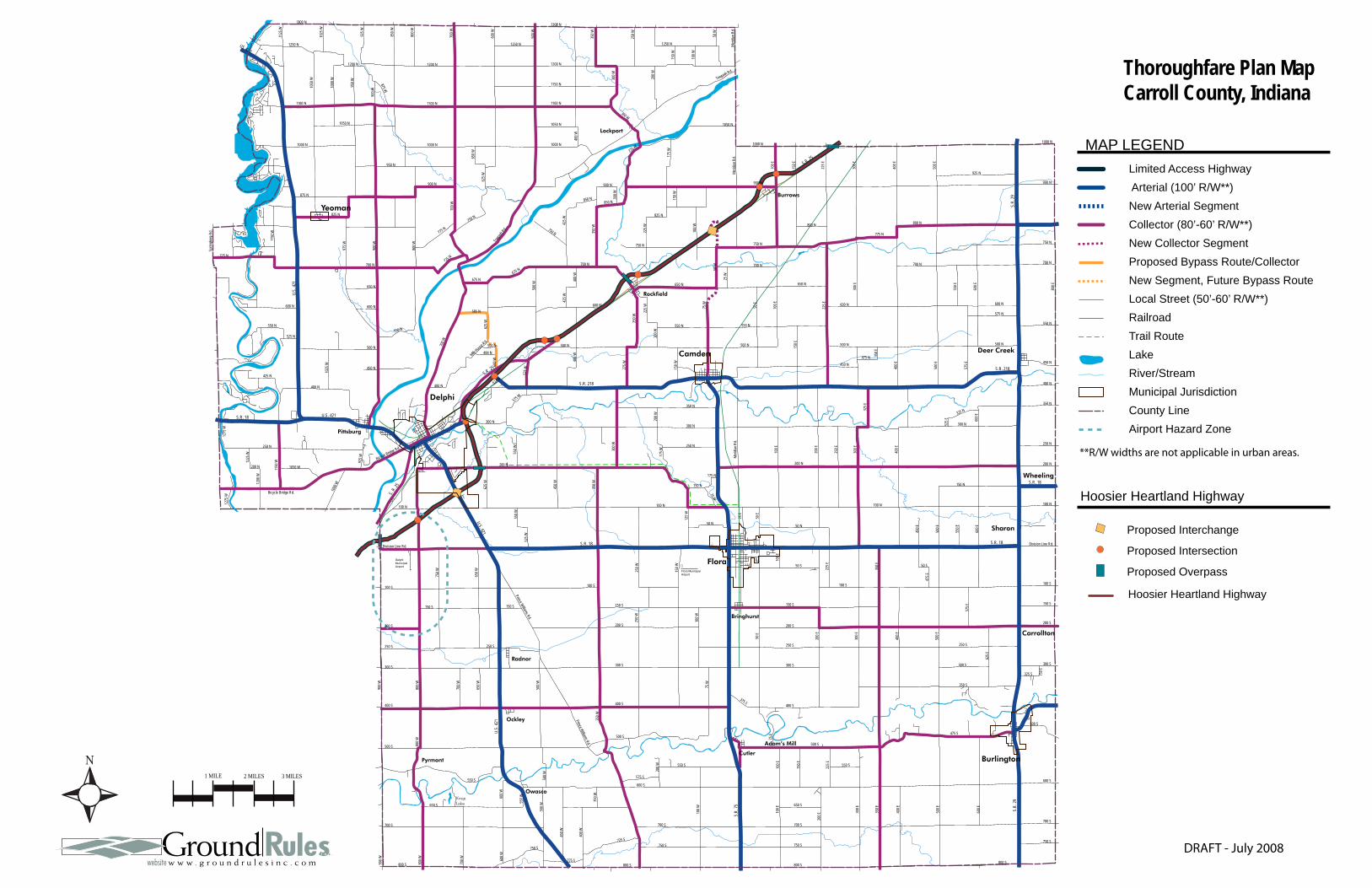
KnopLake
Delphi Municipal Airport
Flora Municipal Airport
Burrows
Yeoman
Deer Creek
Ockley
Delphi
Rockfield
Burlington
Bringhurst
Flora
Camden
Radnor
Cutler
Adam’s Mill
Pittsburg
Owasco
Carrollton
Sharon
Wheeling
Pyrmont
Lockport
Fishe
r St.
Linco
ln St
.
575 W
575 W
762 W
WILD
WOO
D RD
560 W
575 S
420 S
825 W
825 W
585 W
585 W
580 W
415 S
565 W
270 S
265 S
260 S
255 S
Lakview Dr.
575 E
Washington St.
Indiana St.
Jackson St.
8th St.
7th St.
Wild
cat R
iver W
ay
9th St.
10th St.
6th St.
4th St.
5th St.5th St.
Westview Dr.
Valle
y View
Poin
t
Woo
dland
Way
562 E
College St.
Stockton St.
Michigan St.
Arvin Dr.
Mill Rd.
Loyd
Ave.
Zook Ln.
Richard Ave.
730 E
740 E
675 E
McDonald Dr.
Prather St.
50 N
49 N
705 E
Fourth St.
445 N
725 E
460 N
710 E
715 E
470 N
475 N
480 N
720 E
Wate
r St.
Main St.
450 N
450 N
Washington St.
Cumberland St.
Cemetery St.
Sand
erso
n St.
Union
St.
Chur
ch S
t.
Monr
oe S
t. James St.
Arms
trong
Av
e. Ohio
St.
Indian
a St.
Illino
is St
.
Lee S
t.
260 N
500 N
468 N
488 N
450 W
375 N
475 W
Ande
rson D
r.
252 N
Crestwoo
d Dr.
Commercial Dr.
Camden Rd.
900 W
900 W
800 W
Water St.
Monroe St.
Ohio St.
Indiana St.
Illinois St.
Illinois St.
Third
St.
Walnut St.
Vine St.
Columbia St.
Prince William Rd.
Hami
lton S
t.
Hamilton St.
North St.
Bicycle Bridge Rd.
Franklin St.South Rd.
Tenth
St.
Wabash St.
Front St.
Cook St.
Garfield Rd.
Riley Park
Dr.
Market St.
Maso
nic S
t.
Summit S
t.
Tally Ho Dr. Tally Ho Ct.
Deer Mead
ows R
d.
Deer mead
ows R
d.
132 N
Wilson St.
Bicycle Bluffs Ln.
Sue L
n.
Shirl Ct.
905 W
Mill St.
Sixth
St.
Polk St.
Howard St.
Madison St.
Patty Ln.
Diana St.
Bowen Dr.
Clyde St.Bowen Ct.
Mill D
r.
Lafayette St.
Connelly St.
Bicycle Bluff Dr.
Eigh
th St
.
Seve
nth S
t.
Cottage St.
Rhinehart St.
Union St.
Riley Rd.
Wabash St.Market St.
Terrace Ln.
Armory Rd.
Heritage Dr.Herita
ge N
W
300 N
Main St.
Four
th St
.
Washington St.Union St.
Monroe St.
Harrison St.
Elizabeth St.
Adams St.
100 N
Columbia St.
Frank
lin St.
South Rd.
Pearl St.
Heritage NE
310 N
930 W
930 W
285 N
290 N
Ninth
St.
Clay St.
Howard St.Stoney Creek Rd.
High St.
Dodge St.
Fifth
St.
Pack
ett Av
e.
Crest Dr.
Whitem
an D
r.
Deer
Cree
k Dr.
300 N
700 W
Main St
.Washington St.
Riley
Mea
dow
Dr.
325 N
Brew
er A
ve.
Kerlin
Ave
.
Dreif
ers A
ve.
Smith Ave.
Ruffin
g Ave
.
Well
s St.
Belt Line Ave.
Char
les S
t.
358 N
Robin
son S
t.
Chamber Estates Dr.
Arno
ld St
.
Railroad Av.e.
Gosle
e St.
Forest St.
Parso
nage
St.
South St.
Baum
St.
690 N
990 W
680 N 980 W
Alco Way
Bradford Dr.
1132
W
Tippecanoe Ranch Rd.
Lakeside Cabin Rd.
Grav
el Pi
t Rd.
Troy
Ave
.
Misty
Ln.
Char
lais C
ir
Tippecanoe Ranch Rd. Ranch Ln.
Tecum
seh Bend
Rd.
Equestrian Rd.
Archery Rd.
Sharon Chapel Rd.
Lane Rd.
Main Camp Loop
Oregon Rd.
Stables Rd.
Rodg
ers L
n.
1215
W
Jerse
y Dr
925 W
310 N
935 W
910 W
905 W
320 N
330 N
900 N
1175
W
1150
W
1132
W
850 N
Home
rs Dr
.
Calve
rts D
r.
820 N
Fraz
oer B
each
Rd.
800 N
750 N
1175
W
775 N
Sandy Beach Dr.
1250
W
Twin Pine Dr.
Poplar Hills Dr.
Crest Dr.
Hambridge Dr.
Upper Hambridge
1190
W
Oakdale Dr.
1180
W
Grantham Ln.
1185
W
Cedar Dr.
Cedar Circle Dr.
Bridg
e Dr.
1175 W
Bree
zy P
oint D
r.
Breezy Point Ln.
1150
W
1152 W
950 N
1128
W
916 N
Paradise Beach Dr.
Paradise Rd.
Pirates
Roost R
d.
Lazy Ln.
Whit
e Oak
s Dr.
Key D
r. Whiteview Dr.
Reunion Point Rd.
1164
W
1200 N
1100 N
1100 N
1225
W
Orchard Dr.
Conrad Ct.
Uppe
r Lak
e Sho
re D
r.
Upper Lake Shore Dr.Lookout Dr.
Freeman Ln.
Fairw
ay
Ln.
Holiday
Briarwood Dr.
Shaffer
Dr.
1172 N
1182 N
1158 N
Von L
n.
1154 N
Von Hollow Dr.
1175
W
Smith Ridge Ct.
Land
ing Rd
.
Quiet
Wate
r Cir.
Quiet W
ater R
d.
Sugar Bluff Rd.
Linton Ln.
Lower L
akesho
re Dr.
Briarwood Ct.
Visata Dr.
1200
W
Lake Bluff Rd.
Winsor Rd. Ravin
ia Bl
.
Kenilworth Ln.
Drur
y Ln.
Fields
tone C
t.
Lakeshore Dr.
Woodbine Rd.Circle Dr.
Shad
y Ln.
C an
d C B
each
Dr.
Lake
view
Dr.
Corley Dr.
Earl A
v.
Haven Rd.
1200
W
680 N
CD R
d.
625 N
Sleepy Hollow Rd.
Sleepy Hollow Rd.
Hodges Dr.
100 E
374 W
380 W
414 W
863 N
68 E
871 N
90 E
95 E
876 N
884 N
East Rock
field R
d.
250 W
285 W
280 W
255 W
645 N
630 N
270 W
265 W
635 N
655 N640 N
260 W
208 E
150 E
400 E
375 E
480 S
450 E
525 S
190 E
620 S
Merid
ian R
d.
Fourt
h St.
480 S
490 S
5 E
485 S
15 W
20 W
10 E
95 E
175 W
275 W
Four
th St
.
155 S
140 S
150 S
6 W4 W
145 S
9 E
Bring
hurst
Rd.
Bring
hurst
Rd.
Main St.
Four
th St
.
Washington Blvd.
Elizabeth St.
Harm
on S
t.
Kenr
ick S
t.
Adams St.
Way
ne S
t.
Jackson St.
Seco
nd S
t.
First
St.
Camaro Ct.
Camaro Ct.Mano
r Dr.
S. Circle Dr.
Sunset Dr.
Third
St.
5th S
t
Moha
wk D
r.
Julius Dr.
Mead
ow Ln
.
Green Acres Dr.
South St.
Monr
oe S
t.
Cente
r S
t.
Divis
ion S
t.
50 S
Harrison St.
Cleveland St.
Hoop St.
Catherine St. Roos
evelt
St.
Easy
St.
Elizabeth St.
Clem St. Clem St.
Jeffe
rson
St.
Little St.
Brookview Ln.
Capitol St.
Howa
rd D
r.
Main St.
Was
hingto
n S
t.
Cente
r St.
Divis
ion S
t.
Jeffe
rson S
t.
Willo
w St
.
Walnut St.
Elm St.
Vine St.
Maple St.
Brigh
t St.
WES
TWOO
D DR
GABLE DR
EVERGREEN DR
Oak St.
Horseshoe Bend Rd.
Ross
etter
Ln.
1180
WJos
eph Ln
.
Horseshoe Ln. 1217
W
532 N
1145 W
1000 N1000 N
750 N
750 N
750 N
900 N
1300 N1300 N
1250 N1250 N
975 W
1200 N1200 N1200 N
1100 N1100 N 1100 N
950 W
900 W
800 W
800 W
1000
W
1125
W
1025
W
1050
W 300 W
400 W
350 W
250 W
200 W
1150 N
Towpa
th Rd.
Towpath Rd.
100 W
150 W
150 W
500 W
600 W
700 W
700 W
1050 N1050 N
950 N
875 N
625 W
825 N 825 N
175 W
75 W
425 W
775 N
600 N
650 N
1000 N
900 N
1250 N
875 W
900 W
850 W
300 W
300 W
400 W
350 W 100 W
50 W
50 W
500 W
1050 N
275 W
850 N
425 W
700 N
850 N
725 N
Sprin
gbor
o Rd.
925 W
1150
W
650 W
725 N
500 S
500 S
900 W
800 W
800 W
200 W
500 W
500 W
600 W
700 W
650 W
400 S400 S
550 S
550 S600 S
700 S
900 W
800 W
400 W
350 W
100 W50
0 W
600 W
700 W
450 W
800 S800 S
650 S
750 S750 S
550 W
575 S
775 S
725 S
700 S
500 S
350 W
350 W
250 W
250 W
100 W
150 W
75 W
150 E
100 E
300 E50 E
150 S 150 S
50 S
200 S 200 S
250 S
200 E
400 S
300 S 300 S
100 S
75 E
375 S
700 S
100 E
100 E
300 E
225 E
225 E
400 E
500 E
500 E
550 E
350 E
350 E 50 S
800 S
550 S
475 E
650 S
750 S
600 S
475 S
600 E
800 S
750 S
150 S
200 S
100 S
Division Line Rd.
600 E
700 S
400 E
500 E
575 E
250 S
300 S300 S
350 S
325 S 750 E
625 E
200 E
500 S
300 N
150 W
550 N
200 N
150 N
300 W
250 W
200 W
275 W
175 W
150 E
100 E
225 W
500 N
450 N
200 E
325 E
250 N
175 N
200 W
75 W
50 E
250 E
50 N 50 N
25 E
125 W
350 N
150 N
300 N
400 E
600 E
100 N
525 E
325 N
750 N
200 N
300 E
700 N
600 N
500 N
550 N
450 N
575 E
575 N
475 N 350 E
100 N
800 E
400 N
250 N
350 N
800 N
750 N
100 E
300 E
700 N
600 N
25 W
550 N
50 E
225 E
500 N
650 N
450 E
800 N
400 E
500 E
700 N
775 N
550 E
600 E
925 N
1000 N
Merid
ian R
d.Me
ridian
Rd.
Merid
ian R
d.
150 E
100 E
300 E
225 E
400 E
500 E
900 N
1000 N
900 N
200 N
300 N
1025
W
1225
W
600 W
700 W
1150
W
625 W
625 W
700 N
600 N
675 N675 N
500 N 500 N 500 N
525 W
650 N
585 N
550 N
450 N
Milk Hous
e Rd.
450 W
575 W
100 N100 N
550 W
550 W
Bicycle Bridge Rd.
400 N
250 N
624 N
1275
W
200 N
1000
W
1050 W
1200
W
400 W
600 N
550 N
484 N
400 N
525 N
650 W
525 W
Division Line Rd.
750 W
425 N
1275
W
Bicycle Bridge Rd.
925 W
150 S 150 S
200 S
250 S 250 S
300 S
100 S 100 S
Prince Williams Rd.
Prince Williams Rd.
225 W
S.R. 218
S.R. 218
S.R. 18
U.S.
421
U.S.
421
U.S. 421
U.S. 421
S.R. 18 S.R. 18
S. R. 2
5
US 421
S.R.
75 S.R.
29
S.R. 25
S.R. 25
S.R.
29
S.R. 18
Thoroughfare Plan MapCarroll County, Indiana
**R/W widths are not applicable in urban areas.
DRAFT - July 2008
Limited Access Highway
MAP LEGEND
Arterial (100’ R/W**)
River/Stream
County LineAirport Hazard Zone
Collector (80’-60’ R/W**)
Local Street (50’-60’ R/W**)
Municipal Jurisdiction
Railroad
Lake
New Collector Segment
Trail Route
Proposed Intersection
Hoosier Heartland Highway
Proposed Overpass
Proposed Interchange
1 MILE 2 MILES 3 MILES
New Arterial Segment
Proposed Bypass Route/CollectorNew Segment, Future Bypass Route
Hoosier Heartland Highway
Environment (EN)
CARROLL COUNTY COMPREHENSIVE PLAN 31
Introduction Located in northwestern Indiana, Carroll County is characterized by a rolling landscape of rich, fertile farmland. It is accented by streams and river valleys, including the Wabash River, Tippecanoe River, Wildcat Creek and Deer Creek which offer a unique terrain and provide scenic and recreational amenities. These unique environmental assets all contribute to the high quality of life in Carroll County.
Additionally, Carroll County has a variety of historic and cultural resources, many of which are related to the Wabash and Erie Canal era.
The community identified the following topics as important to the overall quality of life in Carroll County:
• protect the water quality of creeks and lakes
• protect the local groundwater supply
• protect and preserve the natural drainage of the 100-year floodplain
• conserve natural wooded areas and wetlands and minimize the conflicts between growth and the natural environment
• protect and preserve historic and cultural resources
Additionally, this section of the Comprehensive Plan includes objectives and implementation measures that encourage new development (residential, commercial and industrial uses) to be limited to areas that can support demands upon infrastructure, thereby reducing the impact upon County financial resources and also protecting environmentally sensitive areas and historic resources.
The following sections discuss issues related to the Environment goal, objectives and implementation measures.
WATER QUALITY Water bodies generally have a designated use associated with them. These uses can include drinking water, fishing, swimming, recreation, aesthetics or irrigation. Each designated use has specific water quality standards established by the Environmental Protection Agency (EPA). The federal Clean Water Act requires states to identify waters that do not meet those water quality standards and are therefore classified as “impaired.” Indiana’s Department of Environmental Management is responsible for testing and classifying waters in Indiana.
According to Indiana’s 2006 list of impaired water bodies (known as the 303(d) list) prepared by the Indiana Department of Environmental Management, there are about thirty (30) impaired stream segments in Carroll County. The impaired stream segments primarily include portions of the Wabash River, Deer Creek, and Wildcat Creek. The primary causes of impairment are exceeding allowable standards for e. coli, mercury, and polychlorinated biphenyls (PCBs).
Carroll County must be sensitive to land uses and practices that could contaminate water resources. Any development that poses a risk to ground or surface water will be prohibited unless proven measures are used to protect water quality. Open loop geothermal systems, in particular, were identified as a potential source of contamination. To continue to protect water quality, the County will require developers to submit development and redevelopment plans that provide for:
Surface stabilization, including tree and vegetation preservation, retaining walls and sodding;
Runoff control, such as swales, small culverts and vegetative buffers;
Sediment control, including sediment traps and filter strips;
Environment (EN)
CARROLL COUNTY COMPREHENSIVE PLAN 32
Storm water management, such as retention and detention ponds; and
Stream protection, including stream bank preservation, buffering and setbacks.
FLOODPLAIN MANAGEMENT Flooding causes more damage to communities across the country than all other types of natural disasters combined. Flooding is costly, not only in terms of the value of the property lost, but also lives lost.
Floodplains act as sponges, soaking in rain, filtering pollutants and slowing the overland flow of water. This contrasts with impervious surfaces, such as parking lots, rooftops and roadways, which accelerate storm water flow. Downstream flooding is exacerbated when the watershed has an increasing quantity of impervious surfaces in the floodplain.
Carroll County continues to struggle with issues resulting from inaccurate delineation of the floodplain and localized flooding. In order to minimize economic losses attributed to flooding, Carroll County should pursue partnerships with the Federal Emergency Management Agency, the Indiana Department of Natural Resources and local watershed organizations to improve the accuracy of the Flood Insurance Rate Maps.
Additionally, Carroll County will encourage the maintenance of natural areas within floodplains. Carroll County will strongly discourage development in floodplains. In instances when development must occur, compensatory storage may be required. Compensatory storage is the creation of additional areas to store flood waters that “compensates” for any filling, building or development that reduces flood storage capacity. Carroll County will strive for “no adverse impact” with regard to development in or near the floodplain.
SOILS Soils limit the type of development, the ability of installing septic systems and the types of land uses able to be supported on a site.
Development on inappropriate soils can result in problems such as foundation damage, water erosion, flooding and insufficient drainage. These problems can financially burden property owners and often impact the County. For instance, a septic system installed on inappropriate soils can be a costly issue for a homeowner, but it could also result in damage to adjacent properties and contamination of surface water and/or County regulated drains.
The soil types within Carroll County vary. Due to this significant variation in soil type, a development that is appropriate in one area of Carroll County, might not be appropriate in another area of Carroll County.
When evaluating sites for development, Carroll County should ensure that soil tests are performed to make certain the land is suitable for the proposed use. In situations where a public building or use is proposed, Carroll County will be responsible for conducting the soil testing. For private developments, Carroll County should require all developers to conduct soil testing and submit the results to the county for consideration in the development approval process.
Carroll County also should make it a policy to encourage all new public and private developments to connect to a sanitary sewer system when located within reasonable proximity to an existing system. The Zoning Ordinance and Subdivision Control Ordinance should indicate specifics regarding determining the reasonable distance.
RIPARIAN CORRIDOR MANAGEMENT Riparian corridors are linear forests and vegetation located along natural rivers, streams and creeks. County regulated drains and ditches are excluded from these types of corridors.
Environment (EN)
CARROLL COUNTY COMPREHENSIVE PLAN 33
Riparian corridors have significant ecological and aesthetic values, in part because they contain a rich array of plants and animals. Additionally, the corridor’s vegetation stabilizes the banks of the waterways, reduces the amount of sediments and pollutants entering waterways and lessens flooding and impacts. Because waterways can be vulnerable to developmental pressures, the County should review its ordinances and policies, as needed, to minimize the effect of development on the stream banks and natural areas.
According to the United States Department of Agriculture (USDA), the ideal riparian corridor includes three (3) specific zones in which development should be restricted. These zones, listed in sequence from the stream, are as follows:
Undisturbed Forest – This zone is a tree and shrub zone located adjacent to the water body. It provides important habitat, litter fall for aquatic wildlife and shading to lower water temperature. Removal of vegetation should not be permitted within this zone.
Managed Forest – This zone is also a tree and shrub zone. It is located between the undisturbed forest zone and runoff control zone. Harvesting of mature trees and older vegetation is encouraged to improve filtering and removal of nutrients through younger, faster growing vegetation.
• Runoff Control – This zone is the outer edge of the corridor buffer. It may be pastured or mowed for recreational purposes, and structures should not be permitted.
The size of these corridors is dependent upon the size of the water feature. This protective buffer may be eighty (80) feet along a large river, but only thirty (30) feet along a stream. Future lands uses should be sensitive to natural riparian and littoral corridors. It is not
the intent to prohibit all development in these areas, but rather to restrict certain land uses and require the use of best management practices to protect the valuable environmental features that exist.
County regulated drains are not considered riparian corridors, but it is critical that development be restricted on land adjacent to these drains. Dense plantings that can hinder surface water flow are strongly discouraged within seventy-five (75) feet of the drain. Structures should also be prohibited.
ENVIRONMENTALLY MANAGED LAND The County should consider adoption of zoning and subdivision control ordinance language to incorporate consideration of protective buffer widths along rivers and streams into future development decisions to protect the environmental and aesthetic value of these lands. The regulations would not be intended to prohibit development. Instead, the regulations would ensure that additional consideration was given to the potential effects of low to moderate developments in these areas and to encourage measures to protect the natural environment.
The County would need to determine site and water body specific buffer distances to protect the resources in each location. Presently, the future land use map utilizes these buffers: primary river – 3,170 feet; large tributary streams – 2,110 feet; and creeks and smaller tributaries – 1,060 feet.
RECREATION AND OPEN SPACE Access to parks, recreation, and open space is essential to a high quality of life, good health, and community spirit. To ensure accessibility and usage, Carroll County provides an assortment of parks and facilities throughout its jurisdiction. Specifically in Carroll County, these include areas along the Wabash River, Tippecanoe River, Wildcat Creek, and Deer Creek, as well as Riley Park, Trailhead Park, Burlington Park, Camden/Jackson
Environment (EN)
CARROLL COUNTY COMPREHENSIVE PLAN 34
Township Park, Carroll County Country Club, Knop Lake, and others.
Access to these areas promotes a high quality of life, good health and community spirit. Additionally, open space and recreational areas are valuable because they can serve as a buffer between non-compatible land uses.
Participants in the public workshops identified parks as a priority for consideration in Carroll County. Carroll County will work to ensure these amenities continue to flourish in Carroll County by protecting natural and historic resources throughout the county.
HISTORICAL AND CULTURAL RESOURCES Carroll County is located amid the Wabash and Tippecanoe rivers and Wildcat and Deer creeks and has a rich cultural and historical heritage related to the settlement era, the Wabash and Erie Canal era, and its period of expansion in the railroad era. The first settlers arrived in Carroll County in late 1824. Today’s citizens have a great sense of pride regarding the area’s history and the unique resources that have been preserved over time. Residents of Carroll County want to see high priority resources, features and sites preserved and protected from the potential effects of future development. Carroll County is home to a number of historic sites and buildings, including schools, churches, houses, mills, shops, cemeteries, bridges and other transportation (including canal, rail, road, and air) features as well as other landmarks that provide a valuable link to the past. Some of these important resources include the 1845 Adams Mill and nearby restored Covered Bridge near Cutler. Restoration of the Adams Mill Covered Bridge included cutting windows in the sides so views of the scenic Wildcat Creek could be enjoyed. Other historical bridge resources include the Lancaster Bridge, the other remaining covered bridge in the County, near Owasco, and Indiana’s oldest continually used
bridge, the 1837 Burnett’s Creek Stone Arch cut stone structure near Lockport. The stone arch bridge is listed on the National Register of Historic Places. The County also has a substantial inventory of other historic features and structures, including the Burris House, a former inn, and Potawatomi Spring, a well-known watering place for Indians and early settlers, both located in Lockport. Remnants of the Wabash and Erie Canal, constructed in 1840, are found in and near the City of Delphi (see additional information in Part 3: Municipal Plan Elements, City of Delphi). The Mullin School House (1874 to 1900) in Liberty Township is also on the National Register of Historic Places. The school house was restored and furnished to resemble a one-room school house from the 1800s. These and some of the other resources of the county are identified on the Historic Bridges and Cultural Resources Map (page 37). The county should continue to work with local groups like the Carroll County Chamber of Commerce Tourism Committee, the Delphi and Camden preservation societies, the Carroll County Historical Society, and other efforts focused on historical preservation, tourism, recreation/trails, and other interested parties or organizations to prioritize features and sites and work toward identification, preservation and protection of these resources. Additionally, Carroll County can continue to expand tourism (economic development) related to these natural, cultural and historical assets of the county.
LIMESTONE QUARRY Carroll County and the City of Delphi recognize the importance and value of the local limestone quarry. It is recognized that the abundance of limestone will enable quarry operations to continue well beyond the planning horizon of this comprehensive plan (approximately 20 years) and that decision-
Environment (EN)
CARROLL COUNTY COMPREHENSIVE PLAN 35
makers should consider these operations in future land use decisions. Specifically, the County and City of Delphi can minimize the potential for nuisance-related land use conflicts by ensuring more sensitive land uses are not located adjacent to lands planned for future mining activity. Additionally, the County City of Delphi could take additional steps toward developing a long-term partnership with quarry owners enabling future collaborative steps related to roadway and infrastructure development and reclamation planning that would benefit all parties.
LANDFILL Carroll County recognizes the potential for future development of a landfill facility to handle the waste stream generated from within the county. Such a facility would be developed only to handle waste generated within the county’s boundaries; the county would not operate or approve private or other landfill operations that accepted waste from outside the county line. Development of a future landfill would require feasibility and alternatives siting studies to determine the potential for a suitable location within the county. The County’s intent would be to develop and operate a landfill that addresses environmental opportunities, including: (1) energy generation; (2) recycling; and (3) materials recovery.
Environment (EN)
CARROLL COUNTY COMPREHENSIVE PLAN 36
Environment Goal Preserve and enhance Carroll County’s natural and historic/cultural resources
and environmental features, and protect these features from development.
Environment (EN) Objectives and Implementation Measures Objective 1: Protect the water quality in lakes, streams and their watersheds EN 1.1 Allow the use of innovative methods
of storm water management such as low impact development, sustainable development, filter strips, drain guards, and constructed wetlands.
EN 1.2 Reduce discharges from non-point source pollutants through education, storm water management, and the reduction of impervious surfaces.
EN 1.3 Reduce discharges from point source pollutants through education, monitoring, enforcement, and incentives.
EN 1.4 Protect underground aquifers from contamination that can result from improper and inappropriate development.
Objective 2: Minimize conflicts between the built environment and the natural environment EN 2.1 Minimize the need for septic systems
by focusing development where sanitary sewer infrastructure exists. Where septic systems are necessary, ensure County and State standards are met or exceeded.
EN 2.2 Encourage new development to balance impervious surfaces with adjacent green space (to help reduce runoff).
EN 2.3 Establish Zoning Ordinance and Subdivision Control Ordinance language that requires new development to be sensitive to environmental features through the use of conservation, buffering, landscaping, filtration strips, tree preservation, retention/detention, and cluster development (homes and other uses on smaller lots with large natural open space areas).
EN 2.4 Develop Zoning Ordinance and Subdivision Control Ordinance regulations specific to future development within a designated protective buffer zone adjacent to rivers, streams and other identified environmentally sensitive or natural resources.
EN 2.5 Work with the Federal Emergency Management Agency, Indiana Department of Natural Resources and local watershed organizations to obtain accurately delineated floodplain maps.
EN 2.6 Prohibit construction in floodway or floodplain, land-locked areas surrounded by floodplain, and on or near steep slopes.
EN 2.7 Restrict construction within the erosion path of waterways.
EN 2.8 Require septic and drainage easement for new residential construction.
EN 2.9 Restrict the encroachment of pollution sources in environmentally sensitive areas.
Environment (EN)
CARROLL COUNTY COMPREHENSIVE PLAN 37
EN 2.10 Disallow land uses that are most likely to pollute or impair surface water when located within proximity to streams, major ditches, or lakes.
EN 2.11 Consider and pursue a variety of State and federal sources to find funding for park improvements, including Department of Natural Resources, Department of Transportation, Department of Environmental Management and others.
Objective 3: Conserve existing natural areas including wood lots, wildlife habitats, riparian corridors, littoral corridors, open space, wetlands and floodplains EN 3.1 Inventory areas with environmental
features that are rare, significant in size, or contain a rich diversity of species so that these areas can be targeted for conservation.
EN 3.2 Restrict development in areas with environmental features that are rare, significant in size, irreplaceable, or contain a rich diversity of species. Development that enhances or embraces the environmental feature, such as a nature trail, should be considered.
EN 3.3 Ensure State-required erosion control plans are adequate prior to issuing building permits. Require site developers to comply with the regulations to minimize soil erosion and prevent pollution at construction sites.
EN 3.4 Participate in State and federal programs to conserve, sustain and restore natural features and areas.
EN 3.5 Educate the public about the benefits of preserving and protecting existing natural areas from development.
Objective 4: Focus growth in or near municipalities EN 4.1 Strongly encourage commercial and
industrial development within reach of public utilities of cities or towns by revising the Zoning Ordinance and Subdivision Control Ordinance.
EN 4.2 Minimize the opportunity to establish rows of residential lots along country roads, thus creating linear subdivisions by revising the Subdivision Control Ordinance.
EN 4.3 Promote opportunities for alternative development patterns (such as cluster or conservation development) that result in the protection and enhancement of environmental features and/or agricultural land.
Objective 5: Preserve Historic and Cultural Resources/Amenities EN 5.1 Balance historical/cultural resource
preservation with other land use needs. Utilize a tiered classification system in making development approval decisions.
EN 5.2 Encourage maintenance and enhancement of historic structures and cultural amenities.
EN 5.3 Develop a Historic Preservation Plan to provide policy guidelines for the identification, preservation, maintenance and enhancement of historic structures throughout the County.
Environment (EN)
CARROLL COUNTY COMPREHENSIVE PLAN 38
EN 5.4 Ensure infill and redevelopment in historic and cultural areas is completed appropriately through ordinance regulations.
Objective 6: Initiate long-term planning related to limestone quarry operations and future land development and reclamation opportunities EN 6.1 Pursue a long-term partnership with the
City of Delphi and limestone quarry owners to create enhanced opportunities for collaboration related to roadway and infrastructure development and reclamation of mined areas.
Objective 7: Consider development of landfill facility to handle County-generated wastes in an environmentally sound manner EN 7.1 Conduct a study to determine the
potential feasibility of and need for developing a County landfill to handle county-generated waste stream. Include consideration of environmental measures including energy generation, household recycling, and materials recovery.
EN 7.2 Develop language in the Zoning Ordinance to enable the County to regulate the nature (type, size, location, waste stream source) of future landfill facilities, such that no outside waste stream is permitted within Carroll County.
ED 7.3 Should the County determine it feasible to develop a landfill, then additional specific language should be prepared in the Zoning Ordinance (and Subdivision Control Ordinance) to enable effective regulation of potential impacts of these facilities, including land use buffers to protect the facility and adjacent land uses from potential incompatibility or other conflict.

KnopLake
Wildcat Creek Scenic Drive
Wabash River Scenic Drive
Eller PondWetlandConservationArea
French PostPark
Sodhouse
X
Historic Canal Lock #32
BurlingtonPark
Burlington-Wildcat Creek Public Access Site
Deer Creek Park
Deer CreekValley RuralHistoric District
1
2
3
6
9
2021
25
16 17
7
14
2223
24
15
5
1213Canal
Park
HistoricTown of
8
18
19
1011
4
Delphi Municipal Airport
Flora Municipal Airport
Burrows
Yeoman
Deer Creek
Ockley
Delphi
Rockfield
Burlington
Bringhurst
Flora
Camden
Radnor
Cutler
Adam’s Mill
Pittsburg
Owasco
Carrollton
Sharon
Wheeling
Pyrmont
Lockport
Fishe
r St.
Linco
ln St
.
575 W
575 W
762 W
WILD
WOO
D RD
560 W
575 S
420 S
825 W
825 W
585 W
585 W
580 W
415 S
565 W
270 S
265 S
260 S
255 S
Lakview Dr.
575 E
Washington St.
Indiana St.
Jackson St.
8th St.
7th St.
Wild
cat R
iver W
ay
9th St.
10th St.
6th St.
4th St.
5th St.5th St.
Westview Dr.
Valle
y View
Poin
t
Woo
dland
Way
562 E
College St.
Stockton St.
Michigan St.
Arvin Dr.
Mill Rd.
Loyd
Ave.
Zook Ln.
Richard Ave.
730 E
740 E
675 E
McDonald Dr.
Prather St.
50 N
49 N
705 E
Fourth St.
445 N
725 E
460 N
710 E
715 E
470 N
475 N
480 N
720 E
Wate
r St.
Main St.
450 N
450 N
Washington St.
Cumberland St.
Cemetery St.
Sand
erso
n St.
Union
St.
Chur
ch S
t.
Monr
oe S
t. James St.
Arms
trong
Av
e. Ohio
St.
Indian
a St.
Illino
is St
.
Lee S
t.
260 N
500 N
468 N
488 N
450 W
375 N
475 W
Ande
rson D
r.
252 N
Crestwoo
d Dr.
Commercial Dr.
Camden Rd.
900 W
900 W
800 W
Water St.
Monroe St.
Ohio St.
Indiana St.
Illinois St.
Illinois St.
Third
St.
Walnut St.
Vine St.
Columbia St.
Prince William Rd.
Hami
lton S
t.
Hamilton St.
North St.
Bicycle Bridge Rd.
Franklin St.South Rd.
Tenth
St.
Wabash St.
Front St.
Cook St.
Garfield Rd.
Riley Park
Dr.
Market St.
Maso
nic S
t.
Summit S
t.
Tally Ho Dr. Tally Ho Ct.
Deer Mead
ows R
d.
Deer mead
ows R
d.
132 N
Wilson St.
Bicycle Bluffs Ln.
Sue L
n.
Shirl Ct.
905 W
Mill St.
Sixth
St.
Polk St.
Howard St.
Madison St.
Patty Ln.
Diana St.
Bowen Dr.
Clyde St.Bowen Ct.
Mill D
r.
Lafayette St.
Connelly St.
Bicycle Bluff Dr.
Eigh
th St
.
Seve
nth S
t.
Cottage St.
Rhinehart St.
Union St.
Riley Rd.
Wabash St.Market St.
Terrace Ln.
Armory Rd.
Heritage Dr.Herita
ge N
W
300 N
Main St.
Four
th St
.
Washington St.Union St.
Monroe St.
Harrison St.
Elizabeth St.
Adams St.
100 N
Columbia St.
Frank
lin St.
South Rd.
Pearl St.
Heritage NE
310 N
930 W
930 W
285 N
290 N
Ninth
St.
Clay St.
Howard St.Stoney Creek Rd.
High St.
Dodge St.
Fifth
St.
Pack
ett Av
e.
Crest Dr.
Whitem
an D
r.
Deer
Cree
k Dr.
300 N
700 W
Main St
.Washington St.
Riley
Mea
dow
Dr.
325 N
Brew
er A
ve.
Kerlin
Ave
.
Dreif
ers A
ve.
Smith Ave.
Ruffin
g Ave
.
Well
s St.
Belt Line Ave.
Char
les S
t.
358 N
Robin
son S
t.
Chamber Estates Dr.
Arno
ld St
.
Railroad Av.e.
Gosle
e St.
Forest St.
Parso
nage
St.
South St.
Baum
St.
690 N
990 W
680 N 980 W
Alco Way
Bradford Dr.
1132
W
Tippecanoe Ranch Rd.
Lakeside Cabin Rd.
Grav
el Pi
t Rd.
Troy
Ave
.
Misty
Ln.
Char
lais C
ir
Tippecanoe Ranch Rd. Ranch Ln.
Tecum
seh Bend
Rd.
Equestrian Rd.
Archery Rd.
Sharon Chapel Rd.
Lane Rd.
Main Camp Loop
Oregon Rd.
Stables Rd.
Rodg
ers L
n.
1215
W
Jerse
y Dr
925 W
310 N
935 W
910 W
905 W
320 N
330 N
900 N
1175
W
1150
W
1132
W
850 N
Home
rs Dr
.
Calve
rts D
r.
820 N
Fraz
oer B
each
Rd.
800 N
750 N
1175
W
775 N
Sandy Beach Dr.
1250
W
Twin Pine Dr.
Poplar Hills Dr.
Crest Dr.
Hambridge Dr.
Upper Hambridge
1190
W
Oakdale Dr.
1180
W
Grantham Ln.
1185
W
Cedar Dr.
Cedar Circle Dr.
Bridg
e Dr.
1175 W
Bree
zy P
oint D
r.
Breezy Point Ln.
1150
W
1152 W
950 N
1128
W
916 N
Paradise Beach Dr.
Paradise Rd.
Pirates
Roost R
d.
Lazy Ln.
Whit
e Oak
s Dr.
Key D
r. Whiteview Dr.
Reunion Point Rd.
1164
W
1200 N
1100 N
1100 N
1225
W
Orchard Dr.
Conrad Ct.
Uppe
r Lak
e Sho
re D
r.
Upper Lake Shore Dr.Lookout Dr.
Freeman Ln.
Fairw
ay
Ln.
Holiday
Briarwood Dr.
Shaffer
Dr.
1172 N
1182 N
1158 N
Von L
n.
1154 N
Von Hollow Dr.
1175
W
Smith Ridge Ct.
Land
ing Rd
.
Quiet
Wate
r Cir.
Quiet W
ater R
d.
Sugar Bluff Rd.
Linton Ln.
Lower L
akesho
re Dr.
Briarwood Ct.
Visata Dr.
1200
W
Lake Bluff Rd.
Winsor Rd. Ravin
ia Bl
.
Kenilworth Ln.
Drur
y Ln.
Fields
tone C
t.
Lakeshore Dr.
Woodbine Rd.Circle Dr.
Shad
y Ln.
C an
d C B
each
Dr.
Lake
view
Dr.
Corley Dr.
Earl A
v.
Haven Rd.
1200
W
680 N
CD R
d.
625 N
Sleepy Hollow Rd.
Sleepy Hollow Rd.
Hodges Dr.
100 E
374 W
380 W
414 W
863 N
68 E
871 N
90 E
95 E
876 N
884 N
East Rock
field R
d.
250 W
285 W
280 W
255 W
645 N
630 N
270 W
265 W
635 N
655 N640 N
260 W
208 E
150 E
400 E
375 E
480 S
450 E
525 S
190 E
620 S
Merid
ian R
d.
Fourt
h St.
480 S
490 S
5 E
485 S
15 W
20 W
10 E
95 E
175 W
275 W
Four
th St
.
155 S
140 S
150 S
6 W4 W
145 S
9 E
Bring
hurst
Rd.
Bring
hurst
Rd.
Main St.
Four
th St
.
Washington Blvd.
Elizabeth St.
Harm
on S
t.
Kenr
ick S
t.
Adams St.
Way
ne S
t.
Jackson St.
Seco
nd S
t.
First
St.
Camaro Ct.
Camaro Ct.Mano
r Dr.
S. Circle Dr.
Sunset Dr.
Third
St.
5th S
t
Moha
wk D
r.
Julius Dr.
Mead
ow Ln
.
Green Acres Dr.
South St.
Monr
oe S
t.
Cente
r S
t.
Divis
ion S
t.
50 S
Harrison St.
Cleveland St.
Hoop St.
Catherine St. Roos
evelt
St.
Easy
St.
Elizabeth St.
Clem St. Clem St.
Jeffe
rson
St.
Little St.
Brookview Ln.
Capitol St.
Howa
rd D
r.
Main St.
Was
hingto
n S
t.
Cente
r St.
Divis
ion S
t.
Jeffe
rson S
t.
Willo
w St
.
Walnut St.
Elm St.
Vine St.
Maple St.
Brigh
t St.
WES
TWOO
D DR
GABLE DR
EVERGREEN DR
Oak St.
Horseshoe Bend Rd.
Ross
etter
Ln.
1180
WJos
eph Ln
.
Horseshoe Ln. 1217
W
532 N
1145 W
1000 N1000 N
750 N
750 N
750 N
900 N
1300 N1300 N
1250 N1250 N
975 W
1200 N1200 N1200 N
1100 N1100 N 1100 N
950 W
900 W
800 W
800 W
1000
W
1125
W
1025
W
1050
W 300 W
400 W
350 W
250 W
200 W
1150 N
Towpa
th Rd.
Towpath Rd.
100 W
150 W
150 W
500 W
600 W
700 W
700 W
1050 N1050 N
950 N
875 N
625 W
825 N 825 N
175 W
75 W
425 W
775 N
600 N
650 N
1000 N
900 N
1250 N
875 W
900 W
850 W
300 W
300 W
400 W
350 W 100 W
50 W
50 W
500 W
1050 N
275 W
850 N
425 W
700 N
850 N
725 N
Sprin
gbor
o Rd.
925 W
1150
W
650 W
725 N
500 S
500 S
900 W
800 W
800 W
200 W
500 W
500 W
600 W
700 W
650 W
400 S400 S
550 S
550 S600 S
700 S
900 W
800 W
400 W
350 W
100 W50
0 W
600 W
700 W
450 W
800 S800 S
650 S
750 S750 S
550 W
575 S
775 S
725 S
700 S
500 S
350 W
350 W
250 W
250 W
100 W
150 W
75 W
150 E
100 E
300 E50 E
150 S 150 S
50 S
200 S 200 S
250 S
200 E
400 S
300 S 300 S
100 S
75 E
375 S
700 S
100 E
100 E
300 E
225 E
225 E
400 E
500 E
500 E
550 E
350 E
350 E 50 S
800 S
550 S
475 E
650 S
750 S
600 S
475 S
600 E
800 S
750 S
150 S
200 S
100 S
Division Line Rd.
600 E
700 S
400 E
500 E
575 E
250 S
300 S300 S
350 S
325 S 750 E
625 E
200 E
500 S
300 N
150 W
550 N
200 N
150 N
300 W
250 W
200 W
275 W
175 W
150 E
100 E
225 W
500 N
450 N
200 E
325 E
250 N
175 N
200 W
75 W
50 E
250 E
50 N 50 N
25 E
125 W
350 N
150 N
300 N
400 E
600 E
100 N
525 E
325 N
750 N
200 N
300 E
700 N
600 N
500 N
550 N
450 N
575 E
575 N
475 N 350 E
100 N
800 E
400 N
250 N
350 N
800 N
750 N
100 E
300 E
700 N
600 N
25 W
550 N
50 E
225 E
500 N
650 N
450 E
800 N
400 E
500 E
700 N
775 N
550 E
600 E
925 N
1000 N
Merid
ian R
d.Me
ridian
Rd.
Merid
ian R
d.
150 E
100 E
300 E
225 E
400 E
500 E
900 N
1000 N
900 N
200 N
300 N
1025
W
1225
W
600 W
700 W
1150
W
625 W
625 W
700 N
600 N
675 N675 N
500 N 500 N 500 N
525 W
650 N
585 N
550 N
450 N
Milk Hous
e Rd.
450 W
575 W
100 N100 N
550 W
550 W
Bicycle Bridge Rd.
400 N
250 N
624 N
1275
W
200 N
1000
W
1050 W
1200
W
400 W
600 N
550 N
484 N
400 N
525 N
650 W
525 W
Division Line Rd.
750 W
425 N
1275
W
Bicycle Bridge Rd.
925 W
150 S 150 S
200 S
250 S 250 S
300 S
100 S 100 S
Prince Williams Rd.
Prince Williams Rd.
225 W
S.R. 218
S.R. 218
S.R. 18
U.S.
421
U.S.
421
U.S. 421
U.S. 421
S.R. 18 S.R. 18
S. R. 2
5
US 421
S.R.
75 S.R.
29
S.R. 25
S.R. 25
S.R.
29
S.R. 18
Historic Resources MapCarroll County, Indiana
Historic Bridges & Resources
DRAFT - July 2008
1 Tioga Bridge (298) - 1890 Whipple Truss, Lake Freeman 2 Potawatomi Trail of Death Marker 3 Bridge 181 - 1840 Stone Arch, Burnett’s Creek 4 Lockport Bridge (142) - 1938 Continuous Concrete T-Beam,
Wabash River
6 Potawatomi Trail of Death Marker 7 Carrollton Bridge (132) - 1927 Concrete Arch, Wabash River
5 Bridge 144 - 1903 Stone Arch, Little Rock Creek
8 Mullin Schoolhouse 9 Potawatomi Trail of Death Marker
10 Bridge 85 - 1874 Bow String Arch Pony Truss, Wabash & Erie Canal 11 Bridge 2 - 1901 Stone Arch, Wabash & Erie Canal
13 Wilson’s Bridge (121) - 1898 Pratt Thru Truss, Deer Creek 14 Bridge 87 - 1932 Warren Pony Truss, Deer Creek 15 Sycamore Row 16 Bridge 150 - 1901 Stone Arch, Wabash & Erie Canal 17 Bridge 1788 - 1935 Concrete Rigid Frame,
North St. over US 421/Washington St.
20 Lancaster Covered Bridge (18) - 1872 Howe Covered Truss, Wildcat Creek
21 Xenia Bridge (25) - 1931 Parker Thru Truss, Wildcat Creek 22 Bridge 3653 - 1948 Parker Thru Truss, Wildcat Creek 23 Bridge 39 - Adam’s Mill Covered Bridge (restored in 1999)
1948 Howe Covered Truss, Wildcat Creek 24 Adam’s Mill 25 Bridge 16 - 1901 Pratt Thru Truss, Middle Fork Wildcat Creek
MAP LEGEND
Wabash River Scenic DriveWildcat Creek Scenic Drive
Proposed Future TrailsBicycle Route #2, Adam’s MillBicycle Route #1, Wabash River Valley
12 High Bridge, Mary I. Gerard Nature Preserve & Monon High Bridge Trail
19 Bridge 153 - 1910 Lattice Pony Truss, Bachelor Run
18 Stearns Truss Bridge
Historic Canal Segment
Historic Town of Lockport
Public Infrastructure and Services (PS)
CARROLL COUNTY COMPREHENSIVE PLAN 41
Introduction County jurisdictions are responsible for a variety of public infrastructure and services. As populations grow, one of the greatest challenges is maintaining public infrastructure and services at a level that meets the needs of the community.
The discussion of facilities and services focuses on sanitary sewer, drainage, and emergency services coordination. Generally, transportation-related infrastructure (roads) and services are discussed earlier in this document in the Transportation section.
Several public infrastructure and services concerns were identified during the public input portion of the Carroll County Planning Initiative. These issues are discussed below.
SANITARY SEWER Coping with the lack of sanitary sewer infrastructure is an issue for Carroll County. Although it is understood that a county-wide sanitary sewer system is not realistic in the future, not everyone is supportive of focusing growth and development where sanitary sewer systems with capacity currently exist.
Most cities and towns in Carroll County have municipally owned and operated collection and treatment facilities, and those specific systems will be addressed in Part Three: Municipal Plan Elements.
Almost all new homes built in rural areas of the County utilize private septic systems. Although the technology related to septic systems has improved, these systems can still fail if they are installed in inappropriate soils or if they are not properly maintained. Failing or inadequate septic systems not only create problems for home owners, but are believed to be a significant contributor to water pollution.
First and foremost, Carroll County and its ordinances should encourage development where access to sanitary sewer systems exists. When development without access to sanitary sewer systems is permitted, the County needs
to account for the increased risk these developments pose to the environment.
Soils testing should continue to be required. Seasonal variations and recent weather conditions should be taken into account in the testing process.
Carroll County ordinances should require new development to include a second on-site area for a septic system should the original system fail. This second site should pass the same soil test as the original site, be identified as a backup septic site on the plat/permit and remain undisturbed.
Additionally, the County would be well-served by any program that would monitor existing septic systems and educate home owners about the maintenance of their septic system.
COUNTY DRAINS Most of the tile drains under Carroll County’s jurisdiction are over eighty (80) years old and were designed to drain agricultural fields and farms. As new development occurs, the water that is channeled to these aged drains increases beyond the designed capacity of the drain. While the County has some maintenance planned for certain tiles and drains, it can be difficult to anticipate all of the locations of new development and the full impact of that development years before it happens. Drains that were designed for agricultural uses are often expected to operate as storm sewers for new development. This can impact every property that is served by the drain as well as those properties that are both upstream and downstream of the developing area.
This plan emphasizes the need for a County-wide storm water ordinance that will minimize the impacts to existing County drains. The storm water ordinance should specify an allowable discharge rate for storm water from new developments. The discharge rate should be based on the capacity of downstream drains
Public Infrastructure and Services (PS)
42 CARROLL COUNTY COMPREHENSIVE PLAN
and may need to be more restrictive in certain areas than others. These regulations will require developers and builders to reduce runoff, accommodate runoff in detention and retention ponds and or reduce impervious surfaces. Moreover, the local Drainage Board should take a proactive approach to installing new drains and regional storm water detention facilities around municipalities and developing areas throughout the County.
Carroll County currently plans for drainage maintenance projects five (5) or more years in advance. This Capital Improvement Plan for drains prioritizes drain maintenance projects based on need and available funding. It is critical the Capital Improvement Plan for drains be publicized so citizens realize that even though resources are limited, improvement projects are still prioritized, planned and scheduled.
EMERGENCY SERVICES (DRY HYDRANTS) Emergency service issues are of utmost importance. Often times, these issues can be life and death situations. These issues deserve Carroll County’s attention.
Carroll County should consider inventorying existing dry hydrants and determining strategic locations for additional dry hydrants. A dry hydrant is a non-pressurized system made up of a hydrant head where a fire truck can attach its hose to draw water, a piping system to an adjacent water source (lake, pond, river, stream, etc.) and a strainer placed within the water source at a sufficient depth for adequate water withdrawal. Rural residents benefit by having reasonable access to water in the event of a fire emergency.
BUILDING INSPECTION AND CODE ENFORCEMENT Carroll County recognizes a need to develop and implement a comprehensive and coordinated building inspection and zoning code enforcement program. Such a program would include hiring one or more qualified building inspectors or an inspection service to ensure new construction, renovations and
existing buildings meet local, state and national building and safety requirements. The County will work with municipalities to determine the best manner in which to establish such a program, potentially including coordination with an adjacent county to balance workload. It is the County’s intent that this program would be self-supporting, paid for by inspection fees rather than using any County general or other funding sources.
The building inspector and code enforcement services could include a number of duties, including:
- review of plans for building construction, destruction, or alterations for compliance with state codes, local bylaws and other applicable;
- on-site inspections for electrical, plumbing, gas lines, and construction
- issue building permits and certificates of occupancy
- work with contractors, other officials and the general public regarding building codes and state statutes
- enforce the state building code and inspect schools, public buildings, residential, commercial and industrial installations to ensure conformance to specifications and building code
- investigate complaints concerning building code violations
- issue stop work orders or other actions concerning potential violations
Development of such a program would enable the County and participating municipalities to improve consistency in meeting health and safety requirements as well as provide a mechanism to implement desired design standards promoting enhanced community character and historic preservation goals.
Public Infrastructure and Services (PS)
CARROLL COUNTY COMPREHENSIVE PLAN 43
Public Infrastructure and Services Goal
Provide essential public services through public and private initiatives, and ensure
future growth and development is accompanied by orderly and efficient expansion of necessary infrastructure.
Public Infrastructure and Services (PS) Objective and Implementation Measures Objective 1: Discourage development practices that unnecessarily burden the County’s financial position PS 1.1 Promote development where access to
infrastructure, specifically sanitary sewer and County drains, is available and has the necessary capacity.
PS 1.2 Require new development to connect to sanitary sewers whenever possible.
PS 1.3 Require developments with on-site wastewater treatment systems (septic) to reserve suitable area on site to accommodate a second septic system should the original one fail.
PS 1.4 Require new development to pay the full cost of on-site infrastructure improvements and to dedicate adequate easements and rights-of-way.
PS 1.5 Develop Zoning Ordinance and Subdivision Control Ordinance language that requires proof of ability to fund and maintain necessary road improvements for private roads in new small or rural subdivisions.
Objective 2: Coordinate emergency services such that they are seamless between jurisdictions PS 2.1 Maintain and strictly enforce
ordinance provisions that impact the provision of emergency services: addressing, adequate road width, accessibility and dry hydrant placement.
Objective 3: Develop and implement a County-wide building inspection and code enforcement program PS 3.1 Work with municipalities to develop
and implement a comprehensive building inspection and code enforcement program.
PS 3.2 Research inspection service options including cooperating and sharing among all municipalities within the county and/or with other adjacent counties.
PS 3.3 Develop the program fee structure such that the program is self-supporting and does not require financial contribution from other County funding sources.
PS 3.4 Coordinate the building inspection and code enforcement program with other related efforts including public health and safety, historical preservation, and community character/architectural design, as appropriate and feasible.
Public Infrastructure and Services (PS)
44 CARROLL COUNTY COMPREHENSIVE PLAN
Part Three
Municipal Plan Elements
City of Delphi
CARROLL COUNTY COMPREHENSIVE PLAN 46
Introduction The City of Delphi is the largest community and the county seat for Carroll County. The city was started in 1828 between Deer Creek and the Wabash River, just north of the confluence of the two water bodies. Since it established, Delphi generally has experienced modest but steady population growth.
The cultural heritage of Delphi is tied to a strong agricultural farming community and development of various modes of transportation making Delphi and Carroll County a crossroads which has and continues to provide access to major cities in all directions.
The Wabash & Erie Canal opened in the 1840’s and connected Delphi to cities and towns in the east and to towns and ports to the south for over 40 years. The early canal system was considered an engineering wonder that served to open Indiana to immigration as well as create economic and cultural connections to New York and New Orleans. The Wabash & Erie Canal Interpretive Center is located along a remnant of the historic canal park and provides information on the operational history of the canal.
The canal system was eventually abandoned and replaced in the late 1870’s with the introduction of two major railroad lines crossing through the county. The railroad became a new and primary means of transporting goods and people. Delphi and other small towns in the county also had an interurban electric railway. Over time, as local road systems improved (became paved), the interurban rails eventually were replaced by busses and then by private automobiles.
The City is interested in continuing the ways of its transportation heritage and wishes to capitalize upon its location within the Hoosier Heartland Highway corridor. The comprehensive plan will assist the City accomplish this by planning for and accommodating appropriate future business,
commercial, and industrial growth in the region.
HISTORIC PRESERVATION Delphi is home to significant remnants of the Wabash and Erie Canal era, including a two mile section of the former canal, park land, Canal Conference and Interpretive Center, seven miles of walking trails, exceptional architecture, and the County Historical Museum in the limestone courthouse.
The community takes great pride in the number of significant outstanding and notable structures and features found in the City of Delphi, including a number of elements that contribute to the designation of the Delphi Historic District. Residents have expressed a strong desire to protect and preserve these resources.
As an aid to meeting these goals, the City should expand the activities of the Architecture Review Board to include historic preservation activities. The board members could serve to help continue to raise the awareness and appreciation of historic preservation and its value in Delphi. Additionally, the Architecture Review Board could be charged with the development of a Historic Preservation Plan to enable the city to further define specific goals related to historic preservation, including specific design standards and regulations. The Board also would serve to (1) review new buildings and alterations to existing structures within designated historic district(s); (2) review applications for landmark designation; and (3) provide the plan commission with guidance on designating structures. These efforts should be coordinated with other economic development efforts, including development of a downtown revitalization plan.
Other top priorities expressed by members of the community include: (1) developing infrastructure to support new growth and development; (2) stabilizing, improving and expanding downtown businesses; (3)
City of Delphi
CARROLL COUNTY COMPREHENSIVE PLAN 47
renovating downtown buildings; (4) promoting and preserving the historic character of the downtown area and the Main Street Historic District; and (5) improving enforcement of code regulations.
The goals, objectives and implementation strategies presented in Part 2: County-Wide Elements are intended to apply throughout the City of Delphi. In addition to those components, this Delphi-specific section of the Carroll County Comprehensive Plan provides objectives and implementation measures to address Delphi-specific issues and opportunities.
Key topics addressed by the objectives that follow include: land use and growth management, economic development of local business and industrial opportunities, housing provision, community character, transportation, and historic and natural resources, including City parks. This information supplements material presented in Part 2: County-Wide Elements.
City of Delphi Objectives and Implementation Measures
Objective 1: Ensure land use patterns support cohesive and compact future development that is fiscally responsible Delphi 1.1 Work with the County to update the
Carroll County Zoning and Subdivision Control ordinances to support and encourage the desired types of development.
Delphi 1.2 Ensure adequate and suitable land for residential, commercial, industrial, mineral resources, limestone quarry operations, farm land, parks, and open space exists.
Delphi 1.3 Encourage redevelopment within the City limits.
Delphi 1.4 Discourage sprawl and “leap frog” development.
Delphi 1.5 Correct inappropriate spot zoning and soften transitions between incompatible adjacent land uses.
Delphi 1.6 Annex property which is very likely to develop, or which has already developed and is contiguous to the City limits.
Objective 2: Promote the growth and development of business and industry Delphi 2.1 Proactively accommodate new
commercial or industrial businesses by having adequate property zoned for such uses.
Delphi 2.2 Ensure adequate public facilities exist to serve new development. This includes distribution systems to provide water services as well as a collection system and treatment facilities to handle wastewater.
Delphi 2.3 Pursue a long-term partnership with the County and limestone quarry owners to create enhanced opportunities for collaboration related to roadway and infrastructure development and reclamation of mined areas.
Delphi 2.4 Recognize the importance of the Delphi Municipal Airport and adopt policy and regulations that place a protective area around it. Specifically, limit development that is incompatible with future growth of the airport.
Delphi 2.5 Encourage new growth in vacant or under-utilized pockets within and around the existing developed City (infill development).
City of Delphi
CARROLL COUNTY COMPREHENSIVE PLAN 48
Delphi 2.6 Utilize public/private partnerships to accomplish economic development projects.
Delphi 2.7 Develop a plan to attract small-scale overnight accommodations to enhance the local tourism industry.
Objective 3: Improve the quality and increase the quantity of housing opportunities Delphi 3.1 Ensure that housing is safe,
accessible, sanitary, and aesthetically appealing.
Delphi 3.2 Develop and implement an “unsafe building” ordinance to target abandoned and dilapidated structures, including blighted areas.
Delphi 3.3 Update the Carroll County Zoning and Subdivision Control ordinances to improve residential amenities such as sidewalks and street tree plantings in new residential developments.
Delphi 3.4 Cooperate with developers, land owners, real estate agents, quasi-governmental agencies, and financial institutions to encourage the development of new housing.
Delphi 3.5 Emphasize “high quality” residential development.
Delphi 3.6 Promote revitalization of older neighborhoods by encouraging creative use of space and lot sizes in character with the existing neighbor.
Objective 4: Promote community character Delphi 4.1 Develop, adopt, maintain and utilize
aesthetic standards/design guidelines that apply in sensitive
areas in the City, including primary corridors, gateways and the downtown.
Delphi 4.2 Develop and implement a Downtown Revitalization Plan to focus on economic development, historic preservation, and tourism potential of the city.
Delphi 4.3 Utilize consistent and high quality materials for all public facilities and public structures including, but not limited to, buildings, signs, fences, park equipment and sidewalks.
Delphi 4.4 Ensure that new residential and commercial development utilize high quality building materials and fit in with the character of their surroundings.
Delphi 4.5 Encourage more green space and landscaping in association with parks, new development, drainage basins, and industrial areas.
Delphi 4.6 Create and utilize an Architecture Review Board or committee to enforce aesthetic standards and design guidelines in the downtown.
Delphi 4.7 Enhance the gateways on all primary roads to facilitate a positive first impression.
Delphi 4.8 Promote the community’s character internally and externally.
Delphi 4.9 Provide way-finding signage to enable people to navigate to primary destinations easily.
City of Delphi
CARROLL COUNTY COMPREHENSIVE PLAN 49
Objective 5: Provide a safe, appropriate, and efficient transportation network Delphi 5.1 Coordinate with the County to
maintain and enhance a transportation/circulation network which helps achieve the land use and growth management goals of the City.
Delphi 5.2 Continue to improve upon pedestrian facilities.
Delphi 5.3 Promote and support additional trail systems using waterways, rail corridors, and utility corridors.
Delphi 5.4 Work with the County regarding re-routing truck traffic around the City of Delphi to preserve the downtown pedestrian access. Work with quarry owners and determine availability of state or federal funding.
Objective 6: Protect historic and natural resources Delphi 6.1 Utilize the Architecture Review
Board in a manner that serves in an advisory role to the Area Plan Commission on decisions regarding historic preservation.
Delphi 6.2 Prepare and adopt a Historic Preservation Plan to serve as a policy guide for development decisions as they relate to identified historic resources.
Delphi 6.3 Protect and preserve existing historic resources from the impacts of new development, especially resources listed or eligible for listing in the National Historic Register.
Delphi 6.4 Identify and establish additional historic residential and neighborhood districts.
Delphi 6.5 Develop a zoning overlay to provide regulations to protect and preserve the historic nature of the community.
Delphi 6.6 Promote development that avoids the flood plains and use these areas for recreation purposes and to provide green space and open space.
Delphi 6.7 Protect scenic views and the natural environment in Delphi and minimize conflicts between development and the natural environment.
Delphi 6.8 Strive to maintain the parks and recreational amenities to a quality that meets or exceeds the needs of the community.
Delphi 6.9 Maintain a park plan that meets Department of Natural Resources standards such to qualify for State and federal funding.
Delphi 6.10 Consider and pursue a variety of State and federal sources to find funding for park improvements, including Department of Natural Resources, Department of Transportation, Department of Environmental Management and others.
Delphi 6.11 Continue to work closely with and utilize the talents of local volunteers by involving them in the maintenance and decision-making regarding the City’s park system.
City of Delphi
CARROLL COUNTY COMPREHENSIVE PLAN 50
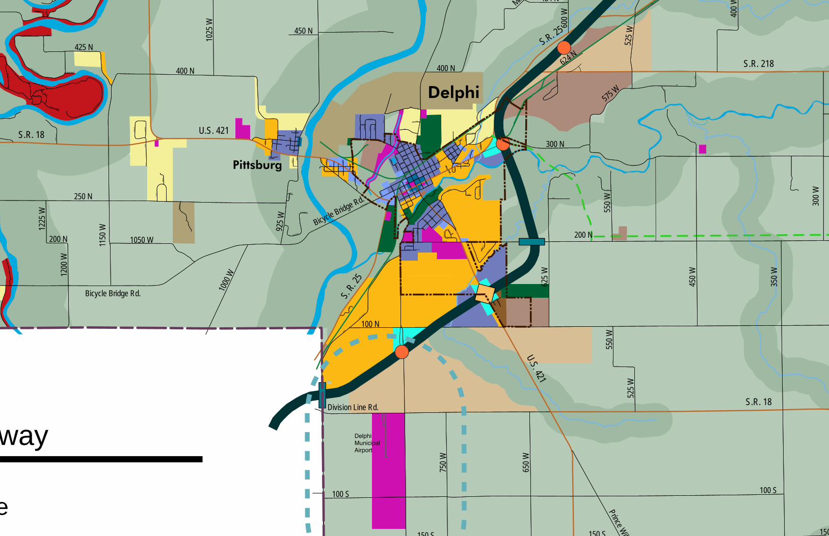
Delphi Municipal Airport
Delphi
Pittsburg
260 N
468 N
450 W
375 N
475 W
Ande
rson D
r.
252 N
Crestwoo
d Dr.
Commercial Dr.
Camden Rd.
900 W
900 W
800 W
Water St.
Monroe St.
Ohio St.
Indiana St.
Illinois St.
Illinois St.
Third
St.
Walnut St.
Vine St.
Columbia St.
Prince William Rd.
Hami
lton S
t.
Hamilton St.
North St.
Bicycle Bridge Rd.
Franklin St.South Rd.
Tenth
St.
Wabash St.
Front St.
Cook St.
Garfield Rd.
Riley Park
Dr.
Market St.
Maso
nic S
t.
Summit S
t.
Tally Ho Dr. Tally Ho Ct.
Deer Mead
ows R
d.
Deer mead
ows R
d.
132 N
Wilson St.
Bicycle Bluffs Ln.
Sue L
n.
Shirl Ct.
905 W
Mill St.
Sixth
St.
Polk St.
Howard St.
Madison St.
Patty Ln.
Diana St.
Bowen Dr.
Clyde St.Bowen Ct.
Mill D
r.
Lafayette St.
Connelly St.
Bicycle Bluff Dr.
Eigh
th St
.
Seve
nth S
t.
Cottage St.
Rhinehart St.
Union St.
Riley Rd.
Wabash St.Market St.
Terrace Ln.
Armory Rd.
Heritage Dr.Herita
ge N
W
300 N
Main St.
Four
th St
.
Washington St.Union St.
Monroe St.
Harrison St.
Elizabeth St.
Adams St.
100 N
Columbia St.
Frank
lin St.
South Rd.
Pearl St.
Heritage NE
310 N
930 W
930 W
285 N
290 N
Ninth
St.
Clay St.
Howard St.Stoney Creek Rd.
High St.
Dodge St.
Fifth
St.
Pack
ett Av
e.
Crest Dr.
Whitem
an D
r.
Deer
Cree
k Dr.
300 N
700 W
Main St
.Washington St.
Riley
Mea
dow
Dr.
325 N
Brew
er A
ve.
Kerlin
Ave
.
Dreif
ers A
ve.
Smith Ave.
Ruffin
g Ave
.
Well
s St.
Belt Line Ave.
Char
les S
t.
358 N
Robin
son S
t.
Chamber Estates Dr.
Arno
ld St
.
Alco Way
Bradford Dr.
1132
W
Tippecanoe Ranch Rd.
Lakeside Cabin Rd.
Grav
el Pi
t Rd.
Troy
Ave
.
Misty
Ln.
Char
lais C
ir
Tippecanoe Ranch Rd. Ranch Ln.
Tecum
seh Bend
Rd.
estrian Rd.
Archery Rd.
Sharon Chapel Rd.
Lane Rd.
Main Camp Loop
Oregon Rd.
Stables Rd.
1215
W
Jerse
y Dr
925 W
310 N
935 W
910 W
905 W
320 N
330 N
Horseshoe Ln. 1217
W
350 W
150
300 W
200 N
300 N
1025
W
1225
W
600 W
1150
W
625 W
525 W450 N
Mil
450 W
575 W
100 N
550 W
550 W
Bicycle Bridge Rd.
400 N
250 N
624 N
200 N
1000
W1050 W
1200
W
400 W
484 N
400 N
650 W
525 W
Division Line Rd.
750 W
425 N
Bicycle Bridge Rd.
925 W
150 S 150 S
100 S 100 S
Prince Will
S.R. 218
S.R. 18 U.S. 421
U.S. 421
S.R. 18
S. R. 2
5
S.R. 25
way
e
Miriam Robeson
Typewritten Text
Delphi Land Use Map
Incorporated Towns: Burlington, Camden, Yeoman
CARROLL COUNTY COMPREHENSIVE PLAN 53
Introduction The Carroll County Area Plan Commission also serves the incorporated towns of Burlington, Camden, and Yeoman. The populations of these areas range from 130 to 582 persons.
Residents of these towns are proud of the friendliness and civic-mindedness of their individual communities. Each town would like to see growth managed wisely by encouraging diversity in local employment opportunities (retail, light industrial and higher paying positions), improving infrastructure, and providing better opportunities (employment, housing, and “quality of life”) for their youth. Generally, new development that occurs in these communities should be consistent, in scale and character, with the rest of the community.
Burlington The Town of Burlington is located in the east central part of Burlington Township approximately one mile west of the Howard County line. Although the region was originally a rich, rolling and dense forest that made settlement challenging, there were a few hardy settlers, including families, in the area as early as 1827. In 1828 an employee of the Government Land Office at Crawfordsville laid out 92 lots running immediately south of Wildcat Creek.
In the early 1830’s settlers established the first grist mill, began clearing timber and opened shops, including the first taverns, and setting the stage for a period of active and prosperous growth. This growth included construction of the Michigan Road in the early to mid-1830’s, which ran through the middle of the town. The Michigan Road was a great thoroughfare between Madison on the Ohio River and Michigan City to the north. The sale of lands along the route helped finance its development and the route proved to provide a primary means of travel and settlement throughout the middle region of the state of Indiana.
By the late 1830’s, the town of Burlington had its first general merchandise store and resident doctor. Between the late 1840’s and late 1850’s the town’s enterprises had expanded to include a brick kiln, saw mill, hotel, and postal operation. Into the 1870’s the town had a flour mill, high production saw and planning mill, and a blacksmith shop that, in the early 1880’s, produced a substantial number of buggies, carriages and spring wagons.
By 1882, the town had a hotel, three general merchandise stores, one drug store, a meat market, several resident physicians, carpenters, a barber/jeweler, saddlers and harness makers, furniture dealer/undertaker, a tinner/hardware dealer, blacksmiths, a wagon maker, boot and shoe makers.
Today, the town is centered about the junction of State Route 29 which extends north to Logansport and State Route 22 which provides access to Kokomo (about 15 miles to the east). In recent years, growth in Burlington has been related to its close proximity to and development as a bedroom community to the larger city of Kokomo.
One of the strengths noted by residents of Burlington is the community of caring, committed, and friendly people who live there and the safe environment that this creates.
Camden The Town of Camden is located in Jackson Township. State Route 218 extends east and west through Camden, State Route 75 junctions with State Route 218 in the town and runs south through the county. Camden occupies a section of the “school section” of Jackson Township. The Indiana Congress set aside the sixteenth section of every township as property of the schools and the care of the section was entrusted to the school commissioner. The commissioner was empowered to sell land within the section and use the funds to support the school. In the early 1830’s the commissioner sold the area that became Camden to establish a village.
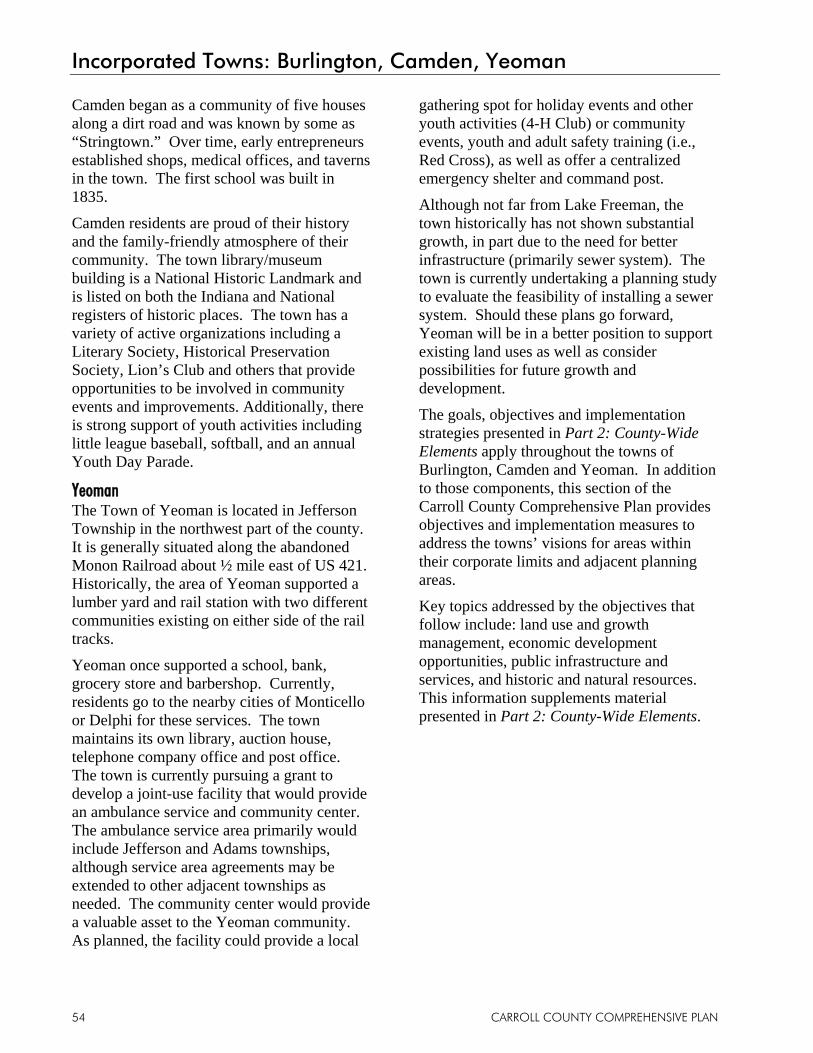
Incorporated Towns: Burlington, Camden, Yeoman
CARROLL COUNTY COMPREHENSIVE PLAN 54
Camden began as a community of five houses along a dirt road and was known by some as “Stringtown.” Over time, early entrepreneurs established shops, medical offices, and taverns in the town. The first school was built in 1835.
Camden residents are proud of their history and the family-friendly atmosphere of their community. The town library/museum building is a National Historic Landmark and is listed on both the Indiana and National registers of historic places. The town has a variety of active organizations including a Literary Society, Historical Preservation Society, Lion’s Club and others that provide opportunities to be involved in community events and improvements. Additionally, there is strong support of youth activities including little league baseball, softball, and an annual Youth Day Parade.
Yeoman The Town of Yeoman is located in Jefferson Township in the northwest part of the county. It is generally situated along the abandoned Monon Railroad about ½ mile east of US 421. Historically, the area of Yeoman supported a lumber yard and rail station with two different communities existing on either side of the rail tracks.
Yeoman once supported a school, bank, grocery store and barbershop. Currently, residents go to the nearby cities of Monticello or Delphi for these services. The town maintains its own library, auction house, telephone company office and post office. The town is currently pursuing a grant to develop a joint-use facility that would provide an ambulance service and community center. The ambulance service area primarily would include Jefferson and Adams townships, although service area agreements may be extended to other adjacent townships as needed. The community center would provide a valuable asset to the Yeoman community. As planned, the facility could provide a local
gathering spot for holiday events and other youth activities (4-H Club) or community events, youth and adult safety training (i.e., Red Cross), as well as offer a centralized emergency shelter and command post.
Although not far from Lake Freeman, the town historically has not shown substantial growth, in part due to the need for better infrastructure (primarily sewer system). The town is currently undertaking a planning study to evaluate the feasibility of installing a sewer system. Should these plans go forward, Yeoman will be in a better position to support existing land uses as well as consider possibilities for future growth and development.
The goals, objectives and implementation strategies presented in Part 2: County-Wide Elements apply throughout the towns of Burlington, Camden and Yeoman. In addition to those components, this section of the Carroll County Comprehensive Plan provides objectives and implementation measures to address the towns’ visions for areas within their corporate limits and adjacent planning areas.
Key topics addressed by the objectives that follow include: land use and growth management, economic development opportunities, public infrastructure and services, and historic and natural resources. This information supplements material presented in Part 2: County-Wide Elements.

Incorporated Towns: Burlington, Camden, Yeoman
CARROLL COUNTY COMPREHENSIVE PLAN 55
Incorporated Towns’ Objectives and Implementation Measures Objective 1: Preserve small town character and rural charm IM 1.1 Work with the County to update the
County Zoning and Subdivision Control ordinances to ensure development regulations that help preserve the small town character within these incorporated towns, including accommodation of mixed use developments.
IM 1.2 Consider preservation of prime agricultural land in decision-making for new development.
IM 1.3 Develop and implement an “unsafe building” ordinance to target abandoned and dilapidated structures.
IM 1.4 Limit strip housing developments along county roadways.
IM 1.5 Encourage high quality residential development that is consistent with each individual towns’ character.
Objective 2: Pursue opportunities for economic development that are consistent with the desired small town character IM 2.1 Promote development of local
businesses and retail districts.
IM 2.2 Encourage new growth in vacant or under-utilized pockets within and around the existing developed town (infill development).
IM 2.3 Encourage development of historic or agricultural–based tourist attractions, businesses and services.
IM 2.4 Increase advertising of existing
festivals and events to expand tourism-based income, including the Burlington Festival, Camden Festival, and Camden Tractor Pull.
IM 2.5 Utilize public/private partnerships to accomplish economic development projects.
Objective 3: Maintain and improve infrastructure and public services IM 3.1 Conduct an inventory of existing road
conditions, determine needs for upgrades and repairs, and develop a prioritized list and implementation strategy for each town.
IM 3.2 Improve and upgrade infrastructure to provide safe and adequate service to the communities (water, sewer, storm drainage systems), including system improvements or expansions to serve new growth and development.
Objective 4: Protect historic and natural resources IM 4.1 Protect and preserve existing historic
resources.
IM 4.2 Promote development that avoids the flood plains and use these areas for recreation purposes and to provide green space and open space.
IM 4.3 Continue to assess and improve local park and recreation facilities.
Note: Future land use maps for the incorporated towns of Burlington, Camden and Yeoman to be added in Adoption Draft.

Rockfield
Camden
Wate
r St.
Main St.
450 N
450 N
Washington St.
Cumberland St.
Cemetery St.
Sand
erso
n St.
Union
St.
Chur
ch S
t.
Monr
oe S
t. James St.
Arms
trong
Av
e. Ohio
St.
Indian
a St.
Illino
is St
.
Lee S
t.
East Rock
field R
d.
250 W
285 W
280 W
255 W
645 N
630 N
270 W
265 W
635 N
655 N640 N
260 W
750 N
825 N
75 W600 N
650 N
350 W 100 W
50 W
150 W
550 N
250 W
200 W
275 W
150 E
225 W
500 N
450 N
47
800 N
750 N
100 E
300 E
700 N
600 N
25 W
550 N
50 E
225 E
500 N
650 N
225 W
18
Miriam Robeson
Typewritten Text
Camden Land Use Map
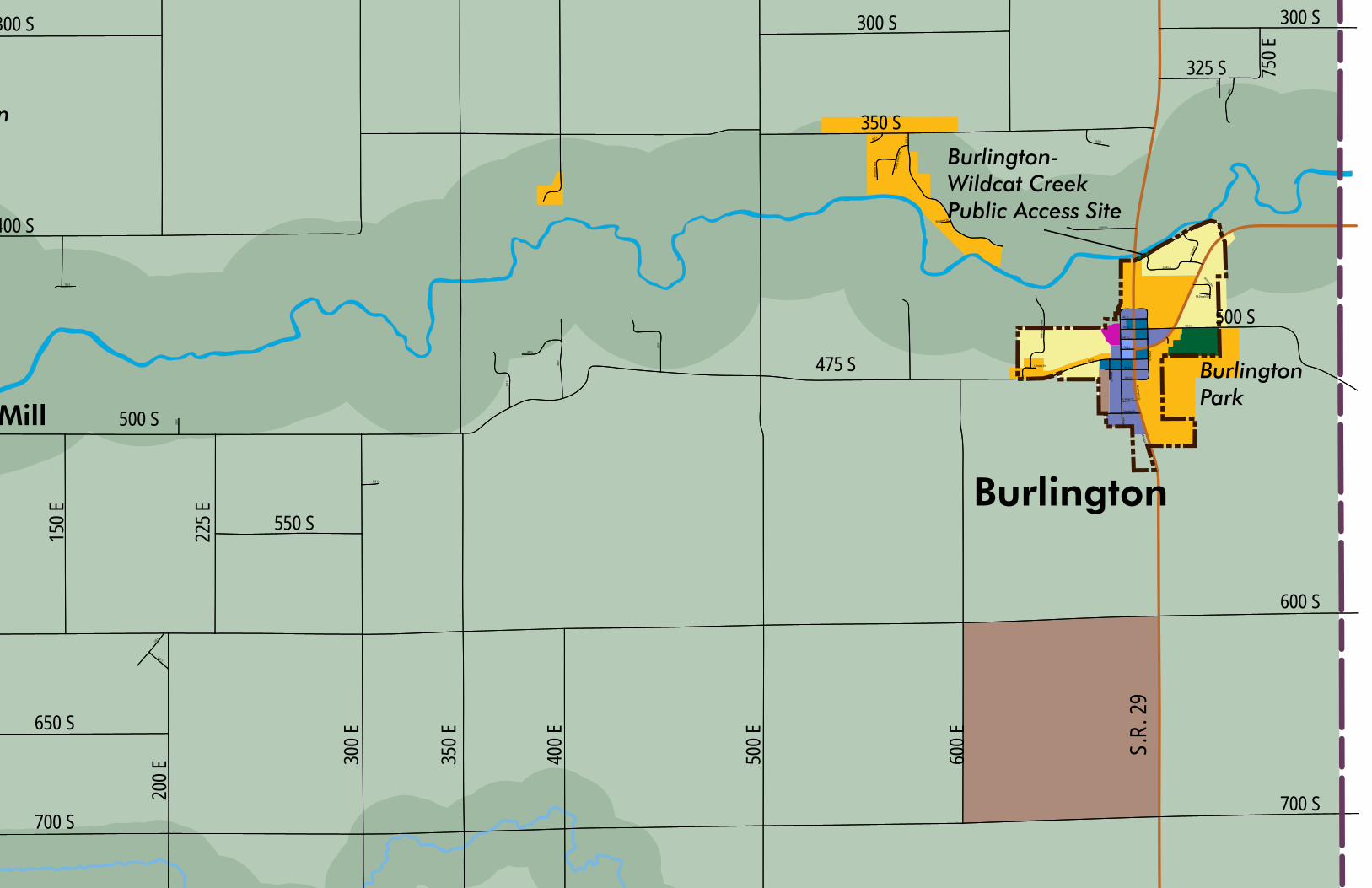
n
BurlingtonPark
Burlington-Wildcat Creek Public Access Site
Burlington
Mill
Lakview Dr.
575 E
Washington St.
Indiana St.
Jackson St.
8th St.
7th St.
Wild
cat R
iver W
ay
9th St.
10th St.
6th St.
4th St.
5th St.5th St.
Westview Dr.
Valle
y View
Poin
t
Woo
dland
Way
562 E
College St.
Stockton St.
Michigan St.Arvin Dr.
Mill Rd.
Loyd
Ave.
Zook Ln.
Richard Ave.
730 E
740 E
675 E
McDonald Dr.
Prather St.
208 E
150 E
400 E
375 E
480 S
450 E
525 S
190 E
620 S
500 S
150 E
400 S
300 S
700 S
300 E
225 E
400 E
500 E
350 E
550 S
650 S
600 S
475 S
600 E
700 S
300 S300 S
350 S
325 S 750 E
200 E
500 S
S.R.
29
Miriam Robeson
Typewritten Text
Burlington Land Use Map
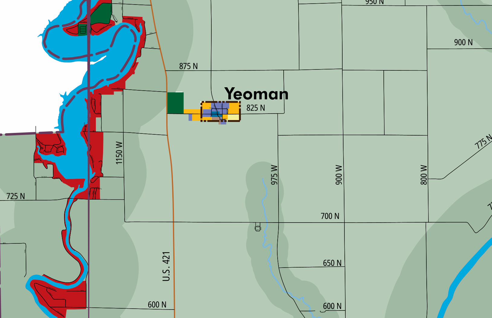
Yeoman
Railroad Av.e.
Gosle
e St.
Forest St.
Parso
nage
St.
South St.
Baum
St.
690 N
990 W
680 N 980 W
900 N
1175
W
1150
W
1132
W
850 N
Home
rs Dr
.
Calve
rts D
r.
820 N
Fraz
oer B
each
Rd.
800 N
750 N
1175
W
775 N
Sandy Beach Dr.
1250
W
Twin Pine Dr.
Poplar Hills Dr.
Crest Dr.
Hambridge Dr.
Upper Hambridge
1190
W
Oakdale Dr.
1180
W
Grantham Ln.
1185
W
Cedar Dr.
Cedar Circle Dr.
Bridg
e Dr.
1150
W
950 N
1128
W
916 N
Paradise Beach Dr.
Paradise Rd.
Pirates
Roost R
d.
Lazy Ln.
Whit
e Oak
s Dr.
Key D
r. Whiteview Dr.
Reunion Point Rd.
1200
W
680 N
CD R
d.
625 N
Sleepy Hollow Rd.
Sleepy Hollow Rd.
Hodges Dr.
900 N
975 W
900 W
800 W
950 N
875 N
825 N
775 N
72
1150
W
725 N
700 N
600 N
650 N
600 N
U.S.
421
Miriam Robeson
Typewritten Text
Yeoman Land Use Map
Part 4
Conclusion
Conclusion
CARROLL COUNTY COMPREHENSIVE PLAN 58
Implementation Strategy An important part of a successful Comprehensive Plan is a plan for its implementation. While it is an enormous accomplishment for Carroll County to prepare the Carroll County Comprehensive Plan, the real work is still to come.
The intent of a Comprehensive Plan is to provide a framework for implementation, but not the exact courses of action. To determine the exact action steps, the County leadership should prepare an implementation strategy to complement the Carroll County Comprehensive Plan. The implementation strategy should focus on achieving a realistic number of projects, programs or policies listed throughout the Comprehensive Plan.
More specifically, the implementation strategy should outline the most important implementation measures that need to be completed and then devise the means to accomplish them. The strategy should address the priorities for the next two years, and then be reviewed and updated every year. The implementation strategy will likely only need to be three to eight pages in length to explain:
• The priority implementation measures to be accomplished in the next two years;
• A timeframe for each project’s estimated start and completion date;
• Who, what group, or which staff will be responsible for the implementation; and
• What funding or staff resources will be necessary to complete each activity or project.
The Comprehensive Plan The Comprehensive Plan cannot be viewed as a static “set in stone” series of unalterable ideas and projects. To be effective, it must be reviewed, evaluated, and when necessary, updated to reflect changing trends, outlooks and big picture thinking in the community. In doing so, the community can collectively plan
for the future in a proactive manner, thus capturing opportunities and avoiding potential pitfalls.
To achieve this result, the Carroll County Area Plan Commission will strive to annually review the Carroll County Comprehensive Plan. This review should denote what has been accomplished and identify necessary minor amendments. Through this process the Area Plan Commission should become more familiar with the plan and its content.
The Carroll County Plan Commission shall comprehensively review the Carroll County Comprehensive Plan every five (5) years. This review should include public workshops, interest group interviews, and full scrutiny of the content and maps. A five-year revision schedule is the most cost effective means to maintain the Comprehensive Plan and will result in greater appreciation for community planning. It will also result in a well-planned community.
Appendix A
Demographics

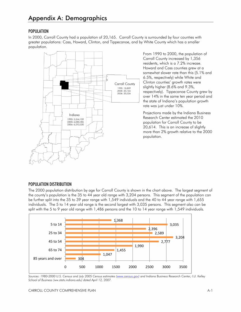
Appendix A: Demographics
CARROLL COUNTY COMPREHENSIVE PLAN A-1
POPULATION In 2000, Carroll County had a population of 20,165. Carroll County is surrounded by four counties with greater populations: Cass, Howard, Clinton, and Tippecanoe, and by White County which has a smaller population.
From 1990 to 2000, the population of Carroll County increased by 1,356 residents, which is a 7.2% increase. Howard and Cass counties grew at a somewhat slower rate than this (5.1% and 6.5%, respectively) while White and Clinton counties’ growth rates were slightly higher (8.6% and 9.3%, respectively). Tippecanoe County grew by over 14% in the same ten year period and the state of Indiana’s population growth rate was just under 10%.
Projections made by the Indiana Business Research Center estimated the 2010 population for Carroll County to be 20,614. This is an increase of slightly more than 2% growth relative to the 2000 population.
POPULATION DISTRIBUTION The 2000 population distribution by age for Carroll County is shown in the chart above. The largest segment of the county’s population is the 35 to 44 year old range with 3,204 persons. This segment of the population can be further split into the 35 to 39 year range with 1,549 individuals and the 40 to 44 year range with 1,655 individuals. The 5 to 14 year old range is the second largest with 3,035 persons. This segment also can be split with the 5 to 9 year old range with 1,486 persons and the 10 to 14 year range with 1,549 individuals.
Sources: 1980-2000 U.S. Census and July 2005 Census estimates (www.census.gov) and Indiana Business Research Center, I.U. Kelley School of Business (ww.stats.indiana.edu) dated April 12, 2007.
3041,047
1,4551,990
2,7773,204
2,5892,396
3,0351,368
0 500 1000 1500 2000 2500 3000 3500
85 years and over
65 to 74
45 to 54
25 to 34
5 to 14
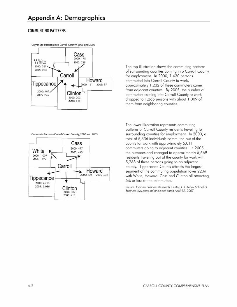
Appendix A: Demographics
A-2 CARROLL COUNTY COMPREHENSIVE PLAN
COMMUNTING PATTERNS
The top illustration shows the commuting patterns of surrounding counties coming into Carroll County for employment. In 2000, 1,430 persons commuted into Carroll County to work, approximately 1,232 of these commuters came from adjacent counties. By 2005, the number of commuters coming into Carroll County to work dropped to 1,265 persons with about 1,009 of them from neighboring counties.
The lower illustration represents commuting patterns of Carroll County residents traveling to surrounding counties for employment. In 2000, a total of 5,336 individuals commuted out of the county for work with approximately 5,011 commuters going to adjacent counties. In 2005, the numbers had changed to approximately 5,669 residents traveling out of the county for work with 5,263 of these persons going to an adjacent county. Tippecanoe County attracts the largest segment of the commuting population (over 22%) with White, Howard, Cass and Clinton all attracting 5% or less of the commuters.
Source: Indiana Business Research Center, I.U. Kelley School of Business (ww.stats.indiana.edu) dated April 12, 2007.
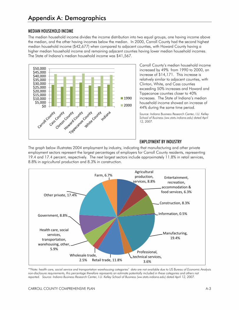
Appendix A: Demographics
CARROLL COUNTY COMPREHENSIVE PLAN A-3
MEDIAN HOUSEHOLD INCOME The median household income divides the income distribution into two equal groups, one having income above the median, and the other having incomes below the median. In 2000, Carroll County had the second highest median household income ($42,677) when compared to adjacent counties, with Howard County having a higher median household income and remaining adjacent counties having lower median household incomes. The State of Indiana’s median household income was $41,567.
Carroll County’s median household income increased by 49% from 1990 to 2000, an increase of $14,171. This increase is relatively similar to adjacent counties, with Clinton, White, and Cass counties exceeding 50% increases and Howard and Tippecanoe counties closer to 40% increases. The State of Indiana’s median household income showed an increase of 44% during the same time period.
Source: Indiana Business Research Center, I.U. Kelley School of Business (ww.stats.indiana.edu) dated April 12, 2007.
EMPLOYMENT BY INDUSTRY The graph below illustrates 2004 employment by industry, indicating that manufacturing and other private employment sectors represent the largest percentages of employers for Carroll County residents, representing 19.4 and 17.4 percent, respectively. The next largest sectors include approximately 11.8% in retail services, 8.8% in agricultural production and 8.3% in construction.
**Note: health care, social service and transportation warehousing categories’ data are not available due to US Bureau of Economic Analysis non-disclosure requirements, this percentage therefore represents an estimate potentially included in these categories and others not reported. Source: Indiana Business Research Center, I.U. Kelley School of Business (ww.stats.indiana.edu) dated April 12, 2007.
Agricultural production, services, 8.8%
Entertainment, recreation,
accommodation & food services, 6.3%
Construction, 8.3%
Information, 0.5%
Manufacturing, 19.4%
Professional, technical services,
3.6%Retail trade, 11.8%Wholesale trade,
2.5%
Health care, social services,
transportation, warehousing, other,
5.9%
Government, 8.8%
Other private, 17.4%
Farm, 6.7%
$0$5,000
$10,000$15,000$20,000$25,000$30,000$35,000$40,000$45,000$50,000
1990
2000
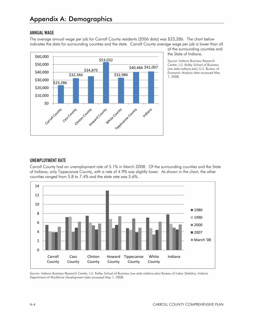
Appendix A: Demographics
A-4 CARROLL COUNTY COMPREHENSIVE PLAN
ANNUAL WAGE The average annual wage per job for Carroll County residents (2006 data) was $23,286. The chart below indicates the data for surrounding counties and the state. Carroll County average wage per job is lower than all
of the surrounding counties and the State of Indiana.
Source: Indiana Business Research Center, I.U. Kelley School of Business (ww.stats.indiana.edu) U.S. Bureau of Economic Analysis data accessed May 1, 2008.
UNEMPLOYMENT RATE Carroll County had an unemployment rate of 5.1% in March 2008. Of the surrounding counties and the State of Indiana, only Tippecanoe County, with a rate of 4.9% was slightly lower. As shown in the chart, the other counties ranged from 5.8 to 7.4% and the state rate was 5.6%.
Source: Indiana Business Research Center, I.U. Kelley School of Business (ww.stats.indiana.edu) Bureau of Labor Statistics, Indiana Department of Workforce Development data accessed May 1, 2008.
0
2
4
6
8
10
12
14
Carroll County
Cass County
Clinton County
Howard County
Tippecanoe County
White County
Indiana
1980
1990
2000
2007
March '08
$23,286
$32,366 $34,875
$53,032
$32,986
$40,466 $41,007
$0
$10,000
$20,000
$30,000
$40,000
$50,000
$60,000
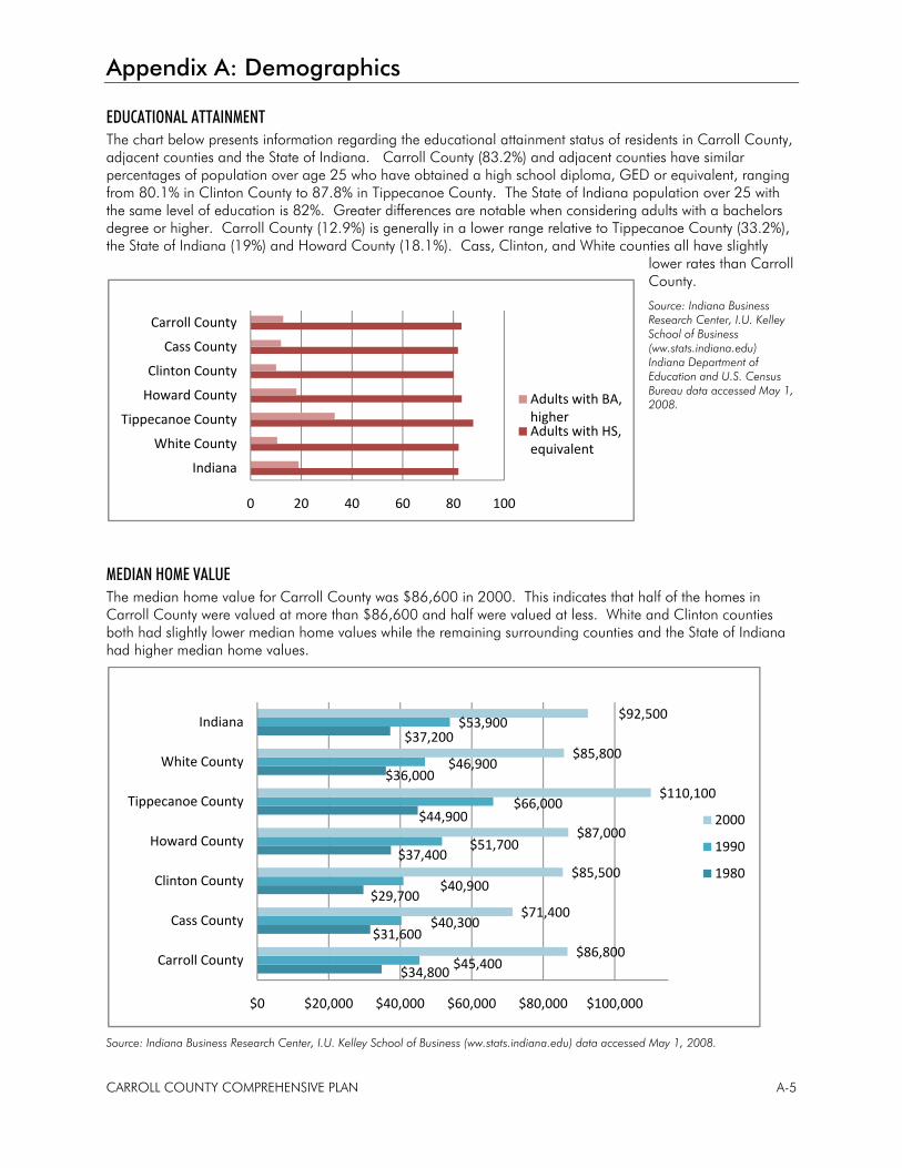
Appendix A: Demographics
CARROLL COUNTY COMPREHENSIVE PLAN A-5
EDUCATIONAL ATTAINMENT The chart below presents information regarding the educational attainment status of residents in Carroll County, adjacent counties and the State of Indiana. Carroll County (83.2%) and adjacent counties have similar percentages of population over age 25 who have obtained a high school diploma, GED or equivalent, ranging from 80.1% in Clinton County to 87.8% in Tippecanoe County. The State of Indiana population over 25 with the same level of education is 82%. Greater differences are notable when considering adults with a bachelors degree or higher. Carroll County (12.9%) is generally in a lower range relative to Tippecanoe County (33.2%), the State of Indiana (19%) and Howard County (18.1%). Cass, Clinton, and White counties all have slightly
lower rates than Carroll County.
Source: Indiana Business Research Center, I.U. Kelley School of Business (ww.stats.indiana.edu) Indiana Department of Education and U.S. Census Bureau data accessed May 1, 2008.
MEDIAN HOME VALUE The median home value for Carroll County was $86,600 in 2000. This indicates that half of the homes in Carroll County were valued at more than $86,600 and half were valued at less. White and Clinton counties both had slightly lower median home values while the remaining surrounding counties and the State of Indiana had higher median home values.
Source: Indiana Business Research Center, I.U. Kelley School of Business (ww.stats.indiana.edu) data accessed May 1, 2008.
$34,800
$31,600
$29,700
$37,400
$44,900
$36,000
$37,200
$45,400
$40,300
$40,900
$51,700
$66,000
$46,900
$53,900
$86,800
$71,400
$85,500
$87,000
$110,100
$85,800
$92,500
$0 $20,000 $40,000 $60,000 $80,000 $100,000
Carroll County
Cass County
Clinton County
Howard County
Tippecanoe County
White County
Indiana
2000
1990
1980
0 20 40 60 80 100
Indiana
White County
Tippecanoe County
Howard County
Clinton County
Cass County
Carroll County
Adults with BA, higherAdults with HS, equivalent

Appendix B
Public Participation

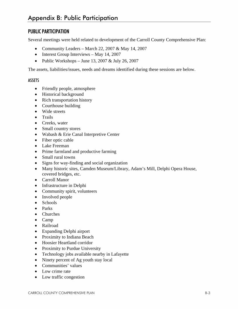
Appendix B: Public Participation
CARROLL COUNTY COMPREHENSIVE PLAN B-3
PUBLIC PARTICIPATION Several meetings were held related to development of the Carroll County Comprehensive Plan:
• Community Leaders – March 22, 2007 & May 14, 2007 • Interest Group Interviews – May 14, 2007 • Public Workshops – June 13, 2007 & July 26, 2007
The assets, liabilities/issues, needs and dreams identified during these sessions are below.
ASSETS
• Friendly people, atmosphere • Historical background • Rich transportation history • Courthouse building • Wide streets • Trails • Creeks, water • Small country stores • Wabash & Erie Canal Interpretive Center • Fiber optic cable • Lake Freeman • Prime farmland and productive farming • Small rural towns • Signs for way-finding and social organization • Many historic sites, Camden Museum/Library, Adam’s Mill, Delphi Opera House,
covered bridges, etc. • Carroll Manor • Infrastructure in Delphi • Community spirit, volunteers • Involved people • Schools • Parks • Churches • Camp • Railroad • Expanding Delphi airport • Proximity to Indiana Beach • Hoosier Heartland corridor • Proximity to Purdue University • Technology jobs available nearby in Lafayette • Ninety percent of Ag youth stay local • Communities’ values • Low crime rate • Low traffic congestion
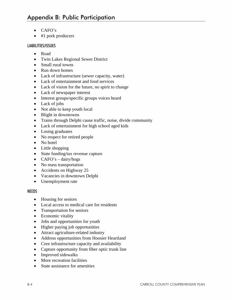
Appendix B: Public Participation
B-4 CARROLL COUNTY COMPREHENSIVE PLAN
• CAFO’s • #1 pork producers
LIABILITIES/ISSUES
• Road • Twin Lakes Regional Sewer District • Small rural towns • Run down homes • Lack of infrastructure (sewer capacity, water) • Lack of entertainment and food services • Lack of vision for the future, no spirit to change • Lack of newspaper interest • Interest groups/specific groups voices heard • Lack of jobs • Not able to keep youth local • Blight in downtowns • Trains through Delphi cause traffic, noise, divide community • Lack of entertainment for high school aged kids • Losing graduates • No respect for retired people • No hotel • Little shopping • State funding/tax revenue capture • CAFO’s – dairy/hogs • No mass transportation • Accidents on Highway 25 • Vacancies in downtown Delphi • Unemployment rate
NEEDS
• Housing for seniors • Local access to medical care for residents • Transportation for seniors • Economic vitality • Jobs and opportunities for youth • Higher paying job opportunities • Attract agriculture-related industry • Address opportunities from Hoosier Heartland • Core infrastructure capacity and availability • Capture opportunity from fiber optic trunk line • Improved sidewalks • More recreation facilities • State assistance for amenities
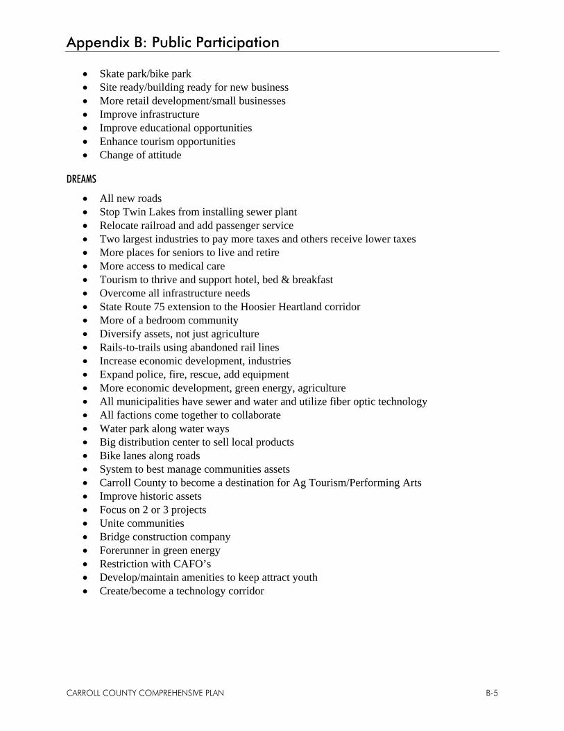
Appendix B: Public Participation
CARROLL COUNTY COMPREHENSIVE PLAN B-5
• Skate park/bike park • Site ready/building ready for new business • More retail development/small businesses • Improve infrastructure • Improve educational opportunities • Enhance tourism opportunities • Change of attitude
DREAMS
• All new roads • Stop Twin Lakes from installing sewer plant • Relocate railroad and add passenger service • Two largest industries to pay more taxes and others receive lower taxes • More places for seniors to live and retire • More access to medical care • Tourism to thrive and support hotel, bed & breakfast • Overcome all infrastructure needs • State Route 75 extension to the Hoosier Heartland corridor • More of a bedroom community • Diversify assets, not just agriculture • Rails-to-trails using abandoned rail lines • Increase economic development, industries • Expand police, fire, rescue, add equipment • More economic development, green energy, agriculture • All municipalities have sewer and water and utilize fiber optic technology • All factions come together to collaborate • Water park along water ways • Big distribution center to sell local products • Bike lanes along roads • System to best manage communities assets • Carroll County to become a destination for Ag Tourism/Performing Arts • Improve historic assets • Focus on 2 or 3 projects • Unite communities • Bridge construction company • Forerunner in green energy • Restriction with CAFO’s • Develop/maintain amenities to keep attract youth • Create/become a technology corridor
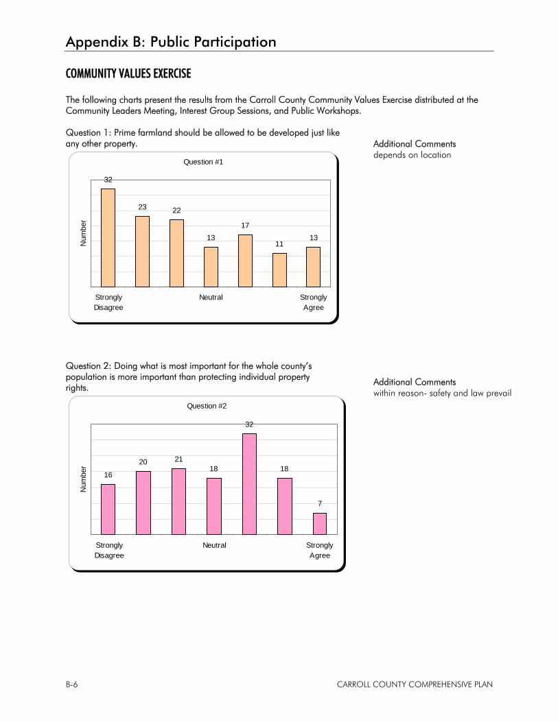
Appendix B: Public Participation
B-6 CARROLL COUNTY COMPREHENSIVE PLAN
COMMUNITY VALUES EXERCISE
The following charts present the results from the Carroll County Community Values Exercise distributed at the Community Leaders Meeting, Interest Group Sessions, and Public Workshops.
Question 1: Prime farmland should be allowed to be developed just like any other property.
Question #1
32
23 22
1317
1113
StronglyDisagree
Neutral StronglyAgree
Num
ber
Question 2: Doing what is most important for the whole county’s population is more important than protecting individual property rights.
Question #2
16
20 2118
32
18
7
StronglyDisagree
Neutral StronglyAgree
Num
ber
Additional Comments depends on location
Additional Comments within reason- safety and law prevail
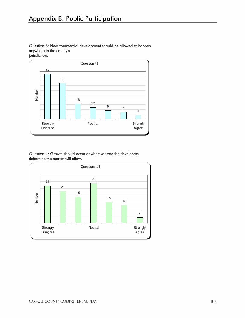
Appendix B: Public Participation
CARROLL COUNTY COMPREHENSIVE PLAN B-7
Question 3: New commercial development should be allowed to happen anywhere in the county’s jurisdiction.
Question #3
47
38
1612
9 74
StronglyDisagree
Neutral StronglyAgree
Num
ber
Question 4: Growth should occur at whatever rate the developers determine the market will allow.
Questions #4
2723
19
29
1513
4
StronglyDisagree
Neutral StronglyAgree
Num
ber
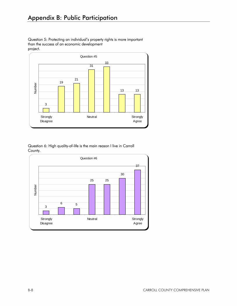
Appendix B: Public Participation
B-8 CARROLL COUNTY COMPREHENSIVE PLAN
Question 5: Protecting an individual’s property rights is more important than the success of an economic development project.
Question #5
3
1921
3133
13 13
StronglyDisagree
Neutral StronglyAgree
Num
ber
Question 6: High quality-of-life is the main reason I live in Carroll County.
Question #6
36 5
25 25
30
37
StronglyDisagree
Neutral StronglyAgree
Num
ber
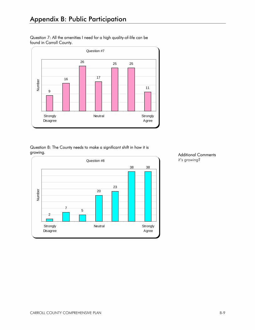
Appendix B: Public Participation
CARROLL COUNTY COMPREHENSIVE PLAN B-9
Question 7: All the amenities I need for a high quality-of-life can be found in Carroll County.
Question #7
9
16
26
17
25 25
11
StronglyDisagree
Neutral StronglyAgree
Num
ber
Question 8: The County needs to make a significant shift in how it is growing.
Question #8
2
75
2023
38 38
StronglyDisagree
Neutral StronglyAgree
Num
ber
Additional Comments it’s growing?
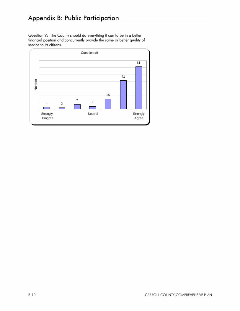
Appendix B: Public Participation
B-10 CARROLL COUNTY COMPREHENSIVE PLAN
Question 9: The County should do everything it can to be in a better financial position and concurrently provide the same or better quality of service to its citizens.
Question #9
3 27 4
15
41
61
StronglyDisagree
Neutral StronglyAgree
Num
ber
Appendix B: Public Participation
CARROLL COUNTY COMPREHENSIVE PLAN B-11
COMPREHENSIVE PLAN INPUT
Question 1: I hope the Comprehensive Plan: • Provides a clear vision for the County’s next 10 years (65) • Addresses the Hoosier Heartland Industrial Corridor impacts (55) • Identifies economic development opportunities (46) • Helps to identify ways to attract or retain our younger generations (42) • Helps the County protect farming and agricultural practices (31) • Addresses rural growth and development (27) • Provides strategies to improve quality of life (21) • Improves Plan Commission and Board of Zoning Appeals decisions (19) • Provides a strong foundation for zoning and subdivision regulations (15) • Help identify County road improvements (13)
Question 2: Knowing the County and municipalities in the County have limited resources, the priorities should be…
#1 Priority #2 Priority #3 Priority
16 9 8 Transportation improvements
9 7 2 Cleaning up our surface water resources (streams, lakes, etc.)
28 29 14 Attracting jobs into the county
3 7 3 Building/providing amenities that improve quality of life
0 0 3 Improving the airport
21 25 21 Proactively encourage new and appropriate development
2 10 4 Workforce development
11 5 20 Preserving farmland
5 7 3 Public safety
0 1 1 Improving aesthetics
9 5 13 Improving the image and identity (branding) of the County
2 3 8 Installing rural wastewater systems (i.e. sewage treatment)
0 0 1 Installing rural water systems
1 0 0 Using wind, solar, biomass, local foods and energy – written in
1 0 0 Air quality, toxic farm chemicals – written in answer
0 0 1 Expanding infrastructure – written in answer
0 0 1 Keeps present jobs and businesses stronger – written in answer
0 1 0 Stop White County from using Carroll County creeks in the disposal of their waste – written in answer
Appendix B: Public Participation
B-12 CARROLL COUNTY COMPREHENSIVE PLAN
Question 3: What types of land uses are needed the most in Carroll County? • Light Industry (81) • Retail/Service Commercial (57) • Farmland (52) • Medium Value Homes (50) – range written in as $50,000 to $500,000 with an average of $162,000. • Entertainment Commercial (49) • Parks and Recreation (34) • Heavy Industry (33) • Open Space/Green Space (26) • Office Commercial (20) • Apartments/Condos/Townhomes (20) • High Value Homes (20) – range written in as $150,000 to $1,000,000 with an average of $362,000. • Trails (19) • Public Facilities/Institutions (16) • Low Value Homes (12) – range written in as $50,000 to 200,000 with an average of $93,000. • Horse Farms (2) • Preservation (1) – written in answer • Agricultural Industrial (1) – written in answer • Mixed Use (1) – written in answer

Appendix C
Town of Flora Future Land Use Map