Carmichael Coal Mine - Department of Environment and Science › __data › assets › pdf_file ›...
27
` Carmichael Coal Mine Advice on Groundwater Dependent Ecosystem Management Plan v11b to the Queensland Department of Environment and Science JUNE 2019
Transcript of Carmichael Coal Mine - Department of Environment and Science › __data › assets › pdf_file ›...

`
Carmichael Coal Mine Advice on Groundwater Dependent Ecosystem Management Plan v11b to the Queensland Department of Environment and Science
JUNE 2019

CSIRO
Australia is founding its future on science and innovation. Its national science agency, CSIRO, is a powerhouse of ideas, technologies
and skills for building prosperity, growth, health and sustainability. It serves governments, industries, business and communities across
the nation. For more information, visit http://www.csiro.au.
Geoscience Australia
Geoscience Australia is Australia’s national geoscience agency and exists to apply geoscience to Australia’s most important challenges.
Geoscience Australia provides geoscientific advice and information to the Australian Government to support current priorities. These
include contributing to responsible resource development; cleaner and low emission energy technologies; community safety; and
improving marine planning and protection. The outcome of Geoscience Australia’s work is an enhanced potential for the Australian
community to obtain economic, social and environmental benefits through the application of first-class research and information. For
more information, visit http://www.ga.gov.au.
Citation
CSIRO and Geoscience Australia (2019) Carmichael Coal Mine. Advice on Groundwater Dependent Ecosystem Management Plan
v11b to the Queensland Department of Environment and Science. CSIRO and Geoscience Australia, Australia.
Copyright
© 2019 Commonwealth Scientific and Industrial Research Organisation and Geoscience Australia. To the extent permitted by law, all
rights are reserved, and no part of this publication covered by copyright may be reproduced or copied in any form or by any means
except with the written permission of CSIRO and Geoscience Australia.
Disclaimer
CSIRO and Geoscience Australia advises that the information contained in this publication comprises general statements based on the
best available information at the time of publication. The reader is advised and needs to be aware that such information may be
incomplete or unable to be used in any specific situation. Therefore, decisions should not be made based solely on this information or
without seeking prior expert professional, scientific and technical advice. To the extent permitted by law, CSIRO and Geoscience
Australia (including their employees and consultants) exclude all liability to any person for any consequences, including but not limited to
all losses, damages, costs, expenses and any other compensation, arising directly or indirectly from using this publication (in part or in
whole) and any information or material contained in it.

Carmichael Coal Mine: Advice on Groundwater Dependent Ecosystem Management Plan (v11b) to the Queensland Department of Environment and Science
1
Executive Summary
The Queensland Department of Environment and Science (DES) requested the Commonwealth Scientific and Industrial Research Organisation (CSIRO) and Geoscience Australia (GA) to review the draft Groundwater Dependent Ecosystem Management Plan (GDEMP) submitted by Adani Pty Ltd for the Carmichael Coal Project in line with the environment authority (EA) approval conditions under the Queensland Environmental Protection Act 1994 (EPML01470513). In accordance with the DES request, advice was provided by CSIRO and GA to DES in November 2018 and February 2019.
The sole purpose of this document is to respond to further questions that the DES posed to CSIRO and GA in relation to the Groundwater Dependent Ecosystem Management Plan (GDEMP v11b (track change versions v10 – v11 and v11a – 11b)).
This document comprises the scientific advice of CSIRO and GA in relation to the questions asked by DES. CSIRO and GA are not responsible for the regulatory consideration or approval (or otherwise) of the GDEMP.
The questions asked by DES related to two aspects of the GDEMP:
1 Advice regarding the source aquifer(s) of the Doongmabulla Springs Complex (DSC)
1. Does the summary (see Introduction Section below) accurately reflect the CSIRO/GA advice with respect to further work that could increase certainty of the source aquifer(s) for the DSC?
Response: Yes, the Summary (see Introduction Section below) is an accurate summary of advice provided by CSIRO and GA in November 2018 and February 2019 to the Commonwealth Department of the Environment and Energy, and advice to DES in the meeting of 16 April 2019. CSIRO/GA note that hydrogeochemical analysis, including isotope and ageing tracers, of samples from different spring groups within each spring complex may improve understanding of the source aquifers of the DSC.
2. Would CSIRO/GA recommend any additional measures?
Response: The following additional measures would be recommended:
• Implement measures identified in Lake Eyre Basin Springs Assessment project by the Queensland Herbarium relevant to the DSC (Fensham et al., 2017).
• Undertake hydrochemistry interpretation from surface and spring water samples to improve understanding of the hydrogeology.
• Optimise the spatial distribution of monitoring bores, including nested or co-located bores intersecting different aquifer units, to enable improved future analysis of water level and hydrochemistry data.
3. Acquire drill cores at new monitoring locations to better understand the intact hydrostratigraphy being drilled through, to inform the conceptual model. Conduct tests on the core samples to assess and quantify hydraulic properties being implemented in the numerical model. Would it be appropriate from an adaptive management framework for all the above matters (a-f) to be undertaken over a set period i.e. prior to the model review (re-run)?

Carmichael Coal Mine: Advice on Groundwater Dependent Ecosystem Management Plan (v11b) to the Queensland Department of Environment and Science
2
Response: Adani have committed to “Conduct a review of the monitoring data … to update conceptualisations and conduct groundwater numerical model review …". "The model re-run is to occur 2 years after the commencement of the box cut and then every 5 years, the same review periods as the GMMP” (Commitment 15 in the GMMP).
• From a technical perspective, additional information to inform the numerical model revision will assist in refining its simulation and subsequently improve confidence in predictions. These measures should progressively improve the understanding of the spring source aquifers. While data collection could commence immediately, data analysis and interpretation will take time. Some of the proposed methods have significant lead times. Indicative timeframes for sample analyses range from up to 3 months for bulk hydrochemistry and up to 2 years for core drilling and analysis.
2. Advice regarding acceptable levels of uncertainty for groundwater research and modelling, groundwater drawdown trigger thresholds and adaptive management measures in the updated GDEMP.
4. Generally, in respect to groundwater research and modelling, is it acceptable and/or common from a scientific basis to have some level of uncertainty? i.e. can source aquifer(s) ever be categorically determined or definitively identified? Can you have absolute certainty? Is there always some level of uncertainty?
Response: There is always some level of uncertainty in geological and groundwater conceptual and numerical models because it is not possible to have complete knowledge of the sub-surface. Measures can be taken to quantify the level of uncertainty. Decision makers can then make decisions on the basis of an acceptable level of uncertainty. However, this requires that stakeholders agree on what an acceptable level of uncertainty is, prior to commencing the simulations. This could include defining a threshold of acceptable change but also defining a threshold of acceptable probability of exceedance of that change (Turnadge et al., 2018).
5. Are the groundwater drawdown trigger thresholds proposed in the updated GDEMP 11b appropriate and suitable to ensure the long-term protection of the DSC in light of your advice that the numerical model is not fit for purpose?
Response: As the numerical model is not fit for purpose (see Section 4.1), it is possible that the groundwater drawdown trigger thresholds may be exceeded earlier than predicted based on the model results. Whether this is sufficient to ensure the long-term protection of the DSC depends on the corrective actions taken if these thresholds are exceeded.
6. For question 5, are the adaptive management measures and commitments in the updated GDEMP appropriate? If not, please provide suggestions to address this?
Response: The appropriateness of adaptive management measures and commitments are regulatory matters and beyond the scope for scientific advice. However, it should be noted that the efficacy of management measures is contingent on accounting for the time lag associated with natural systems and hydrogeological responses to stressors. Management measures need also account for the timeliness of the intended management activity. Address inconsistencies between the GDEMP and GMMP with regard to adaptive management measures and commitments.
Carmichael Coal Mine: Advice on Groundwater Dependent Ecosystem Management Plan (v11b) to the Queensland Department of Environment and Science
3
1 Introduction
On 20 May 2019, the Queensland Department of Environment and Science (DES) requested scientific advice from CSIRO and Geoscience Australia (GA) relating to parts of the draft Groundwater Dependent Ecosystem Management Plan (GDEMP v11b) which was submitted by Adani Pty Ltd for the Carmichael Coal Project in line with the environment authority (EA) approval conditions under Queensland’s Environmental Protection Act 1994 (EPML01470513). This scientific advice is in addition to advice to Department of the Environment and Energy (DoEE) by CSIRO and GA provided in November 2018 (CSIRO and Geoscience Australia, 2018), February 2019 (CSIRO and Geoscience Australia, 2019) and a meeting with DES on 16 April 2019.
The sole purpose of this document is to respond to questions that the DES posed to CSIRO and GA in relation to the Groundwater Dependent Ecosystem Management Plan (GDEMP v11b (track change versions v10 – v11 and v11a – 11b)).
This document comprises the scientific advice of CSIRO and GA in relation to the questions asked by DES. CSIRO and GA are not responsible for the regulatory consideration or approval (or otherwise) of the GDEMP. DES sought advice specifically on six questions:
1 Advice regarding the source aquifer(s) of the Doongmabulla Springs Complex (DSC)
Having regard to the 2019 Report, the 2018 advice, and our meeting of 16 April 2019, the department has the understanding that the following further research (steps) would improve the certainty about the source aquifer(s) of the DSC and other groundwater dependent ecosystems:
a) hydrogeochemical analysis of water samples for comparison within and across relevant aquifers (Clematis Sandstone, Dunda Beds and Rewan Formation);
b) incorporation of the use of isotope and ageing tracers in the above hydrogeochemical analysis;
c) a comprehensive review of groundwater level and quality data from relevant aquifers including data from new proposed nested bores in the vicinity of DSC;
d) detailed geological mapping including cores from bores drilled in the vicinity of DSC and facies modelling to better inform hydraulic connectivity within and across all aquifers;
e) incorporation of the airborne electro-magnetic modelling recently completed by Geoscience Australia (and available to Adani by June 2020); and
f) revision of the conceptual understanding of the source aquifer(s) for DSC and groundwater system based on information collected from the above for incorporation into the groundwater model review (re-run).
1. Does the above summary accurately reflect the CSIRO/GA advice with respect to further work that could increase certainty of the source aquifer(s) for the DSC?
2. Would CSIRO/GA recommend any additional measures?
3. Would it be appropriate from an adaptive management framework for all the above matters (a-f) to be undertaken over a set period i.e. prior to the model review (re-run)?

Carmichael Coal Mine: Advice on Groundwater Dependent Ecosystem Management Plan (v11b) to the Queensland Department of Environment and Science
4
Advice regarding the source aquifer(s) of the Doongmabulla Springs Complex (DSC) (Q1-3) is found in Section 2.
2. Advice regarding acceptable levels of uncertainty for groundwater research and modelling, groundwater drawdown trigger thresholds and adaptive management measures in the updated GDEMP.
4. Generally, in respect to groundwater research and modelling, is it acceptable and/or common to have some level of uncertainty? i.e. can source aquifer(s) ever be categorically determined or definitively identified? Can you have absolute certainty? Is there always some level of uncertainty?
5. Are the groundwater drawdown trigger thresholds proposed in the updated GDEMP 11b appropriate and suitable to ensure the long-term protection of the DSC in light of your advice that the numerical model is not fit for purpose?
6. For question 5, are the adaptive management measures and commitments in the updated GDEMP appropriate? If not, please provide suggestions to address this?
Section 3 addresses Q4 around uncertainty in groundwater research and modelling.
Section 4 addresses Q5 around appropriateness of groundwater drawdown trigger thresholds.
Section 5 addresses Q6 around additional adaptive management measures and commitments.
This advice reviews two versions of the draft Groundwater Dependent Ecosystem Management Plan (GDEMP) provided by Adani to Queensland DES:
• GDEMP track changes v10 to 11.pdf (GDEMP v11)
• GDEMP track changes v11a to 11b.pdf (GDEMP v11b)
Additional information, including studies undertaken since the Commonwealth approval (April 2019) were used to cross-check information that was not reported in the draft GDEMP.
Groundwater Management and Monitoring Program (GMMP):
• GMMP_CCP_07032019_V7toV8_DES_29052019_Ver01_clean.pdf (GMMP v8) - we assume that appendices were unchanged between GMMP v7 and v8 (GMMP_CCP_V7_Master_final.pdf)
EA Permit:
• 201901031_EPML01470513_Adani Mining Pty Ltd_Carmichael CoalMine.pdf
Research Study Report:
• Source Aquifer Doongmabulla Springs Complex Source Aquifer to Doongmabulla Springs_final_281129.pdf
CSIRO and GA Advice to the Department of the Environment and Energy:
• Carmichael Coal Mine: Advice on Groundwater Management and Monitoring and Groundwater Dependent Ecosystem Management plans to the Department of the Environment and Energy. FEBRUARY 2019
• Carmichael Coal Mine: Advice on draft research plans to the Department of the Environment and Energy NOVEMBER 2018

Carmichael Coal Mine: Advice on Groundwater Dependent Ecosystem Management Plan (v11b) to the Queensland Department of Environment and Science
5
2 Source aquifer(s) of the Doongmabulla Springs Complex (DSC)
DES sought advice specifically on three questions regarding the source aquifer(s) of the Doongmabulla Springs Complex (DSC):
Having regard to the 2019 Report, the 2018 advice, and our meeting of 16 April 2019, the department has the understanding that the following further research (steps) would improve the certainty about the source aquifer(s) of the DSC and other groundwater dependent ecosystems:
a) hydrogeochemical analysis of water samples for comparison within and across relevant aquifers (Clematis Sandstone, Dunda Beds and Rewan Formation);
b) incorporation of the use of isotope and ageing tracers in the above hydrogeochemical analysis;
c) a comprehensive review of groundwater level and quality data from relevant aquifers including data from new proposed nested bores in the vicinity of DSC;
d) detailed geological mapping including cores from bores drilled in the vicinity of DSC and facies modelling to better inform hydraulic connectivity within and across all aquifers;
e) incorporation of the airborne electro-magnetic modelling recently completed by Geoscience Australia (and available to Adani by June 2020); and
f) revision of the conceptual understanding of the source aquifer(s) for DSC and groundwater system based on information collected from the above for incorporation into the groundwater model review (re-run).
Q1. Does the above summary accurately reflect the CSIRO/GA advice with respect to further work that could increase certainty of the source aquifer(s) for the DSC?
Yes, the above summary accounts for the advice provided by CSIRO and GA in November 2018 and in February 2019 to the Commonwealth Department of the Environment and Energy, as well as the meeting of 16 April 2019 between DES, DoEE, CSIRO and GA.
Recommendation: Additional clarification is needed on the following points:
Points a) and b): Hydrogeochemical analysis of samples from different spring groups within each spring complex may provide better understanding to discern the source aquifers of the DSC. The hydrogeochemical analyses include but are not limited to:
• Noble gases – for example helium to identify if any deeper groundwater contributes to the springs (identification of source aquifers)
• Radioactive noble gases – to identify source aquifers of recent (decades) to intermediate (centuries) age and
• Strontium isotopes – to identify the source rock of a particular groundwater system.
Point e): The Airborne Electro-Magnetic (AEM) survey data acquired by GA in the region is to be publicly available by June 2020. The proponent would need to undertake their own specific interpretation and analysis of the AEM data. This analysis should be conducted with consideration of other site-specific data the proponent may have and alternative conceptualisations to be tested to ensure the interpretation

Carmichael Coal Mine: Advice on Groundwater Dependent Ecosystem Management Plan (v11b) to the Queensland Department of Environment and Science
6
(inversion) derives appropriate conclusions regarding hydrogeology at the scale of investigation of interest for the proponent. If undertaken, the proponent’s AEM data investigation should articulate how the objectives of an AEM data analysis seek to improve hydrogeological knowledge to ensure the interpretation (inversion) yields desired outcomes.
Q2. Would CSIRO/GA recommend any additional measures?
Following the meeting [with DoEE, QDES, CSIRO and GA] on 16 April 2019, CSIRO/GA have considered other measures that could improve the certainty about the source aquifer(s) of the DSC and other groundwater dependent ecosystems.
This advice builds on previous measures identified by the Queensland Herbarium in 'Section 8.6 Key threats and management’ for the Doongmabulla Galilee Group of the Lake Eyre Basin Springs Assessment report concludes:
“Whether the springs with discharge character at Doongmabulla emanate from a Triassic or Permian aquifer is unresolved without further data. Drilling of new monitoring bores in the vicinity of the springs, and appropriate seismic survey are required. A high-resolution survey of spring elevations would also improve the accuracy of predictions relating to spring flows and the potentiometric surface of potential aquifers. Water chemistry data for the Doongmabulla Springs is stored in the data-base and could serve as a baseline to assess potential future impacts of mining on the groundwater quality of the springs.” (Fensham et al., 2016)
Bores intersecting the Clematis Sandstone are densely drilled within 8 km of DSC, relative to the sparse number of bores drilled into other hydrogeological units. Additional bores drilled into deeper hydrogeological units, including co-located bores, are needed to optimise the spatial distribution of monitoring bores to enable future analysis of water level and hydrochemistry data. Co-located bores are a suite of bores in close proximity to each other and intersecting different depths of hydrostratigraphy. This is opposed to a nested bore which is a singular bore with multiple, hydraulically isolated pipes with screened intervals at different depths.
Recommendation: additional measures for consideration • Measures identified by the Queensland Herbarium in the Lake Eyre Basin Springs Assessment project
for the DSC. • Undertake hydrochemistry interpretation from surface and springs samples to provide more detailed
hydrogeology system understanding. • Optimise the spatial distribution of monitoring bores, including nested or co-located bores intersecting
different aquifer units, to enable improved future analysis of water level and hydrochemistry data. Bores intersecting the Clematis Sandstone are more densely drilled within 8 km of DSC, relative to the sparse number of bores drilled into other hydrogeological units.
• At new monitoring locations, there is the opportunity to acquire drill cores to better understand the intact hydrostratigraphy being drilled through to inform the conceptual model. Tests could be conducted on the core samples to assess and quantify hydraulic properties being implemented in the numerical model.
• Incorporation of mine geotechnical information regarding geological stress regime changes and the potential changes to hydraulic properties as development progresses and material is removed.
Q3. Would it be appropriate from an adaptive management framework for all the above matters to be undertaken over a set period i.e. prior to the model review (re-run)?
The appropriateness of when to incorporate these matters into an adaptive management framework are regulatory matters and beyond the scope of science advice. The numerical model predictions are used to inform management processes and revisions to the model should not be delayed beyond the current agreed

Carmichael Coal Mine: Advice on Groundwater Dependent Ecosystem Management Plan (v11b) to the Queensland Department of Environment and Science
7
timeframe to await further data. Later model revisions are likely be required and would need to capture any data not available for the first model revision or similar.
Adani have made the following commitments regarding model review (re-run):
“15. Conduct a review of the monitoring data, using suitably qualified expert during the review of GMMP to be carried out before 1 July 2020 (or any other time frame as agreed with DES so as to align GMMP review and model re-run to happen concurrently) to update conceptualisations and conduct groundwater numerical model review based on these data)
- To allow for the correct scientific development of the GMMP it is considered (subject to agreement with DES) that the refinement and re-run of the model should occur prior to the update of the GMMP, as the model outputs and modifications can be captured in the GMMP
- The model re-run is to occur 2 years after the commencement of the box cut and then every 5 years, the same review periods as the GMMP” (Commitment 15 in GMMP v8).
CSIRO/GA review of the groundwater model for DoEE (CSIRO and GA, 2019) , as well as the proposed monitoring and management approaches, indicated they are not sufficiently robust to monitor and minimise impacts to protected environments.
“It is unclear what impact these limitations will have on the timing of impacts on the DSC. The implication is that the thresholds and triggers will be reached sooner than anticipated based on this modelling, which means that relying on the model in its current form may not be an appropriate approach to deriving monitoring and management regimes” (CSIRO and Geoscience Australia, 2019).
Commitment 23 in GMMP v8 indicates that Adani have committed to address previously identified issues as part of the groundwater model re-run:
1. Representation in the model of surface water flows for the Carmichael River over-predicts flows from the river into the groundwater. As a result, groundwater drawdown in the alluvium (Carmichael River GDEs) will be greater than the predicted model.
2. Reduced confidence in the ability of the calibrated model parameters to accurately predict groundwater drawdown arising from mine development due to revision of some bore elevations. When model predictions are compared with corrected bore heights scaled RMS error increases from 4.5% to 7.2%.
3. Combined effect of revised bore heights and evapotranspiration, in the unconfined parts of the Clematis Sandstone model layer, on the accuracy of the 0.19 m predicted drawdown at the Doongmabulla Springs complex (DSC) by the SEIS model.
4. Parameterisation of the Rewan Formation and Clematis Sandstone by the SEIS model. Calibrated hydraulic conductivity values for the Rewan Formation are very low compared with measured values, which minimises vertical water movement, and hydraulic conductivity values for the Clematis Sandstone are high, which increases the lateral transfer of water. In combination these hydraulic conductivity values minimise predicted drawdown at the DSC.

Carmichael Coal Mine: Advice on Groundwater Dependent Ecosystem Management Plan (v11b) to the Queensland Department of Environment and Science
8
Recommendation: From a technical perspective, additional information to inform the numerical model revision will assist in refining its simulation and subsequently improve confidence in predictions. These measures should progressively improve the understanding of the spring source aquifers. While data collection could commence immediately, data analysis and interpretation will take additional time (typically 6-12 months). It is noted that some proposed methods have significant lead times. Indicative timeframes for sample analyses or additional data acquisition are:
• Bulk hydrochemistry – up to 3 months (e.g. GAs Exploring for the Future Program)
• Environmental tracers – up to 9-12 months (e.g. CSIROs GISERA Program - Tritium analysis by New Zealand’s GNS Science)
• Seismic acquisition and interpretation program – up to 12 months (e.g. GAs Exploring for the Future Program)
• Core drilling and analysis program – 1-2 years - (e.g. GAs Exploring for the Future Program)

Carmichael Coal Mine: Advice on Groundwater Dependent Ecosystem Management Plan (v11b) to the Queensland Department of Environment and Science
9
3 Uncertainty in groundwater research and modelling
3.1 Summary Q4. Generally, in respect to groundwater research and modelling, is it acceptable and/or common to have some level of uncertainty? i.e. can source aquifer(s) ever be categorically determined or definitively identified? Can you have absolute certainty? Is there always some level of uncertainty?
There is always uncertainty in geological and groundwater conceptual models because we do not have, and will never have, complete knowledge of the sub-surface. The creation of a numerical model, which is a simplification of the biophysical world and processes, compounds this uncertainty. To enable decision-makers to have a sufficient level of confidence in model predictions, it is best practice to describe uncertainty using both quantitative and qualitative methods. Groundwater numerical models use probabilistic model predictions to estimate as many forms of uncertainty as can be quantified (Barnett et al, 2012; Middlemis and Peeters, 2018). For sources of uncertainty that cannot be quantified in a numerical model, a qualitative description of the likely effect of the sources of uncertainty on model predictions can improve confidence for decision-makers in the face of uncertainty (Peeters, 2017). To support the use of predictions from numerical models (i) uncertainty should be adequately quantified, and (ii) the stakeholders agree on an acceptable level of uncertainty.
Issue: Representation of uncertainty in conceptual and numerical models is not adequately described or quantified (see detailed discussion in Section 3.2):
• structural/conceptual uncertainty
• parameterisation uncertainty
• uncertainty associated with measurement error
• scenario uncertainty.
Recommendation: Systematically address all sources of uncertainty and other modelling limitations identified by the CSIRO/GA review when the groundwater model is re-run as per EA and Environment Protection and Biodiversity Conservation Act 1999 (EPBC Act) approval conditions (within 2 years of commencement of mining activities and every 5 years thereafter). Early engagement with decision makers will enable improved communication and agreement on an acceptable level of uncertainty, increased transparency and better appreciation of the limitations, as well as opportunities for further data collection or modelling.
3.2 Sources of uncertainty in conceptual and numerical models The Independent Expert Scientific Committee on Coal Seam Gas and Large Coal Mining Development (IESC) explanatory note on uncertainty in groundwater modelling defines four types of uncertainty (Middlemis and Peeters, 2018):
• structural/conceptual—geological structure and hydrogeological conceptualisation assumptions applied to derive a simplified view of a complex hydrogeological reality (any system aspect that cannot be changed in an automated way in a model)
• parameterisation—hydrogeological property values and assumptions applied to represent complex reality in space and time (any system aspect that can be changed in an automated way in a model via parameterisation)

Carmichael Coal Mine: Advice on Groundwater Dependent Ecosystem Management Plan (v11b) to the Queensland Department of Environment and Science
10
• measurement error—combination of uncertainties associated with the measurement of complex system states (heads, discharges), parameters and variability (3D spatial and temporal) with those induced by upscaling or downscaling (site-specific data, climate data)
• scenario uncertainties—guessing future stresses, dynamics and boundary condition changes (e.g. mining, climate variability, land and water use change).
The Australian Groundwater Modelling Guidelines (Barnett et al, 2012) provide some guidance on the uncertainty of groundwater models and how this uncertainty should be presented to decision makers:
Guiding Principle 3.2: Alternative conceptual models should be considered to explore the significance of the uncertainty associated with different views of how the system operates.
Guiding Principle 7.1: Because a single ‘true’ model cannot be constructed, modelling results presented to decision-makers should include estimates of uncertainty.
Issue: Representation of structural/conceptual uncertainty
Guiding Principle 3.2 in Barnett et al. (2012) is related to the structural/conceptual source of uncertainty defined by Middlemis and Peeters (2018). The uncertainty about the source aquifer of Doongmabulla Springs is a form of structural/conceptual uncertainty. Where there are multiple plausible conceptual models, it is best practice to consider them all until they can be demonstrated as invalid (Enemark et al., 2019).
A well-designed field investigation can provide additional data to test a hypothesis. For example, age-based tracers can determine the range of ages, or more accurately residence times, of water discharging to the springs and these ages can be compared to end members from different potential source aquifers. Hydrochemical modelling of the evolution of the observed hydrochemistry can improve confidence in the conceptualisation of the sources of the water discharging to the springs. With the data presented from all sources to-date, there is still conceptual model uncertainty about whether the Clematis Sandstone is the sole source of water to DSC or whether there is a component from a deeper source (Currell et al., 2017). Without adequate data to invalidate a conceptual model hypothesis, or where the data is inconclusive, then multiple conceptual models should be tested in numerical modelling. This approach allows translation of uncertainty in conceptualisation into uncertainty in predicted impacts.
If multiple conceptualisations can provide an adequate calibration to existing data, then the competing conceptual models are potentially valid. In this situation, the predictions used by multiple models are considered plausible until new information becomes available that invalidates one or more conceptual models. For example, multiple conceptual models were used in the numerical model to test the conceptualisation of the western boundary of the model domain (GHD, 2015). The groundwater numerical model for the Bioregional Assessment of the Galilee Basin also presented an alternative conceptualisation around the regional connectivity of surficial sediments (Peeters, et al, 2018). While a number of alternative conceptualisations have been considered, the three groundwater models in the Galilee Basin (GHD, 2013; Turvey et al, 2015; Peeters, et al, 2018) that simulate drawdown from the Carmichael Coal Project to DSC have not explicitly represented an alternative conceptual model of an additional source of water to the springs from below the Clematis Sandstone.
Communication and agreement on an acceptable level of uncertainty is needed to support the use of predictions from numerical models. Bioregional Assessments used early consultation with target audiences to tailor the uncertainty communication products to decision-makers, as well as avoid the potential for biased interpretation of results, where decision-makers are drawn to the extremes. To support decision-makers, a consistent, calibrated language, tables, plots of the range of predictions and maps designed to convey probabilistic information in an intuitive manner were used. As well, a qualitative uncertainty analysis was used to summarise the rationale for and effect on prediction of each major model assumption. This allows readers to rapidly appreciate the limitations, as well as opportunities for further data collection or modelling.
Recommendation: An approach using a systematic hypothesis assessment is recommended to increase the transparency in the modelling work flow and therefore the confidence in the final modelling predictions, while also anticipating conceptual unknowns. Early engagement with decision makers will enable improved communication and agreement on an acceptable level of uncertainty, increased transparency and better appreciation of the limitations, as well as opportunities for further data collection or modelling.

Carmichael Coal Mine: Advice on Groundwater Dependent Ecosystem Management Plan (v11b) to the Queensland Department of Environment and Science
11
Issue: Representation of parameterisation uncertainty
As well as considering structural model uncertainty, Guiding Principle 7.1 from Barnett et al (2012) also applies to the parameterisation uncertainty of Middlemis and Peeters (2018). In modelling, there are usually multiple parameter combinations that can produce an equally adequate or equally poor calibration, also referred to as non-uniqueness or equifinality (Beven, 2006). In groundwater modelling, non-uniqueness typically occurs when models are calibrated solely to groundwater levels (as was done for the Carmichael Coal Project). This is the same as calibrating the ratio of recharge to transmissivity as a single parameter; e.g., if both recharge and transmissivity are increased by an order of magnitude, the water levels and calibration statistics remain unchanged. This has implications for the predictions made (i.e. drawdown), especially if they are sensitive to the hydraulic conductivity which has not been uniquely defined in this example. It is best practice to sample the entire plausible parameter space and make predictions probabilistically, e.g. rather than a single value of drawdown in each model cell, a distribution of drawdowns is predicted in each cell.
This approach was adopted for the groundwater numerical model for the Bioregional Assessment of the Galilee Basin, which ran 10,000 equally likely parameter sets and reported the drawdown as the 5th, 50th and 95th percentiles (Figure 1). For the Doongmabulla Springs, the median predicted drawdown for the original conceptualisation was 0.88 m, with a 5th and 95th percentile of 0.26 m and 2.07 m respectively. For the alternative conceptualisation, the median predicted drawdown was 0.18 m, with a 5th and 95th percentile of 0.04 m and 0.37 m respectively. By sampling the entire plausible parameter space, uncertainty in the predicted drawdown has been quantified. To reduce the uncertainty in the predictions, additional investigations are required to refine the plausible model parameter space or distribution and refine the conceptual models.
Recommendation: Attention should be equally spread across refining distributions of the most sensitive model parameters and efficient stochastic modelling (Turnadge et al., 2018).
Figure 1. Fig 28 from Peeters et al (2018) showing the maximum modelled drawdown at three environmental assets (GAL_021), GAL_037, and GAL_043) for two alternate conceptualisations (“original” and alternate”) of the Galilee Basin. Note: Figure 28 Boxplots of dmax for the original and alternative conceptualisation at (a) GAL_021 Carmichael GDE overlying Clematis Group, (b) GAL_037 Doongmabulla Springs and (c) GAL_043 Mellaluka Springs Additional drawdown is dmax, the maximum difference in drawdown between the coal resource development pathway (CRDP) and baseline, due to additional coal resource development. GDE = groundwater-dependent ecosystem

Carmichael Coal Mine: Advice on Groundwater Dependent Ecosystem Management Plan (v11b) to the Queensland Department of Environment and Science
12
Issue: Representation of uncertainty associated with measurement error
Measurement error is generally of a secondary nature in regional models but can be important locally. It is more difficult to quantify measurement error as it is rarely sampled for. An example would be a survey error in the elevation of a bore. The elevation of HD02 in the Carmichael Coal Mine Project groundwater model was ~4 m too high, resulting in an over prediction of the groundwater level at that location. This has (unquantified) implications for the drawdown predictions due to non-linear interactions with the evapotranspiration (ET) and river boundaries. Another example of measurement uncertainty is hydraulic conductivity measurement on core samples on the scale of centimetres and assuming that it is representative of a geological layer on the scale of kilometres. Hydraulic conductivity generally increases with the scale of measurement (Schulze-Makuch et al., 1999).
Recommendation: Scale-dependent parameters such as hydraulic conductivity should be defined at the appropriate spatial scale, i.e. commensurate with the size of the numerical grid cell of the groundwater model. If measurement errors are known, they can be used as weights in an automatic calibration procedure (measurements with small uncertainty will have greater weight, as the weights are inversely proportional to the measurement error).
Issue: Representation of scenario uncertainty
Scenario uncertainty relates to representativeness of the mine plan, climate or land use changes that are implemented in the numerical model. For example, a 60 Mtpa mine with a specified arrangement of open cut pits and long wall panels will likely have a different pattern of groundwater drawdown to a significantly smaller mine with a different development profile.
Recommendation: Uncertainty about future scenarios should be addressed by running a sufficient range of plausible scenarios that encompass the range of identified uncertainties.

Carmichael Coal Mine: Advice on Groundwater Dependent Ecosystem Management Plan (v11b) to the Queensland Department of Environment and Science
13
4 Groundwater drawdown trigger thresholds
4.1 Summary Q5. Are the groundwater drawdown trigger thresholds proposed in the updated GDEMP 11b appropriate and suitable to ensure the long-term protection of the DSC in light of your advice that the numerical model is not fit for purpose?
Groundwater drawdown trigger thresholds are referred to in a number of ways in the GDEMP, including 'groundwater level drawdown thresholds’, ‘drawdown level thresholds’, ‘early warning triggers’, ‘groundwater drawdown triggers’, ‘groundwater early warning triggers’, ‘groundwater trigger levels’, ‘groundwater triggers’ and ‘trigger (threshold) levels’, which are used interchangeably. For the purposes of this advice, it is assumed that these terms refer to the agreed groundwater drawdown trigger thresholds as defined by the GMMP. The GMMP provides clarity regarding the terminology and relevant approvals for groundwater drawdown trigger thresholds.
The low impact and high impact threshold levels, derived for the AWL conditions, are the same as the Early warning triggers and Impact thresholds required for the Doongmabulla Springs Complex to meet the requirements of EPBC approval condition 3(d). These early warning / low impact groundwater trigger levels allow for the assessment of drawdown during mining before the predicted groundwater drawdown is reached. (GMMP v8 p214)
To allow for regular assessment of the groundwater level change in the Rewan Formation and Dunda Beds bores, it is planned that the groundwater level hydrographs (updated after every groundwater monitoring event) will be compared to the predicted drawdown from the modelling. The assessment will coincide with the review of the GMMP and groundwater model, that is within 2 years after the box cut excavation and then every 5 years. (GMMP v8, p218)
Previous advice to DoEE on the groundwater drawdown trigger thresholds recommends that “all monitoring locations for which water level thresholds are defined should also have drawdown rate limits derived. Evaluation of drawdown rate limits should form part of routine monitoring data assessment and be included in the Impact Threshold Assessment approach” (CSIRO and Geoscience Australia, 2019).
In response, Adani committed to include “Early warning triggers … in the GDEMP for both the Carmichael River and the Doongmabulla Springs” and “to investigating any drawdown rates that are faster than predicted as per standard practices at model review and update” (DoEE, 2019). The interim drawdown rate triggers for the three bores (Table 46 of GMMP v8, not reported in GDEMP v11b), use timeframes and locations that are appropriate and suitable as the absolute minimum to detect groundwater drawdown that may affect the DSC.
Review of groundwater drawdown trigger thresholds proposed in the updated GDEMP v11b identified several issues that could compromise the long-term protection of the DSC.
Issue: Groundwater drawdown trigger thresholds are not suitable for detecting drawdown rates in a timeframe that is comparable with routine monitoring data assessment and agreed groundwater model review periods.
Recommendation: Groundwater drawdown trigger thresholds should be set for all monitoring locations for which water level thresholds are defined, using a timeframe that is comparable with routine monitoring data assessment and agreed groundwater model review periods. Further, bore locations should consider

Carmichael Coal Mine: Advice on Groundwater Dependent Ecosystem Management Plan (v11b) to the Queensland Department of Environment and Science
14
localised changes that may impact on groundwater-dependent ecosystems and changes to groundwater conditions following planned longwall panel excavation beneath two of the three interim drawdown rate triggers bores. It is recommended that new groundwater drawdown trigger threshold bores are installed/identified as mining progresses.
Issue: Inconsistent description and reporting of groundwater drawdown trigger thresholds in GDEMP v11b and GMMP v8
Recommendation: Address inconsistent description and reporting of groundwater drawdown trigger thresholds between GDEMP v11b and GMMP v8.
4.2 Groundwater drawdown trigger thresholds Groundwater drawdown trigger thresholds are defined in the GMMP and also reported in the GDEMP.
A key document relating to this GDEMP is the GMMP, which provides a framework for the management of groundwater impacts, including defining groundwater trigger levels. The GMMP will facilitate the detection of any mining-related impacts to groundwater (i.e., impacts from establishment and operation of the mine). Triggers from the GMMP, which are related to groundwater dependent ecosystems have also been included in this GDEMP. (GDEMP v11b, p3)
It is to be noted that in the GMMP the groundwater level drawdown triggers are referred to as ‘impact thresholds’. Hence any groundwater level triggers mentioned in this plan will be equivalent to groundwater impact thresholds in the GMMP. (GDEMP v11b, p91)
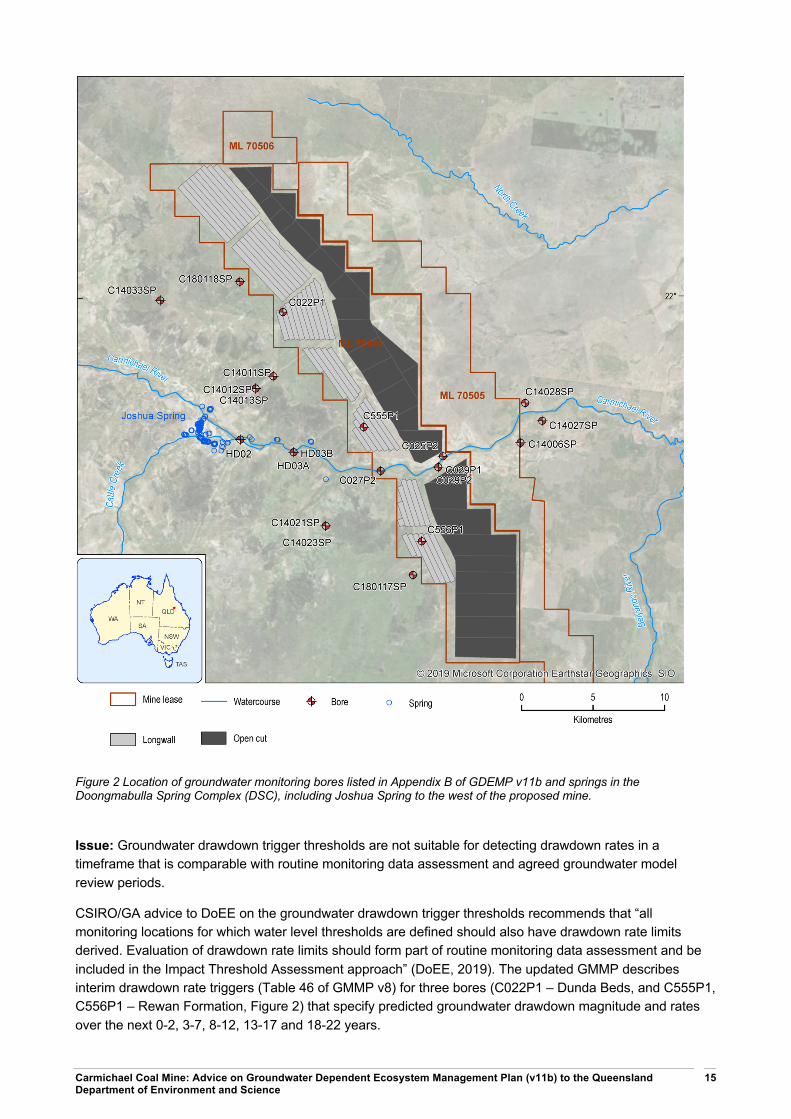
GDEMP v11b includes a new table of ‘Early warning triggers’ in Appendix B, in addition to ‘Table B-1 Groundwater drawdown triggers’, which is unchanged. The stated aim of the “Early Warning triggers” is to “provide early warning regarding the predicted induced flow from groundwater units associated with the Doongmabulla Springs-complex and the Carmichael River towards the dewatered / depressurised coal seams targeted during mining”. It also states “The Early warning triggers have been selected based on the possible change in groundwater levels beyond the recorded natural groundwater level fluctuations (Refer to Section 5.3 of the GMMP). The assessment of groundwater level data, compiled during mining operations, will allow for the evaluation of groundwater level trends”. The 20 early warning trigger and 3 interim drawdown rate trigger bore locations relevant to this review of the GDEMP are shown in Figure 2.
Carmichael Coal Mine: Advice on Groundwater Dependent Ecosystem Management Plan (v11b) to the Queensland Department of Environment and Science
15
Figure 2 Location of groundwater monitoring bores listed in Appendix B of GDEMP v11b and springs in the Doongmabulla Spring Complex (DSC), including Joshua Spring to the west of the proposed mine.
Issue: Groundwater drawdown trigger thresholds are not suitable for detecting drawdown rates in a timeframe that is comparable with routine monitoring data assessment and agreed groundwater model review periods.
CSIRO/GA advice to DoEE on the groundwater drawdown trigger thresholds recommends that “all monitoring locations for which water level thresholds are defined should also have drawdown rate limits derived. Evaluation of drawdown rate limits should form part of routine monitoring data assessment and be included in the Impact Threshold Assessment approach” (DoEE, 2019). The updated GMMP describes interim drawdown rate triggers (Table 46 of GMMP v8) for three bores (C022P1 – Dunda Beds, and C555P1, C556P1 – Rewan Formation, Figure 2) that specify predicted groundwater drawdown magnitude and rates over the next 0-2, 3-7, 8-12, 13-17 and 18-22 years.

Carmichael Coal Mine: Advice on Groundwater Dependent Ecosystem Management Plan (v11b) to the Queensland Department of Environment and Science
16
“In order to allow for a regular assessment of groundwater level decline compared to predictions plus the validation of the aquitard nature of the Rewan Formation between the target coal seams and the GAB units, a rate of groundwater level decline trigger is recommended. This trigger will allow for the evaluation of the aquitard nature and regular assessment of the potential for induced flow” (GMMP v8 p 216).
Timeframes for the interim drawdown rate triggers (0-22 years) and groundwater monitoring are comparable, which increases confidence in both model predictions and the effectiveness of groundwater monitoring. In contrast, early warning trigger levels (also referred to as (Low) Impact thresholds) are not predicted to be exceeded for between 35 and 100 years and (High) Impact thresholds for between 25 and 500 years (Table 2). Mine year when predicted groundwater drawdown exceeds trigger thresholds was estimated, to the nearest 5 years, from plots reported in Appendix E of GMMP v8 (see example for bore C022P1 – Dunda Beds in Figure 3).
For bore C022P1 in the Dunda Beds, the interim drawdown rate trigger level is 0.48 m over the next 22 years, compared to the early warning trigger level (2.9 m after 50 years) and the (High) impact threshold (3.31 m after 60 years) (Figure 3). This demonstrates the importance of using a timeframe that is comparable with routine monitoring data assessment and the agreed review periods (2 years after the commencement of the box cut and then every 5 years).
The location of the three interim drawdown rate bores is suitable as the absolute minimum to detect groundwater drawdown that may affect the DSC. As previously noted, the spatial distribution of monitoring bores intersecting different geological units is important for the analysis of water level and hydrochemistry data.
However, the three interim drawdown rate bores are unlikely to detect localised changes below groundwater-dependent ecosystems along the Carmichael River. Additional bores, such as bore C027P2 – Dunda Beds located adjacent to the Carmichael River, would enable early detection of groundwater drawdown that may affect the Carmichael River.
Two of the interim drawdown rate bores are located within the mining lease area and overlie the proposed longwall panels. Changes to hydraulic parameters are expected above the longwall panels:
“… the expected height of fracturing at the Carmichael Project, is expected to extend from the AB1 seam to the surface over much of the proposed longwall footprint.” (MSEC, 2013, p79)
Groundwater levels above longwall mines can fall due to increases in porosity, which is not necessarily related to water flowing downwards to the goaf (but can be). These changes in groundwater level can be temporary or permanent depending on mine geometry and topography. The groundwater model may not be capable of accurately predicting the effects of the collapse of the goaf on groundwater levels and therefore drawdown triggers could be difficult to interpret in bores above the longwall panels. It is noted that the observation bores located above the longwall panels are valuable for understanding how the goaf collapses.
Recommendation: Groundwater drawdown trigger thresholds should be set for all monitoring locations for which water level thresholds are defined, using a timeframe that is comparable with routine monitoring data assessment and agreed groundwater model review periods. Further, bore locations should consider localised changes that may impact on groundwater-dependent ecosystems and changes to groundwater conditions following planned longwall panel excavation beneath two of the three interim drawdown rate triggers bores. It is recommended that new groundwater drawdown trigger threshold bores are installed/identified as mining progresses.
Issue: Inconsistent description and reporting of groundwater drawdown trigger thresholds between GDEMP v11b and GMMP v8

Carmichael Coal Mine: Advice on Groundwater Dependent Ecosystem Management Plan (v11b) to the Queensland Department of Environment and Science
17
Early warning triggers are first mentioned in the GDEMP v11b in Section 6.7 - Triggers for adaptive management or corrective actions for the Carmichael River.
“The GMMP identifies groundwater early warning triggers and drawdown level thresholds that have been also included in Appendix B for monitoring the impacts to the Carmichael River based on updated groundwater and surface water modelling.”
The early warning triggers described in Appendix B of GDEMP v11b (summarised in Table 1) include eight additional bores for the Carmichael River that are not listed in Table 47 of GMMP v8
• These additional early warning triggers also include a fourth category of early warning trigger level for bore C029P1 – Alluvium (½NF + 25% of prediction) that is not described in either GDEMP v11b or GMMP v8.
• Further, it is unclear why bore C027P2 – Dunda Beds is listed twice in Appendix B of GMMP v11b with different groundwater drawdown trigger thresholds for the ‘Doongmabulla Springs – Dunda Beds’ (½NF + 75% of prediction) and for the ‘Carmichael River – all relevant aquifers’ (½NF + 50% of prediction).
• Groundwater monitoring bores for the Carmichael River reported in Table 6-7 of the GDEMP v11b (C025P1, C027P1, C029P1, HD03B, C14027SP, C14028SP – Alluvium and HD02, HD03A, C14011SP, C14012SP, C14013SP, C14021SP, C14023SP, C18001SP, C18002SP – Clematis) are inconsistent with those reported in Appendix B (summarised in Table 1) and in Table 47 of GMMP v8
Early warning triggers are also described in ‘Section 8.7.1 Pre-impact survey and monitoring for the DSC’ in GDEMP v11b.
“Monitoring sites will be selected on the first pre-impact survey, with the objective of selecting sites that are representative of the hydrological and ecological features that occur throughout the Doongmabulla Springs-complex. Of the 10 sites, a number will be identified to act as indicative early warning triggers and control sites.”
Appendix B of GDEMP v11b lists 12 bores with proposed early warning trigger levels for the DSC - 8 bores in the Clematis Sandstone and 4 bores in the Dunda Beds, that are consistent with the 12 bores listed in Table 47 of GMMP v8.
• Predicted drawdown values differ by more than 0.2 m in 7 of the 20 early warning trigger bores listed in Appendix B (C025P2, C029P2, C14011SP, C14021SP, C14023SP, C180117SP and C180118SP – refer Table 1) when calculated using values reported on pre- and post-mining groundwater impact contours in the GDEMP v11b.
• Not all pre- and post-mining groundwater impact contours are reported in the GDEMP v11b (refer Figure 6-10 Alluvial aquifer impacts, Figure 7-6 Alluvial aquifer impacts, Figure 8-15 Clematis aquifer impacts and Figure 9-8 Mellaluka Springs Complex (includes groundwater impact contour maps for Tertiary and Early Permian (Joe Joe Group)).
• Groundwater impact contour maps reported in Appendix C of GMMP v8were used for the Dunda Beds bores (C022P1, C027P2, C14023SP, C180117SP) (refer Table 1).
Recommendation: Address inconsistent description and reporting of groundwater drawdown trigger thresholds between GDEMP v11b and GMMP v8.

Carmichael Coal Mine: Advice on Groundwater Dependent Ecosystem Management Plan (v11b) to the Queensland Department of Environment and Science
18
Figure 3 Plot of predicted drawdown, early warning (low) and (high) impact thresholds for bore C022P1 – Dunda Beds from Appendix E of GMMPv7

Carmichael Coal Mine: Advice on Groundwater Dependent Ecosystem Management Plan (v11b) to the Queensland Department of Environment and Science 19
Table 1 Extract from Appendix B Groundwater drawdown and quality triggers
Bore ID Aquifer Natural fluctuation
Predicted Drawdown
Early warning level (criteria) (High) Impact Threshold (criteria) Total change in water level
Doongmabulla Springs - Clematis Sandstone
HD02 Clematis 0.46 m 0.03 m 0.26 m (½NF + 90% of prediction) 0.26 m (Prediction plus ½NF) 0.26 m (½NF + 100% model prediction)
HD03A Clematis 1.02 m 0.18 m 0.67 m (½NF + 90% of prediction) 0.69 m (Prediction plus ½NF) 0.69 m (½NF + 100% model prediction)
C180118SP Clematis 0.23 m 2.61 m 2.07 m (½NF + 75% of prediction) 2.46 m (½NF + 90% of prediction) 2.73 m (½NF + 100% model prediction)
C14021SP Clematis 1.09 m 1.66 m 1.37 m (½NF + 50% of prediction) 2.03 m (½NF + 90% of prediction) 2.20 m (½NF + 100% model prediction)
C14033SP Clematis 0.26 m 0.25 m 0.32 m (½NF + 75% of prediction) 0.36 m (½NF + 90% of prediction) 0.38 m (½NF + 100% model prediction)
C14011SP Clematis 0.23 m 0.62 m 0.58 m (½NF + 75% of prediction) 0.67 m (½NF + 90% of prediction) 0.74 m (½NF + 100% model prediction)
C14012SP Clematis 0.23 m 0.38 m 0.40 m (½NF + 75% of prediction) 0.46 m (½NF + 90% of prediction) 0.50 m (½NF + 100% model prediction)
C14013SP Clematis 0.29 m 0.38 m 0.43 m (½NF + 75% of prediction) 0.49 m (½NF + 90% of prediction) 0.53 m (½NF + 100% model prediction)
Doongmabulla Springs - Dunda Beds
C022P1 Dunda Beds 0.42 m 3.86 m 3.10 m (½NF + 75% of prediction) 3.68 m (½NF + 90% of prediction) 4.07 m (½NF + 100% model prediction)
C027P2 * Dunda Beds 0.72 m 1.11 m 1.19 m (½NF + 75% of prediction) 1.36 m (½NF + 90% of prediction) 1.47 m (½NF + 100% model prediction)
C14023SP Dunda Beds 0.30 m 0.32 m 0.39 m (½NF + 75% of prediction) 0.44 m (½NF + 90% of prediction) 0.47 m (½NF + 100% model prediction)
C180117SP Dunda Beds 0.38 m 4.83 m 3.81 m (½NF + 75% of prediction) 4.54 m (½NF + 90% of prediction) 5.02 m (½NF + 100% model prediction)
Carmichael River – all relevant aquifers
HD03B Alluvium 1.26 m 0.004 m 0.63 m (½NF + 75% of prediction) 0.63 m (Prediction plus ½NF) 0.634 m (½NF + 100% model prediction)
C027P2 * Dunda Beds 0.72 m 1.11 m 0.92 m (½NF + 50% of prediction) 1.19 m (½NF + 75% of prediction) 1.47 m (½NF + 100% model prediction)
C029P1 Alluvium 1.01 m 0.33 m 0.59 m (½NF + 25% of prediction) 0.67 m (½NF + 50% of prediction) 0.835 m (½NF + 100% model prediction)
C029P2 Tertiary 0.47 m 0.42 m 0.45 m (½NF + 50% of prediction) 0.55 m (½NF + 75% of prediction) 0.655 m (½NF + 100% model prediction)
C025P2 Tertiary 1.20 m 1.2 m 1.20 m (½NF + 50% of prediction) 1.50 m (½NF + 75% of prediction) 1.80 m (½NF + 100% model prediction)
C14028SP Alluvium 0.31 m 0.075 m 0.21 m (½NF + 75% of Prediction) 0.23 m (Prediction plus ½NF) 0.23 m (½NF + 100% model prediction)
C14027SP Alluvium 0.22 m 0.018 m 0.12 m (½NF + 50% of prediction) 0.13 m (½NF + 75% of prediction) 0.13 m (½NF + 100% model prediction)
C14006SP Early Permian
0.94 m 0.42 m 0.68 m (½NF + 50% of prediction) 0.79 m (½NF + 75% of prediction) 0.89 m (½NF + 100% model prediction)
* Bore C027PS Dunda Beds is listed twice with different groundwater drawdown trigger thresholds. NF = Natural fluctuation

Carmichael Coal Mine: Advice on Groundwater Dependent Ecosystem Management Plan (v11b) to the Queensland Department of Environment and Science 20
Table 2 Estimated groundwater drawdown, trigger levels and year of mine operation that groundwater drawdown trigger levels are predicted to be exceeded.
Bore ID Source of reported drawdown
Reported drawdown (m)
Early warning level (m)
Year predicted
(High) Impact Threshold (m)
Year predicted
Total change in water level (m)
>0.2 m
Doongmabulla Springs – Clematis Sandstone
HD02 Figure 8-15 Clematis 0.02 (-0.01) 0.25 (-0.01) 80 0.25 (-0.01) 80 0.25 (-0.01)
HD03A Figure 8-15 Clematis 0.05 (-0.13) 0.56 (-0.12) 80 0.56 (-0.13) 80 0.56 (-0.13)
C180118SP Figure 8-15 Clematis 0.91 (-1.7) 0.8 (-1.27) 50 0.93 (-1.53) 60 1.03 (-1.71) #
C14021SP Figure 8-15 Clematis 0.12 (-1.54) 0.61 (-0.77) 50 0.65 (-1.38) 80 0.67 (-1.54) #
C14033SP Figure 8-15 Clematis 0.34 (0.09) 0.39 (0.07) 75 0.44 (0.08) 100 0.47 (0.09)
C14011SP Figure 8-15 Clematis 0.42 (-0.2) 0.43 (-0.15) 55 0.49 (-0.18) 60 0.54 (-0.21) #
C14012SP Figure 8-15 Clematis 0.27 (-0.11) 0.32 (-0.08) 55 0.36 (-0.1) 60 0.39 (-0.12)
C14013SP Figure 8-15 Clematis 0.27 (-0.11) 0.35 (-0.08) 55 0.39 (-0.1) 60 0.42 (-0.12)
Doongmabulla Springs – Dunda Beds
C022P1 Appendix C Dunda Beds 3.83 (-0.03) 3.08 (-0.02) 50 3.66 (-0.02) 60 4.04 (-0.03)
C027P2 * Appendix C Dunda Beds 1.06 (-0.05) 1.16 (-0.04) 35 1.31 (-0.05) 40 1.42 (-0.05)
C14023SP Appendix C Dunda Beds 1.44 (1.12) 1.23 (0.84) 100 1.45 (1.01) 150 1.59 (1.12) #
C180117SP Appendix C Dunda Beds 4.09 (-0.74) 3.26 (-0.55) 55 3.87 (-0.67) 100 4.28 (-0.74) #
Carmichael River – all relevant aquifers
HD03B Figure 6-10 Alluvial 0.01 (0.01) 0.64 (0.01) 65 0.64 (0.01) 65 0.64 (0.01)
C027P2 * Appendix C Dunda Beds 1.06 (-0.05) 0.89 (-0.03) not shown 1.16 (-0.03) 35 1.42 (-0.05)
C029P1 Figure 6-10 Alluvial 0.28 (-0.05) 0.58 (-0.01) not shown 0.65 (-0.02) 25 0.79 (-0.04)
C029P2 Figure 9-8 Tertiary 0.22 (-0.2) 0.34 (-0.11) not shown 0.4 (-0.15) 30 0.45 (-0.2) #
C025P2 Figure 9-8 Tertiary 0.46 (-0.74) 0.83 (-0.37) not shown 0.95 (-0.55) 30 1.06 (-0.74) #
C14028SP Figure 6-10 Alluvial 0.01 (-0.06) 0.16 (-0.05) not shown 0.17 (-0.06) 500 0.17 (-0.06)
C14027SP Figure 6-10 Alluvial 0.03 (0.02) 0.13 (0.01) not shown 0.14 (0.01) 500 0.14 (0.01)
C14006SP Figure 9-8 Joe Joe Group 0.42 (0) 0.68 (0) not shown 0.78 (-0.01) 290 0.89 (0) * Bore C027P2 Dunda Beds is listed twice with different groundwater drawdown trigger thresholds. Drawdown and threshold values were estimated from groundwater drawdown impact contours reported in GDEMP v11b and GMMP v8. Brackets show the difference between values summarised in Table 2 and reported values, with differences in excess of 0.2 m identified by # in the right-hand column. ‘Year predicted’ is estimated to nearest 5 years from intersection of predicted groundwater drawdown and trigger thresholds reported in Appendix E of GMMP v8.

Advice on Carmichael Coal Project draft research plans to the Department of the Environment and Energy D2018-150909
21
5 Adaptive management measures and commitments
5.1 Summary Q6. For question 5, are the adaptive management measures and commitments in the updated GDEMP appropriate? If not, please provide suggestions to address this?
Issue: Different levels of commitment are proposed for corrective actions when groundwater drawdown trigger levels are exceeded for each GDE.
Recommendation: Address inconsistencies in level of commitment for corrective actions for each GDE that are applied when groundwater drawdown trigger levels are exceeded.
Issue: Inconsistencies in adaptive management measures and commitments between the GDEMP and GMMP
Recommendation: Address inconsistencies between the GDEMP and GMMP with regard to adaptive management measures and commitments.
5.2 Adaptive management measures and commitments Issue: Different levels of commitment are proposed for corrective actions when groundwater drawdown trigger levels are exceeded for each GDE.
This type of issue is consistent throughout the document where there are proposed adaptive management measures and commitments.
The use of clear and unambiguous language in relation to proposed corrective actions would help engender confidence in the management plan. For example, ‘Table 6-10 Management objectives, performance criteria, adaptive management triggers and corrective actions for the Carmichael River’ describes the following proposed corrective actions when groundwater drawdown trigger levels are exceeded:
“The appropriate corrective actions will be implemented and will include:
• Immediately limiting mining activities to current activities, until monitoring indicates the trigger level(s) are no longer being exceeded, or at further risk of being exceeded.
• If the investigation indicates that there is a risk of impacts to the Carmichael River beyond that approved, monitoring will be reviewed and a report prepared within 3 months to identify the actual impact from the mining activities.
• If the investigation finds that the actual areas of impact to the Carmichael River differs from the area of impact as detailed in the BOS, the BOS will be amended within 30 days and the amended offset delivered within 12 months.”
By contrast, ‘Table 8-10 Management objectives, performance criteria, adaptive management triggers and corrective actions for the Doongmabulla Springs-complex’ describes the proposed corrective actions when groundwater drawdown trigger levels are exceeded in the following terms:
“The appropriate corrective actions will be implemented and may include:

Carmichael Coal Mine: Advice on Groundwater Dependent Ecosystem Management Plan (v11b) to the Queensland Department of Environment and Science
22
• In the event that groundwater level or rate triggers are exceeded, the investigation, response and corrective actions process under the GMMP will be implemented
• Limiting mining to current activities until trigger not exceeded and revision of mine planning or associated activities
• Directing research priorities under the GABSRP and/or RFCRP in relation to mitigation strategies and offset requirements,
• If impacts are predicted to be beyond those allowed in the project approvals, commence planning of further mitigation activities with regards to water availability at the springs.
• Reviewing ecological trigger and groundwater trigger/threshold relationships and, if required, proposed new trigger mechanisms. Assessment and review to be completed within 4 weeks.
• Implementing relevant operational constraints in relation to groundwater drawdown impacts, including revised mine planning or associated activities“
There are different levels of commitment for corrective actions when groundwater drawdown trigger levels are exceeded. Note we have not commented on whether the agreed Biodiversity Offset Strategy (BOS) are appropriate.
Recommendation: Address inconsistencies in the level of commitment for corrective actions for each GDE that are applied when groundwater drawdown trigger levels are exceeded.
Issue: Inconsistencies in adaptive management measures and commitments between the GDEMP and GMMP
The appropriateness of adaptive management measures and commitments are regulatory matters and beyond the scope for scientific advice. CSIRO/GA make the following observations for regulator consideration.
Section 5.3.1 of the GDEMP v11b, states:
“adaptive management for GDEs in the Project area is based on the following steps:
• Linking GDE values with the underpinning groundwater model
• Develop and implement monitoring
• Develop and implement management actions including corrective actions if required
• Evaluate effectiveness of management actions
• Adapt management actions (including mitigation and corrective actions if relevant).”
The adaptive management framework is discussed for each GDE. However, it is frequently stated that the framework will include a ‘review of trigger levels during the course of the Project and particularly in response to long term monitoring and studies undertaken during each assessment and monitoring stage.’ Updating trigger levels is a recurring area of concern in the GDEMP. Triggers need to be based on baseline and pre-impact data only and, if properly assessed, are designed to identify when changes are occurring to the system that are likely to be mine-induced. Trigger levels will need review and revision in light of a model revision and re-run.
GDEMP v11b, Section 8.6.1 states that the ‘adaptive management framework will be employed to mitigate impacts to the springs and will include a review of trigger levels for the springs during the course of the

Carmichael Coal Mine: Advice on Groundwater Dependent Ecosystem Management Plan (v11b) to the Queensland Department of Environment and Science
23
Project.’ Adaptive management involves adjusting how the system is managed in response to information on progress towards the management objectives. Reviewing trigger levels should not be considered the first option in an adaptive management approach to mitigating impacts unless other viable options are exhausted.
The sections of the GDEMP for each GDE (e.g. Section 6.8 for the Carmichael River GDE) state that when ‘adaptive management and corrective actions are triggered, the first step is to investigate the cause of the trigger. Such investigations will involve a review of available data (including groundwater levels), consideration of the potential influence of mining and non-mining activities or fluctuations in the area that may have contributed to the result, and the input of specialist advice. The specific details of the investigation will be tailored to identify the root cause or best available solution to the identified issue.’
This statement has been added to Section 5.4 in GDEMP v11b: "The monitoring methodology described below, and specifically in each GDE Chapter of this plan, is designed to enable the measurement and separation of mining and non-mining influences on the monitoring indicators across the four GDE’s.”
However, there is no detail in the GDEMP describing how these investigations to separate the mining and non-mining influences will be undertaken, and what data will be required for this task. Tables 6-9, 7-5, 8-9 and 9-2 provide some information on the statistical analysis to be undertaken for groundwater level and groundwater quality indicators:
For groundwater levels, this is ‘univariate comparison between groundwater level at time of sampling and groundwater level threshold.’
This approach may not adequately account for temporal changes in the data that may result from seasonality or mining activities at the site. The defined approach does not indicate if there will be an assessment of trends in the data, which may provide an early warning of triggers being approached. It is therefore not clear how these investigations will be able to differentiate between mining and non-mining impacts.
GDEMP v11b, Section 5.3.1 states that ‘The GMMP provides a detailed analysis of the management and mitigation measures that will be implemented to address groundwater specific issues.’ This is not the case. The GDEMP frequently refers to the GMMP for corrective actions relating to groundwater. As noted in the advice from February 2019: “Mitigation actions are not presented in the GMMP”…[which]…”referenced actions described in the Great Artesian Basin Research Plan and the Biodiversity Offset Strategy”. There are few identified corrective actions for groundwater level and quality triggers, which primarily relate to limiting mining to the current activities and increasing the offset area. There are no provisions to stop groundwater pumping (CSIRO and Geoscience Australia, 2019).
CSIRO/GA have not commented on whether the agreed BOS are appropriate as this was not in scope for this advice. For example, the GDEMP relies on offset strategies to mitigate "residual impact". Section 6.4 (#1 Groundwater drawdown) states that "groundwater impact to Carmichael River is to be offset through the Biodiversity Offset Strategy. An area of 90 ha has been established on Moray Downs West for this purpose."
Recommendation: Address inconsistencies between the GDEMP and GMMP with regard to adaptive management measures and commitments.

Carmichael Coal Mine: Advice on Groundwater Dependent Ecosystem Management Plan (v11b) to the Queensland Department of Environment and Science
24
References
Beven K (2006) A manifesto for the equifinality thesis. Journal of Hydrology 320(1), 18-36. Doi: https://doi.org/10.1016/j.jhydrol.2005.07.007.
Barnett B, Townley LR, Post V, Evans RE, Hunt RJ, Peeters L, Richardson S, Werner AD, Knapton A and Boronkay A. (2012) Australian groundwater modelling guidelines, Waterlines report, National Water Commission, Canberra
CSIRO and GA (2018), Carmichael Coal Mine: Advice on draft research plans to the Department of the Environment and Energy, November 2018
CSIRO and GA (2019), Carmichael Coal Mine: Advice on Groundwater Management and Monitoring and Groundwater Dependent Ecosystem Management plans to the Department of the Environment and Energy, February 2019
Currell MJ, Werner AD, McGrath C, Webb JA and Berkman M (2017) Problems with the application of hydrogeological science to regulation of Australian mining projects: Carmichael Mine and Doongmabulla Springs. Journal of Hydrology 548, 674–682. DOI:10.1016/j.jhydrol.2017.03.031.
DOEE (2019) Summary of CSIRO and Geoscience Australia (GA) Advice on Groundwater Management Plans and Response. Department of Environment and Energy, Canberra, Australia. https://www.environment.gov.au/system/files/pages/cb8a9e41-eba5-47a4-8b72-154d0a5a6956/files/summary-csiro-ga-advice-response.pdf.
Enemark, T.; Peeters, L.J.M.; Mallants, D.; Batelaan, O. Hydrogeological conceptual model building and testing: A review.J. Hydrol.2019,569.
Fensham, R.J., Silcock, J.L., Laffineur, B., MacDermott, H.J. 2016, Lake Eyre Basin Springs Assessment Project: Hydrogeology, cultural history and biological values of springs in the Barcaldine, Springvale and Flinders River supergroups, Galilee Basin springs and Tertiary springs of western Queensland. Report to Office of Water Science, Department of Science, Information Technology and Innovation, Brisbane.
GHD (2013) Carmichael Coal Mine and Rail Project SEIS: Report for Mine Hydrogeology Report. Prepared for Adani Mining Pty Ltd by GHD Pty Ltd.
GHD (2015) Carmichael Coal Project: Response to Federal Approval Conditions – Groundwater Flow Model. Prepared for Adani Mining Pty Ltd by GHD Pty Ltd.
Middlemis H and Peeters LJM (2018) Uncertainty analysis—Guidance for groundwater modelling within a risk management framework. A report prepared for the Independent Expert Scientific Committee on Coal Seam Gas and Large Coal Mining Development through the Department of the Environment and Energy, Commonwealth of Australia 2018.
MSEC (2013) Carmichael Project – Revised Subsidence Assessment. Prepared for Adani Mining Pty Ltd by Mine Subsidence Engineering Consultants.
Peeters LJM (2017) Assumption Hunting in Groundwater Modeling: Find Assumptions Before They Find You. Groundwater 55(5), 665-669. Doi: 10.1111/gwat.12565.
Peeters L, Ransley T, Turnadge C, Kellett J, Harris-Pascal C, Kilgour P and Evans T (2018) Groundwater numerical modelling for the Galilee subregion. Product 2.6.2 for the Galilee subregion from the Lake Eyre Basin Bioregional Assessment. Department of the Environment and Energy, Bureau of Meteorology, CSIRO and Geoscience Australia, Australia. http://data.bioregionalassessments.gov.au/product/LEB/GAL/2.6.2.
Queensland Herbarium 2017, Doongmabulla Galilee Springs Group: Hydrogeology and ecology, Department of Science, Information Technology and Innovation, Brisbane. Excerpt from: Fensham, R.J., Silcock, J.L., Laffineur, B., MacDermott, H.J. 2016, Lake Eyre Basin Springs Assessment Project: Hydrogeology, cultural history and biological values of springs in the Barcaldine, Springvale and Flinders River supergroups, Galilee

Carmichael Coal Mine: Advice on Groundwater Dependent Ecosystem Management Plan (v11b) to the Queensland Department of Environment and Science
25
Basin springs and Tertiary springs of western Queensland. Report to Office of Water Science, Department of Science, Information Technology and Innovation, Brisbane.
Schulze-Makuch D, Carlson DA, Cherkauer DS and Malik P (1999) Scale dependency of hydraulic conductivity in heterogeneous media [Review]. Ground Water 37(6), 904-919.
Turnadge C, Mallants D and Peeters L (2018) Sensitivity and uncertainty analysis of a regional-scale groundwater flow system stressed by coal seam gas extraction. CSIRO, Australia.
Turvey C, Skorulis A, Minchin W, Merrick NP and Merrick DP (2015) Galilee Basin hydrogeological model Milestone 3 report for Geoscience Australia. Prepared by Heritage Computing Pty Ltd trading as Hydrosimulations. Document dated 16 November 2015, http://www.bioregionalassessments.gov.au/sites/default/files/galilee-basin-hydrological-model-pdf.