CARDIFF COUNCIL JOINT HOUSING LAND AVAILABILITY STUDY … · CARDIFF COUNCIL . JOINT HOUSING LAND...
24
CARDIFF COUNCIL JOINT HOUSING LAND AVAILABILITY STUDY 1 st April 2013 BETWEEN CARDIFF COUNCIL AND THE STUDY GROUP: HOME BUILDERS FEDERATION LINC CYMRU HOUSING ASSOCIATION WALES & WEST HOUSING ASSOCIATION UNITED WELSH HOUSING ASSOCIATION HENDRE HOUSING ASSOCIATION CARDIFF COMMUNITY HOUSING ASSOCIATION TAFF HOUSING ASSOCIATION CADWYN HOUSING ASSOCIATION DWR CYMRU/WELSH WATER Publication Date: 31 st March 2014
Transcript of CARDIFF COUNCIL JOINT HOUSING LAND AVAILABILITY STUDY … · CARDIFF COUNCIL . JOINT HOUSING LAND...
CARDIFF COUNCIL
JOINT HOUSING LAND AVAILABILITY STUDY
1st April 2013
BETWEEN CARDIFF COUNCIL AND THE STUDY GROUP:
HOME BUILDERS FEDERATION LINC CYMRU HOUSING ASSOCIATION
WALES & WEST HOUSING ASSOCIATION UNITED WELSH HOUSING ASSOCIATION
HENDRE HOUSING ASSOCIATION CARDIFF COMMUNITY HOUSING ASSOCIATION
TAFF HOUSING ASSOCIATION CADWYN HOUSING ASSOCIATION
DWR CYMRU/WELSH WATER
Publication Date: 31st March 2014
2
CONTENTS
1 Summary 3
2 Housing Land Supply 4
3 Commentary 5
4 Monitoring data 6
Appendix 1 – Site Schedules 7
Appendix 2 – Past Completions Data 17
Appendix 3 – Previous Land Supply Data 17
Appendix 4 – Planning Inspector’s Recommendation 18
3
1.0 SUMMARY 1.1 This is the Cardiff Council Joint Housing Land Availability Study for 2013 which
presents the housing land supply for the area at the base date of 1st April 2013. It replaces the report for the previous base date of 1st April 2012.
1.2 The JHLAS has been prepared in accordance with the requirements of Planning Policy
Wales (Edition 6, 2014)1, Technical Advice Note 1 (TAN 1): Joint Housing Land Availability Studies (2006)2 and the Guidance Note on the JHLAS process (2012)3. Please refer to these documents for details of the requirements for the maintenance of a five year housing land supply in each Local Planning Authority area and the process for undertaking the JHLAS.
1.3 Section 2 sets out details of the housing land supply and how it has been calculated. It
shows that based on the past building rates method, Cardiff Council has 3.2 years housing land supply.
Involvement
1.4 The housing land supply has been assessed in consultation with:
• Home Builders Federation • Linc Cymru Housing Association • Wales & West Housing Association • Hendre Housing Association • Cardiff Community Housing Association • Taff Housing Association • Cadwyn Housing Association • Dwr Cymru / Welsh Water
Report Production
1.5 Cardiff Council issued draft site schedules and site proformas for consultation on 21st
June 2013 for a period of 4 weeks until 21st July 2013. Comments were provided by the HBF and other parties within this period. A Statement of Common Ground (SoCG) was subsequently prepared and, following consultation with the Study Group was submitted to the Welsh Government on 30th September 2013.
1.6 It was necessary for an appointed Planning Inspector to resolve a number of disputed
matters because details within the site schedule could not be agreed by all parties through the SoCG stage.
1.7 The appointed Planning Inspector subsequently made a recommendation to the Welsh
Government on the housing land supply (Appendix 4), including recommendations on the points of dispute. The Planning Inspector’s recommendations were considered by the Welsh Government, relevant amendments were made to the site schedules by Cardiff Council and this information has been incorporated into this report4.
1 http://wales.gov.uk/topics/planning/policy/ppw/?lang=en 2 http://wales.gov.uk/topics/planning/policy/tans/tan1/?lang=en 3 http://wales.gov.uk/docs/desh/publications/120919jhlasguidancenoteen.pdf 4 Please note paragraph 30 of the Inspector’s Report contains an error: 1,412 should read 1,462 and 4,485 should read 4,535. This is because from the 1,562 total units under dispute, only 100 were not counted towards the 5 year supply.
4
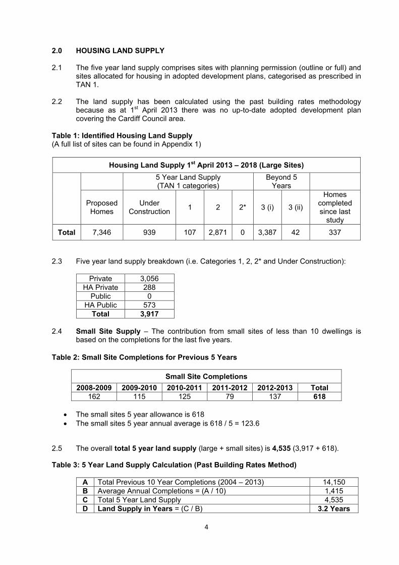
2.0 HOUSING LAND SUPPLY 2.1 The five year land supply comprises sites with planning permission (outline or full) and
sites allocated for housing in adopted development plans, categorised as prescribed in TAN 1.
2.2 The land supply has been calculated using the past building rates methodology
because as at 1st April 2013 there was no up-to-date adopted development plan covering the Cardiff Council area.
Table 1: Identified Housing Land Supply (A full list of sites can be found in Appendix 1)
Housing Land Supply 1st April 2013 – 2018 (Large Sites)
5 Year Land Supply (TAN 1 categories)
Beyond 5 Years
Proposed Homes
Under Construction 1 2 2* 3 (i) 3 (ii)
Homes completed since last
study
Total 7,346 939 107 2,871 0 3,387 42 337
2.3 Five year land supply breakdown (i.e. Categories 1, 2, 2* and Under Construction):
Private 3,056 HA Private 288
Public 0 HA Public 573
Total 3,917 2.4 Small Site Supply – The contribution from small sites of less than 10 dwellings is
based on the completions for the last five years. Table 2: Small Site Completions for Previous 5 Years
Small Site Completions 2008-2009 2009-2010 2010-2011 2011-2012 2012-2013 Total
162 115 125 79 137 618
• The small sites 5 year allowance is 618 • The small sites 5 year annual average is 618 / 5 = 123.6
2.5 The overall total 5 year land supply (large + small sites) is 4,535 (3,917 + 618).
Table 3: 5 Year Land Supply Calculation (Past Building Rates Method)
A Total Previous 10 Year Completions (2004 – 2013) 14,150 B Average Annual Completions = (A / 10) 1,415 C Total 5 Year Land Supply 4,535 D Land Supply in Years = (C / B) 3.2 Years
5
3.0 COMMENTARY 3.1 TAN 1 advises that to meet the requirement for a 5-year land supply the quantity of land
agreed to be genuinely available may be compared with the remaining housing provision in the adopted development plan – the residual method. However, in this case, the Cardiff Local Plan’s new dwelling requirement period ended in 2006 and similarly that for the South Glamorgan Replacement Structure Plan ended in 2011. Whilst they retain development plan status, the 2013 JHLAS period is wholly outside of the development plan period.
3.2 In respect of the above, the Study Group is in agreement that past building rates are the most appropriate method of calculating the land supply. The Inspector concluded it was reasonable to use the past 10 years completions figures for the purpose of calculating land supply.
Council’s Statement
3.3 The Council acknowledges that the land supply, as based upon past build rates, is below the necessary 5 years and is aware of the requirement in such cases to take appropriate steps to increase the land supply as set out in TAN1.
3.4 In terms of addressing the shortfall, it is important to stress at the outset that, in reality, more land is potentially available for development than the figures derived through the rigid methodology prescribed for the Study process. The Council considers that to a large extent the current assessment of land available reflects the prevailing economic conditions affecting the house-building industry generally and is not necessarily a true reflection of the amount of land genuinely available for development. Much land, while potentially available, is either categorised as subject to S106 agreement (2,201 units), or has consent but has been placed in constrained category 3(i) or 3(ii) (3,429 units combined). These categories are not eligible to be counted, but if they were they would add considerably (plus around 3.9 years) to the ‘official’ 3.2 year supply.
3.5 Whilst the Council accepts some sites may see revised schemes with lower densities due to the economic downturn and changed market demand, nevertheless there is still a substantial amount of land in these categories (3(i), 3(ii) & S106) that could in reality contribute to the 5 year supply. Further work will be undertaken to assess the contribution from such sites.
3.6 With regards to reviewing its development plan, the Council continues to progress the preparation of an LDP as fast as procedures allow. The Draft Deposit LDP (2006-2026) was approved by Cardiff Council in September 2013, followed by a six week public consultation period between 15th October 2013 and 26th November 2013. The Plan is due to be submitted to Welsh Government later this year so that an appointed Independent Planning Inspector can make arrangements for the examination. Whilst the plan is not adopted at this point, it none-the-less provides a clear indication of the proposed scale of growth and identifies the necessary amount of strategic sites to deliver requirements.
6
3.7 In addition, the Council is proactively looking in detail into its land holdings with a view to providing a range and choice of brownfield sites for development. The Council’s Partnering Scheme is in progress that will see sale of Council sites and the construction of around 1,000 dwellings.
4.0 MONITORING DATA
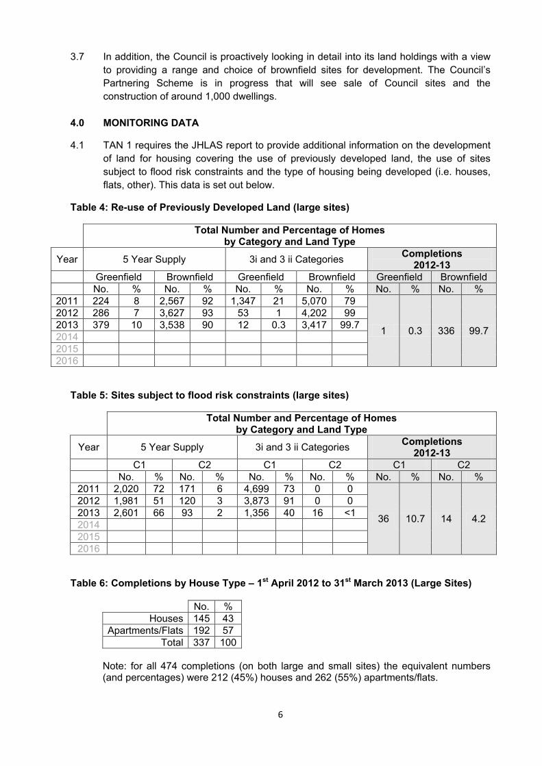
4.1 TAN 1 requires the JHLAS report to provide additional information on the development of land for housing covering the use of previously developed land, the use of sites subject to flood risk constraints and the type of housing being developed (i.e. houses, flats, other). This data is set out below.
Table 4: Re-use of Previously Developed Land (large sites)
Total Number and Percentage of Homes by Category and Land Type
Year 5 Year Supply 3i and 3 ii Categories Completions 2012-13
Greenfield Brownfield Greenfield Brownfield Greenfield Brownfield No. % No. % No. % No. % No. % No. %
2011 224 8 2,567 92 1,347 21 5,070 79
1 0.3 336 99.7
2012 286 7 3,627 93 53 1 4,202 99 2013 379 10 3,538 90 12 0.3 3,417 99.7 2014 2015 2016
Table 5: Sites subject to flood risk constraints (large sites)
Total Number and Percentage of Homes by Category and Land Type
Year 5 Year Supply 3i and 3 ii Categories Completions 2012-13
C1 C2 C1 C2 C1 C2 No. % No. % No. % No. % No. % No. %
2011 2,020 72 171 6 4,699 73 0 0
36 10.7 14 4.2
2012 1,981 51 120 3 3,873 91 0 0 2013 2,601 66 93 2 1,356 40 16 <1 2014 2015 2016
Table 6: Completions by House Type – 1st April 2012 to 31st March 2013 (Large Sites)
No. % Houses 145 43
Apartments/Flats 192 57 Total 337 100
Note: for all 474 completions (on both large and small sites) the equivalent numbers (and percentages) were 212 (45%) houses and 262 (55%) apartments/flats.

7
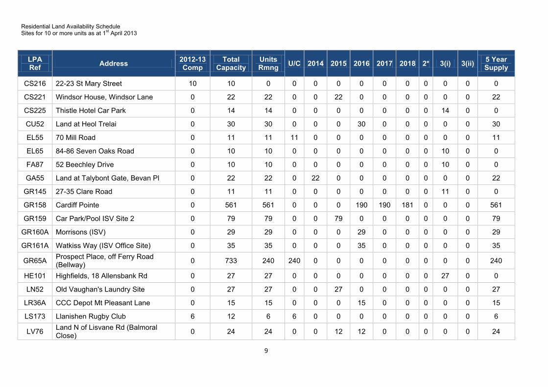
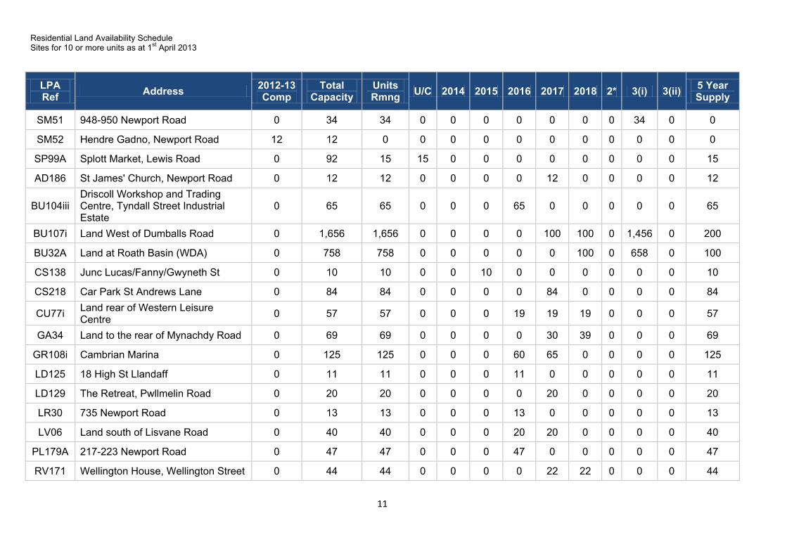
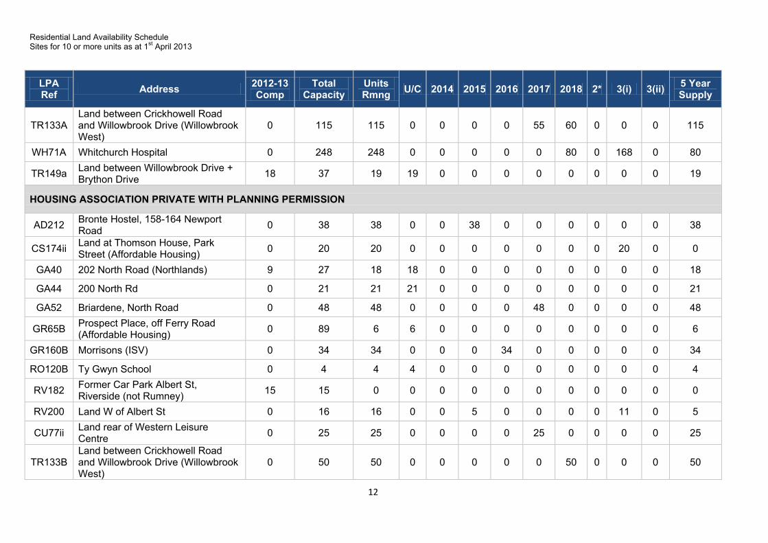
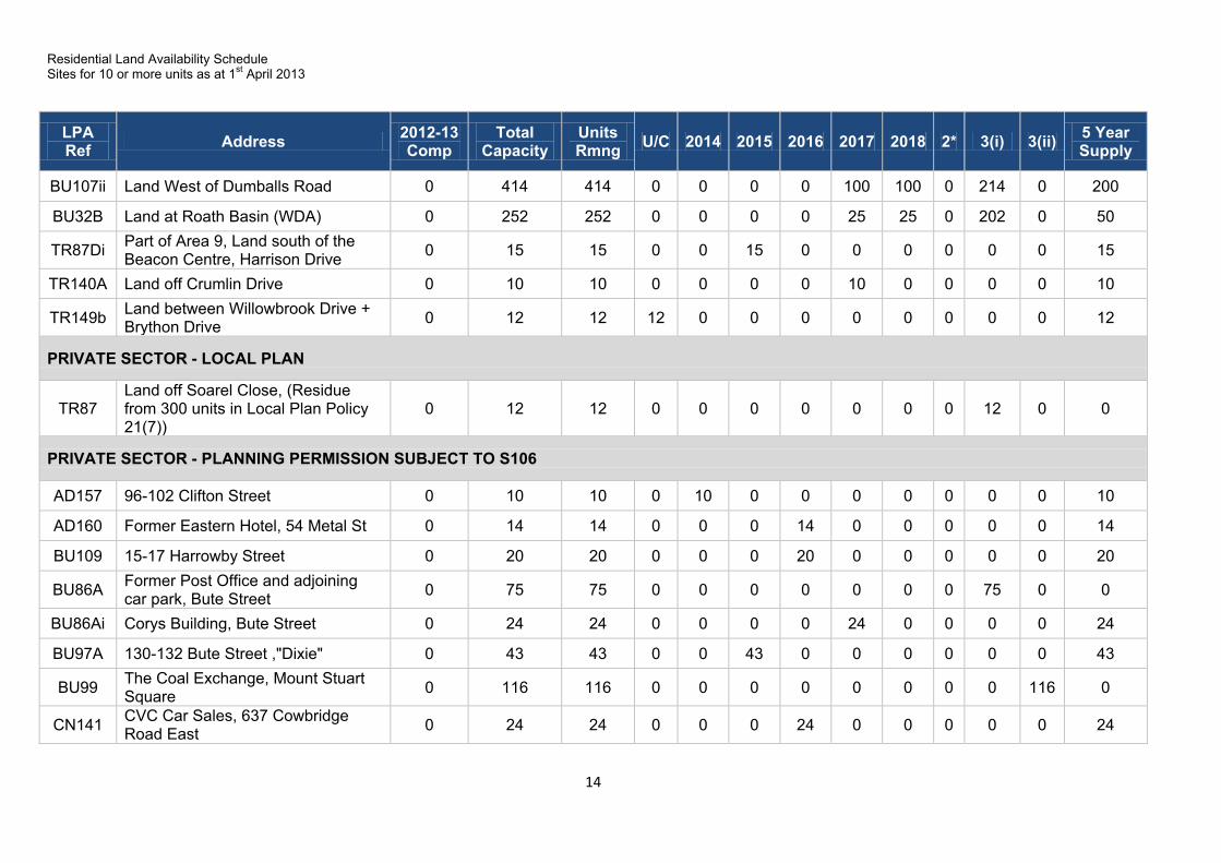
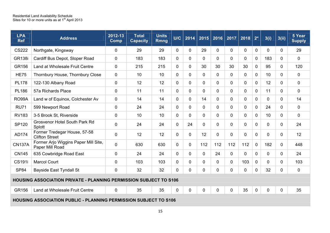
Appendix 1 – Site Schedules
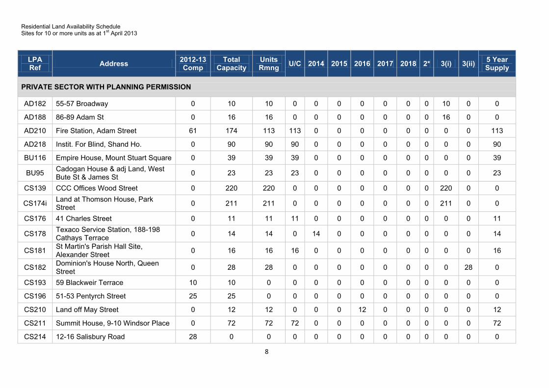
Residential Land Availability Schedule Sites for 10 or more units as at 1st April 2013
8
LPA Ref Address 2012-13
Comp Total
Capacity Units Rmng U/C 2014 2015 2016 2017 2018 2* 3(i) 3(ii) 5 Year
Supply
PRIVATE SECTOR WITH PLANNING PERMISSION
AD182 55-57 Broadway 0 10 10 0 0 0 0 0 0 0 10 0 0
AD188 86-89 Adam St 0 16 16 0 0 0 0 0 0 0 16 0 0
AD210 Fire Station, Adam Street 61 174 113 113 0 0 0 0 0 0 0 0 113
AD218 Instit. For Blind, Shand Ho. 0 90 90 90 0 0 0 0 0 0 0 0 90
BU116 Empire House, Mount Stuart Square 0 39 39 39 0 0 0 0 0 0 0 0 39
BU95 Cadogan House & adj Land, West Bute St & James St 0 23 23 23 0 0 0 0 0 0 0 0 23
CS139 CCC Offices Wood Street 0 220 220 0 0 0 0 0 0 0 220 0 0
CS174i Land at Thomson House, Park Street 0 211 211 0 0 0 0 0 0 0 211 0 0
CS176 41 Charles Street 0 11 11 11 0 0 0 0 0 0 0 0 11
CS178 Texaco Service Station, 188-198 Cathays Terrace 0 14 14 0 14 0 0 0 0 0 0 0 14
CS181 St Martin's Parish Hall Site, Alexander Street 0 16 16 16 0 0 0 0 0 0 0 0 16
CS182 Dominion's House North, Queen Street 0 28 28 0 0 0 0 0 0 0 0 28 0
CS193 59 Blackweir Terrace 10 10 0 0 0 0 0 0 0 0 0 0 0
CS196 51-53 Pentyrch Street 25 25 0 0 0 0 0 0 0 0 0 0 0
CS210 Land off May Street 0 12 12 0 0 0 12 0 0 0 0 0 12
CS211 Summit House, 9-10 Windsor Place 0 72 72 72 0 0 0 0 0 0 0 0 72
CS214 12-16 Salisbury Road 28 0 0 0 0 0 0 0 0 0 0 0 0
Residential Land Availability Schedule Sites for 10 or more units as at 1st April 2013
9
LPA Ref Address 2012-13
Comp Total
Capacity Units Rmng U/C 2014 2015 2016 2017 2018 2* 3(i) 3(ii) 5 Year
Supply
CS216 22-23 St Mary Street 10 10 0 0 0 0 0 0 0 0 0 0 0
CS221 Windsor House, Windsor Lane 0 22 22 0 0 22 0 0 0 0 0 0 22
CS225 Thistle Hotel Car Park 0 14 14 0 0 0 0 0 0 0 14 0 0
CU52 Land at Heol Trelai 0 30 30 0 0 0 30 0 0 0 0 0 30
EL55 70 Mill Road 0 11 11 11 0 0 0 0 0 0 0 0 11
EL65 84-86 Seven Oaks Road 0 10 10 0 0 0 0 0 0 0 10 0 0
FA87 52 Beechley Drive 0 10 10 0 0 0 0 0 0 0 10 0 0
GA55 Land at Talybont Gate, Bevan Pl 0 22 22 0 22 0 0 0 0 0 0 0 22
GR145 27-35 Clare Road 0 11 11 0 0 0 0 0 0 0 11 0 0
GR158 Cardiff Pointe 0 561 561 0 0 0 190 190 181 0 0 0 561
GR159 Car Park/Pool ISV Site 2 0 79 79 0 0 79 0 0 0 0 0 0 79
GR160A Morrisons (ISV) 0 29 29 0 0 0 29 0 0 0 0 0 29
GR161A Watkiss Way (ISV Office Site) 0 35 35 0 0 0 35 0 0 0 0 0 35
GR65A Prospect Place, off Ferry Road (Bellway) 0 733 240 240 0 0 0 0 0 0 0 0 240
HE101 Highfields, 18 Allensbank Rd 0 27 27 0 0 0 0 0 0 0 27 0 0
LN52 Old Vaughan's Laundry Site 0 27 27 0 0 27 0 0 0 0 0 0 27
LR36A CCC Depot Mt Pleasant Lane 0 15 15 0 0 0 15 0 0 0 0 0 15
LS173 Llanishen Rugby Club 6 12 6 6 0 0 0 0 0 0 0 0 6
LV76 Land N of Lisvane Rd (Balmoral Close) 0 24 24 0 0 12 12 0 0 0 0 0 24

Residential Land Availability Schedule Sites for 10 or more units as at 1st April 2013
10
LPA Ref Address 2012-13
Comp Total
Capacity Units Rmng U/C 2014 2015 2016 2017 2018 2* 3(i) 3(ii) 5 Year
Supply
NP58 Land at Church Road 0 45 45 0 0 0 0 45 0 0 0 0 45
PL160 115-119 City Road 0 14 14 0 0 0 0 0 0 0 14 0 0
PL176 46-47 The Parade 0 14 14 14 0 0 0 0 0 0 0 0 14
PL205 Gibbons Yard, Richmond Road 0 49 49 0 0 49 0 0 0 0 0 0 49
PW22A Maelfa Centre, Llanedeyrn Drive 0 83 83 0 0 0 40 43 0 0 0 0 83
RA38Ci Land at Radyr Sidings Phase 3 (Taylor Wimpey) 31 167 4 4 0 0 0 0 0 0 0 0 4
RH36D Land E of Coed y Wenallt 1 10 9 9 0 0 0 0 0 0 0 0 9
RO109 22 Ty Gwyn Road 0 10 10 0 0 10 0 0 0 0 0 0 10
RO118A UWIC Campus Colchester Ave 28 53 16 9 7 0 0 0 0 0 0 0 16
RO120A Ty Gwyn School 0 19 19 6 13 0 0 0 0 0 0 0 19
RO123 Corner of Marlborough and Blenheim Road 0 58 58 58 0 0 0 0 0 0 0 0 58
RO69 Land at White Lodge, Ty Gwyn Ave. 0 11 2 0 2 0 0 0 0 0 0 0 2
RO99i Land at Colchester Avenue (George Wimpey) 14 136 0 0 0 0 0 0 0 0 0 0 0
RU48a Caer Castell Place 15 30 0 0 0 0 0 0 0 0 0 0 0
RV157 169-175 Cathedral Road 0 15 7 0 0 0 0 0 0 0 7 0 0
RV174 St Winefrides Nursing Home, 24 Romily Crescent 0 76 76 0 21 55 0 0 0 0 0 0 76
RV184 Pontcanna Pine 200 Kings Rd 0 14 14 0 0 0 0 0 0 0 0 14 0
SF39A Michaelston Rd 0 54 54 0 0 10 44 0 0 0 0 0 54
Residential Land Availability Schedule Sites for 10 or more units as at 1st April 2013
11
LPA Ref Address 2012-13
Comp Total
Capacity Units Rmng U/C 2014 2015 2016 2017 2018 2* 3(i) 3(ii) 5 Year
Supply
SM51 948-950 Newport Road 0 34 34 0 0 0 0 0 0 0 34 0 0
SM52 Hendre Gadno, Newport Road 12 12 0 0 0 0 0 0 0 0 0 0 0
SP99A Splott Market, Lewis Road 0 92 15 15 0 0 0 0 0 0 0 0 15
AD186 St James' Church, Newport Road 0 12 12 0 0 0 0 12 0 0 0 0 12
BU104iii Driscoll Workshop and Trading Centre, Tyndall Street Industrial Estate
0 65 65 0 0 0 65 0 0 0 0 0 65
BU107i Land West of Dumballs Road 0 1,656 1,656 0 0 0 0 100 100 0 1,456 0 200
BU32A Land at Roath Basin (WDA) 0 758 758 0 0 0 0 0 100 0 658 0 100
CS138 Junc Lucas/Fanny/Gwyneth St 0 10 10 0 0 10 0 0 0 0 0 0 10
CS218 Car Park St Andrews Lane 0 84 84 0 0 0 0 84 0 0 0 0 84
CU77i Land rear of Western Leisure Centre 0 57 57 0 0 0 19 19 19 0 0 0 57
GA34 Land to the rear of Mynachdy Road 0 69 69 0 0 0 0 30 39 0 0 0 69
GR108i Cambrian Marina 0 125 125 0 0 0 60 65 0 0 0 0 125
LD125 18 High St Llandaff 0 11 11 0 0 0 11 0 0 0 0 0 11
LD129 The Retreat, Pwllmelin Road 0 20 20 0 0 0 0 20 0 0 0 0 20
LR30 735 Newport Road 0 13 13 0 0 0 13 0 0 0 0 0 13
LV06 Land south of Lisvane Road 0 40 40 0 0 0 20 20 0 0 0 0 40
PL179A 217-223 Newport Road 0 47 47 0 0 0 47 0 0 0 0 0 47
RV171 Wellington House, Wellington Street 0 44 44 0 0 0 0 22 22 0 0 0 44
Residential Land Availability Schedule Sites for 10 or more units as at 1st April 2013
12
LPA Ref Address 2012-13
Comp Total
Capacity Units Rmng U/C 2014 2015 2016 2017 2018 2* 3(i) 3(ii) 5 Year
Supply
TR133A Land between Crickhowell Road and Willowbrook Drive (Willowbrook West)
0 115 115 0 0 0 0 55 60 0 0 0 115
WH71A Whitchurch Hospital 0 248 248 0 0 0 0 0 80 0 168 0 80
TR149a Land between Willowbrook Drive + Brython Drive 18 37 19 19 0 0 0 0 0 0 0 0 19
HOUSING ASSOCIATION PRIVATE WITH PLANNING PERMISSION
AD212 Bronte Hostel, 158-164 Newport Road 0 38 38 0 0 38 0 0 0 0 0 0 38
CS174ii Land at Thomson House, Park Street (Affordable Housing) 0 20 20 0 0 0 0 0 0 0 20 0 0
GA40 202 North Road (Northlands) 9 27 18 18 0 0 0 0 0 0 0 0 18
GA44 200 North Rd 0 21 21 21 0 0 0 0 0 0 0 0 21
GA52 Briardene, North Road 0 48 48 0 0 0 0 48 0 0 0 0 48
GR65B Prospect Place, off Ferry Road (Affordable Housing) 0 89 6 6 0 0 0 0 0 0 0 0 6
GR160B Morrisons (ISV) 0 34 34 0 0 0 34 0 0 0 0 0 34
RO120B Ty Gwyn School 0 4 4 4 0 0 0 0 0 0 0 0 4
RV182 Former Car Park Albert St, Riverside (not Rumney) 15 15 0 0 0 0 0 0 0 0 0 0 0
RV200 Land W of Albert St 0 16 16 0 0 5 0 0 0 0 11 0 5
CU77ii Land rear of Western Leisure Centre 0 25 25 0 0 0 0 25 0 0 0 0 25
TR133B Land between Crickhowell Road and Willowbrook Drive (Willowbrook West)
0 50 50 0 0 0 0 0 50 0 0 0 50

Residential Land Availability Schedule Sites for 10 or more units as at 1st April 2013
13
LPA Ref Address 2012-13
Comp Total
Capacity Units Rmng U/C 2014 2015 2016 2017 2018 2* 3(i) 3(ii) 5 Year
Supply
WH71B Whitchurch Hospital 0 82 82 0 0 0 0 0 20 0 62 0 20
SF39B Michaelston Rd 0 19 19 0 0 0 19 0 0 0 0 0 19
HOUSING ASSOCIATION PUBLIC WITH PLANNING PERMISSION
BU112 Loudoun Square 13 61 48 48 0 0 0 0 0 0 0 0 48
BU118 Sterling Works, Clarence Road 0 19 19 0 0 0 19 0 0 0 0 0 19
CN122 Canton Health Clinic Wessex St 0 14 14 14 0 0 0 0 0 0 0 0 14
CN124 254 Cowbridge Rd (Vic Pk Clinic) 16 23 0 0 0 0 0 0 0 0 0 0 0
CN155 The Maltings, Cowbridge Road East 0 28 28 0 28 0 0 0 0 0 0 0 28
FA89 60-72 Beechley Drive 0 13 13 0 0 13 0 0 0 0 0 0 13
GR124 Land adj. to Monmouth Street & Clare Road (UWHA) 16 16 0 0 0 0 0 0 0 0 0 0 0
LN52i Old Vaughan's Laundry Site 0 5 5 0 0 0 5 0 0 0 0 0 5
PL109 Former Warehouse, Elm Street 0 10 10 10 0 0 0 0 0 0 0 0 10
PW22B Maelfa Centre, Llanedeyrn Drive 0 21 21 0 0 0 0 21 0 0 0 0 21
RO117 Former Livermore Dairy 0 28 28 28 0 0 0 0 0 0 0 0 28
RO118B UWIC Campus Colchester Ave 9 12 12 12 0 0 0 0 0 0 0 0 12
TR85A Part area 11, St Mellons (CCHA) 0 56 56 0 0 0 56 0 0 0 0 0 56
TR131 Part of Area 9, Land at Hendre Isaf, Hendre Road 0 11 11 11 0 0 0 0 0 0 0 0 11
TR142 Land at Harrison Drive 0 21 21 0 0 0 21 0 0 0 0 0 21
Residential Land Availability Schedule Sites for 10 or more units as at 1st April 2013
14
LPA Ref Address 2012-13
Comp Total
Capacity Units Rmng U/C 2014 2015 2016 2017 2018 2* 3(i) 3(ii) 5 Year
Supply
BU107ii Land West of Dumballs Road 0 414 414 0 0 0 0 100 100 0 214 0 200
BU32B Land at Roath Basin (WDA) 0 252 252 0 0 0 0 25 25 0 202 0 50
TR87Di Part of Area 9, Land south of the Beacon Centre, Harrison Drive 0 15 15 0 0 15 0 0 0 0 0 0 15
TR140A Land off Crumlin Drive 0 10 10 0 0 0 0 10 0 0 0 0 10
TR149b Land between Willowbrook Drive + Brython Drive 0 12 12 12 0 0 0 0 0 0 0 0 12
PRIVATE SECTOR - LOCAL PLAN
TR87 Land off Soarel Close, (Residue from 300 units in Local Plan Policy 21(7))
0 12 12 0 0 0 0 0 0 0 12 0 0
PRIVATE SECTOR - PLANNING PERMISSION SUBJECT TO S106
AD157 96-102 Clifton Street 0 10 10 0 10 0 0 0 0 0 0 0 10
AD160 Former Eastern Hotel, 54 Metal St 0 14 14 0 0 0 14 0 0 0 0 0 14
BU109 15-17 Harrowby Street 0 20 20 0 0 0 20 0 0 0 0 0 20
BU86A Former Post Office and adjoining car park, Bute Street 0 75 75 0 0 0 0 0 0 0 75 0 0
BU86Ai Corys Building, Bute Street 0 24 24 0 0 0 0 24 0 0 0 0 24
BU97A 130-132 Bute Street ,"Dixie" 0 43 43 0 0 43 0 0 0 0 0 0 43
BU99 The Coal Exchange, Mount Stuart Square 0 116 116 0 0 0 0 0 0 0 0 116 0
CN141 CVC Car Sales, 637 Cowbridge Road East 0 24 24 0 0 0 24 0 0 0 0 0 24
Residential Land Availability Schedule Sites for 10 or more units as at 1st April 2013
15
LPA Ref Address 2012-13
Comp Total
Capacity Units Rmng U/C 2014 2015 2016 2017 2018 2* 3(i) 3(ii) 5 Year
Supply
CS222 Northgate, Kingsway 0 29 29 0 0 29 0 0 0 0 0 0 29
GR138i Cardiff Bus Depot, Sloper Road 0 183 183 0 0 0 0 0 0 0 183 0 0
GR156 Land at Wholesale Fruit Centre 0 215 215 0 0 30 30 30 30 0 95 0 120
HE75 Thornbury House, Thornbury Close 0 10 10 0 0 0 0 0 0 0 10 0 0
PL178 122-130 Albany Road 0 12 12 0 0 0 0 0 0 0 12 0 0
PL186 57a Richards Place 0 11 11 0 0 0 0 0 0 0 11 0 0
RO99A Land w of Equinox, Colchester Av 0 14 14 0 0 14 0 0 0 0 0 0 14
RU71 599 Newport Road 0 24 24 0 0 0 0 0 0 0 24 0 0
RV183 3-5 Brook St, Riverside 0 10 10 0 0 0 0 0 0 0 10 0 0
SP120 Grosvenor Hotel South Park Rd Splott 0 24 24 0 24 0 0 0 0 0 0 0 24
AD174 Former Tredegar House, 57-58 Clifton Street 0 12 12 0 0 12 0 0 0 0 0 0 12
CN137A Former Arjo Wiggins Paper Mill Site, Paper Mill Road 0 630 630 0 0 112 112 112 112 0 182 0 448
CN145 635 Cowbridge Road East 0 24 24 0 0 0 24 0 0 0 0 0 24
CS191i Marcol Court 0 103 103 0 0 0 0 0 103 0 0 0 103
SP84 Bayside East Tyndall St 0 32 32 0 0 0 0 0 0 0 32 0 0
HOUSING ASSOCIATION PRIVATE - PLANNING PERMISSION SUBJECT TO S106
GR156 Land at Wholesale Fruit Centre 0 35 35 0 0 0 0 0 35 0 0 0 35
HOUSING ASSOCIATION PUBLIC - PLANNING PERMISSION SUBJECT TO S106
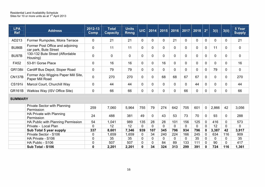
Residential Land Availability Schedule Sites for 10 or more units as at 1st April 2013
16
LPA Ref Address 2012-13
Comp Total
Capacity Units Rmng U/C 2014 2015 2016 2017 2018 2* 3(i) 3(ii) 5 Year
Supply
AD213 Former Rumpoles, Moira Terrace 0 21 21 0 0 0 21 0 0 0 0 0 21
BU86B Former Post Office and adjoining car park, Bute Street 0 11 11 0 0 0 0 0 0 0 11 0 0
BU97B 130-132 Bute Street (Affordable Housing) 0 0 0 0 0 0 0 0 0 0 0 0 0
FA52 53-81 Gorse Place 0 16 16 0 0 16 0 0 0 0 0 0 16
GR138ii Cardiff Bus Depot, Sloper Road 0 79 79 0 0 0 0 0 0 0 79 0 0
CN137B Former Arjo Wiggins Paper Mill Site, Paper Mill Road 0 270 270 0 0 68 68 67 67 0 0 0 270
CS191ii Marcol Court, Churchill Way 0 44 44 0 0 0 0 0 44 0 0 0 44
GR161B Watkiss Way (ISV Office Site) 0 66 66 0 0 0 0 66 0 0 0 0 66
SUMMARY
Private Sector with Planning Permission 259 7,060 5,964 755 79 274 642 705 601 0 2,866 42 3,056
HA Private with Planning Permission 24 488 381 49 0 43 53 73 70 0 93 0 288
HA Public with Planning Permission 54 1,041 989 135 28 28 101 156 125 0 416 0 573 Private - Local Plan 0 12 12 0 0 0 0 0 0 0 12 0 0 Sub Total 5 year supply 337 8,601 7,346 939 107 345 796 934 796 0 3,387 42 3,917 Private Sector - S106 0 1,659 1,659 0 34 240 224 166 245 0 634 116 909 HA Private - S106 0 35 35 0 0 0 0 0 35 0 0 0 35 HA Public - S106 0 507 507 0 0 84 89 133 111 0 90 0 417 Sub Total - S106 0 2,201 2,201 0 34 324 313 299 391 0 724 116 1,361
17
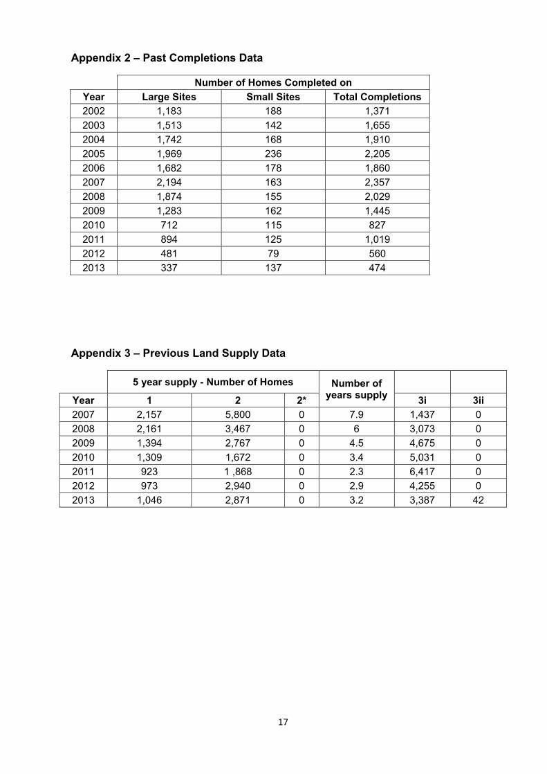
Appendix 2 – Past Completions Data
Number of Homes Completed on Year Large Sites Small Sites Total Completions 2002 1,183 188 1,371 2003 1,513 142 1,655 2004 1,742 168 1,910 2005 1,969 236 2,205 2006 1,682 178 1,860 2007 2,194 163 2,357 2008 1,874 155 2,029 2009 1,283 162 1,445 2010 712 115 827 2011 894 125 1,019 2012 481 79 560 2013 337 137 474
Appendix 3 – Previous Land Supply Data
5 year supply - Number of Homes Number of years supply
Year 1 2 2* 3i 3ii 2007 2,157 5,800 0 7.9 1,437 0 2008 2,161 3,467 0 6 3,073 0 2009 1,394 2,767 0 4.5 4,675 0 2010 1,309 1,672 0 3.4 5,031 0 2011 923 1 ,868 0 2.3 6,417 0 2012 973 2,940 0 2.9 4,255 0 2013 1,046 2,871 0 3.2 3,387 42

18
Appendix 4 – Planning Inspector’s Recommendation
www.planningportal.gov.uk/planninginspectorate
Adroddiad ar gyd-astudiaethau argaeledd tir ar gyfer tai
Report on Joint Housing Land Availability Study
gan R.M. Poppleton DipTP, DMS, MRTPI, JP by R.M. Poppleton DipTP, DMS, MRTPI, JP
Arolygydd a benodir gan Weinidogion Cymru an Inspector appointed by the Welsh Ministers
Dyddiad: 25/02/2014 Date: 25/02/2014
Ref: JHLAS/13/Z6815/515831 Local Planning Authority: Cardiff Council
This report concerns the Cardiff County Council Joint Housing Land Availability Study (JHLAS) April 2013.
The matters in dispute are set out in the JHLAS Statement of Common Ground (SoCG) submitted to the Welsh Government in September 2013.
Recommendation
1. That the 2013 JHLAS housing land supply figure for the Cardiff Council planning area be determined as 3.2 years.
Context of the Recommendation
2. Local Planning Authorities have a duty to ensure that sufficient land is genuinely available or will become available to provide a 5 year supply of land for housing1. The purpose of preparing a JHLAS is to:
Monitor the provision of market and affordable housing;
Provide an agreed statement of residential land availability for development planning and control purposes; and
Set out the need for action in situations where an insufficient supply is identified2.
3. The scope of this report is to recommend an appropriate housing land supply figure in respect of the Cardiff Council area, in the light of the matters in dispute concerning the calculation of such a figure and the available evidence.
Main Issues
4. There is agreement on the use of the past build rate as a suitable methodology for calculating the land supply, although it is not agreed whether this should be based on the past 5 or 10 years completions data. The other principal issue is whether or not each of the disputed sites should contribute towards the supply of land for housing as at the base date of the study (1 April 2013).
1 PPW Edition 5 paragraph 9.2.3
2 TAN 1: Joint Housing Land Availability Studies (June 2006) paragraph 2.1
JHLAS/13/515831
www.planningportal.gov.uk/planninginspectorate
2
Reasons
Method of Calculation:
5. The parties agree that a comparison with past building rates is the most appropriate method for determining the land supply at this time. Technical Advice Note 1 (TAN 1) advises that completion figures for the 5 years preceding the base date of the study should be used, but that a longer or shorter period may be appropriate in some circumstances. The Welsh Government (WG) Guidance Note on the JHLAS process (Version 2 – September 2012) advises that the 10 years immediately preceding the study base date provides a more appropriate timeframe upon which to base the land supply calculation.
6. I note the Council’s comments regarding the lack of consultation on the WG Guidance Note prior to its publication. However, that is not a matter for this report. Having had regard to all material factors, including TAN 1 and the WG 2012 Guidance, I conclude that a 10 year period is reasonable in this case.
7. The SoCG indicates an average build rate of 1,415 homes per annum for all housing sites, based on the 10 years preceding the base date of the study. This is the figure I have used to determine the available land supply.
Disputed Sites:
8. There is agreement on the majority of sites to be included within the 5 year land supply, amounting to an agreed supply of 3,073 units (equivalent to 2.2 years based on the above methodology). The 30 disputed sites amount to an additional 1,562 units (1.1 years). All parties accept that the land supply falls below the necessary 5 years3.
9. TAN 1 provides advice on the criteria to be applied in considering whether sites may be regarded as genuinely available within the 5 year period. I have assessed each of the disputed sites based on the available evidence and the advice in TAN 1.
10. St James' Church, Newport Road (Site AD186) (12 units in dispute): This site first appeared in the 2012 JHLAS and benefits from an extant outline planning permission. The developer has indicated that the site will be taken forward when the market improves. The Council has estimated that the 12 units will be completed in 2016/17; no convincing evidence has been put forward to suggest that this forecast is unreasonable. I consider that the 12 disputed units should remain within the 5 year supply.
11. Driscoll Workshop and Trading Centre, Tyndall Street Industrial Estate (Site BU104iii) (65 units in dispute): At the base date of the study, the site appeared to have outline planning permission. The Council states that a new application has recently been approved subject to Section 106 agreement. While there is some disagreement between the parties regarding the developer’s intention, I note that this site was included within the 2012 JHLAS without dispute. It does not appear that any new constraints have emerged during the past year which might prevent the site from coming forward. I find that the 65 disputed units should continue to be included in the 5 year land supply.
12. Land West of Dumballs Road (Site BU107i) (200 units in dispute) and Land West of Dumballs Road (Site BU107ii) (200 units in dispute): There is disagreement between
3 The Council confirms that it shares this view at paragraph 5.1 of the SoCG.

JHLAS/13/515831
www.planningportal.gov.uk/planninginspectorate
3
the parties as to how long these sites have formed part of the 5 year land supply. They were included, and not disputed, in the 2012 study. The Council states that 2012 was the first time the sites were included in the 5 year supply, but they also appear to have been included in the 2011 JHLAS. Although outline planning permission was granted for the sites in 2011, the developer has now indicated that a new application is likely to be submitted with construction commencing towards the end of the 5 year period. I note that the parties agree that the majority of units associated with these sites fall within category 3i, presumably to reflect the level of uncertainty regarding the sites’ phasing. However, despite this uncertainty, there is no convincing evidence to suggest that the Council’s proposed phasing is unrealistic or to prompt a reclassification of the 400 units not in category 3i. I therefore conclude that all 200 disputed units from Site BU107i, and the 200 additional units from Site BU107ii, should remain within the 5 year land supply.
13. Land at Roath Basin (Private Element) (Site BU32A) (100 units in dispute) and Land at Roath Basin (Site BU32B) (50 units in dispute): These sites benefit from existing outline planning permission. The sites were disputed, but were included, in the 5 year land supply for the 2012 JHLAS. Since last year, a new application has been granted subject to S106 agreement for a revised scheme comprising fewer units. The Council has accordingly reduced the number of units expected to be accommodated on Site BU32A during the 5 year period from 200 to 100. I consider this to be a reasonable adjustment. No evidence of additional constraints has been presented to justify the reclassification of any additional units into category 3i. I consequently find that all 100 disputed units from Site BU32A, and the 50 units from Site BU32B, should count towards the 5 year land supply.
14. Junction of Fanny/Gwyneth Streets (Site CS138) (10 units in dispute): This site benefits from full planning permission, granted in July 2011. The Council has indicated that an application to discharge a condition was submitted in August 2013, but this follows the base date of this study. However, no evidence has been presented to justify an assertion that the site is financially unviable in the current market. I therefore conclude that, consistent with the guidance in TAN 1, the 10 disputed units should remain within the 5 year land supply.
15. Car Park, St Andrews Lane, Cathays (Site CS218) (84 units in dispute): Full planning permission was granted in November 2012. The area of dispute surrounding the site’s inclusion in the 5 year land supply relates to existing leasehold arrangements. There does not appear to be any dispute over the financial viability of the proposed development. Given this, it would appear reasonable to assume that the remaining constraint could be removed in time for the first units to be completed within a five year period. On this basis I conclude that the 84 disputed units should remain within the 5 year land supply.
16. Land to the rear of Western Leisure Centre, Caerau (Site CU77i) (57 units in dispute) and Land rear of Western Leisure Centre (Site CU77ii) (25 units in dispute): Outline planning permission was granted in February 2012. These sites, which are Council-owned, were first included in the 5 year land supply in the 2012 JHLAS study. The sites have not yet been sold by the Council and, possibly for this reason, their phasing has been amended. This new phasing appears reasonable. For this reason, and due to the apparent lack of constraints to development, I conclude that the 57 disputed units from Site CU77i, and the 25 units from Site CU77ii, should be included within the 5 year land supply.
17. Land to the rear of Mynachdy Road (Site GA34) (69 units in dispute): Outline planning permission was granted in 2012 and the site was subsequently included in
JHLAS/13/515831
www.planningportal.gov.uk/planninginspectorate
4
the 5 year land supply for the 2012 JHLAS. The developer’s current intention is not wholly clear: perhaps because of this there is dispute between the parties about the nature and phasing of development. At the study base date of April 2013, the site had been included in the 5 year land supply for less than 5 years. Therefore, as advised by Paragraph 7.4.1 of TAN 1, I do not consider that a reclassification of this site into category 3i is justified. I conclude that the 69 disputed units should remain within the 5 year land supply.
18. Cambrian Marina (Site GR108i) (125 units in dispute): Although this site has outline planning permission, I note that applications have been made to vary conditions under Section 73 of the Town and Country Planning Act 1990. This indicates a degree of uncertainty regarding the likely timescale for delivery (indeed the Statement of Common Ground is itself unclear on this point: page 16 indicates that the first 60 units are likely to be completed in Year 4 of the study, while Section 3 indicates Year 3). The HBF has sought more information on delivery timescales from the Council but has not suggested that units should be moved out of the 5 year supply. I consider that the delivery timescales identified by the Council are reasonable and that the 125 units should remain within the 5 year land supply.
19. 18 High Street, Llandaff (Site LD125) (11 units in dispute): The site benefits from full planning permission. The developer indicates an intention to bring the site forward due to an improving market. There is no evidence before me which would support a reclassification of the site to category 3i. The 11 units should remain within the 5 year land supply.
20. The Retreat, Pwllmelin Road, Llandaff (Site LD129) (20 units in dispute): The parties appear to agree that this site should form part of the 5 year land supply. The area of dispute, between the Council and Asbri Planning, centres on the number of units that will be accommodated on the site. In my view, an extant, full permission provides an appropriate basis for determining the likely capacity of a site. Accordingly, I consider that the 20 disputed units should be included in the 5 year land supply.
21. 735 Newport Road, Llanrumney (Site LR30) (13 units in dispute): This site, which was included in the 2012 study, benefits from outline planning permission. At the base date of the study the site was for sale. In my view, the delivery of the site within the timescale indicated by the Council appears feasible. No evidence has been put forward to support a reclassification of the site to category 3i. The 13 units should remain within the 5 year land supply.
22. Land south of Lisvane Road (Site LV06) (40 units in dispute): This site benefits from full permission and appears to be a viable prospect for development. However, it appears that both the landowner and Council accept that the development of the site will not proceed until access arrangements for a nearby strategic site allocation in the Council’s emerging Local Development Plan are resolved. The Council expects the first 20 units from this site to be completed during 2015/16. Although this may be slightly optimistic, I do not consider that the constraints are of such significance to justify a reclassification of the site to 3i under the terms set out in Para 7.3.2 of TAN 1. I conclude that the 40 disputed units should remain within the 5 year land supply.
23. 217-223 Newport Road (Site PL197A) (47 units in dispute): Following the grant of full permission in 2011, this site was included in the 2012 JHLAS. Although the developer appears to be actively pursuing the scheme, delivery timescales appear uncertain, possibly because the site currently comprises buildings rented to the Council, which provide accommodation for low income families. The Council anticipates all 47 units to be completed during 2015/16. Although the site’s current
JHLAS/13/515831
www.planningportal.gov.uk/planninginspectorate
5
use is clearly a material constraint to its development, I do not consider it sufficient basis for reclassifying any units as 3i, as suggested by some parties. I find that all 47 disputed units should remain within the 5 year supply.
24. Wellington House, Wellington Street (Site RV171) (44 units in dispute): Permission was granted for this site in 2009 and the site was included in the 2012 study without dispute. From the available evidence, it appears that the main constraint to the site’s delivery relates to a lack of financing secured by the landowner. Asbri Planning contends that on this basis the site should be reclassified as 3i, but I do not consider that a reclassification on these grounds would be consistent with Para 7.3.2 of TAN 1. I conclude that the 44 disputed units should remain within the 5 year land supply.
25. Land between Crickhowell Road and Willowbrook Drive (Willowbrook West) (Site TR133A) (115 units in dispute) and Land between Crickhowell Road and Willowbrook Drive (Willowbrook West) (Site TR133B) (50 units in dispute): These Council-owned sites were first granted outline permission in 2006. In 2010 the permissions were granted an extension of time limit under Section 73 of the Town and Country Planning Act 1990. The sites are in an accessible and sustainable greenfield location, and I am not aware of any major physical constraints that would constrain their delivery. Although the sites form part of the Council’s Housing Partnership Programme, which is currently being advanced, they have remained within the 5 year land supply for over 5 years with no apparent change in circumstances. However, as the delivery of homes on these sites appears likely to be predominantly funded by the public sector, I consider that this is sufficient justification for them to remain within the land supply, consistent with the advice at paragraph 7.4.1 of TAN 1. I conclude that the 115 disputed units from Site TR133A, and the 50 units from Site TR133B, should remain within the 5 year supply.
26. Whitchurch Hospital (Site WH71A) (160 units in dispute) and Whitchurch Hospital (Site WH71B) (40 units in dispute): These sites benefit from planning permission which is subject to an extension of time limit under Section 73 of the Town and Country Planning Act 1990 until 2016. The sites were both included, and not disputed, in the 2012 JHLAS report. I note that 130 units of the total capacity of 330 units on these sites are classified as 3i and that the parties are in agreement on this point. The landowner’s agent supports the delivery timescale put forward by the Council but has indicated that there are uncertainties to resolve. Paragraph 7.3.4 of TAN 1 is clear that, for Category 1 and 2 sites, there should be a reasonable prospect of the site being sold for development where the land is not already owned by developers or a public body with its own firm plans for building. Despite the extant permission, the sites’ ownership status and the lack of certainty expressed by the landowner’s agent would suggest that the Council’s projected phasing is overly optimistic. This uncertainty may delay initial completions until Year 5 of the study, rather than Year 4 as anticipated by the Council. In the absence of compelling evidence to give confidence in this regard I find that only 80 units from Site WH71A, and 20 units from Site WH71B, should count towards the 5 year housing land supply.
27. Part of Area 9, Land south of the Beacon Centre, Harrison Drive (Site TR87Di) (15 units in dispute): This site first appeared in the 2012 JHLAS. It benefits from an extant outline planning permission and an application for reserved matters has been approved subject to Section 106. The landowner has indicated that it intends to commence development of the site in around 2 years’ time. The Statement of Common Ground is unclear on the timescale for delivery: page 28 indicates that the 15 units will be completed in Year 3 of the study, while Section 3 indicates Year 2. Regardless of the exact phasing, no convincing evidence has been put forward to
JHLAS/13/515831
www.planningportal.gov.uk/planninginspectorate
6
suggest that either forecast is unreasonable. I consider that the 15 disputed units should remain within the 5 year supply.
28. Land off Crumlin Drive (Site TR140A) (10 units in dispute): This site benefits from full planning permission. The Council proposes to remove the site from the 3i classification (its status in the 2012 JHLAS) to reflect its inclusion in Cardiff Council’s Housing Partnership Programme. The HBF disputes this reclassification on the basis that the site’s inclusion in the Council’s housing programme is not substantive proof that it will be developed. However, the test in TAN 1 is whether sites are or are not ‘genuinely available for housing development’. In this circumstance the site appears to be genuinely available, and an element of funding has been agreed via an ongoing public sector programme. I consider that the 10 disputed units should remain within the 5 year supply.
29. Former Tredegar House, 57-58 Clifton Street (Site AD174) (12 units in dispute); Former Arjo Wiggins Paper Mill Site, Paper Mill Road (Site CN137A: 448 units in dispute; and Site CN137B: 270 units in dispute); 635 Cowbridge Road East (Site CN145) (24 units in dispute); Marcol Court, Churchhill Way (Site CS191i: 103 units in dispute; and Site CS191ii: 44 units in dispute): Although these sites have been included in the Statement of Common Ground as disputed sites, the Council has confirmed that it does not consider them to be part of the five year supply. I accept the Council’s position and have not included any of these disputed units in my calculation of the 5 year land supply.
Conclusion
30. For the above reasons, I find that of the 1,562 disputed units, 1,412 of them should be included in the 5 year land supply figure. Combined with the already agreed figure of 3,073 units, this brings the total land supply figure to 4,485 units.
31. Calculated using the past building rates methodology, and based on the agreed average annual completion of 1,415 units, I conclude that, as at 1 April 2013, the housing land supply for the Cardiff Council planning area is 3.2 years.
Richard Poppleton
Inspector