Capital Ring route section-ten -...
5
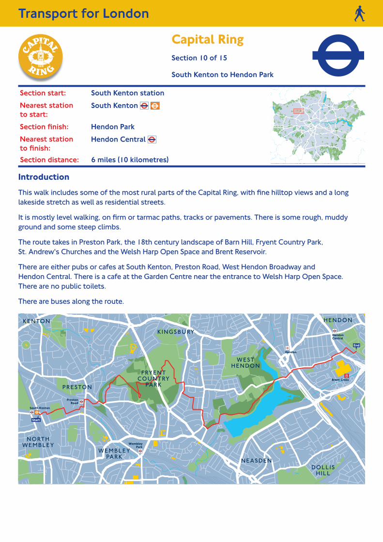
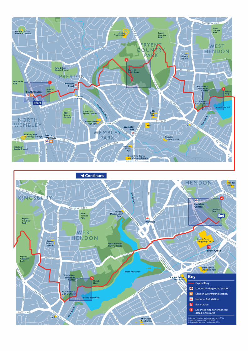
Transport for London. Section distance: 6 miles (10 kilometres). Introduction This walk includes some of the most rural parts of the Capital Ring, with fine hilltop views and a long lakeside stretch as well as residential streets. It is mostly level walking, on firm or tarmac paths, tracks or pavements. There is some rough, muddy ground and some steep climbs. The route takes in Preston Park, the 18th century landscape of Barn Hill, Fryent Country Park, St. Andrew's Churches and the Welsh Harp Open Space and Brent Reservoir. There are either pubs or cafes at South Kenton, Preston Road, West Hendon Broadway and Hendon Central. There is a cafe at the Garden Centre near the entrance to Welsh Harp Open Space. There are no public toilets. There are buses along the route. Section start: South Kenton station. Nearest station to start: South Kenton . Section finish: Hendon Park. Nearest station to finish: Hendon Central . Capital Ring Section 10 of 15. South Kenton to Hendon Park.
-
Upload
trinhtuyen -
Category
Documents
-
view
213 -
download
0
Transcript of Capital Ring route section-ten -...
Transport for London.
Section distance: 6 miles (10 kilometres).
Introduction
This walk includes some of the most rural parts of the Capital Ring, with fine hilltop views and a long lakeside stretch as well as residential streets.
It is mostly level walking, on firm or tarmac paths, tracks or pavements. There is some rough, muddy ground and some steep climbs.
The route takes in Preston Park, the 18th century landscape of Barn Hill, Fryent Country Park, St. Andrew's Churches and the Welsh Harp Open Space and Brent Reservoir.
There are either pubs or cafes at South Kenton, Preston Road, West Hendon Broadway and Hendon Central. There is a cafe at the Garden Centre near the entrance to Welsh Harp Open Space. There are no public toilets.
There are buses along the route.
Section start: South Kenton station.
Nearest station to start:
South Kenton .
Section finish: Hendon Park.
Nearest station to finish:
Hendon Central .
Capital Ring
Section 10 of 15.
South Kenton to Hendon Park.
Continues Continues on next page
Directions
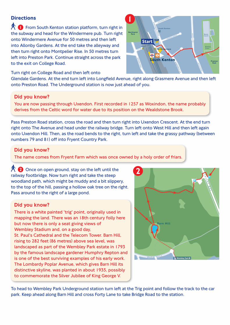
From South Kenton station platform, turn right in the subway and head for the Windermere pub. Turn right onto Windermere Avenue for 50 metres and then left into Allonby Gardens. At the end take the alleyway and then turn right onto Montpelier Rise. In 50 metres turn left into Preston Park. Continue straight across the park to the exit on College Road.
Turn right on College Road and then left onto Glendale Gardens. At the end turn left into Longfield Avenue, right along Grasmere Avenue and then left onto Preston Road. The Underground station is now just ahead of you.
Did you know? You are now passing through Uxendon. First recorded in 1257 as Woxindon, the name probably derives from the Celtic word for water due to its position on the Wealdstone Brook.
Pass Preston Road station, cross the road and then turn right into Uxendon Crescent. At the end turn right onto The Avenue and head under the railway bridge. Turn left onto West Hill and then left again onto Uxendon Hill. Then, as the road bends to the right, turn left and take the grassy pathway (between numbers 79 and 81) off into Fryent Country Park.
Did you know? The name comes from Fryent Farm which was once owned by a holy order of friars.
Once on open ground, stay on the left until the railway footbridge. Now turn right and take the steep woodland path, which might be muddy and a bit slippery, to the top of the hill, passing a hollow oak tree on the right. Pass around to the right of a large pond.
Did you know? There is a white painted 'trig' point, originally used in mapping the land. There was an 18th century folly here but now there is only a seat giving views of Wembley Stadium and, on a good day, St. Paul's Cathedral and the Telecom Tower. Barn Hill, rising to 282 feet (86 metres) above sea level, was landscaped as part of the Wembley Park estate in 1793 by the famous landscape gardener Humphry Repton and is one of the best surviving examples of his early work. The Lombardy Poplar Avenue, which gives Barn Hill its distinctive skyline, was planted in about 1935, possibly to commemorate the Silver Jubilee of King George V.
To head to Wembley Park Underground station turn left at the Trig point and follow the track to the car park. Keep ahead along Barn Hill and cross Forty Lane to take Bridge Road to the station.
To continue on Section 10, walk back past the pond on the opposite side, and descend by a steep path to the right of the one you came up by. Turn right just before the path passes out from the woodland into open fields.
Emerge from the woodland near an informal car park. From its entrance cross the road to the old hay meadows. Follow the hedgerow along to the left, past a small pond, and continue along the hedgerow to the left of the field until you reach the far left-hand corner. Turn left through the gap in the hedge, and proceed up to the summit of Gotfords Hill, known as 'Telly Tubby Hill' by the local children for its grassed, rounded top.
From the summit, turn to face the path you came up by and head towards the left-hand corner of the field; go straight ahead across the next field.
Follow the signs, past a small area of scrub woodland, turn left and pass through some of this scrub to leave the country park by a short alleyway with a wooden kissing gate at the end. Turn right onto Salmon Street, left along Lavender Avenue and then right onto Holden Avenue. Turn left onto Dunster Drive and right onto Church Lane, passing St. Andrews Church.
Did you know? The large St. Andrews Parish Church, opened in 1847 was moved here from near Oxford Circus. With a shift in population from the commercial West End to more rural areas, the church became redundant and was moved to the growing village of Kingsbury in 1931.
After the church turn left into Old Church Lane, and alongside the churchyard of Old St. Andrew's. Turn left again, following the sign to Birchen Close.
On the left is the 12th century Old St. Andrew's Church, with Roman bricks incorporated into it, which was once at the centre of the village of Kingsbury.
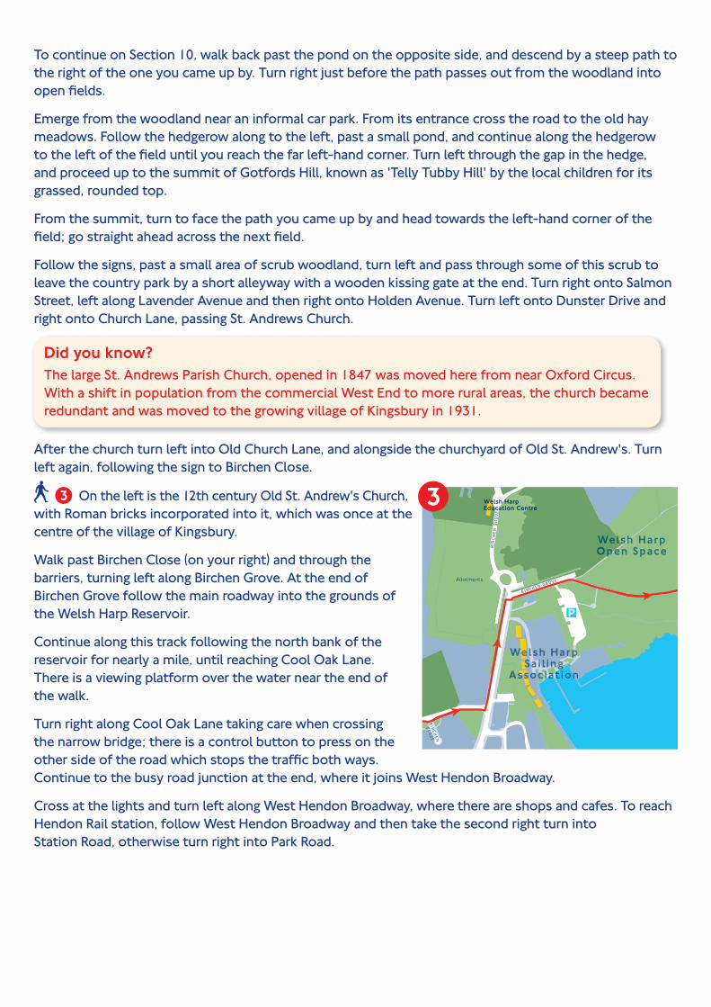
Walk past Birchen Close (on your right) and through the barriers, turning left along Birchen Grove. At the end of Birchen Grove follow the main roadway into the grounds of the Welsh Harp Reservoir.
Continue along this track following the north bank of the reservoir for nearly a mile, until reaching Cool Oak Lane. There is a viewing platform over the water near the end of the walk.
Turn right along Cool Oak Lane taking care when crossing the narrow bridge; there is a control button to press on the other side of the road which stops the traffic both ways. Continue to the busy road junction at the end, where it joins West Hendon Broadway.
Cross at the lights and turn left along West Hendon Broadway, where there are shops and cafes. To reach Hendon Rail station, follow West Hendon Broadway and then take the second right turn into Station Road, otherwise turn right into Park Road.
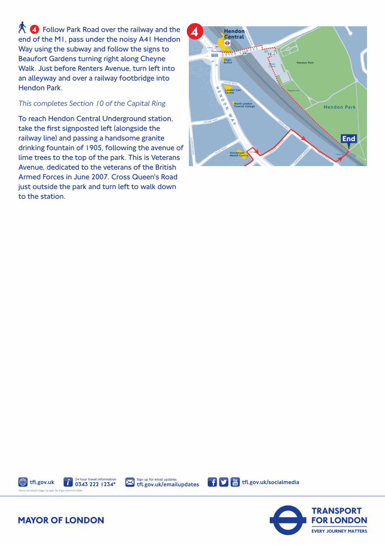
Follow Park Road over the railway and the end of the M1, pass under the noisy A41 Hendon Way using the subway and follow the signs to Beaufort Gardens turning right along Cheyne Walk. Just before Renters Avenue, turn left into an alleyway and over a railway footbridge into Hendon Park.
This completes Section 10 of the Capital Ring.
To reach Hendon Central Underground station, take the first signposted left (alongside the railway line) and passing a handsome granite drinking fountain of 1905, following the avenue of lime trees to the top of the park. This is Veterans Avenue, dedicated to the veterans of the British Armed Forces in June 2007. Cross Queen's Road just outside the park and turn left to walk down to the station.