
Cape Lambert Port A Marine Structures Refurbishment Project
29
Page | 1 Environmental Management Plan Cape Lambert Port A Marine Structures Refurbishment Project December 2018
Transcript of Cape Lambert Port A Marine Structures Refurbishment Project
Page | 1
Environmental Management Plan
Cape Lambert Port A Marine Structures Refurbishment
Project
December 2018
Page | 2
Contents page
1. Background 1
1.1 Project description 1
1.1.1 Project area 1
1.2 Proposed activities 1
1.3 Purpose and scope 1
1.4 Timeframes 1
1.4.1 Project timeframes 1
1.4.2 Work timeframes 1
1.5 Stakeholders 1
1.6 Structure of the EMP 2
1.6.1 Relationship to other plans 2
2. Existing environment 4
3. Work activities and potential impacts 7
4. Risk assessment 8
4.1 Method and scope 8
4.2 Results 11
5. Environmental management and mitigation procedures 15
6. Reporting and review process 22
References 23
Table 1-1: Existing approvals and management plan related to the Cape Lambert lease area 2
Table 2-1: Summary of environmental values at Cape Lambert 4
Table 3-1: Potential impacts associated with the Project 7
Table 4-1: Risk matrix 9
Table 4-2: Risk rating, risk class and associated risk management response 9
Table 4-3: Definition of likelihood 9
Table 4-4: Consequence definitions for fauna, marine/terrestrial environment and sensitive human
receptors 10
Table 4-5: Risk assessment of project activities and management controls 12
Page | 3
Table 5-1: General project activities and industry standard controls that will be implemented to avoid
and reduce impacts 15
Table 5-2: Underwater noise management framework 16
Table 5-3: Ambient noise management framework 19

Page | 1
1. Background
1.1 Project description
The Project is situated within the existing Cape Lambert Port, located on Pilbara coast of Western
Australia approximately 5 km from Point Samson, 12 km from Wickham and 60 km from Karratha
(Figure 1-1). The Cape Lambert Port consists of two operational areas, Cape Lambert Port A (CLA)
and Cape Lambert Port B (CLB).
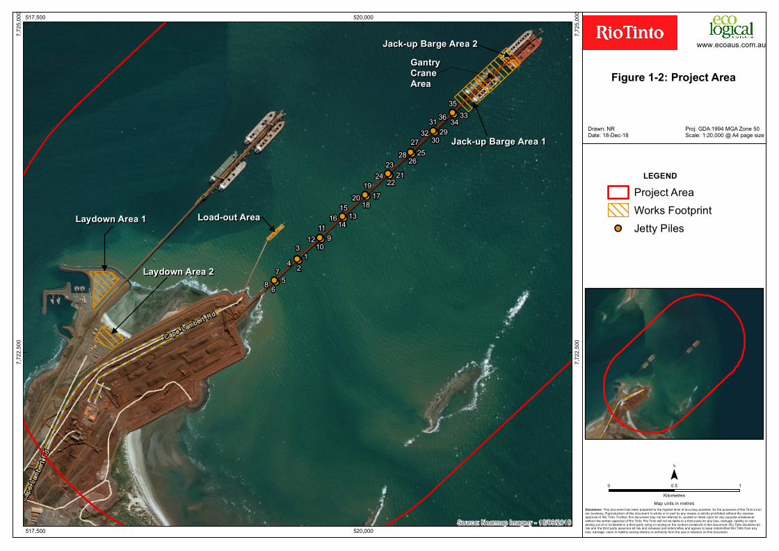
1.1.1 Project area The Project area (Figure 1-2), comprising the works area (CLA jetty/wharf, service wharf and two
laydown areas) plus a 2 km radius, encompasses the extent of potential direct and indirect impacts of
the Project.
1.2 Proposed activities
The proposed activities associated with the Project are predominantly nearshore works, located within
the existing port facility and include:
• Offsite fabrication and delivery of piles, caps, fenders and mooring equipment required for 18
berthing dolphins and two mooring dolphins at the CLA wharf. Piles will be 1.2 m in diameter.
The onshore component of the Project will involve the use of two existing laydown areas within
the Lease Area for storage of piles and associated equipment. The piles will be loaded aboard
barges at the existing CLA Service Wharf for haulage to the nearshore worksites at the CLA
wharf and jetty.
• Replacement of dolphins via the installation of new dolphins alongside the existing structures;
these will be connected by a steel jetty walkway between the new dolphins to enhance safe
access around the wharf. A total of 108 new piles will be driven into the seabed using a
hydraulic pile hammer supported by a crane and jack-up barges. Following the completion of
installation of the new replacement dolphins, the redundant dolphins will be mechanically cut
above seabed level and transported to shore with the intention to be recycled as scrap metal.
• Strengthening the CLA jetty by the installation of an additional 36 piles with tie-ins back into the
jetty. The piles will be installed in groups of four (two either side of the jetty) at nine locations
along the jetty. These piles will also be installed using a hydraulic pile hammer supported by a
crane and jack-up barges.
1.3 Purpose and scope
This Environmental Management Plan (EMP) informs how the Project will manage impacts to sensitive
environmental values as required under the Western Australian Environmental Protection Act 1996 (EP
Act), and the Commonwealth’s Environment Protection and Biodiversity Conservation Act 1999 (EPBC
Act). The EMP will be implemented for the duration of the Project and:
• Describes the environmental values of the Project area
• Identifies potential impacts on species and other sensitive environmental values that may occur
as a result of the Project
• Undertakes a risk assessment to evaluate the potential impacts that pose the most risk to
environmental values and those that require detail management measures to reduce the risk
• Identifies the measures to be applied to avoid and minimise environmental impacts from the
Project
• Details the objectives, triggers and performance targets to be achieved by the implementation
of this management plan.

!
!
!
!
!
!
!
!
!
!
!
!
!
!
!
!
""
MurujugaNational
Park
KarijiniNational
Park
Millstream-ChichesterNational Park
Karratha
Marble Bar
Newman
Pannawonica
Paraburdoo
Roebourne
Tom Price
Wickham
Brockman 2Marandoo
Paraburdoo
MountTom Price
Channar
West Angelas
Yandicoogina
Mesa J
Nammuldi
Eastern Range
Hope Downs 1
Brockman 4
WesternTurner
Syncline
Hope Downs 4
Silvergrass
Cape LambertDampier
N o r th
We s
t Co a s t a l H i g h w a y
G r e a tN o r t h e r n
Highw
a y
400,000
400,000
500,000
500,000
600,000
600,000
700,000
700,000
7,400,000
7,400,000
7,500,000
7,500,000
7,600,000
7,600,000
7,700,000
7,700,000
"
CapeLambert
P I L B A R A
Perth
0 20 40 60 80 100Kilome tre s
¯
Disclaimer: This docume nt has be e n pre pare d to the highe st le ve l of accuracy pos s ible , for the purpos e s of Rio Tinto’s ironore bus ine s s . Re production of this docume nt in whole or in part by any me ans is strictly prohibite d without the e xpre s sapproval of Rio Tinto. Furthe r, this docume nt may not be re fe rre d to, q uote d or re lie d upon for any purpos e whatsoe ve rwithout the writte n approval of Rio Tinto. Rio Tinto will not be liable to a third party for any los s , damage , liability or claimarising out of or incide ntal to a third party us ing or re lying on the conte nt containe d in this docume nt. Rio Tinto disclaims allrisk and the third party as s ume s all risk and re le as e s and inde mnifie s and agre e s to ke e p inde mnifie d Rio Tinto from anylos s, damage , claim or liability arising dire ctly or indire ctly from the us e or re liance on this docume nt.
Map units in me tre s
Legend
! Rio Tinto Mine
" Port
Town
National Park
Rio Tinto Railway
Highway
Major Road
Project Area
Figure 1-1:Locality
Plan No: PDE0164793v1Proj: MGA94 Zone 50
T. MurphyDe ce mbe r, 2018
!!!!!!!!
!!!!!!!!
!!!!!!!!
!!!!!!!!
!!!!!!!!
!!!!!!!!
!!!!!!!!
!!!!!!!!
!!!!!!!!
78 5
6
43
2112
11
109
141316
15 181720
192422
2321
2827
2625
3230
312936
35
3433
517,500
517,500
520,000
520,000
7,722
,500
7,722
,500
7,725
,000
7,725
,000
0 0.5 1Kilo m etres
¯
Disclaimer: This do cum en t has been prepared to the highest level o f accuracy po ssible, fo r the purpo ses o f Rio Tin to ’s iro no re busin ess. Repro ductio n o f this do cum en t in w ho le o r in part by an y m ean s is strictly pro hibited w itho ut the expressappro val o f Rio Tin to . Further, this do cum en t m ay n o t be referred to , quo ted o r relied upo n fo r an y purpo se w hatso everw itho ut the w ritten appro val o f Rio Tin to . Rio Tin to w ill n o t be liable to a third party fo r an y lo ss, dam age, liability o r claimarisin g o ut o f o r in ciden tal to a third party usin g o r relyin g o n the co n ten t co n tain ed in this do cum en t. Rio Tin to disclaim s allrisk an d the third party assum es all risk an d releases an d in dem n ifies an d agrees to keep in dem n ified Rio Tin to fro m an ylo ss, dam age, claim o r liability arisin g directly o r in directly fro m the use o r relian ce o n this do cum en t.
Pro j: GDA 1994 MGA Z o n e 50 Scale: 1:20,000 @ A4 page siz e
Draw n : NRDate: 18-Dec-18
Figure 1-2: Project Area
Map un its in m etres
So urce: Nearm ap Im agery - 18/09/2018
Laydown Area 1Laydown Area 1
Laydown Area 2Laydown Area 2
Load-out AreaLoad-out Area
Jack-up Barge Area 2Jack-up Barge Area 2GantryGantryCraneCraneAreaArea
Jack-up Barge Area 1Jack-up Barge Area 1
LEGENDPro ject AreaWo rks Fo o tprin t
!! Jetty Piles
w w w .eco aus.co m .au
Page | 1
1.4 Timeframes
1.4.1 Project timeframes
The Project will be implemented once all external and internal approvals have been obtained and the
tendering/contract process has been finalised.
It is anticipated that the Project will commence in Q3 2019 and extend for approximately 12-18 months.
This will be dependent on the scheduling of periods when access to CLA berths is granted to undertake
the works so as not to disrupt ongoing port operations. Given good working conditions, completion of a
dolphin could take around 4-5 days, while installation of pile arrangements for the jetty strengthening
works could take around 1-2 days per pile location.
1.4.2 Work timeframes
Piling will be undertaken during day-time (7 am to 7 pm, Monday to Saturday). Piling will only be
undertaken in the evening (7 pm to 10 pm, Monday to Saturday) in the unlikely event that a pile that has
been positioned during the day-time is not secure or stable and is at risk of toppling. In such a scenario,
sufficient piling will be undertaken to make the pile safe and stable before completion the next available
piling day. No piling will be undertaken during night-time (10 pm to 7 am).
Piling will not be required over this whole period. Outside the period of piling, the implementation phase
will involve delivery of piles, stockpiling of piles, loading barges with piles, delivery to the work area,
positioning piles, installation of above water infrastructure (e.g. walkways between dolphins, caps, jetty
tie-ins) and removal of redundant infrastructure.
Depending on progress, the CLA jetty strengthening works will be undertaken at the same time as the
CLA dolphin replacement works. This may result in up to two pile driving barges operating concurrently
for short periods.
1.5 Stakeholders
Key stakeholders were identified based on Rio Tinto’s experience in project developments in the Pilbara
region, especially recent port expansions and upgrades at Dampier and Cape Lambert. The following
key stakeholders were identified:
State and Local Government agencies
• City of Karratha
• Department of Jobs Tourism, Science and Innovation
• Department of Transport
• Environmental Protection Authority Services of the Department of Water and Environmental
Regulation (EPA)
• Pilbara Ports Authority
Commonwealth Government agencies
• Department of the Environment and Energy (DoEE)
Non-government organisations
• Point Samson Community Association
• Coastal Community Environmental Forum
• Dampier Technical Advisory and Consultative Committee
Page | 2
1.6 Structure of the EMP
The objective of this EMP is to create a risk-based usable document that is clear and structured to
assist the regulator during the assessment process, and a document that can be readily implemented
by a Contractor. The EMP structure is summarised below:
• Project description
• An overview of the existing environment
• Identification of activities and potential impacts to populate the risk assessment
• Risk assessment to identify activities that are the highest risk and need active management
• Specific management measures
• Reporting and review.
This EMP has been prepared to identify and assess project activities and risks while tailoring
management actions. The EMP attempts to meet the objectives of the Commonwealth DoEE’s
Environmental Management Plan Guidelines and the Western Australia EPA’s Instruction on how to
prepare Environmental Protection Act 1986 Part IV Environmental Management Plans.
1.6.1 Relationship to other plans
To ensure the EMP is easily implemented by a Contractor, the document has focussed on project
activities that may impact on sensitive receptors, and associated management actions to be
implemented. Information such as the existing environment (terrestrial and marine) can be found in the
Cape Lambert Port A EPBC Act referral (2018) with its associated technical reports, the Cape Lambert
Port A EP Act referral (2018) with its associated technical reports, and the Cape Lambert Port B (CLB)
Development Public Environment Review and Draft Public Environmental Report and its associated
technical reports (SKM 2009).
Table 1-1 outlines the existing approvals and management plans that apply to the Cape Lambert lease
area.
Table 1-1: Existing approvals and management plan related to the Cape Lambert lease area
Existing approvals / management plan Description
Ministerial Statement 514 (28 June 1999)
Upgrade of CLA to accommodate ore from the West Angelas mine
site and increase throughput to 55 Mtpa. Included marine and
terrestrial works
Ministerial Statement 741 (18 May 2007)
Ministerial Statement 1050 (30 December
2016) – s46 change of conditions (dust and
noise)
Upgrade of CLA to increase throughput to 85 Mtpa. Included
terrestrial works only. Subsequent change to proposal amendment
under MS 741 for 105 Mtpa throughput
Ministerial Statement 743 (12 July 2007) Dredging for upgrade of CLA to 85 Mtpa. Included marine works only
Ministerial Statement 840 (30 September
2010) and Ministerial Statement 876 (31
October 2010)
Ministerial Statement 1049 (30 December
2016) – s46 change of conditions (dust)
EPBC 2008/4032 (26 October 2010)
Construction of the CLB project with 130 Mtpa capacity. Both
terrestrial and marine works
Sea Dumping Permit No. SD2016/3242 (16
June 2016)
Dumping up to 400,000 m3 (in-situ) of dredged material derived from
maintenance dredging of Cape Lambert from 16 June 2016 to 31
May 2019
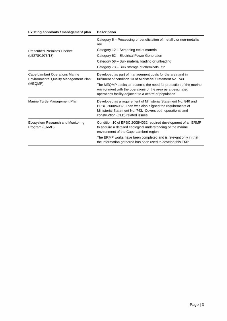
Page | 3
Existing approvals / management plan Description
Prescribed Premises Licence
(L5278/1973/13)
Category 5 – Processing or beneficiation of metallic or non-metallic
ore
Category 12 – Screening etc of material
Category 52 – Electrical Power Generation
Category 58 – Bulk material loading or unloading
Category 73 – Bulk storage of chemicals, etc
Cape Lambert Operations Marine
Environmental Quality Management Plan
(MEQMP)
Developed as part of management goals for the area and in
fulfilment of condition 13 of Ministerial Statement No. 743.
The MEQMP seeks to reconcile the need for protection of the marine
environment with the operations of the area as a designated
operations facility adjacent to a centre of population
Marine Turtle Management Plan Developed as a requirement of Ministerial Statement No. 840 and
EPBC 2008/4032. Plan was also aligned the requirements of
Ministerial Statement No. 743. Covers both operational and
construction (CLB) related issues
Ecosystem Research and Monitoring
Program (ERMP)
Condition 10 of EPBC 2008/4032 required development of an ERMP
to acquire a detailed ecological understanding of the marine
environment of the Cape Lambert region
The ERMP works have been completed and is relevant only in that
the information gathered has been used to develop this EMP

Page | 4
2. Existing environment Extensive environmental studies were conducted in the Cape Lambert area as part of the CLB project
(EPBC 2008/4032 and Ministerial Statement 840). A significant amount of environmental information
has also been gathered during the implementation of Condition 10 (ERMP) of EPBC 2008/4032. Some
additional studies have been specifically undertaken to inform the assessment of the CLA Marine
Structures Refurbishment Project. The key studies and reports include:
• Public Environmental Review and Draft Public Environment Report (SKM 2009)
• Assessment of lighting effects on turtles (Bassett 2009)
• Species specific surveys for Lerista nevinae (Biota 2008a)
• Flora and vegetation survey (Biota 2008b)
• Marine turtle assessment (Biota 2008c)
• Seasonal fauna survey (Biota 2008d)
• Sediment sampling and analysis report (MScience 2015)
• Humpback whale aerial surveys 2012-2016 review (BMT Oceanica 2017)
• Underwater noise literature review addendum (ERM and JASCO 2018)
• Underwater noise modelling report (Li and McPherson 2018)
• Underwater noise report (ERM 2018a)
• Ambient noise impact assessment (ERM 2018b)
• CLA jetty habitat assessment (Hydrobiology 2018).
The following sections present a summary of the existing environment of the Project area, with further
information available in those documents cited above. Table 2-1 summarises the environmental values
for the region. The summary is focused on the key environmental factors that may be impacted and will
be managed through the implementation of the EMP.
The focus of the sensitive receptors relevant to the project activities are the subject of a risk
assessment. The risk ratings are assessed in Section 5 for each environmentally sensitive receptor and
project activity using the risk matrix as per ISO 31000:2009.
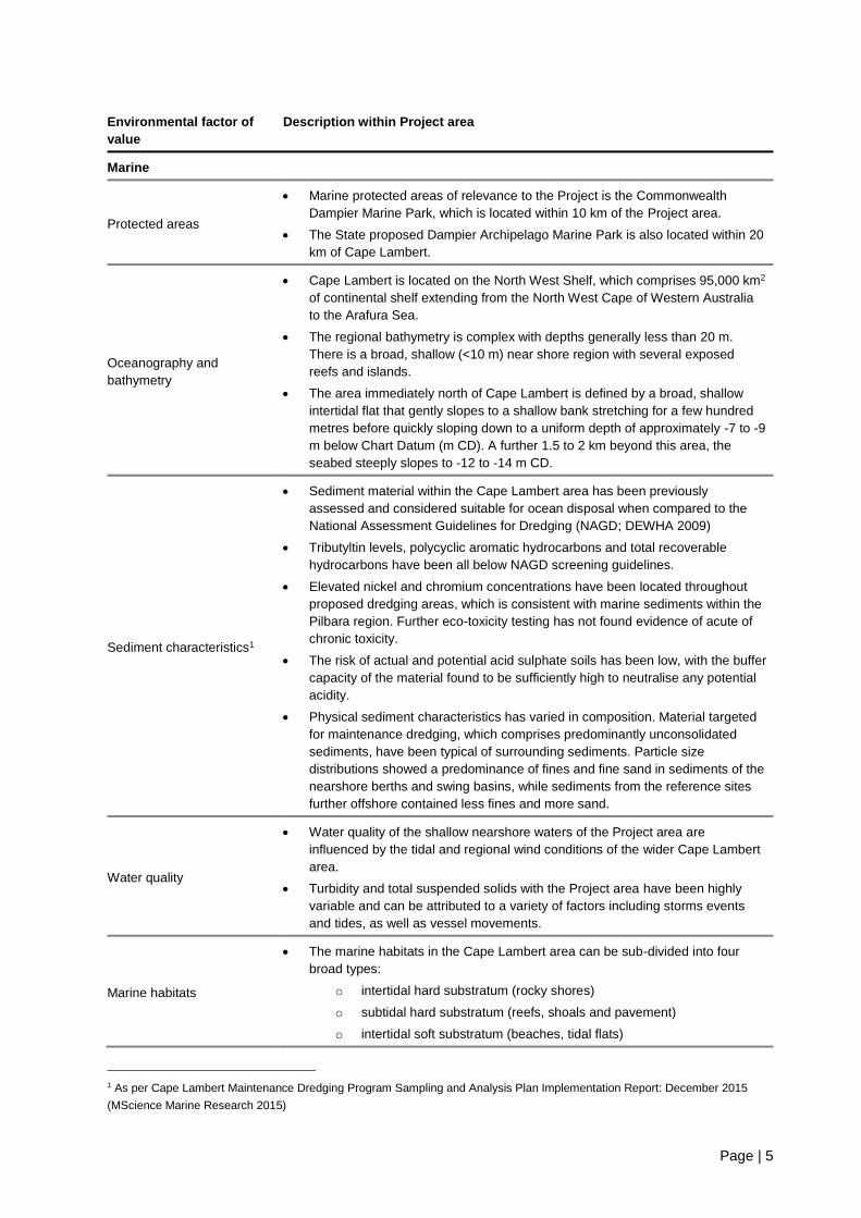
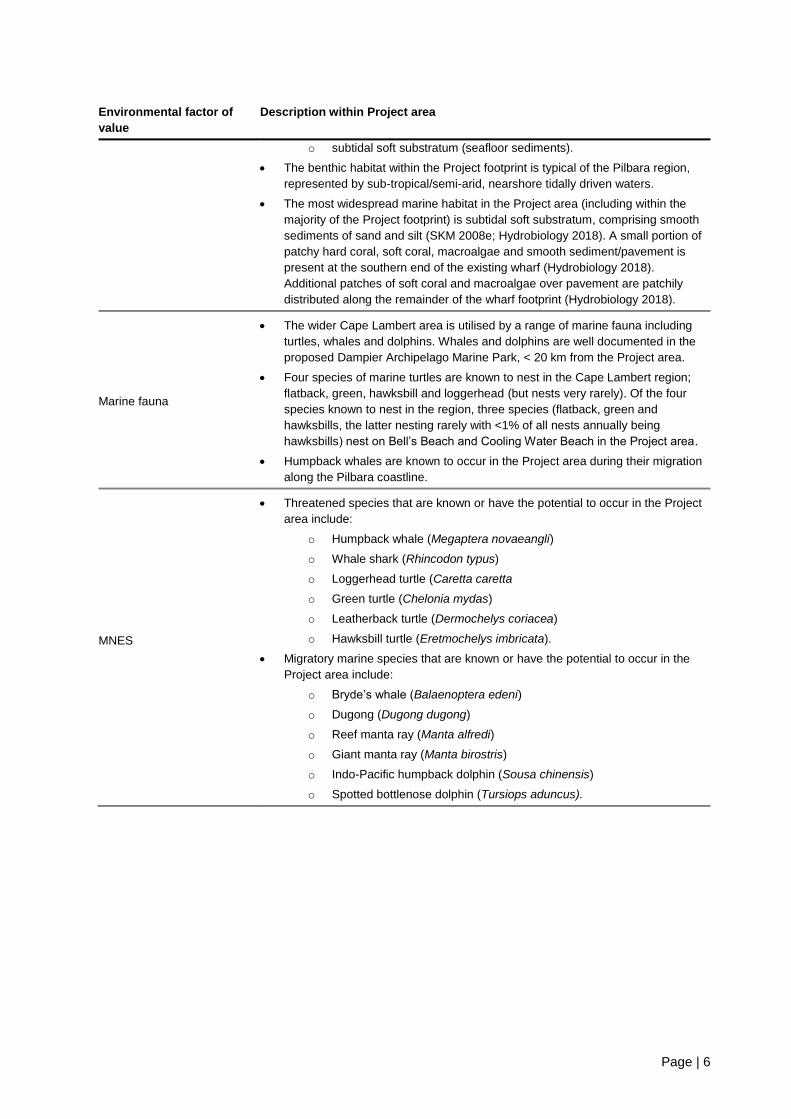
Table 2-1: Summary of environmental values at Cape Lambert
Environmental factor of
value
Description within Project area
Terrestrial
Terrestrial flora and fauna
• The Project area consists of large portions of previously disturbed areas, where
terrestrial vegetation has been cleared to allow for the infrastructure associated
with Cape Lambert operations.
• A search of the EPBC Protected Matters Search Tool (PMST) indicated that no
threatened ecological communities or threatened flora species’ habitat was
known to occur or had the potential to occur within a 10 km radius of the
Project area.
• The terrestrial habitat of highest value is located at Bells Beach and Cooling
Water Beach and is mostly comprised of primary dunes.
Terrestrial environment
• Local light environment at Cape Lambert is well lit due to the requirements of
the operational port facility.
• Eight receptor locations have the potential to be impacted by noise generated
from the Project. The receptors are a mix of industrial, commercial and
residential premises and range from between 4.5 km to 11.5 km away from the
CLA wharf (ERM 2008b).
Page | 5
Environmental factor of
value
Description within Project area
Marine
Protected areas
• Marine protected areas of relevance to the Project is the Commonwealth
Dampier Marine Park, which is located within 10 km of the Project area.
• The State proposed Dampier Archipelago Marine Park is also located within 20
km of Cape Lambert.
Oceanography and
bathymetry
• Cape Lambert is located on the North West Shelf, which comprises 95,000 km2
of continental shelf extending from the North West Cape of Western Australia
to the Arafura Sea.
• The regional bathymetry is complex with depths generally less than 20 m.
There is a broad, shallow (<10 m) near shore region with several exposed
reefs and islands.
• The area immediately north of Cape Lambert is defined by a broad, shallow
intertidal flat that gently slopes to a shallow bank stretching for a few hundred
metres before quickly sloping down to a uniform depth of approximately -7 to -9
m below Chart Datum (m CD). A further 1.5 to 2 km beyond this area, the
seabed steeply slopes to -12 to -14 m CD.
Sediment characteristics1
• Sediment material within the Cape Lambert area has been previously
assessed and considered suitable for ocean disposal when compared to the
National Assessment Guidelines for Dredging (NAGD; DEWHA 2009)
• Tributyltin levels, polycyclic aromatic hydrocarbons and total recoverable
hydrocarbons have been all below NAGD screening guidelines.
• Elevated nickel and chromium concentrations have been located throughout
proposed dredging areas, which is consistent with marine sediments within the
Pilbara region. Further eco-toxicity testing has not found evidence of acute of
chronic toxicity.
• The risk of actual and potential acid sulphate soils has been low, with the buffer
capacity of the material found to be sufficiently high to neutralise any potential
acidity.
• Physical sediment characteristics has varied in composition. Material targeted
for maintenance dredging, which comprises predominantly unconsolidated
sediments, have been typical of surrounding sediments. Particle size
distributions showed a predominance of fines and fine sand in sediments of the
nearshore berths and swing basins, while sediments from the reference sites
further offshore contained less fines and more sand.
Water quality
• Water quality of the shallow nearshore waters of the Project area are
influenced by the tidal and regional wind conditions of the wider Cape Lambert
area.
• Turbidity and total suspended solids with the Project area have been highly
variable and can be attributed to a variety of factors including storms events
and tides, as well as vessel movements.
Marine habitats
• The marine habitats in the Cape Lambert area can be sub-divided into four
broad types:
o intertidal hard substratum (rocky shores)
o subtidal hard substratum (reefs, shoals and pavement)
o intertidal soft substratum (beaches, tidal flats)
1 As per Cape Lambert Maintenance Dredging Program Sampling and Analysis Plan Implementation Report: December 2015
(MScience Marine Research 2015)
Page | 6
Environmental factor of
value
Description within Project area
o subtidal soft substratum (seafloor sediments).
• The benthic habitat within the Project footprint is typical of the Pilbara region,
represented by sub-tropical/semi-arid, nearshore tidally driven waters.
• The most widespread marine habitat in the Project area (including within the
majority of the Project footprint) is subtidal soft substratum, comprising smooth
sediments of sand and silt (SKM 2008e; Hydrobiology 2018). A small portion of
patchy hard coral, soft coral, macroalgae and smooth sediment/pavement is
present at the southern end of the existing wharf (Hydrobiology 2018).
Additional patches of soft coral and macroalgae over pavement are patchily
distributed along the remainder of the wharf footprint (Hydrobiology 2018).
Marine fauna
• The wider Cape Lambert area is utilised by a range of marine fauna including
turtles, whales and dolphins. Whales and dolphins are well documented in the
proposed Dampier Archipelago Marine Park, < 20 km from the Project area.
• Four species of marine turtles are known to nest in the Cape Lambert region;
flatback, green, hawksbill and loggerhead (but nests very rarely). Of the four
species known to nest in the region, three species (flatback, green and
hawksbills, the latter nesting rarely with <1% of all nests annually being
hawksbills) nest on Bell’s Beach and Cooling Water Beach in the Project area.
• Humpback whales are known to occur in the Project area during their migration
along the Pilbara coastline.
MNES
• Threatened species that are known or have the potential to occur in the Project
area include:
o Humpback whale (Megaptera novaeangli)
o Whale shark (Rhincodon typus)
o Loggerhead turtle (Caretta caretta
o Green turtle (Chelonia mydas)
o Leatherback turtle (Dermochelys coriacea)
o Hawksbill turtle (Eretmochelys imbricata).
• Migratory marine species that are known or have the potential to occur in the
Project area include:
o Bryde’s whale (Balaenoptera edeni)
o Dugong (Dugong dugong)
o Reef manta ray (Manta alfredi)
o Giant manta ray (Manta birostris)
o Indo-Pacific humpback dolphin (Sousa chinensis)
o Spotted bottlenose dolphin (Tursiops aduncus).

Page | 7
3. Work activities and potential impacts If left unmanaged, the Project has the potential to result in impacts to environmental values during
implementation. As the port facility is already operating and the Project essentially consists of
maintenance/refurbishment works (with no ongoing changes to current operation once commissioned),
there are no potential impacts from the operation phase of the Project.
The potential impacts associated with the Project are summarised below and discussed in more detail
in the EPBC Referral Supporting Document to the Commonwealth (DoEE) and the Environmental
Review Document supporting the referral to the State (EPA).
The potential impacts presented below (Table 3-1) are further considered via a formal risk assessment
process in Section 5. The risk assessment has been used to inform the potential impacts that require
tailored management and mitigation measures.
Table 3-1: Potential impacts associated with the Project
Potential impact Description within the Project area Species or sensitive
receptor
Underwater noise
Increased underwater noise resulting from pile driving activities
Potential for noise above injury/behavioural change thresholds
within and adjacent to Project area
Marine fauna,
especially humpback
whales and turtles
Ambient noise and
vibration
Potential for slight increases in background noise levels
associated with general work activities
Considered negligible in context of operating port
Neighbouring residential
areas
Terrestrial environment
Light spill Localised and temporary lighting associated with work activities
during restricted work hours Marine turtles
Vessel strike
Very low risk of vessels strike from small number of vessel
movements including crane barge, piling barge, support vessels
moving at restricted speeds (4 – 12 knots)
Marine megafauna
Impacts to water
quality and benthic
communities
Localised reduction in water quality during pile driving as
sediments are disturbed
Potential for turbidity increases, but within ambient conditions of
operational port
Potential for release of contaminants bound in sediment,
although sediments considered suitable for ocean disposal and
wharf environment continually resuspended via ship movements
Highly localised removal of benthic habitat (within footprint of new
piles and jack-up barge supports)
Very low risk for potential for localised smothering of a portion of
benthic habitat. Species present are likely to be resilient to
periodic sedimentation
Marine environment
Introduced marine
pests (IMP)
IMPs may be introduced via vessels that are not resident at the
Port Marine environment
Waste and spills
(terrestrial and/or
marine)
Waste may be released into the terrestrial or marine environment
via spills or inappropriate disposal of waste materials
Marine and terrestrial
environment

Page | 8
4. Risk assessment
4.1 Method and scope
A risk assessment for the Project was undertaken to identify the potential impacts with a greater
environmental risk and where assessment and management controls should be focussed.
This assessment was an iterative process where potential impacts were considered from both a
likelihood and consequence perspective to understand the risk in the absence of management controls.
Any risks with a rating of intermediate or above were determined to require controls to prevent adverse
effects on environmental values. Risk levels were then re-evaluated to consider whether controls
adequately reduced the risk of activity and/or if there are issues which remain a high risk item despite
the introduction of controls.
The risk assessment was undertaken using a systematic approach based on international best practice
standards, including:
• AS/NZS ISO 31000:2009: Risk management – Principles and Guidelines (Standard).
• HB 158:2010: Delivering assurance based on ISO 31000:2009 Risk management – Principles
and Guidelines (Handbook).
• HB 203:2012: Managing environment-related risk (Handbook).
• HB 436:2004: Risk Management Guidelines Companion to AS/NZS 4360:2004 (Handbook).
The scope of this risk assessment includes activities associated with the implementation phase of the
Project. Activities subject to this risk assessment include:
• Underwater noise
• Ambient noise and vibration
• Vessel strike
• Impacts to water quality & benthic communities
• Introduced marine species
• Light spill
• Waste
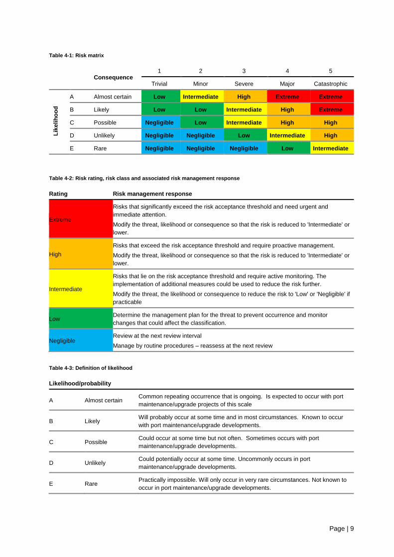
The risk ratings were assessed for each environmentally sensitive receptor and project activity using the
risk matrix in Table 4-1 below. Inherent risk ratings were assessed assuming minimum industry
standard would be achieved without the implementation of additional management controls or risk
assessment.
Management controls relevant to each inherent risk were identified, applying the management response
criteria (Table 4-2) and particularly focussing on those inherent risks rated as 'intermediate' and above.
Controls employed as industry standard practise and/or those currently operating at CLA/CLB were
applied initially to determine initial residual risk ratings. These ratings were further informed by impact
analysis and specific project controls developed within this EMP. The ratings were revised iteratively to
reduce the residual risks to as low as reasonably possible.
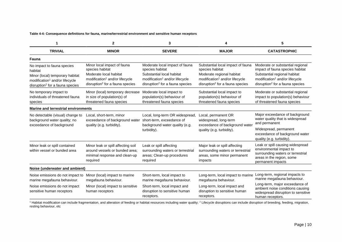
Table 4-3 and Table 4-4 defines the likelihood and consequence relating to the activity.
Page | 9
Table 4-1: Risk matrix
Consequence
1 2 3 4 5
Trivial Minor Severe Major Catastrophic
Lik
eli
ho
od
A Almost certain Low Intermediate High Extreme Extreme
B Likely Low Low Intermediate High Extreme
C Possible Negligible Low Intermediate High High
D Unlikely Negligible Negligible Low Intermediate High
E Rare Negligible Negligible Negligible Low Intermediate
Table 4-2: Risk rating, risk class and associated risk management response
Rating Risk management response
Extreme
Risks that significantly exceed the risk acceptance threshold and need urgent and
immediate attention.
Modify the threat, likelihood or consequence so that the risk is reduced to 'Intermediate' or
lower.
High
Risks that exceed the risk acceptance threshold and require proactive management.
Modify the threat, likelihood or consequence so that the risk is reduced to 'Intermediate' or
lower.
Intermediate
Risks that lie on the risk acceptance threshold and require active monitoring. The
implementation of additional measures could be used to reduce the risk further.
Modify the threat, the likelihood or consequence to reduce the risk to 'Low' or 'Negligible' if
practicable
Low Determine the management plan for the threat to prevent occurrence and monitor
changes that could affect the classification.
Negligible Review at the next review interval
Manage by routine procedures – reassess at the next review
Table 4-3: Definition of likelihood
Likelihood/probability
A Almost certain Common repeating occurrence that is ongoing. Is expected to occur with port
maintenance/upgrade projects of this scale
B Likely Will probably occur at some time and in most circumstances. Known to occur
with port maintenance/upgrade developments.
C Possible Could occur at some time but not often. Sometimes occurs with port
maintenance/upgrade developments.
D Unlikely Could potentially occur at some time. Uncommonly occurs in port
maintenance/upgrade developments.
E Rare Practically impossible. Will only occur in very rare circumstances. Not known to
occur in port maintenance/upgrade developments.
Page | 10
Table 4-4: Consequence definitions for fauna, marine/terrestrial environment and sensitive human receptors
1 2 3 4 5
TRIVIAL MINOR SEVERE MAJOR CATASTROPHIC
Fauna
No impact to fauna species
habitat
Minor (local) temporary habitat
modification1 and/or lifecycle
disruption2 for a fauna species
Minor local impact of fauna species habitat
Moderate local habitat
modification1 and/or lifecycle
disruption2 for a fauna species
Moderate local impact of fauna species habitat
Substantial local habitat
modification1 and/or lifecycle
disruption2 for a fauna species
Substantial local impact of fauna species habitat
Moderate regional habitat
modification1 and/or lifecycle
disruption2 for a fauna species
Moderate or substantial regional impact of fauna species habitat
Substantial regional habitat
modification1 and/or lifecycle
disruption2 for a fauna species
No temporary impact to
individuals of threatened fauna
species
Minor (local) temporary decrease
in size of population(s) of
threatened fauna species
Moderate local impact to
population(s) behaviour of
threatened fauna species
Substantial local impact to
population(s) behaviour of
threatened fauna species
Moderate or substantial regional
impact to population(s) behaviour
of threatened fauna species
Marine and terrestrial environments
No detectable (visual) change to
background water quality; no
exceedance of background
Local, short-term, minor
exceedance of background water
quality (e.g. turbidity).
Local, long-term OR widespread,
short-term, exceedance of
background water quality (e.g.
turbidity).
Local, permanent OR
widespread, long-term
exceedance of background water
quality (e.g. turbidity).
Major exceedance of background water quality that is widespread and permanent
Widespread, permanent
exceedance of background water
quality (e.g. turbidity).
Minor leak or spill contained
within vessel or bunded area
Minor leak or spill affecting soil
around vessels or bunded area;
minimal response and clean-up
required
Leak or spill affecting
surrounding waters or terrestrial
areas; Clean-up procedures
required
Major leak or spill affecting
surrounding waters or terrestrial
areas, some minor permanent
impacts
Leak or spill causing widespread environmental impact to surrounding waters or terrestrial areas in the region, some permanent impacts
Noise (underwater and ambient)
Noise emissions do not impact to
marine megafauna behaviour.
Noise emissions do not impact
sensitive human receptors
Minor (local) impact to marine
megafauna behaviour.
Minor (local) impact to sensitive
human receptors
Short-term, local impact to
marine megafauna behaviour.
Short-term, local impact and
disruption to sensitive human
receptors.
Long-term, local impact to marine
megafauna behaviour.
Long-term, local impact and
disruption to sensitive human
receptors.
Long-term, regional impacts to marine megafauna behaviour.
Long-term, major exceedance of ambient noise conditions causing widespread disruption to sensitive human receptors.
1 Habitat modification can include fragmentation, and alteration of feeding or habitat resources including water quality; 2 Lifecycle disruptions can include disruption of breeding, feeding, migration, resting behaviour, etc
Page | 11
4.2 Results
Inherent risks of the Project were intermediate to high for all Project activities, barring vessel strike, for
which the inherent risk was low. If left unmanaged, underwater noise, changes in water quality and
introduced marine species have the potential to result in impacts on sensitive marine environs and
fauna. Increases in ambient noise can also cause substantial disruption to local communities if left
unmanaged.
With the application of the proposed management controls the residual risk of all potential impacts was
reduced to low or negligible.
The full risk assessment is presented in Table 4-5 below.
Page | 12
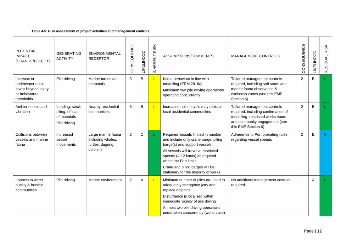
Table 4-5: Risk assessment of project activities and management controls
POTENTIAL
IMPACT
(CHANGE/EFFECT)
GENERATING
ACTIVITY
ENVIRONMENTAL
RECEPTOR
CO
NS
EQ
UE
NC
E
LIK
EL
IHO
OD
IN
HE
RE
NT
RIS
K
ASSUMPTIONS/COMMENTS MANAGEMENT CONTROLS
CO
NS
EQ
UE
NC
E
LIK
EL
IHO
OD
RE
SID
UA
L R
ISK
Increase in
underwater noise
levels beyond injury
or behavioural
thresholds
Pile driving Marine turtles and
mammals
3 B I Noise behaviour in line with
modelling (ERM 2018a)
Maximum two pile driving operations
operating concurrently
Tailored management controls
required, including soft starts and
marine fauna observation &
exclusion zones (see this EMP
Section 6)
2 B L
Ambient noise and
vibration
Loading, stock-
piling, offload
of materials
Pile driving
Nearby residential
communities
3 B I Increased noise levels may disturb
local residential communities
Tailored management controls
required, including confirmation of
modelling, restricted works hours
and community engagement (see
this EMP Section 6)
2 B L
Collisions between
vessels and marine
fauna
Increased
vessel
movements
Large marine fauna
including whales,
turtles, dugong,
dolphins
2 C L Required vessels limited in number
and include only crane barge, piling
barge(s) and support vessels
All vessels will travel at restricted
speeds (4-12 knots) as required
within the Port limits
Crane and piling barges will be
stationary for the majority of works
Adherence to Port operating rules
regarding vessel speeds
2 E N
Impacts to water
quality & benthic
communities
Pile driving Marine environment 2 A I Minimum number of piles are used to
adequately strengthen jetty and
replace dolphins
Disturbance is localised within
immediate vicinity of pile driving
At most two pile driving operations
undertaken concurrently (worst case)
No additional management controls
required
1 A L
Page | 13
POTENTIAL
IMPACT
(CHANGE/EFFECT)
GENERATING
ACTIVITY
ENVIRONMENTAL
RECEPTOR
CO
NS
EQ
UE
NC
E
LIK
EL
IHO
OD
IN
HE
RE
NT
RIS
K
ASSUMPTIONS/COMMENTS MANAGEMENT CONTROLS
CO
NS
EQ
UE
NC
E
LIK
EL
IHO
OD
RE
SID
UA
L R
ISK
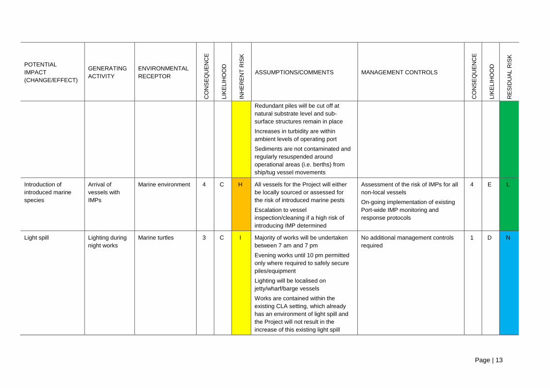
Redundant piles will be cut off at
natural substrate level and sub-
surface structures remain in place
Increases in turbidity are within
ambient levels of operating port
Sediments are not contaminated and
regularly resuspended around
operational areas (i.e. berths) from
ship/tug vessel movements
Introduction of
introduced marine
species
Arrival of
vessels with
IMPs
Marine environment 4 C H All vessels for the Project will either
be locally sourced or assessed for
the risk of introduced marine pests
Escalation to vessel
inspection/cleaning if a high risk of
introducing IMP determined
Assessment of the risk of IMPs for all
non-local vessels
On-going implementation of existing
Port-wide IMP monitoring and
response protocols
4 E L
Light spill Lighting during
night works
Marine turtles 3 C I Majority of works will be undertaken
between 7 am and 7 pm
Evening works until 10 pm permitted
only where required to safely secure
piles/equipment
Lighting will be localised on
jetty/wharf/barge vessels
Works are contained within the
existing CLA setting, which already
has an environment of light spill and
the Project will not result in the
increase of this existing light spill
No additional management controls
required
1 D N
Page | 14
POTENTIAL
IMPACT
(CHANGE/EFFECT)
GENERATING
ACTIVITY
ENVIRONMENTAL
RECEPTOR
CO
NS
EQ
UE
NC
E
LIK
EL
IHO
OD
IN
HE
RE
NT
RIS
K
ASSUMPTIONS/COMMENTS MANAGEMENT CONTROLS
CO
NS
EQ
UE
NC
E
LIK
EL
IHO
OD
RE
SID
UA
L R
ISK
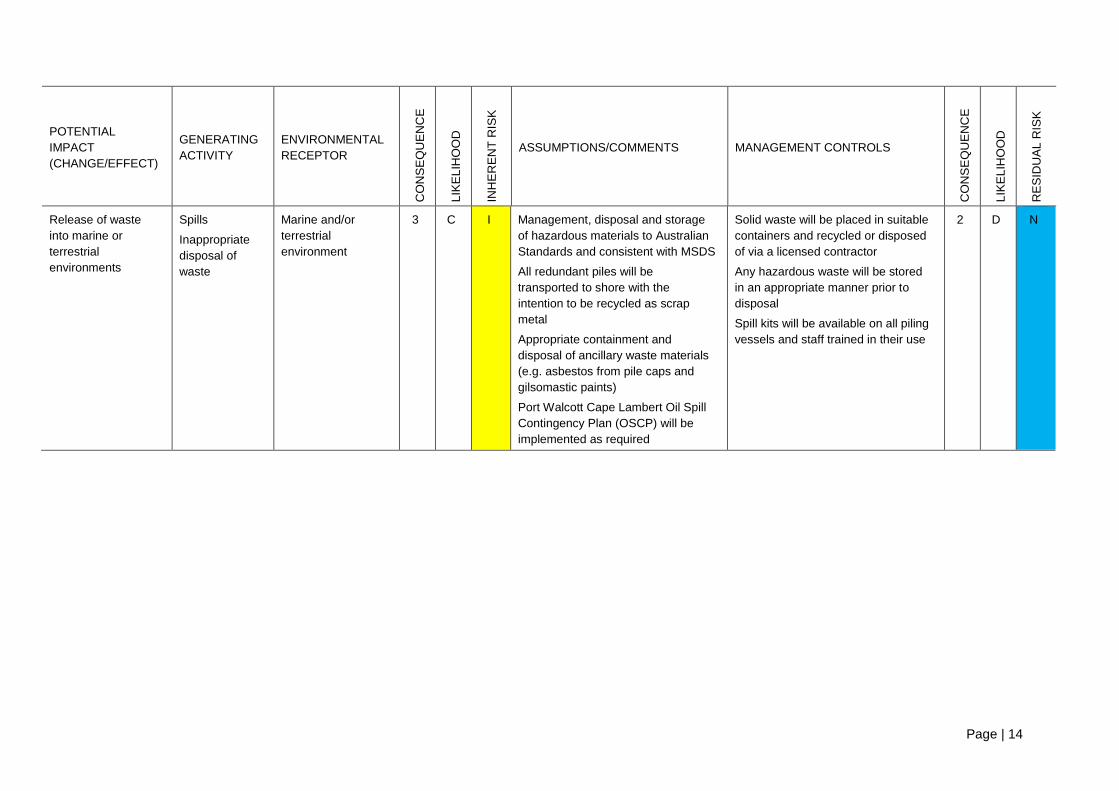
Release of waste
into marine or
terrestrial
environments
Spills
Inappropriate
disposal of
waste
Marine and/or
terrestrial
environment
3 C I Management, disposal and storage
of hazardous materials to Australian
Standards and consistent with MSDS
All redundant piles will be
transported to shore with the
intention to be recycled as scrap
metal
Appropriate containment and
disposal of ancillary waste materials
(e.g. asbestos from pile caps and
gilsomastic paints)
Port Walcott Cape Lambert Oil Spill
Contingency Plan (OSCP) will be
implemented as required
Solid waste will be placed in suitable
containers and recycled or disposed
of via a licensed contractor
Any hazardous waste will be stored
in an appropriate manner prior to
disposal
Spill kits will be available on all piling
vessels and staff trained in their use
2 D N

Page | 15
5. Environmental management and mitigation procedures The risk assessment in Section 4 identified that the majority of potential impacts from the project will
result in negligible risk to environmental values, if undertaken in line with the planned project framework
and industry standard controls. However, both underwater and ambient (terrestrial) noise were
identified as potential impacts that requires specific management controls to be implemented in order to
reduce risks to an acceptable level.
A summary of the general project activities and industry standard controls that will be implemented to
avoid and reduce impacts is provided in Table 5-1. Tailored frameworks for addressing underwater
noise and ambient noise are provided in Table 5-2 and Table 5-3 respectively.
Table 5-1: General project activities and industry standard controls that will be implemented to avoid and reduce
impacts
Measures to avoid and reduce impacts Potential impacts
addressed
All vessels undertaking works associated with the Project will travel at 4 - 12 knots Vessel strike
No more than two pile driving operations will occur concurrently (worst case)
Impacts to water quality,
underwater noise and
ambient noise
Minimum number of piles will be used to undertake jetty strengthening and dolphin
replacement activities
Impacts to water quality and
benthic communities,
underwater noise, ambient
noise
Works will be undertaken as close to existing infrastructure as possible while
ensuring maximum effectiveness
Impacts to water quality and
benthic communities
Redundant piles will be cut at the natural substrate level and removed. Sub-surface
infrastructure will be capped and remain in-situ
Impacts to water quality and
benthic communities
All non-local vessels will be assessed for the risk of IMPs IMPs
On-going implementation of existing Port-wide IMP monitoring and response
protocols IMPs
Works hours will be between 7 am and 7 pm. Night works will extend no later than
10 pm and will only be undertaken if required to safely secure piles/equipment
Light spill, underwater noise
and ambient noise
All lighting will be localised on jetty/wharf/barge vessels Light spill
The existing Rio Tinto complaints hotline will be available for community to register
concerns Ambient noise
All redundant piles will be transported to shore with the intention to be recycled as
scrap metal Waste
Management, disposal and storage of hazardous materials will be to Australian
Standards and will be consistent with Material Safety Data Sheets Waste
Port Walcott Cape Lambert Oil Spill Contingency Plan will be implemented as
required Waste
Spill kits will be available on all piling vessels and staff trained in their use Waste
Solid waste will be placed in suitable containers and recycled or disposed of via a
licensed contractor
Waste

Page | 16
Table 5-2: Underwater noise management framework
Performance Objective Management strategy/target Key Performance Indicators
To ensure marine fauna, particularly humpback whales
and turtles are not injured or significantly disturbed due
to underwater noise
Underwater noise to be managed primarily through
procedural controls during pile driving, with no impacts to
marine animals as a result of piling activity
No works to commence if whales/turtles present in
observation zone
Cessation of piling if whales/turtles observed in exclusion
zone
No reported strandings of sick, injured or decreased
marine turtles or whales within the Project area for the life
of the Project
Daily records of marine fauna observations kept when
piling undertaken
Management component Responsibility Timing
Specific management controls
• The underwater noise management procedure presented in
• Figure 5-1 and described below will be implemented.
• A suitably trained marine fauna observer will be located at an elevated location on the wharf/jetty immediately prior to and
during all piling works.
• An observation zone will be established 2 km from the piling activity.
• An exclusion zone of 500 m for whales and 300 m for marine turtles will be established from the piling activity.
• The observation zone will be checked for 30 minutes prior to the commencement of piling activities each day. If no
whales/turtle are present, works can commence (soft start – see below). If whales/turtles are present in the observation
zone, commencement will be delayed until all animals have exited the observation zone or have not been seen for 20
minutes.
• The suitably trained marine fauna observer will monitor the exclusion zone continuously during piling activities. If
whales/turtles are sighted in the exclusion zone, works will cease (i.e. as soon as safely possible). Works will not
commence until the animal(s) exit the exclusion zone or have not been seen for 20 minutes (soft start required).
• Soft start up procedures will be implemented for all piling activities, for a period of no less than 30 minutes.
Contractor/ Proponent’s
delegate On-going

Page | 17
Management component Responsibility Timing
• During periods of low visibility (where a distance of 500 m cannot be clearly viewed), pile driving activities may be
undertaken provided that during the preceding 24 hour period:
o there have not been 3 or more shut down situations due to marine turtles or whale sightings
o a 2 hour period of continual observations during pile driving works was undertaken in good visibility immediately
prior to low visibility (to a distance of 500 m) and no marine turtles or whales sighted.
• Piling to occur during daylight hours unless in the case of a safety/emergency; at such times it will not extend beyond 10
pm.
• Daily records of all marine fauna sighting and associated shut downs to be kept including:
o record observed cetaceans in a format consistent with the National Cetacean Sighting and Strandings Database
o other marine fauna observations, including fish kills and wildlife injuries within 500 m of piling operations
o fauna behaviours, in particular any behaviours that could be attributed to piling activities
o management responses in relation to dead and injured wildlife, including suspension of piling activities
o observation effort in relation to piling activities.
• Herding of cetaceans from the area will not be undertaken using vessels.
• Warning strikes will not be used to deter cetaceans from the area.
Monitoring
• Daily review of records and compliance to marine fauna procedure (i.e. marine fauna observations undertaken, piling logs
demonstrating soft start-up being undertaken).
• Marine fauna observations ongoing for duration of works.
Trained marine fauna
observer Duration of piling
Reporting
• A log of all visual observations of whales, marine turtles, and other marine fauna maintained daily.
• All operational shut down events to be logged and maintained.
• Report any stranding of sick, injured or deceased marine turtles or whales recorded in 2 km radius (i.e. in the Project area).
Contractor/ Proponent’s
delegate Duration of piling
Adaptive implementation (corrective actions)
• Cease piling works as indicated by controls.
• Any reports of strandings of sick, injured or deceased marine turtles or whales investigated immediately.
Contractor/ Proponent’s
delegate Duration of piling

Page | 18
Figure 5-1: Flow diagram for underwater noise management

Page | 19
Table 5-3: Ambient noise management framework
Performance Objective Management strategy/target Key Performance Indicators
To minimise the impact of Project generated noise
emissions on nearby sensitive receptors and the
environment
Ambient noise to be managed through procedural
controls during noise generating activities, with no
complaints lodged and compliance maintained with
relevant noise regulations
Number of complaints
No exceedance of modelled average noise levels for all
receivers
Management component Responsibility Timing
Specific management controls
• Piling activities will only be undertaken during daytime hours (7 am to 7 pm). Piling will only occur in evening hours in the
case of an emergency or safety concern (7 pm to 10 pm).
• Noise generating activities not associated with pile driving itself (e.g. unloading of piles from ship to shore) will only be
undertaken during daytime hours.
• Induction package will include noise management procedures, piling hours, complaints handling procedures and the
location of noise sensitive receptors.
• Formal notification to Point Samson Community Association and the City of Karratha prior to the commencement of piling
works.
• Rio Tinto’s community hotline/email will be made available to Point Samson Community Association
Contractor/ Proponent’s
delegate On-going
Monitoring
• Noise validation monitoring will be undertaken at Point Samson to confirm noise modelling results. Monitoring will be
managed by suitably qualified technicians and may include:
o attended noise measurements conducted using a hand held Type 1 or Type 2 ‘integrating-averaging’ sound level
meter
o unattended noise measurements using a Type 1 or Type 2 environmental noise logger.
Contractor/ Proponent’s
delegate
Periods over
duration of piling
Reporting
• Updates to Point Samson Community Association on the results of noise model confirmation monitoring
• Complaints will be recorded and reported as per Rio Tinto incident reporting procedure
Contractor/ Proponent’s
delegate Duration of piling
Page | 20
Management component Responsibility Timing
Adaptive implementation (corrective actions)
• If noise modelling confirmation monitoring shows exceedances, the monitoring and action protocol in Figure 5-2 will be
followed
Contractor/ Proponent’s
delegate Duration of piling

Page | 21
Figure 5-2: Noise monitoring and action protocol
Page | 22
6. Reporting and review process Reporting will be undertaken as per the reporting requirements outlined in Table 5-2 and Table 5-3 in
Section 5 above.
The EMP will be reviewed in response to any significant changes in Project scope, legislative
requirements, risk profile or occurrence of major environmental incidents.
If considered necessary, Rio Tinto will update the EMP and submit an amendment for approval to the
DoEE and the Department of Water and Environmental Regulation.
Page | 23
References
Basset Consulting Engineers (Basset) 2009, Cape Lambert Port B Development Assessment of
Lighting Effects on Turtles, prepared for Pilbara Iron Pty Limited.
Biota Environmental Services (Biota) 2008a, A survey of coastal dunes between Cossack and
Karratha for Lerista nevinae, prepared for Pilbara Iron Pty Limited.
Biota Environmental Services (Biota) 2008b, Cape Lambert Port B Development: Flora and
Vegetation Survey, prepared for Pilbara Iron Pty Limited.
Biota Environmental Services (Biota) 2008c, Cape Lambert Port B Development Marine Turtle
Assessment, prepared for Pilbara Iron Pty Limited.
Biota Environmental Services (Biota) 2008d, Cape Lambert Port B Development Seasonal Fauna
Survey, prepared for Pilbara Iron Pty Limited.
Department of Environment, Water, Heritage and the Arts (DEWHA) 2009, National Assessment
Guidelines for Dredging (NAGD)
Environmental Resources Management (ERM) 2018a, Cape Lambert Port A Marine Structures
Refurbishment Project Ambient Noise Impact Assessment, prepared for Rio Tinto.
Environmental Resources Management (ERM) 2018b, Cape Lambert Port A Marine Structures
Refurbishment Project Underwater Noise Impact Assessment, prepared for Rio Tinto.
Environmental Resources Management (ERM) and JASCO Applied Sciences (JASCO) 2018,
Potential Impact of Pile-Driving Noise at Cape Lambert: A Review of the Literature and International
Regulations, 2018 Addendum, report prepared for Rio Tinto.
Hydrobiology 2018, CLA Jetty Habitat Assessment, prepared for Rio Tinto.
Li Z & McPherson CR 2018, Rio Tinto Cape Lambert Port A Marine Structures Refurbishment Project:
Acoustic Modelling of Impact Pile Driving for Assessing Marine Fauna Sound Exposures, technical
report prepared by JASCO Applied Sciences for Environmental Resources Management.
MScience Marine Research (MsScience) 2015, Cape Lambert Maintenance Dredging Program
Sampling and Analysis Plan Implementation Report: December 2015, prepared for Pilbara Iron Pty
Limited.
Sinclair Knight Merz [SKM] 2009, Cape Lambert Port B Development Public Environmental Review
and Draft Public Environment Report, prepared for Rio Tinto.