
Capacity Building for Disaster Risk Reduction Regional ... · The Regional GLOF Risk Reduction...
54
Capacity Building for Disaster Risk Reduction Regional Glacial Lake Outburst Floods (GLOF) Risk Reduction in the Himalayas Preparatory Assessment Study Report Sutlej Basin - Himachal Pradesh India EUROPEAN COMMISSION
Transcript of Capacity Building for Disaster Risk Reduction Regional ... · The Regional GLOF Risk Reduction...
Capacity Building for Disaster Risk ReductionRegional Glacial Lake Outburst Floods (GLOF)
Risk Reduction in the Himalayas
Preparatory Assessment Study Report Sutlej Basin - Himachal Pradesh
India
EUROPEAN COMMISSION
Humanitarian Aid
EUROPEAN COMMISSION

Capacity Building for Disaster Risk ReductionRegional Glacial Lake Outburst Floods (GLOF)
Risk Reduction in the Himalayas
Preparatory Assessment Study Report Sutlej Basin - Himachal Pradesh
India
EUROPEAN COMMISSION
Humanitarian Aid
EUROPEAN COMMISSION

CONTENTS
Abbreviations 4
Executive Summary 5
Background 7
Methodology 18
GLOF/Flash Flood Incidents in the Sutlej Valley 22
Socio-economic Impact of GLOF/Flash Flood Events in Sutlej Valley 24
Risk Reduction and Preparedness Initiatives 28
Needs and Capacity Gaps Assessment 32
Assessing Existing Development Policies and Practices 35
Recommendations 37
References 39
Annexures 41

4
ABBREVIATIONS
BCPR Bureau for Crisis Prevention and Recovery
CBOs Community Based Organisations
DDMA District Disaster Management Authority
DDP (Cold) Desert Development Programme
DRM Disaster Risk Management
DRR Disaster Risk Reduction
DSP Deputy Superintendent of Police
EWS Early Warning System
FGD Focus Group Discussion
GLOF Glacial Lake Outburst Flood
HKH Hindu Kush Himalaya
HRTC Himachal Pradesh Road Transport Corporation
HIPA Himachal Institute for Public Administration
ICIMOD International Centre for Integrated Mountain Development
ITBP Indo-Tibet Border Police
INR Indian National Rupees
Kms Kilometres
KNCC Knowledge Network for Climate Change
MFH Mountain Forum Himalayas
Mts Metres
MW Mega Watt
NH National Highway
NJPC Naptha – Jhakri Power Corporation
NREGA National Rural Employment Guarantee Act
Mw Moment Magnitude
QRT Quick Response Team
SDMA State Disaster Management Authority
UNDP United Nations Development Programme
UNEP United Nations Environmental Programme
5
EXECUTIVE SUMMARY
In the face of accelerated global warming, the glaciers in the Himalayas are retreating at a
rapid pace leading to rapid accumulation of water in mountain-top lakes. These glacial lakes which form behind moraine or ice 'dams' can breach suddenly, leading to floods known as Glacial Lakes Outburst Flood (GLOF). Once breached, millions of cubic metres of water and debris are discharged causing catastrophic flooding up to hundreds of kilometres downstream with serious damage to life, livelihoods, property, forest, farms and high-value socio-economic and infrastructure assets.
The Regional GLOF Risk Reduction Initiative, supported by ECHO and UNDP’s Bureau for Crisis Prevention and Recovery (BCPR), aims to address the risks posed by GLOFs in the Hindu Kush Himalaya (HKH) region comprising India, Pakistan, Nepal and Bhutan through strengthening non-structural and community-based approaches. The project is being implemented by the BCPR South & South West Asia Office through UNDP Country Offices in the four project countries with technical support from the Regional Centre in Bangkok.
The project aims to build on the capacity and knowledge of the communities living in the various flood basins and to strengthen the administrative structure to effectively reduce the impact of flash floods and GLOFs. The project in India is being implemented in the Sutlej basin in Himachal Pradesh because of its proximity to potentially dangerous glacial lakes and its past history of recurrent flash
floods which have caused extensive damage to human life, property and infrastructure. Flash floods in hill regions are considered relevant for the project as the impact from flash floods and the required risk reduction measures are very similar in nature and scope to that of GLOF.
The preparatory assessment report is being compiled in order to understand the socio-economic impact of flash floods in the Sutlej basin and to explore community based risk reduction measures.
This preparatory assessment report of the impact of flash floods in the Sutlej basin has been completed through an extensive review of available secondary material and primary data collected though field missions to the area. The primary data was collected through discussions
with a cross section of stake-holders including administrative departments, scientific institutions, horticulturists, traders, teachers, managers of power projects, village leaders and representatives of women’s groups. The methodology of collecting the data involved various developmental tools. The findings were triangulated through a community consultation workshop that was
held in September at Reckong Peo, the district headquarters of Kinnaur district in the Sutlej basin.
An assessment team was constituted with members from the Mountain Forum Himalayas, an NGO with years of experience in dealing with development issues pertaining to the hill areas, to understand the impact of flash floods, coping mechanisms adopted by communities, relevant development policies and needs and gaps to reduce the vulnerability of the people from flash floods and GLOF.
The project aims to build on the capacity and knowledge of the communities living in
the various flood basins and to strengthen the
administrative structure to effectively reduce the impact of flash floods and GLOFs
66
The preparatory assessment first looked at the socio-economic context of the region to assess their overall vulnerability and capacity. The report recognised that the people in the Sutlej basin have a vibrant socio-cultural life, having been a community on the cross-roads of two very different yet rich civilisations – India and Tibet. The economy of the basin has improved recently due to the success of horticulture, especially apples that generate profound yearly profits.
Recurrent flash floods, whether small or large like the ones in the years 2000 and 2005, have left short and long term socio-economic destruction in their wake. They have also caused losses to economic infrastructure like bridges, roads and power projects. The
administration is aware of the needs of the region and is working towards a unified system to manage flash flood risks in a comprehensive manner. Notwithstanding the disasters, the communities usually have been resilient.
Since they are the first responders, there is a need to enhance the capacity of the communities to handle emergency situations in the Sutlej basin. Non-structural measures such as trainings, information dissemination and community based contingency planning is what is needed to reduce risk in the Sutlej basin. Community based disaster management, including early warning systems and land use planning, needs to be enhanced and the same needs to be incorporated in all future development projects in the Sutlej basin.
7
BACKGROUND
The Himalayan region contains the largest areas covered by glaciers and permafrost
outside the polar region in the world, and is intrinsically linked to global atmospheric circulation, biodiversity, water resources and the hydrological cycle. Being the cradle of nine of the largest rivers in Asia whose basins are home to over 1.3 billion people, the region is susceptible to a whole range of hydro-metrological, tectonic and climate-induced disasters. With warming in the Himalayas being higher than the global average, climate-induced natural hazards are likely to be exacerbated --- including severe glacial melting and retreat at an average rate of 30 to 60 metres per decade, with rapid accumulation of water in mountain-top lakes.
The GLOF Risk Reduction Project, funded by DIPECHO and UNDP’s Bureau for Crisis Prevention and Recovery (BCPR), aims to address the risks posed by GLOFs in HKH region comprising India, Pakistan, Nepal and Bhutan through strengthening non-structural and community-based approaches.
As glaciers retreat, glacial lakes form behind moraine or ice ‘dams’ which have the potential to suddenly breach, due to triggers like avalanches and earthquakes, discharging millions of cubic metres of water and debris in a few hours. This can cause catastrophic flooding up to hundreds of kilometres downstream, devastating property, farms, fragile ecosystems, socio-economic infrastructure and assets, inducing forced migration and undermining the already meagre sources of livelihood of mountain people and downstream communities.
This phenomenon constituting a sudden discharge of a huge volume of water from such glacial lakes is known as GLOF. The frequency of such events is increasing in HKH region since the second half of 20th century due to the combined effects of climate change and deforestation. Satellite observation of the mountain-top lakes in the region has revealed a steady increase in the size and volume of many of these glacial lakes at high altitudes, enhancing the possibility of a devastating outburst flood affecting sizeable populations and damaging precious socio-economic and infrastructure assets in the Himalayan belt.
Over the years, countries in the region have built many high-value economic and infrastructure assets and the emerging threat from GLOFs has serious implications for countries like Nepal and Bhutan who depend heavily on hydropower
exports generated from glacier-fed rivers, which constitutes a substantial portion of their revenue and on India which highly relies on the fresh water supply from these glacier-fed rivers.
A vast swathe of the Himalayan Mountains lies in India with a large number of glaciers in the States of Jammu and Kashmir, Himachal Pradesh, Uttarakhand,
Sikkim and Arunachal Pradesh. These glaciers and others which lie across India’s borders sustain the major Indian river systems of the Ganga, Brahmaputra, Indus, Sutlej, Beas, Chenab, and other water bodies, ensuring a year-round water supply to millions of people downstream.
The Indian Himalayan region is home to over 7,000 glaciers covering an area of 8,500 km. They play a crucial role in shaping and influencing the environmental conditions
7
A vast swathe of the Himalayan Mountains
lies in India with a large number of glaciers in the States of Jammu
and Kashmir, Himachal Pradesh, Uttarakhand, Sikkim and Arunachal
Pradesh
8
in India. Siachen, Gangotri, Zemu, Milam, Bhagirath, Kharak and Satopanth are some of the important glaciers located in the Indian Himalayan region. Around 968 glaciers drain into the Ganga basin in Uttarakhand, over 4,660 glaciers feed the Indus, Shyok, Jhelum and Chenab river systems, the Ravi, Beas, Chenab and Sutlej river systems are fed by 1,375 glaciers, and 611 glaciers drain into the Tista and Brahmaputra basins, and contribute between 50 and 70 percent of their annual discharge. Most of these glaciers are retreating and their overall dimensions are diminishing. Studies conducted on different Indian glacier systems over the past two decades indicate an average annual retreat rate of between 2.6 metres and 40.5 metres.
In the Indian sub-continent, temperatures are predicted to rise between 3.5 and 5.5°C by 2100, leading to increased melting of Himalayan glaciers and the formation of increasing number of glacial lakes. The Himalayan region in India comprises over 156 glacial lakes out of which 16 have been identified to be potentially dangerous. In a study conducted by UNEP in 2003, it has been observed that the frequency of GLOF events has increased in the HKH region during the second half of 20th century and is likely to be further exacerbated in the 21st century.
It is estimated that GLOF events, landslide induced damming or flash floods have been occurring frequently in the mountain regions in India and significantly affecting mountain communities. Incidents of GLOF origin are reported to have occurred in Sikkim and Ladakh in Jammu and Kashmir, and intermittently in Himachal Pradesh and Arunachal Pradesh. However, these incidents have been few and far between and have occurred in sparsely populated areas with meagre socio-economic infrastructure. As such, their impact on people,
livelihoods and social-economic assets has been minimal.
However, devastating incidents of flash floods caused by a sudden outburst of either glacial lakes or landslide-induced damming or cloud-burst have been happening quite regularly in Himachal Pradesh. Some notable incidents occurred in 1997, 2000 and 2005 in the Sutlej basin of Himachal Pradesh and in 1970 and 1978 in Alaknanda and Bhagirathi basins in Uttarakhand state in India. Yet, the threat from GLOF events is not considered to be perceptibly high in Uttarakhand.
Himachal Pradesh
With GLOF or landslide-induced damming outburst or cloud burst incidents causing flash floods seen to be affecting the state of Himachal Pradesh more frequently, it was considered appropriate to study two past incidents to understand the entire cycle of disaster emanating from a GLOF. Himachal Pradesh, as the name suggests in Sanskrit, is a high altitude mountainous state through which the Sutlej River first enters India from the Chinese Autonomous Region of Tibet. It is located in the North West of India, bordered by the states of Jammu and Kashmir to the North, Punjab to the West, Haryana and Uttar Pradesh to the South and the Chinese Autonomous Region of Tibet in the East.
Himachal Pradesh is one of the smallest states of India and has shown significantly high indicators of human development with bountiful natural resources, a distinct physiographic and administrative identity and high literacy rates in both males and females.
As per the year 2001 census, the state recorded a population of 6.8 million people, distributed over
8
99
an area of 55,637 square km. Almost 50 percent of the population lives in three of the state’s twelve districts: Kangra, Mandi and Shimla. Around 7.54 percent of the total population reside, in the three least populated districts of Lahaul and Spiti, Kinnaur and Bilaspur.
Himachal Pradesh’s socio-economic base has a bearing on the level of its development. It has a mountainous and inaccessible terrain, experiences frequent hazards, and faces challenges in connectivity. Himachal Pradesh has also been grappling with a weak economic and institutional base and low level of human skills. However, the state has tried to overcome these inadequacies by turning to horticulture, hydro-power generation, handicrafts and tourism as income generation means and by building and developing its human resources for these activities.
Hazard profile of Himachal Pradesh
Himachal Pradesh is one of the most hazard prone states in the country. It is frequented by earthquakes, GLOFs and flash floods triggered by cloud bursts and landslide induced river dam bursts, landslides, avalanches and forest fires.
It has been hit by a series of massive earthquakes in the past since the state is bound by two major seismic faults in the Himalayas – the Main Boundary Fault and the Main Central Thrust – which keeps the zone fractured with faulted blocks and active faults. These geographic features qualify Himachal Pradesh in the most active seismic zone (IV and V) in the country. The 1905 earthquake in the district of Kangra was the largest instrumented in the state (Mw 7.8) and is remembered in the entire country for the devastating impact that it had on human life and property. At least 28,000 people were killed in the Kangra-Dharamshala region, with casualties and loss of property in the neighbouring state
of Punjab.1 Over the decades, there have been numerous other 6.0 and over earthquakes in the region. They have all had a devastating impact and just to cite one example, the 1975 earthquake which measured 6.2 on the Richter scale managed to kill 60 people in the regions of Kinnaur, Lahaul and Spiti, despite these being very sparsely populated. Earthquakes can also play a role as a trigger for glacial lake outbursts.
Small and large flash floods in the various khuds and nullahs occur intermittently and their impact is felt inter alia on life, livelihoods, infrastructure and power projects. The year 2000 and 2005 flash floods in the Sutlej basin and the 1995 flash floods in the Beas basin wrecked havoc on community life and the administrative set up. These flash floods accentuate the fragile nature of mountain terrain that lies in their wake and can lead to further landslides and damming.
Rationale for selecting Sutlej Valley
In India, the study has been focused on the Sutlej basin in Himachal Pradesh, considering the fact that the Regional GLOF Project would be looking into Bhutan in the Eastern Himalayas, Nepal in relatively central Himalayas, Himachal Pradesh in mid-western and Pakistan would look at the western or Hindu Kush Himalayas.
As per the ICIMOD publication, “Inventory of Glaciers and Glacial Lakes and the Identification of Potential Glacial Lake Outburst Floods (GLOFs) Affected by Global Warming in the Mountains of Himalayan Region” for Himachal Pradesh2 Himalayas, there are 2554 glaciers, with 156 glacial lakes, 16 of them being potentially dangerous.
1 Earthquakes in Himachal Pradesh, India; http://asc-india.org/seismi/seis-himachal-pradesh.htm 2 ICIMOD, Himachal Pradesh Himalayas, India, Inventory of Glaciers and Glacial Lakes and the Identification of Potential Glacial Lake Outburst Floods (GLOFs) Affected by Global Warming in the Mountains of the Himalayan Region, 2004
1010
Contd...
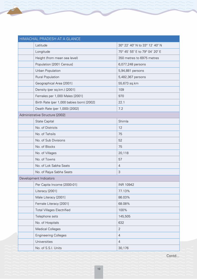
HIMACHAL PRADESH AT A GLANCE
Latitude 30° 22' 40" N to 33° 12' 40" N
Longitude 75° 45' 55" E to 79° 04' 20" E
Height (from mean sea level) 350 metres to 6975 metres
Population [2001 Census] 6,077,248 persons
Urban Population 5,94,881 persons
Rural Population 5,482,367 persons
Geographical Area [2001] 55,673 sq.km
Density (per sq.km.) [2001] 109
Females per 1,000 Males [2001] 970
Birth Rate (per 1,000 babies born) [2002] 22.1
Death Rate (per 1,000) [2002] 7.2
Administrative Structure [2002]
State Capital Shimla
No. of Districts 12
No. of Tehsils 75
No. of Sub Divisions 52
No. of Blocks 75
No. of Villages 20,118
No. of Towns 57
No. of Lok Sabha Seats 4
No. of Rajya Sabha Seats 3
Development Indicators
Per Capita Income [2000-01] INR 10942
Literacy [2001] 77.13%
Male Literacy [2001] 86.03%
Female Literacy [2001] 68.08%
Total Villages Electrified 100%
Telephone sets 145,505
No. of Hospitals 632
Medical Colleges 2
Engineering Colleges 4
Universities 4
No. of S.S.I. Units 30,176

11
From this inventory two moraine dammed glacial lakes of potentially high threat of outburst in the Sutlej Basin were identified.
The criterion for selection of Sutlej basin was that the area has had a history of past flash flood incidents which severely affected the communities in the region. It is also speculated that there are about 24 glacial lakes in Tibet that are potentially dangerous and would be a calamity to the Sutlej basin in case any of them bursts.3 In addition, the valley is heavily populated with mountain communities on either side of the Sutlej River or its numerous
Contd...
distributaries. It also has many high value socio-economic assets including hydro-power projects located downstream.
Currently, the Sutlej Basin is known to be affected by yearly flash floods; the cause of origin of some of them being trans-boundary in nature. In the 1997 floods, six bridges were washed away in the Sutlej basin and Kinnaur district was completely cut off. The year 2000 and 2005 (Parechu river lake burst in Tibet) especially caused heavy destruction of livelihood, infrastructure and loss of life in the basin, particularly in Kinnaur and the eastern part of Shimla districts.
HIMACHAL PRADESH AT A GLANCE
Land Use Pattern
Net Area Sown 560,154 Hectares
Forest Cover [1996-97]
Reserved Forests Area 1,896 sq.km.
Protected Forests Area 43,043 sq.km.
Un-classed Forest Area 976 sq.km.
Other Forests Area 370 sq.km.
Forests not under Forest Dept. 748 sq.km.
No. of Wild Life Sanctuaries 32
Others
Average Rainfall 1469 mm
Source: Government of Himachal Pradesh; www.himachal.gov.nic.in
3 Floods in Sutlej, Made in China, India together; http://www.indiatogether.org/2005/jul/gov-sutlej.htm
Lake No. Latitude Longitude Area (m2) Length (m)
Map Code
Orient-ation
Lake Type
Sutlej _gl 7 31°45’44.73”N 78°06’44.25”E 27779.21 262.1 53i S Moraine dammed
Sutlej _gl 10 32°00’37.86”N 78°23”24.62”E 58659.48 384.6 53i S Moraine dammed
Source: ICIMOD
12
The impact of such fl ash fl oods is further accentuated by the fact that the numerous distributaries of the Sutlej fl ow through narrow fragile valleys and Khuds, prone to constant landslides and mud fl ows.
Hence, the study has focused on Sutlej basin which has witnessed repeated fl ash fl ood events triggered either by landslide-induced damming, cloud burst or a glacial lake outburst fl ood with a view to assess the socio-economic impact of such events, the risk mitigation and preparedness measures adopted, especially the community-based ones and the felt needs for capacity for responding to and preparing for such events.
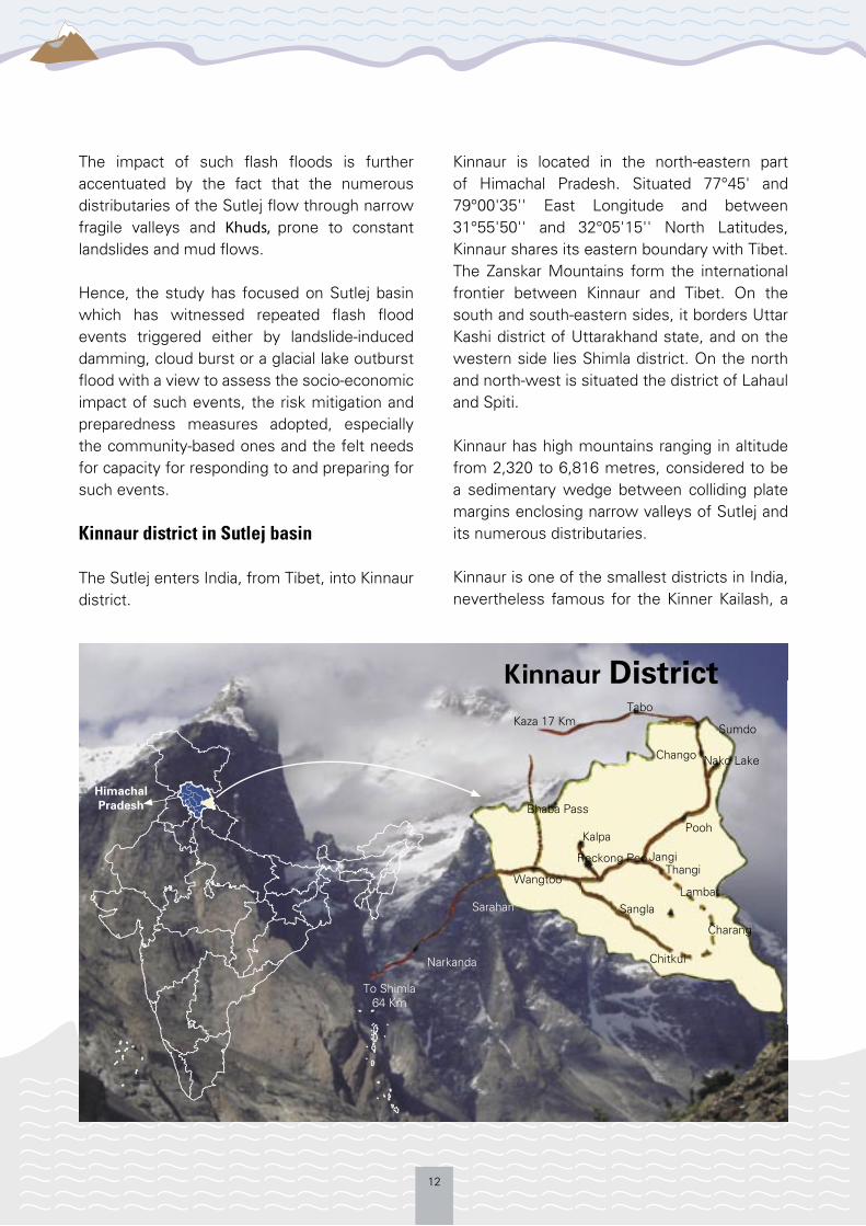
Kinnaur district in Sutlej basin
The Sutlej enters India, from Tibet, into Kinnaur district.
Kinnaur is located in the north-eastern part of Himachal Pradesh. Situated 77°45' and 79°00'35'' East Longitude and between 31°55'50'' and 32°05'15'' North Latitudes, Kinnaur shares its eastern boundary with Tibet. The Zanskar Mountains form the international frontier between Kinnaur and Tibet. On the south and south-eastern sides, it borders Uttar Kashi district of Uttarakhand state, and on the western side lies Shimla district. On the north and north-west is situated the district of Lahaul and Spiti.
Kinnaur has high mountains ranging in altitude from 2,320 to 6,816 metres, considered to be a sedimentary wedge between colliding plate margins enclosing narrow valleys of Sutlej and its numerous distributaries.
Kinnaur is one of the smallest districts in India, nevertheless famous for the Kinner Kailash, a
Kaza 17 KmTabo
Sumdo
Chango Nako Lake
Bhaba Pass
PoohKalpa
Reckong Peo
Wangtoo
JangiThangi
LambarSangla
Charang
Chitkul
Sarahan
Narkanda
To Shimla 64 Km
District
Himachal Pradesh
13
mountain sacred to Hindus, which lies close to the Tibetan border.
The district has a number of valleys varying in altitude from 1,000 metres to 4,000 metres: Sutlej valley, Hangrang or Spiti valley, Ropa or Shiasu valley, Baspa or Sangla valley and the Tidong valley. Among these, the Sutlej valley is the largest river valley of the district and the Sutlej River traverses for about 140 km. in the region.
The district has quite a few Himalayan and trans-Himalayan rivers flowing through it, including the Sutlej, which divides Kinnaur in two almost equal parts. The Spiti is the second major river of the district. The Baspa River rises on the north-eastern declivity of the Dhauladhar range and the Yolong joins the Spiti. The Ropa River rises on the declivity of the range that divides the district Kinnaur and Lahaul and Spiti, and merges with Sutlej near Shiasu.
Kinnaur lies on the ancient trade route between India and Tibet, and the mainstay of the economy is horticulture produce and services. The district is given special status of tribal district and most of the people living here belong to scheduled tribes as categorised by the Constitution of India.
Most of Kinnaur enjoys a temperate climate due to its high elevation, with long and severe winters from October to May, and short summers from June to September. The lower parts of the Sutlej valley and the Baspa valley receive monsoonal rains. The upper areas of the valleys fall mainly in the rain-shadow area. These areas are considered to be arid regions, similar to the climate of Tibet.
It is possible to travel to Kinnaur district on National Highway 22. Roads are narrow, risk prone and cut alongside stiff rocky faces. They
are also frost prone and slippery during the winter months. Landslides and falling rocks are regular features in some specific patches along the way.
Social structure and ethnicity in Kinnaur’s Sutlej valley
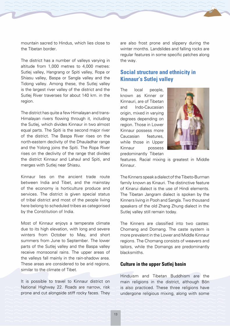
The local people, known as Kinner or Kinnauri, are of Tibetan and Indo-Caucasian origin, mixed in varying degrees depending on region. Those in Lower Kinnaur possess more Caucasian features, while those in Upper Kinnaur possess predominantly Tibetan features. Racial mixing is greatest in Middle Kinnaur.
The Kinners speak a dialect of the Tibeto-Burman family known as Kinauri. The distinctive feature of Kinarui dialect is the use of Hindi elements. The Tibetan Jangram dialect is spoken by the Kinners living in Pooh and Sangla. Two thousand speakers of the old Zhang Zhung dialect in the Sutlej valley still remain today.
The Kinners are classified into two castes: Chomang and Domang. The caste system is more prevalent in the Lower and Middle Kinnaur regions. The Chomang consists of weavers and tailors, while the Domangs are predominantly blacksmiths.
Culture in the upper Sutlej basin
Hinduism and Tibetan Buddhism are the main religions in the district, although Bön is also practiced. These three religions have undergone religious mixing, along with some
14
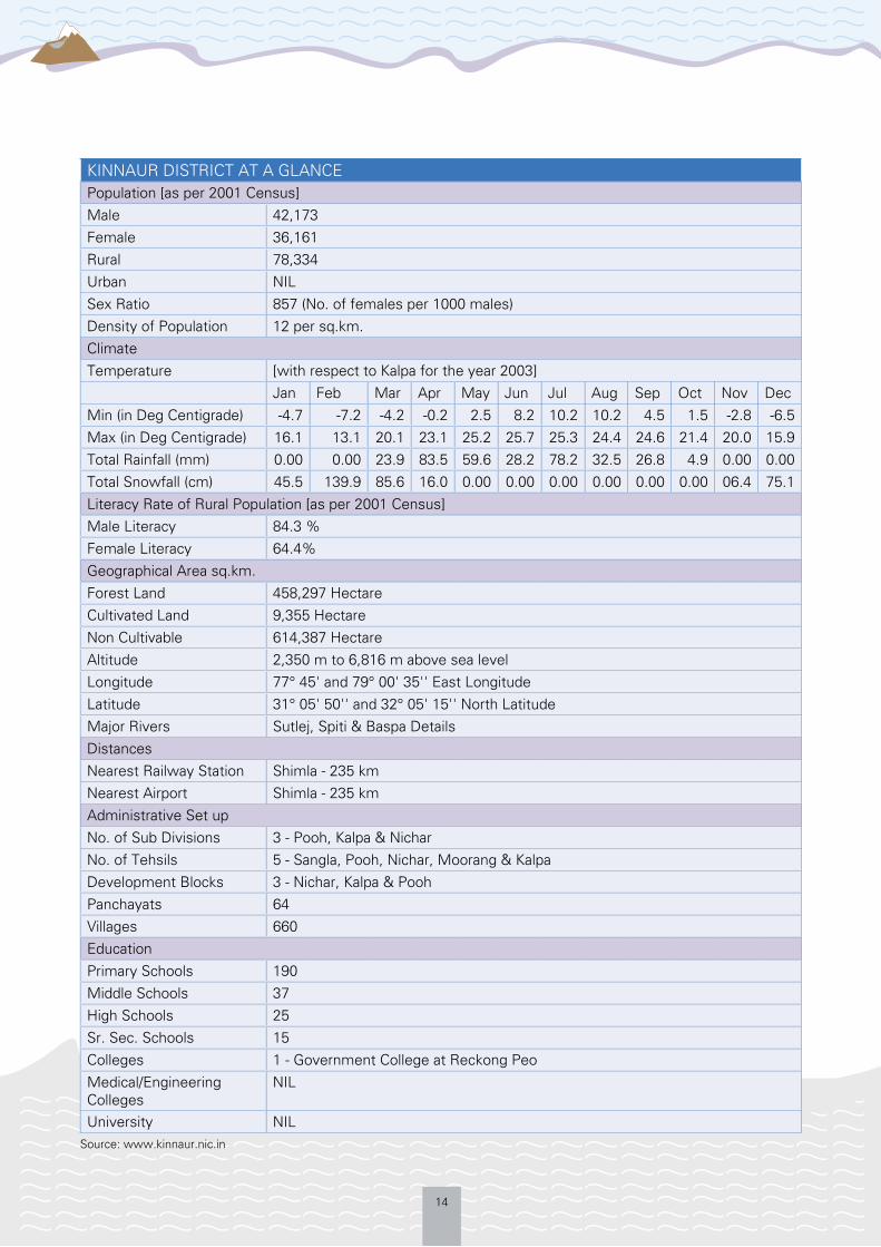
KINNAUR DISTRICT AT A GLANCE Population [as per 2001 Census]Male 42,173Female 36,161Rural 78,334Urban NILSex Ratio 857 (No. of females per 1000 males) Density of Population 12 per sq.km.ClimateTemperature [with respect to Kalpa for the year 2003] Jan Feb Mar Apr May Jun Jul Aug Sep Oct Nov DecMin (in Deg Centigrade) -4.7 -7.2 -4.2 -0.2 2.5 8.2 10.2 10.2 4.5 1.5 -2.8 -6.5Max (in Deg Centigrade) 16.1 13.1 20.1 23.1 25.2 25.7 25.3 24.4 24.6 21.4 20.0 15.9Total Rainfall (mm) 0.00 0.00 23.9 83.5 59.6 28.2 78.2 32.5 26.8 4.9 0.00 0.00Total Snowfall (cm) 45.5 139.9 85.6 16.0 0.00 0.00 0.00 0.00 0.00 0.00 06.4 75.1Literacy Rate of Rural Population [as per 2001 Census]Male Literacy 84.3 %Female Literacy 64.4%Geographical Area sq.km. Forest Land 458,297 HectareCultivated Land 9,355 HectareNon Cultivable 614,387 HectareAltitude 2,350 m to 6,816 m above sea levelLongitude 77° 45' and 79° 00' 35'' East LongitudeLatitude 31° 05' 50'' and 32° 05' 15'' North LatitudeMajor Rivers Sutlej, Spiti & Baspa DetailsDistancesNearest Railway Station Shimla - 235 kmNearest Airport Shimla - 235 kmAdministrative Set upNo. of Sub Divisions 3 - Pooh, Kalpa & NicharNo. of Tehsils 5 - Sangla, Pooh, Nichar, Moorang & KalpaDevelopment Blocks 3 - Nichar, Kalpa & PoohPanchayats 64Villages 660EducationPrimary Schools 190Middle Schools 37High Schools 25Sr. Sec. Schools 15 Colleges 1 - Government College at Reckong PeoMedical/Engineering Colleges
NIL
University NILSource: www.kinnaur.nic.in

15
indigenous shamanistic practices. Strong Buddhist influences are evident in the Hindu religion in Lower Kinnaur, the mixing of Buddhist and Hindu beliefs in Middle Kinnaur, and the influence of Hinduism on Buddhism in Pooh block of Upper Kinnaur. The Buddhist Hangrang area remains largely untouched by any Hindu influence.
Buddhist lamas play an important role in the daily life of the Kinners, and young monks of Upper and Middle Kinnaur are trained from a young age to conduct religious ceremonies, devoting their lives to Lamaism and learning Tibetan scriptures and Buddhist doctrines.
The Kinner Kailash is the most sacred mountain for most Kinners. Every year it is visited by thousands of local people – both Hindus and Buddhists – on religious pilgrimages.
Most of the Kinnauri houses have storerooms for keeping grain and dried fruits, and separate wooden grain storage structures, called kathar. The Kinnauris use utensils made of brass and bronze. Modern influences include the introduction of Chinese crockery, and utensils made of stainless steel and aluminium.
The clothes worn are mainly made of sheep or yak wool. The Tibetan chhuba, a long woollen coat, is worn, with a sleeveless woollen jacket. While men wear woollen churidhar pajamas and tailored woollen shirts such as the chamn kurti, the women wrap themselves up in a dohru.
Economics in the Sutlej valley
The main source of livelihood in the Sutlej valley is agriculture and horticulture. The area produces some of the best apples in the country and effective market linkages are built up to sell the yearly produce at smaller markets
like Rampur and bigger cities like Chandigarh. Besides apples, other cash crops in the area include apricots, peaches, almonds, peas and potatoes. Traditional food grains like ogla and fafra are also produced in the area. Though the terrain is difficult, the villages generally are self-sufficient in their needs i.e. cultivation, transport and communication.
Even though the literacy rate is high, the people prefer horticulture to general services, as the income from horticulture is comparatively high. The social status of a person in the village often determines their level of produce, the acreage under cultivation and land use planning for the orchards.
The area has potentially some of the best assets to promote tourism. Tourism provides some income in the summer months. However, due to the lack of proper tourist infrastructure, harsh terrain and climate in the winters, it attracts mostly adventure tourists.
Animals like sheep, goats, cows and yaks are also reared in the high altitude pastures. Traditionally, mules were used as beasts of
Livelihood Options in Villages
Data source: Random surveys in Sutlej and Baspa basins
21%
34%24%
13%
5%
3%
FarmingHorticulture
Agriculture
Animal rearingServices
Business

16
Not to Scale

17
burden, however nowadays farmers vans are being used to transport the produce in a faster and more effective manner over long distances.
Popular tourist destinations include the towns of Pooh, Reckong Peo, Kalpa, Sangla Valley, as well as the village of Sarahan Bushahr, which has the Bhimakali temple and the Palace of Raja Bushahr.
Besides the cold desert in upper Sutlej Basin, there are also some of the most beautiful high altitude lakes in the region: Nako Lake in Kinnaur and Chandra and Suraj Tal in Lahaul and Spiti.
Other people run general merchandise shops, hotels and restaurants, are in the Government’s administrative services or the armed forces.
The Government is implementing development projects such as Cold Desert Development and Watershed Management. Multiple hydro-power projects are a large source of revenue to the state. However, in many cases it has led to displacement of communities and disruption of livelihood means.
The Hindustan-Tibet Road
18
METHODOLOGY
Geographical coverage
This study was conducted in the Sutlej basin, in Shimla and Kinnaur districts of Himachal
Pradesh. The study focused on the Spiti and Sangla valleys, and the confluence of Parechu-Spiti at Sumdoh, Spiti-Sutlej at Khaab, the Baspa-Sutlej at Karcham and Rampur block on the Sutlej, in Shimla district. The team covered two urban, three semi–urban and six villages, starting from Sumdo on the Kinnaur and Lahaul and Spiti border to Rampur. Interaction was held with community leaders, representatives and common people as well as with administrative functionaries in Rampur, Reckong Peo, Leo, Khaab and Namgy, Sangla, Chitkul, Puh and Sumdo.
Team composition
The study team of six persons comprised two females and four males. The expertise within the team came from various fields including development, grassroots social work, humanitarian action, geology, development communication and disaster risk management. The team collectively possessed years of experience in handling DRR issues with a primary focus of working with communities to build their resilience to natural hazards.
The team members were:
Arvind Sinha, Mr. – Consultant and Hon. Executive Secretary, Mountain Forum Himalayas (MFH) has been a development professional for the past 11 years, and has expertise in disaster management, governance, livelihoods, both at the grassroots and policy level.
Rajni Shrivastava, Ms. – MFH – is a social worker and an expert in community mobilisation. She has five years experience in the field and is also a community counsellor.
Meema Pundir, Ms. – MFH – is a development and social worker with vast experience and expertise in grassroots communication and advocacy.
Devinder Prita, Mr. – PhD – is a geologist with a background in academics. He has an ardent interest in development and has been associated with MFH as a consultant for the last two years.
Arijeet Biswas, Mr. – Assistant Programme Coordinator, MFH – is a specialist in Development Communications. In the past, he
has been associated with projects with UNICEF and NGOs in West Bengal.
The team was facilitated in study inputs and field work by:
Rahul Pandit, Mr. – Project Support Officer India for the UNDP-
BCPR Regional GLOF Risk Reduction in the Himalayas Project – is a humanitarian worker and development professional. Previously he has worked for the United Nations Tsunami Recovery Team in India looking at rehabilitation and reconstruction programmes and a multi-hazard preparedness programme in Uttarakhand.
Problem statement and research question
The Sutlej valley has suffered huge negative impacts from recurrent flash floods as a consequence of either a GLOF or landslide-
The study focused on the Spiti and Sangla Valleys,
and the confluence of Parechu-Spiti at Sumdoh, Spiti-Sutlej at Khaab, the Baspa-Sutlej at Karcham and Rampur block on the Sutlej, in Shimla district
19
induced damming outburst or localised though devastating cloud burst incidents.
These incidents have not only affected lives, livelihoods, property and socio-economic assets but have also disrupted communities’ access to health, education and communications as well as governance systems. The study primarily focused upon the following areas: What are the community level risk reduction
and preparedness measures necessary to reduce vulnerability from flash flood events?
What are the primary socio-economic assets and development infrastructure affected?
What are the gaps and needs regarding capacity to respond to, mitigate and prepare for such events at community and local administration levels?
Objectives of the study
The overall objective of the study was to record the socio-economic impact of various flash floods in the Sutlej valley, with a focus on the years 2000 and 2005 flash floods.
These two events have been selected in an effort to understand the different nature of the two events, their impact, the response at community level, lessons learnt, measures initiated to mitigate future incidents and to assess the entire cycle of disaster.
Specific objectives
1. Highlight the current risk mitigation and preparedness measures in place in the Sutlej valley, with a focus on community based approaches
2. Identify needs and capacity gaps3. Assess existing development practices
in Kinnaur district at community level and
incorporate GLOF risks into development planning processes and policies at the administrative level
4. Recommend community based non-structural risk reduction and preparedness measures.
Mode of study
Review of secondary sources
Prior to commissioning the study, a desk review of various reports, documents, research papers and other studies available on the subject from the countries in the Himalayan region was conducted. The experiences of countries having faced or facing GLOFs were taken into consideration along with the strategies adopted there to mitigate and prepare for GLOF risks – especially at community level.
The study has inputs from Himachal Pradesh Government reports and data from the internet. The ICIMOD publication, “Inventory of Glaciers and Glacial Lakes and the Identification of Potential Glacial Lake Outburst Floods (GLOFs) Affected by Global Warming in the Mountains of Himalayan Region” for Himachal Pradesh Himalayas has also been reviewed. In addition, documentation and research papers on past incidents published by technical, academic or research institutions in the country and the region were also scanned for related information. Other sources include primary material supplied from the Panchayat office of Pooh and the district administration in Kinnaur.
A large resource base of websites and documents was generated out of a query on the subject posted on various knowledge networks including the global Crisis Prevention and Recovery (CPR) Network, regional Disaster

20
Risk Management (DRM) Asia Community of Practice, Solution Exchange India and Bhutan, Disaster Preparedness Network (DP Net) in Nepal and Knowledge Network for Climate Change (KNCC) in Pakistan, among others.4
Certain past field reports from MFH were also referred to for ferreting out information about past incidents. Media reports of the period were also assessed to get a firsthand account of the incidents and the response thereto.
This background research was intended to produce a better understanding and feel of the situation when the two flash flood incidents took place, the nature of the event, the trigger factors, their impact, and the response and mitigation measures initiated either before or after the event. It was felt that examining both the events would help juxtapose the entire cycle of disaster.
Stakeholder mapping
As part of the process of project initiation, interaction was held with various Government ministries and departments at the national and state level, select technical institutions and agencies, academic and research organisations, NGOs and CBOs working in Himachal Pradesh on DRM issues and local communities and other stakeholders to introduce the project activities, outputs and objectives. Before commencement of the field study, a stakeholder mapping exercise5 was carried out to identify the key administrative functionaries, community representatives, traders, teachers, religious leaders, village heads (Pradhan), women’s representatives and hydroelectric project managers. This ensured that the study reflected a fair representation from a cross-
section of society and the data and information generated was valid and relevant.
At the field level, interactions were held with the local community, Panchayat representatives, educationists, government representatives, civil society groups, representatives from various power projects, shopkeepers and hoteliers.
Field research
A field visit to the study area was made for a week by the study team. During the course of interaction with one community in each identified location, the study team split itself into small groups of two and interacted with a cross-section of the population to elicit actionable information from as varied a perspective as possible. The developmental tools that were used for the study were: 1. Random Survey with the use of a
questionnaire6 – detailed questionnaire was developed to compile detailed data about the demographic details, land use pattern, occupational pattern, agricultural and horticultural practices, socio-economic impact of past disasters, risk mitigation and preparedness measures initiated and capacity needs and gaps at community and local administration level.
2. Focus Group Discussions (FGD) at Reckong Peo – FGD technique was employed with a view to facilitate focused discussion on identified and specific areas of research through an open exchange of information, views and perspectives from a cross-section of people and to compile relevant information from them.
3. Semi-structured interviews – One-on-one interaction was conducted with
4 http://www.managingclimaterisk.org/document/GLOF%20Knowledge%20Networks%20Query%20Consolidated%20Reply.pdf 5 Annexure 2 6 Annexure 3
21
women (home-makers and women’s representatives), shopkeepers, youths, horticulturists, primary school teachers and principals, traders, hoteliers, transporters and people displaced from previous flash flood events.
4. Interaction was also held with community elders with memories of past events and also with influential members of society like religious leaders and other respected members of society.
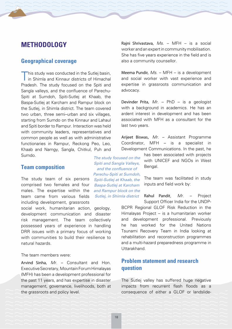
5. Semi-structured interviews with Members of the Kinnaur Legislative Assembly, Panchayat heads and other representatives, Government officials and administrative functionaries such as the Kinnaur Deputy Superintendent FGD at Reckong Peo, May 2008
of Police, Block Development Officer and other civil society representatives.
6. Transect Walks were conducted in the villages of Leo and Namgay to get a better understanding of the livelihood sources and the hazards faced.
ITINERARY OF THE FIELD VISIT
Date Place of visit Activities
31st May, 2008
Shimla to Reckong Peo (via Rampur)
- Internal team meeting- Semi-structured interviews with CSO representatives
1st June, 2008 Reckong Peo to Pooh
- FGD with 12 people at Reckong Peo- Semi-structured interviews with the local MLA, DSP and the ex-
Panchayat pradhan at Pooh - Watched footage of the 2005 flash floods at the Pooh Panchayat
Office
2nd June, 2008
Pooh to Samdoh and Leo
- Personal visualisation of Spiti valley, affected area, water monitoring station at Sumdo and apple orchards
- Semi-structured interviews with Commandant ITBP, Himachal Police personnel at the Sumdo Post
- Random survey with the help of a questionnaire at Leo
3rd June, 2008 Pooh to Namgia, Khab
- Semi-structured interaction with a school teacher, representatives from a women’s group and youth groups
- Interview with the Panchayat pradhan - Random Survey with the help of questionnaire
4th June, 2008 Pooh to Sangla Valley – Chitkul, Raksham, Badseri and Sangla
- Observation of local rituals at Chitkul village at a festival- Interaction with two school teachers at Raksham- Semi-structured interview with the Gram Pradhan of Budseri- Survey with the help of questionnaire - Interaction with an elderly man at Budseri village- Sample of local grains – farfa and ogla – was seen
5th June, 2008 Budseri to Rampur and Shimla
- Semi-structured interview of a wholesaler and shopkeepers at Tapri, Spillo and Wangtu
- Discussion took place with affected community- Survey with the help of questionnaire- Semi-structured interview with the MD of Nathpa-Jhakri Hydro-
electric Project and a journalist at Rampur
22
GLOF/ FLASH FLOOD INCIDENTS IN THE SUTLEJ VALLEY
The Sutlej Basin is a densely populated river basin in Himachal Pradesh. It is the lifeline
for the state in terms of economic activity, power generation, agriculture, horticulture, livestock and vegetable produce.
In the last two decades, the Sutlej valley in eastern Himachal Pradesh has witnessed a substantial increase in the number of flash flood events. The accentuating impact of these events can be attributed to many reasons, including cases of river damming outburst, frequent cloud burst incidents or suspected cases of GLOFs. Increasing anthropogenic pressure, including population growth, seasonal migration to the valleys, exploitation of hydropower potential and changing land use patterns, are some of the other reasons for an increase in the impact from recent flash floods. The combination of natural hazards and anthropogenic changes in the area has resulted in increased incidents of inter-related landslides and flash floods.
These flash floods cause massive devastation in downstream areas in terms of loss of human life, livestock, horticultural and agricultural land, and damage to roads, bridges and houses. Sometimes complete communities get washed away, as happened in the year 2000 when the Sutlej washed people along with their possessions downstream into the Govind Sagar Reservoir.
Formation and dimension
Though flash floods in the Sutlej basin are a recurrent feature, two of them stand out
because of the sheer volume of water that suddenly discharged and the socio-economic impact it had. These were the flash floods that occurred in 2000 and 2005.
Flash flood of 2000
On the night of 1st August, 2000, a 50-feet high wall of water in the Sutlej River swept away around 200 people from Kinnaur and Shimla districts. There was extensive damage caused by the sudden surge of water. Roads and bridges, some of them dating back at least 60 years, were washed away with the waters. There was substantial loss to human life and livelihoods. The Naptha-Jhakri Power Corporation (NJPC) suffered huge losses as a result of the flash floods and there was a substantial delay in
the commissioning of the power project.7
Kinnaur was the worst affected district in Himachal Pradesh in this flash flood and relief had to be air lifted in to the cut off district for a period of time. According to a UN OCHA report dated 22nd August, 2000,8 the Central Government in India conducted an assessment of the situation on 7th and 8th August,
2000 and released INR 1 billion to the state government in relief funds.
Flash flood of 2005
Parechu, a distributary of the Sutlej enters Himachal Pradesh from Tibet. At the beginning of August 2004, a 230 hectare size lake was formed on the river, inside Tibet, 35 km from the Himachal Pradesh border. China claimed
In the last two decades, the Sutlej valley in eastern Himachal
Pradesh has witnessed a substantial increase in
the number of flash flood events. The accentuating impact of these events
can be attributed to many reasons
7 HP seeks 1500 cr for flood damage, The Tribune; http://www.tribuneindia.com/2000/20000812/himachal.htm#18 http://www.reliefweb.int/rw/rwb.nsf/AllDocsByUNID/0c32c79dd3e9a542852569430067da52

23
that this lake was formed due to a sudden landslide leading to blockage of the river, at an inaccessible and high altitude site.9 Early warning of the formation of the lake was given by China, unlike the lack of information exchanged in the year 2000 flash floods which were also trans-boundary in nature.
The lake finally burst in June 2005. Reports claimed that around 5,000 people were evacuated by the government along the 200 km long stretch of the Sutlej as a precautionary measure.10 The press also claimed that the dam might have burst due to the increased water pressure which accumulated due to snow melting caused by above normal temperatures in that period.11
River dam outbursts, such as the Parechu incident of 2005, have led to widespread destruction. There were complete tracts of land, including horticultural fields that were washed away by the surge of water, which at places was more than 25 metres in height.12
Differential impact
In comparative terms of damage, the 2005 flash flood was less harmful from the one in the year 2000. This was even though the volume of water was higher in 2005 and led to the destruction of roads, bridges and houses in Himachal Pradesh with an estimated US$186 million worth of damage.13 The reason behind this, as evident from our interactions in the region, is because the year 2000 flash flood paved a wider basin for
the flow of water that came in the 2005 flood. Moreover, the 2000 flash flood came without any prior warning and in the middle of the night, created a greater impact. In the 2005 situation, the flash flood was expected, though the exact time and date was unknown. As it happened, the flood came in the middle of the day and that too when local people were tired of waiting for it to come for almost a year. As a result the national, state and district administration’s state of preparedness was much greater in 2005 as they had the previous experience of the 2000 flash flood.
The satellite images below show the reduced size of Parechu lake one month after the flood, in July 2005, and size of the lake before it burst in September 2004.
9 http://www.ipcs.org/China_east_asia_articles2.jsp?action=showView&kValue=1582&keyArticle=1009&issue=1009&status=article&mod=a10 AFP; http://www.terradaily.com/news/india-05zb.html 11 AFP; http://www.terradaily.com/2005/050627184318.juof4o4e.html 12 http://www.mapsofindia.com/maps/mapinnews/2005/floot-in-sutlej-himachal-pradesh.html13 IRI-Columbia; http://iri.columbia.edu/climate/cid/Jul2005/impacts.html
Source: NASA; Images of the Parechu River damming in Tibet14
September 1, 2004
July 2, 2005
14 http://earthobservatory.nasa.gov/Newsroom/NewImages/images.php3?img_id=16973
24
SOCIO-ECONOMIC IMPACT OF GLOF/FLASH FLOOD EVENTS IN SUTLEJ VALLEY
Due to the year 2000 flash flood, the completion of Naptha Jhakri hydropower project was delayed by around six months. It hampered the power generation process and heavily damaged the plant in the Sutlej basin. The total estimated loss from this flood alone was INR 3 billion.
The study team’s visit to the basins of the distributaries of the Sutlej highlighted the past and likely impact of these flash floods in various sectors:
Livelihood
Livelihood is normally heavily affected during times of flash floods as horticultural and agricultural fields are washed away. Cattle, sheep, goats and load bearing animals such as mules were washed away snatching further livelihood sources. This dire situation was further accentuated by market linkages being cut off as a result of bridges and patches of roads being destroyed by the flood.
Houses
Houses, especially those located beside the river, were washed away or damaged in the flash floods. Household items, precious family possessions and adjoining land on which the houses stood were also taken away. This caused the displacement and relocation of the people who were directly affected.
Community assets
Schools, hospitals, panchayat ghars etc., if situated at the river side, run a high risk of being
washed away or damaged. As they also serve as an emergency shelter during such hazards, these high value community assets should be built in safer areas. As was observed, such community assets were negatively impacted during the floods and some of them are still located right by the river side in many places to this day.
Infrastructure
Public infrastructure like roads, bridges, electricity and communication structures often get damaged during flash floods. This has an impact on relief and rescue work, development projects and livelihoods. Access to markets is cut off with patches of roads or bridges being washed away.
Economic assets
National economic assets like hydropower projects have to be closed down for a substantial period of time in the eventuality of a flash flood. This leads to a loss of electricity production and revenue generation. In other cases, flash flood waters, carrying huge boulders and silt, might damage power project infrastructure or machinery. It can also delay the commissioning of upcoming projects.
Women
It is a known fact that disasters always have an accentuated effect on women. In most cases women have to support children, run the household, farm and carry on with everyday life even in the face of a calamity. Flash floods have had a similar impact by increasing the responsibilities of women, and in some cases their vulnerability.
Education
There is a serious disruption to education in schools and colleges as the buildings housing

25
Story of Malsi Devi
The study team met Malsi Devi at Wangtoo, a place devastated by the year 2000 flash floods. She was sitting by herself by the road side. As the team soon learned, it was the place where she once had a happy and full household. The flash flood created a huge pool of water in Wangtoo for a period of two months, and took everything away from Malsi Devi: her house, livelihood and the way of life she was used to.
Malsi informed the team that her house and a piece of land next to the river, along with eight pigs, eight goats, one cow and a calf were all washed away. She lost all her savings, but more importantly she lost all her sources of livelihood because of the flood.
Malsi had lost her husband a few years before the flash flood and as a result one of her sons suffered from psychological trauma and has still not fully recovered. She now has the additional responsibility of supporting her son and daughter-in-law from her meagre earnings. She currently works as a daily-wage labourer at the Wangtoo power project
them can be damaged or are used as temporary shelters in the eventuality of a disaster. Education is also not always prioritised in the short run.
Health
Access to health facilities is an issue that needs to be overcome in the remote valleys of the Sutlej basin. In times of a flash flood this service is even further restricted.
Disabled
The disabled, due to a lack of societal neglect and lack of capacity building, form one of the most vulnerable sections of the society. They are quite handicapped in the event of a disaster and in many cases totally dependent on support from family members and friends in order to survive its aftermath.
Impact on different valleys
The study team also looked at the impact of the various flash floods on the different valleys of
the river basins of Parechu, Spiti, Sutlej and the Baspa.
Upper Kinnaur (Parechu, Spiti and Sutlej basins)
On the river banks of the Spiti River, at a village named Leo, the overall damage to houses, horticultural land and livestock was substantial for a small community. Sixteen houses were washed away and some of the other houses developed cracks. The approach road and bridge were completely destroyed leading to the isolation of the village. No conveyance was available after the flash flood and some tourists, along with the community, were stranded for quite a few days. Access to the market was also substantially hampered. The seasonal harvest of peas was affected, which directly affected the economic well-being and stability of the people. This compelled some of the affected people to withdraw from their bank savings to maintain day to day living. A fraction of the loss suffered was compensated by the district administration, but this was insufficient and less than the actual price of the yield.

26
At Khaab village, there was no loss of life and livestock in the 2005 flash floods. However, communication facilities were totally damaged. The villagers were unable to access the market and the seasonal pea yield was fully damaged. The ITBP camp at the Spiti and Sutlej confluence at Khaab was also destroyed during the flash flood. The villagers had to use their ingenuity and traditional knowledge to build a temporary bridge to re-establish contact with the outside world.
Spello village, near Pooh, was affected during both the flash floods of 2000 and 2005. In the year 2000 there was loss of one human life, two cows and a house. Horticultural and agricultural land, roads, bridges and the communication system were destroyed. In 2005, the horticultural land and the road was again washed away. Since the 2005 flash flood came during the day, there was no loss to life and livestock.
The flash floods wash away prime horticultural land on the river banks in their wake. Since annual horticultural produce forms the lifeline for many in the area, people have started clamouring for land which belongs to the forest department of the Government.
Roads and bridges were also destroyed in the 2005 flood around Raksham village, near the confluence of the Sutlej and the Baspa rivers.
Sangla Valley (Baspa basin)
The Sangla Valley has been affected by recurrent flash floods on an almost annual basis. Just below Raksham village there is a huge flood plain with a considerable amount of debris scattered around. At Budseri village, just above Sangla town, the Panchayat Pradhan said that during flash floods in 2007 they lost several houses, horticultural and agricultural
land, 2,000 to 3,000 apple saplings and trees and the connecting road and bridge. The village is also host to seasonal migrants from Nepal and Jharkhand. A point to note is that the worst affected in the 2007 flash floods were people belonging to the weaker sections of society.
Middle and Lower Kinnaur (Sutlej basin)
Tapri village, on National Highway-22, in the recent past was heavily affected three times by flash floods in 1995, 2000 and 2005. In the year 1995, 15 to 20 houses, a HRTC workshop and a bus were washed away. In the year 2000, patches of the road, the connecting bridges, and the communication system were washed away. Kinnaur remained cut off by road from the rest of the country for almost two months. According to local tea stall vendors, the local Army base, with houses, at Choling was also destroyed in the year 2005. The damaged roads and bridges were re-constructed by Jaypee Power Project after the destruction by several flash floods in the region.
The triggering factor of any flash flood could be GLOFs, cloud bursts or river damming. In the Sutlej valley, known incidents are recorded as a result of the latter two triggering factors and there is unsubstantiated speculation regarding minor GLOF events.
Urban settlements
Urban settlements on the banks of the Sutlej, like Rampur in Shimla district, serve as market towns, for the yearly horticultural and agricultural produce in the various valleys in the Sutlej basin. It also serves as a supply and warehousing depot. During flash floods, market access is often disrupted due to damage to roads and bridges. This affects the livelihood of various people in the town dependent on local trade.
27
In brief, the major socio-economic impacts of flash floods are:• Loss of human life• Loss of livelihood sources (orchards; apples,
almonds, peaches, agricultural produce, livestock)
• Loss of valuable land for horticulture and agriculture
• Access to markets is disrupted• Loss of irrigation facilities• Loss of infrastructure: bridges, roads,
culverts, houses and community buildings (schools, panchayat bhavans, and army camps)
• Loss of means of communications such as telephone lines, wireless and monitoring stations
• Psycho-social trauma• Loss of schooling for the children• Leads to dependency on past savings,
relatives, community and the Government.
Meeting with a journalist
The study team interacted with a freelance journalist, Mr. Bisheshar Negi, at Rampur Bushar town on the Sutlej River, which falls under the Shimla district. Mr. Negi informed the team that he has covered quite a few incidents of flash floods in various local newspapers and magazines.
Mr. Negi went on to inform the team that the yearly flooding not only destroyed roads and bridges but also adversely affected the environment. There are continuous landslides leading to a lot of silt being washed away. The water load passing by Rampur town is substantial as most of the major distributaries of the Sutlej have their confluence with the Sutlej upstream from Rampur. Therefore, the force of water is also much larger and as a result Rampur is consistently battered by flash floods.
Houses and bridges being washed away is a consistent feature in this area. Just upstream from Rampur, the 1,500 MW Nathpa-Jhakri Hydroelectric Power Station on the banks of Sutlej has had to be shut down four times because of the silt deluge in the river caused by such floods.
Mr. Negi also described a flash flood in December 2007 in the Sangla valley. It is unusual in nature to have a flash flood in the heart of winter and the reason for it is as yet unknown. There is speculation in some quarters that it could have been a GLOF. He also mentioned that he treks up to some of the high altitude lakes in the area and was very well versed on the hazards threatening the Sutlej basin.
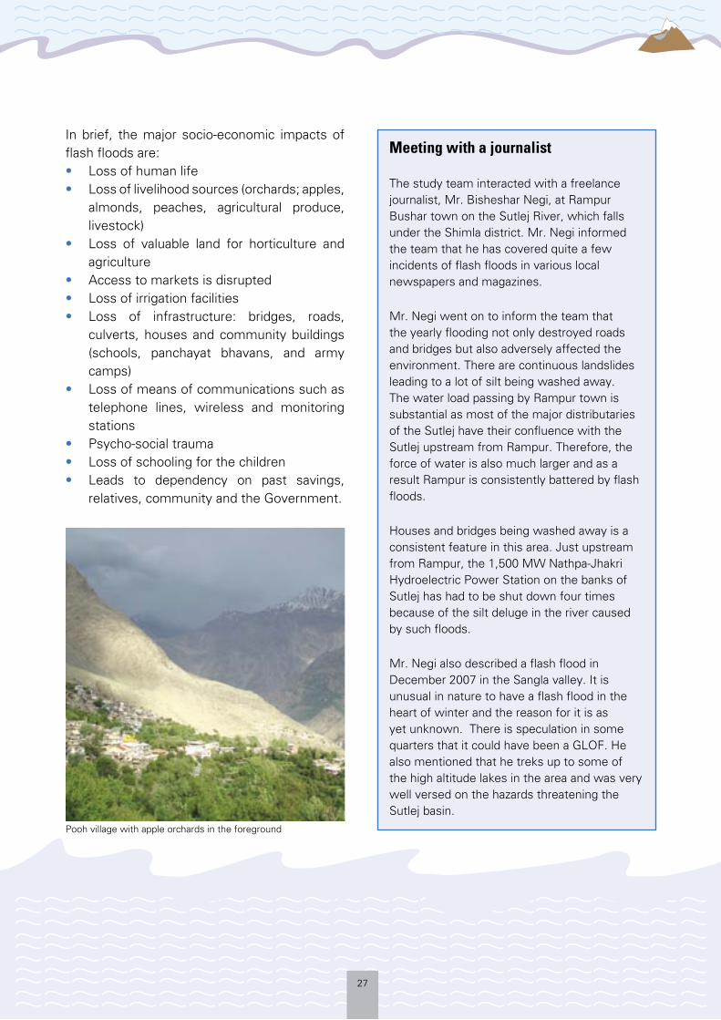
Pooh village with apple orchards in the foreground

28
RISK REDUCTION AND PREPAREDNESS INITIATIVES
As evident from the preceding chapters, the Sutlej basin frequently experiences flash
floods which often lead to death and destruction. These floods are coupled with incidents of river damming, landslides, forest fires, avalanches, and in extreme cases earthquakes of high magnitude.
These devastating incidents and their impact on all spheres of life in Himachal Pradesh have drawn attention to the need to initiate appropriate risk reduction and preparedness measures – both at administrative and community levels.
However, a lack of adequate communication facilities, infrastructure, awareness, hazardous terrain and high altitude, make it difficult to take the adequate steps required to support the disaster mitigation and preparedness process.
Notwithstanding such constraints, the study team did observe certain structural and non-structural measures in place which could be used for monitoring, forecasting and early warning in the Sutlej valley. Some of these measures, like the telemetry stations in Sumdo, at the confluence of the Parechu and Spiti rivers, and Khaab, at the confluence of the Spiti and Sutlej rivers, have been set up to fill the gap in early warning that was felt after the year 2000 floods. These have led to a progressive decline in the impact of flash floods downstream, as preparedness measures have improved due to the early warning generated through these stations.
Some of the measures put into place are as follows:
Monitoring, Forecasting and EWS
Wireless connectivity
There are multiple wireless set ups in Kinnaur district:• The Indian Army has a wireless station
at Kalpa. This is connected to the various outposts of the army in the border areas of the Sutlej basin. It is also linked with the various levels of the army hierarchy and boosts the civilian network in times of need.
• The Indo-Tibetan Border Police (ITBP) has a wireless station at Reckong Peo connected to all border outposts. This is similar, though separate, to the army network. Since the ITBP relies on visual monitoring of the water level, this wireless network is very useful in generating
warnings and in communicating during emergencies. • One Doordarshan satellite earth
station is located at Reckong Peo, the district headquarters of Kinnaur, along with the All India
The Sutlej basin frequently experiences
flash floods which often lead to death and
destruction
Radio relay centre. • The Police wireless station at Reckong
Peo is connected through wireless sets with various Patwaris at Gram Panchayats. This is again used to communicate during emergencies, with the last mile connectivity in the remotest of settlements usually being bridged by policemen physically going and warning people of impending hazards.
• Most villages are connected to the outside world through Dish and Tata Sky Television, and cable television.
• Bharat Sanchar Nigam Limited provides cellular connectivity to most areas in all three blocks of Kinnaur, with the Reliance network fast catching up. Landline telephones exist in most inhibited valleys.
29
This indicates that most of the Sutlej basin is quite soundly connected with the outside world. There is every possibility to interlink these various networks and use them in tandem to generate early warnings through a command and control mechanism.
The people of the Sutlej basin being generally economically well off and to a large extent educated, are competent in using and appreciating early warning mechanisms and practices, if cultivated, through community based disaster preparedness measures.
Advance water level monitoring systems
The ITBP and the Army rely on visual monitoring of the water level at various outposts. This is a technique which is quite useful, though it can only be done during daylight hours.
The ITBP was quite successful in anticipating the gush of water in 2005 by visual sighting of a wall of water and mist roaring downhill, as it was during the day time.
To complement such human efforts, two advanced monitoring stations were set up quite close to the international border to intercept any increase in the water level in the Parechu, Spiti and Sutlej rivers and relay information.
The telemetry relay station at Sumdo (the confluence of the Parechu and Spiti rivers) was established by the Snow and Hydrology Division of the Central Water Commission, Ministry of Water Resources, Government of India. A similar station is located at Khaab (the confluence of the Spiti and Sutlej rivers) and at Dubling by the Naptha-Jhakri project, to serve prior warnings for the protection of the hydropower project.
These stations are very useful in generating early warnings and also for monitoring the flow and level of water over a passage of time. Such instruments, being structural in nature, need technical and institutional back-up. Each of the valleys of the various distributaries of the Sutlej river merits such telemetry stations to generate and record warnings.
Community led initiatives
There are certain community level disaster preparedness activities that have been initiated, but these are largely few and far in between. Concerted efforts and community based disaster preparedness programmes have not yet taken concrete shape in any of the valleys and villages that the study team visited, though some initiatives have been taken by local administration and other stakeholders to generate awareness.
There are a few NGOs/CBOs and journalists, mostly in Reckong Peo, who have a high level of awareness pertaining to the hazards that the communities face and are willing to work to mitigate their effects. Communities have also undertaken some steps on the basis of their own experience and local traditional knowledge. Building of traditional bridges, mapping alternate routes and a strong community network are some of the measures that the community utilise at a moment’s notice.
During interactions with some of the gram pramukhs in different valleys of the Sutlej basin, it was evident that the level of understanding and appreciation of hazard issues was quite high among the community leaders and within the communities.
However, because of the challenges of terrain and strategic location close to the international
30
border and less access to technical and training resources at the local level, communities are heavily dependent upon the administration for risk mitigation and preparedness initiatives.
The community holds basic capacity in relaying messages through cellphones and telephones and by shouting across certain valleys. Modern tools such as remote sensing, topographic maps, aerial photographs and satellite images play a crucial role in identifying potential risks and monitoring the behaviour of possible hazards. However, because the Sutlej valley lies close to the international border with China, most of the detailed information remains classified. They are only available to the civilian administration, armed forces and to the government’s scientific establishment.
Administrative initiatives
As per the Disaster Management Act, 2005, the District Collector is responsible for coordinating risk mitigation, preparedness and response measures for disaster management at the district level and all relief and response agencies are answerable to him.
Non-structural initiatives
Though lacking in effective community based preparedness measures, the administration does gear up when it comes to response. Kinnaur district has a District Disaster Management Plan dating back to 2003, which is usually updated every year. As per the plan, district and block level committees, involving various departments of the Government, armed forces and NGOs/CBOs are in place to coordinate any response measures required during a disaster.
Once immediate measures have been taken by the community, the administration is usually instrumental in providing additional
relief and rescue assistance (even extending to the use of helicopters as was evident in 2005), building temporary bridges and re-working alternative roads whenever one is affected.
The police are responsible for the maintenance of law and order and for wireless communications during more localised disasters like the flash floods in 1995, 1997 and 2007, which were more in the valleys of the distributaries of the Sutlej river.
The more serious 2000 and 2005 flash floods caught state, national and international attention. In such cases the local administration was under constant media glare and the best of coordination efforts were needed to deal with the state administration, media, and the demands of the communities, NGOs/CBOs and the armed forces.
Structural initiatives
There are some visible risk reduction praxis in terms of bridges at higher elevations, roads being reconstructed on more stable ground, the relocation of communities to a higher elevation and the promotion of horticultural fields at a higher elevation where they cannot be flooded. Embankments, contour trenches and check walls have also been constructed at various places where it is anticipated that flood waters might breach a particular vulnerable or important dwelling or location.
This is coupled with the telemetry stations at two important river confluences used to record, monitor and relay early warning in cases of rapidly rising water levels.
The Army and Paramilitary forces
The Army and Paramilitary forces generally assist the civilian administration whenever they

31
are called upon to provide rescue and relief assistance.
There are several army and other paramilitary (SSB, ITBP, BRO) outposts throughout the Sutlej basin. In times of a disaster, the armed forces are instrumental in rescue and relief operations. Re-establishment of communication systems, temporary bridges and roads, first aid, medical aid, air rescue/transport of those stranded and in need of immediate evacuation are just some of the aspects of disaster management that the Army and the Paramilitaries are responsible for.
Community coping mechanisms
It is a known fact that affected communities apply various coping mechanisms in the aftermath of a disaster. In response to a question from the study teams on coping mechanisms in the event of a disaster, the answers depended on the degree to which the impact was felt. The people whose houses were washed away in flash floods were usually provided temporary shelter with relatives, other houses or in the various community halls in the village.
It was noted that none of the respondents cited experiences where they starved or even went without some basic meals for an extended period of time. Dependency on relatives and neighbours is high and it is customary in the region to expect and extend such help. Relief in food items, utensils, bedding and clothes was also extended to victims by neighbouring villages and communities.
People in the region are relatively well off, so in times of crisis, to varying degrees, they have been able to withdraw from their savings in banks or mortgage household jewellery, to tide them over the crisis period. In a few instances, people have taken on manual labour jobs as a means of earning a living.
Besides short term relief and response, the Government also plays an important role in long term rehabilitation. For instance, at Leo village in Pooh block, the Government has provided alternative housing sites at a higher elevation, away from the 2005 flood affected river banks.
It has also subsidised travel and transport of agricultural produce whenever roads and bridges have been damaged due to natural calamities. Since the economy of the area largely depends on the yearly sale of horticultural produce, the Government ensures that market access is provided at all times.
The water level monitoring station at Sumdo

32
NEEDS AND CAPACITY GAPS ASSESSMENT
Though the community in the Sutlej basin is resilient, the field survey observed that
there is a huge capacity gap in overall disaster preparedness. There is a need to strengthen the awareness and preparedness levels of communities, administrative officers, PRI representatives, NGOs and CBOs.
The local community has yet not visualised the risk of GLOFs in many parts of the areas visited in Shimla and Kinnaur districts. In spite of the fact that repeated incidents of flash floods and the resultant damage have occurred, the risks of GLOF events is still not being factored into community level livelihood and occupational patterns. There is inadequate understanding of the capacity required to prepare for such events and to mitigate their impact.
At the local administrative level, though the process of putting in place mechanisms for responding to such events has been activated, significant gaps in the involvement of local communities through awareness generation, training and capacity building for handling such events remains. This has led to an overwhelming dependence on the administrative set up for all risk mitigation and preparedness endeavours. Communities were also not part of active discussions when committees for the planning and review of structural risk reduction measures were formed. The community has visualised the threat of avalanches and they have also encountered them several times in their villages.
GLOF or flash flood risk has been insufficiently factored into the development and planning
process at the individual, community and local level. This has resulted in the exposure of meagre development infrastructure such as bridges, roads, electricity, telecommunication systems and other socio-economic assets to recurrent destruction or damage.
It has been observed during interactions with the community that community level disaster risk management and preparedness planning has not been taken up in a systematic manner. There is also a general lack of awareness and information about the kind of risk mitigation and preparedness measures which can be taken up at community level. The process of developing a community based disaster management plan
has not been initiated. Communities have little or no knowledge as to what initiatives they can take to minimise the impact of recurring flash floods or GLOFs.
Due to the absence of community level disaster risk mitigation and preparedness plans, there is an increasing dependence on
local administrative machinery and external agencies for assistance in the event of any natural calamity. The fact that communities can develop systems and plan for future calamities is still not well understood and observed at the local level. This was also evident during past flash flood events, as the affected communities had to fend for themselves in the aftermath of a disaster (especially in the first few days), as administration took some time to organise response and recovery efforts.
Locally elected institutions like panchayats and bodies including elected representatives or administrative functionaries at the village/block level, have not received any specialised training in managing disaster situations. The capacity at local administration level for
It has been observed during interactions with
the community that community level disaster
risk management and preparedness planning
has not been taken up in a systematic manner
33
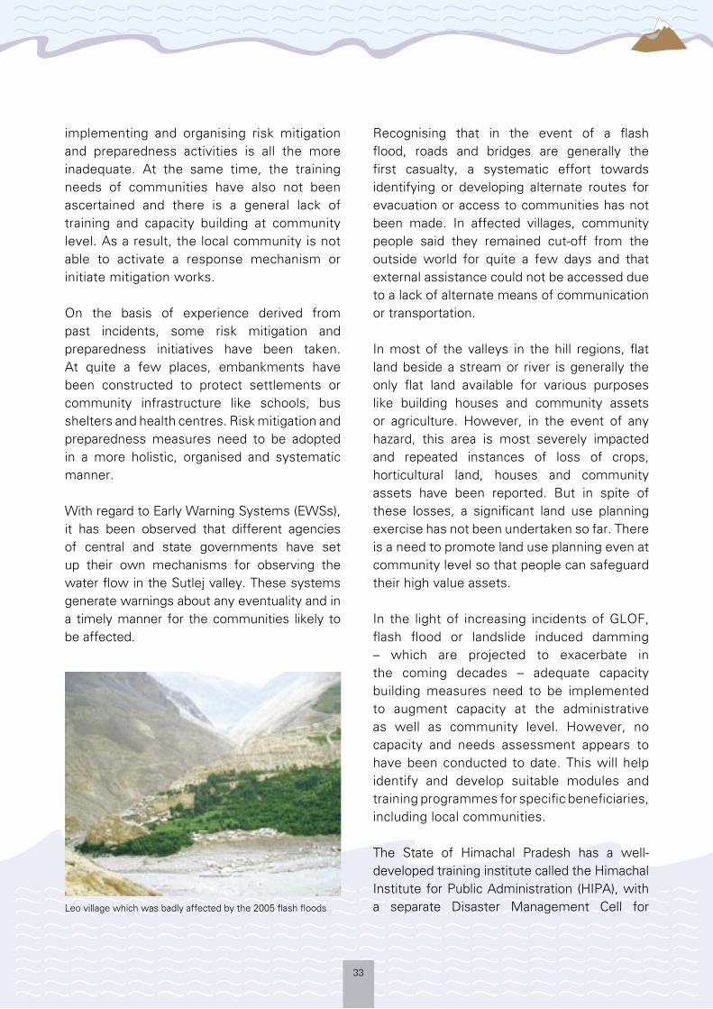
implementing and organising risk mitigation and preparedness activities is all the more inadequate. At the same time, the training needs of communities have also not been ascertained and there is a general lack of training and capacity building at community level. As a result, the local community is not able to activate a response mechanism or initiate mitigation works.
On the basis of experience derived from past incidents, some risk mitigation and preparedness initiatives have been taken. At quite a few places, embankments have been constructed to protect settlements or community infrastructure like schools, bus shelters and health centres. Risk mitigation and preparedness measures need to be adopted in a more holistic, organised and systematic manner.
With regard to Early Warning Systems (EWSs), it has been observed that different agencies of central and state governments have set up their own mechanisms for observing the water flow in the Sutlej valley. These systems generate warnings about any eventuality and in a timely manner for the communities likely to be affected.
Recognising that in the event of a flash flood, roads and bridges are generally the first casualty, a systematic effort towards identifying or developing alternate routes for evacuation or access to communities has not been made. In affected villages, community people said they remained cut-off from the outside world for quite a few days and that external assistance could not be accessed due to a lack of alternate means of communication or transportation.
In most of the valleys in the hill regions, flat land beside a stream or river is generally the only flat land available for various purposes like building houses and community assets or agriculture. However, in the event of any hazard, this area is most severely impacted and repeated instances of loss of crops, horticultural land, houses and community assets have been reported. But in spite of these losses, a significant land use planning exercise has not been undertaken so far. There is a need to promote land use planning even at community level so that people can safeguard their high value assets.
In the light of increasing incidents of GLOF, flash flood or landslide induced damming – which are projected to exacerbate in the coming decades – adequate capacity building measures need to be implemented to augment capacity at the administrative as well as community level. However, no capacity and needs assessment appears to have been conducted to date. This will help identify and develop suitable modules and training programmes for specific beneficiaries, including local communities.
The State of Himachal Pradesh has a well-developed training institute called the Himachal Institute for Public Administration (HIPA), with a separate Disaster Management Cell for Leo village which was badly affected by the 2005 flash floods

34
catering to the capacity building and training requirements of administrative functionaries as well as of other stakeholders in the field of disaster management. However, GLOF events have not received adequate attention in terms of the development of course curricula incorporating this existing and accentuating threat, or for identifying the districts which require special capacity building efforts in this direction.
There is also a need to establish closer ties between scientific and academic institutions studying the impact of climate change in the Himalayas, developmental practitioners, local administration and communities, to factor Remains of the previous bridge at Leo
disaster risk reduction into all the developmental policies in the Sutlej basin.

35
sustainability, reduce vulnerability and to build a culture of disaster preparedness.
Developmental activities at the administrative level
Infrastructure: Ever since the flash floods in 2000 and 2005 that washed away bridges and patches of the National Highway-22 and other roads, there is a concerted effort to rebuild bridges at a higher elevation, so that they cannot be touched by flood waters. This was quite evident in Leo, where the new bridge’s elevation can be visibly compared with the carcass of the old one.
Similarly, the old Hindustan-Tibet highway, a time tested route, is being revived in places at a higher elevation, and therefore less prone to land and mud slides. Embankments and contour trenching are also visible at places as and where they need to
protect vital and vulnerable locations.
Helipads have been constructed in various valleys that are normally used solely for the movement of army or civilian officials, but are also being utilised in cases of emergency. However, further thought needs to go into the location of these sensitive installations, as for example in Sangla, the helipad is located right beside the river.
Similarly, community assets like schools are being constructed right by the river, for example in Chitkul, probably because this is the only flat land available. However, this fact also makes it equally vulnerable in situations of flash floods when installations in the flood plain are the first to be adversely affected by flood water. This
15 http://hpkinnaur.nic.in/admn.htm
Ever since the flash floods in 2000 and 2005 that washed away bridges and patches of the National Highway-22 and other roads, there is a concerted effort to rebuild
bridges at a higher elevation
ASSESSING EXISTING DEVELOPMENT POLICIES AND PRACTICES
Most of the areas in the upper Sutlej basin fall under the Special Area Development
Authority, responsible for development initiatives in the valley. This special status is granted because the Sutlej lies in a remote border area, which suffered from years of neglect and apathy during various Government regimes over the centuries and because of the fact that most of the populace in the region is of tribal stock.
Since the formation of the state of Himachal Pradesh and the re-organisation of districts in the Sutlej basin, Kinnaur and other remote districts like Lahaul and Spiti have a localised administrative and governance structure of their own. For example, the Deputy Commissioner of Kinnaur has been given wider administrative and financial powers as a single line administrator for all departments in the district. The development schemes of various departments also have to be routed through the Deputy Commissioner.15 The local administration and PRIs do have the capacity, in the local scenario, to influence development policies and practices.
Since flash floods are frequent in the region and some have a huge impact on life and livelihoods, it is an issue that hovers over everyone’s mind in the Sutlej basin.
Therefore, it should be natural that development practices in the region should factor in disaster risk reduction measures to ensure long term
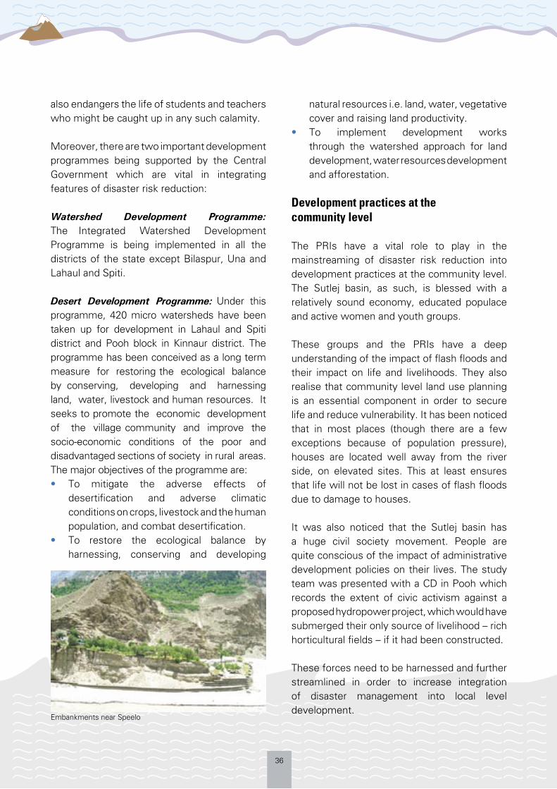
36
also endangers the life of students and teachers who might be caught up in any such calamity.
Moreover, there are two important development programmes being supported by the Central Government which are vital in integrating features of disaster risk reduction:
Watershed Development Programme:The Integrated Watershed Development Programme is being implemented in all the districts of the state except Bilaspur, Una and Lahaul and Spiti.
Desert Development Programme: Under this programme, 420 micro watersheds have been taken up for development in Lahaul and Spiti district and Pooh block in Kinnaur district. The programme has been conceived as a long term measure for restoring the ecological balance by conserving, developing and harnessing land, water, livestock and human resources. It seeks to promote the economic development of the village community and improve the socio-economic conditions of the poor and disadvantaged sections of society in rural areas. The major objectives of the programme are:• To mitigate the adverse effects of
desertification and adverse climatic conditions on crops, livestock and the human population, and combat desertification.
• To restore the ecological balance by harnessing, conserving and developing
natural resources i.e. land, water, vegetative cover and raising land productivity.
• To implement development works through the watershed approach for land development, water resources development and afforestation.
Development practices at the community level
The PRIs have a vital role to play in the mainstreaming of disaster risk reduction into development practices at the community level. The Sutlej basin, as such, is blessed with a relatively sound economy, educated populace and active women and youth groups.
These groups and the PRIs have a deep understanding of the impact of flash floods and their impact on life and livelihoods. They also realise that community level land use planning is an essential component in order to secure life and reduce vulnerability. It has been noticed that in most places (though there are a few exceptions because of population pressure), houses are located well away from the river side, on elevated sites. This at least ensures that life will not be lost in cases of flash floods due to damage to houses.
It was also noticed that the Sutlej basin has a huge civil society movement. People are quite conscious of the impact of administrative development policies on their lives. The study team was presented with a CD in Pooh which records the extent of civic activism against a proposed hydropower project, which would have submerged their only source of livelihood – rich horticultural fields – if it had been constructed.
These forces need to be harnessed and further streamlined in order to increase integration of disaster management into local level development.
Embankments near Speelo

37
RECOMMENDATIONS
Himachal Pradesh needs to formulate a disaster management policy considering its
extremely vulnerable geographical settings as well as the settlement patterns in both rural and urban areas. The Government should establish a State Disaster Management Authority (SDMA) as stipulated under the Disaster Management Act, 2005, at the earliest. Similarly, District Disaster Management Authorities, and further down, Block Disaster Management Authorities need to be formed to provide an institutional framework to handle the entire cycle of disaster management effectively.
Disaster management has to be mainstreamed in the state’s development programmes and policies so that all departments are prepared for calamities and can play an appropriate part in risk reduction, relief and rehabilitation. State level training institutes like HIPA should be optimally utilised to impart training on disaster management to administrators and community representatives.
Difficult geographical conditions and inaccessible habitat have prevented different government and non-government machinery for reaching disaster hit areas as fast as possible. Therefore, village level organisations, resources, NGOs, Panchayats should be well equipped with the skills of disaster management and their role should be effectively demarcated in state policy documents.
Disaster management, including awareness raising on flash floods risk reduction, should be included in the curriculum at the school level and it could be offered as a diploma in colleges. Insurance, to cover the losses during any disastrous situation, should be promoted. All vulnerable groups including children, pregnant and lactating women, differently abled and the elderly,
have to be kept in mind when formulating state disaster management policy and frameworks.
District Disaster Management Authority meetings need to be regularised on a half yearly basis, as well as on a need basis. District Disaster Management plans should be updated on a regular basis considering the changing necessities and involvement of different stakeholders. Awareness campaigns and first response trainings should be held regularly at the district level. Awareness on the relatively unknown risk of GLOFs needs to be included District administration should budget for a specific fund for preparedness and risk reduction training. Mock drills should be organised with all stakeholders – civilians, military, civil society and PRIs – to ensure synergy and consolidate the control and command systems that needs to be operationalised in a disaster scenario.
Last mile connectivity should be ensured in cases of early warning systems. Quite a few models are available to bridge the last mile connectivity and these should be tested to best suit the requirements of the Sutlej basin.16
The flood zone in the Sutlej basin should be demarcated and further construction work should be forbidden in this area. The old Hindustan-Tibet Highway needs to be revived in its entirety, so as to provide an alternative route in cases of an emergency, as well as to promote tourism.
Community contingency planning, from the village level upwards, should be undertaken and these plans should be updated on a regular basis. Preparedness and training on first response should be given to disaster management teams that need to be established at every village. Gender sensitive training, focusing on women, backward communities and vulnerable groups should be conducted.
16 For more information refer: http://www.managingclimaterisk.org/document/e-discussion.pdf

38
Community based preparedness measures, an institutional framework at the district level, updated disaster preparedness plans and maps from the district and blocks down to the village level need to be implemented.
Disaster risk reduction measures need to be mainstreamed into the developmental initiatives in the Sutlej valley, for example, the Cold Desert Development Programme and the Watershed Management Programme.
The following could be done on a priority basis:
Flood disaster management
Pre-flood arrangements: District adminis-tration needs to convene meetings of the district level disaster management committee and other sub-divisional committees every year. The meeting will attempt to ensure preparedness with respect to the following issues:• Stock taking of the functioning of the
integrated district disaster control room including seismic monitoring (as seismic activity can be a trigger for GLOF) and monitoring of water levels in glacier lakes.
• Wireless network checked so that it’s functioning properly and covering the entire basin, down to the last mile of inhabited land.
• Storage of food and other emergency items at interior, vulnerable and strategic points.
• Arrangements to keep the drainage system clear of any major blockages.
• Evacuation plans including special evacuation needs of vulnerable, elderly, disabled, women and children.
• Transport arrangements for horticultural and agricultural produce and essential items, in case of an emergency.
• Suitable health arrangements made and sufficient stocks of essential medicines to be maintained.
• Suitable veterinary arrangements in place.
• Selection/construction of flood shelters.• Organisation of relief teams incorporating
trained community volunteers, civilian personnel, police, home guards and ITBP personnel.
• Planning of early warning mechanisms to ensure last mile connectivity.
Post flood arrangements: Response mechanism
Several post flood arrangements can be adopted to mitigate the impact:• First step is to warn people in time about
the flood occurrence through telephone, wireless, media and local practices.
• Evacuation of all people, especially the vulnerable, to safer places – community shelters at higher elevations (schools, Panchayat/Mahila mandal/Yuva mandal bhavans) and other identified buildings.
• Search and rescue operations for missing people and provide the evacuated population with medical help by organising relief parties in the form of quick response teams.
• Organise relief camps for the affected people and provide them with food, drinking water, sanitation, public health care and veterinary services.
• Establish alternate communication links so that communication is maintained with otherwise cut off areas.
Disaster risk mitigation, preparedness and preventive measures for reducing vulnerability, and effective rescue and relief actions immediately after a flood event, are essential elements of the development process in disaster prone areas. Government departments, NGOs/CBOs and local administration need to jointly take steps in this direction.

39
REFERENCES
Books and Journals Bajracharya S.R., Mool P.K., and Shrestha B., (2007) Impact of Climate Change on Himalayan Glaciers and Glacial Lakes-Case Studies on GLOF and Associate Hazards in Nepal and Bhutan, ICIMOD.
Dekens J., (2007); Herders of Chitral The Lost Messengers-Local Knowledge on Disaster Preparedness in Chitral District, Pakistan, ICIMOD
Dekens J., (2007); The Snake and the River Don’t Run Straight-Local Knowledge on Disaster Preparedness in the Eastern Terai of Nepal, ICIMOD.
Hasnain, S. I. (2000); Status of the Glacier Research in the HKH Region 2000, ICIMOD, Kathmandu.
ICIMOD (2007); Disaster Preparedness and Natural Hazards Current Status in India.
Lal M., (2002); Possible Impacts of Global Climate Change on Water Availability in India- Report to Global Environment and Energy in the 21st Century, Indian institute of Technology, New Delhi.
Mool P.K. and Bajracharya S.R., (2003); Tista Basin, Sikkim Himalaya, Inventory of Glaciers, Glacial Lakes and the Identification of Potential Glacial Lakes Outburst Floods (GLOFs) Affected by the Global Warming in the Mountains of the Himalayan Region, ICIMOD.
Mool P.K. and Bajracharya S.R., (2004); Himachal Pradesh Himalaya, Inventory of Glaciers, Glacial Lakes and the Identification of Potential Glacial
Lakes Outburst Floods (GLOFs) Affected by the Global Warming in the Mountains of the Himalayan Region, ICIMOD.
Mool P.K., Bajracharya S.R. and Joshi S.P. (2001); Inventory of Glaciers, Glacial Lakes and Glacial Lakes Outburst Flood Monitoring and Early Warning System in the Hindu Kush Himalaya Region, ICIMOD, Kathmandu.
Mool P.K., Bajracharya S.R. and Shrestha B., (2005); Uttaranchal Himalayas, Inventory of Glaciers, Glacial Lakes and the Identification of Potential Glacial Lakes Outburst Floods (GLOFs) Affected by the Global Warming in the Mountains of the Himalayan Region, ICIMOD.
South Asian Disaster Report (2007); SAARC Disaster Management Centre, New Delhi.
UNDP (2007); Managing Risks of a Changing Climate to Support Development-Report of the Asia Regional Workshop, 23-26 April 2007, Kathmandu, Nepal.
UNDP India; Country Programme Action Plan between the Government of India and the United Nations Development Programme 2008-2012.
United Nations Development Programme, (2007/2008); Human Development Report- Fighting Climate Change: Human Solidarity in a Divided World.
United Nations International Strategy for Disaster Reduction, (2004); Living with Risk- A Global Review of Disaster Reduction Initiatives, Geneva.
WWF Nepal Programme (2005); An Overview of Glaciers, Glacier Retreat and Subsequent Impacts in Nepal, India and China.
40
Internet Resources
(Website have been accessed over the months of July 2008 to January 2009)
Consolidated Reply; E-discussion of the Regional Glacial Lakes Outburst Floods in the Himalayas, UNDP; http://www.manag ingc l imater i sk .o rg /document /e -discussion.pdf
Consolidated Reply to the Query Glacial Lakes Outburst Flooding/ Himalayan Region/ Comparative Experiences, UNDP; http://www.managingclimaterisk.org/document/GLOF%20Knowledge%20Networks%20Query%20Consolidated%20Reply.pdf
District Administration of Kinnaur; www.kinnaur.nic.in; http://hpkinnaur.nic.in/admn.htm
Earthquakes in Himachal Pradesh, India; http://asc-india.org/seismi/seis-himachal-pradesh.htm
Floods in Sutlej, Made in China, Jul. 11, 2005, India together; http://www.indiatogether.org/2005/jul/gov-sutlej.htm
Government of Himachal Pradesh; www.himachal.gov.nic.in
HP seeks 1500 cr for flood damage, Aug. 11, 2000, The Tribune; http://www.tribuneindia.
com/2000/20000812/himachal.htm#1
India Evacuates Thousands in Northern State after Tibet River Raises Rapidly, Jun. 26, 2005, Terra Daily; http://www.terradaily.com/news/india-05zb.html
India-Floods Situation Report No. 2, Aug. 22, 2000, Relief Web; http://wwww.reliefweb.int/rw/rwb.nsf/AllDocsByUNID/0c32c79dd3e9a542852569430067da52
IRI-Columbia Climate Digest Jul. 2005; http://iri.columbia.edu/climate/cid/Jul2005/impacts.html
Landslide lake in Tibet floods India, NASA Earth Observatory, Jul. 14, 2005; http://earthobservatory.nasa.gov/Newsroom/NewImages/images.php3?img_id=16973
Sutlej Floods vast areas in Himachal Pradesh, Jun. 27, 2005, Maps of India; http://www.mapsofindia.com/maps/mapinnews/2005/floot-in-sutlej-himachal-pradesh.html
The Parechu Incident: A Preliminary Analysis, Nov. 30, 2004, Institute of Peace and Conflict Studies; http://www.ipcs.org/article_details.php?articleNo=1569&cID=
Thousands cut-off in Northern India by river flood from Tibet, Jun. 27, 2005, Terra Daily; http://www.terradaily.com/2005/050627184318.juof4o4e.html

41
ANNEXURE – 1
Inventory of existing infrastructure
Road and infrastructure
National Highway-22 connects Kinnaur to the rest of the country. It follows the old Hindustan-Tibet highway to a large extent. The roads are narrow, risk prone and in patches cut through sheer rock faces. Some areas are very fragile. Land slide and stone shooting are regular events in some specific zones. The nearest airport to Kinnaur district is Jubbar Hatti (from Shimla to Kalpa) is 244 km away and the nearest access to the railways is the narrow gauge railway station at Shimla, 250 km away. There are helicopters with the Government and the army and a few helipads dotted across the Sutlej basin.
Wireless communication
The following is a list of wireless centres in the area: i. Satellite earth station at Reckong Peoii. Police wireless station at Reckong Peoiii. All India Radio relay centre at Reckong Peoiv. Army wireless station at Kalpav. ITBP wireless station at Reckong Peo
Bridges
• Chaura Bridge • Nigulsari Bridge • Sholding Bridge• Panvi Khud Bridge• Wangtoo Bridge• Karchham Bridge• Shongthong Bridge• Pangi Nallah Bridge• Kashang Nallah Bridge• Kharo Bridge• Akpa Bridge• Moorang Bridge • Kiran Khud Bridge• Nesang Bridge• Siaso Khud Bridge• Kannam Bridge• Dubling Bridge• Khab Bridge• Shalkhar Bridge
Hydro-power projects
As of now, there are the following hydro-power projects in Kinnaur district of the Sutlej basin:• Nathpa-Jhakri Power Project at Nathpa• Bhabha Augmentation Project at Kafnoo• Sanjay Vidyut Pariyajanaat Bhabha• Baspa Hydro-electric Project• Kashang Hydro-electric Project• Titan Khud Project
42
ANNEXURE – 2
List of participants at the Community Consultation Workshop at Reckong Peo, September 9, 2008
No. Name Address
1 Sh. Tejwant Singh Negi Member of the Legislative Assembly (MLA), Kinnaur, V.P.O. Kalpa
2 Sh. P.S. Draik Deputy Commissioner, Kinnaur
3 Smt. Chander Mani Negi Zila Parishad Chairperson, V.P.O. Chansu, Teh. Sangla Kinnaur
4 Sh. Rahul Pandit Project Support Officer, UNDP-BCPR, New Delhi
5 Sh. Tarun Singh Dhani Asst. Commandant, ITBP 17th Bn, R-Peo Distt. Kinnaur H.P.
6 Sh. Harbans Singh Project Officer, Integrated Tribal Development Programme, Kinnaur
7 Sh. S.G. Negi Company Guard, Home Guards R-Peo
8 Sh. Arvind Sinha Mountain Forum Himalayas, Shimla
9 Sh. H.S. Negi Fire Officer, Reckong Peo
10 Sh. Sushil Sana Vice-Pradhan, Village. Panchayat. Pooh
11 Sh. Chirangi Kumar Village. Panchayat. Pooh
12 Kl. Wang lak Head Lama, Village Post Office, Labrang
13 Sh. Bishesher Negi Journalist, Rampur, Shimla district
14 Sh. Bishuk Sain V.P.O. & Teh. Sansla Distt Kinnaur
15 Smt. Vinya Devi Pradhan, Village Barang, Teh. Kalpa, Distt. Kinnaur, H.P
16 Sh. Shyam Sunder Negi Pradhan, Village Purvni, Teh. Kalpa Distt. Kinnaur
17 Sh. Satyajeet Negi Village Purvni, Teh. Kalpa Distt. Kinnaur
18 Sh. Arun Negi Journalist, Reckong Peo
19 Ku. Rattan Manjari Chairperson, Mahila Kalyan Parishad, Recong Peo
20 Smt. Ganga Bagati V.P.O. Xavarangi
21 Smt. Anita V.P.O. Kalpa
22 Sh. Inder Bagat Negi V.P.O. Batsari Teh Sangla
23 Sh. Chander V.P.O. Kinnaur
24 Sh. Virender Kumar V.P.O. Labrang
25 Sh. Jagat Singh Negi O/C Deputy Director Animal Husbandry Distt. Kinnaur H.P.
26 Sh. Gishaheri Lal Tehsil Office Sangla
27 Sh. Dil Bag Singh Tehsil Office Kalpa
28 Sh. Dhari Kumar Tehsil Office Moorang
29 Sh. Dhan Bhag D.C. Office
30 Sh. Virbal Negi V.P.O. Badseri
31 Sh. Devi Singh Negi Tehsil Office Nichar at Bhoba Nagar Distt. Kinnaur

43
No. Name Address
32 Sh. R.S. Negi V.P.O. & Tehsil Pooh
33 Sh. Raju Negi Journalist, C/o Rushap Kunj R/Peo
34 Sh. Jeet Ram Journalist, Village Panvi, Kinnaur
35 Sh. Ramesh Chauhan Inspector, C/o S.P. Office Recong Peo
36 Dr. S.B. Negi Principal, Govt. Collage Rekong Peo
37 Smt. Baghwati Negi Bhagwati Niwas Reclong Peo
38 Sh. Chhetter Singh Pradhan, Vill & P.O Leo
39 Sh. Padam Bisht Principal, Govt. Senior Secondary School, Pangi Kinnaur
40 Smt. Parvati Devi Up-Pradhan, Village & P.O. Leo
41 Sh. Prem Singh Negi Sr. Lecturer, Govt. College R/Peo
42 Sh. Karam Singh Up-Pradhan, Gram Panchayat Leo
43 Sh. Parminder Singh Kinnaur
44 Sh. Manoj Kumar Pradhan, G.P. Chitkul, Tehsil Sangla
45 Chhodan Jangmo Pradhan, Mahila Mandal Dal, Leo
46 Smt. Shanti Devi Secretary, Mahila Mandal Dal, Village Leo
47 Sh. Sanjay Sharma GM Industries Deptt R/Peo
48 Sh. Punit Singh Reckong Peo
49 Sh. Parveen Chauhan V.P.O. Kalpa, Kinnaur
50 Er. Vineet Sood Project Officer, Himurja Kinnaur, Reckong Peo
51 Sh. Mukesh Chander V.P.O. Kalpa Distt. Kinnaur
52 Sh. Praveen Kumar V.P.O. Kalpa Distt. Kinnaur
53 Sh. L.R. Negi AC to Deputy Commissioner, Kinnaur
54 Smt Tenjin Dolma Pradhan, Mahila Mandal, Vill. Chuling, Teh. Yangthang, Kinnaur
55 Smt. Kamlesh Negi V.P.O. Kalpa, Kinnaur
56 Sh. Jeet Prakesh Kinnaur
57 Sh. Praveen Kr. Negi Panchayat Member, V.P.O. Nesang, Teh. Pooh, Kinnaur
58 Sh. Rajeev Pathria Special Correspondent, Punjab Kesri, Al Manjil, U.S. Club, Shimla
59 Sh. Anil Kumar Negi Pradhan, V.P.O. Batseri, Teh. Sangla Kinnaur
60 Sh. Dharmender Singh Vice-Pradhan, V.P.O. Batseri, Teh. Sangla Kinnaur
61 Sh. Gautam Singh Yuva Mandal Pradhan, V.P.O. Batseri, Teh. Sangla Kinnaur
62 Smt. Radha Krishna Secretary, Mahila.Mandal, Nako, Kinnaur
63 Smt. Bhag Devi Kalpa, Kinnaur
64 Smt. Bhagi Devi Vill. Vangtu, P.O. Panvee, Kinnaur
65 Sh Arijit Biswas Mountain Forum Himalayas, Shimla
66 Ku. Rajni Srivastav Mountain Forum Himalayas, Shimla
67 Sh. Surender Singh Negi Mahila Mandal Shinso office at Maling Nako, Kinnaur

44
ANNEXURE – 3
QUESTIONAIREPreparatory Assessment Study of Flash Floods
Kinnaur District, Himachal Pradesh
I. Personal/Community Information
1. Name:
2. Name and location of village/township:
________________________________________________________________________________________
3. Age: Up to 15 years 15- 25 years 25- 50 years Above 50 years
4. Gender: M/F
5. Education Level: Up to Std. 8 Std. 8 to 12 Graduate Post-graduate
6. No. of members in the family:
7. Family income per annum (from all sources): Up to INR 20,000 INR 20,000 – 50,000 INR 50,000 – 200,000 Above INR 200,000
Comment if any _________________________________________________________________________
8. Occupation involved in : Homemaker Farming Business Other ________________________________________________________________________
45
9. What are the main livelihood options in your village: Farming/Horticulture/Agriculture Animal Rearing/Fishing Services Business
10. Are these livelihood options seasonal in nature: Y/N
If yes, please explain the link
________________________________________________________________________________________
________________________________________________________________________________________
________________________________________________________________________________________
11. What is the institutional setup of your village vis-à-vis:
Community Set up: Ex. Temple community etc.
________________________________________________________________________________________
________________________________________________________________________________________
Formal/Administrative Set up
________________________________________________________________________________________
________________________________________________________________________________________
II. Understanding of natural hazards
12. What are the natural hazards that you have been exposed to in the past? Landslides Frequency: ___________________ Earthquakes Frequency: ___________________ Flash Floods Frequency: ___________________ Flooding Frequency: ___________________ Others _________________ Frequency: ___________________
13. Did any of the past events lead to: Loss of life? No. of people who died: _____________________________________________
Loss of livelihood? What kind: __________________________________________________
Damage to public buildings and houses? No. ______________________________________
Damage to communication links and roads? Please describe _______________________
46
14. What was the approximate amount of expenditure, if any, you had to incur to recover from the loss suffered?
________________________________________________________________________________________
15. If your village was affected by the 2000 and 2005 flash floods, what was the differential impact?
________________________________________________________________________________________
________________________________________________________________________________________
________________________________________________________________________________________
16. What has been the impact of any such event on the following: Agriculture
________________________________________________________________________________________
________________________________________________________________________________________
Livestock________________________________________________________________________________________
________________________________________________________________________________________
Forestry________________________________________________________________________________________
________________________________________________________________________________________
Roads and bridges________________________________________________________________________________________
________________________________________________________________________________________
Telecommunications________________________________________________________________________________________
________________________________________________________________________________________
Tourism________________________________________________________________________________________
________________________________________________________________________________________
Access to trade/market ________________________________________________________________________________________
________________________________________________________________________________________

47
Schooling________________________________________________________________________________________
________________________________________________________________________________________
Sanitation/health ________________________________________________________________________________________
________________________________________________________________________________________
Hydro-electric projects ________________________________________________________________________________________
________________________________________________________________________________________
17. If livelihood was affected, what was the co-relation between the disaster and the livelihood option?
________________________________________________________________________________________
________________________________________________________________________________________
________________________________________________________________________________________
18. Are women and children, elderly and disabled specially affected by such events? Y/N
Please explain:
________________________________________________________________________________________
________________________________________________________________________________________
________________________________________________________________________________________
19. Is there a need to train women in disaster preparedness?
________________________________________________________________________________________
________________________________________________________________________________________
________________________________________________________________________________________
20. How are community leaders/ex. Local medical practitioner/priest/teacher involved in any disaster preparedness programme, if there is any such initiative?
________________________________________________________________________________________
________________________________________________________________________________________
________________________________________________________________________________________
48
III. Risk mitigation/preparedness and response
21. If there was any loss of life/other damages, what was the reason behind it? Lack of early warning systems Lack of preparedness measures Particularly geographically vulnerable Person from any vulnerable section __________________________ (specify)
Additional comment if any
________________________________________________________________________________________
22. What have been some of the past risk reduction measures, either at the community level or initiated by the Government? Embankments
________________________________________________________________________________________
________________________________________________________________________________________
Early Warning System________________________________________________________________________________________
________________________________________________________________________________________
Evacuation ________________________________________________________________________________________
________________________________________________________________________________________
Land use planning________________________________________________________________________________________
________________________________________________________________________________________
Preparedness measures________________________________________________________________________________________
________________________________________________________________________________________
Social safety net________________________________________________________________________________________
________________________________________________________________________________________
Trained local human resource________________________________________________________________________________________
________________________________________________________________________________________
49
Other measures________________________________________________________________________________________
________________________________________________________________________________________
23. What response was there to any of the past flash flood events, in case your village was affected?
Local:
________________________________________________________________________________________
________________________________________________________________________________________
________________________________________________________________________________________
External/Govt:
________________________________________________________________________________________
________________________________________________________________________________________
________________________________________________________________________________________
24. What coping mechanisms do you adopt in the aftermath of an event?
Sell household goods/jewellery________________________________________________________________________________________
________________________________________________________________________________________
Withdraw savings ________________________________________________________________________________________
________________________________________________________________________________________
Migrate to other towns/villages________________________________________________________________________________________
________________________________________________________________________________________
Temporarily move to relative’s house________________________________________________________________________________________
________________________________________________________________________________________
Reduce consumption of food/starve________________________________________________________________________________________
________________________________________________________________________________________
50
Seek support from Govt./NGOs ________________________________________________________________________________________
________________________________________________________________________________________
Other measures________________________________________________________________________________________
________________________________________________________________________________________
25. How would you rate your access to facilities for:
Poor Average Good Excellent
Healthcare
Education
Communications
Electricity
Transportation
Disaster preparedness
26. Are there felt needs vis-à-vis any hazards? Ex. Embankments, trainings, tele-communication ________________________________________________________________________________________
________________________________________________________________________________________
________________________________________________________________________________________
27. Any other comment/note ________________________________________________________________________________________

www.undp.org/cprwww.managingclimaterisk.org/glofs.htm
Regional GLOF Risk Reduction Project, Bureau for Crisis Prevention and Recovery, South and South-west Asia, 40, IIC, New Delhi – 3

EUROPEAN COMMISSION
Humanitarian Aid
EUROPEAN COMMISSION


![Tsho Glacial Lake Outburst Flood (GLOF) in Bhutan: …...in Tibet between 1930 and 2010, resulting in loss of life and properties [10] . In 1988 a GLOF in Guangxieco Lake in China](https://static.fdocuments.net/doc/165x107/5fe20784baae0649ab07bfbe/tsho-glacial-lake-outburst-flood-glof-in-bhutan-in-tibet-between-1930-and.jpg)


