Campbell Highway & South Canol Road Interpretive Plan 2005 · Drawing #18 Graphic Design Elements...
56
Yukon Depar tment of T ourism Heritage Branch February 1997 Revised March 2005 Inukshuk Planning & Development In Association with EDA Collaborative Inc. and Aasman Design Inc. Campbell Highway & South Canol Road Interpretive Plan
Transcript of Campbell Highway & South Canol Road Interpretive Plan 2005 · Drawing #18 Graphic Design Elements...

Yukon Depar tment of TourismHeritage Branch
February 1997Revised March 2005
Inukshuk Planning & DevelopmentIn Association with EDA Collaborative Inc. and Aasman Design Inc.
Campbell Highway & South Canol Road Interpretive Plan


The Department of Tourism Heritage Branch willuse this interpretive plan for the CampbellHighway and South Canol Road to guide the loca-tion, development and replacement of interpretivesignage along these road corridors. The plan isconsistent with the 1995 Yukon-wide guidelinesfor new site selection, spacing distances, site ratio-nalization, sign construction and maintenance.
The formation of partnerships with other govern-ment agencies such as Renewable Resources,Community & Transportation Services, FirstNations and area communities will influence thetiming, pace and manner of implementation. Thisplan provides a framework for action.
The report has been prepared by a consulting teamcomprised of Ian Robertson (Inukshuk Planning &Development), Ted Muller (EDA CollaborativeInc.) and Al and Margriet Aasman (Aasman DesignInc.) under the able direction of Loree Stewart(YTG Heritage Branch). The project could nothave been completed without input from the affect-ed First Nations, communities of Carmacks, Faro,Ross River, Watson Lake and Teslin and the assis-tance of staff in the departments of Tourism,Renewable Resources and Community &Transportation Services.
Ian D. RobertsonInukshuk Planning & Development
February 1997
iCampbell Highway and South Canol Road Interpretive Plan
Foreword

iiCampbell Highway and South Canol Road Interpretive Plan

Foreword .................................................................................................... i
1.0 Introduction ........................................................................................ 1
1.1 Program Background & Plan Context ........................................ 11.2 Purpose & Objectives ............................................................. 21.3 Planning Approach ................................................................. 2
2.0 Tourism Context ................................................................................. 3
3.0 The Existing Situation ........................................................................ 5
3.1 South Canol Road Corridor Overview ........................................ 53.2 Campbell Highway Corridor Overview ....................................... 93.3 Assessment of Current Sign Text ............................................. 123.4 Analysis of Thematic Representativeness .................................. 19
Cultural Theme Representation .................................. 20Historical Theme Representation ................................ 20Natural History Theme Representation ........................ 21Regional Tourism Representation ............................... 21
3.5 Implications for Interpretive Plan Development .......................... 21
4.0 Campbell and South Canol Corridor Interpretation Plan .............. 22
4.1 Approach ............................................................................. 224.2 Thematic Representation Rationale .......................................... 25
Themes and Historic Context ..................................... 25Traditional Territories ............................................... 25Ecoregions ............................................................. 25Distinctive Features ................................................. 25
4.3 Media & Audience ................................................................. 26Radio Frequency Messages ....................................... 26Print Media & Tapes .................................................. 26
4.4 Highway Interpretive Units ...................................................... 27Kaska Homeland ...................................................... 28Tintina Trench ......................................................... 29Little Salmon Country ............................................... 30Big RIver Country .................................................... 31Road to Oil ............................................................. 32
4.5 Sign Types & Locations .......................................................... 334.5.1 Campbell Highway ............................................ 334.5.2 South Canol Road ............................................. 39
5.0 Sign Design Concepts ...................................................................... 44Corridor Identity Image ............................................. 44Materials and Uses ................................................... 45Colours .................................................................. 45Sign and Support Fabrication .................................... 46
6.0 Implementation & Operations .............................................. 48
6.1 Priorities .............................................................................. 486.2 Directional Signs ................................................................... 48
6.2.1 Major Site Advance Warning Sign ........................ 496.2.2 Minor Site Advance Warning Sign ........................ 49
6.3 Capital and Maintenance Costs ............................................... 49
Table of DrawingsDrawing #1 Existing Highway Signage ....................................................... 6Drawing #2 Typical Regional Site .............................................................. 22Drawing #3 Map of Overall Corridor Plan ................................................. 23Drawing #4 Typical Major and Minor Sites ................................................ 24Drawing #5 Five Thematic Units ............................................................... 27Drawing #6 The Kaska Homeland Thematic Unit ...................................... 28Drawing #7 The Tintina Trench Thematic Unit ............................................29Drawing #8 The Little Salmon Country Thematic Unit .............................. 30Drawing #9 The Big River Country Thematic Unit ..................................... 31Drawing #10 The Road to Oil Thematic Unit ............................................. 32Drawing #11 Robert Campbell Highway Exhibit ....................................... 33Drawing #12 Ross River Road Junction Exhibit ........................................ 36Drawing #13 North Klondike Junction Exhibit ........................................... 38Drawing #14 Johnson’s Crossing Intersection Exhibit .............................. 39Drawing #15 Quiet Lake Grader Station Exhibit ....................................... 41Drawing #16 South Canol/Campbell Highway Intersection Exhibit ........... 43Drawing #17 Sign Design Concepts ......................................................... 44Drawing #18 Graphic Design Elements .................................................... 45Drawing #19 Panel and Support Design, Details ...................................... 46Drawing #20 Panel/Frame Cross-section Detail ........................................ 47Drawing #21 Post Details .......................................................................... 47Drawing #22 Major Site Advance Warning Sign ....................................... 49Drawing #23 Minor Site Advance Warning Sign ....................................... 49
iiiCampbell Highway and South Canol Road Interpretive Plan
Table of Contents

Robert Campbell Highway and South Canol Road Study Area
ALASKA
B.C.
YUKONNORTHWESTTERRITORIES
0 20 50 100km
Nahanni R ange
Road
North
Cano
l Roa
d
Alaska Highway
Sou
thCa
nol R
oad
KlondikeHighway
Yukon
Riv
er
Big Salmon R iver
PellyRive
r
JOHNSON'SCROSSING
TESLIN
WHITEHORSE
CARCROSSWATSON LAKE
ROSS RIVER
FARO
CARMACKS
Quiet Lake
Marsh Lake
Lake Laberge
Teslin Lake
YUKONB.C.
Little Salmon Lake
Finlayson Lake
Frances Lake
Simpson Lake
Robert Campbell Highway
ivCampbell Highway and South Canol Road Interpretive Plan

Campbell Highway and South Canol Road Interpretive Plan
The Campbell Highway is a 583 kilometre “road to resources” linking WatsonLake to Carmacks via Ross River and Faro. The road was constructed over 30years ago to open up the rich mineral resources of the Tintina Trench and east cen-tral Yukon. The South Canol Road stretches 220 kilometres between Johnson’sCrossing and Ross River. The Canol Road was constructed in 1942 as part of theCanol Pipeline project which linked the oilfields at Norman Wells, NorthwestTerritories to the Alaska Highway at Johnson’s Crossing. Although the pipelinewas abandoned in 1944, the road receives seasonal use to this day.
The character of each road is different. The South Canol is a road from the past,narrow and winding following the original pipeline route. The Campbell Highwayis a road of the future, gradually being reconstructed to modern standards and cur-rent traffic speeds. Each offers the visitor a different driving experience. Overall,traffic volumes are light, distances between services long, and the extent ofdevelopment which can be seen from the road minimal. Both roads offer diversescenery, good wildlife viewing opportunities and appeal to the visitor interestedin the “road less travelled”.
The roads pass through the traditional territories of three First Nations, theTeslin Tlingit, Kaska Dena and Northern Tutchone following traditional travel andtrade corridors. The First Nation presence is not well represented.
Interpretive signs are intended to give residents and visitors alike, an appreciationof the Yukon’s natural, cultural and historical features. They are a simple, inex-pensive way to inform, interest and educate the viewer on a year round basis. Theirprimary objective is to tell a story. The story will have many themes; how placesgot their names, why some landscape features are present and others not, who usesthe land or what happened here?
1.1 Program Background & Plan ContextThe Department of Tourism, Heritage Branch has the primary responsibility fordeveloping and maintaining interpretive signage along the principal highways inthe Yukon Territory. In 1995, the Department commissioned a study of all exist-ing highway interpretive signage with a view to establishing program guidelines.The Yukon Interpretive Signage Strategy (Inukshuk Planning & Development1995) provides Yukon-wide guidelines for new site selection, spacing distances,site rationalization, sign construction and maintenance. The program guidelinesprovide direction for the preparation of these corridor specific plans.
1.0 Introduction
An upgraded section of the Campbell Highway, North of Faro.
A view down the South Canol Road, “the road less travelled”.
1
2Campbell Highway and South Canol Road Interpretive Plan
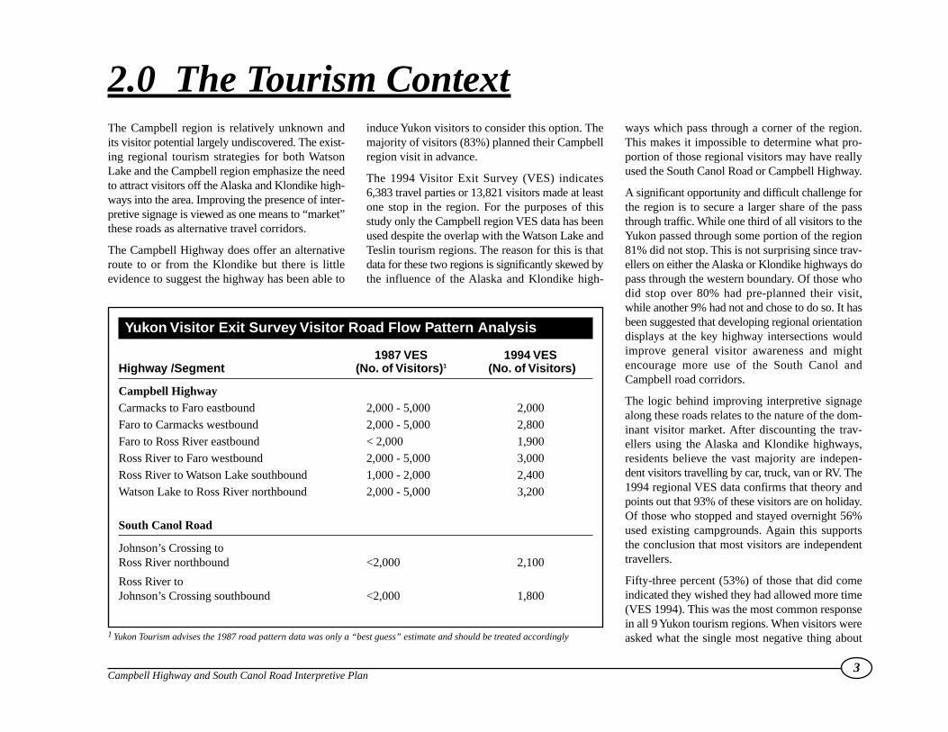
Key recommendations from the 1995 Strategywhich guide the succeeding corridor plans include:
• program principles such as optimum spacingdistances between sites and facilities; variety ininterpretive media, message balance and repre-sentativeness, the need for year round siteaccessibility; and shared responsibility for pro-gram implementation;
• a hierarchy of sign types reflecting site signifi-cance and role, differentiating between territor-ial entrance, regional orientation, major andminor locations;
• program management directions to encourageinter-agency co-operation and co-operativepartnerships in plan implementation;
• site facility development policies regarding theappropriate use of information kiosks, toilets,garbage containers, viewing platforms and sim-ilar support infrastructure;
• inspection and maintenance standards to guideannual inter-agency agreements on site mainte-nance and facilitate budgeting.
In 1996, plans for the Klondike Highway werecompleted. This report concentrates on the spe-cific needs of the South Canol Road and CampbellHighway. These two roads are a priority becausethey are under-represented in the government signprogram and the existing signs are nearing the endof their useful life. There are 7 existing sites alongthe Campbell Highway and 3 on the South CanolRoad, all erected in the mid 1980’s.
1.2 Purpose & ObjectivesThe intent is to produce an interpretive plan thatdescribes themes, suggests appropriate locationsand presents guidelines for signage and site devel-opment along both road corridors. The goal is topresent the road traveller with an accurate, bal-anced, and interesting picture of both roads.
The study objectives include:
• identifying representative themes and messagesfor both road corridors;
• evaluating the effectiveness of existing signagefor site location appropriateness, redundancy,message currency, theme representation andbalance;
• determining the need for new sites for interpre-tive site development;
• formulating concepts for corridor motifs andkey site priorities;
• outlining the capital costs and operationalrequirements recommended for corridorimprovements; and
• seeking First Nation, community, and govern-ment agency input in defining corridor needs,suggesting changes and development priorities,
locating new sites, evaluating message contentand creating corridor motifs.
1.3 Planning ApproachThe study approach involved a review of road cor-ridor history, regional tourism plans and the 1994Visitor Exit Survey regional data. This was fol-lowed by interviews with individuals, governmentagencies, First Nations, area communities, and afield-trip along both road corridors. A SituationAnalysis Report was produced following the fieldtrip which highlighted the main issues and set thecontext for developing preliminary corridor con-cepts.
A Preliminary Concepts Report was produced andcirculated widely for comment as a discussionpaper. The report described the main issues, ana-lyzed the strengths and weaknesses of the existingsites in terms of location, theme representation,message content and put forward tentative sug-gestions for corridor improvements.
This was followed up with community meetingswith the main stakeholders. Possible motif designsfor both corridors were presented at these meetingsas well. The stakeholder discussions resulted in anumber of plan refinements which are reflectedherein. The changes included:
• modification of the suggested motif designs;
• incorporation of the “Big River Country” sub-theme developed for the Klondike Highwaycorridor for that section of the CampbellHighway near Carmacks where the YukonRiver is visible for message consistency;
• deletion of some existing and proposed sites;and
• resolution of some specific site issues at Faro,Ross River and Carmacks.
Old vehicles from “dumps” along the Canol Road arehistoric “features” that could be utilized.
The Campbell region is relatively unknown andits visitor potential largely undiscovered. The exist-ing regional tourism strategies for both WatsonLake and the Campbell region emphasize the needto attract visitors off the Alaska and Klondike high-ways into the area. Improving the presence of inter-pretive signage is viewed as one means to “market”these roads as alternative travel corridors.
The Campbell Highway does offer an alternativeroute to or from the Klondike but there is littleevidence to suggest the highway has been able to
induce Yukon visitors to consider this option. Themajority of visitors (83%) planned their Campbellregion visit in advance.
The 1994 Visitor Exit Survey (VES) indicates6,383 travel parties or 13,821 visitors made at leastone stop in the region. For the purposes of thisstudy only the Campbell region VES data has beenused despite the overlap with the Watson Lake andTeslin tourism regions. The reason for this is thatdata for these two regions is significantly skewed bythe influence of the Alaska and Klondike high-
ways which pass through a corner of the region.This makes it impossible to determine what pro-portion of those regional visitors may have reallyused the South Canol Road or Campbell Highway.
A significant opportunity and difficult challenge forthe region is to secure a larger share of the passthrough traffic. While one third of all visitors to theYukon passed through some portion of the region81% did not stop. This is not surprising since trav-ellers on either the Alaska or Klondike highways dopass through the western boundary. Of those whodid stop over 80% had pre-planned their visit,while another 9% had not and chose to do so. It hasbeen suggested that developing regional orientationdisplays at the key highway intersections wouldimprove general visitor awareness and mightencourage more use of the South Canol andCampbell road corridors.
The logic behind improving interpretive signagealong these roads relates to the nature of the dom-inant visitor market. After discounting the trav-ellers using the Alaska and Klondike highways,residents believe the vast majority are indepen-dent visitors travelling by car, truck, van or RV. The1994 regional VES data confirms that theory andpoints out that 93% of these visitors are on holiday.Of those who stopped and stayed overnight 56%used existing campgrounds. Again this supportsthe conclusion that most visitors are independenttravellers.
Fifty-three percent (53%) of those that did comeindicated they wished they had allowed more time(VES 1994). This was the most common responsein all 9 Yukon tourism regions. When visitors wereasked what the single most negative thing about
3Campbell Highway and South Canol Road Interpretive Plan
2.0 The Tourism Context
1 Yukon Tourism advises the 1987 road pattern data was only a “best guess” estimate and should be treated accordingly
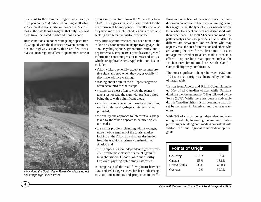
Yukon Visitor Exit Survey Visitor Road Flow Pattern Analysis
1987 VES 1994 VESHighway /Segment (No. of Visitors)1 (No. of Visitors)
Campbell HighwayCarmacks to Faro eastbound 2,000 - 5,000 2,000
Faro to Carmacks westbound 2,000 - 5,000 2,800
Faro to Ross River eastbound < 2,000 1,900
Ross River to Faro westbound 2,000 - 5,000 3,000
Ross River to Watson Lake southbound 1,000 - 2,000 2,400
Watson Lake to Ross River northbound 2,000 - 5,000 3,200
South Canol Road
Johnson’s Crossing to Ross River northbound <2,000 2,100
Ross River to Johnson’s Crossing southbound <2,000 1,800
their visit to the Campbell region was, twenty-three percent (23%) indicated nothing at all while20% indicated transportation concerns. A closerlook at the data though suggests that only 12.5% ofthese travellers rated road conditions as poor.
Road conditions do not encourage high speed trav-el. Coupled with the distances between communi-ties and highway services, there are few incen-tives to encourage travellers to spend more time in
the region or venture down the “roads less trav-elled”. This suggests that a key target market for thenear term will be independent travellers becausethey have more flexible schedules and are activelyseeking an alternative visitor experience.
Very little specific research has been done in theYukon on visitor interest in interpretive signage. The1992 Psychographic Segmentation Study and adepartmental survey in 1994 provides some generalinformation concerning visitor interest and site usewhich are applicable here. Applicable conclusionsinclude:
• Yukon visitors generally expect to see interpre-tive signs and stop when they do, especially ifthey have advance warning;
• reading about a site in the Milepost magazineoften accounted for their stop;
• visitors stop most often to view the scenery,take a rest or read the sign with preferred sitesbeing those with a significant view;
• visitors like to have and will use basic facilities,such as toilets and garbage containers, whenprovided;
• the quality and approach to interpretive signagetaken by the Yukon appears to be meeting visi-tor needs;
• the visitor profile is changing with a younger,more mobile segment of the tourist marketlooking at the Yukon as a discrete destinationfrom the traditional primary destination ofAlaska; and
• the Campbell region independent highway trav-eller profile most closely fits the “OrganizedNeighbourhood Outdoor Folk” and “EarthyExplorer” psychographic study categories.
A comparison of the road flow pattern between1987 and 1994 suggests there has been little changein visitation numbers and proportionate traffic
flows within the heart of the region. Since road con-ditions do not appear to have been a limiting factor,this suggests that the type of visitor who did comeknew what to expect and was not dissatisfied withtheir experience. The 1994 VES data and road flowpattern analysis does not provide sufficient detail todifferentiate between Yukon residents who mayregularly visit the area for recreation and others whoare visiting the area for the first time. It is alsonot apparent whether travellers made a consciouseffort to explore loop road options such as theTatchun-Frenchman Road or South Canol -Campbell Highway combination.
The most significant change between 1987 and1994 is in visitor origin as illustrated by the Pointof Origin table.
Visitors from Alberta and British Columbia makeup 60% of all Canadian visitors while Germansdominate the foreign market (68%) followed by theSwiss (13%). While there has been a noticeabledrop in Canadian visitors, it has been more than off-set by increases in American and overseas trav-ellers.
With 79% of visitors being independent and trav-elling by vehicle, increasing the amount of inter-pretive signage along both roads is consistent withvisitor needs and regional tourism developmentgoals.
4Campbell Highway and South Canol Road Interpretive Plan
Points of Origin
Country 1987 1994Canada 55% 18.8%
United States 33% 49.0%
Overseas 12% 32.3%View along the South Canol Road. Conditions do notencourage high speed travel

There are 10 existing signs along the two roadcorridors and one wildlife viewing site at FinlaysonLake (map, next page). Suggested text for a pro-posed sign at the Quiet Lake Grader Station wasprepared to complement the Canol constructionequipment display. All are vertical routed woodsigns constructed in the early eighties.
The original dark wood stained signs with whiterouted letters are in better shape than more recentadditions where a varathane finish was used.
3.1 South Canol Road CorridorOverview
There are 3 existing wood signs along the CanolRoad, one at Johnson’s Crossing (km. 0.2), anoth-er at Quiet Lake (km. 89.7) and a third at LapieRiver canyon bridge (km. 210). The signs wereerected in 1983 and 1984 and are nearing the end oftheir useful life.
Beginning at Johnson’s Crossing two problems
and one opportunity stand out. The first problem iscreated by the intersection itself as the AlaskaHighway cuts through the slope down to the TeslinRiver bridge. The net effect is to screen the SouthCanol intersection. There is no advance warningsignage or other normal visual clues which suggestthis is an important intersection or a good place tostop, even if they have no plans to take the roaditself. Furthermore the existing interpretive signs arenot visible or accessible from the Alaska Highwaywhich is the dominant traffic corridor.
The Alaska Highway commemorative plaquewhich refers to the Canol project seems out ofplace and off to the side. The actual wood routedCanol sign is well placed and directly visible oncethe turn is made but little thought has been given tosite development. Immediately after this sign, thereare a series of information warning signs which dis-courage rather than promote further travel. Hiddenfrom view is an old landfill site full of vehicles fromthe days of the initial road construction. Thesevehicles could be collected and used to create aninteresting “entry” exhibit building on the signagealready in place.
The focus here is on the Canol project historytheme which makes sense but it is only part of theentire story. For example, there is nothing to enticethe visitor to drive even the first 15 km. up into thealpine area, or any acknowledgement of Tlingitculture or traditional use before the Canol projectwas initiated.
The road has a distinctive character that reflects itshistory and level of use. It is truly a “road from thepast”, narrow and winding evoking memories oftimes gone by. It presents a unique opportunity
5Campbell Highway and South Canol Road Interpretive Plan
3.0 The Existing Situation
Above, the older Canol Road sign has weathered better than the Town of Faro sign.The latter displays seri-ous problems with its varathane finish.

6Campbell Highway and South Canol Road Interpretive Plan
0 20 50 100km
Nahanni R ange
Road
North
Cano
l Roa
d
Alaska Highway
Sou
thCa
nol R
oad
KlondikeHighway
Yukon
Riv
er
Big Salmon R iver
PellyRive
r
CANOL ROAD
NAHANNI RANGE ROAD
QUIET LAKE
LAPIE RIVERBRIDGE/CANYON
FARO JUNCTION
COLUMBIAN DISASTER
FINLAYSON LAKE WILDLIFE VIEWPOINT
FINLAYSON LAKE
FRANCIS LAKE
ROBERT CAMPBELL HIGHWAY
REST STOP VIEWPOINTOF TOWN
ROSS RIVER
JOHNSON'SCROSSING
TESLIN
WHITEHORSE
CARCROSSWATSON LAKE
ROSS RIVER
FARO
CARMACKS
Quiet Lake
Marsh Lake
Lake Laberge
Teslin Lake
YUKONB.C.
Little Salmon Lake
Finlayson Lake
Frances Lake
Simpson Lake
Robert Campbell Highway
Map showing existing highway signage in study area

for the highway traveller to get a sense of what theoriginal roads were like.
The South Canol Road climbs quickly in the next15-20 kilometres rising above tree-line before drop-ping back into the Nisutlin River valley. The uplandarea is very accessible and offers a range of possi-bilities for short hikes if a new rest area and inter-pretive site were developed at approximately km. 15.
The first formal rest area is a pull-out overlookingSidney Lake near a short access road down to thelake. The spacing distance is appropriate for aminor rest area. The pull-out area is quite small.Archaeological evidence confirms the SidneyLake/Nisutlin River area is an important Tlingittraditional use area. The area includes regionallysignificant wildlife habitat.
An old mining road follows Sidney Creek to IronCreek and loops back to the south end of Quiet Lake.This creates a loop recreation trail possibility thatcould also be acknowledged at the Sidney Lake site2.
At kilometre 67.5, a short road leads down to a pop-ular boat launch location and small river edgecampground on the Nisutlin River. This is anotherlocation that has potential for minor developmentas it is a traditional Tlingit travel corridor and is stillpopular as a put-in spot for canoe trips down theNisutlin River. The river is also known for itswildlife viewing potential.
Between Quiet Lake campground and the grader sta-tion at kilometre 99, the road follows the edge of thelake. The existing sign site (km. 89.7) is suitable fora minor site but the proximity to the campgroundand a small recreation area preclude the necessity ofadding additional infrastructure. The existing display
at the grader station site could be upgraded to amajor site by adding garbage cans, outhouses and alow profile interpretive plaque that talks about theconstruction equipment on display. Because thesite is part of the adjacent grader station grounds,maintenance costs are minimal. It appears to make
sense to add an interpretive sign at this point as itwould complement the exhibit developed by theHighways crew. This site also provides some con-tinuity to the “Canol Road” theme at the mid-pointwithout detracting from other interpretive themesthat are under-represented.
7Campbell Highway and South Canol Road Interpretive Plan
The existing display at the Quiet Lake Grader Station is an excellent candidate for upgrading to a major site
2 Recreation trail development is not within the HeritageBranch sign program mandate, The interpretive opportunityis just being recognized. Development is dependent on FirstNation and government consultation
In the Rose River area there is potential to combineseveral sites into one main site in the vicinity ofkilometre 155. The actual location would requiremore careful analysis and comparison of individualsite features to determine a preferred site. There arealso a number of potential view locations in theLapie Lakes area between kilometre 169 to 171.Geomorphology, climate and ecology themes suchas the effects of elevation change on vegetationsuccession could be pursued.
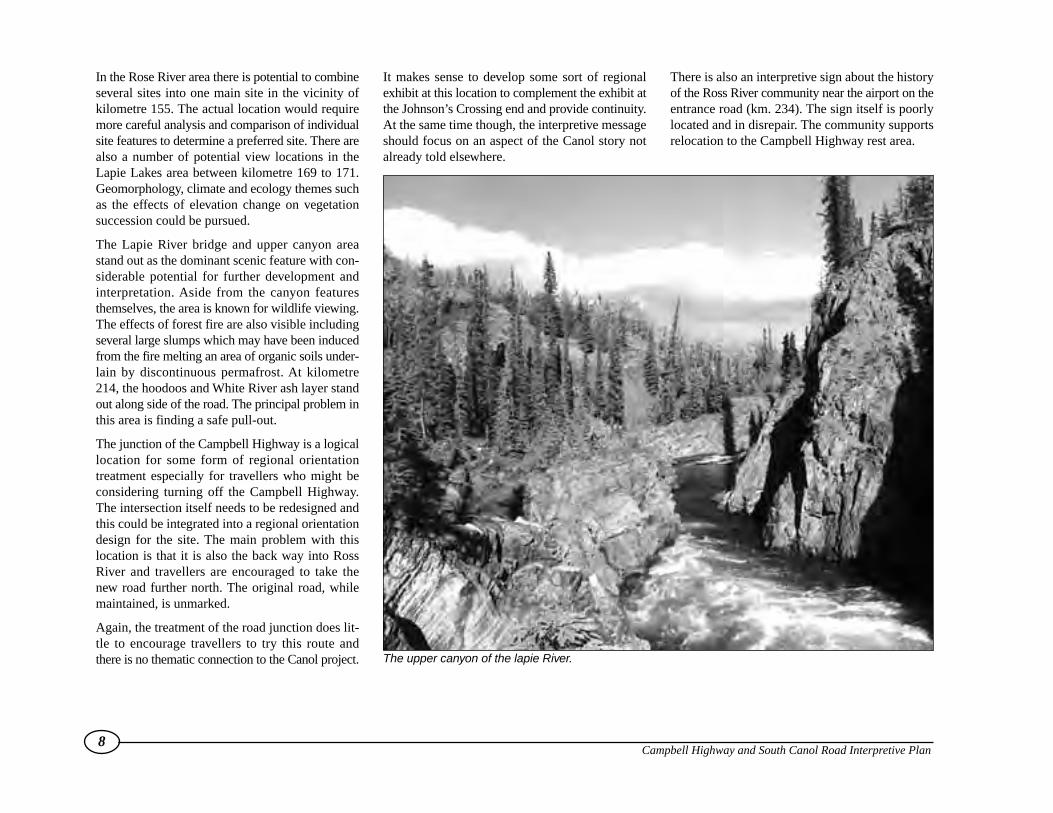
The Lapie River bridge and upper canyon areastand out as the dominant scenic feature with con-siderable potential for further development andinterpretation. Aside from the canyon featuresthemselves, the area is known for wildlife viewing.The effects of forest fire are also visible includingseveral large slumps which may have been inducedfrom the fire melting an area of organic soils under-lain by discontinuous permafrost. At kilometre214, the hoodoos and White River ash layer standout along side of the road. The principal problem inthis area is finding a safe pull-out.
The junction of the Campbell Highway is a logicallocation for some form of regional orientationtreatment especially for travellers who might beconsidering turning off the Campbell Highway.The intersection itself needs to be redesigned andthis could be integrated into a regional orientationdesign for the site. The main problem with thislocation is that it is also the back way into RossRiver and travellers are encouraged to take thenew road further north. The original road, whilemaintained, is unmarked.
Again, the treatment of the road junction does lit-tle to encourage travellers to try this route andthere is no thematic connection to the Canol project.
It makes sense to develop some sort of regionalexhibit at this location to complement the exhibit atthe Johnson’s Crossing end and provide continuity.At the same time though, the interpretive messageshould focus on an aspect of the Canol story notalready told elsewhere.
There is also an interpretive sign about the historyof the Ross River community near the airport on theentrance road (km. 234). The sign itself is poorlylocated and in disrepair. The community supportsrelocation to the Campbell Highway rest area.
8Campbell Highway and South Canol Road Interpretive Plan
The upper canyon of the lapie River.
3.2 Campbell Highway CorridorOverview
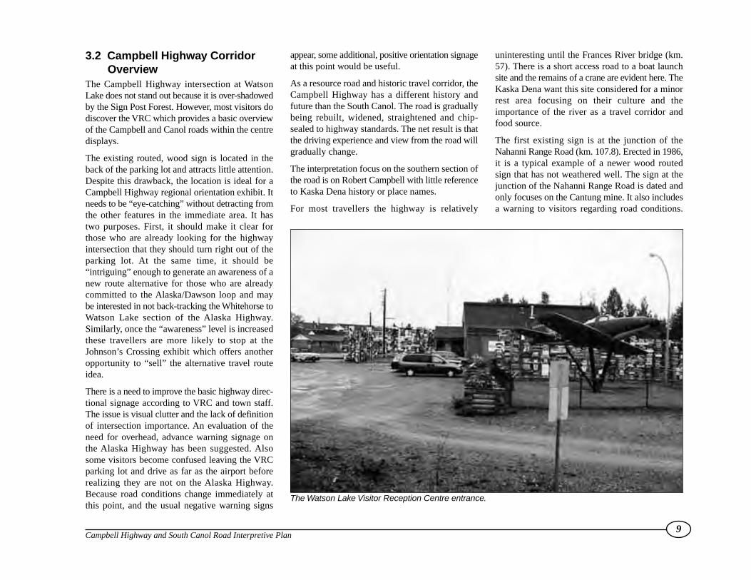
The Campbell Highway intersection at WatsonLake does not stand out because it is over-shadowedby the Sign Post Forest. However, most visitors dodiscover the VRC which provides a basic overviewof the Campbell and Canol roads within the centredisplays.
The existing routed, wood sign is located in theback of the parking lot and attracts little attention.Despite this drawback, the location is ideal for aCampbell Highway regional orientation exhibit. Itneeds to be “eye-catching” without detracting fromthe other features in the immediate area. It hastwo purposes. First, it should make it clear forthose who are already looking for the highwayintersection that they should turn right out of theparking lot. At the same time, it should be“intriguing” enough to generate an awareness of anew route alternative for those who are alreadycommitted to the Alaska/Dawson loop and maybe interested in not back-tracking the Whitehorse toWatson Lake section of the Alaska Highway.Similarly, once the “awareness” level is increasedthese travellers are more likely to stop at theJohnson’s Crossing exhibit which offers anotheropportunity to “sell” the alternative travel routeidea.
There is a need to improve the basic highway direc-tional signage according to VRC and town staff.The issue is visual clutter and the lack of definitionof intersection importance. An evaluation of theneed for overhead, advance warning signage onthe Alaska Highway has been suggested. Alsosome visitors become confused leaving the VRCparking lot and drive as far as the airport beforerealizing they are not on the Alaska Highway.Because road conditions change immediately atthis point, and the usual negative warning signs
appear, some additional, positive orientation signageat this point would be useful.
As a resource road and historic travel corridor, theCampbell Highway has a different history andfuture than the South Canol. The road is graduallybeing rebuilt, widened, straightened and chip-sealed to highway standards. The net result is thatthe driving experience and view from the road willgradually change.
The interpretation focus on the southern section ofthe road is on Robert Campbell with little referenceto Kaska Dena history or place names.
For most travellers the highway is relatively
uninteresting until the Frances River bridge (km.57). There is a short access road to a boat launchsite and the remains of a crane are evident here. TheKaska Dena want this site considered for a minorrest area focusing on their culture and theimportance of the river as a travel corridor andfood source.
The first existing sign is at the junction of theNahanni Range Road (km. 107.8). Erected in 1986,it is a typical example of a newer wood routedsign that has not weathered well. The sign at thejunction of the Nahanni Range Road is dated andonly focuses on the Cantung mine. It also includesa warning to visitors regarding road conditions.
9Campbell Highway and South Canol Road Interpretive Plan
The Watson Lake Visitor Reception Centre entrance.

This is an ideal location for a regional orientationsign talking about the geography (Logan Mountainecoregion), history of the area and the rationalefor road construction (mine access).
The existing wood routed signs at Frances (km.171) and Finlayson (km. 232.5) lakes wereinstalled in 1983 and 1984. They are located off thehighway at boat launch sites and easily missed.The signs explain the rationale for RobertCampbell’s names while ignoring the First Nationequivalent and importance of these lakes to theircultural history.
Highways is suggesting a rest area be located at JadeMountain (kilometre 160). A minor interpretivesite could be developed at this location featuring thelarge jade boulder that exists at this location. TheFrances Lake highway rest area at kilometre 170.6offers the first distant view of the lake. Highwayspropose to relocate this rest area to the JadeMountain site. As the Frances Lake sign is approx-imately 2 km. down the side road by the boat launch,the advance warning signage needs to be improvedso people are encouraged to drive down to the lake.
The next logical stopping point is Finlayson Lake.The wildlife viewing site at Finlayson Lake (km.233) has been upgraded by Highways in order toclose their rest area at km. 231.7. It makes sense torelocate the existing Finlayson Lake sign from its’site by the lake (km. 232.5) where it is not visible.
The dilemma with both the Frances Lake andFinlayson Lake signs is that they are currentlylocated off the actual highway. Diversions arejustifiable if the location is a more appropriate oraccurate interpretive site (i.e. the actual tradingpost site). It is thought that this type of diversiondoes get the traveller to stop for a longer period oftime, but that less travellers actually stop becauseof the inconvenience factor.
The next major site to stand out is the Hoole Rivercanyon (km. 303). Renewable Resources alreadyhas a campground reserve in the area, andHighways has indicated this would make a logicalrest area site. There is also a mining explorationroad which makes a natural trail up the north sideof the canyon. This is an ideal site for an interde-partmental joint venture with Tourism providingtrailhead signage and Highways building the restarea. Both initiatives would complement a futureRenewable Resources campground initiative andhelp reduce all agency infrastructure maintenancecosts.
The junction of the South Canol Road (km. 355) ispoorly marked. The main highway rest area islocated 8 kilometres further down the road at theintersection of the new road into Ross River. Thedilemma here is that while the South Canol Roadintersection requires some interpretive treatment, thesupporting infrastructure is already in place at therest area by the new entrance. This presents anopportunity to differentiate between sites with thenew entrance location focusing on the communityof Ross River and the North Canol, while the SouthCanol intersection, maintains the Canolpipeline/road theme.
The scenic lower Lapie River bridge andcampground is less than a kilometre away from themain Ross River intersection. This is one situationwhere consideration should be given to over-ridingthe spacing distance because of the attributes of thefeature itself. Regular highway users and highwaymaintenance crews indicate this is a commonpicture taking stopping point for travellers althoughthere is no safe pull-out by the road. While it wouldbe difficult to develop a safe pull-out along side theroad, it may be possible to modify the campgroundaccess road to achieve this purpose. This is alsoanother example, where program objectives can
be met by another agency, namely RenewableResources, as part of their campground mandatebecause the program objectives are complementary.
The Faro junction area has two sites. The rest area(km. 414) allows the traveller a view across the val-ley to the town itself. The intersection rest area(km. 415) has been expanded and landscaped by thetown to encourage tourists to stop. Any interpretiveupgrades in this area should complement the town’sinitiatives. This is also a situation where an “exhib-it” style display could replace a vertical sign.
It would compliment the town’s efforts. Given thecommunity’s investment in a new visitor interpre-tation centre, it makes sense to concentrate onupdating the signage at the main rest area toencourages travellers to visit the new facility intown. Faro has also indicated it would like to retainthe viewing opportunity of the town at kilometre414.
While there are a number of views of Little SalmonLake visible from the road which follows the shore-line, none really stand out. The existing Highwaysrest area (km. 480) works and a minor interpretivesign could be added at minimal cost.
Between kilometre 543 and 556 there is a cluster ofsites with interpretation potential. The FrenchmanTatchun loop road, Little Salmon Village site andEagles Bluff are prominent features which offer avariety of theme development opportunities. TheFrenchman-Tatchun lake chain is an importantwildlife movement corridor and includes twocampgrounds and several known archaeologicalsites.
The Little Salmon Village site is off the highway butaccessible. The entrance road is not marked and vis-itors have traditionally been discouraged from vis-iting such sites. The Ts’awlnjik Dän (Carmacks
10Campbell Highway and South Canol Road Interpretive Plan

Little Salmon) First Nation have not decided ifthe Little Salmon Village story should be told on-site.
The Columbian Disaster site (km. 556) is within akilometre of Eagles Nest Bluff (km. 555) rest area.There is some concern with sight distances andsize of the rest areas in this section of highwaybecause of the terrain, restricted road width andamount of truck traffic. Site consolidation issuggested. There are a variety of regional storiesthat could be told at this point relating to NorthernTutchone cultural history. The Little SalmonVillage history, the story behind the name forEagles Nest Bluff and the importance of theFrenchman-Tatchun lakes system are possibilitiesthat would help redress the lack of attention toFirst Nations presence.
The junction of the Campbell and North Klondikehighways warrants more attention in the immediatevicinity of the intersection. Again the problemrelates to regional orientation and encouraging thetraveller to take the alternative route, even if theyjust do the Frenchman/Tatchun lake loop road. Aregional orientation component was included insignage erected at the south entrance to Carmacksand at Tantalus Butte, approximately 1 kilometrenorth of the intersection. The Campbell Regionsignage at Tantalus Butte was knocked over in1996 and has not been replaced.
The importance of this intersection should not beunder-rated because it has the greatest potentialto divert south-bound traffic returning from theAlaska/Dawson loop.
The Campbell Highway is gradually beingupgraded with priority on the Carmacks to Farosection. Further upgrading will become necessaryalong the southern section of the road if mines aredeveloped in the Finlayson Lake area and forestry
operations expand north of Watson Lake. As theroad surface is straightened, widened and improvedvehicle traffic increases and visitors travel faster andfurther. Given the length of road involved and itscurrent condition, reconstruction will be a longrange and expensive project.
This has obvious safety implications for the
corridor signage program. For example, rest areascan generally be enlarged at minimal cost when co-ordinated with highway reconstruction. Whereimprovements are not anticipated for some time, itis important that interpretive sites and rest areas beadequately sized, have clear sight-lines andsufficient advance warning signs for user safety.
11Campbell Highway and South Canol Road Interpretive Plan
The Columbian Disaster site, with a view toward Eagle Rock.
To provide thematic continuity, the message pre-sented at each individual sign location was analyzedas the messages reflect particular perspectives andthemes.
The actual text on each Tourism Department sign is
in the left column. The right column contains notesthat explain the text deficiencies and suggestedways to improve thematic representation to makethe signage more relevant today.
In general, there is an over-reliance on large panels
with upper case text and no graphic elements.Upper case text hinders reader comprehension.Research shows upper case text takes longer, and ismore difficult to read. Adding a graphic elementusually reduces text length and makes the inter-pretive message clearer.
12Campbell Highway and South Canol Road Interpretive Plan
EXISTING SIGN TEXT
SOUTH CANOL ROAD
Johnson’s Crossing
Current Theme: Canol Project History
Just past east end of Johnson’s Crossing Bridge, junction with Canol Road.
The Canol Project
After the bombing of Pearl Harbor in December 1941, the American government feared aJapanese invasion of its Alaskan coastline. To counter this threat, the United States Armyupgraded the airfields of the Northwest Staging Route and built the Alaska Highway to trans-port men and equipment to their Alaskan bases.
Construction and maintenance of these strategic transportation routes required enormousamounts of gasoline and oil. Normally, fuel would have been carried north by ship. With theJapanese in the Aleutian Islands, however, the United States Government feared that reg-ular shipping lanes were not safe. The Canol Project was born out of the need for asecure oil supply.
Canol, short for Canada Oil, was a massive effort funded by the United States military andbuilt by the construction consortium, Bechtel-Price-Callahan. Under this project, the oil fieldsat Norman Wells in the Northwest Territories were developed, a refinery was built inWhitehorse, and a four inch pipeline was laid between the two. In addition, 600 miles of road,telephone lines, several airstrips and ten pumping stations were built to service the line.
Oil was pumped up and down the highways through auxiliary lines between Whitehorse andFairbanks, and from Carcross to Watson Lake. A line was also built between Whitehorse andSkagway, Alaska to bring oil from the south if necessary. In all, 200,000 tons of material andover 50,000 people were employed on the Canol. From an estimated cost of $30 million, thefinal price of this megaproject ballooned to over $134 million.
COMMENT
One intriguing aspect of the Canol Project that is notdiscussed in the current signage, is the environ-mental cleanup–the other “cost” of the project.Clean-up activities began at the end of the war andcontinued on and off well into the 1970s.
A survey in 1970 found 200 filled or partially filledoil drums, 6000 empty drums, 200 truck hulks aswell as miscellaneous construction debris. It alsofound large areas of ground blackened and reekingfrom spilled oil. It has been estimated that close to190,000 barrels of oil were spilled during con-struction.
Much of the debris was simply buried, as had beendone during the first clean-up activities in the 1940s.One study conducted in the early 1980s indicatesthat the bulldozer method of environmental clean-up may itself have set the environment back furtherthan no activity at all.
In the on-going debate over the environmentalimplications of tanker shipments of crude, it isworth noting that during the time of the CanolProject, Alaska was being supplied from the lower
3.3 Assessment of Current Sign Text

13Campbell Highway and South Canol Road Interpretive Plan
The project was controversial. It consumed an incredible amount of workers, labour, andmaterials at a time when they were badly needed elsewhere. The Japanese threat tocoastal shipping never materialized. Production costs for a barrel of oil from the Canol wasover four times higher than the world price. It was much cheaper to ship oil to the AlaskaHighway via the 110 mile line from Skagway.The project was shut down in 1944, less thana year after the refinery had opened. Robert P. Patterson, United States Under Secretaryof War, summed up the Canol Project saying:
I suppose that we must bow to the verdict, that the project was useless and a waste ofpublic funds.
Canol Road
Current Theme: Canol Project History
km. 0.2 Canol Road
IN 1942 THE IMPORTANCE OF ALASKA TO THE WAR EFFORT PROMPTED THE U.S.ARMY TO BEGIN CONSTRUCTION OF AN OIL PIPELINE FROM NORMAN WELLS,N.W.T. TO WHITEHORSE. THE CANOL, OR CANADIAN OIL PROJECT, WAS COM-PLETED IN 2 YEARS AT A COST OF $164 MILLION. THE ILL-FATED PROJECT WASABANDONED IN THE MID 1940S. MANY RELICS MAY STILL BE SEEN WHICH PROVIDEPROOF OF THE EXTREME CONSTRUCTION CONDITIONS.
Quiet Lake
Current Theme: Geography and History
km. 90 Canol Road
QUIET LAKE IS THE LARGEST OF THREE LAKES THAT FORM THE HEADWATERS OFTHE BIG SALMON RIVER SYSTEM. THE 28-KM LAKE WAS NAMED IN 1887 BY JOHNMcCORMACK, ONE OF FOUR MINERS WHO PROSPECTED THE BIG SALMON RIVERFROM ITS MOUTH ON THE YUKON RIVER TO ITS SOURCE. ALTHOUGH THEY DIDFIND SOME GOLD, THE RIVER AND LAKES HAVE BECOME BETTER KNOWN FORTHEIR GOOD FISHING AND FINE SCENERY. UNTIL THE COMPLETION OF THESOUTH CANOL ROAD IN THE 1940’S, THIS AREA WAS REACHED MAINLY BY BOAT-ING AND PORTAGING HUNDREDS OF MILES UP THE TESLIN AND NISUTLIN RIVERS.
48 with 12 tankers per month. At the height of pro-duction, the Canol project provided Alaska withthe equivalent of 1 additional tanker of oil permonth. Was it worth the environmental damage?Perhaps the environmental impact story could bestbe told at the proposed regional orientation exhib-it at the north end of the South Canol, at its junctionwith the Robert Campbell Highway. This wouldcompliment the existing signage at the Johnson’sCrossing end and the new signage proposed forthe Quiet Lake Maintenance Camp at km. 99. In thisway, there would be a continuity in the Canol storyover the whole road, rather than a concentration atJohnson’s Crossing.
Reference ought to be made to the Canol Roadcorridor’s historic use as a traditional travel route byFirst Nations. George Smith tells of large gatheringsin the early 1900s around Ross River by peopletravelling from several places including Teslin alongwhat later became the Canol route. Including thisaspect of Canol history would balance the storyand change the perception of the land as “unoccu-pied wilderness”.
The Northern Tutchone name for this lake is ChuLa
‘, “end water” . The Tlingit have a legend about
a water monster that inhabits this lake. The creatureis half fish and half man, can laugh like a person andcan hold a boat in one spot regardless of how dili-gently the occupants row. This makes an intriguingstory with strong visitor appeal.

14Campbell Highway and South Canol Road Interpretive Plan
Canol Road Construction (Proposed, never fabricated or installed)
Current Theme: Canol Project Construction History
km. 99 Canol Road, Quiet Lake Grader Station
FEARING AN ATTACK ON WEST COAST SHIPPING LANES, THE U.S. ARMY INITIAT-ED THE CANOL PROJECT IN 1942 TO PROVIDE FUEL FOR ALASKA’S DEFENSE.THISILL-FATED PROJECT INCLUDED BUILDING A 6” DIAMETER OIL PIPELINE AND AN 825KM (515 MILE) SERVICE ROAD FROM NORMAN WELLS, N.W.T. TO JOHNSON’SCROSSING, YUKON.
OVER 4,500 PIECES OF LARGE EQUIPMENT WERE USED IN THE CONSTRUCTION.THE GRAVEL DUMPTRUCK IS A 2-TON INTERNATIONAL WITH A 6-CYLINDER, FLAT-HEAD, GASOLINE ENGINE. THE GRADER WAS PULLED BY A D-8 CATERPILLAR.
WHILE THE PIPELINE WAS MOTHBALLED IN 1945, AND LATER SALVAGED, THEYUKON PORTION OF THE CANOL ROAD HAS BEEN MAINTAINED AND IMPROVED.
PLEASE DO NOT REMOVE OR DISTURB THE EQUIPMENT AND OTHER ARTIFACTSYOU SEE ALONG THE ROAD.YOUR COOPERATION IN PRESERVING THE HISTORYOF THE CANOL PROJECT IS GREATLY APPRECIATED.
Lapie River Canyon
Current Theme: Geomorphology
km. 217 Canol Road
APPROXIMATELY 100 MILLION YEARS AGO, FLAT HORIZONTAL LAYERS OF ROCKWERE BURIED SEVERAL KILOMETRES BELOW THE SURFACE OF THE EARTH.MOVEMENT BY RIGID PLATES OF THE EARTH’S CRUST SUBJECTED THE ROCK TOMASSIVE COMPRESSION AND STRAIN, AND IT WAS DEFORMED INTO FOLDS.OVER MILLIONS OF YEARS, THE ROCKS ROSE TO THEIR PRESENT POSITION,EXPOSING THE FOLDS IN THE CANYON WALL.
This panel would be a useful interpretive aid to gowith the old equipment currently on display at thissite. Since it is the equipment that is on display, sig-nage here should be unobtrusive. A relatively small,low-key, possibly cast sign, would be appropriate.
For travellers heading north, there are severalinteresting features to come. This would be anappropriate place to interpret, and suggest theywatch out for, layers of volcanic ash in cutbanks, andfor wind eroded hoodoos.

15Campbell Highway and South Canol Road Interpretive Plan
Robert Campbell Highway
Current Theme: Road history
km. 0.1 Campbell Highway, at Watson Lake VRC
THIS HIGHWAY, WHICH WAS COMPLETED IN 1968, CLOSELY FOLLOWS SECTIONSOF THE FUR-TRADE ROUTE ESTABLISHED BY ROBERT CAMPBELL. CAMPBELL WASA HUDSON’S BAY CO. TRADER WHO WAS SENT INTO THIS REGION IN THE 1840’STO TRY AND FIND A ROUTE WEST INTO THE UNEXPLORED AREAS OF CENTRALYUKON. TRAVELLING FROM THE SOUTHEAST, HE FOLLOWED THE LIARD ANDFRANCES RIVERS, BUILDING A CHAIN OF POSTS ALONG THE WAY. HIS MAJOR DIS-COVERY CAME IN 1843 WHEN HE REACHED THE YUKON RIVER, WHICH WAS TOBECOME THE MAJOR TRANSPORTATION ROUTE WITHIN THE YUKON.
Nahanni Range Road
Current Theme: Mining History
km. 107.8 Campbell Highway
1. NAHANNI RANGE ROAD
IN 1959 THE CANADA TUNGSTEN MINING CORPORATION WAS FORMED TO DEVEL-OP THE RICH DEPOSIT OF SCHEELITE WHICH HAD BEEN DISCOVERED 125 MILESNORTH OF HERE, PAST THE NORTHWEST TERRITORIES BORDER.THIS IMMENSEDEPOSIT OF TUNGSTEN-BEARING ORE IS THE LARGEST IN THE FREE WORLD.LOCATED AT THE HEADWATERS OF THE FLAT RIVER, THE AREA WAS REMOTE ANDDIFFICULT TO REACH, WITH A PRIMITIVE LANDING STRIP PROVIDING THE ONLYMEANS OF ACCESS. IN 1961 AN AERIAL RECONNAISSANCE WAS CARRIED OUT,AND LATER THAT YEAR, WITHOUT ANY FURTHER SURVEY WORK, CONSTRUCTIONSTARTED ON THE CANTUNG ROAD, AS IT WAS COMMONLY CALLED. FUNDINGFOR THE PROJECT WAS PROVIDED BY THE COMPANY AND THE GOVERNMENT,AND CONSTRUCTION WAS COMPLETED IN 1963.
Campbell’s routes were themselves established bythe Kaska Dena who lived in the region, togetherwith their Tahltan and Taku River Tlingit tradingpartners. Well established trails connected traditionalFirst Nations sites at Frances Lake with those nearPelly Banks, Pelly Lakes, Lower Post and the Takuand Hyland Rivers.
The Kaska name for the Frances River is Tu’ Cho’Túé, for the upper part of the Liard River–NêtiTué’.
This is the key southern regional access point andsite of proposed regional exhibit. The Kaska storyand history that predates Robert Campbell should begiven more prominence.
This is an example of outdated signage, as the mineis closed. While the story is interesting, other themescould be added about the geography of the regionand condition of the road. This is a logical place fora minor regional orientation site.

16Campbell Highway and South Canol Road Interpretive Plan
Frances Lake
Current Theme: History of Place Name
Access at km. 172 Campbell Highway
ROBERT CAMPBELL FIRST REACHED FRANCES LAKE IN 1840 AND NAMED ITAFTER LADY FRANCES SIMPSON, WIFE OF THE GOVERNOR OF THE HUDSON’S BAYCOMPANY. IN 1842 HE ESTABLISHED A TRADING POST (FORT FRANCES) AT THESOUTHERN END OF THE LAKE. THIS WAS THE FIRST FORT BUILT BY THE COMPA-NY IN THE YUKON. IT WAS ABANDONED IN 1851 WHEN OTHER TRADE ROUTESWERE DEVELOPED.
Finlayson Lake
Current Theme: History of Place Name
Access at km. 231 Campbell Highway
IN 1840, ROBERT CAMPBELL WAS SENT INTO THIS REGION BY THE HUDSON’S BAYCOMPANY TO LOCATE A ROUTE INTO THE CENTRAL YUKON, AND ESTABLISHFUR-TRADING POSTS. CAMPBELL DISCOVERED THIS LAKE AND NAMED IT AFTERDUNCAN FINLAYSON, A MEMBER OF THE H.B.CO’S BOARD OF DIRECTORS. THELAKE, WHICH IS APPROXIMATELY 10 MILES LONG, IS SITUATED ON THE CONTI-NENTAL DIVIDE. ITS WATERS DRAIN SOUTHEAST THROUGH THE LIARD INTO THEMACKENZIE RIVER, WHILE THE RIVERS TO THE NORTH EMPTY INTO THE YUKONRIVER SYSTEM.
The Kaska name for Frances Lake is Tu’ Cho’Méné. The people who originally lived here were theTi’ Cho’ Tena or Ta’tcogotena, the “Big WaterPeople”. There are numerous traditional sites inthe area, including the old village at the narrowsknown as Kedelini Túé. Archaeological evidenceindicates this site was in use for 1500-2000 years.Another old village site is at the lake outlet, near themouth of the Frances River. This village, TetugiTs’ódi, was at the beginning of a main trail that ledto caribou hunting grounds. Campbell built his postacross the narrows from Kedelini Túé.
As with all the posts he established, this one faileddue to mismanagement, difficulty of maintainingsupply lines, and fierce competition from Chilkatand Tahltan traders that at times broke into openconfrontation. Try as he might, Campbell couldnot displace these traditional trading patterns.
The Kaska name for Finlayson Lake is Tetla-nejoji.The focus of interpretive signage at these two sitesshould be on the Kaska Dena, as this is the heart oftheir traditional territory. The history of Englishnames should be balanced and complemented byFirst Nations place names, with the Campbell his-tory element becoming a sub-component of theprincipal First Nations theme. The Campbell storycould be more, fairly told as well if it balanced hissuccess as a traveller/explorer with his failures as abusiness man
17Campbell Highway and South Canol Road Interpretive Plan
Ross River
Current Theme: Community
Access at km. 371 Campbell Highway
IN 1843 EXPLORER ROBERT CAMPBELL NAMED ROSS RIVER FOR CHIEF TRADERDONALD ROSS OF THE HUDSON’S BAY COMPANY. FROM 1903, A TRADING POSTLOCATED AT THE CONFLUENCE OF THE ROSS AND PELLY RIVERS SUPPLIED THEINDIANS OF THE AREA FOR NEARLY FIFTY YEARS. WITH THE BUILDING OF THECANOL PIPELINE SERVICE ROAD IN WARTIME AND THE COMPLETION OF THEROBERT CAMPBELL HIGHWAY IN 1968, THE COMMUNITY WAS LINKED TO THEREST OF THE TERRITORY BY ROAD. ORIGINALLY SITUATED ON THE NORTH SIDEOF THE PELLY RIVER, THE TOWN HAS BEEN IN ITS PRESENT LOCATION SINCE 1964.
Faro
Access at km. 414 Campbell Highway
Current Theme: Community History
1 TOWN OF FARO
WITH THE SELWYN MOUNTAINS AS BACKDROP, THE TOWN OF FARO CAN BESEEN FROM HERE ON AN ESCARPMENT ABOVE THE TINTINA TRENCH, THE LONGVALLEY THROUGH WHICH THE PELLY RIVER FLOWS. THE TOWN WAS CON-STRUCTED IN 1969 BY THE CYPRUS ANVIL MINING CORPORATION TO HOUSEEMPLOYEES OF ITS MINE LOCATED 19 KM TO THE NORTH (WITHIN THE MOUN-TAINS). TRUE TO ITS NAME, FROM A 19TH CENTURY GAMBLING CARD GAME,FARO HAS KNOWN THE BOOM AND BUST OF FATE. ON FRIDAY, JUNE 13, 1969 THISBRAVE LITTLE TOWN WAS TOTALLY DESTROYED BY FOREST FIRE DURING CON-STRUCTION AND HAD TO BE REBUILT; IT HAS SURVIVED A PROLONGED MINE CLO-SURE; AND IT HAS BEEN FLUSH WITH THE SUCCESS OF PROSPERITY. FARO,ONE OF THE LARGEST CENTRES IN THE YUKON, IS A FULL SERVICE COMMUNITY,AND OFFERS TOURS OF THE LARGEST OPEN-PIT LEAD-ZINC MINE IN THE WORLD.
The Kaska Dena of the Upper Pelly were one of thelast peoples of North America to be contacteddirectly by white traders. The community of RossRiver, Tu- L~idli-ni “Rivers flowing together”, wasstrategically located where natural passes connect-ed travel routes from the Mackenzie River, from theWatson Lake area and from Teslin Lake.Traditionally, the Kaska Dena of this area had closefamily ties with the Tlingit to the southwest. The Kaska Dena name for the Ross River is Tehke-
deni’a- Tué’, “Standing Alone River”. The namefor the Pelly River is Tu- Désdés Tué’, “Clear WaterRiver”. When this sign is replaced, text should berevised to include the First Nations component.
There is a fair bit of overlap and repetition betweennumber 1 and 2, including reference to its beingnamed for a card game and the town’s early destruc-tion by fire. There are also foreseeable problemswith keeping these signs current, as they make ref-erence to recent and on-going events in the town’sdevelopment. It also uses a superlative in referenceto the size of its open pit, a circumstance that canchange at any time–if it has not already done so.The location of sign 1 affords a good opportunity tohighlight for visitors what is visible, perhapsemploying a graphic device as an aid. Graphicscould also be employed in sign 2 to show the rela-tive size of the mine.
18Campbell Highway and South Canol Road Interpretive Plan
Access at km. 415 Campbell Highway/Faro Access RoadCurrent Theme: Geology
2 FARO
THE LEAD-ZINC ORE BODIES DISCOVERED HERE IN 1965 HAVE PROVIDED THETERRITORY’S LARGEST SOURCE OF MINING INCOME, EVEN EXCEEDINGKLONDIKE GOLD EARNINGS.THEIR DISCOVERY FOLLOWED YEARS OF INTENSIVEEXPLORATION AND LED TO THE ESTABLISHMENT OF THE CYPRUS ANVIL MINE,ROAD IMPROVEMENTS, AND CONSTRUCTION OF THE PELLY RIVER BRIDGE. FARO,WHICH WAS NAMED AFTER A TYPE OF CARD GAME, WAS BUILT IN 1969 TO SER-VICE THE MINE AND DEVELOPED INTO THE YUKON’S SECOND LARGEST COM-MUNITY. THE TOWN HAD TO BE REBUILT AFTER BEING DESTROYED BY FORESTFIRES DURING CONSTRUCTION.
Columbian Disaster
Current Theme: Transportation History
km. 573 Campbell Highway
FOR OVER 50 YEARS, STERNWHEEL RIVERBOATS PROVIDED THE MAIN MEANS OFTRANSPORTATION WITHIN THE YUKON, AND EAGLE ROCK WAS A WELL-KNOWNLANDMARK TO THE RIVER PILOTS. IN SEPTEMBER 1906, IT WAS THE SITE OF ANEXPLOSION THAT DESTROYED THE S.S. COLUMBIAN AND KILLED 6 OF HER CREW.THE STEAMER HAD BEEN CARRYING SEVERAL TONS OF BLASTING POWDERDOWNSTREAM WHEN ONE OF THE CREW MEMBERS ACCIDENTALLY FIRED AGUN INTO THE POWDER AND IGNITED IT. ALTHOUGH MANY OF THE RIVERBOATSWERE INVOLVED IN LESS SERIOUS ACCIDENTS, THIS WAS THE MOST DEVASTAT-ING.
This is Northern Tutchone country. The NorthernTutchone name for Little Salmon Lake is Chu Cho,for the Little Salmon River is Tánintsé
‘Chú, for
Drury Lake is Edzenághro- Mä-n, and for the YukonRiver is Tàgé Cho Gé. Traditional Territories stretchfrom Carmacks to Quiet Lake, and the seasonalround and travel patterns of this First Nation are welldocumented.
Northern Tutchone have many names for featureswithin this landscape. In one record of 74 Tutchonetoponyms for this region, only half the features haveofficial English equivalents. First Nations namingconventions are different from English naming con-ventions. Landscape features are rarely named afterpeople, for instance, while people are more oftennamed after places where they live. This subject alonewould be well worth interpretation.
This would also be an appropriate site to interpretEagle’s Nest Bluff (Ts’ál Cho An) and the NorthernTutchone legend of the den of the giant frog.

Theme considerations for the Campbell and SouthCanol highway corridors fall into the four cate-gories shown below: cultural (First Nations), his-torical, natural history and regional tourism pro-motion.
Within each is a subset of themes that reflect thesignificant events and defining characteristics of theregion. There are major deficiencies. In particular,no reference is made in any of the existing signageto any of the three First Nations whose traditional
territories traverse the two road corridors. Naturalhistory themes are only lightly touched, whiletourist orientation and visitor expectations are dis-cussed at only one of three major entrances into theregion.
19Campbell Highway and South Canol Road Interpretive Plan
Category Theme Represented by At
CULTURAL First Nations • Trade Routes not represented –––• Kaska Dena not represented –––• Tlingit not represented –––• Little Salmon/Carmacks not represented –––
HISTORICAL • European Explorers Robert Campbell Highway km. .01 Camp Hwy, W.Lake VRCFrances Lake km. 172 Campbell Highway
• Trade Routes 1/2 panel—Finlayson Lake km. 231 Campbell Highway1/2 panel—Ross River km. 371 Campbell Highway
• Transportation Quiet Lake km. 90 Canol Road1/2 panel—Ross River km. 371 Campbell HighwayColumbian Disaster km. 573 Campbell Highway
• World War Two Canol Road Johnson’s CrossingJohnson’s Crossing Johnson’s CrossingThe Canol Project Watson Lake VRC
• Mineral Resources Faro 1 km. 427 Campbell HighwayFaro 2 km. 427 Campbell Highway
NATURAL HISTORY • Flora not represented –––
• Fauna Finlayson Lake Caribou panels km. 231 Campbell Highway
• Geomorphology Lapie River Canyon km. 217 Canol Road1/2 panel—Finlayson Lake km. 231 Campbell Highway
• Ecoregion not represented –––
REGIONAL TOURISM • Orientation & Expectations Watson Lake VRC* Watson LakePROMOTION Campbell Hwy orientation signs Carmacks
*Provided by VRC staff
3.4 Analysis of Thematic Representativeness

Cultural Theme RepresentationFrom the current signage the visitor might con-clude the landscape was un-populated before thearrival of Robert Campbell. All place namesreferred to generally reflect the names given byRobert Campbell in honour of his colleagues andpatrons in the Hudson Bay Company. The historicreferences usually describe the international contextfor the event such as the construction of the Canolpipeline but overlook or ignore the local conse-quences that resulted.
To adequately balance interpretive text in the regionfrom a cultural perspective, any changes to existingsign texts and new signage should respond to thefollowing questions:
• Who are the First Nations that live here?How many are there? Where are theylocated and where did they come from?
• How did they live and interact with oneanother and what changes occurredwhen they met the first Europeanexplorers? How do they live today?
A variety of approaches are suggested to adjustthe imbalance in First Nation’s cultural represen-tation. Three possibilities are:
• the introduction of additional text panels thatparallel the existing historical panels. In thisway, First Nations place names and traditionalland use patterns can be integrated with “new”names and land use patterns. First Nationsspellings and, ideally, translations, would rein-force the message to travellers that FirstNations did and do still exist in this landscape;
• development of additional signage/themes thatdiscuss pre-contact history, lifestyles, tradition-al territories, language and culture;
• grouping major sites. In this way, a story can betold by way of different themes in close juxta-
position. For instance, the existing SS.Columbian site could discuss the nearby pres-ence of Little Salmon Village and the impor-tance of the Tatchun-Frenchman valley.
Historical Theme RepresentationThat Robert Campbell travelled through the regionnaming features, is abundantly clear. How he wentabout his business is not. Something is needed tobring that era more fully to life-a page from his
diary, a day-in-the-life, photographic or illustrativeimages, reminiscences etc. This could be doneeither with additional signage, or by substitutingone or more of the existing panels for new anddifferently focused ones.
The Canol Project is thoroughly covered, especiallyat the Watson Lake visitor reception centre (VRC).However, it seems that a natural interpretive site–theold equipment displayed on a landscaped strip in
20Campbell Highway and South Canol Road Interpretive Plan
A balanced message on interpretive panels would address the issues of First Nations lifestyles and the impactof contact with European explorers and traders
front of the Quiet Lake grader station–ought toinclude some text. Specifically, the proposed textpanel “Canol Road Construction” would be a goodway to interpret the old equipment. This need not bea large routed sign. Its attractive-and attractivelymaintained-setting might better be served with a lowprofile sign, perhaps even a plaque or casting.
It is also worth noting that there is currently noCanol-related signage beyond the southern termi-nus of the road or at the Watson Lake VRC.Specifically, signage at or near the Ross Riverjunction would seem appropriate both for thoseentering the South Canol from the north and forthose who may want to explore the North Canol.
Natural History Theme RepresentationGiven that the region is remote with high wildernessviewing potential, this theme seems under-repre-sented. Curiosity about the obvious geomorpholo-gy to be seen in the area-the Tintina Trench, WhiteRiver Ash, Lapie River hoodoos, to name a few-should be satisfied to some extent. The TintinaTrench is also an important seasonal bird migrationcorridor. Fisheries information could be the focusat one of the major lakes (i.e. Big Salmon Lake).The Finlayson Lake wildlife viewing site providesa good example of how various themes can beintegrated into an informative display.
A map showing ecoregion boundaries and theirrelation to geopolitical boundaries and traditionalterritories, might be included in any regional ori-entation signage or at a site where the regionaltransition is quite obvious..
The mineral resources theme might be enhancedwith reference to current exploration activities, espe-cially at Cominco’s new mine access road nearFinlayson Lake, or at the Nahanni Range (oldCantung) Road junction with the Campbell Highway.
Regional Tourism RepresentationThere is no sense of arrival or entrance at the keyintersections leading into the region. With theexception of the Carmacks panels, which them-selves are nowhere near the intersection itself,there is nothing to induce or encourage travellers toconsider taking either the Campbell or South Canolas an alternative travel route.
There are also no text prompts to take diversionaryside trips at appropriate locations. It is generallyassumed travellers will naturally have to visit eitherFaro or Ross River to get gas. Faro has recognizedthis issue and developed the entry road rest area toencourage travellers to stop. At Ross River, the exist-ing sign is located at the town boundary next to theairport. The sign is also “upstaged” by the more inter-esting community identification sign which is framedby a truck body from the Canol Road constructionera.
There are a number of mining exploration sideroads along the South Canol Road such as theSydney Creek/Quiet Lake trail which could beused for hiking, mountain biking or horsebackriding. There are also a number of opportunitiesalong both roads to create diversionary side-tripswhich would encourage visitors to spend moretime in the region. For example, an old miningroad follows the north bank of Hoole Canyon on theCampbell Highway providing a ready-made trail. Anumber of opportunities for short trails also exist inthe Rose Lake area of the South Canol whichwould enhance a travellers’ experience and induceothers to come and visit the region.
Development and interpretation is within the mandateof the Department of Renewable Resources work-ing in conjunction with the appropriate First Nation.
There is some possibility of developing “talkingsigns” at key intersections in conjunction with
Highways which could serve several purposes includ-ing providing road condition advice and regional ori-entation, or other interpretive messages that mightencourage the traveller to consider these alternativeroutes. This approach might help reduce the amountof negative warning signage that currently exists.
3.5 Implications for InterpretivePlan Development
The research confirms:
• the need for more thematic balance especiallyin the area of First Nations history and culture;
• the need to use positive orientation signage par-ticularly at the main highway junctions, to givethe traveller some incentive to “get off the beat-en path”;
• the need to make well-placed regional orienta-tion signage a sign plan priority;
• there are opportunities to eliminate, relocateand update the existing signs and install addi-tional sites along both highway corridors;
• all the affected communities support programimprovements to encourage regional visitation;
• a phased implementation approach would beappropriate given existing and projected visitortraffic volumes, and current sign conditions;
• the 1994 VES indicates visitors to this region,although not numerous, are generally independenttravellers who can stay longer and would spendmore time if they were encouraged to do so
• although most of the existing signage is in rela-tively good shape given their physical age, theyare reaching the end of their useful life. The mes-sages also need to be reviewed and updated; and
• there are opportunities for inter-agency andcommunity participation to expand programeffectiveness and control capital developmentand maintenance costs.
21Campbell Highway and South Canol Road Interpretive Plan

4.1 ApproachThe concept builds on what currently existsresponding to specific problems and thematicweaknesses. It begins by acknowledging specificregional concerns including inadequate FirstNations representation and the need to give trav-ellers some incentive to visit the region and choosethese alternate routes.
The old style, wood routed and stained signs erect-ed in the early eighties have lasted longer thananticipated. In some cases the older signs such asthe one at Frances Lake is in better shape than thenewer signs at the Nahanni Range Road junctionand Faro. All will need to be replaced in the nextfew years. The real issue is that the approach isdated and interpretive messages unbalanced.
The Concept Plan proposes a basic site hierarchy(Overall Corridor Plan, next page) which followsthe general guidelines set out in the Yukon wideInterpretive Sign Strategy. Priority is given toregional site development at all the key intersec-tions. The logic for this reflects the fundamentalneed to make these alternative routes more visiblyappealing to the traveller. By concentrating newinvestment at these points, a number of problemsare attended to. First, the intersection location androads themselves become more prominent andtherefore more noticeable. Second, the regionalorientation need is met. Third, the First Nationtraditional territory link can be introduced andacknowledged adding the proper context to otherhistorical events such as Robert Campbell’s explo-ration activities.
The three main regional orientation sites are atWatson Lake, Johnson’s Crossing and Carmacks.
22Campbell Highway and South Canol Road Interpretive Plan
4.0 Campbell and South Canol Corridor Interpretation Plan
Typical Regional Site
TOILET BUILDINGSGRAVEL TRAIL/PEDESTRIAN ZONE
BEAR PROOF WASTE RECEPTACLEBENCH
ORIENTATION/MAP/INTERPRETIVE SIGNAGEVIEWPOINT OR DISPLAY VIEWING AREA
BOLLARD/BOULDER BARRIERPULL OFF/PARKING LOT
ISLAND/PARKING PROTECTION PICNIC SITES
ADVANCE WARNING SIGN

Three, smaller regional sites are also proposed.The first involves updating and expanding the exist-ing Nahanni Range Road intersection site.
It is also suggested that both Campbell Highwayintersections at the South Canol Road and RossRiver (North Canol) be upgraded and given aregional focus.
Remaining sites are classified as either major orminor. Major sites are generally spaced from 50 to100 kilometres apart. The spacing distance takesinto account anticipated travel speed which varieswith road conditions. Visitors are encouraged toleave their vehicles. They are expected to spendmore time at major sites and thus the interpretive
exhibits will tend to be more elaborate. These siteswould all have bear proof garbage cans and out-houses.
Minor sites will have a single vertical sign withminimal support infrastructure, usually, only a bearproof garbage can. The pull-outs are smaller withthe signage generally viewable from the vehicle.
23Campbell Highway and South Canol Road Interpretive Plan
Map of overall Corridor Plan
0 20 50 100km
Nahann
i Ran
geRo
ad
North
Cano
lRoa
d
Klondike Highway
Yukon R iverBig Salmon River
Pelly River
CANOL ROAD
ALPINE TRANSITION
SIDNEY LAKE
NISUTLIN RIVER CAMPGROUND
QUIET LAKE
QUIET LAKE GRADER STATION
LAPIE RIVER BRIDGE
FARO JUNCTION
LITTLE SALMON LAKE
NORTH KLONDIKE JUNCTION
COLUMBIAN DISASTER/ EAGLES NEST BLUFF
CAMPBELL/CANOL HIGHWAY JUNCTION
HOOLE RIVER CANYON
FINLAYSON LAKE VIEWPOINT
FRANCES LAKE
JADE MOUNTAIN
NAHANNI RANGE ROAD JUNCTION
FRANCES RIVER BRIDGE
ROBERT CAMPBELL HIGHWAYLAPIE LAKES
ROSS RIVERROAD JCT
JOHNSON'S CROSSING
WATSONLAKE
ROSSRIVERFARO
CARMACKS Quiet Lake
Drury Lake
LittleSalmon Lake
Finlayson Lake
Fortin Lake
Pelly Lakes
Frances Lake
Simpson Lake
Robert Campbell Highway
South Canol Road
EXISTING SITESminor
major
regional
PROPOSED SITESminor
major
regional

The Plan also looks at site consolidation,combining highway rest areas with logicalinterpretive sites whenever possible. Given presenttourist numbers, it is difficult to justify both thecapital and O&M dollars for new site development
unless sites can serve multiple purposes or achieveeconomies of scale. A good example of this is theFinlayson Lake site developed by RenewableResources. Highways has agreed to close theirnearby rest area, expand the parking area at this site
and add outhouses and garbage bins. It makessense for Heritage Branch to either relocate theirexisting interpretive sign by the lake to this site orto remove it completely when it is time to bereplaced.
24Campbell Highway and South Canol Road Interpretive Plan
Typical Major SiteTypical Minor Site
ADVANCE WARNING SIGNGRAVEL TRAIL/PEDESTRIAN ZONE
ROAD WIDENING/PULL OFF (2-3 VEHICLES) INTERPRETIVE DISPLAY SIGN
BEAR PROOF WASTE RECEPTACLE
TOILET BUILDINGSBEAR PROOF WASTE RECEPTACLE
ORIENTATION AND INTERPRETIVE SIGNAGENATURAL VIEWPOINT OR DISPLAY VIEWING AREA
GRAVEL TRAIL/PEDESTRIAN ZONEBOLLARD/BOULDER BARRIER
PULL OFF (6-8 VEHICLES) PICNIC SITES
ADVANCE WARNING SIGN
4.2 Thematic RepresentationRationale
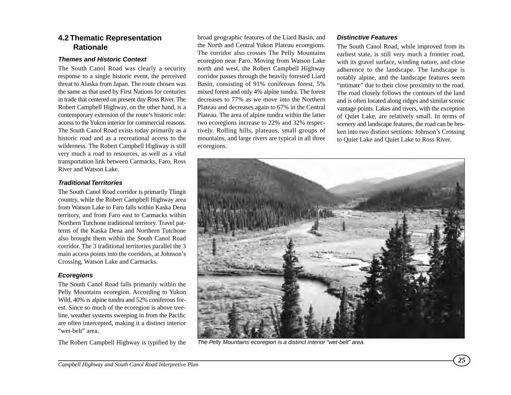
Themes and Historic ContextThe South Canol Road was clearly a securityresponse to a single historic event, the perceivedthreat to Alaska from Japan. The route chosen wasthe same as that used by First Nations for centuriesin trade that centered on present day Ross River. TheRobert Campbell Highway, on the other hand, is acontemporary extension of the route’s historic role:access to the Yukon interior for commercial reasons.The South Canol Road exists today primarily as ahistoric road and as a recreational access to thewilderness. The Robert Campbell Highway is stillvery much a road to resources, as well as a vitaltransportation link between Carmacks, Faro, RossRiver and Watson Lake.
Traditional TerritoriesThe South Canol Road corridor is primarily Tlingitcountry, while the Robert Campbell Highway areafrom Watson Lake to Faro falls within Kaska Denaterritory, and from Faro east to Carmacks withinNorthern Tutchone traditional territory. Travel pat-terns of the Kaska Dena and Northern Tutchonealso brought them within the South Canol Roadcorridor. The 3 traditional territories parallel the 3main access points into the corridors, at Johnson’sCrossing, Watson Lake and Carmacks.
EcoregionsThe South Canol Road falls primarily within thePelly Mountains ecoregion. According to YukonWild, 40% is alpine tundra and 52% coniferous for-est. Since so much of the ecoregion is above tree-line, weather systems sweeping in from the Pacificare often intercepted, making it a distinct interior“wet-belt” area.
The Robert Campbell Highway is typified by the
broad geographic features of the Liard Basin, andthe North and Central Yukon Plateau ecoregions.The corridor also crosses The Pelly Mountainsecoregion near Faro. Moving from Watson Lakenorth and west, the Robert Campbell Highwaycorridor passes through the heavily forested LiardBasin, consisting of 91% coniferous forest, 5%mixed forest and only 4% alpine tundra. The forestdecreases to 77% as we move into the NorthernPlateau and decreases again to 67% in the CentralPlateau. The area of alpine tundra within the lattertwo ecoregions increase to 22% and 32% respec-tively. Rolling hills, plateaus, small groups ofmountains, and large rivers are typical in all threeecoregions.
Distinctive FeaturesThe South Canol Road, while improved from itsearliest state, is still very much a frontier road,with its gravel surface, winding nature, and closeadherence to the landscape. The landscape isnotably alpine, and the landscape features seem“intimate” due to their close proximity to the road.The road closely follows the contours of the landand is often located along ridges and similar scenicvantage points. Lakes and rivers, with the exceptionof Quiet Lake, are relatively small. In terms ofscenery and landscape features, the road can be bro-ken into two distinct sections: Johnson’s Crossingto Quiet Lake and Quiet Lake to Ross River.
25Campbell Highway and South Canol Road Interpretive Plan
The Pelly Mountains ecoregion is a distinct interior “wet-belt” area.

The Robert Campbell Highway is more of a mixedroad, retaining some of the same frontier charac-teristics as the South Canol Road, but improved toa higher degree. The landscape consists of broadviews and many sizeable rivers and lakes. As well,there is a greater sense of forest and of expansivewilderness. The Tintina Trench is a major, highlyvisible geological formation. This road can be bro-ken into three distinct sections: Carmacks to Faro,Faro to Ross River and Ross River to Watson Lake.
4.3 Media & AudienceThe focus of this Interpretive Plan is on signagerather than other media because signs are usuallythe simplest and most cost effective approach,requiring the least amount of maintenance. A num-ber of other media approaches can be used in con-junction with an on-site signage program to presentthe corridor themes.
The South Canol/Campbell visitor profile suggeststhat these people are independent travellers that attacha high importance to “being there”. The wildernesscharacter of these roads is what attracts them to getoff the main highways. They want to take the “roadless travelled” and experience these roads directly.This is the determining factor in media selection.
Although signage cannot convey a great deal ofdetail, they complement the direct on-site experi-ence and provide an insight into the principal themebeing interpreted.
Radio Frequency MessagesThe use of “talking signs” has been introduced intothe Yukon in the last few years as part of the visitorradio program. While their overall utility is stillunverified, the technology has been used success-fully elsewhere. These signs can be used to add apersonal message and convey moods, drama andmusic that are not possible with the written word.The medium is flexible, adding more depth than ispossible with a fixed sign while the message itselfcan be easily changed. Since Yukon First Nationshave an oral tradition, this media provides anotheropportunity to present their culture themes.
The principal drawbacks with these systems relateto the set-up and maintenance costs, the range of themessage and getting the visitor to tune in. The vis-itor can remain in the vehicle and need not stop,devaluing the overall experience.
In the case of the South Canol Road and CampbellHighway, these signs could play a role at theregional orientation sites at the main highway inter-sections. Both roads contain a number of negativemessage signs for the traveller warning of no gas,difficult road conditions, etc. The messages arenot intended to be negative but are perceived thatway. There is an opportunity here to work withHighways to combine road condition messageswith interpretive information at the regional sites atWatson Lake, Johnson’s Crossing, Carmacks, Faroand Ross River.
Since their effectiveness is not yet known, it isrecommended that this approach not be imple-mented until the effectiveness of other test sites (i.e.Jakes Corners) has been confirmed.
Print Media & TapesThe opportunity to develop highway corridorguidebooks or pamphlets was also consideredespecially for the South Canol Road as its historyis well documented. The logic behind this approachrelates to the intrusiveness of signage into awilderness landscape.
Cassette tapes are a blend of the “talking sign”and print media. They are transportable,informative and, like guidebooks, have a souvenirquality that makes them an opportunity for privatesector development. Both approaches would needto be supplemented with simple “milepostmarkers” to work effectively for the traveller.
Given the current number of highway visitors,these media approaches are unlikely to be costeffective for some time. However, when the time isright, they could easily be adapted by the privatesector to complement the government signageprogram.
26Campbell Highway and South Canol Road Interpretive Plan
View of distant mountains from the Tintina Trench

There are many stories to tell in the thematicframework suggested for these roads. The land-scape is not uniform and different sections of bothroads convey different visual images. The chal-
lenge is to find a way to organize the driving expe-rience so the visitor’s attention is focused on thedominant themes and can follow the logical land-scape changes. At the same time the objective is to
maintain an image of the road corridor as a wholeexperience. The key is finding the right number ofsimple, logical connecting themes.The Campbell Highway has been divided into four
27Campbell Highway and South Canol Road Interpretive Plan
4.4 Highway Interpretive Units
Four distinct thematic units of the Campbell Highway and South Canol Road, with some overlap of the North Klondike Highway unit “Big River Country.”
0 20 50 100km
Nahanni R ange
Road
North
Cano
l Roa
d
Alaska Highway
Sou
thCa
nol R
oad
KlondikeHighway
Yukon
Riv
er
Big Salmon R iver
PellyRive
r
JOHNSON'SCROSSING
TESLIN
WHITEHORSE
CARCROSSWATSON LAKE
ROSS RIVER
FARO
CARMACKS
Quiet Lake
Marsh Lake
Lake Laberge
Teslin Lake
YUKONB.C.
Little Salmon Lake
Finlayson Lake
Frances Lake
Simpson Lake
LITTLE SALMONTLE SALMONCOUNTRYLITTLE SALMONTLE SALMONCOUNTRY TINTINA
TRENCHTRENCHTINTINATRENCHTRENCH
BIG RIVERCOUNTRYBIG RIVERCOUNTRY
KASKAHOMELHOMELANDKASKAHOMELAND
ROADTO OILROADTO OIL
Robert Campbell Highway

thematic units while only one is proposed for theSouth Canol Road. The five highway units can bedescribed as follows:
Kaska HomelandThis sector extends from Watson Lake to just north
of Finlayson Lake at the Pelly River. The CampbellHighway traverses the Liard Basin ecoregion cross-ing the Continental Divide into the Yukon Plateaubetween Frances and Finlayson lakes. Consideredthe heart of Kaska Dena territory, the lakes, riversand mountains currently reflect only the place
names given by Robert Campbell, the first whiteexplorer to visit this area. History, First Nationstrade and travel, and ecological themes mix with themodern mining exploration, forestry and recre-ation use themes associated with the road toresources focus of this highway.
28Campbell Highway and South Canol Road Interpretive Plan
The Kaska Homeland thematic unit
0 10 20 30 40 50km
WATSON LAKE
Robert Campbell Highway
Pelly River
Naha
niRang
e Road
NAHANNI RANGE ROAD JUNCTION km 107.8• North Nahanni Regional Orientation• Geography• Cantung Mining History
JADE MOUNTAIN km 160• Geology• Geography/Landforms
FINLAYSON LAKE VIEWPOINT km 233• Historical• Kaska Dena First Nations (Homeland)• Mining Activity• Wildlife Viewing
FRANCES RIVER BRIDGE km 57• Fisheries• First Nations Travel Route (River Name)• Ecoregions
ROBERT CAMPBELL HIGHWAY km 0.1• Regional Orientation• Historical• Kaska Dena First Nations Territory
Frances Lake
FinlaysonLake
SimpsonLake
FRANCES LAKE km 171• Historical• Kaska First Nations Name
EXISTING SITESminor
major
regional
PROPOSED SITESminor
major
regional

Tintina TrenchThe linear character of this dominant geologicallandscape feature stands out. Extending from justnorth of Finlayson Lake to the Magundy River,this section of road follows the Pelly River valley
and parallels the Pelly Mountains to the west. Themountains create a distinct orographic barrier. Thetrench is also an important migratory bird flywaywith the wetlands associated with the major valleyssuch as the Pelly (T’sekína Tu’) major resting and
staging areas along the way.
The Tintina Trench is known for its minerals suchas the Faro lead-zinc deposit. The Faro discoveryprovided the major impetus to open up the area andconstruct the highway as a road to resources.
29Campbell Highway and South Canol Road Interpretive Plan
The Tintina Trench thematic unit
0 10 20 30 40 50km
EXISTING SITESminor
major
regional
PROPOSED SITESminor
major
regional
FAROROSS RIVER
Robert Campbell HighwayPelly River
FARO JUNCTION km 415• Regional Tourism/ Community Orientation• Mining Activity• Geology (Tintina Trench)
ROSS RIVER ROAD JUNCTION km 383• Regional Tourism/Orientation• Ross River Dena First Nations
Little SalmonLake
PellyLakes
FortinLakes
HOOLE RIVER CANYON km 303• Geology• Recreation TrailheadSouth Canol Road
Nort
hCa
nolR
oad
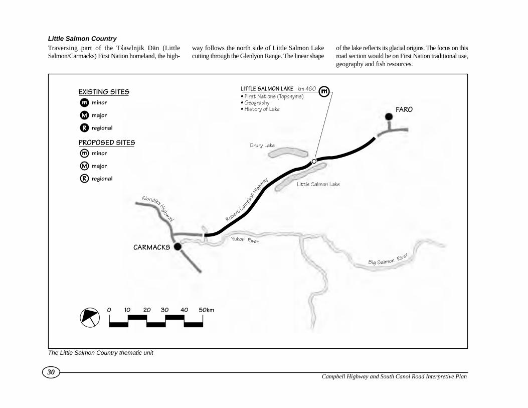
Little Salmon Country Traversing part of the Ts’awlnjik Dän (LittleSalmon/Carmacks) First Nation homeland, the high-
way follows the north side of Little Salmon Lakecutting through the Glenlyon Range. The linear shape
of the lake reflects its glacial origins. The focus on thisroad section would be on First Nation traditional use,geography and fish resources.
30Campbell Highway and South Canol Road Interpretive Plan
The Little Salmon Country thematic unit
0 10 20 30 40 50km
FARO
CARMACKS
RobertCam
pbell
Highway
Klondike Highway
Big Salmon River
Yukon River
LITTLE SALMON LAKE km 480• First Nations (Toponyms)• Geography• History of Lake
Drury Lake
Little Salmon Lake
EXISTING SITESminor
major
regional
PROPOSED SITESminor
major
regional

Big River CountryThere is an area of overlap with the North KlondikeCorridor plan at this point. From Eagles Nest Bluff(km. 556) to the junction of the North Klondike
Highway (km. 582.9) the Yukon River becomesvisible. For thematic continuity, the North Klondiketheme has been adopted for this section of road.
History, First Nations traditional use and legends arethe appropriate thematic stories to be developedwith regional orientation emphasized at the inter-section itself.
31Campbell Highway and South Canol Road Interpretive Plan
The Big River Country thematic unit
0 10 20 30 40 50km
CARMACKS
RobertCam
pbell Highway
Yukon River
NORTH KLONDIKE JUNCTION km 582.9• Regional Orientation• Ts,awlnjik Dän Homeland• Geography
COLUMBIAN DISASTER/EAGLES NEST BLUFF km 556• Historical• First Nations (Legends)
EXISTING SITESminor
major
regional
PROPOSED SITESminor
major
regional
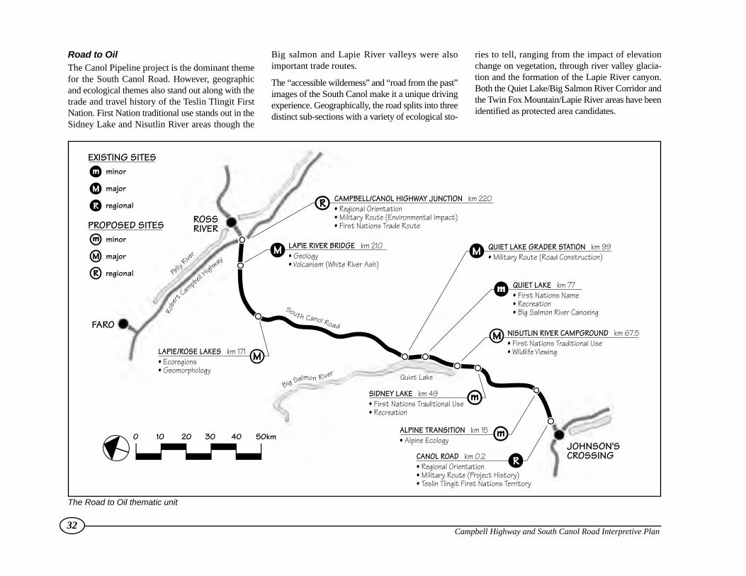
Road to OilThe Canol Pipeline project is the dominant themefor the South Canol Road. However, geographicand ecological themes also stand out along with thetrade and travel history of the Teslin Tlingit FirstNation. First Nation traditional use stands out in theSidney Lake and Nisutlin River areas though the
Big salmon and Lapie River valleys were alsoimportant trade routes.
The “accessible wilderness” and “road from the past”images of the South Canol make it a unique drivingexperience. Geographically, the road splits into threedistinct sub-sections with a variety of ecological sto-
ries to tell, ranging from the impact of elevationchange on vegetation, through river valley glacia-tion and the formation of the Lapie River canyon.Both the Quiet Lake/Big Salmon River Corridor andthe Twin Fox Mountain/Lapie River areas have beenidentified as protected area candidates.
32Campbell Highway and South Canol Road Interpretive Plan
The Road to Oil thematic unit
0 10 20 30 40 50km
LAPIE/ROSE LAKES km 171• Ecoregions• Geomorphology
Pelly
River
ROSSRIVER
FARO
Robe
rtCampb
ellHigh
way
South Canol Road
Big Salmon River Quiet Lake
JOHNSON'SCROSSING
CAMPBELL/CANOL HIGHWAY JUNCTION km 220• Regional Orientation• Military Route (Environmental Impact)• First Nations Trade Route
LAPIE RIVER BRIDGE km 210• Geology• Volcanism (White River Ash)
QUIET LAKE GRADER STATION km 99• Military Route (Road Construction)
NISUTLIN RIVER CAMPGROUND km 67.5• First Nations Traditional Use• Wildlife Viewing
QUIET LAKE km 77• First Nations Name• Recreation• Big Salmon River Canoeing
SIDNEY LAKE km 49• First Nations Traditional Use• Recreation
ALPINE TRANSITION km 15• Alpine Ecology
CANOL ROAD km 0.2• Regional Orientation• Military Route (Project History)• Teslin Tlingit First Nations Territory
EXISTING SITESminor
major
regional
PROPOSED SITESminor
major
regional
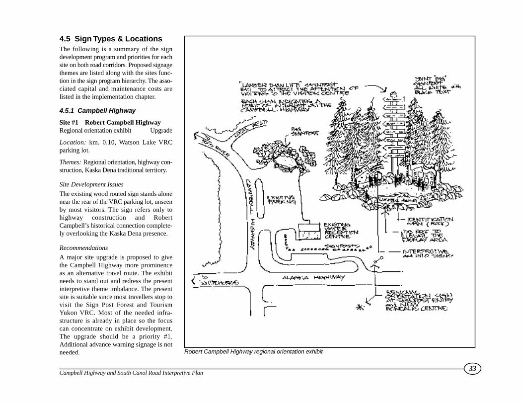
4.5 Sign Types & LocationsThe following is a summary of the signdevelopment program and priorities for eachsite on both road corridors. Proposed signagethemes are listed along with the sites func-tion in the sign program hierarchy. The asso-ciated capital and maintenance costs arelisted in the implementation chapter.
4.5.1 Campbell Highway
Site #1 Robert Campbell HighwayRegional orientation exhibit Upgrade
Location: km. 0.10, Watson Lake VRCparking lot.
Themes: Regional orientation, highway con-struction, Kaska Dena traditional territory.
Site Development Issues
The existing wood routed sign stands alonenear the rear of the VRC parking lot, unseenby most visitors. The sign refers only tohighway construction and RobertCampbell’s historical connection complete-ly overlooking the Kaska Dena presence.
Recommendations
A major site upgrade is proposed to givethe Campbell Highway more prominenceas an alternative travel route. The exhibitneeds to stand out and redress the presentinterpretive theme imbalance. The presentsite is suitable since most travellers stop tovisit the Sign Post Forest and TourismYukon VRC. Most of the needed infra-structure is already in place so the focuscan concentrate on exhibit development.The upgrade should be a priority #1.Additional advance warning signage is notneeded.
33Campbell Highway and South Canol Road Interpretive Plan
Robert Campbell Highway regional orientation exhibit

Site #2 Frances River BridgeMinor New
Location: km. 57, left side of the road south ofbridge, by boat launch.
Themes: First Nations Travel Route, LiardEcoregion, fisheries.
Site Development Issues
The site will require minimal physical develop-ment as it is already used as an informal camp-ground and boat launch site. The site was identifiedby the Kaska Dena as an ideal location to talkabout the importance of the river as a travel/tradecorridor and the importance of local fish resources.It is also a good opportunity to talk about the LiardEcoregion.
Recommendation
Add as a minor site adopting the themes describedabove. Highways has proposed a rest area withgarbage and toilet facilities. Intersection sight linesrequire improvement. Resurface and delineate theparking area. Add advance warning signs. Priority#3.
Site #3 Nahanni Range Road IntersectionMajor Replace Signage
Location: km. 107.8, right side of the road justbefore intersection.
Themes: North Nahanni regional orientation andgeography, Cantung mining history.
Site Development Issues
The site is an overgrown burn site and unattractive,yet strategically located just before the intersectionitself. The sign has not weathered well and warrants
immediate replacement. Garbage cans, outhousesand advance warning signage is required but thepull-out itself only requires minor upgrading. Thisis the only site on the Nahanni Range Road whereany development can be justified at this point intime.
Recommendation
Upgrade as a major sub-regional site to place moreemphasis on the North Nahanni regional geographyin addition to the mining history. Because of thepoor condition of the existing sign, replacementshould be a priority #1.
Site #4 Jade MountainMinor New
Location: km. 160, left side of the road.
Themes: Geology, geography and landforms.
Site Development Issues
The site is a former gravel pit and is largely dis-tinguished by the presence of a large boulder of jadethat was quarried from the nearby mountain. Thesite was identified by Highways staff as an oppor-tunity to integrate a truck rest-stop with the inter-pretive signage program. The jade boulder is theobvious attraction though the site also offers somepotential to interpret local geology and area land-forms.
Highways has proposed a rest area with garbageand toilet facilities.
Recommendation
Add as a minor site following development byHighways. Program requirements include advancewarning signage and the site sign itself. Priority #3.
34Campbell Highway and South Canol Road Interpretive Plan
View of Francis River Bridge from the boat launch.
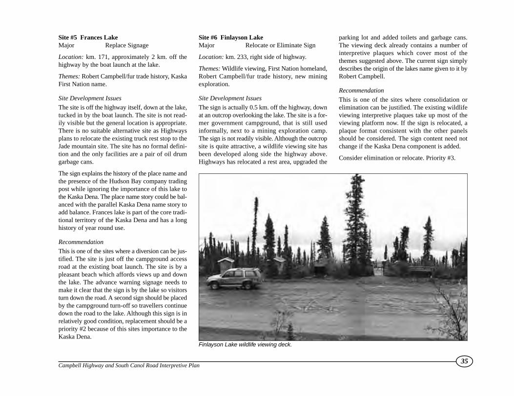
Site #5 Frances LakeMajor Replace Signage
Location: km. 171, approximately 2 km. off thehighway by the boat launch at the lake.
Themes: Robert Campbell/fur trade history, KaskaFirst Nation name.
Site Development Issues
The site is off the highway itself, down at the lake,tucked in by the boat launch. The site is not read-ily visible but the general location is appropriate.There is no suitable alternative site as Highwaysplans to relocate the existing truck rest stop to theJade mountain site. The site has no formal defini-tion and the only facilities are a pair of oil drumgarbage cans.
The sign explains the history of the place name andthe presence of the Hudson Bay company tradingpost while ignoring the importance of this lake tothe Kaska Dena. The place name story could be bal-anced with the parallel Kaska Dena name story toadd balance. Frances lake is part of the core tradi-tional territory of the Kaska Dena and has a longhistory of year round use.
Recommendation
This is one of the sites where a diversion can be jus-tified. The site is just off the campground accessroad at the existing boat launch. The site is by apleasant beach which affords views up and downthe lake. The advance warning signage needs tomake it clear that the sign is by the lake so visitorsturn down the road. A second sign should be placedby the campground turn-off so travellers continuedown the road to the lake. Although this sign is inrelatively good condition, replacement should be apriority #2 because of this sites importance to theKaska Dena.
Site #6 Finlayson LakeMajor Relocate or Eliminate Sign
Location: km. 233, right side of highway.
Themes: Wildlife viewing, First Nation homeland,Robert Campbell/fur trade history, new miningexploration.
Site Development Issues
The sign is actually 0.5 km. off the highway, downat an outcrop overlooking the lake. The site is a for-mer government campground, that is still usedinformally, next to a mining exploration camp.The sign is not readily visible. Although the outcropsite is quite attractive, a wildlife viewing site hasbeen developed along side the highway above.Highways has relocated a rest area, upgraded the
parking lot and added toilets and garbage cans.The viewing deck already contains a number ofinterpretive plaques which cover most of thethemes suggested above. The current sign simplydescribes the origin of the lakes name given to it byRobert Campbell.
Recommendation
This is one of the sites where consolidation orelimination can be justified. The existing wildlifeviewing interpretive plaques take up most of theviewing platform now. If the sign is relocated, aplaque format consistent with the other panelsshould be considered. The sign content need notchange if the Kaska Dena component is added.
Consider elimination or relocate. Priority #3.
35Campbell Highway and South Canol Road Interpretive Plan
Finlayson Lake wildlife viewing deck.
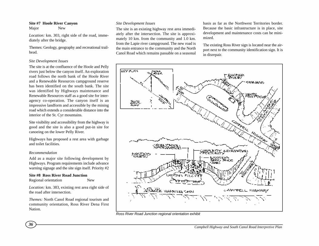
Site #7 Hoole River CanyonMajor New
Location: km. 303, right side of the road, imme-diately after the bridge.
Themes: Geology, geography and recreational trail-head.
Site Development Issues
The site is at the confluence of the Hoole and Pellyrivers just below the canyon itself. An explorationroad follows the north bank of the Hoole Riverand a Renewable Resources campground reservehas been identified on the south bank. The sitewas identified by Highways maintenance andRenewable Resources staff as a good site for inter-agency co-operation. The canyon itself is animpressive landform and accessible by the miningroad which extends a considerable distance into theinterior of the St. Cyr mountains.
Site visibility and accessibility from the highway isgood and the site is also a good put-in site forcanoeing on the lower Pelly River.
Highways has proposed a rest area with garbageand toilet facilities.
Recommendation
Add as a major site following development byHighways. Program requirements include advancewarning signage and the site sign itself. Priority #2
Site #8 Ross River Road JunctionRegional orientation New
Location: km. 383, existing rest area right side ofthe road after intersection.
Themes: North Canol Road regional tourism andcommunity orientation, Ross River Dena FirstNation.
Site Development Issues
The site is an existing highway rest area immedi-ately after the intersection. The site is approxi-mately 10 km. from the community and 1.0 km.from the Lapie river campground. The new road isthe main entrance to the community and the NorthCanol Road which remains passable on a seasonal
basis as far as the Northwest Territories border.Because the basic infrastructure is in place, sitedevelopment and maintenance costs can be mini-mized.
The existing Ross River sign is located near the air-port next to the community identification sign. It isin disrepair.
36Campbell Highway and South Canol Road Interpretive Plan
Ross River Road Junction regional orientation exhibit

Recommendation
Develop as a regional orientation site and relocatethe existing Ross River sign by the airport. Includereference to the lower Lapie River canyon that isless than 1.0 km. away. Development of the region-al exhibit and relocation of the existing sign shouldbe a priority #1.
Site #9 Faro JunctionMajor Upgrade
Location: km. 415, left side of the road.
Themes: Regional tourism and community orien-tation, mining history, Tintina Trench geology.
Site Development Issues
There are two sites here, one at km. 414 whichoverlooks the town itself and the second largersite at the road junction. There is a considerableamount of repetition in the signage at both sites.The community agreed to consolidate efforts atthe intersection site and eliminate the signage at km.414 provided the pull-out itself was retained. TheTown of Faro has developed an attractive, land-scaped rest area at the intersection and it makessense to complement that effort by redoing andupdating the present signage.
Recommendation
Upgrade the intersection site (km. 415), eliminatethe signage at km. 414 but maintain the advancewarning signs and pull-out for informal use.Priority #2.
Site #10 Little Salmon LakeMinor New
Location: km. 480, existing rest area left side of theroad.
Themes: First Nations names, geography, history oflake.
Site Development Issues
This is an existing truck rest area. While there area number of places along the lake where an inter-pretive site could be developed none particularlystand out above the rest so it makes sense to use anexisting site which fits the general spacing dis-tance guidelines. The only site improvements need-ed are the advance warning signs and the inter-pretive sign itself.
Recommendation
add to the existing Highways site. Priority #3.
Site #11 Columbian Disaster/Eagles nest BluffMajor Upgrade
Location: km. 556, right side of the road on a bend.
Themes: Historical event, First Nations legendsand traditional use.
Site Development Issues
The main problem with this site relates to traffic andpedestrian safety. The road is relatively narrowand winding at this point and the views of theYukon River and bluff are across the road.Highways has enlarged this rest area and addedgarbage cans and toilets. There is no real suitablealternative site.
Recommendation
Consolidate activities at this site and upgrade thepresent signage to add the First nation component.Consider additional upgrades when this section ofroad is rebuilt to increase pedestrian safety. Adoptthe Big River Country theme for this section toreflect the presence of the Yukon River and overlapwith the North Klondike plan. Priority #2.
37Campbell Highway and South Canol Road Interpretive Plan
The Robert Campbell Highway winds around Little Salmon Lake.

Site #12 North Klondike Junction Regional orientation New
Location: km. 582.9, right side ofthe road at intersection.
Themes: Regional orientation,Tsawlnjik Dan (Little Salmon/Carmacks) First Nations homeland,geography.
Site Development Issues
The problem with this site relates totraffic flow and safety. The majori-ty of traffic travels the NorthKlondike Highway and the objec-tive is to try and persuade some ofthat visitor traffic to take theCampbell Highway. The ideal loca-tion is on the Klondike Highway ,north bound side, just before theintersection but this may encroachinto private property. Several alter-natives are currently under studybut none are ideal. One alternativefor south bound traffic is to replacethe signage that was knocked overat the Tantalus Butte site on theNorth Klondike highway and movethe panels at the Carmacks rest areasouth of town closer to the actualintersection. This regional orienta-tion site will be the most difficult todevelop and relatively expensivewithout highways help.
Recommendation
Assess the alternatives further andco-ordinate with any intersectionimprovement work undertaken byHighways. Priority #1.
38Campbell Highway and South Canol Road Interpretive Plan
North Klondike Junction regional orientation exhibit
4.5.2 South Canol Road
Site #1 Johnson’s CrossingIntersection Regional orientation Upgrade
Location: km. 0.2, right side of theroad.
Themes: Regional orientation, mil-itary route, Teslin Tlingit FirstNations territory.
Site Development Issues
The main problem with this inter-section is visibility. The intersectionis screened by the vertical clay banksmaking it easy to miss as trafficdescends towards the Teslin Riverbridge. There are several signs clus-tered here including the main woodrouted sign, an interpretive plaqueand a milepost marker. Across theAlaska Highway on private property,there is a former storage tank, build-ing and a section of the original pipe.
To be effective, this site must be vis-ible from the Alaska Highway. Itneeds to be a prominent landmarkthat stands out and raises the trav-ellers curiosity. A number of formermilitary vehicles can be found in adump less than a kilometre away. Theidea is to incorporate some of thesevehicles into a convoy style displaywhich would become the focus forthe regional orientation exhibit. Whilethe military history of the Canol dom-inates, it is important to incorporatethe most obvious missing component–Teslin Tlingit First Nation land useand occupancy.
39Campbell Highway and South Canol Road Interpretive Plan
Johnson’s Crossing Intersection regional orientation exhibit

To make this intersection work, the clay cliffs willneed to be cut back to improve the sight lines. TheTeslin Tlingit also own private lands in the immedi-ate vicinity so any proposals outside the road right-of-way would require their approval and co-operation.
Recommendation
Relocate and reorganize the existing signage andsupplement the exhibit to make the site visiblyinteresting enough to encourage travellers to stop.Emphasize the theme of the “road from the past”and the ecological diversity. Promote the TeslinTlingit presence. As this is a key traffic diversionpoint it should be a priority #1. Include toilets,picnic tables and garbage cans.
Site #2 Alpine Transition Minor New
Location: km. 15, right or left side of the road.
Themes: Alpine ecology
Site Development Issues
This new site is proposed because it is the onlyplace close to the Alaska Highway where a visitorcan get up into the alpine close to the highway. Aminor pull-out would have to be developed andgarbage cans and advance warning signs added.There are also a number of recreation hiking oppor-tunities up nearby hills which afford views of theTeslin River and Teslin Lake.
Recommendation
Select a site in the general vicinity which affordsaccess to the surrounding hills and an opportunityto interpret alpine features such as vegetation dif-ferences and plant adaptability. Develop a minor sitewith advance warning signs and a garbage can.Priority #2.
Site #3 Sidney Lake Minor New
Location: km. 49, existing pull-out, right side of theroad overlooking lake.
Themes: First Nations traditional use, recreation
Site Development Issues
This is an existing small pull-out overlooking thelake by the access road to the boat launch. Theview of the lake is partially screened by existingtrees which could be trimmed to improve the view.This area is an important traditional use area. Thereis also an old mining road on the north side whichfollows Sidney Creek back towards the mountains.It connects back to the South Canol near QuietLake campground. This could be another trailheadpartnership opportunity with Renewable Resourcesand the Teslin Tlingit.
Recommendation
Upgrade existing rest area and add new sign withTeslin Tlingit traditional use focus. Replace garbagecans and add advance warning signs. Priority #3.
Site #4 Nisutlin River Campground Major New
Location: km. 67.5, access road 0.5 km. down bythe river, right side of the South Canol Road.
Themes: First Nations traditional use, wildlife viewing.
Site Development Issues
The-is site is just off the road itself, down by theriver. A popular launch site for river trips for hunt-ing, fishing and wildlife viewing, the Nisutlin is con-sidered part of the heart of Teslin Tlingit territory.The site would require minor improvements includ-ing replacement of outhouses and garbage bins.
Recommendation
Upgrade the site and add interpretive signage as apriority #2. The Teslin Tlingit want to advocatecare and respect for wildlife and the land at thispopular recreation site.
Site #5 Quiet Lake Minor Upgrade
Location: km. 77, left side of the road on a bendnext to the lake.
Themes: Current and First Nation place name leg-end. Big Salmon River recreation.
Site Development Issues
This site is right on the edge of the lake with noroom for expansion. It is a natural stopping spotwith the first real opportunity to get close to thewater. Advance warning signs are needed and agarbage can should be added.
40Campbell Highway and South Canol Road Interpretive Plan
The Nisutlin River

The sign content could be expanded to incorporatethe First Nation place name legend which is anintriguing story.
Recommendation
Replace sign and review the message content to addFirst Nation component. Add advance warningsigns and garbage can. Priority #3.
Site #6 Quiet lake grader Station Major Upgrade
Location: km. 99, left side of the road in front ofmaintenance compound.
Themes: Military Route, road construction.
Site Development Issues
The site is in front of the seasonal highway main-tenance camp. The existing display consists of sev-eral pieces of original highway construction equip-ment salvaged by road crews along the road. Asign with appropriate text has been designed for thissite. There is sufficient room to create a proper reststop at the location complete with support facilitiessince maintenance costs can be minimized.
Adding to the Highways display complements theirinitiative at modest cost.
Recommendation
Upgrade site in conjunction with Highways.Priority #2.
Site #7 Lapie/Rose Lakes Major New
Location: km. 171, right or left side of the road.
Themes: Ecoregions and geomorphology.
Site Development Issues
There are a number of possible sites in this areawhich over good view across the lakes and into the
surrounding mountains. A variety of ecologicalthemes can be demonstrated in this area and thereare a number of good wildlife viewing locations.There are several mining exploration roads in thisarea as well which provide access into the back-country and a number of mountains near the roadcan be easily climbed providing commandingviews of the valley below.
The geomorphology of the area is also intriguingwith ample evidence of glaciation. Development ofan interpretive site would involve developing thepull-out, installing outhouses and garbage cans inaddition to the interpretive display. Care shouldbe taken to make the facilities as unobtrusive as pos-sible to protect the wilderness character of thisarea.
41Campbell Highway and South Canol Road Interpretive Plan
Quiet Lake grader station exhibit
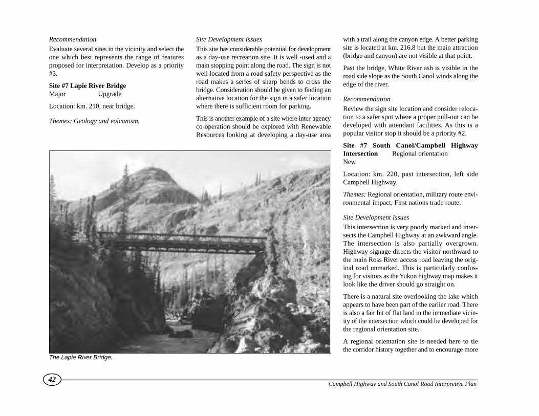
Recommendation
Evaluate several sites in the vicinity and select theone which best represents the range of featuresproposed for interpretation. Develop as a priority#3.
Site #7 Lapie River Bridge Major Upgrade
Location: km. 210, near bridge.
Themes: Geology and volcanism.
Site Development Issues
This site has considerable potential for developmentas a day-use recreation site. It is well -used and amain stopping point along the road. The sign is notwell located from a road safety perspective as theroad makes a series of sharp bends to cross thebridge. Consideration should be given to finding analternative location for the sign in a safer locationwhere there is sufficient room for parking.
This is another example of a site where inter-agencyco-operation should be explored with RenewableResources looking at developing a day-use area
with a trail along the canyon edge. A better parkingsite is located at km. 216.8 but the main attraction(bridge and canyon) are not visible at that point.
Past the bridge, White River ash is visible in theroad side slope as the South Canol winds along theedge of the river.
Recommendation
Review the sign site location and consider reloca-tion to a safer spot where a proper pull-out can bedeveloped with attendant facilities. As this is apopular visitor stop it should be a priority #2.
Site #7 South Canol/Campbell HighwayIntersection Regional orientationNew
Location: km. 220, past intersection, left sideCampbell Highway.
Themes: Regional orientation, military route envi-ronmental impact, First nations trade route.
Site Development Issues
This intersection is very poorly marked and inter-sects the Campbell Highway at an awkward angle.The intersection is also partially overgrown.Highway signage directs the visitor northward tothe main Ross River access road leaving the orig-inal road unmarked. This is particularly confus-ing for visitors as the Yukon highway map makes itlook like the driver should go straight on.
There is a natural site overlooking the lake whichappears to have been part of the earlier road. Thereis also a fair bit of flat land in the immediate vicin-ity of the intersection which could be developed forthe regional orientation site.
A regional orientation site is needed here to tiethe corridor history together and to encourage more
42Campbell Highway and South Canol Road Interpretive Plan
The Lapie River Bridge.

loop road activity. The one elementof the road and pipeline construc-tion that is not discussed is theensuing environmental impact.This would complement the otherdisplays at Johnson Crossing andthe Quiet Lake Grader station. Alsomissing is the First nation traderoute component.
This site would involve develop-ment of a rest area with the rec-ommended infrastructure exclud-ing toilet facilities, as they alreadyexist 10 km. away. Advance warn-ing signage should also be placedon both roads.
Recommendation
Developing this site should be apriority #1 following the upgradesat Watson lake, Johnson’s Crossingand Carmacks.
43Campbell Highway and South Canol Road Interpretive Plan
South Canol/Campbell Highway Intersection regional orientation exhibit
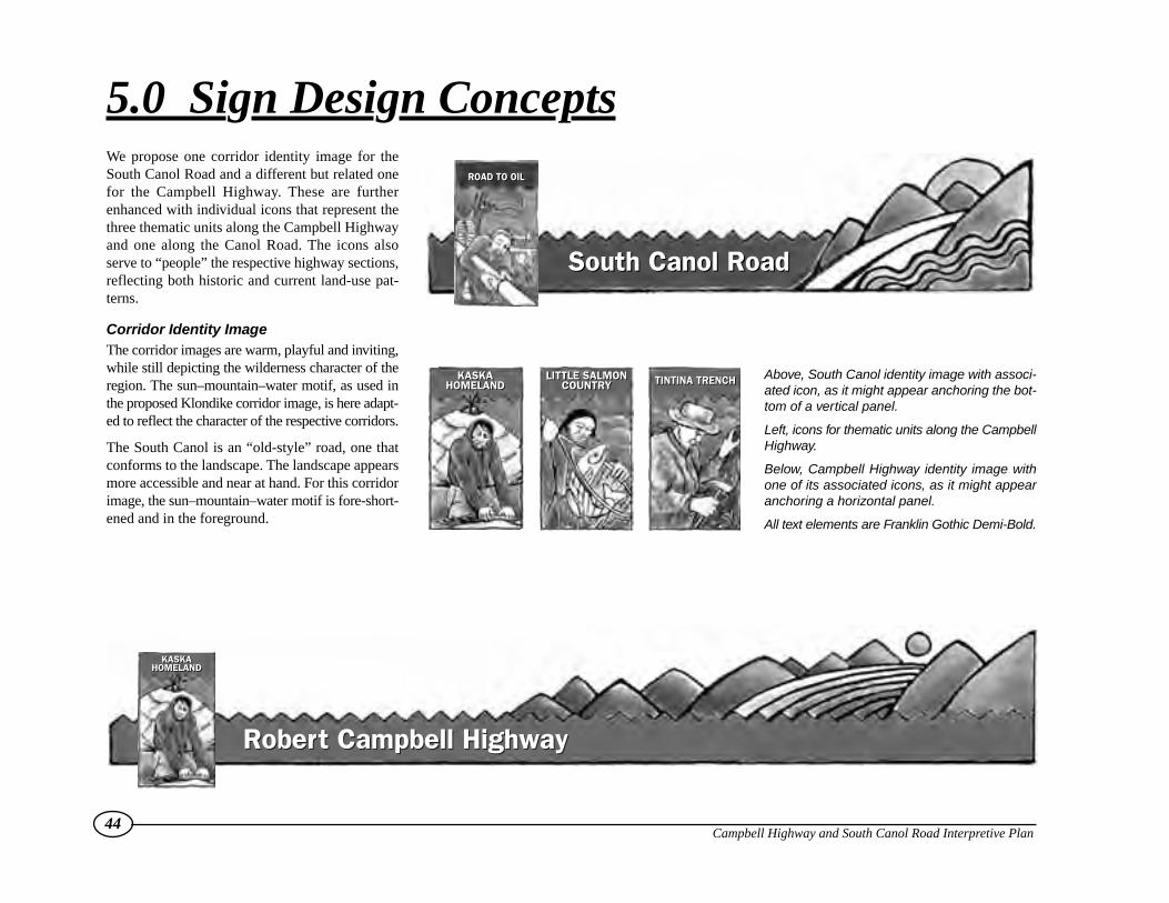
We propose one corridor identity image for theSouth Canol Road and a different but related onefor the Campbell Highway. These are furtherenhanced with individual icons that represent thethree thematic units along the Campbell Highwayand one along the Canol Road. The icons alsoserve to “people” the respective highway sections,reflecting both historic and current land-use pat-terns.
Corridor Identity ImageThe corridor images are warm, playful and inviting,while still depicting the wilderness character of theregion. The sun–mountain–water motif, as used inthe proposed Klondike corridor image, is here adapt-ed to reflect the character of the respective corridors.
The South Canol is an “old-style” road, one thatconforms to the landscape. The landscape appearsmore accessible and near at hand. For this corridorimage, the sun–mountain–water motif is fore-short-ened and in the foreground.
44Campbell Highway and South Canol Road Interpretive Plan
5.0 Sign Design Concepts
Robert Campbell HighwayRobert Campbell Highway
Above, South Canol identity image with associ-ated icon, as it might appear anchoring the bot-tom of a vertical panel.
Left, icons for thematic units along the CampbellHighway.
Below, Campbell Highway identity image withone of its associated icons, as it might appearanchoring a horizontal panel.
All text elements are Franklin Gothic Demi-Bold.
South Canol RoadSouth Canol Road
ROAD TO OILROAD TO OIL
KASKAHOMELAND
KASKAHOMELAND
LITTLE SALMONCOUNTRY
LITTLE SALMONCOUNTRY TINTINA TRENCHTINTINA TRENCH
KASKAHOMELAND
KASKAHOMELAND
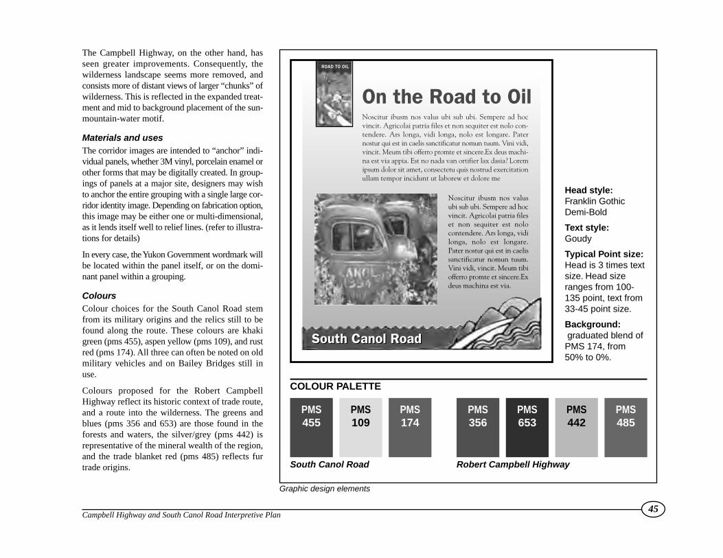
The Campbell Highway, on the other hand, hasseen greater improvements. Consequently, thewilderness landscape seems more removed, andconsists more of distant views of larger “chunks” ofwilderness. This is reflected in the expanded treat-ment and mid to background placement of the sun-mountain-water motif.
Materials and usesThe corridor images are intended to “anchor” indi-vidual panels, whether 3M vinyl, porcelain enamel orother forms that may be digitally created. In group-ings of panels at a major site, designers may wishto anchor the entire grouping with a single large cor-ridor identity image. Depending on fabrication option,this image may be either one or multi-dimensional,as it lends itself well to relief lines. (refer to illustra-tions for details)
In every case, the Yukon Government wordmark willbe located within the panel itself, or on the domi-nant panel within a grouping.
ColoursColour choices for the South Canol Road stemfrom its military origins and the relics still to befound along the route. These colours are khakigreen (pms 455), aspen yellow (pms 109), and rustred (pms 174). All three can often be noted on oldmilitary vehicles and on Bailey Bridges still inuse.
Colours proposed for the Robert CampbellHighway reflect its historic context of trade route,and a route into the wilderness. The greens andblues (pms 356 and 653) are those found in theforests and waters, the silver/grey (pms 442) isrepresentative of the mineral wealth of the region,and the trade blanket red (pms 485) reflects furtrade origins.
45Campbell Highway and South Canol Road Interpretive Plan
Graphic design elements
PMS455
PMS109
PMS174
PMS356
PMS653
PMS442
PMS485
South Canol Road
COLOUR PALETTE
Robert Campbell Highway
South Canol Road
On the Road to Oil
South Canol Road
Noscitur ibusm nos valus ubi sub ubi. Sempere ad hocvincit. Agricolai patria files et non sequiter est nolo con-tendere. Ars longa, vidi longa, nolo est longare. Paternostur qui est in caelis sanctificatur nomun tuum. Vini vidi,vincit. Meum tibi offerro promte et sincere.Ex deus machi-na est via appia. Est no nada van ortifier lax dasia? Loremipsum dolor sit amet, consectetu quis nostrud exercitationullam tempor incidunt ut laborew et dolore me
Noscitur ibusm nos valusubi sub ubi. Sempere ad hocvincit. Agricolai patria fileset non sequiter est nolocontendere. Ars longa, vidilonga, nolo est longare.Pater nostur qui est in caelissanctificatur nomun tuum.Vini vidi, vincit. Meum tibiofferro promte et sincere.Exdeus machina est via.
ROAD TO OILROAD TO OIL
Head style:Franklin GothicDemi-Bold
Text style:Goudy
Typical Point size:Head is 3 times textsize. Head sizeranges from 100-135 point, text from33-45 point size.
Background:graduated blend of
PMS 174, from50% to 0%.

Sign and Support FabricationAll signs will be supported by 200 mm turned tim-ber posts. These will be approximately 3500 mm inlength, with 2200 mm above ground. A distinctive 40mm notch is routed into the post 100 mm from the
top, to a depth of between 13 and 19 mm. The top ofthe post itself should be slightly convex for drainage.All notches will be stained an opaque red, similar toSikkens brand Navajo Red. Posts will then be treat-ed with an appropriate clear finish, such as Behr
46Campbell Highway and South Canol Road Interpretive Plan
Panel and support design, fabrication and dimensional details.
200 mm
1525 mm
200 mm
500 mm
100 mm
13-19 mm
60 mm40 mm
Notches stainedopaque red, asSikkens Navajo Red
Main panel of 19 mmcrezone or similar,1830 x 1525 mmwith 38 x 38 mmlet-in pine frame
Side panels of 19mm crezone orsimilar, 915 x 1525mm with 38 x 38mm let-in pine frame
200 mm turnedtimber post finishedwith clearpreservative
Thematic Unit Identity icon, on same plane as panel or on19mm raised panel, 200 mm x 350 mm
Highway Identity Strip, on same plane aspanel or on 19mm raised panel of crezone,HD foam or other appropriate material,with 3M Scotchprint art adhered
ORIENTATION MAPCAMPBELL/CANOL REGIONlocates and identifies specific
sites within entire region
REGIONAL DISPLAY INFO PANEL,WITH SITE SPECIFIC SIDE-BAR
overview of the region with specificspertaining to site
COMMUNITY INFO/ MAP/INTERPRETATION
where a site is in closeproximity to a community
POST TOPDETAIL
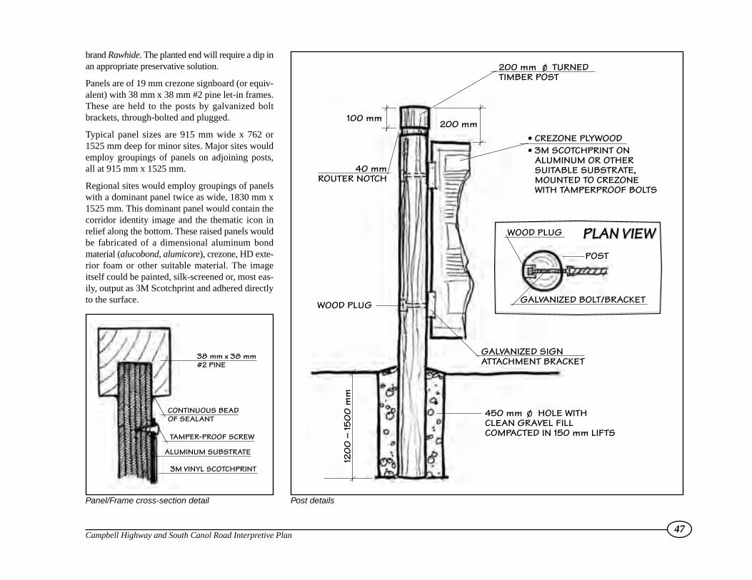
brand Rawhide. The planted end will require a dip inan appropriate preservative solution.
Panels are of 19 mm crezone signboard (or equiv-alent) with 38 mm x 38 mm #2 pine let-in frames.These are held to the posts by galvanized boltbrackets, through-bolted and plugged.
Typical panel sizes are 915 mm wide x 762 or1525 mm deep for minor sites. Major sites wouldemploy groupings of panels on adjoining posts,all at 915 mm x 1525 mm.
Regional sites would employ groupings of panelswith a dominant panel twice as wide, 1830 mm x1525 mm. This dominant panel would contain thecorridor identity image and the thematic icon inrelief along the bottom. These raised panels wouldbe fabricated of a dimensional aluminum bondmaterial (alucobond, alumicore), crezone, HD exte-rior foam or other suitable material. The imageitself could be painted, silk-screened or, most eas-ily, output as 3M Scotchprint and adhered directlyto the surface.
47Campbell Highway and South Canol Road Interpretive Plan
200 mm TURNEDTIMBER POST
450 mm HOLE WITHCLEAN GRAVEL FILLCOMPACTED IN 150 mm LIFTS
GALVANIZED SIGNATTACHMENT BRACKET
WOOD PLUG
WOOD PLUG
40 mm ROUTER NOTCH
120
0 –
150
0 m
m
POST
GALVANIZED BOLT/BRACKET
100 mm
• CREZONE PLYWOOD• 3M SCOTCHPRINT ON
ALUMINUM OR OTHER SUITABLE SUBSTRATE, MOUNTED TO CREZONE WITH TAMPERPROOF BOLTS
200 mm
3M VINYL SCOTCHPRINT
TAMPER-PROOF SCREW
ALUMINUM SUBSTRATE
CONTINUOUS BEADOF SEALANT
38 mm x 38 mm#2 PINE
Panel/Frame cross-section detail Post details

6.1 PrioritiesThe priorities listed below reflect the program defi-ciencies identified during this study. The existingsignage on both the South Canol Road andCampbell Highway are all nearing the end of theiruseful life. Surprisingly, most of the original woodrouted stained signs erected between 1983 and1984 have survived better than the newer ones.
There are a number of significant gaps in the exist-ing signage program which need to be resolved. Thiswill result in the addition of a significant number ofnew sites which will necessitate a phased approachto implementation. The Department of TourismHeritage Branch only has a limited amount of pro-gram funds and as each corridor plan is completednew pressing priorities will be identified. Given
current visitation levels, it is likely this Sign Plan willtake 5-7 years to implement.
Based on the consultant’s analysis of the issuesand the community feedback received to date, thefirst priority should be on upgrading the regionalorientation signage since this is the most pressingprogram deficiency. The desire to attract visitor tothese two roads is a long stated priority.
The next priority is to redress the imbalance inFirst Nation theme representation. While recogni-tion of their traditional territories will be an equalpart of the proposed regional orientation sites, itshould also be considered when existing signs arereplaced. Adding the First Nation name for FrancesLake for example, should be equally as importantas explaining the English name.
The third priority should be replacing existingsigns on an as required basis. Major new sitesshould take priority over minor sites with adjust-ments made as the program develops to co-ordinateplans with any road reconstruction work.
6.2 Directional SignsAdvance warning signs are a used to provide thetraveller time to slow down, identify the type ofinterpretive opportunity ahead and turn off thehighway safely. Consistency in appearance andcontent is a crucial part of making these signsfunctional for the travelling public. In their reporton the North Klondike the authors note:
• information on existing signs is insufficient toattract visitors, especially to major sites. It isconsidered valuable to include informationabout the available facilities at the site;
• the site name is important to give visitors asense of the focus of the interpretive messageand to relate to the previous highway orienta-tion information or reference in print, such asthe Milepost;
• an identifying logo is desirable to link the siteto the corridor series in the mind of the visitor;
• sign sizes should be indicative of major andminor sites; and
• advance warning signs should be installed forall sites in each direction. (reprised from NorthKlondike Plan PRP, 1996)
48Campbell Highway and South Canol Road Interpretive Plan
6.0 Implementation & Operations
Sign Plan Implementation Priorities
Priority #1 Priority #2 Priority #3
Alaska Highway Junction Frances Lake Frances River Bridge
Watson Lake
Johnson Crossing Junction Hoole River Canyon Jade Mountain
Klondike Highway Junction Columbian Disaster/Eagles Finlayson LakeNest Bluff
South Canol Road/Campbell Alpine Transition Little Salmon LakeHighway Junction
Campbell Highway/North Nisutlin River Sidney lakeCanol Road Junction
Nahanni Range Road Quiet Lake Grader Station Quiet Lake
Faro Junction Lapie River Bridge Lapie Lakes
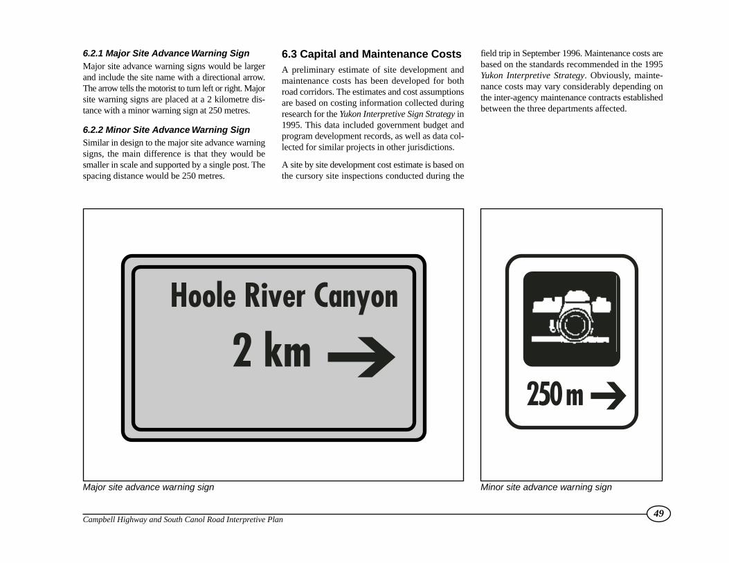
6.2.1 Major Site Advance Warning SignMajor site advance warning signs would be largerand include the site name with a directional arrow.The arrow tells the motorist to turn left or right. Majorsite warning signs are placed at a 2 kilometre dis-tance with a minor warning sign at 250 metres.
6.2.2 Minor Site Advance Warning SignSimilar in design to the major site advance warningsigns, the main difference is that they would besmaller in scale and supported by a single post. Thespacing distance would be 250 metres.
6.3 Capital and Maintenance CostsA preliminary estimate of site development andmaintenance costs has been developed for bothroad corridors. The estimates and cost assumptionsare based on costing information collected duringresearch for the Yukon Interpretive Sign Strategy in1995. This data included government budget andprogram development records, as well as data col-lected for similar projects in other jurisdictions.
A site by site development cost estimate is based onthe cursory site inspections conducted during the
field trip in September 1996. Maintenance costs arebased on the standards recommended in the 1995Yukon Interpretive Strategy. Obviously, mainte-nance costs may vary considerably depending onthe inter-agency maintenance contracts establishedbetween the three departments affected.
49Campbell Highway and South Canol Road Interpretive Plan
Major site advance warning sign Minor site advance warning sign
Hoole River Canyon
2 km ➔250 m ➔

50Campbell Highway and South Canol Road Interpretive Plan
Appendices – Site, Capital & Operation Estimate