Camp Ellis, Maine: A small beach community with a big ... · (Kelley and Anderson, ... and...
20
INTRODUCTION The community and beach at Camp Ellis, Maine, located at the mouth of the Saco River (Fig. 1), have had a tumultuous rela- tionship centrally influenced by a federal jetty for more than 100 yr (Kelley and Anderson, 2000; Pilkey and Dixon, 1996). Residential development and the erection of engineering structures, combined with a general ignorance of ongoing geological processes, have led to tragic property losses and extraordinary public expendi- tures. Camp Ellis is a classic example of a coupled human and natural system characterized by temporally variable reciprocity and feedback (Liu et al., 2007). Because of the complicated social and physical nature of this system, the connection between human events at Camp Ellis and their consequences has often gone un- recognized. As with many land-use conflicts, every “solution” to the erosion problems at Camp Ellis has had detractors as well as supporters. With growing population pressure along sandy beaches like Camp Ellis, all stakeholders want to maintain a stable beach, but most local residents want to maintain other traditional uses of the area, including houses, navigation, and commercial enterprises. Although it is a small, relatively undeveloped beach by global stan- dards, Camp Ellis exhibits many of the problems shared by more developed strands and represents an example of problems that less- developed beaches might seek to avoid. 1 Kelley, J.T., and Brothers, L.L., 2009, Camp Ellis, Maine: A small beach community with a big problem/jetty, in Kelley, J.T., Pilkey, O.H., and Cooper, J.A.G., eds., America’s Most Vulnerable Coastal Communities: Geological Society of America Special Paper 460, p. 1–20, doi: 10.1130/2009.2460(01). For permission to copy, contact [email protected]. ©2009 The Geological Society of America. All rights reserved. The Geological Society of America Special Paper 460 2009 Camp Ellis, Maine: A small beach community with a big problem…its jetty Joseph T. Kelley Laura L. Brothers Department of Earth Sciences, University of Maine, Orono, Maine 04469-5790, USA ABSTRACT This paper is a case history of coastal development at Camp Ellis, Saco, Maine. It begins in 1867 with dredging and jetty construction at the mouth of the Saco River to facilitate commercial navigation. Beach accretion, resulting from tidal delta collapse, was followed by residential development before the ephemeral nature of the shoreline was recognized. A misunderstanding of the riverine source of beach sand and the net, northward direction of longshore transport confounded U.S. Army Corps of Engineers (USACOE) efforts to maintain navigation and the adjacent beach. Beach erosion at Camp Ellis claimed dozens of properties before the role of the north jetty at the mouth of the Saco River became apparent to state and univer- sity scientists. Erosion also led to sand migration to the north and to the closure of the Little River inlet and growth of Pine Point spit. This spit was later developed and a jetty was placed at its tip to preclude continued accretion into the Scarborough River inlet. Despite numerous studies, the USACOE failed to recognize the connec- tion between beach erosion at Camp Ellis and beach accretion at Pine Point. Under political pressure, the USACOE recently conducted detailed modeling studies and has proposed construction of breakwaters seaward of Camp Ellis to solve the prob- lem. A discussion of the pros and cons of this proposal is presented in light of the long history of development at Camp Ellis. spe460-01 page 1
-
Upload
nguyenkhue -
Category
Documents
-
view
216 -
download
1
Transcript of Camp Ellis, Maine: A small beach community with a big ... · (Kelley and Anderson, ... and...

INTRODUCTION
The community and beach at Camp Ellis, Maine, located at the mouth of the Saco River (Fig. 1), have had a tumultuous rela-tionship centrally infl uenced by a federal jetty for more than 100 yr (Kelley and Anderson, 2000; Pilkey and Dixon, 1996). Residential development and the erection of engineering structures, combined with a general ignorance of ongoing geological processes, have led to tragic property losses and extraordinary public expendi-tures. Camp Ellis is a classic example of a coupled human and natural system characterized by temporally variable reciprocity and feedback (Liu et al., 2007). Because of the complicated social
and physical nature of this system, the connection between human events at Camp Ellis and their consequences has often gone un-recognized. As with many land-use confl icts, every “solution” to the erosion problems at Camp Ellis has had detractors as well as supporters. With growing population pressure along sandy beaches like Camp Ellis, all stakeholders want to maintain a stable beach, but most local residents want to maintain other traditional uses of the area, including houses, navigation, and commercial enterprises. Although it is a small, relatively undeveloped beach by global stan-dards, Camp Ellis exhibits many of the problems shared by more developed strands and represents an example of problems that less-developed beaches might seek to avoid.
1
Kelley, J.T., and Brothers, L.L., 2009, Camp Ellis, Maine: A small beach community with a big problem/jetty, in Kelley, J.T., Pilkey, O.H., and Cooper, J.A.G., eds., America’s Most Vulnerable Coastal Communities: Geological Society of America Special Paper 460, p. 1–20, doi: 10.1130/2009.2460(01). For permission to copy, contact [email protected]. ©2009 The Geological Society of America. All rights reserved.
The Geological Society of AmericaSpecial Paper 460
2009
Camp Ellis, Maine: A small beach community with a big problem…its jetty
Joseph T. KelleyLaura L. Brothers
Department of Earth Sciences, University of Maine, Orono, Maine 04469-5790, USA
ABSTRACT
This paper is a case history of coastal development at Camp Ellis, Saco, Maine. It begins in 1867 with dredging and jetty construction at the mouth of the Saco River to facilitate commercial navigation. Beach accretion, resulting from tidal delta collapse, was followed by residential development before the ephemeral nature of the shoreline was recognized. A misunderstanding of the riverine source of beach sand and the net, northward direction of longshore transport confounded U.S. Army Corps of Engineers (USACOE) efforts to maintain navigation and the adjacent beach. Beach erosion at Camp Ellis claimed dozens of properties before the role of the north jetty at the mouth of the Saco River became apparent to state and univer-sity scientists. Erosion also led to sand migration to the north and to the closure of the Little River inlet and growth of Pine Point spit. This spit was later developed and a jetty was placed at its tip to preclude continued accretion into the Scarborough River inlet. Despite numerous studies, the USACOE failed to recognize the connec-tion between beach erosion at Camp Ellis and beach accretion at Pine Point. Under political pressure, the USACOE recently conducted detailed modeling studies and has proposed construction of breakwaters seaward of Camp Ellis to solve the prob-lem. A discussion of the pros and cons of this proposal is presented in light of the long history of development at Camp Ellis.
spe460-01 page 1
At present, with concurrent property loss and beach ero-sion, Camp Ellis seeks to become a benefi ciary of the U.S. Water Reclamation and Development Act of 2007. The act would funnel approximately $27 million toward numerically modeled hard and soft stabilization efforts (breakwaters and beach nourishment) along the embattled shoreline. This large investment of public funds would be just the latest chapter in the area’s notorious history with sediment transport models, hard engineering structures, and the U.S. Army Corps of Engi-neers (USACOE) (Pilkey and Dixon, 1996; Kelley and Ander-son, 2000). Local residents hope this extreme engineering will permanently mitigate the threat of erosion at Camp Ellis and are unwilling to consider other options, such as a buyout. The present situation illustrates a preference for risk-laden future speculation and precarious status quo versus a safer, less-expensive retreat option. Camp Ellis owes its marred existence today to reliance on such short-term solutions, repeated engi-neering errors, and disregard for geological fi ndings. Instead of recognizing this damaging pattern, Camp Ellis is set to engage in even more expensive and potentially damaging engineered construction projects in the nearshore zone. This paper exam-ines Camp Ellis’ story, and in doing so, seeks to understand the context of the core decisions that led the community down the treacherous road it has traveled, as well as to suggest an alterna-tive solution to the present situation.
GEOLOGICAL SETTING
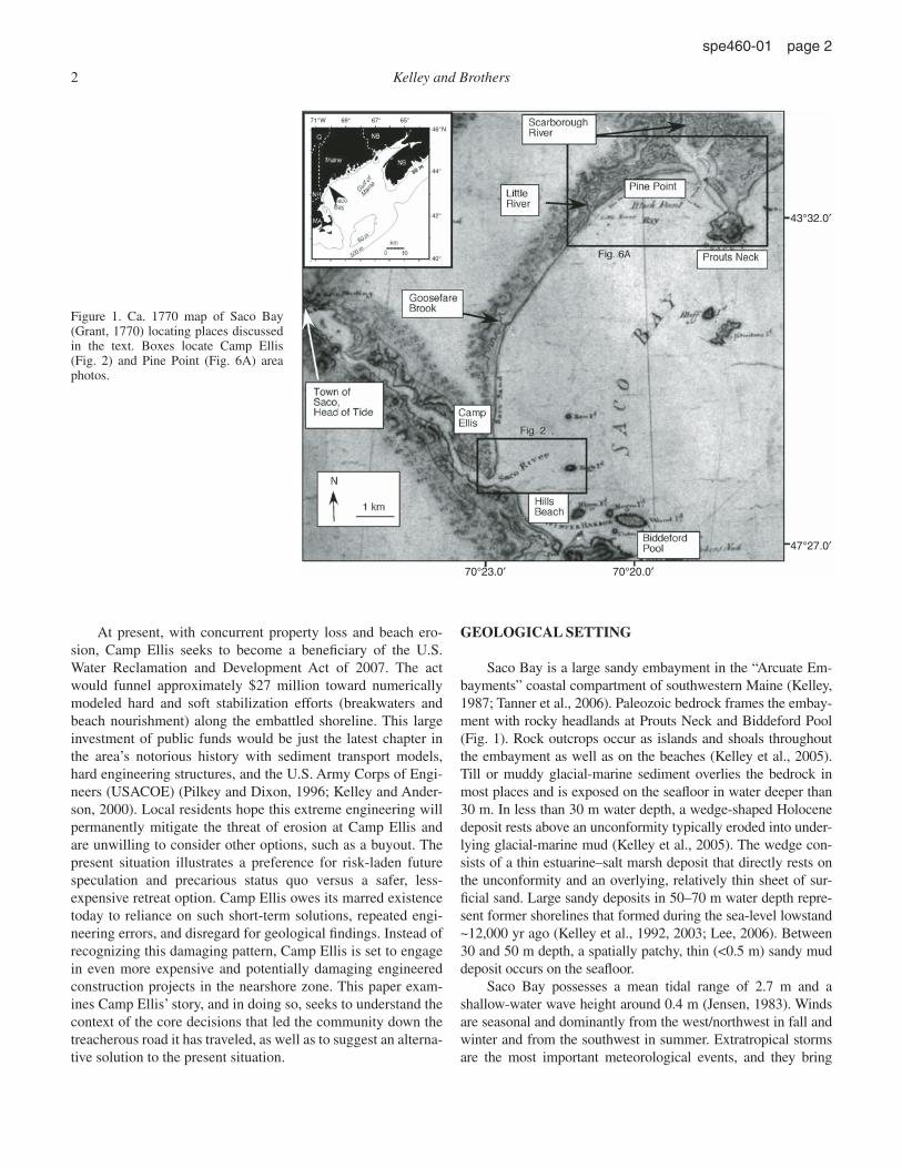
Saco Bay is a large sandy embayment in the “Arcuate Em-bayments” coastal compartment of southwestern Maine (Kelley, 1987; Tanner et al., 2006). Paleozoic bedrock frames the embay-ment with rocky headlands at Prouts Neck and Biddeford Pool (Fig. 1). Rock outcrops occur as islands and shoals throughout the embayment as well as on the beaches (Kelley et al., 2005). Till or muddy glacial-marine sediment overlies the bedrock in most places and is exposed on the seafl oor in water deeper than 30 m. In less than 30 m water depth, a wedge-shaped Holocene deposit rests above an unconformity typically eroded into under-lying glacial-marine mud (Kelley et al., 2005). The wedge con-sists of a thin estuarine–salt marsh deposit that directly rests on the unconformity and an overlying, relatively thin sheet of sur-fi cial sand. Large sandy deposits in 50–70 m water depth repre-sent former shorelines that formed during the sea-level lowstand ~12,000 yr ago (Kelley et al., 1992, 2003; Lee, 2006). Between 30 and 50 m depth, a spatially patchy, thin (<0.5 m) sandy mud deposit occurs on the seafl oor.
Saco Bay possesses a mean tidal range of 2.7 m and a shallow-water wave height around 0.4 m (Jensen, 1983). Winds are seasonal and dominantly from the west/northwest in fall and winter and from the southwest in summer. Extratropical storms are the most important meteorological events, and they bring
43°32.0′
47°27.0′
70°20.0′70°23.0′
40°
42°
44°
46°N
71°W 69° 67° 65°
Figure 1. Ca. 1770 map of Saco Bay (Grant, 1770) locating places discussed in the text. Boxes locate Camp Ellis (Fig. 2) and Pine Point (Fig. 6A) area photos.
2 Kelley and Brothers
spe460-01 page 2
strong winds from the northeast or southwest for up to days at a time (Hill et al., 2004). Most signifi cant beach erosion at Camp Ellis has occurred during extratropical storms with winds from the northeast (Hill et al., 2004).
The embayment hosts the largest salt marsh in the re-gion, the Scarborough Marsh (Jacobson et al., 1987), as well as the longest beach (van Heteren et al., 1996; Kelley et al., 1989b). The beach system, ~15 km long, is punctuated by inlets at Bidde ford Pool, the Saco River, Goosefare Brook, and the Scar borough River, from south to north, respectively (Fig. 1). The Little River inlet, just south of the Scarborough River, was closed in the late nineteenth century (discussed later herein). Sand on the beach ranges from medium to coarse size and fi nes toward the north (Farrell, 1972).
The Saco River discharges 3.1 × 10⁹ m3/yr to the sea on average (Barber, 1995), and estimates of sand discharge are ~8500 m3/yr (Kelley et al., 2005). This estimate was based on dredging records from the harbor at Camp Ellis, but it does not include sand that bypasses the harbor and is directly transported into Saco Bay. Based on current meter work, Brothers et al. (2008) estimated that ~900 m3 of sand escaped the river mouth during 56 d of fl ood in 2005. The recent current meter work and stream gauge analysis demonstrate that sand escapes past the har-bor and into the bay an average of 63 ± 24 d/yr, and it has done so for each of the 89 yr of recorded discharge (Brothers et al., 2008).
The Scarborough and Goosefare Rivers pass through large salt marshes and discharge relatively small quantities of water and probably no sand into the bay (Farrell, 1972). Each inlet, including Biddeford Pool, is deemed a sand sink (van Heteren et al., 1996) and not a source of sand to the bay.
Based on historical maps, spit orientations, and dredge spoil movement, it is presently accepted that the Saco River was the main source of sand for the regional beaches (Kelley et al., 2005; Brothers et al., 2008) and that sand travels north from the river mouth. Earlier ideas are described herein, but recent observations do not account for the precise pathway or rates of sand movement from the mouth of the jetties to Pine Point (shoreface or long-shore transport), nor the specifi c conditions that promote sand movement (tidal or storm currents and waves). It is clear that human construction has profoundly altered rates and pathways of sand movement in the past century (Kelley et al., 2005), and original conditions (pre-1870) may not be relevant to the contem-porary situation.
METHODS
This paper presents a case history of the cultural development of Camp Ellis, Maine, in light of ongoing geological processes. Because human activity dominates much of the recent history, we have utilized many nonscientifi c, non-peer-reviewed sources, including newspaper accounts, USACOE reports, consultant reports, and letters between public offi cials. Several earlier un-published theses also involved interviews with public offi cials as well as reviews of available literature, and these are used and cited
here (Cervone, 2003; Brothers, 2006). One consistent diffi culty we encountered was identifying exactly when the U.S. Army per-formed earlier projects. Reports by the USACOE refer to dates when projects were either authorized, appropriated, begun, or completed, and it is sometimes unclear which time is referred to in a reference. Similarly, USACOE activities are divided between improvements and maintenance, fl ood control, and other catego-ries that appear to be inconsistently used. Exact volumes of mate-rial dredged are also confused by accounts of anticipated dredge volumes and actual volumes (Normandeau Associates, 1994). We have tried to be consistent and refer to actual times of construction initiation and actual volumes dredged, and cite to our sources.
INDUSTRIAL PERIOD: 1866–1940
Construction Activity and Shoreline Responses at Camp Ellis
Saco was settled by the British in the early seventeenth cen-tury, and sawmills were established at the head of tide on the falls of the Saco River, ~8 km upstream of the river mouth. By the middle of the nineteenth century, textile plants used power from the waterfalls and dominated local industries. Coal, imported by water and later rail, was increasingly important as a source of energy (Cervone, 2003).
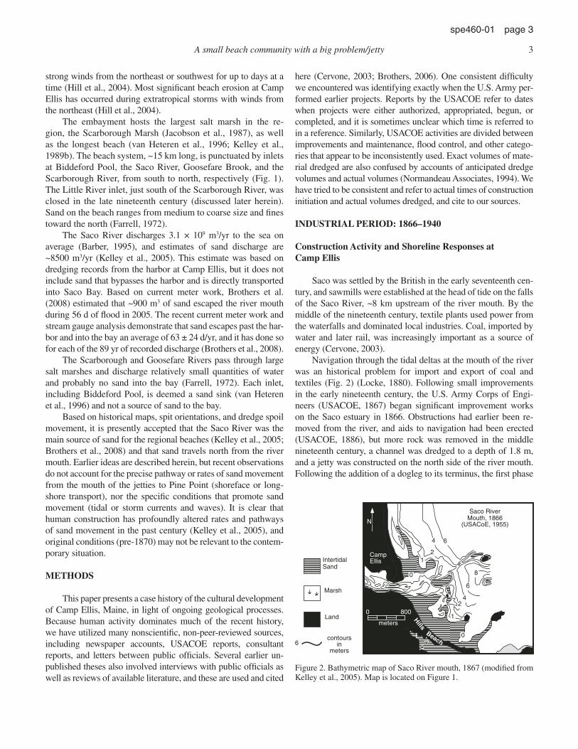
Navigation through the tidal deltas at the mouth of the river was an historical problem for import and export of coal and textiles (Fig. 2) (Locke, 1880). Following small improvements in the early nineteenth century, the U.S. Army Corps of Engi-neers (USACOE, 1867) began signifi cant improvement works on the Saco estuary in 1866. Obstructions had earlier been re-moved from the river, and aids to navigation had been erected (USACOE, 1886), but more rock was removed in the middle nineteenth century, a channel was dredged to a depth of 1.8 m, and a jetty was constructed on the north side of the river mouth. Following the addition of a dogleg to its terminus, the fi rst phase
Saco River Mouth, 1866
(USACoE, 1955)N
0 800
meters
2
8
6
42
1
0
1
4
Hills
Beach
Land
IntertidalSand
Marsh
6
0
Camp Ellis
contours in
meters6
Figure 2. Bathymetric map of Saco River mouth, 1867 (modifi ed from Kelley et al., 2005). Map is located on Figure 1.
A small beach community with a big problem/jetty 3
spe460-01 page 3

of the north jetty was completed by 1873 to a length of 1280 m and raised to prevent beach sand from washing over it into the channel (Fig. 3) (USACOE, 1955).
At the time of the initial work, no cultural development was in evidence at Camp Ellis (Fig. 2), although boathouses belong-ing to people who fi shed may have existed. The ebb tidal delta was well developed with a northern marginal fl ood channel,
channel-margin linear bars, and a central ebb channel. The swash platform was probably a dynamic surface with swash bars that shifted positions and were a cause of navigation uncertainties. The terminal lobe extended to between 4 m and 6 m depth, but rock obstructions complicated its defi nition.
The channel shoaled continuously during the early stages of work, and additional dredging and improvements were requested by industries in the Saco area (USACOE, 1886). The nautical chart of 1877 (Fig. 3) depicts the completed fi rst stage of the north jetty, attached to a small spit as well as remnants of the ebb tidal delta. A complex channel with bars existed on the disintegrating ebb tidal delta, and a large looped bar extended ~1 km north of the jetty. By the late 1880s (Fig. 4), although substantial shoals remained in the navigation channel, the ebb tidal delta morphol-ogy was largely eliminated, except for a few sand bars that the rock structure rested upon. Intertidal sand bars on the northern side of the jetty suggest continued transport of the remnant tidal delta sand toward the beach to the north. Such collapse of the tidal delta following construction of the jetty is consistent with more recent observations elsewhere (FitzGerald, 1988) and led to enlargement of the beach at Camp Ellis. The enlargement of the beach was attributed by the USACOE to sand moving from north to south within the littoral cell and then out along the north jetty and into the navigation channel (USACOE, 1910). Little cultural development is depicted on the beach between 1867 and 1891 (Fig. 5A), except for the railroad line that brought people to a ferry crossing at the river.
To facilitate commerce, in 1886, the U.S. Army considered (1) lengthening the north jetty, (2) raising the north jetty, (3) build-ing a south jetty, and (4) dredging the channel deeper (Fig. 4). Since “the effect of the north breakwater…was practically
N
1 km
1877
Goosefare Brook
Camp Ellis
Figure 3. Camp Ellis area from U.S. Coast and Geo-detic Survey Chart 6 (1877). Location of the map is the same as Figure 2.
Proposedconstruction
Existing, 1887construction
N
1 km
Figure 4. Existing and proposed con-struction at Saco River mouth, 30 June 1887 (modifi ed from USACOE, 1886, and anticipating future appearance of jetty). Location of the map is the same as Figure 2.
4 Kelley and Brothers
spe460-01 page 4

1 km
N
1923
B
1 km
N
Biddeford, ME Quad., 1891A
Figure 5. (A) 1891 U.S. Geo-logical Survey map of the Camp Ellis area. (B) 1925 U.S. Coast and Geodetic Survey chart 231 (actually surveyed in 1923). Ar-row points to spur jetty erected in 1912). Location of the map is the same as Figure 2.
A small beach community with a big problem/jetty 5
spe460-01 page 5

negligible ” (USACOE, 1924, p. 17), a south jetty was begun and extended in at least two stages to constrain the river fl ow and scour the channel. The north jetty was also raised, and the chan-nel was dredged. By 1924, the south jetty was 1460 m long, but it was lower than the north jetty, since its function was to constrain channel fl ow more than prevent longshore sand from entering the estuary (Fig. 5B). Despite the jetties, substantial sand remained within the navigation channel and seaward of it into the early twentieth century (Fig. 5B).
A comparison of the area from 1866 to 1923 indicates that much of the sand from the ebb tidal delta had been removed, though it had not all entirely escaped the area. Between the north jetty and Sharps Rocks, water was barely 1 m deep in 1877, but was charted at 5.2 m deep (17 ft) in 1923 (Figs. 3 and 5B). The 1923 survey shows that the north jetty still rested on an extensive shoal that is also depicted in the 1877 map, but depths adjacent to the north jetty increased from 1 m in 1877 to 2 m in 1923. A wide beach from the north jetty to Ferry Beach, which apparently grew from sand derived from the ebb tidal delta, was reduced to a small bulge of sand in the wave shadow of Eagle Island. A similar small tombolo extended from Camp Ellis to a shallow rock in 1923.
The 1923 map also depicts the development of a grid of roads in what is now named “Camp Ellis.” It is also notable that the fi rst structure not directly related to navigation, a 122-m-long “spur jetty,” was erected parallel to and 46 m from shore off the north jetty in 1912 (Fig. 5B) “to protect against outfl anking during storms” (USACOE, 1955, p. 10). This expansion of duties from strictly navigational concerns to shoreline protection dem-onstrates a change in both character and expectations of Camp Ellis and the USACOE.
The area was surveyed 12 times between 1859 and 1955 (USACOE, 1955) because of chronic shoaling, especially be-tween the jetties. To remedy this, the north jetty was extended 488 m by 1930 and 262 m by 1938. Sand continued to enter the project area during spring fl oods (Brothers et al., 2008), although the U.S. Army thought that sand came from around the landward end of the structure and “by wind and wave uprush” (USACOE, 1955, p. 10), presumably over the top and at the landward termi-nation of the structure.
Construction Activity and Shoreline Responses at Pine Point
Pine Point was a barrier island that was bounded by the Scarborough and Little River inlets in the eighteenth century (Fig. 1). In 1875, the Little River inlet had closed (Farrell, 1972), and a railroad line crossed the site of the former inlet by 1877 (Fig. 6A). The Little River inlet had been open for thousands of years and permitted several meters of salt marsh peat to accu-mulate before its abrupt closing; thus, it is likely that sand from Camp Ellis closed the Little River inlet. Once it was closed, sand that was transported from the south bypassed the old fl ood tidal delta of the Little River and accumulated farther north (Farrell, 1972; Kelley et al., 2005).
The ebb tidal delta of the Scarborough River displayed prominent channel-margin bars on top of a substantial shoal with swash bars in 1877 (Fig. 6A). A road from the mainland reached Pine Point by 1877, and a dirt road led halfway across the spit to a structure on the edge of the salt marsh, but the area was otherwise unsettled.
Examination of U.S. Geological Survey topographic maps shows that a road with 13 houses existed on Pine Point by 1891 (map not shown because shoreline was the one used in 1877). On the 1916 U.S. Geological Survey topographic map, a network of roads was established on Pine Point, and 56 houses had been built. A large new beach ridge also had begun to develop seaward of the original Pine Point barrier spit, and the ebb tidal delta of the Scarborough River exhibited substantial shoaling toward the south, with new bars in the throat of the inlet (Fig. 6B). The ebb tidal delta shows development of a convex-seaward terminal lobe in 1923 (Fig. 6B) that was absent in 1877 (Fig. 6A) and elonga-tion of channel-margin bars.
Growth of the Pine Point spit continued until the fi rst aerial photograph of the area in 1940 (Fig. 6C). In 1940, the intertidal area appears obscured by high water, but the new spit had grown and narrowed the Scarborough River inlet by more than 50%. The northern tip of the original spit had also grown to the edge of the main channel of the estuary. None of this new land was yet developed, and a low swale (Fig. 6C; unlabeled arrow) separated the two spits.
Understanding of Coastal Processes
The Saco River, like other large streams in New England (Horne and Patton, 1989; FitzGerald et al., 2000; Brothers et al., 2008), experiences a snowmelt-augmented freshet in the spring and delivers sand to the sea. The U.S. Army recognized this in early reports: “The river, rising back in the White Mountains, during spring freshets carried large quantities of sand and…logs, sawdust and other refuse, with it” (USACOE, 1886, p. 5). Dams along the river are of a “run of the river” sort, in which water and sediment pour over their tops in the spring without impound-ing sediment in the reservoir (Cervone, 2003). Despite this early knowledge of sand transport down the river, sand entering the navigation channel was later ascribed to “a constant movement of sand from north to south along the ocean beach” (USACOE, 1910, p. 3). In this early phase of development of the river mouth, it is understandable that the U.S. Army overlooked the role of the river as a supplier of sand because the break up of the ebb tidal delta left a large volume of visible material near the grow-ing structures and adjacent to the channel (Figs. 3–5). The river was not ignored by the U.S. Army, and was noted for its ability to “scour the channel clear” after fl oods (USACOE, 1934, p. 9).
The movement of sand from south to north and the result-ing enlargement of the Pine Point spit were not noted by the USACOE. Their early belief that material moved from north to south was never reexamined in the fi eld (USACOE, 1910, 1955). Although the growth of Pine Point was supplied by sand from the
6 Kelley and Brothers
spe460-01 page 6

south and abetted by the closure of the Little River inlet, changes in the tidal prism of the Scarborough River estuary may have in-fl uenced the narrowing of the inlet as well. The area of salt marsh landward of the Little River inlet was fi rst separated from the ocean with closure of the inlet, and then it was cut off from the Scarborough estuary when the road was built from the mainland to Pine Point. Two railroad lines across the Scarborough estuary and the coastal highway across the upper estuary further reduced the tidal prism of the estuary. With a reduction in the tidal prism
of the Scarborough estuary, the cross-sectional area of the inlet naturally decreased as well (O’Brian, 1969).
Beach erosion became an issue at Camp Ellis and Hills Beach early in the twentieth century. The USACOE measured a seaward growth of the Camp Ellis shoreline of almost 200 m be-tween 1866 and 1883, followed by shoreline recession of more than 100 m between 1896 and 1909 (Table 1; USACOE, 1955, 1992). Residential development apparently followed beach accretion and continued during the period of erosion. In two
AN
1 km
1877
1940
Pine Point
N
1 km
former Little RiverInlet
C
N
1 km
1923
B
Figure 6. (A) Pine Point area from U.S. Coast and Geodetic Survey Chart 6 (1877). (B) Pine Point area from U.S. Coast and Geodetic Survey Chart 231, surveyed in 1923. (C) Air photo from Pine Point, 1940 (from Farrell, 1972). Map is located on Figure 1.
A small beach community with a big problem/jetty 7
spe460-01 page 7

separate studies (USACOE, 1920, 1939), the U.S. Army denied that the navigation project caused shoreline erosion (“the erosion was not caused by the Federal navigation project” (USACOE, 1939, restated by USACOE, 1955, p. 1), although no fi eld study was conducted. In 1935, the Beach Erosion Board, in an un-published study, recommended either wooden bulkheads or a “concrete promenade” to prevent erosion of the beach houses (USACOE, 1955).
Economic Justifi cation of the Navigation Project
The original purpose of the navigation aids at the Saco River mouth was to improve navigation for supporting industries in the Saco region. Although economic data to justify the growing expenditures appeared to come from local interests (Cervone, 2003), the U.S. Army accepted them. At each phase of the en-largement of the project, there were dissenting voices from the USACOE (1910, 1924, 1934), but the structures were enlarged in a piecemeal fashion in any case.
Commerce on the river competed with railroads just as New England industries competed with textile production to the south throughout this period. Growth of rail traffi c, both for the import of coal and export of manufactured goods, exceeded shipping tonnage by early in the twentieth century. In 1910, for
example, total river tonnage received was 50,746 tons, with noth-ing shipped out, compared with 63,276 tons received by rail, and another 131,714 tons exported by rail (Cervone, 2003). This sort of data led the division engineer, Colonel Knight, to write, “Con-sidering the commerce to be benefi ted and the probable cost of survey, of repairs of existing works, of completing existing and of extension of project [sic], I do not deem this locality worthy of improvement by the General Government, and I am of the opin-ion that the completion of the existing project is not justifi ed” (USACOE, 1910, p. 4).
The unsatisfactory economics continued, and as manufac-turing left New England, the need for the navigation project dis-appeared. By 1940, the last coal vessel transited the river, and the industrial phase of the Saco estuary was over. The navigation project, ironically, was largely complete by then.
RESIDENTIAL PERIOD: 1940–2001
Construction Activity and Shoreline Responses at Camp Ellis
Following completion of the jetties at the Saco River mouth, and the termination of the commercial activity they were intended to enhance, relatively few structural changes occurred for several
TABLE 1. SHORELINE CHANGES AT CAMP ELLIS IN THE CONTEXT OF CONSTRUCTION AND METEOROLOGICAL EVENTS
Time period(yr) Construction activity
Number of storm events
coincident with high tides
Shoreline change at four locations 31, 62, 124, and 155 m north of the jetty
(m)1775–1859 1836, construction of piers, removal of
obstructions, and placement of cribwork at mouth
2 +49 +32 –20 –41
43+42+01+7+0*.A.N6681–95811866–1872 1867–1868, jetty extended 914 m, north
jetty raised to +2.7 m above mean high water (AMHW); 1869–1871, jetty length increased 366 m to total 1280 m
0 +100 +68 +46 +122
09+89+88+0.A.N3881–27811883–1892 1885–1897, jetty extended to 1280 m long
and raised to +4.6 m AMHW; the most landward portion raised +2.7 m AMHW
2 –10 +7 +54 +73
002–7–1.A.N6981–2981.D.N381–931–701–9.A.N9091–6981 †
.D.N7+7+7–0.A.N2191–90911912–1923 1912, a spur jetty constructed, 122 m long
at an elevation of +2.6 m AMHW5 +22 –7 –20 –24
1923–1938 1930, jetty extended 488 m; 1936–1938, jetty extended 262 m to total 2012 m; 1936–1937, most landward portion raised +4.6 m AMHW
5 –59 –59 –34 –32
1938–1994 1958 landward portion repaired; 1968–1969, jetty extended 259 m, landward portion raised +5.2 m AMHW and sand tightened
18 –27 +5 +7 +10
64–72–02+94+244991–5771Note: Data are from personal letter by Colonel Richardson (1995). Data were provided as a supplement to the
1995 USACOE model study by Bottin et al. (1995).*N.A.—no activity.†N.D.—not determined.
8 Kelley and Brothers
spe460-01 page 8

decades. Sand formed a pronounced bar parallel to the north jetty and connected to the shoreline near a shoal that had formed a wave shadow since the beginning of the project (Fig. 7A). This feature has appeared in all air photos since the early 1950s and remains today (Farrell, 1972; WHG, 2006). The bar is separated from the jetty by a scoured area where the ebb tidal delta once existed. A large fl ood ramp accumulated near the landward end of the north jetty, and an additional bar framed the southern side of the channel. A sand beach extended from the ocean to the river side of the jetty, where erosion continued to threaten to outfl ank the structure (USACOE, 1955). This sand beach abetted sand movement into the river. Continued erosion elsewhere in Camp Ellis led to construction of a large rip-rap seawall on Surf Street in 1953 (Fig. 7A).
By 1969, interest in redeveloping the river mouth for the commercial lobster industry emerged, and a 4.25 ha (10 acre) harbor was dredged to 2 m (MLW [Mean Low Water]) along
with a nearby “turning basin.” This work was matched by the creation of a parking lot and boat launch by the state (Fig. 7B). Dredging for the anchorage eliminated some of the fl ood tidal delta, but sand began to accumulate immediately on the upstream and downstream sides of the parking lot.
To further prevent sand from entering the river channel and to secure the north jetty, in 1969–1979, the outer 259 m were raised to 5.2 m (MLW) in height, and an additional 259 m along the landward side of the jetty were raised to 3.4 m from 1.7 m height. The inner portion of the north jetty was also in-tentionally made more refl ective by orienting the north-facing stones toward the incoming waves. The south jetty was raised and strengthened, and the landward terminations and walls of both structures were secured (USACOE, 1992). In 1982, an additional 1.2 ha anchorage was added to the harbor, and ice breakers were installed to protect boats and harbor infrastructure (USACOE, 1992).
1953 Surf St. seawall
200 m
jetty- parallel bar
flood- tidal delta
11/29/67
A
harbor
parking lot
4/23/71
B
Figure 7. (A) Photo mosaic of Camp Ellis taken 29 November 1967 (from Farrell , 1972, his Fig. 27b). (B) Oblique air photo of Camp Ellis from 23 April 1971 (from Farrell, 1972, his Fig. 31b). Scale on A is approximate; no scale is possible for oblique photo in B. Location of the map is the same as Figure 2.
A small beach community with a big problem/jetty 9
spe460-01 page 9

Construction Activity and Shoreline Responses at Pine Point
After 1940, the Pine Point spit continued to grow, and the Scarborough River inlet narrowed as a result of contin-ued introduction of sand moving north and the closure of the sand sink that was the Little River inlet (Fig. 8A). By 1946, the Town of Scarborough petitioned the USACOE to stabi-lize the Scarborough River inlet (USACOE, 1946). In 1956, the Army dredged the channel and an anchorage on the Pine Point side of the inlet and put the dredge spoils onto Pine Point (Fig. 8B). The low swale between the older and newer spits was fi lled, and all of the land was elevated by 1957. A jetty was constructed on the south side of the Scarborough River inlet shortly after that to inhibit the continued introduction of sand. The estuarine end of the spit was armored to prevent erosion of the spit tip as wakes generated by boat traffi c in the channel led to property loss in the 1990s.
Dredging of the Scarborough River inlet continues to be a chronic problem (Table 2), and this location requires more dredg-ing than any other inlet in the region (Kelley et al., 2005). Sandy spoils from this activity were deposited offshore after Pine Point became developed and were even barged to Camp Ellis in 1996. Erosion of Western Beach, on the eastern side of the inlet, now requires dredged sand to be located in this area (Maine Geologi-cal Survey, 2009). No study has examined this formally, but the eastward projection of the ebb tidal delta of the Scarborough River inlet apparently has blocked sand from getting to Western Beach (Fig. 8C).
Understanding of Coastal Processes: 1940–2000
Following the loss of houses and whole streets, the City of Saco constructed a 213 m rip-rap seawall in front of Surf Street, Camp Ellis, in 1953 (Figs. 7A and 9). This was toppled, and in 1955, the city requested another federal study of the role of the north jetty in causing the erosion under Section 2 of the River and Harbor Act (USACOE, 1955). This study was the largest to date, but it was not a process-oriented study as much as an examination of shoreline and bathymetric changes, a discussion of wind, waves, and geomorphology, and review of earlier re-ports. A conclusion was that: “The beach material in the study area is of glacial deposit origin with present position due to wave and wind work…there is apparently no natural source of mate-rial other than by local erosion within the confi nes of Saco Bay” (USACOE, 1955, p. 6). This was based on an earlier assertion that there were glacial sediments in the area and not on inde-pendent mapping. The river was not considered a source of sand based on a single current velocity measurement from 1892 and the observation that the jetties extended far out to sea. The as-sertion from 1910 (quoted above) that sand moved from north to south and thence into the estuary completed the conceptual model of how the estuary operated, although it was never fi eld checked by the U.S. Army.
The centerpiece of the 1955 report involved a series of shore-normal topographic/bathymetric profi les between the north jetty and a point 305 m (1000 ft) north, bounded by a line 183 m (600 ft) west of the spur jetty and bathymetric contours measured during past surveys (Fig. 10). The time-series evalu-ation of the increasing depth offshore led to the conclusion that the shoreface had eroded 61,900 m3/yr (81,000 yd3/yr) between 1859 and 1955. Since the assumed direction of longshore trans-port was from north to south, presumably the eroded material entered the estuary around the outer or landward ends of the jetty (USACOE, 1955). This was far more sand than had been dredged from the estuary during the entire project, however. It was further stated that the jetty “affected the shore benefi cially by impound-ing fi ne material seaward of the 6 foot” contour (2 m) and a small distance north of the jetty (the bar noted above). On the basis of their evaluation of the temporal changes in the area of land above the mean low and mean high water lines and a comparison of those changes with times of jetty construction and enlargement (Fig. 10), the Army concluded that “the Saco River jetties have not caused nor accelerated erosion in the study area” (USACOE, 1955, p. iii). They noted that the beach above high water reached its greatest extent in 1896, long after jetty construction, and it was at its smallest before jetty construction. The area above mean low water declined slowly through the time of interest, but it seemed to have been stable since 1912. There was no correla-tion in changes of area with jetty construction, and storms were cited as the cause of episodic erosion. The report concluded that beach replenishment or a revetment would be the best solutions to the problem, but that there was no federal interest to justify federal action. They further concluded that because “the jetty in its present state has a benefi cial effect on the shore, further bene-fi t could be obtained by raising and extending the inshore end to interrupt the lateral drift of material” (USACOE, 1955, p. E-8).
No action was taken after the 1955 report, and erosion con-tinued to claim property at Camp Ellis (Fig. 9). By 1976, the City of Saco requested more U.S. Army assistance. The U.S. Army report that followed (USACOE, 1976) noted that 20 additional properties had been destroyed and 12 lots lost at Camp Ellis in the prior 25 yr. No actual study of the problem was made, however. They restated earlier conclusions about the inferred north-south transport of sand from an unseen glacial source in Saco Bay, but new wording was added about the physical oceanography of the Saco estuary. This apparently was taken (without reference) from the theses of Farrell (1970, 1972), who demonstrated that the Saco was stratifi ed in the summer. The U.S. Army concluded that beach replenishment, a seawall, or an offshore breakwater would ameliorate the erosion problem, but that the benefi t/cost ratio of such a project was too low to warrant federal action.
Farrell’s work (1972), though unpublished, was ground breaking in other ways. He compiled a complete time series of maps and photos of Saco Bay (many used in this paper) and was the fi rst to realize that sand from the erosion of Camp Ellis led to the historic growth of Pine Point. He also conducted a reconnais-sance survey of the seafl oor of Saco Bay and noted no obvious
10 Kelley and Brothers
spe460-01 page 10

N
500 m
6/1/53
A
dredged material
500 m
4/30/57
B
Western Beach
N
500 m
6/5/76
C
Figure 8. (A) Air photo of Pine Point, 1 June 1953 (from Farrell, 1972). (B) Air photo of Pine Point, 30 April 1957. (C) Air photo of Pine Point 5 June 1976. Scale on all photos is approximate. Location of the map is the same as Figure 6.
A small beach community with a big problem/jetty 11
spe460-01 page 11

sand source. These observations on the direction of longshore transport and lack of sand source in the bay were never cited by the U.S. Army.
In 1978, the largest storm on record struck Maine and led to $47 million in coastal damages, as well as more property losses at Camp Ellis (Ten Broeck, 1978). The state responded by bring-ing nationally prominent marine geologists to Maine, who fo-cused attention on rising sea level and the failed seawalls. The state hired a marine geologist (the senior author) and state and University of Maine scientists created beach development regu-lations that were adopted by Maine. These were the fi rst rules in the United States to prohibit seawall construction and require the removal of storm-damaged properties, among other things. For Camp Ellis, this meant that further armoring of the shoreline was no longer an option the state would allow.
Throughout the 1980s, federal, state, and university geolo-gists conducted studies in Saco Bay (Kelley et al., 1986, 1987, 1989a; Luebke and Grosz, 1986). These summarized earlier observations and initiated study of the seafl oor of Saco Bay. The U.S. Army responded to requests for help from the City of Saco with an offer for a concrete seawall at Surf Street but was rebuffed by the state because such structures were no longer allowed (Major Murphy, 1987, written commun.).
Renewed property losses in 1990–1991 led to the forma-tion of Save Our Shores–Camp Ellis (S.O.S) (Save Our Shores [S.O.S.] Camp Ellis, 2009). The public focus by this property-rights group led to the fi rst systematic university and state study of coastal processes in Saco Bay. Several theses (Barber, 1995; Dickson, 1999; Manthorp, 1995; van Heteren, 1996) led to pub-lished papers that: (1) demonstrated the competence of the Saco
River to deliver sand to the bay in the spring fl ood; (2) precluded an offshore source of glacial sand; and (3) showed that on geo-logi cal and historical time scales, sand moved north from the Saco River toward Pine Point (FitzGerald et al., 2005; Kelley et al. 1995, 2003, 2005; van Heteren et al., 1996). As a result of these studies, the state entertained thoughts of a buyout of en-dangered properties with a combination of U.S. Army and Fed-eral Emergency Management Agency (FEMA) monies (Fig. 11) (Vestal et al., 1995). In describing the prohibitive costs of an engineered solution to erosion at Camp Ellis, and the unknown impacts to nearby beaches, Maine Department of Environmental Protection Commissioner Dean Marriott wrote the U.S. Army to say: “All these concerns make non-structural solutions much more desirable” (Marriott letter, 28 January 1992).
In 1991, the S.O.S citizen group politically compelled the U.S. Army to conduct a Reconnaissance Section 111 study of the impact of the north jetty on the adjacent beach. This review of historical conditions and reports concluded that no new sand entered the system and that sand in the bay moved to the south (USACOE, 1991). They reiterated that a large seawall or a break-water coupled with beach replenishment would be the only ap-
TABLE 2. DREDGING ACTIVITY IN SACO BAY, 1827–1996
Year River channelVolume dredged
(m3)Up to 1872 Saco River 84,0731886 Saco River 12,5151912 Saco River 65,2791930 Saco River 63,4371939 Saco River 60,8241940 Saco River 48,1511956 Scarborough River 97,9441962 Scarborough River 114,6901965 Saco River 28,2791965 Scarborough River 25,0441969 Scarborough River 35,9361969 Saco River 66,7651969 Saco River 55,8931973 Scarborough River 144,3571973 Saco River 28,2791975 Scarborough River 69501978 Saco River 61,1441978 Saco River 38,2151982 Saco River 55791992 Saco River 10,0001992 Saco River 65,7061992 Saco River 19,1071996 Saco River 117,7091996 Scarborough River 68,814
1991 photo
N
Saco River
N. Jetty
0 200
Meters
1991
1967
1908
Property Lots
Figure 9. Property loss at Camp Ellis, Maine, and shoreline change (modifi ed from Kelley et al., 2005). Scale on all photos is approximate. Location of the map is the same as Figure 2.
12 Kelley and Brothers
spe460-01 page 12

propriate solutions, but that the benefi ts were outweighed by the costs, and no federal action would be taken. In an accompany-ing letter, Colonel Morris noted that: “The study also found that the navigation project may, to some extent, infl uence the coastal processes in the area” (Morris letter, 14 January 1992).
The state response was swift; Maine Governor McKernan wrote to General Hatch of the U.S. Army: “Our feeling was that it was possible to put a package together involving participation and funding from FEMA, the Corps, the State of Maine, and the City of Saco to bring to fruition the option of a buy-out and con-struction of a dune and beach system along with any changes to the jetty that were determined to be appropriate as a result of the Section 111 study” (McKernan letter, 28 May 1992). Political force from Senator George Mitchell (majority leader of the U.S. Senate) forced the U.S. Army into another study. Initially, this
was to be a joint state-federal investigation, and the state pro-posed a fi eld measurement/monitoring program in conjunction with the planned placement of dredged sand at Camp Ellis. The U.S. Army unilaterally decided that a physical model of the sys-tem at the Waterways Experimental Station in Vicksburg, Missis-sippi, was “the best means for studying processes and solutions to the localized erosion problems” (USACOE, 1991, p. B2), and that no fi eld observations were needed.
The physical model was a relatively expensive ($850,000, compared to the $170,000 state/university study), large-scale (1:100) concrete representation of the Camp Ellis area, including 2438 m (8000 ft) of shoreline (Fig. 12). The U.S. Army favored this model over the collection of fi eld observations (“prototype data”) because they could evaluate wave height and sediment transport under a variety of situations (breakwater, spur jetty, no
Figure 10. Graph of area of land land-ward of mean high and low water, three depth contours, and the times of jetty construction and enlargement (from USACOE, 1955, Fig. E-1). The growth on the area landward of the mean high water line in 1896, well after completion of the fi rst phase of construction of the north jetty, was taken as evidence that the jetty was benefi cial to the beach and not a cause of erosion.
A small beach community with a big problem/jetty 13
spe460-01 page 13

jetty, offshore berm, etc.), with varying wave conditions, all with a single structure (Bottin et al., 1995). Maine coastal geologists opposed this because the scale model was excessively simplistic, lacked functioning estuary and tides, and a deformable seabed (cf. Figs. 12A and 12B). The U.S. Army acknowledged that the model was not ideal, but “In view of the complexities and un-knowns involved in conducting ‘moveable bed studies’ and due to limited funds and time,” only a “qualitative” study of sand transport could be conducted (Bottin et al., 1995, p. 10). The physical model study concluded that a spur jetty, perpendicular to the north jetty and backfi lled with sand, was the solution most likely to succeed. Interestingly, the model also indicated that: “All conditions tested with historical alternatives resulted in sedi-ment constantly moving north [italics added] out of the Camp Ellis Beach area” (Bottin et al., 1995, p. 36). In the end, the Army refused to take any action because costs outweighed benefi ts. They also believed that the erosion was rooted in history; the lost
Camp Ellis houses were built on temporary land impounded by jetty construction, and erosion was storm related and not associ-ated with the jetty.
THE PRESENT SITUATION
Distressed by the lack of action on the U.S. Army’s part, local authorities and citizen groups renewed their efforts for an engineered answer and rejected any talk of a buyout (Saco Bay Implementation Team [SBIT], 2005, 2006, personal commun.). In 2001, the city performed an economic assessment of the vul-nerable properties in Camp Ellis (S.M. Dickson, 2006, personal commun.; R. Michaud, 2006, personal commun.; Lawton, 2001). The city’s analysis included a larger set of properties than previ-ous assessments and produced a far different result than the esti-mate found by Vestal et al. in 1995 ($12 million). The 2001 study estimated that the vulnerable properties’ net value exceeded $41 million (Lawton, 2001).
Economists explained this dramatic increase by the surge in shorefront property values nationally (Lawton, 2001). Despite the fact that many of the endangered Camp Ellis properties are modest dwellings that have remained on the market for years (Higgins, 1991), Camp Ellis was compared to Kennebunkport, Maine, President G.H.W. Bush’s summer retreat, and a premier New England coastal community. The 2001 assessment of Camp Ellis properties assumed future federal engineering activity that would restore and increase the amount of shorefront property available at Camp Ellis.
The artifi cially high property values fueled Camp Ellis resi-dents’ desire for a federally funded engineering solution. More importantly, the infl ated values obfuscated an alternative way to mitigate loss to Camp Ellis homeowners, that of buying out the properties. Because property values rose, the idea of a buyout, once a likely alternative and promulgated by federal and state
jetty
future Camp Ellis Park
commercial establishments
Figure 11. Artists representation of Camp Ellis following a property buyout and creation of a park (from Maine Department of Environ-mental Protection).
43°28′58″W
43°27′33″W
70°23′08″N
70°23′08″N
Figure 12. Aerial photo of Camp Ellis denoting locations of (A) USACOE proposed hard structures; (B) nearshore, and (C) offshore current observations made by two Acoustic Doppler Cur-rent Profi lers. Locations of two islands responsible for wave refraction are also shown (modifi ed from WHG, 2006).
14 Kelley and Brothers
spe460-01 page 14

agencies (Fig. 11), became logistically infeasible and universally abhorred by Camp Ellis residents (R. Marvinney, 2006, personal commun.; S.M. Dickson, 2006, personal commun.; SBIT, 2003, 2004 , 2005, personal commun.; Lawton, 2001).
The increased interest from local residents, organized property rights groups, and city offi cials caused their local congres sional representative and a Maine senator to again seek erosion mitiga-tion, again through a Section 111 study. This 2001 invocation of Section 111 began with a geophysical study within the inlet and immediately adjacent to the jetties for sources of sand for beach nourishment at Camp Ellis (Hart Crowser, Inc., 2002). The hired consulting group found no appropriate locations for a borrow pit.
In 2003, the USACOE contracted with an engineering con-sulting company, Woods Hole Group (WHG), to model near-shore sediment transport patterns in Saco Bay and propose engi-neering solutions to the erosion problem at Camp Ellis (WHG, 2006). WHG conducted a wave/current study from February to April 2003 seaward and landward of two islands located in the southern portion of Saco Bay (Fig. 13). From these time-series data, WHG modeled the wave energy acting on the Saco Bay shoreline. It is worth noting that there were no major northeast storms experienced during the data collection. WHG initially pro-posed 25 engineering solutions, all of which included 76,455 m3 (100,000 yd3) of beach nourishment at Camp Ellis. From the onset, several potential construction alternatives were assessed, including a “do nothing” option. Alternatives that did not protect the area immediately seaward of Camp Ellis were eliminated; alternatives that created a shadow zone seaward of Camp Ellis were considered in the later, more time-intensive, sediment trans-port modeling stages. In addition, alternatives were excluded or modifi ed in the initial stages after input from the USACOE. In February 2006, WHG turned in the fi nal draft report of their mod-eling efforts (WHG, 2006), and later that month, the USACOE New England division presented the fi nal proposed alternatives, Plan 6 and a modifi ed version of Plan 25 called Plan 25A at a public meeting (Fig. 12) (USACOE, 2006, personal commun.).
Unlike Plan 25, and the other 24 original alternatives considered by WHG, Plan 25A was never modeled. Despite this drawback, Plan 25A is more popular with Camp Ellis residents than Plan 6 because breakwaters appear to offer the most protection.
State and university geologists have criticized aspects of the draft report and its modeling, in part because none of the natu-ral complexity in nearshore sand transport was recognized by the model (S.M. Dickson, 2007, written commun.). Continued research conducted by university scientists found that the Saco River is a signifi cant source of sand for Saco Bay on an annual basis. Further, they observed that actual sand transport pathways within Saco Bay are highly variable, not restricted to alongshore movement, and that sand is not confi ned by Saco Bay and may escape beyond the bounding bedrock headlands (Brothers et al., 2008). These fi ndings corroborate previous observations made by Dickson (1999), Hill et al. (2004), and Kelley et al. (2005). The WHG model did not allow for riverine-introduced sand, on/offshore sand transport, or sand erosion and accumulation (a changing seafl oor), nor the possibility for sediment escape from Saco Bay. Modeled sand did move north, but all sand was re cycled within the bay with no losses or gains, contrary to pub-lished work that was not cited in the report (Kelley et al., 2005).
There is reasonable concern that the area north of the planned breakwater will erode due to wave refraction around the struc-ture. Though backfi lling of the area landward of the breakwater with replenished sand is planned to minimize this erosion, future replenishment actions (and their cost) would not be the responsi-bility of the U.S. Army, but of an unnamed “host” to the project.
The 2007 Water Resources and Development Act authorized approximately $27 million for the Camp Ellis Beach Restora-tion project. Currently, the appropriation is under review because several regulatory determinations must be met, including federal consistency under the Coastal Zone Management Act. Moving this proposal forward will require approval from federal, state, and local entities (MNRPA, 1993).
DISCUSSION
Construction Activity
The purpose of the Saco River navigation structures has changed over time, and associated coastal construction and its overall impact have signifi cantly expanded. The initial purpose was to accommodate industry, and until the end of the indus-trial period in 1940, all construction and dredging was focused on maintenance of the navigation channel to service industrial needs (Fig. 13). Most early studies also dwelt on the navigation issues, although complaints from local beach residents resulted in a consideration of erosion problems on the adjacent beaches (USACOE, 1939).
After 1940, when the industrial need for the navigation project ended, Congress could have deauthorized it with little concern (Fig. 13). By then, fi shing and recreation dominated the area, and the project had evolved locally as its impact expanded
ACTIVITY YEAR 1870 1890 1910 1930 1950 1970 1990 2010
ECONOMICIndustry Recreationand Residence
ENGINEERING Construction Maintenance * ** * * * * ***Dredging * * ** * **** ****Mitigation * * ?
SCIENCE Army * ***** ** ** **** ** * * *** * ** ** * *Non-Federal ** * *****
****
Figure 13. Schematic graph of activities in the Camp Ellis area versus time. Width of bars represents relative amount of an activity. Vertical lines represent times when project could have been terminated; dashed vertical line represents the present.
A small beach community with a big problem/jetty 15
spe460-01 page 15
across Saco Bay to Pine Point. Although sand from the collapse of the ebb tidal delta led to rapid beach growth at Camp Ellis (Fig. 10) and spread north to fi ll in the Little River inlet (Figs. 1 and 6), initially little attention was paid to these changes. By the 1920s, beaches at Camp Ellis and Pine Point were heavily devel-oped (Figs. 5B and 6B), and by the 1950s, sand dynamics driven by construction of the north jetty at Camp Ellis led home owners in each area to request mitigation. This second, rec reational, period , from 1940 to present, has been marked by construc-tion activity and studies (Fig. 13) to understand and mitigate the impact of the Saco River navigational structures (USACOE, 1946, 1947, 1955, 1992, 2006, personal commun.; Farrell, 1972; Kelley et al., 1989a, 1995, 2003, 2005; Barber, 1995; Man-thorp, 1995; van Heteren, 1996; van Heteren et al., 1996; Dick-son, 1999; Knisel, 2003; Brothers, 2006; Brothers et al., 2008). In Pine Point, the mitigation involved a new jetty at the mouth of the Scarborough River and its periodic dredging. In Camp Ellis, the mitigation has involved millions of dollars in federal studies, and hundreds of thousands of dollars in university and state studies, but no new structures have been built as of 2008. Involvement in Camp Ellis over time has grown from the inter-ests of some local industries to major roles by the City of Saco, Maine State government agencies, the governor of the state of Maine, and members of the state’s congressional delegation.
Understanding of Coastal Processes
Originally, there was little perceived need to understand coastal processes. The U.S. Army initially recognized that the Saco River delivered sand to the bay but misunderstood the late nineteenth-century accretion at Camp Ellis. As sand continued to clog the harbor, they developed the working hypothesis that sand moved toward Camp Ellis from the north, was partly entrapped by the north jetty, and partly bypassed the jetty to fi ll the anchor-age. This hypothesis explained the growth of Camp Ellis and the infi lling of the harbor, and it implied that the north jetty needed to be lengthened and elevated.
This conceptual model for how sand traveled in the Saco Bay system was repeated for almost a century (USACOE, 1992). To explain the chronic loss of property at Camp Ellis, the U.S. Army invoked storms and denied any role in the erosion by the north jetty. Storms were directly correlated to the property loss, whereas jetty construction was not, and so this hypothesis pre-vailed (Fig. 10) (USACOE, 1955, 1992).
In the early 1950s, the New England Division of the USACOE was simultaneously considering the growth of the Pine Point spit and the erosion at Camp Ellis (USACOE, 1955, 1946). Their Camp Ellis study determined that a large quantity of sand was being eroded from the beach and shoreface at Camp Ellis, but it did not relate this observation to the growth of the Pine Point spit because it violated their working hypothesis on the direction of longshore movement. Neither the U.S. Army study in Pine Point or at Camp Ellis references the other, and the Camp Ellis study developed a new hypothesis for the behavior of
sand in Saco Bay: it originates from a glacial source “within the confi nes of Saco Bay” (USACOE, 1955, p. 6). This untestable hypothesis of the source of beach sand allowed them to maintain their belief in the direction of longshore drift without examining it. It is diffi cult to understand how the USACOE, with decades of involvement in Saco Bay and in the midst of a large study of beach erosion there, could have failed to see the connection be-tween erosion at Camp Ellis and accretion at Pine Point.
When confronted with evidence contrary to their working hypotheses in the 1990s, the U.S. Army, in the words of Maine Governor McKernan, “walked away” from the problem (Gov-ernor McKernan, letter, 1992). When political pressure required the U.S. Army to conduct a study, they controlled the outcome by preventing state or university scientists from becoming di-rectly involved (funded) and performed experiments thousands of miles away that could never be observed or replicated by their critics (Fig. 12). Although they retained their hypotheses of sand source and lack of involvement of the jetty in erosion, the physi-cal model clearly indicated that their hypothesis on the direction of longshore transport was in error (Bottin et al., 1995).
The error in the direction of longshore was never cited in any retraction, but when new studies were begun in the twenty-fi rst century, northward transport of sand from Camp Ellis was the U.S. Army’s new working model (WHG, 2006). Just as they did not cite Farrell’s work on sand transport in the bay, the new-est study does not cite confl icting work by university scientists (Kelley et al., 2003, 2005; Brothers et al., 2008). The latest study, like prior work, was controlled by contracting with a private company and employed a numerical model that could not be rep-licated or reviewed by others. This report does not specifi cally consider whether the Saco River is a source of sand to the area, but rather it invokes new sources like Goosefare Brook and the Scarborough River (WHG, 2006).
Over time, just as the engineering activity has shifted from maintaining a navigation channel to mitigating the problems that activity spawned, studies of the project have also evolved. Early work was performed and published by the USACOE, but begin-ning with Farrell (1970, 1972), most studies are more academic and revolve around the impact of the jetties on the shoreline. Most research on Camp Ellis since the 1990s has appeared in sci-entifi c journals and theses. In contrast, the most recent USACOE study was completely contracted out and published as a consul-tant report (WHG, 2006).
The Coupled Human-Natural System
Liu et al. (2007, p. 1513) defi ned coupled human-natural sys-tems as “integrated systems in which people interact with natural systems.” In such a situation, an effort to manage the natural com-ponents while ignoring the human (or vice versa) “gives rise to the possibility that human agency and landscape processes can no longer meaningfully be treated separately” (Werner and McNamara , 2007, p. 394). The Saco Bay shoreline has many of the properties described for such a human-natural system.
16 Kelley and Brothers
spe460-01 page 16
Nonlinear DynamicsFor millennia, the Saco Bay littoral system was relatively
unchanging. Sand supply varied annually, and there was slow beach accretion (Kelley et al., 2005; van Heteren et al., 1996), but there is no evidence that any inlet closed until the late nine-teenth century, when sand from Camp Ellis fl ooded the Little River (Farrell, 1972; Kelley et al., 2005). Since that human-induced change, sand eroded from Camp Ellis has rapidly moved north at a rate much greater than in the past (Kelley et al., 2005). This longshore transport in turn closed the Little River and then shoaled the Scarborough River inlet until people responded by constructing another jetty there.
ThresholdsThresholds are transitions between alternate states within
a system. For Saco Bay, the construction of the north jetty rep-resents a threshold that permanently changed the entire inte-grated system. The erection of the 2030 m structure represents the relatively sudden introduction of a static, rock boundary to an otherwise sandy, dynamic system. It moved the point of sand introduction well offshore, increased the longshore current, and altered wave refraction near the river mouth. In addition to the physical changes within the Saco Bay littoral system, the jetty also wrought important social transformations. The demise of the ebb tidal delta that resulted from the initial construction of the north jetty created new land, however temporary, that prompted the residential beachfront community of Camp Ellis into exis-tence. The installation of residential interest in this system has dramatically infl uenced the bay’s engineering history and con-sequently its physical system. The beach system continues to change long after the initial structure was built, and it has induced humans to respond with proposals to build mitigating break-waters, which will still further perturb the beach.
Legacy EffectsThere is a temporal delay, or time lag, between an action
and its impact on either the human or natural system. Clearly, the long-lasting impact of the jetties represents a legacy effect, although the USACOE denies its signifi cance. There is an added spatial dimension to the legacy effect in that the north jetty has had a large impact on Pine Point, at the opposite end of the bay. It has been the spatial and temporal legacy effects of the jetty that have made it diffi cult for the people to understand how the overall beach system operates.
SurprisesCoupled human-natural systems can yield surprising effects
that cannot be predicted in advance. Following the great storm of 1978, the state of Maine did not respond by building more and larger engineering structures. Geologists clearly explained why seawalls led to beach sand loss and, in turn, further property loss. So, surprisingly, the state response to the storm was to ban all new engineering structures from its beaches. This state response probably increased the desire in local Camp Ellis residents to do
something to stop their property from falling into the sea and led to the present effort to construct a breakwater. Ironically, the same state law remains in effect and must be amended in some fashion to permit the proposed breakwaters.
If Saco Bay beaches represent a coupled human-natural system, then the effort to construct new breakwaters should be viewed as the most recent link in the cascade of events that have occurred since people began to meddle with the Saco estuary 150 yr ago. Although the USACOE believes the breakwaters will “solve” the problems at Camp Ellis, in all likelihood, the overall system, people, and beach will each respond on their own. Prop-erty values would soar in the newly protected Camp Ellis; high-rise buildings and marinas are reasonable expectations because the added infrastructure (and the taxes paid by residents) would help defray the cost of necessary, perpetual beach replenishment. Just as Pine Point gained at Camp Ellis’ loss earlier, Camp Ellis’ gain now will likely come at the expense of their neighbors to the north. Wave refraction around the breakwaters could draw sand from the nearby beach into the protected area behind the breakwater, leading to erosion of properties that are in no danger today. It is conceivable that these homeowners will take action themselves some day to request their own breakwaters.
An Alternative for the Future
What else can be done to protect Camp Ellis except build breakwaters or other forms of shoreline armor? Removal of the jetties is frequently mentioned during discussions of the problem, but the diffi culties with this are many: (1) marinas and lobster boats represent a constituency that will advocate to maintain the navigation project; (2) the cost to remove the jetties would be large; (3) there is no place to put all of the rocks from the jetties; and (4) removal of the jetties would likely lead to more erosion at Camp Ellis as the new, unfettered inlet adjusted to the situation.
The buyout option stands as the only viable, if unpopular, solution. It would not be necessary to remove the commercial properties at Camp Ellis because these are already protected by the jetty (Fig. 11). Likewise, properties located in the interior of Camp Ellis are not at risk and should remain. It is the approxi-mately twenty beachfront houses and associated infrastructure (sewers, seawalls, roads) that are at risk. These threatened proper-ties are easily identifi ed by fl ood insurance claims, visible storm damage, and their proximity to shoreline armoring, beach scarps, and other evidence of erosion. As discussed earlier, Lawton’s (2001) assessment of house values in Camp Ellis included prop-erties not at risk and compared Camp Ellis to Kennebunkport. His methods projected the cost to buy out all assessed proper-ties to exceed $40 million. When one assesses Camp Ellis based upon local conditions, a very different number is attained. No more than twenty homes in Camp Ellis are in danger and require a buyout. As of this publication, two of these homes are for sale and an additional home has sold in the past 18 mo. The current list prices for two of the endangered homes are $289,000 and $300,000. The price of the recently (April 2008) sold Camp Ellis
A small beach community with a big problem/jetty 17
spe460-01 page 17

home was $550,000. Another home in the near vicinity that is not threatened by erosion is listed for $374,900. A nonthreatened home in Camp Ellis sold for $181,000 in June 2008. The mean price of these fi ve homes is $338,980. If one uses this value as the average price for each endangered home, the cost of buying out 20 houses in Camp Ellis is $6,779,600. This value is an order of magnitude less than the cost of Plan 25A ($27 million). Remain-ing money could be put into beach replenishment at the local park created where properties once existed (Fig. 11). The public would clearly benefi t more from this solution than from more shoreline armoring. Those directly impacted would oppose this, although compensation for their properties is a generous offer, given that all houses were built after the jetties were constructed and beach erosion was recognized in the area.
There have been several times in the past when a decision was made regarding the future of the Camp Ellis area (Fig. 13): (1) in 1940, when no more commerce needed the project, but it was continued; (2) in 1969, when the state built the new anchorage/parking lot instead of seeking deauthorization of the project; and (3) in 1992, when the buyout option failed for lack of money. Following each of these decisions, erosion problems arose or continued. Now we face another time of decision. The future of Saco Bay’s beaches will be signifi cantly different depending on whether breakwaters or a park is created at Camp Ellis.
CONCLUSIONS
The problems at Camp Ellis have many sources, including poor understanding of coastal processes, the alteration of sedi-mentary dynamics, unsound development, and misguided policy initiatives. A principal fi gure in this tale of failed coastal man-agement is the USACOE. The USACOE initiated its actions at popular request, but it has since exhibited tendencies that have exacerbated problems they created.
1. The USACOE authorized a navigation project with mini-mal economic justifi cation that severely altered the natural sedi-mentary pathways in Saco Bay. The USACOE demonstrated little regard for the temporal or spatial impacts of the project, and the USACOE’s interference created new land that would subse-quently undergo decades of erosion.
2. The brief accretion of sand at Camp Ellis permanently altered the perception of Camp Ellis from an uninhabitable dynamic shoreline to that of a static substrate appropriate for residential housing. USACOE’s continued support for the navi-gation project after the exodus of industry, along with the City of Saco’s investment in infrastructure in Camp Ellis, encouraged this fallacy.
3. It is possible that the USACOE directly induced erosion by continuing the navigation project after its original economic justifi cation ended. Enlargement of the north jetty in 1969 cre-ated a more refl ective surface that increased wave height in the nearshore. It is possible erosion problems would have diminished with time had the north jetty not been built higher and made more refl ective. In addition, the increased mass of the north jetty along
with the project’s status as “ongoing” instead of “deauthorized” inhibited removal or alteration of the structures.
4. The USACOE adhered to established concepts and mod-els even in the light of new and better data and did not state and test hypotheses regarding Saco Bay in a scientifi c way. Thus, the conceptual models of an offshore source of sand and a south-fl owing net longshore current were accepted as dogma, acted upon, and never tested. When new observations were published, the USACOE ignored them (never cited them in studies). When fi nally compelled to change conceptual models, they did so, but never acknowledged earlier errors.
5. The USACOE controlled all studies of their projects by defi ning the research questions and through control of funding. Thus, all studies before the 1990s were made by USACOE staff. Later U.S. Army investigations involved physical or numerical models that could not be tested or verifi ed by others. Field ob-servations (“prototype data”) were minimized, compromising model validity. When two USACOE studies were conducted at the same time on Saco Bay in the early 1950s (the Pine Point jetty justifi cation and the Camp Ellis erosion study; USACOE, 1946, 1955), neither study referenced the other, even though the erosion at Camp Ellis caused the shoaling at Pine Point.
6. The USACOE always assumed that equilibrium between structures and beach and people would be achieved quickly. This is why they could not accept that the north jetty was caus-ing erosion at Camp Ellis more than 100 yr after it was built. It remains the reason why they propose building more hard struc-tures offshore of Camp Ellis and anticipate no harmful changes to beaches to the north. The assumption of equilibrium precludes any need to collect fi eld observations to test hypotheses.
7. The USACOE is not alone in causing the erosion prob-lems at Camp Ellis. Local property owners built or bought in an area that has eroded for more than a century and long after the north jetty was erected. They were offered a buyout package for their property in the early 1990s, but they rejected the idea. In-stead, they persuaded Maine’s congressional delegation to bring in the U.S. Army to build the proposed breakwaters. If further erosion follows this action, it will have begun in Camp Ellis.
8. For its own part, Maine’s elected representatives, at all levels, have sympathized with Camp Ellis residents and abetted their demand that the U.S. Army fi x the problem. Although the USACOE’s proposed plan is popular with Camp Ellis residents, there is no historical precedent or scientifi c evidence that this proposed project will be a terminal solution for Camp Ellis. By not pursuing a buyout option, Maine’s representatives act not as leaders in addressing the problem, but intermediaries between residents and the U.S. Army.
ACKNOWLEDGMENTS
The authors wish to thank Stewart Farrell for providing aerial photos from his Ph.D. thesis for this manuscript. Thanks are also extended for the many helpful comments from Walter Barnhardt during his review of this paper.
18 Kelley and Brothers
spe460-01 page 18

REFERENCES CITED
Barber, D.C., 1995, Holocene Depositional History and Modern Sand Budget of Inner Saco Bay, Maine [M.S. thesis]: Orono, Maine, University of Maine, 178 p.
Bottin, R., Mize, M., and Demirbilek, Z., 1995, Camp Ellis Beach, Saco Bay, Maine, Model Study of Beach Erosion: Coastal Engineering Research Center (CERC) Technical Report 95-11: Vicksburg, Mississippi, Water-ways Experimental Station, 39 p. plus unnumbered appendices.
Brothers, L.L., 2006, Nearshore Sedimentary Pathways and their Social Im-plications: Saco Bay, Maine [M.S. thesis]: Orono, Maine, University of Maine, 122 p.
Brothers, L.L., Belknap, D.F., Kelley, J.T., and Janzen, C.D., 2008, Sediment transport and dispersion in a cool-temperate estuary and embayment, Saco River estuary, Maine, USA: Marine Geology, v. 251, p. 183–194, doi: 10.1016/j.margeo.2008.02.004.
Cervone, E., 2003, An Engineering, Economic, and Political Approach to Beach Erosion Mitigation and Harbor Development: A Review of the Beach Communities of Camp Ellis, Maine, Wells, Maine, and Cape May, New Jersey [M.S. thesis]: Orono, Maine, University of Maine, 291 p.
Dickson, S.M., 1999, The Role of Storm-Generated Combined Flows in Shore-face and Inner Continental Shelf Sediment Erosion, Transport, and Depo-sition [Ph.D. thesis]: Orono, Maine, University of Maine, 321 p.
Farrell, S.C., 1970, Sediment Distribution and Hydrodynamics, Saco River and Scarboro Estuaries, Maine: University of Massachusetts Coastal Research Center Contribution 6, 142 p.
Farrell, S.C., 1972, Coastal Processes, Historical Changes, and the Post-Pleistocene Geologic Record of Saco Bay, Maine [Ph.D. thesis]: Amherst, Massachusetts, University of Massachusetts, 296 p.
FitzGerald, D.M., 1988, Shoreline erosional-depositional processes associated with tidal inlets, in Aubrey, D., and Weishou, L., eds., Hydrodynamics and Sedimentary Dynamics of Tidal Inlets: Heidelberg, Springer-Verlag, p. 186–225.
FitzGerald, D.M., Buynevich, I.V., Fenster, M.S., and McKinlay, P.A., 2000, Sand dynamics at the mouth of a rock-bound, tide-dominated estuary: Sedimentary Geology, v. 131, p. 25–49, doi: 10.1016/S0037-0738(99)00124-4.
FitzGerald, D.M., Buyenvich, I.V., Fenster, M.S., Kelley, J.T., and Belknap, D.F., 2005, Coarse-grained sediment transport in northern New England estuaries: A synthesis, in FitzGerald, D.M., and Knight, J., eds., High-Resolution Morphodynamics and Sedimentary Evolution of Estuaries: Dordrecht, Springer, p. 195–214.
Grant, M.J., 1770, Saco Bay, Deputy Surveyor of the lands of North America: Surrey, UK, Public Record Offi ce.
Hart-Crowser, Inc., 2002, Subsurface Exploration Data Report Saco Bay, Saco River, and Scarborough River Saco, Maine: Prepared draft report for USACOE New England Division, contract GS-10F-0308K, 42 p. plus un-numbered appendices.
Higgins, J., 1991, Ocean ravages hurt Camp Ellis house market: Maine Sunday Telegram, 15 December 1991, p. 1b.
Hill, H.H., Kelley, J.T., Belknap, D.F., and Dickson, S.M., 2004, The ef-fects of storms and storm-generated currents on the sand beaches in southern Maine: Marine Geology, v. 210, p. 149–168, doi: 10.1016/j.margeo.2004.05.008.
Horne, G., and Patton, P., 1989, Bedload sediment transport through the Con-necticut River estuary: Geological Society of America Bulletin, v. 101, p. 805–819, doi: 10.1130/0016-7606(1989)101<0805:BSTTTC>2.3.CO;2.
Jacobson, H.A., Jacobson, G.L., and Kelley, J.T., 1987, Distribution and abun-dance of tidal marshes along the coast of Maine: Estuaries, v. 10, p. 126–131, doi: 10.2307/1352176.
Jensen, R.E., 1983, Atlantic Coast Hindcast, Shallow-Water, Significant Wave Information: U.S. Army Engineer Waterways Experiment Station, Hydraulics Laboratory WIS Report 9, 713 p.
Kelley, J.T., 1987, An inventory of environments and classifi cation of Maine’s estuarine coastline, in Rosen, P., and FitzGerald, D., eds., A Treatise on Glaciated Coastlines: San Diego, Academic Press, p. 151–176.
Kelley, J.T., and Anderson, W.A., 2000, The Maine shore and the Army Corps: A tale of two harbors, Wells and Saco, Maine: Maine: Policy Review, v. 20, p. 20–32.
Kelley, J.T., Kelley, A.R., Belknap, B.F., and Shipp, R.C., 1986, Variability in the evolution of adjacent bedrock-framed estuaries in Maine, in Wolfe, D.A., ed., Estuarine Variability: Orlando, Academic Press, p. 21–42.
Kelley, J.T., Belknap, D.F., and Shipp, R.C., 1987, Sedimentary Framework of Southern Maine’s Inner Shelf: A Report to the Minerals Management Service: Maine Geological Survey Open-File Report 87-5, 83 p.
Kelley, J.T., Shipp, R.C., and Belknap, D.B., 1989a, Geomorphology and late Quaternary evolution of the Saco Bay region, in Tucker, R.D., and Marvinney, R.G., eds., Studies in Maine Geology, Volume 5: Augusta, Maine, Maine Geological Survey, p. 47–66.
Kelley, J.T., Kelley, A.R., and Pilkey, O., 1989b, Living with the Maine Coast: Durham, Duke University Press, 174 p.
Kelley, J.T., Dickson, S.M., Belknap, D.F., and Stuckenrath, R., 1992, Sea-level change and the introduction of late Quaternary sediment to the south-ern Maine inner continental shelf, in Wehmiller, J., and Fletcher, C., eds., Quaternary Coasts of the United States: Society of Economic Paleontolo-gists and Mineralogists Special Paper 48, p. 23–34.
Kelley, J.T., Belknap, D.F., FitzGerald, D.M., Barber, D.C., Dickson, S.M., Van Heteren, S., Fink, L.K., and Manthorp, P.A., 1995, A Sand Budget for Saco Bay: Maine Geological Survey Open-File Report 95-1, 40 p.
Kelley, J.T., Dickson, S.M., Belknap, D.F., Barnhardt, W.A., and Barber, D.C., 2003, Distribution and volume of sand bodies on the rocky, glaciated inner continental shelf of the northwestern Gulf of Maine: Journal of Coastal Research, v. 19, p. 41–56.
Kelley, J.T., Barber, D.C., Belknap, D.F., Fitzgerald, D.M., van Heteren, S., and Dickson, S.M., 2005, Sand budgets at geological, historical and contem-porary time scales for a developed beach system, Saco Bay, Maine, USA: Marine Geology, v. 214, p. 117–142, doi: 10.1016/j.margeo.2004.10.027.
Knisel, J.M., 2003, Hazardous Beach-System Development in Maine and Some Outcomes of the Sand Dune Rules [M.S. thesis]: Orono, Maine, Univer-sity of Maine, 71 p.
Lawton, C., 2001, A Cost-Benefi t Analysis of the Investment in Beach Nourish-ment and Erosion Control Proposed by the Army Corps of Engineers for Camp Ellis Beach Saco, Maine: A prepared report for the City of Saco, Maine, 22 p.
Lee, K.M., 2006, Late Quaternary Sea-Level Lowstand Environments and Chronology of Outer Saco Bay, Maine [M.S. thesis]: Orono, Maine, Uni-versity of Maine, 134 p.
Liu, J., Dietz, T., Carpenter, S., Alberti, M., Folke, C., Moran, E., Pell, A., Dead-man, P., Kratz, T., Lubchenco, J., Ostrom, E., Ouyang, Z., Provencher, W., Redman, C., Schneider, S., and Taylor, W., 2007, Complexity of coupled human-natural systems: Science, v. 317, p. 513–516, doi: 10.1126/science.1144130.
Locke, J.S., 1880, Shores of Saco Bay: A Historical Guide to Biddeford Pool, Old Orchard Beach, Pine Point, Prouts Neck: Boston, Boston Press, 105 p.
Luebke, G., and Grosz, A., 1986, Distribution of Economic Heavy Minerals in Sediments of Saco Bay, Maine: U.S. Geological Survey Bulletin 1681, 12 p.
Maine Department of Environmental Protection, 1991, Landscape architect’s view of Camp Ellis after a buyout: Augusta, Maine, Commissioned by the Maine Department of Environmental Protection (MDEP); provided to Kelley by K. Jensen, Maine Department of Environmental Protection.
Maine Geological Survey, 2009, Beach Nourishment at Western Beach, Scar-borough, Maine, Benefi ts for the Beaches and Birds: http://maine.gov/doc/nrimc/mgs/explore/marine/sites/jun06.htm (last accessed 14 August 2009).
Manthorp, P.A., 1995, Estuarine Circulation and Sediment Transport in the Saco River Estuary, Maine [M.S. thesis]: Boston, Boston University, 230 p.
MNRPA (Maine Natural Resource Protection Agency), 1993, Department of Environmental Protection, Coastal Sand Dune Rules, Chapter 355: Augusta, Maine, Maine Department of Environmental Protection, Bureau of Land and Water Quality, 21 p.
Normandeau Associates, 1994, A Dredged Material Management Study for Coastal Maine and New Hampshire: Waltham, Massachusetts, Report to the U.S. Army Corps of Engineers, New England Division, R-13116.08, 8 chapters separately numbered plus unnumbered appendices.
O’Brian, M.P., 1969, Equilibrium fl ow areas of inlets on sandy coasts: Journal of Waterways, Harbors and Coastal Engineering, American Society of Civil Engineers, v. 95, p. 43–55.
Pilkey, O.P., and Dixon, K.L., 1996, The Corps and the Shore: Island Press, Washington, D.C., 272 p.
Save Our Shores (S.O.S.) Camp Ellis, 2005, Property Rights Group, Mis-sion Statement: http://www.soscampellis.homestead.com/ (last accessed 14 August 2009).
A small beach community with a big problem/jetty 19
spe460-01 page 19

Tanner, B.R., Perfect, E., and Kelley, J.T., 2006, Fractal analysis of Maine’s glaciated shoreline tests established coastal classifi cation scheme: Journal of Coastal Research, v. 22, p. 1300–1304, doi: 10.2112/05-0474R.1.
Ten Broeck, C., 1978, Policy Recommendations for Reducing Coastal Storm Damages: A Report to the Governor’s Committee on Coastal Develop-ment and Conservation: Augusta, Maine State Planning Offi ce, 29 p., 3 unnumbered appendices.
USACOE (U.S. Army Corps of Engineers), 1867, Improvement of Breakwater at Mouth of Saco River, Maine: Waltham, Massachusetts, USACOE, New England Division, unnumbered.
USACOE (U.S. Army Corps of Engineers), 1886, Survey of the Saco River, Maine: 49th Congress, 1st Session, Ex. Document 37, 5 p.
USACOE (U.S. Army Corps of Engineers), 1910, Reports on the Examination and Survey of the Saco River, Maine: House Document 752, 61st Con-gress, 2nd session, 12 p.
USACOE (U.S. Army Corps of Engineers), 1920, Preliminary Examination of the Saco River, Maine, 66th Congress, 2nd session, 8 p.
USACOE (U.S. Army Corps of Engineers), 1924, Saco Harbor and River, Maine: House Document 477, 68th Congress, 2nd session, 24 p.
USACOE (U.S. Army Corps of Engineers), 1934, Saco River, Maine: House Document 11, 74th Congress, 1st session, 14 p.
USACOE (U.S. Army Corps of Engineers), 1939, Preliminary Examination (Review of Reports) on Saco River, Maine: October, 1939, unnumbered.
USACOE (U.S. Army Corps of Engineers), 1946, Preliminary Examination of Scarboro River, Maine: Boston, U.S. Engineer Offi ce, February 28, 1946, 7 p.
USACOE (U.S. Army Corps of Engineers), 1947, Scarboro River, Maine, Survey Report: Boston, New England Division, Corps of Engineers–War Department, 14 May 1947, 16 p.
USACOE (U.S. Army Corps of Engineers), 1955, Beach Erosion Control Re-port on Cooperative Study of Saco, Maine: Boston, New England Divi-sion, 23 p. plus appendices.
USACOE (U.S. Army Corps of Engineers), 1976, Camp Ellis Beach, Saco, Maine. Beach Erosion Reconnaissance Report: Waltham, Massachusetts, New England Division, Corps of Engineers, 18 p.
USACOE (U.S. Army Corps of Engineers), 1991, Assessment of Coastal Processes in Saco Bay, Maine, with Emphasis on Camp Ellis Beach: Waltham, Massachusetts, U.S. Army Corps of Engineers, New England Division.
USACOE (U.S. Army Corps of Engineers), 1992, Camp Ellis Beach, Saco, Maine: Section 111 Report: Waltham, Massachusetts, U.S. Army Corps of Engineers, New England Division, 11 p. plus appendices.
van Heteren, S., 1996, Preserved Records of Coastal-Morphological and Sea-Level Changes in the Stratigraphy of Paraglacial Barriers [Ph.D. thesis]: Boston, Boston University, 248 p.
van Heteren, S., FitzGerald, D.M., Barber, D.C., Kelley, J.T., and Belknap, D.F., 1996, Volumetric analysis of a New England barrier system using ground-penetrating-radar and coring techniques: The Journal of Geology, v. 104, p. 471–483.
Vestal, B., Rieser, A., Kelley, J.T., Leyden, K., and Montagna, M., 1995, Anticipa tory planning for sea-level rise along the coast of Maine: Wash-ington, D.C., U.S. Environmental Protection Agency Offi ce of Policy, Planning and Evaluation Report EPA-230-R-900, 6 chapters, separately numbered plus appendices.
Werner, B.T., and McNamara, D.E., 2007, Dynamics of coupled human-landscape systems: Geomorphology, v. 91, p. 393–407, doi: 10.1016/j.geomorph.2007.04.020.
WHG (Woods Hole Group, Aubrey Consultants Inc.), 2006, Saco River and Camp Ellis Beach Section 111 Project: Report prepared for the USACOE: Falmouth, Woods Hole Group, Aubrey Consultants Inc., 252 p.
MANUSCRIPT ACCEPTED BY THE SOCIETY 02 JUNE 2009
Printed in the USA
20 Kelley and Brothers
spe460-01 page 20