Review of the Stratigraphy, Depositional Systems, and Reservoirs in Lower Ordovician Ellenburger

For permission to copy, contact [email protected]© 2006 Geological Society of America
GSA Bulletin; March/April 2006; v. 118; no. 3/4; p. 491–510; doi: 10.1130/B25828.1; 15 fi gures.
491
ABSTRACT
Recent work on Himalayan tectonics indi-cates that prior to the Cenozoic collision of India and Asia, an enigmatic Cambrian–Ordovician event may have strongly infl u-enced the regional geology of the Himalaya. Stratigraphic and sedimentological analyses of well-preserved Cambrian deposits are critical for understanding the nature of this early tectonic event and its infl uence on the later tectonic evolution of the Himalaya. The Parahio Formation, defi ned herein, of the Parahio Valley, Spiti region, in the Tethyan Himalaya of India, is the best biostratigraph-ically resolved section of Cambrian strata in the entire Himalaya. This formation consists of >1350 m of dominantly siliciclastic deltaic deposits. The formation ranges from upper-most Lower Cambrian (Lungwangmiaoan Stage) to middle Middle Cambrian (Hsu-chuangian Stage), representing a time span of ~5–10 m.y. It contains numerous medium-scale shoaling cycles that range from storm-infl uenced offshore deposits to thick trough cross-bedded fl uvial facies. Many thin car-bonate beds with abundant trilobite fossils directly overlie the fl uvial facies and repre-sent transgressive systems tract deposits. The cycles are interpreted to have resulted from delta-lobe switching, based on a lack of systematic stratigraphic changes in cycle or
facies thicknesses. This paleoenvironmental reconstruction contradicts previous interpre-tations of this unit that range from deep-sea fl ysch to shallow-marine tidalites. In addi-tion, our paleoenvironmental analysis and paleocurrent data suggest that the upper-most Lower to Middle Cambrian deposits of the Lesser and Tethyan Himalaya are parts of the same ancient northward-prograd-ing, fl uvial-deltaic depositional system of the paleo-Tethys margin of India.
An angular unconformity with overlying Ordovician conglomeratic rocks has consid-erable local relief, with meter-scale scours and a valley fi ll >100 m thick. The scours have northeast-southwest orientations, which parallel both the paleocurrents in the under-lying Parahio Formation as well as published paleocurrent readings from the coarse red beds of the overlying Ordovician strata. The Cambrian–Ordovician unconformity is of regional extent, and our recent biostrati-graphic database indicates that the minimum hiatus associated with the unconformity in Spiti is ~15 m.y. Our sedimentological analy-sis and associated paleocurrent data from the Parahio Formation, along with additional data from units both above and below the unconformity, indicate that published mod-els portraying foreland basin development at this time with southward-directed thrusting are problematic. An alternate possibility—that uplift took place south of the Tethyan Himalaya—is also problematic, because no
published stratigraphic or structural evi-dence exists for such an uplift to the south for either the Greater or the Lesser Himalaya lithotectonic zones.
Keywords: Cambrian, Parahio Formation, India, Tethyan Himalaya, stratigraphy.
INTRODUCTION
The Himalaya consist of three principal lithotectonic zones, based on internal stratigra-phy and bounding faults, which were activated during the Cenozoic collision of India with Asia (Gansser, 1964; LeFort, 1975) (Fig. 1). To the south, the Lesser Himalaya contains thick Neo-proterozoic through upper Lower Cambrian (and likely younger Cambrian) strata that are uncon-formably overlain by Permian and younger rocks. The central zone, the Greater Himalaya, consists of high-grade metamorphic rocks. The northern-most Tethyan Himalaya contains an extensive record of deposition from the Precambrian to the Eocene. The paleogeographic affi nities of the three zones are the subject of much debate. Nd isotope and geochronological data have been used to suggest that the Lesser Himalaya has dis-tinctly older sedimentary source materials than the Greater Himalaya and the Tethyan Himalaya, and that the two latter zones together represented a separate terrane and cover succession, respec-tively, that was accreted to India during the early Paleozoic (DeCelles et al., 2000). Myrow et al. (2003) demonstrated that previously published
Cambrian stratigraphy and depositional history of the northern Indian Himalaya, Spiti Valley, north-central India
Paul M. Myrow†
Department of Geology, Colorado College, Colorado Springs, Colorado 80903, USA
Karl R. ThompsonNigel C. HughesDepartment of Earth Sciences, University of California, Riverside, California 92521, USA
Timothy S. PaulsenDepartment of Geology, University of Wisconsin, Oshkosh, Wisconsin 54901, USA
Bryan K. SellDepartment of Earth Sciences, University of California, Riverside, California 92521, USA
Suraj K. ParchaWadia Institute of Himalayan Geology, Dehra Dun, Uttranchal 248001, India
†E-mail: [email protected].

MYROW et al.
492 Geological Society of America Bulletin, March/April 2006
Lesser Himalayan data were skewed by the sampling of only older Precambrian strata and that samples from younger units of similar depositional age (late Early Cambrian) from the Tethyan Himalaya and the Lesser Himalaya are similar to each other and to the protolith of the Greater Himalaya. This eliminated the bulk of evidence for an exotic origin of Greater Hima-laya and Tethyan Himalaya rocks. Other tectonic models of the early tectonic history of the Hima-laya are based on reconstructions of the northern Indian margin during the Cambrian and Early Ordovician (Garzanti et al., 1986; Gehrels et al., 2003), including an enigmatic tectonic event represented in northern India by a prominent Cambrian–Ordovician boundary unconformity. However, the sedimentological and stratigraphic context of the Cambrian Tethyan sedimentary succession, on which such reconstructions rely, is poorly known.
The Cambrian Parahio Formation of the Spiti Valley region of northern India, which lies within the Tethyan Himalayan fold-thrust belt that formed along the northern Indian passive margin during deformation in the Eocene (Searle, 1986; Steck et al., 1993; Corfi eld and Searle, 2000; Wiesmayr and Grasemann, 2002), is particularly important in this regard. It is a thick and well-preserved sedimentary Cambrian succession that has never been subjected to a detailed sedimen-tary analysis. The formation represents the oldest Tethyan sedimentary rocks with abundant and well-preserved fossils and sedimentary structures. Chronostratigraphic data for this section is supe-rior to that currently available for any other Cam-brian section within the Tethyan Himalaya. We herein provide the fi rst detailed sedimentological analysis and depositional history of the Parahio Formation and discuss the tectonic implications of its overlying unconformity.
GEOLOGIC SETTING OF FIELD AREA
The Spiti Valley lies in the Lahual-Spiti dis-trict of the state of Himachal Pradesh, northern India. The fi eld area for this study is in the Para-hio River Valley (Figs. 1, 2), a subsidiary val-ley of the Pin River Valley, which joins the Spiti Valley ~40 km southeast of the town of Kaza. Low-grade Neoproterozoic to Eocene sedimen-tary rocks of the Tethyan Himalayan fold-thrust belt exposed within the Spiti Valley are bounded to the south by the high-grade gneisses of the Greater Himalaya across the Sangla Detach-ment (Vannay and Grasemann, 1998; Wyss et al., 1999; Vannay et al., 2004). The Sangla Detachment is one of a series of north-dip-ping, extensional shear zones that are generally referred to as the South Tibetan detachment sys-tem (Searle, 1986; Herren, 1987; Burchfi el et
al., 1992; Vannay and Grasemann, 1998; Dezes et al., 1999; Wyss et al., 1999; Vannay et al., 2004). The northern boundary of this belt is the south-dipping Cenozoic Great Counter Thrust, which marks most of the Indus-Tsangpo suture zone, separating rocks of the Indian and Eur-asian plates to the south and north, respectively (Yin et al., 1999; Yin and Harrison, 2000).
The sections of the Parahio Formation described in this study (Fig. 3) are on the south-west limb of the Muth Syncline, 10–15 km west of the village of Mikkim, on steep slopes on the north side of the Parahio River, near the confl u-ence of the Khemangar River and the Debsa Khad River (Fig. 2). This section was fi rst stud-ied by Hayden (1904). The uppermost part of the section was measured southeast of the vil-lage of Thango on the east side of the Sumna River (also known as the Kinlung Nala) just above where it joins the Parahio River.
The base of the Parahio Formation and its contact with the Batal Formation is not exposed within the area. The units are juxtaposed by the Khemangar River Fault, which is partly covered by the river. The fault strikes north-northwest, dips steeply to the east, and displays a normal sense of stratigraphic offset (Figs. 2, 4). The ori-entation of the Khemangar River Fault is similar to a series of north-striking Cenozoic extensional faults ~30 km to the southeast in the Sutlej Val-ley area (Vannay et al., 2004). However, the fault is also parallel to north-northwest–striking out-crop-scale strike-slip faults that we measured in exposures near the confl uence of the Kheman-gar and Debsa Khad Rivers (Fig. 4).
PREVIOUS WORK
Hayden (1904) performed the fi rst and most comprehensive study of the Parahio Formation to date. He established a basic stratigraphy of this dominantly siliciclastic succession and col-lected a Middle Cambrian trilobite fauna from several zones within the unit (Reed, 1910; Jell and Hughes, 1997). His measured section from the Parahio River area shows several mixed siliciclastic-carbonate cycles in what he called the Cambrian System. He described upward-coarsening depositional cycles that consist of a thick lower shale unit and an overlying sand-stone unit that are capped by a thick, orange-weathering dolostone bed. The environments of deposition for the Parahio Formation have been variably interpreted. Several workers considered the section as a record of an upward transition from deeper-water euxinic and fl ysch facies to shallow-water deposits with thick, orange-weathering dolostone beds (Srikantia, 1981; Bhargava et al., 1982; Srikantia and Bhargava, 1983). Fuchs (1982) also conducted work in
the Spiti region and considered the formation to be of fl ysch origin. An intertidal to tidal-fl at environment has been invoked for the upper part of the section (Bhargava et al., 1982; Bhargava and Bassi, 1998; Srikantia and Bhargava, 1998, p. 227), and also for intervals within the lower part (Bhargava et al., 1986).
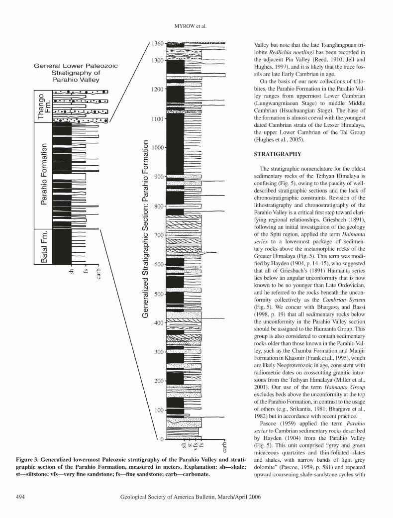
The thickness of the Parahio Formation has long been debated. Hayden (1904, p. 13) noted that in the Parahio Valley “numerous folds can be seen thus proving that the enormous thickness [of the Parahio Formation] is only apparent.” He concluded that the entire sec-tion between the Khemangar River Fault and the Cambrian–Ordovician unconformity is not more than ~600–900 m thick, but noted that this estimate was “merely approximate” (Hayden, 1904, p. 15). Other estimates for the thickness of the entire formation in the Parahio Valley are <400 m (Parcha, 1996; Fig. 2), 1080 m (Bhargava and Bassi, 1998), ~2000 m (Fuchs, 1982), 2700 m (Kumar et al., 1984; Bhargava et al., 1986), and 3350 m (Srikantia, 1981). Our detailed bed-by-bed measurement of the section revealed that structural complications were not an issue and that a nearly complete measured section was possible. Our section of the Parahio Formation (Fig. 3) is 1352 m thick. An addi-tional ~100–200 m of poorly exposed Parahio Formation exists at the base of the section but was not measured. The sedimentology of this interval is directly comparable to that of the rest of the measured section.
Biostratigraphic data help to resolve the dis-crepancy between Hayden’s thickness estimate and our own. His trilobite collections are now assigned to 16 species from shale beds (Jell and Hughes, 1997). New collections were recov-ered from some of Hayden’s shale zones, and for the fi rst time from carbonate beds, and both lithologies contain similar taxa. Data from all the zones from which we collected are in the expected stratigraphic order, based on com-parison with biostratigraphic databases from sections in China. As the order of stratigraphic occurrence of these taxa is similar in both Hayden’s and our studies, the positions of our collections with respect to height in the section indicate that Hayden (1904) consistently under-estimated stratigraphic thickness.
Trace fossil assemblages that include ich-nogenera attributed to Astropolichnus and Pla-giogmus occur below our measured section within the poorly exposed basal 100–200 m of the Parahio Formation, and were interpreted to be Early Cambrian in age (Bhargava et al., 1982; Bhargava et al., 1986). This is consis-tent with the age of the oldest trilobites in our section. We have no fi rm constraint on the age of the base of the Parahio Formation in the Parahio

CAMBRIAN STRATIGRAPHY AND DEPOSITIONAL HISTORY IN NORTHERN INDIAN HIMALAYA
Geological Society of America Bulletin, March/April 2006 493
78 00‘
3200‘
77 00‘E
N
25 km
Greater HimalayanSequence (paragneiss)
Lesser HimalayaCrystalline Sequence (paragneiss)
Sub-Himalaya
Sangla Detachment (SD)
Main Boundary Thrust (MBT)
Munsiari Thrust (MT)
Tethyan HimalayanPaleozoic-Mesozoicsedimentary rocks
Main Central Thrust (MCT)
Cambrian-OrdovicianGranite
Lesser HimalayaSedimentary Series
Tethyan HimalayanNeoproterozoic(?) sedimentaryrocks
500 km
INDIA
TIBET
MCT GHS
30 STDSSuture
Zanskar
Proterozoic granite
KumaunBasin
N
Figure 1. Regional geology, showing major faults and geologic units of the northwestern Himalaya in India (modifi ed from Vannay and Grasemann, 2001). Box delineates region shown in Figure 2. STDS—South Tibetan detachment system; TH—Tethyan Himalaya; GHS—Greater Himalaya sequence; LH—Lesser Himalaya.
Cambrian Batal Fm.
Cambrian Parahio Fm.
Late Triassic-Ordovician
Middle Jurassic-Late Triassic
Quaternary
FaultU: UpthrownD: Downthrown
2 kmUD
AnticlineSyncline
78 05
3200N
78 00E
N
Ordovician Thango Fm.
KhemangarFault
MeasuredSections
Figure 2. Simplifi ed geologic map of the Tethyan Himalayan fold-thrust belt in the area of the Parahio and Pin Valleys (compiled and modi-fi ed from Fuchs, 1982; Bhargava and Bassi, 1998; Wiesmayr and Grasemann, 2002). Map area shown as boxed region in Figure 1.
MYROW et al.
494 Geological Society of America Bulletin, March/April 2006
Valley but note that the late Tsanglangpuan tri-lobite Redlichia noetlingi has been recorded in the adjacent Pin Valley (Reed, 1910; Jell and Hughes, 1997), and it is likely that the trace fos-sils are late Early Cambrian in age.
On the basis of our new collections of trilo-bites, the Parahio Formation in the Parahio Val-ley ranges from uppermost Lower Cambrian (Lungwangmiaoan Stage) to middle Middle Cambrian (Hsuchuangian Stage). The base of the formation is almost coeval with the youngest dated Cambrian strata of the Lesser Himalaya, the upper Lower Cambrian of the Tal Group (Hughes et al., 2005).
STRATIGRAPHY
The stratigraphic nomenclature for the oldest sedimentary rocks of the Tethyan Himalaya is confusing (Fig. 5), owing to the paucity of well-described stratigraphic sections and the lack of chronostratigraphic constraints. Revision of the lithostratigraphy and chronostratigraphy of the Parahio Valley is a critical fi rst step toward clari-fying regional relationships. Griesbach (1891), following an initial investigation of the geology of the Spiti region, applied the term Haimanta series to a lowermost package of sedimen-tary rocks above the metamorphic rocks of the Greater Himalaya (Fig. 5). This term was modi-fi ed by Hayden (1904, p. 14–15), who suggested that all of Griesbach’s (1891) Haimanta series lies below an angular unconformity that is now known to be no younger than Late Ordovician, and he referred to the rocks beneath the uncon-formity collectively as the Cambrian System (Fig. 5). We concur with Bhargava and Bassi (1998, p. 19) that all sedimentary rocks below the unconformity in the Parahio Valley section should be assigned to the Haimanta Group. This group is also considered to contain sedimentary rocks older than those known in the Parahio Val-ley, such as the Chamba Formation and Manjir Formation in Khasmir (Frank et al., 1995), which are likely Neoproterozoic in age, consistent with radiometric dates on crosscutting granitic intru-sions from the Tethyan Himalaya (Miller et al., 2001). Our use of the term Haimanta Group excludes beds above the unconformity at the top of the Parahio Formation, in contrast to the usage of others (e.g., Srikantia, 1981; Bhargava et al., 1982) but in accordance with recent practice.
Pascoe (1959) applied the term Parahio series to Cambrian sedimentary rocks described by Hayden (1904) from the Parahio Valley (Fig. 5). This unit comprised “grey and green micaceous quartzites and thin-foliated slates and shales, with narrow bands of light grey dolomite” ( Pascoe, 1959, p. 581) and repeated upward-coarsening shale-sandstone cycles with
0
100
200
300
400
500
600
700
800
900
1000
1100
1200
1300
1360
carb
Bat
al F
m.
Par
ahio
For
mat
ion
Tha
ngo
Fm
.
carb
General Lower PaleozoicStratigraphy ofParahio Valley
Gen
eral
ized
Str
atig
raph
ic S
ectio
n: P
arah
io F
orm
atio
n
sh fs
sh fsst vfs
Figure 3. Generalized lowermost Paleozoic stratigraphy of the Parahio Valley and strati-graphic section of the Parahio Formation, measured in meters. Explanation: sh—shale; st—siltstone; vfs—very fi ne sandstone; fs—fi ne sandstone; carb—carbonate.

CAMBRIAN STRATIGRAPHY AND DEPOSITIONAL HISTORY IN NORTHERN INDIAN HIMALAYA
Geological Society of America Bulletin, March/April 2006 495
carbonate caps. Hayden’s Cambrian trilobite-bearing rocks from the Parahio Valley are within this unit, the upper boundary of which was defi ned by the unconformity. The base of the Parahio series was considered conformable with the underlying red and black slate, with quartz-ite beds assigned by Pascoe (1959) to the upper part of the Haimanta series. Pascoe’s lithologi-
cal description of the Parahio series provides an accurate description of these beds, and the term has historical precedence as a lithostratigraphic name. Accordingly, we formally herein desig-nate Pascoe’s Parahio series as the Parahio For-mation, with the type section described in this paper. The Parahio Formation includes the entire section of the Parahio Valley rocks described
herein, with its top defi ned here by the uncon-formity and its base defi ned by the fi rst occur-rence of trace fossil–bearing strata. Rocks of the underlying Batal Formation are devoid of car-bonate beds and trace and body fossils, although an acritarch assigned to Angulopanina has been recorded from the uppermost part of this forma-tion, according to Kumar et al. (1984).
Parahio River
1 km
N
Strike-SlipFaults
n = 19 n = 40
Poles toBedding
OrdovicianThango Formation
CambrianParahio Formation
StructuralElements
CambrianBatal Formation
n = 52
pi axis (T&P)318/1
Bedding-CleavageIntersection Lineations
Poles to CleavageFold Axes
pi axis (T&P)141/16
pi axis (T&P)127/31
Left-lateral
Right-lateral
Figure 4. Simplifi ed geologic map of the fi eld area in the Parahio Valley (modifi ed from Bhargava and Bassi, 1998). Map area is shown in Figure 2. Synoptic equal-area plots of structural data measured in the Batal, Parahio, and Thango Formations show little dif-ference in the orientation of structural data from Cam-brian units and the Ordovician Thango Formation. The major fault in the area displays a nor-mal stratigraphic offset and is covered by the Khemangar River. Note that the fault is parallel to outcrop-scale, right-lateral strike-slip faults that we measured in exposures near the confl uence of the Kheman-gar and Debsa Khad Rivers (Fig. 2). The right-lateral faults are part of a conjugate strike-slip fault array, but the paral-lelism of the right-lateral faults and the Khemangar Fault may indicate that faulting included a component of right-lateral strike-slip movement.
MYROW et al.
496 Geological Society of America Bulletin, March/April 2006
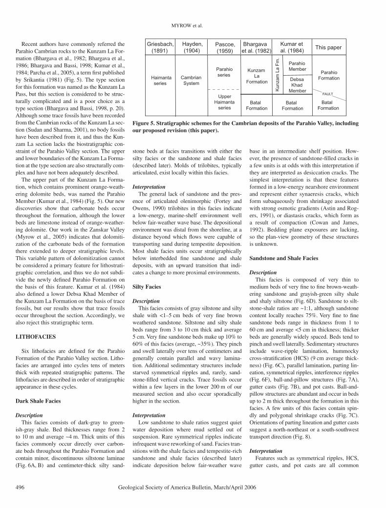
Recent authors have commonly referred the Parahio Cambrian rocks to the Kunzam La For-mation (Bhargava et al., 1982; Bhargava et al., 1986; Bhargava and Bassi, 1998; Kumar et al., 1984; Parcha et al., 2005), a term fi rst published by Srikantia (1981) (Fig. 5). The type section for this formation was named as the Kunzam La Pass, but this section is considered to be struc-turally complicated and is a poor choice as a type section (Bhargava and Bassi, 1998, p. 20). Although some trace fossils have been recorded from the Cambrian rocks of the Kunzam La sec-tion (Sudan and Sharma, 2001), no body fossils have been described from it, and thus the Kun-zam La section lacks the biostratigraphic con-straint of the Parahio Valley section. The upper and lower boundaries of the Kunzam La Forma-tion at the type section are also structurally com-plex and have not been adequately described.
The upper part of the Kunzam La Forma-tion, which contains prominent orange-weath-ering dolomite beds, was named the Parahio Member (Kumar et al., 1984) (Fig. 5). Our new discoveries show that carbonate beds occur throughout the formation, although the lower beds are limestone instead of orange-weather-ing dolomite. Our work in the Zanskar Valley (Myrow et al., 2005) indicates that dolomiti-zation of the carbonate beds of the formation there extended to deeper stratigraphic levels. This variable pattern of dolomitization cannot be considered a primary feature for lithostrati-graphic correlation, and thus we do not subdi-vide the newly defi ned Parahio Formation on the basis of this feature. Kumar et al. (1984) also defi ned a lower Debsa Khad Member of the Kunzam La Formation on the basis of trace fossils, but our results show that trace fossils occur throughout the section. Accordingly, we also reject this stratigraphic term.
LITHOFACIES
Six lithofacies are defi ned for the Parahio Formation of the Parahio Valley section. Litho-facies are arranged into cycles tens of meters thick with repeated stratigraphic patterns. The lithofacies are described in order of stratigraphic appearance in these cycles.
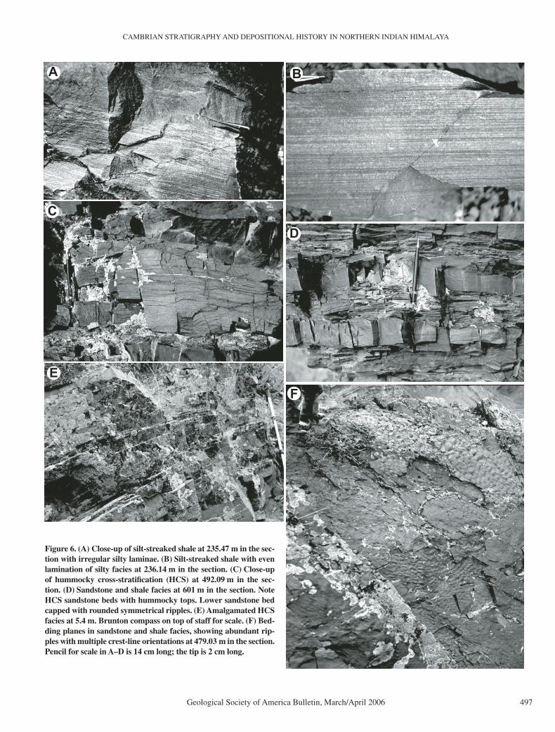
Dark Shale Facies
DescriptionThis facies consists of dark-gray to green-
ish-gray shale. Bed thicknesses range from 2 to 10 m and average ~4 m. Thick units of this facies commonly occur directly over carbon-ate beds throughout the Parahio Formation and contain minor, discontinuous siltstone laminae (Fig. 6A, B) and centimeter-thick silty sand-
stone beds at facies transitions with either the silty facies or the sandstone and shale facies (described later). Molds of trilobites, typically articulated, exist locally within this facies.
InterpretationThe general lack of sandstone and the pres-
ence of articulated olenimorphic (Fortey and Owens, 1990) trilobites in this facies indicate a low-energy, marine-shelf environment well below fair-weather wave base. The depositional environment was distal from the shoreline, at a distance beyond which fl ows were capable of transporting sand during tempestite deposition. Most shale facies units occur stratigraphically below interbedded fi ne sandstone and shale deposits, with an upward transition that indi-cates a change to more proximal environments.
Silty Facies
DescriptionThis facies consists of gray siltstone and silty
shale with <1–5 cm beds of very fi ne brown weathered sandstone. Siltstone and silty shale beds range from 3 to 10 cm thick and average 5 cm. Very fi ne sandstone beds make up 10% to 60% of this facies (average, ~35%). They pinch and swell laterally over tens of centimeters and generally contain parallel and wavy lamina-tion. Additional sedimentary structures include starved symmetrical ripples and, rarely, sand-stone-fi lled vertical cracks. Trace fossils occur within a few layers in the lower 200 m of our measured section and also occur sporadically higher in the section.
InterpretationLow sandstone to shale ratios suggest quiet
water deposition where mud settled out of suspension. Rare symmetrical ripples indicate infrequent wave reworking of sand. Facies tran-sitions with the shale facies and tempestite-rich sandstone and shale facies (described later) indicate deposition below fair-weather wave
base in an intermediate shelf position. How-ever, the presence of sandstone-fi lled cracks in a few units is at odds with this interpretation if they are interpreted as desiccation cracks. The simplest interpretation is that these features formed in a low-energy nearshore environment and represent either synaeresis cracks, which form subaqueously from shrinkage associated with strong osmotic gradients (Astin and Rog-ers, 1991), or diastasis cracks, which form as a result of compaction (Cowan and James, 1992). Bedding plane exposures are lacking, so the plan-view geometry of these structures is unknown.
Sandstone and Shale Facies
DescriptionThis facies is composed of very thin to
medium beds of very fi ne to fi ne brown-weath-ering sandstone and grayish-green silty shale and shaly siltstone (Fig. 6D). Sandstone to silt-stone-shale ratios are ~1:1, although sandstone content locally reaches 75%. Very fi ne to fi ne sandstone beds range in thickness from 1 to 60 cm and average <5 cm in thickness; thicker beds are generally widely spaced. Beds tend to pinch and swell laterally. Sedimentary structures include wave-ripple lamination, hummocky cross-stratifi cation (HCS) (9 cm average thick-ness) (Fig. 6C), parallel lamination, parting lin-eation, symmetrical ripples, interference ripples (Fig. 6F), ball-and-pillow structures (Fig. 7A), gutter casts (Fig. 7B), and pot casts. Ball-and-pillow structures are abundant and occur in beds up to 2 m thick throughout the formation in this facies. A few units of this facies contain spin-dly and polygonal shrinkage cracks (Fig. 7C). Orientations of parting lineation and gutter casts suggest a north-northeast or a south-southwest transport direction (Fig. 8).
InterpretationFeatures such as symmetrical ripples, HCS,
gutter casts, and pot casts are all common
Haimanta series
Hayden, (1904)
Cambrian System
Pascoe, (1959)
Parahio series
UpperHaimanta series
Bhargavaet al. (1982)
Kunzam LaFormation
BatalFormation
BatalFormation
Kun
zam
La
Fm.
Kumar etal. (1984)
ParahioMember
Debsa KhadMember
This paper
Parahio Formation
Griesbach, (1891)
FAULT
BatalFormation
Figure 5. Stratigraphic schemes for the Cambrian deposits of the Parahio Valley, including our proposed revision (this paper).
CAMBRIAN STRATIGRAPHY AND DEPOSITIONAL HISTORY IN NORTHERN INDIAN HIMALAYA
Geological Society of America Bulletin, March/April 2006 497
A
D
B
C
EF
Figure 6. (A) Close-up of silt-streaked shale at 235.47 m in the sec-tion with irregular silty laminae. (B) Silt-streaked shale with even lamination of silty facies at 236.14 m in the section. (C) Close-up of hummocky cross-stratifi cation (HCS) at 492.09 m in the sec-tion. (D) Sandstone and shale facies at 601 m in the section. Note HCS sandstone beds with hummocky tops. Lower sandstone bed capped with rounded symmetrical ripples. (E) Amalgamated HCS facies at 5.4 m. Brunton compass on top of staff for scale. (F) Bed-ding planes in sandstone and shale facies, showing abundant rip-ples with multiple crest-line orientations at 479.03 m in the section. Pencil for scale in A–D is 14 cm long; the tip is 2 cm long.

MYROW et al.
498 Geological Society of America Bulletin, March/April 2006
storm-generated sedimentary features (Myrow, 1992a, 1992b). HCS is produced during high-energy, storm-generated multidirectional and oscillatory currents (Arnott and Southard, 1990; Dumas et al., 2005). Interbedding of fi ne sand-stone and shale indicates deposition in an inner shelf setting below fair-weather wave base. Gut-ter casts refl ect movement of sand via small-scale channels and are interpreted to form as a result of the unidirectional component of storm currents that erode the substrate, leaving small channel-like structures that are commonly fi lled by lag or fi ne sand from the shoreface (Myrow, 1992a). Pot casts are infi llings of erosional fea-tures that form as a result of vertical vortices within storm-generated fl ows (Myrow, 1992a). Gutter cast and parting lineation orientations are north-northeast–south-southwest, indicating consistent orientations of fl ow during erosive and depositional stages of storm fl ows. Wave-ripple, crest-line orientations are bimodal, with the strongest mode oriented west-northwest–east-southeast. Wave-ripple crest-line orienta-
tions in ancient shallow-water deposits com-monly refl ect shoreline orientation caused by wave refraction (Potter and Pettijohn, 1977; cf. Myrow, 1992b). The gutter cast and parting lin-eation data are also parallel to paleocurrent data from inferred fl uvial deposits (described later), thus indicating fl ow offshore toward the north-northeast. This is similar to other studies that document offshore-directed, storm-generated fl ow (Leckie and Krystinik, 1989) and devel-opment of gutter casts as a result of shoreline bypass of sand (Myrow, 1992b).
Amalgamated Hummocky Cross-Stratifi ed (HCS) Sandstone Facies
DescriptionThis facies consists of amalgamated beds of
gray, fi ne-grained HCS sandstone (Fig. 6E). The sandstone is reddish gray to steel blue on weathered surfaces and gray on fresh surfaces. Beds range in thickness from tens of centime-ters to upward of a meter, with an average bed
thickness of ~30 cm. Beds generally pinch and swell laterally, and are locally separated by centimeter-scale shale beds. Individual hum-mocks range in spacing from 1 to nearly 4 m in length. This facies is interbedded with the sandstone and shale facies in some areas. Both symmetric and asymmetric forms of HCS occur within this facies.
InterpretationThe abundance of HCS indicates deposition
along a storm-dominated shoreline (Leckie and Walker, 1982; Dott and Bourgeois, 1982; and others). The absence of intervening shale beds refl ects deposition within the shoreface where mud is removed by fair-weather processes and amalgamation of sand beds results from storm deposition. Deposition of thick beds of HCS accompanied reworking of the shoreface and elimination of stratifi cation generated dur-ing fair-weather conditions. The existence of this facies stratigraphically above the sand-stone and shale facies refl ects shoaling from
A C
B
Figure 7. (A) Ball-and-pillow structures at 156.26 m in the section. Such structures are common throughout the formation. Hammer for scale. (B) Oblique view of partly exhumed gutter cast (next to pencil) at 491.49 m in the section; 14-cm-long pencil for scale. (C) Shrinkage cracks at 290.62 m in the section.

CAMBRIAN STRATIGRAPHY AND DEPOSITIONAL HISTORY IN NORTHERN INDIAN HIMALAYA
Geological Society of America Bulletin, March/April 2006 499
nearshore and transition zone environments into shoreface settings.
Trough Cross-Bedded Sandstone Facies
DescriptionThis facies consists of large-scale, trough cross-
bedded, gray-green fi ne sandstone (Fig. 9A, B) that is light gray to white on weathered surfaces. Bed thicknesses range from 15 to 120 cm, with an average of 54 cm. Units of this facies range up to 30 m thick. The bases of these units show small-scale cutout of underlying beds laterally in the section. Decimeter-scale, parallel-laminated sandstone beds locally separate trough cross-bed sets. This facies generally overlies the amalgam-ated HCS facies and underlies the limestone facies (described later) and/or shale facies. Paleo-current readings suggest north-northeastward fl ow (Fig. 8).
InterpretationThe thick beds of trough cross-bedded fi ne
sandstone record the migration of three-dimen-sional dunes in high-energy depositional systems (Harms et al., 1982). The scale of the cross-bed-ding, unimodal paleocurrents, lack of body or trace fossils, and facies transitions indicate depo-sition in a riverine environment (Potter and Petti-john, 1977; Walker and Cant, 1984). Stratigraphic transitions with underlying shoreface deposits indicate shoaling to nonmarine environments associated with progradation of the shoreline.
Carbonate Facies
DescriptionThis facies consists of limestone and dolos-
tone beds, many of which serve as marker beds within the formation. The limestone consists of greenish-gray carbonate mudstone to coarse grainstone with abundant trilobites, phosphatic linguliformid brachiopods, and sponge spicules in grainstone. Limestone beds range in thickness from 3 cm to 1.86 m, with an average thickness of ~60 cm. The limestone is thinly laminated (millimeter scale) and is pink to rusty orange on weathered surfaces. Some of the thinner beds are discontinuous over tens of meters. Thin-bedded homogeneous fi ne-crystalline limestone beds occur below grainstone throughout the sec-tion (e.g., 78.7 m). Much of the coarse and fi ne grainstone is thinly interbedded. Limestone beds are partially dolomitized and silicifi ed locally (Fig. 9C, F). Some beds contain abundant intra-clasts at their base and locally contain thin lag deposits on their upper bedding contacts.
Orange-weathering dolostone beds occur in the uppermost 200 m of the formation (Fig. 9D). They consist of extremely well-sorted, massive
dolosiltite (Fig. 9E). Bed thicknesses range from 23 cm to 12.8 m, with an average thick-ness of ~4 m. Internal sedimentary structures and biogenic structures are absent except where phosphatic brachiopods are concentrated along individual laminae. Diagenetic nodules of orange-weathering dolostone occur locally within underlying sandstone units.
In general, beds of the carbonate facies rest stratigraphically above trough cross-bedded facies of presumed fl uvial origin, and, in a few places, shoreface deposits of amalgamated HCS sandstone. These beds in turn are overlain by the dark shale or silty facies.
InterpretationThe presence of minor carbonate units within
the dominantly siliciclastic Parahio Formation suggests intermittent decreases in supply of terrigenous siliciclastic sediment. Trilobite and brachiopod fossils indicate deposition under marine conditions. Micritic beds accumulated in lower energy conditions, whereas the bio-clastic grainstone beds were reworked by ocean waves and currents. The homogeneous nature of the orange-weathering dolosiltite suggests a shallow-marine environment of uniform energy. Transitions from underlying trough cross-bed-ded sandstone to limestone indicate that marine fl ooding surfaces (Van Wagoner et al., 1988) separate these facies.
PALEOCURRENTS
Paleocurrent readings were measured from parting lineation, trough cross-beds, symmetri-cal wave ripples, and gutter casts throughout
the Parahio Formation. The long axis directions of parting lineations (Fig. 8A) and gutter casts are south-southwest–north-northeast. Wave ripples (Fig. 8B) display scattered orientations, but the strongest mode is essentially perpendic-ular to the other features, namely, west-north-west–east-southeast. Large-scale sets of trough cross-beds of the trough cross-bedded sand-stone facies indicate a unimodal northeastward transport (Fig. 8C). This is consistent with the reconstructed position of these Tethyan depos-its along the northern margin of India at that time. The largest mode in the wave-ripple data, perpendicular to the trough cross-bed sets, could represent refraction of waves parallel to the inferred paleoshoreline, although the data are sparse and somewhat scattered. The scatter in the data is not unusual for shoreline depos-its, because variable coastal winds and shallow depths lead to variable oscillatory water move-ments (Weimer et al., 1982).
The paleocurrent readings do not account for oroclinal bending of the Himalaya and coun-terclockwise rotation of India during Cenozoic orogenesis, which resulted in a relative move-ment between India and its northern continen-tal margin (Klootwijk et al., 1985; Schill et al., 2001, 2002). Paleomagnetic studies of the Pin Valley, ~10–15 km south and east of our study area (Schill et al., 2001), suggest a pos-sible 20°–35° clockwise vertical axis rotation of rocks with respect to India. Trial rotations of our paleocurrent data, using 20° and 35°, produce nearly due north mean paleocurrent directions, which are an even better fi t with the idea that the Tethyan Himalaya records the northern margin of India during the Cambrian.
14 25
Parting Lineations Wave RippleCrest-line
Orientations
Trough Cross-bedPaleocurrentOrientations
37
A CB
Figure 8. Equal-area paleocurrent rose diagrams of the Parahio Formation (north at top). Parting-lineation orientations and wave-ripple crest-line orientations were taken from the sandstone and shale facies. Cross-bed orientations were taken from the trough cross-bedded sandstone facies.

MYROW et al.
500 Geological Society of America Bulletin, March/April 2006
BA
C
E F
D
Figure 9. Trough cross-bedded facies and carbonate facies. (A) Compound trough cross-bedding at 57.3 m in the section. Pencil (top left) for scale. (B) Large-scale trough cross-bedding with sets up to 1.5 m thick at 760.5 m in the section. Hammer for scale (circled). (C) Partly silici-fi ed limestone bed, showing nodular weathering pattern at 765.14 m in the section. (D) Thick (12.8 m) orange dolosiltite bed at 1242.4 m in the section. (E) Close-up of D, showing well-sorted, homogeneous orange dolosiltite. (F) Nodular gray limestone unit, 1.3 m thick, with abundant chert nodules at 779.35 m. Pencil for scale is 14 cm long.

CAMBRIAN STRATIGRAPHY AND DEPOSITIONAL HISTORY IN NORTHERN INDIAN HIMALAYA
Geological Society of America Bulletin, March/April 2006 501
PALEOENVIRONMENTAL SYNTHESIS
The foregoing sedimentological analysis indi-cates that the dominantly siliciclastic strata of the Parahio Formation range from offshore-marine to trough cross-bedded fl uvial deposits. Over-all, the strata are relatively fi ne grained, ranging from shale to fi ne sandstone, with a few scattered medium sandstone beds. The presence of thick, well-developed deposits of the fl uvial trough cross-bedded sandstone facies indicates a strong infl uence of fl uvial processes and earmarks these strata as deltaic deposits. The fl uvial deposits are also relatively fi ne grained and reasonably well sorted, indicating low local stream gradients and a position relatively distal to sediment sources during the Cambrian in this region. However, the general character of the section indicates that riv-ers deposited large volumes of sediment on the shoreline and inner shelf on the ancient northern passive margin of India.
Extensive ball-and-pillow features occur throughout these deposits in several facies. These features represent gravitational synsedimentary deformation during sediment accumulation. This kind of deformation results from partial liquefaction caused by high pore-fl uid pressures and unstable packing (Seed, 1968). Such con-ditions are common in environments with rapid sediment accumulation rates, particularly in deltas with abundant silt to very fi ne sand. The thickness of Middle Cambrian strata in the Para-hio Formation indicates high sediment accumu-lation rates, which supports our interpretations of deltaic deposition. Trilobite biostratigraphic data indicate that most of the ~1350-m-thick measured section is of early and middle Middle Cambrian age. On the basis of recent geochro-nological work (Landing et al., 1998; Davidek et al., 1998), the entire Middle Cambrian was ~10 m.y. in duration. A conservative accumu-lation rate estimate has been calculated on the basis of (1) the assumption that the lower and middle parts of the Middle Cambrian were 7 m.y. in duration, (2) an estimate of ~50% shale and 50% sandstone for the formation, and (3) com-paction estimates of 50% for shale and 15% for sandstone with >5 km burial (Houseknecht, 1971; Bond and Kominz, 1984). The estimate of sediment accumulation rate is 30.4 cm/1000 yr, similar to time-averaged accumulation rates in deltaic settings (Stanley and Hait, 2000). The interpretation of the Parahio Formation as a storm-infl uenced deltaic succession contradicts previous paleoenvironmental interpretations. Srikantia (1981) and Fuchs (1982) considered the succession to be dominated by fl ysch depos-its. Similarly, Parcha (2005) suggested that the Parahio Formation accumulated in an outer detrital belt setting. Srikantia (1981), Bhargava
et al. (1982, 1986), Bhargava and Bassi (1998, p. 146), and Parcha et al. (2005) all argued that the Parahio Formation records overall shallowing from a euxinic basin toward a tidally dominated nearshore setting.
We fi nd no sedimentological evidence for deposition in an oxygen-stratifi ed basin, e.g., biofacies patterns of anaerobic or dysaerobic environments (Byers, 1977; Myrow and Land-ing, 1992), let alone evidence for a long-term euxinic basin. In addition, trilobite taxa that occur in the shallow-water limestone beds are identical to those in overlying dark shale facies, suggesting normal-marine settings for both paleoenvironments (i.e., similarly well-oxygen-ated conditions). Fuchs (1987) and Garzanti et al. (1986) both consider time-equivalent strata exposed in the Zanskar Valley to the north-northwest to represent tidal fl at, coastal sand, and peritidal carbonate deposits. Our sedimen-tological analysis, as well as our work on the Zanskar strata (Myrow et al., 2006), reveals little evidence for tidal processes in these depos-its, such as diagnostic sedimentary structures (e.g., herringbone cross-bedding, reactivation surfaces) or facies successions.
SEDIMENTARY CYCLES
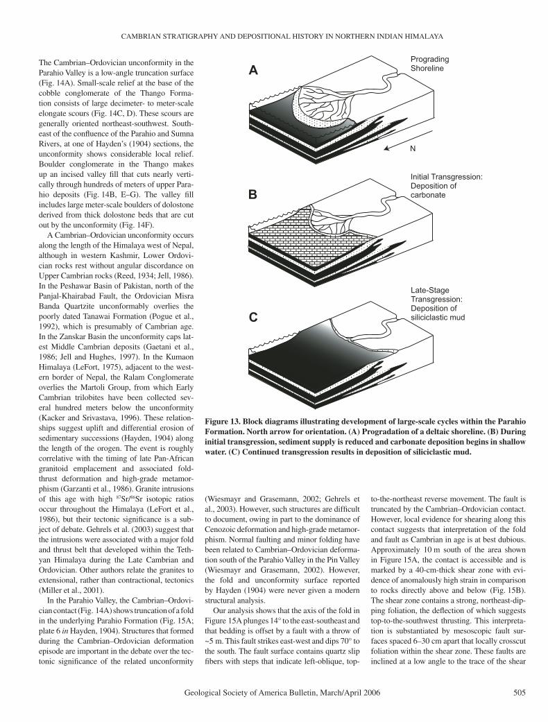
The strata of the Parahio Formation range from storm-infl uenced shelf deposits to thick, trough cross-bedded fl uvial facies, many of which are arranged in medium-scale, upward-coarsening shoaling cycles (Fig. 10A). The cycles range from 2.5 m to 61 m thick and differ slightly in facies sequences from cycle to cycle. An idealized cycle begins with sand-starved deposits of the dark shale facies (Fig. 10B, C) and grades upward sequentially into the silty facies, sandstone and shale facies, amalgamated HCS facies, and fi nally the trough cross-bed-ded sandstone facies. Within the cycles, beds of sandstone become thicker and increasingly more abundant upward until all shale is miss-ing in the amalgamated HCS facies. The trough cross-bedded sandstone facies generally overlies the amalgamated HCS facies across an erosional surface. Carbonate-rich sandstone or beds of the carbonate facies overlie the trough cross-bedded sandstone facies and are succeeded by another unit of the dark shale facies (Fig. 11A).
Many of these shoaling cycles are incom-plete. Some lack the dark shale facies and instead commence with the silty facies, the sandstone and shale facies, or shoreface depos-its (Fig. 11B). One cycle commences with amal-gamated HCS sandstone deposits. Other cycles are abbreviated at their tops, and the carbonate facies is absent, or both the trough cross-bedded sandstone facies and carbonate facies are absent
(Figs. 11B, 12). The latter type of cycle ends with the amalgamated HCS facies (Fig. 12) or with thick, bioturbated sandstone beds, both of which are of shoreface origin (Fig. 11A). In a few cycles, the trough cross-bedded sandstone facies directly overlies the sandstone and shale facies.
Interpretation of Cycles
The succession of lithofacies in a cycle is interpreted to record upward shoaling along a prograding storm-dominated shoreline (Fig. 13). Complete cycles record changes from offshore-marine environments to fl uvial settings, although incomplete cycles begin in nearshore facies or end in shoreface deposits, the latter being due to renewed transgression before shoaling culmi-nated in deposition above sea level. The upper cycle boundaries represent marine fl ooding sur-faces. The marine parts of the shallowing cycles record progradation of a storm-dominated shoreline with upward increases in tempestite bed thickness and decreasing shale content.
In these cycles, the transitions from fl uvial cross-bedded sandstone to carbonate facies are interpreted as marine fl ooding surfaces and subsequent deposition in shallow-marine envi-ronments that were essentially fl ooded coastal plains (Fig. 13). Fully marine conditions are sup-ported by the presence of trilobite and brachio-pod fossils, as well as trace fossils. Beds of the carbonate facies are sharply overlain by deep-water shelf deposits of the dark shale facies, the transition representing another fl ooding surface. The fl ooding surface at the top of the carbonate represents deepening to the point of shutdown of carbonate production, as was the case with some ancient carbonate platforms (Schlager, 1981). The carbonate facies are thus essentially thin transgressive deposits. The rest of these cycles, from the base or slightly above the base of the dark shale facies to the top of the cycles, formed during shoreline progradation (Fig. 13A). Given the deltaic setting of these strata, and the fact that the cycles do not form regular stacking pat-terns (i.e., progradationally or retrogradationally stacked parasequences; Lehrmann and Gold-hammer, 1999), we interpret the cyclicity to be mostly autocyclic, driven by changes in sediment input associated with switching of delta lobes. Changes in eustasy and subsidence may have played roles in the development of these cycles, but it is not possible to determine their relative infl uence. The few places where fl uvial depos-its rest directly on inner shelf deposits of the sandstone and shale facies may point to forced regression (Posamentier et al., 1992) and rapid seaward shift of environments. Avulsion and deltaic lobe shifting would have been enhanced

MYROW et al.
502 Geological Society of America Bulletin, March/April 2006
CB
A
Figure 10. (A) Two well-developed cycles in the upper part of the Parahio Formation. Lower cycle rests on an orange dolostone bed (at top of an underlying cycle) in lower left of photo. Lower cycle begins at 1166.7 m in the section, is 61 m thick, and is capped with an 18-m-thick unit of amalgamated HCS sandstone. Overlying cycle begins at 1227.9 m in the section, is 29.6 m thick, and is capped with a 12.8-m-thick bed of orange dolostone. Sharp upper contact of second cycle is overlain by shale, marking the base of a third cycle. (B) Base of 30-m-thick cycle at 1097.92 m in the section. Note shale (left center) and an upward increase in sandstone thickness and abundance. (C) Base of 18.6 m cycle at 1258.77 m in the section. Note the top of a carbonate bed in the upper left and a dark shale directly above. Note an upward increase in sandstone bed thickness and abundance. Hammer for scale.

CAMBRIAN STRATIGRAPHY AND DEPOSITIONAL HISTORY IN NORTHERN INDIAN HIMALAYA
Geological Society of America Bulletin, March/April 2006 503
330
335
340
345
350
355
360
365
sh fsvfs
Sho
alin
g
FS
FS
Fluv
ial
Fore-
Sho
refa
ceFl
uvia
l
Fluv
ial (
Min
or S
hore
face
)S
hore
face
sh fsvfs
grns
t
Sho
alin
gS
hoal
ing
Sho
alin
g
Sho
refa
ceS
helf
to S
hore
face
Sho
refa
ce w
ith a
bund
ant s
oft-
sedi
men
t def
orm
atio
n fe
atur
es
880
885
890
895
sh fsvfs
grns
tm
ic
FSFS
Sho
alin
gS
hoal
ing
A B
FS?shore
AS
BS
Sho
refa
ce/
Fore
shor
e
LS
Sh
Sl
ISS
AS
Sl
AS
TCS
TCS
TCS
AS
Sh
Sl
LS
AS
Figure 11. (A) Parts of two shoaling cycles from 879.09 to 899.72 m in the section. Amal-gamated HCS shoreface depos-its of the lower cycle, overlain by bioturbated upper shoreface or foreshore deposits and then limestone. The base of the lime-stone is a marine fl ooding sur-face, and the top another fl ood-ing surface. (B) Parts of three shoaling cycles between 326.59 and 366.42 m in the section. The lower cycle has very thick amalgamated shoreface depos-its overlain by trough cross-bedded facies of fl uvial origin. Possible foreshore deposits at the top are bracketed by fl ood-ing surfaces, and the base of the next cycle begins in lower shoreface deposits directly above the limestone. FS—fl ooding surface; sh—shale; vfs—very fi ne sandstone; fs—fi ne sandstone; mic—micrite; grnst—grainstone; Lithofacies: SH—dark shale; SI—siltstone; ISS—interbedded sandstone and shale; BS—bioturbated sandstone; AS—amalgamated sandstone; TCS—trough cross-bedded sandstone.

MYROW et al.
504 Geological Society of America Bulletin, March/April 2006
by regional subsidence resulting from sediment loading within the deltaic setting, which would have been caused by high sediment accumula-tion rates (Coleman, 1988). This subsidence would have enhanced any thermal subsidence to increase accommodation space. Following avulsion events that shifted sediment supply to adjacent parts of the shoreline, local production of accommodation space would have been rapid. This would have resulted in deepening through the zone of carbonate production, which may have been generally narrow in this deltaic set-ting, and in deposition of relatively thin, trans-gressive carbonate deposits.
One stratigraphic pattern of note is the presence of thicker (orange-weathering dolostone) car-bonate beds in the upper part of the Parahio For-mation. These carbonate beds are more extensive and continuous than the thinner limestone beds in the lower Parahio. Similar dolostone beds also occur in the upper part of the Parahio Formation in the Zanskar Valley to the northwest. Unfortu-nately, our biostratigraphic information does not allow us to determine whether individual dolo-stone beds are continuous between the Zanskar and Spiti regions. In Zanskar, the Parahio Forma-tion is overlain by the Thidsi Member of the Karsha Formation (Myrow et al., 2006), which is composed of >150 m of orange-weathering dolostone (Gaetani et al., 1986). The region-ally extensive Cambrian–Ordovician unconfor-mity (see following discussion) cuts downsec-tion between Zanskar and the Spiti Valley, so the Thidsi Member and even younger strata are absent in Spiti. The upper Parahio Formation thus records a transition from siliciclastic- to carbon-ate-dominated strata, representing a long-term decrease in supply of terrigenous detritus, and to some degree this transition might represent the signal of part of a third- (1–2 m.y.) or second-order (up to 15 m.y.) depositional sequence (Vail et al., 1977).
CAMBRIAN–ORDOVICIAN UNCONFORMITY
The unconformity between the Cambrian Parahio Formation and the overlying Thango Formation is poorly understood, but it has important implications for the early tectonic history of the Himalaya. The age of the uncon-formity is in part constrained by trilobites from the basal part of the Takche Formation, which overlies the Thango Formation and which is no older than Middle Ordovician and no younger than latest Ordovician (Patterson, 2004; R.A. Fortey, 2004, personal commun.). Trace fos-sils from the Thango Formation (Bhargava and Bassi, 1998) are consistent with this estimate, because they also suggest an Ordovician age.
1090
1095
1100
1105
1120
1125
1115
1110
sh vfs fs
Nea
rsho
reS
and-
Sta
rved
She
lf
Shore-face
Nea
rsho
reS
hore
face
Nea
rsho
re
sh vfs fs
FS
San
d-S
tarv
edS
helf
Sho
alin
gS
hoal
ing
Sho
alin
g
ISS
AS
Sh
Sh
Sl
ISS
ISS
AS
Figure 12. Two shoaling cycles from 1087.67 to 1127.92 m in the section. Note thick ball-and-pillow zones of probable shoreface origin at the top of the second cycle. See Figure 11 caption for explanation of abbreviations.
CAMBRIAN STRATIGRAPHY AND DEPOSITIONAL HISTORY IN NORTHERN INDIAN HIMALAYA
Geological Society of America Bulletin, March/April 2006 505
The Cambrian–Ordovician unconformity in the Parahio Valley is a low-angle truncation surface (Fig. 14A). Small-scale relief at the base of the cobble conglomerate of the Thango Forma-tion consists of large decimeter- to meter-scale elongate scours (Fig. 14C, D). These scours are generally oriented northeast-southwest. South-east of the confl uence of the Parahio and Sumna Rivers, at one of Hayden’s (1904) sections, the unconformity shows considerable local relief. Boulder conglomerate in the Thango makes up an incised valley fi ll that cuts nearly verti-cally through hundreds of meters of upper Para-hio deposits (Fig. 14B, E–G). The valley fi ll includes large meter-scale boulders of dolostone derived from thick dolostone beds that are cut out by the unconformity (Fig. 14F).
A Cambrian–Ordovician unconformity occurs along the length of the Himalaya west of Nepal, although in western Kashmir, Lower Ordovi-cian rocks rest without angular discordance on Upper Cambrian rocks (Reed, 1934; Jell, 1986). In the Peshawar Basin of Pakistan, north of the Panjal-Khairabad Fault, the Ordovician Misra Banda Quartzite unconformably overlies the poorly dated Tanawai Formation (Pogue et al., 1992), which is presumably of Cambrian age. In the Zanskar Basin the unconformity caps lat-est Middle Cambrian deposits (Gaetani et al., 1986; Jell and Hughes, 1997). In the Kumaon Himalaya (LeFort, 1975), adjacent to the west-ern border of Nepal, the Ralam Conglomerate overlies the Martoli Group, from which Early Cambrian trilobites have been collected sev-eral hundred meters below the unconformity (Kacker and Srivastava, 1996). These relation-ships suggest uplift and differential erosion of sedimentary successions (Hayden, 1904) along the length of the orogen. The event is roughly correlative with the timing of late Pan-African granitoid emplacement and associated fold-thrust deformation and high-grade metamor-phism (Garzanti et al., 1986). Granite intrusions of this age with high 87Sr/86Sr isotopic ratios occur throughout the Himalaya (LeFort et al., 1986), but their tectonic signifi cance is a sub-ject of debate. Gehrels et al. (2003) suggest that the intrusions were associated with a major fold and thrust belt that developed within the Teth-yan Himalaya during the Late Cambrian and Ordovician. Other authors relate the granites to extensional, rather than contractional, tectonics (Miller et al., 2001).
In the Parahio Valley, the Cambrian–Ordovi-cian contact (Fig. 14A) shows truncation of a fold in the underlying Parahio Formation (Fig. 15A; plate 6 in Hayden, 1904). Structures that formed during the Cambrian–Ordovician deformation episode are important in the debate over the tec-tonic signifi cance of the related unconformity
(Wiesmayr and Grasemann, 2002; Gehrels et al., 2003). However, such structures are diffi cult to document, owing in part to the dominance of Cenozoic deformation and high-grade metamor-phism. Normal faulting and minor folding have been related to Cambrian–Ordovician deforma-tion south of the Parahio Valley in the Pin Valley (Wiesmayr and Grasemann, 2002). However, the fold and unconformity surface reported by Hayden (1904) were never given a modern structural analysis.
Our analysis shows that the axis of the fold in Figure 15A plunges 14° to the east-southeast and that bedding is offset by a fault with a throw of ~5 m. This fault strikes east-west and dips 70° to the south. The fault surface contains quartz slip fi bers with steps that indicate left-oblique, top-
to-the-northeast reverse movement. The fault is truncated by the Cambrian–Ordovician contact. However, local evidence for shearing along this contact suggests that interpretation of the fold and fault as Cambrian in age is at best dubious. Approximately 10 m south of the area shown in Figure 15A, the contact is accessible and is marked by a 40-cm-thick shear zone with evi-dence of anomalously high strain in comparison to rocks directly above and below (Fig. 15B). The shear zone contains a strong, northeast-dip-ping foliation, the defl ection of which suggests top-to-the-southwest thrusting. This interpreta-tion is substantiated by mesoscopic fault sur-faces spaced 6–30 cm apart that locally crosscut foliation within the shear zone. These faults are inclined at a low angle to the trace of the shear
A
B
C
N
ProgradingShoreline
Initial Transgression:Deposition ofcarbonate
Late-StageTransgression:Deposition ofsiliciclastic mud
Figure 13. Block diagrams illustrating development of large-scale cycles within the Parahio Formation. North arrow for orientation. (A) Progradation of a deltaic shoreline. (B) During initial transgression, sediment supply is reduced and carbonate deposition begins in shallow water. (C) Continued transgression results in deposition of siliciclastic mud.

MYROW et al.
506 Geological Society of America Bulletin, March/April 2006
G
A
C
F
E
B
ThickValley
Fill
D
Parahio Formation
Ordovician
Cambrian–Ordovician
Parahio Fm.Cambrian
Unconformity
Thango Fm.Ordovician

CAMBRIAN STRATIGRAPHY AND DEPOSITIONAL HISTORY IN NORTHERN INDIAN HIMALAYA
Geological Society of America Bulletin, March/April 2006 507
zone, and defl ection of the foliation by the faults, along with stepped quartz slip fi bers on their sur-faces, suggests that they represent riedel shears related to top-to-the-southwest thrusting. Inter-pretation of the contact as a thrust also serves to explain the stair-step shape of the contact in profi le as it cuts upsection to the southwest in the footwall (Fig. 15A; plate 6 in Hayden, 1904); this resembles a footwall ramp-on-fl at geometry that is commonly displayed by thrust faults (Boyer and Elliot, 1982). The southwest-directed sense of movement along the surface is consistent with the direction of thrusting for the region (Wiesmayr and Grasemann, 2002) and with minor out-of-the-syncline thrusting related to the folding of the Devonian Muth Formation to the north in Parahio Valley (Fig. 4).
To further evaluate whether Cambrian rocks contain evidence for pre-Ordovician deforma-tion, we also examined and compared structures above and below the Cambrian–Ordovician unconformity. Folds occur locally within all of the stratigraphic units within the study area and are upright to inclined, cylindrical (Fig. 4), and have amplitudes and wavelengths that range from a few meters to a kilometer. Bedding-par-allel slip surfaces occur on the limbs of folds, and these contain quartz and epidote slip fi bers with steps, indicating that folds formed pre-dominantly by fl exural slip. We did not observe refolded folds indicative of polyphase deforma-tion. Bedding poles defi ne great-circle girdles that have horizontal or shallow, southeast-plunging pi axes (Fig. 4), similar to the orienta-
tion of fold axes in the area (Fig. 4). Disjunctive slaty to spaced cleavage occurs within all strati-graphic units in the study area and varies from being axial planar to slightly fanning around folds. Cleavage strikes northwest-southeast, and cleavage-bedding intersection lineations plunge ~20° to the southeast (Fig. 4), similar to the orientation of the pi axes and fold axes. A comparison of structures between Cambrian and Ordovician stratigraphic units reveals little difference in orientation between fold axes, cleavage, and cleavage-bedding intersection lineations (Fig. 4). Thus, we conclude that no clear evidence exists that the Cambrian rocks have been deformed in a separate phase of thrust-related folding and faulting during the Cambrian–Ordovician interval.
OrdovicianThango Formation(Conglomerate)
Cambrian-OrdovicianContact
foliation
Riedel Shear
SWNEOrdovicianThango Formation(Conglomerate)
CambrianParahioFormation
Fold and left-obliquereverse fault
SN
~10 m
Cambrian-OrdovicianUnconformity
Cambrian-ParahioFormation
B
A
Figure 14. Cambrian–Ordovician unconformity. (A) View of the upper Parahio Forma tion above the Sumna River. Note cutout of orange dolostone beds below the sub-Ordovician unconformity (white dashed lines) and thick valley fi ll on left. (B) View of the upper Parahio Formation in the foreground and conglomeratic Ordovician valley fi ll in the background at left at the same stratigraphic level. (C) Close-up of oriented meter-scale scours along the unconformity at the base of Ordovician deposits. (D) Irregular unconformity at the base of the Ordovician, including oriented scours as shown in C. (E) Close-up of the unconformity at the base of thick valley fi ll, with sandstone and shale of the Parahio Formation at the base and coarse conglomerate of the Thango Formation above. (F) Close-up of coarse, thick valley fi ll with large boulders of orange dolostone that were cut out below the Cambrian–Ordovician unconformity. (G) Thick Ordovician valley fi ll. Photo shows >100 m of conglomeratic strata.
Figure 15. (A) Close-up of the Cambrian–Ordovician unconformity at the base of thick valley fi ll. Note that the Parahio Formation has been folded and offset by a fault ~5 m. The fold and fault are apparently truncated by the Cambrian–Ordovician contact. (B) Further close-up of the Cambrian–Ordovician contact as viewed to the southeast. Note that the contact is marked by a 40-cm-thick shear zone that contains a well-developed foliation and brittle riedel shears. Evi-dence for shear along this contact indicates that the fold shown in A is likely not Cambrian.

MYROW et al.
508 Geological Society of America Bulletin, March/April 2006
DISCUSSION
As outlined earlier, the paleoenvironments and depositional history of the Parahio Formation have been radically reinterpreted as recording a series of progradational cycles of a storm-domi-nated shoreline. Thin limestone beds represent transgressive systems tract deposits, which were shown in this study to contain abundant trilobite fossils. New collections from these beds allow for detailed correlation of this important section with those elsewhere in the Himalaya and glob-ally, as well as to defi ne the duration of deposi-tion of the formation and the hiatus of the over-lying Cambrian–Ordovician unconformity.
The results of this study have bearing on the continued debate concerning the early deposi-tional and tectonic history of the Himalaya. Part of the debate concerns the relationship between the three lithotectonic zones of the Himalaya—the Lesser Himalaya, the Greater Himalaya, and the Tethyan Himalaya. Paleocurrent data, particularly those from the fl uvial trough cross-bedded facies of the Parahio Formation, show a parallelism to those of the uppermost Lower Cambrian Tal Group of the Lesser Himalaya (Ganesan, 1975), namely, with transport to the north-northeast. Myrow et al. (2003) suggested that the uppermost Member E of the Tal, which consists of more than 1000 m of unfossilifer-ous cross-bedded sandstone, is generally age equivalent to the Parahio and is of possible fl uvial origin. However, Hughes et al. (2005) suggested a revised lithostratigraphic correla-tion in which the carbonate of Member D of the upper part of the Tal Group equates to the late Middle Cambrian Karsha Formation of Zanskar. In this case the Parahio Formation would be correlative with Member C of the Tal Group, a 300-m-thick unfossiliferous cross-bedded sandstone also likely of fl uvial origin. Member B of the Tal Group is nearly contem-poraneous (±1–2 m.y.) with the earliest dated beds in the Parahio Forma tion.
According to this model, the upper Tal is the record of Lesser Himalaya rivers that fed the deltaic Tethyan Himalaya environments of the Parahio along the northern Indian margin. It is diffi cult to evaluate the original distance between these two zones because of uncertainties in the Cenozoic displacement along two faults: (1) the Main Central Thrust, with top-to-the-south thrusting; and (2) the South Tibetan detachment system, with top-to-the-north extensional move-ment along with an older phase of top-to-the-south thrusting. The Main Central Thrust is esti-mated to have a displacement of 150–200 km or more (Schelling and Arita, 1991; Schelling, 1992); southwest of our study area the displace-ment is estimated as a minimum of 100 km
(Vannay and Grasemann, 2001). The recent top-to-the-north displacement along the South Tibetan detachment system is estimated to be a minimum of 35 km in both Nepal (Burchfi el et al., 1992; Hodges, 2000) and Zanskar (Dezes et al., 1999). The displacement magnitude of the earlier south-directed phase of thrust movement along the South Tibetan detachment system is also unclear. Detailed lithofacies analysis of the upper Tal Group is needed as a test of the link between Lesser Himalaya and Tethyan Hima-laya ancient environments, although the simi-larities in detrital zircon age spectra (Myrow et al., 2003) and paleocurrents are strong evidence for contiguous depositional systems of the same northern Indian margin, with no evidence for an intervening landmass separating the two regions (cf. Saxena, 1971; Bhargava and Bassi, 1998).
Our structural and stratigraphic analysis indi-cates that although the unconformity in the Spiti Valley is generally a low-relief surface, consid-erable local relief of several hundred meters is represented by a thick valley fi ll. The duration of the hiatus in the Spiti Valley was a minimum of 15 m.y. and possibly as much as 20–30 m.y. (Myrow et al., 2006). A variety of data, includ-ing the spatial extent of the unconformity, the difference in the level of erosion along the length of the Himalaya, and evidence for early structural deformation in the adjacent Pin Val-ley, all indicate that the Cambrian–Ordovician unconformity had a tectonic, as opposed to a purely eustatic, origin.
The unconformity and bounding strata in Zanskar were considered by Garzanti et al. (1986) to have recorded development of a deep-water foreland basin and adjacent subduction complex. Gehrels et al. (2003) extended this model to include southward-directed thrusting and development of coarse molasse wedges shed from north to south. Our paleocurrent data from Spiti and additional data from Zans-kar (Myrow et al., 2006) indicate fl ow toward the north during the Cambrian. Paleocurrents taken from Ordovician molasse deposits of northern India also indicate transport to the north and northeast (Garzanti et al., 1986; Bagati et al., 1991), parallel to the orienta-tion of the meter-scale scours along the Cam-brian–Ordovician unconformity described ear-lier. These are inconsistent with the models of foreland basin development as just described (see also Myrow et al., 2006). Given the north-ward-directed Ordovician paleocurrents, it is possible that uplift may have taken place south of the present position of the South Tibetan detachment system to provide a source of sedi-ment for Ordovician strata, but features that would clarify the nature of this purported uplift are obscured owing to Cenozoic high-grade
metamorphism and deformation as recorded in the Greater Himalaya.
A southern uplift is also problematic in that no well-developed Cambrian-age structural fabrics are preserved in strata from either the Tethyan Himalaya or the Lesser Himalaya. In addition, clasts in the Ordovician molasse of Spiti are coarse (boulder size) and of local origin, so they provide no evidence of long distance transport. Ultimately, detailed integrative analyses will be required along the length of the Himalaya to decipher, even to the fi rst order, the nature of this enigmatic Cambrian–Ordovician event.
CONCLUSIONS
The Parahio Formation of the Spiti region represents the northern margin of India during the Cambrian. Facies analysis and northeast-directed paleocurrents in this >1350-m-thick succession indicate that these strata record prograding river- and storm-infl uenced deltaic deposits. This is in striking contrast to previous paleoenvironmental interpretations that ranged from a deep-water fl ysch setting to a tidally dom-inated shoreline (Srikantia, 1981; Fuchs, 1982). These strata contain well-defi ned decameter-scale cycles that record high sediment accumu-lation rates and likely resulted from delta-lobe switching, based on a lack of systematic strati-graphic changes in cycle or facies thicknesses. Trilobite-bearing limestone beds represent thin transgressive systems tract deposits developed over marine fl ooding surfaces. The fauna indi-cate that the formation ranges from uppermost Lower Cambrian (Lungwangmiaoan Stage) to middle Middle Cambrian (Hsuchuangian Stage). Paleocurrent data from the Parahio For-mation indicate northward fl ow, and, combined with geochemical and geochronological data for these strata, they suggest continuity of depo-sitional systems between the Lesser Himalaya and the Tethyan Himalaya in the Cambrian.
A prominent Cambrian–Ordovician uncon-formity at the top of the Parahio Formation is marked by irregular meter-scale scours and a valley-fi ll succession >100 m thick. The meter-scale scours are oriented northeast-southwest, parallel to the inferred north- and northeast-directed transport of sediment, as measured from paleocurrents in the overlying Ordovician deposits. The unconformity is of regional extent and, within northern India, shows progressive downcutting from Zanskar in the north-north-west toward the Spiti Valley. Based on our tri-lobite data, the minimum hiatus associated with the unconformity in Spiti is 15 m.y.
The nature of this Cambrian–Ordovician boundary unconformity remains an enigma. Stratigraphic and sedimentological data from

CAMBRIAN STRATIGRAPHY AND DEPOSITIONAL HISTORY IN NORTHERN INDIAN HIMALAYA
Geological Society of America Bulletin, March/April 2006 509
the Parahio Formation and overlying units from both the Spiti and Zanskar Valleys are not con-sistent with published models of foreland basin development with southward-directed thrusting. The possibility exists that uplift took place south of the present southern limit of the Tethyan Himalaya, namely, the South Tibetan detach-ment system, but there is no published evidence for such an uplift in either the Greater or Lesser Himalaya lithotectonic zones to the south.
ACKNOWLEDGMENTS
We thank O.N. Bhargava, L.R.M. Cocks, R.A. Fortey, C.H. Holland, A.R. Palmer, and J.E. Taylor for discussion. We extend particular thanks to Eric Draganits for discussions of the Tethyan stratigra-phy. Associate Editors Ron Law and Robert Rain-bird, and reviewers An Yin, Laurent Godin, and an anonymous reviewer, provided helpful reviews. Field support was provided through the Wadia Institute of Himalayan Geology. Our Himalayan research is sup-ported by U.S. National Science Foundation grants EAR-9980426 to N.C.H. and EAR-9980376 to P.M.M., and by National Geographic Society grant NGS7293-02 to N.C.H.
REFERENCES CITED
Arnott, R.W., and Southard, J.B., 1990, Exploratory fl ow-duct experiments on combined-fl ow bed confi gura-tions, and some implications for interpreting storm-event stratifi cation: Journal of Sedimentary Petrology, v. 60, p. 211–219.
Astin, T.R., and Rogers, D.A., 1991, Subaqueous shrinkage cracks in the Devonian of Scotland reinterpreted: Jour-nal of Sedimentary Petrology, v. 61, p. 850–859.
Bagati, T.N., Kumar, R., and Ghosh, S.K., 1991, Regres-sive-transgressive sedimentation in the Ordovician sequence of the Spiti (Tethys) basin, Himachal Pradesh, India: Sedimentary Geology, v. 73, p. 171–184, doi: 10.1016/0037-0738(91)90029-D.
Bhargava, O.N., and Bassi, U.K., 1998, Geology of Spiti-Kinnauer Himachal Himalaya: Geological Survey of India Memoir 124, p. 1–210.
Bhargava, O.N., Kumar, G., and Gupta, S.S., 1982, Cam-brian trace fossils from the Spiti Valley, Himachal Himalaya: Journal of the Geological Society of India, v. 23, p. 183–191.
Bhargava, O.N., Bhandari, A.K., and Sharma, R.K., 1986, Lower Cambrian trace fossils from the Kilung Valley, Lahaul and Spiti District, Himachal Himalaya: Bulletin of the Indian Geologists’ Association, v. 19, p. 66–68.
Bond, G., and Kominz, M.A., 1984, Construction of tectonic subsidence curves for the Early Paleozoic miogeocline, southern Canadian Rocky Mountains: Implications for subsidence mechanisms, age of break up, and crustal thinning: Geological Society of America Bulletin, v. 95, p. 155–173, doi: 10.1130/0016-7606(1984)95<155:COTSCF>2.0.CO;2.
Boyer, S., and Elliot, D., 1982, Thrust systems: American Association of Petroleum Geologists Bulletin, v. 66, p. 1196–1230.
Burchfi el, B.C., Chen, Z., Hodges, K.V., Liu, Y., Royden, L.H., Deng, C., and Xu, J., 1992, The South Tibetan Detachment System, Himalayan Orogen: Extension contemporaneous with and parallel to shortening in a collisional mountain belt: Geological Society of Amer-ica Special Paper 269, 44 p.
Byers, C.W., 1977, Biofacies patterns in euxinic basins: A general model, in Cook, H.E., and Enos, P., eds., Deep-water carbonate environments: Society of Economic Paleontologists and Mineralogists Special Publica-tion 25, p. 5–17.
Coleman, J.M., 1988, Dynamic processes and changes in the Mississippi River delta: Geological Society of America
Bulletin, v. 100, p. 999–1015, doi: 10.1130/0016-7606(1988)100<0999:DCAPIT>2.3.CO;2.
Corfi eld, R.I., and Searle, M.P., 2000, Crustal shortening estimates across the north Indian continental margin, Ladakh, NW India, in Khan, M.A., et al., eds., Tec-tonics of the Nanga Parbat Syntaxis and the Western Himalaya: Geological Society [London] Special Pub-lication 170, p. 395–410.
Cowan, C.A., and James, M.P., 1992, Diastasis cracks: Mechanically generated synaeresis-like cracks in Upper Cambrian shallow water oolite and ribbon car-bonates: Sedimentology, v. 39, p. 1101–1118.
Davidek, K., Landing, E., Bowring, S.A., Westrop, S.R., Rushton, A.W.A., and Adrain, J.M., 1998, New uppermost Cambrian U-Pb date for Avalonian Wales and age of the Cambrian–Ordovician boundary: Geo-logical Magazine, v. 135, p. 303–309, doi: 10.1017/S0016756898008711.
DeCelles, P.G., Gehrels, G.E., Quade, J., Lareau, B.N., and Spurlin, M.S., 2000, Tectonic implications of U-Pb zircon ages of the Himalayan orogenic belt in Nepal: Science, v. 288, p. 497–499, doi: 10.1126/sci-ence.288.5465.497.
Dezes, P.J., Vannay, J.C., Steck, A., Bussy, F., and Cosca, M., 1999, Synorogenic extension: Quantitative constraints on the age and displacement of the Zanskar shear zone (NW-Himalaya): Geological Society of America Bulletin, v. 111, p. 364–374, doi: 10.1130/0016-7606(1999)111<0364:SEQCOT>2.3.CO;2.
Dott, R.H., Jr., and Bourgeois, J., 1982, Hummocky stratifi -cation: Signifi cance of its variable bedding sequences: Geological Society of America Bulletin, v. 93, p. 663–680, doi: 10.1130/0016-7606(1982)93<663:HSSOIV>2.0.CO;2.
Dumas, S., Arnott, R.W.C., and Southard, J.B., 2005, Experi-ments on oscillatory-fl ow and combined-fl ow bed forms: Implications for interpreting parts of the shallow-marine sedimentary record: Journal of Sedimentary Research, v. 75, p. 501–513, doi: 10.2110/jsr.2005.039.
Fortey, R.A., and Owens, R.M., 1990, Trilobites, in McNa-mara, K.J., ed., Evolutionary trends: London, Belhaven Press, p. 121–142.
Frank, W., Grasemann, B., Guntli, P., and Miller, C., 1995, Geological map of the Kishtwar, Chamba, and Kulu region, NW Himalaya, India: Jahrbuch der Geolo-gischen Bundesanstalt Wien, v. 138, p. 299–308.
Fuchs, G., 1982, The geology of Pin Valley in Spiti, Him-achal Pradesh, India: Jahrbuch der Geologischen Bundesanstalt Wien, v. 124, p. 325–359.
Fuchs, G., 1987, The geology of southern Zanskar (Ladakh)—Evidence for the autochthony of the Tethys Zones of the Himalaya: Jahrbuch der Geologischen Bundesanstalt Wien, v. 130, p. 465–491.
Gaetani, M., Casnedi, R., and Fois, E., Garzanti, El, Jadoul, F., Nicora, A., and Tintori, A., 1986, Stratigraphy of the Tethys Himalaya in Zanskar, Ladakh: Rivista Italiana di Paleontologia e Stratigraphia, v. 48, p. 237–265.
Ganesan, T.M., 1975, Paleocurrent pattern in the upper Tal rocks of Nigali, Korgai synclines (H.P.) and Mussorie syncline (U.P.): Journal of the Geological Society of India, v. 16, p. 503–507.
Gansser, A., 1964, Geology of the Himalayas: London, Interscience Publishers, 289 p.
Garzanti, E., Casnedi, R., and Jadoul, F., 1986, Sedimentary evidence of a Cambro-Ordovician orogenic event in the northwestern Himalaya: Sedimentary Geology, v. 48, p. 237–265, doi: 10.1016/0037-0738(86)90032-1.
Gehrels, G.E., DeCelles, P.G., Martin, A., Ojha, T.P., Pinhassi, G., and Upreti, B.N., 2003, Initiation of the Himalayan orogen as an early Paleozoic thin-skinned thrust belt: GSA Today, v. 13, no. 9, p. 4–9, doi: 10.1130/1052-5173(2003)13<4:IOTHOA>2.0.CO;2.
Griesbach, C.L., 1891, Geology of the Central Himalayas: Geological Survey of India Memoir 23, p. 1–232.
Harms, J.C., Southard, J.B., and Walker, R.G., 1982, Structures and sequences in clastic rocks: Society of Economic Paleontologists and Mineralogists Short Course 9, 249 p.
Hayden, H.H., 1904, The geology of Spiti, with parts of Bashahr and Rupshu: Geological Survey of India Memoir 36, p. 1–129.
Herren, E., 1987, Zanskar shear zone: Northeast-south-west extension within the Higher Himalayas (Ladakh,
India): Geology, v. 15, p. 409–413, doi: 10.1130/0091-7613(1987)15<409:ZSZNEW>2.0.CO;2.
Hodges, K.V., 2000, Tectonics of the Himalaya and south-ern Tibet from two perspectives: Geological Society of America Bulletin, v. 112, p. 324–350, doi: 10.1130/0016-7606(2000)112<0324:TOTHAS>2.3.CO;2.
Houseknecht, D.W., 1971, Assessing the relative importance of compaction processes and cementation to reduction of porosity in sandstones: American Association of Petroleum Geologists Bulletin, v. 55, p. 633–642.
Hughes, N.C., Peng, S.-C., Bhargava, O.N., Ahulwalia, A.D., Walia, S., Myrow, P.M., and Parcha, S.K., 2005, Early Tsanglangpuan (late early Cambrian) trilobites from the Nigali Dhar syncline and the Cambrian bio-stratigraphy of the Tal Group, Lesser Himalaya, India: Geological Magazine, v. 142, p. 57–80, doi: 10.1017/S0016756804000366.
Jell, P.A., 1986, An early Late Cambrian trilobite faunule from Kashmir: Geological Magazine, v. 123, p. 487–492.
Jell, P.A., and Hughes, N.C., 1997, Himalayan Cambrian trilo-bites: Special Papers in Palaeontology, v. 58, p. 1–113.
Kacker, A.K., and Srivastava, M.C., 1996, Redlichia from Milam Formation of Martoli Group, Kumaon Himalaya, India—Systematics and signifi cance: Proceedings of Symposium on Recent Advances in Geological Studies of Northwest Himalaya and the Foredeep: Geological Survey of India Special Publication 21, p. 291–293.
Klootwijk, C.T., Conaghan, P.J., and Powell, C.McA., 1985, The Himalayan Arc: Large-scale continental subduc-tion, oroclinal bending and back-arc spreading: Earth and Planetary Science Letters, v. 75, p. 167–183, doi: 10.1016/0012-821X(85)90099-8.
Kumar, G., Raina, B.K., Bhargava, O.N., Maithy, P.K., and Babu, R., 1984, The Precambrian–Cambrian boundary problem and its prospects, northwest Himalaya, India: Geological Magazine, v. 121, p. 211–219.
Landing, E., Bowring, S.A., Davidek, K.L., Westrop, S.R., Geyer, G., and Heldmaier, W., 1998, Duration of the Early Cambrian: U-Pb ages of volcanic ashes from Avalon and Gondwana: Canadian Journal of Earth Sci-ences, v. 35, p. 329–338, doi: 10.1139/cjes-35-4-329.
Leckie, D.A., and Krystinik, L.F., 1989, Is there evidence for geostrophic currents preserved in the sedimentary record of inner to middle-shelf deposits?: Journal of Sedimentary Petrology, v. 59, p. 862–870.
Leckie, D.A., and Walker, R.G., 1982, Storm- and tide-dom-inated shorelines in Cretaceous Moosebar—Lower Gates interval—Outcrop equivalents of Deep Basin gas trap in western Canada: American Association of Petroleum Geologists Bulletin, v. 66, p. 138–157.
LeFort, P., 1975, Himalayas: The collided range: Present knowledge of the continental arc: American Journal of Science, v. 275-A, p. 1–44.
LeFort, P., Debon, F., Pêcher, A., Sonet, J., and Vidal, P., 1986, The 500 Ma magmatic event in Alpine southern Asia, a thermal episode at Gondwana scale: Sciences de la Terre, v. 47, p. 191–209.
Lehrmann, D.J., and Goldhammer, R.K., 1999, Secular variation in parasequence and facies stacking patterns of platform carbonates: A guide to application of stack-ing-patterns analysis in strata of diverse ages and set-tings, in Harris, P.M., et al., eds., Advances in carbon-ate sequence stratigraphy: Application to reservoirs, outcrops and models: SEPM (Society for Sedimentary Geology) Special Publication 63, p. 187–225.
Miller, C., Tiioni, M., Frank, W., Grasemann, B., Klotzli, U., Guntli, P., and Draganitz, E., 2001, The early Palaeo-zoic magmatic event in the Northwest Himalaya, India: Source, tectonic setting and age of emplacement: Geo-logical Magazine, v. 138, p. 237–251, doi: 10.1017/S0016756801005283.
Myrow, P.M., 1992a, Pot and gutter casts from the Chapel Island Formation, southeast Newfoundland: Journal of Sedimentary Petrology, v. 62, p. 992–1007.
Myrow, P.M., 1992b, Bypass-zone tempestite facies model and proximality trends for an ancient muddy shoreline and shelf: Journal of Sedimentary Petrology, v. 62, p. 99–115.
Myrow, P.M., and Landing, E., 1992, Mixed siliciclas-tic–carbonate deposition in a lower Cambrian oxygen-stratifi ed basin, Chapel Island Formation, southeastern Newfoundland: Journal of Sedimentary Petrology, v. 62, p. 455–473.

MYROW et al.
510 Geological Society of America Bulletin, March/April 2006
Myrow, P.M., Hughes, N.C., Paulsen, T.S., Williams, I.S., Parcha, S.K., Thompson, K.R., Bowring, S.A., Peng, S.-C., and Ahluwalia, A.D., 2003, Integrated tectonostratigraphic reconstruction of the Himalaya and implications for its tectonic reconstruction: Earth and Planetary Science Letters, v. 212, p. 433–441, doi: 10.1016/S0012-821X(03)00280-2.
Myrow, P.M., Snell, K.E., Hughes, N.C., Paulsen, T.S., Heim, N.A., and Parcha, S.K., 2006, Cambrian deposi-tional history of the Zanskar Valley region of the Indian Himalaya: Tectonic implications: Journal of Sedimen-tary Research, v. 76 (in press).
Parcha, S.K., 1996, Cambrian sequences in the Tethyan zone of Spiti Himalaya and its boundary problems: Newslet-ters on Stratigraphy, v. 34, p. 3–11.
Parcha, S.K., 2005, Biostratigraphic studies and correlation of the middle Cambrian successions of northwestern Kashmir Himalaya: Journal of the Geological Society of India, v. 65, p. 183–196.
Parcha, S.K., Singh, B.P., and Singh, B.P., 2005, Palaeo-ecological signifi cance of ichnofossils from the Early Cambrian succession of the Spiti Valley, Tethys Hima-laya, India: Current Science, v. 88, p. 158–162.
Pascoe, E.H., 1959, A manual of the geology of India and Burma (3rd edition): Calcutta, Geological Survey of India, v. 2, p. 1–1343.
Patterson, J.R., 2004, Palaeobiogeography of the Ordovician trilobite Prosopiscus, with a new species from western New South Wales: Alcheringa, v. 28, p. 65–76.
Pogue, K.R., Wardlaw, B.R., Harris, A.G., and Hussain, A., 1992, Paleozoic and Mesozoic stratigraphy of the Peshawar basin, Pakistan: Correlations and implica-tions: Geological Society of America Bulletin, v. 104, p. 915–927, doi: 10.1130/0016-7606(1992)104<0915:PAMSOT>2.3.CO;2.
Posamentier, H.W., Allen, G.P., James, D.P., and Tes-son, M., 1992, Forced regressions in a sequence stratigraphic framework: Concepts, examples, and sequences stratigraphic signifi cance: American Association of Petroleum Geologists Bulletin, v. 76, p. 1687–1709.
Potter, P.E., and Pettijohn, F.J., 1977, Paleocurrents and basin analysis: Berlin, Springer-Verlag, 425 p.
Reed, F.R.C., 1910, The Cambrian fossils of Spiti: Palaeon-tologia Indica (15th Ser.), v. 7, p. 1–70.
Reed, F.R.C., 1934, Cambrian and Ordovician fossils from Kashmir: Palaeontologia Indica, v. 21, p. 1–38.
Saxena, M.N., 1971, The crystalline axis of the Himalaya, Indian shield and continental drift: Tectonophysics, v. 12, p. 433–447, doi: 10.1016/0040-1951(71)90044-8.
Schelling, D., 1992, The tectonostratigraphy and struc-ture of the eastern Nepal Himalaya: Tectonics, v. 11, p. 925–943.
Schelling, D., and Arita, K., 1991, Thrust tectonics, crustal shortening, and the structure of the far-eastern Nepal Himalaya: Tectonics, v. 10, p. 851–862.
Schill, E., Appel, E., Zeh, O., Singh, V.K., and Gautam, P., 2001, Coupling of late-orogenic tectonics and sec-ondary pyrrhotite remanences: Towards a separation of different rotation processes and quantifi cation of rotational underthrusting in the western Himalaya, northern India: Tectonophysics, v. 337, p. 1–21, doi: 10.1016/S0040-1951(01)00113-5.
Schill, E., Crouzet, C., Gautam, P., Singh, V.K., and Appel, E., 2002, Where did rotational shortening occur in the Himalayas? Inferences from paleomagnetic remagne-tizations: Earth and Planetary Science Letters, v. 203, p. 45–57, doi: 10.1016/S0012-821X(02)00842-7.
Schlager, W., 1981, The paradox of drowned reefs and carbonate platforms: Geological Society of America Bulletin, v. 92, p. 197–211, doi: 10.1130/0016-7606(1981)92<197:TPODRA>2.0.CO;2.
Searle, M.P., 1986, Structural evolution and sequence of thrusting in the High Himalayan, Tibetan-Tethys and Indus suture zones of Zanskar and Ladakh, Western Himalaya: Journal of Structural Geology, v. 8, p. 923–936, doi: 10.1016/0191-8141(86)90037-4.
Seed, H.B., 1968, Landslides during earthquakes due to soil liquefaction: Journal of the American Society of Civil Engineering: Soil Mechanics and Foundations Divi-sion, v. 94, no. SM5, p. 1053–1122.
Srikantia, S.V., 1981, The lithostratigraphy, sedimentation and structure of Proterozoic–Phanerozoic formations of Spiti basin in the higher Himalaya of Himachal Pradesh, India, in Sinha, A.K., and Nautiyal, S.P., eds., Contem-porary geoscientifi c researches in India: Dehra Dun, Sishen Singh Mahendra Pal Singh, v. 1, p. 31–48.
Srikantia, S.V., and Bhargava, O.N., 1983, Geology of the Palaeozoic sequence of the Kashmir Tethys Himalayan basin in the Lidder Valley, Jammu and Kashmir: Journal of the Geological Society of India, v. 24, p. 363–377.
Srikantia, S.V., and Bhargava, O.N., 1998, Geology of Him-achal Pradesh: Bangalore, Geological Society of India, 406 p.
Stanley, D.J., and Hait, A.K., 2000, Deltas, radiocarbon dat-ing, and measurements of sediment storage and subsid-ence: Geology, v. 28, p. 295–298, doi: 10.1130/0091-7613(2000)028<0295:DRDAMO>2.3.CO;2.
Steck, A., Spring, L., Vannay, J.C., Masson, H., Stutz, E., Bucher, H., Marchant, R., and Tieche, J.C., 1993, Geo-logical transect across the northwestern Himalaya in eastern Ladakh and Lahul (a model for the continental collision of India and Asia): Eclogae Geologicae Hel-vetiae, v. 86, p. 219–263.
Sudan, C.S., and Sharma, U.K., 2001, Trace fossil from the Cambrian rocks of Kunzam La section, Spiti, H.P., India: Journal of the Palaeontological Society of India, v. 46, p. 161–171.
Vail, P.R., Mitchum, R.M., Jr., Todd, R.G., Widmier, J.M., Thompson, S., III, Sangree, J.B., Bubb, J.N., and Hatlelid, W.G., 1977, Seismic stratigraphy and global changes of sea level, in Payton, C.E., ed., Seismic stra-
tigraphy—Applications to hydrocarbon exploration: American Association of Petroleum Geologists Mem-oir 26, p. 49–212.
Vannay, J.-C., and Grasemann, B., 1998, Himalaya inverted metamorphism in the High Himalaya of Kinnaur (NW India): Petrography versus thermobarometry: Schweizerische Mineralogische und Petrographische Mitteilungen, v. 78, p. 107–132.
Vannay, J.-C., and Grasemann, B., 2001, Himalaya inverted metamorphism and syn-convergence extension as a conse-quence of a general shear extrusion: Geological Magazine, v. 138, p. 253–276, doi: 10.1017/S0016756801005313.
Vannay, J.-C., Grasemann, B., Rahn, M., Frank, W., Carter, A., Baudraz, V., and Cosca, M., 2004, Miocene to Holocene exhumation of metamorphic crustal wedges in the NW Himalaya: Evidence for tectonic extrusion coupled to fl uvial erosion: Tectonics, v. 23, p. TC1014, doi: 10.1029/2002TC001429.
Van Wagoner, J.C., Posamentier, H.W., Mitchum, R.M., Vail, P.R., Sarg, J.F., Loutit, T.S., and Hardenbol, J., 1988, Overview of the fundamentals of sequence stratigraphy and key defi nitions, in Wilgus, C.K., et al., eds., Sea-level changes—An integrated approach: Society of Economic Paleontologists and Mineralogists Special Publication 42, p. 39–45.
Walker, R.G., and Cant, D.J., 1984, Sandy fl uvial systems, in Walker, R.G., ed., Facies models (2nd edition): Geosci-ence Canada Reprint Series 1, p. 71–89.
Weimer, R.J., Howard, J.D., and Lindsay, D.R., 1982, Tidal fl ats and associated tidal channels, in Scholle, P.A., and Spearing, D., eds., Sandstone depositional environ-ments: American Association of Petroleum Geologists Memoir 31, p. 191–245.
Wiesmayr, G., and Grasemann, B., 2002, Eohimalayan fold and thrust belt: Implications for the geodynamic evo-lution of the NW-Himalaya, India: Tectonics, v. 21, p. 8-1–8-18.
Wyss, M., Hermann, J., and Steck, A., 1999, Structural and metamorphic evolution of the northern Himachal Hima-laya, NW India (Spiti-eastern Lahul-Parvati valley tra-verse): Eclogae Geologicae Helvetiae, v. 92, p. 3–44.
Yin, A., and Harrison, T.M., 2000, Geologic evolution of the Himalayan-Tibetan orogen: Annual Review of Earth and Planetary Sciences, v. 28, p. 211–280, doi: 10.1146/annurev.earth.28.1.211.
Yin, A., Harrison, T.M., Murphy, M.A., Grove, M., Nie, S., Ryer-son, F.J., Wang, X., and Chen, Z., 1999, Tertiary deforma-tion history of southeastern and southwestern Tibet during the Indo-Asian collision: Geological Society of America Bulletin, v. 111, p. 1644–1664, doi: 10.1130/0016-7606(1999)111<1644:TDHOSA>2.3.CO;2.
MANUSCRIPT RECEIVED BY THE SOCIETY 27 MARCH 2005REVISED MANUSCRIPT RECEIVED 1 SEPTEMBER 2005MANUSCRIPT ACCEPTED 25 OCTOBER 2005
Printed in the USA