
by Ronald G. Worl - pubs.usgs.gov · by Ronald G. Worl ABSTRACT ... countries to the north. The...
94
U. S. GEOLOGICAL SURVEY SAUDI ARABIAN PROJECT REPORT 233 MINERAL EXPLORATION: MAHD ADH DHAHAB DISTRICT KINGDOM OF SAUDI ARABIA by Ronald G. Worl U.S. Geological Survey Jiddah, Saudi Arabia 1978
Transcript of by Ronald G. Worl - pubs.usgs.gov · by Ronald G. Worl ABSTRACT ... countries to the north. The...

U. S. GEOLOGICAL SURVEY
SAUDI ARABIAN PROJECT REPORT 233
MINERAL EXPLORATION: MAHD ADH DHAHAB DISTRICT
KINGDOM OF SAUDI ARABIA
by
Ronald G. Worl
U.S. Geological Survey Jiddah, Saudi Arabia
1978

CONTENTS
Page
ABSTRACT................................................... 1
INTRODUCTION. I ............................................. 2
Location and description.............................. 2
Previous investigations............................... 4
Present investigations................................ 6
Acknowledgements...................................... 7
GEOLOGIC SETTING........................................... 8
Regional geology...................................... 8
Lithologies and alteration............................ 9
Structure............................................. 14
Mineralization........................................ 17
GEOCHEMISTRY............................................... 20
Sampling plan......................................... 20
Discussion of results................................. 22
EXPLORATION PROGRAM........................................ 28
Introduction.......................................... 28
Drill targets......................................... 34
Southern mineralized zone........................ 34
The SAMS mine area............................... 42
Geophysical target............................... 59
CONCLUSIONS AND RECOMMENDATIONS............................ 59
REFERENCES................................................. 65
APPENDIX A Analytical results............................. 66a
APPENDIX B Core logs...................................... 79

ILLUSTRATIONS
Paqe
Plate 1. Generalized geologic map of the Mahd adhDhahab area.............................. Back pocket
2. Geology of the main metalized quartz vein zone, Mahd adh Dhahab area, Kingdom of Saudi Arabia, showing sample locations in southern mineralized zone............. Back pocket
3. Geology of the 300' level ^ the Mahd adhDhahab mine............... =.............« Back pocket
Figure 1~. Index map showing the location of theMahd adh Dhahab district...................... 3
2. Geologic cross section along line A-A 1 .......... 18
3. Histograms and computer and visually derived smooth curves for Si02 distribution in the upper, middle, and lower units of the lower agglomerate............................. 26
4. Geologic cross section through diamond drillhole MD-1..................................... 35
5. Geologic cross section through diamond drillhole MD-2..................................... 36
6. Geologic cross section through diamond drillholes MD-3 and 8.............................. 37
7. Geologic cross section through diamond drillhole MD-4..................................... 38
8. Geologic cross section through diamond drillhole MD-7..................................... 39
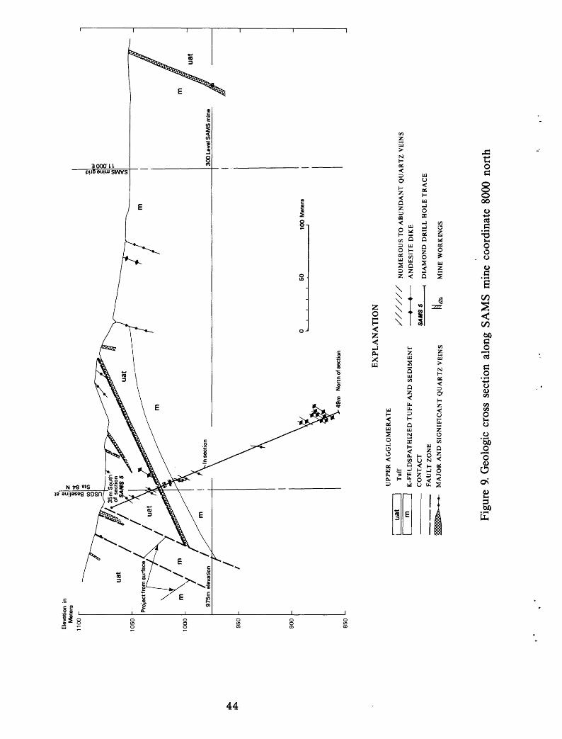
9. Geologic cross section along SAMS minecoordinate 8000 north......................... 44
10. Geologic cross section through diamond drillhole SAMS-1................................... 45
11. Geologic cross section through diamond drillhole SAMS-13 - <,....««. ......................... 46
12. Geologic cross section through diamond drillhole SAMS-12 ...........o...................... 47
13. Geologic cross section through diamond drillhole MD-9..................................... 48
ii

Paqe
Figure 14. Geologic cross section through diamond drillholes SAMS-10, 7, 2, and 8.................. 49
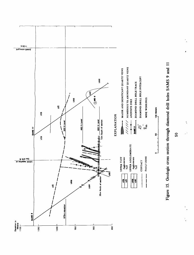
15. Geologic cross section through diamond drillholes SAMS-9 and 11......................... 50
16. Geologic cross section through diamond drillholes SAMS-3................................ 51
17. Geologic cross section through diamond drillhole MD-6................................... 52
18. Geologic cross section through diamond drillhole MD-5................................... 57
19. Geologic cross section through diamond drillhole MD-10.................................. 60
TABLES Table 1. Summary of analytical results and specific
gravity determinations of 128 character core samples from diamond drill holes MD-1, 2, 3, and 4. ........................................ 23
2. High, medium, and low population mode values determined by visual inspection of bimodal and trimodal distribution curves.............. 27
3. Zones of metalization in core from diamonddrill holes MD-1 through 10................... 30
4. Length, azimuth, inclination and location ofdiamond drill holes MD-1 through 10........... 33
5. Potential resource grades and tonnages (metric)of the southern mineralized zone.............. 43
111

MINERAL EXPLORATION: MAHD ADH DHAHAB DISTRICT KINGDOM OF SAUDI ARABIA
by
Ronald G. Worl
ABSTRACT
Mahd adh Dhahab is the largest of numerous ancient gold
mines scattered through the Precambrian shield of Saudi Arabia
and the only one with recent production. During the period
1939-54, 765,768 fine ounces of gold and 1,002,029 ounces of
silver were produced from the mines by the Saudi Arabian Mining
Syndicate.
Ore minerals at Mahd adh Dhahab include free gold and
silver, tellurides, sphalerite, and chalcopyrite in and
associated with a system of north-trending quartz veins and quartz
veinlet stockworks. Pyrite is a common sulfide gangue mineral.
Country rocks are a north dipping sequence of pyroclastic and
transported pyroclastic rocks of the Hulayfah Group that are
locally highly silicified and potassium-feldspathized.
The prime target for this exploration program was a north-
trending zone of quartz veins and breccias, faults, alteration,
and metalization approximately 400 m wide and 1000 m long. The
ancient and recent mine workings are located in the northern
part of this zone. Although the quartz veins and alteration
cut all lithologies, the major metalization is confined to
the intersection of veins and agglomerate. Ten holes were
diamond drilled to explore geochemical, geological, and geo
physical targets in the area.
1

A significant new zone of metalization was discovered
700 m south of the ancient and recent mine workings and within
the same major zone of quartz veins, alteration, and faults.
Metalization in this southern mineralized zone is at the inter
section of the quartz veins and a distinctive and highly altered
agglomerate. The total zone of vein and agglomerate intercept
is potentially metalized and comprises a block of ground 40 m
thick and 400 m wide along the strike of the agglomerate and
projected downdip 250 m. Tonnage of this block is 17.2 million
tons. The explored zone, approximately 25 percent of the
potentially metalized rock, has a potential resource of 1.1
million tons containing 27 g/t gold and 73 g/t silver.
INTRODUCTION
Location and description
Mahd adh Dhahab, situated 250 km north of At Ta'if and
170 km southeast of Al Madinah at lat 23°30'N.; and long
40°53 I E. (fig.1), is an ancient and recent gold mining site.
Access to the area is by unimproved tracks across playas and
low rolling rocky hills north from the At Ta'if-Riyad surfaced
highway and south from the Al Madinah-Suwaydurah highway.
During the later part of 1975 construction of a new road from
Mahd adh Dhahab to Al Madinah was initiated.
The village of Mahd adh Dhahab, a local trade center, lies
just north of Jabal Mahd adh Dhahab and the ancient and recent
mining site situated along the eastern flank of the Jabal.
The Mahd adh Dhahab area has been a center of mining activity
throughout the recorded history of Arabia. Besides gold mining,
2

36
16
Figure 1. * Index map showing the location of the Mahd adh Dhahab district.
3

which may date back to 950 B.C. (Luce and others, 197Jf, p. 2) ,
the area was a central point along trade routes and the inland
pilgrim routes between Mecca, Al Madinah, and the Moslem
countries to the north. The caravan and pilgrim trails followed
a natural route along easily-traveled terrain between wells and
springs situated along the eastern front of the Harrat Rahat
(Tertiary plateau basalts). The ease of access and abundance
of nearby water was probably an important factor in making this
a major mining center in ancient times.
Previous investigations
Ancient mining activity in the area is indicated by
numerous narrow workings that extend to a depth of 85 m along
major veins, several thousand tons of slag left from crude
smelting .operations, and a largely destroyed tell with
attendant ruins and artifacts. These operations occurred during
two periods, possibly about 950 B.C. and during the Abbasiad
Caliphate about 800 A.D. (Luce and others, 1976, p. 1). These
dates are based upon C^ dating of charcoal found in slag and
from scanty mention in historical journals. No evidence of
mining activity between about 1000 A.D. and the twentieth
century has been found. In recent times (1931) the Mahd adh
Dhahab mine was recognized as part of a major mining district
by geologists and engineers retained by the Saudi Arabian
government. A concession for development of the Mahd adh
Dhahab mine was granted the Saudi Arabian Mining Syndicate
(SAMS) in 1936, and production of gold began in 1939. SAMS
will be used throughout to designate the Saudi Arabian Mining
4
Syndicate mining operations at Mahd adh Dhahab. During the
period 1939-54, 765,768 fine ounces gold and 1,002,029 ounces
of silver were produced from the mine by SAMS. Ancient gold
production probably equaled recent production. During the
SAMS operation of the general mine area, all mine workings and
diamond drill core were mapped and studied in detail. The
geologic maps and sections from this period are largely the
work of Dirom (1947) with modifications and additions by
succeeding mine geologists.
Geologists of the U.S. Geological Survey (USGS) mission
and the Saudi Arabian Directorate General of Mineral Resources
(DGMR) covered the general region in the early to middle 1960s
doing 1:500,000 scale mapping of the Precambrian shield
(Brown and others, 1963) and by more detailed (1:50,000)
regional studies in the Mahd adh Dhahab area (Goldsmith and
Kouther, 1971). During this period the USGS drilled two
exploration holes in an altered zone that contains anomalous
molybdenum values, at the western edge of Jabal Mahd adh Dhahab
approximately 1 km southwest of the SAMS mine shaft (Theobald
and others, 1977) .
Geologists of the French Bureau de Recherches Geologiques
et Minieres (BRGM) mapped and studied at a scale of 1:100,000
the Jabal Sayid quadrangle (Aguttes and Duhamel, 1971) and
the Sufaynah quadrangle (Lefevre, 1969, and Dottin, 1974).
Mahd adh Dhahab lies close to the boundary line between these
two quadrangles. BRGM geologists have undertaken extensive
studies in the vicinity of Jabal Sayid, a major copper
5

occurrence, 40 km to the north. The regional geology was being
analyzed and synthesized as part of a 1:250,000 scale mapping
program by BRGM geologists in 1976.
Present investigations
The United States Geological Survey, in accordance with a
work agreement with the Ministry of Petroleum and Mineral
Resources, Kingdom of Saudi Arabia, has been studying and
evaluating mineral deposits in the Mahd adh Dhahab district
(23°30'N.; 40°53'E.). The first phases of the study included
geologic mapping at a scale of 1:2,500 (Luce and others, 1976),
geochemical investigations (Roberts and others, 1978) , and
placer gold investigations (Bagdady and others, H75 ) The
second phase of the study, reported here, included extensive
diamond drilling/ detailed mapping at a scale of 1:1000, limited
surface geochemical investigations, and synthesis and evaluation
of SAMS geological data.
U.S. Geological Survey drill holes are designated throughout
this report by the symbol MD- and the drill hole number; i.e.
MD-5. Saudi Arabian Mining Syndicate drill holes are designated
by SAMS- and the drill hole number; i.e. SAMS-5.
Plates 1 and 3 and figures 9 through 16 and the northern
portion of plate 2 are modified and simplified after Dirom
(.1947). Modifications to Dirom 1 s maps and sections were minor
and involved only lithologic reinterpretations based upon
fieldwork and examination by the author of representative core
samples from the SAMS drilling program. Samples (5 cm split
core chips) from the 13 SAMS diamond drill holes were discovered
6

late in the spring of 1975, beneath a pile of rubble within
the village of Mahd adh Dhahab. Unfortunately the bulk of the
SAMS drill core was unusable as it had been dumped into one
rubble pile some time after mining operations ceased. Many
representative lithologic core samples however, could be
accurately positioned with respect to hole number and depth and
afford a direct connection between surface rocks, USGS drill
core, SAMS drill core, and subsurface mine mapping and also
provided fresh samples for petrologic and petrographic studies.
Incomplete drill logs and assay data are available for the
SAMS drill holes, but were not in suitable shape to use in this
report. The 1" to 40' scale maps and cross sections of Dirom
(1947) contain a wealth of data that could not be transferred
to the author's 1:1000 scale working maps.
Three horizontal controls are included on plates 1, 2 and
3; the SAMS mine grid, in feet; latitude and longitude; and
a 50-meter square grid set by the USGS and used for 1:1000
scale mapping and sampling and geophysical studies. The SAMS
mine grid is included for correlation. Several of the maps
and sections used were poor paper copies that have not held
scale, thus correlations between some plates is not exact.
Transfer of data from one control system to another was based
on distance from the southwest corner of the main shaft.
Acknowledgements
Acknowledgement is due the Minister of Petroleum and
Mineral Resources of the Kingdom of Saudi Arabia and the
Directorate General of Mineral Resources for providing the
support that made the study possible.

The guidance and discussion concerning this study by
T.H. Kiilsgaard, Project Chief, and R.J. Roberts of the USGS
are gratefully acknowledged. Abdulaziz Bagdady contributed
to the synthesis of the SAMS data and general geologic knowledge
of the area. Ziad Al Kolak logged core from drill hole MD-9
and is responsible for geologic interpretation of that core.
Roy Nixon and Charles Robins laid out the 50-meter square grid
that served as base for detailed mapping and for geophysical
work. Geologists too numerous to mention, from the USGS, DGMR,
BRGM, and private industry have contributed by discussion of
the area.
GEOLOGIC SETTING
Regional geology
The Mahd adh Dhahab district is underlain by a complex of
Precambrian pyroclastic, volcanic, and clastic rocks overlying
a large body of diorite to granodiorite (Goldsmith and Kouther,
1971, pi. 1). Regional correlations of this largely pyroclastic
sequence, the Mahd adh Dhahab series, is not in agreement among
previous investigators. The rocks have been assigned to the
Hulayfah Group (Halaban Group) (Aquttes and Duhamel, 1971;
Delfour, 1975), the Halaban Group and Fatima Formation (Brown
and others, 1963), an intraformational agglomerate above the
Halaban (Lefevre, 1969), the Fatima and Murdama Formations
(Goldsmith and Kouther, 1971) and to the Murdama Group (Luce
and others, 1976; Dottin, 1975). The author concurs with
assignment to the Hulayfah Group. This sequence rests upon
granitic rocks .of the type that intrude pre-Hulayfah Group
8
rocks elsewhere in the region and in turn is overlain by
relatively nonmetamorphosed volcanic flow rocks and breccia of
the Murdama Group (Brown and others, 1963). The Mahd adh
Dhahab series in the vicinity of the Mahd adh Dhahab mine is
described by Aguttes and Duhamel (1971, p. 17) as predominantly
"rhyolitic pyroclastites" with interstratified andesite,
fine-grained sedimentary rocks, "ignimbrite", and silicic tuff,
none of which has regional extent except the "ignimbrite".
They consider the Mahd adh Dhahab series in the mine area as a
succession of lenses several meters to 40 m thick and limited
in areal extent by numerous facies changes. Towards the west
the Mahd adh Dhahab series grades by intertonguing and facies
changes to a predominantly tuff and dolomite sequence (Aguttes
and Duhamel, 1971, p. 18). Alkalic granite and rhyolite cut
the sequence north of Mahd adh Dhahab and andesite dikes and
sills cut it throughout its exposures.
The Mahd adh Dhahab area is in a zone of strong regional
northeast-trending faults and folds (Goldsmith, 1971, p. 36).
Within the study area (pi. 2), however, north-trending structures
dominate with subordinate northeast and northwest-trending
structures. The southwestern edge of the northwest-trending
Najd fault system is only a few kilometers northeast.
Lithologies and alteration
Rocks of the Mahd adh Dhahab series exposed in the study
area (pi. 2) are composed of an intimate mixture of pyroclastic
and transported pyroclastic and clastic detrital material.
Volcanic flow rocks, welded tuff, and breccia are subordinate.
Grain size and related parameters of sorting, grading, and
9

bedding vary much more than lithic, pyroclastic, and mineral
composition, which is relatively consistent through most units
mapped. Most of the medium- to fine-grained rocks are bedded,
and commonly graded. The rocks exposed range from coarse
agglomerate to very fine-grained tuff. Lithic and pyroclastic
fragments in order of decreasing abundance are andesite to
rhyodacite volcanic rock, silicic tuff, and chert, with locally
abundant broken feldspar grains, diorite, pumice, and glass
shards. The common minerals are chlorite, plagioclase, potassium-
feldspar, and quartz, with locally abundant epidote and minor
amphibole. The rocks are not regionally metamorphosed, but are
hydrothermally altered. The original mafic minerals have
altered to chlorite and magnetite. Much of the plagioclase
has been altered to either masses of sericite and quartz or
to saussurite aggregates.
Two types of post-depositional alteration have affected
these rocks: 1) hydrothermal alteration, mainly silicification,
pyritization, and propylitization centered on the quartz vein
zone and 2) more widespread and pervasive potassium-feldspathiza-
tion. The relationship between the two is not documented, but
the potassium-feldspathization seems to be in part contempor
aneous with early quartz veining. Three types of potassium-
feldspar are found: disseminated crystals, as a replacement of
plagioclase, and as a minor vein mineral. All three types are
similar optically and X-ray diffraction patterns suggest they
are compositionally similar, nearly maximum microcline.
10

Randomly disseminated potassium-feldspar crystals occur in all
map units indiscriminately throughout the groundmass and in
lithic and pyroclastic fragments of all types. The subhedral
potassium-feldspar crystals commonly cut grain boundaries of
metamorphic minerals. Fragmental plagioclase in crystal-lithic
tuff of the upper and lower agglomerates are partially to
totally replaced by potassium-feldspar; plagioclase cores with
potassium-feldspar rims are common. Potassium-feldspar occurs
as an early vein mineral in banded veins and as monomineralogic
veinlets, mostly in the mine area.
The lithologic sequence of Luce and others (1976) , in
decreasing age of lower agglomerate, lower tuff, upper agglo
merate and upper tuff, with further breakdown of the units is
retained in this report. The lower agglomerate has been
subdivided by the author into lower, middle, and upper units
on the basis of drill core information. The subdivision is
recognizable at the surface, but is not readily discernible on
the scree-covered outcrops. The lower unit is mainly andesite
tuff and lapilli tuff and is distinctive from the middle and
upper units. The middle and upper units, both mafic-lapilli
tuff to agglomerate, appear similar but the upper unit has a
mostly siliceous gray groundmass while the middle unit has a
chlorite and epidote-rich groundmass. In addition, the middle
unit has locally abundant chert and siliceous tuff fragments
not present in the upper unit. The three units also differ
geochemically as discussed in this report under the section
on geochemistry. The contact of the lower agglomerate and
11

lower tuff is gradational across a wide zone of intercalated
lapilli tuff, agglomerate, and massive tuff. The upper
contact of the lower tuff with the upper agglomerate is sharp
with no gradation or intercalation of the two lithologies.
Rocks considered by previous investigators to be rhyolite
(Dirom, 1947; Luce and others, 1976) are considered by the
author to be potassium-feldspathized tuff, wacke, and sandstone
and are probably raetasomatized equivalents of part of the lower
tuff. Rocks of the two units are similar in texture, composi
tion, and mineralogy, with the exception of the locally abundant
potassium-feldspar crystals and zones of sericitization(?) in
the metasomatized rock. The gradation from unaltered to altered
rock can be observed in core from drill holes MD-6, 9, and 10
and SAMS-1, 4, 5, and 13.
The upper agglomerate is here divided into two units,
crystal-lithic tuff to agglomerate and gray agglomerate. The
crystal-lithic tuff conformably overlies the lower tuff. The
lower few meters are primarily a mafic pyroclastic rock and
contains an abundance of flattened lapilli and possible shards.
The remainder of the crystal-lithic tuff and agglomerate is
generally bedded and commonly graded. The gray agglomerate seems
to be unconformable to the crystal-lithic tuff and agglomerate, as
its outcrop pattern transects layering in the underlying crystal-
lithic tuff and agglomerate and in some areas it directly
overlies potassium-feldspathized tuff and sediments. The gray
agglomerate is characterized by subrounded chert, tuff, and
12

volcanic rock fragments set in a siliceous gray groundmass.
Layering is not common but is present in a few finer-grained
zones.
The upper tuff is largely agglomerate-conglomerate with
a relatively thin unit of argillite and carbonate-bearing tuff
at the base. It is in unconformable contact with the underlying
upper agglomerate. Where penetrated by drill or mine workings
the contact is a bedding plane fault, parallel to bedding in
the upper tuff. The nature of this contact is important as the
quartz veins terminate upward against it. If the contact is
a fault plane with major offset, the vein system may continue
northward from the faulted offset whereas if it is primarily an
unconformity it may represent the northward terminus of the vein
system. The vein system may predate the unconformity and be
truncated by that structure, or the veins may have terminated
upwards against the unconformity because of the overlying
incompetent tuff. Whereas the more competent underlying
agglomerate would fracture and subsequently fill with vein
forming material the less competent tuff would absorb the
fracturing stress and open fractures would not develop. The
argillite and carbonate-bearing tuff of the upper tuff are
finely bedded, waterlain and differ distinctly from the lower
tuff. The overlying agglomerate-conglomerate portion is
characterized by an abundance of pale-green dacite fragments
and well-rounded red chert fragments, and local fragmental
quartz.
13

Structure
The Mahd adh Dhahab series, aside from the upper tuff, is
highly fractured and cut by numerous faults, joints, and quartz
veins, but the rocks are not highly sheared and primary textures,
bedding, and lithologic layering may be seen in most outcrops.
Schistosity or other metamorphic penetrative surfaces are not
well developed. Deformation of the rocks other than the upper
tuff was brittle rather than plastic, and more typical of near
surface fracturing than deep-seated thermal dynamic metamorphism.
The most obvious structural feature within the study area
(pi. 2) is the zone of north to N45°E trending quartz veins,
andesite dikes, and faults. There is also an important, but
less obvious because of lack of contained quartz veining, fault
system that trends N45°W to west. Several periods of faulting
and quartz vein and andesite dike emplacement along the north
to northeast trending systems and to a lesser extent the north
west to west system are evident (Luce and others, 1976). The
latest faulting was along the northwest to west trending system,
although lateral offset in the map area (pi. 2) is minor. The
low angle thrust faults in the northern part of the area (pi. 2)
are nearly parallel to layering in the crystal-lithic tuff-
agglomerate unit of the upper agglomerate. These are local
features related to folding, and are not of regional significance.
A major northeast-trending right lateral fault system
bounds the map area on the southeast (Goldsmith and Kouther,
1971, pi. 1; also pi. 1 of this report). Although not exposed,
the individual zones of alteration associated with this fault
14

system are well delineated by SP and EM geophysical anomalies
in the alluvial covered valley just to the east of the study
area (Mark Gettings, personal communication, 1975). The
anomalies associated with these faults are offset and truncated
by northwest to west trending faults. A segment of a major
northeast-trending fault was penetrated by drill hole MD-10.
This was the only fault zone penetrated in the USGS diamond
drilling characterized by an abundance of clay-rich gouge, vugs,
and complete water loss during drilling. The other intersected
fault zones were characterized by minor sericite mylonitic
shears, or thin seams of gouge and granulated rock.
A nearly horizontal joint system cuts all rock types and
in some places minor offset of quartz veins along this system
can be seen. In drill core these joints are generally open
and often lined with fine drusy quartz and are nearly penetrative
surfaces in some sections of core. The significance of this
system is unknown.
Structure of the Mahd adh Dhahab Series is defined by
primary sedimentary or volcanic bedding and lithologic layering
in most units. Only the agglomerates lack measurable bedding
or other primary layering features. Foliation and other meta-
morphic penetrative planar structures are not well developed,
and where present are generally parallel to bedding or to an
adjacent major shear zone. Minor fold axes and other measurable
linear penetrative structures are lacking. Folds in the Mahd
adh Dhahab series are broad, open flexural types; shear folds
and flow folds common in higher metamorphic grade rocks of the
Arabian Precambrian shield were not seen.
15

Main strike direction of bedding and layering is east-west
with north dips. Structural analysis of measured attitudes
available from all sources (unpublished SAMS data; Dirom, 1947;
Goldsmith and Kouther, 1971; Luce and others, 1976; this report)
defined areas of broad open folds (pi. 1). Poles to bedding
attitudes were plotted on the lower hemisphere of a Schmidt
equal-area net to define structurally homogeneous subareas I
through VI (pi. 1). Fold models shown by curvilinear strike and
dip symbols within each subarea are based upon the distribution
of poles to bedding on the corresponding stereonet. Structure
in most of the map area, and in subareas I and V (pi. 1), is a
slightly folded homocline. In structural subareas II, III, and
IV, structure is open flexural folding around a north-plunging
axis, while in the subarea VI the folding is around an east-
plunging axis. Relationship of folding in subareas II, III,
and IV to regional structure is unknown, but these folds are
probably subsidiary folds on the flanks of large regional-scale
features. Variation in attitude of axis of folding between
subareas, and variation of poles to bedding away from the
best-fit great circle within subareas is the result of post-
folding block faulting. Note that most subarea boundaries are
along major faults. The structures defined in subarea VI are
probably the result of drag folding along the major northeast-
trending fault system just to the east and are not of regional
significance. There is no evidence in any of the subareas for
multiple episodes of folding.
16

Special mention must be made of structural subarea III as
the structure defined in this subarea is the basis for the
structural interpretation in cross-section A-A 1 (fig. 2), which
shows that metasomatized tuff is continuous with and is an
altered portion of the lower tuff. Data in this subarea
includes attitudes noted as flow-banding in rhyolite on the
SAMS 300' level geologic map (Dirom, 1947). The poles to bedding
have relatively wide scatter around the defined great circle, but
there is little question that this area is structurally homo
geneous. This supports the premise that the lower tuff is
continuous into the metasomatized rock.
Mineral!zation
Mineralization at Mahd adh Dhahab consists of gold, silver,
copper, and zinc metalization in or associated with quartz veins.
Although quartz veins occur throughout Jabal Mahd Dhahab they
are most abundant in a north-trending zone 400 m wide and
approximately 1000 m in length along the eastern edge of the
jabal. This zone of faulting, veining, and metalization is the
prime exploration target of this study and contains the SAMS
mine and most ancient workings.
The quartz veins range in width from 1 mm to as much as 5 m
for some composite veins, but most individual veins are 10 to
50 cm in width. Vein material is generally space filling of
fractures, open breccias, and fissures and commonly earlier vein
material is brecciated and healed by later quartz. The larger
veins are invariably brecciated composite veins composed of
quartz-healed breccias of previous vein material and wall rock
, /f

fragments and sheeted veins in the 10 to 50 cm width range.
Veins 10 to 50 cm wide are typified by banding, crystal-lined
vugs, cockade structure, and comb structure of inwardly
terminated zoned quartz crystals. The veins are mostly quartz
with subordinate bands of pyrite, sphalerite, chalcopyrite, and
chlorite. Chalcendonic quartz and carbonate are late consti
tuents in some veins. In a few sections of core dark-gray
quartz-sulfide veinlets cut all other quartz. Potassium feldspar
is locally abundant, especially in the SAMS mine area, as bands
in the veins and as veinlets in altered wall rock. Metalization
is highest where quartz veining is most intense, but all such
zones are not metalized.
Luce and others (1976) recognized four types of quartz veins.
Their breakdown was not readily apparent in drill core, although
two or three distinct generations of quartz deposition was
evident and mm veinlets of drusy quartz and carbonate lining a
nearly horizontal joint system are common throughout. Post-
mineral (.quartz vein) shears and faults occur within and along
the edge of most of the major veins.
Sulfides present in the veins are pyrite, chalcopyrite, at
least two generations of sphalerite, minor galena, tetrahedrite,
and argentite. Native gold and silver accompany the major
sulfides. Preliminary petrologic and mineralogic studies of the
USGS drill core indicate that much of the gold, and presumably
also the silver, in the southern mineralized zone as outlined
by drill holes MD-3, 7, and 8, is in the form of tellurides.
BRGM geologists have recognized hessite, empressite, and rare
19

altaite and pezite in ore samples from Mahd adh Dhahab (Delfour,
1975, p. 24). An occasional gold grain or wire can be found in
quartz from the dumps or outwash plain. Visible gold was seen
in only one core sample, from drill hole MD-6. According to
studies by Luce and others (1976) "Silver is distributed
throughout the specimen (study sample) in galena and tetra-
hedrite, but gold is mainly in selvage zones".
The degree of wall rock alteration is variable. Most of
the core is pyritized and propylitized(?) while some zones are
intensely silicified and other zones are potassium-feldspathized,
as shown by veinlets of potassium-feldspar and pyroclastic
fragments and plagioclase replaced by potassium-feldspar.
Highly fractured rock with a pervasive stockwork of 1 cm sized
veinlets is the most strongly altered. Alteration at the contact
of the larger veins sometimes consists of a thin zone of dark-
green chlorite, although there is generally no contact alteration.
GEOCHEMISTRY
Sampling plan
Three types of samples were collected for geochemical
analysis; split core, character core, and surface samples. The
split core was analyzed to test for metalization while the
character core was used to determine the geochemistry of the
host rocks. Surface samples were taken to check the distribution
of metals in and along quartz veins through rocks of different
lithologies. All analyses were performed by the DGMR-USGS
laboratory in Jiddah. Analytical results are stored in the RASS
system. Split core samples have sample (RASS) numbers 97,000-
97,499, 97,628-97,749, 97,900-97,999, 105,100-105,999, and
20

110,100-110,356; character core samples have sample (RASS)
numbers 97,500-97,628; and surface character samples have
numbers (RASS) 105,700-105,999.
The entire diamond drill core obtained, with the exception
of sections of drill holes MD-5, MD-6, and MD-7, was split,
with one-half being retained and stored, the other half being
submitted for analyses. Sampled intervals were generally 1 or
2 m lengths of core. The split core samples were analyzed for
gold, silver, copper, and zinc by atomic absorption methods.
The results are part of the permanent core record on file with
the USGS project, Jiddah. Only the logs and analyses for holes
MD-7, 8, and 3 are included with this report (Appendix B).
Every tenth sample from part of the drill core was further
analyzed by semiquantitative spectrographic methods. The
results of the spectrographic analyses are listed in Appendix A.
One hundred twenty-eight lithologic character samples from
diamond drill holes MD-1, -2, -3, and -4 were taken according
to a nested hierarchical sampling plan. The purpose was to test
element concentration variation within and between lithologic
units. These 20-30 gram samples were taken before the core was
split by sawing out a 1 to 2 cm disk. Since this size is the
equivalent of a chemical split, no variation in analytical
results was introduced by sample splitting or sample preparation.
The total sample was used in the analysis. An attempt was made
to include only wall rock in the sample disk, but in some sample
zones the wall rock contained a pervasive network of mm-sized
quartz veinlets that could not be avoided.
21

Analyses performed on the lithologic character samples
included gold, silver, copper, lead, zinc, bismuth, cadmium,
cobalt, manganese, sodium, potassium, SiO2 , aluminium, and
calcium by atomic absorption methods and molybdenum, tungsten,
arsenic, and antimony by colorimetric methods. Values for
molybdenum, tungsten, arsenic, antimony, and bismuth were
generally low, at or below detection levels. Values for copper,
lead, and zinc were erratic and generally corresponded to values
obtained from the split core samples. Mean, variance, and
standard deviation of each element grouped as to lithologic
unit within the lower agglomerate are given in table 1.
A suite of surface geochemical samples were taken to test
metal distribution within and along veins in several lithologies.
Sample locations are shown on plate 2, and sample description
and anlytical results are listed in Appendix A. Gold, silver,
copper, and zinc were determined by atomic absorption methods.
Each sample was composed of numerous 1 to 3 cm sized chips
taken from outcrop along the length of the sample zone which
varied with each sample (Appendix A). The total weight of sample
varied with sample length; aim sample contained approximately
2 kg of rock chips.
Discussion of results
Metal values in split core samples from drill holes MD-3,
-7, and -8 indicate a major body of metalization within the
lower agglomerate in the southern part of the zone of quartz
veins, alteration, and faults. Surface expression of this
mineralized zone is shown by anomalous gold geochemical values
22

Table 1. Summary of analytical results and specific gravity determinations of 128 character core samples from diamond drill holes MD-1, 2, 3, and 4.
I Upper unit of lower agglomerate - 32 samples
Element Mean Standard deviation Range in values
KSi02NaAlCaMgMn
Sp GrAg
Au(-)AuCuZn
0.3675.690.663.720.492.53.11
2.7013.100.141.250.090.38
0.4213.701.132.420.511.79.08
0.1243.70.105.190.130.41
0.02-1.50 50.38-94.16 0.01-3.40 0.50-9.40 0.05-2.22 0.16-5.98 0.01-0.25 2.41-3.13 1.00-245.00 0.04-0.40 0.04-29.44 0.002-.58 0.03-1.65
II Middle unit of lower agglomerate - 80 samples
KSiO2 NaAlCaMg Mn
Sp GrAg
Au(-)AuCuZn
2.9070.25 0.844.220.432.35.15
2.681.98 0.080.200.05.17
1.689.931.402.100.361.43.07.08
5.500.080.620.15.21
0.04-5.81 45.70-93.02 0.01-8.00 0.30-7.60 0.01-1.18 0.58-5.80 0.03-.34 2.28-2.89 0.10-47.10 0.02-0.50 0.02-4.80 0.001-.95 0.008-1.12
III Lower zone of lower agglomerate - 16 samples
KSiO2 NaAlCaMg Mn
Sp Gr Ag AuCuZn
1.7263.38 2.306.071.562.48 0.162.77 1.57 0.060.020.22
1.320.872.173.581.161.300.080.080.920.050.0080.52
0.30-3.45 42.06-95.78 0.06-5.90 0.30-9.80 0.06-3.00 0.24-4.16 0.04-0.25 2.65-2.86 0.60-4.70 0.02-0.16 0.003-0.03 0.009-2.14
23

(pi. 2, and Roberts and others, 1978, pi. 1). High metal
values in the core are in altered and quartz veinlet zones
next to major veins, or within major quartz veinlet stockworks.
More importantly all of the high gold and silver values and
most of the high copper and zinc values are restricted to a
distinct stratigraphic horizon; the upper unit of the lower
agglomerate. The high values from surface samples also occur
within this unit. The distinction of units within the lower
agglomerate was made first by examination of the drill core, but
later was recognized on the surface. Although similar in hand
specimen lithology, units 1 and 2 of the lower agglomerate differ
markedly geochemically (see for example table 1). Unit 1 is
distinctly lower in K and possibly lower in SiC>2 and Al than
unit 2. Metal values are higher in unit 1, even when the few
anomalously high values are removed from consideration.
The variance of element concentration values within each
unit is high for most elements (table 1); too high to allow
direct comparison of element concentration between units.
Assuming that any one element within a lithologic unit has a
single and evenly distributed origin the analytical determina
tions for that element will be from a single population, and will
have a normal or lognormal distribution. Something other than
normal or lognormal distribution and especially distributions
with more than one mode (high), suggests that more than one
population was being sampled. In this case it suggests that the
element being analyzed had either more than one origin, or that
it was not evenly distributed at the time of formation of the
24

unit being sampled. Of the elements listed in table 1, only
the values for specific gravity and background metals have
normal or lognormal distribution; the others are mostly bimodal
or trimodal. The lack of normal distributions, reflected in
the high variance values (table 1), makes comparison of chemistry
between the units difficult. Only the differences in K values
between the upper unit and the other two units has statistical
significance. The mode of individual populations within the
obviously bimodal or trimodal distribution curves can be approxi
mated. For example, using SiO2 values from the upper unit three
populations with approximate mode values of 48 percent, 67
percent, and 90 percent can be differentiated (fig. 3). This was
done by visually fitting curves to a histogram of the SiO2
values. The 90 percent SiO2 population is slightly greater in
abundance than the 67; the 50 percent is relatively minor. Using
SiO2 values from the lower unit (fig. 3), the same three popula
tions can be recognized, only here the 45 percent SiO2 population
is dominant and the 68 percent and 92 percent SiO2 populations
are less, but still significant. Only two populations can be
seen in the SiO2 histogram for the middle unit; a very dominant
67 percent Si02 population and a minor 90 percent SiO2 population
(fig. 1). The modes for all significant elements were determined
in this manner and are listed in table 2.
The trimodal nature of element value distribution reflects
the genetic history of the lower agglomerate. Using the modes
listed in table 2 and petrography as a guideline it can be
inferred that the source of elements for the lower agglomerate
25

N =
ME
\N
=
ST
D.
DE
V .
= SK
EX
YN
ESS
=
KL
RT
OS
IS =
X
MIN
-
XM
AX
=
RA
NG
E =
16 63. 38
20.8747
0. 3072
1.28
9542.0600
95. 78
0053
,720
0
DO05
PERCENT
N =
ME
AN
=
ST
D.
DE
V,
=S
KE
WN
ES
S =
KU
RT
OS
IS =
XM
IN =
XM
AX
=R
AN
GE
=
80 70, 9. 0. ?,
45,
93.
47.
2534
9328
3050
8646
7000
0200
3200
o
N
=M
EA
N =
ST
D.
DE
V.
= S
KE
W N
ES
S =
K
UR
TO
SIS
=
XM
IN =
X
MA
X =
R
AN
GE
=
PE
RC
EN
T S
i02
LO
WE
R
t'NIT
PE
RC
EN
T S
iO2
MID
DL
E U
NIT
PE
RC
EN
T S
i02
UP
PE
R U
NIT
Figu
re 3
. - H
isto
gram
s an
d co
mpu
ter
deri
ved
( o 0
o 0 )
and
vis
ually
der
ived
( )
smoo
th
curv
es f
or S
iO2
dist
ribu
tion
in t
he u
pper
, mid
dle,
and
low
er u
nits
of t
he l
ower
agg
lom
erat
e.

Table 2. High, medium, and low population mode values determined by visual inspection of bimodal and trimodal distribution curves. Value representing dominant population is underlined
Element Upper unit Middle unit Lower unit
hK m % 1
h Si02 m % 1
hNa m % 1
hAl m% 1
hCa m % 1
hMg m% 1
h Mn m ppm 1
h Au m ppm 1
.50
90 67 48
3.8 1.5 .50
9.05.51.25
2.1.9
5.7 3.2
2400 1400 400
.35
.1,
4.001.75 .50
87 6J7
2.2 .25
7.004.751.00
.9 JL!
5.5 3.81.2
3200
800
.02
3.502.00 .25
92 68 £5
4.5 2.2 .50
9.504.251.25
2.8.9 .3
3.5.75
2400 1800 700
.02
27

was in part andesite volcanic rock and in part diorite to
granodiorite plutonic rock and dacite to rhyodacite volcanic
rock. This is consistent with the geologic history of the
region. Imposed upon the agglomerate were later metamorphic and
hydrothermal alterations reflected by the high K, high SiC^ /
high Na, low Al, high Mg(?), and high metal modes. The modes
(table 2) suggest that the upper unit is more highly altered
than either the middle or lower unit. If the upper unit was
originally composed largely of andesitic component, similar to
the lower unit, alteration involved the introduction of SiO2 and
metals and removal or dilution of Ca, Mn, Al, and Mg. If the
upper unit was originally composed largely of diorite-dacite
component, similar to the middle unit, alteration involved the
introduction of SiO2 and metals and removal or dilution of K,
and possibly Al, and Mg. In conclusion, the chemical differences
including the higher metal content of the upper unit were
introduced by post-depositional alteration rather than being a
primary feature.
EXPLORATION PROGRAM
Introduction
The USGS exploration project at Mahd adh Dhahab was
initiated in 1972. The area of Jabal Mahd adh Dhahab was mapped
at a scale of 1:2500 and the petrology and genesis of the gold
deposits studied (Luce and others, 1976) . An extensive traverse
and grid geochemical sampling program in parts of Jabal Mahd adh
Dhahab outlined several areas containing anomalous metals and
also provided information on the genetic relationships of the
28
metals present (Roberts and others, 1978). The placer potential
of the gravels surrounding the mine area was also investigated
(Bagdady and others, /97V ) Tne diamond drilling program
was based upon results of work by Luce, Roberts, and Bagdady.
An extensive geophysical survey was done under contract to ARGAS
during July and August of 1975.
Three target areas were tested: the southern mineralized
zone, the SAMS mine area, and a geophysical anomaly between the
mine area and the southern mineralized zone. The main objective
of the diamond drilling program was to prove existence of
metalization, not to outline size, shape, and tonnage of ore
bodies. The drill holes were located in a manner to obtain the
maximum geologic information in addition to testing potential
metalized zones. Targets were picked on the basis of geology,
geochemistry, and undergound maps and data of the SAMS operation
Geophysical data were utilized in the placement of drill hole 10
Diamond drilling was by the Arabian Drilling Company during
the period November 11, 1973 to June 28, 1975. A total of 10
holes with an aggregate length of 3720 m were drilled into the
selected targets. Core logs containing drilling information,
core recovery, structure, lithology and mineralization of core
sample, and sample interval and anlytical results are on
permanent file with the USGS project, Jiddah. Appendix B
contains complete logs for drill holes MD-3, 7, and 8, and
summary logs of the other drill holes. Metalized zones are
listed in table 3 and drill-hole information in table 4.
29

Table 3.--Zones of metalization in core from diamond drill holes MD-1 through 10
Coreinterval (m)
MD-1
292-303.6
MD-2
nothing
MD-3
16-1862-74
106-120124-140148-158166-190
(includes)174-190174-182176-182178-182
214-230
MD-4
40-4664-86
118-122156-168194-198
MD-5
351-379
Length (m)
11.6
21214161024
16864
16
6124
124
28
Aug/ton
17.132.842.460.9
3.8
.20
Agg/ton
84.9164.0207.0200.5
30.1
.30
Cu%
.25
.12
.25
.42
.30
.23
.50
.45
.20
.32
.62
.51
.23
.30
Zn%
.81
.271.19
.40
Au/Ag
.52
.85
.42
.20
.20
.20
.30
.13
.67
Cu/Zn
.75
30

Table 3.--Zones of metalization in core from diamond drill holes MD-1 through 10 (cont'd.)
Coreinterval
MD-6
218.02-219.10247.00-250. 00303.05-304.70332.40-335.25353.00-355.00366.35-368.45403.40-404.45
MD-7
121.00-125.50129.50-139.50
(includes)133.50-135-50
149.90-151.20174.50-175.65185.90-186.70198.80-200.63248.25-256.00262.00-267.00271.00-276.00289.30-289.80299.15-299.30
MD-8
72-7878-8181-8787-9090-9494-9797-112
112-122122-123123-130130-132132-133133-135135-148
Length
1.023.001.652.852.002.101.05
4.5010.00
2.001. 301.15.80
1.837.755.05.0.50.15
636343
151017212
13
Aug/ton
.96
.18
.04
.04
.04
.0816.40
4.15.7
15.020.84.37.21 .401.48
.14
.14
1281.412.897.33.2
31 .85.0.21
10.2.30
9.2190.010.0
.33
Ag ;g/ton ;
19.59.58.14.89.4
65.0.3
26. 728.6
64.0140.079.527.010.020.194.25.05
13.703.40
1216956.2
24920.4
17031.74.431.06.53
3024019.02.68
Cu%
.631.351.56.91.92
2.80
.24
.26
.472.151.92
. 78
. 701.571.45.87
4.058.65
.40
.70
.60
.60
.401.201.20.20-
.20
.20
.45
.20
.16
Zn%
5.00.51.93.17.70
2.00
.901.40
3.4512.504.972.10.22
4.10
1 .022.90.07
.701.401.504.30.50
3.002.90.97-
.90
.302.30.70.30
1
Au/Ag
.05
.02
.004
.01
.004
.001
.55
.15
.15
.23
.15
.05
.27
.14
.07
.03
.01
1.48.23.39.16.19.16.05.10.05.31.79.53.12
Cu/Zn
.132.651.685.361.311.40
.27
.18
.14
.17
.39
.373.18.38
.871.40
123.6
31

Table 3.--Zones of metalization in core from diamond drill holes MD-1 through 10 (cont'd.)
Coreinterval
MD-8 (cont'd.)
148-156277-280295-296353-355358-359
72-9097-112
112-130130-135135-156
72-112 72-156
MD-9
nothing
MD-10
84-8888-9090-9292-9797-99
119-121122-123133-139
171.43-171.70
Lengthm
83121
2515185
21
40 84
42252
213
.27
Auppm
.88
.09
.20
325.8
46.5
22 14
.15
.15
.10
.15
.10
2.44-.23
-
Agppm
7.182.01.633.12
16
90325
685
68 39
2.785.802.653.521.50
42.002 .068.00
7.00
Cu%
.72
.53
.881.98
.601.20.20.30.37
.30
.55
.10
.80
.18
.25
Zn%
1.35.84.55.13.80
1.632.90.92.90.70
.90 1.43
. 302.25.20
1.21j .39
Au/Ag
.01
.06
.01
.36
.16
.16
.68
.10
. 32
.36
1.052.031.042.041
i.64 1.06
Cu/Zn
.37
.41
.22
.33
.53
.33
.38
. 33
. 36
.90
.21
.50 2.70 2 ; .19
.57
2.88
.41 1.03 1.39i j
12i
32

Table 4. Length, azimuth, inclination and location of diamond drill holes MD-1 through 10
MapHole #
uses
MD-1
MD-2
MD-3
MD-4
MD-5
MD-6
MD-7
MD-8
MD-9
MD-10
Length
303.60
321.45
251.85
223.60
601.80
450.05
300.30
445.65
582.45
249.70
Azimuth
265°
305°
300°
115°
100°
157°
300°
300°
112°
90°
Inclination
30°
40°
35°
50°
45°
50°
35°
50°
70°
50°
Coordinates
346S 116W
346S 116W
286S 12E
344S 114W
662N 298W
608N 91E
244S 36E
303S 38E
444N 251W
OOON 207E
33

Drill targets
Southern mineralized zone
The southern mineralized zone occurs at the intersection
of the north-trending zone of faults, alteration, and quartz
veins and the east-striking, north-dipping, upper unit of the
lower agglomerate (pi. 2). Metalization is mainly gold and
silver, but copper and zinc are also important constituents.
Although metals are most abundant next to the major quartz
veins, anomalous gold and silver occur throughout the intervein
areas penetrated by drilling. The entire zone of quartz
vein~upper unit intersection can be considered as potentially
metalized. As surface exposures are poor the outcrop pattern
of the metalized zone is not exactly defined (pi. 2). The
surface expression is best shown by the distribution of samples
containing anomalous gold (pi. 2).
Diamond drill holes MD-1, 2, 3, 4, 7, and 8 (figs. 4-8)
explored the southern mineralized zone. Several major veins
cut the agglomerate and the rock is sufficiently fractured and
filled with quartz veins and veinlets to constitute a stockwork
in many areas. Large areas of rock near and around the veins
are highly silicified. Ancient people mined along many of these
veins and faults by means of shallow pits and trenches. Most
importantly, surface rock samples indicate a large area with
anomalous concentrations of gold, silver, copper, lead, and
zinc (Roberts and others, 1978, and pi. 2) that coincides with
the major vein systems. All drill holes in this zone were
designed to intersect numerous veins and still remain within the
lower agglomerate.
34

Elevation in Meters
1150 r
1100 -
1050 -
1000
950
MD 1
975m elevation
303.60
50 100 Meters
MOT
EXPLANATIONLOWER AGGLOMERATE
Upper UnitMiddle UnitLower Unit
CONTACT
FAULT ZONE
MAJOR AND SIGNIFICANT QUARTZ VEINS
NUMEROUS TO ABUNDANT QUARTZ VEINS
ANDESITE DIKE
DIAMOND DRILL HOLE TRACE
Figure 4. Geologic cross section through diamond drill hole MD 1
35
1050 -
1000 -
950 -
900 L
EXPLANATION
LOWER TUFF Tuff and sediment
LOWER AGGLOMERATEUpper UnitMiddle Unit
CONTACT
FAULT ZONEMAJOR AND SIGNIFICANT QUARTZ VEINS
NUMEROUS TO ABUNDANT QUARTZ VEINS
ANDESITE DIKE
DIAMOND DRILL HOLE TRACE
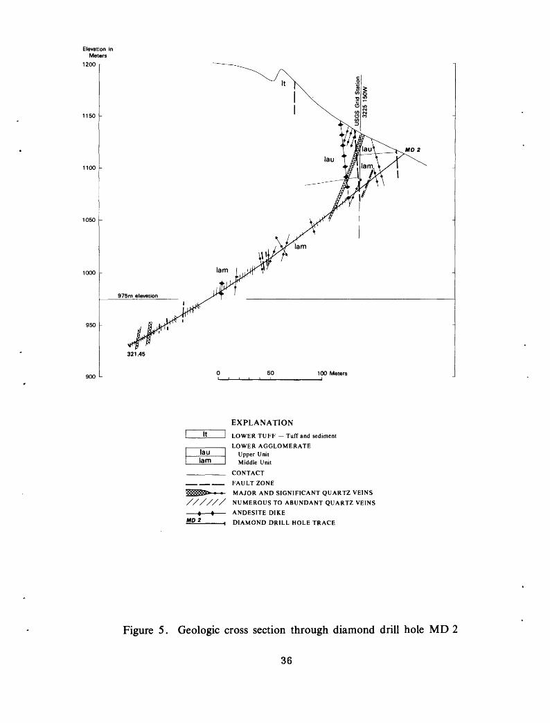
Figure 5. Geologic cross section through diamond drill hole MD 2
36

EXPLANATION
LOWER TUFF Tuff and sediment
LOWER AGGLOMERATEUpper UnitMiddle UnitLower Unit
CONTACT FAULT ZONE
BEDDING ATTITUDE Approximate
MAJOR AND SIGNIFICANT QUARTZ VEINS
850 -
800 -
750 L
NUMEROUS TO ABUNDANT QUARTZ VEINS
ANDESITE DIKE
DIAMOND DRILL HOLE TRACE
CROSS SECTION OF BLOCK OF METALIZEDGROUND USED TO CALCULATE POTENTIALRESOURCES TONNAGES
50 100 Meters
Figure 6. Geologic cross section through diamond drill holes MD 3 and 8
37

1050 -
1000 -
950 L
50 100 Meters
EXPLANATIONLOWER AGGLOMERATE
Middle UnitLower Unit
CONTACT FAITLT ZONE
MAJOR AND SIGNIFICANT QUARTZ VEINS
////// NUMEROUS TO ABUNDANT QUARTZ VEINS
ANDESITE DIKE
\ DIAMOND DRILL HOLE TRACE
Figure 7. Geologic cross section through diamond drill hole MD 4
38

950 -
900 L
50 100 Maters
MD 7
EXPLANATION
LOWER TUFF Tuff and sediment
LOWER AGGLOMERATEUpper Unit Middle Unit
CONTACT
FAULT ZONE
BEDDING ATTITUDE Approximate
MAJOR AND SIGNIFICANT QUARTZ VEINS
NUMEROUS TO ABUNDANT QUARTZ VEINS
ANDESITE DIKE
H DIAMOND DRILL HOLE TRACE
CROSS SECTION OF BLOCK OF METAL1ZED GROUND USED TO CALCULATE POTENTIAL RESOURCES TONNAGES
Figure 8. Geologic cross section through diamond drill hole MD 7
39

Drill holes MD-1, 2, and 4 (figs. 4, 5, and 7) penetrated
mainly the lower and middle units of the lower agglomerate.
Core from these drill holes was generally barren of metals.
Drill holes MD-3, 8, and 7 (figs. 6 and 8) penetrated mainly
the upper unit of the lower agglomerate. Core from these three
holes contain extensive lengths of anomalous to very high-grade
metalized rock. This zone of metalization, is thought to be a
major orebody and worthy of more extensive exploratory investi
gations.
Tonnages and grades given in this report are not reserve
calculations, but are estimates of potential resources. Only
geologic presence and perspective of metalization is given in
this report. Determination of size, distribution, and grade of
ore bodies must await development work. The following assump
tions are placed upon the estimates of potential resources:
a. Metalization is confined to a 40-m thick section of
the upper unit of the lower agglomerate,
b. Metalization is parallel to the major quartz veins,
c. The size, shape, and grade of any one metalized block is
consistent and continuous from surface to a point 50 m
downdip from deepest drill penetration. This point is
250 m downdip and 160 m vertically below surface,
d. Core interval, totaling 254 m, from MD-3, 7, and 8 is
representative of that zone of vein-upper unit
intersection,
e. Specific gravity averages 2.7.
40

f. No assumption is made about metallurgical properties
or recoverability of the metals.
The potentially metalized rock includes all of the upper
unit of the lower agglomerate within the zone of faults,
alteration, and quartz veins. The exposed width of the vein
zone is approximately 300 m f but an additional 100 m of width
under wadi fill to the east of the exposures can be inferred by
southward projection of veins from the mine areas (pi. 2). The
potentially metalized rock can be visualized as a north-dipping
tabular sheet 40 m thick, 250 m wide (downdip of upper unit) ,
and 400 m long (along strike of upper unit). North, northwest,
and west-trending faults break this block into wedges that are
slightly offset from one another. This block contains 17,210,000
tons of potentially metalized rock.
Drill holes MD-3, 8, and 7 (figs. 6 and 8) tested approxi
mately 150 m of the possible 400 m length of vein-upper unit
intersection. The block of ground tested by drilling, a north-
dipping tabular sheet 40 m thick, 250 m wide (downdip), and
150 m long (along strike), contains 4,050,000 metric tons.
Average grade of this block, as determined from analyses of all
split core from the upper unit of the lower agglomerate, is
6 g/t gold and 22 g/t silver.
Five blocks of higher-grade metalization can be defined
within the zone tested by drilling. Cross-sections of the
higher-grade blocks are noted on figures 6 and 8. Each block is
40 m thick, 250 m wide (downdip) and of the length (along strike)
shown on the cross-sections. The size and grade of each of the
41

five blocks is given in table 5. Various combinations of the
high-grade blocks are used to calculate estimated potential
resources, also given in table 5. The potential resources
compare favorably in grade to the grade determined from production
figures of the SAMS operation. Approximately 585,000 metric tons
of underground ore containing an average of 37 g/t gold and
58 g/t silver were produced during the SAMS operation. The
southern mineralized zone has a potential resource of 783,000
metric tons of 31 g/t gold and 68 g/t silver ore or 1,107,000
metric tons of 27 g/t gold and 73 g/t silver ore. Because only
150 m of the possible 400 m width of vein-upper unit intersection
has been explored, it is tempting to increase all potential
resource figures 2.7 times. However, the geologic perspective
does not warrant this; much of the untested zone is not exposed
and is inferred to begin with, and metalization along the untested
veins is unproved.
The SAMS mine area
The SAMS mine area was the center of most ancient mining
and all recent mining. Ancient mining was from surface pits and
narrow stopes and shafts as much as 50 m deep. The SAMS operation
was from a quarry and from 150', 300', 450*, and 600' levels of
the mine (figs. 9-17). Most ore came from four major vein
systems, numbers 1, 4, 8, and 14. Approximately 600,000 tons of
ore averaging 1 oz of gold were taken from underground workings
during the SAMS operation.
The number 1 vein system (pis. 2 and 3), the easternmost
of the productive veins, is a north-trending system that was
mined from surface to the 450' level. It was most productive
42

Table 5.--Potential resource grades and tonnages (metric) of the southern mineralized zone
Block
Total potential metalized rock
Total metalizedrock tested by drilling program
I/ A
B
C
D
E(includes A,B, and intervening rock)
Size (meters)
40x250x400
40x250x150
40x250x40
40x250x04
40x250x12
40x250x07
40x250x50
Tonnage (metric)
17,210,000
4,050,000
675,000
108,000
324,000
189,000
1,350,000
Grade Gold g/ton Silver g/ton
6 22
28 68
47 68
17 84
11 57
13 38
Potential Resources
C, D, and E
A and B
A, B, and C
1,863,000
783,000
1,107,000
13.5
31
27
48
68
73
Outline of blocks A-E shown on figures 5 and 6.
43
900
-
850
u
I ua
t
EX
PL
AN
AT
ION
UP
PE
R A
GG
LO
ME
RA
TE
Tu
ff
//////
NU
ME
RO
US
TO
AB
UN
DA
NT
QU
AR
TZ
VE
INS
K-F
EL
DS
PA
TH
IZE
D T
UF
F A
ND
SE
DIM
EN
T
« *
AN
DE
SIT
E D
IKE
SAM
S 5
CO
NT
AC
T
FA
UL
T Z
ON
E
MA
JOR
AN
D S
IGN
IFIC
AN
T Q
UA
RT
Z V
EIN
S
H D
IAM
ON
D D
RIL
L H
OL
E T
RA
CE
<SS>
MIN
E W
OR
KIN
GS
Figu
re 9
. Geo
logi
c cr
oss
sect
ion
alon
g SA
MS
min
e co
ordi
nate
800
0 no
rth

01
EX
PL
AN
AT
ION
UP
PE
R A
GG
LO
ME
RA
TE
Agg
lom
erat
e
900
-
850
L
50
100
Met
ers
K.-
FE
LD
SP
AT
HIZ
ED
TU
FF
AN
D S
ED
IME
NT
CO
NT
AC
T
FA
UL
T Z
ON
E
MA
JOR
AN
D S
IGN
IFIC
AN
T Q
UA
RT
Z V
EIN
S
//////
NU
ME
RO
US
TO
AB
UN
DA
NT
QU
AR
TZ
VE
INS
» t
AN
DE
SIT
E D
IKE
SA
MS
fH
D
IAM
ON
D D
RIL
L H
OL
E T
RA
CE
MIN
E W
OR
KIN
GS
Figu
re 1
0.
Geo
logi
c cr
oss
sect
ion
thro
ugh
diam
ond
drill
hol
e SA
MS
1

1000 -
950 -
900 u
50 100 Meters
SAMS 6
EXPLANATIONUPPER TUFF
Tuff
UPPER AGGLOMERATEAgglomerateTuff
K-FELDSPATHIZED TUFF AND SEDIMENT
CONTACT
FAULT ZONE
MAJOR AND SIGNIFICANT QUARTZ VEINS
NUMEROUS TO ABUNDANT QUARTZ VEINS
ANDESITE DIKE
DIAMOND DRILL HOLE TRACE
MINE WORKINGS
Figure 11. Geologic cross section through diamond drill holes SAMS 6 and 13
46

950 -
900 -
850 L
EX
PL
AN
AT
ION
UP
PE
R A
GG
LO
ME
RA
TE
Agglom
erateT
uff
K-F
EL
DS
PA
TH
IZE
D T
UF
F A
ND
SE
DIM
EN
T
CO
NT
AC
T
FA
UL
T Z
ON
E
-«
MA
JOR
AN
D S
IGN
IFIC
AN
T Q
UA
RT
Z V
EIN
S
AN
DE
SIT
E D
IKE
SA
MS
12
H
DIA
MO
ND
DR
ILL
HO
LE
TR
AC
E
MIN
E W
OR
KIN
GS
Figure 12. G
eologic cross section through diamond drill hole SA
MS
12
47

975m elevation 300 ft Level
EXPLANATIONUPPER AGGLOMERATE
Agglomerate
K-FELDSPATHIZED TUFF AND SEDIMENT
CONTACTFAULT ZONE
. BEDDING ATTITUDE Approximate
MAJOR AND SIGNIFICANT QUARTZ VEINS
////// NUMEROUS TO ABUNDANT QUARTZ VEINS
« t ANDESITE DIKE
600 -
5OO LMD 9
©
H DIAMOND DRILL HOLE TRACE
DIAMOND DRILL HOLE INTERCEPT
Figure 13. Geologic cross section through diamond drill hole MD 9

CO
18m
Nor
th
of
sect
ion
20m
Nor
th
13m
Nor
th
/"of
sect
ion
fof
sect
ion
EX
PL
AN
AT
ION
UPP
ER
TU
FF
A
gglo
mer
ate
Tuf
f
UPP
ER
AG
GL
OM
ER
AT
EA
gglo
mer
ate
Tuf
f
CO
NT
AC
T
FAU
LT
ZO
NE
MA
JOR
AN
D S
IGN
IFIC
AN
T Q
UA
RT
Z V
EIN
S A
ND
ESI
TE
DIK
E
900
-
850
800
H D
IAM
ON
D D
RIL
L H
OL
E T
RA
CE
DIA
MO
ND
DR
ILL
HO
LE
IN
TE
RC
EP
T
MIN
E W
OR
KIN
GS
Figu
re 1
4. G
eolo
gic
cros
s se
ctio
n th
roug
h di
amon
d dr
ill h
oles
SA
MS
2,
7, 8
, an
d 10
900
-
85
0 u
EX
PLA
NA
TIO
N
UP
PE
R T
UF
FA
gglo
mer
ate
Tuf
f
UP
PE
R A
GG
LO
ME
RA
TE
Agg
lom
erat
eT
uff
CO
NT
AC
T
FA
UL
T Z
ON
E
MA
JOR
AN
D S
IGN
IFIC
AN
T Q
UA
RT
Z V
EIN
S
//////
NU
ME
RO
US
TO
AB
UN
DA
NT
QU
AR
TZ
VE
INS
« «
AN
DE
SIT
E D
IKE
SA
MS
9 <©
'
50
-4 . D
IAM
ON
D D
RIL
L H
OL
E T
RA
CE
DIA
MO
ND
DR
ILL
HO
LE
IN
TE
RC
EPT
MIN
E W
OR
KIN
GS
100
Met
ers
Figu
re 1
5. G
eolo
gic
cros
s se
ctio
n th
roug
h di
amon
d dr
ill h
oles
SA
MS
9 an
d 11
50

1000 -
950 h
900 -
uta
MD6
975m elevation
uaa
850 <-
SAMS3
EXPLANATION
UPPER TUFFAgglomerateTuff
UPPER AGGLOMERATEAgglomerate
CONTACT FAULT ZONE
MAJOR AND SIGNIFICANT QUARTZ VEINS
ANDESITE DIKE
50 100 Maters
-I DIAMOND DRILL HOLE TRACE
~ DIAMOND DRILL HOLE INTERCEPT
Figure 16. Geologic cross section through diamond drill holes SAMS 3
51

800 -
750 -
700 I-
® MO 5
50 100 Meters
EXPLANATIONUPPER TUFF
AgglomerateTuff
UPPER AGGLOMERATEAgglomerateTuff
K-FELDSPATHIZED TUFF AND SEDIMENT CONTACT FAULT ZONE
MAJOR AND SIGNIFICANT QUARTZ VEINS
ANDESITE DIKE
DIAMOND DRILL HOLE TRACE
DIAMOND DRILL HOLE INTERCEPT
MINE WORKINGS
Figure 17. Geologic cross section through diamond drill holes MD 6 and SAMS 14.
52

on and above the 300' level where 250 m of vein length in 3 ore
shoots was stoped. Only 107 m of vein length in one ore shoot
was stoped on the 450' level and there was no mining attempted
on the 600' level because only narrow widths of low-grade ore
were indicated by exploratory diamond drilling.
The number 4 is a northeast-trending vein system that was
the early major producer for the SAMS operation. Towards the
southwest the number 4 system turns southward and joins the
north-trending number 8 vein system (pi. 2). Excellent ore
was mined above the 300' level from one ore shoot 165 m long;
the same ore shoot on the 450' level was 130 m long, but was of
very low grade. Only minor ore was taken from the number 4 vein
on the 600' level. The south-trending portion of the number 4
vein system, before it joins the number 8 system, was a major
producer at the surface but yielded no ore below the 150' level.
The number 8 vein system was the focus of extensive ancient
near-surface mining. That portion of the number 8 system north
of the intersection with the number 4 vein was also a major SAMS
producer. Above the 300' level one ore shoot approximately 100 m
long was stoped to the surface. On the 450' level this ore shoot
was only 30 m long and it did not extend to the 600' level.
South of the intersection with the number 4 vein the number 8
system splits into a multitude of minor mineralized fractures.
One stope in this zone mined from 300' to 150' level produced
ore of very erratic grade and low average gold content.
The number 14 vein system consists of two major veins, the
14 footwall (14 FW) and the 14 hanging wall (14 HW) veins (pis. 2
53

and 3). Only the number 14 footwall vein has produced ore.
The number 14 hanging wall is a post-ore barren quartz vein.
The nature of the number 14 footwall vein is not well documented.
Based on some mine reports and maps the vein seems to steepen
abruptly in dip at the 300' level from 45° above to 90° below.
Other mine reports and maps suggest that there are actually two
veins, a 45° dipping vein that is cut off by a later nearly
vertical vein. Surface indications support this concept, as
throughout the study area (pi. 2) earlier shallow dipping veins
are cut by later nearly vertical veins, faults, and dikes.
According to mining records several stopes along the number 14
footwall vein stopped abruptly against faults, mafic dikes, or
barren quartz veins of north-trend and nearly vertical attitude.
The number 14 hanging wall vein is within and along a major shear
zone that extends the length of the map area (pi. 2), and the
number 14 footwall vein is broken and offset as it approaches
this zone. Two major ore shoots were mined along the number 14
footwall vein; a southern ore shoot approximately 100 m in
length was stoped from the surface' to the 300' level and a
northern ore shoot approximately 100 m in length was stoped
from the 300' level to the 600' level.
The ore shoots mined by the SAMS operation are all within
200 m of the contact of the upper agglomerate and the overlying
upper tuff and occur only in the upper agglomerate. Fracturing
and subsequent vein filling was post folding; the veins are not
folded. The number 4 vein system and the number 14 footwall
vein probably represent vein filling of fractures developed
54

along the contact of the metasomatized tuffs and sediments and
the overlying upper agglomerate at the time of folding.
Although much of the mine data suggests that metalization
does not extend below the 450' level of the mine there is
evidence to the contrary. Most of the ore shoots mined quit
with depth; but this seems to be more a function of distance
from the overlying upper tuff contact than from actual depth.
The southern ore shoots along the number 8 and north-trending
portion of number 4 veins were productive only near the surface.
The bulk of these ore shoots were probably removed by erosion
with only the lower tail left. The north ore shoot along the
number 8 vein was productive from the surface, or the contact
with the overlying upper tuff to the 450' level. The southern
ore shoot along the number 14 footwall vein was productive from
the surface to the 300' level while the northern ore shoot was
productive from the upper tuff contact to the 600' level. Also
a blind ore body that extends to depth in the number 10 vein,
was discovered in the northwesternmost workings of the 600'
level, shortly before mining operations ceased.
In summary, there were three controlling factors in ore
formation: the distance below the overlying upper tuff, the
presence of upper agglomerate wallrock, and the metal-bearing
quartz veins. Any zone, no matter the depth, where all three
criteria are met- short distance below the upper tuff, upper
agglomerate wallrock, and metal-bearing quartz-veins is a prime
target area. Three such targets were explored by diamond drill
holes MD-5, 6, and 9 (figs. 18, 17, and 13).
55

Diamond drill hole MD-5 (fig. 18) was designed to test the
extensions of vein systems 8 and 14 and 10 northward from the
mine area. Metalization in the mine area is confined to a zone
directly below the tuff, that rakes approximately 50° north
more or less parallel to the northward dip of the upper tuff.
MD-5 intersected veins thought to be extensions of vein systems
14 and 8 just below the overlying tuff in the down rake extension
of the mined ore bodies. The intersections were in the projected
target area. The drill penetrated 60 m of silicified agglomerate
containing abundant quartz veins and stockworks of veinlets, but
the core contains only trace amounts of gold f .08 to 1.6 g/t,
throughout. The best zone of metalization, 28 cm of core length,
contains an average .20 g/t gold, .30 g/t silver, .30 percent
copper, and .40 percent zinc (table 3).
Although quartz veining does continue northward from the
mine under the overlying tuff cover, the low metal values detected
in the split drill core do not justify further investigations.
Diamond drill hole MD-6 (fig. 17) was designed to test vein
system number 4 below the 600' level of the SAMS mine and to
test for possible parallel vein systems to the north. SAMS data
and maps indicate that the number 4 vein system was a major
producer from all mine levels, except the 600' level, and that
ore on the 600' level was confined to that section of vein within
agglomerate. Drill hole MD-6 intersected several veins of the
number 4 system within agglomerate and one vein within fine
grained rocks (fig. 8). Most contain anomalous concentrations
of copper, zinc, or silver, but only one has significant gold
56

Ele
vatio
n in
M
eter
s
MD
5
1050
1000
950
90
0
T-
850
800
750
700
650
L
SAM
S 14
55
m N
orth
of
sect
ion
Geo
logy
pro
ject
ed t
o se
ctio
n
EX
PLA
NA
TIO
NU
PP
ER
TU
FF
A
gglo
mer
ate
Tuf
f
UP
PE
R A
GG
LO
ME
RA
TE
Agg
lom
erat
eT
uff
CO
NT
AC
T
FA
U L
T Z
ON
E
MA
JOR
AN
D S
IGN
IFIC
AN
T Q
UA
RT
Z V
EIN
S
ST
OC
KW
OR
K O
F Q
UA
RT
Z V
EIN
S A
ND
VE
INL
ET
S
//////
NU
ME
RO
US
TO
AB
UN
DA
NT
QU
AR
TZ
VE
INS
M
O 5
I D
IAM
ON
D D
RIL
L H
OL
E T
RA
CE
Figu
re 1
8. G
eolo
gic
cros
s se
ctio
n th
roug
h di
amon
d dr
ill h
ole
MD
5 a
nd S
AM
S 14

(table 3 and fig. 17). Although not encouraging, the results
of drill hole MD-6 indicate that the number 4 vein system and
some metalization does extend to depth and that most of the
veins remain within agglomerate at depth.
Diamond drill hole MD-9 (fig. 13) was designed as a test
of vein system 16, a possible westward extension of the flat
dipping number 14 footwall vein and also to test the interior
of what was presumed to be an altered and possibly mineralized
rhyolite stock. This drill hole was completed before the
abandoned SAMS drill core samples were discovered. Instead of
rhyolite, the drill intersected fine-grained tuff and meta-
sediment, locally potassium-feldspathized. Following examination
of the SAMS drill core samples it was determined that the rock
intersected in drill hole MD-9 was the relatively unaltered
equivalent of the rock mapped at the surface as rhyolite.
Rather than rhyolite the rock is considered to be potassium-
feldspathized tuff and metasediment. The drill penetrated only
minor veins and vein systems (fig. 13) that may be the extensions
of veins 14 and 16. Faults paralleling vein systems 8, 14, and
16 are major structures, and it is possible that the drill
intersected a zone where the vein systems had been faulted out.
The results of MD-9 indicate little potential for metaliza
tion at depth immediately below the 600' level; the veins
diminish in size, the grade of mineralized material decreases,
and the country rock is crytal-lithic tuff, a poor host for
metalization.
58

Geophysical target
Ground IP and SP geophysical surveys outlined several
geophysical anomalies east of the main zone of shearing,
veining and alteration in an area of alluvial cover (Habib M.
Merghelani, personal commun., 1975). One northeast-trending
zone of coincident IP and SP anomalies occurs just east and
south of the abandoned SAMS mill. Diamond drill hole MD-10
(fig. 19) was designed to test the highest of these anomalies.
The anomalies undoubtedly outline alteration associated with
major faults; but the purpose of the drilling was to ascertain
the presence of metalized veins within or parallel the fault.
The drill penetrated several quartz veins and quartz veinlet
stockworks and a major fault system. Several intervals of core
contained anomalous but not high metal values (table 3). The
metalization potential below the trace of drill hole MD-10 is
not considered favorable as the veins pass into fine-grained
tuffs and metasediments with depth. However, this is a newly
recognized gold-bearing quartz vein and by tracing this vein
northward or southward to areas of favorable agglomerate host
rock significant ore bodies may be found.
CONCLUSIONS AND RECOMMENDATIONS
The main target investigated at Mahd adh Dhahab is a north-
trending zone of quartz veins, faults, alteration, and related
metalization that is exposed in an area approximately 400 m wide
and 1000 m long. The eastern and southern boundaries of the
quartz vein zone are covered by alluvium. The quartz vein zone
cuts a sequence of volcanic, volcanic-sedimentary, and sedimentary
59

Oi o
950 -
900
L
-«
»-
K-F
EL
DSP
AT
HIZ
ED
TU
FF
AN
D S
ED
IME
NT
L
OW
ER
TU
FF
T
uff
and
sedi
men
t
CO
NT
AC
T
FAU
LT
ZO
NE
MA
JOR
AN
D S
IGN
IFIC
AN
T Q
UA
RT
Z V
EIN
S
AN
DE
SIT
E D
IKE
**° 10
H D
IAM
ON
D D
RIL
L H
OL
E T
RA
CE
5010
0 M
eter
s
Figu
re 1
9. G
eolo
gic
cros
s se
ctio
n th
roug
h di
amon
d dr
ill h
ole
MD
10
rocks of the Mahd adh Dhahab Series, which may be correlated
regionally to the Hulayfah Group. Most of the rock types
exposed at Mahd adh Dhahab, from coarse-grained agglomerate to
very fine-grained tuff, are of mixed clastic, pyroclastic, and
transported pyroclastic origin. Low-grade metamorphism has not
obliterated original textures of the rock, nor has alteration,
shearing, and large scale brecciation within the vein zone.
Host rocks within the quartz vein zone are generally propylitized
and locally silicified. A more widespread potassium-
feldspathization has affected all rock types, but is most
intense in the vicinity of the SAMS mine.
Anomalous metal values occur within or next to quartz veins
throughout the length of their exposure within all rock types.
Significant concentrations of gold and silver, however, occur
only where the quartz vein zone intersects agglomerate. The
SAMS mine ore bodies occur along the quartz vein zone-upper
agglomerate intersection, and the southern metalized zone occurs
along the quartz vein zone-lower agglomerate intersection. In
both metalized zones the agglomerate is propylitized, highly
silicified, and locally highly pyritized, with fragments in the
agglomerate replaced by pyrite. Quartz veins through the
agglomerates are larger and have extensive stockworks of veinlets
extending out from them that are not present where the veins
cut finer-grained rocks.
The southern metalized zone at the intersection of quartz
vein zone and the upper unit of the lower agglomerate contains
approximately 4 million metric tons of potentially metalized
61

rock. Size of this block is 40 m thick, 250 m downdip, and
150 m along strike of the lower agglomerate. Average grade of
the block explored by three diamond drill holes is 6 g/t gold
and 22 g/t silver. Unexplored portions of the zone of quartz
vein-upper unit intersection contain an additional 13 million
metric tons of potentially metalized rock. Three higher grade
blocks within the explored block contain 1.1 million metric tons
containing an average 27 g/t gold and 73 g/t silver.
The potential for additional ore in the SAMS mine area lies
in zones directly below the upper tuff where metal-bearing
quartz veins cut agglomerate. Several of these zones were
tested by diamond drilling with little success. The down-rake
extension of vein systems 8, 10, and 14 below the upper tuff
were tested by drill hole MD-5. ,The possibility of metal-
bearing veins north of and parallel to the number 4 vein system
and the extension of the number 4 vein system to depth was
tested by drill hole MD-6. The number 16 vein system and the
possibility of a westward extension of the shallow dipping
number 14 footwall vein were tested by drill hole MD-9.
Two targets remain untested in the SAMS mine area: the
possibility of metalization in the lower agglomerate below
the potassium-feldspathized tuffs and sediments and the north
and northeast extensions of the number 1 and number 4 vein
systems. Thickness of the lower tuff is estimated to be 150
to 200 m. Depth to the contact in the vicinity of the southern
portions of vein systems 8 and 14 should be 250 to 300 m.
However the depth to the contact will increase rapidly north, west,
and south, as the structure is a northwest-plunging antiform.
62

The extensions of the number 4 and number 1 vein systems
to the north and east are thought to have the best potential
for undiscovered metalization. Neither the northward and
down-rake extension of vein system number 1, nor the eastward
and down-rake extension of vein system number 4 have been
adequately tested. Both systems have been traced underground
to their terminations against the overlying upper tuff, but
their extensions under the tuff were not checked. The
favorable host-rock agglomerates extend to depth in this area.
The potential of hidden quartz veins and zones of metal
ization under alluvial cover in the wadi to the east of the
map area (pi. 2) is unknown. A few poor outcrops of veins can
be seen, but the configuration of the favorable agglomerates
is unknown as extensive faulting along north and northeast
trends makes projection from the mapped area difficult. A
series of drill holes in a panel extending eastward in the
plane of drill holes MD-3, 7, and 8 is needed to define the
eastern limit of the vein zone-lower agglomerate intersection.
Planning of other drill holes in this area should be based on
geophysical surveys.
The quartz veins and related metalization occupy north
and northeast-trending fractures that are thought to be tear
faults associated with major northeast-trending right lateral
faulting. The metals were deposited largely in the agglomerates
because the agglomerate was a "chemical" and "physical"
receptive host and in part because poorly developed fractures
63
in the tight lower and upper tuffs restricted fluid movement,
thus trapping metal-bearing fluids in the underlying agglo
merates. The setting of quartz vein emplacement and metaliza-
tion in the geologic history of the region is uncertain.
Quartz veins in the surrounding area are genetically and
physically related to a series of rhyodacite to rhyolite dikes.
Although not exposed in the map area, similar dike rock occurs
on the SAMS mine dump, suggesting that dikes were intersected
underground. These dikes terminate in flow rocks and breccia
of the Murdama Group (Brown and others, 1963) exposed a few
kilometers north of the mine area, and are probably feeder
dikes to that volcanic sequence. All intrusive rocks in the
region including the alkaline granites are cut by the dike
swarms that may be a late phase of alkaline granite igneous
activity. It is thought that both the potassium-feldspathization
and the quartz veining and metalization are related to alkaline
igneous activity, best represented by the intrusive bodies at
Jabal Sayid and Jabal Hadh'b Daheen, north and northeast of
the mine area, and the series of dikes. The potassium-
feldspathization took place during emplacement of the plutonic
bodies, dikeswarms, and volcanic rocks, and the quartz veining
and metalization during late-stage dike and vein formation.
64

REFERENCES
Aguttes, J., and Duhamel, M. , 1971, Geology and mineral explora-?
tion of the Jabal Sayid quadrangle: French Bur. Recherches
Geol. Minieres open-file rept. 71-JED-4, 49 p./97J,
Bagdady, A., Whitlow, Jesse, and Roberts, R.J.,x Placer deposits
at Jabal Mahd adh Dhahab, Kingdom of Saudi Arabia: U.S.
Brown, G.F., Jackson, R.O., Bogue, R.G., and Maclean f W.H.,
1963, Geologic map of the Southern Hijaz quadrangle,
Kingdom of Saudi Arabia: U.S. Geol. Survey Misc. Geol.
Inv. Map I-210A, scale 1:500,000.
Delfour, J. , 1975, Volcanism and mineral deposits of the Arabian-
Nubian Shield: Bur. Recherches Geol. Minieres open-file
rept. 75-JED-33.
Dirom, G.A. , 1947, Mahd adh Dhahab mine and vicinity, surface-
geologic plan and cross-sections : Saudi Arabian Mining
Syndicate, Ltd., unpub. maps in files of Saudi Arabian
Dir. Gen. Mineral Resources, Jiddah.
Dottin, O., 1975, Revised geology of the Sufaynah quadrangle,*
23/40 D: Bur. Recherches Geol. Minieres open-file rept.
75-JED-29.
Goldsmith, Richard, 1971, Mineral resources of th2 So J them
Hijaz quadrai.^xe, Kingdom of Saudi Arabia: Saudi Arabian
Dir. Gen. Mineral Resources bull. 5, 62 p.
Goldsmith, Richard, and Kouther, J.H., 1971, Geology of the
Mahd adh Dhahab-Umm ad Damar area, Kingdom of Saudi Arabia:
Saudi Arabian Dir. Gen. Mineral Resources bull. 6, 20 p. >
65

Lefevre, J.C. , 1969, Mineral resources and geology of the
Safaynah quadrangle (sheet 112): Bur. Recherches Geol.
Minieres open-file rept. 69-JED-8, 51 p., 5 maps, 2 apps.
Luce, R.W., Bagdady, A., and Roberts, R.J., 1974, Geology and
ore deposits of the Mahd adh Dhahab mine, Kingdom of Saudi
Arabia: U.S. Geol. Survey open-file rept. (IR)SA-176.
Roberts, R.J., Bagdady, A., and Luce, R.W., 1978, Geochemical
investigations in the Mahd adh Dhahab district, Kingdom
of Saudi Arabia: U.S. Geol. Survey open-file rept.
(IR)SA-231.
Theobald, P.K., Jr., 1977, Geologic status report, April 1965,
Mahd adh Dhahab area,Saudi Arabia: U.S. Geol. Survey
open-file rept. (IR)SA-15, 11 p.

APPENDIX A
Analytical results
The list that follows contains sample descriptions and
analytical values for geochemical surface samples and semi-
quantitative spectrographic analysis results of split core
samples. Locations of the geochemical surface samples are
given on plate 2.
66a

Appendix A-l.
Geoc
hemi
cal
surface
sample descriptions and
analytical values
Mapi-
Location
033N
038N
032N
031N
015N
001S
002S
002S
012N
004S
019S
019S
003S
023S
02 3S
024S
024S
024S
031S
043S
034S
030S
027S
007S
02 5S
032S
051S
051S
051S
051S
027E
027E
020E
02 2E
030E
028E
030E
025E
008E
001E
002W
002W
02 4W
02 3W
024W
025W
026W
02 7W
044W
090W
085W
080W
075W
01 OE
003E
006W
024W
02 3W
022W
01 5W
Au
Ag
ppm
ppm .75
.95
3.30
1.50
.18
2.80
8.40
6.20
24.00
8.00
20.00
3.00
11.50
.30
.40
6.40
.12
2.00
-1.
30 .40
.80
1.30
2.50
1.60
2.30 .70
.50
.08
1.30 .80
.80
.80
240.5
0
1.00
1.00 .50
.70
Cu
ppm 100
2650 240
2500 240
2500
3050
3000 90
2950
425 85
6250 500
600
700
1700
7750 500
650
3900
1325
3550 310
600
135
1225
1375 325
1025
Zn
ppm 90
2750 175
2000 110
3875
6750
4300
1500 650
350
325 90 - 90
450
700
425
925
1150 750
600 - 325
1000 475
450
150
150
Sample
Au/Ag
number
105700 701
702
703
704
.26
705
.40
706
.26
707
708
709
710
711
712
713
713
714
715
716
.70
717
718
719
720
721
722
723
724
725
726
726
727
728
729
Inte
rval
meters
1.2
2.0 .90
.30
.60
.40
.30
.60
.15
dump
2.4
2.4
2.0
through 717
1.2 .9
1.2 .8
2.9 .20
.50
1.0
1.0 .80
1.0
1.0 .60
through 72
8
.70
.90
1.0
1.0
Description
Country rock
, no
quartz
Quartz breccia on
east ed
ge main zone
Comb
quartz vein on west edge of main
zone
Copper-stained sheared
Cr on ed
ge main vein zo
neQu
artz
breccia from center
main ve
in zo
neQu
artz
breccia from center main vein zone
Sheared and
brecciated Cr on ea
st edge main ve
in zo
neStringy quartz veinlet zo
ne on we
st ed
ge main vein
Comb
quartz ve
in,
west-trend
Quar
tz breccia
Inte
rcal
ated
wall
rock from stringy
quartz veinlet zo
neQu
artz
only from abo
ve zo
neSh
eare
d, granular quartz br
ecci
a, ea
st ed
ge main zone
Continuous sequence from east to
west across zone
Quartz breccia
on east ed
ge main vein zo
neMassive quartz br
ecci
a, minor WR
Massive quartz
Chlorite-rich quartz veinlets in
andesite tuff
Massive
to slightly veined an
desi
te tuff
Comb quartz ve
in,
25°
tren
dStringy co
mb quartz vein
Stringy quartz breccia ve
in,
50%
WR,
copp
er stain
Stringy quartz breccia vein
Comp
osit
e, comb and
breccia ve
in,
loca
l copper stain
Lense of quartz breccia in stringy
comb quartz vein zo
neQu
artz
breccia
on edge of large
comb quartz vein
Massive comb quartz
Continuous sequence from west to
ea
st across zo
ne
Slightly sheared
and
altered purple tuff
Sheared an
d altered
tuff with abundant gr
een
chlo
rite
White quartz breccia vein
Slightly veined and
sheared
breccia
I/ Map coordinates oc
cur
as field
number ca
rd 3
in RAS.S
syst
em:
columns
1-5
mete
rs north or south; column 6-letter N
or S; co
lumn
7-
blan
k;
~~
colu
ms 8-
12 meters east or west;
colu
mn 13,
letter E
or W.

Appendix A-2.
Geoc
hemi
cal
surf
ace
samp
le descriptions and
analytical v
alues
(cont'd.)
0> 00
Map
Location
Au
ppm
Ag
ppm
Cu
ppm
Zn
ppm
Sample
Au/Ag
number
Interval
meters
730 through 73
2
052S
052S
052S
016S
0188
030S
037S
050S
0253
022S
022S
002N
040N
031S
034S
056S
0808
074S
053S
068S
107S
120S
1248
118S
109S
09 3S
101S
104S
0868
098E
01 2W
011W
010W
01 8E
026E
02 5E
030E
035E
050E
065E
065E
090E
130E
130E
112E
132E
14 OE
139E
090E
02 6E
146E
148E
14 3E
132E
12 5E
101E
097E
07 OE
060E
050E
.05
- - .20
- - - - - .65
2.00
2.10
.16
6.20
.16
.14
.35
.06
.06
.06
.44
1.10
- - - .40
.24
.08
.34
.34
2.30
.70
.80
1.80
- - - - .70
.70
1.50
7.00
2.30
15.00
4.00
1.30
.50
1.50
.70
- .50
.80
.40
.80
.40
.80
.60
.40
.40
.40
7500
600
340
875
235 80
80
350
350
1700
1250
1000
6375
1845
1500
1325
975
825
110
360
750
18000
150
360
300
1225
1125
260
525
175
225 90
150
125
150
110
100
100
1000
250
1875
2375
1075
3500
2375
475
700
55060 50
375
45090 90
150
300
650
250
150
150
105731
732
734
735
736
737
738
739
740
1.33
741
.30
742
.41
743
744
745
746
747
748
749
750
751
1.4
752
753
754
755
756
757
758
759
760
.80
1.0
1.0 .60
1.2 .50
1.0 .30
.50
.40
.40
2.0
Dump
1.2
1.3 .80
.60
1.0
1.0 .60
.90
.90
.90
1.20
.50
.30
1.0 .90
Dump
.80
Desc
ript
ion
Contin
uous
se
quen
ce from wes
t to
ea
st
Quartz breccia on
west ed
ge ve
in,
copper st
aine
dMa
inly
massive quartz
Massive qu
artz
Comb quartz v
ein,
so
me copper-stain
Quartz an
d Cr breccia
Comb
quartz,
30%
CrStringy quartz breccia
Banded comb quartz
Silicified zo
ne al
ong
edge of fault
Stri
ngy
comb
qu
artz
vein,
low west dip
Granular quartz br
ecci
a, ea
st ed
ge ve
inStringy co
mb qua
rtz
veins
Quartz breccia, copper-stained
Banded st
ring
y ve
ins
Diffuse
stri
ngy
vein
Quartz br
ecci
a, along
low we
st di
ppin
gQuartz breccia, lo
w we
st dip, Mn
an
d Fe
Altered
Cr b
reccia.
Fe ox
ides
Sili
cifi
ed bre
ccia
zo
neComb quartz ve
in
, Cu st
aine
d
litho
contact
oxides
Veined an
d al
tere
d zone,
low west di
p, Cu
st
aine
dVeined an
d altered
zone al
ong
post-altered fault
Altered breccia in
Wadi
Comb qu
artz
vein
Brec
ciat
ed co
mb qu
artz
Comb
quartz
Brec
cia,
co
mb qu
artz
with 40
% Cr
Stringy
comb
quartz
vein
s, 50%
Quartz br
ecci
aStringy
comb q
uartz

Appendix A-3.
Geochemical surface sample descriptions and analytical values (c
ont'
d.)
Map
Location
100S
100S
100S
100S
100S
100S
101S
095S
092S
094S
CO
094S
094S
095S
095S
091S
071S
061S
097S
103S
103S
104S
134S
134S
133S
137S
137S
148S
148S
154S
150S
020W
21W
22W
23W
25W
26W
33W
SOW
52W
81W
82W
83W
89W
90W
104W
83W
76W
02W
HE
12E
02 8E
12 1W
128W
105W
098W
09 3W
092W
08 3W
076W
06 OW
Au
ppm .12
- .06
.12
.12
.14
.24
4.00
.32
.08
.04
1.10
.28
- - .12
.12
- .14
- .12
- - .04
.14
.72
.12
.18
3.00
.14
Ag
ppm .50
.50
1.30
.80
1.00
1.00
1.00
4.50
1.00
1.00
1.60
2.10
3.20
1.00
1.00
3.30
2.80
.40
2.10
1.00
.50
.50
.80
.70
1.00
1.90
1.60
1.60
5.30
1.10
Cu
ppm
3925
700
1750
750
425
600
1700
3250
3125
750
900
875
1225
425
260
300
750
300
1800
875
2025 975
100
260
1075
1700
600
2825
24500
1500
Zn
ppm
Au/Ag
350
175
500
210
175
210
2500
2750
.93000
425
510
700
.52
2250
1475
950
1100
700
225
950
1225
520
400
925
600
975
925
1200
650
2175
.57
750
Sample
number
761
105761
762
763
764
765
766
767
768
769
770
770
771
772
773
774
775
776
111
778
779
780
781
782
783
784
785
786
787
788
789
790
Interval
meters
through 766
1.0
1.1
1.0
1.8
1.5 .60
.65
.90
.70
through 772
.90
1.2 .80
.90
.80
.60
.40
.30
.20
.50
.30
.60
1.3
1.0 .40
.35
1.1 .20
.35
.50
.80
Description
Continuous sequence from east to west across zone
Comb quartz
Granular quartz breccia
Same
Same
Massive
to co
mb quartz
Gran
ular
quartz breccia
Quar
tz br
ecci
a, Mn
ox
ides
Stringy banded ve
in,
abundant ch
lori
te,
Cu stained
Same
Continuous sequence from ea
st to
west across zo
ne
String quartz breccia
Granulated breccia
of quartz and
CrStringy quartz breccia
Brecciated co
mb quartz
Veined and
altered
zone on
west ed
ge ve
in.
Cu stained
Stringy co
mb quartz
Faul
t breccia, mixed quartz and
CrBrecciated co
mb quartz
Comb
quartz
Brecciated co
mb quartz
Chlorite-rich breccia on
ed
ge of
vein
Stringy comb quartz
Brecciated co
mb quartz
Granulated fa
ult
breccia
Brecciated comb quartz
Stringy co
mb quartz,
east
trend
Vuggy br
ecci
a, 60
% Cr
Stringy quartz breccia
Same
Granulated quartz br
ecci
a, Cu
stain
Altered an
d shear
Cr an
d qu
artz
al
ong
fault

Appendix A-4.Geochemical surface sample descriptions and analytical values (c
ont'
d.)
Map
Location
147S
142S
142S
142S
142S
142S
144S
144S
144S
144S
^
143S
O
154S
150S
146S
147S
156S
156S
156S
156S
156S
156S
125S
118S
129S
157S
200S
196S
152S
160S
175S
051W
037W
034W
033W
032W
031W
02 3W
022W
021W
020W
014W
019W
001W
021W
024W
041E
042E
04 3E
044E
04 5E
04 6E
080E
083E
044E
066E
07 OE
069E
100W
Q95W
70W
Au
ppm .88
.40
- .18
- - .08
.08
.08
.08
1.24
- - - .84
1.98
.08
.20
.22
.60
- - .32
.14
.05
.08
- 3.10
4.90
.27
Ag
ppm
1 1 2 1 3 3 2 2 3 2 0 1 2 7 4
.50
.70
.50
.00
.10
.80
.10
.80
.10
.80
.70
.50
.20
.80
.90
.50
.20
.60
.20
.70
.90
.80
.10
.60
.50
.50
.50
.00
.20
.20
Cu
ppm 600
2125 700
700
575
1635 825
575
1425
1500
500
270
370
1600
825
2575 285
825
2250
1800
190
2400
33000
500
380
575
575
825
3075
38000
Zn
ppm
Au/Ag
575
425
600
425
225
520
350
300
175
175
200
.34
50
300
825 50
250
.57
7512
5450
325 75
400
1150 75 70
225
550
1875
1.55
460
.68
9259
Sample
numb
er
105791 792
792
793
794
795
796
797
797
798
799
800
801
802
803
804
805
806
806
807
808
809
810
811
812
813
814
815
816
817
818
819
820
Interval
meters
through 1 1 1 2
through 1 1 1 1
through 1 1
.40
.75 796
.5 .0 .4 .0 800
.60
.0 .0 .9 .75
.55
.65
.3 .0 811
.7 .6 .7 .9 .2 .3 .60
.25
Dump
.60
.35
.90
.70
.45
.40
Description
Brecciated comb quartz
Stringy comb quartz
Continuous sequence from west to east across zone
Fine-grained tuffaceous sandstone
Fault breccia, knots of quartz
Same
Slightly sheared and altered country rock
Continuous sequence from west to east across zone
Stringy veinlet zone on west edge main vein
Brecciated comb quartz
Granulated quartz breccia, Fe oxides
Same ,
Cu stained
Comb quartz
Brecciated zone on east edge vein
Comb quartz ,
combined with minor Cr
Granulated quartz and Cr breccia
Same
Continuous se
quen
ce fr
om west
to ea
st across zo
ne
Granulated quartz br
ecci
a, Fe
oxides
Comb quartz
Stringy co
mb quartz
Granulated quartz br
ecci
a, abundant chlorite
Same
Comb
quartz
Brecciated comb quartz
Altered
fault
zone,
copper-stained
Quartz br
ecci
a, Fe oxides
Slightly brecciated comb quartz
Quartz br
ecci
a, Fe
oxides
Coarse br
ecci
a, mostly comb quartz
Stringy
quartz breccia
Band
ed ch
lorite quartz ve
in,
Cu stained
Granulated quartz breccia
in bedding pla
ne fault

Appendix A-5.Geochemical surface sample descriptions and analytical values (c
ont'
d.)
Map
Location
184S
184S
175S
***
182S
182S
182S
182S
191S
192S
192S
191S
196S
197S
198S
197S
182S
187S
206S
204S
202S
178S
185S
204S
204S
205S
205S
205S
217S
218S
***
172S
70W
69W
40W
26W
25W
24W
23W
13E
29E
30E
34E
49E
50E
51E
64E
120W
119W
107W
103W
100W
95W
92W
91W
91W
87W
86W
85W
54W
46W
26W
Au
ppm .12
- .05
- - - .08
- .08
- - - - - - .38
.12
.12
.12
.05
.05
.14
- - .46
.17
- -
Ag
ppm
1 1 1 3 1 1 1 1 1 5 2 3 1 2 1 1 1
.30
.40
.70
.90
.80
.80
.80
.40
.90
.50
.80
.80
.80
.60
.80
.84
.40
.70
.60
.60
.40
.00
.10
.50
.50
.30
.40
.10
.70
.40
Cu
ppm
1200
1250
1100
650
575
1200
41000
400
425
150
475
415
850
455
260
3000
335
425
800
375
4000
1650
480 75
700
900
600
1150
265
250
Zn
Sample
ppm
Au/Ag
number
123
145
760
1100
300
138
500
525
325 48
300
225
475
275 40
1800
625
2250
300
550
2250
1625
950
350
1875
850
350
250
103
125
105821
822
823
825
825
826
827
828
829
830
831
832
833
834
835
836
837
838
839
840
841
842
843
844
845
846
846
847
848
849
850
824
Interval
meters
.20
.60
.65
through
838
.50
1.0 .80
.90
.35
.45
.50
.70
.40
.70
.50
.70
.50
.45
.50
.35
.20
1.0 .70
.85
.85
through
848
.50
.50
.50
.70
.20
.30
Description
Bleached and altered tuff on west edge vein
Vuggy, dursy stringy vein
Same
Continuous sequence from west to east
Granular, rounded quartz breccia on edge vein
Quartz breccia, abundant small angular fragments
Vuggy, stringy veins, Fe oxides
Quartz breccia, granulated, Cu stained
Stringy vein, Fe oxides
Comb quartz
Comb quartz
Stringy quartz breccia, rounded to angular
Comb quartz copper-stained
Same
Stringy comb quartz ,
30%
Cr
Comb quartz
Brecciated comb quartz ,
local vugs
Breccia from fault zone
fragments
.Bre
ccia
ted
and altered rock next to fault zone
Banded comb quartz vein
Comb quartz
Coarse breccia, minor quartz cement, Cu stain
Quartz breccia, Fe oxides and Cu stain
Comb quartz with chlorite banding
Country rock from same zone as 844
Continuous sequence from west to east
Quartz and wall rock breccia, locally granulated
Same
Same
Quartz breccia, Fe oxides, minor Cu stain
Banded comb quartz
Comb anartz .
oael- 1-r
-pnr
l i nr
r TToin

Appe
ndix
A-6.
Geochemical
surf
ace
samp
le descriptions an
d analytical values (c
ont'
d.)
to
Map
Location
218S
218S
239S
239S
239S
239S
239S
239S
239S
239S
239S
239S
239S
245S
244S
240S
250S
246S
248S
254S
248S
233S
235S
233S
233S
235S
313S
308S
299S
295S
43W
41W
12 9W
12 8W
127W
126W
12 5W
124W
123W
12 2W
121W
120W
119W
116W
113W
111W
111W
101W
98W
90W
85W
60W
56W
47W
35W
34W
140W
120W
150W
160W
Au
ppm
- -
3.30
1.60
3.80
.18
.28
.35
.72
.58
.17
.17
.15
1.50
.12
.12
.17
.12
.20
.25
.02
.17
.15
.05
.05
.12
6.50
3.50
- .17
Ag
ppm
2.70
1.70
2.80
7.30
25.00
3.60
4.50
4.25
3.25
8.50
1.56
2.75
3.35
3.90
2.21
2.40
1.10
2.10
.75
1.75
1.00
1.20
.75
.51
.75
1.25
32.50
21.20
1.20
1.65
Cu
ppm
365
600
2700
520
2400
1000
1500
1350
625
485
850
950
580
700
1375
750
450
1150
1150
1150
1250
465
1150
520
110
350
21500
1800
900
485
Zn
ppm
Au/Ag
108
135
126
1.18
100
.22
1000
.15
410
145
145
350
300
875
625
550
975
.38
250
750
300
500
130
1375
560
126
350
325 74
350
8000
.20
775
.17
300
970
Sample
number
105851
852
853
853
854
855
856
857
858
859
860
861
862
863
864
865
866
867
868
869
870
871
872
873
874
875
876
877
878
879
880
Interval
meters
2.5 .55
through 86
3
1.0
1.0
1.0
1.0
1.0
1.0 .50
1.0
1.0
1.0
1.0 .55
1.0 .45
.60
.45
.35
.30
.70
.45
.70
.40
.70
1.4
Dump
1.0 .80
.40
Description
Coarse quartz and wall rock breccia
Breccia on east edge vein, mostly Cr with granular quartz
Continuous sequence from west to east
Massive healed quartz breccia
Sheared Cr with numerous 1-2 cm quartz veinlets
Vuggy banded quartz vein
Slightly sheared and vein Cr
Same
Same
wi
th se
vera
l banded ve
inle
tsMajor
fracture zo
ne,
brec
ciat
ed qu
artz
an
d Cr
Lacy b
anded
vein systems
in sh
eare
d Cr
Lacy b
anded
vein and
vein
let
syst
em in
sh
eare
d Cr
Same
Same
Granulat
ed qu
artz
breccia
Stringy
vein
s of
granulated an
d br
ecci
ated
quartz
Banded an
d lo
call
y granulated vein
Stringy
vein
s of
brecciated
quartz
Same
30%
SrQuartz breccia, granulated
Stringy
veins
Horsetail
zone of la
rger
ve
inBa
nded
, vu
ggy
quar
tz carbonate
vein,
Cu st
ain
Same
Granulated qu
artz
br
ecci
a, Fe
ox
ides
Quartz br
ecci
a, an
gula
r fr
agme
nts
Brec
ciat
ed and
silicified WR
on
east
ed
ge vein
Quartz br
ecci
a, Fe
oxides,
Cu st
aine
dQuartz breccia, ch
lori
te-r
ich
Quar
tz br
ecci
a, may
not
be in
place
Stringy
comb
qu
artz
veins

Appendix A-7.
Geochemical surface sample descriptions and analytical values (cont'd.)
Map
Location
287S
273S
270S
268S
265S
265S
264S
262S
27 3S
351S
352S
353S
353S
353S
343S
31 6S
31 6S
316S
316S
316S
316S
320S
322S
320S
322S
323S
325S
32 5S
325S
325S
158W
141W
135W
125W
12 3W
11 3W
115W
108W
73W
174W
169W
160W
159W
158W
148W
75W
74W
73W
72W
71W
64W
63W
61W
59W
46W
42W
36W
35W
34W
33W
Au
ppm .10
.65
.72
.72
.20
.97
.42
.20
.10
2.50
7.80
31.00
1.70
27.50
35.00
.15
.15
2.50
1.80
1.80
.12
.66
2.40
.55
.95
.17
.25
.62
.92
2.20
Ag
ppm
2.75
3.25
10.00
1.85
2.25
2.75
3.00
1.65
.51
18.00
75.00
47.50
17.50
31.50
33.50
8.50
1.85
22.50
56.00
32.50
6.50
13.50
15.00
6.50
38.50
3.80
4.75
15.00
37.50
9.00
Cu
ppm
500
2125
1450
1100
450
950
1200
1125
475
7500
2300
61000
2200
8500
1450
675
1200
1725
2200
975
475
1725
6875
4625
1250
825
250
11500
20000
5625
Zn
ppm
1500
840
1250
1750
190
450
1375
1250
450
7000
650
7800
2500
7800
1625
1700
67000
1150
1575
790
575
2900
3450
2825
465
500
910
450
31000
5400
Au/Ag
.14
.10
.65
.10
.87
1.04
.11
.03
.06
.16
.24
Sample
number
105881
882
883
884
885
886
887
888
889
890
891
892
through
892
893
894
895
896 through
896
897
898
899
900
901
902
903
904
905
906
907
through
907
908
909
910
Interval
meters
.75
.60
1.0 .70
.20
1.5 .70
1.0
1.0
1.0
1.0
894 1.0
1.0
1.0 .40
900 1.0
1.0
1.0
1.0 .80
.75
1.0 .50
.80
1.0 .80
910 1.0
1.0
1.0
. 1.0
Description
Altered WR between vein and andesite dike
Stringy comb quartz veins
Same
Brecciated CR from fault zone
Comb quartz
Quartz breccia, angular to rounded fragments
Quartz and WR breccia along edge of major vein
Brecciated and altered country rock
Stringy veins of brecciated quartz, 50% WR
Stringy comb quartz ,
Cu stain
Coarse breccia of quartz and silifified WR
Continuous sequence from west to east
Sheared, altered veinlet zo
ne,
Cu stained
Vuggy quartz breccia, rounded
fragments
Same
Quartz breccia, with abundant chlorite-rich fragments
Continuous sequence from west to east
Granulated quartz breccia
Quartz breccia, with post mieral shearing
Same
Stringy breccia zone,
boudins of older quartz
Same
Granulated quartz vein, banding
Same
Comb quartz,
copper -stained
Altered breccia zo
ne on east edge vein
Stringy vein zone,
abun
dant
chlorite
Brecciated comb quartz
Continuous sequence from west to
east
Quar
tz breccia
Same
Same
, abundant copper stain
Altered Cr on ea
st ed
ge of vein

Appendix A-8
Geochemical surface samples descriptions and analytical values (cont'd.)
Map
Location
326W
326S
297S
266S
264S
265S
285S
345S
345S
345S
347S
348S
35 OS
350S
338S
342S
345S
350S
354S
358S
359S
358S
360S
362S
364S
365S
367S
368S
369S
370S
27W
24W
11W
21W
20W
26W
30W
19W
18W
17W
04W
01W
06W
22E
109W
91W
90W
78W
SOW
76W
75W
66W
63W
62W
60W
56W
54W
52W
SOW
49W
Au
ppm
9.00
1.32
.10
.10
.15
.26
.15
2.20
2.24
24.00
3.60
1.72 .11
3.30
.14
.05
.30
.87
.25
.10
.20
.25
.12
.05
- .22
.22
.60
2.24
.02
Ag
ppm
5.00
2.50
1.10
2.70
4.00
21.20
1.00
38.50
37.50
100.00
24.00
18.50
-
1.10
5.00
2.20
5.00
18.50
5.00
1.77
2.15
3.60
4.60
1.77
3.30
2.10
5.50
3.30
7.50
5.00
Cu
ppm
475
375
625
325
1725
1450
375
325
250
375
2700
1550
675
625
500
675
1500
625
625
675
1700
325
575
1500
1350
875
675
13750
13750
375
Zn
ppm
Au/Ag
279
1.80
225 90 80
700
1550
510
250
.06
60
.06
120
.24
1550
.15
715
.09
75
3.0
7539
0465
6200
2520
585
500
1000
490
465
1700
850
510
365
5100
2900
250
.30
Sample
Interval
number
meters
105911
912
913
914
915
916
917
918 through 920
918
919
920
921
922
923
924
925
926
927
928
929
930
931
932
933
934
935
936
937
938
939
340
.70
1.2 .60
.50
1.0 .50
1.0 .80
.50
.70
.65
1.0 .45
.40
.30
1.10
.55
.50
.85
.45
.50
1.3 .40
.20
.55
1.0 .60
1.0 .60
.60
Description
Quartz WR breccia
Stringy banded veins, Fe
oxides,
post mineral shears
Massive
quartz
Quartz breccia
Altered tuff on east edge of vein
Veined and
altered Cr
, al
ong NW tr
end
Bleached an
d altered zone
Continuous sequence fr
om west
to east
Altered and
sheared
zone,
50% WR
Granulated quartz breccia
Altered and
veined zone,
30% WR
Granulated quartz br
ecci
a, slight banding
Stringy qu
artz
veins
Massive
comb qu
artz
Band
ed comb quartz
Same
Granulated qu
artz
breccia
with comb quartz along edges
Quar
tz breccia, abundant chlorite
Stringy qu
artz
veins
Stringy qu
artz
veins, 50
% WR
Vuggy quartz br
ecci
a, abundant Fe ox
ide
Altered Cr
on east ed
ge of
vein
Lacy breccia with banded quartz
Granulated quartz breccia
Bleached and
altered WR on
edge
of vein
Boudin of
older quartz,
brecciated
Altered and
veined WR
, 30
% vein
Vugg
y, open drusy ve
ins
carbonate (?) ,
Cu stained
Granulated qu
artz
breccia
Altered WR,
Fe oxides,
Cu stained
Breccia of
WR a
nd gr
anul
ated
qu
artz

Appendix A-9.
Geochemical surface sample descriptions and analytical values (cont'd.)
Map
Location
365S
366S
365S
359S
372S
370S
374S
363S
369S
380S
372S
374S
370S
376S
375S
384S
396S
398S
396S
406S
397S
398S
4 DOS
437S
438S
425S
432S
441S
440S
432S
430S
41 OS
400S
409S
404S
43W
34W
27W
21W
23W
18W
16W
11W
08W
06W
01E
06E
HEHE
16E
25E
23E
35E
4 IE
40E
48E
61E
80E
36W
38W
30W
36W
48W
SOW
19W
10W
01E
17W
24W
33W
Au
ppm .02
.07
.14
.85
.20
1.28
7.52 .60
7.24
3.60
.30
.06
.20
3.30
.24
.16
.32
1.48
.10
.16
.16
.26
.12
.10
.22
.24
-
23.00
.02
- .35
1.00
.20
.17
-
Ag
ppm
3.30
3.14
3.70
7.00
6.50
5.00
75.00
6.50
11.00
5.00
.85
.50
.95
.65
1.35
1.65
.65
2.40
.80
.65
1.10
1.35
.50
1.20
.85
2.00
.30
6.50
1.10
1.20
1.00
.85
1.35
1.00
.65
Cu
ppm 775
1250
675
775
375
775
1600
675
825
25250
1451
160
675
2525
450
450
1250
9250
500
925
475
500
195
238
625
1250
125
4875
275
325
575
1050
1175
190
185
Zn
ppm 620
860
465
1800
690
3050
850
730
600
9550
245
475
345
790
690
730
675
1875
325
2650
1675
760
175
760
730
140
500
725
190
860
565
2100
650
1950
530
Sample
Au/Ag
number
105941
942
943
944
945
.26
946
.10
947
948
.66
949
.72
950
951
952
953
5.08
954
955
956
957
.62
958
959
960
961
962
963
964
965
966
967
6.54
968
969
970
971
972
973
974
975
Interval
meters
.75
.75
1.6
1.3
1.2
1.1
1.1 .25
.50
.50
.30
1.1 .30
.25
.40
.40
.60
,60
.40
.75
.60
.85
.25
.70
1.4 .60
.65
1.0
1.0 .45
.85
1.0
1.0
1.0 .80
Description
Altered shear zo
ne,
Fe oxides
Same
Granulated quartz breccia
Quartz br
ecci
a, fr
agme
nts
of older
quar
tzGranulated quartz,
chlorite banding
Same
Quartz br
ecci
a, abundant chlorite an
d older quartz fr
ags
Band
ed comb quartz
Quartz breccia
with later
comb quartz in
center
Same
, Cu stained
Banded comb quartz
Silicified breccia,
tuff
an
d chert
frag
ment
sCo
mb quartz
Comb quartz with Cu stain
Stringy
veins
Band
ed and
crustified vein with granular quartz
Same ,
but
by la
ter
comb
Stringy
band
ed veins, Cu stained
Massive
brown chert
Massive white quartz
Band
ed and
crustified quartz veins
Massive
white quartz ,
minor banding
Milky white quartz with sc
atte
red
clear quartz
Quartz br
ecci
a, fr
agme
nts
of older, cu
t by comb
Vuggy quartz breccia, may crosscut 96
4Stringy ve
ins,
Cu
st
ain
Brec
cia,
quartz and WR fr
agme
nts
Breccia
, rounded
to angular fr
agme
nts
quar
tz an
dSa
me to
we
stQuartz breccia
quartz
WR
Quartz br
ecci
a, so
me ch
lori
te banding, cut
by comb quartz
Quartz breccia with fr
agme
nts
of older, cu
t by comb qu
artz
Granulated qu
artz
breccia
Quartz br
ecci
a, ol
der
quartz frags
set
in milky
Breccia
of WR and
comb qu
artz
fragments
quar
tz matrix

Appe
ndix
A-10.
Geoc
hemi
cal
surf
ace
samp
le descriptions and
analytical values (c
ont'
d.)
Map
Location
Au
ppm
ppm
Cu
ppm
Zn
ppm
Au/Ag
Samp
le
number
Inte
rval
meters
Desc
ript
ion
401S
404S
401S
395S
401S
458S
47
3S
470S
48
0S
39W
52W
65W
104W
12 OW
72W
54W
46W
30W
.10
2.70
.08
.80
.16
.08
1.00
.06
2.0
1.00
.85
1.45
2.50
1.10
.80
2.60
1.10
825
675
475
675
475
7250
1075
1075
1306
220
520
110
1100
875
155
875
230
640
2.70
.38
105976
977
978
979
980
981
982
983
984
..0 .80
.90
.60
.35
.70
.60
.85
.35
Granulated quartz breccia, abundant chlorite
Same with cross-cutting comb quartz veinlets
White massive quartz, Cu stain
Stringy banded vein
Faulted continuation of 979
Stringy comb quartz, Cu stained
Same with 50% altered andesite
Chlorite fragments in quartz breccia
Breccia, quartz and andesite
-3
O5

Appendix A-ll, Semiquantitative spectrographic analyses of 2-meter split core. Other elements analyzed for include: As, B, Be, Bi, Cd, Co, Cr, La, Mo, Nb, Ni, Sb, Sc, Sn, Sr, W. and Y. Their values were generally at or below detection levels.
Sample number
97181971919720197211972219723197241972519726197271972819729197301973119732197331973419735197361973719738197391974019741197421974319744197451974619747197481974919763197641976519766197671
Fe % Mg %
3 .53 23 22 12 .52 .73 1.52 15 1.53 1.53 15 1.53 1.55 23 332 33 15 22 22 23 33 53 33 51 1.52 23 25 35 52 22 25 25 25 22 .53 3
Ca %
.3
.3
.5
.3
.3
.05
.51.52.3.5
2.5.7.3.3.05.05.1.1.7.3.3.7
2.1.1.05.3.2.3.7
3.5.3.2.7
Ti %
.7
.5
.7
.5
.5
.3
.5
.31.7.3.7.3.7.7.7.5.7.7.5.5.5.5.7.7.15.2.2.5.5.2.2.5.5.5.1.7
Mn ppm
300100010001500700
1000100010001500700700
150010001500150015001500
701000500
10001000500050005000700
100010001500200010001000150015001500500
1000
Ba ppm
50003000
G50003000200015003000200015001500500020001500
50200015005002000500070020002000
G500030002000700300500200150
15001000200700
1000500
1000
V ppm
15015070
1507070
150150
100070030070020030070505070
7005070
100150300300505050
1001005050
15070
10030
100
Zr ppm
5030303020503030705030303030
10010010010010050
10010050
1001001501505070
3001001005050
10050
500
78

APPENDIX B
Core logs
The section that follows includes summary geologic logs
for drill holes MD-1, 2, 4, 5, 6, 9, and 10 and photo
reductions of complete drilling and geologic logs for drill
holes MD-3, 7, and 8. The complete logs (similar to those
included here for holes MD-3, 7, and 8) are on permanent file
with the U.S. Geological Survey Mission, Jiddah, Saudi Arabia
79

Appendix B. Summary geologic logs of diamond drill core from MD-1, 2, 4, 5, 6, 9, and 10
B-l
Summary log MD-1
From
0
31.05
34.50
65.00
108.30
118.30
158.38
180.80
214.15
265.20
0
47.10
60.20
66.05
To
31.05
34.50
65.00
108.30
118.30
158.38
180.80
303.60
216.40
266.40
S
47.10
60.20
66.05
67.20
Description
Weathered agglomerate
Quartz vein
Intercalated lithic tuff and agglomerate
Intercalated lithic tuff and agglomerate Several gougy fault zones Several quartz veins Numerous to abundant quartz veinlets
Agglomerate
Intercalated lithic tuff and agglomerate Numerous quartz veinlets
Agglomerate
Andesitic tuff
Fault zone, gouge
Fault zone gouge
ummary log MD-2
Agglomerate
Agglomerate, numerous quartz veinlets and several quartz veins
Agglomerate
Andesite dike
80

SummaryB-2 From
67.20
69.80
111.25
120.30
143.94
167.95
170.30
171.48
179.40
218.33
219.25
244.00
0
39.50
40.75
86.00
96.40
99.80
113.72
log MD-2 (<
To
69.80
111.25
120.30
143.94
167.95
170.30
171.48
179.40
218.33
219.25
244.00
321.45
j
39.50
40.75
86.00
96.40
99.80
113.72
180.00
continued)
Description
Fault, gouge
Intercalated tuff and agglomerate/ numerous quartz veinlets and several quartz veins
An de site tuff
Intercalated agglomerate and lithic tuff, numerous quartz veinlets
Intercalated agglomerate and lithic tuff, numerous quartz veinlets and several quartz veins
Andesite dike
Fault zone
Agglomerate
Agglomerate, numerous quartz veinlets
Andesite dike
Andesitic tuff
Andes! tic tuff to agglomerate, numerous to abundant quartz veinlets, several small faults
Summary log MD-4
Agglomerate
Quartz vein
Intercalated lithic tuff and agglo merate, several fault zones, gouge. Numerous large quartz healed breccias
Agglomerate
Fault zone, gouge
Quartz healed breccia
Agglomerate, numerous quartz veinlets81

Summary log MD-4 (continued) B-3
From
180.00
191.00
196.35
199.60
0
37.70
38.98
71.58
11?. 40
121.45
152.53
200.05
216.36
218.90
230.55
233.85
To Description
191.00
196.35
199.60
223.60
Intercalated agglomerate and andesitic tuff, numerous quartz veinlets
Andesitic tuff
Fault zone, gouge, vein quartz fragments
Andesitic tuff
Summary log MD-5
37.70
38.98
71.58
118.40
121.45
152.53
200.05
Weathered agglomerate
Fault zone
Massive tuff
Intercalated lapilli to massive tuff and agglomerate
Fault zone, gouge
Intercalated mafic agglomerate cherty tuff
Mafic agglomerate
216.36 1 Carbonate-bearing tuffj
218.90 i Fault zone
230.55 ' Talc, massive
233.85 Fault zone, gouge
and
332.00 j Intercalated argillite, carbonate and ? talc bearing tuff and volcanic , conglomeratet
332.00 359.90 , Numerous fault zones, gouge
359.90 376.00 Agglomerate gray, silicified, abundantquartz veinlets and stockworks
82
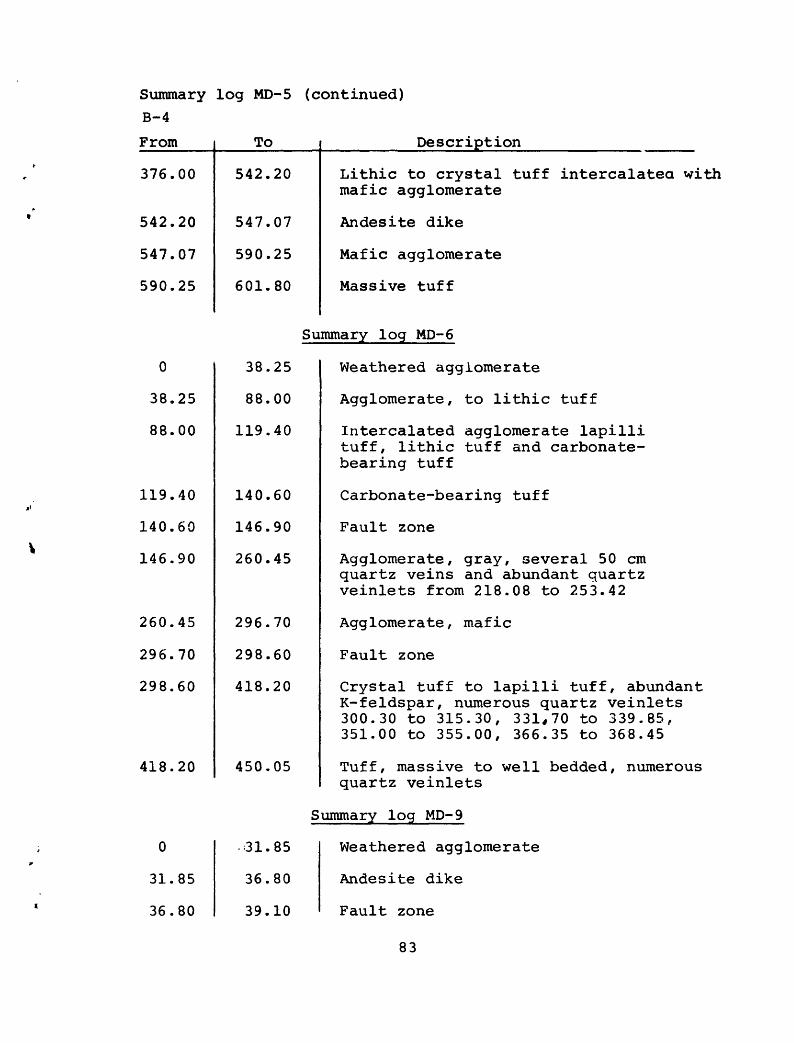
Summary log MD-5 (continued) B-4
From
376.00
542.20
547.07
590.25
To
542.20
547.07
590.25
601.80
Description
Lithic to crystal tuff intercalated with mafic agglomerate
An de site dike
Mafic agglomerate
Massive tuff
Summary log MD-6
0
38.25
88.00
119.40
140.60
146.90
260.45
296.70
298.60
418.20
38.25
88.00
119.40
140.60
146.90
260.45
296.70
298.60
418.20
450.05
Weathered agglomerate
Agglomerate, to lithic tuff
Intercalated agglomerate lapilli tuff, lithic tuff and carbonate- bearing tuff
Carbonate-bearing tuff
Fault zone
Agglomerate, gray, several 50 cm quartz veins and abundant quartz veinlets from 218.08 to 253.42
Agglomerate , mafic
Fault zone
Crystal tuff to lapilli tuff, abundant K- feldspar, numerous quartz veinlets 300.30 to 315.30, 331,70 to 339.85, 351.00 to 355.00, 366.35 to 368.45
Tuff, massive to well bedded, numerous auartz veinlets
Summary log MD-9
0 31.85 Weathered agglomerate
31.85 36.80 Andesite dike
36.80 39.10 Fault zone
83

Summary log MD-9 B-5
(continued)
From
39.10
100.00
106.50
192.80
194.30
207.20
211.20
296.80
306.20
322.55
342.40
343.80
355.00
356.30
364.80
365.20
371.60
376.00
431.85
To
100.00
106.50
192.80
194.30
207.20
211.20
296.80
306.20
342.40
322.80
343.80
355.00
356.30
364.80
365.20
371.60
376.00
431.85
580.45
Description
Agglomerate, gray scattered quartz veins
Stockwork of quartz veins
Agglomerate, gray, scattered quartzveins
Fault zone
Lithic to crystal tuff, generally bedded
Quartz vein, minor sulfides
Lithic to crystal tuff, scatteredquartz veins
Stockwork of quartz veins and veinlets
Andes! tic tuff intercalated withagglomerate and lapilli tuff
Shear zone
Stockwork of quartz veins
Agglomerate intercalated with lithic tuff
Stockwork of quartz veinlets
Intercalated agglomerate and lithic tuff
Shear zone
Andes! tic tuff, generally bedded
Stockwork of quartz veins and veinlets
Intercalated andesitic tuff, lapilli tuff and agglomerate
Massive to well bedded andesitic tuff,local mafic lapilli
84

Summary log MD-10B-6
From
0
23.25
23.85
38.95
40.35
85.40
110.00
122.10
125.20
148.30
160.10
165.80
182.15
193.75
198.80
219.50
247.75
To
23.25
23.85
38.95
40.35
85.40
110.00
122.10
125.20
148.30
160.10
165.80
193.75
187.00
198.80
249.70
238.95
249.70
Description
Weathered agglomerate
Fault zone
Agglomerate , gray
Andesite dike
Intercalated agglomerate, andesitic tuff, lapilli tuff and crystal tuff, generally layered
Andesitic tuff and tuff breccia, numerous to abundant quartz veins and veinlets
Andesitic tuff
Quartz breccia vein, minor sulfides
Intercalated andesitic tuff toagglomerate, layered, several 20 cm quartz veins and numerous quartz veinlets
Agglomerate
Andesite dike
Intercalated andesitic tuff toagglomerate
Sheared zone
Agglomerate with abundant pyrite and pyrite-rich fragments
Intercalated andesitic tuff, crystal tuff and lithic tuff
Fault zone, gouge and shear planes
Fault zone
85

MINISTRY OF PETROLEUM AND MINERAL RESOURCES DIRECTORATE GENERAL OF MINERAL RESOURCES
KINGDOM OF SAUDI ARABIA SA (IR) 233 PLATE 3
9.000 E 10.000 N
9 000 N -
10000E 11 .ODD E
6.000 N -
Protected from SAMutt
SAMS 10 SAMS.7
EXPLANATION
AGGLOMERATEAgglomerate Crystal-lap'"' tuff
MF.TASOMATIZFD ROCK
ANDESITE DIKE
MAJOR AND SIGNIFICANT QUARTZ VEINS
CONTACT
FAULT
MINE WORKINGS
DIAMOND DRILL HOLE INTERCEPT
Major laull zone
project ) from MD 10r
10.000 N
* " 3 H a 2. £
w n
SICL 0 crPJ ** |P I* /-*3. | 9 * §;
3 rr" ffi 13 o
B 1 S O(Do 0 |Vi is2 o t K m x-
: u M i- i~ ^,O i X '- >3 P» O <5 Ty" Ti "~&> Cu < r* ::' fn
O1> - » ., ^ *w o. 2 H 5
?~p
-oGJ
9 000 N
- 8.000 N
9.000 E 10.000 E 11.000 E
100
SCALE 1:2500
0 1003; EC:
200 MtTERS
GEOLOGY OF THE 300 FT LEVEL OF THE MAHD ADH DHAHAB MINE

A'
Major north-trending vein, nearly parallel to section
MO 8 MD 7
300 ft Level SAMS mine
EXPLANATIONUPPER TUFF
Agglomerate Tuff
UPPER AGGLOMERATEAgglomerateTuff
K-FELDSPATHlZfcD TUFF AND SEDIMtNT
LOWER TUFF Tuff and sediment
LOWER AGGLOMERATEUpper UnitMiddle UnitLower Unit
CONTACT
900 -
850 -
800 -
750 >-
ANALYTICAL RESULTS- 48 ppm Au
16-48 ppm Au
FAULT ZONE
MAJOR AND SIGNIFICANT QUARTZ VEINS
DIAMOND DRILL HOLE TRACE
DIAMOND DRILL HOLE INTERCEPT
CROSS SEC MON OF BLOCK OF METALIZED GROUND USED TO CALCULATE POTENTIAL RESOURCES TONNAGES
Figure 2. Geologic cross section along line A-A'
18
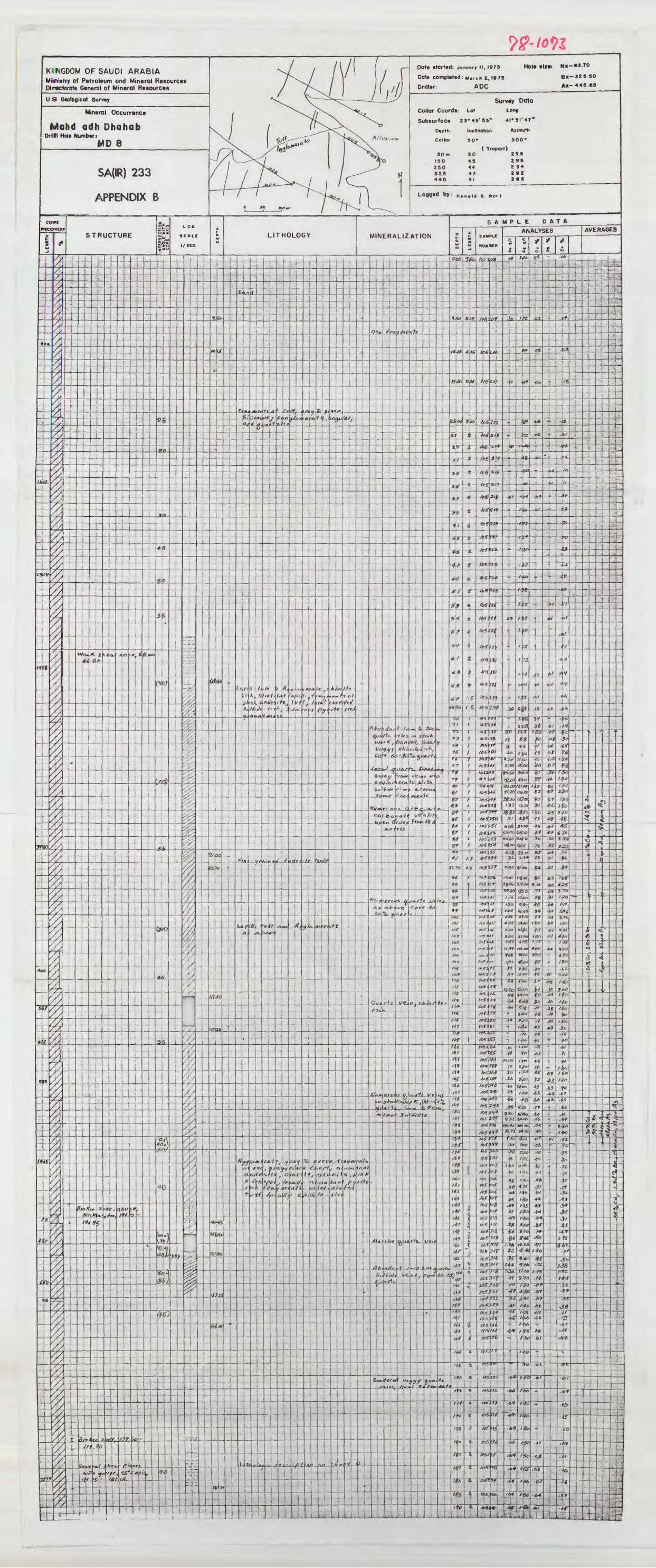

Date started; November 14.1974
Date Completed: January 9^1975
Driller: A DC
KINGDOM OF SAUDI ARABIA Ministry of P*troi«um and Mineral Resources Directorate General of Mineral Resources
U S Geological SurveySurvey Data
Lal Long Z3-49'54" 4l-3l'47"
Mineral Occurrence Collar Coorde
Subsurface
Depth
Collar
Mahd adh DhahabDrill Hole Number:
MD 7Inclination Azimuth
300- 35-
( Troparj)
298- 35'
296 39
SA(IR) 233
APPENDIX B
MINERALIZATION
i i
few Ai htouJar lat^Uy arc/KL£Ajaf »
Sv/^dv f</lSkH'rtj-*y. »,,**! , itf!
-LLU-
*~ 1R /

KINGDOM OF SAUDI ARABIA Ministry of Petroleum and Mineral Resources Directorate General of Mineral Resources
U S Geological Survey
Mineral Occurrence
Mohd adh OhahabDrill Hal* Number: _
ML) 3
SA(IR) 233
APPENDIX B
COKE
RECOVERY
STRUCTURELOS
SCALE
1/200
LITHOLOGY
Date storied: March 21. 1974
Dote completed: M>y £6,1974
Driller- ADC
HOI* (iZ*: *- 79. tS
( 177.39
,-rsi.eo
Survey DataCollar Coardi: Loi Long
Subsurface 23-4»'ss' 4i«si'47"
Dvpth
Collar
10(1
ISO
190
Incllnalion Azimulh
39* 3OO*
( Troporll3e-99 39 J4
SOI*
(97 2 9« 2*4
Lagged by:R«n«ld 0 Worl
MINERALIZATION
SAMPLE DATA
ANALYSES AVERAGES
4_ i :
4- --t
^ i-
- 4
-J- ±
S_
> j-** «7<2fl J>*
-t
J
1
i
.
I
i :i _.L. .1
l-
_L_L_. i.12
-L.
.-**
Iff 31
lr-1334- -t
.0*
/.*
I 5-I
_1__LJ-l -or
. i i .' I I Ir~4i*~itr *£
j
f >i»^ ^e.rf-S
Iy
X
t'-/. r* ! » /-«
4-
pi" »/ »,.,,,! i I
( s I ITMH J-Z
4 -
T7-M4
-fctTtss? I <
r.-frr
' 'a j »'«. '-^ ; t
»'< *
_Ul
-L
x;
- ffcaf^i Jld ppi '.4wrsi -j$j
tff, iU>t«L C^* «
ojH, '(/"._'
7.
X
y.
;:«-- 7irf^ir~
_ _]_ 1
i Ve/jTJ,
4-
r
St '
85
IJ
f'**/
J7! A* _.
H-
; «7«7
-4 I-l'6 ' ,I ! '
1J4JD
__| .. I____ . J ._
-*
J.1 i . .JO
! I
fjK^ ^fl U
4--UJ Iq.
!//7|
t:-Ht±
we 77*77
/fa
/22 1
2g .3*
«* .r
Jy
/.JZ
iLieii£i^i .ig
1 «*
rain _| _
iMM
979BS
174B7
17410
-V
JS '**
JC
4
ri
.ib
t|T<
i'J
-.11 H, (jr/J
fcg
i
»,,
to i« :-f*
</i*j
Atrttrivf / *%;Mv r» v"T/*7>; i5"3 "-
fipv.
/oci//y
rrfo
1
MijU.p
-ft/. 31
42 'S
?/ <?«
: I -.ivtfrt f.3
»«j«t'
«'*ito
ift.
-t- -
-i-ri' 4* t-
i B k J0>*^.e> *f<
/,
i
J_4
-<-
-I
* 4--
:,'-4*
tt <.fA'rtl<i
!- --J. -r-L
|
' ity
i
J J._
i~M-
.Ml/rl1/
-19 -r -
/go ,
«:8 2
i -
iVft. - IWfi"
'W4i.fefe
--JS-
i i?_.: J J_'_5.
i I .
tte
£
Y>
a/.
BA> 2oieS*'*;"
^
%
J»
lit
X
X
1
U,TSuTtrt/And
P4^/4q -fVnjg «t >i_
1"" ' _ diX*t
VCLH. /K <My*JX/ __
- .1
t *« )«. *
i.l_LJ-
"T__L i
Im*. »^
±fl jo 1-3
j .
,£rf !
1.0 , ft?,
I-**
zo4
SOB
f\ *i
-&' I -21 j 1.7
< 2/0 ., f V*S
21-2
.e« l&
JO 1-21 1-01
J?
!«:.»: .2ig £
ZI2 »*»»
.23, f-8
I I
zzi »»»^ 1- .efj .
1 7 Al V
1 7 .^J ! /J6
r l\ '<fl 66
'/H-r-tiri,,, \l e*: '- 7 i.ol I .«
I I I J .; .. ./» , 1 i xa . .07
.,1. .- It » » -9
«, /*, <«! i /)«
-f-
\
_'_^j -! -1/!3 i
250 «3 fi-V

KINGDOM OF SAUDI ARABIA Ministry of Petroleum and Mineral Resources Directorate General of Mineral Resources
U S Geological Survey
Mineral Occurrence
Drill Hole Number:MD8 Sheet 2
SA(IR) 233
APPENDIX B
CORE
RECOVERY
LC NflTH
-:
i
ISfS
- -
>
-
Ito
&ii
-'
533
-
<ax
j
't
~i-
i
| -
iJ
. !
1
-
4
*
y,y
y^'y)y.y/y/y,7,
7,y/K%
\'/,/ j
7,'/,7,
7,
^y/y/y/7/y/7,
!
/^'^
'//
y,yt,
y,
%
7,///7/y.////,s /
///
7///,y.//s
ly,y/
Iy,y.y.y/
y,y/7/7/
STRUCTURE
i-
iL
;-
J .
;
i
~-
_
i
"}-
_ j _;--
r
'~r
'
;
:
-
-i
i
-i-
-
_ L.
i
-f -
-i
'
5<!a*7l
t,*'^
1
; 1
-
\
\
-t
-
"
-
fnf*x,i
1
! 1
:
1
-io
-
-
(
J__
;
LJ
-
-
T
!
. ,
nJ-
i i
1
y/it,i7>y,y,y,y,7,/,
^y
^
y^
l/ /,
i
,i
if
fau
i
1
;-
J_
.-
|-
;
;-
-
;
-
S/,<(7
-
^Ckn
S -
~f *
.«
;
i
--
1
-;
--
-
- -
'
aref 7«
1
l
1
1
1
J-.
1
i
i
= T<£i*
i
r_j . f \
/s ///
//
/ /*
/ /
/ ///
-
1
1 -- -
-4
-
I
,-, 4
l i
-f-
-f-
(
!
.;.-
J_
-
/ z^ 0:
1
_-j ...
-
1
1
---
E-.J}a/i
>«i
i-
L-
1
-\-
-t
._.
-;-
-
/ 2L- 3
i-
J
"I
1
-4- -
i
Ti
i
^INTERSECTI ANOLE WIT CORE AXI
i
-
,
-
J
t
4- --
-4
6O
--
(35
- J
1
^
&SJ
?&
Jo,
\&fj
i
!
OiVy
00
=»
? "!'*,
J_i
1
J
T '
-;-
-
:- -
«r 4
,
i
1
JL
H-
ii
,
-
{
\
fttyiQ
-
:
,
-
1
1
,
:-'
J
i
,4-
i i
T
4
Jt
^~
1-
f:
-i
Vtttt
i
_L
1
.
It)
,20)
30;
-^_
M
f
'/<»
i
zo;
j
fejs)
-.
4
f£S)
1-}-
;j
(fo)
6D
J
i
1
i
&OJ
I
*I/l"<i«JI"
1
AfJ
* l
1 ! l
- -
1
40
c?
L oe
SCALE
1/200
1
1
t
j-4--
,i!
j
~
-
,
r
ii
L...
-
1
, -
-*
f
T~
,-i
1
i_ !__
V1
T_ i__
-
-Jr--
--F -j
--*---
J-f-.-H f-
i i
_ L
--
jt~
j
1
-,
FV=5
;
I
J
'' t''''
7/
y/////^//yyj2
.
a.
o
-
-
J
'
Y7
MAS
1
1
-1 ...
23
LITHOLOGY
,
1"
_L
~^-
- r
-j
-
-
--
4j
- 1't
S&&
SSTOA _
1J
t
i
-4
^J
,
J
!
,
;
1+-
J
r
i
1
-
fk-Sij
1 '
i1
_L
--
-
3i
i
_i_
^
_ _ -
-
_.
.,_
dCJJ
.. 1
IF A*
«H
"*
"
1
x* -
j
1
-
1
i»«
J.
MT*.
r-
1
7
-f
T-
3^^
1
4-ii
-j
i
j
-
f
4. i
-,
;
--L
L
_
.
-
i
i
j_
*»^
iEDlf
-
-H
!
I
i
---
r
t-4
my
-
{
j
L
J -
J
- _j
.--
j
l
f /,"'
fl"iTi"^
-
i
Ta'.
/, fo
"
{
t
i
_
j-
fVI r'
Pi2-,
«-
i i
-
_
-i
tt
,
-
-3f-f
P, /Oj
^
I
fa '-H
a.eV!
fVJT
J
+ J
i
J .
HVt
ATIfci*r* ^'c
1
f/PS/Uf, J
F, t
elL
>:.-!
i
»Cft/tel^s
, J^O a/*-*
ffk ,?*,i
i4
j
_
.!
-
9n
£i:
\
tf
:
i
-f
-T-
-
1
-i"
1
|
-\
-i
^
\
'
i
i
_ iii
<*,
-
A"-
/
-tt
a
f »<t.ttj
i#rj mt.
r,*
^ft
,
.
1!
(- &
C*#y-
e<f i
|_
-
-
-;
f-j
H-
--
1
!
j
11
1
1
"T
^t'9-£°J.
^17,
j
1
1
1
,
fl.
t"
'.
rtet>
ii
t
i4
r.4 75 )« H/'y rtl(,)3l^
Tf!
-
L
^Wn/
C
'
C-9
*.-./
-i-
--;
i~j
L»n<3
t
-
i
f- :
-
i
-
4 C
i of I/K/fle
A.
.oi
«
^ rt
Jf-\
1
1
1#/0.
^*3 j '
«w
j
(
i
'r
fy,
H^.f 4d. 4-^
3«f
;
i
;
>
l i
i
1L
3/tfn
f^irlSfi«
j
or
i/y
,<3
t
'
f] 1
f'
_e .
Date started-.
Dote completed:
Driller: ADC
Hoi* eize: Nx-
Bx
Ax-
Survey DataCollar Coord*: Lot Long
Subsurface
D>plh Inclination Azimuth
Collar
( Tropari )
Logged by:
SAMPLE DATA
MINERALIZATION
i
r,
^
I
;
1
:JPiJal t-
-
Scalar
-I-
ApjjA-A
t*/ *w
.
-ftf
Vr
Tof
1
t N
(
-
CO
f
"I
i
;
1
1
i
/V«t, faf.altif. ct^cirtlflA/ C(iA*-^«/ -fin*-a foinzij ~ttlf4
^v^t/-' =rf/
-
-
1
;-
~-^
J« l'/tA /
'
.
.
l
i i
_!_
'
, .
t
1
i
ii
i
f
.
,
1
gfl'°
-_0-^
tftLf
^s^hjiCO/-
,f/r t
frt S'1
3- i..'w
"K
":
or...
.
1i
V </-ej"V
. ,
_. i
"
AbuV
lii;
;
i
1
|A/.u ;
Ve
.fl*u
;
i
.
^ ^
m O-
fhn
i
,
:
-
t
1Y*
Of SaJ/ft'o
l
i
,..(! f *^-*
i
^ ViJ
t
J.
1 .
7 t/<3-
95 1
ff\dt
f*
i -
-
1J
1
i,."
-
,
5^L#fr_fl
3 iKS,
1
L<|^ >
u^do-^t
>i (LA.f^£><
\ i - -
TX 1
i
J»H
-^.
-f-
P
t f,^-- /. «-i*ci
,
hiCS.
»un
^
1
-J-4-ii
'/lie Ut
^i
15«/*^i-CAT
-\
-)
, i
in it
^i
1. -
» ife -Aju.fy t
i
-
-
1»rijaAf/i
x X£ »-
s sO _j
y?£? ^
.« i
til *
^ /^/ «.
/<?* a
. ZAO A
24i a
; sjos £
i 2*7 J
Jt9 I
«S i
1 2(7 f
JJo /
z^j a
'?5 i
if r j
2g/ , a
Iv^l *iJ5j ?237
2*9
2443 X
i
2fZ ^
* idfl 2
1I-" z2''fl . S
SAMPLE
NUMBER
I»5p4/
"S: <i
>off*3
HSJ
"S3
V4
*^
»f*rt
"**?'
165141
5*,
1BS3SI
"*
*'::ts. /--i
its.
Jab.
^iMj
JJi,
JeS105
ris
/6$ J
' 25Z 1 rt>S3 ZSS , ,» ;IS"
If5j zs8 '
Jff
ftf>y
tf!
u>
«J_
i4
US
to
/7
n
rs!7A- f7
r?ASOS 37?
35B /£^fj
«*'] " /af
261 I
2<5! a
Kf S
2<7 2
126-0
Bl
rfi
Si?
J»»5j(fl4
**3w
/o
»5««
Z7J *
J?f <
tA>r.. 2 fiz -a
-»3"JJf
o-ijto
M«- » /'
//-.jyj /trill^I
«»Jif
2** 4 1 /*5-*"
?8t 2
z«e '
"° a ,
|W5 2
Joo a
Joz -a (
S^<4 IT
J *^ *
l,?,/ ^
,5/5 7
J'?, »
3"i '
3/5-
3I/ «_! -.-.i 33J S
M^- *
/4iJ
'tefr'
It5^
left
H&1
tt
*e
iy
DO
a
ffj
of
/erfw
J^>-
IfSI
i
JJO 2
i30!!..! 31 J
!3J«i 2
- i
-"ti r
i«« /(.^ T /«« /H\3-f7 '
\
?fo, /
3^7 ^ ^ ?ST >
r,t/ , * 4 'rf.s J^, 'uc /
^ i
y**\ '
\*£f\ ,
Sfeatii
3«^ fl-
J7/ *
T 37$ t
jyS ^
37^ «.
5^ ,I
* -irt« ^
yo*i ! 2
t»*i a
17 r J
7V3! 3
[-*"'.
|3»» a
<«/ a
013' a
4*7' a
W,
n
lift
fT~
i/cfiT
/i.jf
"1
H1
1X1
rn&fn
ItoSVl t /A&V2&
.0,5431
i
/frSVJJf
toSJM
fr*i<3-f f
">SS-1I>
ISf,
**1
(to£
/jsg
fl~
<PH
mr*s
/Sw«»5W
«ff*%
/«»% /-JBfL.
^torftKL
/D5
/P.*
Jo5
/05
t*
A*
/»*
«5<
«.
4<7
*f8
<«,
iff
IH
'«
WF
V<»
Wf
ffi a K&PI
+0 y
1^]JL.
1 faf in1
' /p57?5
!<i/ ! a
(7*
*«w-
' fcf t'f" t ~T" :i«Ti"« "
4.Z 1 £
, W^ r «i
«7fl
fr?
ftffl
i-W S n,«,«;l
^7 1^J5". ^ ,'«i"
141f X
wwj t
. |*»«!.«
«?
/« *#
;»J-Mg
ANALYSES
i
-OS
.ai
.06
.Df
D*
_**:
.P6
J?*0*'
^
,oT
-
^oi
J.1
,4)T
ot
^
»
ISo
tJS
160
A*."
:
A£>t
U
.el
-li
°v
»> fl
If0:*3
Iff
l-So
/fa
nf
3JO
/W
iff,IfcI'fC
1*0
' ff
I+V
->«TO
.15
.*,
-li
^*i.
-o>.
fit
.0}
~*v
.41.
.AI
Jl
/
_
j_
.
ol
"
'V"*" *" °^
-os"! - j
«S '-** J? /-rfl-
£
.
j
i -
-1
'
J-f.*?-26
«
47
JS?
J./
-0?
If
-.--
.fo
(«
-/o
.0}
.r*
//
.z/
«
«
-BJ
-.'*
~*
. J
Dj
.01
./f i -5^
*? | -/<>
-OJ /«» -
iy. ^> -
J^, t= -
.05
of
-4?
JT
." -
-tt
/Jl
_ "
^
M< .02-
jii
i.*o' -
TiO
ut
1
-Pi
j/-OS
,1- -.08
J '"
**
06
»«
-C*
"**
**
.0*.
-/*
Jn_
/o
.04
ts
_
^ .20
/.*F! *J
I3Sus'
He.
'
oc
-«
"" "*
i.to
l-to
,/iU
MB
lAt
Mfi
^
-US
/Vo
J-OO
/ £«:
i-ie,
US
I.K
3140
/ *e/-*8rgrZJ7
l.lD
-
.£/
.0'
"
"
;
«/ 4£
£0 is
itews* /uoi -e/
-^g
.of -*«
-Of
.«*
to
.K
_J»_
/l?
/to
.Dt>
jrt
",*s
'/%
us
/.fs
1-25
rioo
?.<*
lAt
*««.^
-M-
06
-OS
A
5
tja
iff
if
t-te
I3f
.1?
:'«
-DZ.
.or pi
-61
01
,.
Sf
-FT
n/J
J5
-10
<Sa
-off
.03
.01
.D/
-
j
--
-
f1
!
1 '
-1
r i -!--
4
1
L
i -
i
*
AVERAGES
1
t
- K
,'
-\-
,-
,i
~ "1"
1
-1
jLt
i
_i
iI
1
-J---f--
'
- -I.
1
iI
- -
i
-
j-,
-,i
f
_! _
-f-
1-}-
4--
--
tI !
* i
«2- ^
.«*
-*3
-*i
f/
-/«
jfl
i-
j !
1---
- 1 " i L=S2
_L»4 ' **
..-M
-OS
«
./O
1 ""
.02.
,W
-2J
J3-
"~
_
'-
. -
-'-
i
-r'-,
---
> .
-
i
*«i/*ol .
-oA] /4o{ -«l
A?
Ai
-*
fft-
.,
^
^
,« ./2J -
/« -
/«
I.2J
p.-
4-1
Of J J
^ ! fjf
.n
*t
^M!.
HA
J-K
JJt
U
>'-
jit
-
*3
-OB
fl
J>*
*3
.**
nl
-&1
.02
o-l
.11
-oz
00
-O*
07
.£> 2.
.62
-B2
a 2-
0?
of
1?-ci
^ .
-iL
0«
OJ
Jf
.«?
J6
JJ
6*
.»*
*f.6*
-C*
.02
»5
. +
AT
03
-.t,
t.«A- -
;-
-
* * r *, - J. 4 i
!
-
i
*
T
?
1
-
r-
--
i
i
.
~t"
'-
1
JL
l
;
-
l
_ j _
_ j
-
-
,
.u.,.
_u._
I
...
-
~~t
~
,
1
- f-
- i-
i_L_
-4--4- -
* _
-^!
4/-4-
,-,_
-;
L
4-
-
^
- a-
i
.
- !
I
-
-
'
-j
4-
-7-
-
-
-f~
- r-
--'-
-i-
-;-
1
-1-
i"-I-
;
T
-J-
.02.! i i '
.04
-o>3
-13
*+
..f
of
t****
-
v
*^
./f
J>5
i.
- | j-
1 * "
i _
!
-
J
---
!
, |-
. 1


