by Keith A. Yenne Open-File Report 88-402 STAGES DEPARTMENT OF THE INTERIOR GEOLOGICAL SURVEY...
27
UNITED STAGES DEPARTMENT OF THE INTERIOR GEOLOGICAL SURVEY HYDROCARBON (OIL, GAS, AND COAL) PROSPECT FOR BURMA by Keith A. Yenne Open-File Report 88-402 Report prepared for the Agency for International Development, U.S. Department of State This report is preliminary and has not been reviewed for conformity with U.S. Geological Survey editorial standards and stratigraphic nomenclature. 1988
Transcript of by Keith A. Yenne Open-File Report 88-402 STAGES DEPARTMENT OF THE INTERIOR GEOLOGICAL SURVEY...

UNITED STAGESDEPARTMENT OF THE INTERIOR
GEOLOGICAL SURVEY
HYDROCARBON (OIL, GAS, AND COAL) PROSPECT FOR BURMA
by
Keith A. Yenne
Open-File Report 88-402
Report prepared for the Agency for International Development,U.S. Department of State
This report is preliminary and has not been reviewed for conformity with U.S. Geological Survey editorial standards and stratigraphic nomenclature.
1988

CONTENTS
Pag<
SUMMARY OF FINDINGS.................................... 1
INTRODUCTION........................................... 2
GENERAL GEOLOGY........................................ 6
PETROLEUM GEOLOGY...................................... 9Central Lowlands.................................. 11Arakan coast and offshore area.................... 18Gulf of Martaban offshore area.................... 19
COAL IN BURMA.......................................... 21
SELECTED REFERENCES.................................... 25
ILLUSTRATIONS
Figure 1. Index map of Burma.......................... 32. Physiographic zones of Burma................ 73. Principal structural features of Burma...... 104. Principal oil and gas fields of Burma....... 125. Strati graphic sequence of the Tertiary Burma
basin.................................... 136. Offshore blocks and wildcat wells........... 207. Coal deposits of Burma...................... 23
Table 1. Burma crude oil and natural gas production1975-1981................................ 16

HYDROCARBON (OIL, GAS, AND COAL) PROSPECT FOR BURMA
by
Keith A. Yenne
SUMMARY OF FINDINGS
1. Burma's estimated proved reserves on 1/1/82, according to the Oiland Gas Journal, are 28 million barrels of oil and 170 billion cubic feet of gas.
2. The potential for finding new deposits of oil or gas in the prospective petroleum areas of Burma is as follows:
Chindwin basin - fair to good Central basin - excellent Irrawaddy basin - excellent Arakan coast and offshore area - good Gulf of Martaban - good
3. Petroleum exploration and development in Burma is hampered by the unfavorable ... weather of the monsoon season. Offshore, however, the environment is
favorable for low cost production facilities.
4. Any oil or gas field discovered will probably be small. Giant fields (500 million barrels of oil or 3.5 trillion cubic feet of gas) are rare in Southeast Asia.
5. Burma's measured and indicated reserves of hard coal total 42 millionlong tons: measured and indicated reserves of brown coal total 266 million long tons.
6. Almost all the coal used in Burma is imported, known deposits being hich-ash lignite to sub-bituminous in rank.
7.. The potential for discovering new deposits of hard coal in Burma is poor: for brown coal the potential is fair.
INTRODUCTION
This report was prepared under RSSA no. INT-USGS 1-80 as a component
of technical assistance to countries assisted by the Agency for Inter
national Development, U.S. Department of State, in the exploration and
development of conventional energy resoi >v*ces.

In 1963 Burma's Revolutionary Council passed the Enterprise Nationalization
Law eliminating private industry in Burma. Two years later petroleum exploration,
development, and production activities were handed over to the state oil company,
Myanma Oil Corporation (MOC). Myanma's record has been relatively good in the
short time it has been in existence, considering that the company has had very
little foreign assistance and funds have been short.
Transportation of petroleum, however, is another story and Burma's oil industry
in recent years has been plaqued with transportation and distribution problems.
The cause of the problems can be attributed, in large part, to antiquated equipment,
lack of funds to repair and replace equipment, and poor planninq.
The Burmese government maintains the position that the government is self-
sufficient in petroleum; local consumption being limited to the capacity of
Burma's refineries. The country has two old refineries, one 20,000 barrel-per-
day unit at Syriam, near Rangoon (fig.. 1) and another 6,000 barrel-per-day unit at
Chaulk oil field. In the past, crude oil production has about kept pace with
the two refineries and frequent petroleum shortages have been due mainly to
transportation problems. A new refinery, with a 25,000 barrel-per-day capacity,
is being constructed at the Mann oil field. With this new refinery on stream,
Burma's ability to supply its domestic needs will be determined largely by
crude oil output from its own oil fields. At the present time, gas is produced
for use only in industry and in gas turbine generating plants.
HISTORY OF PETROLEUM EXPLORATION AND PRODUCTION IN BURMA
Petroleum has been extracted from Yenangyaung oil field for centuries,
perhaps as far back as the thirteenth century. By 1797 the petroleum industry

L S / -/ ) *» ^ VsTv J*' M!k ^ W ^S^^ooN^x^^r ^i r^r^/l^y^y MouhnAfe\St«fA^ T
KMipeng
GULF OF
THAILAND
Figure 1. Index map of Burma.

was firmly established at Yenangyang with several hundred hand-dug wells yielding
200 to 400 barrels per day.
Tainsh (1950) reported that in 1949 wells were still being dug to depths
of 400 feet or more. The digger wore a helmet similar to a diver's helmet
with a supply of air pumped from the surface; light was supplied by reflection
of sunlight in a mirror; the sides of the pit were timbered as digging proceeded.
A number of small oil fields have been discovered and exploited in Burma,
but most of the oil produced over the years has come from five large fields:
Chauk-Lanywa and Yenangyaunq, officially listed as discovered in 1902; Myanaung,
discovered in 1964: Prome, discovered in 1965:. and Mann, discovered in 1970.
Among the more prominent oil companies in the development of the Burmese oil
industry were the Burmah Oil Company, the Indo-Rurma Petroleum Company, the
British Burmah Petroleum Company, and the Math Singh Oil Company.
During World War II the Chauk-Lanywa and Yenangyang oil fields were severely
damaged in an effort to prevent access- to the oil by the Japanese. The major
oil companies began the costly task of repairing the fields after the war, but
unfortunately, widespread political unrest in the country interfered with the
orderly rehabilitation of the oil industry.
The petroleum industry was nationalized in 1965 and put under the jurisdiction
of the national oil company, Myanma Oil Corporation (MOC). Myanma's most important
contribution to the economy of Burma was the discovery of the Mann oil field in
1970. Mann reached peak production in 1979 of over 23,000 barrels of oil per
day, which was nearly three-auarters of Burma's total production. Mann's
production rate is presently declining however, in spite of efforts to stimulate
production.
Myanma Oil Corporation began drilling offshore in the Gulf of Martaban in
1972 and by the end of 1974 had drilled 12 wells, all abandoned as dry holes. No

information was released on these wells, but it is believed that one, and perhaps
two, wells encountered gas that would have been commercial had the wells been
located onshore.
In 1974, Myanma took radical departure from its former policy by inviting
foreign oil companies to bid on production-sharing service contracts for
exploring offshore blocks. Thirteen blocks were awarded to four bidders:
Esso (Fxxon), Martaban-fities Service (U.S. consortium), Arakan Oil
(Japanese consortium), and Totale (European consortium). The four operators
released their offshore holdings in 1977 after drilling a number of dry holes.
Totale was reported to have discovered gas in potentially commercial quantities
off the Arakan coast but the offshore location made exploitation impractical at
that time. MOC again opened bidding on 24 offshore concessions in 1978.
Because of the contract terms, oil companies showed little interest in the
bidding and no concessions were awarded..
Petroleum exploration onshore has been more successful and Myanma has kept
all exploration and development rights for itself. Production has increased 50
percent since 1976, largely due to increased output from the Mann oil field.
Exploratory drilling in 1981 resulted in what appeared to be major discoveries
of three oil and gas fields. The Htantabin wildcat, located about 180 miles
northwest of Rangoon, discovered light oil and pas in Miocene limestone
reservoirs. Kyontani wildcat, located approximately 75 miles west-northwest of
Rangoon, also found hydrocarbons in Miocene limestones. Both of the above
discoveries are in the Irrawaddy basin. In the Central basin a discovery was
made at Pagan-Tuyintaung, located about 15 miles northeast of the Chaulk field.
The reservoirs in this field are sandstones (about 300 feet thick) of the Oligocene
Shwezetaw Formation.

In recent years Burma has purchased new drilling equipment. This will
allow MOC to explore deeper horizons and will quite likely further increase
Burma's oil and gas reserves.
GENERAL GEOLOGY
From west to east, Burma can be divided into four physiographic zones
(fig. 2):
1. Arakan Coast
2. Arakan Yoma - Chin Hills
3. Central Lowlands
4. Shan Hills
The Arakan Coast, fringing the Pay of Bengal, consists of Upper Cretaceous
abyssal sediments, lower Tertiary flysch deposits, and upper Tertiary molasse
deposits. The beds are thick and intensely folded and faulted.
East of the Arakan Coast is a mountain range known in the south as the
Arakan Yoma and further north as the Chin Hills. The rocks making up the range
are mainly dark Eocene shale and sandstone beds with interfolded thin Cretaceous
limestones and shales. The latter shales are altered in part to slates and
phyllites. On the east side of the range there is a more intensely metamorphosed
group of quartzose schists and phyllites of unknown age. The opinion favored
by most, however, is that the schists are dynamical ly metamorphosed Cretaceous
and lower Eocene beds. Ophiolites are found at intervals along the entire
length of the eastern margin of the range. Folding in the zone is moderate to
strong.
The Central Lowlands include the drainage basins of the Chindwin River in
the north and the Irrawaddy and Sittang Rivers in the south. The basins cover
an area over 60,000 square miles located between the Arakan Yoma - Chin

IQ C
-5 n> -a o IQ -5
Q)
-a rr
_ i.
o N
O Z5 o DO c
-$
3 -h -5
O
3 n> -a a

Hills on the west and the Shan Hills on the east. This area is frequently
termed the Burma Tertiary basin.. Sediments filling the Central Lowlands include
sandstone, siltstone, shale, and claystone beds ranging in aoe from Late
Cretaceous to Holocene. They are, for the most part, molasse facies. Minor
lenticular limestones occur at a number of horizons. Tertiary intrusive and
extrusive volcanic rocks crop out in the northern part of the lowlands and are
present in the sub-surface in some areas to the south.
Folding is strong in the area bordering the Arakan Yoma - Chin Hills but
diminishes toward the east.
All the major oil and gas fields of Burma are found in this physiographic
zone and therefore the geology will be discussed in more detail under the
heading, "Petroleum Geology".
The easternmost physiographic zone is the Shan Hills consisting of low
moutains or plateaus. The Shan Hills are made up of Precambrian schists,
Paleozoic limestones and dolomites, and Jurassic and Cretaceous red beds.
Serpentines and marbles of unknown aqe are also present. These rocks are cut
by Late Mesozoic-Tertiary granitic intrusions aligned in a north-south direction.
The western boundary of this zone is marked by a major fault system.
The geologic history of Burma is vastly different than that of neighboring
India. In Paleozoic time Burma was a part of the supercontinent Laurasia while
India was a part of the supercontinent Gondwana. A comparison of Permian rocks
in India and Burma illustrates their different origins. In India Permian rocks
contain warm water faunas and extensive reef complexes.
In Early Cretaceous time, shortly after or during the epeirogenic uplift of
the Shan Hills, compensatory subsidence began to affect large offshore areas of
the Burma portion of the Laurasian shelf. During Late Cretaceous time the

approaching Indian plate began to deform the subsiding area into a typical
geosynclinorium that received terrigenous sedimentation of abyssal facies in the
south and flysch facies in the north. At the beginning of the Tertiary an
island arc was raised directly to the west of the present position of the Arakan
Yoma - Chin Hills, and the flysch sedimentation of the northern areas began to
expand southward.
As the result of the collision of the Indian and China plates in Oligocene
time, the Arakan Yoma - Chin Hills were raised from this flysch trough and moved
against and over the island arc, whereas on both flanks of the new range, molasse
basins were formed. Continuing compressional phases, up to Quaternary time,
narrowed the bordering basins.
Offshore from Burma in the Gulf of Martaban and further south in the
Andaman sea, the major structural elements are parts of an island arc system
(fig. 3). To some degree these elements can be traced ashore in Burma. Deep
seated earthquake foci onshore attest that a subduction zone is present
corresponding to the offshore trench. Volcanoes onshore are aligned with
volcanic islands and seamounts offshore. Other elements of the island arc
system are not so clear-cut onshore. It is probable that during the Neogene, a
fault-fold pattern of wrench tectonics was established over the earlier island
arc pattern. As a consequence, the Neogene basins of Burma have a character of
their own that is unlike any neighboring basins.
PETROLEUM GEOLOGY
In this report, Burma has been divided into three areas with proven or
potential hydrocarbon resources.
1. The Central Lowlands (proven)
2. Arakan coast and offshore area (potential)
3. Gulf of Martaban offshore area (potential)

L-21 BAY OF BENGAL
. THAILAND
GULF OF MARTABAN
' Barren ^Volcanic Isle
Figure 3. Principal structural features of Burma. (After Paul and Lian, 1975).
10

Central Lowlands
The major oil fields of Purma are found in the Central Lowlands in the
broad median valleys of the Chindwin and Irrawaddy Rivers (fig. 4). Although
the eastern boundary of the Central Lowlands is formed by the pre-Tertiary massif
of the Shan Hills, the eastern portion of the lowlands south of Mandalay is
separated from the Irrawaddy valley by a long belt of hills known as the Pegu Yoma
(fig. 3). The high ground of the Pegu Yoma marks an uplift of intensely deformed
Tertiary rocks with some basaltic intrusions.
North of Mandalay the area of the divide between the Chindwin and Irrawaddy
Rivers is superficial Tertiary and Quaternary sedimentation on an uplifted
basement surface.
Within the Central Lowland there are three sedimentary basins separated by
arches (fig. 3). These basins, from north to south, are the Chindwin,
Central, and Irrawaddy. The basins are elongated in a general north-south
direction along the western side of the Central Lowlands.
A prominent feature of the lowlands is a number of extinct volcanoes that
are aligned approximately north-south along the eastern borders of the sedimentary
basins. These volcanoes are part of the volcanic arc that is represented by
volcanic islands and seamounts offshore (fig. 3).
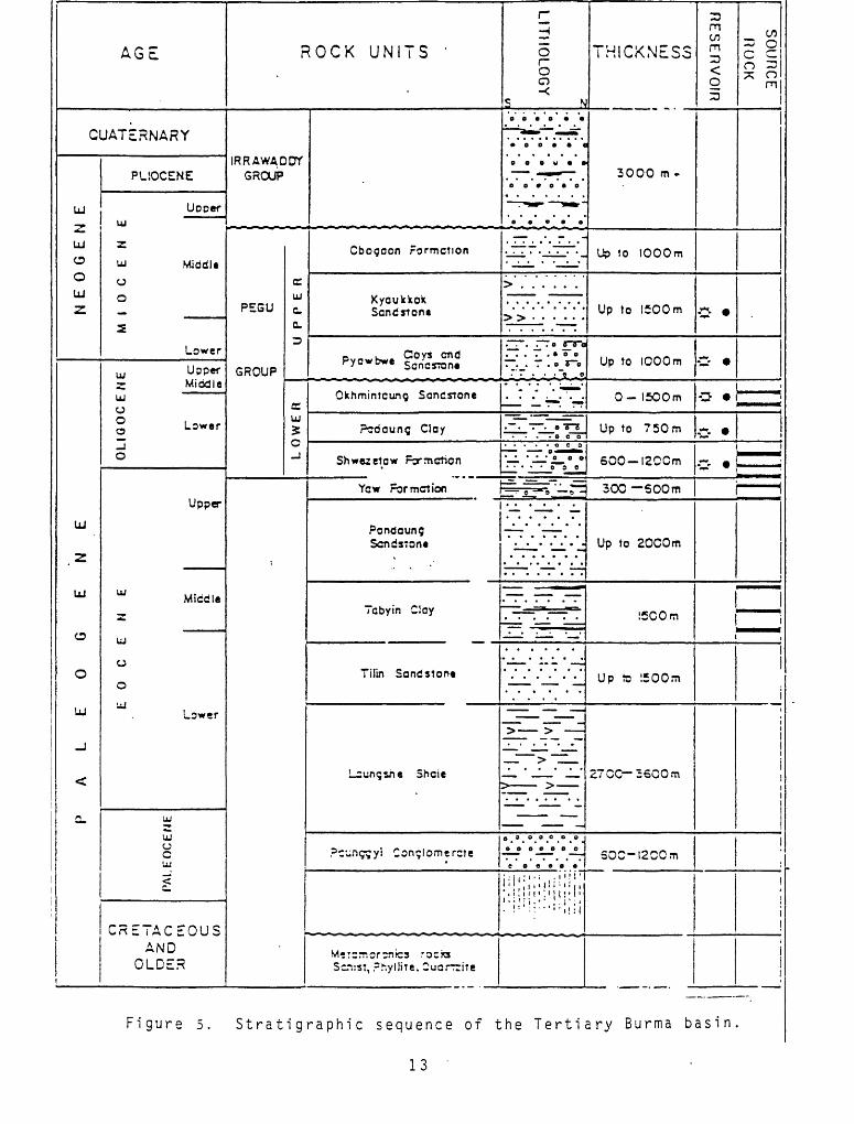
The Tertiary stratigraphy of the Central Lowlands is summarized in figure 5.
Brunnschweiler (1974) has catagorized the Upper Cretaceous through Eocene
rocks as flysch, and post-Eocene rocks as molasse. The Pegu Group, which contains
the hydrocarbon reservoirs, is predominantly marine with deltaic and fluvial
intervals. In the Central and Irrawaddy basins, Pegu and Eocene rocks consist
of alternating successions of sandstones and shales or claystones, with lesser
amounts of grits, conglomerates, and limestones. Locally there are deltaic and
fluviatile sandstones and shales with lignites, coal beds, and fossil wood. The
Pegu Group Generally becomes more sandy and less marine northward.
11

IRRAWADDIY BASIN
Figure 4. Principal oil and gas (after Lepper , 1933) .
12
fields of Burma
AGE
QUATERNARY
"*_LJ
O
0
LU
Z
LJ
.2
LU
O
0
UJ
_J
<
a_
PLIOCENE
UpperUJ
z
UJ Middle oO
3.
Lower
w lJ PP«f r MiddleUJoi Lower
13 o
Upper
w Middle
u
o
o
UJLower
UJ
UJ 0cUJ
£
CRETACEOUS AND
OLDER
ROCK UNITS '
IRRAWADDY GROUP
££
UJPEGU c.
0.
D
GROUP
c u 5 O _!
Cbogoon Formation
Kyoukkok Sandrrone
*«-b« g&SS
Okhmintcung Sandstone
Pcdoung CJay
Shwezetow Formction
nH
Or~
O O <
S N
t-ai. HT
-^i-'-^i,-a o c o
. - _
>......
» . . . . . .
^J-^,-'^ * -51* '- ' : '. i-i-' 7 ". TT
.~. ~ . o "o~5
. o o o
- O^B>M»
..... o s e
Yew For motion [ ^ e -» 3 _~
Pondaung Sandstone
Tcbyin Cloy
Tilin Sandstone
Lzuncshe Shaie
Pc-nggyi Conqlomercie
M-rcmor^nics rocw Scnjst, rhyllite. CuarrriTe
. _
.
_
: ! '_^' L^.
- _-__""__T
-==*=-= 1 .
. _
_. . . .
^> ««M^ ^ IM^V
" >
5 >
___
o. s .°. 0 .° .°.°.
Mi!" 1 r' 1 ! 1 '' 1 ,i.'l!i : I.,
.:!S|S!::;!! :!;
THICKNESS
3000 m*
Up to 1000m
Up to 1500 m
Up to 1000m
0- 1500m
Up to 750m
500 1200m
300 SOOm
Up to EOCOm
150 Om
Up to SOOm
27 CC 3600m
50C-!2CCm
RESERVOIR
0-
C-
SOURCE ROCK
1
a j ^
&
V
ti .
ki«M»M|
1i «
1
! i1
i
'
Figure 5. Strati graphic sequence of the Tertiary Burma basin.
13
North of Latitude 22 degrees North, in the Chindwin basin, the Pegu and
Eocene rocks are, for the most part, fresh water massive sandstones, grits,
conglomerates, and mottled claystones.
The upper Miocene-Pliocene Trrawaddy Group consists of a thick succession
of fluviatile conplomerates, grits, and ferruginous sandstones with subordinate
claystones. Concretions are common in this part of the section.
Over a wide area in central and southern Burma the contact between the
Irrawaddy and Pegu Groups is unconformable and commonly is marked by a prominent
red bed consisting of white quartz and other pebbles in a ferruginous, lateritic
matrix.
The general trend of folds, as would be expected in the basins of the
Central Lowlands, is approximately north-south, parallel to the trend of the
Arakan Yoma - Chin Hills. Many of the folds are tight, asymmetrical, faulted,
and overthrust toward the east. The intervening synclines, however, are broad,
commonly flat bottomed, and unfaulted.
Evidences of hydrocarbons have been found in most all the Tertiary form
ations of the Central and Chindwin basins. Commercial production to date has
come, for the most part, from the Central basin. Indaw, an oil field of large
area but limited productivity, was discovered a number of years ago in the
Chindwin basin, and recently a gas discovery was reported near the town of Chindwin,
Four oil and gas fields are producing in the northern part of the Irrawaddy
basin, and recently in this area, oil and gas were found for the first time in
Miocene limestone reservoirs. New discoveries also have been made in the
central and southern parts of the basin. These new discoveries are being
evaluated and have not yet been put on production.
14

The eight major producing oil and gas fields of Burma are given in table 1.
Production rates have been declining at Chauk, Yenangyaung, Prome and Myanaung
oil fields in spite of .MOC's efforts to maintain a steady level of production.
However, the decline in production in the Yenangyaung oil field was arrested by
the introduction of gas lift and water injection systems. MOC's development
of the Mann oil field, which went on full production in 1979, has been the
principle reason for Burma's more or less steady oil production rate. The Mann
oil field produced 75 percent of the oil in Burma in 1981.
The major oil fields are located on a north-south trend near the Irrawaddy
River in the Central basin of Burma. The best known of these is the Yenanayauna
oil field located on a dome 25 miles long and 6 miles wide. The field is only
slightly asymmetrical with dips up to 40 degrees on the east flank and 50
degrees on the west flank. On this structure 4,000 plus wells have been
completed, producing from more than 50 sandstone reservoirs that range in
thickness from 10 to 150 feet. The reservoirs are found from the surface to
depths of 5,500 feet.
Porosities and permeabilities of the reservoirs vary,"but maximum porosities
of 25 percent and maximum permeabilities of 200 millidarcies have been measured.
Reservoir pressures to a depth of 5,000 feet are equal to hydrostatic pressure.
In the central part of the field, however, at depths below 5,000 feet the
reservoirs are over-pressured and the pressure gradient is equal to one pound
per square inch per foot of depth below the surface. The high pressure reservoirs
are water bearing only.
Initial production per well has ranged from 0.5 to 1,000 barrels of
oil per day and some wells have produced for more than 50 years. The crude oil
has a paraffin base and a high-wax content. There are no gas caps on the shallow
15

Mann/Htankshabin
Yenangyaung
Chauk/Lanywa
Yenangyat/Ayadaw
Prome
Myanaung
Shwepyitha
Htantabin
Others
Table 1.
BURMA
CRUDE OIL AND NATURAL GAS PRODUCTION 1975-1981
1975
1976
1977
1978
1979
1980
1981
CRUDE OIL (mil lion bbls. )
6.48
8.18
8.99
10.03
10.82
9.32
8.26
NATURAL GAS (MMCF)
7,300
8,900
8,910
9,890
12,030
20,016
20,372
1981 PRODUCTION BY FIELDS
BBLS. OF OIL
6,387,865
730,000
273,750
91,250
334,705
243,455
121,545
584
60,225
MILLION CUBIC FEET OF GAS
4,380
365
4,380
4,380
1,825
365
4,380
297
From: Petroconsultants
16

and intermediate depth reservoirs. Flowing wells get their energy from a
dissolved gas drive or from gravitational flow.
Because of the large number of individual, lenticular, sandstone reservoirs,
it has been difficult to apply secondary recovery methods to the field. Gas
injection has been tried over the years but the results have been questionable.
Inasmuch as petroleum is known to be present and there are many untested
structures in the basin, the potential for discovering new deposits of oil or
aas in the Central hasin is excellent.
Potential petroleum-bearing structures in the Jrrawaddy basin south
of Henzada are concealed beneath the sur-Mcial deposits of the Irrawaddy delta.
Locating favorable drill sties, therefore, depends upon costly and time consuming
geophysical surveys, which explains why the surface structures of the Central
basin have been exploited for a number of years whereas the Irrawaddy basin is
just beginning to be developed. Two gas discoveries have been made near Rangoon
and several oil and gas discoveries have been made in the northern part of the
basin. Additional drilling is being done to evaluate these potential oil and
gas fields.
The potential for discovering new deposits of oil or gas in the Irrawaddy
basin is excellent.
Except for the Indaw oil field and a potential gas well recently discovered,
petroleum exploration in the Chindwin basin has been unsuccessful. One possible
explanation is that the Tertiary sediments in the basin are mostly non-marine
and source beds of petroleum in the Central basin may be entirely marine.
Whatever the reason, the potential for finding new deposits of oil or gas is
only fair in the northern half of the Chindwin basin and fair to good in the
southern half.
17

There is very little published information regarding the structural geology
of the Pegu Yoma. Tainsh (1953) states that the Pegu Yoma is, for the most part
an anticlinorium of tightly packed folds of small amplitude, intersected by
cross faults, and exposing no great thickness of Miocene rocks. Some of the
folds of the Pegu Yoma have been tested by shallow wells. All tests were
abandoned as dry holes, though a few oil and aas "shows" were encountered during
the drilling. Because the rocks have been intensely deformed and the Tertiary
section is believed to be thin, the potential for finding new deposits of
petroleum in the Pegu Yoma is poor.
Arakan coast and offshore area
Interest in the petroleum potential of the Arakan coastal area has existed
for many years because of the well known oil and gas seeps on several of the
islands along the Arakan coast. On Cheduba Island (fig. 2) the oil occurs in
very compressed folds and is associated with mud volcanoes, some of which are
subject to sudden eruptions of gas and mud. On Ramri and Baronga Islands
(fig. 2) oil occurs in narrow faulted folds. Shallow wells, hand dug on these
islands, have produced minuscule amounts of oil over the years. The oil seeps
are believed to be in rocks of Eocene age.
Durina 1979 and 1980 five tests were drilled on Ramri Island on the so-
called Yenandaung structure. These wells tested 5 to 30 barrels of oil per day
from Miocene elastic rocks at depths of 4,600 to 5,250 feet. Two other
structures on the island, Kyaukpyu and Ledaung, are being explored at the
present time.
North of the islands along the Arakan coast, oil and gas seeps are less
numerous but nevertheless present. At the Bangladesh border several anticlinal
trends are present which continue into Bangladesh. Some of these trends have
18

proven productive of gas in Bangladesh, but none of the trends have been tested
on the Burmese side of the border.
The stratigraphic section of the Arakan coastal area ranges from abyssal Upper
Cretaceous sediments plus ophiolites and tuffs at the base, through Paleogene
flysch and molasse, to Neogene molasse at the top (Brunnschweiler, 1974).
Estimated thicknesses of these rocks are: Cretaceous 3,000 feet, Paleogene
33,000 feet, Neogene 13,000 feet.
Offshore along the southern half of the Arakan coast, the shelf with water
depths less than 200 meters is quite narrow, but the northern half of the shelf
is wider and the area accessible for petroleum exploration is more extensive.
One wildcat has been drilled off the southern tip of the Arakan coast and
six have been drilled off the northern Arakan coast in the vicinity of Cheduba,
Ramri, and Baronga Islands (fig. 6). One of the six tests, drilled by a
consortium operated by Cie. Francaise des Petroles, struck gas in potentially
commercial quantities but the location made exploitation impractical at that time,
The potential for discovering new deposits of oil or gas in the Arakan
coast or offshore area is good.
Gulf of Martaban offshore area
This area includes the waters of the Gulf of Martaban and waters to the
south in the Andaman Sea bordering the Mergui Archipelago.
A number of wells have been drilled in the Gulf of Martaban (fig. 6)
but very little has been published concerning the geology of the area. Wells
drilled in the eastern part of the Gulf of Martaban reached total depths
between 13,000 and 14,000 feet. Inasmuch as the principle oil and gas reservoirs
of Burma are the Pegu Group of Oligocene and Miocene age, it is assumed that in
most wildcats the entire Pegu Group was penetrated before drilling was abandoned.
19

GASDISCOVERY NEAPCHIN'DWIN IN 1979
MAIN AREA OF EXPLORATION AND DEVELOPMENT BY : MYANMA OIL CO.
SAY Of BENGAL
DEEP OIL DISC IN 1979
MANN REACHED FULL PROD FOR THE FIRST TIME IN 1979 AND BEGAN DECLINING i960 WATER INJECTION PROGRAM STILL UNDERWAY
i mortfv/ cnqyourV
11
KYAUK PYU SHALLOW OIL FiSLD DEVELOP. ASSISTANCE PROJECT WITH JNOC
3 SHALLOW EXPLORATORY OIL WELLS DRILLED IN 1979 AND ADDITIONAL DELINEATION IN I960 rJi-;5Mi PIPELINE
r, COMPLETED IN 1
APPROXIMATE AREA OF PROPOSED MOC SEISMIC SURVEY
f . ., 3 AREAS FORMERLY tv.-'^-.il HELD BY FOREIGN
CONTRACTORS.ACREAGE RELINQUISHEDIN 1977. OFFERED IN 1950
ACREAGE ORIGINALLY RESERVED FOR MYANMAOIL CO. RELEASED DURINGV. .-. . . .-. . . . .197B; OFFERED ?OR FOREIGN CONTRACTOR PARTICIPATION IN 1980
ANDAMAN ISLANDS
%\ANDAMAN SEAINDIAN OCEAN
Indian i960 Cos Discovery
-. . .EXt-MC-.-.-. V.
Figure 6. Offshore blocks and wildcat wells. (from American Association of Petroleum Geologists, October 1981).
20

The combined thickness of the Pegu Group and the overlying Irrawaddy Group,
therefore, is probably in the range of 13,000 to 14,000 feet. The beds are
believed to be somewhat thinner to the west. The Paleogene sediments below the
Pegu Group probably are more than 15,000 feet thick.
A wildcat well drilled southwest of Rangoon in the Irrawaddy delta found
middle (?) Miocene strata directly overlying a thick series of volcanic
agglomerates. A positive Bouguer gravity anomaly suggests that volcanics may
be present at shallow depths over a fairly large area both onshore and offshore
in the northwest corner of the Gulf of Martaban. Paleogene rocks probably
are present in considerable thickness beneath the volcanics.
Twenty two wildcats have been drilled in the Gulf of Martaban - 12 by the
Myanma Oil Corporation (MOC), 8 by Esso (Exxon), and 2 by a consortium operated
by the Cities Service Company. One well drilled by MOC in block M-6 about 30
miles south of the Irrawaddy delta encountered gas but apparently not in sufficient
amounts to be commercial. Gas shows also were found in some of the other
wildcats drilled by Myanma.
Offshore areas along the Mergui Archipelago appear to be unattractive for
petroleum exploration because of the presence of Paleozoic and crystalline
rocks.. No offshore wells have been drilled in the area but seismic surveys are
being conducted at the present time.
In the Gulf of Martaban the potential for finding new deposits of oil or
gas is good.
COAL IN BURMA
Burma's coal imports are currently costing about $10 million per annum.
Production of coal in Burma more than doubled in the fiscal year 1P80/81.
The amount produced, 32,000 long tons, was minor, however, compared to the
needs of the country. It is not known what type of coal was produced or from
what area it was mined.
21

Coal K'orldwide-Petroconsul tants (1975) reports Burma's coal reserves in
long tons to be a follows:
HARD COAL BROWN COAL TOTALMeasured 26,000,000 - 26,000,000Indicated 16,000,000 266,000,000 282,000,000Total 42,000,000 266,000,000 308,000,000
The figures above indicate that Burma ranks 54th among the coal producing
countries of the world. Indicated reserves of brown coal are much larger than
indicated reserves of hard coal.
Localities of coal deposits in Burma are shown on figure 7. Jurassic
hard coal occurs on the edge of the Shan plateau where it is scattered in
pockets, streaks, and lenses. Exploration in the area has been unsuccessful
because coal beds are exceedingly irregular, crushed, and broken, and reserves
appear to be very small. Estimated measured reserves are only 40,000 long tons.
Hard coal of Jurassic or Cretaceous age is known also in the Henzada area.
Near Kywezin there is an 8-foot bed,, perhaps the best of all the occurrences,
but the local rocks are tightly folded and the coal has been crushed. Attempts
at mining here have not been successful and large scale tests of the coal have
been disappointing.
The most extensive coal fields of Burma lie in the Upper Chindwin valley.
They are brown coals of Eocene age. Coal beds less than 2-feet thick are the
general rule, but thicknesses up to 12 feet are reported.
The brown coals of late Tertiary age in Burma differ from the Eocene coals
described in the preceeding paragraph by reason of their freshwater, lacustrine
and fluvio-lacustrine origin. They are found in the extreme south in the Mergui
district and in the Shan States.
In the Mergui district, the Theindaw-Kawmapyin field, which has been known
for over a century, contains several beds of brown coal that range from 4 to
22
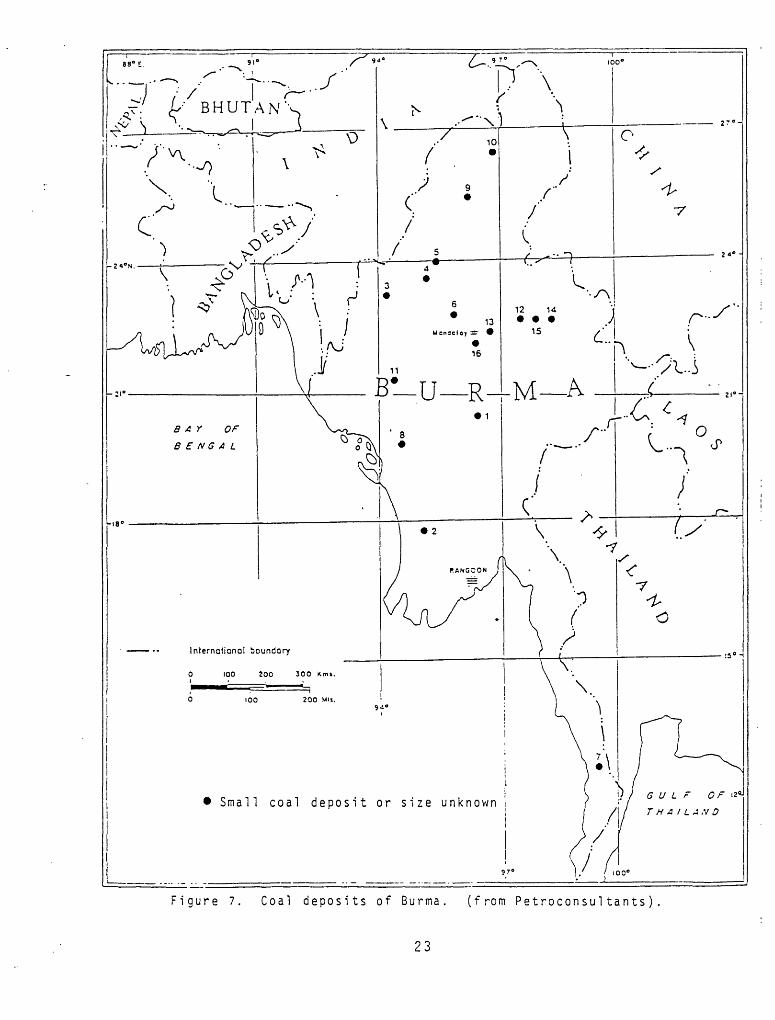
Figure 7. Coal deposits of Burma. (from Petroconsultants)
23

15 feet in thickness. The coal beds are believed to cover an area of about
30 square miles but at present the reserves are unknown. Averape samples have
been assayed as follows.: moisture 13.87 percent, volatile matter 35.74 percent,
fixed carbon 43.75 percent, and ash 6.64 percent.
In the Shan States, a number of intermontane basins are filled with
Plio-Pleistocene strata containing brown coal. Perhaps the best known is the
Namma coal field, situated about 11 miles south of Lashio, with a area of
approximately 50 square miles. Two beds of brown coal, one 12-feet
thick and the other 21-feet thick, contain an estimated 30 million tons and 50
million tons respectively. The mean of five assays showed moisture 16.58
percent, volatile matter 36.90 percent, fixed carbon 38.81 percent and ash
7.71 percent. Namma is the only Shan field that has been extensively explored:
the Burma Corporation Ltd. did most of the exploration in 1918 - 19.
Almost all the coal used in Burma is imported: known indigenous deposits
are high-ash lignite to sub-bituminous in rank.
The potential for discovering new deposits of hard coal in Burma is poor:
for brown coal the potential is fair.

SELECTED REFERENCES
Adams, T.D., 1980, Petroleum exploration in S.E. Asia: a 2 year overview (1978- 79): Oil and Gas Journal, v. 78, no. 33, p. 103 - 105.
American Association of Petroleum Geologists, "1981, World eneray developments. 1980: Am. Assoc. Petroleum Geologists Bull., v. 65, no. 10, p. ?166.
Brown, J.C., and Dpy, A.K., 1975, The minera 1 and nuclear fuels of the Indian subcontinent and Burma: Oxford University Press, Delhi.
Brunnschweiler, R.O., 1974, Indoburman ranges, in Mesozoic-fenozoic oroaenic belts, edited by A.M. Spencer: Geological Society of London.
Lepper, G.W., 1933, An outline of the geology of the oil-bearing regions of the Chindwin-Irrawaddy valley on Burma, and of Assam: Proc. World Petroleum Cong., v. 1, p. 15-25.
Oil and Gas Journal, 1981, Worldwide issue: Oil and Gas Jour., v. 79, no. 52, p. 103-105.
Paul, D.D., and Lian, H.M., 1975, Offshore Tertiary basins of Southeast Asia, Bay of Bengal to South China Sea: Proc. 9th World Petroleum Cong., v. 3, p. 107-115.
Petroconsultants, S.A., 1976-1982, International Energy Services, 8-10 Rue Muzy 1211 Geneva 6 Switzerland.
Tainsh, H.R., 1950, Tertiary geology and principal oil fields of Burma: Am. Association Petroleum Geologists Bull., v. 34, no. 5, p. 823-855.
Weeks, L.A., Harbison, R.N., and Peter, G., 1967, Island arc systems in Andaman Sea: Am. Assoc. Petroleum Geologists Bull., v. 51, no. 9, p. 1803-1815.
25