business pl an - Unity Gold Mines Group, Inc. · • Planned extraction of 400,000 tons of gold...
40
WWW.UNITYGOLDMINES.COM BUSINESS PLAN B U S I N E S S P L A N 1 EXCELSIOR PROJECT WASHINGTON STATE, USA CNC enterprises Colombia, South America HAMILTON mining GUINEA, WEST AFRICA Triple 7 commodities West virginia, USA
Transcript of business pl an - Unity Gold Mines Group, Inc. · • Planned extraction of 400,000 tons of gold...

w w w . U n i t y G o l d m i n e s . c o m
B U s i n e s s P l A n
b u s i n e s s p l a n
1
EXCELSIOR PROJECT
WASHINGTON STATE, USA
CNCenterprises
Colombia, South America
HAMILTON mining
GUINEA, WEST AFRICA
Triple 7 commodities
West virginia, USA

w w w . U n i t y G o l d m i n e s . c o m
B U s i n e s s P l A n UGMG
2
overviewUnity Gold Mines Group, Inc. (the “Company” or “Unity”) is a private entity being used to consolidate precious metals, semi-precious, and mineral properties internationally. The Company is focused on exploration, development, commercialization and trade of these valuable commodities.Unity is choosing the highest quality gold and mineral projects that have real prospects for economic development to include in its portfolio. To date the Company has identified 4 prospects that have potential for commercialization as well as additional blue-sky potential. They are Excelsior mine located in Washington State USA, Triple 7 Commodities located in West Virgina, USA, CNC Enterprises located in Colombia, South America, and Hamilton Mining & Marketing S.A.R.L. located in Guinea, West Africa.
Excelsior• 10 claims totaling 200 acres in Whatcom County, Washington• Historical producing mine• 7,820,370 tons Au-Ag indicated and inferred resource containing a
high-grade, proven/probable, 500,000 ton ore body grading 0.13 opt Au and 12.5 opt Ag
• Geological analysis from M.A. Hawksworth’s (1989) report revealed 500,000 oz. of Au equivalent indicated historic resource
• Executed Lease Option Agreement• Recently discovered several large copper-gold drill targets located
600 to 800 ft. west of the mine• Exploration, core and RC drilling from 1968-1990 resulted in the
outlining of a historic mineral resource of 4,148,000 tons grading 0.042 opt Au and 2.604 opt Ag (reported as Probable Reserves)
CNC Enterprises • 180.9-hectare property located Colombia • Historical producing mine• Min. resource of 102,305 oz of Au at a cut off grade of 3 ppm in
Block-A based on historical drill data • In-situ potential value of $143 mil @ $1400 oz Au (Block A)• Planned extraction of 400,000 tons of gold rich ore from Block-A• Currently upgrading existing 100 tpd processing plant in order to
begin production• Aggressive extraction plan with simultaneously drilling and
exploration of future Blocks B through Z • Executed Joint Venture Agreement
Hamilton Mining & Marketing S.A.R.L. • Located in Upper Guinea between two world class operating mines • 11 km2 Land Exploitation Permit• Focused on becoming a gold producer • Phase 1 total identified gold potential of 128,950 oz to be recovered
from 6 blocks at 92% purity (NI 43-101 compliant) • In-situ potential value of $180 mil @ $1400 oz of Au • Production can commence with the installation of a 100 Yd3/hour
capacity wash plant • Local contractor in place• Executed Joint Venture Agreement
Triple 7 CommoditiesGME• Unity executed an exclusive agreement to acquire 50%
interest in the GME Mining & Reclamation property• Contains app. 1.9 million tons of metallurgical red ash coal in
Beartown, West Virginia• Previously produced 4000 tons per mo. and now increasing
to 20,000 tons per mo. with new mountaintop permit application
• Red ash coal is very sought after and used in making specialty metals
• Off take agreements in place at $114 per ton expected to increase to $145 per ton once minimum tonnage reached
• In-situ value of $275 million @ $145 per ton• Executed Joint Venture Agreement
Totten Ridge Overview • Contracted Lonesome Pine Development to begin both
highwall and contourmining within 60 to 120 days• Total cost per ton of $75.13• Production expected to reach 20,000 tons per month of net
clean metallurgical coal within 3 months of production• Off-take agreements in place at $92/ton expected to increase
to $120/ton once minimum10,000tons/mo.reached• Net cash of $340K per month at $92/ton and $900K per
month at $120/ton• Executed Joint Venture Agreement
Key Highlights• Executed agreements with 3 gold
companiesand one metallurgical coal company• Plans for public listing • Combination of near-term production plays
and exploration properties with major blue-sky potential
• Drilling programs outlined • Pipeline of additional acquisitions
w w w . U n i t y G o l d m i n e s . c o m
B U s i n e s s P l A n
3
EXCELSIOR mining Project

w w w . U n i t y G o l d m i n e s . c o m
B U s i n e s s P l A n
OverviewThe Excelsior mine is located in steep slump block terrain in a heavily wooded area of Whatcom County, Washington, on the western slope of the North Cascade range. The Excelsior Mine historically produced silver (Ag) and Gold (Au) from 50,000 tons of high-grade ore from 1902 to 1916. Exploration and substantial core and reverse circulation drilling from 1968-1990 resulted in the outlining of a historic mineral resource (reported as Probable Reserves) of 4,148,000 tons grading 0.042 ounces per ton Au (opt/Au) and 2.604 ounces per ton Ag (opt/Ag). This reserve is an irregularly mineralized semi-tabular body, about 1300 ft. long, 405 ft. wide, over a general thickness of 100 ft. and could be mined from a shallow pit. It is a bulk-mineable, disseminated epithermal, submarine - volcanogenic, Ag-Au deposit, consisting of a 7,820,370 tons Au-Ag indicated and inferred resource containing a high-grade, proven/probable, 500,000 ton ore body grading 0.13 opt Au and 12.5 opt Ag. The geological analysis from the M.A. Hawksworth’s (1989) report revealed that the property has 500,000 ounces (oz.) of Au equivalent indicated historic resource. Additionally the company has recently discovered several large copper-gold drill targets located 600 to 800 ft. west of the mine workings. The company has outline an aggressive drilling program to increase and expand the overall historic resource mentioned above and confirm the recently discovered copper-gold targets.
LOCATION and ACCESSThe Excelsior project and claim blocks are located in the west half of Section 5 and the east half of Section 6, T. 39 N., R. 8 E., Whatcom County, Washington within the Mt. Baker-Snoqualmie National Forest.
Access to the claim blocks is gained from Bellingham, Washington by State Highway 542 to the village of Glacier some 36 miles to the east. One mile east of Glacier a 6-mile gravel US Forest Service leads to the property. A 1-mile mine road leads to the mine site and numerous drill roads which give the company additional accessibility.
PROPERTY CLAIMSWithin the above area there are 10 claims totaling 200 acres currently. The location of an additional 20 mining claims have been surveyed and are awaiting filing which will complete 30 claims totaling 600 acres collectively.
excelsior
4

excelsior
w w w . U n i t y G o l d m i n e s . c o m
B U s i n e s s P l A n
ALTERATION AND MINERALIZATIONCompanies that have previously studied the deposit consider it a submarine epithermal volcanogenic Ag-Au deposit. It appears that the permeable units within the Wells Creek Volcanics (lower green tuff, dark sediments, felsic volcanic breccia, felsic volcanics, grey siliceous tuff and upper green tuff allowed the movement of hydrothermal fluids. Brecciation of some of the units may have been caused by hydrostatic boiling. The alteration and associated minerals are indicative of an epithermal deposit. The silver–gold mineralization is associated with copper, lead and zinc minor amounts of copper, lead and zinc, but pyrite is ubiquitous .
A copper geochemical anomaly is located west of the mine. Recent geophysical work (CSAMT) has discovered several large-tonnage copper-gold targets west of the mine. This is consistent with other similar volcanic massive sulfide (VMS) deposits which contain gold and silver.
HISTORICAL WORKThe ore deposit was first located in 1902 and later became known as the President Group and Great Excelsior Mine. Approximately 50,000 tons of Au-Ag ore containing 7 opt Ag and 0.1 opt Au was mined from the Big Stope zone prior to 1916 when the mine was closed due to WWI and other factors. In 1967, ASARCO began the first of several exploration programs to develop a large open pit mine. This was subsequently followed by 7 other companies in response to fluctuating metal prices. The list includes: Silver Standard (1972-1975), Hanna Mining Company (1975), Quintana Exploration (1976), US Borax
5
excelsior
w w w . U n i t y G o l d m i n e s . c o m
B U s i n e s s P l A n
(1977-1985), Steelhead Resources (1985-1990), FMC Gold(1989) Stanford Metals Ltd. (1990-1991), and Arizuma Silver, Inc (1995-1998). The model developed by most of the previous exploration programs was one of westerly dipping zones of syngenetic gold-silver mineralization related to a distal volcanic massive sulfide environment. Drilling was focused on exploration and development of a silver-dominant, bulk tonnage deposit. Stanford Metals believed that there is an extraordinary potential for the discovery of thick, high-grade, gold-dominate ore bodies which could be developed for underground mining, but they were unable to secure additional financing with the results of their earlier drilling program due to market conditions. Additionally, the company lacked an understanding of the complex structure of the “Mine Series” rocks and did not have an offsite
milling solution available at the time.
mineral RESOURCEThe Excelsior is a bulk-mineable, disseminated epithermal, submarine - volcanogenic, Ag-Au deposit, consisting of a 7,820,370 ton Au-Ag indicated and inferred resource, striking N300E open to the southwest and northeast (along strike) and to the west.
The high-grade ore (Ranging from 10 to 100 opt Ag and 0.15 to 1.1 opt Au) is localized in northeast trending faults, fractures and shears contained in and parallel to the Big Stope Zone. The primary feature of the Big Stope Zone is a sedimentary breccia consisting of altered breccia fragments up to 25 cm (1 ft) in diameter. Where drilled it has a strike length of over 800 feet and has been traced on the surface for over 2.17 km (7,000 ft). The explored portion of the deposit is located on a large down-dropped landslide block. There are 115 core and reverse circulation holes delineating a 4.8 million ton indicated resource of .07 opt AuEq (Ag and Au values combined). This previously delineated ore body contains approximately 500,000 oz. of AuEq indicated resource.
Within the larger resource is a 500,000-ton underground-mineable ore body, consisting of 12.5 opt Ag and 0.13 opt Au of historic proven/probable reserves. Within this high-grade zone is an even higher-grade zone containing a 300,000-ton ore body assaying 0.207 opt Au and 20.1 opt Ag (Tshauder, 1999). The author of the geological report goes on to say that he believes there are five high-grade pipes, similar to the “Big Stope pipe” each containing approximately 94,000 tons, outlined by 20 drill holes of the 106 drill holes he examined.
Arizuma contracted a CSAMT study of the area west of the mine workings which located several conductive anomalies, believed to be feeder pipes and/or Cu-Au massive sulfides. The evidence for this is based on the configuration of the anomaly, geochemical sampling and the presence of a near-by copper gossan. If management’s hypothesis is correct it will increase the high-grade resource by a factor of five or more. The company will be drilling these targets.
In the South Zone, DDH Ex-14 contains an intercept running 0.124 opt Au and 16.8 opt Ag, which includes a 5 ft intercept of 1.01 opt Au and 77.2 opt Ag. Ex-24 contains a 45 ft intercept running 0.404 opt Au and 44.04 opt Ag. N-39 intercepted 60 ft of 0.20 opt Au and 9.24 opt Ag. In the North Zone N-2 cut 30 ft of 0.096 opt Au and 10.22 opt Ag. These areas and the down-dip extension of the “Big Stope” should be drilled.
excelsior
6
w w w . U n i t y G o l d m i n e s . c o m
B U s i n e s s P l A n
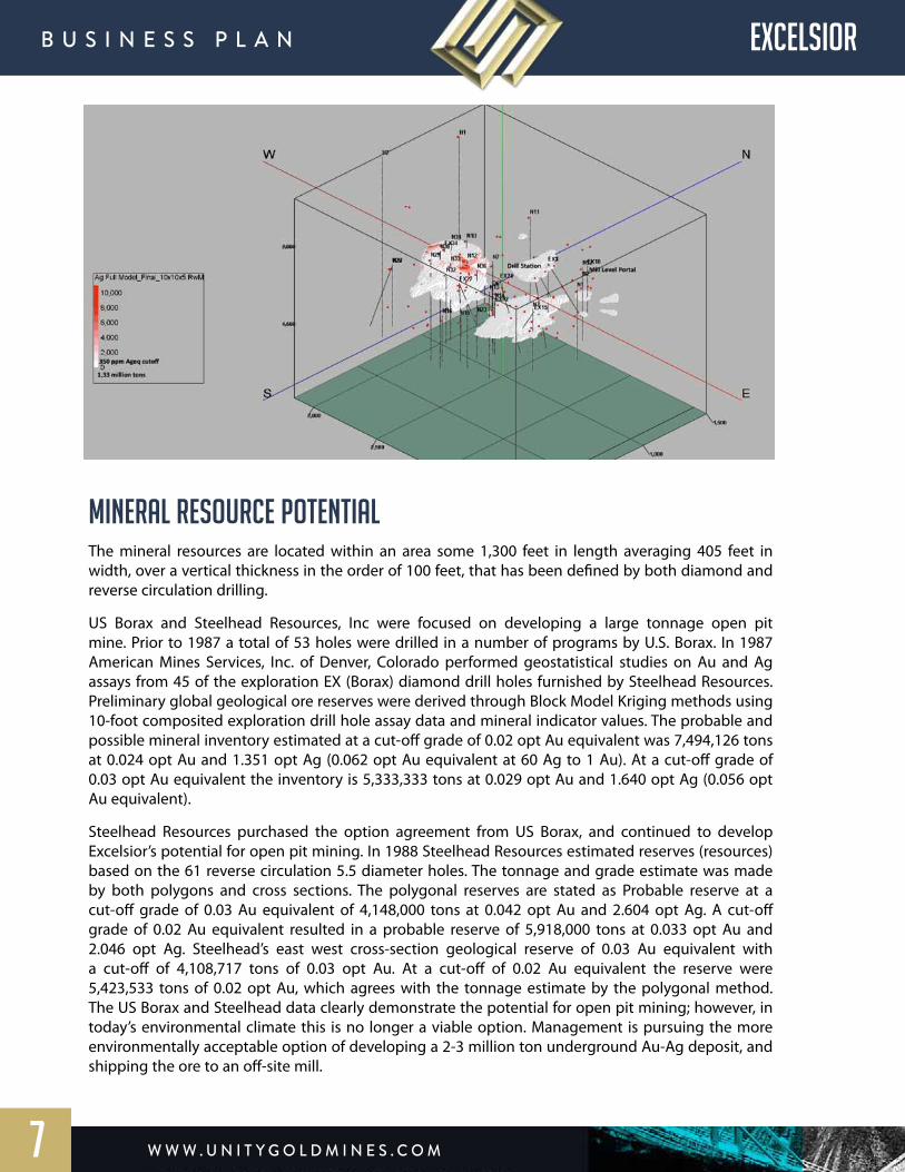
mineral RESOURCE POTENTIALThe mineral resources are located within an area some 1,300 feet in length averaging 405 feet in width, over a vertical thickness in the order of 100 feet, that has been defined by both diamond and reverse circulation drilling.
US Borax and Steelhead Resources, Inc were focused on developing a large tonnage open pit mine. Prior to 1987 a total of 53 holes were drilled in a number of programs by U.S. Borax. In 1987 American Mines Services, Inc. of Denver, Colorado performed geostatistical studies on Au and Ag assays from 45 of the exploration EX (Borax) diamond drill holes furnished by Steelhead Resources. Preliminary global geological ore reserves were derived through Block Model Kriging methods using 10-foot composited exploration drill hole assay data and mineral indicator values. The probable and possible mineral inventory estimated at a cut-off grade of 0.02 opt Au equivalent was 7,494,126 tons at 0.024 opt Au and 1.351 opt Ag (0.062 opt Au equivalent at 60 Ag to 1 Au). At a cut-off grade of 0.03 opt Au equivalent the inventory is 5,333,333 tons at 0.029 opt Au and 1.640 opt Ag (0.056 opt Au equivalent).
Steelhead Resources purchased the option agreement from US Borax, and continued to develop Excelsior’s potential for open pit mining. In 1988 Steelhead Resources estimated reserves (resources) based on the 61 reverse circulation 5.5 diameter holes. The tonnage and grade estimate was made by both polygons and cross sections. The polygonal reserves are stated as Probable reserve at a cut-off grade of 0.03 Au equivalent of 4,148,000 tons at 0.042 opt Au and 2.604 opt Ag. A cut-off grade of 0.02 Au equivalent resulted in a probable reserve of 5,918,000 tons at 0.033 opt Au and 2.046 opt Ag. Steelhead’s east west cross-section geological reserve of 0.03 Au equivalent with a cut-off of 4,108,717 tons of 0.03 opt Au. At a cut-off of 0.02 Au equivalent the reserve were 5,423,533 tons of 0.02 opt Au, which agrees with the tonnage estimate by the polygonal method. The US Borax and Steelhead data clearly demonstrate the potential for open pit mining; however, in today’s environmental climate this is no longer a viable option. Management is pursuing the more environmentally acceptable option of developing a 2-3 million ton underground Au-Ag deposit, and shipping the ore to an off-site mill.
excelsior
7

w w w . U n i t y G o l d m i n e s . c o m
B U s i n e s s P l A n
A large copper anomaly is located west of the mine. Recent geophysical work (CSAMT) has discovered several large-tonnage copper-gold targets over 200 ft. in diameter and up to 400 ft. wide, west of the mine. This is similar to other VMS deposits containing gold and silver.
metallurgy
A number of metallurgical studies have been completed on the deposit, the most recent of which was by Hazen research in 1989. Their best Au and Ag recoveries were obtained using rougher flotation and nitric acid preleaching followed by carbon in leaching. Metallurgical recoveries using flotation are approximately 85%. When treated with nitric acid and leached using cyanide the recoveries increase to between 93% and 95% for both the gold and silver.
ECONOMIC GEOLOGYThis is a VMS which was remobilized and over printed by epithermal Au-Ag mineralization. Mineralizing fluids invaded a sequence of tuffs, siltstones and graywackes, depositing silica, adularia, and Au-Ag mineralization in a blanket up to 210 feet thick and over a strike length of 7000 feet. Grades in this disseminated deposit are on the order of 0.03 – 1.01 opt Au and 1.2 – 234 opt Ag. The disseminated mineralization dips the west making it favorable to underground mining. The continuation the of Big Stope pipe can be inferred from the existing mine workings. It is about 100 feet in diameter and is inclined to the south at 45 degrees.
The source of the mineralization is a series of mineralized “feeder pipes” located west of the mine workings. These were initially “black smokers” located in a deep trench on the Jurassic sea floor. Typically this type of pipe is rich in Cu, Pb or Zn. In this case several such mineralized pipe-like zones have been located using CSAMT. We believe that they contain rich deposits of Cu-Au, and are excellent targets for the planned drilling program.land rises very steeply. All of the area is heavily forested with fir and cedar and covered with rainforest vegetation. Snow may be expected above 2000 ft. during the winter months.
With the steep topography, camp grounds and proximity to the Nooksack River and Wells Creek it will be necessary to locate any mine tailings and waste dumps above the mine area where the topography is not as severe. Power and water are readily available.
NEXT STEPS
Drilling has indicated mineralized sections well above the cutoff grade of 0.02 opt Au equivalent and over 200 feet in length. There is also a very good chance to extend the outlined mineralized ore because the drill holes on the east side encountered some mineralization.
The company will post a Bond with Bureau of Land Management, precure estimates with mine contractors to bring the mine to safety and compliance standards, stake and file additional claims, do road work, complete needed work in the Blacksmith level, begin a surface exploration and sampling program, do additional drilling and complete a NI 43-101 report for final analysis and review.
excelsior
8
w w w . U n i t y G o l d m i n e s . c o m
B U s i n e s s P l A n
cncenterprises
9
w w w . U n i t y G o l d m i n e s . c o m
B U s i n e s s P l A n CNC
10
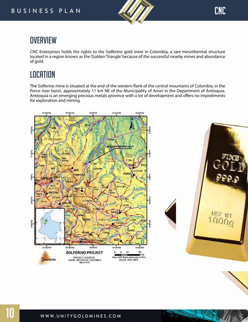
OVERVIEW CNC Enterprises holds the rights to the Solferino gold mine in Colombia, a rare mesothermal structure located in a region known as the ‘Golden Triangle’ because of the successful nearby mines and abundance of gold.
LOCATIONThe Solferino mine is situated at the end of the western flank of the central mountains of Colombia, in the Porce river basin, approximately 11 km NE of the Municipality of Anorí in the Department of Antioquia. Antioquía is an emerging precious metals province with a lot of development and offers no impediments for exploration and mining.
w w w . U n i t y G o l d m i n e s . c o m
B U s i n e s s P l A n SOLFERINOCNC
11
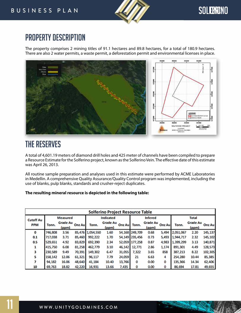
PROPERTY DESCRIPTIONThe property comprises 2 mining titles of 91.1 hectares and 89.8 hectares, for a total of 180.9 hectares. There are also 2 water permits, a waste permit, a deforestation permit and environmental licenses in place.
THE RESERVES A total of 4,601.19 meters of diamond drill holes and 425 meter of channels have been compiled to prepare a Resource Estimate for the Solferino project, known as the Solferino Vein. The effective date of this estimate was April 26, 2013.
All routine sample preparation and analyses used in this estimate were performed by ACME Laboratories in Medellin. A comprehensive Quality Assurance/Quality Control program was implemented, including the use of blanks, pulp blanks, standards and crusher-reject duplicates.
The resulting mineral resource is depicted in the following table:
w w w . U n i t y G o l d m i n e s . c o m
B U s i n e s s P l A n CNC
12
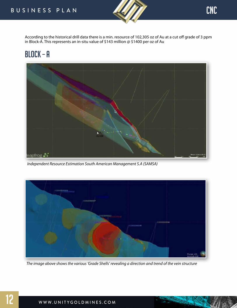
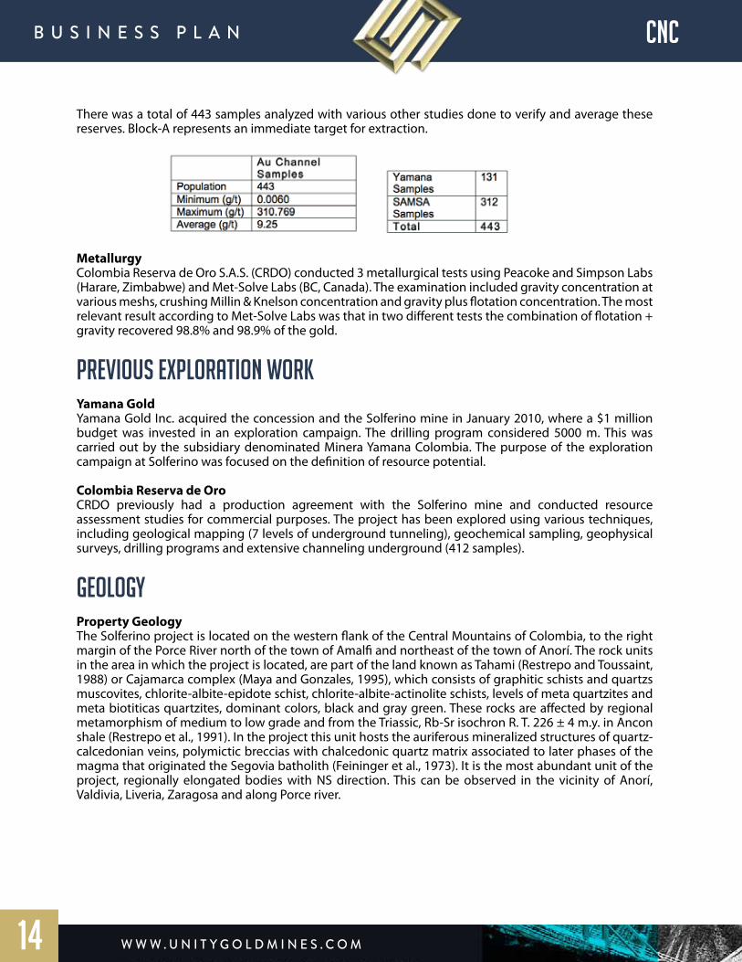
According to the historical drill data there is a min. resource of 102,305 oz of Au at a cut off grade of 3 ppm in Block-A. This represents an in-situ value of $143 million @ $1400 per oz of Au
BLOCK – A
Independent Resource Estimation South American Management S.A (SAMSA)
The image above shows the various ‘Grade Shells’ revealing a direction and trend of the vein structure
w w w . U n i t y G o l d m i n e s . c o m
B U s i n e s s P l A n CNC
13
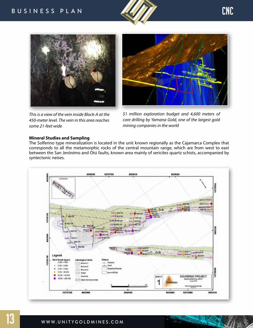
This is a view of the vein inside Block-A at the 450-meter level. The vein in this area reaches some 21-feet wide
Mineral Studies and SamplingThe Solferino type mineralization is located in the unit known regionally as the Cajamarca Complex that corresponds to all the metamorphic rocks of the central mountain range, which are from west to east between the San Jerónimo and Otú faults, known area mainly of sericites quartz schists, accompanied by syntectonic neises.
$1 million exploration budget and 4,600 meters of core drilling by Yamana Gold, one of the largest gold mining companies in the world
w w w . U n i t y G o l d m i n e s . c o m
B U s i n e s s P l A n CNC
14
There was a total of 443 samples analyzed with various other studies done to verify and average these reserves. Block-A represents an immediate target for extraction.
MetallurgyColombia Reserva de Oro S.A.S. (CRDO) conducted 3 metallurgical tests using Peacoke and Simpson Labs (Harare, Zimbabwe) and Met-Solve Labs (BC, Canada). The examination included gravity concentration at various meshs, crushing Millin & Knelson concentration and gravity plus flotation concentration. The most relevant result according to Met-Solve Labs was that in two different tests the combination of flotation + gravity recovered 98.8% and 98.9% of the gold.
PREVIOUS EXPLORATION WORKYamana GoldYamana Gold Inc. acquired the concession and the Solferino mine in January 2010, where a $1 million budget was invested in an exploration campaign. The drilling program considered 5000 m. This was carried out by the subsidiary denominated Minera Yamana Colombia. The purpose of the exploration campaign at Solferino was focused on the definition of resource potential.
Colombia Reserva de OroCRDO previously had a production agreement with the Solferino mine and conducted resource assessment studies for commercial purposes. The project has been explored using various techniques, including geological mapping (7 levels of underground tunneling), geochemical sampling, geophysical surveys, drilling programs and extensive channeling underground (412 samples).
GEOLOGYProperty GeologyThe Solferino project is located on the western flank of the Central Mountains of Colombia, to the right margin of the Porce River north of the town of Amalfi and northeast of the town of Anorí. The rock units in the area in which the project is located, are part of the land known as Tahami (Restrepo and Toussaint, 1988) or Cajamarca complex (Maya and Gonzales, 1995), which consists of graphitic schists and quartzs muscovites, chlorite-albite-epidote schist, chlorite-albite-actinolite schists, levels of meta quartzites and meta biotiticas quartzites, dominant colors, black and gray green. These rocks are affected by regional metamorphism of medium to low grade and from the Triassic, Rb-Sr isochron R. T. 226 ± 4 m.y. in Ancon shale (Restrepo et al., 1991). In the project this unit hosts the auriferous mineralized structures of quartz-calcedonian veins, polymictic breccias with chalcedonic quartz matrix associated to later phases of the magma that originated the Segovia batholith (Feininger et al., 1973). It is the most abundant unit of the project, regionally elongated bodies with NS direction. This can be observed in the vicinity of Anorí, Valdivia, Liveria, Zaragosa and along Porce river.
w w w . U n i t y G o l d m i n e s . c o m
B U s i n e s s P l A n CNC
15
During March 2010 diamond core drill holes done by Yamana Gold, there were no reports of any change in the lithology. All the drill hole data reports schists with very thin dikes of diorite in the base.
In the surroundings of the Project it is difficult to find outcrops, because of the presence of colluvial deposits and dense vegetation coverage. The favorable zones where this unit can be observed, is along the access road between Camp and the Solferino Mine and the gullies and tributaries near this.
The structural domain of the project is defined by the fault system of Out-Pericos, nowadays considered as a limit of the Tahami and Chibcha terrains, west and east respectively. It has been established a dominant component of sinistral type (Feininger et al., 1972), consisting of fracturing patterns with NS regional tendency at N10oW, showing a favorable framework for the generation of structures where mineralization can be hosted. The main mineralized structure of the project is not different to this domain, because its average direction is N60W and 75 NE dip, closer to these tendencies.
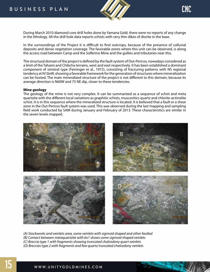
Mine geologyThe geology of the mine is not very complex. It can be summarized as a sequence of schist and meta quartzite with the different local variations as graphitic schists, muscovitics quartz and chlorite-actinolite schist. It is in this sequence where the mineralized structure is located. It is believed that a fault or a shear zone in the Out-Pericos fault system was used. This was observed during the last mapping and sampling field work conducted by SAM during January and February of 2013. These characteristics are similar in the seven levels mapped.
(A) Stockworks and veinlets area, some veinlets with sigmoid shaped and other faulted(B) Contact between metaquartzite with bx1 shows some sigmoid shaped veinlets(C) Breccia type 1 with fragments showing truncated chalcedony quart veinlets (D) Breccias type 2 with fragments and few quartz truncated chalcedony veinlets
w w w . U n i t y G o l d m i n e s . c o m
B U s i n e s s P l A n CNC
16
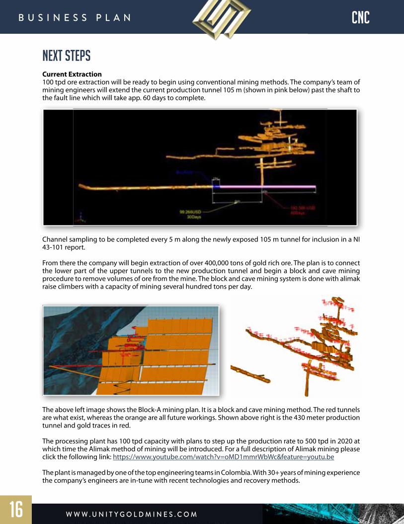
NEXT STEPSCurrent Extraction 100 tpd ore extraction will be ready to begin using conventional mining methods. The company’s team of mining engineers will extend the current production tunnel 105 m (shown in pink below) past the shaft to the fault line which will take app. 60 days to complete.
Channel sampling to be completed every 5 m along the newly exposed 105 m tunnel for inclusion in a NI 43-101 report.
From there the company will begin extraction of over 400,000 tons of gold rich ore. The plan is to connect the lower part of the upper tunnels to the new production tunnel and begin a block and cave mining procedure to remove volumes of ore from the mine. The block and cave mining system is done with alimak raise climbers with a capacity of mining several hundred tons per day.
The above left image shows the Block-A mining plan. It is a block and cave mining method. The red tunnels are what exist, whereas the orange are all future workings. Shown above right is the 430 meter production tunnel and gold traces in red.
The processing plant has 100 tpd capacity with plans to step up the production rate to 500 tpd in 2020 at which time the Alimak method of mining will be introduced. For a full description of Alimak mining please click the following link: https://www.youtube.com/watch?v=oMD1mmrWbWc&feature=youtu.be
The plant is managed by one of the top engineering teams in Colombia. With 30+ years of mining experience the company’s engineers are in-tune with recent technologies and recovery methods.
w w w . U n i t y G o l d m i n e s . c o m
B U s i n e s s P l A n CNC
17
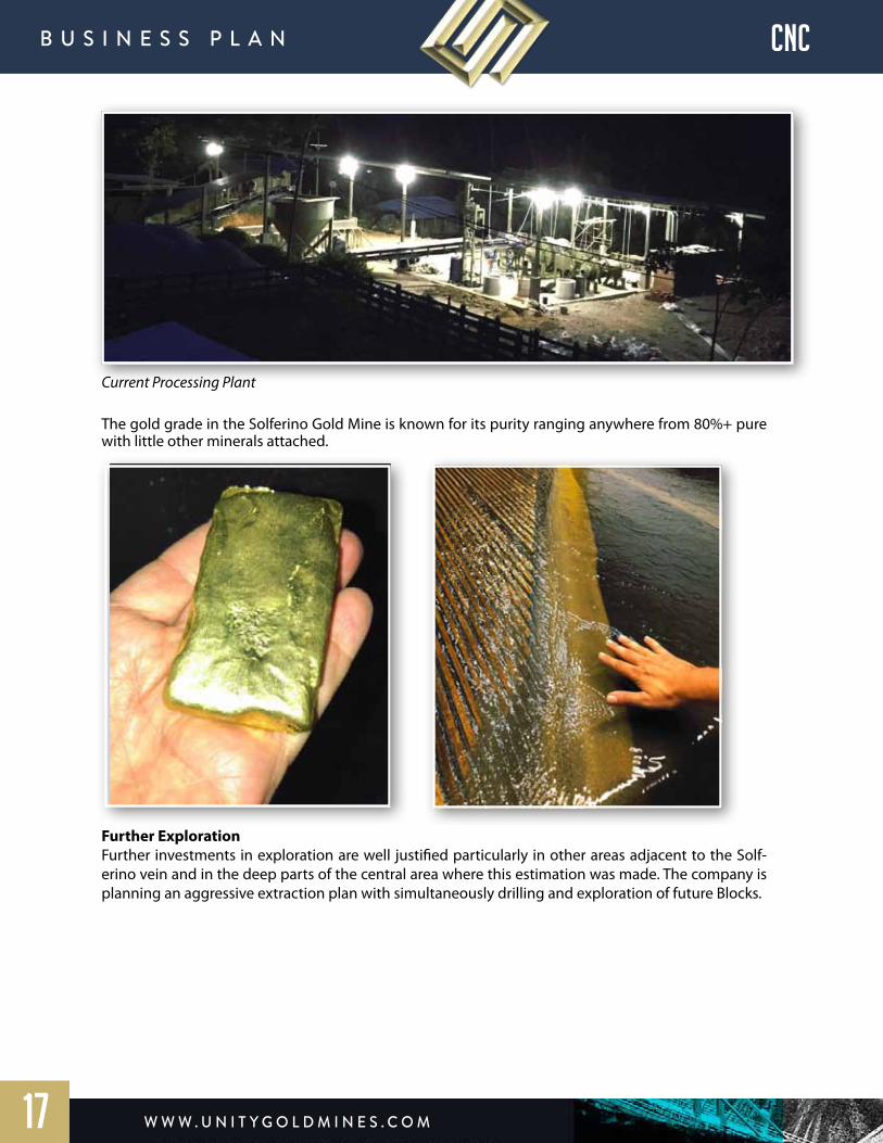
Current Processing Plant
The gold grade in the Solferino Gold Mine is known for its purity ranging anywhere from 80%+ pure with little other minerals attached.
Further ExplorationFurther investments in exploration are well justified particularly in other areas adjacent to the Solf-erino vein and in the deep parts of the central area where this estimation was made. The company is planning an aggressive extraction plan with simultaneously drilling and exploration of future Blocks.

w w w . U n i t y G o l d m i n e s . c o m
B U s i n e s s P l A n
HAMILTON mining & Marketing S.A.R.L .
18

overview Hamilton Mining & Marketing S.A.R.L. (“Hamilton Mining”) is a private international mining company located in Upper Guinea which is focused on becoming an intermediate sized gold producer. The company currently holds the Fifa Land Exploitation Permit which is strategically located within a 70 km radius between two world class operating mines. Approximately 30 km west of the large Siguiri gold mine operation at Kintinian, owned and operated by AngloGold Ashanti, and 40 km from the Guinor mine located at Lero.
FIFA (LAND) EXPLORATION AND EXPLOITATION PERMITThe Fifa Exploration Permit area is located about 80 km west of the town of Siguiri, accessible by Route Nationale #30. It is to the north of the prominent Tinkisso River which extends over 28 km and includes the gravel terraces on both sides, North and South, of the river. Hamilton Mining previously held a dredging exploration license for gold and associated minerals several years ago, but has since decided to focus on the alluvial and hard rock exploration.
Over the past 10 years Hamilton Mining surveyed the 135 km² Fifa permit area for an assessment of its potential for alluvial, eluvial-lateritic and primary gold deposits when it finally chose an area of 11 km² around the village of Fifa as the most prospective of all areas for a retrocession and conversion from a Permis de Recherche Minière to a Permis d’Exploitation of the Fifa concession as mandated by the Guinean Ministry of Mines.
w w w . U n i t y G o l d m i n e s . c o m
B U s i n e s s P l A n hamilton
19

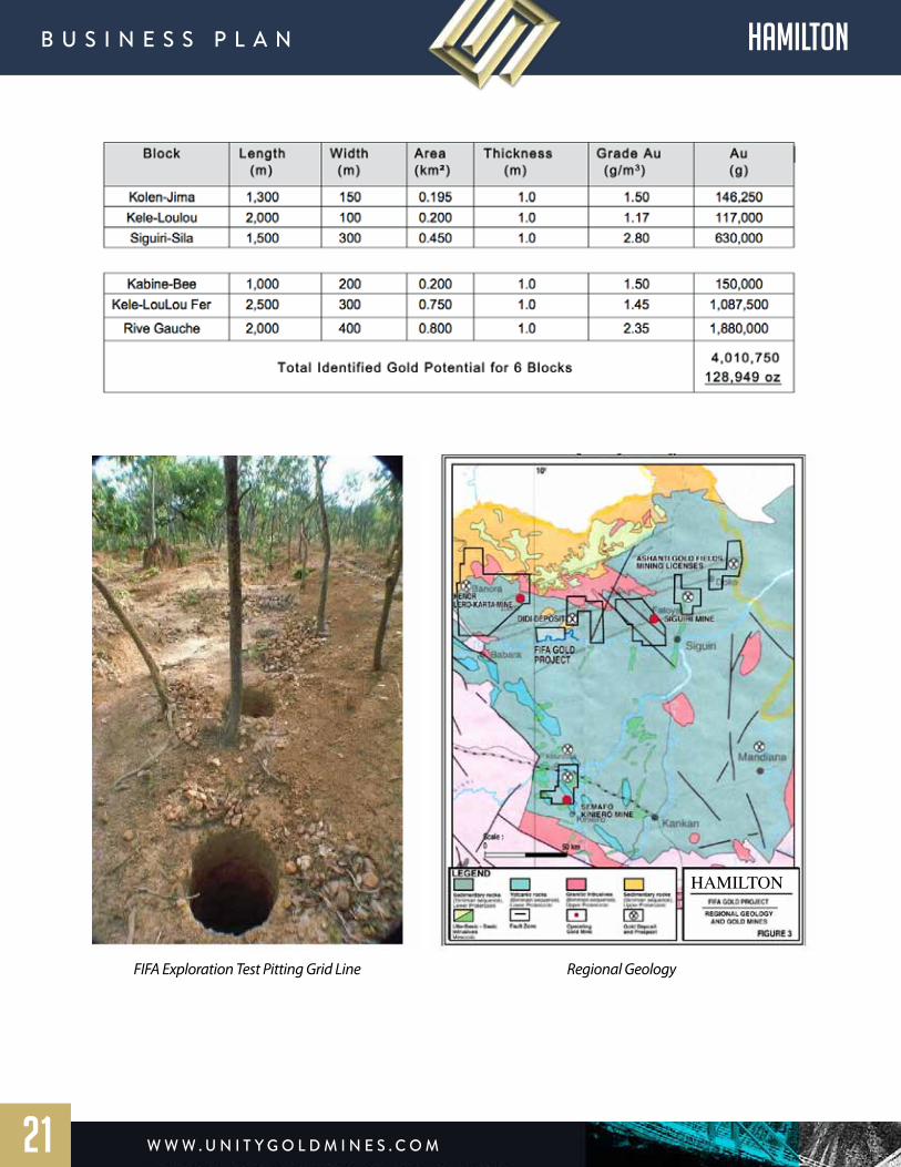
TOTAL IDENTIFIED GOLD POTENTIAL
Field work consisting of mapping, pitting, soil sampling in laid out grids as well as trenching was carried out mainly West and South of the village of Fifa in the Eastern section of the permit area. Six prospective blocks were targeted for alluvial gold mining where previous local mining activity had taken place within the Fifa Permit: Kolen-Jima, Kele-Lolou, Kele-LouLou Fer, Rive Gauche, Siguiri-Sila and Kabine-Bee.
Hamilton Mining’s field crews excavated over 2000 prospecting pits mainly along the Bereko River, West of Fifa village. Gold grades of 0.2 to 1.97 g/m³ were recovered from the basal gravel of 0.27 to 1.16 m thickness. The overburden above the gravel ranged in thickness between 5.6 and 9.4 m. At Siguiri Sila, located South of the village and one of 6 alluvial prospects within the retrocession area, 14 pits were excavated in a 300 m² grid with an average grade of 2.14 g Au/m³ and one of the pits showing a grade of 7.36 g Au/m³. Hamilton Mining’s original estimate was that these 6 areas hold the potential for 488 kg (approx. 15,700 oz) of recoverable gold. A later conservative estimate, based on newer and more detailed data and assuming that only 50% of the original ore has remained in-situ, inferred the potential for at least about 4,010 kg (approx. 128,950 oz) of gold to be recovered from the 6 blocks. At 92% purity and a price/oz of $1,200 that would represent a value of app. $142 million. The quoted number of ounces, however, appears to be very conservative in view of the estimate of B. Violette (based on 75% of original ore still remaining in place) in his NI 43-101 compliant report, where the author (B. Violette, 2004) quotes a potential for gold from alluvial (paleo-channel) gravels in the SE quadrant of the Fifa concession of approx. 269,600 oz Au.
The Fifa Exploration Permit reduced to New Permit Retrocession for Exploitation
Map of the Fifa Exploration Permit and the Tinkisso River Dredging Permits
HAMILTON
w w w . U n i t y G o l d m i n e s . c o m
B U s i n e s s P l A n hamilton
20
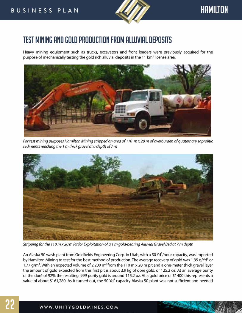
HAMILTON
FIFA Exploration Test Pitting Grid Line Regional Geology
w w w . U n i t y G o l d m i n e s . c o m
B U s i n e s s P l A n hamilton
21
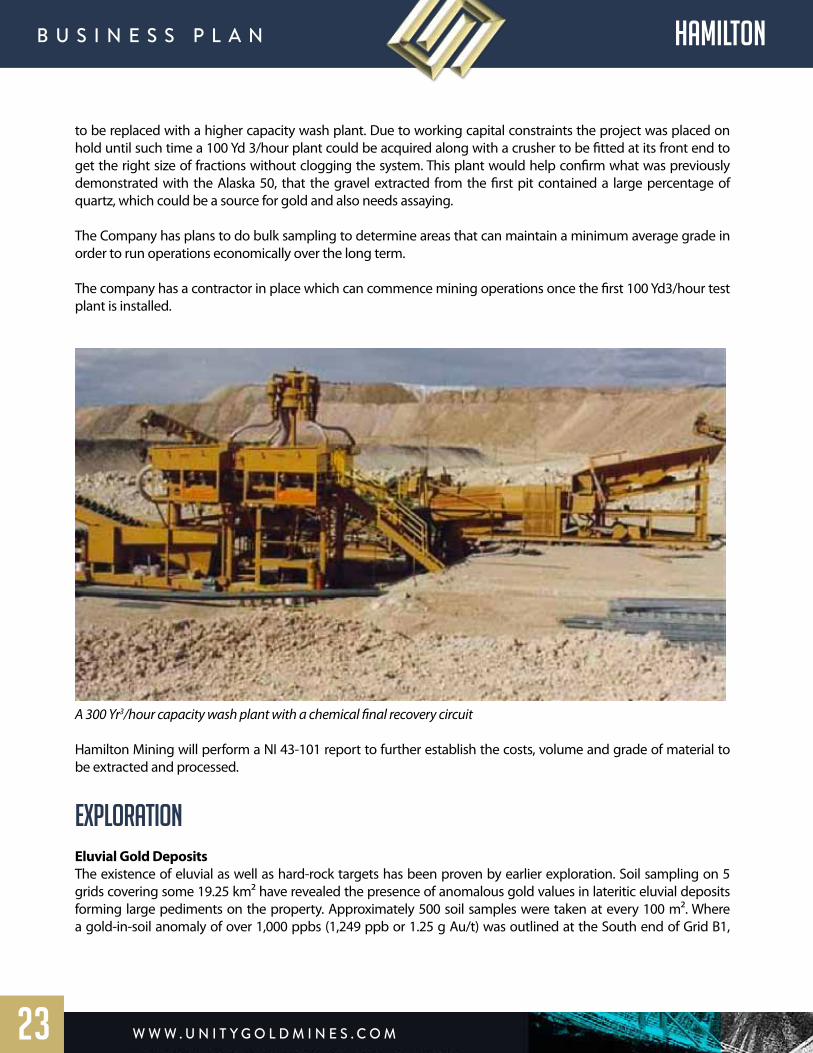
TEST MINING AND GOLD PRODUCTION FROM ALLUVIAL DEPOSITS Heavy mining equipment such as trucks, excavators and front loaders were previously acquired for the purpose of mechanically testing the gold rich alluvial deposits in the 11 km2 license area.
For test mining purposes Hamilton Mining stripped an area of 110 m x 20 m of overburden of quaternary saprolitic sediments reaching the 1 m thick gravel at a depth of 7 m
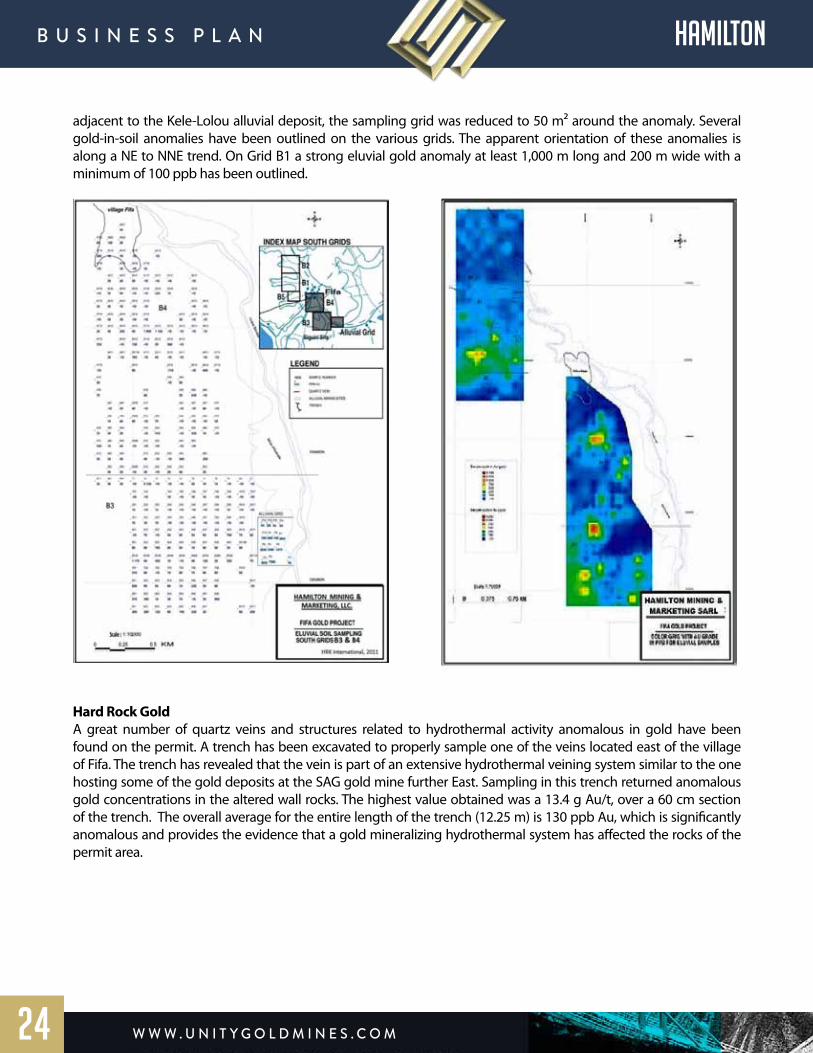
Stripping for the 110 m x 20 m Pit for Exploitation of a 1 m gold-bearing Alluvial Gravel Bed at 7 m depth
An Alaska 50 wash plant from Goldfields Engineering Corp. in Utah, with a 50 Yd³/hour capacity, was imported by Hamilton Mining to test for the best method of production. The average recovery of gold was 1.35 g/Yd³ or 1.77 g/m³. With an expected volume of 2,200 m³ from the 110 m x 20 m pit and a one-meter thick gravel layer the amount of gold expected from this first pit is about 3.9 kg of doré gold, or 125.2 oz. At an average purity of the doré of 92% the resulting .999 purity gold is around 115.2 oz. At a gold price of $1400 this represents a value of about $161,280. As it turned out, the 50 Yd³ capacity Alaska 50 plant was not sufficient and needed
w w w . U n i t y G o l d m i n e s . c o m
B U s i n e s s P l A n hamilton
22
to be replaced with a higher capacity wash plant. Due to working capital constraints the project was placed on hold until such time a 100 Yd 3/hour plant could be acquired along with a crusher to be fitted at its front end to get the right size of fractions without clogging the system. This plant would help confirm what was previously demonstrated with the Alaska 50, that the gravel extracted from the first pit contained a large percentage of quartz, which could be a source for gold and also needs assaying.
The Company has plans to do bulk sampling to determine areas that can maintain a minimum average grade in order to run operations economically over the long term.
The company has a contractor in place which can commence mining operations once the first 100 Yd3/hour test plant is installed.
A 300 Yr3/hour capacity wash plant with a chemical final recovery circuit
Hamilton Mining will perform a NI 43-101 report to further establish the costs, volume and grade of material to be extracted and processed.
EXPLORATION Eluvial Gold DepositsThe existence of eluvial as well as hard-rock targets has been proven by earlier exploration. Soil sampling on 5 grids covering some 19.25 km² have revealed the presence of anomalous gold values in lateritic eluvial deposits forming large pediments on the property. Approximately 500 soil samples were taken at every 100 m². Where a gold-in-soil anomaly of over 1,000 ppbs (1,249 ppb or 1.25 g Au/t) was outlined at the South end of Grid B1,
w w w . U n i t y G o l d m i n e s . c o m
B U s i n e s s P l A n hamilton
23
adjacent to the Kele-Lolou alluvial deposit, the sampling grid was reduced to 50 m² around the anomaly. Several gold-in-soil anomalies have been outlined on the various grids. The apparent orientation of these anomalies is along a NE to NNE trend. On Grid B1 a strong eluvial gold anomaly at least 1,000 m long and 200 m wide with a minimum of 100 ppb has been outlined.
Hard Rock Gold A great number of quartz veins and structures related to hydrothermal activity anomalous in gold have been found on the permit. A trench has been excavated to properly sample one of the veins located east of the village of Fifa. The trench has revealed that the vein is part of an extensive hydrothermal veining system similar to the one hosting some of the gold deposits at the SAG gold mine further East. Sampling in this trench returned anomalous gold concentrations in the altered wall rocks. The highest value obtained was a 13.4 g Au/t, over a 60 cm section of the trench. The overall average for the entire length of the trench (12.25 m) is 130 ppb Au, which is significantly anomalous and provides the evidence that a gold mineralizing hydrothermal system has affected the rocks of the permit area.
w w w . U n i t y G o l d m i n e s . c o m
B U s i n e s s P l A n hamilton
24

Fifa Exploration for hard-rock targets two outcrops of gold-bearing quartz veins (upper 2 pics) and altered quartz vein embedded in saprolitized birimian schists (lower pic) from Locations W and NW of the Village of Fifa
Additional ExplorationReconnaissance prospecting and soil sampling around the village of Fifa has highlighted the overall great potential of the permit. That includes besides the vast potential for alluvial gold also the potential for eluvial- lateritic and primary hard-rock gold deposits. Hamilton Mining will conduct exploration work on the permit under NI 43-101 guidelines to determine the overall number of drill holes, diamond core and/or RC drilling needed estimate the potential for gold in both these deposit types separately or together. Looking at the four main gold mining locations around Fifa; SAG to the East, Lero to the NW, Dinguiraye to the West and Cassidy Gold to the South, which each have a similar geological situation and 100,000’s of ounces in gold reserves, Hamilton Mining is expecting to find significant gold potential.
w w w . U n i t y G o l d m i n e s . c o m
B U s i n e s s P l A n hamilton
25
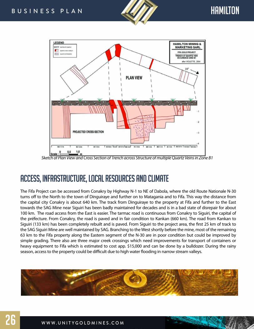
Sketch of Plan View and Cross Section of Trench across Structure of multiple Quartz Veins in Zone B1
ACCESS, INFRASTRUCTURE, LOCAL RESOURCES AND CLIMATEThe Fifa Project can be accessed from Conakry by Highway N-1 to NE of Dabola, where the old Route Nationale N-30 turns off to the North to the town of Dinguiraye and further on to Matagania and to Fifa. This way the distance from the capital city Conakry is about 640 km. The track from Dinguiraye to the property at Fifa and further to the East towards the SAG Mine near Siguiri has been badly maintained for decades and is in a bad state of disrepair for about 100 km. The road access from the East is easier. The tarmac road is continuous from Conakry to Siguiri, the capital of the préfecture. From Conakry, the road is paved and in fair condition to Kankan (660 km). The road from Kankan to Siguiri (133 km) has been completely rebuilt and is paved. From Siguiri to the project area, the first 25 km of track to the SAG Siguiri Mine are well maintained by SAG. Branching to the West shortly before the mine, most of the remaining 63 km to the Fifa property along the Eastern segment of the N-30 are in poor condition but could be improved by simple grading. There also are three major creek crossings which need improvements for transport of containers or heavy equipment to Fifa which is estimated to cost app. $15,000 and can be done by a bulldozer. During the rainy season, access to the property could be difficult due to high water flooding in narrow stream valleys.
w w w . U n i t y G o l d m i n e s . c o m
B U s i n e s s P l A n hamilton
26
A town of over 100,000 inhabitants in Siguiri together with the SAG mining operation at Kintinian offers a wide range of services, including drilling and mining contractors, heavy equipment repair facilities and spare parts, an analytical laboratory operated by SGS and a broad range of logistical services, such as food and fuel. Abundant skilled and unskilled labor also can be found in the area. Siguiri has an airport, which occasionally is serviced by flights from and/or to Conakry. The Malenké ethnic group forms the majority of the population, which gains its living through agriculture, fishing and the breeding of goats, sheep and cattle. An important source of income is the artisanal gold production from mostly alluvial deposits. The climate of Upper Guinea is qualified as dry tropical with two seasons. Between November and May, a hot (40°C) and dry season prevails and between June and October a wet season with precipitation in the range of 1,300 mm. During the rainy season, water rises in the stream and rivers, roads are cut off and often field work has to be suspended.
LOCAL GEOLOGY OF FIFA PROJECT AREAAccording to the geological map of the Siguiri map sheet at a scale of 1:200,000 produced by the BRGM (ÉGAL et al, 1999) the Fifa gold project is underlain by finely stratified siltites, argillites and minor feldspathic sandstones typical of continental marine platform deposits and filling up most of the Siguiri Basin. The property is almost entirely covered with lateritic duricrust plateaus, pediments and recent alluvial deposits. Rocks in outcrops are mostly saprolitized. Rocks fragments of these formations are found in the rubbles and rock debris left from the artisanal mining activities in the alluvial flats of the property. Along the Bereko River most of these fragments are weathered phyllites.
w w w . U n i t y G o l d m i n e s . c o m
B U s i n e s s P l A n hamilton
27
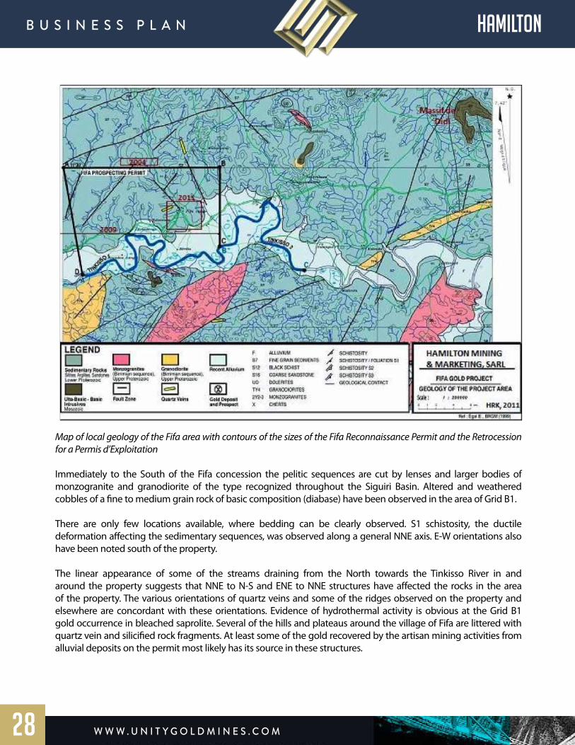
Map of local geology of the Fifa area with contours of the sizes of the Fifa Reconnaissance Permit and the Retrocession for a Permis d’Exploitation Immediately to the South of the Fifa concession the pelitic sequences are cut by lenses and larger bodies of monzogranite and granodiorite of the type recognized throughout the Siguiri Basin. Altered and weathered cobbles of a fine to medium grain rock of basic composition (diabase) have been observed in the area of Grid B1. There are only few locations available, where bedding can be clearly observed. S1 schistosity, the ductile deformation affecting the sedimentary sequences, was observed along a general NNE axis. E-W orientations also have been noted south of the property.
The linear appearance of some of the streams draining from the North towards the Tinkisso River in and around the property suggests that NNE to N-S and ENE to NNE structures have affected the rocks in the area of the property. The various orientations of quartz veins and some of the ridges observed on the property and elsewhere are concordant with these orientations. Evidence of hydrothermal activity is obvious at the Grid B1 gold occurrence in bleached saprolite. Several of the hills and plateaus around the village of Fifa are littered with quartz vein and silicified rock fragments. At least some of the gold recovered by the artisan mining activities from alluvial deposits on the permit most likely has its source in these structures.
w w w . U n i t y G o l d m i n e s . c o m
B U s i n e s s P l A n hamilton
28
w w w . U n i t y G o l d m i n e s . c o m
B U s i n e s s P l A n
29
Triple 7 C o m m o d i t i e sI N C O R P O R A T E D

overview Triple 7 Commodities, Inc. (“Triple 7”) has acquired land and mineral rights to mine and recover premium quality metallurgical coal for sale to commercial and industrial consumers both in the U.S. and internationally. The Company’s coal extraction operations are located in McDowell County, West Virginia, a region known for geologically verified coal seams and premium- grade coals used for processing in the steel making industry. Unity has entered into a JV agreement for one of these properties, GME Mining & Reclamation.
GME Mining & ReclamationTriple 7 has executed an agreement to acquire GME Mining & Reclamation located in Beartown, West Virginia. The property contains the Red Ash seam with approximately 1.9 million tons of metallurgical coal. There was previously 4000 tons per month of permitted production capacity on the property and the company is now increasing the permit to 25,000 tons per month with a new mountaintop removal permit application. This is expected to become effective within 90 days of final submission of core samples.
In 2018 GME produced $1.8 million in gross revenue under the limited output permit it originally possessed. With the new permit allowing increased production up to 25,000 tons per month and a new offtake agreement in place, Triple 7 will increase the annual revenue to $34.8 million at full capacity.
The met coal being produced on the property is called “red ash” coal and is very sought after and used in making specialty metals. The company has a contractor in place called Lonesome Pine Development which us ready to begin mountaintop removal. The contractor is a seasoned operator with over 30 years of experience in mining coal which helps eliminate any execution risk and locks in the company’s profit margin for production.
w w w . U n i t y G o l d m i n e s . c o m
B U s i n e s s P l A n TRIPLE 7
30
PRODUCTIONWith the simple addition of a D10 dozer and 4 dump trucks the company can begin removing up to 25,000 tons per month. The coal will be trucked less than 3 miles to a rail loadout facility and does not require any washing. Furthermore deu to the nature of mountain top removal, there is no reclamation needed which significantly reduces the overall production cost of this material. The total cost per ton is $70.32. The company has off-take agreements in place at $114 per ton increasing to $145 per ton once a minimum tonnage is reached. The net cash per month from the operation is $1.49 million at $145 per ton of which Unity has 50%.
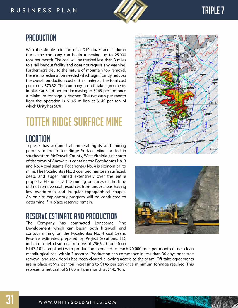
Totten Ridge Surface MineLocationTriple 7 has acquired all mineral rights and mining permits to the Totten Ridge Surface Mine located in southeastern McDowell County, West Virginia just south of the town of Anawalt. It contains the Pocahontas No. 3 and No. 4 coal seams. Pocahontas No. 4 is economical to mine. The Pocahontas No. 3 coal bed has been surfaced, deep, and auger mined extensively over the entire property. Historically, the mining practices of the time did not remove coal resources from under areas having low overburden and irregular topographical shapes. An on-site exploratory program will be conducted to determine if in-place reserves remain.
Reserve Estimate and ProductionThe Company has contracted Lonesome Pine Development which can begin both highwall and contour mining on the Pocahontas No. 4 coal Seam. Reserve estimates prepared by Project Solutions, LLC indicate a net clean coal reserve of 796,920 tons (non NI 43-101 compliant) with production expected to reach 20,000 tons per month of net clean metallurgical coal within 3 months. Production can commence in less than 30 days once tree removal and rock debris has been cleared allowing access to the seam. Off take agreements are in place at $92 per ton increasing to $145 per ton once minimum tonnage reached. This represents net cash of $1.05 mil per month at $145/ton.
w w w . U n i t y G o l d m i n e s . c o m
B U s i n e s s P l A n TRIPLE 7
31
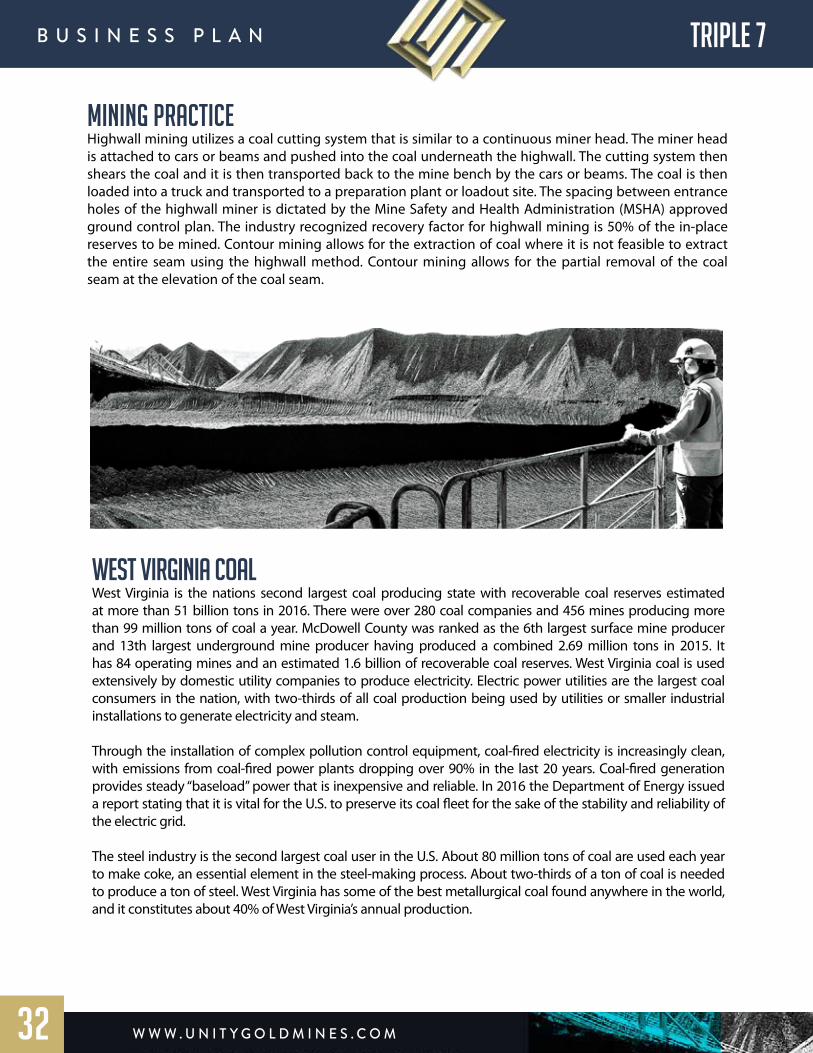
Mining PracticeHighwall mining utilizes a coal cutting system that is similar to a continuous miner head. The miner head is attached to cars or beams and pushed into the coal underneath the highwall. The cutting system then shears the coal and it is then transported back to the mine bench by the cars or beams. The coal is then loaded into a truck and transported to a preparation plant or loadout site. The spacing between entrance holes of the highwall miner is dictated by the Mine Safety and Health Administration (MSHA) approved ground control plan. The industry recognized recovery factor for highwall mining is 50% of the in-place reserves to be mined. Contour mining allows for the extraction of coal where it is not feasible to extract the entire seam using the highwall method. Contour mining allows for the partial removal of the coal seam at the elevation of the coal seam.
west virginia coalWest Virginia is the nations second largest coal producing state with recoverable coal reserves estimated at more than 51 billion tons in 2016. There were over 280 coal companies and 456 mines producing more than 99 million tons of coal a year. McDowell County was ranked as the 6th largest surface mine producer and 13th largest underground mine producer having produced a combined 2.69 million tons in 2015. It has 84 operating mines and an estimated 1.6 billion of recoverable coal reserves. West Virginia coal is used extensively by domestic utility companies to produce electricity. Electric power utilities are the largest coal consumers in the nation, with two-thirds of all coal production being used by utilities or smaller industrial installations to generate electricity and steam.
Through the installation of complex pollution control equipment, coal-fired electricity is increasingly clean, with emissions from coal-fired power plants dropping over 90% in the last 20 years. Coal-fired generation provides steady “baseload” power that is inexpensive and reliable. In 2016 the Department of Energy issued a report stating that it is vital for the U.S. to preserve its coal fleet for the sake of the stability and reliability of the electric grid.
The steel industry is the second largest coal user in the U.S. About 80 million tons of coal are used each year to make coke, an essential element in the steel-making process. About two-thirds of a ton of coal is needed to produce a ton of steel. West Virginia has some of the best metallurgical coal found anywhere in the world, and it constitutes about 40% of West Virginia’s annual production.
w w w . U n i t y G o l d m i n e s . c o m
B U s i n e s s P l A n TRIPLE 7
32

w w w . U n i t y G o l d m i n e s . c o m
B U s i n e s s P l A n UGMG
33
5 Year Cash Flow Summary
Note: Non 43-101 Compliant. Management Forecast. See Disclaimer
w w w . U n i t y G o l d m i n e s . c o m
B U s i n e s s P l A n UGMG
34
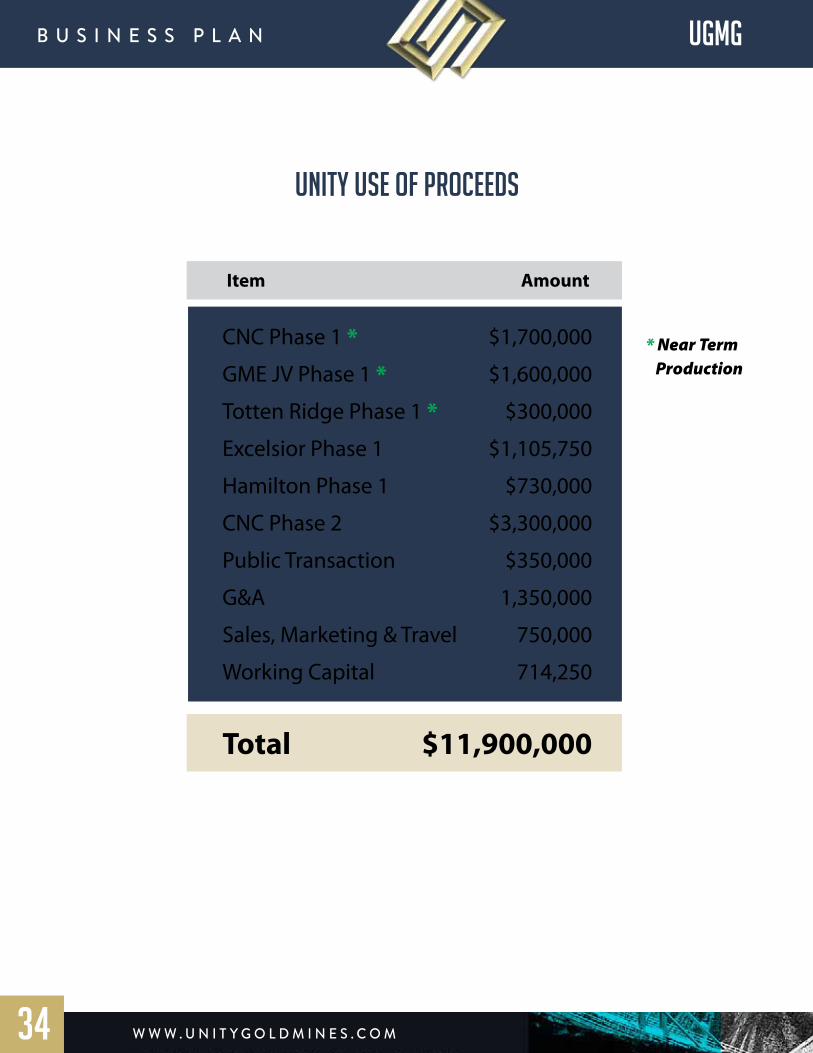
Item Amount
CNC Phase 1 * $1,700,000
GME JV Phase 1 * $1,600,000
Totten Ridge Phase 1 * $300,000
Excelsior Phase 1 $1,105,750
Hamilton Phase 1 $730,000
CNC Phase 2 $3,300,000
Public Transaction $350,000
G&A 1,350,000
Sales, Marketing & Travel 750,000
Working Capital 714,250
Total $11,900,000
* Near Term Production
unity use of proceeds
MANAGEMENT TEAM
Salvador Ramos / President and Chief Executive OfficerMr. Ramos has extensive experience in the area of corporate finance, project development, permitting, site excavation, management of work crews and has a significant background in the real estate industry. He has planned and implemented large scale excavation of land development sites, organized logistics, hired subcontractors, managed work site efficacy to maximize savings of the final deliverable products within each project. Mr. Ramos also has an extensive background in real estate development, building his own luxury home business with Accent Homes, and participating in International joint ventures with Fercon Florida. Mr. Ramos was an Executive Vice President of Transeastern Homes when they originally entered the marketplace in Coral Springs. During his tenure he spearheaded their sales effort by collaborating on the designs of their North Port & Brookside Models named “The Rosecliff” and “The Lauren” respectively. He was also charged with creating sales materials, and marketing materials, sales promotions to brokers within the Coral Ridge Properties organization that led to increased market share and sales. As Regional Sales Consultant for Alta Moda Eyewear in the South Florida marketplace, he grew market share and penetrated untapped markets, for their new line of eyewear and accessories. Due to extraordinary success, and sales levels attained, he subsequently achieved extensive sales achievement awards and accolades. He is a founding shareholder of Unity Gold Mines Group and is dedicated to the successful development of the company’s expansion of its assets while working with our geological and engineering team members.
Theresa Voss / Chief Financial OfficerMiss Voss’s prestigious carrier began as an auditor with Ernst & Young, she has spent more than 30 years in accounting, audit and multiple consulting roles for public and private companies. Although she worked with clients as large as Mobil Oil, she developed a preference to assist early stage companies as a strategic consultant. She has worked with the SEC and IRS in matters involving accounting compliance which has given her a unique perspective of the regulatory framework, pitfalls companies need to avoid and benefits of maintaining the highest level of accounting standards.
Gregory Klok / Chief Operating OfficerMr. Klok has over 20 years of mining operations experience and was one of the Co-founders of Consolidated Mining Inc, a company formed to research and mine precious minerals and develop business opportunities globally. Since the 1990’s he has been involved in mining operations internationally including Mexico, Peru, Colombia, West Africa and North America. He has managed placer and hard rock mining operations, completed major infrastructure work and managed a work force of over 60 people during the production phase of several mining operations. Between 2003 and 2007 prior to co-founding Consolidated Mining he worked with Gekko
w w w . U n i t y G o l d m i n e s . c o m
B U s i n e s s P l A n UGMG
35

systems to design and set up a custom placer processing plant for Inca Minerals to evaluate their Kiabamba Gold River Project and was responsible for dealing with local customs and mining authorities to import equipment obtain mining permits for Inca Minerals in Peru. He was also head of exploration for Hamilton mining SARL where he was responsible for evaluating the Tinkisso River Dredging Permit.
Bill Ross / VP of ExplorationMr. Ross has over 30 years of African mining experience and is the founder of Hamilton Mining & Marketing LLC. He has worked in several West African countries since 1995. He has researched for diamonds, gold and other precious metals and minerals. He has consulted and evaluated the economic feasibility of multiple properties in West Africa. A major achievement of his was negotiating a 4 year joint venture with the DeBeers Corporation in South Africa to research kimberlitic diamonds whilst opening a diamond buying and polishing office in Antwerp, Belgium. Mr. Ross has a graduate degree form the Housing Development Institute of the American University in Washington DC (1972) and from Catonsville community college of Maryland (1975) with a degree in Business Management. Between 1972 and 1995 he was dedicated to the housing development and real estate business in the Mid Atlantic Region of the USA where he developed over 3,000 properties. Mr. Ross is a principal agent of ILDG-CMM which is the majority Class A Unit Member.
Jon Banks / V.P. Engineer DevelopmentMr Banks brings over thirty years of experience, which includes plant maintenance, plant engineering, industrial construction, field engineering, process engineering, and project management. Mr. Banks is a seasoned electrical engineer with broad design background in instrumentation, control systems, data networks, communications systems and power distribution. Management skills include supervision of 30 employees under his direct control and 130 indirectly. He has demonstrated a unique ability to discover efficient design solutions by developing expert resources outside areas of normal consideration. He is an excellent troubleshooter, continuous learner, team player and able to be productive under pressure. Mr. Banks has spent the past three years in Colombia working on engineering plans and coordination for mining operations.
Onsite mining experience includes Barrick and Newmont Gold Strike, Carlin Trend , Nevada. Florida Canyon Mine, Pegasus Gold Corp., Winnemucca, Nevada. – Battle Mountain Gold, Battle Mt., Nevada – Sleeper Mine, Amax Mining, Battle Mt., Nevada ¬- Mesquite Gold, Gold Fields Operating Co, Brawley, CA.
Jack King / Senior Geologist – QPMr. King has been involved in gold, copper, diamond, uranium, iron, and silver exploration throughout the United States, Canada, Guyana, Venezuela, Panama, Borneo, Indonesia, Colombia, Peru, and Argentina. He has planned and conducted grass root regional exploration through recovery and diamond core drilling for many years. Additionally he also has overseen successful production efforts of gold from alluvial deposits in Guyana and Colombia throughout his professional carrier using land based recovery systems and produced from narrow high grade gold-silver veins and faults. He has a MS in Geology and MS in Operations Management which gives him a great ability to successfully manage projects. His professional geologist registration is in the United States and is fluent in English and Spanish.
w w w . U n i t y G o l d m i n e s . c o m
B U s i n e s s P l A n UGMG
36
Enrique Estrada Ruiz / Senior Mining EngineerMr Ruiz is Senior mining and metallurgy engineer, with more than 30 years of experience in the operation of underground gold, copper and coal mines, auro-argentiferous mineral processing plants. Management and Administration of mining projects and graduate of School of Engineering of Antioquia EIA in Medellín, Colombia. He specializes in process control, production engineer, design and mining planning. He has extensive mining operations experience and has previously managed Mineros Nacionales, one of the largest mining projects in Colombia with more than one thousand (1000) employees in the ground. He will also be responsible for interacting with departmental and municipal authorities as he has developed strong ties to government officials within the ministry in Colombia.
Jim Bonfils / Senior Corporate Finance ConsultantJim has over 28 years of experience in emerging market credit ranging from sales/trading and credit origination to commodity finance and hedging. His first 10 years of his career were involved in the trading of LATAM sovereign hard currency and local rates with PNC Bank in Pittsburgh and then in NY with the hedge fund CS/MG, a joint venture between Credit Suisse and the German conglomerate Metallgesellschhaft. The CS-MG role enabled him to experience first-hand the factors involved in the trading and hedging of energy commodity markets and the credit of the companies involved in the natural resource space. From there he moved to London to manage the sovereign Mexico local rates book for HSBC.
He returned to NY in the mid 90’s to build the start-up EM effort for Standard Bank from South Africa. He was instrumental in opening 5 offices throughout Latin America while adding over 100 employees throughout the region. The focus at Standard was on trading but more importantly on debt capital origination for natural resource companies throughout the region. After 12 years there, he moved to Renaissance Capital to again build a new sales and trading business with a focus on emerging European credit, Russia and the frontier markets of Sub Saharan Africa. The common theme across these geographies was that all the countries we covered shared a focus on natural resource production as a strategy to service their USD debt at the sovereign and corporate level.
His next role begins in August as he will move to the commodity trading firm, INTL FC Stone where he will focus on structured commodity finance as well as secondary credit trading of emerging market corporates and sovereigns.
He has a BA in economics from Colorado College and a Masters in International Finance from the American Graduate School of International Management at Arizona State University. He also holds the following FINRA licenses: Series 4, 7, 24 and 63.
w w w . U n i t y G o l d m i n e s . c o m
B U s i n e s s P l A n
37
UGMG

Juan David Perez Schile / Mining EngineerMr Schiel is a top level professional in mining and metallurgy engineering with experience in Aluvial and lode gold mining throughout South America. He holds a post graduate degree from University of Nottingham MSc in Mining Engineering. He has extensive experience in project management, consulting and business management in all facets of the mining industry within Colombia. He is a professor of the Faculty of Mines of the National University of Colombia and has been teaching Mining and Metallurgy at the undergraduate and graduate level for many years. He has extensive relationships within the Colombian mining sector and is highly respected on a governmental level. He has operated as a consultant for top level companies like Carbones del Cerrejón, Drummon Ltd Colombia, Empresas Públicas de Medellín. Additionally he has completed advisory work for mine valuations for Carbones Colombianos del Cerrejón, Frontino Gold Mines and Minera las Brisas de Colombia. His experience and local relationships are a key contribution to the operations within the country.
Theodore Spoltore / Senior VP of Investor RelationsMr. Spoltore graduated from Atlantic University in the early nineteen eighties and from there quickly established himself as a leader in the auto industry for eight years. From there he moved into the franchising trade where his first endeavor – Great Expectations – quickly grew to a number one position where it remained under his supervision and direction for over five years including a number of other significant franchise operations. From there Mr. Spoltore was introduced to medical companies with emerging technology that required a direction and funding to grow and establish themselves as leaders in their field. Mr. Spoltore pioneered the use of Medical Advisory Boards to build a cohesive infrastructure to fuel advancement through Research and Development and Corporate Development. Once his acumen was discovered and proven highly successful, Mr. Spoltore was brought on as the Senior Vice-President of Corporate Development and Investor Relations for multiple medically based operations including Cancer Centers of America, Non-Invasive Medical Technologies and Bongiovi Acoustics for which he drove significant investment income to back public solvency and commercial growth over the past twenty years. Mr. Spoltore brings his experience, wisdom, and financial insight to oversee the fiscal stability and growth of Unity Gold Inc.
w w w . U n i t y G o l d m i n e s . c o m
B U s i n e s s P l A n UGMG
38
DISCLAIMERThe information contained in this Business Plan or subsequently provided to the Recipient of this Business Plan, whether orally or in writing by or on behalf of Unity Gold Mines Group, Inc. or its officers, employees, agents or consultants (hereinafter referred to as the “Information”) is provided to the Recipients for informational purposes only and is not a solicitation to buy or sell any securities of Unity Gold Mines Group, Inc. The Information is provided on the terms and conditions set out in this notice. The Recipient should not treat the contents of this Business Plan as advice relating to legal, taxation or investment matters and should consult its own professional advisors. This Business Plan includes certain statements, estimates and projections that rely upon various assumptions. Those assumptions may or may not prove to be correct. This Business Plan does not purport to contain all the information that a prospective investor may require. The Business Plan may not be appropriate for all persons and it is not possible for Unity Gold Mines Group, Inc. to have regard to the investment objectives, financial situation, and particular needs of each Recipient who reads or uses this Business Plan. In all cases, before acting in reliance on any Information, the Recipient should conduct their own investigation and analysis in relation to the business opportunity and should check the accuracy, reliability, and completeness of the Information and obtain independent and specific advice from appropriate professional advisors not connected to or compensated on this transaction.
An investment in Unity Gold Mines Group, Inc. should be considered high-risk. Investors may lose 100% of their capital invested and should only use capital they are fully prepared to lose in its entirety. Any investor, in investing, affirms that such investment is appropriate for their situation, that outside professional advisors have confirmed this fact to the investor and that the investor is seeking high-risk investments such as this investment. The investor assumes responsibility for and is capable of carrying out his/her own due-diligence and will not invest until such due-diligence is substantial, adequate and complete. The Recipient of this document represents he/she is an accredited or qualified investor and agrees to not share this document with parties other than his/her own professional advisors.
The Information is subject to clarification and change and Unity Gold Mines Group, Inc. may in its absolute discretion, but without being under any obligation to do so, update, amend or supplement the Information. This Business Plan is not, and should not be construed to be, any form of a Prospectus or other disclosure document. To the maximum extent permitted by law, no representation, warranty or undertaking, express or implied, is made and, to the maximum extent permitted by law, no responsibility or liability is accepted by Unity Gold Mines Group, Inc. or any of its officers, employees, agents or consultants or any other person as to the adequacy, accuracy, completeness or reasonableness of this Business Plan. To the maximum extent permitted by law, no responsibility for any errors or omissions from this Business Plan whether arising out of negligence or otherwise is accepted. Any statements described herein cannot be guaranteed. The successful development of Unity Gold Mines Group, Inc. business plan is contingent upon multiple high risk factors that must be successfully dealt with in order to achieve the intended results. Any statements made herein should be considered “forward-looking statements” within the meaning of Section 27A of the Securities Act of 1933, as amended, and Section 21E the Securities Exchange Act of 1934, as amended and such forward-looking statements are made pursuant to the safe harbor provisions of the Private Securities Litigation Reform Act of 1995.
Unity Gold Mines Group, Inc., its officers, employees, agents, or consultants makes no representation or warranty to Recipient with respect to any financial projection or forecast relating to Unity Gold Mines Group, Inc. With respect to any such projection or forecast delivered or made available by or on behalf of Unity Gold Mines, Inc., its officers, employees, agents, or consultants to Recipient, Recipient acknowledges that (a) there are uncertainties inherent in attempting to make such projections and forecasts, (b) it is familiar with such uncertainties, (c) I is taking full responsibility for making its own evaluation of the adequacy and accuracy of all such projections and forecasts so furnished to it and (d) it shall have no claim against Unity Gold Mines Group, Inc., its officers, employees, agents, or consultants.
w w w . U n i t y G o l d m i n e s . c o m
B U s i n e s s P l A n
39
UGMG

w w w . U n i t y G o l d m i n e s . c o m
B U s i n e s s P l A n
U n i t y G o l d m i n e s G r o U P i n c
1 5 0 s e 2 n d A v e , s U i t e 3 0 0 , m i A m i F l 3 3 1 3 1
P h o n e : 3 0 5 - 7 2 8 - 3 2 7 2
F A x : 3 0 5 - 3 7 1 - 4 5 1 6
UGMG
40
EXCELSIOR PROJECT
WASHINGTON STATE, USA
CNCenterprises
Colombia, South America
HAMILTON mining
GUINEA, WEST AFRICA
Triple 7 commodities
West virginia, USA