Bulletin of World Volcanism num -...
17
BULLETIN OF WORLD VOLCANISM Bulletin of World Volcanism Issue: August 2013 NEW ACTIVITY/UNREST Alban Hills? (Italy).….….….….……. Ebulobo (Indonesia).…….….………. Illiwerung (Indonesia).….…………... Ketoi (Russia).….….…………….….. Kliuchevskoi (Russia).….….….……. Kverkfjoll (Iceland).…..….…………. CONTINUING ACTIVITY White Island (New Zealand).….……. Ambrym (Vanuatu).…….….….…….. Gaua (Vanuatu).….….….….….…….. Manam (Papua New Guinea)……….. Ulawun (Papua New Guinea)…….…. Rabaul (Papua New Guinea)……..…. Paluweh (Indonesia).….…………….. Batu Tara (Indonesia).….….….…….. Sakura-Jima (Japan).….….….……… Pagan (USA).……….……….……… Chirpoi (Russia).…….……………… Chrinkotan (Russia)………….……… Continued on the inside VOLCANO EXPRESS …...................................................... 3 3 3 3 4 4 4 4 4 5 5 5 5 6 6 6 6 7 13
Transcript of Bulletin of World Volcanism num -...

BULLETIN OF WORLD VOLCANISM
Bulletin of World Volcanism Issue: August 2013
NEW ACTIVITY/UNRESTAlban Hills? (Italy).….….….….…….
Ebulobo (Indonesia).…….….……….
Illiwerung (Indonesia).….…………...
Ketoi (Russia).….….…………….…..
Kliuchevskoi (Russia).….….….…….
Kverkfjoll (Iceland).…..….………….
CONTINUING ACTIVITYWhite Island (New Zealand).….…….
Ambrym (Vanuatu).…….….….……..
Gaua (Vanuatu).….….….….….……..
Manam (Papua New Guinea)………..
Ulawun (Papua New Guinea)…….….
Rabaul (Papua New Guinea)……..….
Paluweh (Indonesia).….……………..
Batu Tara (Indonesia).….….….……..
Sakura-Jima (Japan).….….….………
Pagan (USA).……….……….………
Chirpoi (Russia).…….………………
Chrinkotan (Russia)………….………
Continued on the inside
VOLCANO EXPRESS…......................................................
3
3
3
3
4
4
4
4
4
5
5
5
5
6
6
6
6
7
13

BULLETIN OF WORLD VOLCANISM
Karymsky (Russia)…………………
Kizimen (Russia).….….….…..….…
Tolbachik (Russia).….….…….…….
Shiveluch (Russia).…….…….……..
Veniaminof (USA).….…….….…….
Kilauea (USA).……..….….….…….
Popocatepetl (Mexico).……….…….
Santa Maria (Guatemala).……….….
Fuego (Guatemala).…….…….…….
Pacaya (Guatemala).…….….………
Reventador (Ecuador).…..…….……
Tungurahua (Ecuador).….…….……
Copahue (Chile/Argentina border)…
Villarrica (Chile).…….……………..
BULLETIN INFORMATION
Writer (s); Lucas Wilson [Editor]
Promotion; Tom Pfeiffer
Partners with: VolcanoDiscovery
Contact: [email protected]
For more information visit:
www.volcanismbulletin.org
FALSE REPORTS OF
VOLCANIC ACTIVITY
-
7
7
7
8
8
9
9
10
10
11
11
11
11
11
2
Joint project with:
http://www.volcanodiscovery.com/adventure-travel.html: Volcano Tours
http://www.volcano-news.com/: Volcano News
BULLETIN OF WORLD VOLCANISM
WORLDWIDE MONTHLY VOLCANIC ACTIVITY VOLCANOES ORGANISED BY THE CAVW/GVP VOLCANO NUMBER CODE
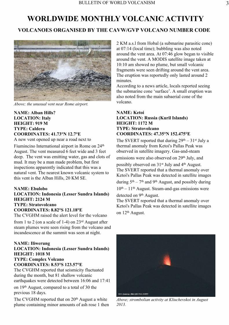
NAME: Alban Hills?LOCATION: ItalyHEIGHT: 919 MTYPE: CalderaCOORDINATES: 41.73°N 12.7°EA new vent opened up near a road next toFiumincino International airport in Rome on 24th
August. The vent measured 6 feet wide and 3 feetdeep. The vent was emitting water, gas and clots ofmud. It may be a man made problem, but firstinspections apparently indicated that this was anatural vent. The nearest known volcanic system tothis vent is the Alban Hills, 20 KM SE.
NAME: EbuloboLOCATION: Indonesia (Lesser Sundra Islands)HEIGHT: 2124 MTYPE: StratovolcanoCOORDINATES: 8.82°S 121.18°EThe CVGHM raised the alert level for the volcanofrom 1 to 2 (on a scale of 1-4) on 23rd August aftersteam plumes were seen rising from the volcano andincandescence at the summit was seen at night.
NAME: IliwerungLOCATION: Indonesia (Lesser Sundra Islands)HEIGHT: 1018 MTYPE: Complex VolcanoCOORDINATES: 8.53°S 123.57°EThe CVGHM reported that seismicity fluctuatedduring the month, but 81 shallow volcanicearthquakes were detected between 16:06 and 17:41on 19th August, compared to a total of 30 theprevious 18 days.The CVGHM reported that on 20th August a whiteplume containing minor amounts of ash rose 1 then
2 KM a.s.l from Hobal (a submarine parasitic cone)at 07:14 (local time); bubbling was also notedaround the vent area. At 07:46 glow began to visiblearound the vent. A MODIS satellite image taken at10:10 am showed no plume, but small volcanicfragments were seen drifting around the vent area.The eruption was reportedly only lasted around 2minutes.According to a news article, locals reported seeingthe submarine cone ‘surface’. A small eruption wasalso noted from the main subaerial cone of thevolcano.
NAME: KetoiLOCATION: Russia (Kuril Islands)HEIGHT: 1172 MTYPE: StratovolcanoCOORDINATES: 47.35°N 152.475°EThe SVERT reported that during 29th – 31st July athermal anomaly from Ketoi's Pallas Peak wasobserved in satellite imagery. Gas-and-steamemissions were also observed on 29th July, andpossibly observed on 31st July and 4th August.The SVERT reported that a thermal anomaly overKetoi's Pallas Peak was detected in satellite imagesduring 5th – 7th and 9th August, and possibly during10th – 11th August. Steam-and-gas emissions weredetected on 9th August.The SVERT reported that a thermal anomaly overKetoi's Pallas Peak was detected in satellite imageson 12th August.
Above; the unusual vent near Rome airport.
Above; strombolian activity at Kliuchevskoi in August2013.
3

BULLETIN OF WORLD VOLCANISM
NAME: KliuchevskoiLOCATION: Russia (Kamchatka)HEIGHT: 4835 MTYPE: StratovolcanoCOORDINATES: 56.057°N 160.638°E
A new eruption on 15th August at 06:30 UTC wasacompained by strong tremor. Strombolianactivity in the summit crater was noted. A gas-and-steam plume containing minor amounts ofash rose to a height of 5.5 KM and drifted NE on16th August. Strong incandescence was observedat night. Satellite images from 15th – 17th Augustshowed a strong thermal anomaly at the volcano.Gas-and-steam plumes containing minor amountsof ash rose to an altitude of 5.5 KM a.s.l. during16th – 17th August. Incandescence from the craterat night and a thermal anomaly in satellite imagescontinued to be reported during 17th – 19thAugust.
NAME: KverkfjollLOCATION: IcelandHEIGHT: 1929 MTYPE: StratovolcanoCOORDINATES: 64.65°N 16.72°W
The IMO reported that a small phreatic eruption atthe volcano occurred around 16th August. Theexplosions emitted dark ash. The eruptionproduced a small glacial flood which was releasedinto the Volga river.
CONTINUING ACTIVITY
NAME: White IslandLOCATION: New ZealandHEIGHT: 321 MTYPE: StratovolcanoesCOORDINATES: 37.52°S 177.18°E
GNS Science reported than on 20th August at 10:23(local time) a small eruption occurred at the volcanothat continued for 10 minutes. The eruption produced asteam plume with minor ash content that rose 4 KMa.s.l. The eruption ejected mud and rock. The AlertLevel was raised from 1 to 2 (on a scale of 0-5), theAviation Colour Code was raised to RED then loweredto ORANGE.
NAME: AmbrymLOCATION: VanuatuHEIGHT: 1334 MTYPE: Pyroclastic ShieldCOORDINATES: 16.25°S 168.12°E
According to NASA's Earth Observatory, a satelliteimage acquired on 9th August showed steam-and-gasplumes rising from Ambrym’s Benbow cone and fromthe active lava lake in Mbwelesu Crater (one of threeactive sub-craters of the Marum cone).
NAME: GauaLOCATION: VanuatuHEIGHT: 797 MTYPE: StratovolcanoCOORDINATES: 14.27°S 167.50°E
On 14th August the Vanuatu Geohazards Observatoryreported that activity at Gaua had increased since June;volcanic tremor levels increased slightly and ash plumeemissions continued.
Above; aftermath of the Kverkfjoll eruption whichhappened around 16 August. With the glacier coveredby black ash and lahar deposits.
Above; webcam capture of the eruption at White island at10:30 on 20 August.
4

BULLETIN OF WORLD VOLCANISM
NAME: ManamLOCATION: Papua New GuineaHEIGHT: 1807 MTYPE: StratovolcanoCOORDINATES: 4.080°S 145.037°E
The RVO reported that activity at Manam's Southernand Main craters remained low during 22nd -31st
July; observers noted white vapour plumes risingfrom the craters during periods of clear weather.Considerable amounts of blue vapour rose fromSouthern Crater during 25th – 26th July. Deep andlow booming noises were heard on the island onmost days since 24th July, however, on 30th July aloud explosion was heard in Bogia, 25 – 30 KMSSW of Manam on the N coast of the mainland.Seismicity fluctuated but remained high.The Darwin VAAC reported that on 19th August anash plume from Manam rose to an altitude of 4.6KM a.s.l. and drifted 65 KM NW.
NAME: UlawunLOCATION: Papua New Guinea (New Britain)HEIGHT: 2334 MTYPE: StratovolcanoCOORDINATES: 5.05°S 151.33°EThe RVO reported that activity at Ulawun was lowduring 22nd July – 4th August; emissions from thesummit crater consisted of white vapour. Seismicitywas also low. RSAM values decreased from 80 on21st July to 50 on 31st July, and then began toincrease on early 2nd August. By 4th August RSAMvalues reached 600, attributed to an increase involcanic tremor.
NAME: RabaulLOCATION: Papua New Guinea (New Britain)HEIGHT: 688 MTYPE: Pyroclastic ShieldCOORDINATES: 4.271°S 152.203°EThe RVO reported that during 22nd – 31st July low-level activity consisted of discrete emissions of palegrey ash plumes occurring at short intervals. Someemissions were explosive and generated plumes thatrose 2 KM above the crater. Plumes drifted E, NE,N, NW, W, and SW, and deposited minor amountsof fine white and grey ash in areas downwindmainly between Namanula and Malaguna No. 1(with Rabaul Town, 3 – 5 KM NW, in between), andto a lesser extent between the Vulcan area andMalaguna No. 2. Roaring and rumbling noises alsocontinued, often in conjunction with explosions.
NAME: PaluwehLOCATION: Indonesia (Lesser Sundra Islands)HEIGHT: 875 MTYPE: StratovolcanoCOORDINATES: 8.32°S 121.708°E
According to news articles, a partial lava-domecollapse at Paluweh on 10th August generated apyroclastic flow that travelled N towards a beachvillage and killed at least 5 people. A volcanologistat the monitoring post for Paluweh noted that theeruption lasted seven minutes, and that thepyroclastic flow burned trees around the beach andvillages, making it difficult to reach the victims.Pyroclastic flows continued to be reported hoursafter the initial eruption. Based on analyses ofsatellite imagery and wind data, the Darwin VAACreported that an ash plume rose to an altitude of 4.3KM a.s.l. and drifted 130 KM W.News sources noted that a mandatory evacuationorder had caused some residents to evacuate prior tothe eruption on 10th August, but nearly10,000 stillremained on the island. After the eruption, a rescueteam was sent to evacuate about 2,000 people thatremained inside a 3-KM exclusion zone. A teammember noted that rescuing people was difficultsince they were reluctant to leave their livestock andhomes, but also that the ground was hot and coveredin 10-20 cm of ash. The VAAC reported that during11th – 12th August ash plumes rose to an altitude of1.8 KM a.s.l. and drifted 110 – 130 KM W. A newsarticle noted that the eruptions were smaller on 12th
August, but pyroclastic flows continued to beobserved.
Above; large ash plume due to partial collapse of thegrowing lava dome on Paluweh on 10 August.
5

BULLETIN OF WORLD VOLCANISM
NAME: Batu TaraLOCATION: Indonesia (Lesser SundraIslands)HEIGHT: 748 MTYPE: StratovolcanoCOORDINATES: 7.792°S 123.579°E
The Darwin Volcanic Ash Advisory Centre(VAAC) reported that on 16th August an ashplume from Batu Tara rose to an altitude of 1.5KM a.s.l. and drifted 130 KM W.
NAME: Sakura-JimaLOCATION: Japan (Kyushu)HEIGHT: 1117 MTYPE: StratovolcanoCOORDINATES: 31.585°N 130.657°E
The JMA reported that 10 explosions at Sakura-jima's Showa Crater were detected during 29th
July – 2nd August and ejected tephra as far as 1.3KM. Incandescence from the crater was observedon 1st August. Based on information from JMA,the Tokyo VAAC reported that during 31st July –6th August explosions generated plumes that roseto altitudes of 1.5 – 3 KM a.s.l. and drifted E, SE,and S. On 31st July and 4th August pilots observedash plumes that rose to altitudes of 2.4 – 3 KMa.s.l. and drifted E.The Tokyo VAAC reported that during 7th – 11th
and 13th August explosions from Sakura-jimagenerated plumes that rose to altitudes of 1.8 – 4.6KM a.s.l. and drifted SE, S, and NW. On 8th, 10th
and 13th August pilots observed ash plumes thatrose to altitudes of 2.7 – 3 KM a.s.l., and travelledSE, S, and vertically, respectively. The JMAreported that seven explosions at Showa Crater
were detected during 9th – 12th August and ejectedtephra as far as 800 M. A 50-minute-long eruption on9th August generated an ash plume that rose 3.5 KMabove the crater.The JMA reported that 24 explosions at Sakura-jima'sShowa Crater were detected during 12th – 19th Augustand ejected tephra as far as 1.8 KM. Incandescencefrom the crater was observed on 14th August. A verysmall eruption from Minami-dake Crater occurred on16th August, producing an ash plume that rose 200 M.An explosion from Showa Crater on 18th Augustgenerated a large ash plume that rose 5 KM above thecrater and drifted NW. A small pyroclastic flowtravelled SE. According to news sources, the 50-minute-long eruption produced ashfall in the centraland northern parts of Kagoshima (10 KM W), causingtrain delays and poor visibility for car drivers. Theevent was the 500th explosion this year.
NAME: PaganLOCATION: USA (Mariana Islands)HEIGHT: 570 MTYPE: StratovolcanoesCOORDINATES: 18.13°N 145.80°EThe seismic network at Pagan recorded tremor andsmall discrete earthquakes during 9th – 16th August,indicating low-level unrest. A steam-and-gas plumewas visible in satellite images during periods of clearweather and from web-camera images. A smallexplosion with a relatively high amplitude seismiccomponent and small infrasound component occurredat 00:10 on 12th August. The data suggested thatdegassing increased about 30 sec after the event.
NAME: ChirpoiLOCATION: Russia (Kuril Islands)HEIGHT: 742 MTYPE: CalderaCOORDINATES: 46.525°N 150.875°EThe SVERT reported that a thermal anomaly overSnow, a volcano of Chirpoi, was detected in satelliteimages during 5th – 7th and 9th August, and possiblyduring 10th -11th August. Steam-and-gas emissionswere detected on 9th August.The SVERT reported that a thermal anomaly fromSnow, a volcano of Chirpoi, was detected in satelliteimages on 12th August, along with gas-and-steamemissions. Cloud cover prevented observations during13th – 18thAugust.Above; Pagan island is made up of two volcanic
centres joined by a narrow isthmus. South Pagan isseen in the foreground with North Pagan (top centre)in the distance.
6
BULLETIN OF WORLD VOLCANISM
NAME: ChirinkotanLOCATION: Russia (Kuril Islands)HEIGHT: 724 MTYPE: StratovolcanoCOORDINATES: 48.98°N 153.48°E
The SVERT reported that a thermal anomaly fromChirinkotan was observed during 29th – 31st July.The SVERT reported that a thermal anomaly andgas-and-steam emissions from Chirinkotan wereobserved on 5th and 9th August. A thermal anomalywas visible on 7th August, and possible gas-and-steam emissions were observed on 7th and 8th
August.The SVERT reported that a possible thermalanomaly from Chirinkotan was observed on 12th
August.
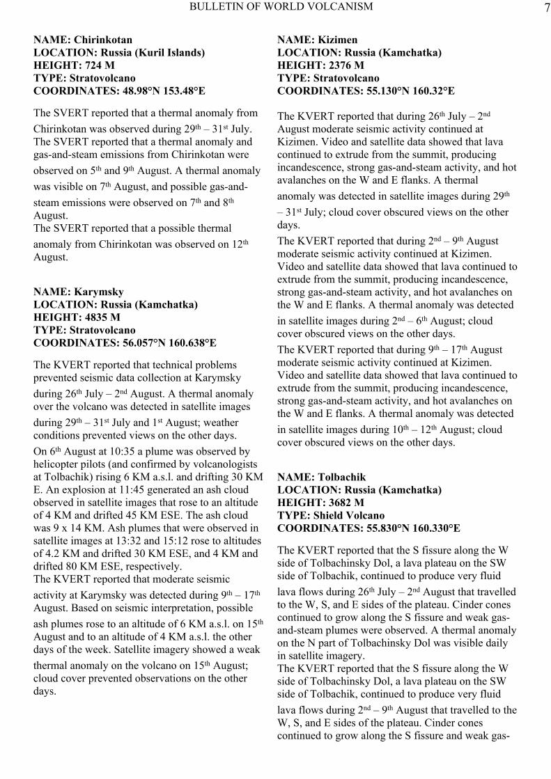
NAME: KarymskyLOCATION: Russia (Kamchatka)HEIGHT: 4835 MTYPE: StratovolcanoCOORDINATES: 56.057°N 160.638°E
The KVERT reported that technical problemsprevented seismic data collection at Karymskyduring 26th July – 2nd August. A thermal anomalyover the volcano was detected in satellite imagesduring 29th – 31st July and 1st August; weatherconditions prevented views on the other days.On 6th August at 10:35 a plume was observed byhelicopter pilots (and confirmed by volcanologistsat Tolbachik) rising 6 KM a.s.l. and drifting 30 KME. An explosion at 11:45 generated an ash cloudobserved in satellite images that rose to an altitudeof 4 KM and drifted 45 KM ESE. The ash cloudwas 9 x 14 KM. Ash plumes that were observed insatellite images at 13:32 and 15:12 rose to altitudesof 4.2 KM and drifted 30 KM ESE, and 4 KM anddrifted 80 KM ESE, respectively.The KVERT reported that moderate seismicactivity at Karymsky was detected during 9th – 17th
August. Based on seismic interpretation, possibleash plumes rose to an altitude of 6 KM a.s.l. on 15th
August and to an altitude of 4 KM a.s.l. the otherdays of the week. Satellite imagery showed a weakthermal anomaly on the volcano on 15th August;cloud cover prevented observations on the otherdays.
NAME: KizimenLOCATION: Russia (Kamchatka)HEIGHT: 2376 MTYPE: StratovolcanoCOORDINATES: 55.130°N 160.32°E
The KVERT reported that during 26th July – 2nd
August moderate seismic activity continued atKizimen. Video and satellite data showed that lavacontinued to extrude from the summit, producingincandescence, strong gas-and-steam activity, and hotavalanches on the W and E flanks. A thermalanomaly was detected in satellite images during 29th
– 31st July; cloud cover obscured views on the otherdays.The KVERT reported that during 2nd – 9th Augustmoderate seismic activity continued at Kizimen.Video and satellite data showed that lava continued toextrude from the summit, producing incandescence,strong gas-and-steam activity, and hot avalanches onthe W and E flanks. A thermal anomaly was detectedin satellite images during 2nd – 6th August; cloudcover obscured views on the other days.The KVERT reported that during 9th – 17th Augustmoderate seismic activity continued at Kizimen.Video and satellite data showed that lava continued toextrude from the summit, producing incandescence,strong gas-and-steam activity, and hot avalanches onthe W and E flanks. A thermal anomaly was detectedin satellite images during 10th – 12th August; cloudcover obscured views on the other days.
NAME: TolbachikLOCATION: Russia (Kamchatka)HEIGHT: 3682 MTYPE: Shield VolcanoCOORDINATES: 55.830°N 160.330°E
The KVERT reported that the S fissure along the Wside of Tolbachinsky Dol, a lava plateau on the SWside of Tolbachik, continued to produce very fluidlava flows during 26th July – 2nd August that travelledto the W, S, and E sides of the plateau. Cinder conescontinued to grow along the S fissure and weak gas-and-steam plumes were observed. A thermal anomalyon the N part of Tolbachinsky Dol was visible dailyin satellite imagery.The KVERT reported that the S fissure along the Wside of Tolbachinsky Dol, a lava plateau on the SWside of Tolbachik, continued to produce very fluidlava flows during 2nd – 9th August that travelled to theW, S, and E sides of the plateau. Cinder conescontinued to grow along the S fissure and weak gas-
7

BULLETIN OF WORLD VOLCANISM
and-steam plumes were observed. A thermalanomaly on the N part of Tolbachinsky Dol wasvisible daily in satellite imagery.The KVERT reported that the S fissure along the Wside of Tolbachinsky Dol, a lava plateau on the SWside of Tolbachik, continued to produce very fluidlava flows during 9th – 17th August that travelled tothe W, S, and E sides of the plateau. Cinder conescontinued to grow along the S fissure and weakgas-and-steam plumes were observed. A thermalanomaly on the N part of Tolbachinsky Dol wasvisible daily in satellite imagery.
NAME: ShiveluchLOCATION: Russia (Kamchatka)HEIGHT: 3283 MTYPE: StratovolcanoCOORDINATES: 56.653°N 161.360°E
The KVERT reported that during 26th July – 2nd
August, a viscous lava flow effused on the NWflank of Shiveluch's lava dome, accompanied byhot avalanches, incandescence, and fumarolicactivity. Satellite images detected a daily thermalanomaly.A strong explosion at 22:55 on 26th July generatedash plumes that rose as high as 10 KM a.s.l. anddrifted 520 KM SE. Pyroclastic flows travelled 5KM. An ash cloud 15 x 7 KM was observed insatellite images about 60 KM SE of the volcano on29th July. At 17:07 on 4th August video imagesshowed an ash plume rising to altitudes of 4.5 – 5KM a.s.l. and drifting 50 KM E. The next day theseismic network detected an explosion at 16:04;video images showed an ash plume rising toaltitudes of 6.5 – 7 KM a.s.l. and drifting 50 KMESE.The KVERT reported that during 2nd – 9th August aviscous lava flow effused on the NW flank ofShiveluch's lava dome, accompanied by hotavalanches, incandescence, and fumarolic activity.Satellite images detected a thermal anomaly during3rd – 6th, 8th, and 10th – 11th August. Explosionsduring 4th – 5th August generated ash plumes thatrose to altitudes of 5 – 7 KM a.s.l. and drifted SSE.A video camera recorded ash plumes that rose toaltitudes of 7 – 7.5 KM a.s.l. during 10th – 11th
August.The KVERT reported that during 9th – 17th Augusta viscous lava flow effused onto the NW flank ofShiveluch's lava dome, accompanied by hotavalanches, incandescence, and fumarolic activity.
Satellite images detected a thermal anomaly during9th – 12th, 14th, and 16th – 17th August; cloud coverprevented observations on the other days. Explosionsgenerated ash plumes that rose to altitudes of 5 – 7KM a.s.l. and drifted E and NE.
NAME: VeniaminofLOCATION: USA (Alaska)HEIGHT: 2507 MTYPE: StratovolcanoCOORDINATES: 56.17°N 159.38°W
The AVO reported that the ongoing low-leveleruption of Veniaminof, characterized by lavaeffusion and emissions of minor amounts of ash andsteam, continued during 31st July – 2nd August.Although seismic activity decreased during 31st July– 2nd August, it still remained above backgroundlevels, and small discrete events continued to bedetected. Cloud cover prevented satellite image andweb-camera views.The AVO reported that during 7th – 11th Augustseismicity at Veniaminof remained above backgroundlevels. Cloud cover obscured views of the cinder coneinside the caldera during 7th – 8th August. Slightlyelevated surface temperatures, consistent with coolinglava flows, were detected in partly cloudy satelliteimages during 9th – 10th August. On 11th Augustcloud cover prevented satellite image views, andweb-camera views showed nothing significant.During 11th – 12th August seismic tremor increasedand persistent elevated surface temperatures,consistent with lava effusion, were visible in satelliteimagery. The web camera in Perryville (32 KM SSE)recorded intermittent steam-and-ash plumes; one on12th August rose 3.7 KM a.s.l. and drifted W.Seismic tremor has remained high on 13th August.
Above; erupting cinder cone and lava flow in the centre ofVeniaminof caldera.
8

BULLETIN OF WORLD VOLCANISM
The AVO reported that during 13th – 15th Augustseismic tremor at Veniaminof was high, andpersistent elevated surface temperatures consistentwith lava effusion were visible on satelliteimagery. During 16th – 17th August the high levelsof tremor became sustained; seismicity remainedhigh through 20th August. Very high surfacetemperatures were detected in images during 16th –17th August; only weak thermal signals wereevident through the cloud cover in satellite dataduring 17th – 18th August. Clear views on 18th
August from the FAA web-camera in Perryville(32 KM SSE) showed minor ash emissions.During a helicopter overflight on 19th Augustgeologists observed two active lava flows from thecone, and lava flowing passively over ice at thefoot of the cone. Elevated surface temperatureswere detected in satellite data during 19th – 20th
August. Clear web-camera views showed minorash emissions rising to an altitude of 3.7 KM a.s.l.and drifting W and then SSE, just past the calderarim.
NAME: KilaueaLOCATION: USA (Hawaii)HEIGHT: 1222 MTYPE: Shield VolcanoCOORDINATES: 19.421°N 155.287°W
During 31st July – 6th August, the HVO reportedthat the circulating lava lake occasionally rose andfell in the deep pit within Kilauea's Halema'uma'uCrater. The plume from the vent continued todeposit variable amounts of ash, spatter, and Pele'shair onto nearby areas. The lake level was 51 Mbelow the Halema'uma'u Crater floor on 5th
August.At Pu'u 'O'o Crater, glow emanated from threespatter cones and a small lava pond on the E partof the crater floor. The Kahauale’a 2 lava flowbranches, fed by the NE spatter cone, were activeas far NE as 3.2 KM and as far NW as 2 KM, andburned forest occasionally in two locations at theN edge of the 1983-1986 'a'a flows from Pu'u 'O'o.Peace Day activity, fed by lava tubes extendingfrom Pu'u 'O'o, consisted of some breakout activityon the pali and coastal plain, and an ocean entryoutside of the National Park boundary to the E.During 7th – 13th August, the HVO reported thatthe circulating lava lake occasionally rose and fellin the deep pit within Kilauea's Halema'uma'uCrater. The plume from the vent continued to
deposit variable amounts of ash, spatter, and Pele'shair onto nearby areas. The lake level rose during theweek; the level was 49 M below the Halema'uma'ucrater floor on 7th August and 37 – 39 M below thefloor during 10th – 12th August. The level rose to 48 Mbelow the floor during 12th – 13th August.At Pu'u 'O'o Crater, glow emanated from spatter coneson the N and S portions of the crater floor. TheKahauale’a 2 lava flow, fed by the NE spatter cone,was active with scattered break-out flows and burnedforest N of Pu'u 'O'o. Peace Day activity, fed by lavatubes extending from Pu'u 'O'o, consisted of somebreakout activity on the pali and coastal plain, and anocean entry outside of the National Park boundary tothe E.During 14th – 20th August, the HVO reported that thecirculating lava lake occasionally rose and fell in thedeep pit within Kilauea's Halema'uma'u Crater; thelake level was as high as 36 M below theHalema'uma'u crater floor on 16th and 18th August.The plume from the vent continued to deposit variableamounts of ash, spatter, and Pele's hair onto nearbyareas.At Pu'u 'O'o Crater, glow emanated from spatter coneson the N and S portions of the crater floor. TheKahauale’a 2 lava flow, fed by the NE spatter cone,was active with scattered break-out flows and burnedthe forest N of Pu'u 'O'o. On 18th August on 13:30 theE flank of the N spatter cone apparently burst, causinglava flows to sporadically rush from the cone andcover a large part of the crater floor by the nextmorning. Peace Day activity, fed by lava tubesextending from Pu'u 'O'o, consisted of some breakoutson the pali and coastal plain, and an ocean entryoutside of the National Park boundary to the E.
NAME: PopocatepetlLOCATION: MexicoHEIGHT: 5426 MTYPE: StratovolcanoesCOORDINATES: 19.023°N 98.622°W
The CENAPRED reported that during 31st July – 6th
August seismicity at Popocatépetl indicatedcontinuing gas-and-steam emissions that sometimescontained ash; cloud cover often prevented visualconfirmation. Incandescence from the crater wasoccasionally observed. On 31st July a clear decrease inthe size of the water vapour and gas plumes wasobserved; plumes were pushed by winds down theNW flank and rose only 100 M above the crater rim.An explosion was detected at 23:12 on 1st August, but
9

BULLETIN OF WORLD VOLCANISM
cloud cover prevented confirmation of any ejecta.On 2nd August minor amounts of ash fell in theTepetlixpa, Atlautla, Ecatzingo, and Ozumbamunicipalities of Mexico State. On 4th Augustemissions of gas, steam, and ash drifted NW. During5th – 6th August a few observed plumes rose 1 – 2KM and drifted WNW, W, and WSW.The CENAPRED reported that during 14th – 20th
August seismicity at Popocatépetl indicatedcontinuing emissions; cloud cover sometimesprevented observations of the crater. Incandescencefrom the crater was observed and occasionallyintensified with some emissions. On 14th August aperiod of tremor was accompanied by an ashemission that drifted W. Ashfall was reported in thetowns of Ozumba (18 KM W), Tepetlixpa (20 KMW), Atlautla (17 KM W), and Ecatzingo (15 KMSW) in the State of México. Later that day an ashplume rose 1 KM above the crater and drifted W.Gas-and-steam plumes were observed during 15th –16th August. A period of tremor on 17th August wasaccompanied by an ash plume that rose 1.5 KM anddrifted WSW. Ash fell in Tetela del Volcán (20 KMSW), Ocuituco (24 KM SW), Yecapixtla (31 KMSW), Tlayacapan (40 KM WSW), Cuautla (43 KMSW), Ayala (45 KM SW), and Cuernavaca (65 KMWSW). On 18th August high-frequency, low-amplitude tremor was accompanied by an ashemission that rose 1.2 KM and drifted SW. On 19th
August minor steam-and-gas emissions drifted W.During 19th – 20th August emissions likely containedsmall amounts of ash but cloud cover preventedconfirmation.
NAME: Santa MariaLOCATION: GuatemalaHEIGHT: 3772 MTYPE: StratovolcanoCOORDINATES: 14.756°N 91.552°W
The INSIVUMEH reported that an explosion fromSanta María's Santiaguito lava-dome complex at05:29 on 1st August generated an ash plume thatrose 150 M above the crater and drifted SW. Ashfallwas reported in the ranches of Monte Claro (S) andLa Florida (5 km S). A few avalanches from the lavadome travelled short distances. On 4th August aweak explosion at 06:13 produced a white plumethat rose 300 M and drifted SW. Minor amounts ofash fell in Monte Claro, El Rosario (45 km SW), andPalajunoj (S). Avalanches were generated by thelava flow on the S flank. Seven explosions were
detected during 5th – 6th August; the explosionsgenerated avalanches on the NE flank, anddegassing, jet-engine, and rumbling sounds. The lastexplosion was followed by a weak pyroclastic flowthat travelled S and a moderate one that travelledSW. White and grey plumes rose 500 – 800 M.Ashfall was reported in the Palajunoj area. Later thatday on 6 August OVSAN reported that explosionswere heard, and ash plumes that rose 500 – 800 Mdrifted W and SW.The INSIVUMEH reported that two explosions on7th August from Santa María's Santiaguito lava-domecomplex were followed by white plumes that rose500 M. Pyroclastic material descended the E, S, andSW flanks. Fumarolic plumes rose 100 M on 8th
August. On 10th August white plumes rose 250 M.An explosion at 06:24 generated an ash plume thatrose 900 M and drifted SW, causing ashfall in MonteClaro (S). Heavy rainfall on 11th August caused alahar in the San Isidro-Tambor River, a tributary ofSamala River, which was 30 M wide, 1.5 M thick,and carried branches, tree trunks, and blocks up to1.5 M in diameter. A few explosions on 13th Augustgenerated ash plumes that rose 1 KM and drifted 10KM WSW.
NAME: FuegoLOCATION: GuatemalaHEIGHT: 3763 MTYPE: StratovolcanoCOORDINATES: 14.473°N 90.880°W
The INSIVUMEH reported that explosions fromFuego during 13th – 14th August generated ashplumes that drifted 10 KM W and SW. Three lavaflows were active; one of the flows travelled SW.Five explosions during 14th – 15th August ejectedincandescent material 100 M high, and generated ashplumes that rose 300 M and drifted 6 KM. Lavaflows were 150 and 300 M long in the Taniluya (SW)and Ceniza (SSW) drainages, respectively. The nextday explosions produced ash plumes that rose 550 Mand drifted 10 KM W. On 17th August 30-M-widelahars carrying blocks travelled down the Las Lajas,Ceniza, and El Jute (SE) drainages. During 17th – 18th
August explosions that were heard generated ashplumes that rose 200 – 300 M and drifted 7 KM W.Lava flows in the Taniluya and Ceniza drainageswere each 400 M long.During 18th – 19th August the flow rate increased; thelava flows were 600 and 800 M long in the Taniluyaand Ceniza drainages, respectively. Incandescentblocks from the lava-flow fronts rolled down the
10

BULLETIN OF WORLD VOLCANISM
flanks and reached vegetated areas. Explosionsduring 19th – 20th August ejected incandescentmaterial as high as 150 M, and generated ashplumes that rose 400 M.
NAME: PacayaLOCATION: GuatemalaHEIGHT: 2552 MTYPE: Complex VolcanoCOORDINATES: 14.381°N 90.601°WThe INSIVUMEH reported that during 7th – 8th
August white vapour plumes rose 200 M abovePacaya and drifted E. On 9th August seismicityincreased, and Strombolian explosions ejectedtephra 200 M above MacKenney Crater and ontothe flanks, 400 M away from crater. The next daythe number and magnitudes of explosionsincreased, and seismic signals indicating fluidmovement were recorded. Tephra was again ejected400 M away from MacKenney Crater, causingsmall avalanches of volcanic material on the flanks.On 12th August fumarolic plumes rose 50 M. Cloudcover prevented observations of the crater on 13th
August; however, the seismic network recorded afew gas explosions and tremor.The INSIVUMEH reported that during 13th – 14th
August the seismic network at Pacaya recordedweak tremor and explosions, although no ashplumes were observed. Incandescence from thecrater was visible at night during 14th – 15th August.White and blue plumes rose from the crater on 15th
August. A Strombolian eruption occurred on 16th
August from 19:15 to 22:45, producing a 300-M-long lava flow that travelled W from MacKenneyCrater. The seismic network recorded a few gasexplosions and intermittent tremor during 17th –18th August. Seismicity increased on 19th August;tremor and explosions were detected. On 20th
August white plumes rose to low heights anddrifted N.
NAME: ReventadorLOCATION: EcuadorHEIGHT: 3562 MTYPE: StratovolcanoCOORDINATES: 0.077°S 77.656°W
The IG reported that during 7th – 8th Augustexplosions at Reventador ejected incandescentmaterial onto the SW flank. Steam emissions wereobserved on 8th and 9th August, and on 10th Augustthey contained ash and rose 1 KM above the crater.
Cloud cover prevented observations during 11th – 13th
August; roaring was reported on 13th August.
NAME: TungurahuaLOCATION: EcuadorHEIGHT: 5023 MTYPE: StratovolcanoCOORDINATES: 1.467°S 78.442°W
The IG reported that activity at Tungurahua remainedhigh during 31st July – 5th August; the seismicnetwork detected explosions, emissions, and long-period earthquakes indicating fluid movement.Although cloud cover mostly prevented visualobservations of the crater, plumes were occasionallyobserved. Roaring was also heard. Steam plumes withlow ash content were observed on 31 July, and on 1st
August drifting W. Ashfall was reported in Mocha(25 KM WNW) on 31st July and in El Manzano (8KM SW) on 1st August. On 2nd August a low-energysteam-and-ash emission was noted. During 2nd – 3rd
August ash fell in El Manzano and Choglontus (SW).IG reported that seismic activity at Tungurahua wasmoderate to high during 7th – 13th August; the seismicnetwork detected long-period earthquakes indicatingfluid movement and some emissions. Although cloudcover mostly prevented visual observations of thecrater, plumes were occasionally observed. On 8th
August an ash plume rose 2 KM and drifted W, andash fell in Choglontus (SW). A small steam plumerose 100 M and drifted SW the next day. Minorvapour emissions were noted on 11th and 13th August.
NAME: CopahueLOCATION: Chile/Argentina borderHEIGHT: 2997 MTYPE: StratovolcanoCOORDINATES: 37.85°S 71.17°W
Webcams on the night of 15th August showedincandescence in the summit crater.
NAME: VillarricaLOCATION: ChileHEIGHT: 2847 MTYPE: StratovolcanoCOORDINATES: 39.42°S 71.93°W
According to Projecto Observación Visual VolcánVillarrica (POVI), satellite images of Villarricaacquired on 25th July revealed a weak thermal
11

BULLETIN OF WORLD VOLCANISM
anomaly. On 29th July observers photographed thecrater and described a thermal anomaly on the Sedge of the crater rim, in the same area from whicha lava flow originated on 29th December 1971.They also heard deep degassing sounds. A secondphotograph showed a diffuse gas plume rising fromthe bottom of the crater, and ash and lapilli on thesnow on the inner crater walls.
All volcano reports in this issue are subjectto change. All reports in this issue werefrom the following sources.
Global Reports:
Activolcans: http://activolcans.info/
VolcanoDiscovery:http://www.volcanodiscovery.com/news.html
Global Volcanism Program (WeeklyReports):http://www.volcano.si.edu/reports/usgs/
Volcanolive - John Seach:http://www.volcanolive.com/index.html
And Also the writers and commenters ofEruptions and VolcanoCafe.
Also Including:
The Daily Telegraph:http://www.telegraph.co.uk/
The Jakarta Globe:http://www.thejakartaglobe.com/
Acronyms and Abbreviations
a.s.l - Above Sea Level
AVO - Alaska Volcano Observatory
CENAPRED - Centro Nacionale dePrevencion de Desastres
CVGHM - Center of Volcanology andGeological Hazard Mitigation
HVO - Hawaii Volcano Observatory
IG - Instituto Geofísico
IMO - Icelandic Meteorological Office
INSIVUMEH - Instituto Nacional deSismologia, Vulcanologia, Meteorologia eHidrologia
JMA - Japanese Meteorological Agency
KVERT - Kamchatkan Volcanic EruptionResponse Team
MODIS - Moderate Resolution ImagingSpectroradiometer
RVO - Rabaul Volcano Observatory
SVERT - Sakhalin Volcanic EruptionResponse Team
VAAC - Volcanic Ash Advisory Centre
12
BULLETIN OF WORLD VOLCANISM
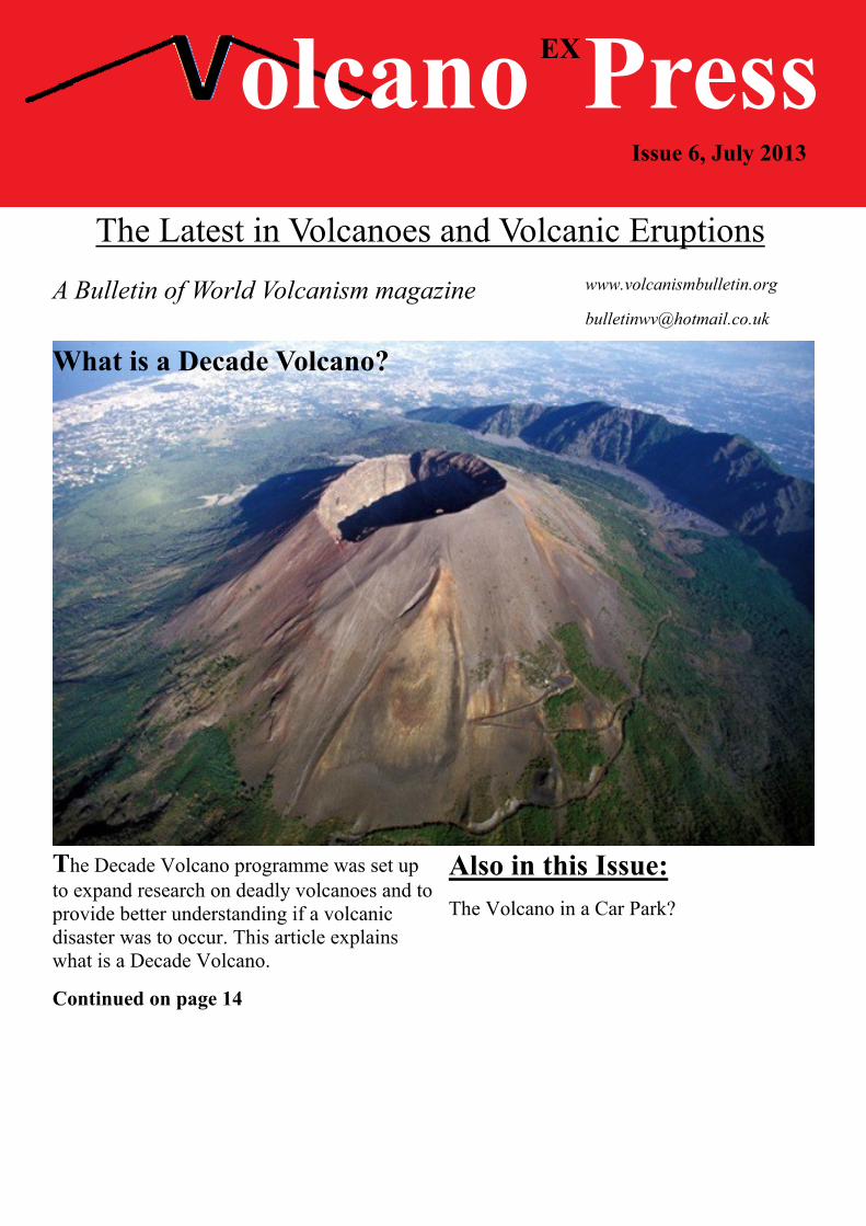
olcano PressThe Latest in Volcanoes and Volcanic Eruptions
A Bulletin of World Volcanism magazine
Issue 6, July 2013
www.volcanismbulletin.org
Also in this Issue:The Volcano in a Car Park?
The Decade Volcano programme was set upto expand research on deadly volcanoes and toprovide better understanding if a volcanicdisaster was to occur. This article explainswhat is a Decade Volcano.
Continued on page 14
EX
What is a Decade Volcano?

BULLETIN OF WORLD VOLCANISM
Sometimes in articles about a particularvolcano the phrase ‘Decade Volcano’ ismentioned, but what is a decade volcano?
A Decade Volcano
A decade volcano is a volcano that has beenchosen by the IAVCEI (basically the headorganization of Volcanology) as aparticularly dangerous volcano with needfor special research.
The Programme
The Decade Volcano programme is a threeway programme between the UnitedNations, the IAVCEI and the IDNDR.
The IDNDR was the International Decadefor Natural Disaster Reduction. The decadewas 1990-2000. The Decade volcanoprogramme has helped many volcanicdisasters as shown below.
The Volcanoes
At the time of writing, currently 16volcanoes are ‘decade volcanoes’, they arelisted below.
1. Avanchinsky - Koryaksky (twovolcanoes next to each other), Russia
2. Colima, Mexico
3. Etna, Italy
4. Galeras, Colombia
5. Mauna Loa, USA
6. Merapi, Indonesia
7. Nyiragongo, Democratic Republic of theCongo
8. Rainier, USA
9. Sakura-Jima, Japan
10. Santa Maria, Guatemala
11. Santorini, Greece
12. Taal, Philippines
13. Tenerife [Teide], Spain
14. Ulawun, Papua New Guinea
15. Unzen, Japan
16. Vesuvius, Italy
Success and Disappointment
The programme was called into action in1992 when an eruption on the SE flank ofEtna that began in 1991 began to produce alava flow that threatened to overrun the townof Zafferana. The lava flow was diverted byman made barriers. They also lowered severalconcrete blocks into the active lava tube thatwas feeding the flow. Their efforts saved thetown.
However nothing could be done to prevent asudden explosion of Galeras volcano inColombia in 1993 that killed several people.Or the 2010 eruption of Merapi that was oneof the most devastating on record.
Research
The main focus of the Decade VolcanoProgramme was to improve the understandingof the above volcanoes. Some of thevolcanoes, like Etna in Italy are very wellknown. Others however have hardly beenstudied; political problems prevent muchresearch of Nyiragongo volcano in the Congo.
Above; Rainier volcano in Washington state, USA isa decade volcano. Its main volcanic hazard is largemud flows (lahars) produced during eruptions.
14

BULLETIN OF WORLD VOLCANISM
Others have hardly been studied. Forexample, Ulawun volcano in Papua NewGuinea was selected to be a decadevolcano because of its large range oferuptive styles. But the volcano has notbeen studied since the announcement of itsstatus.
Suggestions of Other Decade Volcanoes
The 16 above volcanoes are just a verysmall portion of the 1500 active andpotentially active volcanoes knowncurrently. It is clear that the above list isnot a complete list of all of Earthsdangerous volcanoes.
For my decade volcano list, I wouldn’t gofor volcanoes that have maybe had a largeeruption (most volcanoes have largeeruptions at some point in their lives). Itwould be the volcanoes that have had a listof large eruptions in the Holocene.
One volcano I’d definitely recommend forthis status would be Apoyeque inNicaragua. This large ignimbrite complexhas had 4 known eruptions in the past10,000 years. Three of these were verylarge eruptions. The volcano has beenquiet for thousands of years and it may beone to watch out for.
Two other things make this a placedeserving of Decade Volcano status arediscussed below:
1) Next to Apoyeque volcano is the minorcentre of Nijapa-Miraflores. These aremostly made up of maars, maars thatcould form on anyplace on the fissure onwhich they are built. What makes this tinyvolcano dangerous is that it andneighbouring Apoyeque are situated onthe outskirts of Managua, the capital ofNicaragua and its surrounding inhabitants,with a combined population of 3,335,000people.
Apoyeque is situated just 4 km from the cityand Nijapa-Miraflores straddles the city, withsome volcanic centres inside it.
Another example is the Campi Flegrei volcanojust outside the city of Naples. Its neighbouringvolcano, Vesuvius is also a decade volcano, butmany Italian scientists say that this volcanocould be a bigger hazard than Vesuvius.
The volcano forms a caldera which lies lessthan 10 KM from the city of Naples. Thecaldera was once home to a stratovolcano likeVesuvius, however large eruptions thousands ofyears ago destroyed this cone leaving thecaldera. The volcano has had a few smalleruptions since then which have formed maarsand pyroclastic cones. The last created theMonte Nuovo in 1538. What really worriesItalian Volcanologists is the fact that the townof Pozzuoli, home to around 83,000 people liesin the centre of activity. A new eruption in thisarea would spell disaster for this town.
These are just a couple of examples of possibleDecade Volcanoes, and there are countlessmore. It still shows that when it comes toVolcanic Hazards, we are still not that wellprepared.
15

BULLETIN OF WORLD VOLCANISM
The Volcano in a Park?
In the middle of a normal suburbanneighbourhood in Puebla lies what many inMexico believe to be the world’s smallestvolcano. Cuexcomate.
Geology
The cone of Cuexcomate is 13 metres talland 23 metres in diameter. It is now a smalltallest attraction. It has a 4-8 diameter craterthat has a depth of 17 metres. At the bottomsits a pool of still warm water.
Formation
Historical Records show that Cuexcomateformed around 1060 years ago during amajor eruption of nearby volcanoPopocatepetl. Not much is known aboutanything else apart from this.
The Mexicans for centauries claimed this tobe the worlds smallest volcano.
New Research
However, the first real geological surveytaken at the ‘volcano’ show a very differentstory.
Results published in 2012 show the‘volcano’ to be 90 % sinter (hydrothermaldeposits). This is almost identical tocurrently active Geysers in Mexico.
But, even though it is not volcano (formedinstead from phreatic eruptions andhydrothermal explosions), this makes it theworlds largest Geyser!.
16
Above; Cuexcomate, is this the worlds smallestvolcano?
Above; inside Cuexcomate’s crater.

BULLETIN OF WORLD VOLCANISM
Website of the Month
GNS Science - Volcanoes
New Zealand is one of the most amazing and beautiful places of volcanic activity in theworld. With is impressive snow-capped, volcanoes like Tongariro and Ruapehu or thesubdued massive caldera volcanoes like Taupo. You can learn about these wonders on theGNS Website, the official website for New Zealand's natural hazards. As New Zealand'svolcanoes are some of the most intensely studied in the world, there is a treasure trove ofinformation on this website. From how they work to how they are monitored, it is the perfectstarting place to learn more about New Zealand's volcanoes.
http://www.gns.cri.nz/Home/Learning/Science-Topics/Volcanoes
Your Thoughts
This month, do you think there is evidence of recent volcanic activity on Venus?, write to usat [email protected] an let us know!
17