Historic & Archaeological Resources of Southeast Massachusetts
BULLETIN OF THE
MASSACHUSETTS ARCHAEOLOGICALSOCIETY
VOLUME 53, NUMBER 1
CONTENTS:
SPRING 1992
THE CEDAR SWAMP ARCHAEOLOGICAL DISTRICT: A MODEL FORCONSERVATION ARCHAEOLOGY Curtiss Hoffman 1
THE CONRAIL SITES AND THE CEDAR SWAMP ARCHAEOLOGICAL DISTRICTAlan Leveillee 18
CHELONIAN ZOOARCHAEOLOGY OF EASTERN NEW ENGLAND: TURTLEBONE REMAINS FROM CEDAR SWAMP AND OTHER PREHISTORIC SITES
Anders G. J. Rhodin 2 1
ARCHAEOBOTANICAL CLUES FROM CEDAR SWAMP, WESTBOROUGH, MASS.Tonya Baroody Largy 31
IN MEMORIAM: FREDERICK M. CARTY, 1951-1991
ContributorsNotes to Contributors
James W. Bradley 38
4030
THE MASSACHUSETTS ARCHAEOLOGICAL SOCIETY, Inc.P.O.Box 700, Middleborough, Massachusetts 02346
OFFICERS
President: . . . . . . . . . . . . . . . . Ruth Warfield, 13 Lee St., Worcester MA 01602First Vice President: Curtiss Hoffman, 58 Hilldale Rd., Ashland MA 01721Second Vice President: Charles Bartels, 147 Emerson Gardens, Lexington MA 02173Corresponding Secretary: Lesley H. Sage, 33 West Rd., 2B, Orleans MA 02653Recording Secretary: Thomas Doyle, P.O. Box 1708, North Eastham, MA 02651Financial Secretary: . . . .. Lillian Harding, 143 Fisher St., Westborough MA 01581Membership Secretary: . . Eunice Kramer, Off North St., Middleborough MA 02364Treasurer: . . . . .. . . . Marilyn Crary, Box 427, Eastham MA 02642Bulletin Editor: . . . . . . . Elizabeth A. Little, 37 Conant Rd., Lincoln MA 01773Newsletter Editor & Museum Director: . . . Thomas Lux, 45 Nisbet St., Providence RI 02906Museum Coordinator: Michael Roberts, 51 Hollis St., Groton MA 01450
Trustees:1990-92: Joseph F. Freitas, Jr., Roger J. Heinen, Robert A. Trotta, James H. Wait1991-93: Kathleen S. Anderson, Carolyn Maguire, Jane C. Lopes, Alan F. Smith
Past President: Michael Touloumtzis, 367 S. Main St., Attleboro MA 02703
Archivist: . . . . . . . . . . . . . . Ralph Bates, 42 Leonard St., Bridgewater MA 02324MHC Representative: ....Barbara Luedtke, Anthropology Dept., UMass, Boston MA 02125Museum Development Director: ..... Linda V. Hewitt, 290 Elm St., Pembroke MA 02359
The BULLETIN OF THE MASSACHUSETTS ARCHAEOLOGICAL SOCIETY is published semiannually, with each volume beginning in the spring. Institutional subscriptions are $25; individualmemberships in the Society are $18 and include a subscription to the Bulletin. Information onspecial rates for family members, seniors, students, etc., is available from the MembershipSecretary. Order back issues of the Bulletin from the Museum Director, MassachusettsArchaeological Society, P. O. Box 700, Middleborough, MA 02346 (508-947-9005).
Manuscripts and communications for the Bulletin may be sent to:
Elizabeth A. Little, EditorBulletin of the Massachusetts Archaeological Society37 Conant Road, Lincoln, MA 01773 (617-259-9397 or 508-228-4381)
BULLETIN OF THE MASSACHUSETIS ARCHAEOLOGICAL SOCIETY. VOLUME 53(1). 1992
THE CEDAR SWAMP ARCHAEOLOGICAL DISTRICT:A MODEL FOR CONSERVAnON ARCHAEOWGY
Curtiss Hoffman
1
Introduction
Archaeological research in the Northeasthas until recent years concentrated on certainecological zones: coastlines, major rivers, andlakes. These are areas in which early Europeansettlers recorded major aboriginal base camps andconcentrations of population. They are also areasin which archaeological remains are fairly abundant and visible on the surface as the result ofplowing and erosion. Upland areas, and interiorwetlands in particular, tend to be underrepresentedin the archaeological record, even though thereare historical accounts of Indians living in, or atleast retreating to, upland swamps.
A series of recent studies by researchersall over the Northeast (Nicholas 1986, 1991; McBride 1984, 1990; Kiviat 1986; Thorbahn 1982;Mavor and Dix 1985, 1990; Funk 1990; Hasenstab 1991; Warfield 1986; Hoffman 1984, 1985a)have suggested that these environments are crucialto an understanding of prehistoric lifeways throughout the 12,000 years that people have occupied the Northeast. Upland swamps were sourcesof vegetable and animal foods, places of shelterduring certain months of the year, permanentsources of water, and provided transportationcorridors for water travel by dugout canoe from
one drainage to another. There may have beensome periods during which these environmentswould have been more important than others, fordiffering reasons. For example, Nicholas (1991)
has shown that wetland resource diversity during
Copyright 1992 Curtiss Hoffman
the warm and dry Early Archaic period (c. 9,000- 8,000 years ago) made these zones more attractive for settlement than other parts of SouthernNew England. The author (Hoffman 1985a) hassuggested that from about 4500 to 2700 years ago,population pressures throughout the Northeastencouraged groups to move into environmentsincreasingly upstream of major riverine zones,including upland swamps. A number of studies(Barber 1984; Luedtke 1987; Kenyon 1984; Feder1984) have shown that during the Middle Woodland period (1500-900 years ago) the intensification of trade in exotic raw materials necessitatedthe use of waterways for transmission of thesegoods, while most settlements concentrated alongthe coast. During the Contact period (1620-1775A.D.), Native Americans seem to have consideredupland swamp zones as places of refuge fromEuropeans, and many of the battles of KingPhillip's War (1675-1676) were fought there.Some of these areas continued to be used byNative Americans well into the 19th century(Mavor and Dix 1990; Leveillee 1992).
The series of four articles which followwere presented in 1989 as part of a symposium atthe 50th Annual Meeting of the Massachusetts Archaeological Society. They demonstrate thepotential for cultural resources in this zone, andencourage the preservation of such resourcesthrough the National Register process. Theyexemplify the Conjunctive Approach in archaeology (Taylor 1967), in which the work of fieldarchaeologists is joined to that of geologists,palynologists, paleobotanists, paleozoologists, andhistorians to produce a more complete compositepicture. The articles focus upon the Cedar
This journal and its contents may be used for research, teaching and private study purposes. Any substantial or systematic reproduction, re-distribution, re-selling,loan or sub-licensing, systematic supply or distribution in any form to anyone is expressly forbidden. ©2011 Massachusetts Archaeological Society.
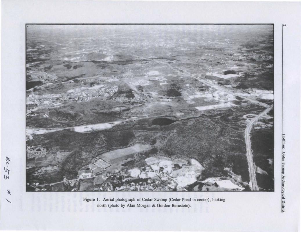
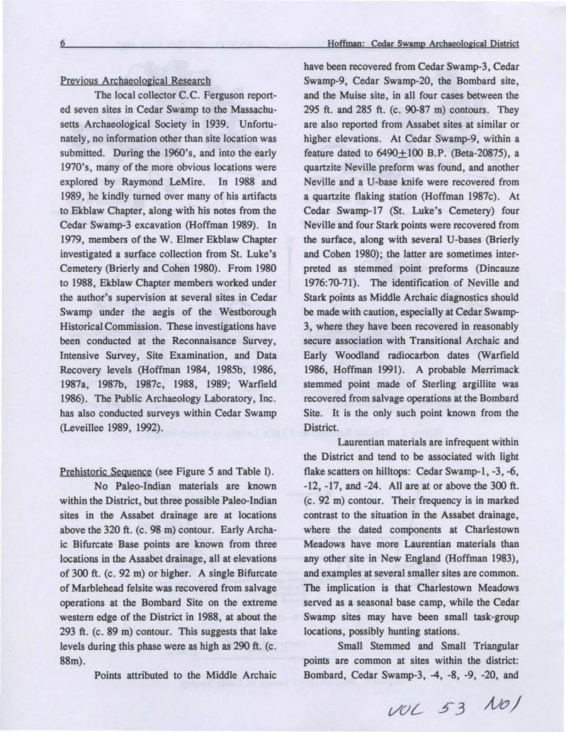
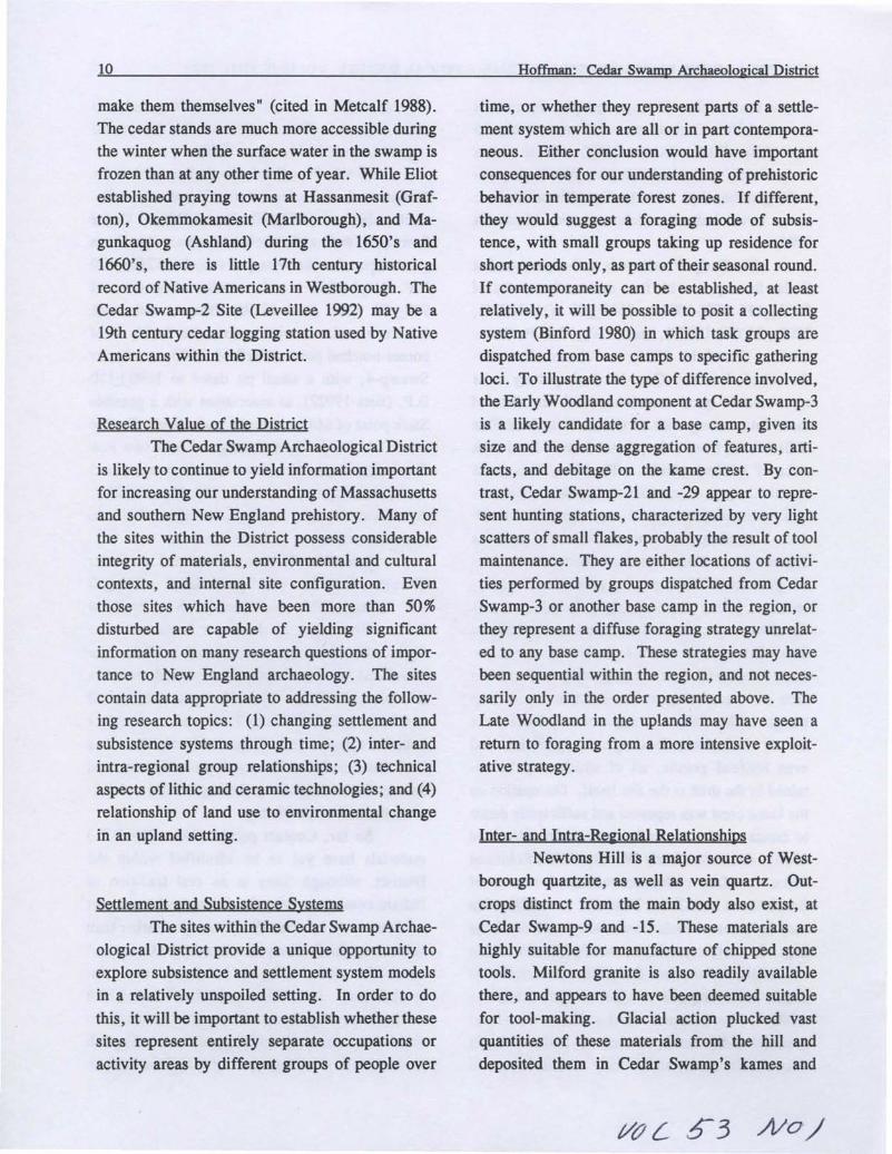
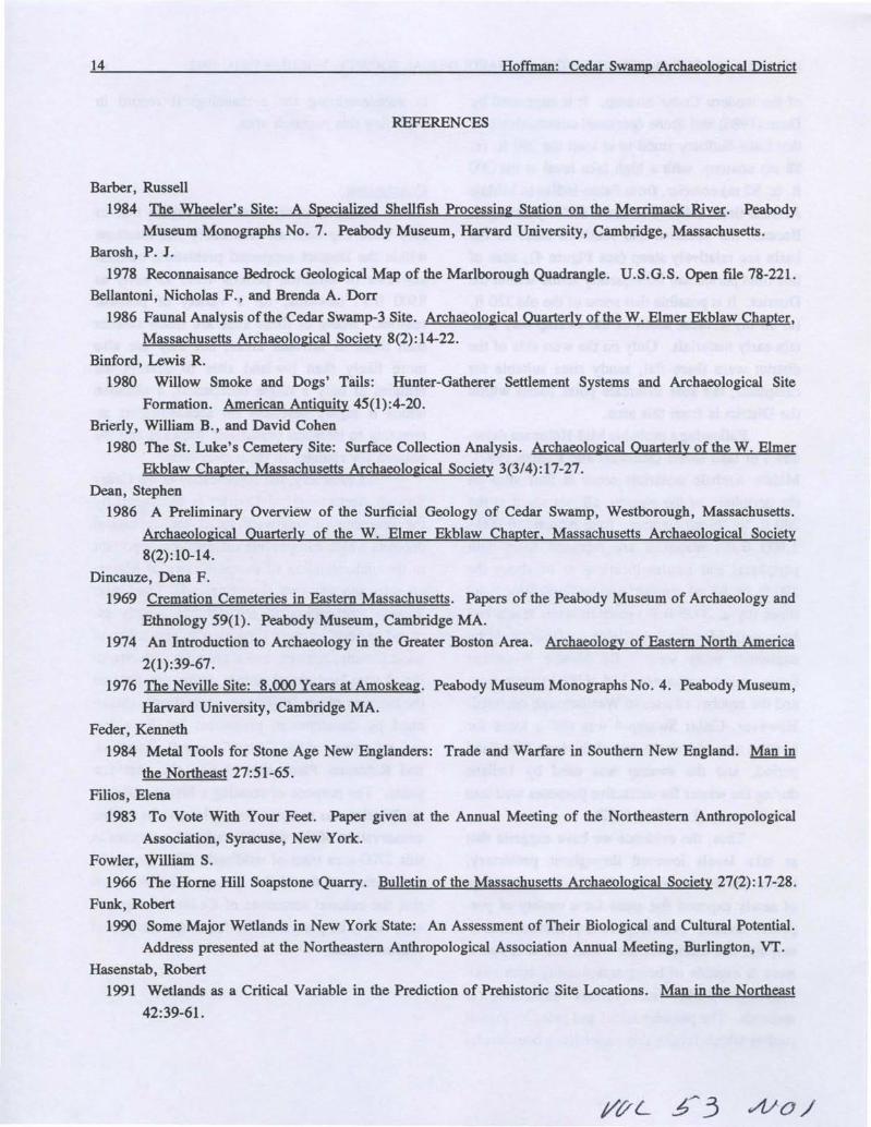
Figure 1. Aerial photograph of Cedar Swamp (Cedar Pond in center), looking
north (photo by Alan Morgan & Gordon Bernstein).
N
BULLETIN OF THE MASSACHUSETTS ARCHAEOLOGICAL SOCIETY, VOLUME 53(1), 1992 3
Swamp Archaeological District in Westborough,Massachusetts, which was placed on the NationalRegister of Historic Places in May of 1988. Thisarticle and the tWo which follow it (Largy 1992,Rhodin 1992) contributed substantively to theNational Register Nomination; the final article(Leveillee 1992) illustrates the advantage ofplacing such districts on the Register, since thesites they contain (even previously undiscoveredones) are thereby afforded the full protection ofFederal and State laws.
Geological and Ecological Description of CedarSwamp
The Cedar Swamp Archaeological District
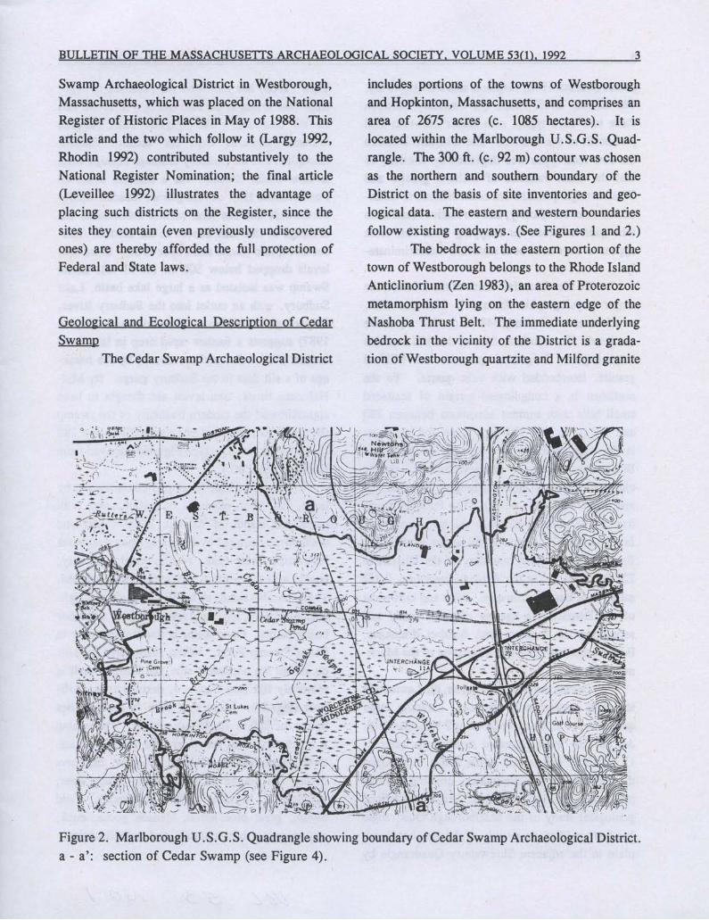
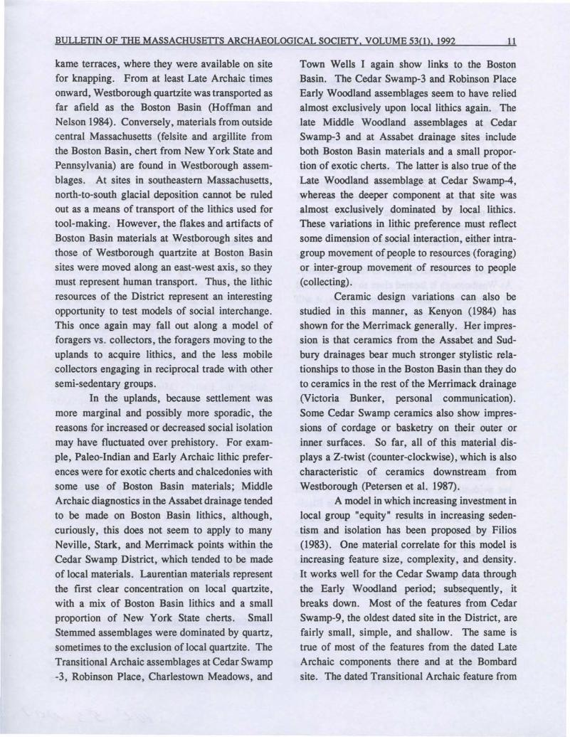
includes portions of the towns of Westboroughand Hopkinton, Massachusetts, and comprises anarea of 2675 acres (c. 1085 hectares). It islocated within the Marlborough U.S.G.S. Quad
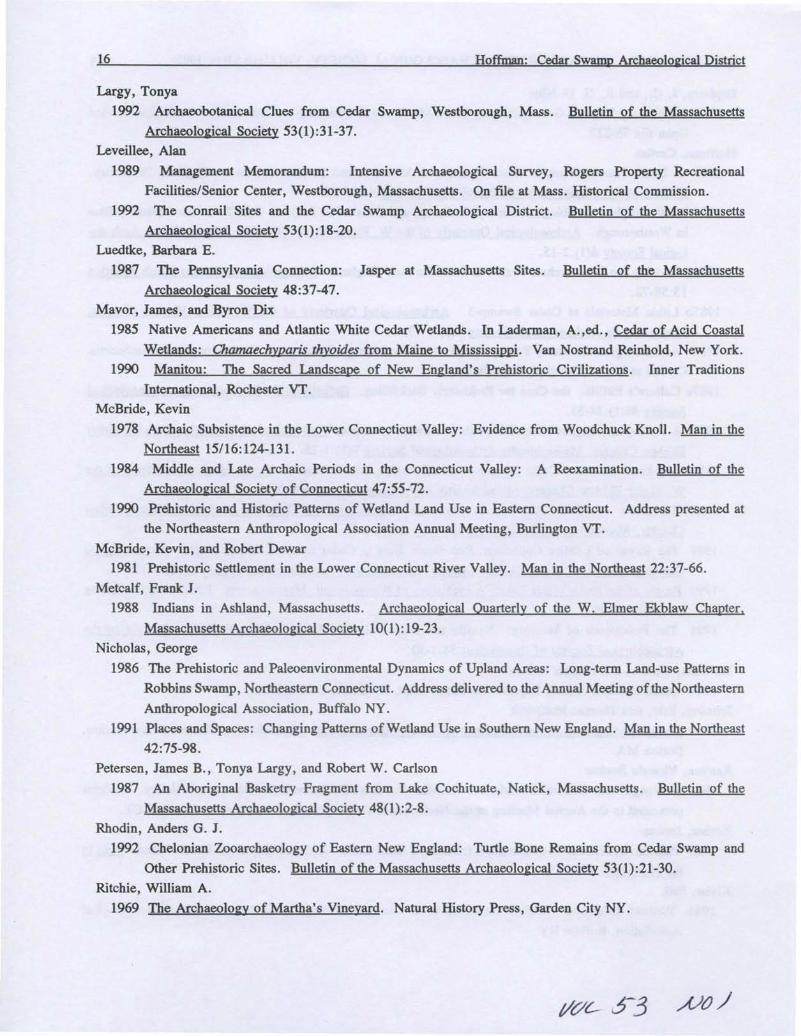
rangle. The 300 ft. (c. 92 m) contour was chosenas the northern and southern boundary of theDistrict on the basis of site inventories and geological data. The eastern and western boundariesfollow existing roadways, (See Figures 1 and 2.)
The bedrock in the eastern portion of thetown of Westborough belongs to the Rhode IslandAnticlinorium (Zen 1983), an area of Proterozoicmetamorphism lying on the eastern edge of theNashoba Thrust Belt. The immediate underlyingbedrock in the vicinity of the District is a gradation of Westborough quartzite and Milford granite
Figure 2. Marlborough U.S.G.S. Quadrangle showing boundary of Cedar Swamp Archaeological District.a - a': section of Cedar Swamp (see Figure 4).
4
gneiss (Barosh 1978; Hepburn and DiNitto 1978).
The Bloody Bluff Fault, the boundary betweenthese two rock types, runs under Newtons Hill
just north of the District. The interface between
the two rock types was degraded by friction, so
that the local varieties of Milford granite andWestborough quartzite are often difficult to differ
entiate macroscopically; and the Native Americans
who quarried stone for knapping from cliff facesappear to have used both materials indiscriminately.
To the immediate north of the District, the
major physiographic feature is Newtons Hill,
which rises to a summit 548 ft. (c. 167 m) abovesea level. The southern face of this hill contains
large exposed ledges of quartzite and Milford
granite, interbedded with vein quartz. To the
northeast is a complicated terrain of scattered
small hills with summit elevations between 350
and 450 ft. (c. 107-137 m). South and southeast
is the watershed area between the Sudbury and
Blackstone drainages, characterized by closely
clustered hills with summits ranging between 450
and 550 ft. (c. 137-168 m). The Sudbury River
has cut its channel between the last two areas,
falling from 270 ft. (c. 82 m) at the Fruit Street
Bridge at the eastern boundary of the District to
222 ft. (c. 68 m) at the Ashland town line, 2 1/2
miles (c. 4 km) downstream. West and northwest
of the District is a narrow ridge of sandy soil
separating the Sudbury and Assabet drainages.
Both of these streams are tributaries of the Merri
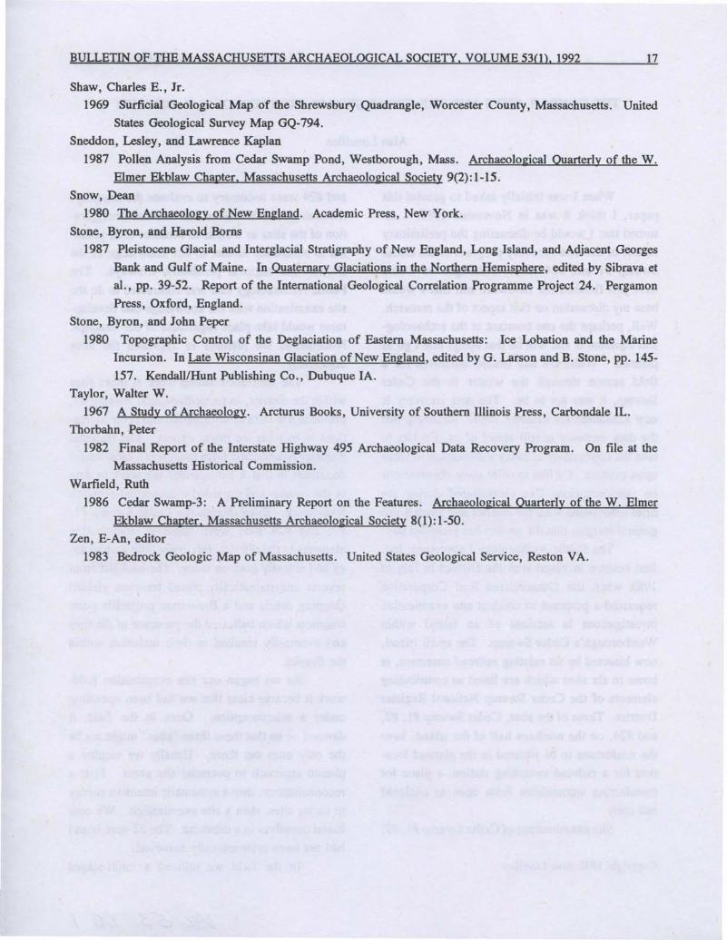
mack River.During the late Pleistocene, the Laurentide
ice mass pushed over the area, scraping large
quantities of soil and bedrock off Newtons Hill.
As the ice front retreated northwards after c.
15,500 B.P. (Stone and Borns 1987), it dammed
the outflow of the meltwater, creating a large
proglaciallake, Lake Assabet. While no surficial
geological study of the Marlborough Quadrangle
has been published, a study of the Assabet flood
plain in the adjacent Shrewsbury Quadrangle by
Hoffman: Cedar Sw!nm Archaeological District
Shaw (1969) has indicated the presence of highstage lake levels at the 320 and 300 ft. (c. 98 and
92 m) contours. The original Lake Assabetdrained eastwards from the modern Assabet
floodplain into the Sudbury drainage through whatis now Cedar Swamp, via a channel south ofPowderhouse Hill. As the glacier receded rapidly
northwards and the land surface rebounded, the
drainage of this lake altered to the modern Assabet floodplain (Stone and Peper 1980). Once lakelevels dropped below 300 ft. (c. 91 m), CedarSwamp was isolated as a large lake basin, Lake
Sudbury, with an outlet into the Sudbury River.Palynological evidence (Sneddon and Kaplan1987) suggests a further rapid drop in lake level
around 6000 B.P., perhaps caused by the break
age of a silt dam in the Sudbury gorge. By MidHolocene times, lake levels are thought to have
approximated the modern boundary of the swamp
(Byron Stone, personal communication), the 280
ft. (c. 85 m) contour. (See Figure 3, derived from
Hoffman 1990:30.)
Today, Cedar Swamp is characterized bylarge, flat, open expanses of cattail marsh with
occasional stands of Atlantic White Cedar and
white birch bounded by relatively open deciduous
hardwood forest (oak, swamp maple, hickory,
beech) with a few pines and hemlocks intermixed.
There are also stands of hazel, low-bush and high
bush blueberry, royal and sensitive fern, and other
bushy plants. Open water is found today only in
Cedar Swamp Pond. While surrounded by hills
on all but the northwest side, the District itself is
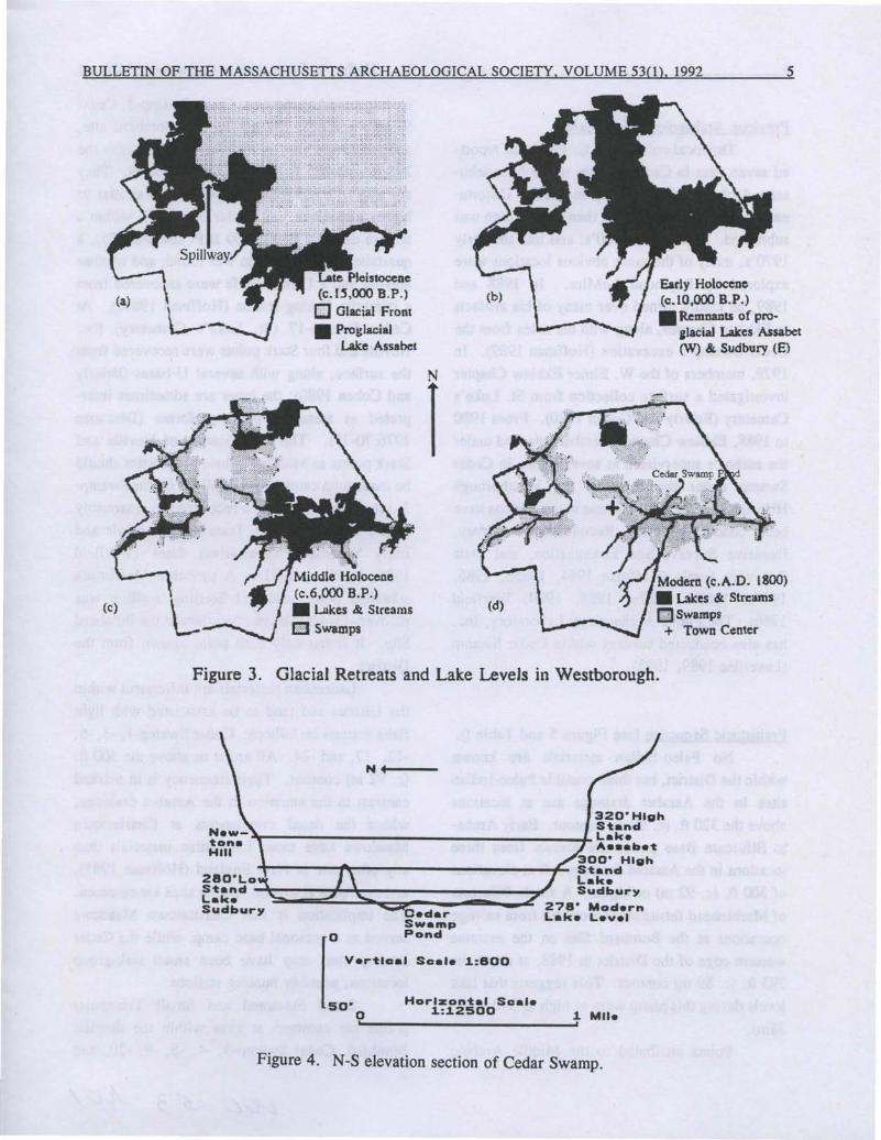
relatively flat (see Figure 4, derived from Hoff
man 1990:28). More than 80% of the area lies
below the 280 ft. (c. 85 m) contour. The swamp
is a natural habitat for many wild animal species;
those observed by Ekblaw Chapter members
during the course of excavation include deer,
woodchuck, weasel, rabbit, chipmunk, field
mouse, great blue heron, Canada goose, duck,
and snapping, box, painted, and spotted turtles.
A)O)
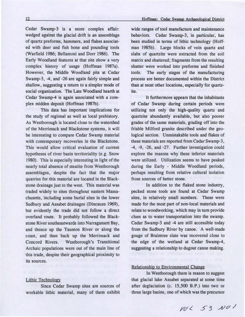
BULLETIN OF THE MASSACHUSETTS ARCHAEOLOGICAL SOCIETY, VOLUME 53(1), 1992 5
(a)
(c)
Late Pleistocene(c.I~,OOO B.P.)[J Glacial Front• Proglacial
Lake Assabet
Middle Holocene(c,6,OOO B.P.)• Lakes & Streams
E!1 Swamps
(b)
(d)
Early Holocene(c. 10,000 B.P.)• Remnants of pro
ilaciaJ Lakes Assabet(W) &. Sudbury (E)
.cr:..
Modern (c. A.D. 1800)• Lakes & StreamsEm Swamps+ Town C¢nter
Figure 3, Glacial Retreats and Lake LeveJs in Westborough.
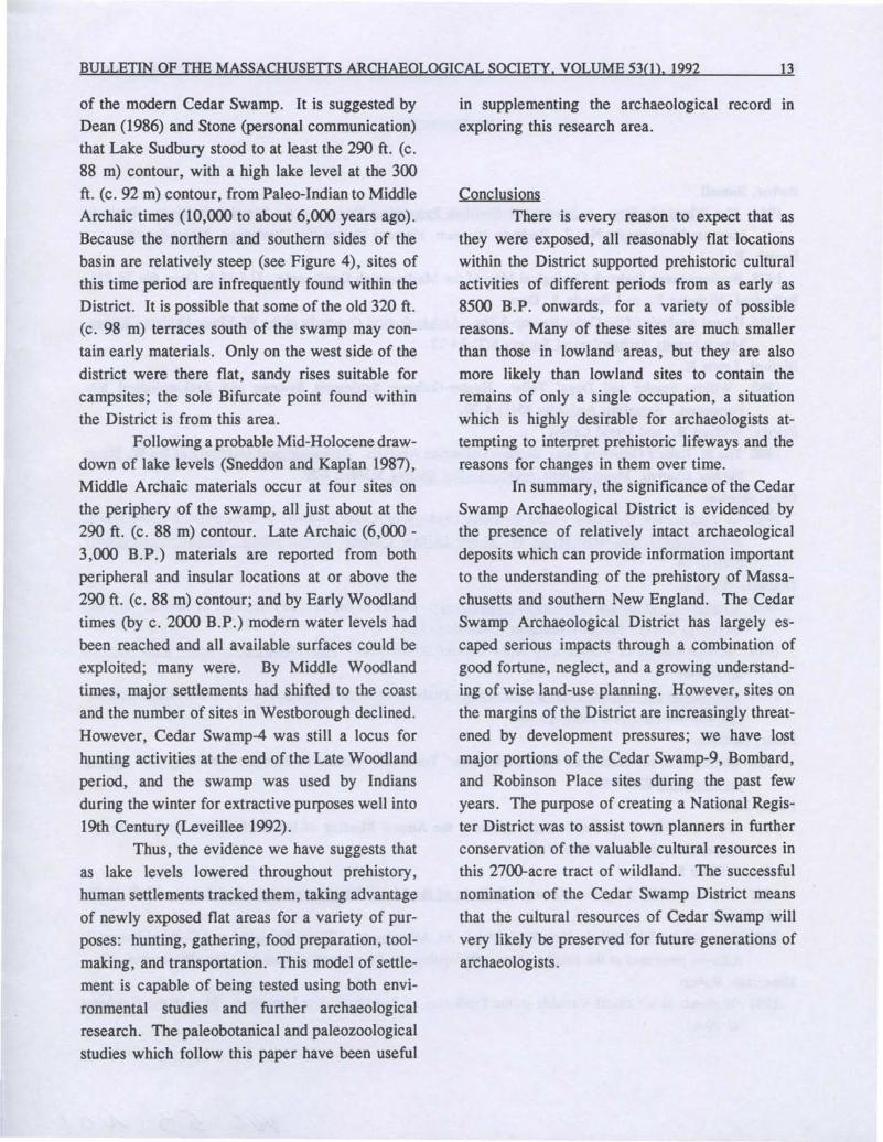
N".---320"HlghStand'T'-------------------I- LakeA••abet
1----.....,t-r-------------/-::. 300" High, Stand280'Lo LakeStand SudburyLakeSUdburu 278' Modern
, Cedar Lake LevelSwamp
o Pond
[
Vertical Scale 1.:600
50' Horizontal Scalea 1.:1.2500 1. Mile...' -----------_....
Figure 4. N-S elevation section of Cedar Swamp.
6
Previous Archaeological ResearchThe local collector C.C. Ferguson report
ed seven sites in Cedar Swamp to the Massachusetts Archaeological Society in 1939. Unfortunately, no information other than site location wassubmitted. During the 1960's, and into the early1970's, many of the more obvious locations wereexplored by Raymond LeMire. In 1988 and1989, he kindly turned over many of his artifactsto Ekblaw Chapter, along with his notes from theCedar Swamp-3 excavation (Hoffman 1989). In1979, members of the W. Elmer Ekblaw Chapterinvestigated a surface collection from St. Luke'sCemetery (Brierly and Cohen 1980). From 1980to 1988, Ekblaw Chapter members worked underthe author's supervision at several sites in CedarSwamp under the aegis of the WestboroughHistorical Commission. These investigations havebeen conducted at the Reconnaisance Survey,Intensive Survey, Site Examination, and DataRecovery levels (Hoffman 1984, 1985b, 1986,1987a, 1987b, 1987c, 1988, 1989; Warfield1986). The Public Archaeology Laboratory, Inc.has also conducted surveys within Cedar Swamp(Leveillee 1989, 1992).
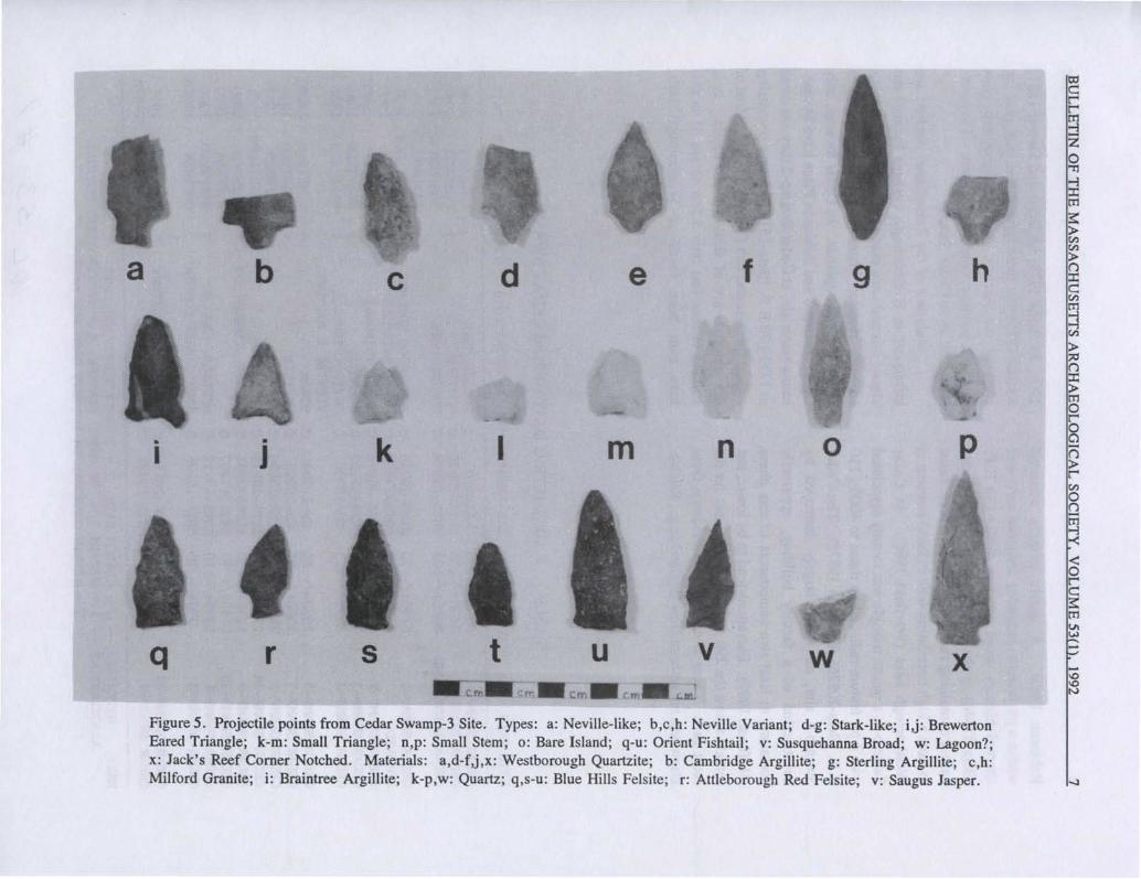
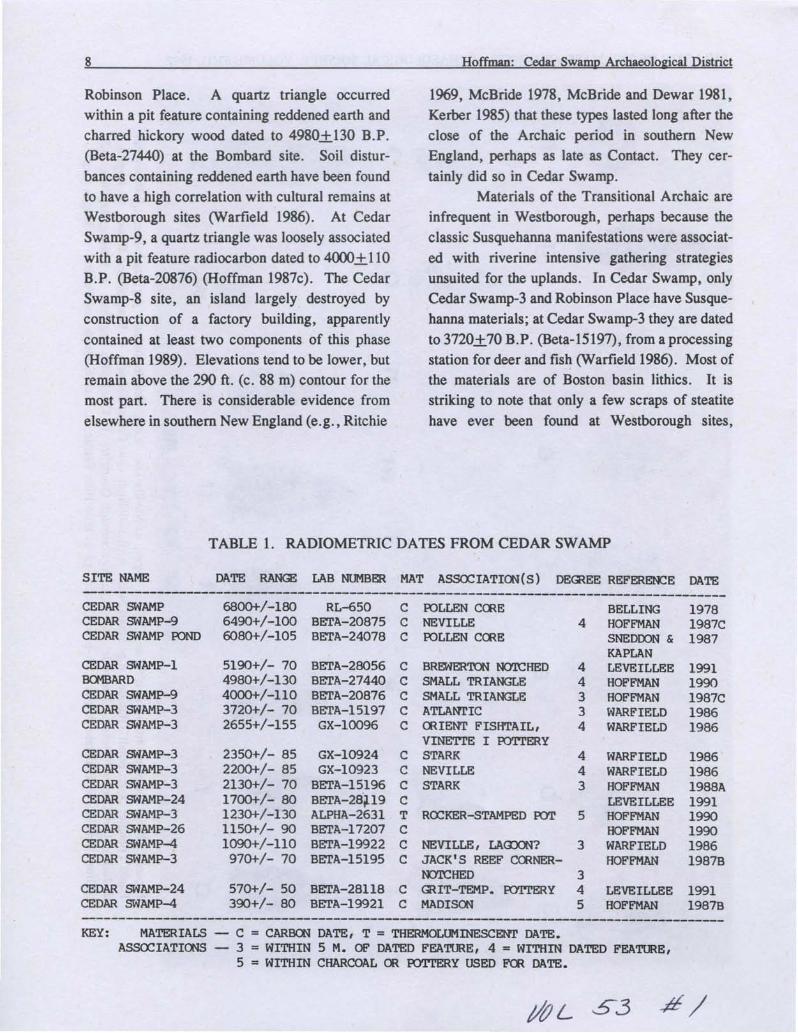
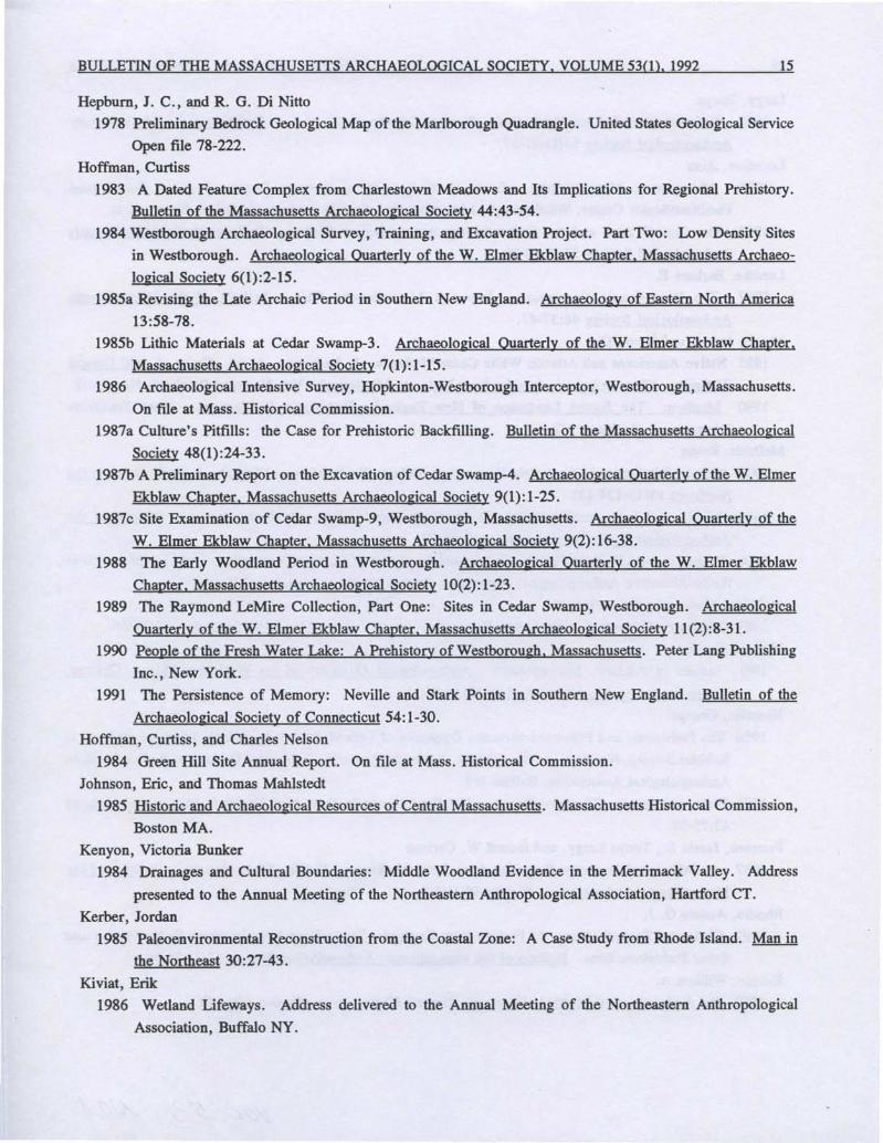
Prehistoric Segyence (see Figure 5 and Table I).No Paleo-Indian materials are known
within the District, but three possible Paleo-Indiansites in the Assabet drainage are at locationsabove the 320 ft. (c. 98 m) contour. Early Archaic Bifurcate Base points are known from threelocations in the Assabet drainage, all at elevationsof 300 ft. (c. 92 m) or higher. A single Bifurcateof Marblehead felsite was recovered from salvageoperations at the Bombard Site on the extremewestern edge of the District in 1988, at about the293 ft. (c. 89 m) contour. This suggests that lakelevels during this phase were as high as 290 ft. (c.88m).
Points attributed to the Middle Archaic
Hoffman: Cedar Swamp Archaeological District
have been recovered from Cedar Swamp-3, CedarSwamp-9, Cedar Swamp-20, the Bombard site,and the Muise site, in all four cases between the295 ft. and 285 ft. (c. 90-87 m) contours. Theyare also reported from Assabet sites at similar orhigher elevations. At Cedar Swamp-9, within afeature dated to 6490+ 100 B.P. (Beta-20875), aquartzite Neville preform was found, and anotherNeville and a U-base knife were recovered froma quartzite flaking station (Hoffman 1987c). AtCedar Swamp-17 (St. Luke's Cemetery) fourNeville and four Stark points were recovered fromthe surface, along with several U-bases (Brierlyand Cohen 1980); the latter are sometimes interpreted as stemmed point preforms (Dincauze1976:70-71). The identification of Neville andStark points as Middle Archaic diagnostics shouldbe made with caution, especially at Cedar Swamp3, where they have been recovered in reasonablysecure association with Transitional Archaic andEarly Woodland radiocarbon dates (Warfield1986, Hoffman 1991). A probable Merrimackstemmed point made of Sterling argillite wasrecovered from salvage operations at the BombardSite. It is the only such point known from theDistrict.
Laurentian materials are infrequent withinthe District and tend to be associated with lightflake scatters on hilltops: Cedar Swamp-I, -3, -6,-12, -17, and -24. All are at or above the 300 ft.(c. 92 m) contour. Their frequency is in markedcontrast to the situation in the Assabet drainage,where the dated components at CharlestownMeadows have more Laurentian materials thanany other site in New England (Hoffman 1983),and examples at several smaller sites are common.The implication is that Charlestown Meadowsserved as a seasonal base camp, while the CedarSwamp sites may have been small task-grouplocations, possibly hunting stations.
Small Stemmed and Small Triangularpoints are common at sites within the district:Bombard, Cedar Swamp-3, -4, -8, -9, -20, and
-1010N
h
p
x
9
o
w
f
n
v
e
em
m
u
d
I
t
c
k
sr
•J
b
•I
q
a
Figure 5. Projectile points from Cedar Swamp-3 Site. Types: a: Neville-like; b,c,h: Neville Variant; d-g: Stark-like; i,j: BrewertonEared Triangle; k-m: Small Triangle; n,p: Small Stem; 0: Bare Island; q-u: Orient Fishtail; v: Susquehanna Broad; w: Lagoon?;x: Jack's Reef Corner Notched. Materials: a,d-f,j,x: Westborough Quartzite; b: Cambridge Argillite; g: Sterling Argillite; c,h:Milford Granite; i: Braintree Argillite; k-p,w: Quartz; q,s-u: Blue Hills Felsite; r: Attleborough Red Felsite; v: Saugus Jasper.
8 Hoffman: Cedar Swamp Archaeological District
Robinson Place. A quartz triangle occurredwithin a pit feature containing reddened earth andcharred hickory wood dated to 4980+ 130 B.P.(Beta-27440) at the Bombard site. Soil disturbances containing reddened earth have been foundto have a high correlation with cultural remains atWestborough sites (Warfield 1986). At CedarSwamp-9, a quartz triangle was loosely associatedwith a pit feature radiocarbon dated to 4000+ 110B.P. (Beta-20876) (Hoffman 1987c). The CedarSwamp-8 site, an island largely destroyed byconstruction of a factory building, apparentlycontained at least two components of this phase(Hoffman 1989). Elevations tend to be lower, butremain above the 290 ft. (c. 88 m) contour for themost part. There is considerable evidence fromelsewhere in southern New England (e.g., Ritchie
1969, McBride 1978, McBride and Dewar 1981,Kerber 1985) that these types lasted long after theclose of the Archaic period in southern NewEngland, perhaps as late as Contact. They certainly did so in Cedar Swamp.
Materials of the Transitional Archaic areinfrequent in Westborough, perhaps because theclassic Susquehanna manifestations were associated with riverine intensive gathering strategiesunsuited for the uplands. In Cedar Swamp, onlyCedar Swamp-3 and Robinson Place have Susquehanna materials; at Cedar Swamp-3 they are datedto 3720+70 B.P. (Beta-15197), from a processingstation for deer and fish (Warfield 1986). Most ofthe materials are of Boston basin lithics. It isstriking to note that only a few scraps of steatitehave ever been found at Westborough sites,
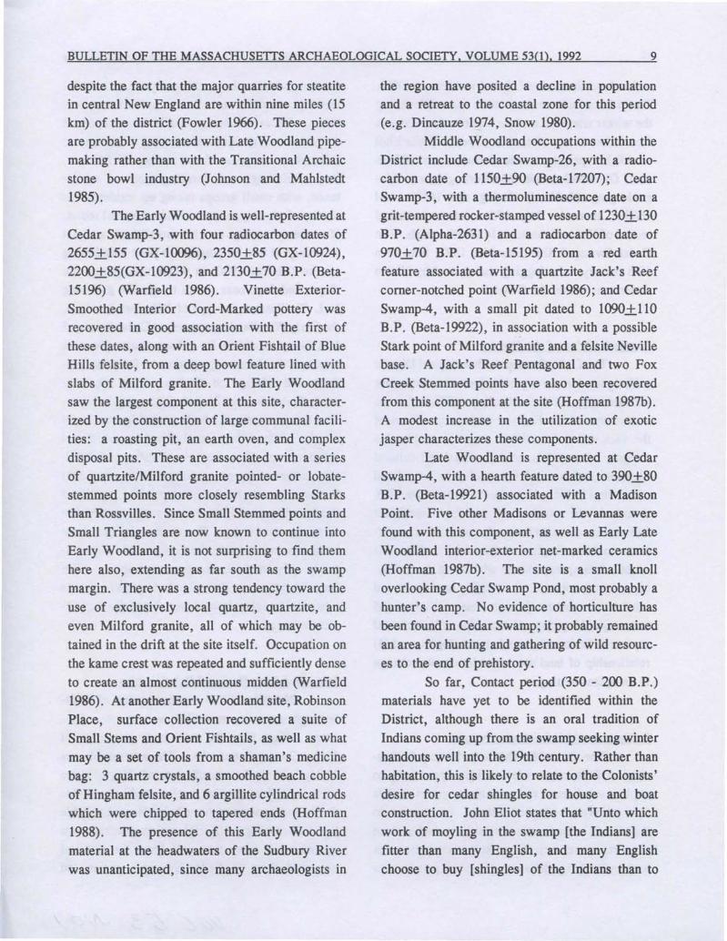
TABLE 1. RADIOMETRIC DATES FROM CEDAR SWAMP
SITE NAME DATE RANGE LAB NUMBER MAT ASSOCIATIOO(S) DEffiEE REFERENCE DATE---------------------------------------------------------------------------------------
6800+/-180 RL-650 C roLLEN CCRE6490+/-100 BETA-20875 C NEVILLE6080+/-105 BETA-24078 C roLLEN CCRE
570+/- 50 BETA-28118 C390+/- 80 BETA-I9921 C
199119901987C19861986
19781987C1987
198619861988A19911990199019861987B
19911987B
BELLINGHOFFMANSNEDOON &KAPLANLEVEILLEEHOFFMANHOFFMANWARFIELDWARFIELD
WARFIELDWARFIELDHOFFMANLEVEILLEEHOFFMANHOFFMANWARFIELDHOFFMAN
LEVEILLEEHOFFMAN
4
44334
5
443
3
345
ROCKER-STAMPED roT
NEVILLE, LACDON?JACK'S REEF CORNERN<Y.OCHEDffiIT-TEMP. roTTERYMAOISOO
BREWERTON N<Y.OCHEDSMALL TRIANGLESMALL TRIANGLEATLANrICCRIENT FISHTAIL,VINE'ITE I roTTERY
C STARKC NEVILLEC STARKCTCCC
BETA-28056 CBETA-27440 CBETA-20876 CBETA-15197 CGX-l0096 C
GX-I0924GX-I0923
BETA-15196BETA-2S'P9ALPHA-2631BETA-I7207BETA-19922BETA-15195
5190+/- 704980+/-1304000+/-1103720+/- 702655+/-155
2350+/- 852200+/- 852130+/- 701700+/- 801230+/-1301150+/- 901090+/-110970+/- 70
CEDAR SWAMPCEDAR SWAMP-9CEDAR SWAMP roND
CEDAR SWAMP-lBa<1BARDCEDAR SWAMP-9CEDAR SWAMP-3CEDAR SWAMP-3
CEDAR SWAMP-3CEDAR SWAMP-3CEDAR SWAMP-3CEDAR SWAMP-24CEDAR SWAMP-3CEDAR SWAMP-26CEDAR SWAMP-4CEDAR SWAMP-3
CEDAR SWAMP-24CEDAR SWAMP-4---------------------------------------------------------------------------------------KEY: MATERIALS - C = CARBCN DATE, T = THERMOLUMINESCENT DATE.
ASSOCIATIOOS - 3 = WITHIN 5 M. OF DATED FEATURE, 4 = WITHIN DATED FEATURE,5 = WITHIN CHARCOAL OR roTTERY USED FCR DATE.
/&L S3 -#/
BULLETIN OF THE MASSACHUSETIS ARCHAEOLOGICAL SOCIETY, VOLUME 53(1),1992 9
despite the fact that the major quarries for steatitein central New England are within nine miles (15km) of the district (Fowler 1966). These piecesare probably associated with Late Woodland pipemaking rather than with the Transitional Archaicstone bowl industry (Johnson and Mahlstedt1985).
The Early Woodland is well-represented atCedar Swamp-3, with four radiocarbon dates of2655+ 155 (GX-l0096), 2350+85 (GX-I0924),22oo+85(GX-I0923), and 2130+70 RP. (Beta151%) (Warfield 1986). Vinette ExteriorSmoothed Interior Cord-Marked pottery wasrecovered in good association with the first ofthese dates, along with an Orient Fishtail of BlueHills felsite, from a deep bowl feature lined withslabs of Milford granite. The Early Woodlandsaw the largest component at this site, characterized by the construction of large communal facilities: a roasting pit, an earth oven, and complexdisposal pits. These are associated with a seriesof quartzite/Milford granite pointed- or lobatestemmed points more closely resembling Starksthan Rossvilles. Since Small Stemmed points andSmall Triangles are now known to continue intoEarly Woodland, it is not surprising to find themhere also, extending as far south as the swampmargin. There was a strong tendency toward theuse of exclusively local quartz, quartzite, andeven Milford granite, all of which may be obtained in the drift at the site itself. Occupation onthe kame crest was repeated and sufficiently denseto create an almost continuous midden (Warfield1986). At another Early Woodland site, RobinsonPlace, surface collection recovered a suite ofSmall Stems and Orient Fishtails, as well as what
may be a set of tools from a shaman's medicinebag: 3 quartz crystals, a smoothed beach cobbleof Hingham felsite, and 6 argillite cylindrical rodswhich were chipped to tapered ends (Hoffman1988). The presence of this Early Woodlandmaterial at the headwaters of the Sudbury Riverwas unanticipated, since many archaeologists in
the region have posited a decline in populationand a retreat to the coastal zone for this period(e.g. Dincauze 1974, Snow 1980).
Middle Woodland occupations within theDistrict include Cedar Swamp-26, with a radiocarbon date of 1150+90 (Beta-I7207); CedarSwamp-3, with a thermoluminescence date on agrit-tempered rocker-stamped vessel of 1230+ 130B.P. (Alpha-2631) and a radiocarbon date of970+70 B.P. (Beta-15195) from a red earthfeature associated with a quartzite Jack's Reefcomer-notched point (Warfield 1986); and CedarSwamp-4, with a small pit dated to 1090+ 110R P. (Beta-I9922), in association with a possibleStark point of Milford granite and a felsite Nevillebase. A Jack's Reef Pentagonal and two FoxCreek Stemmed points have also been recoveredfrom this component at the site (Hoffman 1987b).A modest increase in the utilization of exoticjasper characterizes these components.
Late Woodland is represented at CedarSwamp-4, with a hearth feature dated to 390+80B.P. (Beta-I9921) associated with a MadisonPoint. Five other Madisons or Levannas werefound with this component, as well as Early LateWoodland interior-exterior net-marked ceramics(Hoffman 1987b). The site is a small knolloverlooking Cedar Swamp Pond, most probably ahunter's camp. No evidence of horticulture hasbeen found in Cedar Swamp; it probably remainedan area for hunting and gathering of wild resources to the end of prehistory.
So far, Contact period (350 - 200 B.P.)materials have yet to be identified within theDistrict, although there is an oral tradition ofIndians coming up from the swamp seeking winter
handouts well into the 19th century. Rather thanhabitation, this is likely to relate to the Colonists'desire for cedar shingles for house and boatconstruction. John Eliot states that "Unto whichwork of moyling in the swamp [the Indians] arefitter than many English, and many Englishchoose to buy [shingles] of the Indians than to
10
make them themselves" (cited in Metcalf 1988).The cedar stands are much more accessible duringthe winter when the surface water in the swamp isfrozen than at any other time of year. While Eliotestablished praying towns at Hassanmesit (Grafton), Okemmokamesit (Marlborough), and Magunkaquog (Ashland) during the 1650's and1660's, there is little 17th century historicalrecord of Native Americans in Westborough. TheCedar Swamp-2 Site (Leveillee 1992) may be a19th century cedar logging station used by NativeAmericans within the District.
Research Value of the DistrictThe Cedar Swamp Archaeological District
is likely to continue to yield information importantfor increasing our understanding of Massachusettsand southern New England prehistory. Many ofthe sites within the District possess considerableintegrity of materials, environmental and culturalcontexts, and internal site configuration. Eventhose sites which have been more than 50%disturbed are capable of yielding significantinformation on many research questions of importance to New England archaeology. The sitescontain data appropriate to addressing the following research topics: (1) changing settlement andsubsistence systems through time; (2) inter- andintra-regional group relationships; (3) technicalaspects of lithic and ceramic technologies; and (4)relationship of land use to environmental changein an upland setting.
Settlement and Subsistence SystemsThe sites within the Cedar Swamp Archae
ological District provide a unique opportunity toexplore subsistence and settlement system modelsin a relatively unspoiled setting. In order to dothis, it will be important to establish whether thesesites represent entirely separate occupations oractivity areas by different groups of people over
Hoffman: Cedar Swamp Archaeological District
time, or whether they represent parts of a settlement system which are all or in part contemporaneous. Either conclusion would have importantconsequences for our understanding of prehistoricbehavior in temperate forest zones. If different,they would suggest a foraging mode of subsistence, with small groups taking up residence forshort periods only, as part of their seasonal round.If contemporaneity can be established, at leastrelatively, it will be possible to posit a collectingsystem (Binford 1980) in which task groups aredispatched from base camps to specific gatheringloci. To illustrate the type of difference involved,the Early Woodland component at Cedar Swamp-3is a likely candidate for a base camp, given itssize and the dense aggregation of features, artifacts, and debitage on the kame crest. By contrast, Cedar Swamp-21 and -29 appear to represent hunting stations, characterized by very lightscatters of small flakes, probably the result of toolmaintenance. They are either locations of activities performed by groups dispatched from CedarSwamp-3 or another base camp in the region, orthey represent a diffuse foraging strategy unrelated to any base camp. These strategies may havebeen sequential within the region, and not necessarily only in the order presented above. TheLate Woodland in the uplands may have seen areturn to foraging from a more intensive exploitative strategy.
Inter- and Intra-Re2ional RelationshipsNewtons Hill is a major source of West
borough quartzite, as well as vein quartz. Outcrops distinct from the main body also exist, atCedar Swamp-9 and -15. These materials arehighly suitable for manufacture of chipped stonetools. Milford granite is also readily availablethere, and appears to have been deemed suitablefor tool-making. Glacial action plucked vastquantities of these materials from the hill anddeposited them in Cedar Swamp's kames and
BULLETIN OF THE MASSACHUSETTS ARCHAEOLOGICAL SOCIETY, VOLUME 53(1), 1992 11
kame terraces, where they were available on sitefor knapping, From at least Late Archaic timesonward, Westborough quartzite was transported asfar afield as the Boston Basin (Hoffman andNelson 1984). Conversely, materials from outsidecentral Massachusetts (felsite and argillite fromthe Boston Basin, chert from New York State andPennsylvania) are found in Westborough assemblages. At sites in southeastern Massachusetts,north-to-south glacial deposition cannot be ruledout as a means of transport of the lithics used fortool-making. However, the flakes and artifacts ofBoston Basin materials at Westborough sites andthose of Westborough quartzite at Boston Basinsites were moved along an east-west axis, so theymust represent human transport. Thus, the lithicresources of the District represent an interestingopportunity to test models of social interchange.This once again may fall out along a model offoragers vs. collectors, the foragers moving to theuplands to acquire lithics, and the less mobilecollectors engaging in reciprocal trade with othersemi-sedentary groups.
In the uplands, because settlement wasmore marginal and possibly more sporadic, thereasons for increased or decreased social isolationmay have fluctuated over prehistory. For example, Paleo-Indian and Early Archaic lithic preferences were for exotic cherts and chalcedonies withsome use of Boston Basin materials; MiddleArchaic diagnostics in the Assabet drainage tendedto be made on Boston Basin lithics, although,curiously, this does not seem to apply to manyNeville, Stark, and Merrimack points within theCedar Swamp District, which tended to be madeof local materials. Laurentian materials representthe first clear concentration on local quartzite,with a mix of Boston Basin lithics and a smallproportion of New York State cherts. SmallStemmed assemblages were dominated by quartz,sometimes to the exclusion of local quartzite. TheTransitional Archaic assemblages at Cedar Swamp-3, Robinson Place, Charlestown Meadows, and
Town Wells I again show links to the BostonBasin. The Cedar Swamp-3 and Robinson PlaceEarly Woodland assemblages seem to have reliedalmost exclusively upon local lithics again. Thelate Middle Woodland assemblages at CedarSwamp-3 and at Assabet drainage sites includeboth Boston Basin materials and a small proportion of exotic cherts. The latter is also true of theLate Woodland assemblage at Cedar Swamp-4,whereas the deeper component at that site wasalmost exclusively dominated by local lithics.These variations in lithic preference must reflectsome dimension of social interaction, either intragroup movement ofpeople to resources (foraging)or inter-group movement of resources to people(collecting).
Ceramic design variations can also bestudied in this manner, as Kenyon (1984) hasshown for the Merrimack generally. Her impression is that ceramics from the Assabet and Sudbury drainages bear much stronger stylistic relationships to those in the Boston Basin than they doto ceramics in the rest of the Merrimack drainage(Victoria Bunker, personal communication).Some Cedar Swamp ceramics also show impressions of cordage or basketry on their outer orinner surfaces. So far, all of this material displays a Z-twist (counter-clockwise), which is alsocharacteristic of ceramics downstream fromWestborough (petersen et at. 1987).
A model in which increasing investment inlocal group "equity" results in increasing sedentism and isolation has been proposed by Filios(1983). One material correlate for this model isincreasing feature size, complexity, and density.It works well for the Cedar Swamp data throughthe Early Woodland period; subsequently, itbreaks down. Most of the features from CedarSwamp-9, the oldest dated site in the District, arefairly small, simple, and shallow. The same istrue of most of the features from the dated LateArchaic components there and at the Bombardsite. The dated Transitional Archaic feature from
12
Cedar Swamp-3 is a more complex affair:wedged against the glacial drift is an assemblageof quartz preforms, hammers, and flakes associated with deer and fish bone and pounding tools(Warfield 1986; Bellantoni and Dorr 1986). TheEarly Woodland features at that site show a verycomplex history of usage (Hoffman 1987a).However, the Middle Woodland pits at CedarSwamp-3, -4, and -26 are again fairly simple andshallow, suggesting a return to a simpler mode ofsocial organization. The Late Woodland hearth atCedar Swamp-4 is again associated with a complex midden deposit (Hoffman 1987b).
This data has important implications forthe study of regional as well as local prehistory.As Westborough is located close to the watershedof the Merrimack and Blackstone systems, it willbe interesting to compare Cedar Swamp materialwith contemporary recoveries in the Blackstone.This would allow critical evaluation of currenthypotheses of river basin territoriality (e.g. Snow1980). This is especially interesting in light of thenearly total absence of steatite from Westboroughassemblages, despite the fact that the majorquarries for this material are located in the Blackstone drainage just to the west. This material wastraded widely to sites throughout eastern Massachusetts, including some burial sites in the lowerSudbury and Assabet drainages (Dincauze 1969),but evidently the trade did not follow a directoverland route. It probably followed the Blackstone River southeastwards into Narragansett Bay,and thence up the Taunton River or along thecoast, and then back up the Merrimack andConcord Rivers. Westborough's TransitionalArchaic populations were out of the main line ofthis trade, despite their geographical proximity toits sources.
Lithic TechnologySince Cedar Swamp sites are sources of
workable lithic material, many of them exhibit
Hoffman: Cedar Swamp Archaeological District
wide ranges of tool manufacture and maintenancebehaviors. Cedar Swamp-3, in particular, hasbeen studied in terms of lithic technology (Hoffman 1985b). Large blocks of vein quartz andslabs of quartzite were extracted from the soilmatrix and shattered; fragments from the resultingshatter were worked into preforms and finishedtools. The early stages of the manufacturingprocess are better documented within the Districtthan at most other locations, especially for quartzite.
It furthermore appears that the inhabitantsof Cedar Swamp during certain periods wereutilizing not only the high-quality quartz andquartzite abundantly available, but also poorergrades of the same materials, grading off into thefriable Milford granite described under the geological section. Unmistakable tools and flakes ofthese materials are reported from Cedar Swamp-3,-4, -9, -26, and -27. Further investigation couldexplore the reasons why these inferior materialswere utilized. Utilization seems to have peakedduring the Early - Middle Woodland periods,perhaps resulting from relative cultural isolationfrom sources of better stone.
In addition to the flaked stone industry,pecked stone tools are found at Cedar Swampsites, in relatively small numbers. These weremade for the most part of non-local materials andrelate to woodworking, which may in tum provideclues as to water transportation into the swamp.Cedar Swamp-3 and -4 are still accessible todayfrom the Sudbury River by canoe. A well-madegouge of Braintree slate was recovered close tothe edge of the wetland at Cedar Swamp-4,suggesting a relationship to dugout canoe making.
Relationship to Environmental ChangeIn Westborough there is reason to suggest
that glacial lake Assabet separated at some timeafter deglaciation (c. 15,500 B.P.) into two orthree large basins, one of which was the precursor
BULLETIN OF THE MASSACHUSETIS ARCHAEOLOGICAL SOCIETY, VOLUME 53(1), 1992 13
of the modern Cedar Swamp. It is suggested byDean (1986) and Stone (personal communication)that Lake Sudbury stood to at least the 290 ft. (c.88 m) contour, with a high lake level at the 300ft. (c. 92 m) contour, from Paleo-Indian to MiddleArchaic times (10,000 to about 6,000 years ago).Because the northern and southern sides of thebasin are relatively steep (see Figure 4), sites ofthis time period are infrequently found within theDistrict. It is possible that some of the old 320 ft.(c. 98 m) terraces south of the swamp may contain early materials. Only on the west side of thedistrict were there flat, sandy rises suitable forcampsites; the sole Bifurcate point found withinthe District is from this area.
Following a probable Mid-Holocene drawdown of lake levels (Sneddon and Kaplan 1987),Middle Archaic materials occur at four sites onthe periphery of the swamp, all just about at the290 ft. (c. 88 m) contour. Late Archaic (6,000 3,000 B.P.) materials are reported from bothperipheral and insular locations at or above the290 ft. (c. 88 m) contour; and by Early Woodlandtimes (by c. 2000 B.P.) modern water levels hadbeen reached and all available surfaces could beexploited; many were. By Middle Woodlandtimes, major settlements had shifted to the coastand the number of sites in Westborough declined.However, Cedar Swamp-4 was still a locus forhunting activities at the end of the Late Woodlandperiod, and the swamp was used by Indiansduring the winter for extractive purposes well into19th Century (Leveillee 1992).
Thus, the evidence we have suggests thatas lake levels lowered throughout prehistory,human settlements tracked them, taking advantageof newly exposed flat areas for a variety of purposes: hunting, gathering, food preparation, toolmaking, and transportation. This model of settlement is capable of being tested using both envi
ronmental studies and further archaeologicalresearch. The paleobotanical and paleozoologicalstudies which follow this paper have been useful
in supplementing the archaeological record inexploring this research area.
ConclusionsThere is every reason to expect that as
they were exposed, all reasonably flat locationswithin the District supported prehistoric culturalactivities of different periods from as early as8500 B.P. onwards, for a variety of possiblereasons. Many of these sites are much smallerthan those in lowland areas, but they are alsomore likely than lowland sites to contain theremains of only a single occupation, a situationwhich is highly desirable for archaeologists attempting to interpret prehistoric lifeways and thereasons for changes in them over time.
In summary, the significance of the CedarSwamp Archaeological District is evidenced bythe presence of relatively intact archaeologicaldeposits which can provide information importantto the understanding of the prehistory of Massachusetts and southern New England. The CedarSwamp Archaeological District has largely escaped serious impacts through a combination ofgood fortune, neglect, and a growing understanding of wise land-use planning. However, sites onthe margins of the District are increasingly threatened by development pressures; we have lostmajor portions of the Cedar Swamp-9, Bombard,and Robinson Place sites during the past fewyears. The purpose of creating a National Register District was to assist town planners in furtherconservation of the valuable cultural resources inthis 27OQ-acre tract of wildland. The successfulnomination of the Cedar Swamp District meansthat the cultural resources of Cedar Swamp willvery likely be preserved for future generations ofarchaeologists .
14
REFERENCES
Hoffman: Cedar Swamp Archaeological District
Barber, Russell
1984 The Wheeler's Site: A Specialized Shellfish Processing Station on the Merrimack River. Peabody
Museum Monographs No.7. Peabody Museum, Harvard University, Cambridge, Massachusetts.
Barosh, P. J.
1978 Reconnaisance Bedrock Geological Map of the Marlborough Quadrangle. U.S.G.S. Open file 78-221.
Bellantoni, Nicholas F., and Brenda A. Dorr
1986 Faunal Analysis ofthe Cedar Swamp-3 Site. Archaeological Quarterly ofthe W. Elmer Ekblaw Chapter,
Massachusetts Archaeological Society 8(2): 14-22.
Binford, Lewis R.
1980 Willow Smoke and Dogs' Tails: Hunter-Gatherer Settlement Systems and Archaeological Site
Formation. American Antiquity 45(1):4-20.
Brierly, William B., and David Cohen
1980 The St. Luke's Cemetery Site: Surface Collection Analysis. Archaeological Quarterly of the W. Elmer
Ekblaw Chapter. Massachusetts Archaeological Society 3(3/4):17-27.
Dean, Stephen
1986 A Preliminary Overview of the Surficial Geology of Cedar Swamp, Westborough, Massachusetts.
Archaeological Quarterly of the W. Elmer Ekblaw Chapter. Massachusetts Archaeological Society
8(2):10-14.
Dincauze, Dena F.
1969 Cremation Cemeteries in Eastern Massachusetts. Papers of the Peabody Museum of Archaeology and
Ethnology 59(1). Peabody Museum, Cambridge MA.
1974 An Introduction to Archaeology in the Greater Boston Area. Archaeology of Eastern North America
2(1):39-67.
1976 The Neville Site: 8.000 Years at Amoskeag. Peabody Museum Monographs No.4. Peabody Museum,
Harvard University, Cambridge MA.
Feder, Kenneth
1984 Metal Tools for Stone Age New Englanders: Trade and Warfare in Southern New England. Man in
the Northeast 27:51-65.
Filios, Elena
1983 To Vote With Your Feet. Paper given at the Annual Meeting of the Northeastern Anthropological
Association, Syracuse, New York.
Fowler, William S.
1966 The Home Hill Soapstone Quarry. Bulletin of the Massachusetts Archaeological Society 27(2):17-28.
Funk, Robert
1990 Some Major Wetlands in New York State: An Assessment of Their Biological and Cultural Potential.
Address presented at the Northeastern Anthropological Association Annual Meeting, Burlington, VT.
Hasenstab, Robert1991 Wetlands as a Critical Variable in the Prediction of Prehistoric Site Locations. Man in the Northeast
42:39-61.
A/o/
BULLETIN OF THE MASSACHUSETIS ARCHAEOLOGICAL SOCIETY. VOLUME 530). 1992 15
Hepburn, J. C., and R. G. Di Nitto
1978 Preliminary Bedrock Geological Map of the Marlborough Quadrangle. United States Geological Service
Open file 78-222.
Hoffman, Curtiss
1983 A Dated Feature Complex from Charlestown Meadows and Its Implications for Regional Prehistory.
Bulletin of the Massachusetts Archaeological Society 44:43-54.
1984 Westborough Archaeological Survey, Training, and Excavation Project. Part Two: Low Density Sites
in Westborough. Archaeological Quarterly of the W. Elmer Ekblaw Chapter. Massachusetts Archaeo
logical Society 6(1):2-15.
1985a Revising the Late Archaic Period in Southern New England. Archaeology of Eastern North America
13:58-78.
1985b Lithic Materials at Cedar Swamp-3. Archaeological Quarterly of the W. Elmer Ekblaw Chapter.
Massachusetts Archaeological Society 7(1):1-15.
1986 Archaeological Intensive Survey, Hopkinton-Westborough Interceptor, Westborough, Massachusetts.
On file at Mass. Historical Commission.
1987a Culture's Pitfills: the Case for Prehistoric Backfilling. Bulletin of the Massachusetts Archaeological
Society 48(1):24-33.
1987b A Preliminary Report on the Excavation of Cedar Swamp-4. Archaeological Quarterly of the W. Elmer
Ekblaw Chapter. Massachusetts Archaeological Society 9(1):1-25.
1987c Site Examination of Cedar Swamp-9, Westborough, Massachusetts. Archaeological Quarterly of the
W. Elmer Ekblaw Chapter. Massachusetts Archaeological Society 9(2):16-38.
1988 The Early Woodland Period in Westborough. Archaeological Quarterly of the W. Elmer Ekblaw
Chapter. Massachusetts Archaeological Society 10(2): 1-23.
1989 The Raymond LeMire Collection, Part Qne: Sites in Cedar Swamp, Westborough. Archaeological
Quarterly of the W. Elmer Ekblaw Chapter. Massachusetts Archaeological Society 11(2):8-31.
1990 People of the Fresh Water Lake: A Prehistory of Westborough. Massachusetts. Peter Lang Publishing
Inc., New York.
1991 The Persistence of Memory: Neville and Stark Points in Southern New England. Bulletin of the
Archaeological Society of Connecticut 54: 1-30.
Hoffman, Curtiss, and Charles Nelson
1984 Green Hill Site Annual Report. Qn file at Mass. Historical Commission.
Johnson, Eric, and Thomas Mahlstedt
1985 Historic and Archaeological Resources of Central Massachusetts. Massachusetts Historical Commission,
Boston MA.
Kenyon, Victoria Bunker
1984 Drainages and Cultural Boundaries: Middle Woodland Evidence in the Merrimack Valley. Address
presented to the Annual Meeting of the Northeastern Anthropological Association, Hartford CT.
Kerber, Jordan
1985 Paleoenvironmental Reconstruction from the Coastal Zone: A Case Study from Rhode Island. Man in
the Northeast 30:27-43.
Kiviat, Erik
1986 Wetland Lifeways. Address delivered to the Annual Meeting of the Northeastern Anthropological
Association, Buffalo NY.
16 Hoffman: Cedar Swamp Archaeological District
Largy, Tonya
1992 Archaeobotanical Clues from Cedar Swamp, Westborough, Mass. Bulletin of the Massachusetts
Archaeological Society 53(1):31-37.
Leveillee, Alan
1989 Management Memorandum: Intensive Archaeological Survey, Rogers Property Recreational
Facilities/Senior Center, Westborough, Massachusetts. On file at Mass. Historical Commission.
1992 The Conrail Sites and the Cedar Swamp Archaeological District. Bulletin of the MassachusettsArchaeological Society 53(1): 18-20.
Luedtke, Barbara E.
1987 The Pennsylvania Connection: Jasper at Massachusetts Sites. Bulletin of the Massachusetts
Archaeological Society 48:37-47.
Mavor, James, and Byron Dix
1985 Native Americans and Atlantic White Cedar Wetlands. In Laderman, A. ,ed., Cedar of Acid Coastal
Wetlands: Chamaechyparis thyoides from Maine to Mississippi. Van Nostrand Reinhold, New York.
1990 Manitou: The Sacred Landscape of New England's Prehistoric Civilizations. Inner Traditions
International, Rochester VT.
McBride, Kevin
1978 Archaic Subsistence in the Lower Connecticut Valley: Evidence from Woodchuck Knoll. Man in the
Northeast 15/16:124-13l.
1984 Middle and Late Archaic Periods in the Connecticut Valley: A Reexamination. Bulletin of the
Archaeological Society of Connecticut 47:55-72.
1990 Prehistoric and Historic Patterns of Wetland Land Use in Eastern Connecticut. Address presented at
the Northeastern Anthropological Association Annual Meeting, Burlington VT.
McBride, Kevin, and Robert Dewar
1981 Prehistoric Settlement in the Lower Connecticut River Valley. Man in the Northeast 22:37-66.
Metcalf, Frank J.
1988 Indians in Ashland, Massachusetts. Archaeological Quarterly of the W. Elmer Ekblaw Chapter,
Massachusetts Archaeological Society 10(1): 19-23.
Nicholas, George
1986 The Prehistoric and Paleoenvironmental Dynamics of Upland Areas: Long-term Land-use Patterns in
Robbins Swamp, Northeastern Connecticut. Address delivered to the Annual Meeting ofthe Northeastern
Anthropological Association, Buffalo NY.
1991 Places and Spaces: Changing Patterns of Wetland Use in Southern New England. Man in the Northeast
42:75-98.
Petersen, James B., Tonya Largy, and Robert W. Carlson
1987 An Aboriginal Basketry Fragment from Lake Cochituate, Natick, Massachusetts. Bulletin of the
Massachusetts Archaeological Society 48(1):2-8.
Rhodin, Anders G. J.
1992 Chelonian Zooarchaeology of Eastern New England: Turtle Bone Remains from Cedar Swamp and
Other Prehistoric Sites. Bulletin of the Massachusetts Archaeological Society 53(1):21-30.
Ritchie, William A.
1969 The Archaeology of Martha's Vineyard. Natural History Press, Garden City NY.
BULLETIN OF THE MASSACHUSETTS ARCHAEOLOGICAL SOCIETY, VOLUME 53(1), 1992 17
Shaw, Charles E., Jr.
1969 Surficial Geological Map of the Shrewsbury Quadrangle, Worcester County, Massachusetts. United
States Geological Survey Map GQ-794.
Sneddon, Lesley, and Lawrence Kaplan
1987 Pollen Analysis from Cedar Swamp Pond, Westborough, Mass. Archaeological Quarterly of the W.
Elmer Ekblaw Chapter, Massachusetts Archaeological Society 9(2):1-15.
Snow, Dean
1980 The Archaeology of New England. Academic Press, New York.
Stone, Byron, and Harold Borns
1987 Pleistocene Glacial and Interglacial Stratigraphy of New England, Long Island, and Adjacent Georges
Bank and Gulf of Maine. In Quaternary Glaciations in the Northern Hemisphere, edited by Sibrava et
at., pp. 39-52. Report of the International Geological Correlation Programme Project 24. Pergamon
Press, Oxford, England.
Stone, Byron, and John Peper
1980 Topographic Control of the Deglaciation of Eastern Massachusetts: Ice "Lobation and the Marine
Incursion. In Late Wisconsinan Glaciation of New England, edited by G. Larson and B. Stone, PP' 145
157. Kendall/Hunt Publishing Co., Dubuque IA.
Taylor, Walter W.
1967 A Study of Archaeology. Arcturus Books, University of Southern Illinois Press, Carbondale IL.
Thorbahn, Peter
1982 Final Report of the Interstate Highway 495 Archaeological Data Recovery Program. On file at the
Massachusetts Historical Commission.
Warfield, Ruth
1986 Cedar Swamp-3: A Preliminary Report on the Features. Archaeological Quarterly of the W. Elmer
Ekblaw Chapter, Massachusetts Archaeological Society 8(1):1-50.
Zen, E-An, editor
1983 Bedrock Geologic Map of Massachusetts. United States Geological Service, Reston VA.
18 Leveillee: The Conrail Sites, Cedar Swamp
THE CONRAIL SITES AND THE CEDAR SWAMP ARCHAEOLOGICAL DISTRICT
Alan Leveillee
When I was initially asked to present thispaper, I think it was in November 1988, I assumed that I would be discussing the preliminaryresults of the data recovery program of the CedarSwamp #1 and #24 sites. I thought we would
have just finished the fieldwork and that I wouldbase my discussion on that aspect of the research.Well, perhaps the one constant in the archaeological equation is and will be that things don't go as
planned. While we had braced ourselves for afield season through the winter in the CedarSwamp, it was not to be, The data recovery isnow scheduled for summer 1989. Realizing that
the data recovery is still ahead of us, I'd like totake the opportunity oftoday's discussion to focusupon process. I'd like to offer some observationson misconceptions I've encountered during my
brief association with the district and share somegeneral insights that the project has provided me,
The Public Archaeology Laboratory, Inc.
first became involved with the District in July of
1988 when the Consolidated Rail Corporationrequested a proposal to conduct site examinationinvestigations in sections of an island withinWestborough's Cedar Swamp. The small island,
now bisected by an existing railroad easement, ishome to six sites which are listed as contributingelements of the Cedar Swamp National Register
District. Three of the sites, Cedar Swamp #1, #2,
and #24, on the northern half of the island, havethe misfortune to be situated in the planned location for a railroad switching station, a place for
transferring automobiles from open to enclosed
rail cars.Site examinations of Cedar Swamp #1, #2,
Copyright 1992 Alan Leveillee
and #24 were necessary to evaluate the integrity,
chronological affiliations and internal configuration of the sites as well as to consider their potential to contribute further to our knowledge of theDistrict and regional prehistoric lifeways, ThePublic Archaeology Lab was contracted to do thesite examination with the knowledge that development would take place regardless of our findings.Nonetheless we planned to approach the sites
objectively.The well-documented work at other sites
within the district, in particular Cedar Swamp #3,provided a wealth of information and some indica
tions as to what we might expect. The NationalRegister Nomination form itself was a most usefuldocument in that it summarized the work to datein the swamp and provided a contextual research
framework. Even though the Cedar Swamp #1,#2, and #24 sites were listed as contributingelements to the district, relatively little archaeolo
gy had actually gone on there. The backdirt from
several unsystematically potted trenches yieldedchipping debris and a Brewerton projectile point
fragment which indicated the presence of the sitesand eventually resulted in their inclusion within
the district.As we began our site examination field
work it became clear that we had been operating
under a misconception. Once in the field, it
dawned on us that these three "sites" might not be
the only ones out there. Usually we employ aphased approach to potential site areas. First a
reconnaissance, then a systematic intensive survey
to locate sites, then a site examination. We nowfound ourselves in a dilemma. The 22-acre islandhad not been systematically surveyed.
In the field we utilized a multi-staged
This journal and its contents may be used for research, teaching and private study purposes. Any substantial or systematic reproduction, re-distribution, re-selling,loan or sub-licensing, systematic supply or distribution in any form to anyone is expressly forbidden. ©2011 Massachusetts Archaeological Society.
BULLETIN OF THE MASSACHUSETTS ARCHAEOLOGICAL SOCIETY, VOLUME 53(1), 1992 19
sampling strategy that provided some coverageacross the entire project area; we then focusedupon higher densities of materials and features.Our results indicated that cultural material wasscattered across the entire island. The projectarea contained a number of sites, or more appropriately components, which we were then able toconcentrate upon.
The suspected earliest occupation of theproject area is concentrated in the northwestsection of the island, atop the slope overlookingthe swamp. Testing in this location has yielded arelatively high density of debitage, a Nevilleprojectile point and a drill. A Middle Archaicaffiliation is suspected. The processing of floraland faunal resources during a Laurentian occupation is indicated by a concentration of materials inthe north central section of the island. Here ahalf spherical pit feature of fine sandy oxidizedsoils contained a variety of chipping debris, deerbone fragments, hazelnut fragments and charcoal.The feature had a radiocarbon age of 5,190 + 70years B.P. (Beta 28056). Another Laurentiandeposit in the west central section of the islandalong the swamp margin is represented by a lowdensity lithic scatter and an associated Brewertonpoint.
A third chronologically distinct utilizationof the project landscape is reflected in a concentration of rhyolite chipping debris and three smallassociated features, charcoal from which yieldeda radiocarbon date of 1,700 + 80 B.P. (Beta28119). The large number (197 pieces) of debitage concentrated in proximity to these featuresindicates a discrete lithic workshop area. Theradiocarbon date indicates a Middle Woodlandcultural affiliation.
An apparent Late Woodland component onthe site is located to the immediate north of theexisting railroad cut, upon higher elevations in thecentral section of the island. A high density anddiversity of debitage and a hearth feature dating to570 + 50 years B.P. (Beta 28118) dominate this
loci of activity. In this component a single ceramic fragment was recovered from a burnt rockplatform/hearth feature. The location of thiscomponent on higher ground away from theswamp margin may suggest different activities andtarget resources during this particular prehistoricoccupation.
A small knoll with an elevation of 300 feetis situated in the east central project area. It isthe location of a low density of prehistoric culturalmaterial as well as a historic period component.A "cellar hole" depression is surrounded by lowdensities of kaolin pipe fragments, redware ceramic fragments, and structural material (glass, nails)as well as chipping debris. Since documentarysources describe Native American occupationwithin the swamp into the nineteenth century, it ispossible that native groups were affiliated with thestructure.
To summarize our findings, we concludedthat seven different areas within the proposedfacility should be targeted for further excavationwithin the scope of a data recovery program.Thanks to the talents and efforts of Brona Simonand Peter Mills of the Massachusetts HistoricalCommission and of Marie Bourassa of the ArmyCorps of Engineers and with the help of CurtHoffman, a comprehensive data recovery plan hasbeen formulated for the Cedar Swamp #1 and #24sites. We look forward to what we expect will bea multi-disciplinary research effort relying onsome of the expertise represented at this conference.
One of the misconceptions I have encountered during my involvement with the CedarSwamp district is exemplified by people saying tome "but the sites are on the National Register,aren't they protected? II Indeed not; they arerecognized, but not protected. A second misconception is a notion that all the sites within thedistrict are known and that we needn't look forothers. We need to think of the Nomination formas a planning document, not a finished product.
20
My experience in the project has also reinforced,for me~ the notion that we have a long way to gobefore contract archaeology is utilized effectivelyfor the preservation of sites. I find myself moreand more drawn toward educational programsdirected at the grass roots level.
I'd like to take the remainder of this paperto touch upon a subject related to the theme of theMassachusetts Archaeological Society 50th anniversary conference, the issue of how do we justifydoing archaeology into the coming decades. First,this is not a simple world where resolution tocomplex problems will be found in popular songlyrics or on prime time television. This is an erain which Time magazine names Earth the planet ofthe year and warns that it is endangered, while thecirculation demands of that magazine result in thecutting of over one hundred thousand trees. Thisis a world in which Exxon is a major corporategiver to science and education while now responsible for an ecological catastrophe.
Leveillee: The Conrail Sites. Cedar Swamp
Archaeology is important, and there aretwo related reasons why. One is that history as astring of politically significant events is not realityand its recorders cannot be objective. As Voltairesaid, "History is agreed upon lies." The humanexperience is most accurately studied by considering the day-to-day lives of individuals within asociety or culture and that is what we as archaeologists do. Secondly, we must consider our position as organisms on this planet. Earth is in factnot endangered; we are. On a cosmic or geological time scale we, as a failed species, will not begone long before the synergistic systems of theplanet repair the damage which we have done. Anew Garden of Eden for a new species. Ifwe areto avoid rejection by our host planet we mustunderstand how we have, throughout our briefstay here, interacted with our environment.Archaeology is one of the lines of that investigation.
BULLETIN OF THE MASSACHUSETIS ARCHAEOLOGICAL SOCIETY. VOLUME 53(1). 1992
CHELONIAN ZOOARCHAEOLOGY OF EASTERN NEW ENGLAND:TURTLE BONE REMAINS FROM CEDAR SWAMP
AND OTHER PREHISTORIC SITES
Anders G. J. Rhodin
21
Turtles have been used by man for a longtime. Primitive tribes around the world haveoften based a large proportion of their resourceutilization on local turtle populations. In South
America, the large riverine species Podocnemisexpansa was so heavily exploited that early Amazonian explorers estimated that literally millionsof adult turtles and their eggs were harvested and
consumed by the natives every year. ModernAmazonian tribes continue to use the same turtleresources, but by now they have dwindled to merefractions of their former abundance.
The use of turtles as a food resource was
also widely practiced by prehistoric man in NewEngland. Though never reaching the same degreeof utilization as in the tropics, turtles were nonetheless an important component of the local
subsistence diet. At the Cedar Swamp sites, turtlebone remains constitute approximately 23 % of the
salvaged faunal material (Warfield 1986).
Cedar Swamp Sites,
The Cedar Swamp sites at Westborough,Massachusetts have yielded a total of 260 frag
ments of turtle bone. Of these, 223 are from theCedar Swamp-3 site, 1 from Cedar Swamp-2, and
36 from Cedar Swamp-4. Nearly all the fragments are calcined bone less than 1.0 cm in size,with most being less than 0.5 cm. Of the 260fragments, only 40 (15.4%) are identifiable to
Copyright 1992 Anders G. J. Rhodin
species (see Table I). This low percentage is dueto the small and fragmentary nature of the material. Preliminary analysis of much of this materialhas previously been published (Rhodin 1986).
Ofthe 260 turtle fragments recovered, 165(63.4%) are from two single Cedar Swamp-3features (# 6 and # 12) interpreted as shallow redearth middens (Warfield 1986). Feature # 6 has
been radiocarbon dated at 970 ± 70 B.P. (Beta15195; Hoffman 1988). Much of the other bonerecovered has also been found associated withmidden features. Of the 198 fragments recovered
from identifiable features, 94.9% are from shallow red earth middens, and only 5.1 % from deepred earth storage pits.
The 40 identifiable fragments of turtle
bone from the Cedar Swamp sites represent seven
different species of turtles: painted turtle, Chrysemyspicta; snapping turtle, Chelydra serpentina;spotted turtle, Clemmys guttata; box turtle, Terrapene carolina; musk turtle, Stemotherus odoratus;wood turtle, Clemmys insculpta; and redbelly
turtle, Pseudemys rubriventris.The most common turtle species found at
the Cedar Swamp sites is the painted turtle (Chrysemys picra), represented by 17 fragments (43%
of the total). The painted turtle is a small aquaticspecies averaging 5 to 7 inches (13-18 cm) in
carapace length. It is an abundant, highly gregarious species, often seen basking in great numberson logs and rocks, and is easily the most conspicuous member of the New England turtle fauna. In
Massachusetts, it is active from about April to
October, and does not estivate during the warm
This journal and its contents may be used for research, teaching and private study purposes. Any substantial or systematic reproduction, re-distribution, re-selling,loan or sub-licensing, systematic supply or distribution in any form to anyone is expressly forbidden. ©2011 Massachusetts Archaeological Society.
22 Rhodin: Turtle Bone Remains from Cedar Swamp
Table I. Identified turtle bone fragments from Cedar Swamp sites.
Species Feature Quadrant ElementChrysemys picta (painted) CS3 S1l9WO plastron margin
S89W49 left hyoplastronCS3-4 SlOOW19-B costalCS3-6 SlO7W29-B2 right hypoplastron
marginal• left epiplastron
SlO7W3Q-A3 marginal• SlO7W30-B2 costal
seventh neural• • marginal
• right epiplastronmarginal
CS3-12 S98Ell xipbiplastronCS3-15 S69W20-B2 entoplastronCS4 S143Wl64-A3 marginal
marginalS139W169-A3 marginal
Cbelydra serpentina (snapper) CS3 Surface marginalmarginal
CS3-4 SlOOW19-B left maxillaleft postorbital
CS3-12 S99Ell-B2 marginalscapula
CS3-15 S69W20-B2 costalS69W20-A3 costal
Clemmys guttata (spotted) CS2 Surface hypoplastronCS3-5/9 S99W29-B2 left hypoplastronCS3-6 SlO7W30-A3 left third marginalCS3-12 S99Ell-B2 right first costal
• right seventh marginalTerrapene carolina (box) CS3-6 SlO7W29-B2 left second costal
CS3-12 S98Ell xipbiplastronS99Ell-B2 epiplastron
CS4 S139W169-B2 nuchalStemotherus odoratus (musk) CS3-6 SlO7W29-B2 right seventh marginal
SlO7W30-B2 right second marginalCS3-12 S99Ell-B2 right fifth costalCS4 S143W169-A3 marginal
Clemmys insculpta (wood) CS4 Surface left hypoplastronPseudemys rubriventris (redbelly) CS4 S139W169-A3 plastron fragment
summer months.
The second most common turtle species is
the snapping turtle (Chelydra serpentina), repre
sented by 8 fragments (20%). Of the turtle
species recorded at Cedar Swamp, it is the larg
est, with individuals reaching 12 to 15 inches (3D38 cm) in carapace length. It is a highly aquatic
species, which does not bask but can often be
BULLETIN OF THE MASSACHUSEITS ARCHAEOLOGICAL SOCIETY. VOLUME 53(1). 1992 23
found close to shore in mud shallows. It is activefrom April to October, and is often found wandering on land during nesting season in June. Largeindividuals can weigh from 30 to 50 pounds (1323 kg) and yield a good quantity of deliciousmeat. Commercial exploitation of snappers formeat and soup still occurs in our society today.
The third most common turtle species isthe spotted turtle (Clemmys guttata), representedby 5 fragments (13%). The spotted turtle is asmall aquatic species, averaging 4 to 5 inches (1013 cm) in carapace length. Though now somewhat uncommon and localized, it was historicallya relatively common and often locally abundantturtle, usually found in cranberry bogs and othershallow ponds and marshes with extensive vegetation. In Massachusetts, it is active from aboutMarch to October, usually with a period of relative estivation during the warmest summermonths. It emerges from hibernation earlier inthe spring than the painted turtle and is oftenreplaced by the painted turtle in the same habitatduring late spring and early summer as the temperatures rise. Of the 5 fragments of spottedturtle bone found, two demonstrate signs ofseasonality. Both are plastral fragments showingfour distinct peripheral growth zones. Of thesefour growth zones, the most recent one is ca. 1.5to 2 times as wide as any of the preceding ones.This means that the turtle had grown more rapidlyin its most recent growing season and also that theanimal had probably been caught at the very endof this very active growing season. This canmean that it was either caught late in the fall justbefore hibernation or early in the spring, justbefore starting a new growth zone. It is unlikelythat it was captured in the middle of the summer,as one would then expect to see an incompletegrowth zone of a much lesser width. Due to thefact that spotted turtles are most easily captured inthe early spring when they emerge from hibernation, and less apt to be found in the fall as theysettle into hibernation, it appears likely that these
animals were captured in about March or April.The next most common species of turtle at
Cedar Swamp is the box turtle (Terrapene caroli
na), represented by 4 fragments (10%). In Massachusetts, this species occurs at the extremenorthern limit of its range. It is a moderatelycommon, though solitary, small terrestrial species,averaging 4 to 6 inches (10-15 cm) in carapacelength. It typically occupies woodlands and fieldsbut can also be found in marshes and swamps. Ittends to emerge from terrestrial hibernationsomewhat late in the spring, usually after paintedturtles in April, and often partially estivatesduring hot periods in t~e summer.
As common as the box turtle is the muskturtle (Stemotherus odoratus), also represented by4 fragments (10%). This is a common, verysmall aquatic species, averaging 3 to 4 inches (710 cm) in carapace length. It is the smallest turtlefound at Cedar Swamp, with very little ediblemeat. It is also known as the stinkpot turtle andexudes an extremely foul smelling musk whenhandled. It is active from about April to Octoberand is most easily encountered in marshes orshallow still bodies of water with extensive aquatic vegetation.
The next turtle species found at CedarSwamp is the wood turtle (Clemmys insculpta),
represented by one fragment (2 %). The woodturtle is a moderately common, solitary, mediumsized terrestrial species, averaging about 6 to 8inches (15-20 cm) in carapace length. Its habitatis similar to the box turtle, except that it hibernates in streams, and it is active somewhat earlier,from about March to October.
The last turtle species found at CedarSwamp is the redbelly turtle (Pseudemys rubri
ventris), also represented by a single fragment(2 %). The presence of this species in the CedarSwamp turtle fauna was not recorded in the earlierreport on this material (Rhodin 1986). The singlefragment was found at Cedar Swamp-4 in quadrant S139W169, level A3, and measures 10 x 7
24
rom in size and 4.5 mm thick. The bone represents a fragment of plastron and is identifiable asPseudemys rubriventris by its thickness and thepresence of the typical irregular finely sculptedsurface pattern. The redbelly was the secondlargest turtle available to the local inhabitants,reaching a carapace length of 10 to 12 inches (2531 cm). Like the smaller painted turtle, it is aconspicuous basker and also active from aboutApril to October. It is good to eat, and as recently as the turn of the century was commonly soldin food markets in the Chesapeake Bay region andWashington D.C.
The Redbelly Turtle.
The redbelly turtle is currently extremelyrare and restricted in New England. It is aninteresting species that has a disjunct moderndistribution. During the last interglacial period itwas probably contiguously distributed all alongthe emergent continental shelf from North Carolina to New Hampshire. The northeastern population of the species now appears to survive only inone small area of Plymouth County of Massachusetts. This population is now isolated, endangered, and protected by the U.S. Fish and Wildlife Service. Until recently, it was felt to repre
sent a distinct subspecies, Pseudemys rubriventrisbangsi, but recent morphological investigationshave failed to differentiate it from the southernpopulations of what used to be the nominatesubspecies, which is currently distributed alongthe coastal Chesapeake Bay region from southernNew Jersey to northeastern North Carolina. Arecovery plan for saving the remaining Massachusetts populations is currently in effect (U.S. Fishand Wildlife Service, 1985), and knowledgegained through archaeological studies is helping usto understand the redbelly's former range andhelping us to formulate a conservation policybased on documented former localities.
Rhodin: Turtle Bone Remains from Cedar Swamp
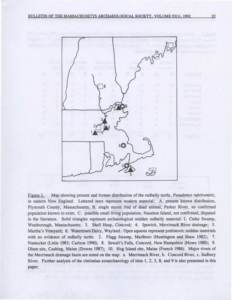
The former New England distribution ofthe redbelly turtle was wider than it is now, andit appears to have become locally extirpated atleast partially through the predatory pressure ofprehistoric man. Several other instances of theoccurrence of redbelly turtle material in prehistoric midden deposits in New England have beenrecorded. Bullen (1949), Waters (1962, 1966),and Rhodin and Largy (1984) have recordedmidden finds at Ipswich, Martha's Vineyard, andConcord. The present record extends the formerrange of the redbelly turtle to Cedar Swamp,Westborough, at the headwaters of the SudburyRiver, a range extension of ca. 25 km southwestof the Concord record. It also represents the firstrecord of this species as having formerly occurredin Worcester County, Massachusetts.
An additional fragment of Pseudemysrubriventris bone has also recently been found atthe Watertown Dairy site on the Sudbury River inWayland, Massachusetts by Tonya Largy (seeLargy 1983, for site description). I have examined and identified the fragment, a surface find ofcalcined bone of obvious archaeological origin,measuring 9 x 7 mm and 2.5 mm thick. Thepiece represents a carapace fragment showing asuture line and typical subparallel carapacialrugose striations. The fragment is very slightlyconcave, probably representing the medial third ofthe right 8th costal of a subadult animal with thevertebral-pleural suture just lateral to the costiform process.
The finds of redbelly turtle at CedarSwamp and Watertown Dairy confirm the former
widespread distribution of the species in thesouthern extent of the Merrimack River drainagebasin, especially in the Concord and Sudburydrainages. The present and former distribution ofthe redbelly turtle is illustrated in Figure 1.
1Vo/
BULLETIN OF THE MASSACHUSETIS ARCHAEOLOGICAL SOCIETY, VOLUME 53(1), 1992 25
Figure 1. Map showing present and former distribution of the redbelly turtle, Pseudemys rubriventris,in eastern New England. Lettered stars represent modem material: A. present known distribution,Plymouth County, Massachusetts; B. single recent find of dead animal, Parker River, no confirmedpopulation known to exist; C. possible small living population, Naushon Island, not confirmed, disputedin the literature. Solid triangles represent archaeological midden redbelly material: 1. Cedar Swamp,Westborough, Massachusetts; 3. Shell Heap, Concord; 4. Ipswich, Merrimack River drainage; 5.Martha's Vineyard; 6. Watertown Dairy, Wayland. Open squares represent prehistoric midden materialswith no evidence of redbelly turtle: 2. Flagg Swamp, Marlboro (Huntington and Shaw 1982); 7.Nantucket (Little 1983; Carlson 1990); 8. Sewall's Falls, Concord, New Hampshire (Howe 1988); 9.Olsen site, Cushing, Maine (Downs 1987); 10. Hog Island site, Maine (French 1986). Major rivers ofthe Merrimack drainage basin are noted on the map: a. Merrimack River, b. Concord River, c. SudburyRiver. Further analysis of the chelonian zooarchaeology of sites 1, 2, 3, 8, and 9 is also presented in thispaper.
26 Rhodin: Turtle Bone Remains from Cedar Swamp
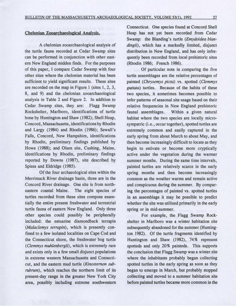
Table II. Chelonian zooarchaeological analysis of five eastern New England prehistoric sites. See text for
sources of data and site descriptions. Only Flagg Swamp material not identified by Rhodin. N = numberof identified fragments of turtle bone, % = percentage of each species' occurrence in each faunal assemblage
as based on number of bone fragments found.
CEDAR FLAGG CONCORD SEWALL'S OLSEN-SWAMP SWAMP SHELLHEAP FALLS SITE
SPECIES N % N % N % N % N %
PAINTED 17 43 10 20 118 38 3 8 12 57sporrED 5 13 36 74 4 1 1 3 2 10SNAPPER 8 20 0 0 13 4 9 -- 25 0 0BOX 4 10 1 2 35 12 0 0 0 0MUSK 4 10 0 0 60 20 1 3 0 0WOOD 1 2 2 4 6 2 22 61 7 33REDBELLY 1 2 0 0 66 21 0 0 0 0BLANDING 0 0 0 0 7 2 0 0 0 0
TOTALS 40 100 49 100 307 100 36 100 21 100
CONCORD
SHELLHEAP
FLAGG
SWAMP
CEDAR
SWAMP
SEWALL'S
FALLS
OLSEN
SITE
PAINTED
SPOTTED
SNAPPER
BOX
MUSK
WOOD
REDBELLY
BLANDING
Figure 2. Graphic representation of the chelonian zooarchaeological analysis presented in Table II.
Horizontal lengths of solid bars represent the percentage of each species' occurrence in each faunal
assemblage, with the total for each site adding up to 100%, and the scale identical for each site.
/Vol
BULLETIN OF THE MASSACHUSETIS ARCHAEOLOGICAL SOCIETY, VOLUME 53(1), 1992 27
Chelonian ZooarchaeololUcal Analysis.
A chelonian zooarchaeological analysis ofthe turtle fauna recorded at Cedar Swamp sitescan be performed in conjunction with other eastern New England midden finds. For the purposesof this paper, I compare Cedar Swamp with fourother sites where the chelonian material has beensufficient to yield significant results. These sitesare recorded on the map in Figure 1 (sites 1, 2, 3,8, and 9) and the chelonian zooarchaeologicalanalysis in Table 2 and Figure 2. In addition toCedar Swamp sites, they are: Flagg SwampRockshelter, Marlboro, identifications of turtlebone by Huntington and Shaw (1982); Shell Heap,Concord, Massachusetts, identifications by Rhodinand Largy (1984) and Rhodin (1986); Sewall'sFalls, Concord, New Hampshire, identificationsby Rhodin, preliminary findings published byHowe (1988); and Olsen site, Cushing, Maine,identifications by Rhodin, preliminary findingsreported by Downs (1987), site described bySpiess and Eldridge (1985).
Of the four archaeological sites within theMerrimack River drainage basin, three are in theConcord River drainage.· One site is from northeastern coastal Maine. The eight species ofturtles recorded from these sites compose essentially the entire present freshwater and terrestrialturtle fauna of eastern New England. Only threeother species could possibly be peripherallyincluded: the estuarine diamondback terrapin(Malaclemys terrapin), which is presently confined to a few isolated localities on Cape Cod andthe Connecticut shore, the freshwater bog turtle(Clemmys muhlenbergii), which is extremely rareand exists only in a few small disjunct populationsin extreme western Massachusetts and Connecticut, and the eastern mud turtle (Kinostemon sub
rubrum), which reaches the northern limit of itspresent-day range in the greater New York Cityarea, possibly including extreme southwestern
Connecticut. One species found at Concord ShellHeap has not yet been recorded from CedarSwamp: the Blanding's turtle (Emydoidea blandingii) , which has a markedly limited, disjunctdistribution in New England, and has only infrequently been recorded from local prehistoric sites(Rhodin 1986; French 1986).
Of particular note in comparing the fiveturtle assemblages are the relative percentages ofpainted (Chrysemys picta) vs. spotted (Clemmys
guttata) turtles. Because of the habits of thesetwo species, it sometimes becomes possible toinfer patterns of seasonal site usage based on theirrelative frequencies in, New England prehistoricfaunal assemblages. Within a given naturalhabitat where the two species are locally microsympatric (i.e., occur together), spotted turtles areextremely common and easily captured in theearly spring from about March to about May, andthen become increasingly difficult to locate as theybegin to estivate or become more crypticallyactive under the vegetation during the warmersummer months. During the same time intervals,painted turtles are relatively scarce in the earlyspring months and then become increasinglycommon as the weather warms and remain activeand conspicuous during the summer. By comparing the percentages of painted vs. spotted turtlesin an assemblage it may be possible to predictwhether the site was utilized primarily in the earlyspring or in mid-summer.
For example, the Flagg Swamp Rockshelter in Marlboro was a winter habitation sitesubsequently abandoned for the summer (Huntington 1982). Of the turtle fragments identified byHuntington and Shaw (1982), 74% representspotteds and only 20% painteds. This supportsthe conclusion that Flagg Swamp was a winter sitewhere the inhabitants probably began collectingspotted turtles in the early spring as soon as theybegan to emerge in March, but probably stoppedcollecting and moved to a summer habitation sitebefore painted turtles became more common in the
28
later spring months.In contrast, the Concord Shell Heap site
has 38 % painted turtles and only 1% spotted.This would suggest that the site was primarily asummer habitation, not occupied until the latespring when the weather was warm enough tocause most of the spotted turtles to disappear intoestivation. Alternatively, it is possible that thesite was also used in the early spring, but that nosuitable spotted turtle habitat was found in thearea. This hypothesis would appear less likelysince spotted turtles are presently relatively common in the greater Concord area.
The percentages of painteds vs. spottedsfor Cedar Swamp are intermediate between thosefor Flagg Swamp and Concord Shell Heap.Painted turtles accounted for 43 % and spottedturtles 13 %. This may suggest that the site wasneither exclusively a winter to early spring habitation nor strictly a summer site. Instead, thepercentages support the probability that CedarSwamp was an all-year habitation, where spottedturtles were collected in the early spring monthsand then primarily painted turtles in the laterspring and summer months. The two spottedturtle plastral fragments found with visible growthzones support the supposition that spotted turtleswere being collected at the site during the early
spring months. The higher percentage of paintedturtles supports the probability that the site wasalso being actively used during the summermonths. These findings support Warfield's (1986)conclusion that Cedar Swamp was a relativelypermanent habitation where the inhabitants hadcreated a structured site with a complete socialgroup subsisting on a wide local resource base.
The extremely low percentages of eitherpainted or spotted turtles at Sewall's Falls site inNew Hampshire suggest a local scarcity of thesespecies. The correspondingly high percentage of
wood (Clemmys insculpta) and snapping turtles
(Chelydra serpentina) , more cold-tolerant thaneither painteds or spotteds, suggests that Sewall's
Rhodin: Turtle Bone Remains from Cedar Swamp
Falls site was inhabited during a period of timewhen the climate there was colder than it is now.The percentages of turtles in the prehistoric faunaare more similar to some areas of present-dayCanada such as northern Nova Scotia, wherewood and snapping turtles are abundant butpainted turtles uncommon and spotted turtles notknown to occur. The present-day turtle fauna ofthe general Sewall's Falls area resembles that ofprehistoric Concord Shell Heap or Cedar Swamp(with the exception of redbelly and box turtles,which are not known to occur in New Hampshire).
The percentages of painteds and spottedsat Olsen site in Maine suggest an all-year habitation at the northern limit of the range for spottedturtles, where painteds constitute the majority ofthe relatively depauperate turtle fauna, but spotteds were collected when available, and thecold-tolerant wood turtle was relatively abundant.The absence of snapping turtles from Olson site issurprising but may simply reflect the relativelysmall size of the sample available for analysis.
Both Sewall's Falls and Olsen sites arelocated north of the northern range limit of redbelly and box turtles, so their absence in thosefaunas is not surprising, and the distribution ofBlanding's turtles is extremely disjunct, so theirabsence is not unexpected. Box turtles (Terrapene
carolina) were only common at the two summeror all-year habitation sites within the current rangeof the species, Concord and Cedar Swamp, andrelatively uncommon at the winter site, FlaggSwamp. Wood turtles (Clemmys insculpta) wereonly common at the two northern colder climatesites, Sewall's Falls and Olsen site, less commonat the southern warmer weather sites, Concord,Flagg Swamp, and Cedar Swamp. Musk turtles(Sternotherus odoratus), though foul smelling andvery small, were obviously utilized by prehistoric
man, being found at three of the five sites. Theiruse in the diet of prehistoric man has also previously been noted by Adler (1968). The redbelly
!/pL 53
BULLETIN OF THE MASSACHUSETIS ARCHAEOLOGICAL SOCIETY, VOLUME 53(1), 1992 29
turtle (Pseudemys ruhriventris) , as discussedabove, was found at three sites where livingpopulations no longer occur. The evidencesuggests at least partial extirpation at the hand ofprehistoric man. A similar pattern of humaninduced local prehistoric extinction has beendocumented for box turtles in northern New Yorkstate (Adler, 1970).
In conclusion, analysis of the chelonianzooarchaeology of prehistoric sites can augmentour understanding of the resource utilizationpatterns of the inhabitants, the climate and seasonality of the habitation, and the historical distribution and population trends of the turtle speciesencountered. Cedar Swamp and the other sitesexamined in this paper confirm the value of thistype of faunal analysis.
LITERATURE CITED
Adler, Kraig K.
1968 Turtles from archeological sites in the Great Lakes region. Michigan Archeologist 14:147-163.
1970 The influence of prehistoric man on the distribution of the box turtle. Annals of the Carnegie Museum
41 :263-280.
Bullen, R. P.
1949 Excavations in northeastern Massachusetts. Papers of the Peabody Foundation 1(3):129-132.
Carlson, Catherine C.
1990 Seasonality of fish remains from Locus Q-6 of the Quidnet site, Nantucket Island, Massachusetts.
Bulletin of the Massachusetts Archaeological Society 51(1):2-14.
Downs, Elinor F.
1987 Observations of the Graf collection of faunal remains from the Olsen Site, Cushing, Maine. Private
Distribution: 1-5.
French, Thomas W.
1986 Archaelogical evidence of Emydoidea blandingii in Maine. Herpetological Review 17(2):40.
Hoffman, Curtiss
1988 Radiocarbon dates from Massachusetts. Bulletin of the Massachusetts Archaeological Society 49:21-38.
Howe, Dennis E.
1988 The Beaver Meadow Brook site: prehistory on the west bank at Sewell's Falls, Concord, New
Hampshire. New Hampshire Archeology 29:48-107.
Huntington, Frederick W.1982 Preliminary report on the excavation of Flagg Swamp Rockshelter. Institute for Conservation
Archaeology, Pub!. 214, Cambridge, Mass.
Huntington, Frederick W. and Leslie C. Shaw
1982 Turtle remains. In: Preliminary report on the excavation of Flagg Swamp Rockshelter. Huntington,
F. W., ed., pp. 113-117. Institute for Conservation Archaeology, Pub!. 214, Cambridge, Mass.
Largy, Tonya
1983 A controlled study at the Watertown Dairy site. Man in the Northeast 25:95-107.
Little, Elizabeth A.1983 Locus 0-6, Site M52/65, Quidnet, Nantucket, Massachusetts. Nantucket Archaeological Studies 2.
Nantucket Historical Association.
30 Rhodin: Turtle Bone Remains from Cedar Swamp
Rhodin, Anders G. J. and Tonya Largy
1984 Prehistoric occurrence of the redbelly turtle (Pseudemys rubriventris) at Concord, Middlesex County,Massachusetts. Herpetological Review 15(4):107.
Rhodin, Anders G. J.1986 Analysis of prehistoric turtle bone remains from Cedar Swamp, Westborough, Worcester County,
Massachusetts. Archaeological Quarterly of the W. Elmer Ekblaw Chapter. Massachusetts Archaeo
logical Society 8(2):2-9.
Spiess, Arthur E. and Stuart Eldridge1985 Cushing/St. George archaeological survey, 1985. Report on file with the Maine Historic Preservation
Commission, Augusta.
U.S. Fish and Wildlife Service.1985 Revised Plymouth red-bellied turtle recovery plan. U.S. Fish and Wildlife Service, Newton Corner,
MA.Warfield, Ruth
1986 Cedar Swamp-3: a preliminary report on the features. Archaeological Quarterly of the W. Elmer Ekblaw
Chapter. Massachusetts Archaeological Society 8(1):1-50.Waters, Joseph H.
1962 Former distribution of the red-bellied turtle in the Northeast. Copeia 1962(3):649-651.1966 Second find of red-bellied turtle on Martha's Vineyard Island, Massachusetts. Copeia 1966(3):592.
A BRIEF NOTE TO CONTRIBUTORS
The Editor solicits for publication original contributions related to the archaeology ofMassachusetts.
Manuscripts should be sent to the Editorfor evaluation and comment. Authors ofarticles submitted to the
Bulletin ofthe Massachusetts Archaeological Society are requested to follow the style guide for American
Antiquity 48:429-442 (1983). Additional instructions for authors may be found in the Bulletin of the
Massachusetts Archaeological Society. Volume 51:98 (/990).
~o/
This journal and its contents may be used for research, teaching and private study purposes. Any substantial or systematic reproduction, re-distribution, re-selling,loan or sub-licensing, systematic supply or distribution in any form to anyone is expressly forbidden. ©2011 Massachusetts Archaeological Society.
BULLETIN OF THE MASSACHUSETTS ARCHAEOLOGICAL SOCIETY, VOLUME 53(1), 1992
ARCHAEOBOTANICAL CLUES FROM CEDAR SWAMP, WESTBOROUGH, MASS.
Tonya Baroody Largy
INTRODUCTION
31
Plant macrofossils found in southern NewEngland sites consist of both carbonized andnon-carbonized materials. These include woodand bark, nutshell, seeds, stems, roots, leaf andstem galls, and various parts of coniferous trees(needles, the fascicles which hold the leaf bundlestogether, and cone scale tips). All of the abovewere recovered from Cedar Swamp, Westborough, Massachusetts. Since little is known abouthow long these materials preserve in New England's acidic soils, most analysts are wise toconsider only carbonized remains as being ofprehistoric origin unless there is reason to thinkotherwise (Minnis 1981).
Flotation, the recovery method used, is awater separation process which removes macrofossils from their soil matrix. When dried, theyare examined under magnification ranging between lOX and 200X, using a binocular dissectingmicroscope. Then, the specimens are identified to
the nearest taxonomic level. One hundred twentyfour samples of both floated and dry-sifted materials have been analyzed from two sites in CedarSwamp, CS-3 and CS-9.
CONTEXT AND EXTENT OFDISTURBANCE
Context and extent of disturbance on a sitemust be considered when interpreting archaeobotanical remains. CS-3, in particular, showsquite a bit of disturbance from rodents. One was
Copyright 1992 Tonya Baroody Largy
even caught in the act during excavation. Strauss(1978, 1981, 1985) and Hoffman (1987) havediscussed various origins of disturbance from bothnatural and human processes. Hoffman's (1987)article, "Culture's Pitfills: The Evidence forPrehistoric Backfilling", is based partially on datafrom CS-3. He has proposed that several largefeatures were backfilled with basketloads of dirt,possibly from elsewhere on the site. Imaginewhat this means in terms of moving plant materials from one locus to another.
Another factor to consider is featuredensity, which is fairly high, especially at CS-9.Hoffman (1987:44-45) has calculated that 23 % ofthe horizontal area of the site is made up offeatures, some of which bisect each other. Exceptfor selected features, I hesitate to make firmstatements regarding the plant species representedat this site because the original context of deposition is unclear and disturbance has been demon
strated.
PRESENTENVIRONMENT
A site visit was made in early October,
1985 to inventory species growing there today.Trees, woody shrubs, herbaceous plants, vines,mosses and ferns were noted. Tree speciesinclude red maple (Acer rubrum), black cherry(prunus serotina), birch (Betula, sp.), stumpsprouts of the American chestnut (Castanea dentata), white pine (pinus strobus), hickory (Carya,sp.), and oak (Quercus, spp.). Both white and
This journal and its contents may be used for research, teaching and private study purposes. Any substantial or systematic reproduction, re-distribution, re-selling,loan or sub-licensing, systematic supply or distribution in any form to anyone is expressly forbidden. ©2011 Massachusetts Archaeological Society.
32
red oak groups are represented. The diameters ofthe trees indicate they are fairly young. Thehickories and oaks probably are between thirtyand fifty years of age. The few birches noted aredefinitely being crowded out. However, theirpresence indicates early succession in a previouslyopen area.
Shrub species include hazelnut (Col)'lus, sp.),maple-leaved viburnum (Viburnum acerifolium),witch-hazel (Hamamelis virginiana), sheep laurel(Kalmia augustifolia), sweet pepperbush (Clethraalnifolia), swamp azalea (Rhododendron, sp.),arrowwood (Viburnum, sp.), highbush and lowbush blueberry (Vaccinium, sp.), and spiraea(Spiraea, spp.).
Vines of wild grape (Vitis, sp.), dewberry(Rubus, sp.), and greenbrier (Smilax, spp.) arethere today. Also present are low growing species, such as wintergreen (Gaultheria hispidula)and pippsissewa (Chimaphila maculata). Herbaceous species such as knotweed (Polygonum, sp.)and pokeweed (phytolacca americana) are alsopresent.
Wetland species include several species offerns (Filicinae), sphagnum moss (Sphagnum,sp.), sedges (Cyperaceae) and cat-tail (Typha,sp.). Water-lilies (Nymphaeceae) grow in CedarSwamp Pond, but these can not be seen from thesite. All species listed commonly grow in acidicsoils of temperate regions. Many are economicspecies having uses as food, medicine, beverages,firewood, tool handles, etc. These species arenative to the area (Jackson 1909; Seymour 1982)and could have grown on or near the site inprehistoric times.
WOOD DATA
Charred wood of both white oak (leucobalanus group of Quercus) and red oak (erythrobalanus group of Quercus) was recovered fromboth CS-3 and CS-9. White oak acorns were
Largy: Archaeobotanical Clues. Cedar Swamp
valued most by foraging peoples because, withtheir lower tannin content, they required lessprocessing than red oak acorns. However, onlytiny fragments of acorn shell and one acorn cupfragment were recovered. Sycamore (platanusoccidentalis) was also present on both sites but isnot seen today.
Hickory (Cal)'a, spp.) wood and nutshell wasidentified at CS-3, while only a solitary questionable fragment of nutshell was found at CS-9. Oakand hickory would have been valued as firewoodsince both are rated among the highest in BritishThermal Units (U.S.D.E. 1980:4).
The gymnosperm, or conifer wood in thesamples can be classed as Pinaceae, either pine~, sp.), spruce ~, sp.), or larch (Larixlaricina, sp.), based on the presence of resincanals (Core, Cote and Day 1979:90). Atlanticwhite cedar also was identified at both sites. Thesignificance of its presence in Feature 9 at CS-3lies in how nicely it correlates with Sneddon andKaplan's pollen study (1987). The C-14 date of2130+70 B.P. (Beta 15196, uncorrected forC-13;Hoffman 1988), is very close to estimated arrivalfor cedar at mid-zone at 2200 B.P. (Sneddon andKaplan 1987:9).
American chestnut was another late-arrivingspecies. Davis (1983: 172) concludes that itmoved slowly northward from the Appalachiansand did not reach Connecticut until 2000 yearsago. Chestnut wood (Castanea dentata) waspresent in four features at CS-3: Feature 3,Feature 6, Feature 23, and Feature 24. Feature 6yielded a C-14 date of 970+70 B.P. (Beta 15195,uncorrected for C-13; Hoffman 1988), with arange of 900 B.P. to 1040 B.P. This date issupported by the association of a Jack's Reefcomer-notched point (Hoffman 1988). Thus, thisspecies can indicate a terminus post guem, Le., adate after which the species was available as aresource.
The presence of a species in features canprovide clues to site structure. At CS-3, various
S3 AJO)
BULLETIN OF THE MASSACHUSETIS ARCHAEOLOGICAL SOCIETY, VOLUME 53(1), 1992 33
parts of pitch pine (Pinus ri~ida) were recoveredfrom more than one flotation sample. The extreme difference in plant materials identified fromtwo adjoining units, thought to be the same shallow feature, helped discriminate between thefeature and a second shallow feature, a tree whichprobably burned in place. Feature 4, whichspanned two units, S99/WI9 and SlooIW18,appeared to be one large feature during excavation. However, the unit map included a linedemarking a possible separate feature in thesecond unit. When the flotation samples wereanalyzed, Sloo/W18 was replete with fascicles,charred needles, cone scales and bark chips ofpitch pine. The sample from S99IWI9 containedhickory wood, a diffuse-porous wood, and afragment of hickory nut.
SEEDS AND NUTSHELL
Uncharred seeds from Feature 4, Sloo/W18 (CS-3) also included one seed of Gramineae(the grass family), a number of seeds tentativelyidentified as Cyperaceae (sedge family), andLeguminoseae (legumes, subfamily: Papilionoideae, which include the clovers). The clovers areintroduced into New England from Eurasia. Theyare not prehistoric. Their presence may indicateCS-3 was used as pasture at one time, along withevidence provided by the presence of stone walls.A dry cartpath connects with CS-9, to the northwest, where Jason Chamberlain operated a dairyfarm until the mid-19th century (C. Hoffman,1987 personal communication).
Species of charred nutshell and berriesfound at CS-3 include hazelnut (CoQ'lus, sp.),huckleberry (Gaylussacia, sp.), and blackberry/raspberry (Rubus, sp.). The wild species fromthis site commonly grow in this area. Many arelisted in the plant inventory. Any of these mayhave been deposited on the site in a number ofways, both accidental and cultural. Assuming
these seeds were charred shortly after becomingavailable, their preservation would point to asummer through fall season of occupation.
Sometimes both carbonized and non-carbonized seeds of the same species are recoveredfrom a single feature or the same unit. Perhapsthe uncharred seeds are products of earlier generations of plants, which are deposited in the seedbank (naturally deposited seeds awaiting an opportunity to germinate). Years later, if land iscleared by burning, either in late prehistoric or inhistoric times, the seeds buried just under the leaflitter might be charred while their ancestors,buried more deeply, escape charring.
Charred and uricharred seeds of Sumac~, sp.) and sweet-fern (Comptonia peregrina)were identified from the same provenience. Bothspecies are indicators of disturbed soil and bothhave economic uses. Sumac berries are used tomake a beverage which has been compared tolemonade. Sweet-fern is an early successionalspecies that thrives best in disturbed sandy soiland full sunlight. It relies on root sprouts forextending its range. Studies by Del Tredici(1977) of a clear-cut area in Connecticut showthat seeds of sweet-fern retain their viability in thesoil for a period of seventy years. Since manyuncharred, degraded nutlets are present at bothsites, this species is evidence that CS-3, especially, was once more open.
Two charred seeds of an aquatic speciesidentified from CS-3 are Potamogeton, sp.,pondweed, which grows in shallow ponds andwaterways. Its rhizomes are farinaceous andedible (Fernald and Kinsey 1958:85), and wouldhave been a reliable food resource. Two charredseeds tentatively identified as Potamogeton wererecently reported from Feature 37 dated to 590+70 B.P. at the Morgan site, a Late Woodlandfarming community in the Connecticut RiverValley (Lavin 1988: 18). One charred seed tentatively identified as Chenopodiaceae, goosefootfamily, was recovered from Feature 2, CS-3.
34
This seed was larger than most species in thisgenus, but shared other diagnostic characteristics,including its form after being carbonized.
OTHER PLANT PARTS
Other plant parts include a carbonizedfruit capsule of the heath family (Ericaceae) fromCS-9. Its value is primarily as a seasonalityindicator. It is not edible in itself. Variousgenera in this family flower in May through earlyJuly. The fruits are formed in late July throughearly September, depending on the microenvironment and climatic variation. This specimencontains the mature seeds within, implying thisspecimen was charred before the end of the seasonwhen seeds are expelled. It could not have beencharred in this exact state of maturation at anyother time. I examined herbarium specimens
collected in Worcester County by members of theNew England Botanical Club in the months ofNovember, December, and January, and foundthat the seeds had not yet been expelled from theircapsules. Thus, the archaeological specimenmight be assigned seasonality ranging from summer through early winter.
Other species recovered from CS-9 in
clude a charred stem of white water-lily, Nymphaea [odorata]. Its presence suggests a range ofoccupation extending from early June through fall.Since water-lily buds, leaves, seeds and rhizomes
had food value, this resource encompasses severalseasons. The plant dies back in the winter whenshallow ponds freeze over and would not be easilyavailable. The rhizomes of this species measurearound 5 cm in diameter and would be a storableresource after parching or drying for winter use.Frederick Coville (1902) reported in detail howthe Klamath Indians of Oregon harvested andprocessed seeds of Nymphaea polysepala, thegreat yellow water-lily. Huron Smith noted use ofboth the yellow and white water-lily among the
Largy: Archaeobotanical Clues. Cedar Swamp
Potawatomi (1933:65), Menomini (1923:42-43,69-70) and Ojibwe (1932:376,407), who used bothspecies as food and medicine. Closer to homeJohn Josselyn, in New England Rarities Discovered [1672], writes, "Water Lilly, with yellowflowers, the Indians eat the Roots, which are longa boiling, they taste like the Liver of a Sheep...(Josselyn 1972:44)".
CONCLUSION
Archaeobotanical recoveries from sites inCedar Swamp are not plentiful, but the speciesidentified provide clues to subsistence and seasonof occupation, assuming these were carbonizedcontemporaneously with occupation of the site.Several ideas come to mind when considering thecharred wood from Cedar Swamp. I suggest thatcharcoal samples be identified to species beforebeing submitted for radiocarbon dating. Thespecies could be both identified and dated, andthese data would be valuable to those studyingforest succession and migration of species duringthe Holocene. In addition, I see an importantimplication for the archaeologist trying to interpreta site on a limited budget. For example, thepresence of chestnut wood in a feature allows that
feature to be dated to the Middle or Late Woodland, in the absence of other diagnostics.
When all data are. considered, CedarSwamp was an ideal place to live year round.Plant, mammal, reptile, bird and fish resourceswere plentiful. Firewood was available and freshwater, too. The late Allen Morgan, Director ofSudbury Valley Trustees and a well-known birder,
stated that even in the coldest months of winterwhen Cedar Swamp pond is frozen, the outletremains open water for one-quarter mile downstream, providing habitat for birds which might be
added to the family larder. According to Morgan,in recent times, kingfisher and wood duck havebeen observed on the open water in February.
I/I/L 5.3 A/d/
BULLETIN OF THE MASSACHUSETIS ARCHAEOLOGICAL SOCIETY, VOLUME 53(1), 1992 35
Considering plant resources alone, the sitecatchment area could have provided fresh orstorable carbohydrates for a small band of severalfamilies to live year round supplemented by meatobtained from fishing, hunting and trappmg. Therecovery of lithics representing more than onecomponent, the recovery of ceramics, the presence of many features, and the recovered faunalassemblage all support the conclusion that resources in Cedar Swamp were deemed importantenough to draw people again and again throughtime.
Acknowlediments: I would like to thank Dr.Hollis Bedell, Wood Anatomist at the BaileyWetmore Laboratory of Plant Anatomy andMorphology, Harvard University, for her assistance in identifying the sycamore wood from CS-3and CS-9 and for suggestions regarding the waterlily stem. Thanks also to Mary Walker, NewEngland Botanical Club, and Dr. Gerald Kelso,National Park Service, who contributed helpfulcomments. Editor Elizabeth A. Little providedgentle editorial guidance.
TABLE I. CARBONIZED PLANT SPECIES FROM CS-9 FEATURES
WOOD:
SEED:
FRUIT:
Oak, red & whiteAtlantic White CedarSycamorePine family (pinaceae)Diffuse-porous species
Sweet Fern* (C. peregrina)Blackberry/raspberry <Rubus)Huckleberry CGaylussacia)
Heath family** (Ericaceae)
Fea.3Fea.9
Fea. 15
Fea.3
NUTSHELL: Acorn? (Quercus)Hickory? (Carya)
Fea. 16Fea. 147
STEM/ROOT: Fragrant water-lily (Nymphaea [odoratal)*** Fea. 14
*Seeds may be used as a nibble; leaves as tea; available mid-summer through fall.**Species include Sheep Laurel, Sweet Pepperbush, Maleberry, plus others; fruit forms late July-early
September. Leaves used as tea; some species as greens in scarce times.***Both roots and seeds are edible; flowerbuds available in spring; seeds and roots available in autumn.
36 Largy: Archaeobotanical Clues, Cedar Swamp
TABLE II. CARBONIZED PLANT SPECIES FROM CS-3 FEATURES
Fea. 4Fea.4Fea.4Fea. 4
Fea. 6; C-14 age: 970+70 B.P.Fea. 9; C-14 age: 2130+30 B.P.
WOOD: ChestnutAtlantic White CedarOak, red & whiteHickoryPine family (Pinaceae)SycamoreDiffuse-porous species (more than one species)Birch (Betula) Fea. 4Sweet Fern (C. peregrina) Fea. 4, 12Grass family (panicoideae) Fea. 12Grass family (Gramineae) Fea.4Self-heal (prunella vulgaris)* Fea. 4Clover (papilionoideae)* Fea. 4Sumac (Rhus, sp.) Fea. 8Pondweed (potamogeton, sp.) Fea.4Chenopodiaceae Fea.2Dogwood (Comus) Fea.4Blackberry/raspberry (Rubus) Fea. 1, I-A, 2, 4, 9, 12Huckleberry (Gaylussacia) Fea. 2
NUTSHELL: Acorn (Quercus) Fea. 12Hickory (Car:ya) Fea. 3, 4, 13, 15Hazelnut (Cor:ylus) Fea. 2, 5/9, 6, 7, 8, 12, 13
PITCH PINE (pinus rigida):NeedlesFasciclesCone scale tipsBark chips
SEED:
*introduced
REFERENCES CITED
Core, Harold A., Wilfred A. Cote, and Arthur C. Day1979 Wood Structure and Identification. Syracuse University Press, Syracuse.
Coville, Frederick1902 Wokas, A Primitive Food of the Klamath Indians. Report of the United States National Museum:
725-739.
63 /1/0/
BULLETIN OF THE MASSACHUSETIS ARCHAEOLOOICAL SOCIETY. VOLUME 53(1). 1992 37
Davis, Margaret B.1983 Holocene Vegetational History of the Eastern United States. In Late-OuatemllQ' Environments of the
United States, Vol. 2, H. E. Wright, Jr., editor. University of Minnesota Press, Minneapolis.Del Tredici, Peter
1977 The Buried Seeds of Comptonia peregrina, the Sweet Fern, Bulletin of the Torrey Botanical Club,104:270-275.
Fernald, Merritt L., and Alfred C. Kinsey1958 Edible Wild Plants of Eastern North America. Harper and Row, New York.
Hoffman, Curtiss1987 Culture's Pitfill: The Evidence for Prehistoric Backfilling. Bulletin of the Massachusetts
Archaeological Society 48:24-34.1988 Radiocarbon Dates from Massachusetts: An Annotated Listing. Bulletin ofthe Massachusetts Archaeo
logical Society 49:21-39.Jackson, Joseph
1909 A Catalogue of the Flowering Plants and Ferns ofWorcester County. Massachusetts. Worcester Natural
History Society, Worcester.
Josselyn, John1972 New Englands Rarities Discovered [1672, London]. Massachusetts Historical Society, Boston.
Lavin, Lucianne1988 The Morgan Site, Rocky Hill, Connecticut: A Late Woodland Farming Community in the Connecticut
River Valley. Bulletin of the Archaeological Society of Connecticut 51 :7-21.
Minnis, Paul1981 Seeds in Archaeological Sites: Sources and Some Interpretive Problems. American Antiguity 46:1.
Seymour, Frank C.1982 The Flora of New England. Moldenke and Moldenke, Plainfield, N.J.
Smith, Huron1923 Ethnobotany of the Menomini. Bulletin of the Public Museum of Milwaukee 4(1).
1932 Ethnobotany of the Ojibwe. Bulletin of the Public Museum of Milwaukee 4(3).1933 Ethnobotany of the Potawatomi. Bulletin of the Public Museum of Milwaukee 7(1).
Sneddon, Leslie and Lawrence Kaplan1987 Pollen Analysis From Cedar Swamp Pond, Westborough, Mass. Archaeological Quarterly of the W.
Elmer Ekblaw Chapter, Massachusetts Archaeological Society, 9(2):1-15.
Strauss, Alan E.1978 Nature's Transformations and Other Pitfalls: Toward a Better Understanding of Post-Occupational
Changes in Archaeological Site Morphology in the Northeast. Part One: Vegetation. Bulletin of the
Massachusetts Archaeological Society 39:47-63.1981 Nature's Transformations and Other Pitfalls: Toward a Better Understanding of Post-Occupational
Changes in Archaeological Site Morphology in the Northeast. Part Two: Invertebrates. Bulletin of ~
Massachusetts Archaeological Society 42:2-10.1985 Natures's Transformations and Other Pitfalls: Toward a Better Understanding of Post-Occupational
Changes in Archaeological Site Morphology in the Northeast. Part Three: Animal Activity and Frost
Action. Bulletin of the Massachusetts Archaeological Society 46:65-72.
U.S. Department of Energy1980 Heating With Wood. Pamphlet DOElCS-Q158. Washington, D.C.
38 Bradley: In Memoriam: F. M. Carty
IN MEMORIAM: FREDERICK M. CARTY, 1951-1991
James W. Bradley
With the death of Fred Carty this past
summer, the archaeological community in Massachusetts lost an important, if often unrecognized,member. Fred had a lifelong interest in theprehistory of eastern Massachusetts. Joining the
M.A.S. in 1964, he quickly became active in theaffairs of the Society especially as a member of
the South Shore Chapter. Over the next twentyyears, Fred remained an active participant inMassachusetts archaeology and made many substantial contributions, especially in the areas oflithic technology and our understanding of earlysites (Paleo through Archaic) in the Neponset and
other drainages south and west of Boston.
This was the area where Fred grew up andwhich he knew best. Born in Boston in 1951,Fred was raised in Holbrook and graduated fromHolbrook High School in 1969. From 1969 to1973, he attended Beloit College in Wisconsin
receiving a B.A. in anthropology in 1974.Through field schools, Beloit also provided Fred
with the opportunity to participate in archaeologi
cal fieldwork outside Massachusetts. He excavated at the Cahokia site in East St. Louis (1971),
assisted in the salvage of a Late Woodland effigy
mound in Wisconsin (1972), and worked on both
survey and excavation projects in Costa Rica(1973). Costa Rica also gave Fred his first
professional publication (Carty and Lange 1975).
After returning to Massachusetts, Fred
continued to pursue his interests in local prehistory. He worked for the Institute for Conservation
Copyright 1992 James W. Bradley
Archaeology during the late 1970s and was in
volved in the survey and excavation of severalsites in southern New England. In 1979 Fred,along with David Anthony and Linda Towle,joined the State Survey Team of the Massachus
ettts Historical Commission. Established to assistState Archaeologist Valerie Talmage in verifyingand expanding the information contained inMHC's prehistoric site files, the team publishedan initial methodology (MHC 1980a). With hisknowledge of typology and local lithic sources,Fred was an important contributor to the team.
Over the next few years, the Survey Teaminventoried several major institutional collections,adding these data to the MHC files. Fred was amember of the team as they completed examina
tion of the collections at the Bronson Museum,Attleboro (MHC 1980b, 1981c); the PeabodyMuseum at Harvard (MHC 1981a); and theRobert S. Peabody Museum in Andover (MHC
1981b). Even after he left the Survey Team, Fred
continued to provide assistance to the State Ar
chaeologist. His preliminary report on the Gills
Farm site (Carty 1983b) provided the basis forlisting this important Middle Archaic district on
the National Register of Historic Places. Among
the other important sites Fred brought to the
attention of the State Archaeologist was NeponsetWamsutta, the first large Paleo-Indian site recorded in the Neponset drainage (Carty 1984; Cartyand Spiess, in preparation).
My best memories of Fred are from those
times when we were in the field together. He wasa person at home in the natural world, one who
Ala I
This journal and its contents may be used for research, teaching and private study purposes. Any substantial or systematic reproduction, re-distribution, re-selling,loan or sub-licensing, systematic supply or distribution in any form to anyone is expressly forbidden. ©2011 Massachusetts Archaeological Society.
BULLETIN OF THE MASSACHUSETTS ARCHAEOLOGICAL SOCIETY, VOLUME 53(1), 1992 39
saw the landscape and its resources in a way thatfew of us do. Particularly vivid is the memory ofa visit to the Blue Hill River site, a Late Archaiclithic workshop. The ground was covered withspalls, as well as scarred boulders, of Braintreeslate. When I asked Fred what these were, hepicked up a large stone hammer and deftly struckoff one of the boulders a slab-like spall similar tothose on the ground. An ulu preform, he explained, as he started to trim and shape it. Wedid not take time to finish the object, but therewas no question that Fred could have done so and
then gone on to use the tool he had made.
This was Fred's special contribution, awillingness to experiment, along with a desire tounderstand and use traditional technology in waysthat native people did. This approach, he believed, would help us better understand andinterpret the archaeological record. In addition tohis published work (Carty 1983a), Fred's knowledge helped to bring other projects to completion(MHC 1984) and continues to challenge andinspire those who knew him.
BIBLIOGRAPHY
Carty, Frederick M.1983a Report of a Cache of Points Relating to the Susquehanna Tradition. Bulletin of the Massachusetts
Archaeological Society 44:6-16.
1983b The Gills Farm Site (19-NF-40) and the Middle Archaic Cochato Complex: A Preliminary Report.
Ms. on file at the Massachusetts Historical Commission.
1984 The Neponset Wamsutta Site (l9-NF-70), Canton, Massachusetts: Background and Preliminary Report.
Ms. on file at the Massachusetts Historical Commission.
Carty, Frederick M. and Frederick W. Lange
1975 Salt Water Application of the Floatation Technique. Journal of Field Archaeology 2:119-123.
Carty, Frederick M. and Arthur E. Spiess
no date The Neponset Wamsutta Site: A Preliminary Report. Massachusetts Historical Commission
1980a MHC State Reconnaissance Survey: Prehistoric Survey Methodology. Ms on file at the Massachusetts
Historical Commission.1980b MHC State Survey Report: The Bronson Museum, Attleboro. Ms. on file at the Massachusetts Histor
ical Commission.
1981a MHC State Survey Report: The Peabody Museum, Harvard. Ms. on file at the Massachusetts Histor
ical Commission.
1981b MHC State Survey Report: The R. S. Peabody Museum, Andover. Ms. on file at the Massachusetts
Historical Commission.
1981c Report on the Bronson Museum. Bulletin of the Massachusetts Archaeological Society 42:30-36.
1984 Guide to Prehistoric Site Files and Artifact Classification System. Massachusetts Historical
Commission.
40
CONTRIBUTORS
JAMES W. BRADLEY, past director of Preservation Planning at the Massachusetts
Historical Commission, is currently Director of the R. S. Peabody Museum of
Archaeology at Andover.
DR. CURTISS HOFFMAN teaches anthropology at Bridgewater State College and is a
former president of the Massachusetts Archaeological Society.
ALAN LEVEIILEE, Senior Archaeologist and Director of Educational Programs, ThePublic Archaeology Laboratory, Inc., is also chairman of the Warwick, RI,
Historic District Commission.
TONYA BAROODYLARGYofWayland is a consultant in archaeobotany and a research
assistant to Dr Richard H. Meadow, Zooarchaeology Laboratory, Peabody
Museum, Harvard University. Ms. Largy is a long-time member of the W.
Elmer Ekblaw Chapter ofMAS.
ANDERS G. J. RHODIN, MD, is an orthopaedic surgeon in Leominster, and Associate
in Herpetology, Museum of Comparative Zoology, Harvard University.
,A!O/
This journal and its contents may be used for research, teaching and private study purposes. Any substantial or systematic reproduction, re-distribution, re-selling,loan or sub-licensing, systematic supply or distribution in any form to anyone is expressly forbidden. ©2011 Massachusetts Archaeological Society.