B. Argument: Evidence for Evolution by Common Descent 1. Geology 2. Paleontology
New Mexico Bureau of Mines & Mineral Resources
A DIVISION OF
NEW MEXICO INSTITUTE OF MINING & TECHNOLOGY
Geology and paleontology of the Santa Fe Group, southwestern Albuquerque Basin,
Valencia County, New Mexico
by Richard P. Lozinsky¹ and Richard H. Tedford2
'New Mexico Bureau of Mines and Mineral Resources, Socorro, NM 87801 'American Museum of Natural History, New York, NY 10024
SOCORRO 1991

ii
NEW MEXICO INSTITUTE OF MINING & TECHNOLOGY Laurence H. Lattman, President
NEW MEXICO BUREAU OF MINES & MINERAL RESOURCES Charles E. Chapin, Director and State Geologist
BOARD OF REGENTS Ex Officio
Bruce King, Governor of New Mexico Alan Morgan, Superintendent of Public Instruction
Appointed Steve Torres, President, 1967-1997, Albuquerque
Carol A. Rymer, M.D., President-Designate, 1989-1995, Albuquerque Lt. Gen. Leo Marquez, Secretary/Treasurer, 1989-1995, Albuquerque
Robert 0. Anderson, 1987-1993, Roswell Charles Zimmerly, 1991-1997, Socorro
BUREAU STAFF Full Time
ORIN J. ANDERSON, Geologist ROBERT W. EVELETH, Senior Mining Engineer NORMA J. MEEKS, Senior Pub./Bus. Office Clerk RUBEN ARCHULETA, Metallurgical Lab. Tech. Lois GOLLMER, Staff Secretary BARBARA R. POPP, Chemical Lab. Tech. 11 AUGUSTUS K. ARMSTRONG, USGS Geologist IBRAHIM GUMMIER, Metallurgist MARSHALL A. REITER, Senior Geophysicist GEORGE S. AUSTIN, Senior Industrial Minerals Geologist WILLIAM C. HANEBERG, Engineering Geologist JACQUES R. RENAULT, Senior Geologist AL BACA, Maintenance Carpenter II JoHN W. HAWLEY, Senior Env. Geologist JAMES M. ROBERTSON, Senior Economic Geologist JAMES M. BARKER, Industrial Minerals Geologist CAROL A. HJELLMING, Assistant Editor JANETTE THOMAS, Cartographic Drafter II MARGARET W. BARROLL, Post-Doctoral Fellow GRETCHEN K. HOFFMAN, Coal Geologist SAMUEL THOMPSON III, Senior Petrol. Geologist PAUL W. BAUER, Field Economic Geologist GLEN JONES, Computer Scientist/Geologist REBECCA J. Titus, Cartographic Supervisor ROBERT A. BIEBERMAN, Emeritus Sr. Petroleum Geologist FRANK E. Kottlowski, Emeritus Director and State Geologist JUDY M. VAIZA, Executive Secretary LYNN A. BRANDVOLD, Senior Chemist ANN LAMING, Administrative Secretary MANUEL J. VASQUEZ, Mechanic I RON BROADHEAD, Petrol. Geologist, Head, Petroleum Section ANNABELLE LOPEZ, Petroleum Records Clerk JEANNE M. VERPLOEGH, Chemical lab. Tech. II MONTE M. BROWN, Cartographic Drafter II THERESA L. LOPEZ, Receptionist/Staff Secretary ROBERT H. WEBER, Emeritus Senior Geologist KATHRYN E. CAMPBELL, Cartographic Drafter II DAVID W. LOVE, Environmental Geologist SUSAN J. WELCH, Assistant Editor STEVEN M. LATHER, Field Economic Geologist JANE A. CALVERT LOVE, Editor NEIL H. WHITEHEAD, III Petroleum Geologist RICHARD CHAMBERLIN, Field Economic Geologist WILLIAM MCINTOSH, Research Geologist MARC L. WILSON, Mineralogist RICHARD R. CHAVEZ, Assistant Head, Petroleum Section CHRISTOPHER G. McKEE, X-ray Facility Manager DONALD WOLBERG, Vertebrate Paleontologist RUBEN A. CRESPIN, Garage Supervisor VIRGINIA MCLEMORE, Geologist MICHAEL W. WOOLDRIDGE, Scientific Illustrator Lois M. DEVLIN, Director, Bus./Pub. Office LYNNE MCNEIL, Technical Secretary Jun ZIDEK, Chief Editor—Geologist
Research Associates CHRISTINA L. BALK, NMT ALONZO D. JACKA, Texas Tech HOWARD B. NICKELSON, Carlsbad WILLIAM L. CHENOWETH, Grand Junction, CO BOB JULYAN, Albuquerque GLENN R. OSBURN, Washington Univ. RUSSELL E. CLEMONS, NMSU SHARI A. KELLEY, SMU ALLAN R. SANFORD, NMT WILLIAM A. COBBAN, USGS WILLIAM E. KING, NMSU JoHN H. SCHILLING, Reno, NV CHARLES A. FERGUSON, Univ. Alberta MICHALL J. KUNK, USGS WILLIAM R. SEAGER, NMSU JOHN W. GEISSMAN, UNM TIMOTHY E LAWTON, NMSU EDWARD W. SMITH, Tesuque LELAND H. GILE, Las Cruces DAVID V. LEMONE, UTEP JOHN F. SUTTER, USGS JEFFREY A. GRAMBUNG, UNM GREG H. MACK, NMSU RICHARD H. TEDFORD, Amer. Mus. Nat. Hist. RICHARD W. HARRISON, T or C NANCY J. MCMILLAN, NMSU TOMMY B. THOMPSON, CSU CAROL A. HILL, Albuquerque
Graduate Students WILLIAM C. BECK ROBERT L. FRIESEN GARRETT K. Ross JENNIFER R. BORYTA ROBERT S. KING ERNEST F. SCHARKAN, JR. STEPHEN G. CROSS DAVID J. SIVILS
Plus about 30 undergraduate assistants
Original Printing
Published by Authority of State of New Mexico, NMSA 1953 Sec. 63-1-4 P r i n t e d b y U n i v e r s i t y o f N e w M e x i c o P r i n t i n g S e r v i c e s , A u g u s t 1 9 9 1
Available from New Mexico Bureau of Mines & Mineral Resources, Socorro, NM 87801 Published as public domain, therefore reproducible without permission. Source credit requested.

iii
Preface
Most work in this publication was done by Lozinsky as part of a Ph.D. dissertation completed at the New Mexico Institute of Mining and Technology in 1988. Field work was done intermittently from 1984 to 1987. Fossils found during the project, together with earlier discoveries by Theodore Galusha of the American Museum of Natural History, were the basis for the paleontological contribution by Tedford.
This report on the geology and paleontology of the southwestern Albuquerque Basin is important because it is the first study of the Santa Fe Group that combines surface and subsurface information to interpret the depositional history of the area. Although focusing mainly on the Santa Fe Group, this work also discusses pre-Santa Fe Tertiary deposits recognized in oil test wells and provides inferences on the erosion history of the surrounding uplifts.
Acknowledgments—The Huning Land Trust and the McKinley Ranch granted access to the mighty Gabaldon badlands area, and special thanks are due to Jack Huning and Weldon McKinley for their steadfast support of geological research in the area. Shell Oil Company allowed Lozinsky to examine and release some of its seismic reflection data on this southwestern part of the Albuquerque Basin. J. Hawley and D. Love aided Lozinsky in the field and discussions with them greatly helped this study. Major funding was provided by the New Mexico Bureau of Mines and Mineral Resources (F. Kottlowski, Director) through a research assistantship to Lozinsky and field funds to Tedford. Additional funding for Lozinsky was provided by the New Mexico Geological Society. The Frick Laboratory Endowment Fund of the American Museum of Natural History also supported Tedford's work. We are indebted to the late Theodore Galusha, whose careful field records helped us to integrate his collections with those of ours. The recent cataloging and editing of Mr. Galusha's records by Marian Galusha has also been of great help and her contribution is gratefully acknowledged.
Critical reviews by J. Hawley, S. Lucas, G. Smith, and S. Cather improved the content of this report and are sincerely appreciated.

iv
CONTENTS
A B S T R A C T 5 INTRODUCTION 7
GEOGRAPHIC SETTING 7 GEOLOGIC SETTING7
GEOL OGY 7 PREVIOUS WORK 7 METHODS AND TECHNIQUES 8
Mapping and measuring sections 8 Paleocurrent measurements 8 Clast counts 8 Sample collection and preparation 8 Petrographic analyses 8
GABALDON BADLANDS 9 Stratigraphy of Santa Fe Group 10
Popotosa Formation 10 Unit 1 10 Unit 2 11 Unit 3 12
Sierra Ladrones Formation 12 Mohinas Mountain 14
Age of Gabaldon section 14 Structure 15
Bobo BUTTE 15 Stratigraphy of Santa Fe Group 15
Popotosa Formation 15 Sierra Ladrones Formation (?) caprock unit on
Bobo Butte 17
Age of Bobo Butte section 17 OIL TEST WELLS 17
Stratigraphy of units encountered 17 Humble SFP #1 17 Shell SFP #2 18
SANDSTONE PETROLOGY 18 Santa Fe Group 18 Pre-Santa Fe Tertiary deposits 20 Upper Cretaceous deposits 22
PROVENANCE 22 DEPOSITIONAL HISTORY OF SOUTHWESTERN ALBUQUERQUE BASIN 23
PALEONTOLOGY 24 PREVIOUS WORK 24 BIOSTRATIGRAPHY 24 SYSTEMATICS 24
Order Lagomorpha 24 Order Rodentia 24 Order Carnivora 25 Order Perissodactyla 26 Order Artiodactyla 26
BIOCHRONOLOGY AND ZOOGEOGRAPHY 28 CONCLUSIONS 28 REFERENCES 29 APPENDICES 31
I—MEASURED SECTIONS 31 II—POINT-COUNT DATA 35
Tables
1—Point-count parameters 8 2—Clast counts in Gabaldon badlands area 10
3—Clast counts in Bobo Butte area 17
F i g u r e s
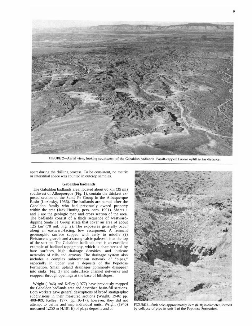
1—Location map for the Gabaldon badlands and Bobo Butte areas 6
2—Aerial photograph of the Gabaldon badlands 9 3—Sink hole in unit 1 of Popotosa Formation 9 4—Stratigraphic chart for Gabaldon badlands 10 5—Unit 1 deposits 11 6—Contact between units 1 and 2 of Popotosa
Formation 11 7—Camel trackway in unit 3 of Popotosa
Forma t io n 13 8—Crossbeds in Sierra Ladrones Formation 14
9—Contact between Triassic sediments and Santa Fe Group 16
10—View of Bobo Butte from the north 16 11—Stratigraphic column for Humble SFP #1 18 12—Stratigraphic column for Shell SFP #2 18 13—Ternary diagrams for Gabaldon badlands 19 14—Ternary diagrams for Bobo Butte 20 15—Ternary diagrams for oil test wells 21
16—Rose diagram for Popotosa Formation units 1-3 22
17—Rose diagram for Sierra Ladrones Formation 23 18—Fossil bone drawings of Leporidae, Castoridae, and Canidae 25
19—Fossil bone drawings of Camelidae 26 20—Fossil bone drawings of Antilocapridae 27
Shee ts
1—Geology of the Gabaldon badlands area in pocket 2—Geologic cross sections of the Gabaldon badlands
area in pocket
3—Geology of the Bobo Butte area in pocket

5
Abstract Santa Fe Group outcrops in the southwestern Albuquerque Basin occur in the Gabaldon badlands and
Bobo Butte areas. Two oil test wells located near the Gabaldon badlands, the Humble Santa Fe Pacific #1 and Shell Santa Fe Pacific #2, penetrate the Santa Fe Group and pre-Santa Fe Tertiary deposits and bottom in Mesozoic bedrock.
In the Gabaldon badlands, the thickness of the exposed Santa Fe Group is at least 1,138 m (3,732 ft) and may be as much as 1,800 m (6,000 ft). In the Humble Santa Fe Pacific #1 and Shell Santa Fe Pacific #2 wells, the Santa Fe thickness is 1,494 and 1,460 m (4,902 and 4,790 ft), respectively. The thickness of the exposed Santa Fe section at Bobo Butte is 246 m (807 ft). In the oil test wells, up to 1,097 m (3,600 ft) of pre-Santa Fe Group Tertiary deposits, which are correlative with possible Baca Formation and an unnamed post-Baca/pre-Santa Fe unit, underlie the Santa Fe Group. These pre--Santa Fe deposits indicate the presence of a depositional basin that predates the Albuquerque Basin.
The Santa Fe Group exposed in the Gabaldon badlands area is divided into four units that correlate with the Popotosa Formation (units 1-3) and the Sierra Ladrones Formation. Units 1-3 of the Popotosa Formation were deposited in a closed-basin, distal-fan/basin-floor environment at a calculated sedimentation rate of 204 m/m.y. (669 ft/m.y.). The Sierra Ladrones Formation was deposited by a large, throughflowing, fluvial system and local alluvial-fan distributaries on adjacent piedmont slopes. Santa Fe Group deposits in the Bobo Butte area correlate with parts of the Popotosa Formation and were deposited in a proximal fan area. The caprock unit on Bobo Butte is probably correlative with at least part of the Sierra Ladrones Formation.
Analysis of outcrop and thin-section data indicates that the Popotosa Formation in the southwestern Albuquerque Basin was derived from the Lucero uplift. At the time units 1-3 were deposited, the Lucero uplift was covered by at least one Tertiary ash-flow-tuff sheet and Upper Cretaceous strata. These rocks have since been eroded from the Lucero uplift and deposited in the southwestern Albuquerque Basin. The fluvial facies of the Sierra Ladrones Formation was at least partly derived from more distant source areas to the west and northwest. Outcrop data show that the caprock unit on Bobo Butte was derived from the Lucero uplift.
Vertebrate fossils recovered from the Gabaldon badlands include Epicyon sp. cf. E. haydeni validus, Dipoides sp. cf. D. vallicula, Michenia sp. cf. M. yavapaiensis, and Plioceros sp. Fossils from units 2 and 3 indicate an early Hemphillian age (7-9 Ma), and the upper part of unit 1 is perhaps slightly older (latest Clarendonian).


7
Introduction
The uppermost Oligocene to middle Pleistocene Santa Fe Group is the major synorogenic deposit of the Rio Grande rift. Sedimentary fill of the Santa Fe Group includes piedmont-alluvial, playa, fluvial, and eolian deposits that locally reach thicknesses of over 4,000 m (13,000 ft; Lozinsky, 1988). The thickest exposed section of the Santa Fe Group lies in the southwestern part of the basin. Most studies of the Santa Fe Group have been conducted in the northern part of the Albuquerque Basin, whereas studies in the southwestern part have been few. Thus, the southwestern part A the basin is a critical area for studying the Santa Fe Group and the depositional history of the Albuquerque Basin.
The purpose of this investigation is to examine the stra-tigraphy, structure, sandstone petrology, paleontology, and depositional history of the Santa Fe Group in the south-western part of the Albuquerque Basin. This is the first study on this area that incorporates detailed field mapping, oil-test-well analysis, sandstone petrology, and paleontol-ogy to interpret the depositional history of the southwestern Albuquerque Basin and the erosional history of the Lucero Liplift.
Geographic setting The southwestern Albuquerque Basin lies within the
northern portion of the Mexican Highland section of the Basin and Range physiographic province (Fenneman, 1928; Hawley, 1986). Low topographic relief characterizes the re-gion. Elevations range from about 1,520 m (5,000 ft) along the Rio Puerco to over 2,100 m (6,800 ft) in the Lucero uplift. The Rio Puerco flows through the southwestern basin area (Fig. 1) and forms a prominent valley. Minor landforms include mesas, low hills, and alluvial slopes.
The southwestern Albuquerque Basin area is sparsely populated. Paved and dirt roads provide good access into
most areas, but many parts of the area have restricted access due to private and Indian ownership.
Geologic setting The Albuquerque Basin is one of the largest of the struc-
tural and physiographic basins that comprise the Rio Grande rift. It is composed of a northern, eastward-tilted half-graben and a southern, westward-tilted half-graben (Lozinsky, 1988). The southwestern basin area lies within the southern half-graben.
Within the Albuquerque Basin, major basin-bounding faults do not occur along the topographically high margins, but instead are farther basinward (Lozinsky, 1988). Seismic reflection data suggest that the major basin-bounding fault in the southwestern Albuquerque Basin occurs beneath the present position of the Rio Puerco. Oil-test-well control in this area is too poor to confirm the location of the fault, but the water-table contour map of Titus (1963) shows a major drop in the ground-water level across this zone, perhaps indicating a fault.
The Ladron Mountains and the Lucero uplift form the southwestern margin of the Albuquerque Basin. The Ladron Mountains are a pyramid-shaped, structurally complex horst that consists mostly of Precambrian granitic and meta-morphic rocks with minor amounts of upper Paleozoic sed-imentary units. The Lucero uplift dips gently to the west and contains mainly upper Paleozoic limestone, shale, and sandstone capped by late Cenozoic basalt flows. The fault that separates the Lucero uplift from the basin is extremely complex and shows Laramide-age reverse and possibly strike-slip motion with later late Cenozoic normal faulting (Callender and Zilinski, 1976; Hammond, 1987).
Geology
Previous work Hayden (1873) first proposed the name "Santa Fe marls"
for basin-fill deposits in the Espanola Basin just north of Santa Fe. These deposits were renamed the "Santa Fe For-mation" by Darton (1922). Bryan and McCann (1937, 1938) were the first to study the Santa Fe Formation in the Al-buquerque Basin. Working mainly in the northwestern part of the basin, these researchers extended the Santa Fe For-mation into the Albuquerque Basin from the north and sub-divided it into three informal units based primarily on color: lower gray, middle red, and upper buff. Kottlowski (1953) and Spiegel and Baldwin (1963) proposed that the Santa Fe Formation be raised to group rank, and this rank has be-come accepted by most workers.
The earliest work on the Santa Fe Group in the south-western region was by Denny (1940) who described areas east and south of the Ladron Mountains extending into the northern Socorro and La Jencia Basins. He divided the basin fill into two formations: the late Miocene (?) Popotosa and the late Miocene (?) to Pliocene Santa Fe. He also recognized that the Popotosa represented closed-basin drainage, whereas the Santa Fe contained both closed-basin and throughflowing deposits. Wright (1946) studied and mapped the southwestern basin area using the Santa Fe subdivisions of Bryan and McCann (1937). He correlated these subdivisions with those described by Denny (1940) and constructed paleogeographic maps depicting the area during Santa Fe time. Although Wright (1946) believed that the playa deposits in
the Gabaldon section were similar to the playa deposits in the Popotosa Formation, he did not think they were cor-relative because the Popotosa Formation was thought to be an older unit. The Popotosa Formation outcrops east and south of the Ladron Mountains were also described by Bruning (1973).
Kelley (1977) mapped the southwest region and measured a section in the Gabaldon badlands as part of his basin-wide study of the Albuquerque Basin. At the southern end of the Albuquerque Basin in the San Acacia quadrangle, Machette (1978a) divided the basin fill into two units that essentially coincide with Denny's (1940) Popotosa and Santa Fe Formations. However, Machette (1978a) followed modern Santa Fe Group usage and included both of Denny's (1940) formations in the Santa Fe Group, renaming the upper unit the Sierra Ladrones Formation. He also established ages for these formations; the early to late Miocene Popotosa and the middle Pleistocene to early Pliocene Sierra Ladrones. Machette (1978b) also mapped the Sierra La-drones Formation as far north as Albuquerque.
Love and Young (1983) and Love (1986) undertook a de-tailed study of sediment dispersal patterns of the Santa Fe Group and post—Santa Fe deposits in the southwestern basin area. They used this information to interpret the depositional history of these deposits. Lozinsky (1986) briefly described the geomorphology and some of the major strati-graphic, sedimentologic, and paleontologic features of the Gabaldon badlands area. Asher-Bolinder (1988) has recently
8
described reference sections in Denny's (1940) type area of the Popotosa south of the Ladron Mountains. She estimated that the formation in this type area is as much as 1,447 m (4,747 ft) thick and ranges in age from more than 26.4 Ma to less than 7 Ma. These ages are based on dated volcanic units that are interbedded with and cap the formation.
Methods and techniques
Mapping and measuring sections The Gabaldon badlands and Bobo Butte areas were mapped
geologically on U.S. Geological Survey 71/2-minute quad-rangles at a scale of 1:24,000. Quadrangle names are shown on the maps (Sheets 1, 3). Vertical, color aerial photographs at a scale of 1:31,000 aided field mapping.
The stratigraphic sections of the Santa Fe Group measured in the Gabaldon badlands and Bobo Butte areas are shown on Sheets 1 and 3. Descriptions of the measured sections are in Appendix I. The two sections were measured primarily using a Jacob's staff and Abney level; however, the lower part of unit 1 in the Gabaldon badlands was measured with a theodilite and tape because outcrops are widely separated by a thin cover of younger alluvium. A Munsell chart aided in color determination of the deposits.
Paleocurrent measurements Paleocurrent directions were determined from imbricated
clasts, crossbeds, and parting lineations. These paleocurrent studies aided in source-area determination.
In a well-exposed, coarse to very coarse conglomeratic bed, clast imbrication measurements were made on the largest clasts (15-25 cm (5-10 in) in diameter in about a 1 m2 (10 ft-2) area) using a Brunton compass. The azimuth of the dip direction was recorded, and rose diagrams were constructed from the data.
Trough crossbeds are abundant in the Sierra Ladrones Formation deposits of the Gabaldon badlands. Paleoflow direction in these beds was calculated by using the strike and dip of the trough margins. These data were then plotted on a stereonet diagram. The resultant girdle on the stereonet indicates the paleoflow direction (DeCelles et al., 1983).
Parting lineations were measured on bedding surfaces in sandstone beds with a Brunton compass. These lineations may be the result of imperfections in cementation (Potter and Pettijohn, 1977). The lineations are parallel to the flow direction; however, they only show the line of movement and not the flow direction. Other paleoflow indicators (e.g., imbricated clasts) must be used in conjunction with parting lineations to determine flow direction.
Clast counts Clast counts were made on coarse to very coarse beds that
contained pebbly to cobbly material. These counts were used to characterize lithologic types in the deposits and to help in provenance determination. Within a 30-m2 (100-ft2) area, clasts were counted noting rock type in approximate 30-cm (1-ft) intervals. A total of 50 clasts were counted at each location.
Sample collection and preparation Samples from outcrops and well cuttings were used for
petrographic analysis. Outcrop samples were collected mainly from sandy intervals in the measured sections. Cuttings from the two oil test wells, Santa Fe Pacific #1 and Santa Fe Pacific #2, were examined initially with a binocular microscope in order to construct a provisional stratigraphic column for each well and to determine sample intervals for thin-section work. Cuttings were examined at approximate 6-m (20-ft) intervals.
Based on the preliminary cutting analysis, samples for thin-section study were collected at approximate 300-m (1,000) intervals. In zones within the wells where more detail was needed, shorter sample intervals were used. Once the samples were collected from both outcrops and cuttings, they were prepared for standard thin-section analysis. For a more complete description of these procedures, see Lozinsky (1988).
Borehole geophysical logs were available for the two oil test wells. These logs, primarily resistivity and spontaneous potential, aided in the cutting analysis and in determining contacts between units within the wells.
Petrographic analysis Thin sections of outcrop and drill-hole samples were an-
alyzed using criteria described by Dickinson (1970) in order to determine detrital modes and provenance. Four hundred framework grains per thin section were counted with a Nikon binocular microscope and Swift point counter. Pa-rameters counted and used to determine petrofacies are listed in Table 1. Although the Gazzi-Dickinson point-counting method does not use granitic rock fragments as a counting parameter, they were noted when observed for provenance determination.
One problem in petrographic work is differentiating be-tween polycrystalline quartz (chert) and silicic volcanic grains. In this study, the grain was counted as a volcanic lithic grain if crystal laths could be recognized or the groundmass was feldspar stained. Otherwise, it was counted as a polycrystalline quartz grain.
Based on the point-count data, ternary diagrams were constructed. After each point count, the thin section was further examined to determine grain size, sorting, round-ness, and other important features for provenance inter-pretations. Only framework grains were counted. Matrix and interstitial space were not counted because most of the well-cutting samples were loosely consolidated and broken
apart during the drilling process. To be consistent, no matrix or interstitial space was counted in outcrop samples.
Gabaldon badlands The Gabaldon badlands area, located about 60 km (35 mi)
southwest of Albuquerque (Fig. 1), contain the thickest ex-posed section of the Santa Fe Group in the Albuquerque Basin (Lozinsky, 1986). The badlands are named after the Gabaldon family who had previously owned property within the area (Jack Huning, pers. corn. 1991). Sheets 1 and 2 are the geologic map and cross section of the area. The badlands consist of a thick sequence of westward-dipping Santa Fe Group strata that cover an area of about 125 km' (78 mil; Fig. 2). The exposures generally occur along an eastward-facing, low escarpment. A remnant geomorphic surface capped with early to middle (?) Pleistocene gravels and a strong calcic paleosol is at the top of the section. The Gabaldon badlands area is an excellent example of badland topography, which is characterized by bare surfaces, high drainage densities, and intricate networks of rills and arroyos. The drainage system also includes a complex subterranean network of "pipes," especially in upper unit 1 deposits of the Popotosa Formation. Small upland drainages commonly disappear into sinks (Fig. 3) and subsurface channel networks and reappear through openings at the base of hillslopes.
Wright (1946) and Kelley (1977) have previously mapped the Gabaldon badlands area and described basin-fill sections. Both workers gave general descriptions of broad stratigraphic subdivisions in their measured sections (Wright, 1946: pp. 408-409; Kelley, 1977: pp. 16-17); however, they did not attempt to define and map individual units. Wright (1946) measured 1,250 m (4,101 ft) of playa deposits and at

10
least 213 m (699 ft) of alluvial-fan deposits for a total Ga-baldon section thickness of at least 1,463 m (4,800 ft); the precise location where the section was measured is not known. Wright (1946) correlated these deposits with the lower gray and middle red members (playa deposits) and the upper buff member (alluvial-fan deposits) of Bryan and McCann's (1937) Santa Fe Formation. Wright (1946) believed that the thick playa deposits may have been part of a large playa system occupying the southern Albuquerque Basin during Santa Fe time.
Kelley (1977) also measured a section in the Gabaldon badlands, but he determined its total thickness to be 944 m (3,098 ft) and its lower 610 m (2,001 ft) to represent playa deposits. During a rapid reconnaissance of the Gabaldon badlands area, Machette (1978b) included all exposed basin fill in the Sierra Ladrones Formation; he did not recognize that units 1, 2, and 3 (of this report) are actually part of the lower Santa Fe Group.
Stratigraphy of Santa Fe Group The Gabaldon section of the Santa Fe Group measured in
this study is 1,138 m (3,732 ft) thick (Appendix I). This is an incomplete section because: (1) a major fault has removed the lower part of the section; (2) another fault has removed an unknown thickness of unit 1 of the Popotosa Formation; and (3) 115 m (375 ft) of section is covered by younger alluvium. The actual exposed thickness may be near 1,800 m (6,000 ft) if the lower faulted-out section is included. The Gabaldon section was divided into four units based on facies type, erosional pattern, and dip angle (Sheet 1). Units 1, 2, and 3 are assigned to the Popotosa Formation, whereas the unconformably overlying unit 4 is correlated with the Sierra Ladrones Formation (Fig. 4). Wright's (1946) playa deposits generally correlate with units 1-3, and his alluvial-fan deposits are similar to the Sierra Ladrones Formation. Dips of beds in units 1-3 range from 10 to 15°, but Sierra Ladrones beds dip from 4 to 5°. For a more detailed description of these units, see Appendix I.
Popotosa Formation Unit 1—Unit 1 of the Popotosa Formation is the thickest of the units mapped in the Gabaldon badlands area and forms the more subdued, rounded hills in the lower part of the section (Fig. 5). The total measured thickness is 585 m (1,914 ft; see measured section in Appendix I). Lower unit 1 de-posits are exposed west and southwest of Mohinas Mountain (Sheet 1). These deposits correspond to the strata faulted
out at the base of the measured section. The approximate thickness of this section is 600 m (1,968 ft), which brings the total exposed thickness of unit 1 to about 1,200 m (4,000 ft).
Interbedded fine-grained sand and clay characterize most of unit 1. Sand beds are usually moderately to well sorted, loosely consolidated, light brown to yellowish brown, 3060 cm (1-2 ft) thick, crossbedded, and locally well cemented. Climbing ripples occur locally within the sand beds. Clay beds are light brown to reddish brown, typically 30-120 cm (1-4 ft) thick, laminated (locally wavy and containing mud-cracks), and weather to form rough "popcorn"-textured slopes. In two samples from unit 1, Anderholm (1985) de-termined that the clay fraction includes the following clay minerals (in descending order of abundance): mixed-layer illite/smectite, kaolinite, calcium smectite, and illite. Scat-tered nodular, calcium carbonate layers and secondary gyp-siferous beds also occur. Locally, gypsum rosettes (up to 6 cm (2 in) in diameter) are found within the gypsiferous beds. The upper 200 m (650 ft) of unit 1 coarsens upward to contain mostly fine- to coarse-grained sand with minor clay interbeds. At the top, scattered pebbles and rare cobbles occur within the sand beds. Unit 1 also coarsens northward in the area west and southwest of Mohinas Mountain. There, unit 1 contains interbeds of coarse- to very coarse grained sand and lenticular conglomerate that are very similar to those in unit 2 (Table 2).
Most of unit 1 is barren of fossils, except near the top where a fossiliferous zone was discovered. Two approxi-mately 15-cm-(6-in)-thick ash beds are exposed along a ma-jor arroyo (see Sheet 1 for locations). They are lenticular in shape and mostly water-laid. Paleosols are rare.
The abundance of fine-grained sand and clay indicates that the sediments of unit 1 were deposited within a low-to moderate-energy environment. Sand and clay were de-posited mainly by sheetwash flow that formed thin, tabular beds. The climbing ripples indicate that deposition rates were probably high. The low amounts of gypsum and the preservation of sedimentary structures (i.e., wavy lami-nations, mudcracks) further show that these sediments were

not deposited within a saline lake because the growing salt crystals would have destroyed the sedimentary structures. Thus, unit 1 deposits seem to best fit the "dry mudflat and sandflat" subenvironment of Hardie et al. (1978) that exists in basin-floor areas between the distal ends of an alluvial fan and playa. Some of the fine-grained sand is probably eolian. The coarser, unit 2-like beds in the northern part of the map area may represent alluvial-fan tongues. Evidence for this interpretation is discussed below.
Unit 2—The distinctly redder and stronger cliff-forming beds that overlie the more subdued unit 1 deposits comprise the unit 2 deposits. The cliffs in unit 2 are typically ledgy with rilled faces between the ledges (Fig. 6). The measured thickness of unit 2 is 193 m (633 ft). The unit thickens to the north and thins to the south. The southern extent of unit 2 is unknown because younger valley fill (Sheet 1) covers the region south of the measured section. Here, unit 2 deposits form a south-trending chain of isolated outcrops that

12
can be traced until the outcrops end. It is unclear, however, if these deposits pinch out because, where they should reappear in a north-facing cliff, only Sierra Ladrones Formation deposits cover the area. Unit 2 possibly continues in the subsurface beneath Sierra Ladrones sediments.
The contact between units 1 and 2 of the Popotosa For-mation is gradational. This contact is mapped at the base of the lowest conglomeratic sand that contains abundant cobble-size ash-flow-tuff clasts. Unit 2 consists mainly of poorly sorted, light-brown to brown, fine- to very coarse grained sand and conglomeratic sand with clay and silt interbeds. Conglomeratic beds are usually lenticular and matrix supported, but do have crude stratification and grading. Clast lithology (Table 2) is dominated by ash-flow tuff (80-90%). G. R. Osburn (pers. comm., 1986) identified some of these ash-flow-tuff clasts as the La Jencia or Vicks Peak Tuffs of the Mogollon-Datil volcanic field located southwest of the map area. The red to reddish-brown silt and clay beds are typically 30-90 cm (1-3 ft) thick and locally laminated. Unit 2 deposits generally fine upward into unit 3 deposits.
Near the top and bottom of unit 2 are two lenticular ash beds (see Sheet 1 for locations), each less than 15 cm (6 in) thick. A few fossil bones were recovered from the base of unit 2. Local 30-60-cm-(1-2-ft)-thick red clay zones are in-terpreted to be paleosols because the beds redden upward and contain abundant clay.
The coarser, sometimes channelized beds show that unit 2 was deposited in a higher energy environment than unit 1. Some of the silt, sand, and conglomeratic sand beds are believed to have been deposited by mudflows and debris flows due to the poorly sorted, matrix-supported, and len-ticular nature of the beds (Costa, 1984). However, many of these beds are graded and display stratification that indicates a fluvial origin. These deposits have many of the physical characteristics of alluvial-fan deposits as described by Bull (1972) and Nilsen (1982). These characteristics include the criteria that an alluvial-fan deposit: (1) is oxidized and rarely contains well-preserved organic
material; (2) commonly consists of mudflow and debris-flow deposits,
water-laid deposits, or both; (3) has beds that vary in particle size, sorting, and thick-
ness; (4) has intertonguing relations with units of other depositional
environments. The clay beds, especially those in the upper part of the
unit, are similar to clay beds in unit 1. Therefore, the unit 2 sediments were deposited in a distal piedmont-slope en-vironment and in the adjacent mudflat area, slightly higher up the piedmont-slope than unit 1 deposits. The upward-fining sequence indicates that the alluvial-fan complex was eventually buried by an expanding basin-floor depositional system.
Unit 3—The unit 3 deposits of the Popotosa Formation can be divided into two subunits: a lower slope-forming, clay-dominated subunit that is similar to unit 1 and an upper cliff-forming, sand-dominated subunit that coarsens upward. Unit 3 as a whole was measured as 216 m (706 ft) thick, but thickness increases towards the north and south. In most areas, the contact between unit 2 and unit 3 is mapped at the top of a 1-m-(3-ft)-thick, well-cemented sandstone bed. Both younger alluvium and Sierra Ladrones deposits overlie unit 3 in the Gabaldon badlands area. In the south, younger alluvium partly buries unit 3 deposits, which form another chain of outcrop "islands" (see Sheet 1). In this area, because of a possible pinch-out of unit 2, it is
unclear if unit 3 is underlain only by unit 2 or directly by unit 1.
The lower third of unit 3 is dominated by clay beds with minor fine- to medium-grained sand interbeds. These light-brown to reddish-brown clay beds are locally laminated and are up to 2 m (6 ft) thick. They rarely contain gypsum, and they weather to form "popcorn"-textured slopes. Sand beds are light-brown to brown, up to 1 m (3 ft) thick, locally crossbedded, and moderately to well sorted. Fossiliferous horizons are scattered throughout the section, but the lower 30 m (100 ft) contain the most fossiliferous zone in the Gabaldon section (Fig. 7). Fine- to coarse-grained sand be-comes dominant in the upper two-thirds of the unit. In the upper part, sand beds up to 1.5 m (5 ft) thick are commonly crossbedded and contain scattered pebbles, which are lith-ologically similar to those in unit 2. Clay beds are similar to the underlying clay beds, except thicknesses are usually 30-60 cm (1-2 ft). A few of the red clay zones are believed to be paleosols.
The lower subunit has many of the same sedimentologic characteristics as unit 1. This similarity suggests that the lower subunit of unit 3 was also deposited in a mudflat subenvironment as defined by Hardie et al. (1978); this en-vironment could have been contiguous with a large playa area. However, the coarsening-upward sequence in the upper subunit indicates that it was not deposited in a mudflat area, but rather in a distal piedmont environment such as that formed by coalescing alluvial fans. The relatively poor sorting, lenticular beds, and variation in bed thickness lend support to this interpretation. The upper subunit deposits are better sorted, more commonly crossbedded, and contain less matrix-supported beds than unit 2 deposits, suggesting that this subunit was dominated by fluvial processes rather than debris-flow and mudflow deposition. In all, unit 3 deposits display a transition from a basin-floor mudflat to distal piedmont-slope environments.
Sierra Ladrones Formation The buff to light-brown, cliff-forming deposits of the Sierra
Ladrones Formation cap the Gabaldon section. The total measured thickness of the Sierra Ladrones Formation is 146 m (479 ft). The unit rests with a 4-5° angular unconformity on unit 3 in most places, except in the south, where Sierra Ladrones deposits truncate older deposits and rest directly on unit 1 (Sheet 1). Within the Sierra Ladrones, dips of beds decrease from about 9° at the base to about 4-5° at the top. A constructional, geomorphic surface, of possible early to middle Pleistocene age, is very locally preserved at the top of the Sierra Ladrones Formation. Associated with this surface in the uppermost Sierra Ladrones beds is a 60-90-cm(2-3-ft)-thick, stage III-IV calcic horizon (Gile et al., 1981). At one time, the Sierra Ladrones Formation probably covered a much larger area. With uplift, these deposits were eroded back to expose the Gabaldon section.
Locally, very coarse gravel beds are preserved in the up-permost Sierra Ladrones beds along the western escarpment (locations for these beds are shown on Sheet 1). Kelley (1977) considered these beds to postdate the Santa Fe and included them with his Ortiz "pediment" deposits. Field evidence shows no unconformity at the base of the gravels, and clast types are similar to those in the basal beds of the Sierra Ladrones Formation. In this investigation, these gravels are considered part of the Sierra Ladrones Formation. The coarse beds may represent the western edge of an alluvial unit deposited by a high-energy fluvial system that flowed from the north into the present Gabaldon badlands area. These beds may record the final deposition of the Santa Fe Group that formed the constructional surface preserved lo-

cally west of the badlands (Mesa Mojinas surface of Love and Young, 1983) and extensively east of the Rio Puerco valley (Llano de Albuquerque).
The Sierra Ladrones Formation is a sand-dominated unit with minor clay and silt interbeds. Sand beds are light gray to light brown, loosely consolidated, fine- to very coarse grained, moderately to well sorted, abundantly cross-bedded, and up to 1.5 m (5 ft) thick (Fig. 8). Scattered pebbles occur throughout the sand beds. Conglomerate lenses are common in the upper and lower parts of the unit. Clasts are subangular to subrounded, range in size from pebbles to small boulders (30 cm (1 ft) in diameter), and are both clast- and matrix-supported. Clast lithology is more varied than clasts found in the underlying units and includes chert, light-colored sandstone, granite, limestone, and silicic to mafic volcanic rocks. Table 2 shows the clast types and their relative abundances. Clay and silt beds are
reddish brown to light brown, locally laminated, and usually <60 cm (<2 ft) thick. Sierra Ladrones deposits generally fine upward from the lower part of the unit into the middle. The middle part of this section (about 50 m (160 ft) thick) forms the more subdued slopes and contains mostly inter-bedded fine-grained sand, silt, and clay. This middle section contains one possible paleosol and, locally, a bed containing abundant ash-flow-tuff clasts in the lower part. This ash-flow-tuff-rich bed represents a piedmont unit and indicates the western margin of the large fluvial system. The unit coarsens upward; the largest clasts (cobbles and boulders) in the section occur in the uppermost beds.
Most of the Sierra Ladrones Formation was deposited by a large fluvial system as evidenced by the moderately to well-sorted, trough-crossbedded sand. Campbell (1976) and Cant and Walker (1978) have determined that trough cross-

bedding, nondefined channels, and high sand-to-clay ratios are important characteristics of braided-river deposits. Sierra Ladrones deposits exhibit these characteristics and, there-fore, are interpreted to have been deposited by a braided-river system. These deposits are very similar to the high-gradient fluvial deposits that are described by Blair (1987) for a unit occurring in an ancient rift basin of Mexico. The characteristics of Sierra Ladrones deposits show that the depositional pattern of the area changed from a piedmont-slope/internally-drained basin-floor complex with coalescent alluvial-fans and playas to a basin-floor fluvial plain (and marginal piedmont) with a throughflowing river system, probably occupied by an ancestral Rio San Jose or Rio Puerco. This important change in depositional patterns rec-ords the transition from closed-basin drainage to through-flowing drainage.
Mohinas Mountain Mohinas Mountain is the large hill in the northeastern
part of the mapped area (Sheet 1). This feature has been interpreted as the exhumed lower part of a volcano by Kel-ley and Kudo (1978). The mountain consists of alkali basalt and olivine diabase that have intruded the lowermost beds of unit 1 of the Popotosa Formation. A large funnel-shaped intrusion forms the core of the mountain, and unit 1 beds around its margin dip inward. Abundant talus and landslide debris cover much of the flanking slopes, making study of the Santa Fe beds difficult on Mohinas Mountain. The in-trusive rocks have locally deformed and altered the unit 1 deposits. Several basaltic sills and at least two breccia pipes have intruded surrounding deposits in and around the mountain.
Hidden Mountain, another volcanic feature that is similar to Mohinas Mountain, is located outside the mapped area
about 2.5 km (1.5 mi) to the north. Both volcanic centers have also been mapped by Gratton (1958) and Kelley and Kudo (1978).
Age of the Gabaldon section Part of the Gabaldon section (Sheet 1) can be dated by
using faunal remains and, in one area, volcanic deposits. Abundant identifiable vertebrate fossil material have been recovered from the uppermost beds of unit 1 and throughout units 2 and 3 of the Popotosa Formation. No identifiable fossil material has been recovered from the lower unit 1 beds, and only one bone was found in the Sierrra Ladrones Formation. Identification of fossil vertebrates and age de-terminations are discussed in the section on paleontology.
As detailed in the section on paleontology, no major faunal changes are recognized in the fossiliferous part of the Po-potosa Formation in the Gabaldon section. The faunal as-semblage suggests an age of 7-9 Ma (early Hemphillian) for this fossiliferous zone. Unfortunately, the ash beds that occur in units 1 and 2 are unacceptable for isotopic dating, so independent verification of age is not possible. Baldridge et al. (1987) have recently reported a K-Ar date for Hidden Mountain of 8.3 Ma ± 0.2. The rocks there intrude the lower unit 1 deposits, and the K-Ar date is consistent with the ages determined by fossils.
Although the age range of the one identifiable fossil in the Sierra Ladrones Formation is too large to be useful for dating, the age of the Sierra Ladrones Formation can be approximated by correlation with other Sierra Ladrones de-posits of known age in other parts of the basin. In the southern part of the Albuquerque Basin, the Sierra La-drones Formation contains a 4.5 Ma ± 0.1 basalt flow near its base and has an estimated 0.5 Ma soil capping the unit (Machette, 1978a; Love and Young, 1983). Thus, the Sierra
Ladrones Formation in the Gabaldon badlands probably ranges in age from about 5 Ma to possibly as young as 1.0 to 0.5 Ma.
Structure Folds and faults deform all four mapped units of the Santa
Fe Group in the Gabaldon section (Sheet 1). However, the Sierra Ladrones Formation is less deformed than the un-derlying units and, within the mapped area, the capping surface is only slightly offset by faulting. As mentioned in the section on stratigraphy, dips of beds generally decrease upsection. Major structures of the Gabaldon badlands are discussed below.
Two major folds occur in the Gabaldon section. The lower part of unit 1 is folded into a large, asymmetrical, southwest-plunging anticline. The southwest extent of this fold cannot be determined because of alluvial cover. Where observed, the anticline deforms unit 1 strata only. The nose of the fold is slightly offset by a fault. In the west-central part of the mapped area, a large, northeast-plunging syn-cline deforms all four units, but deformation is less in Sierra Ladrones deposits. This syncline is more open and sym-metrical than the anticline. Numerous smaller folds occur within the mapped area, particularly in the vicinity of the northeast-trending fault.
Faults are the main structural features in the Gabaldon section. These faults all show normal displacement and gen-erally strike north to northeast. The fault that bounds the section just east of Gabaldon reservoir (Sheet 1) is north-striking and down-to-the-east. The amount of stratigraphic throw is unknown, but is probably not more than about 400 m (1,300 ft) because beds of lower unit 1 occur on both sides of the fault. To the south, this fault splays into at least three segments. Here, the fault plane dips between 65 and 75° to the east. Further south, the fault appears to offset the capping surface deposits (Qs) as evidenced by the increase in slope across the fault projection. The northern extent of the fault is unclear, but it may merge with the northeast-striking fault immediately to the north. A significant north-west-striking, down-to-the-west fault lies about 1 km (0.6 mi) west of the anticline. This fault, dipping 65° to the west, has removed an unknown thickness of unit 1.
The most prominent structure in the region is the north-east-striking fault that cuts obliquely across bedding in the central part of the mapped area (sec. 35, T6N, R2W). It is a down-to-the-southeast fault and has about 0.5 km (0.3 mi) of stratigraphic throw. Part of this displacement may be due to strike-slip motion. The fault can be traced for about 3 km (1.9 mi) from the Sierra Ladrones Formation where it becomes buried by younger alluvium. In this area, the fault may die out, but movement may have been transferred to another northeast-striking fault just to the north. Thickness changes in the Popotosa and Sierra Ladrones units across the fault clearly indicate syndepositional movement. This movement is easily demonstrated in Sierra La-drones deposits where offset on the fault gradually decreases until the fault dies out. Numerous local faults are associated with Mohinas and Hidden Mountains.
Seismic reflection work by Shell Oil Company indicates that there is a prominent seismic discontinuity beneath the Gabaldon badlands (see Sheet 2). This discontinuity appears to project into the Santa Fe fault, one of the main frontal faults of the Lucero uplift. Reflectors, which are believed to be bedding planes, are truncated by the feature. The discontinuity is interpreted to be a low-angle detachment surface that has cut-off the Gabaldon beds at depth. The decrease in bedding dips upsection in the Gabaldon badlands may be explained by rotation along this detachment surface.
Most deformation in the Gabaldon badlands area oc
15
curred before and during deposition of the Popotosa For-mation. Deformation decreased greatly by Sierra Ladrones time as indicated by less deformation within this unit and by the lower bedding dips. Deformation would have been most active before 5 Ma. No limit can be placed on the beginning of deformation based on evidence from the Gabaldon section.
Bobo Butte The Bobo Butte area is located along the western edge of
the Albuquerque Basin about 8 km (5 mi) west of the Ga-baldon badlands (Fig. 1). Here, the Santa Fe fault has jux-taposed the Santa Fe Group with Triassic strata (Fig. 9; Callender and Zilinski, 1976). Bobo Butte is an informal name for an approximate 150-m-(500-ft)-high mesa located in the NE1/4SW1/4 sec. 5, T6N, R2W, of the South Garcia SE 71/2-minute U.S. Geological Survey topographic quad-rangle. The butte is capped by conglomeratic sandstone, siltstone, and travertine that unconformably overlie a se-quence of eastward-dipping Santa Fe Group strata (Fig. 10). The Bobo Butte section is the most westerly of the Santa Fe Group outcrops studied and, in contrast to the Gabaldon section, provides data on a proximal alluvial-fan area. Sheet 3 shows the geology and the extent of the outcrops in the Bobo Butte area. Good exposures of the Santa Fe Group occur just east of the Santa Fe fault. Access into the area is good via a dirt road; however, part of the area is on private land.
Prior to Lozinsky (1988) the Santa Fe Group in the Bobo Butte area had not been studied in detail. Wright (1946: p. 403) mentioned the "discontinuous exposures of the Santa Fe formation along the Carrizo [Santa Fe] fault east of Lu-cero Mesa," but he only generally described the basin-fill lithology. The geology and structural history of the Lucero uplift was discussed by Callender and Zilinski (1976). They mapped the Santa Fe Group east of the Santa Fe fault, but did not recognize individual units within the group. Kelley (1977) briefly mentioned some of the Santa Fe outcrops east of the Lucero uplift. Hammond (1987), in a study of the structure of the Navajo Gap area, mapped the Santa Fe Group just east of the margin fault and noted ash-flow-tuff clasts within the Santa Fe beds.
Stratigraphy of Santa Fe Group A section of the exposed Santa Fe Group was measured
and described between the Santa Fe fault and Bobo Butte (Sheet 3, Appendix I). The total measured thickness, in-cluding the flat-lying caprock unit, is 246 m (803 ft). Al-though the Santa Fe Group strata are faulted and folded throughout this area, the measured section is relatively un-deformed. Two units were recognized in the measured sec-tion: the thicker, eastward-tilted Popotosa Formation and the relatively flat-lying Sierra Ladrones (?) caprock unit. Appendix I contains the Bobo Butte measured section. This section is not complete because the base of the unit is fault-bounded and an angular unconformity marks the upper contact with the caprock unit.
Popotosa Formation Alternating beds of sand, silty sand, clayey sand, and
conglomerate comprise the Popotosa deposits. The total measured thickness is 235 m (768 ft). These beds are typi-cally cliff-formers, except for the silty sand and clayey silt beds. Pure clay beds are rare, and may be argillic horizons of paleosols. Because of limited outcrop, it is unknown if the unit thickens or thins to the north or south.
Sand beds are fine to very coarse grained, moderately to poorly sorted, pale brown to reddish yellow, mostly loosely consolidated, up to 2 m (6 ft) thick, and locally crossbedded


and well cemented. The sand beds can also contain pebbly lenses and scattered pebbles. Similar in color and thickness to the sand beds, the poorly sorted conglomerate beds are usually matrix supported and lenticular. Subrounded to angular clasts are mostly pebble size with some cobbles. Ash-flow tuffs and calcareous mudstones are the major clasts (Table 3). Silty sand and clayey silt beds are red to brown, up to 1 m (3 ft) thick, and locally laminated. In general, the unit coarsens upward in the lower 100 m (300 ft) and then fines upward in the upper 135 m (450 ft).
These poorly sorted and matrix-supported Popotosa beds were deposited mainly by debris-flows. The crude strati-fication and grading seen indicate that some beds are fluvial deposits. Based on Bull's (1972) criteria, the Popotosa For-mation deposits are interpreted as alluvial-fan deposits. Be-cause of the abundance of sand and conglomerate, these beds appear to have been deposited relatively high on an alluvial fan, probably within the proximal to medial regions.
Sierra Ladrones Formation (?) caprock unit on Bobo Butte The well-cemented, very coarse grained, flat-lying cap-
rock on Bobo Butte comprises the Sierra Ladrones (?) cap-rock unit. The measured thickness is 11 m (35 ft). The unit consists of conglomerate interbedded with sandstone, silt-stone, and travertine. Conglomerate beds are matrix sup-ported, reddish yellow, poorly sorted, up to 2 m (6 ft) thick, and locally lenticular. Clasts are subrounded to angular and mostly pebble to cobble size, but some are up to 1 m (3 ft) in size. Clast types and their percentages are shown on Table 3. Clast lithology is distinctly different from that in the Popotosa Formation. Major differences include the lack of ash-flow-tuff clasts and the presence of abundant clasts of Abo Formation sandstone and Paleozoic limestone. Fine-to coarse-grained sandstone and siltstone beds are reddish yellow, up to 60 cm (2 ft) thick, and contain scattered peb-bles. Banded travertine ranges in color from white to red-dish yellow. Beds in the Sierra Ladrones (?) caprock unit coarsen upward.
Clastic beds in the caprock unit were also deposited by debris flows. The lack of stratification and poor sorting indicate that the caprock on Bobo Butte was deposited in the proximal area of an alluvial fan (Bull, 1972). The tray-
17
ertine beds were deposited by calcium-bicarbonate-rich water that emanated from nearby springs and flowed over and through the deposits. This shallow-ground-water and vadose-zone process is responsible for the well-cemented nature of the Sierra Ladrones (?) caprock unit.
Age of the Bobo Butte section No datable material (fossils or ash beds) was found in the
Bobo Butte area. However, based on correlation with the Gabaldon section, possible ages can be inferred.
The Popotosa Bobo Butte section (Sheet 3) is very similar both lithologically and in the amount of deformation to the Popotosa units of the Gabaldon section (Sheet 1). Clast types are dominated by ash-flow tuffs in both units. This similarity establishes that the Popotosa Formation underlying Bobo Butte is possibly 7-9 Ma in age.
The caprock unit on Bobo Butte is much younger than the Popotosa Formation because the unit is relatively flat-lying and its clast lithology is quite different. The caprock unit is probably equivalent to part of the Sierra Ladrones Formation of the Gabaldon section. They both show similar amounts of deformation. It is possible that the caprock unit on Bobo Butte postdates Sierra Ladrones Formation of the Gabaldon section and represents a post—Santa Fe Group deposit.
Oil test wells Cuttings from two oil test wells were examined from the
area of the southwestern Albuquerque Basin: the Humble Oil Santa Fe Pacific #1 (Humble SFP #1) and the Shell Santa Fe Pacific #2 (Shell SFP #2). The locations of these wells are shown on Sheet 1. These wells were spudded in Quaternary surficial deposits and then penetrated unit 1 of the Gabaldon section. Gas shows were reported from Cretaceous units; however, both wells were reported as dry and abandoned (Black, 1982).
Stratigraphy of units encountered
Humble SFP #1 This well, completed in 1953, was drilled to a total depth of
3,868 m (12,690 ft) and bottomed in Cretaceous strata. Cuttings from this well were examined from 3 to 3,289 m (10 to 10,791 ft).
Santa Fe Group beds extend down to 1,494 m (4,902 ft) and are all considered to be part of unit 1 of the Popotosa in the Gabaldon section (Fig. 11). The upper 884 m (2,900 ft) of the section consists mainly of medium- to coarse-grained, pale sand with reddish brown clay interbeds. Sub-angular to rounded pebbles of quartz, quartzite, chert, ba-salt, and ash-flow tuff are scattered throughout the upper 30 m (98 ft). These pebbles may be contamination from beds near the top of the hole. This upper interval fines down-ward, and clay interbeds become more numerous near the bottom of this 884-m (2,900-ft) section. Reddish brown to gray clay with silt and fine- to medium-grained sand in-terbeds dominate the borehole down to 1,494 m (4,902 ft).
At this depth of 1,494 m (4,902 ft), the cuttings exhibit a major color change to purplish red claystone and fine- to medium-grained sandstone. This color change marks the top of the pre—Santa Fe Tertiary section. Some zones within the 1,494-2,591-m (4,902-8,501-ft) interval contain coarse-grained sandstone and scattered pebbles of chert, quartz, and andesite. As will be discussed in the section on sandstone petrology, most of the pre—Santa Fe Tertiary units penetrated by this well and by the Shell SFP #2 are cor-relative with an unnamed unit, designated the unit of Isleta #2 well by Lozinsky (1988) based on the presence of vol-

canic-lithic clast types. However, the very lower part of this section may also contain a thin interval of Eocene Baca Formation strata. Foster (1978) reported that these wells penetrated Baca deposits.
The Mesozoic section starts at 2,591 m (8,501 ft) where another major color and texture change occurs. Here light gray to black shale, siltstone, and fine-grained sandstone become the major lithology down to 3,290 m (10,794 ft) where cutting analysis stopped. The Mesozoic section ex-amined is interpreted to be Upper Cretaceous based on the coal beds and dominance of gray shales. The well also pen-etrated a 94-m-(308-ft)-thick intrusive of intermediate com-position at 2,768 m (9,081 ft).
Shell SFP #2 Completed in 1974, this well bottomed in Triassic strata
at a total depth of 4,360 m (14,304 ft). Cuttings were ex-amined from a depth of 128 to 3,460 m (420 to 11,352 ft). This well is shown in the cross section on Sheet 2.
The upper 1,460 m (4,790 ft) of the well comprises the Santa Fe Group and is considered to be unit 1 of the Po-potosa Gabaldon section (Fig. 12). Fine- to coarse-grained sand with minor light brown to pink silt and clay interbeds dominate the upper 1,280 m (4,200 ft) of the well. This interval gradually fines downward. From 1,280 to 1,463 m (4,200 to 4,790 ft), alternating beds of fine- to medium-grained sand and pinkish silt occur.
At 1,460 m (4,790 ft), beds change to mostly purplish-red to dark-red claystone with lesser fine- to medium-grained, silty sandstone and siltstone of the unit of Isleta #2 well (Lozinsky, 1988). Poorly sorted, silty sandstone beds are more common than claystone beds below 1,899 m (6,230 ft). The interval between 2,316 and 2,511 m (7,598 and 8,238 ft) may include beds of the Baca Formation. Beds change to light and dark gray by 2,511 m (8,238 ft), but are still
mostly silty sandstone. This section is of Mesozoic age, probably Upper Cretaceous. Possible coal interbeds are en-countered between 2,694 and 2,841 m (8,839 and 9,321 ft). Gray to dark-gray claystone beds with minor siltstone and silty sandstone are the main lithology below 2,896 m (9,501 ft).
Sandstone petrology Point counts were conducted on 38 thin sections from the
southwestern Albuquerque Basin; 30 from the Santa Fe Group, 4 from pre-Santa Fe Tertiary units, and 4 from the Upper Cretaceous. Point count results are tabulated in Ap-pendix II. A minimum of 3 samples were collected from each of the mapped units in the Gabaldon section, and then' locations are plotted on Sheet 1. Only Popotosa Formation samples were point counted from the Bobo Butte section (Sheet 3). All thin sections from the oil test wells were cut from impregnated cutting samples; no core samples were available. Point-count results are plotted on the ternary dia-grams (Figs. 13-15).
Santa Fe Group The average sand-grain composition of the Santa Fe sam-
ples from the southwestern basin area range from 43.4% quartz, 40.8% feldspar, and 15.8% lithic fragment for the Bobo Butte samples to 49.2% quartz, 24.8% feldspar, and 26.0% lithic fragment for the Shell SFP #2 (Figs. 13, 14). These samples classify as arkose, lithic arenite, and feld-spathic litharenite (Folk, 1974). Sand grains are typically fine to coarse grained, poorly to well sorted, and subangular to subrounded. Calcium carbonate is the main cement, and some grains in uncemented samples display clay rims.

Clear, monocrystalline quartz (Qm) is the most abundant
detrital grain. These grains exhibit straight extinction and seldom show overgrowth rims. Chert (Qpn) is the chief polycrystalline quartz (Qp). Tectonic polycrystalline quartz (Qpt) is rare, but Sierra Ladrones samples from the Gabal-don badlands generally contain higher percentages. The Qp/Q ratio averages range from 0.07 in the Humble well to 0.11 in the Shell well. There is no systematic change in the Qp/Q ratio with depth in both outcrop and oil test well samples, but there does appear to be a slight increase in quartz percentage on the QFL plots with depth.
Plagioclase is the major feldspar in most samples; however, potassium feldspar is slightly more abundant in the Shell SFP #2 well and Bobo Butte samples. Plagioclase grains, both as detrital grains and as phenocrysts, range in composition from oligoclase to labradorite, but most are andesine. These grains are commonly twinned and occasionally show oscillatory zoning. Some grains show sericitic alteration, but most are fresh. Most potassium feldspars are orthoclase and sanidine. Microcline is more common higher in the section, particularly in Gabaldon Sierra Ladrones samples. Feldspar percentages change little with depth.

Volcanic lithic fragments are the dominant lithic grain, averaging over 80% of all lithic fragments. These grains are mostly andesitic and silicic displaying both microlitic and porphyritic textures. Mafic volcanic fragments become more common higher in the section. Averages of sedimentary lithic fragments range from 7.6% in the Gabaldon samples to 16.2% in the Shell SFP #2 well samples. They include shale, siltstone, and carbonate rocks. Very low percentages of metamorphic lithic fragments (<1.0%) were recognized in the oil test wells only. A few granitic fragments were
recognized in the upper 2 samples in the Shell SFP #2 well and in Gabaldon Sierra Ladrones samples.
Pre—Santa Fe Tertiary deposits These samples are only from the oil test wells (Fig. 15).
Pre—Santa Fe Tertiary samples have higher quartz percent-ages than Santa Fe samples, averaging 64% quartz, 24% feldspar, and 12% lithic fragment in the Humble SFP #1 and 59.5% quartz, 26.0% feldspar, and 14.5% lithic fragment in the Shell SFP #2. They are lithic arenites and arkoses

(Folk, 1974). In thin section, detrital grains are fine to medium grained, moderately to well sorted, and subangular to subrounded.
Monocrystalline quartz and plagioclase are the dominant grains and are similar to those grains described for the Santa Fe Group. Polycrystalline quartz, primarily chert, indicates little change in this unit from the Santa Fe. The P/F ratio varies between the samples (Appendix II). Lithic fragments average 83.0% volcanic, 15.0% sedimentary, and 2.0% meta-morphic rocks in the Humble SFP #1 and 85.5% volcanic,
13.0% sedimentary, and 1.5% metamorphic rocks in the Shell SFP #2. The volcanic lithic fragments are mainly an-desitic and silicic, similar to the Santa Fe Group. No granitic fragments were noted in these samples.
Based on the relatively high quartz and volcanic-lithic percentages, the pre—Santa Fe Tertiary section in the wells is believed to correlate mainly with the unit of Isleta #2 well of Lozinsky (1988). This informal unit is at least partly equivalent to the Datil Group and probably includes portions of the sequence from Hells Mesa Tuff through South

22
Canyon Tuff and La Jara Peak Basaltic Andesite that overlie the Datil Group as defined by Osburn and Chapin (1983). Because this unit may include the overlying sequence of volcanic units in addition to the Datil Group, it was given its own informal name for convenience. The unit of Isleta #2 ranges in age from late Eocene to late Oligocene (about 39-27 Ma).
No thin sections were examined from the lower part of the pre—Santa Fe Tertiary section from 2,164 to 2,591 m (7,100 to 8,501 ft) in the Humble SFP #1 and from 2,316 to 2,511 m (7,598 to 8,238 ft) in the Shell SFP #2 because of the fine-grained nature of this interval. Thus, it is possible that Baca Formation strata may be present within this unexamined interval overlying the Upper Cretaceous section.
Upper Cretaceous deposits The Upper Cretaceous samples were obtained only from
the oil test wells and contain the highest quartz percentages. They average 77.0% quartz, 19.0% feldspar, and 4.0% lithic fragment in the Humble SFP #1 and 71.0% quartz, 24.5% feldspar, and 4.5% lithic fragment in the Shell SFP #2. Sam-ples of Upper Cretaceous rocks are texturally more mature than Santa Fe and pre—Santa Fe Tertiary samples and in-clude arkose, subarkose, and sublitharenite (Folk, 1974). Sand grains are generally subangular to rounded, fine to coarse grained, and well sorted.
Quartz is dominated by clear, monocrystalline grains, but more grains exhibit undulose extinction with overgrowth rims than quartz grains in the other two groups. Chert is most common in these samples, too. The Qp/Q ratio is about the same for both wells. The average P/F ratio is quite high for the Humble SFP #1 (0.83), but fairly low for the Shell SFP #2 (0.36). Feldspars, especially zoned plagioclase, commonly show sericitic alteration. Lithic-fragment percentages are low in Upper Cretaceous samples and consist of subequal amounts of volcanic and sedimentary lithic grains. A few metamorphic grains were counted in sample SS-109 only. The volcanic lithic grains may not be representative from this unit and may be contamination from higher in the hole. No granitic fragments were recognized from these samples.
Provenance Santa Fe Group deposits in the southwestern Albuquer-
que Basin area were derived from more than one source area. However, the composition of the Popotosa Formation (including the Bobo Butte section) show that most sedi-ments came primarily from two source areas; whereas, the Gabaldon Sierra Ladrones deposits originated more equally from three or four source terranes and the Bobo Butte cap-rock unit was derived mainly from one source terrane.
The abundance of volcanic clasts in outcrop and the high percentages of plagioclase (twinned and zoned) and an-desitic rock fragments in thin section clearly indicate an intermediate volcanic source area for most of the Popotosa deposits. A sedimentary source area is suggested by the sedimentary clasts (sandstone, calcareous mudstone, pet-rified wood, chert, and limestone) in outcrop and by the rounded quartz grains with overgrowth rims in thin section. Most of the dasts represent reworked Cretaceous strata, based on their similarity to nearby exposures of known Cretaceous rocks. The lack of calcareous mudstone clasts in the Gabaldon Popotosa section (although abundant in the Bobo Butte section) may be a result of preferential removal of these clast types with longer transport distance. Due to a lack of metamorphic and/or granitic rock fragments, a significant source area from these terranes is ruled out. Thus, these deposits were derived primarily from an intermediate volcanic source area with lesser amounts re-worked from a sedimentary terrane.
The Sierra Ladrones Formation from the Gabaldon sec-tion shows strong evidence for intermediate volcanic and sedimentary source terranes as well as evidence for other source areas. High percentages of volcanic and sedimentary material are also present in both outcrop and thin section, lending strong support for source areas from these terranes. Some of the volcanic and sedimentary material may be re-worked from the underlying basin-fill units. Metamorphic (schists and quartzites) and granitic clasts occur in Sierra Ladrones outcrops. Thin-section work shows significant amounts of tectonic polycrystalline quartz, strained quartz, granitic rock fragments, and microcline. These data indicate that Sierra Ladrones deposits from the Gabaldon section were also derived from metamorphic and/or granitic source areas.
Clast lithology within the Bobo Butte caprock unit is dis-tinctly different than that in Bobo Butte Popotosa deposits. The abundant limestone and red sandstone clasts were de-rived from the nearby Permian San Andres and Abo For-mations exposed in the Lucero uplift. Eastward paleoflow directions shown by imbricated clasts support this inter-pretation. Only a minor amount of detritus was derived fron volcanic source areas as evidenced by the low volcanic percentages in outcrop. These volcanics are mainly basaltic in composition. Clast types clearly show that metamorphic and granitic terranes were not source areas for the caprock deposits.
Paleocurrent measurements on imbricated clasts, cross-beds, and parting lineations show that Gabaldon Popotosa units were derived primarily from the west in alluvial-fan fades and from the north in mudflat fades (Fig. 16). Im-bricated clasts in Bobo Butte Popotosa deposits show that they were derived exclusively from the west in the Lucero uplift. Imbricated dasts and trough crossbeds in the braided-river deposits of Gabaldon Sierra Ladrones deposits indicate a source from the northwest (Fig. 17).
Intermediate volcanic and sedimentary terranes are the major source areas for the unit of Isleta #2 deposits pen-etrated in the two oil test wells. This interpretation is sup-ported by the high percentages of quartz and volcanic lithic fragments. Although these deposits lack paleocurrent data,

they were most likely derived from the Lucero uplift region to the west and southwest. Based on the overall fine-grained nature of these deposits, they were deposited in a low-energy alluvial environment.
If Baca Formation equivalent units occur in the oil test wells, then they were probably derived from sedimentary source terranes in the Lucero uplift. However, this source cannot be substantiated until thin sections from this interval are analyzed.
Depositional history of southwestern Albuquerque Basin The possible Eocene deposits penetrated by the oil test wells
indicate that Eocene deposition may have occurred in the southwestern basin area. If these sediments are present, then they may have been derived from the Lucero uplift and deposited along alluvial aprons that extended eastward from the uplift area. Chapin and Cather (1981) suggested that the Lucero uplift was a positive area during the Eocene.
Sediments of the unit of Isleta #2 well penetrated by the two oil test wells were derived mainly from intermediate to silicic volcanic and sedimentary source terranes. It is not known from what direction these deposits were derived because no paleocurrent directions could be measured from the cuttings. However, these deposits were most likely derived from the west and southwest where large volumes of volcanic and volcaniclastic rocks were being produced in the Mogollon—Datil volcanic field (Osbum and Chapin, 1983). These volcanic units were widespread and extended farther north than the present-day outcrops indicate, probably almost as far north as Albuquerque (Lozinsky, 1988).
The unit of Isleta #2 was deposited mainly by debris flows and mudflows, perhaps along large alluvial aprons that ex-tended outward from the Ladron—Lucero uplift area. These deposits may also include ash-flow tuffs and intermediate to mafic lava flows although none were recognized in the well cuttings. These deposits attained thicknesses of at least
23
1,000 m (3,280 ft) according to the analysis of samples from the oil test wells.
The time when Santa Fe Group deposition began in the southwestern basin area is unknown. The oldest Santa Fe Group beds were penetrated by the oil test wells, far below the 7-9-Ma deposits in the Gabaldon section. However, based on petrology and textures of well cuttings, the source areas and depositional environments for these older deposits are similar to those for Popotosa deposits of the Gabaldon section. This suggests that there was little change in the depositional pattern from initial Santa Fe deposition up until 7 Ma in the southwestern basin area. In this section, the older Santa Fe units in the oil test wells are discussed with the Popotosa units studied in the Gabaldon and Bobo Butte areas.
The Popotosa Formation deposits in the southwestern Albuquerque Basin area were derived from the west in the Lucero uplift area as evidenced by paleoflow indicators. Clast counts and sand petrology clearly show that the source area for these deposits consisted mainly of intermediate to silicic volcanic and Cretaceous rocks. None of these rock types are exposed in the Lucero uplift area today. The clos-est outcrops of these rock types occur in the Bear Mountains located about 50 km (30 mi) to the southwest. The small exposures of Oligocene volcanic units along the north side of the Ladron Mountains are not considered a possible source because the paleoflow directions do not point to this area. Thus, there are two possible source areas for these deposits: (1) the Lucero uplift and (2) the Bear Mountains.
A source area in the Lucero uplift would require the area to have once been covered by Oligocene volcanic and Cre-taceous rocks, which have since been removed by erosion. Transport distance for these deposits would have been rel-atively short. A Bear Mountain source area would require a complex drainage system to have delivered detritus from the Bear Mountains to the basin, perhaps across the Lucero uplift. Transport distance would have been quite long. Clast counts on conglomerate beds in the Gabaldon and Bobo Butte sections show very high percentages of intermediate to silicic volcanic and Cretaceous rocks with very little mix-ing with other rock types. If the Bear Mountains were the source area, there would have been more of a chance for mixing with other rock types. Also, the calcareous mud-stone in the Bobo Butte section would not survive long transport, and there is no evidence for a drainage system emanating from the Bear Mountains.
Therefore, the Lucero uplift seems to be the most likely source area for the Popotosa deposits in the southwestern Albuquerque Basin area. Such a source area implies that, from the initial Santa Fe deposition until about 5 Ma, the Lucero uplift was shedding volcanic and Cretaceous detritus into the basin. Deposition was occurring primarily along alluvial aprons and mudflat areas that extended from the Lucero uplift out into the basin. These deposits probably terminated in a playa system that was located in a large closed depression in the south-central part of the basin. Deposition rates were fairly rapid during the 7-9 Ma time span as evidenced by the fossil record. In the Gabaldon badlands, the sedimentation rate is calculated to be 204 m/ m.y. (670 ft/m.y.) for the 7-9 Ma time span, but in the central Albuquerque Basin it may have been as high as 600 m/m.y. (1,970 ft/m.y.; Lozinsky, 1988). However, these deposition rates were slower prior to this time when tectonic activity of the basin was lower. Depositional rates for the Zia Formation, a lower Santa Fe Group unit with an age of 21-10 Ma located in the northwestern basin area, ranged from 24 to 75 m/m.y. (79 to 246 ft/m.y.; Lozinsky, 1988). Sedimentation rates were calculated using only the age and thickness of a given unit and do not include estimates of post-depositional compaction.
24
By about 5 Ma, or Sierra Ladrones time of the Gabaldon section, the volcanic and Cretaceous rocks were removed by erosion from the Lucero uplift area. The Sierra Ladrones Formation was deposited by a major braided fluvial system, an ancestral Rio San Jose—Rio Puerco system. This indicates a major change in the depositional history of the south-western Albuquerque Basin area when the basin shifted from dosed-basin drainage to throughflowing drainage. Sierra Ladrones deposits were derived from a larger variety of source terranes than the Popotosa Formation. These source terranes not only included intermediate to silicic volcanic and Cretaceous rocks, but also Paleozoic, metamorphic, and granitic rocks as well. Paleoflow indicators show a northwest source area. The only areas to the northwest that contain metamorphic and granitic rocks are the Zuni Mountains located about 100 km (62 mi) to the west and the Nacimiento Mountains located about 130 km (81 mi) to the north. Such a northwest source area suggests that ancestral drainages
had headwaters in one or both of these areas and trans-ported detritus derived from varied source terranes into the basin. Interbedded piedmont deposits in the Sierra La-drones Formation further imply that the ancestral drainage was near the western basin margin. This ancestral river probably joined an ancestral Rio Grande in the south-central part of the Albuquerque Basin.
Because of a lack of age control, the caprock unit of the Bobo Butte section cannot conclusively be correlated with the Sierra Ladrones Formation. It could be an older post—Santa Fe unit; however, the caprock unit is probably 2 Ma or younger. If the caprock unit is upper Sierra Ladrones, then the Lucero uplift must have lost its volcanic and Cre-taceous cover by this time and was shedding detritus onto the western margin of the basin. This detritus was derived from rock types that are similar to those exposed in the uplift today.
Paleontology
Previous work Fossil mammal remains were first discovered in the Ga-
baldon badlands area by H. E. Wright, Jr., while he was mapping the lower Puerco valley in 1940. Only a fragment of a limb bone was obtained from the "upper portion of the playa beds in the Gabaldon Badlands" (Wright, 1946: p. 413), which was identified by F. C. Whitmore "as belonging to any of three genera of pronghorns, namely Ramoceros, Plioceros, or Osbornoceros" (Wright, 1946: p. 413). This report initiated an investigation of the area in 1946 by T. Galusha of the Frick Laboratory, American Museum of Natural History, New York. Galusha and assistants spent about 14 days in the Gabaldon badlands during June, August, and October of 1946, May of 1947, and August of 1951 recovering fragmental fossil remains from several horizons. The total collection contains 51 field numbers and perhaps twice as many specimens. This collection resides in the American Museum of Natural History (acronym F:AM). It served as the basis for Tedford's (1981) remarks on the nature and age of the composite fauna recorded from rocks now recognized as the Popotosa Formation.
In the course of mapping the Gabaldon badlands, Loz-insky (1988) made a further collection from 14 sites, most of which include the same stratigraphic intervals explored by Galusha. These collections reside in the New Mexico Bureau of Mines and Mineral Resources, Socorro (acronym NMBM). The present report makes use of the American Museum and New Mexico Bureau of Mines collections.
Biostratigraphy Galusha recognized five fossiliferous intervals in the Ga-
baldon section, the most productive of which appear to be equivalent to three of those from which Lozinsky (1988) also obtained material. Galusha's measured section and those of Lozinsky (1988) provide a basis for correlation of the results of both investigators.
Lozinsky (1988) grouped the strata exposed in the Gabaldon badlands into four units. Fossil mammal remains occur in sandy deposits usually near the facies changes that mark the boundaries of Lozinsky's (1988) units. The fossil localities of Lozinsky (1988) are shown on Sheet 1. These are in descending order:
Sierra Ladrones Formation: Unit 1: A single camelid astragalus is the only fossil re-
covered from this youngest exposed Tertiary unit (Lozinsky (1988) Site 14, Level G).
Unconformity Popotosa Formation: Unit 3: This is the most fossiliferous unit; three of Galu-
sha's and two of Lozinsky's (1988) fossil-bearing levels occur within it. The lowest level occurs at the base (Galusha's second fossiliferous horizon; Lozinsky's (1988) Sites 6 and 7, and Level C of this report); about 18 m (59 ft) higher, is Galu-sha's third horizon, Lozinsky's (1988) Sites 3 and 4 (Level D); Galusha's fourth horizon is about 34 m (112 ft) from the top of the unit (Level E); and his fifth is about 17 m (56 ft) from the top (Level F) as recognized by the first prominent occur-rence of gravels that mark the base of the Sierra Ladrones Formation.
Unit 2: Galusha's lowest level occurs at the base of this unit as does Lozinsky's (1988) Sites 8, 11, and 13 (Level B).
Unit 1: Sands in the upper part of the unit contain fossil mammals, Lozinsky's (1988) sites 9 and 10, the lowest occurrence of fossils discovered (Level A).
The collections available are mostly highly fragmented fossil bones and rarer jaw fragments with broken teeth. Articulation of bones of a single individual is recorded for a few specimens. Such a fragmental and relatively small collection limits the biostratigraphic conclusions that can be drawn because of the difficulties in precise identification of the material.
Systematics
Order LAGOMORPHA Family LEPORIDAE
A small Hypolagus is represented by a left P3 (Fig. 18A) in a fragment of a ramus from NMBM Site 6b, Level C. The P3 corresponds in size and morphology (White, 1988) to Hypolagus fontinalis from Clarendonian sites in Nevada and the Great Plains. Two calcanea, F:AM Rio P. 42 and NMBM Site 7c from Level E and Level C, respectively, pertain to a larger rabbit the size of Hypolagus vetus that occurs in Hem-phillian deposits in the Great Basin.
Order RODENTIA Family CASTORIDAE DIPOIDES sp. cf. D. VALLICULA
Part of a right ramus with complete cheek tooth dentition of a small beaver (F:AM 65126, Fig. 18B, C) was collected

by Galusha in 1947 from his "second horizon" (fossiliferous Level C of this report). The P4 is in early wear and, besides showing persistent para- and mesostriids, has a short me-tastriid as well. The M12 at this stage of wear have achieved the "S-pattern," the striids of which are broad at their ter-minations, and the M3 shows a parastriid. Of described beavers, this specimen most closely matches Dipoides val-licula Shotwell, 1970. It is smaller than the hypodym from the type locality in the Chalk Butte Formation of the eastern Columbia Plateau of Oregon. The genus Dipoides, as pres-ently conceived, is confined to the Hemphillian and early Blancan, and the species D. vallicula is confined to the Hem-phillian; the type locality is early Hemphillian in age.
Order CARNIVORA Family CANIDAE Subfamily CANINAE
Two fragments of the same fox right ramus (F:AM Rio P. 6 and 7, Fig. 18D) from Level D show the roots of P12, the crown of P3, roots of P4, talonid of M1, and broken crown of K. This specimen belongs to an undescribed genus of vulpine characterized by elongate M2 relative to the length
of the carnassial and anterior premolars well separated by diastemata. The Gabaldon specimen is closely similar in size and morphology to others from early Hemphillian sites in the Great Basin.
Subfamily BOROPHAGINAE A proximal end of a femur (F:AM Rio P. 1) from Level C, a
metacarpal III (F:AM Rio P. 33) from Level F, and a partial tibia (F:AM Rio P 44, Fig. 18E, F) from Level C represent borophagine canids of medium to large size. The most easily identified element is the tibia which represents a large form most closely similar to Epicyon haydeni validus from early Hemphillian sites in the southern Great Plains. The smaller femur and metacarpal are of appropriate size to belong to a single taxon which seems closest to early Hemphillian Osteoborus species such as 0. pugnator that coexist with E. h. validus in the early Hemphillian of the Great Plains.
Family FELIDAE NIMRAVIDES sp. cf. N. CATOCOPIS
A fragment of the distal end of a large cat humerus (F:AM Rio P. 45) from Level C matches those of Nimravides catocopis

26
from the southern Great Plains. This is the largest known cat in the early Hemphillian, and its remains are often found with those of the above identified canids.
Order PERISSODACTYLA Family EQUIDAE
A distal end of a stout median phalanx of a lateral me-tapodial (F:AM Rio P. 24) from Level C represents a tridactyl equid, most likely a hipparionine horse if these deposits are of early Hemphillian age.
Order ARTIODACrYLA Family CAMELIDAE
The collection consists of fragments of limb bones, podial elements, and a few broken jaw fragments, but since this is the most abundantly represented group the material allows recognition of four genera.
Subfamily CAMELINAE Tribe PROTOLABIDINI MICHENIA sp. cf. M. YAVAPAIENSIS
The most abundant camelid is a small, slender-limbed form with relatively short metapodials (estimated to be shorter than skull length); high-crowned, transversely com-pressed, molars with reduced styles; P2 is lacking and P3 .4 are very reduced in size relative to the molars. This com-bination of features indicates a small protolabidine very close to M. yavapaiensis Honey and Taylor, 1978 described from late Clarendonian deposits in central Arizona, and recognized in the earlier Clarendonian Avawatz Formation of the Mojave Desert in southeastern California. A similar taxon is represented by rare remains in the late Clarendon-ian Round Mountain Quarry in rocks referred to the Cham-ita Formation in the western Espanola Basin, New Mexico. No early Hemphillian occurrences of the genus or species

have been recorded, but a related, somewhat larger, form of similar morphology is common in the late Hemphillian faunas of Nevada and Arizona.
From the Gabaldon badlands area, this taxon ranges nearly throughout the fossiliferous part of the section. Particularly useful material is recorded from Level A (broken jaw frag-ments of immature individuals from NMBM Site 9), Level C (F:AM Rio P. 12 jaw fragment with roots of P3.4 F:AM 47971 nearly complete metatarsal, Fig. 19E), Level D (NMBM Site 3d, left maxillary fragment with broken P34 M1_3, Fig. 19A, B), Level E (F:AM 68388, partial skeleton without skull or mandible; F:AM 68385 fragment of right ramus with parts of M13, Fig. 19C, D), and Level F (F:AM 47969 distal end of metatarsal).
Tribe LAMINI HEMIAUCHENIA sp.
A right astragalus of a small llama was obtained from the Gabaldon Sierra Ladrones Formation, Level G (NMBM Site 14). This element is nearly twice the size as those of Mich-enia, and half the size of the larger lamines reported below. Its identification as Hemiauchenia is mainly from these size relationships and the common occurrence of species of this genus (H. vera) with the larger lamines in Late Clarendonian and Hemphillian faunas.
PROCAMELUS sp. A jaw fragment with roots of P1, (F:AM Rio P 1) from
Level B represents a large form of Procamelus comparable with undescribed material from the early Hemphillian of
27
the Texas panhandle and adjacent Oklahoma. The lack of strong reduction of the premolars distinguishes this form from contemporary Aepycamelus of similar size.
ALFORJAS sp. Two jaw fragments (F:AM 41426, roots L.3 CP1, P3 P4 M1
talonid M3 , Level F, Fig. 19H; F:AM 47936,P3.4 M1.3, Level C, Fig. 19F, G) represent a large llama lacking P2, having P3 reduced relative to P4, weak anteroexternal styles, and laterally compressed C, roots. These features characterize A. taylori Harrison, 1979 but the Gabaldon individuals are larger than the late Hemphillian Edson Quarry (Kansas) sample used to typify that taxon. They more closely approximate in size the sample referred to the genus from Wray, northeastern Colorado, of late—early Hemphillian age. Many large limb fragments may pertain to this genus, although none seem large enough to represent Megatylopus, a similar form belonging to the Camelini and often found with Alforjas. Most indicative of Alforjas is a radius (F:AM 41425, Level C) and metatarsals and associated proximal median phalanx (F:AM 41429, Level F).
Family ANTILOCAPRIDAE Subfamily ANTILOCAPRINAE
Remains of pronghorns are second to camels in abun-dance in the Gabaldon exposures. They have been found at all levels except the lowest one. Horn cores are rare, and this is unfortunate as the taxonomy of the group is largely based on the morphology of the adult cranial appendages. There is no clear evidence of the presence of merycodont antilocaprids although the dental and appendicular remains

28
overlap the range in size of larger merycodonts. The lack of abundant merycodont horn-core fragments compared with the relative abundance of antilocaprid remains, especially at Level C, suggests that merycodonts were absent.
Two types of horn cores are present. One is represented by a juvenile right core and orbital roof associated with two maxillae (Dp3-4 M1-3, F:AM Rio P. 37, Level E, Fig. 20D, E, F). The horn rudiment is a transversely flattened structure formed of a single blunt point situated posteriorly and ex-tended forward by an anterior crest. The horn core is ori-ented slightly anteroexternally on the orbit. This structure is similar enough to adult Plioceros cores that it could represent a species of that genus. The associated upper dentition is larger than most species of the genus except P. blicki from the late Clarendonian of the Espanola Basin.
The second horn-core type is represented by a fragment of the base of a left core and attached orbital and cranial structures (F:AM Rio P. 50, Level C, Fig. 20A, B, C) and the tip of a horn core from the same locality. Three fragments (F:AM Rio P. 5, Level C) appear to be associated pieces of left and right horn cores of a single individual. Two associated fragments of the shaft of a horn core (NMBM Site 7c, Level C) are superficially merycodont-like but are provisionally assigned here. The figured horn core has a strongly triangular cross section apparently with an acute angle of flange oriented anterolaterally on the orbit in the manner of Osbornoceros osborni. Like the latter genus the shaft of the horn core makes a wide angle with the sagittal plane, the horns sweeping outward and posteriorly. The proximal shaft fragments are flattened and concave laterally passing to ova] in cross section distally, as in 0. osborni. They have a counterclockwise torsion. This taxon seems to represent 0. osborni; the figured horn is a juvenile as the other fragments are similar in size to the late Hemphillian form from the Espanola Basin.
Isolated dentitions from Level C (NMBM Site 7a, right DP3-4 M1-2), Level D (NMBM Site 3b, right P3.4 M1-3, Fig. 20G, H), and Level F (F:AM Rio P. 36, right 3.4 M1.2) Dp3-4 M1-2 are similar in size and height of crown to 0. osborni or P. blicki and could represent either genus in the Gabaldon collection. The same applies to the limbs, although a considerable range in size is apparent and may have taxonomic significance.
Biochronology and zoogeography Tedford (1981: p. 1016) gave the first faunal list for the
fossiliferous interval in the Gabaldon badlands mentioning "the dog Epicyon cf. E. haydeni; the camels Michenia, Alforjas, Megatylopus, and Aepycamelus; and the antilocaprine pronghorns Plioceros or Texoceros." He speculated that the fauna was of late Clarendonian age, possibly extending into the early Hemphillian in the younger part of the fossiliferous interval. The present work extends and confirms part of these identifications and rejects others to yield the following list:
Leporidae Hypolagus sp. M. fontinalis H. sp.
Castoridae Dipoides sp. cf. D. vallicula
Canidae Vulpine, n. gen. et sp. Epicyon sp. cf. E. haydeni validus Osteoborus sp.
Felidae Nimravides sp. cf. N. catocopis
Equidae hipparionine Camelidae Michenia sp. cf. M. yavapaiensis
Procamelus sp. Alforjas sp.
Antilocapridae Plioceros sp. Osbornoceros sp. cf. 0. osborni
All the taxa in the above list occur together, or in over-lapping local stratigraphic ranges in fossiliferous levels B through F of the Popotosa Formation. We will apply the term Gabaldon Fauna to this interval. The fauna may also be represented in Level A, by Michenia sp. cf. M. yavapaien-sis, but as this is the only taxon present there, and is a form better known from Clarendonian rocks, it is possible that that level could be of late Clarendonian age. Likewise, the Sierra Ladrones Formation represents a major shift in dep-ositional regime and is probably significantly younger than the closed-basin deposits underlying it. The record of Hem-iauchenia in the Sierra Ladrones Formation does not closely constrain the age of these deposits, for species of the genus of similar size range into the Pleistocene.
Taken as a whole, and with respect to the level of iden-tification possible with the material at hand, the Gabaldon Fauna as restricted is of early Hemphillian age. Some taxa occur in older late Clarendonian faunas, others extend intc the late Hemphillian, but the combination of forms, espe-cially the beaver and the carnivores, are uniquely early Hemphillian. As presently calibrated by K—Ar dating of mammal faunas of early Hemphillian age from the Great Basin and Great Plains, this part of the late Miocene spans the interval from about 7-9 Ma.
The ungulate fauna of the Gabaldon outcrops is domi-nated by camels and pronghorns; horses are rare and rhinos and mastodonts unrecorded. This is in strong contrast tc early Hemphillian faunas of the Great Plains in which horses are taxonomically diverse, usually equally or more abundant than camels, and rhinos and mastodons are conspicuous members. Late Clarendonian and Hemphillian sites of the southern Great Basin are similar to the Gabaldon Fauna in relative abundances of ungulates, suggesting the region was a distinctive zoogeographic province especially characterized by the survival of small, very hypsodont, pro-tolabidine camels into latest Miocene time.
Paleontological dating of the Popotosa Formation out-crops in the Gabaldon badlands area in the southwestern Albuquerque Basin provides a basis for correlation of this part of the section with the sedimentary and volcanic se-quence exposed in the northern part of the basin. Units 2 and 3, containing the Gabaldon Fauna, can be correlated with the lower part of the Cochiti Formation and the in-terfingering volcanics of the Keres Group, deposits which record the first influx of coarse detritus into the northern part of the basin probably upon initiation of uplift of the Jemez volcanic center.
In the north-central part of the Espanola Basin, the lower part of the type section of the Chamita Formation contain; the canid Epicyon sp. cf. E. haydeni validus in rocks reinter. preted by Tedford (1981: pp. 1013-1014) to belong to pa. leomagnetic Chron 7 between 6.7 and 8.2 Ma. The Chamita Formation is the youngest unit deposited in the closed Es. pañola Basin. It was truncated after 5.5 Ma by structura events associated with the northern Jemez volcanic center and the development of throughflowing drainage.
Conclusions The total exposed thickness of the Santa Fe Group in the
Gabaldon badlands area is at least 1,138 m (3,732 ft) and may be as much as 1,800 m (6,000 ft). This is the thickest exposed section of the group in the Albuquerque Basin. The Bobo Butte section was measured at 246 m (803 ft) thick, and thicknesses of the Santa Fe Group in the oil test wells ranged from 1,460 m (4,790 ft) in the Shell SFP #2 to 1,494 m (4,902 ft) in the Humble SFP #1. Analysis of oil-test-well

cuttings show that up to 1,097 m (3,600 ft) of pre-Santa Fe Tertiary deposits underlie the Santa Fe Group and overlie Upper Cretaceous strata. These pre-Santa Fe Tertiary de-posits are correlated with the unit of Isleta #2 (informal unit of Lozinsky, 1988) and possibly the Baca Formation and indicate the presence of an Oligocene-Eocene depositional basin that predates the Albuquerque Basin.
Four Santa Fe units are recognized in the Gabaldon section. These units show that early Santa Fe Group deposition (units 1-3, Popotosa Formation) occurred in a closed-basin, distal-fan/basin-floor region. An average sedimentation rate for the exposed Popotosa Formation in the Gabaldon section was calculated to be 204 m/m.y. (670 ft/m.y.). After 79 Ma, the Sierra Ladrones Formation was deposited by a large throughflowing fluvial system.
Popotosa deposits in the Bobo Butte section were depos-ited in a proximal fan area. Outcrop and thin-section data show that the Lucero uplift was once covered by at least one Tertiary ash-flow-tuff sheet and by Upper Cretaceous strata. These deposits have since been eroded from the Lucero uplift and deposited in the southwestern Albuquerque Basin. The Bobo Butte caprock unit was deposited as alluvial
29
fans along the western margin of the throughflowing basin. Fossil vertebrate remains from the Popotosa Formation ex-posed in the Gabaldon badlands indicate an early Hem-phillian age (late Miocene, 7-9 Ma) for units 2 and 3, and the fauna from the upper part of unit 1 are of this age or slightly older (latest Clarendonian). A single camelid bone from the unconformably overlying Sierra Ladrones For-mation is not age diagnostic, but this unit is dated elsewhere in the southern Albuquerque and northern Socorro Basins as being mostly of Blancan age (Pliocene-earliest Pleistocene; Tedford, 1981). These data indicate that the exposed Popotosa Formation in the southern Albuquerque Basin was being deposited at the same time as the Cochiti Formation and interfingering Keres Group volcanic deposits in the northern part of the basin and the Chamita Formation in the Espanola Basin. Older Popotosa beds (much of unit 1) are probably correlative with the Tesuque Formation in the Espanola Basin. Integration of drainage in the Albuquerque Basin (i.e., the shift from internal to throughflowing drainage) took place at approximately the same time from north to south correlative with the same events in the Espanola Basin.
References Anderholm, S. K., 1985, Clay-size fraction and powdered whole-
rock x-ray analyses of alluvial basin deposits in central and southern New Mexico: U.S. Geological Survey, Open-file Report 85173, 18 pp.
Asher-Bolinder, S., 1988, Stratigraphy of reference sections in the Popotosa Formation, Socorro County, New Mexico: U.S. Geological Survey, Bulletin 1800, 22 pp.
Baldridge, W. S., Perry, F. K., and Shafiqullah, M., 1987, Late Cenozoic volcanism of the southeastern Colorado Plateau: I. Volcanic geology of the Lucero area, New Mexico: Geological Society of America Bulletin, v. 99, pp. 463-470.
Black, B. A., 1982, Oil and gas exploration in the Albuquerque Basin: New Mexico Geological Society, Guidebook to 33rd Field Conference, pp. 313-324.
Blair, T. C., 1987, Sedimentary processes, vertical stratification sequences, and geomorphology of the Roaring River alluvial fan, Rocky Mountain National Park, Colorado: Journal of Sedimentary Petrology, v. 57, pp. 1-18.
Bruning, J. E., 1973, Origin of the Popotosa Formation, north-central Socorro County, New Mexico: unpublished Ph.D. dis-sertation, New Mexico Institute of Mining and Technology, 132 PP.
Bryan, K., 1938, Geology and groundwater conditions of the Rio Grande depression in Colorado and New Mexico; in U.S. Natural Resources Planning Board, The Rio Grande Joint Investigations in the upper Rio Grande Basin: Washington, U.S. Government Printing Office, v. 1, pt. 2, pp. 197-225.
Bryan, K., and McCann, F. T., 1937, The Ceja del Rio Puerco: A border feature of the Basin and Range province in New Mexico, Part I: Journal of Geology, v. 45, pp. 801-828.
Bryan, K., and McCann, F. T., 1938, The Ceja del Rio Puerco: A border feature of the Basin and Range province in New Mexico, Part II: Journal of Geology, v. 46, pp. 1-16.
Bull, W. B., 1972, Recognition of alluvial-fan deposits in the strati-graphic record; in Rigby, K., and Hablin, W. K. (eds.), Recog-nition of ancient sedimentary environments: Society of Economic Paleontologists and Mineralogists, Special Publication 16, pp. 63-83.
Callender, J. C., and Zilinski, R. E., 1976, Kinematics of Tertiary and Quaternary deformation along the eastern edge of the Lu-cero uplift, central New Mexico: New Mexico Geological Society, Special Publication 6, pp. 53-61.
Campbell, C. V., 1976, Reservoir geometry of a fluvial sheet sandstone: American Association of Petroleum Geologists, Bulletin, v. 60, pp. 1009-1020.
Cant, D. J., and Walker, R. G., 1978, Fluvial processes and facies sequences in the sandy braided South Saskatchewan River, Canada: Sedimentology, v. 25, pp.625-648.
Chapin, C. E., and Cather, S. M., 1981, Eocene tectonics and sedi-
mentation in the Colorado Plateau-Rocky Mountain area; in Dickinson, W. R., and Payne, W. D. (eds.), Relations of tectonics to ore deposits in the southern Cordillera: Arizona Geological Society, Digest, v. 14, pp. 173-198.
Costa, J. E., 1984, Physical geomorphology of debris flows; in Costa, J. E., and Fleisher, P. J. (eds.), Developments and applications of geomorphology: Springer-Verlag, Berlin, pp. 268-317. Darton, N. H., 1922, Geologic structure of parts of New Mexico: U.S. Geological Survey, Bulletin 726, pp. 173-275. DeCelles, P. G., Langford, R. P., and Schwartz, R. K., 1983,
Two new methods of paleocurrent determination from trough cross-stratification: Journal of Sedimentary Petrology, v. 53, pp. 629642.
Denny, C. S., 1940, Tertiary geology of the San Acacia area, New Mexico: Journal of Geology, v. 48, pp. 73-106.
Dickinson, W. R., 1970, Interpreting detrital modes of graywacke and arkose: Journal of Sedimentary Geology, v. 40, pp. 695-707.
Fenneman, 1928, Physiographic division of the United States: An- nals of the Association of American Geologists, v.28, pp 261-333
Folk, R. I., 1974, Petrology of sedimentary rocks: Hemphill Pub- lishing Co., Austin, 182 pp.
Foster, R. W., 1978, Selected data for deep drill holes along the Rio Grande rift in New Mexico; in Hawley, J. W. (compiler), Guide-book to the Rio Grande rift in New Mexico and Colorado: New Mexico Bureau of Mines and Mineral Resources, Circular 163, pp. 236-237.
Gile, L. H., Hawley, J. W., and Grossman, R. B., 1981, Soils and geomorphology in the Basin and Range area of southern New Mexico-guidebook to the Desert Project: New Mexico Bureau of Mines and Mineral Resources, Memoir 39, 222 pp.
Grafton, P. J. F., 1958, Geology of Hidden Mountains, Valencia County, New Mexico: unpublished M.S. thesis, University of New Mexico, 56 pp.
Hammond, C. M., 1987, Geology of the Navajo Gap area between the Ladron Mountains and Mesa Sarca, Socorro County, New Mexico: a structural analysis: unpublished M.S. thesis, New Mex-ico Institute of Mining and Technology, 212 pp.
Hardie, L. A., Smoot, J. P., and Eugster, H. P., 1978, Saline lakes and their deposits: a sedimentologic approach; in Matter, A., and Tucker, M. E. (eds.), Modem and ancient lake sediments: Inter-national Association of Sedimentologists, Special Publication, v. 2, pp. 7-41.
Harrison, J. A., 1979, Revision of the Camelinae (Artiodactyla, Tylopoda) and description of the new genus Alforjas: Paleontol-ogy Contribution Paper 95, University of Kansas, 20 pp. Hawley, J. W, 1986, Physiographic provinces; in Williams, J. L., (ed.), New Mexico in maps (2nd edition): University of New Mexico Press, Albuquerque, pp. 23-27. Hayden, F. V., 1873, First, second, and third annual reports of the

30
U.S. Geological Survey of the territories for years 1867, 1868, 1869 (reprint): U.S. Government Printing Office, Washington, D.C., 261 pp.
Honey, J., and Taylor, B. E., 1978, A generic revision of the Pro-tolabidini (Mammalia, Camelidae), with a description of two new Protolabidines: Bulletin of American Museum of Natural History, v. 161, pp. 367-426.
Kelley, V. C., 1977, Geology of Albuquerque Basin, New Mexico: New Mexico Bureau of Mines and Mineral Resources, Memoir 33, 59 pp.
Kelley, V. C., and A. M. Kudo, 1978, Volcanoes and related basalts of Albuquerque Basin, New Mexico: New Mexico Bureau of Mines and Mineral Resources, Circular 156, 30 pp.
Kottlowski, E E., 1953, Tertiary-Quaternary sediments of the Rio Grande valley in southern New Mexico: New Mexico Geological Society, Guidebook to 4th Field Conference, pp. 144-148.
Love, D. W., 1986, A geological perspective of sediment storage and delivery along the Rio Puerco, central New Mexico; in Hadley, R. F. (ed.), International Association of Hydrological Sciences, Publication no. 159, pp. 305-322.
Love, D. W., and Young, J. D., 1983, Progress report on the late Cenozoic geological evolution of the lower Rio Puerco: New Mex-ico Geological Society, Guidebook to 34th Field Conference, pp. 277-284.
Lozinsky, R. P., 1986, The Gabaldon badlands: New Mexico Geol-ogy, v. 8, pp. 34-35.
Lozinsky, R. P., 1988, Stratigraphy, sedimentology, and sand pe-trology of the Santa Fe Group and pre-Santa Fe Tertiary deposits in the Albuquerque basin, central New Mexico: unpublished Ph.D. dissertation, New Mexico Institute of Mining and Technology, 298 pp.
Machette, M. N., 1978a, Geologic map of the San Acacia quadrangle, Socorro County, New Mexico: U.S. Geological Survey, Geo-
logic Quadrangle Map GQ-1415, scale 1:24,000. Machette, M. N., 1978b, Preliminary geologic map of the Socorro 1°
x 2° quadrangle, central New Mexico: U.S. Geological Survey, Open-file Report 78-607.
Nilsen, T. N., 1982, Alluvial fan deposits; in Scholle, P. A., and Spearing, D. (eds.), Sandstone depositional environments: American Association of Petroleum Geologists, Memoir 31, pp. 49-86.
Osburn, G. R., and Chapin, C. E., 1983, Nomenclature for Ce-nozoic rocks of northeast Mogollon-Datil volcanic field, New Mexico: New Mexico Bureau of Mines and Mineral Resources, Stratigraphic Chart 1.
Potter, P. E., and Pettijohn, E J., 1977, Paleocurrents and basin analysis (2nd edition): Springer-Verlag, New York, 425 pp.
Shotwell, J. A., 1970, Pliocene mammals of southeastern Oregon and adjacent Idaho: University of Oregon, Museum of Natural History, Bulletin 17, 103 pp.
Spiegel, Z., and Baldwin, B., 1963, Geology and water resources of the Santa Fe area, New Mexico: U.S. Geological Survey, Water-Supply Paper 1525, 258 pp.
Tedford, R. H., 1981, Mammalian biochronology of the late Ce-nozoic basins of New Mexico: Geological Society of America Bul-letin, Part I, v. 92, pp. 1008-1022.
Titus, F. B., 1963, Geology and ground-water conditions in eastern Valencia County, New Mexico: New Mexico Bureau of Mines and Mineral Resources, Ground-water Report 7, 113 pp.
White, J. A., 1988, The Archaeolaginae (Mammalia, Lagomorpha) of North America excluding Archaeolagus and Panolax: Journal of Vertebrate Paleontology, v. 7, pp. 425-450.
Wright, H. E., Jr., 1946, Tertiary and Quaternary geology of the lower Puerco area, New Mexico: Geological Society of America Bulletin, v. 57, pp. 383-456.


Editors: Jennifer Boryta Susan Welch
Drafters: Kathy Campbell Richard Lozinsky John Robinson Jan Thomas
Typeface: Palatino
Presswork: Miehle Single Color Offset Harris Single Color Offset
Binding: Saddlestitched with softbound cover
Paper: Cover on 12-pt. Kivar Text on 70-lb White Matte
Ink: Cover—PMS 320 Text—Black
Quantity: 1,000