
Remote sensing image correction. Introductory readings – remote sensing .

Graz Symposium, 15 September 2005
Building Capacities in the application of remote sensing to water resources management in
Africa: UNESCO examples
Ms. Annukka Lipponen
UNESCO International Hydrological Programme
Division of Water Sciences

If the current trend continues, subIf the current trend continues, sub--Saharan Africa will Saharan Africa will notnot reach MDG water reach MDG water
targettarget
Progress in drinking water
coverage, 1990-2002
(UNICEF/WHO JMP)
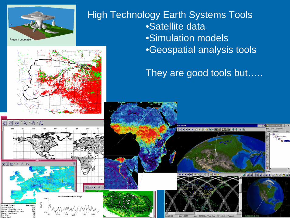
High Technology Earth Systems Tools•Satellite data•Simulation models•Geospatial analysis tools
They are good tools but…..

The International Hydrological Programme
(IHP)
Intergovernmental scientific programme on Water Resources of the
UN system
Countries established National Committees that present their priorities for consideration
by the IHP (jointly formulate strategies)
Water Resources are recognized as UNESCO Priority Action

Water Interactions : Water Interactions : Systems at Risk and Social Systems at Risk and Social
ChallengesChallengesPhase VI (2002Phase VI (2002--2007)2007)
International Hydrological ProgrammeInternational Hydrological Programmeof UNESCO of UNESCO
ThemesThemes1 Global changes and water resources1 Global changes and water resources
2 Integrated Watershed and Aquifer Dynamics2 Integrated Watershed and Aquifer Dynamics3 Land Habitat Hydrology3 Land Habitat Hydrology
4 Water and Society4 Water and Society5 Water Education and Training 5 Water Education and Training

UNESCOUNESCO--WaterWater
UNESCO-IHPUNESCO-IHE Institute for Water Education, DelftSecretariat of the World Water AssessmentProgrammeRegional institutes/centresUNESCO Chairs in WaterIHP National Committees
Network, channel to distribute information to water Network, channel to distribute information to water communitycommunity

„Groundwater Map of the World“

HELP GLOBAL NETWORK
Evolving
Operational Proposed
Demonstration
HELP basins(Hydrology for Environment, Life and Policy)

UNESCO cooperated with ESA since UNESCO cooperated with ESA since 2003 2003 International Hydrological International Hydrological ProgrammeProgramme(IHP) of UNESCO is facilitating the (IHP) of UNESCO is facilitating the dialogue between the remote sensing and dialogue between the remote sensing and water communitieswater communitiesIHP projects, publications, training IHP projects, publications, training activitiesactivities
Launching the TIGER initiativeLaunching the TIGER initiative

TIGERTIGERMission
“Develop sustainable earth observation information services for integrated water resources management in developing countries, with a focus on Africa”
Key requirements• Sustainability strategic partners needed• Appropriateness level of technology must fit
user’s capabilities• User engagement driven by African users

In common with many parts of the World, Africa too is endowed with transboundary aquifers that have not as yet been completely investigated
from MARGAT( UNESCO-OSS)
INVENTORY –Global Atlas by 2007
Trasboundary Aquifers in Africa

Niger
Nigeria
Mali
Air Tenere Reserve
R. Niger
Shared Watersheds,Niger-Nigeria
(NNOCC)
Managing HydrogeologicalRisk in the Iullemeden
Aquifer System
•Aquifer shared between Mali, Niger and Nigeria•Total exploitable water reservesabout 2 000 km3
•GEF Medium Size Project•UNESCO providing scientificsupervision
Agriculture, population growth,land degradation, high water use,changing land-use, risk ofsalinization

Related project:Related project:
ESA demonstrator project ESA demonstrator project AQUIFERAQUIFER
Primary Project Objective Primary Project Objective (GAF AG, Munich (GAF AG, Munich GERMANY)GERMANY)
support the involved support the involved national authorities and national authorities and international institutions to international institutions to better manage better manage internationally shared internationally shared aquifersaquifers
Geographic scope: Geographic scope: •• SASS Aquifer System SASS Aquifer System ––
Northern AfricaNorthern Africa•• IullemedenIullemeden Aquifer Aquifer
System System

BilkoBilko -- Virtual global faculty for Virtual global faculty for remote sensing remote sensing
Software Software BilkoBilko is a complete system is a complete system for learning and teaching remote sensing image for learning and teaching remote sensing image analysis skills. Current lessons teach the analysis skills. Current lessons teach the application of remote sensing to oceanography application of remote sensing to oceanography and coastal management, but and coastal management, but BilkoBilko routines may routines may be applied to the analysis of any image in an be applied to the analysis of any image in an appropriate format, and include a wide range of appropriate format, and include a wide range of standard image processing functions.standard image processing functions.

UNESCO volume on Groundwater and UNESCO volume on Groundwater and Remote Sensing; applications and methodsRemote Sensing; applications and methods
an expert group currently being formed for the an expert group currently being formed for the preparation, coordinated by preparation, coordinated by profprof. A. . A. MeijerinkMeijerink/ITC/ITCmanual to give practical examples and cases, discuss manual to give practical examples and cases, discuss spatial aspects of groundwater studiesspatial aspects of groundwater studies
Among the contents:Among the contents:Demonstrate the various aspects of RS contributions for Demonstrate the various aspects of RS contributions for modellingmodelling and information systemsand information systemsImage processing and Image processing and hydrogeologichydrogeologic interpretationinterpretationGroundwater management, environmental aspectsGroundwater management, environmental aspectsGlobal databases of interestGlobal databases of interest

The CEOS strategy for Earth observation education and training is the creationof an effective coordination and partnership mechanism among CEOS agenciesand institutions offering education and training. The CEOS WGEdu wasestablished by the 13th CEOS Plenary in November 1999. Tasked to develop aplan for future CEOS activities in education and training particularly indeveloping countries, a coordination and partnership mechanism betweenCEOS agencies was established. The goal of the WGEdu is to facilitate activitiesthat enhance international education and training in Earth observation techniques,data analysis interpretation, and applications.
UNESCO co-chairs with UN-OOSA the CEOS Working Group on Education, Training and Capacity Building, which has developed a portal on Earth Observation educational materials. The website is: http://wgedu.ceos.org.

Earth Observation & GIS for Earth Observation & GIS for IWRMIWRM
Some Fields of ApplicationSome Fields of ApplicationWater Availability: Water Availability:
•• Backup and extrapolation tool for hydro(geo)logical studies, Backup and extrapolation tool for hydro(geo)logical studies, precipitation, precipitation, evapotranspirationevapotranspiration, surface and groundwater , surface and groundwater flow, flooding, droughtflow, flooding, drought
Environmental Protection: Environmental Protection: •• Broad range assessment tool for natural and manBroad range assessment tool for natural and man--made made
processes such as erosion, sedimentation, deforestation, processes such as erosion, sedimentation, deforestation, landland--use changes, contamination, environmental flow use changes, contamination, environmental flow requirements, etc.requirements, etc.
Demography & Water Demand: Demography & Water Demand: •• Analysis of population concentrations, consumption patterns, Analysis of population concentrations, consumption patterns,
water allocation, transport & distribution, dams & reservoirs, water allocation, transport & distribution, dams & reservoirs, irrigation & drainage, waste water, navigation, tourism, etc.irrigation & drainage, waste water, navigation, tourism, etc.
D. Schotanus, UNESCO-IHE

Earth Observation & GIS for Earth Observation & GIS for IWRM IWRM -- 22
Some Levels of ApplicationSome Levels of Application•• Resource AssessmentResource Assessment•• Database and Database and visualisationvisualisation tool for tool for
WS&SWS&S•• ModellingModelling Tool for Quantity and Quality Tool for Quantity and Quality
FlowsFlows•• RealReal--Time DecisionTime Decision--Support System for Support System for
ManagementManagement
D. Schotanus, UNESCO-IHE

Earth Observation & GIS for Earth Observation & GIS for IWRM IWRM -- 33
Required Required CompentencyCompentency LevelsLevelsBasic User Level: Data Entry, Database Use, Basic Basic User Level: Data Entry, Database Use, Basic Mapping, Basic Analysis, DSS, ManagersMapping, Basic Analysis, DSS, Managers
•• Training Needs:Training Needs: Short Courses, Occasional UpdatesShort Courses, Occasional UpdatesAdvanced User Level: Sector Specialists & Sector Advanced User Level: Sector Specialists & Sector ResearchersResearchers
•• Training Needs:Training Needs: Several Short Courses, but preferably Several Short Courses, but preferably University level educational modules, integrated with University level educational modules, integrated with disciplinary disciplinary subjectessubjectes..
Expert User Level: Database Administrators, GIS & Expert User Level: Database Administrators, GIS & ICT Support Staff, EO & GIS ResearchersICT Support Staff, EO & GIS Researchers
•• Training Needs: Training Needs: SpecialisedSpecialised polytechnic and/or university polytechnic and/or university education.education.
D. Schotanus, UNESCO-IHE

UNESCOUNESCO--IHE Institute for Water IHE Institute for Water EducationEducation
Partner in Capacity BuildingPartner in Capacity Building

Themes, Academic Departments & CoresThemes, Academic Departments & CoresCrossCross--cutting Research, Education and Institutional cutting Research, Education and Institutional
DevelopmentDevelopment
Hydraulic EngineeringHydrology
Land & Water Development
Water Engineering
Water Security
Wetlands EcologyPollution Prention &
ControlEnvironmental Systems
Environmental Resources
Environmental Integrity
Water SupplyWaste WaterSolid Waste
Urban Mobility
Municipal Infrastructure
Urbanisation
Governance &Management
Management &Institutions
Water Resources ManagementWater Services Management
Capacity Building
Information &Communication
Hydro-Informatics &Knowledge Management
Hydro-InformaticsKnowledge Management

Capacity BuildingCapacity BuildingModels for coModels for co--operationoperation
A.1 Implementation of Generic CoursesA.1 Implementation of Generic CoursesA.2 TailorA.2 Tailor--made Degree/Sandwich Coursesmade Degree/Sandwich CoursesA.3 TailorA.3 Tailor--made Short Coursesmade Short Courses
B.1B.1 Joint Curriculum DevelopmentJoint Curriculum DevelopmentB.2B.2 Course Transfer and AdjustmentsCourse Transfer and AdjustmentsB.3B.3 Staff Development (PhD, Staff Development (PhD, MScMSc))B.4B.4 Improvement of FacilitiesImprovement of FacilitiesB.5B.5 Research and DevelopmentResearch and DevelopmentB.6. B.6. Improvement of Management SystemImprovement of Management System
A.A. RESOLVE IMMEDIATE NEEDSRESOLVE IMMEDIATE NEEDS B. B. DEVELOP LOCAL CAPACITYDEVELOP LOCAL CAPACITY
Target Group in the Water Sector
(A)(A) (B)(B)
Resources CentresInternational Agencies
Private Sector
450Guest lecturers
LocalAuthorities
Private SectorAlumniNGOs
Local Knowledge Centre
UNESCO-IHE

Vegetation classification from satellite images of 1984 and 2003in Xefina Pequeña Island and localization of vegetation changes
The Use of Remote Sensing forMonitoring Environmental Indicators:
the Case of the Incomati Estuary,Mozambique
Margarita LeMarie
Degree studies at UNESCO-IHEInstitute for Water Education,Delft, the Netherlands

CentresCentres providing RS applicationproviding RS applicationtraining in Africatraining in Africa
UNESCO ChairUNESCO Chair scheme, e.g. University of scheme, e.g. University of Western Cape (UWC) in South AfricaWestern Cape (UWC) in South Africa
Short Training Course onthe Application of Remote Sensing
for Integrated Management ofWater Resources and Ecosystems
24 – 28 October 2005Organised by
the Earth Sciences Department atthe UWC

SIMDASSIMDAS, UNESCO’s regional flagship , UNESCO’s regional flagship programmeprogramme intends intends to address the to address the most urgent and pressing needsmost urgent and pressing needs for for regional regional multisectoralmultisectoral cooperation between Southern cooperation between Southern
African countries (14 SADC countries) among themselves African countries (14 SADC countries) among themselves and with their multiple external partnersand with their multiple external partners
Climate and global climatic changes and sustainable Climate and global climatic changes and sustainable developmentdevelopmentRemote sensing and integrated study of arid and semiRemote sensing and integrated study of arid and semi--arid regions of Southern Africaarid regions of Southern AfricaSoil and land degradationSoil and land degradationWater resources and sustainable developmentWater resources and sustainable developmentEcology, ecosystems and their protection and Ecology, ecosystems and their protection and preservationpreservationEnergy and sustainable developmentEnergy and sustainable developmentEnvironmental systems and integrated management.Environmental systems and integrated management.

UNESCO Water PortalUNESCO Water Portalwwwwww.unesco.unesco.org/water.org/water


![[REMOTE SENSING] 3-PM Remote Sensing](https://static.fdocuments.net/doc/165x107/61f2bbb282fa78206228d9e2/remote-sensing-3-pm-remote-sensing.jpg)

