Bryce National Park - USEmbassy.gov in on... · Bryce Canyon National Park in southwestern Utah was...
8
Bryce National Park photo © Bozena Pilat Bryce National Park In this issue: Bryce NP Zoom in on America By the U.S. Missions of Austria and Poland Volume V. Issue 3. March 2013
Transcript of Bryce National Park - USEmbassy.gov in on... · Bryce Canyon National Park in southwestern Utah was...

Bryce National Park photo © Bozena Pilat
Bryce National Park
In this issue: Bryce NP Zoom in on America
By the U.S. Missions of Austria and Poland Volume V. Issue 3.
March 2013

page 2
meanings, but with regard to Bryce it simply de-
notes “a natural column of rock often in a fan-
tastic form”. Bryce Canyon is made up of hun-
dreds of thousands of brilliantly colored hoo-
doos.
Birth of Bryce Canyon
Bryce Canyon’s history dates back 65 million
years, to the end of the earth’s Cretaceous Pe-
riod, a time when cataclysmic changes, includ-
ing the extinction of the dinosaurs, were hap-
pening on our planet. Present day Utah was
then covered by a large lake to which rivers and
streams transported various sediments. Colorful
minerals: red and yellow iron, as well as pink
and violet manganese mixed with dissolved cal-
cium carbonate, created the amazingly colored
limestone we see today. Sometime later the
Breathtaking, literally and metaphorically
When I got to Rainbow Point, at an elevation of
9,115 feet (2778m), on a particularly hot day in
July, 2008, I was short of breath. Such eleva-
tions subject you to only about 70% of the oxy-
gen you might be used to. Panting for breath I
looked around in bewilderment. The view that
spread below my feet and as far as my eyes
could reach was one of the most spectacular
sights I have ever seen. There I was, looking at
one of the world’s most amazing sights: Bryce
Canyon. I took my camera out of the bag and did
not put it back before leaving this enchanted
place.
What does “hoodoo” mean?
While talking about Bryce the word “hoodoo” is
particularly important. The word has several
Breathtaking Bryce
Hoodoos and forest in Bryce National Park
Bryce Canyon National Park in southwestern Utah was established in the 1920s to preserve
and protect outstanding scenic and scientific values. The main attraction of the park are the
beautiful colored rock formations known as hoodoos.

page 3
water disappeared leaving the multicolored Claron
Formation from which Bryce Canyon is carved.
About 10-15 million years ago, tectonic shifts ele-
vated the region of the Colorado Plateau. A series
of smaller plateaus also were created as a result
of these tectonic shifts. Table Cliff, east of Bryce,
is the highest of these plateaus. Bryce Canyon
was carved from the eastern rim of the Paunsau-
gunt Plateau, with its shape determined by power-
ful earthquakes, and the forces of weathering and
erosion.
The Sculptor
The erosion process in Bryce Canyon is relatively
fast and it is enhanced by the melting of snow and
ice during the day, and re-freezing after sunset.
Water expands up to 9% as it freezes and exerts
a powerful force on the rocks. Moreover, rain wa-
ter dissolves the limestone, rounding off rock
edges. Smalls streams and rivers which run down
Bryce’s rim form so called gullies, which in turn
are cut into narrower walls or rock fins. Holes,
called windows appear in fins and collapse as they
grow bigger. In this way new hoodoos are born. Then
they age and collapse, giving way to new ones.
Which hike to choose?
There are different hiking trails in Bryce Canyon. The
easy ones take anywhere from 1 to 2 hours and in-
clude, among others, a streamside walk to a waterfall
(Mossy Cave), the Rim Trail, which offers magnificent
views of hoodoos from above, Bristlecone Loop
(Rainbow Point), which leads through a spruce-fir for-
est to cliffs with panoramic vistas and a spur trail to
Sunrise Point called Queens Garden. Moderate hikes,
including Navajo Trail, Queens/Navajo Combination
Loop, Tower Bridge and Hat Shop, can involve con-
siderable elevation change (e.g. Hat Shop takes you
down from 1336 to 407 feet which you then have to
reverse on your return hike,) last between 3 and 4
hours. Strenuous hikes with multiple elevation
changes require about 5 hours. Fairyland Loop takes
tourists to the China Wall, Tower Bridge and tall hoo-
doos. The remaining trails:
A “window” forms in a rock, Bryce National Park

page 4
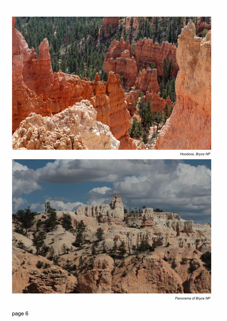
Wide panorama of Bryce National Park
Peekaboo Loop, Navajo/Peekaboo Combina-
tion Loop and the “Figure 8” are also used by
horses. On these paths, which can be very
steep, horses have the right-of-way. A hiker
has to stand on the uphill side of a trail to let
horses pass. When I saw a group on horse-
back descend a narrow and steep trail, I felt
shivers down my spine. Will they make it? Are
they experienced enough? But I shouldn’t have
worried. The groups are guided by profes-
sional wranglers and very experienced horses.
Rock falls and slides
The erosion that goes on silently but unavoid-
ably causes risks and dangers. In May 2006, a
huge rockfall took place in a section of the Na-
vajo Loop Trail called Wall Street. About 500
tons of rock fell, covering an area approxi-
mately 60 feet long, 15 feet deep, and 15 feet
wide. Though there were tourists in the area,
fortunately no one was injured. A day of heavy
rain following Hurricane Dean in 2007 caused
a large mud and rock slide that closed the
Bryce Connecting Trail to the Peekaboo Loop.
Safe? Yes, but…
While Bryce Canyon reports less than 1 fatality
per year, hundreds of accidents occur annually.
The causes of accidents include unsafe driving,
sliding down cliffs, dehydration, over-exertion,
and bad choice of footwear. It is crucial to follow
the Park’s safety measures and abide to speed
limits (25, 35 or 45 mph). Wild animals fre-
quently cross park roads. I saw it happen a few
times during my short visit. Tourists must be
aware of the fact that during their visit to the
park, the temperature can change by up to 50
degrees Fahrenheit (10 degrees Celsius), espe-
cially during summer rain storms. It is essential
to drink 1 quart (1 liter) of water every 1-2 hours
to avoid dehydration. Knowing one’s own physi-
cal limitations is important, too. All trails start at
the top which means that all returns are uphill.
Foremost, however, it is important not to disturb

page 5
Riders on a horse trail in Bryce National Park
Hoodoos in Bryce National Park
the year-round inhabitants of Bryce Canyon:
the Utah Prairie Dog (who is actually a mem-
ber of the rodent family), the Pronghorn, the
fastest land animal in the Western Hemi-
sphere (and runner-up worldwide - only the
African Cheetah can run faster,) and other
species that inhabit this enchantingly beautiful
region.
Text by Krakow AIRC
All photos in this issue © Bozena Pilat
page 6
Panorama of Bryce NP
Hoodoos, Bryce NP
page 7page 7
About ZOOMAbout ZOOM
Contact us at [email protected]
American Reference Center
U.S. Embassy Vienna Boltzmanngasse 16
1090 Vienna
http://austria.usembassy.gov/
arc.html
Activity Page
Read the text below and then put back the prepositions which were re-
moved from it:
Hoodoos and forest mixed together
Bryce Canyon, famous ... (1) its worldly unique geology, consists ... (2)
a series of horseshoe-shaped amphitheaters carved ... (3) the eastern
edge ... (4) the Paunsaugunt Plateau. The erosional force ... (5) frost-
wedging and the dissolving power ... (6) rainwater have shaped the
colorful limestone rock of the Claron Formation ... (7) bizarre shapes,
including slot canyons, windows, fins, and spires called “hoodoos”.
(source: the website of the National Park Service)
Work with 2 other students. Each
student should choose one picture.
The pictures show the American
National Parks which were de-
scribed in Zoom in on America. De-
cide which park your photo shows
(if you are not sure, ask others for
help.)
1. Describe your photo to the stu-
dents in your group;
2. Compare your pictures and the
places they show. Take into con-
sideration such factors as: location,
climate, and landmarks;
3. Discuss the advantages and dis-
advantages of traveling to places
like national parks. Which ones
would be on your list of places you
would like to visit?
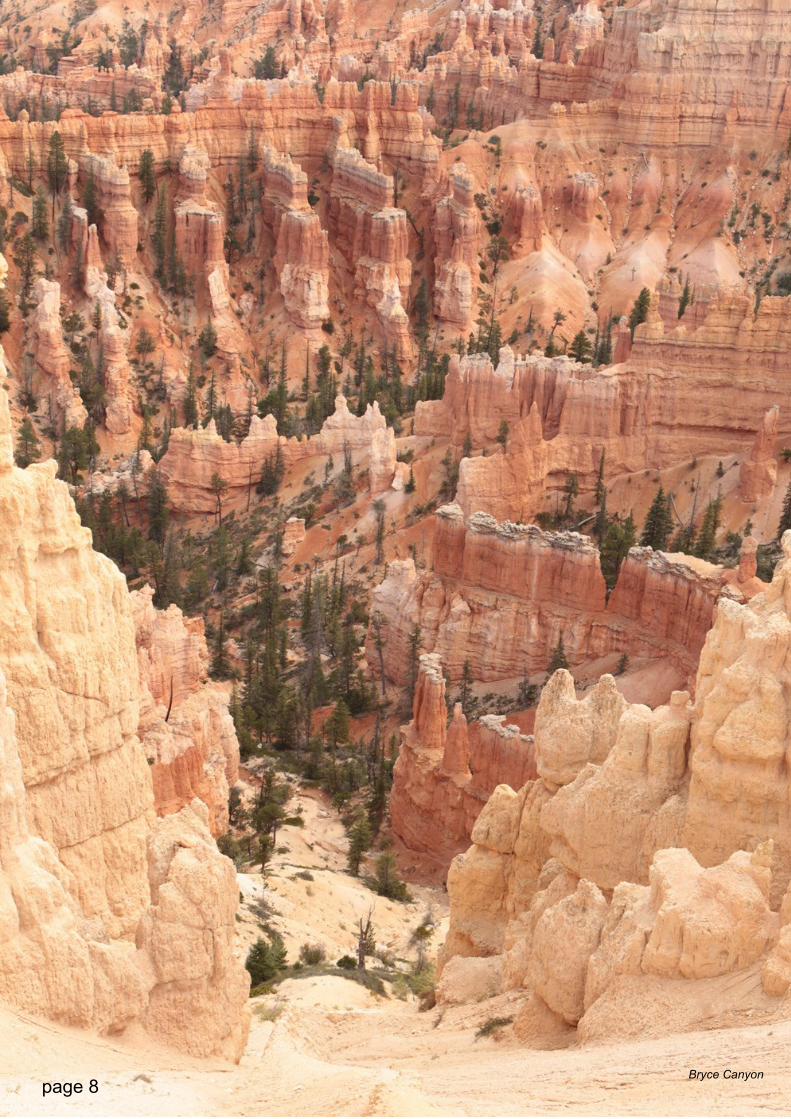
page 8 Bryce Canyon