
broadway valdez district specific plan
48
BROADWAY VALDEZ DISTRICT SPECIFIC PLAN PRESENTED TO THE CITY OF OAKLAND DECEMBER 1, 2011 DRAFT PLAN CONCEPT
Transcript of broadway valdez district specific plan

broadway valdez district specific plan
presented to the
city of oakland
december 1, 2011
draft Plan concePt


december 1, 2011 | draft plan concept
table of contents
I. PlannIng contextA. Retail ContextB. Physical Context
II. vIsIon & goals
A. Vision StatementB. Project Goals C. Implementation Strategies Overview
III. land UseA. Overall Land Use ConceptB. Overall Development ProgramC. Valdez Triangle Land Use ConceptD. Valdez Triangle Retail Concept E. North End Land Use ConceptF. Housing
Iv. commUnIty desIgnA. Overall Community Design FrameworkB. Valdez Triangle Community Design FrameworkC. North End Community Design FrameworkD. Adaptive Reuse and Historic Building Fabric
v. cIrcUlatIon, access, and ParkIng A. Overall Planning Area Circulation ConceptB. Overall Parking Concept C. Valdez Triangle Circulation ConceptD North End Circulation Concept
vI. ImPlementatIon aPProach and strategIesA. Short-Term StrategiesB. Mid- and Long-term Strategies

iv
december 1, 2011 | draft plan concept
city of oakland

december 1, 2011 | draft plan concept
1broadway valdez district specific plan
Retail ContextA.
Retail Need. à Oakland is one of the most under-retailed major cities in the United States, with limited options for comparison goods shopping, a retail category that includes stores for apparel (clothing, accessories, shoes), home furnishings/appliances, specialty goods (gifts, jewelry, books, stationery and cards, sporting goods, etc.), and department and other general merchandise stores.
Citywide Retail Strategy. à The Citywide Retail Enhancement Strategy (Conley, 2006) and the companion Upper Broadway Strategy – A Component of the Oakland Retail Enhancement Strategy (Conley, 2007) identified the City’s need to re-establish major destination retail in Oakland as being critical to stemming the extreme retail leakage and associated loss of tax revenue that the City suffers annually. The reports also identified the Broadway Valdez District as the City’s best opportunity to re-establish a retail core with the type of comparison shopping that once served Oakland and nearby communities, and that the City currently lacks.
Comparison Retail Market. à The Broadway Valdez area is surrounded by a large and potentially lucrative market for new retail development. Within a 10-minute drive of the area (Primary Trade Area), there are over 400,000 residents who spend $1.6 billion per year for comparison goods shopping. It is estimated that the Broadway Valdez area would only need to capture 12% of these expenditures to support major retail development in the project area, which is considered very reasonable given the high leakage of spending.
Retail Climate. à While studies identify strong demand for comparison retail, a number of recent trends have changed the traditional dynamics of retail development. The downturn in the economy over the past few years has made developers and lenders much more cautious about tackling major new projects or pioneering unproven areas, and the City has fewer resources available to catalyze new development.
While the economy has also made retailers more cautious, advances in information technologies and shifts in demographics are also changing traditional retail formulas. The shift in population into cities has large anchor-type retailers exploring new physical formats that fit in urban settings. Similarly, changes in shopping habits influenced by the internet and social networking have retailers reconsidering the role and size of brick-and-mortar outlets.
I. PlannIng context
Broadway is Downtown Oakland’s central spine
Current retail trends and formats encourage infill and building reuse
This Draft Plan Concept presents the initial concepts and strategic framework that will help the City to address it’s retail deficiencies over the long term, while bridging current economic conditions and shiftng retail trends. As presented in the follwing sections, the long-term vision for the Broadway Valdez District is to create a local- and regional-serving retail district, seamlessly integrated with its surrounding context and balanced by a mix of uses that will bring around-the-clock activity to the area.
The concepts and strategies presented in this Draft Plan Concept will be more fully developed and detailed in the subsequent Specific Plan, with an emphasis on providing a set of near- and long-term strategies, incentives and guidelines aimed at leveraging the area’s assets, creating value, generating interest, and establishing a positive new identity that will advance the realization of the City’s vision.
Phot
o co
urte
sy o
f th
e La
ke M
errit
t/U
ptow
n A
ssoc
iatio
nPh
oto
cour
tesy
of
the
Lake
Mer
ritt/
Upt
own
Ass
ocia
tion

2
december 1, 2011 | draft plan concept
city of oakland
Physical ContextB.
The Broadway Corridor. à Broadway is Oakland’s historic spine. Extending from the Oakland Estuary to the Oakland Hills, the corridor connects some of the City’s primary retail and employment destinations along its 4-mile length, including Jack London Square, Chinatown, Old Town, Downtown, Uptown, Pill Hill/Kaiser Medical Centers, Pleasant Valley, and the Piedmont and College Avenue retail districts. The transformation of the Broadway Valdez District from its historic emphasis on automotive sales and repair to a retail-oriented mixed use district will create a dynamic linkage between the Downtown and the neighborhood centers to the north and east.
I. PlannIng context
Phot
o co
urte
sy o
f th
e La
ke M
errit
t/U
ptow
n A
ssoc
iatio
nPh
oto
cour
tesy
of
the
Dow
ntow
n O
akla
nd A
ssoc
iatio
n

december 1, 2011 | draft plan concept
3broadway valdez district specific plan
figure 1: broadway - “hills to water”0 0.2 0.4 Mi
EB I580
EB S24
BRO
AD
WAY
TELE
GR
APH
AV
14TH ST
7TH ST
EB I9
80
3RD ST
40TH ST
12TH ST
45TH ST
GRA
ND
AV
42ND ST
8TH AV
MA
RK
ET S
T
AD
ELIN
E ST
5TH AV
9TH ST
9TH AV
2ND ST
13TH AV
OAKLAND AV
34TH ST
BRU
SH S
T
17TH ST
WEB
STER
ST
AILEEN ST
SHA
FTER
AV
6TH ST
PARK BLVD
SAN
PAB
LO A
V
41ST ST
LAK
ESH
ORE
AV
14TH AV
OA
K S
T
HOWE S
T
18TH ST
W GRAND AV
E 24TH ST
E 18TH ST
10TH ST
MY
RTLE
ST
56TH ST
MA
RTI
N L
UTH
ER K
ING
JR
WY
51ST ST
UN
ION
ST
HARRISON ST
27TH ST
11TH AV
PIEDM
ONT AV
JACK
SON
ST
21ST ST
3RD AV
MACARTHUR BLVD
MA
DIS
ON
ST
16TH ST
FRA
NK
LIN
ST
SHA
TTUC
K A
V
CAST
RO S
T
E 15TH ST
49TH ST
59TH ST
WES
T ST
E 21ST ST
46TH ST
W MACARTHUR BLVD
6TH AV
4TH AV
PERA
LTA
ST
GEN
OA
ST
CLAY
ST
30TH ST
MORAGA AV
CO
LLEGE A
V
LIN
DEN
ST
E 12TH ST
FILB
ERT
ST
7TH AV
63RD ST
STANFORD AV
LINDA AV
MA
GN
OLI
A S
T
IVY DR
33RD ST
57TH ST
10TH AV
12TH AV
POPL
AR
ST
APGAR ST
2ND AV
VALLEJO
ST
19TH
AV
PARK WY
EMBARCADERO WEST
PERK
INS
ST
CLA
REM
ON
T AV
60TH ST
44TH ST
ALI
CE S
T
LEE
ST
55TH ST
OCEAN VIEW DR
32ND ST
43RD ST
VERNON ST
FOO
THILL BLVD
31ST ST
EUC
LID A
V
BON
ITA A
V
KEITH AV
39TH ST
BOYD
AV
54TH ST
BROADWAY TER
MA
RSH
ALL ST
35TH ST
WA
LKER
AV
LONGRIDGE RD
47TH ST
TRESTLE GLEN RD
CALMAR AV
52ND ST
GIL
BERT
ST
8TH ST
OPA
L ST
53RD ST
MILES AV
E 10TH ST
BALFOUR AV
20TH ST
MA
NIL
A A
V
MANDANA BLVD
ACACIA AV
ARLINGTON AV
BROOKLYN AV
TAFT AV
26TH ST
29TH ST
FOREST ST
MO
SS AV
ROSE AV
ADAMS ST
1ST AV
HILLSID
E AV
FREM
ON
T ST
CAVOUR ST
HA
DD
ON
RD
MA
RG
AR
IDO
DR
HUDSON ST
PROSPECT AV
SPRU
CE S
T
CLEVELAND AV
WES
LEY
AV
HELEN
ST
HIG
HLA
ND
AV
ORANGE ST
LOCK
SLEY
AV
SANTA CLARA AV
LUSK
ST
WA
SHIN
GTO
N S
TW
EBST
ER T
UBE
HO
LLIS ST
5TH ST
LOW
ELL
ATH
OL
AV
LOW
ELL ST
HA
NN
AH
ST
CLAREWO
OD DR
JAM
ES A
VB
ELLE
VU
E A
V
KALES AV
E 25TH STPOSE
Y T
UBE
STA
TEN
AV
48TH ST
JAYNE AV
RO
MA
NY
RD
WIN
SOR
AV
LAWTON AV
GA
SKILL ST
MONTE VISTA AV
BOULEVARD W
Y
JOHN ST
SYCAMORE ST
JEROM
E AV
YO
RK D
R
23RD ST
WALAVISTA AV
37TH ST36TH ST
E 31ST ST
MATHER ST
CHATHAM RD
AYA
LA A
V
22ND ST
WILDWOOD AV
28TH ST
RONADA AV
RA
CIN
E ST
TERR
ACE
ST
HARBORD DR
58TH ST
NEW
TON
AV
BROCKHURST ST
19TH STROSEMOUNT RD
CH
ESTN
UT
ST
E 23RD ST
CHABOT RD
THO
MA
S A
V
CR
OSS R
D
RAND AV
OLIVE AV
62ND ST
LOU
ISE ST
17TH
AV
ARBOR DR
61ST ST
VALD
EZ S
T
MONTG
OMER
Y ST
25TH ST
CAPE
LL S
T
WATER ST
NO
VA D
R
LAKE A
V
ARIMO AV
FAIRMOUNT AV
MA
NO
R DR
CO
LBY
ST
PRINCE ST
ECHO
AV
MONROE AV
50TH ST
VERM
ONT ST
LEN
OX
AV
RICH ST
11TH ST
EL CERRITO A
V
HANOVER AV
PALM
DR
64TH ST
E 22ND ST
BAYVIEW AV
LAKESIDE DR
E 27TH ST
BA
KER
ST
PALM
AV
DES
MO
ND
ST
WARF
IELD
AV
GLEN AV
SUM
MIT
ST
E 32ND ST
E 17TH ST
ELWO
OD AV
E 20TH ST
PALA
AV
WALLACE ST
ALMA PL
SANTA RAY AV
FAIRBANKS AV
BRYA
NT
AV M
AN
DA
LAY RD
15TH ST
D/W
HILLGIRT CIR
4TH ST
BA
Y PL
VISTA AV
RICARD
O A
V
LESTER AV
GR
OSV
ENO
R P
L
VALL
EY S
T
MA
CC
ALL ST
E 34TH ST
FALL
ON
ST
MESA
AV
ATHENS AV
MEAD AV
CA
NN
ING
ST
KEN
WYN
RD
BRANDON ST
PARK
LN
POIRIER ST
RU
BY
ST
E 26TH ST
BIRCH CT
MO
NTC
LAIR
AV
KENMO
RE AV
ELM
ST
SANTA ROSA AV
KINGSTON AV
13TH ST
24TH STER
IE S
T
GREEN
BAN
K A
V
CA
RLT
ON
ST
MO
NTE A
V
SYLVAN WY
ARROYO AV
BLAIR AV
E 28TH ST
E 33RD ST
ROSAL AV
OCEAN AV
WILLIAM ST
JEFF
ERSO
N S
T
WAY
NE A
V
BR
OO
K S
T
MER
RITT
AV
CURT
IS S
T
ALMA A
V
EMER
ALD
ST
PERRY PL
ISABELLA STYORK
ST
JEA
N S
T
E 19TH ST
HARVARD RD
CA
RB
ERRY
AV
16TH
AV
WB GRAND ONRP AV
CLA
RK
E ST
VIC
ENTE
ST
NO
RTH
GA
TE A
V
HO
WELL ST
WARWICK AV
61ST PL
MONTECITO AV
HER
ZOG
ST
MILTON ST
MONTELL ST
E 16TH ST
DR
AC
ENA
AV
HAWTHORNE AV
RAMONA AV
GLENEDEN AV
NACE AV
YOSEMITE AV
PEARL ST
ANNERLY RD
PALOMA AV
BEACO
N ST
HA
VEN
ST
MOSS W
Y
ENTRA
DA
AV
FRISBIE ST
OA
K RD
BROOKWOOD RD
EL DORADO AV
AVON ST
OAKMONT AV
STANLEY PL
BURK ST
BELLA VISTA AV
WELDON AV
ESTR
ELLA
AV
WAYNE PL
GRACE AV
RIO VISTA AV
CLIFTON ST
38TH ST
CAPI
TAL
ST
NORTHVALE RD
40TH STREET WY
HILL RD
PARK
VIE
W T
ER
WA
LDO
AV
RAD
NO
R RD
KIR
KH
AM
ST
CARM
EL AV
VAN
DY
KE
AV
ZORA
H S
T
E 8TH ST
BOWLING DR
VIC
ENTE
WY
ELLI
TA A
V
YERBA BUENA AV
BEATIE ST
VIRMAR AV
ALPIN
E TER
DO
VER
ST
ALIC
IA ST
HAMILTON PL
WH
ITNEY
ST
WA
VER
LY S
T
E 11TH ST
LATI
MER
PL
DAVIDSO
N WY
LORI
TA A
V
MERRIMAC ST
HOME PL E
SUNNYSLOPE AV
LARKSPUR RD
MC
CLU
RE
ST
HAZEL
LN
VIL
LAG
E C
IR
GLENDALE AV
OC
CID
ENTA
L ST
HO
RTON
ST
KINGSL
EY ST
HARDY ST
RAN
DW
ICK AV
WESTA
LL AV
KA
ISER
PLZ
PORTLA
ND
AV
VIONA AV
CROXTO
N AV
GARLAND AV
WA
RREN AV
BO
YER
ST
HA
RLA
N ST
VERNON TER
61ST ST
WES
T ST
18TH ST
59TH ST
19TH ST
25TH ST
E 20TH ST
VALD
EZ S
T
LIN
DEN
ST
BLAIR AV
MY
RTLE
ST
54TH ST
MONTG
OMER
Y ST
E 33RD ST
29TH ST
MA
RK
ET ST
46TH ST
CLAY
ST
CH
ESTN
UT
ST
LIN
DEN
ST
7TH ST
MA
NIL
A A
V
LIN
DEN
ST
36TH ST
28TH ST
53RD ST
19TH ST
10TH AV
7TH AV
LIN
DEN
ST
47TH ST
E 19TH ST
18TH ST
ALI
CE S
T
26TH ST
FILB
ERT
ST
8TH ST
50TH ST
VERNON S
T
38TH ST
WALAVISTA AV
7TH AV
10TH AV
SAN
PAB
LO A
V
MA
NIL
A A
V
HA
RRIS
ON
ST
58TH ST
D/W
43RD ST
14TH ST
MA
RTIN
LU
THER
KIN
G J
R W
YLAWTON AV
26TH ST
22ND ST
E 21ST ST
E 17TH ST
48TH ST
FILB
ERT
ST
20TH ST
WESLEY AV
57TH ST
50TH ST
12TH AV
18TH ST
15TH ST
52ND ST
6TH ST
62ND ST
E 19TH ST
E 23RD ST
SANTA RAY AV
61ST ST
CLARKE ST
LAW
TON
AV
28TH ST
11TH AV
32ND ST
E 17TH ST
E 34TH ST
E 27TH ST
55TH ST
23RD ST
37TH ST
61ST ST
PALA AV
22ND ST
31ST ST
13TH ST
62ND ST
FALL
ON
ST
44TH ST
LIN
DEN
ST
28TH ST
54TH ST
41ST ST
E 20TH ST
51ST ST
7TH ST
MY
RTLE
ST
WEB
STER
ST
16TH ST
DO
VER
ST
CAST
RO S
T
10TH ST
NO
RTH
GA
TE A
V
15TH ST
JEFF
ERSO
N S
TMANILA AV
E 17TH ST
58TH ST
60TH ST
53RD ST
39TH ST
E 22ND ST
19TH ST
15TH ST10TH ST
E 25TH ST
21ST ST
60TH ST
61ST ST
AD
ELIN
E ST
FILB
ERT
ST
28TH ST
E 28TH ST
E 26TH ST
TAFT AV
RU
BY
ST
49TH ST
36TH ST
24TH ST
23RD ST
35TH ST
59TH ST
LAKE A
V
MIL
ES A
V
ALI
CE S
T
13TH ST
33RD ST
4TH ST
21ST ST
MA
RK
ET S
T
23RD ST
WELD
ON
AV
JEAN S
T
25TH ST
E 11TH ST
34TH ST
61ST ST
GREENBANK AV
63RD ST
CH
ESTN
UT
ST
62ND ST
D/W
30TH ST
24TH ST
24TH ST
32ND ST
7TH ST
54TH ST
MA
NIL
A A
V
32ND ST
53RD ST
41ST ST
56TH ST
55TH STE 20TH ST
30TH ST
60TH ST
BRO
AD
WAY
Claremont Country Club
Mountain View Cemetary
Lake Merritt
Broadway/ Valdez District
Uptown Entertainment District
Central Business District/ Downtown
Old Town / Chinatown
Jack London Square
San Francisco Bay
Oakland Hills
Rockridge/ College Avenue Retail
Pleasant Valley/ Upper Broadway
Piedmont Avenue
Pill Hill/Kaiser Medical Center
0 0.2 mi 0.4 mi
I. PlannIng context

4
december 1, 2011 | draft plan concept
city of oakland
I. PlannIng context
Local Surroundings and Influences. à The Broadway Valdez District is surrounded by a number of distinctive and dynamic neighborhoods and uses. The District will derive its strength from this context, leveraging the energy of surrounding neighborhoods to create a vibrant retail and mixed-use destination that is a fully-integrated extension of the Downtown—not an isolated shopping district.
Complementary and Connected. à The Broadway corridor should serve as a “seam” in the urban fabric—one that complements and connects a series of dynamic adjoining uses by providing:
A regional shopping destination that brings shopping •options, activity, and robust tax base to Downtown Oakland
A local shopping and entertainment destination for •residents in adjoining neighborhoods
A retail, office and residential complement to the •employment nodes of the Summit Alta Bates and Kaiser Permanente medical centers
A lunch-time and evening destination for office workers in •the Kaiser Center/Lake Merritt office district
An extension of the dining, entertainment, and residential •uses in the thriving Uptown District
A retail complement to the active Central Business District•
A dining, entertainment and cultural complement to the •distinctive Garage/Art Murmur District
Phot
o co
urte
sy o
f th
e La
ke M
errit
t/U
ptow
n A
ssoc
iatio
nPh
oto
by N
atha
nael
Ben
nett
Phot
o by
Nat
hana
el B
enne
tt
Phot
o by
Aui
ntar
d H
ende
rson

december 1, 2011 | draft plan concept
5broadway valdez district specific plan
figure 2: surrounding land use 0 275 ft 550 ft
I. PlannIng context
29TH ST
34TH ST
TELE
GR
APH
AV
HA
RRIS
ON
ST
27TH ST
WEB
STER
ST
LEE
ST21ST ST
GRAND AV
26TH ST
VERNON ST
28TH ST
30TH STVA
LDEZ
ST
25TH ST
PIEDMONT AV
RICH
MO
ND BLV
D
SUM
MIT
ST
FAIRMOUNT AV
LEN
OX
AV
BA
Y PL
VALL
EY S
T
ELM
ST
22ND ST
OAKLAND A
V
W GRAND AV
ORANGE ST
BR
OO
K S
T
33RD ST
31ST ST
MONTECITO AV
24TH ST
32ND ST
ADAMS ST
23RD ST
FRISBIE ST
PARK
VIE
W T
ER
SYCAMORE ST
KEMPT
ON AV
HAMILTON PL
FRA
NK
LIN
ST
WA
VER
LY S
T
JAYNE AV
MERRIMAC ST
MC
CLU
RE
ST
RAN
DW
ICK AV
WESTA
LL AV
KA
ISER
PLZ
GARLAND AV
WA
RREN AV
VERNON TER
AN
DO
VER
ST
OR
IN D
R
29TH ST
WEB
STER
ST
25TH ST
FRISBIE ST
22ND ST
30TH ST
HAWTHORNE AV
VALD
EZ S
T
28TH ST
33RD ST
SUM
MIT
ST
28TH ST
24TH ST
23RD ST
0 275 550 ft
Mosswood Park
Residential
Lake Merritt Lakeside Park
Whole Foods
Broadway/ Valdez District
DowntownOffice
UptownEntertainment
District
Art Murmur/ Entertainment
BRO
AD
WAY
Institutional
Mixed-Use: Residential,
Medical Offices
Alta BatesMedical Center
Kaiser Permanente
Medical Center
Residential
Project Boundary

6
december 1, 2011 | draft plan concept
city of oakland
II. vIsIon and goals
Vision StatementA.
To transition the Broadway corridor to being a new, re-imagined 21st Century “complete” neighborhood that addresses the City’s objectives for promoting socially and economically sustainable mixed use development; increasing the capture of local sales tax revenue; and implementing a “green,” “transit-first” strategy that reduces greenhouse gas emissions.
Project GoalsB.
Destination Retail.1. A destination retail district that addresses the City’s deficiency in comparison goods shopping and significantly reduces sales tax leakage, while also serving neighborhood shopping needs.
A “Complete” Neighborhood.2. A “complete” mixed-use neighborhood that is economically and socially sustainable—providing quality jobs, diverse housing opportunities, and an appealing mix of retail, dining and entertainment uses.
An Authentic Oakland Place.3. Adaptive reuse of historic buildings where feasible that maintains a connection to the neighborhood’s history and contributes to a distinctive character and identity.
A Walkable District.4. An attractive, pedestrian-oriented retail and mixed use district.
Transit-Oriented.5. A compact neighborhood that is well-served by and supportive of transit.
Complete Streets.6. A network of “complete” streets that are designed to safely and efficiently balance pedestrian, bicycle, transit and vehicular circulation.
Managed Parking.7. Carefully managed parking that addresses retail needs while not undermining walking, bicycling and public transit as preferred modes of transportation.
Public Space.8. A safe and attractive system of streets, parks, and civic spaces that provides graciously-scaled open spaces that support pedestrian activity and social interaction.
Leveraging Existing Assets.9. New uses and development that enhance the neighborhood’s social and economic vitality by building upon the area’s existing strengths and successes.
Sustainable Development.10. Sustainably-designed, “green” buildings and infrastructure that protect the natural environment and reduce the consumption of energy and resources.
Implementation Strategies OverviewC.
Implementation Challenges. à The realization of the vision for the Broadway Valdez District is faced with challenges, some inherent to the area (e.g., numerous land owners, small parcel sizes, high land values, limited land control by RDA, perception of public safety, lack of retail identity, etc.) and some related to more global issues (e.g., poor economic climate, retail industry in flux, limited redevelopment funding, etc.). As a result, implementation is likely to occur incrementally over a number of years.
Near-term Strategies. à In the face of these challenges, instigating innovative actions that will bridge the current economy and better position the area for development will be critical. These near-term strategies will be important to demonstrate the City’s commitment to the vision for the District, and support existing businesses and landowners who are already working to revitalize the area. The focus of these near-term strategies should be to (See Figure 3):
Build on what is “working” in the area (e.g., dining, •entertainment, the arts)
Activate the area (e.g., fill in gaps, promote use of “dead” •spots, etc.)
Make the area “fun”, “safe” and “active” (e.g., promote •events, improve lighting, etc.)
Improve connectivity/mobility (e.g., add bicycle facilities, •improve pedestrian crossings, etc.)
Enhance the physical character of the area (e.g., add street •trees, façade and tenant improvements, etc.)

december 1, 2011 | draft plan concept
7broadway valdez district specific plan
II. vIsIon and goals
figure 3: building a destination retail district from the ground up
Leverage existing assets
impLement targeted
investments
support private
investment
nurture and
reinvest
New Retail Businesses in Existing
Spaces
Retrofit and Repurpose
Existing Buildings for
Retail
Major New Retail and Mixed Use Development
Valdez Triangle
Retail District
Fine Dining • (Pican, Plum, Ozumo)
‘Hip’ Scene • (MUA, Lukas Tap Room)
Casual Fare •(Z Café, Trueburger, Bakesale Betty)
Garage District •Gallery Cluster
Art Murmur, Art •Walk
Creative Growth •Art Center
Paramount •Theater
Stork Club•
Shashamane•
The Uptown•
Whole Foods•
YMCA•
Cathedral of •Christ the Light
Lake Merritt/•Lakeside Park
Food EntErtainmEnt dEstinationsarts
Public Art•
Plaza •Enhancements
Street Furniture•
Street Trees•
Pedestrian •Enhancements (bulb-outs, crosswalks, etc)
Bike Facilities • (bike lanes, signage, bike boxes, etc.)
Transit Service/•Facilities (shelters, benches, etc.)
Façade and Tenant •Improvements
Events and Temporary •Uses (festivals, pop-up stores, Food Trucks, etc.)
Public Parking • (parking district, parking facilities, etc.)
mobility improvEmEnts
activating and Enhancing
public spacE improvEmEnts
rEusE rEtroFit rEdEvElop

8
december 1, 2011 | draft plan concept
city of oakland
III. land Use
Table 1: Overall Development Program
commerical office retail hotel residentials.f. (min) s.f. (max) s.f. (min) s.f. (max) s.f. (min) s.f. (max) dU (min) dU (max)
Valdez Triangle 300,000 500,000 500,000 800,000 50,000 120,000 300 700
North End 200,000 400,000 300,000 600,000 - - 600 1,100
Total Plan Area 500,000 900,000 800,000 1,400,000 50,000 120,000 900 1,800
Pedestrian-scaled, destination retail
Residential above ground-floor retail
Overall Planning Area Land Use ConceptA.
Two Distinct Subareas. à Given the area’s length, the different physical configuration of the areas north and south of 27th Street, and the desire to create a walkable, pedestrian-friendly district, the land use concept conceives the planning area as two distinct subareas: the Valdez Triangle and the North End—each of which will have a different land use focus.
Valdez Triangle as Retail Destination. à Due to its proximity to the Downtown, its accessibility to transit and freeways, and its fine-grained network of cross-streets, the focus in the Valdez Triangle will be on creating a new destination retail district (see following discussion of Triangle for more detail).
North End as Mixed-Use Boulevard. à Due to its linear configuration, proximity to the two medical centers, and inventory of historic buildings, the focus in the North End will be on creating a high-density mixed use boulevard that caters to adjoining medical complexes and residential neighborhoods with a mix of office, retail, residential and professional services (see following discussion of North End for more detail).
Market-Driven Plan. à The land use concept assumes that plan implementation will be both market-driven and incremental.
Overall Development ProgramB.
The projected development program is an estimate of what could potentially occur in the planning area consistent with the Specific Plan vision for the District. The estimate represents a balancing of several factors including:
Projected market demand, including the need for a critical àmass of retail to establish the area as a retail destination
Response to adjacent land use/development context à
The physical size and configuration of developable parcels à
The susceptibility (i.e., likelihood) of parcels to àredevelopment
The desire to repurpose historic and distinctive existing àbuildings
The desire to create a balanced mix of uses that offers àopportunities for living, working, and recreating

december 1, 2011 | draft plan concept
9broadway valdez district specific plan
III. land Use
figure 4: overall land use concept0 275 550 ft
BRO
AD
WAY
29TH ST
34TH STTE
LEG
RA
PH A
V
HA
RRIS
ON
ST
27TH ST
WEB
STER
ST
LEE
ST21ST ST
GRAND AV
26TH ST
VERNON ST
28TH ST
30TH STVA
LDEZ
ST
25TH ST
PIEDMONT AV
RICH
MO
ND BLV
D
SUM
MIT
ST
FAIRMOUNT AV
LEN
OX
AV
BA
Y PL
VALL
EY S
T
ELM
ST
22ND ST
OAKLAND A
V
W GRAND AV
ORANGE ST
BR
OO
K S
T
33RD ST
31ST ST
MONTECITO AV
24TH ST
32ND ST
HAWTHORNE AV
ADAMS ST
23RD ST
FRISBIE ST
PARK
VIE
W T
ER
SYCAMORE ST
KEMPT
ON AV
HAMILTON PL
FRA
NK
LIN
ST
WA
VER
LY S
T
JAYNE AV
MERRIMAC ST
MC
CLU
RE
ST
RAN
DW
ICK AV
WESTA
LL AV
KA
ISER
PLZ
GARLAND AV
WA
RREN AV
VERNON TER
AN
DO
VER
ST
29TH ST
WEB
STER
ST
25TH ST
FRISBIE ST
22ND ST
22ND ST
30TH ST
HAWTHORNE AV
28TH ST
33RD ST
SUM
MIT
ST
28TH ST
24TH ST
23RD ST
Retail Priority Area
Existing Plaza
Retail/ Restaurant Entertainment Frontage Required
Mixed-Use Designation
Medical Influence Overlay
Existing Park/ Greenway
Residential
Potential Park/ Greenway
Major Development Opportunity
Institutional
Commercial Frontage Required
Adams Park/ Veterans
Memorial
Lake Merritt
Cathedral of Christ the Light
Whole Foods
Westlake Middle School
Oak Glen Park
First Congregational
Church of Oakland
First Presbyterian
Church
Alta Bates Summit Medical
Center
Kaiser Permanente
Medical Center
Mosswood Park
0 275 ft 550 ft
10
december 1, 2011 | draft plan concept
city of oakland
III. land Use
Valdez Triangle Land Use ConceptC.
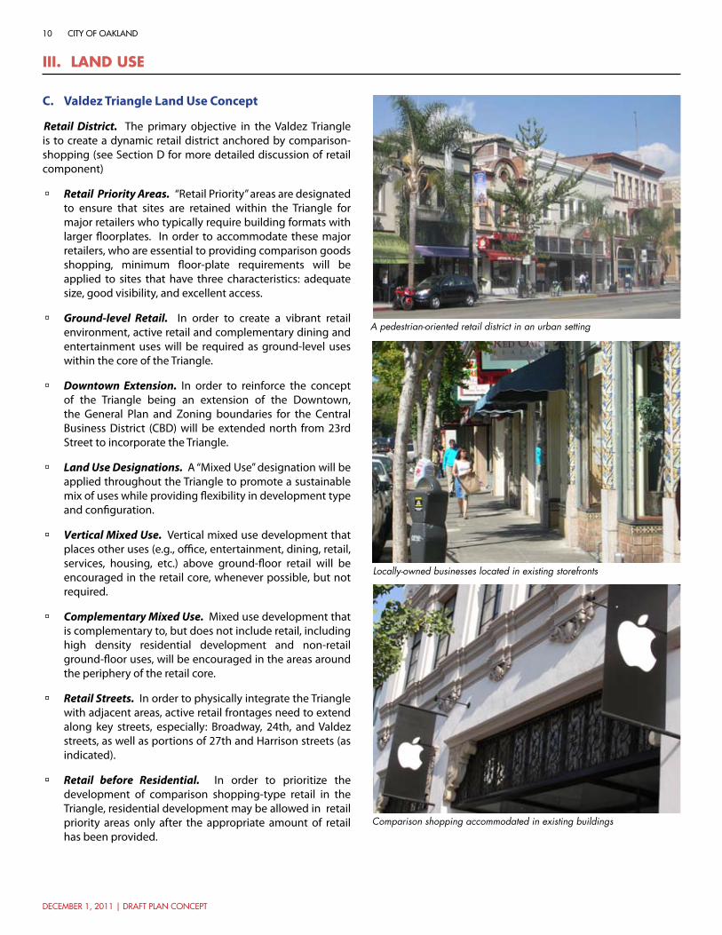
Retail District. The primary objective in the Valdez Triangle is to create a dynamic retail district anchored by comparison-shopping (see Section D for more detailed discussion of retail component)
Retail Priority Areas. à “Retail Priority” areas are designated to ensure that sites are retained within the Triangle for major retailers who typically require building formats with larger floorplates. In order to accommodate these major retailers, who are essential to providing comparison goods shopping, minimum floor-plate requirements will be applied to sites that have three characteristics: adequate size, good visibility, and excellent access.
Ground-level Retail. à In order to create a vibrant retail environment, active retail and complementary dining and entertainment uses will be required as ground-level uses within the core of the Triangle.
Downtown Extension. à In order to reinforce the concept of the Triangle being an extension of the Downtown, the General Plan and Zoning boundaries for the Central Business District (CBD) will be extended north from 23rd Street to incorporate the Triangle.
Land Use Designations. à A “Mixed Use” designation will be applied throughout the Triangle to promote a sustainable mix of uses while providing flexibility in development type and configuration.
Vertical Mixed Use. à Vertical mixed use development that places other uses (e.g., office, entertainment, dining, retail, services, housing, etc.) above ground-floor retail will be encouraged in the retail core, whenever possible, but not required.
Complementary Mixed Use. à Mixed use development that is complementary to, but does not include retail, including high density residential development and non-retail ground-floor uses, will be encouraged in the areas around the periphery of the retail core.
Retail Streets. à In order to physically integrate the Triangle with adjacent areas, active retail frontages need to extend along key streets, especially: Broadway, 24th, and Valdez streets, as well as portions of 27th and Harrison streets (as indicated).
Retail before Residential. à In order to prioritize the development of comparison shopping-type retail in the Triangle, residential development may be allowed in retail priority areas only after the appropriate amount of retail has been provided.
Locally-owned businesses located in existing storefronts
Comparison shopping accommodated in existing buildings
A pedestrian-oriented retail district in an urban setting

december 1, 2011 | draft plan concept
11broadway valdez district specific plan
figure 5: valdez triangle land use concept
III. land UseIII. land Use
21ST ST
28TH ST
FAIR
MO
UN
T A
V
SUM
MIT
ST
VERNON ST
HAMILTON PL
FRA
NK
LIN
ST
KA
ISER
PLZ
MONTECITO AV
MERRIMAC ST
28TH ST
22ND ST
SUM
MIT
ST
VALL
EY S
T
Adams Park/ Veterans Memorial
0 175 350 ft
BRO
AD
WAY
23RD ST
HA
RRIS
ON
ST
WEB
STER
ST
BA
Y PL
RIC
HM
ON
D A
V
VALD
EZ S
T
28TH ST
26TH ST
GRAND AV
24TH ST
TELE
GR
APH
AV
VALD
EZ S
T
VALD
EZ S
T
29TH ST
WEB
STER
ST
30TH ST
W GRAND AV
25TH ST
27TH ST
WA
VER
LY S
T
Lake Merritt
Cathedral of Christ the Light
Whole Foods
Westlake Middle School
First Congregational
Church of Oakland
24TH ST
First Presbyterian
Church
Retail Priority Area
Mixed-Use
Existing Plaza
Institutional
Project Boundary
Existing Park
(SEE FIGURE 6 FOR NORTH ENDLAND USE)
Retail/ Restaurant Entertainment Frontage Required
0 175 ft 350 ft

12
december 1, 2011 | draft plan concept
city of oakland
III. land Use
Valdez Triangle Retail ConceptD.
Comparison Shopping. à The concept for the Valdez Triangle is to have a core of comparison shopping-type retail complemented with local-serving retail, dining, entertainment, office, and service uses
A Retail Mix. à The Triangle is intended to be a unique, Oakland-based shopping district that includes a mix of local and national retailers
Authentic Oakland Character. à By blending high-quality new buildings with renovated and re-purposed historic buildings, the Triangle will continue to be perceived as an authentic Oakland “place”—not a generic development that could be anywhere.
Pedestrian-oriented Retail. à The area will feature street-oriented retail in an attractive, pedestrian-oriented environment that includes vibrant, active sidewalks, and safe and attractive public spaces that encourage leisurely outings, social interaction, and strolling.
Around-the-Clock Activity. à The intent is to promote a complementary mix of retail, office, entertainment, and residential uses that creates a vibrant urban district that is active both day and night, not only on weekdays, but on weekends as well.
A Variety of Retail Formats. à The area will include a complementary mix of retail “anchor” stores (major, mid, and juniors), and small retail stores. While attracting major retail anchors as the foundation for the new district is desirable, it is not required. The plan recognizes that the anchor function within the district can be filled with many combinations of major, mid, and junior size anchor stores.
Minimum Floor Plate Requirements. à In order to accommodate the larger floor-plate, anchor store retailers that are essential to providing comparison goods shopping, minimum floor-plate requirements will be applied to retail priority areas in the Triangle that have three characteristics: adequate size, good visibility, and excellent access.
Critical Mass. à To be successful, the Triangle must provide for a critical mass of retail and complementary commercial uses that establishes the area as an attractive and competitive destination within the region.
Spaces and uses that provide for around-the-clock activity
A public realm and uses that encourage pedestrian activity and strolling
Existing buildings can be retrofitted with uses and frontages that address the public realm
Phot
o co
urte
sy o
f th
e La
ke M
errit
t/U
ptow
n A
ssoc
iatio
n

december 1, 2011 | draft plan concept
13broadway valdez district specific plan
III. land Use

14
december 1, 2011 | draft plan concept
city of oakland
III. land Use
North End Land Use ConceptE.
Mixed Use Boulevard. The North End is envisioned as an attractive, mixed-use boulevard that links Downtown to the Piedmont/North Broadway areas and is integrated with the adjoining residential and health care-oriented neighborhoods.
Major Development Sites. à Three areas, the Linden/Hill, Deng, and Grocery Outlet sites, have been designated as key opportunity sites for major new development given their relatively large size and the prevalence of surface parking lots on each. While development of large-format retail will be permitted, it is not a priority for the North End, and more emphasis will be placed on mixed use development.
Commercial Ground-level Uses. à Commercial uses (e.g., retail, office, commercial services, dining, entertainment, etc.) will be required along Broadway frontages, complemented with upper floor residential, office, professional service, etc. uses. On deep lots that have dual frontage on both Broadway and another street, ground-floor residential use may be permitted on non-Broadway frontages.
Medical Center Influence. à Uses that complement and support the adjoining Summit Alta Bates and Kaiser Permanente medical centers, such as professional and medical office uses, medical supplies outlets, and visitor and workforce housing, will be strongly encouraged.
Automobile Sales. à Broadway between 27th and 30th Streets will continue to accommodate automobile dealerships. The City will work with existing successful dealerships to explore and encourage urban formats for dealerships.
Residential Use. à Emphasis will be placed on preserving and enhancing existing residential uses along Brook Street and Richmond Boulevard, and supporting incorporation of residential uses on the eastern portion of the Grocery Outlet site if redeveloped.
Reuse of Existing Buildings. à Emphasis is placed on the renovation and repurposing of historic garage and auto showroom buildings along Broadway to preserve a link to the corridor’s past and enrich its character.
Focus on Local-serving Uses. à Commercial use along Broadway will focus on a mix of primarily local-serving retail, commercial services, entertainment, and dining.
Around-the-Clock Activity. à The land use strategy will encourage a complementary mix of commercial, office, medical, and residential uses that creates a dynamic level of activity on the corridor throughout multiple times of day.
Integration with Mobility. à Primary focus will be on creating a vibrant commercial mixed use corridor that is safely and efficiently served by transit, bicycle and automobiles, and has an active and appealing pedestrian environment.
Diverse uses, including commercial, office, and residential
Active commercial frontages
Adaptive reuse of existing showrooms

december 1, 2011 | draft plan concept
15broadway valdez district specific plan
III. land Use
34TH ST
SUM
MIT
ST
28TH ST
ELM
ST
HA
RR
ISO
N S
T
FAIR
MO
UN
T A
V
TELE
GR
APH
AV
HAWTHORNE AV
FRISBIE STOAKLA
ND AV
ORANGE ST
HAMILTON PL
MC
CLU
RE
ST
GARLAND AV
AN
DO
VER
ST
SUM
MIT
ST
FRISBIE ST
0 175 350 ft
29TH ST
BRO
AD
WAY
WEB
STER
ST
27TH ST
26TH ST
PIEDMONT AV
BR
OO
K S
T
RICH
MO
ND BLV
D
VALD
EZ S
T
RAN
DW
ICK AV
CROXTO
N AVHAWTHORNE AV
27TH ST
30TH ST
Oak Glen Park
Alta Bates Summit Medical Center
Kaiser Permanente Medical Center
Mosswood Park
Major Development Opportunity
Commercial Frontage Required
Mixed-Use
Medical Influence Overlay
Existing Park/ Greenway
Project Boundary
Residential
Potential Park/ Greenway
(SEE FIGURE 5 FOR VALDEZ TRIANGLE LAND USE)
figure 6: north end land use concept 0 175 ft 350 ft

16
december 1, 2011 | draft plan concept
city of oakland
III. land Use
HousingF.
Critical Neighborhood Element. à Housing will be a critical element in the planning area’s long-term economic success and sustainability in that it will:
Create a built-in customer base for district businesses -
Provide housing options for those who work at the -nearby medical centers, in planning area businesses, or in the Downtown
Reduce vehicle trips by allowing people to walk or take -transit to shop or work
Provide an around-the-clock population who will -activate the streets and public spaces and, in turn, monitor neighborhood activities
Diverse Housing Opportunities. à Planning area housing will need to address a diversity of housing needs, including families, empty-nesters, young professionals, seniors, and those with special needs.
Housing Affordability. à Housing will include affordable and market rate housing to address the full range of household incomes in Oakland, with at least 15% of planning area housing being affordable.
Workforce Housing. à Emphasis will be placed on providing workforce housing that is affordable to those who work in the area’s commercial businesses and nearby medical campuses.
Supportive Regulation. à Recent rezoning by the City of Oakland has provided new opportunities to develop a variety of housing types with a modern, urban development character within the planning area.
Housing Goal. à The Plan’s goal is to provide at least 900-1,800 new residential units, with 15% (135-270) of those being affordable units. New affordable units can be distributed throughout the greater planning area vicinity, including the Telegraph/Northgate area immediately to the west where numerous potential sites exist for infill development. Additionally, a menu of options to incentivize affordable housing will be explored (i.e. reduced parking requirements, reduced open space requirements, etc.).
Housing Locations. à Housing will be provided primarily as upper floor uses in mixed use buildings that include retail or other ground-floor commercial. Along Brooke and Webster Streets, in the North End, and other areas along the planning area periphery, ground-floor residential will be permitted. On deep lots that have dual frontage on both Broadway and another street, ground-floor residential use may also be permitted on the non-Broadway frontage.
Units may be added above while preserving existing historic buildings
Units above commercial ground floors will contribute to street life
Ground floor entrances will address the public realm in areas where commercial frontages are not required

december 1, 2011 | draft plan concept
17broadway valdez district specific plan
III. land Use
BRO
AD
WAY
29TH ST
34TH STTE
LEG
RA
PH A
V
HA
RRIS
ON
ST
27TH ST
WEB
STER
ST
LEE
ST21ST ST
GRAND AV
26TH ST
VERNON ST
28TH ST
30TH STVA
LDEZ
ST
25TH ST
RICH
MO
ND BLV
DSUM
MIT
ST
FAIRMOUNT AV
LEN
OX
AV
BA
Y PL
VALL
EY S
T
ELM
ST
22ND ST
OAKLAND A
V
W GRAND AV
ORANGE ST
BR
OO
K S
T
33RD ST
31ST ST
MONTECITO AV
24TH ST
32ND ST
HAWTHORNE AV
ADAMS ST
23RD ST
FRISBIE ST
PARK
VIE
W T
ER
SYCAMORE ST
KEMPT
ON AV
HAMILTON PL
FRA
NK
LIN
ST
WA
VER
LY S
T
JAYNE AV
MERRIMAC ST
MC
CLU
RE
ST
RAN
DW
ICK AV
WESTA
LL AV
KA
ISER
PLZ
GARLAND AV
WA
RREN AV
VERNON TER
AN
DO
VER
ST
29TH ST
WEB
STER
ST
25TH ST
FRISBIE ST
22ND ST
22ND ST
30TH ST
HAWTHORNE AV
VALD
EZ S
T
28TH ST
33RD ST
SUM
MIT
ST
28TH ST
23RD ST
0 275 550 ft
Adams Park/ Veterans
Memorial
Oak Glen Park
Lake Merritt
Mosswood Park
Whole Foods
Westlake Middle School
First Congregational
Church of Oakland
First Presbyterian
Church
Alta Bates Summit Medical
Center
Kaiser Permanente
Medical Center
Existing Park/ Greenway
Project Boundary
Potential Locations for Upper Floor Residential
figure 7: potential residential development areas 0 275 ft 550 ft

18
december 1, 2011 | draft plan concept
city of oakland
Iv. commUnIty desIgn
Overall Community Design Concept A.
Broadway Corridor. à Broadway will serve as the Downtown’s “grand boulevard” that links the Broadway Valdez District to other key destinations from the Estuary to the Oakland Hills.
Primary Access Streets: à 27th, Webster (northern portion), Piedmont, Harrison and Grand serve as primary regional and local access into the District. The importance of these routes will be marked by streetscape improvements, street trees, and new delvelopment that reinforces corridor character and definition.
Secondary Access Streets: à Streetscape improvements, street tree plantings and new development will be introduced along key secondary access streets, such as 24th, Valdez, 29th, 30th and Webster streets, to enhance and clarify their function whether it be as pedestrian-scaled shopping streets or key local connectors.
Gateways: à Key intersections throughout the District will be enhanced through use of public realm improvements such as signage, landscaping, lighting, special street design, and public art, and the design of private buildings to highlight the importance of these intersections as District entry points.
Public Space Features: à Public space features, such as plazas and small parks, are distributed throughout the district to highlight key activity nodes and entries, and to provide strategically located places for public gathering. Public spaces may incorporate features such as seating, fountains, landscaping, street furniture, and public art.
Building Placement and Height: à New buildings will be set up to, and accessed directly from, the public sidewalk, and have active ground floor frontages and uses that engage and animate the public realm. Taller buildings generally will be located on primary access streets with lower heights maintained along internal streets.
Streetscape Improvements: à Streetscape improvements are proposed throughout the District to provide a more generous and attractively designed pedestrian environment with street trees, lighting, seating, and other streetscape furniture and amenities. Key east-west streets will be retrofitted as “Green Streets” that capture and treat stormwater before it drains into Glen Echo Creek and Lake Merritt.
Pedestrian Connections: à Opportunities for pedestrian streets, or paseos, are identified throughout the District to enhance pedestrian activity by reducing conflicts with automobiles, providing more direct routes between key destinations, and creating distinctive shopping and dining environments.
Parks/Greenways: à A linear park is proposed along Glen Echo Creek between Oak Glen Park and 29th Street, which will include the enhancement of the existing creekside frontage along Glen Echo Creek north of 30th Street and the creation of a new creekside greenway between 29th and 30th Streets.
Street trees and streetscape improvements help create sense of place
Corner buildings should be designed to activate corners
Public gathering spaces should be incorporated into public and private developments

december 1, 2011 | draft plan concept
19broadway valdez district specific plan
figure 8: overall community design concept 0 175 ft 350 ft
Iv. commUnIty desIgn
BRO
AD
WAY
29TH ST
34TH STTE
LEG
RA
PH A
V
HA
RRIS
ON
ST
27TH ST
WEB
STER
ST
LEE
ST21ST ST
GRAND AV
26TH ST
VERNON ST
28TH ST
30TH STVA
LDEZ
ST
25TH ST
PIEDMONT AV
RICH
MO
ND BLV
DSUM
MIT
ST
FAIRMOUNT AV
LEN
OX
AV
BA
Y PL
VALL
EY S
T
ELM
ST
OAKLAND A
V
W GRAND AV
ORANGE ST
BR
OO
K S
T
33RD ST
31ST ST
MONTECITO AV
24TH ST
32ND STHAWTHORNE AV
ADAMS ST
23RD ST
FRISBIE ST
PARK
VIE
W T
ER
SYCAMORE ST
KEMPT
ON AV
HAMILTON PL
FRA
NK
LIN
ST
WA
VER
LY S
T
JAYNE AV
MERRIMAC ST
MC
CLU
RE
ST
RAN
DW
ICK AV
WESTA
LL AV
KA
ISER
PLZ
GARLAND AV
WA
RREN AV
VERNON TER
AN
DO
VER
ST
29TH ST
WEB
STER
ST
25TH ST
FRISBIE ST
22ND ST
22ND ST
30TH ST
28TH ST
33RD ST
SUM
MIT
ST
28TH ST
24TH ST
23RD ST
Secondary Access Street
Broadway Corridor
Primary Access Street
Secondary Access Street
Existing Pedestrian Connection
Primary Gateway
Secondary Gateway
Public Space Feature
Project Boundary
Potential Park/ Greenway
Existing Plaza
Existing Park
Streetscape Improvements
Potential Pedestrian Connection
0 275 550 ft
Improved Freeway Undercrossing
Potential Street Extention
Adams Park/ Veterans
Memorial
Lake Merritt
Cathedral of Christ
the Light
Whole Foods
Westlake Middle School
Oak Glen Park
First Congregational
Church of Oakland
First Presbyterian
Church
Alta Bates Summit Medical
Center
Kaiser Permanente
Medical Center
MosswoodPark
CROXTO
N AV

20
december 1, 2011 | draft plan concept
city of oakland
Iv. commUnIty desIgn
Secondary gateways may include paseos or signage
Use of existing buildings and unique streetscape elements are encouraged
Intimate pedestrian retail streets may include restaurants and small shops
Valdez Triangle Community Design FrameworkB.
Pedestrian-Oriented Retail District. The Triangle will be a vibrant pedestrian-oriented retail district with attractively designed and generously proportioned sidewalks, plazas and public spaces, animated by active storefronts.
Broadway Corridor: à In the tradition of grand urban boulevards in other major cities, Broadway will serve as the Downtown spine that links the Triangle to other key destinations from the Estuary to the Oakland Hills.
Primary Access Streets: à 27th Street, Harrison Street, and Grand Avenue are the primary access routes into the District. These routes will be designed as attractive, well-defined boulevards lined with street-oriented mixed use buildings and a consistent planting of large street trees.
Secondary Access “Shopping Streets”: à 24th Street and Valdez Street will serve as key pedestrian-oriented shopping streets that are more intimately scaled, and with lower vehicular traffic volumes and slower travel speeds.
Gateways: à Building and streetscape design treatments will be used to enhance and highlight key intersections as primary or secondary gateways into the Triangle. Primary gateways include the Broadway and Harrison Street intersections with 27th Street, and Broadway at Grand. Secondary gateways include Valdez at Grand and 27th, and 24th at Broadway.
Public Space Features: à Using a combination of publicly- and privately-owned land, publicly-accessible plazas and open space features will be created at key gateways (e.g., Valdez/27th and 24th/Harrison) to the Triangle to enhance district identity and support pedestrian activity. In addition, existing public plazas on Broadway at 25th and 27th Streets will be redesigned to provide more attractive and accommodating public open space and focal features.
Building Placement and Height: à Taller building heights generally will be allowed along the wide arterial streets (Broadway, 27th, Harrison and Grand) that frame the Triangle, with lower heights maintained along the internal shopping and neighborhood streets.
Enhanced Pedestrian Environment. à Streetscape improvements are proposed throughout the Triangle to create wider sidewalks that provide a more generous and attractively designed pedestrian environment with street trees, lighting, seating, and other streetscape furniture and amenities.
Pedestrian Connections: à To reinforce the pedestrian orientation of the district, the plan provides the flexibility to create pedestrian-only shopping streets or paseos that facilitate pedestrian movement and increase retail frontage. Existing pedestrian connections to cultural destinations to the south occur at Grand Avenue.

december 1, 2011 | draft plan concept
21broadway valdez district specific plan
0 175 350 ft
27TH ST
21ST ST
28TH ST
FAIR
MO
UN
T A
V
SUM
MIT
ST
VERNON ST
HAMILTON PL
FRA
NK
LIN
ST
KA
ISER
PLZ
MONTECITO AV
MERRIMAC ST
28TH ST
22ND ST
SUM
MIT
ST
VALL
EY S
T
Broadway Corridor
Primary Access Street
Secondary Access Street
Existing Pedestrian Connection
Primary Gateway
Secondary Gateway
Public Space Feature
Project Boundary
Existing Plaza
Existing Park
Streetscape Improvements
23RD STH
ARR
ISO
N S
T
WEB
STER
ST
BA
Y PL
RIC
HM
ON
D A
V
VALD
EZ S
T
28TH ST
26TH ST
GRAND AV
24TH ST
TELE
GR
APH
AV
VALD
EZ S
T
VALD
EZ S
T
29TH ST
WEB
STER
ST
30TH ST
W GRAND AV
25TH ST
27TH ST
WA
VER
LY S
TBRO
AD
WAY
Lake Merritt
Cathedral of Christ the Light
Whole Foods
First Congregational
Church of Oakland
First Presbyterian
Church
Westlake Middle School
(SEE FIGURE 10 FOR NORTH ENDLAND USE)
figure 9: valdez triangle community design framework
Iv. commUnIty desIgn
0 175 ft 350 ft

22
december 1, 2011 | draft plan concept
city of oakland
Iv. commUnIty desIgn
Underpass treatments (art, liighting, etc.) under I-580 will enhance pedestrian movement between the planning area and the Kaiser Medical Ceneter, Mosswood Park, and Piedmont Avenue
Re-use of historic buildings is important to retaining District character
Medical office and other non-retail uses will maintain active, ground-level facades that engage the public realm
North End Community Design FrameworkC.
Fine-grained, Mixed Use District: New development and public realm improvements will focus on creating finer-grained texture to district development, complemented with streetscape plantings, amenities and focal features that contribute to the area’s pedestrian scale and comfort, and mitigate the North End’s linear character.
Broadway Corridor: à New infill development will give better definition to the Broadway corridor by eliminating existing gaps created by surface parking and auto sales lots. Broadway will be reconfigured to create wider sidewalks that create a more generous pedestrian environment.
Primary Access Streets: à 27th Street, Webster Street, and Piedmont Avenues are the primary access routes into the North End. These routes will be designed as attractive, well-defined boulevards lined with street-oriented mixed use buildings and a consistent planting of large street trees.
Secondary Access Streets: à Streetscape improvements to 29th, 30th, and Webster Streets will help to link and extend the quality and character envisioned for Broadway to the adjoining areas.
Gateways: à Building and streetscape design treatments at the Broadway and Piedmont Avenue intersection will signify the importance of this intersection as a gateway into the North End and the Downtown.
Public Space Features. à A plaza is proposed in conjunction with the pedestrian street midway between Hawthorne and 30th Street to enhance Broadway’s identity and support pedestrian activity.
Building Placement and Height: à Given the width of Broadway, it is envisioned that new buildings generally will be 4-6 stories at the street frontage, with potential for taller building heights set back from the main corridor—particularly near Pill Hill and I-580.
Park/ Greenway. à In order to enhance pedestrian circulation and expand the area’s limited open space resource, a linear park is proposed along Glen Echo Creek between Oak Glen Park and 29th Street.
Pedestrian Connection: à Given the absence of an east-west street between 30th Street and Hawthorne Avenue, a “paseo“ or pedestrian street, or is proposed between Broadway and Webster Street to facilitate pedestrian movement.
Underpass Enhancements. à Enhancements are proposed to I-580 underpasses at Broadway and Piedmont to improve their appearance, safety, and overcome the sense of separation created by the freeway. These may include public art and lighting, as well as programming to activate the area between the two corridors (e.g., a skate park, mountain bike course).

december 1, 2011 | draft plan concept
23broadway valdez district specific plan
Iv. commUnIty desIgn
0 175 350 ft
34TH ST
SUM
MIT
ST
28TH ST
ELM
ST
HA
RR
ISO
N S
T
FAIR
MO
UN
T A
V
TELE
GR
APH
AV
HAWTHORNE AV
FRISBIE STOAKLA
ND AV
ORANGE ST
HAMILTON PL
MC
CLU
RE
ST
GARLAND AV
AN
DO
VER
ST
SUM
MIT
ST
FRISBIE ST
29TH ST
BRO
AD
WAY
WEB
STER
ST
27TH ST
PIEDMONT AV
BR
OO
K S
T
RICH
MO
ND BLV
D
RAN
DW
ICK AV
CROXTO
N AVHAWTHORNE AV
30TH ST
Oak Glen Park
Mosswood Park
26TH ST
VALD
EZ S
T
Alta Bates Summit Medical Center
Kaiser Permanente Medical Center
Broadway Corridor
Primary Access Street
Potential Street Extention
Secondary Access Street
Streetscape Improvements
Primary Gateway
Improved Freeway Undercrossing
Public Space Feature
Existing Park
Project Boundary
Potential Park/ Greenway
Potential Pedestrian Connection
(SEE FIGURE 9 FOR VALDEZ TRIANGLE COMMUNITY DESIGN FRAMEWORK)
Existing Pedestrian Connection
figure 10: north end community design framework 0 175 ft 350 ft

24
december 1, 2011 | draft plan concept
city of oakland
Iv. commUnIty desIgn
Historic resources of “Auto Row” include showroom spaces which offer great potential for reuse
Residential buildings in the District may be retrofitted for a variety of uses
New development should incorporate unique elements of Oakland’s architectural and commercial heritage, when possible
Adaptive Reuse and Historic Building FabricD.
Authentic Character. à In order to preserve a connection to the area’s history and maintain a unique and authentic feel to the district, the Plan encourages the rehabilitation and reuse of as much of the older and historic building fabric as feasible and consistent with the goals of the Plan.
Adaptive Reuse. à Adaptive reuse is encouraged for historic and older buildings with distinctive character that will contribute to the scale and character envisioned for the Broadway Valdez district. This includes both larger floorplate showrooms that may accommodate larger retailers, and residential buildings and small commercial buildings that may support smaller shops.
Relocation of Important Resources à . Where adaptive reuse of existing residential buildings is not feasible or practical in their current location, the City will work with landowners and developers to explore relocation of historic buildings to another location in the surrounding area that is similar in scale and context.
Incentives for Reuse. à Incentives such as façade and tenant improvement grants, reduced property, sales, and/or gross receipts taxes, or lower parking requirements may be offered to developers and/or landowners who choose to refurbish existing buildings for new uses. Expedited development review may also be considered on a limited, case-by-case basis.
Flexible Building Standards. à The City will explore more flexibility in building standards (e.g., relaxation on requirements for features such as fire separation, insulation, etc.) in order to make reuse more viable.
IPho
t by
Nat
hana
el B
enne
tt

december 1, 2011 | draft plan concept
25broadway valdez district specific plan
0 275 550 ft
BRO
AD
WAY
29TH ST
34TH STTE
LEG
RA
PH A
V
HARRIS
ON S
T
27TH ST
WEB
STER
ST
LEE
ST21ST ST
GRAND AV
26TH ST
VERNON ST
28TH ST
30TH STVA
LDEZ
ST
25TH ST
RICH
MO
ND BLV
DSUM
MIT
ST
FAIRMOUNT AV
LEN
OX
AV
BA
Y PL
VALL
EY S
T
ELM
ST
22ND ST
OAKLAND A
V
W GRAND AV
ORANGE ST
BR
OO
K S
T
CROXTO
N AV
33RD ST
31ST ST
MONTECITO AV
24TH ST
32ND STHAWTHORNE AV
ADAMS ST
23RD ST
FRISBIE ST
PARK
VIE
W T
ER
SYCAMORE ST
KEMPT
ON AV
HAMILTON PL
FRA
NK
LIN
ST
WA
VER
LY S
T
JAYNE AV
MERRIMAC ST
MC
CLU
RE
ST
RAN
DW
ICK AV
WESTA
LL AV
KA
ISER
PLZ
GARLAND AV
WA
RREN AV
VERNON TER
AN
DO
VER
ST
29TH ST
WEB
STER
ST
25TH ST
FRISBIE ST
22ND ST
22ND ST
30TH ST
HAWTHORNE AV
VALD
EZ S
T
33RD ST
SUM
MIT
ST
28TH ST
24TH ST
23RD STAdams Park/
Veterans Memorial
Oak Glen Park
Lake Merritt
Mosswood Park
Whole Foods
Westlake Middle School
First Congregational
Church of Oakland
First Presbyterian
Church
Alta Bates Summit Medical
Center
Kaiser Permanente
Medical CenterLocal Register of Historic Resources
25th Street Garage District ASI
Upper Broadway/ Auto Row ASI
Waverly Street District ASI
Richmond Avenue District ASI
Project Boundary
Existing Park
Richmond Boulevard District ASI
Adaptive Reuse Priority Areas
figure 11: historic resources & adaptive reuse 0 275 ft 550 ft
Iv. commUnIty desIgn
26
december 1, 2011 | draft plan concept
city of oakland
v. cIrcUlatIon, access & ParkIng
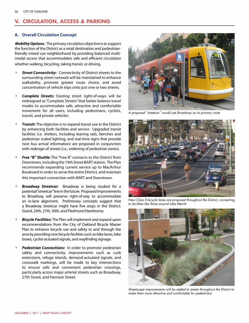
A proposed “streetcar” would use Broadway as its primary route
Streetscape improvements will be added to streets throughout the District to make them more attractive and comfortable for pedestrians
New Class II bicycle lanes are proposed throughout the District, connecting to facilities like those around Lake Merritt
Overall Circulation ConceptA.
Mobility Options. The primary circulation objective is to support the function of the District as a retail destination and pedestrian-friendly mixed use neighborhood by providing balanced multi-modal access that accommodates safe and efficient circulation whether walking, bicycling, taking transit, or driving.
Street Connectivity: à Connectivity of District streets to the surrounding street network will be maintained to enhance walkability, promote greater route choice, and avoid concentration of vehicle trips onto just one or two streets.
Complete Streets: à Existing street right-of-ways will be redesigned as “Complete Streets” that better balance travel modes to accommodate safe, attractive and comfortable movement for all users, including pedestrians, cyclists, transit, and private vehicles.
Transit: à The objective is to expand transit use in the District by enhancing both facilities and service. Upgraded transit facilities (i.e. shelters, including leaning rails, benches and pedestrian scaled lighting, and real-time signs that provide next bus arrival information) are proposed in conjunction with redesign of streets (i.e., widening of pedestrian zones).
Free “B” Shuttle: à The “Free B” connects to the District from Downtown, including the 19th Street BART station. The Plan recommends expanding current service up to MacArthur Boulevard in order to serve the entire District, and maintain this important connection with BART and Downtown.
Broadway Streetcar: à Broadway is being studied for a potential “streetcar” line in the future. Proposed improvements to Broadway will preserve right-of-way to accommodate an in-lane alignment. Preliminary concepts suggest that a Broadway streetcar might have five stops in the District: Grand, 24th, 27th, 30th, and Piedmont/Hawthorne.
Bicycle Facilities: à The Plan will implement and expand upon recommendations from the City of Oakland Bicycle Master Plan to enhance bicycle use and safety to and through the area by providing new bicycle facilities such as bike lanes, bike boxes, cyclist-actuated signals, and wayfinding signage.
Pedestrian Connections: à In order to promote pedestrian safety and connectivity, improvements such as curb extensions, refuge islands, demand-actuated signals, and crosswalk markings, will be made to key intersections to ensure safe and convenient pedestrian crossings, particularly across major arterial streets such as Broadway, 27th Street, and Harrison Street.

december 1, 2011 | draft plan concept
27broadway valdez district specific plan
v. cIrcUlatIon, access & ParkIng
figure 12: overall circulation concept
240
680
95
57
185
250
4060
76
477
467
309
433
831,216
1,086
0 275 550 ft
1
1R
72R
51
59
11
12
59a
59
59a
51
851
34TH STTE
LEG
RA
PH A
V
LEE
ST21ST ST
VERNON ST
30TH ST
RICH
MO
ND BLV
D
SUM
MIT
ST
FAIRMOUNT AV
LEN
OX
AV
ELM
ST
OAKLAND A
V
ORANGE ST
33RD ST
31ST ST
MONTECITO AV
24TH ST
32ND ST
HAWTHORNE AV
ADAMS ST
23RD ST
FRISBIE ST
PARK
VIE
W T
ER
SYCAMORE ST
KEMPT
ON AV
HAMILTON PL
FRA
NK
LIN
ST
JAYNE AV
MERRIMAC ST
MC
CLU
RE
ST
RAN
DW
ICK AV
WESTA
LL AV
KA
ISER
PLZ
GARLAND AV
WA
RREN AV
VERNON TER
AN
DO
VER
ST
29TH ST
25TH ST
22ND ST
22ND ST
33RD ST
SUM
MIT
ST
28TH ST
CROXTO
N AV
24TH ST
23RD ST
28TH ST
WEB
STER
ST
WA
VER
LY S
T
BRO
AD
WAY
29TH STH
ARR
ISO
N S
T
27TH ST
WEB
STER
ST
26TH ST
28TH ST
25TH ST
VALL
EY S
T
W GRAND AV
30TH ST
PIEDMONT AV
BR
OO
K S
T
BA
Y PL
VALD
EZ S
T
GRAND AV
Adams Park/ Veterans
Memorial
Lake Merritt
Cathedral of Christ
the Light
Whole Foods
Westlake Middle School
First Congregational
Church of Oakland
First Presbyterian
Church
Alta Bates Summit Medical
Center
Kaiser Permanente
Medical Center
Mosswood Park
Oak Glen Park
abB A R T
19th St.BART(0.2 mi)
abB A R T MacArthurBART(0.7 mi)
abB A R T
12th St.BART(0.5 mi)
Parking Facilities
Existing Parking Structure / Spaces #
Bicycle Facilities
Existing Class IIIa
Proposed Class IIIa
Proposed Bicycle Blvd
Existing Class IIProposed Class II
TransitAC Transit Line
Free “B” Shuttle (Weekend)
Potential Broadway Streetcar
Existing Park/ Greenway
Project Boundary
#
Potential Park/ Greenway
Pedestrian ConnectionsExisting Pedestrian Path
Proposed Pedestrian Path
Free “B” Shuttle
Existing Parking Lot / Spaces #
Future Parking Structure / Spaces #
0 275 ft 550 ft

28
december 1, 2011 | draft plan concept
city of oakland
All parking structures should be wrapped with active ground-level uses
Parking garages should maintain a consistent frontage and animate the public realm
Parking structures may be shared and financed among uses
v. cIrcUlatIon, access & ParkIng
Overall Parking Concept B.
Parking Management. à A full range of parking management strategies will be implemented to increase parking facility efficiency through sharing, regulating and pricing in order to minimize the amount of new parking that needs to be provided.
Existing Parking Resources: à Priority will be given to maximizing use of existing parking structures, and building new structures only on an as-needed basis.
Parking Benefit District. à A Parking Benefit District may be established to manage and finance parking, in addition to streetscape improvements.
Parking Ratios. à Low overall parking ratios will be implemented that support a “transit-first” district, while also allowing for higher parking ratios that support early retail development, and are then gradually reduced as the area’s identity as a retail destination matures and transit service becomes more convenient and reliable.
“Park Once”. à Parking will be distributed and managed so that it supports a “park once” strategy and reduces the number of short vehicle trips within the area.
Structured Parking: à In order to optimize development potential, ensure development of a compact walkable neighborhood, and protect neighborhood character, District parking will be provided in parking structures. At a minimum, all parking structures should be wrapped with active ground-level uses. Where feasible, below-grade parking is encouraged as a strategy to minimize impact on District character.
Parking Access: à Entrances to public and private parking facilities generally will be limited to side streets, or located to not detract from pedestrian-oriented retail streets. Curb cuts will be prohibited from Broadway, except where unavoidable.

december 1, 2011 | draft plan concept
29broadway valdez district specific plan
v. cIrcUlatIon, access & ParkIng
Valdez Triangle Circulation ConceptC.
Pedestrian-Oriented Retail District. The circulation concept for the Triangle is to efficiently get people to the District, but once there to encourage walking. Transit and primary vehicular access deliver people to the edge of the District allowing internal streets to be reserved primarily for pedestrians and low volumes of local traffic.
Street Design: à A number of design changes are proposed to existing streets to calm traffic, improve bicycle and pedestrian safety, and enhance the pedestrian environment:
Key intersections along 27th Street (i.e., Broadway, -Valdez and 24th) will be reconfigured to reduce crossing distances (e.g., curb extensions), minimize pedestrian/vehicle conflicts (e.g., remove free right turn lanes), and create a stronger connection between the areas north and south of 27th Street.
The cross-sections of Valdez, 24th, 27th, and Broadway -will be redesigned to create wider and more attractively designed pedestrian and bicycle facilities (see Figures 14 through 17)
Bicycle Facilities: à Existing Class II bicycle facilities on Broadway and Grand will be augmented with new Class II bike lanes on Harrison and 27th Streets and Telegraph Avenue. Improvements such as bike lanes, bike boxes, bicycle actuated signals, and wayfinding will be introduced on Broadway to enhance bicycle use and safety.
Arterial Bicycle Route: à The Class IIIa bicycle route proposed on Webster Avenue south of 25th Street will be signed with a “sharrow” (a marking on the street surface that indicates a shared route for bicycles and vehicles) and lower posted speeds, since adequate right-of-way does not exist to add a full bike lane.
Free “B” Shuttle: à The “Free B” service to the Triangle should be upgraded to seven days a week, rather than the current weekend-only service, if staff can identify additional funding sources.
Transit: à Upgraded transit facilities (i.e. shelters, including leaning rails, benches and pedestrian-scaled lighting, and real-time signs that provide next bus arrival information) should be provided at 24th, 25th, and 28th streets in conjunction with streetscape improvements on Broadway.
Potential Broadway Streetcar: à Street improvements to Broadway will preserve right-of-way to accommodate possible future in-lane streetcar use and transit stops at Grand Avenue, 25th and 27th Streets.
Valdez Triangle is included on the Free “B” Shuttle Route
Existing pedestrian connection at Grand Avenue
Pedestrian Connections: à Exclusive pedestrian connections into Valdez Triangle currently exist across Grand Avenue west of Harrison Street in the form of greenways. These allow pedestrian access to routes leading to Lake Merritt, the Cathedral of Christ the Light, and Downtown.
Parking Facilities: à In the near term, emphasis will be placed on utilizing excess capacity in existing parking structures (i.e., YMCA and 180 Grand) to serve new development. New parking structures will only be built when there is clear demand for additional parking. The location and size of these structures will be determined by the location and size of future development.

30
december 1, 2011 | draft plan concept
city of oakland
21ST ST
28TH ST
FAIR
MO
UN
T A
V
SUM
MIT
ST
VERNON ST
HAMILTON PL
FRA
NK
LIN
ST
KA
ISER
PLZ
MONTECITO AV
MERRIMAC ST
28TH ST
22ND ST
SUM
MIT
ST
VALL
EY S
T
Adams Park/ Veterans Memorial
0 175 350 ft
BRO
AD
WAY
23RD ST
HA
RRIS
ON
ST
WEB
STER
ST
BA
Y PL
RIC
HM
ON
D A
V
VALD
EZ S
T
28TH ST
26TH ST
GRAND AV
24TH ST
TELE
GR
APH
AV
VALD
EZ S
T
VALD
EZ S
T
29TH ST
WEB
STER
ST
30TH ST
W GRAND AV
25TH ST
27TH ST
WA
VER
LY S
T
Lake Merritt
Cathedral of Christ the Light
Whole Foods
Westlake Middle School
First Congregational
Church of Oakland
24TH ST
First Presbyterian
Church
240
95
57
1854060
76
1
1R
51
59
851
11
12
abB A R T
19th St.BART(0.2 mi)
abB A R T
12th St.BART(0.5 mi)
680
477
250
Parking Facilities
Existing Parking Structure / Spaces #
Bicycle Facilities
Existing Class IIIa
Proposed Class IIIa
Proposed Bicycle Blvd
Existing Class IIProposed Class II
TransitAC Transit Line
Free “B” Shuttle (Weekend)
Potential Broadway Streetcar
Existing Park/ Greenway
Project Boundary
#
Potential Park/ Greenway
Pedestrian ConnectionsExisting Pedestrian Path
Proposed Pedestrian Path
Free “B” Shuttle
Existing Parking Lot / Spaces #
figure 13: valdez triangle circulation concept 0 175 ft 350 ft
v. cIrcUlatIon, access & ParkIng

december 1, 2011 | draft plan concept
31broadway valdez district specific plan
v. cIrcUlatIon, access & ParkIng
1/16”=1’
100’ ROW
100’ ROW
80’
72’
10’ 7.5’ 5.5’ 5.5’11’ 11’ 10’ 11’ 11’ 7.5’ 10 ’
14’ 11’ 11’ 11’ 11’ 14 ’
SidewalkSidewalk
SidewalkSidewalkWEST SIDE EAST SIDEBikeLane
BikeLane
Parking/BulbOut
Parking/BulbOut
Median ParkingParking Bike BikeTravelLane
TravelLane
TravelLane
TravelLane
TravelLane
TravelLane
TravelLane
TravelLane
8’ 6’ 6’ 8’
figure 14: broadway (north of 27th st.)
Proposed
Existing
Summary of Improvements:
Remove center median in order to widen sidewalks to 14 feet and expand bike lanes to 6 feet à
Maintain 11-foot travel lanes to provide for buses and vehicular circulation à
Neck-down key intersections with bulb-outs to calm traffic and facilitate pedestrian crossing à
Provide a consistent planting of large street trees and attractive pedestrian-scaled lighting à
Add transit shelters and facilities at key transit stops à
*Final street designs will be determined as part of the Specific Plan following coordination with TSD.

32
december 1, 2011 | draft plan concept
city of oakland
figure 15: 27th street
v. cIrcUlatIon, access & ParkIng
80’
8’-10’ 8’-10’19’ 11’ 11’ 4’+(Variable)
11’ 11’ 19’
12’-14’ 8’-10’11’ 11’ 6’ -10’ 11’ 11’ 8’8’ 6’6’
102’-106’ ROW
102’-106’ ROW
86’
1/16”=1’
Travel Lane
Parking &Travel Lane
Parking &Travel Lane
Sidewalk Sidewalk
SidewalkMedian/
Bioswale/ Turn Lane
SidewalkBikeBike
Travel Lane
Travel Lane
Travel Lane
Travel Lane
Travel Lane
Travel Lane
Travel Lane
Median
SOUTH SIDE NORTH SIDEParking/BulbOut
Parking/BulbOut
(Variable)
Proposed
Existing
Summary of Improvements:
Reduce the number of travel lanes from 6 to 4 (plus left-turn lanes at intersections) à
Add 6-foot bike lanes and 8-foot parking lanes to both sides of street à
Widen median to 6-10 feet to accommodate more robust landscaping, possible stormwater treatment (rain àgarden), and center turn lane at intersections
Widen sidewalks on the south side to 12-14 feet to better serve new retail à
Add bulb-outs and remove free-right turn lanes at intersections to calm traffic and facilitate pedestrian crossing à
*Final street designs will be determined as part of the Specific Plan following coordination with TSD.

december 1, 2011 | draft plan concept
33broadway valdez district specific plan
9’ 9’
15’ 15’7.5’ 7.5’10.5’
36’
10.5’
48’
1/16”=1’
Sidewalk SidewalkParking BulbOut
Parking BulbOut
TravelLane
TravelLane
WEST SIDE EAST SIDE
66’ ROW
66’ ROW
Bulb-out
v. cIrcUlatIon, access & ParkIng
figure 16: valdez street
Proposed
Existing
Summary of Improvements:
Widen sidewalks to 15 feet to accommodate pedestrian flow, street trees, and other streetscape amenities à
Add bulb-outs at key intersections to calm traffic and facilitate pedestrian crossing. Bulb-out will include space for an àadditional row of trees which will further enhance pedestrian realm.
Provide a consistent planting of large street trees à
Provide attractive pedestrian-scaled lighting à
*Final street designs will be determined as part of the Specific Plan following coordination with TSD.

34
december 1, 2011 | draft plan concept
city of oakland
10’ 45’ 10’
14.5’ 7.5’ 7.5’10.5’ 10.5’ 14.5’
65’ ROW
65’ ROW
Travel Lanes withParking on both sides
Sidewalk Sidewalk
Sidewalk SidewalkTravel Lane
Travel Lane
37’
SOUTH SIDE NORTH SIDEParking/BulbOut
Parking/BulbOut
1/16”=1’
v. cIrcUlatIon, access & ParkIng
figure 17: 24th street
Proposed
Existing
Summary of Improvements:
Widen sidewalks to 14.5 feet to accommodate pedestrian flow, street trees, and other streetscape amenities à
Add bulb-outs at key intersections to calm traffic and facilitate pedestrian crossing. à
Provide a consistent planting of large street trees à
Provide attractive pedestrian-scaled lighting à
*Final street designs will be determined as part of the Specific Plan following coordination with TSD.
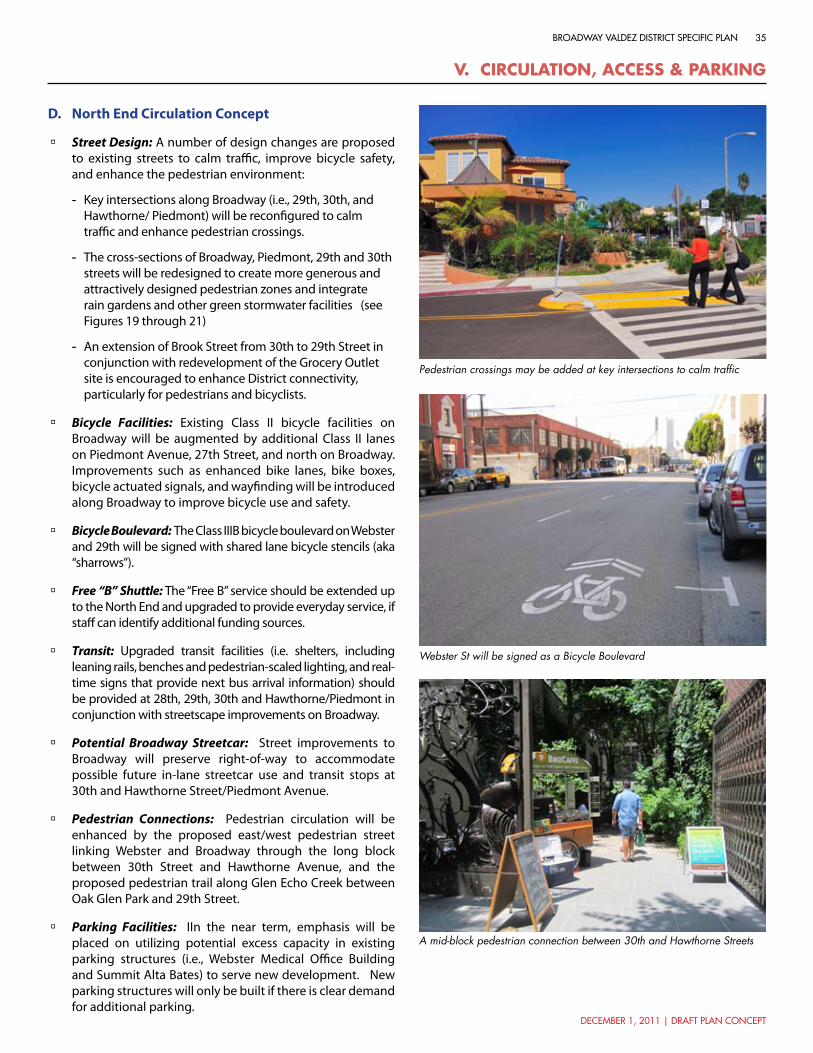
december 1, 2011 | draft plan concept
35broadway valdez district specific plan
v. cIrcUlatIon, access & ParkIng
North End Circulation ConceptD.
Street Design: à A number of design changes are proposed to existing streets to calm traffic, improve bicycle safety, and enhance the pedestrian environment:
Key intersections along Broadway (i.e., 29th, 30th, and -Hawthorne/ Piedmont) will be reconfigured to calm traffic and enhance pedestrian crossings.
The cross-sections of Broadway, Piedmont, 29th and 30th -streets will be redesigned to create more generous and attractively designed pedestrian zones and integrate rain gardens and other green stormwater facilities (see Figures 19 through 21)
An extension of Brook Street from 30th to 29th Street in -conjunction with redevelopment of the Grocery Outlet site is encouraged to enhance District connectivity, particularly for pedestrians and bicyclists.
Bicycle Facilities: à Existing Class II bicycle facilities on Broadway will be augmented by additional Class II lanes on Piedmont Avenue, 27th Street, and north on Broadway. Improvements such as enhanced bike lanes, bike boxes, bicycle actuated signals, and wayfinding will be introduced along Broadway to improve bicycle use and safety.
Bicycle Boulevard: à The Class IIIB bicycle boulevard on Webster and 29th will be signed with shared lane bicycle stencils (aka “sharrows”).
Free “B” Shuttle: à The “Free B” service should be extended up to the North End and upgraded to provide everyday service, if staff can identify additional funding sources.
Transit: à Upgraded transit facilities (i.e. shelters, including leaning rails, benches and pedestrian-scaled lighting, and real-time signs that provide next bus arrival information) should be provided at 28th, 29th, 30th and Hawthorne/Piedmont in conjunction with streetscape improvements on Broadway.
Potential Broadway Streetcar: à Street improvements to Broadway will preserve right-of-way to accommodate possible future in-lane streetcar use and transit stops at 30th and Hawthorne Street/Piedmont Avenue.
Pedestrian Connections: à Pedestrian circulation will be enhanced by the proposed east/west pedestrian street linking Webster and Broadway through the long block between 30th Street and Hawthorne Avenue, and the proposed pedestrian trail along Glen Echo Creek between Oak Glen Park and 29th Street.
Parking Facilities: à IIn the near term, emphasis will be placed on utilizing potential excess capacity in existing parking structures (i.e., Webster Medical Office Building and Summit Alta Bates) to serve new development. New parking structures will only be built if there is clear demand for additional parking.
Pedestrian crossings may be added at key intersections to calm traffic
Webster St will be signed as a Bicycle Boulevard
A mid-block pedestrian connection between 30th and Hawthorne Streets

36
december 1, 2011 | draft plan concept
city of oakland
0 175 350 ft
477
467
309
83
1,086
433
1,216
51
59
59a
59
59a
51
851
11
12
abB A R T MacArthurBART(0.7 mi)
34TH ST
SUM
MIT
ST
28TH ST
ELM
ST
HARRISON S
T
FAIR
MO
UN
T A
V
TELE
GR
APH
AV
HAWTHORNE AV
FRISBIE ST
OAKLAND A
V
ORANGE ST
HAMILTON PL
MC
CLU
RE
ST
GARLAND AV
AN
DO
VER
ST
SUM
MIT
ST
FRISBIE ST
29TH ST
BRO
AD
WAY
WEB
STER
ST
27TH ST
PIEDMONT AV
BR
OO
K S
T
RICH
MO
ND BLV
D
RAN
DW
ICK AV
CROXTO
N AVHAWTHORNE AV
30TH ST
Oak Glen Park
26TH ST
VALD
EZ S
T
Alta Bates Summit Medical Center
Kaiser Permanente Medical Center
Mosswood Park
29TH ST
30TH ST
(SEE FIGURE 13 FOR VALDEZ TRIANGLE CIRCULATION CONCEPT)
Parking Facilities
Existing Parking Structure / Spaces #
Bicycle Facilities
Existing Class IIIa
Proposed Class IIIa
Proposed Bicycle Blvd
Existing Class IIProposed Class II
TransitAC Transit Line
Free “B” Shuttle (Weekend)
Potential Broadway Streetcar
Existing Park/ Greenway
Project Boundary
#
Potential Park/ Greenway
Pedestrian ConnectionsExisting Pedestrian Path
Proposed Pedestrian Path
Free “B” Shuttle
Existing Parking Lot / Spaces #
Future Parking Structure / Spaces #
figure 18: north end circulation concept 0 175 ft 350 ft
v. cIrcUlatIon, access & ParkIng

december 1, 2011 | draft plan concept
37broadway valdez district specific plan
Parking &Travel Lane
Parking &Travel Lane
Sidewalk Sidewalk
Sidewalk SidewalkTravel Lanes
12’ 12’
12’ 24’ 8’ max. 8’ max. 12’
20’ 20’
64’ ROW
40’
64’ ROW
40’
SOUTH SIDE NORTH SIDEParking/Bulb Out
Parking/Bulb Out
1/16”=1’
v. cIrcUlatIon, access & ParkIng
figure 19: 29th street
Proposed
Existing
Summary of Improvements:
Maintain existing 12-foot sidewalk widths to accommodate pedestrian flow and amenities à
Maintain existing curb-to-curb cross-section, but stripe to provide 8-foot parking lanes and 12-foot travel lanes à
Add bulb-outs at key intersections to calm traffic, facilitate pedestrian crossing, and accommodate rain gardens and àother landscape features to aid in stormwater management
Provide a consistent planting of street trees à
Provide attractive pedestrian-scaled lighting à
Designate as a Bicycle Boulevard and add “sharrows” to indicate shared use between bicycles and vehicles in the travel lane à
*Final street designs will be determined as part of the Specific Plan following coordination with TSD.

38
december 1, 2011 | draft plan concept
city of oakland
Parking &Travel Lane
Parking &Travel Lane
Sidewalk Sidewalk
Sidewalk SidewalkTravel LanesParking/Bulb-Out
Parking/Bulb-Out
8’-14’ 8’-14’
Varies(8’ min)
Varies(8’ min)
18’-24’7’-8’ 7’-8’
16’-18’ 16’-18’
Varies(58’-62’ ROW)
Varies(58’-62’ ROW)
(32’- 40’ )
Varies(32’-40’ )
SOUTH SIDE NORTH SIDE
Varies
1/16”=1’
v. cIrcUlatIon, access & ParkIng
figure 20: 30th , hawthorne, and 34th streets
Proposed
Existing
Summary of Improvements:
Maintain existing sidewalk widths and existing curb-to-curb cross-section à
Add bulb-outs at key intersections to calm traffic, facilitate pedestrian crossing, and accommodate rain gardens àand other landscape features to aid in stormwater management
Provide a consistent planting of street trees à
Provide attractive pedestrian-scaled lighting à
*Final street designs will be determined as part of the Specific Plan following coordination with TSD.

december 1, 2011 | draft plan concept
39broadway valdez district specific plan
v. cIrcUlatIon, access & ParkIng
11’ 8’26’ 26’
48’
52’
10’9’ 6’6’ 9’8’8’ 10’
Sidewalk SidewalkParking/Bulb-Out
Parking/Bulb-Out
TravelLane
TravelLane
BikeLane
BikeLane
WEST SIDE EAST SIDE
Parking &Travel Lane
Parking &Travel Lane
1/16”=1’
71’ ROW
66’ ROW
Sidewalk Sidewalk
figure 21: piedmont avenue
Proposed
Existing
Summary of Improvements:
Widen sidewalks on both sides of street to 9 feet to better accommodate pedestrian flow and amenities à
Re-stripe street cross-section to provide 8-foot parking lanes, 6-foot bike lanes, and 10.5 travel lanes in each direction à
Provide a consistent planting of street trees à
Provide attractive pedestrian-scaled lighting à
Add bulb-outs at key intersections to calm traffic, facilitate pedestrian crossing, and accommodate rain gardens and àother landscape features to aid in stormwater management
*Final street designs will be determined as part of the Specific Plan following coordination with TSD.

40
december 1, 2011 | draft plan concept
city of oakland
vI. ImPlementatIon aPProach and strategIes
As previously noted, the vision for the Broadway Valdez District is faced with many challenges, some inherent to the area and some related to the broader economy. As a result, implementation of the vision for the District is projected to occur incrementally. The challenge in this period of limited resources and cautious development is to identify strategic near-term actions that can be taken to better position the area for future development by contributing to the area’s appeal and value.
In order to build on the energy being generated by the arts and dining scenes in the adjoining Uptown and Garage Districts, the strategy is to concentrate near-term investments in the Valdez Triangle, particularly along the Broadway and Webster Street corridors between Grand Avenue and 26th Street. The focus of these near-term actions should be to activate the area and enhance its physical character.
Near Term StrategiesA.
Extending the Lake Merritt/Downtown Community àBenefits District: Currently Downtown Oakland and the Lake Merritt/Uptown areas are part of community benefit districts that provide security and maintenance of the shared public realm through a property tax assessment paid by property owners in the area. By extending this boundary to include the Triangle, it would provide a mechanism for improving the area’s safety and cleanliness.
Arts and Entertainment District: à An Arts and Entertainment Overlay District could be created for the area along Broadway from Grand Avenue to 28th Street, to incentivize new arts and entertainment type uses by loosening regulations related to things such as outdoor dining and hours of operation.
Designing for Safety: à Creating a sense of safety in the District is essential for successful redevelopment. Therefore, principles of Crime Prevention Through Environmental Design (CPTED) should accompany all design recommendations. Near-term improvements may include pedestrian-scaled lighting, street trees that are well-maintained and appropriately-scaled, and landscaping that presents an open and obstacle-free public realm. For long-term redevelopment, design guidelines will ensure that the built environment addresses the public realm and puts “eyes on the street.”
Public Art: à Public art may be included in a variety of ways and is a commonly-used strategy for generating interest, adding visual appeal, and contributing district identity. Public art can be either temporary or permanent, and can take many forms including sculpture, murals, street furniture, water features, video, and even performance.
Temporary Events: à Temporary events such as festivals, gatherings of mobile food vendors, farmers markets, and craft fairs are excellent vehicles for drawing attention and activity to the District and establishing an identity for the
Pop-up Food Vendor, San Francisco, CA
Temporary Event in Vacant Lot, Williamsburg, New York
area which will make it more appealing for permanent development. Several large parking lots located along Broadway and Webster would be ideal locations for such events, and could be coupled with temporary street closures to provide additional space and engage existing businesses.
Pop-up Storefronts: à Visible and attractive storefronts line Broadway and side streets within the District, yet many of them are vacant. These storefronts offer the ideal spaces for temporary use by vendors that may not have the means to open a permanent business, or for the exhibition of student work, art work, or other civic displays. This can help generate buzz within the area and encourage longer-term development.
Public Space Enhancement: à The existing plazas on Broadway at 25th and 27th streets represent opportunities to make public space improvements that can contribute to the area’s identity and provide spaces for public gathering. Such improvements should focus on making these spaces more comfortable and accommodating for people, and shift the identity away from automobile sales.

december 1, 2011 | draft plan concept
41broadway valdez district specific plan
vI. ImPlementatIon aPProach and strategIes
figure 22: short term strategies - valdez triangle 0 175 ft 350 ft
0 175 350 ft
27TH ST
21ST ST
28TH ST
FAIR
MO
UN
T A
V
SUM
MIT
ST
VERNON ST
HAMILTON PL
FRA
NK
LIN
ST
KA
ISER
PLZ
MONTECITO AV
MERRIMAC ST
28TH ST
22ND ST
SUM
MIT
ST
VALL
EY S
T
Potential Mural Location
Existing Business/ Activity GeneratorsProject Boundary
Short-term Strategy Focus Area
Public Plaza
Streetscape Improvements
Adaptive Reuse
Parking Lots to be Activated with Temporary Events
Potential Temporary Event Street Closure
23RD ST
HA
RRIS
ON
ST
WEB
STER
ST
BA
Y PL
RIC
HM
ON
D A
V
28TH ST
26TH ST
GRAND AV
24TH ST
TELE
GR
APH
AV
VALD
EZ S
T
VALD
EZ S
T
29TH ST
WEB
STER
ST
30TH ST
W GRAND AV
25TH ST
27TH ST
WA
VER
LY S
TBRO
AD
WAY
Lake Merritt
Cathedral of Christ the Light
Whole Foods
First Congregational
Church of Oakland
First Presbyterian
Church
Westlake Middle School
Adams Park/ Veterans Memorial

42
december 1, 2011 | draft plan concept
city of oakland
(e.g., curb extensions, refuge islands, lighting, etc.) and enhanced transit stops (e.g., shelters, seating, signage, etc.). Bicycle use can be enhanced by adding in-street enhancements such as painted bike lanes and bike boxes and adding facilities for bike parking.
Parking Benefit District: à A Parking Benefit District may be established that can help manage and finance parking resources and finance streetscape improvements that promote walking, cycling and transit use, such as sidewalks, curb ramps, and bicycle lanes.
Public Parking: à Contributing to the funding of a centralized public parking garage could catalyze new development in the District while also supporting a “park once” strategy and creation of a pedestrian-oriented environment.
Broadway Streetcar: à Re-introducing streetcar service to Broadway would demonstrate not only a significant commitment by the City to the Broadway corridor, but would also improve access to the area and contribute to establishing a unique new identity for the Broadway Valdez District.
Transit Facilitiy, Portland, OR
“Bike Box” Bicycle Facility, San Francisco, CA
Parklets: à Not all public space improvements need to be permanent. The current trend of using public parking spaces to create parklets that provide additional public outdoor seating is an excellent way to promote pedestrian activity and enhance neighborhood character by providing pleasant places for people to stop, rest and relax.
Attracting Business: à A “Business Development Team” should be established, where businesses, residents, property owners, and CEDA’s Business Development Department work together with real estate brokers to attract and maintain businesses in the identified priority areas. Focused strategies could include the formation of a “restaurant row” on the east side of Broadway between 30th and Piedmont Avenue.
Historic Building Regulation: à Creating greater flexibility in building regulations on historic buildings to make adaptive reuse of existing buildings more financially feasible for building owners, while still ensuring that safety code requirements are met, will help transition former garage and automobile showrooms to new commercial uses while also protecting the District’s architectural heritage.
Façade and Tenant Improvement Programs: à Façade and tenant improvement programs that provide grants to property owners to make physical building improvements can have immediate beneficial effects on District character and improve the leasability of commercial space and bring new businesses to the area.
Free “B” Shuttle Service: à Extending Free B bus service to 27th Street on a daily basis will facilitate getting people to and from the area, providing increased activity and support for District businesses.
Mid- and Long-Term StrategiesB.
Extending the CBD: à In order to reinforce the concept of the Triangle as an extension of the Downtown, the Central Business District (CBD) General Plan and Zoning designations will be extended north to incorporate the District. These boundaries are currently set at 23rd Street, while areas to the north are designated as Community Commercial. Applying the CBD policies and regulations will ensure that future development meets requirements for land use and urban form that are consistent with the vision for the District.
Streetscape Improvements: à Streetscape improvements to the pedestrian zones such as street trees, benches, bollards, lighting and decorative paving can transform the physical character and perception of the District, and demonstrate the City’s commitment to future development.
Pedestrian, Bicycle and Transit Facilities: à Connectivity and mobility improvements within the District are important elements that will improve access to the District, increase pedestrian activity, and ultimately encourage new development. Pedestrian activity will be enhanced through improved pedestrian crossings at key intersections
vI. ImPlementatIon aPProach and strategIes

december 1, 2011 | draft plan concept
43broadway valdez district specific plan
Parklet, San Francisco, CA
vI. ImPlementatIon aPProach and strategIes
MacArthur BART Underpass Lighting, Oakland, CA
Underpass treatment, Burnside Bridgehead, Portland, OR
Reuse of “garage” building, San Diego, CA
Historic building reuse, Pasadena, CA
Plaza Improvement, Walnut Creek, CA

Wallace Roberts & Todd, LLC
444 Townsend Street, Suite 4
San Francisco, CA 94107
415.575.4722
www.wrtdesign.com


![Broadway - Capital Pacific · 206 Broadway E Seattle, WA 98102 206 Broadway [ ] 206 Broadway . 206 Broadway Broadway is a generational ... TRANSIT SCORE 91*](https://static.fdocuments.net/doc/165x107/5ac3885d7f8b9aae1b8c7cb8/broadway-capital-broadway-e-seattle-wa-98102-206-broadway-206-broadway-.jpg)


