
Bova Marina Preliminary Archaeological Report, Project ... · Report, 2008 Season edited by John...
71
Bova Marina Archaeological Project Preliminary Report, 2008 Season edited by John Robb With contributions by Meredith Chesson, Helen Farr, Paula Lazrus, Kostalena Michelaki, John Robb, Chantel White, Nicholas Wolff, and David Yoon Department of Archaeology Cambridge University Cambridge CB2 3DZ United Kingdom tel. 00-44-1223-339004 fax 00-44-1223-333503 [email protected]
Transcript of Bova Marina Preliminary Archaeological Report, Project ... · Report, 2008 Season edited by John...

Bova Marina
Archaeological
Project
Preliminary
Report,
2008
Season
edited by John Robb
With contributions by
Meredith Chesson,
Helen Farr, Paula
Lazrus, Kostalena
Michelaki, John Robb,
Chantel White, Nicholas
Wolff, and David Yoon
Department of Archaeology
Cambridge University
Cambridge CB2 3DZ
United Kingdom
tel. 00-44-1223-339004
fax 00-44-1223-333503
Bova Marina Archaeological Project 2008
2
CONTENTS
Riassunto: “Proggetto Archeologico Bova Marina”, 2008 Campagna di ricerca________________ 4
Scavi dell’età del Bronzo e medioevale a Sant’Aniceto (Chesson, Robb, Yoon)__________________ 4
L’occupazione medieovale e greca di Sant’Aniceto (Yoon) _________________________________ 5
Studi di archeologia del paesaggio ____________________________________________________ 5
Revisione delle collezioni preistoriche nel Museo Archeologico Nazionale di Reggio Calabria (Robb)6
1. Introduction: project goals for 2008 (John Robb) ______________________________________ 7
2. Bronze Age and Medieval Excavations at Sant’Aniceto (Meredith Chesson, John Robb,
Nicholas Wolff, and David Yoon) ______________________________________________________ 9
2.1. Introduction __________________________________________________________________ 9
2.2. Trench 4____________________________________________________________________ 10
2.3. Excavations north and north-east of the church: Trenches 9 and 10 (Nicholas Wolff)________ 21
2.4. Prehistoric finds ______________________________________________________________ 26
2.5. Palaeobotanical analysis of flotation samples from Sant’Aniceto (Chantel White) ___________ 29
2.6. Sediment sampling and micrimorphological analysis at Sant’Aniceto, 2007-8 (Nicholas Wolff) 30
2.7. Radiocarbon dates for Sant’Aniceto_______________________________________________ 35
2.8. Trench 8, and the Classical and medieval finds (David Yoon)___________________________ 36
3. Landscape Investigations _________________________________________________________ 42
3.1. 2008 Field Survey (David Yoon) _________________________________________________ 42
3.2. Historical landscape investigations (Paula Lazrus) __________________________________ 46
3.3. Technological studies of prehistoric pottery and raw material survey (Kostalena Michelaki) __ 47
3.4. Archaeology of coastal land use in the Bova Marina area (Helen Farr and John Robb)______ 54
4. Restudy of the prehistoric collections in the Museo Archeologico Nazionale, Reggio Calabria
(John Robb)_______________________________________________________________________ 60
4.1. The collections _______________________________________________________________ 60
4.2. Review by period______________________________________________________________ 61
Bibliography ______________________________________________________________________ 70

Bova Marina Archaeological Project 2008
3
Acknowledgements
We are grateful to Dott. Caterina Greco, Soprintendente, and to Dottoressa Rossella Agostino, Ispettrice, of the Soprintendenza Archeologica della Calabria for help, advice and administrative support; to our host, Silvana Scordo, for her hospitality; and to our cooks, Franca Meduti and Annunziata Caracciolo. We are also grateful to the Amminstrazione Comunale of Bova Marina for collaboration and Drs. E. and A. Mollica for their consent to excavate at Sant’Aniceto. We gratefully acknowledge funding from the McDonald Institute for Archaeological Research at Cambridge University, the Arts and Humanities Research Council, the SSHRC (Canada) Strategic Research and Research Development Initiatives and the Department of Anthropology, McMaster University, and the Institute for Scholarship in the Liberal Arts at the University of Notre Dame.
Bova Marina Archaeological Project: Crew, 2008 Season
Co-director (Prehistory) Meredith Chesson (Notre Dame)
Co-director (Prehistory) John Robb (Cambridge)
Co-director (Survey, Medieval archaeology) David Yoon (New York)
Ceramic Technology Kostalena Michelaki (McMaster University)
Micromorphology Nicholas Wolff
Historic landscapes Paula Lazrus (St. John’s, New York)
Palaeobotany Chantel White
Coastal survey Helen Farr
Coastal survey, crew Glenn Dunaway
Crew Carina Buckley
Crew Sheena Ketchum
Crew Kelly Peterson
Site assistant Leo Romeo
Cook Annunziata Caracciolo
Cook Franca Meduti
Lab crew Johnanna Farr
Lab crew Nicholas Robb

Bova Marina Archaeological Project 2008
4
RIASSUNTO: “PROGGETTO ARCHEOLOGICO BOVA MARINA”, 2008
CAMPAGNA DI RICERCA
La campagna di ricerca 2008 del Proggetto Archeologico Bova Marina si è svolta dal 28 giugno fino al 28 luglio 2008. Per limitazioni finanziarie, l’equipe era formato da solo 10-12 persone; ciò nonostante, le ricerche erano molto prodottive. Oltre l’attività principale, lo scavo del sito preistorico e medioevale di Sant’Aniceto, perseguivamo varie ricerche sul paessaggio antico della zona e una revisione sistematica delle collezioni preistoriche nel Museo Archeologico Nazionale di Reggio Calabria.
Scavi dell’età del Bronzo e medioevale a Sant’Aniceto (Chesson, Robb, Yoon)
Sant’Aniceto è un sito preistorico e medioevale ubicato in cima di una collina ripida alta 180 m. slm, ad una distanza di 1.5 km dal mare accanto alla Torrente Vena. Il sito era già conosciuto dalla chiesetta medioevale e resti preistorici superficiali erano scoperti là alcuni anni fa. Nella prima campagna di scavo BMAP al sito, nel 2007, si sono scavati 7 saggi esplorativi in zone diverse. Si erano localizzate due strutture, un mura dell’Età del Bronzo vicino alla chiesetta ed un mura medioevale al punto più alto della collina. Le obiettive dello scavo 2008 comprendevano l’allargamento dello scavo della struttura del Bronzo (Trincea 4), la conclusione dello scavo del mura medioevale (Trincea 8), e l’esplorazione di altre aree del sito non ancora esplorato (Trincee 9 e 10).
La struttura dell’Età del Bronzo, ubicato nella zona immediatamente all’est della chiesetta medioevale, era segnalata dalla presenza di un tratto di mura nel quadrato 113e/ 104n (Trincea 4). In 2008, si sono scavati altri tre quadrati adjacenti. Si è dimostrato che il mura appartiene ad una struttura probabilmente di forma circolare invece di ovale, e di un diametro piuttosto grande (forse 8-10 m in totale). È quasi certo che la parte occidentale della struttura è stata distrutta nella costruzione della chiesa medioevale, ma il resto sembra in una condizione di conservazione eccezionale. Probabilmente si tratta di una casa o capanna; la struttura rientra nella tipologia di strutture abitative di epoca protostorica per la regione di Calabria e Sicilia orientale. In confronti con altri esempi coevi, è piuttosto alta, con mura di oltre un metro, ed è anomalo il fatto che il mura è inclinato invece di verticale; tutt’e’ due fatti probabilmente risultano dal modo semi-interrato di costruzione.
Durante lo scavo non si è raggiunto la base della struttura perchè il fondo del mura estende fuori i quadrati scavati. Il processo di riempimento si è svolto in tre fasi. Non molto tempo dopo l’abbandono della casa, la struttura veniva riempita con 20-50 cm di sedimenti omogenei e grigi, associati con ceramica protostorica e resti faunistici. L’analise micromorfologico suggerisce che questi sedimenti erano depositati rapidamente, forse in un solo episodio intenzionale, senza micro-stratigrafia. In seguito, c’era un fase di deposizione di sedimenti colluviale, sempre nel periodo protostorico. All’inizio dell’epoca storica, rimaneva una depressione profonda ca. 50 cm, la quale si è riempita con sedimenti colluviali associati con reperti medioevali e moderni (sopratutto tegole).
Si sono ottenuto tre datazione assolute per la struttura. Queste danno conferma che l’occupazione preistorica risale all’Età del Bronzo Finale (ca. 1200-900 a.C.), e probabilmente alla periodo più antico di quest’epoca, fra 1200 e 1000 a.C. Questa cronologia accorda bene con la ceramica di tipo Ausonio trovata al sito.
Due altri saggi erano scavati: Trincea 9 (1x2 metri, al nord della chiesetta) e Trincea 10 (1x1 metri, al nord di Trincea 4). Non si sono trovate strutture preistoriche o storiche, ma si è dimostrato l’esistenza di una stratigrafia intatta con una sepolta superficie preistorica che può meritare un’investigazione approfindita per raccogliere evidenza dell’uso di spazio esterno alla struttura abitativa. L’analise paleobotanica di due campioni di flottazione di Trincea 9 e uno di Trincea 4 ha rivelato la presenza di grano (triticum dicoccum), lens cf. culinaria, e vicia cf. sativa.

Bova Marina Archaeological Project 2008
5
L’occupazione medieovale e greca di Sant’Aniceto (Yoon)
Al stretto punto in cima della collina di Sant’Aniceto, abbiamo allargato Trincea 8, con lo scopo di scavare i resti esegui del mura medioevale localizzato in 2007. La trincea è stata allargata a 1x3 metri e scavata fino alla roccia di base. Il mura si estendeva in direzione est-ovest attraverso la trincea, ed è la parte inferiore di un mura strutturale. I sedimenti associati comprendono livelli di pietre, tegole e frammenti di gesso affrescato. Sulla base della tipologia di tegole, la struttura sembra più recente della chiesetta; sia lo stile degli affreschati sia i reperti ceramici suggeriscono una datazione al 15-16 secolo d.C. Rimane ancora incerta la funzione della struttura, anche se, con mure sostanziali e affreschati, probabilmente non era una capanna rustica; si deve interpretarla in connessione con l’uso religioso del sito.
Sulla base di una datazione assoluta al radiocarbonio, la prima occupazione medioevale di Sant’Aniceto è testimoniato dal silos o strutture erosiva scavato in Trincea 4 in 2007, il quale risale a 1000-1200 d.C. Alcune secolo dopo, si è stata costruita la chiesetta; visto che le muri della chiesetta congengono molte tegole medioevale, c’ere probabilmente una chiesetta o altra struttura anteriore al sito. La strutture di Trincea 8 segue ad una distanza di alcuni secoli. La cronologia che emerge degli scavi così da evidenza di una storia lunga dell’uso medioevale di Sant’Aniceto.
Come anche negli scavi 2007, lo scavo 2008 ha reso una quantità di resti di epoca greca, con tegole, frammenti di pithos, e frammenti di vasi più fine. È probabile quindi che c’era un’insediamento al sito nei periodi arcaico e classico. Comunque non sono stati trovati fino ad adesso resti in situ.
Studi di archeologia del paesaggio
Ricognizione territoriale (Yoon)
La ricognizione territoriale in 2008 era limitata a due giorni di ricognizione sistematia nei intorni di Sant’Aniceto e un giorno di ricognizione non-sistematica. Abbiamo compiuto la raccolta di dati su due siti già scoperti da L. Saccà e S. Stranges, tutt’e due localizzati a Monte Calamittà al ovest della città di Bova Marina. Uno (Calamittà a, b). Uno risale all’epoca greca (classico-ellenistico); l’altro all’epoca tardoromana-medioevale. Tutt’e’ due sono disturbati dall’erosione e dalla coltivazione di olive.
Uso storico del territorio (Lazrus)
Si è continuato lo studio dell’uso storico del territorio con ricerca al Archivio di Stato, Reggio Calabria, con particolare attenzione al Archivio Nesci e ai catasti storici; si è compiuta anche una visita preliminare al Archivio di Stato, Napoli, per verificare la presenza di documentazione relativa al territorio di Bova sotto il regno borbonico.
Studi tecnologici della ceramica preistorica e ricognizione di fonti di materiali crudi (Michelaki)
Questo progetto, a termine lungo, ha il scopo di capier lo sviluppo della tecnologia ceramica durante la preistoria. Quest’anno si è finito la ricognizone territoriale di materiali crudi. Si sono identificati e visitati tutte le numerose zone argillose in un raggio di 3 km dai siti preistorici di Umbro e Penitenzeria. Sono stati raccolti campioni geologici di argille naturali per analisi fisiche e chimiche all’Università di McMaster, Canada. I risultati saranno utilizzati come confronti per i materiali archeologici di Umbro, Penitenzeria ed altri siti preistorici per capire l’acquisizione di materiali crudi e il processo di manufattura della ceramica nella preistoria.
Bova Marina Archaeological Project 2008
6
Archeologia dell’uso della fascia costiera (H. Farr, Robb, Dunaway)
In questo proggetto, si sono messi insieme tutti i fonti di informazione sull’uso storico e preistorico della zona costiera (e.g. archivi del proggetto BMAP, cartografia, visiti a siti costieri, valutazione geografica delle possibilità di uso marittimo). Si è rivelato una forte evoluzione dell’uso umano della costa. Nelle epoche greca e romana, il mare era un modo di trasporto e di integrazione con posti lontani; in contrasto, dal medioevo fino a sec. XVIII, il mare aveva delle connotazioni negative e l’uso del mare sembra bassa. Dal 18 e 19 sec. si vede una crescità nell’uso del mare per trasporto e scambio regionale; nel 20 sec. si emerge un modello idiosincratico, con insediamento fortamente orientato alla costa ma con uso vero del mare minima tranne per tempo libero/ turistico. L’uso della costa nei periodi preistorici rimane per la maggiore parte sconosciuto; questa mancanza di dati riflette una sommersione della terra con la consequenza che i preistorici siti costieri saranno adesso probabilmente sommersi.
Revisione delle collezioni preistoriche nel Museo Archeologico Nazionale di Reggio
Calabria (Robb)
Lo scopo di questo proggetto era una rivisione sistematica dei materiali preistorici nel Museo
Archeologico Nazionale, Reggio Calabria. C’è una collezione notevole di reperti nei magazzini che risulta principalmente dalle attività di archeologhi della zona durante le ultime tre decenni (circa una meta delle collezioni sono state fatte da S. Stranges and L. Saccà, con contributi discreti da altri ricercatori). Inoltre, sono stati raccolti tutti gli altri fonti dispolibili sull’occupazione preistorica della zona (lavori pubblicati, comunicazioni personali di altri archeologhi, e la ricognizione BMAP). L’idea era di riunire tutti i dati dispolibili per formare un quadro sintetico della preistoria della zona.
Complessivamente, si sono identificati 99 siti preistorici nella zona da Capo Spartivento e Capo d’Armi; sono rappresentati tutti i periodi trannè per il Mesolitico. Per 30 siti, le collezioni contengono solo frammenti non databili di ceramica. Per 66, si può assegnarli ad uno o più epoche, anche se a volte in modo molto tentativo. I risultati dimostrano un’occupazione sparsa nel Paleolitico Medio e Superiore (2 siti); un’occupazione piuttosto fitta nel Neolitico (31 siti), discreta nell’Eneolitica (13 siti), e alta nell’Età del Bronzo (32 siti). Non si sono identificati siti dell’Età del Ferro per se, ma ci sono cinque siti appertinenti all’Ausonio e altre periodi della tarda protostoria, ed alcuni di questi probabilmente risalgono all’Età del Ferro.
Per quanto riguarda l’interpretazione di questi risultati, non si deve affidarsi troppo ai dati quantitativi sulla variazione fra periodi, visto che ci sono anche variazioni forti fra periodi preistorici in quanto sono riconoscibili da collezioni superficiali ed anche perchè alcuni periodi sono lunghi ed altri brevi. Comunque, si dimostra chiaramente un’occupazione continua e fitta della zona in tutta l’arca cronologica dal Neolitico fino ai tempi storici, compresi periodi come l’Età del Rame e l’Età del Ferro che prima erano sconisciuti o conosciuti da pochissimi siti.

Bova Marina Archaeological Project 2008
7
1. INTRODUCTION: PROJECT GOALS FOR 2008 (JOHN ROBB)
The 2008 field season of the Bova Marina Archaeological Project opened on the 28th of June and closed on the 29th of July. Due to exigencies of reseach funding and other research commitments, our project was small this year, with no classical team and a reduced prehistoric team. Funding limitations reflects both cuts to UK research agencies and the weakening value of the pound and dollar against the euro. We therefore planned accordingly, with a small, strategically targeted field project.
The first few days of the project overlapped with the end of a four-week season of underwater geological reconnaissance and geophysical prospection carried out in collaboration between Dr. E. Reinhardt and Dr. J. Boyce of McMaster University and Dr. J. Robb and Dr. H. Farr of Cambridge University. Following this, the remainder of the season continued with a core of 10-12 staff, including specialists, a small but highly experienced field crew, and lab staff.
We had two principal goals to accomplish in the 2008 field season, and four specialist landscape projects.
1. Our main fieldwork was to continue the excavation at the Bronze Age site of Sant’Aniceto. Extensive site testing in 2007 had revealed well-preserved Bronze Age architecture and stratified deposits as well as sub-surface medieval features. Because limited crew and funding made a large area excavation impossible, we planned instead to continue the site testing to explore other areas of the site, to finish excavating the medieval wall fragment uncovered in 2007 in Trench 8, and to obtain specific data on the Trench 4/7 area important for planning more extensive work in the future. This work was directed jointly by Meredith Chesson, John Robb and David Yoon, assisted by Nicholas Wolff.
2. A parallel project involved reviewing the prehistoric collections kept in the Museo Archeologico
Nazionale di Reggio Calabria. These collections include materials collected as far back as the 1950s and result from substantial work by both professional archaeologists and local enthusiasts; they represent an unstudied repository of the archaeology of the zone between Capo d’Armi and Capo Spartivento. In 2008, we intended to conduct a systematic review of them with the goal of creating a reliable archaeological map for the prehistory of this zone. This was carried out by John Robb.
3. Our specialist landscape projects included:
a. Continuation of the Bova Marina site survey. Because of crew limitations and because David Yoon, the survey director, was also occupied with the medieval excavations at Sant’Aniceto, we carried out very little field survey this year; nonetheless, we surveyed some of the immediate environs of Sant’Aniceto to complete our coverage of the site’s context, as well as revisiting and re-recording two known sites in the area.
b. Paula Lazrus continued her investigation of historical landscape use through a combination of archive work at the Archivio di Stato, Reggio Calabria and landscape reconnaissance, in part in collaboration with Kostalena Michelaki’s survey of clay sources and in part in collaboration with the coastal land use investigation.
c. Kostalena Michelaki continued her long-term research into the prehistoric ceramic technology of Bova Marina. This year’s work was concentrated largely upon completing the raw material survey of the area, with extensive targeted visits to geological deposits throughout the territory of Bova Marina and Bova to collect specific clays for physical and chemical analysis and experimental replication work.
d. In concert with the AHRC-funded investigation of underwater geological reconnaissance, we carried out an investigation into coastal land use in Bova Marina and adjacent areas. This involved visits to coastal sites and evaluation of the coastline in terms of its potential for ancient maritime activity and for preserved evidence of such activity. This work was carried out by Glenn Dunaway and Dr. Helen Farr.

Bova Marina Archaeological Project 2008
8
Fieldwork went very well, with fruitful results and no unanticipated events. As described below, the Trench 4 extension changed our picture of the Bronze Age hut’s form, provided confirmation of the stratified sequence there, finished exposing the medieval wall fragment, and provided important samples for botanical, micromorphological, faunal and not least radiocarbon analysis. Absolute dates for the site are now available, confirming conclusively its Final Bronze Age date suggested by its ceramics. Revision of the museum collections proved similarly productive, resulting in a list of 99 known prehistoric sites in the area, approximately half of which can be dated to specific periods. All four of the landscape projects achieved their goals for the season and made substantial progress towards their long-term objectives.
It was an unusually busy season for presentation of archaeology to the public in various forms. On one level, we had visits and informal discussions with local enthusiasts, reports on our work in the local press (Il Quotidiano and Calabria Ora), and email correspondence from members of the public visiting our bilingual project website (www.arch.cam.ac.uk/~jer39/BMAP), which shows a continuing public interest in uncovering the archaeology of Bova Marina. During the field season, we also presented our cumulative results from many years’ work in a general lecture to the public of San Luca, and John Robb presented highlights of recent work to the town of Bova Marina in a well-attended public lecture hosted by the mayor, Dott. Giovanni Squillace. We also participated in planning discussions for two new museums projected for Bova Marina, the Antiquarium being built at San Pasquale by the Soprintendenza
Archeologica della Calabria for the display of which Robb selected and catalogued finds from BMAP excavations in Bova Marina and the historical museum being constructed by the Comune di Bova Marina in the ex-Frantoio Nesci, Contrada S. Pasquale.

Bova Marina Archaeological Project 2008
9
2. BRONZE AGE AND MEDIEVAL EXCAVATIONS AT SANT’ANICETO
(MEREDITH CHESSON, JOHN ROBB, NICHOLAS WOLFF, AND DAVID YOON)
2.1. Introduction
Sant’Aniceto is a small Bronze Age and medieval site located in southwestern Bova Marina, on a rocky, steep peak above the Torrente Vena about 2 km inland. As described in the BMAP 2007 Report, text excavations there revealed a well-preserved, buried prehistoric site and interesting medieval features both around the church still standing on the site and upon the small peak which forms the hill’s highest point. A small team returned to continue test excavations at Sant’Aniceto in July 2008. Based on the preliminary results of 2007 tests, we expanded two trench areas (Trenches 4 and 8) and opened two new trenches (Trenches 9 and 10) (Figure 1). Descriptions of the results from each trench follows below, as well as discussions of artifactual material recovered in each trench.
Figure 1. Sant'Aniceto, showing excavation trenches.
Bova Marina Archaeological Project 2008
10
2.2. Trench 4
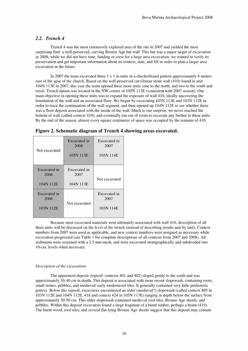
Trench 4 was the most extensively explored area of the site in 2007 and yielded the most surprising find: a well-preserved, curving Bronze Age hut wall. This hut was a major target of excavation in 2008; while we did not have time, funding or crew for a large area excavation, we wanted to verify its preservation and get important information about its context, date, and fill in order to plan a larger area excavation in the future.
In 2007 the team excavated three 1 x 1 m units in a checkerboard pattern approximately 6 meters east of the apse of the church. Based on the well-preserved curvilinear stone wall (410) found in unit 104N 113E in 2007, this year the team opened three more units (one to the north, and two to the south and west). Trench datum was located in the NW corner of 105N 113E (consistent with 2007 season). Our main objective in opening these units was to expand the exposure of wall 410, ideally uncovering the foundation of the wall and an associated floor. We began by excavating 105N 113E and 103N 112E in order to trace the continuation of the wall segment, and then opened up 104N 112E to see whether there was a floor deposit associated with the inside of the wall. Much to our surprise, we never reached the bottom of wall (called context 410), and eventually ran out of room to excavate any further in these units. By the end of the season, almost every square centimeter of space was occupied by the remains of 410.
Figure 2. Schematic diagram of Trench 4 showing areas excavated.
Not excavated
Excavated in 2008
105N 113E
Excavated in 2007
105N 114E
Excavated in 2008
104N 112E
Excavated in 2007
104N 113E
Not excavated
Excavated in 2008
103N 112E
Not excavated
Excavated in 2007
103N 114E
Because most excavated materials were ultimately associated with wall 410, description of all three units will be discussed on the level of the trench (instead of describing results unit by unit). Context numbers from 2007 were used as applicable, and new context numbers were assigned as necessary while excavation progressed (see Table 1 for complete descriptions of all contexts from 2007 and 2008). All sediments were screened with a 2.5 mm mesh, and were excavated stratigraphically and subdivided into 10-cm. levels when necessary.
Description of the excavations
The uppermost deposit (topsoil: contexts 401 and 402) sloped gently to the south and was approximately 30-40 cm in depth. This deposit is associated with more recent slopewash, containing roots, small stones, pebbles, and medieval/ early modernroof tiles. It generally contained very little prehistoric pottery. Below this topsoil, excavators encountered an older (medieval?) slopewash (called context 405 in 103N 112E and 104N 112E, 418 and context 424 in 105N 113E) ranging in depth below the surface from approximately 30-50 cm. This older slopewash contained medieval roof tiles, Bronze Age sherds, and pebbles. Within this deposit excavators found a large fragment of a burnt timber, perhaps a beam (419). The burnt wood, roof tiles, and several flat-lying Bronze Age sherds suggest that this deposit may contain

Bova Marina Archaeological Project 2008
11
redeposited materials, both prehistoric pottery and medieval building debris. These could have been associated with the construction of the church, as it is known that the Bronze Age deposits in nearby Area 7 (excavated in 2007) were disturbed when the foundation trench for the church wall was dug. It seems likely that relatively large Bronze Age sherds were thrown up onto the medieval ground surface where they sat, mixed with medieval debris, for some length of time before being buried.
Below this probably medieval slopewash (contexts 405 and 424) the deposits are chiefly related to the prehistoric infilling of the structure defined by wall 410. Wall 410 is part of a semi-subterranean, curvilinear, stone structure. It was probably a house wall which may have been dug into the ground either all around or just on one side where the slope was higher. As the wall descended, each course of stone was positioned slightly closer to the centre of the structure so that the overall wall sloped downwards at about 60 degrees (see profiles below). Excavators uncovered 17 courses of stones in 104N 112E before running out of room to excavate in the limited area of the sondage.
Proceeding downwards in the stratigraphy, the first stratum encountered inside the wall was a level of medieval roof materials and mixed prehistoric and medieval debris. This evidently resulted from materials from upslope washing in to fill the abandoned structure, which would have been mostly but not entirely filled in at this point. Some of the higher stones in the wall stub evidently also were dislodged and fell into the structure at this point too. Deposits slope downward from sides of wall 410, and stones fallen from the wall (this rock fall is called context 427 in 105N 113E and context 429 in 104N 112E and 103N 112E) rest at an angle along the face of the wall in several instances. The most recent deposits associated with the filling in of this structure were 429 and 427 (large stones fallen from the wall) found within contexts 420 (104N 112E and 103N 112E) and 430 (105N 113E). Context 429 (wall fall) extends from the top of the wall to the lowest courses in 104N 112E. Mixed in with the wall fall, excavators found a few chunks of molded and unmolded daub.
These deposits were likely laid down over an extended period of time, as the uppermost stony portions contain medieval tile, while the lower levels of 429 contained daub and prehistoric pottery. In unit 105N 113E context 430 was deposited over the uppermost courses of wall 410, suggesting that at least part of this wall was visible in the medieval period and that the process of completely burying the structure occurred over a period of two millennia. Preliminary micromorphological analysis of deposits suggests that the initial infilling of the structure was relatively quick (see below), but it seems that at least one portion of the structure (particularly the section excavated in 105N 113E) was visible to the medieval builders of the church.
A major stratigraphic break, in terms of both artifacts and sediments, is represented in the transition from contexts 420/430 to all deposits below. In the most general sense, the deposits including and above 420/430 contain a mixture of medieval tile and prehistoric pottery, but below this point excavators found only prehistoric pottery, as well as a considerable quantity of faunal remains. In terms of the sediments, contexts 420/430 and deposits above were all some variation of brown sediment; below 420/430 all deposits are grey and ashy in feel (see micromorphological analysis below for further details on the different grey deposits).
Directly under context 420 in 104N 112E, excavators uncovered a series of thin, gray deposits (423, 425, and 428) which sloped downward as they ran westward from the edges of the stone wall 410 towards the center of the structure. Context 423 was approximately 10-12 cm thick, very loose, ashy grey in color, and contained very small pebbles and faunal remains. Context 425 was 8-10 cm in depth, slightly more compact than 423, also grey in color and contained small pebbles. Context 428 was very loose, soft, silty, gray-brown material with disintegrating bits of sandstone. Context 428 was limited to a small lens of material, approximately 5 cm in depth, found only in the northwestern portion of 104N 112E.
Underlying these three lenses of grey ashy material was context 426, approximately 32 cm in depth, and composed of light, very loose, silty gray material. This deposit also sloped to the west from the western face of wall 410 toward the center of the structure. To the naked eye, the material seemed to be grey ashy material, but it contained almost no charcoal. This context matches in elevation and composition context 705, which was identified at about this depth four metres to the west in the Apse Profile (Area 7, see 2007 report). Context 426 contained a well-preserved faunal remains, molded and unmolded daub,

Bova Marina Archaeological Project 2008
12
and Bronze Age ceramics. It seems to be redeposited material. This material may perhaps have been part of the roof materials, or decomposed wall treatment (from a wall plastering?). Samples of this material were collected for micromorphological analysis (see below).
Below context 426, excavators found context 432, which was more compact, a silty brownish grey, and approximately 40 cm in depth. This context contained visible charcoal flecks, with more small- and medium-sized pebbles, and fist-sized and larger stones. On the top of 432, excavators found two small, hard patches of material (431) which we had hoped might be part of a floor. However, on further exploration, it was decided that 431 was simply an extremely compacted patch of the top of 432, suggesting that perhaps the upper surface of deposit 432 may have been exposed to the elements to harden a bit in at least these two small patches. Only further excavation of the interior of this structure will allow us to access the nature of this transition from 426 to 432, and to investigate whether 431 turns out to be behaviorally significant (i.e., an actual floor).
There is a clear contextual change at the bottom of context 432, signaled by the appearance of packed rubbly material including small stones and pottery (context 433). The deposit was grayish brown, with charcoal flecks, stones, pottery and faunal remains. It seemed to have been packed closely together, with many of the faunal remains and pottery sherds found in all orientations as if someone had laid down a fill and packed it as well as they could. For this reason, we hypothesize that 433 represents a fill event, possibly indicating that the top of this context may have been a walking surface and a floor inside the structure. Only a very small area of the interior of the structure could be exposed at this depth, so it is hard to interpret the small amount of context 433 found. It seems likely that this section of flooring may not have survived the abandonment and decomposition of the structure. Alternatively, there may also have been a bench along the wall where we were excavating. If this were the case, then the floor would not have been hard-packed since people would not have been walking on it, and thus it would not be easily discernable. Further support for the idea of a bench comes in the form of architectural daub fragments found in contexts 426 and 429, which were molded around a stick or a pole about 3 cm in diameter (which could have been placed into the floor to support a bench). Ultimately expanded excavations of the interior of this structure will be the only way to understand if this transition between 432 and 433 was the final occupational floor for this structure.
Finally, excavation in 2008 helped correct a misinterpretation in the 2007 report. In the north-easternmost square of Trench 4 (105n 114e) we encountered a loose, vertical scatter of medium-sized rocks in the western profile. These were named Context 415 and tentatively interpreted as a damaged remnant of a possible wall. Based upon their stratigraphic position and associated finds such as medieval roof tile, they were assigned to the medieval period. Because they were set in the baulk of the square, they were left in situ. In 2008, we excavated these stones in the course of taking out the adjacent square to the west (105n 113e). It became clear that they are not a wall of any kind, but just a loose tumble of stones. They may simple be tumbled stones; another possibility is that all or some of them were originally part of the top of the Bronze Age wall, and they became dislodged and redeposited.
T10T9
T4
N
0 5 10 m
Figure 3. Reconstructed form of Bronze Age structure, with medieval church
indicated on left.

Bova Marina Archaeological Project 2008
13
Figure 4. Trench 4, from west, during excavation. Note tumbled rock fall from top
of wall cascading into house which was already abandoned and partially filled-in.
Figure 5. Trench 4: sherd scatter on top of upper Bronze Age post-abandonment
fill.
Figure 6. Trench 4, 104n 112e, view from south. Stratigraphy shows clear
distinction between upper (historic) slopewash, lower (Bronze Age) slopewash, and
greyish Bronze Age fill immediately following abandonment.

Bova Marina Archaeological Project 2008
14
Figure 7. Trench 4 at end of excavation, from north, showing wall; medieval deep
pit or other feature is to the left of the Bronze Age wall.
Figure 8. The Bronze Age wall, seen from south at close of excavation.

Bova Marina Archaeological Project 2008
15
Figure 9. Plan of Bronze Age wall, Trench 4.

Bova Marina Archaeological Project 2008
16
Figure 10. Trench 4, profiles.
Table 1. Summary of contexts in Trench 4 (including both 2007and 2008 seasons).
Context Units Definition Notes Comments/Interpretation
401
103N 114E, 104N 113E, 105N 114E, 103N 112E, 105N 113E, 104N 112E
Loose, friable, dry, dessicated, crumbly, brown with tile, stone, pebbles, and roots as inclusions Topsoil
Topsoil/ surface deposits= slopewash; NB in 103N/112E topsoil was taken off in surface -70ish layer that probably corresponds to 401, 402 and maybe even part of 405 in 104N/112E
402 104N 112E
Friable, brown deposit with sandy feel, 7.5 YR 3/2 dark brown with varying concentrations of small rocks and pebbles with lenses of dense pebbly bits
Deposit below topsoil with higher concentration of pebbles and small cobbles
Prehistoric pottery appears, older slopewash deposit
403 103N 114E Continuation of 402 without the large lumps Like 402 without tile/stone

Bova Marina Archaeological Project 2008
17
of tile and stone; 2.5YR 3/2 very dark grayish brown; clay loam
404 104N 113E
Possible pit feature containing a scatter of prehistoric pottery.
Not seen clearly in the soil during excavation, but defined on the basis of prehistoric pottery (large pieces lying flat); retrospectively it was visible in the profile
405 104N 112E, 103N 112E
Friable, ashy gray sediment, 10YR 3/1 very dark gray with charcoal BA sherds and pebbles as inclusions
Crumbly ashy gray sediment with chunks of charcoal and largish pieces of burnt wood fragments (419)
This 405 may be the uppermost deposit of 405 from 2007. The previous 405 contained what were probably multiple depositional events which were lumped together in test excavations. May be depositional BA sediments and pottery associated with later medieval activities
406 103N 114E
Silty clay with sandstone chips; 2.5YR 4/2 dark grayish brown; silty clay with sandstone chips
Thin, lighter colored layer in the lowest part of T4
Possible formed naturally from decomposing bedrock
407 104N 113E Clayish soil
408 105N 114E
Under 403 in T4; more yellowish than 403, but otherwise similar
409 104N 113E
Darker, siltier siol under 407 and alone E side of stones of wall 410
Defined so that it is below the tops of the surviving wall stones of 410, thus clearly divided by them from anything to the northeast
410
105N 113E, 104N 112E, 103N 112E, 104N 113E
Curvilinear, sloping stone wall at least 17 courses high (approximately 1.4 m tall and still going down) None Wall
411 105N 114E Yellow chunky soil on rocks, lots of tile
Ended at base of 150-160, elev. 160SE, 158 ctr, 156 NE, 156 NW; see field notes
412 104N 113E Soft, grayish, few rocks Prehistoric finds
Soft, easily cut with trowel; equivalent probably to grayish prehistoric context in profile by church (at 150cm below T4 datum), only prehistoric finds; bone and pottery
413 105N 114E
Interesting characteristics: this context has very little rock-very little compact clay (yellow like clay with bits of charcoal) Seems to have predominantly prehistoric pottery. Fairly clear break from context 411 which is directly above it; unknown at this time how it relates to context 414; started excavation in T4- 105N 114E at approx 155cm
414 105N 114E
Clayier soil with bits of charcoal prehistoric pot; little rock
415 105N 114E 2007:Wall (?) running; 2008: seems to be a See diagram on context form

Bova Marina Archaeological Project 2008
18
group of stones on the side of the large medieval feature (trench? Pit?)—not a wall
416 105N 114E
It has a lot of sand-hence photographs and label of sandy. However it quickly reverts to clay/ gravely layer with black/ white/ orange mottles
417 105N 114E
Mottled brownish gray clay containing small gravel and orange and black/white mottles.
418 105N 113E
Friable, compact, yellowy brown, 2.5 Y 3/2 very dark grayish brown
Older slopewash
More yellowish brown deposits sloping to SE, older slopewash
419 104N 112E Burnt wood
Largish chunks of burnt wood within 405; these were pedestaled, photod, and sampled
420 104N 112E, 103N 112E
Friable, chunky sandy, 10 YR 2/2 very dark brown with small pebbles as inclusions
Possibly equal to midlevel deposits from 405 from 2007, med. Tile reappears in this level
421 105N 113E
Compact, very fine, silty, yellowish brown, 10 YR 3/2 ery dark grayish brown with medium pebbles, but not many
422 105N 113E Not excavated in 2008
(12/7/08) We have not excavated this yet, but stopped at its upper level. amongst wall fall, so probably equal to 424 on other side of wall 410 probably equal to 429
423 104N 112E, 103N 112E
Loose, Very loose ashy gray sediment, 5 YR 3/1 very dark gray with very, very small pebbles and bone as inclusions
424 105N 113E Friable, 7.5 YR 3/1 very dark gray
Soft, dark brown friable sediment, moist, lots of bits of bone, bit of daub, flecks of charcoal, rocks, pebbles, and large rocks from wall collapse; equals 423 in 104N 112E to 103N 112E
425 104N 112E, 103N 112E
Friable, Compact, 10 YR 3/2 very dark grayish brown with small pebbles as inclusions
426
104N 112E, 103N 112E, 105N 113E
Loose, Friable, silty light gray ashy material, 5 Y 2.5/1
No charcoal at all. May equal similar level at similar elevation in Apse Profile (Area 7)

Bova Marina Archaeological Project 2008
19
Black
427 105N 113E
Wall fall and associated sediments Removal of wall fall
428 104N 112E
Loose, soft, silty with disintegrating bits of sandstone; 7.5 YR 4/1 dark gray
Soft, loamy brownish gray sediment overlaying 426 in W half of unit
May be a lens of brown sediment or may be a proper level on the W half of the unit (see stratigraphic sketch on context form)
429 103N 112E, 104N 112E
Brown chunky material with large stones (wall fall from 410)
Wall fall to the E and W of wall 410, inculdes large and small rocks and sediment
See sheet for harris matris sketch on context form
430 105
Friable, compact yet chunky; 5Y 3/2 dark olive gray Is the same as 425 in 104N 112E
431 103N 112E, 104N 112E
Compact, silty, extremely compact
Hard packed surface of compact silty gray material
Two patches of possible surface; if it is a surface, it is unclear whether it is post-occupational or a renovation of an existing floor
432 104N 112E
Compact, silty brownish gray; 10YR 3/2 very dark grayish brown with charcoal flecks, dark small/medium pebbles and stones as inclusions.
433 104N 112E
Gray with hint of brown tone; 2.5Y 5/2 grayish brown with charcoal, stones, flecks, pottery, and fauna as inclusions
Light rubble packing of cobble-small boulders, large sherds, common charcoal flecks, and bone in sediment matrix apparently the same as 432. Not particularly even; most of sherds sitting vertically rather than horizontal, and no noticeable compaction. May possibly be a fill laid down to prepare for a surface, although no overlying surface was found
Discussion of the Bronze Age architecture
The 2008 excavations in Trench 4 made several distinct contributions:
• They confirmed the stratigraphic sequence known from Trench 4 and Area 7, showing both that the stratigraphic sequence is well-preserved and the Bronze Age deposits are undisturbed and also that the sequence is general over a large area. This latter is an important consideration given that the 2007 excavations in Trench 4 found essentially three different stratigraphies in each one meter by one meter square.
• They yielded important samples for micromorphology, flotation and radiocarbon dating (see below).

Bova Marina Archaeological Project 2008
20
• They yielded much further light on the Bronze Age structure, which both clears up some questions about it and poses new questions.
By far the most significant result of this trench was to expand our knowledge of the Bronze Age structure. To start with, this excavation confirms that we are dealing not with an isolated segment of wall but with a substantially preserved structure which, quite likely, will prove to be complete except where destroyed by the construction of the medieval church. Moreover, we have had to change our interpretation of its size and shape. Following the 2007 excavation and extrapolating from one meter of wall, the best guess was that it was likely to represent a small to medium sized oval structure. With a three-meter segment of curving, well-constructed wall exposed with a probably intentional fill (see below), it is increasingly likely that this represents a hut rather than some other kind of structure such as a terrace wall. Besides the architecture itself, the finds support this interpretation. The vast majority of the pottery sherds come from standard forms used in daily life in residential contexts. Furthermore the abundance of faunal remains, a shell tool, and the spindle whorl also lend credence to the idea of this structure as a house. It is also now clear that the structure is probably round rather than oval, although on present evidence we cannot exclude an oval shape with a semi-circular end. It is larger than we thought earlier; a realistic projection would place it at perhaps 7-9 meters in diameter.
In itself, this is not surprising; Bronze Age houses throughout Southern Calabria and northeastern Sicily are either round or oval (see table below; also Spigo and Martinello 2003). The general indigenous tradition is of separated round huts; the only contexts in which contiguous rectangular buildings are found are those with substantial Aegean contact, notably at Thapsos, and even this is not true for all such sites (for instance, Bronze Age villages in the Aeolian islands show a clear persistence of hut traditions in spite of substantial evidence for Aegean contact). It is however evident that there is great variation in these huts are actually built. The most common technique is to have dry-stone lower walls with upper walls and roof of daub, timber and thatch, but the Pettigliola house has only foundation trenches for walls dug directly into bedrock and at Umbro if a stone wall was present it is now destroyed. Separated houses are common, but at Punto del Milazzese, where perhaps they were clustered because they were built in a restricted space on a narrow headland. Within the house, benches around the walls are common but not universal; floors were usually hard-packed earth, but were sometimes stone or (at Umbro) a cobbled pavement. Sometimes (as again at Umbro) the foundation seems to have been dug out and then filled in to create a constructed surface.
Table 2. Bronze Age houses in Southern Calabria and North-eastern Sicily.
Site Period Form Reference
Porte di Pettigliola Bronzo Antico Apsidal, with post holes dug into bedrock, without foundation walls
Cardosa 2004
Lipari Acropolis Bronzo Antico through Bronzo Finale
Oval and round, with stone walls Bernabò Brea and Cavalier 1980
Capo Graziano Bronzo Antico Oval and round, with stone walls Bernabò Brea and Cavalier 1968
Milazzo Bronzo Antico Oval and round, with stone walls Levi et al. 2004
Umbro Bronzo Medio Oval, with cobbled pavement but without postholes or preserved perimeter wall
BMAP reports
Filo Bracco Bronzo Medio Oval and round, with stone walls Bernabò Brea and Cavalier 1968
Punto del Milazzese, Panarea
Bronzo Medio Oval and round, with stone walls Bernabò Brea and Cavalier 1968
Portella, Salina Bronzo Medio Oval and round, with stone walls; dug into steep slope (semi-subterranean on one side)
Bernabò Brea and Cavalier 1968; Martinelli et al. 2004
Sant’Aniceto Bronzo Finale Round, with stone walls; dug into steep slope (semi-subterraenean on at least one side)
This report

Bova Marina Archaeological Project 2008
21
This variation provides a context for the Sant’Aniceto house, which is unusual in several related respects. First, this is the only example of a Bronze Age house in the area with sloping rather than vertical walls. Sloping walls would obviously not work unless supported by the earth on one side, and this clearly is a structure dug into the side of a hill. Secondly, the wall here is unusually high or deep; we have excavated 17 courses to a depth of well over a meter without finding a definitive architectural base for it. There are several possible ways of interpreting this. The wall may have been built up unusually high as part of setting the hut into the side of a moderate slope. If so, it may have had a constructed floor some ways above the base of the wall, reducing the apparent height of the walls to the residents within. The house may have been genuinely semi-subterranean. Finally, it may be the case not that the Sant’Aniceto house wall is unusually high but that the preserved house walls at other sites are unusually low; in other words, that Bronze Age house walls were routinely built up well over a meter high (as indeed is true of many vernacular dry-stone dwellings) but that they rarely survive to this height where they are not fortuitously protected by the side of a hill.
Finally, this year’s excavations revealed something of the life history of the hut (see micromorphology report below). This happened in three moments:
1. After it was used, it was apparently filled in to a depth of .5-1 meter with a homogeneous deposit containing both fine, size-sorted anthropogenic debris and larger pieces of pottery and fauna. Some of the anthropogenic material might include building debris of other kinds, such as daub and clay used for floor or wall plasters; the evenly spread traces of animal dung may perhaps reflect the use of dung as a fuel or plaster rather than stabling animals directly in the hut. The fill shows little visible internal stratification, suggesting a rapid infilling; a few large stones from the wall were tumbled into the fill at this time too.
2. Following this, there was a period of gradual prehistoric infilling as slopewash filled the structure for about .75 meter’s depth.
3. Finally, the remaining concavity of up to half a meter) was filled in by medieval and early modern infill, in a deposit which initially included substantial amounts of prehistoric pottery probably redeposited from the church wall foundation trench but which increasingly included medieval roof tiles.
2.3. Excavations north and north-east of the church: Trenches 9 and 10 (Nicholas
Wolff)
Besides excavating in Trench 4, we continued our explorations of other areas of the site. This year two new trenches were dug north and north-east of the standing church, Trenches 9 and 10.
Trench 9
Trench 9 was laid out as a square two meters by two meters, though in 2008 only the eastern two units were excavated (108N/106E and 109N/106E). The trench was positioned on the north side of the church, two meters from its exterior wall. We decided to put a trench here based on the observation that a greater depth of soil was evident in upslope locations, protected as they are by the medieval structure itself which blocks erosion and helps soil to accumulate. Given the circumscribed area of the site and lack of useful results from 2007 test excavations both on the south side of the church (Trenches 1,3, and 5) and the steeper slope to the north (Trench 2), the expectation of deeper deposits was reason to dig in the spot.
The uppermost levels of the trench (Contexts 901, 902, and 903) consist of typical thin topsoil, colluvium, and slope deposits, as seen in many other trenches on the hill. The deposits here are somewhat stonier than elsewhere; this is not surprising given their location at a break in slope, where larger clasts

Bova Marina Archaeological Project 2008
22
would come to rest at the distal end of debris flows – particularly in the southern half of the southern unit, 108N/106E, where the ground surface levels out. In terms of artifactual content, all these contexts are dominated by historic (Medieval) tile, derived either from the adjacent church or from structures further upslope. This stratigraphic phase corresponds to the period of Medieval/ early modern occupation, or, more likely, its subsequent abandonment.
Below this horizon, Context 904 is similar to the overlying Context 902, a dark brown friable sediment with common small cobbles and pebbles throughout, though here there is a notable decrease in cultural material. The latter trend ends abruptly at the interface between Context 904 and 905, where we uncovered a dense scatter of prehistoric sherds, many of them large and relatively unabraded, with some adjoining fragments. This scatter extended across Unit 109N/106E into the northern section of Unit 108N/106E. Similar concentrations of generally horizontal Bronze Age sherds have been excavated in Trench 4 and they seem to indicate the top of the prehistoric sequence – at and below this stratigraphic level there are no more artifacts of the historic period in Trench 9.
Below the surface concentration, Context 905 is a dark gray-brown deposit containing minimal cultural material beyond flecks of charcoal and ceramics. It gives way shortly to a compact brown and very compact olive gray clay (Context 906). This underlying clay was excavated to a maximum depth of 30 cm below the top of the context and is clearly the sterile substrate; it is very similar to the sterile substrate encountered in the north-eastern square of Trench 4. It is characterized by long-running desiccation cracks and pedogenic carbonate mottles, visible at the bottom of the north profile. Considered in tandem, contexts 905 and 906 may well comprise a thin paleosol, or buried ground surface, on which the scatter of ceramics was deposited. In this case, Context 905 constitutes the A horizon, while Context 906 includes the B and C horizons.
The sequence described above is evident across Unit 109N/106E and the northern half of 108N/106E, dipping from north to south at approximately the same angle as the modern ground surface. From the midway point of Unit 108N/106E to its southern end, however, the underlying clay plunges abruptly. In the interests of time, we half-sectioned this unit north-south in order to follow the clay and elucidate stratigraphic relationships. In the narrow southwestern quandrant of the unit, Context 905 appears to continue immediately beneath Context 902, without the intervening Context 904, and there is no evidence of a clear or convenient boundary, such as the scatter of Bronze Age sherds, dividing the Medieval building debris from underlying prehistoric deposits. In the lowest reaches, the sediment shifts to a compact dark gray-brown with greater clay content and fewer inclusions (Context 907). Those artifacts that were recovered were solely prehistoric.
At least in part, the results from Trench 9 present a straightforward stratified sequence of both the Bronze Age and Medieval occupations at Sant’Aniceto. While Medieval deposits all appear to be re-deposited slope material, the prehistoric levels offer slightly more promising opportunities. The possibility of a buried ground surface raises the potential for studying exterior space at the site: how were areas outside the hut defined and used? To this end, preliminary botanical analyses have laid a baseline for the area (C. White, this report) and micromorphology will also contribute (a large sample of the lowermost contexts awaits study). In addition, the overlying ceramic scatter demands fuller explanation, whether it represents refuse disposal during the Bronze Age occupation or post-abandonment re-working.
The explanation of Context 907 and the corresponding steep dive in the underlying clay (Context 906) remains obscure. Proximity to the church wall initially suggested it could be part of a Medieval foundation trench, but it is not aligned parallel with the church wall and possibly too large for this (D. Yoon, personal communication). Another possibility, though still very tentative, is that it is in fact a foundation trench for the Bronze Age structure unearthed in Trench 4. Although there is no sign of the wall itself in Trench 9, projections of a full elliptical circuit based on the arc thus far exposed suggest that its exterior may pass immediately to the southeast of the trench at roughly the same orientation as the line of the putative cut (Figure 4). Despite this exciting possibility, it should be acknowledged that we cannot yet rule out a natural geomorphological reason for the abrupt deviation in slope – particularly given evidence from nearby trenches which indicate variability in depth-to-basement over short lateral distances.

Bova Marina Archaeological Project 2008
23
Figure 11. Trench 9, general location (looking southeast; trench is located at figure
in foreground).
Figure 12. Trench 9, looking north: pottery scatter.
Figure 13. Trench 9, looking south, at end of excavation.

Bova Marina Archaeological Project 2008
24
Figure 14. Trench 9: profiles
Trench 10
Trench 10 was a one by one meter test unit (109N/113E) excavated due north of Trench 4 and due east of Trench 9, largely as a means of testing the depth of deposit in the vicinity. As elsewhere, the upper levels (Contexts 1001 and 1002) are characterized as topsoil and colluvium, a friable, dark gray-brown sediment that contains abundant Medieval tile and stony slope debris (Figure 7). In contrast to Trench 9, this area also yielded common glazed Medieval sherds.
While there is no obvious change in the mode of deposition or general sedimentary matrix of underlying deposits, cultural inclusions indicate earlier episodes of accumulated slope material. Starting with Context 1003, the quantity of tile and larger rocks decreases as prehistoric pottery begins to appear. This trend continues into Context 1004, and Context 1005 contains solely Bronze Age artifacts, with a significant concentration of ceramics (here dispersed throughout the deposit, rather than organized into a distinct layer as in Trench 9), as well as abundant charcoal flecks, bone, and daub fragments.
Due to time constraints, Trench 10 remained unfinished in 2008. At the time of closing, steep banks of the conglomerate bedrock had emerged from the northwest and northeast corners of the trench. While Context 1005 has not been wholly removed, a compact yellowish clay (Context 1006) also appeared along the east wall and remains to be excavated as well. This suggests that the trench was very close to becoming completely sterile when excavation was closed.

Bova Marina Archaeological Project 2008
25
The appearance of numerous ceramics – including some glazed – along with the typically abundant Medieval tile is an interesting contrast to other trenches excavated thus far. It suggests the possibility that some patterning may be distinguishable in the distribution of historic materials, despite the degree of reworking that has clearly taken place. In terms of the earlier occupation, Trench 10 provided no clear evidence of a Bronze Age surface, since all prehistoric material apparently is incorporated into a lower phase of colluvium. This, as well as the degraded condition of much of the ceramic material, suggests a substantial re-deposition of upslope deposits. There is little hope of finding any remnant of these deposits intact, given the steep, bare slope that extends to the north of the trench. In any case, however, Trench 10 was well placed to delimit the area of study and inform excavation strategies in future seasons.
Figure 15. Trench 10, general location. View is across Trench 4 looking north;
Trench 10 is located at figure in background.
Figure 16. Trench 10 at close of excavation.

Bova Marina Archaeological Project 2008
26
Figure 17. Trench 10: profiles.
2.4. Prehistoric finds
The prehistoric finds from Sant’Aniceto are very similar to finds from the 2007 season. The most common prehistoric find was pottery. This consisted of a handmade impasto ware in a range of surface finishes, including a simple smoothed finish and occasional burnished pieces, and colours ranging from orange to black. Characteristic features include:
• Square bases of all sizes, but particularly in larger vessels; ring bases are known in smaller vessels.
• Vessel forms including small to medium sized bowls with strongly everted rims (Figure 18b) and large bucket shaped vessels (Figure 18a shows sherds from the pottery scatter in Trench 4 depicted in Figure 4)
• Straight rims with a square profile (Figure 18c); these frequently occur in straight-sided vessels with plastic appliqué ridges running horizontally below the rim, a typical Ausonian form known from the Castello and Piazza Monfalcone on Lipari (Bernabò Brea and Cavalier 1960, 1980)
• Handles. While tall strap handles with a concave section – a generic Bronze Age feature but not one specific to a particular facies -- are common, there are also more elaborate ones. One example is lightly bifurcated. Another (Figure 18e) is fenestrated: the surviving fragment bridges two openings in the handle. This was probably part of an elaborate horned handle, the centre of which featured two circular perforations (its orientation is not certain).

Bova Marina Archaeological Project 2008
27
Several sherds show signs of sootingor burnt-on residues, suggesting use as cooking vessels. The texture and style of the ceramics are very similar to other Bronze Age assemblages in the area, and in all cases in which the ceramic finds have features diagnostic to a specific facies, they confirm the assignment of the site to the Final Bronze Age – Early Iron Age Ausonian (Alessandri et al. 2004; Bettelli et al. 2004; Pacciarello and Varricchio 2004; see below for chronology).
The other relatively common find was faunal remains. These appeared to be closely associated with Bronze Age levels; animal bone was relatively uncommon in the medieval/ recent fill in the upper part of the trenches, increasing in both frequency and size in the intact Bronze Age strata, particularly in Trench 4 (a pattern of distribution also seen in Trench 4 and Area 7 in 2007). While the fauna has yet to be studied by a faunal analyst, common domesticates such as sheep/goat, pigs and cattle seem to be present. One larger bone, possibly from a cow jaw, displays obvious cut-marks.
Four finds of shell were made (three are depicted in Figure 18f). All four are from the Bronze Age levels in Trench 4. Two are flat or gently curving fragments of large shells; while one is too eroded to discern clearly, the other is oval-shaped and has smoothed edges, which suggests it was intentionally shaped and perhaps used as an implement of some kind. Neither is perforated. The other two are smaller spiral shells which do not show obvious signs of modification. Given that these are the only shells found here, all four were probably brought to the site for use as raw material or tools rather than as part of shellfish consumption for food.
Daub (intonaco di capanna) was found in small to moderate amounts. Most pieces were fragile and crumbly, lightly burnt rather than highly burnt or sintered, and were smaller than 1 cm in size. Daub seemed more frequent in the intact Bronze Age levels, but no particular concentrations were found which might suggest in situ building collapse; it all seemed clearly redeposited. A few pieces displayed smoothed surfaces which were evidently the outside or inside of a wall, and the largest piece found was notable in displaying a round, molded hole about 3 cm in diameter perforating it, evidently where a post or stick passed through the structure transversely (Figure 18d).
Two fragments of metal were found, both small and amorphous. Both come from Bronze Age strata in Trench 4. One (Bag 3477) is a small, amorphous fragment of bronze approximately 3 mm in largest dimension. The other (Bag 3523) is a small cylindrical fragment about 3.5 mm long and about 1 mm in diameter. It probably forms a fragment of a pin, perhaps part of a fibula. A third fragment of metal (Bag 3423) consisted of a small length of rusty iron about 2 cm long and 4 mm across, with a rectangular cross-section. It came from a context in Trench 9 which also yielded historic debris, and is probably attributable to the medieval/ early modern occupation. It is worth noting that part of an iron horseshoe was found in 2007 Trench 4 at a similar stratigraphic position, close to the base of the historical slopewash deposits.
Finally, one spindle whorl was found (Figure 18g). This was made of fine impasto, accurately shaped, with a diameter and height both of about 32 mm and a relatively large central perforation of about 10 mm. Unlike the common biconical form of spindle whorl, it is modelled with two tronco-conic halves, giving it a hexagonal form in side view.

Bova Marina Archaeological Project 2008
28
Figure 18. Bronze Age finds, Sant'Aniceto.

Bova Marina Archaeological Project 2008
29
2.5. Palaeobotanical analysis of flotation samples from Sant’Aniceto (Chantel White)
Three flotation samples were collected from archaeological deposits at Sant’Aniceto during the 2008 season: two from context 905 (located above a potential LBA paleosol surface), and one from context 426 (an ashy layer within an LBA structure). Although the preservation of charred botanical remains in these contexts is rather poor, identified plant taxa include Vicia cf. sativa (common vetch), Lens cf. culinaris (lentil), and Triticum dicoccum (emmer wheat). This preliminary analysis indicates that carbonized plant remains are indeed preserved within deposits at the site and that continued recovery of flotation samples will likely provide more information about human activities at Sant’Aniceto.
Methodology
The light fraction obtained from the three flotation samples was presented for microscopic analysis at the Boston University Paleoethnobotany Lab. The heavy fraction from these samples was examined in the field by N. Wolff and was not found to contain any carbonized plant remains. Each of the light fraction samples was weighed in the lab and then sieved using geological sieves of 2 mm, 1 mm, and 0.5 mm mesh sizes. Given the preliminary nature of this study, only the 2 mm and 1 mm fractions were examined. Seed identifications were conducted using a Leica Stereozoom microscope at magnifications ranging from 7x to 30x. In this study, carbonized wood was noted for its presence/absence, as were legumes, cereals, and other useful plant types.
Results
Flotation Sample 1. Trench 9. 109 N 106E, 80-100 cm below datum. Context 905. From this 10 liter flotation sample, the total weight of the light fraction is 142.52 grams. This sample featured the largest amount of identifiable botanical remains, the most interesting of which are numerous fragments of a large, domesticated legume species tentatively identified as Vicia cf. sativa. These remains, coupled with the presence of charred cereals (including at least one grain of Triticum dicoccum, emmer wheat), suggest a possible domestic context or midden deposit. Preservation of the legume fragments is very good, and in many specimens the testa (seed coat) is still present. This suggests that the remains may have been quickly covered with little disturbance.
Flotation Sample 2. Trench 9. 108N 106E, 90-100 cm below datum. Context 905. From this 10 liter flotation sample, the total weight of the light fraction is 39.84 grams. Identified plant remains are limited to two large fragments of legumes, also likely to be Vicia sativa. Little can be said about the context of this sample from the seed remains, due to the fact that preservation is not nearly as good as in the adjoining unit from which Flotation Sample 1 was recovered. However, many of the carbonized plant remains in this sample are wood charcoal pieces and may be identified in the future.
Flotation Sample 3. Trench 4. 104N 112E, 129-135 cm below datum. Context 426. From this 10 liter flotation sample, the total weight of the light fraction is 76.74 grams. Carbonized botanical preservation in this sample is very poor: specimens are generally very small in size and appear to have been heated to such a high temperature that any defining characteristics have been destroyed. Only one fragment was identifiable, that of a small Lens cf. culinaris (lentil) seed, and a few small fragments of legumes and cereal grains. Wood charcoal is present in this sample, although the pieces are quite small and not likely to be identified.
The botanical specimens identified at Sant’Aniceto (vetch, lentil, and emmer wheat) have been identified at other Bronze Age sites in central and southern Italy (Ciaraldi 1998-2000: 260). Although these crops were first domesticated in the Near East, each has its own long history of cultivation and movement across the Mediterranean landscape (Zohary and Hopf 2000). Domesticated vetch is sometimes eaten by humans but is more commonly a fodder food for sheep and goats, while lentils are

Bova Marina Archaeological Project 2008
30
regarded as an important legume crop for human consumption. Emmer wheat, potentially the oldest of all domesticated plants, is a hulled wheat that requires a specific set of processing activities to remove the grain from the spikelet. Details concerning the agricultural economy and residential activities of Sant’Aniceto (including the storage, consumption, and disposal of food remains) may be further revealed through the implementation of a systematic flotation sampling program in the future.
Figure 19. Macrobotanical remains from Flotation Sample 1. Left: Triticum
dicoccum (emmer wheat). Right: Vicia cf. sativa (common vetch).
2.6. Sediment sampling and micrimorphological analysis at Sant’Aniceto, 2007-8
(Nicholas Wolff)
Beginning in the 2007 field season of the Bova Marina Archaeological Project, a program of sediment sampling was initiated at the site of Sant’Aniceto for micromorphology and other analyses. To date seven block samples have been taken from three different trenches: 3 in 2007, all from the apse profile, and 4 in 2008, one from Trench 9 and three from Trench 4 (Table 1). Each block sample is accompanied by one or more loose sediment samples from the same location.
Table 3. Micromorpological samples taken at Sant'Aniceto, 2007-8.
Sample Dimensions (cm) Trench Unit Context Thin sections
SA07-1 12x8x5 Apse profile (Area 7) - 702
SA07-2 8x6x4 irreg. Apse profile (Area 7) - 705 1
SA07-3 9.5x6.5x5 Apse profile (Area 7) - 703,705
SA08-1 15x7x8 Trench 4 103N,112E 426 1
SA08-2 40x12x10 Trench 9 109N,106E 905,906
SA08-3.1 16x7x5 Trench 4 104N,112E 428,426 2
SA08-3.2 10x6.5x4.5 Trench 4 104N,112E 433 1
Bova Marina Archaeological Project 2008
31
Methodology
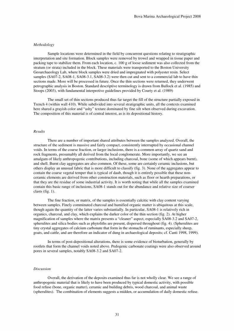
Sample locations were determined in the field by concurrent questions relating to stratigraphic interpretation and site formation. Block samples were removed by trowel and wrapped in tissue paper and packing tape to stabilize them. From each location, c. 100 g of loose sediment was also collected from the stratum (or strata) included in the block. These materials were transported to the Boston University Geoarchaeology Lab, where block samples were dried and impregnated with polyester resin. Select samples (SA07-2, SA08-1, SA08-3.1, SA08-3.2) were then cut and sent to a commercial lab to have thin sections made. More will be processed in future. Once the thin sections were returned, they underwent petrographic analysis in Boston. Standard descriptive terminology is drawn from Bullock et al. (1985) and Stoops (2003), with fundamental interpretive guidelines provided by Courty et al. (1989)
The small set of thin sections produced thus far target the fill of the structure partially exposed in Trench 4 (within wall 410). While subdivided into several stratigraphic units, all the contexts examined here shared a grayish color and “ashy” texture dominated by fine silt when observed during excavation. The composition of this material is of central interest, as is its depositional history.
Results
There are a number of important shared attributes between the samples analyzed. Overall, the structure of the sediment is massive and fairly compact, consistently interrupted by occasional channel voids. In terms of the coarse fraction, or larger inclusions, there is a common array of quartz sand and rock fragments, presumably all derived from the local conglomerate. More importantly, we see an amalgam of likely anthropogenic contributions, including charcoal, bone (some of which appears burnt), and shell. Burnt clay aggregates are also common. Of these, some are certainly ceramic inclusions, but others display an unusual fabric that is more difficult to classify (fig. 3). None of the aggregates appear to contain the coarse vegetal temper that is typical of daub, though it is entirely possible that these non-ceramic elements are derived from other construction materials, such as floor or hearth preparations, or that they are the residue of some industrial activity. It is worth noting that while all the samples examined contain this basic range of inclusions, SA08-1 stands out for the abundance and relative size of coarser clasts (fig. 1).
The fine fraction, or matrix, of the samples is essentially calcitic with clay content varying between samples. Finely comminuted charcoal and humified organic matter is ubiquitous at this scale, though again the quantity of the latter varies substantially. In particular, SA08-1 is relatively rich in organics, charcoal, and clay, which explains the darker color of the thin section (fig. 2). At higher magnification of samples where the matrix presents a “cleaner” aspect, especially SA08-3.2 and SA07-2, spherulites and silica bodies such as phytoliths are present, dispersed throughout (fig. 4). (Spherulites are tiny crystal aggregates of calcium carbonate that form in the stomachs of ruminants, especially sheep, goats, and cattle, and are therefore an indicator of dung in archaeological deposits; cf. Canti 1998, 1999).
In terms of post-depositional alterations, there is some evidence of bioturbation, generally by rootlets that form the channel voids noted above. Pedogenic carbonate coatings were also observed around pores in several samples, notably SA08-3.2 and SA07-2.
Discussion
Overall, the derivation of the deposits examined thus far is not wholly clear. We see a range of anthropogenic material that is likely to have been produced by typical domestic activity, with possible food refuse (bone, organic matter), ceramic and building debris, wood charcoal, and animal waste (spherulites). The combination of elements suggests a midden, or accumulation of daily domestic refuse.
Bova Marina Archaeological Project 2008
32
However, the relatively low quantity of organic matter in most of the fill and the level of sorting, especially as regards the fine fraction, runs counter to such a straightforward interpretation. The matrix is remarkable for its internally comminuted homogeneity, with finely ground charcoal and organic matter evenly incorporated throughout (cf. also comments by C. White on the poor and highly fragmentary nature of charred plant remains from these contexts). The same is true of spherulites, which do not appear in any clear concentration, but are spread with thin consistency through the samples in which they do appear.
Evidence on the formation of the fill also militates against its interpretation as a midden. Gradual accumulation, which one would expect in the case of regular refuse disposal, is not a likely scenario given that these samples lack any internal stratigraphy. It is possible that bioturbation has homogenized the fill to such an extent that any sign of original stratification has been destroyed, though currently this does not seem to be the case; apart from common rootlet channels, there is little evidence of recent large-scale disturbance by soil fauna.
The sole exception to the absence of micro-stratigraphic subdvision comes from sample SA08-3.1, which was intentionally removed from the profile so as to include the bottom of Context 428, a band of darker gray sediment, and the top of Context 426 below it. In thin section the distinction is still visible, though very subtle, with a shift to slightly “cleaner” sediment occurring along an irregular contact near the bottom of the sample. Though somewhat tentative, I would argue that this evidence suggests intentionally dumped material, rather than natural infilling, since there is no evidence of any sorting along the boundary at all, as one would expect if either water or gravity were the mechanism shifting the sediment. Furthermore, the upper boundary of Context 426 does not appear to have been compacted by trampling or altered by any extended subaerial exposure, which suggests that it was rapidly buried.
The degree of variability that we do see between the samples examined here does not appear to be due purely to vertical stratigraphic change. This is highlighted by the fact that there are marked differences between SA08-1 and SA08-3.1 (figs. 1-2), two samples that were removed from the same context at essentially the same elevation. It is not certain at this stage whether this diversity is connected to the relative proximity of SA08-1 to wall of the structure, or whether there is simply a certain amount of lateral variation within fill deposits. There is, however, some evidence for progressively “cleaner” and more calcitic sediment with depth. This could be due to differential soil formation beneath an earlier exposed ground surface or simply a degree of difference between sequential deposits. The former is supported by the presence of pedogenic carbonate coatings in the lower samples, though the fact that there is no significant alteration in the micro-structure of the sediment across the profile, as one would expect, is problematic for such an interpretation.
Ultimately, it will be clear in reading this short report that there is strong potential in the application of micromorphological techniques at Sant’Aniceto, but that further work is needed if we are to arrive at more definitive conclusions. Aside from continued analysis of the existing thin sections and final processing for the other samples collected, there is a need for comparative work on the fragmentary building materials incorporated into the fill and further study of matrix constituents, including organic matter, spherulites, phytoliths, and other silica bodies (possible parasite eggs?).

Bova Marina Archaeological Project 2008
33
Figure 20. Scanned thin sections from samples SA08-1 (left) and SA08-3.1 (right).
Both demonstrate compact, massive structure with channel voids resulting from root action. In SA08-1, we see a much darker matrix and a greater abundance of inclusions, many of them ceramic fragments or clay aggregates (orange or dark gray material). SA08-3.1 is similar in overall composition, though better sorted, and the matrix contains less charcoal and humified organic matter. Slides are 50 x 75 mm.
Figure 21. Details of the fine fraction for samples SA08-1 (left) and SA08-3.1
(right).
The greater quantity of comminuted charcoal and organic matter in the matrix of SA08-1 is readily apparent beside the “cleaner” appearance of SA08-3.1. Plane polarized light, each field of view = 0.47 mm.

Bova Marina Archaeological Project 2008
34
Figure 22. Details of two clay aggregate inclusions observed in sample SA08-1.
Left: a typical fired ceramic fragment with quartz sand and silt temper. Right: the swirly structure, internal voids, and well-sorted, fine-grained texture suggest a different origin or intended function for this material. Plane polarized light, each width of view = 2.35 mm.
Figure 23. Examples of large charcoal fragments (C) and phytoliths (P). Other
unidentified silica bodies are visible in the image on right (S). Plane polarized light,
each width of view = 0.47 mm.
P
C
P
C S
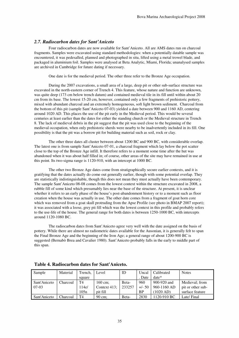
Bova Marina Archaeological Project 2008
35
2.7. Radiocarbon dates for Sant’Aniceto
Four radiocarbon dates are now available for Sant’Aniceto. All are AMS dates run on charcoal fragments. Samples were excavated using standard methodologies: when a potentially datable sample was encountered, it was pedesalled, planned and photographed in situ, lifted using a metal trowel blade, and packaged in aluminium foil. Samples were analysed at Beta Analytic, Miami, Florida; unanalysed samples are archived in Cambridge for future dating if necessary.
One date is for the medieval period. The other three refer to the Bronze Age occupation.
During the 2007 excavations, a small area of a large, deep pit or other sub-surface structure was excavated in the north-eastern corner of Trench 4. This feature, whose nature and function are unknown, was quite deep (173 cm below trench datum) and contained medieval tile in its fill until within about 20 cm from its base. The lowest 15-20 cm, however, contained only a few fragments of prehistoric pottery, mixed with abundant charcoal and an extremely homogeneous, soft light brown sediment. Charcoal from the bottom of this pit (sample Sant’Aniceto 07-03) yielded a date between 900 and 1160 AD, centering around 1020 AD. This places the use of the pit early in the Medieval period. This would be several centuries at least earlier than the dates for either the standing church or the Medieval structure in Trench 8. The lack of medieval debris in the pit suggest that the pit was used close to the beginning of the medieval occupation, when only prehistoric sherds were nearby to be inadvertently included in its fill. One possibility is that the pit was a borrow pit for building material such as soil, rock or clay.
The other three dates all cluster between about 1200 BC and 900 BC, with considerable overlap. The latest one is from sample Sant’Aniceto 07-01, a charcoal fragment which lay below the pot scatter close to the top of the Bronze Age infill. It therefore refers to a moment some time after the hut was abandoned when it was about half filled in; of course, other areas of the site may have remained in use at this point. Its two-sigma range is 1120-910, with an intercept at 1000 BC.
The other two Bronze Age dates come from stratigraphically secure earlier contexts, and it is gratifying that the dates actually do come out generally earlier, though with some potential overlap. They are statistically indistinguishable, though this does not mean they must actually have been contemporary. The sample Sant’Aniceto 08-08 comes from the lowest context within the structure excavated in 2008, a rubble fill of some kind which presumably lies near the base of the structure. At present, it is unclear whether it refers to an early phase of the house’s post-abandonment history or to a moment such as floor creation when the house was actually in use. The other date comes from a fragment of goat horn core which was removed from a goat skull protruding from the Apse Profile (see photo in BMAP 2007 report); it was associated with a loose, grey pit fill which was the lowest context in this profile and probably refers to the use-life of the house. The general range for both dates is between 1250-1000 BC, with intercepts around 1120-1080 BC.
The radiocarbon dates from Sant’Aniceto agree very well with the date assigned on the basis of pottery. While there are almost no radiometric dates available for the Ausonian, it is generally felt to span the Final Bronze Age and the beginning of the Iron Age; a general range of about 1200-900 BC is suggested (Bernabò Brea and Cavalier 1980). Sant’Aniceto probably falls in the early to middle part of this span.
Table 4. Radiocarbon dates for Sant'Aniceto.
Sample Material Trench, square
Level ID Uncal. Date
Calibrated date*
Notes
Sant'Aniceto 07-03
Charcoal T4 114e/ 105n
160 cm; Context 413; pit fill
Beta-233257
960 +/- 50 BP
900-920 and 960-1160 AD (1020 AD)
Medieval; from pit or other sub-surface feature
Sant'Aniceto Charcoal T4 90 cm; Beta- 2830 1120-910 BC Late/ Final
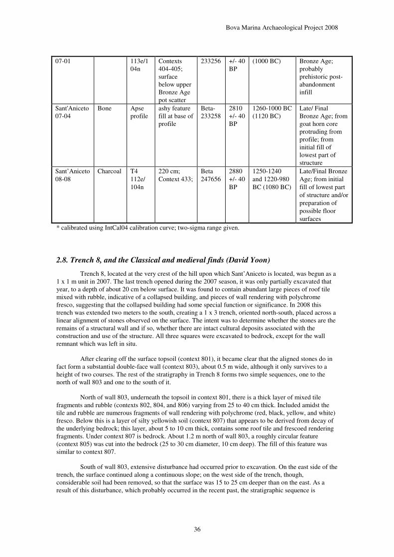
Bova Marina Archaeological Project 2008
36
07-01 113e/104n
Contexts 404-405; surface below upper Bronze Age pot scatter
233256 +/- 40 BP
(1000 BC) Bronze Age; probably prehistoric post-abandonment infill
Sant'Aniceto 07-04
Bone Apse profile
ashy feature fill at base of profile
Beta-233258
2810 +/- 40 BP
1260-1000 BC (1120 BC)
Late/ Final Bronze Age; from goat horn core protruding from profile; from initial fill of lowest part of structure
Sant’Aniceto 08-08
Charcoal T4 112e/ 104n
220 cm; Context 433;
Beta 247656
2880 +/- 40 BP
1250-1240 and 1220-980 BC (1080 BC)
Late/Final Bronze Age; from initial fill of lowest part of structure and/or preparation of possible floor surfaces
* calibrated using IntCal04 calibration curve; two-sigma range given.
2.8. Trench 8, and the Classical and medieval finds (David Yoon)
Trench 8, located at the very crest of the hill upon which Sant’Aniceto is located, was begun as a 1 x 1 m unit in 2007. The last trench opened during the 2007 season, it was only partially excavated that year, to a depth of about 20 cm below surface. It was found to contain abundant large pieces of roof tile mixed with rubble, indicative of a collapsed building, and pieces of wall rendering with polychrome fresco, suggesting that the collapsed building had some special function or significance. In 2008 this trench was extended two meters to the south, creating a 1 x 3 trench, oriented north-south, placed across a linear alignment of stones observed on the surface. The intent was to determine whether the stones are the remains of a structural wall and if so, whether there are intact cultural deposits associated with the construction and use of the structure. All three squares were excavated to bedrock, except for the wall remnant which was left in situ.
After clearing off the surface topsoil (context 801), it became clear that the aligned stones do in fact form a substantial double-face wall (context 803), about 0.5 m wide, although it only survives to a height of two courses. The rest of the stratigraphy in Trench 8 forms two simple sequences, one to the north of wall 803 and one to the south of it.
North of wall 803, underneath the topsoil in context 801, there is a thick layer of mixed tile fragments and rubble (contexts 802, 804, and 806) varying from 25 to 40 cm thick. Included amidst the tile and rubble are numerous fragments of wall rendering with polychrome (red, black, yellow, and white) fresco. Below this is a layer of silty yellowish soil (context 807) that appears to be derived from decay of the underlying bedrock; this layer, about 5 to 10 cm thick, contains some roof tile and frescoed rendering fragments. Under context 807 is bedrock. About 1.2 m north of wall 803, a roughly circular feature (context 805) was cut into the bedrock (25 to 30 cm diameter, 10 cm deep). The fill of this feature was similar to context 807.
South of wall 803, extensive disturbance had occurred prior to excavation. On the east side of the trench, the surface continued along a continuous slope; on the west side of the trench, though, considerable soil had been removed, so that the surface was 15 to 25 cm deeper than on the east. As a result of this disturbance, which probably occurred in the recent past, the stratigraphic sequence is

Bova Marina Archaeological Project 2008
37
described on the basis of the eastern side of the trench, where it is better preserved. Under the topsoil (context 801) is a thick layer of mixed tile fragments and rubble (contexts 809, 810, and 812) varying from 25 to 35 cm thick. This is generally similar to the tile and rubble deposit on the north side of wall 803, except that pottery fragments, though still scarce, are considerably more frequent (0.2 g/L south of the wall; 0.07 g/L north of the wall) and fresco/rendering fragments are much less abundant (1.7 g/L south of the wall; 5.4 g/L north of the wall). Under the tile and rubble layer are some large stone blocks (context 811) that may represent remains of some sort of feature or may be blocks fallen from wall 803; due to the disturbance in this this trench, not enough was left in place to allow one to decide this with confidence. Finally, underneath contexts 811 and 812 was a silty yellowish soil (context 813) that resembled context 807 north of the wall, both in being apparently derived from natural decay of the bedrock and in containing some artifactual material that suggests it post-dates the structure to which wall 803 belonged.
Because the fresco fragments were much more abundant north of wall 803, it seems evident that this side was the interior of the structure to which wall 803 belonged. The somewhat higher frequency of pottery fragments, as well as a few fragments of vessel glass, on the south side of the wall supports this hypothesis, as trash is more likely to have been deposited outside a building, at least while it was in use. Neither north of the wall nor south of it is any ground surface identifiable that would have been in use at the time the building was standing. One possibility is that contexts 807/813 were a dirt surface that had post-destruction material incorporated into them through natural processes; otherwise, either the rather uneven bedrock was the surface in use, or the surface of that time was lost to erosion before the building‘s roof collapsed. None of these hypotheses is entirely satisfactory.
Unfortunately, the function of this structure is no clearer than it was in 2007. It occupied the top of the hill, which is currently only about 5 x 5 meters at the elevation of this wall. Unless a significant area was lost to rockfalls, it must have been a very small building. There is no evidence for a prepared floor inside the building, but the walls were decorated with polychrome frescoes. Judging from the surface remains, the area excavated in 2008 is the side likely to have been damaged least by erosion. Further excavation may provide a larger sample of artifacts and possibly additional evidence on the shape of the building, but it does not seem highly likely that such additional evidence will answer many questions.
Figure 24. Trench 8 profiles.

Bova Marina Archaeological Project 2008
38
Figure 25. Trench 8 plan.

Bova Marina Archaeological Project 2008
39
Figure 26. Trench 8, looking north.
Figure 27. Trench 8: medieval wall, looking north.

Bova Marina Archaeological Project 2008
40
Medieval and early modern finds at Sant’Aniceto
As in 2007, the sample of medieval and early modern pottery recovered is small and generally in very poor condition. One piece from Trench 4 has remnants of a tin glaze painted in blue and brown; this could be quite informative if it were better preserved, but unfortunately only two small spots of glaze, amounting to about 0.2 sq. cm in all, remain. There are, however, a few pieces that add support to the conclusion that the assemblage should be considered late medieval to early modern. Several pieces were found with an undecorated green glaze covering a white slip, and a few have green glaze-paint decoration on an otherwise unglazed surface.
The fresco fragments found in Trench 8 include several pieces with recognizable patterns. All of these are geometric rather than figurative, with either a criss-cross pattern or vague stripes. It has been suggested to us that this style of painting belongs to the end of the Middle Ages or beginning of the modern era (G. Bruno, personal communication).
By far the most abundant class of artifacts from the post-classical occupation at Sant‘Aniceto is roof tile. The enlarged sample of tile from Trench 8 provides strong evidence for a chronological interpretation for which the other artifact classes do not provide sufficient information. In Trenches 4, 9, and 10 the roof tile is almost all of a single general type: thick, heavy, curved tiles with numerous voids left by straw temper burnt out in firing. In Trench 8, only about 20% by count (28% by weight) of tile fragments belong to that type. Most of the rest belong to various types familiar from our survey that we have considered to be early modern or modern, in some cases even found in association with ruins that were in use in the nineteenth or early twentieth century. Thus, the structure in Trench 8 was probably built and certainly maintained significantly later than the church near Trenches 4, 9, and 10.
Figure 28. Medieval and classical finds: (a) green-glazed pottery; (b) and (c)
painted wall fresco fragments; (d) probable Archaic Greek painted pottery.
Bova Marina Archaeological Project 2008
41
The date and nature of the medieval occupation
The 2008 excavations have changed our view of the medieval use of Sant’Aniceto in several ways. In addition to the further detail on the Trench 8 structure and finds discussed above, we now know that the possible “wall” in Trench 4 attributed to the medieval period is not actually a wall (see above). Moreover, as mentioned above, we now have radiocarbon dates of around 1000 AD for sub-surface features in Trench 4. This is substantially earlier than one would date the church based upon the style of the standing architecture. We also have gained some chronological distinctions based upon roof tile (see above).
While our understanding of the site’s function as a Christian place of cult remains the same, with the standing church and the small, probably ritual structure in Trench 8 as the principal features, the site’s medieval history appears more complex. The first attested medieval use dates to about 1000 AD or later and resulted in deposition of burnt wood in a pit, depression, or erosional feature. It is uncertain what this feature was and whether it was associated with a religious or secular use of the site. There do not appear to be any extant standing features dating to this period, although it is possible that the church rests upon an earlier foundation. At some point within the late Middle Ages the church was built, incorporating a large amount of recycled medieval roof tile within its fabric. The fact that the church wall incorporates some medieval roof tile suggests that there may have been an earlier structure on the site which supplied this tile, perhaps an earlier version of the church, although it is also possible that used tile was brought to the site specifically for reuse as a building material. The small structure on the peak (Trench 8) probably followed some centuries later in the late medieval or early modern period. The church was evidently used and maintained well into the modern period, to judge from its state of preservation. Taken all together, the different phases of use attest an impressive continuity, as Sant’Aniceto was used over most of the second millennium AD.
Sporadic Greek finds at Sant’Aniceto
As in 2007, small quantities of Greek-period artifacts were found, often redeposited in medieval strata but also occasionally in strata that contained no medieval finds. In Trench 8, these consisted mainly of tile and pithos fragments that had evidently been used in building the medieval wall there. In Trenches 4, 9, and 10 they consisted mostly of small pottery fragments, usually in poor condition. It is worth noting that the one bag which contained Greek wares without any medieval artefacts (3463) came from the level in Trench 10 just above the beginning of contexts containing only prehistoric wares. One decorated piece from Trench 9 may be significant: a small body fragment of the usual local Greek fineware fabric, unslipped, with painted decoration on the interior consisting of a wide horizontal red band with narrow black bands above and below. The vessel is probably a wide cup. This decoration is likely to be relatively early, possibly of the Archaic period.
The mechanism by which sporadic pieces of Greek pottery came to be deposited at Sant’Aniceto remains unclear. Although these Classical finds are few, the fact that some are tile and pithos pieces suggests perhaps that there was a small Classical structure here. The Classical tile and pithos pieces come mostly from the Trench 8 area, but they may have been brought there from somewhere else on the site to be re-used as building material, so this does not necessarily indicate the general location of a putative Classical structure. The presence of a few Archaic or Classical pottery fragments suggests that the ancient material was not brought to the site from elsewhere as recycled building material. It seems likely that a small Greek-period componentis present on site, though we have not found any in situ deposits. This component could have been a small rural farmstead or house, though other possibilities cannot be excluded. If so, this would be an intriguing possibility, spanning the late prehistoric and early medieval uses of the site.

Bova Marina Archaeological Project 2008
42
3. LANDSCAPE INVESTIGATIONS
3.1. 2008 Field Survey (David Yoon)
As in the previous two years, we were able to carry out only a limited amount of field survey in 2008, due to the number of other demands on our time. Our survey work this year was all in the western portion of Bova Marina, which had received little attention from us since 1998.
We used the same methods as in previous years. For systematic survey, the basic units were single fields or arbitrarily defined tracts called ‘areas’, ranging in size from 0.1 to 2.0 hectares. These areas were walked in a series of parallel transects 10 meters apart, or as close an approximation to this as slope and vegetation allowed. When a site was identified, it was recorded by making surface collections from 10 m2 units spaced 10 meters apart along crossed axes through the estimated center of the site. In addition to systematic survey, we also did some nonsystematic reconnaissance survey of the hills near the Bronze Age and medieval site of Sant’Aniceto.
Our systematic survey was carried out on two days, with a single crew of 4 persons on one day and 3 persons on the other, for a total of 7 person-days. We assigned 9 new area numbers (420 to 428) and 2 new site numbers (72 to 73). Our systematic field walking covered a total of 6.7 hectares, all previously unsurveyed by us. The location of Sites 72 and 73 is shown in Figure 28 and an updated summary of all sites found in our survey is given in Table 6.
Sites found in 2008
Site 72 (Monte Calamitta A, Area 426). Site, 0.2 ha. Greek. Previously reported to us by Luigi Saccà and Sebastiano Stranges. The site is visible as a surface scatter an olive grove near the southeastern end of Monte Calamitta. Artifacts are also visible in an erosion face along the southwestern side of this scatter. In the erosion face, these artifacts are in much better state of preservation than in the field above and they occur mostly around 1 to 3 meters below the surface. There is no distinct soil horizon associated with the artifacts; they are found in a light gray clayey soil similar to what occurs above and below.
The most specifically diagnostic artifact that we collected at Site 72 is the base of a Greek drinking vessel. Based on the curvature of the interior and the height of the base, it is either a small, low kylix or some other sort of stemmed cup with a short stem. Much of the surface is covered with black-gloss slip of variable quality; the tondo is reserved but decorated with a dot inside a small circle. It is unusual for circle-and-dot decoration to be found on the interior, as opposed to the underside of the base, but in either case it should be considered a fifth-century decorative style. In addition, a local amphora rim of the usual form imitating Corinthian B almond-shaped rims was found.
Despite this evidence for the Classical period, it is likely that much of the material is later. Most of the pottery found is plainware without black gloss, and the roof tiles found, though not abundant, are in some cases of forms that would fit better into the early imperial Roman period. These tiles are most closely paralleled at the site of Mazza (Site 12), specifically from the dense tile scatter at the highest point of the site. Therefore, it seems plausible that the site continued in use at least into the Hellenistic period. Additionally, two fragments may be prehistoric, although the evidence for use of hand-made fabrics in the late Archaic or early Classical period at San Salvatore raises the possibility that they could be contemporary with the decorated cup base.
Site 73 (Monte Calamitta B, Area 427). Site, 0.6 ha. Roman, medieval. Previously reported to us by Luigi Saccà and Sebastiano Stranges. This site was found in an olive grove on the northern end of Monte Calamitta and the saddle where Calamitta joins the next hill to the north. It is a long, narrow scatter of tile and pottery fragments, with no visible architectural remains. With the exception of one body fragment of a North African amphora, all of the pottery fragments are of nondescript local plainwares or coarsewares. Some are Roman, a few are modern, and a few may be medieval.
Roof tile is much more abundant at this site than pottery, and it is also more informative. Most is clearly Roman, in fabrics that have been found at a number of late Roman sites in our survey, but some

Bova Marina Archaeological Project 2008
43
fragments are of the same medieval type as that associated with the church at Sant‘Aniceto: thick, crude, red or yellow curved tiles with voids from straw temper that was burnt out in firing. This indicates a second component at the site, presumably mid-medieval or late medieval.
Discussion
The areas surveyed near Sant’Aniceto, both systematic and nonsystematic, produced no evidence of any further sites of any period before the modern era. This is not conclusive evidence of the absence of such sites, but it does suggest that Sant’Aniceto is a distinctive location, used in a different manner from its surroundings.
Sites 72 and 73 conform to the general patterns observed for Greek and Roman sites in the study area. The situation of Site 72, on the southern end of a plateau overlooking the sea, is similar to that of the much larger site at Mazza (Site 12). The ubiquity of Roman sites at lower altitudes, especially in locations adjacent to expanses of arable land, is well exemplified by Site 73. However, the presence of a medieval component at Site 73 is an oddity; it is closer to the coast and lower in altitude than sites of similar date. It is, though, in the vicinity of the settlement called “Vivo” that can be seen on early modern maps of the region. This adds significantly to our evidence for late medieval occupation in the Bovese.
Sites 72 and 73 are both located in fields composed of gray clay that appears to be the natural substrate. Although neither is on a steep slope, there is no indication of any well-developed topsoil at either site. At Site 72, an erosional scarp about 4 meters high provides a section through the southwestern side of the site; artifact density appears to be highest between 1 and 2 meters below the surface, but there is no evident soil differentiation to indicate that this is a sign of in situ archaeological deposits instead than redeposition. At both sites, it is possible that a bulldozer has been used to level the ground for olive cultivation. Thus, it seems unlikely that any significant subsurface deposits survive at either Site 72 or Site 73.

Bova Marina Archaeological Project 2008
44
Figure 29. Location of survey areas around Sites 72 and 73 and Sant'Aniceto, 2008
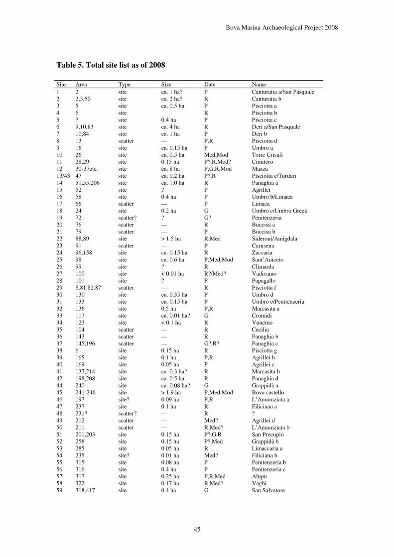
Bova Marina Archaeological Project 2008
45
Table 5. Total site list as of 2008
Site Area Type Size Date Name 1 2 site ca. 1 ha? P Canturatta a/San Pasquale 2 2,3,50 site ca. 2 ha? R Canturatta b 3 5 site ca. 0.5 ha P Pisciotta a 4 6 site R Pisciotta b 5 7 site 0.4 ha P Pisciotta c 6 9,10,83 site ca. 4 ha R Deri a/San Pasquale 7 10,84 site ca. 1 ha P Deri b 8 13 scatter — P,R Pisciotta d 9 16 site ca. 0.15 ha P Umbro a 10 26 site ca. 0.5 ha Med,Mod Torre Crisafi 11 28,29 site 0.15 ha P?,R,Med? Cimitero 12 30-37etc. site ca. 8 ha P,G,R,Mod Mazza 13/43 47 site ca. 0.2 ha P?,R Pisciotta e/Turdari 14 51,55,206 site ca. 1.0 ha R Panaghia a 15 52 site ? P Agrillei 16 58 site 0.4 ha P Umbro b/Limaca 17 66 scatter — P Limaca 18 24 site 0.2 ha G Umbro c/Umbro Greek 19 72 scatter? ? G? Penitenzeria 20 76 scatter — R Buccisa a 21 79 scatter — P Buccisa b 22 88,89 site > 1.5 ha R,Med Sideroni/Amigdala 23 91 scatter — P Carusena 24 96,158 site ca. 0.15 ha R Zaccaria 25 98 site ca. 0.6 ha P,Med,Mod Sant’Aniceto 26 99 site ? R Climarda 27 100 site < 0.01 ha R?/Med? Vadicamo 28 101 site ? P Papagallo 29 8,81,82,87 scatter — R Pisciotta f 30 130 site ca. 0.35 ha P Umbro d 31 133 site ca. 0.15 ha P Umbro e/Penitenzeria 32 136 site 0.5 ha P,R Marcasita a 33 117 site ca. 0.01 ha? G Cromidi 34 123 site < 0.1 ha R Vunemo 35 104 scatter — R Cecilia 36 143 scatter — R Panaghia b 37 145,196 scatter — G?,R? Panaghia c 38 6 site 0.15 ha R Pisciotta g 39 165 site 0.1 ha P,R Agrillei b 40 169 site 0.05 ha P Agrillei c 41 137,214 site ca. 0.3 ha? R Marcasita b 42 198,208 site ca. 0.5 ha R Panaghia d 44 240 site ca. 0.08 ha? G Grappidà a 45 241-246 site > 1.9 ha P,Med,Mod Bova castello 46 197 site? 0.09 ha P,R L’Annunziata a 47 237 site 0.1 ha R Filiciana a 48 231? scatter? — R ? 49 212 scatter — Med? Agrillei d 50 211 scatter — R,Med? L’Annunziata b 51 201,203 site 0.15 ha P?,G,R San Precopio 52 258 site 0.15 ha P?,Med Grappidà b 53 285 site 0.05 ha R Limaccaria a 54 235 site? 0.01 ha Med? Filiciana b 55 315 site 0.08 ha P Penitenzeria b 56 316 site 0.4 ha P Penitenzeria c 57 317 site 0.25 ha P,R,Med Alupu 58 322 site 0.17 ha R,Med? Vaghi 59 318,417 site 0.4 ha G San Salvatore

Bova Marina Archaeological Project 2008
46
60 345 site 0.1 ha R Limaccaria b 61 346 site 0.8 ha P,G,R,Med? Limaccaria c 62 346 scatter — R Limaccaria d 63 348 scatter — Med? Limaccaria e 64 28 scatter — P Cimitero b 65 365 scatter — Med? Visco 66 386 site 0.05 ha R, Med? Cavalli 67/68 396,406 site 0.25 ha R?,Med Travi 69 402 scatter — P Agrapida 70 416 site 0.2 ha G,Med? Monte Grosso 71 419 site 0.1 ha R, Med? Scilindermeno 72 426 site 0.2 ha G Monte Calamittà a 73 427 site 0.5 ha R, Med Monte Calamittà b P = prehistoric; G = Greek; R = Roman; Med = medieval; Mod = modern.
3.2. Historical landscape investigations (Paula Lazrus)
The 2008 field season again provided the opportunity to take a multi-pronged approach in my ongoing study of socio-economic conditions in Bova on either side of the Napoleonic period. It was a productive season that included archival work in Archivo di Stato di Reggio Calabria, the Archivo di
Stato di Napoli, field work and continued elaboration of my evolving ArcGis (geographic information systems) database. Once again the archivists at the Archivio di Stato di Reggio Calabria were extremely kind and helpful and their efforts are appreciated.
This season, my archival work led me to concentrate on materials found in the Nesci Archive as well as in other folders containing legal documents pertaining to the division of the Comune di Bova into the two comuni extant today (Bova and Bova Marina). Even a first and perforce cursory look at this data has provided insights into how the landscape was viewed by the different individuals and shed some light onto how the landscape was perceived by those who lived in it. This becomes clearer through the investigation of legal papers and letters that describe the products grown the areas where they are located as well as through an understanding of what types of properties are swapped or given as dowries etc. With regard to the political division of Bova this season’s work has opened up interesting avenues for further investigation and has already illuminated some of the differences in how the parties involved viewed the physical territory and its economic and social worth to the inhabitants on either side of the controversy (those supporting the split and the establishment of Bova Marina, as well as those who were against this move). Among the interesting lessons here is that we appear to move from a period in which the land is understood and described by its physical characteristics to one where ownership is the label that identifies landscape and property ownership. Additional insights regarding the political influence of particular families and literacy rates will also help build a more complex picture of the lives of those living in this area in the early 1800s through the early 1900s as well as providing a continuum of changes that start with the 1742 Oncario. Various fiscal documents perused continue to illuminate the value of different resources, as well as the cost to the commune of different services such as education or other civil services.
Of particular interest in this season’s work have been the documents that discuss the wooded and forested portions of the Comune and the various views competing groups had over their extension, worth and ownership. Another finding of interest was the first explicit mention of pastoral activities and animals that have been uncovered by this particular study. Some of this data stretches back to 1742 and has already provided some fascinating glimpses of how the area now know as the Campi di Bova were once viewed, owned and utilized, and how that changed over the years.
A brief perusal of part of the 888 page Bova Catasto of 1742 indicates that it too will illuminate new corners of our landscape and socio-economic studies. In the brief period this document was examined several things became clear, not least the continual importance of certain families in the life of the Comune from this date right through the 1900s, as well as the role of literacy in understanding ever changing place names. Initial study of this document has already shown interesting data with regard to the changing prices of different resources and thus perhaps also their importance in the local economy and the potential impact they have on the environment. Comments about the difficulty of getting to and from certain areas or the strains of working particular locations shed additional light on how the landscape was

Bova Marina Archaeological Project 2008
47
perceived and utilized at this time. Data on work animals and on animals in general will help this study clarify which animals were of importance in the local economy, one area of information that this study has lacked until now.
My work with ArcGis, has proceeded steadily and this summer provided the first opportunity to test it. During this season, my work in the field was combined with that of our ceramics expert Kostalena Michelaki, with very instructive results. We were able to visit areas that helped to shed some light on my ongoing ArcGIS work, and already it has provided some initial data that will help verify how the terrain is being exploited now in comparison with how it appears to have been exploited in the past. This will lead to new analytical questions that can be further elaborated visually. Since this visual component is still in early stages it was very instructive to go visit specific spots, verify GPS data and then to see how they map onto the digital database I am building. Having the time to go back and double check certain data was very useful, and I suspect that similar work will need to be done in the upcoming season. We used data collected in the field for Dr. Michelaki’s clay samples to create visual maps of the area that combined information about deposit location and distance from specific locations in order to gain an immediate sense of the relationships. As analysis goes forward we will find this a very useful tool across several of our research areas. In terms of the landscape, it is proving very useful in generating new questions, for instance about how specific resources were produced upon specific kinds of topography and about intervisibility between fields and resources. This work is still in its initial stages and I expect it to help us in our visualization of the older landscape(s) as we progress as it is an excellent tool for building models of spatial analysis.
3.3. Technological studies of prehistoric pottery and raw material survey (Kostalena
Michelaki)
In 2008 we continued our long-term project of studying prehistoric ceramic production in Bova and Bova Marina. This summer our work had two specific goals:
1) select samples from the Umbro Neolithic and Umbro Bronze Age sites for technological analyses, as well as preliminary samples from Sant’Aniceto;
2) to continue our raw materials survey.
3.3.1. Sample Selection
The Bova Marina prehistoric pottery is the focus of a programme of analytical work taking place in the laboratories of McMaster University; the range of analyses includes chemical analysis (X Ray Diffraction and INAA), physical analyses (petrographic analysis of thin sections), and technological analysis of sherd color, fracture patterns, temper proportion and composition, and similar signs of manufacture process. During the first week of the season I focused on selecting new material for technological analyses from the sites of Umbro Neolithic, Umbro Bronze Age and Sant’Aniceto, to complement the sample I had selected in 2004 from Penitenzeria. After John Robb and Meredith Chesson provided me with the most secure contexts from each site, I selected a random sample of material from within those contexts, trying to represent all the variability I saw in terms of clay recipes. The particular sherds selected, divided by site and type can be found in Table 7.
Table 6. Ceramic samples selected for technological analyses.
Site Type Sample # Total
Umbro Bronze Bronze Age
1552/1, 1552/4, 1552/5, 1552/6, 1552/10, 1552/12, 1552/68, 1217/1, 1270/19, 1270/48, 1432/1, 1432/2, 1432/7, 1432/8, 1432/9, 1432/33, 1637/3, 1637/4+5, 1637/6, 1637/12, 1637/26, 1637/55, 1896/2, 1896/5, 1896/32,
38

Bova Marina Archaeological Project 2008
48
1896/51, 1896/52, 1896/81, 1635/1, 1635/2, 1635/4, 1635/7, 1635/8, 1634/12, 1896/1, 1257/26, 1634/115, 1898/4
Umbro Neolithic Impressed 1111/3, 1122/3, 1290/6, 1191/14, 1252/8+9, 1330/2, 1399/a, 1121/19, 1283/7, 1219/2, 1284/5, 1392/2, 1410/5
13
Umbro Neolithic Stentinello 1118/1, 1129/1, 1285/1a+b, 1291/1, 1291/2, 1211/10, 1125/1, 1328/9, 1303/1, 1399/2a, 1393/2, 1430/a, 1430/b,
13
Umbro Neolithic Rocker 1302/6 1 Umbro Neolithic Buff 1108/1, 1330/13 2 Umbro Neolithic Red Paint 1392/3 1
Umbro Neolithic Diana 1329/3, 1110/22, 1120/1, 1293/4, 1111/18, 1151/5
6
Umbro Neolithic Undecorated 1070/a, 1070/b, 1088/a, 1103/a, 1215/13, 1252/4, 1328/7, 1392/8
8
Umbro Neolithic Copper Age 1111/25, 1331/1, 1162/7 3
Sant’Aniceto Late Bronze Age
3429/a, 3429/b, 3429/c, 3429/d, 3429/e, 3411/a, 3411/b, 3411/c, 3411/d, 3411/e, 3430/a, 3430/b, 3430/c, 3434/a, 3434/b, 3434/c, 3434/d, 3434/e, 3406/a, 3406/b, 3406/c, 3406/d, 3406/e, 3406/f, 3408/a
25
This material is now at McMaster University. Christine Sally (McMaster undergraduate anthropology student) has photographed each sherd, while Kelsey Phillips and Sam Huisbrink (McMaster undergraduate Art students) are drawing all decorated and diagnostic sherds. Upon the completion of drawings and after material is entered into the ceramic samples database, all the material will be sent for thin-sectioning at Spectrum Petrographics in Washington (USA), as well as for Instrumental Neutron Activation Analysis, at the McMaster Nuclear Reactor. The goal of this analysis will be to study the chemical and physical composition of each sherd, with the goal of assessing both its original source and properties and the operational sequence through which it was mixed with tempering material and worked into a finished vessel. Furthermore, a restricted number of samples will also be examined under a Scanning Electron Microscope, to estimate firing temperatures.
3.3.2. Raw Materials Survey
The second and third weeks of the season were devoted to a raw materials survey. This continued and expanded an effort begun in previous years to locate, map and sample all clay sources within a 3 km radius of the Neolithic sites of Umbro and Penitenzeria, as well as selected localities outside this radius (particularly the sources of fine white clays at Calamittà and Pappagallo). Clay sources were located using both existing geological maps of the area and our own observations based upon sediments visible in eroded areas, road cuts and valley sides. The limit of 3 km was based upon ethnographic generalizations about how far potters typically travel to collect clay.
This year the raw material survey was conducted by Kostalena Michelaki, Paula Lazrus and Kelly Peterson. It had two main goals: 1) to revisit previous sample locations and take accurate GPS readings, as previously they had simply been plotted upon maps, and 2) to cover systematically the area within a 3 km radius to the north, south and west of Umbro and Penitenzeria; the east side and some areas to the south had already been covered in previous years. The samples collected and their locations can be found in Table 8.
When an outcrop was located, we collected samples and documented the location through GPS readings, by plotting it on a map, and photographically. Each sample was cleaned of loose material and dried, and a sub-sample was shipped to McMaster University for further analysis. The ultimate goal is create a comparative collection showing the variability of clays available in the area which can be used in conjunction with the sherd samples above to determine where prehistoric potters obtained clay, and to
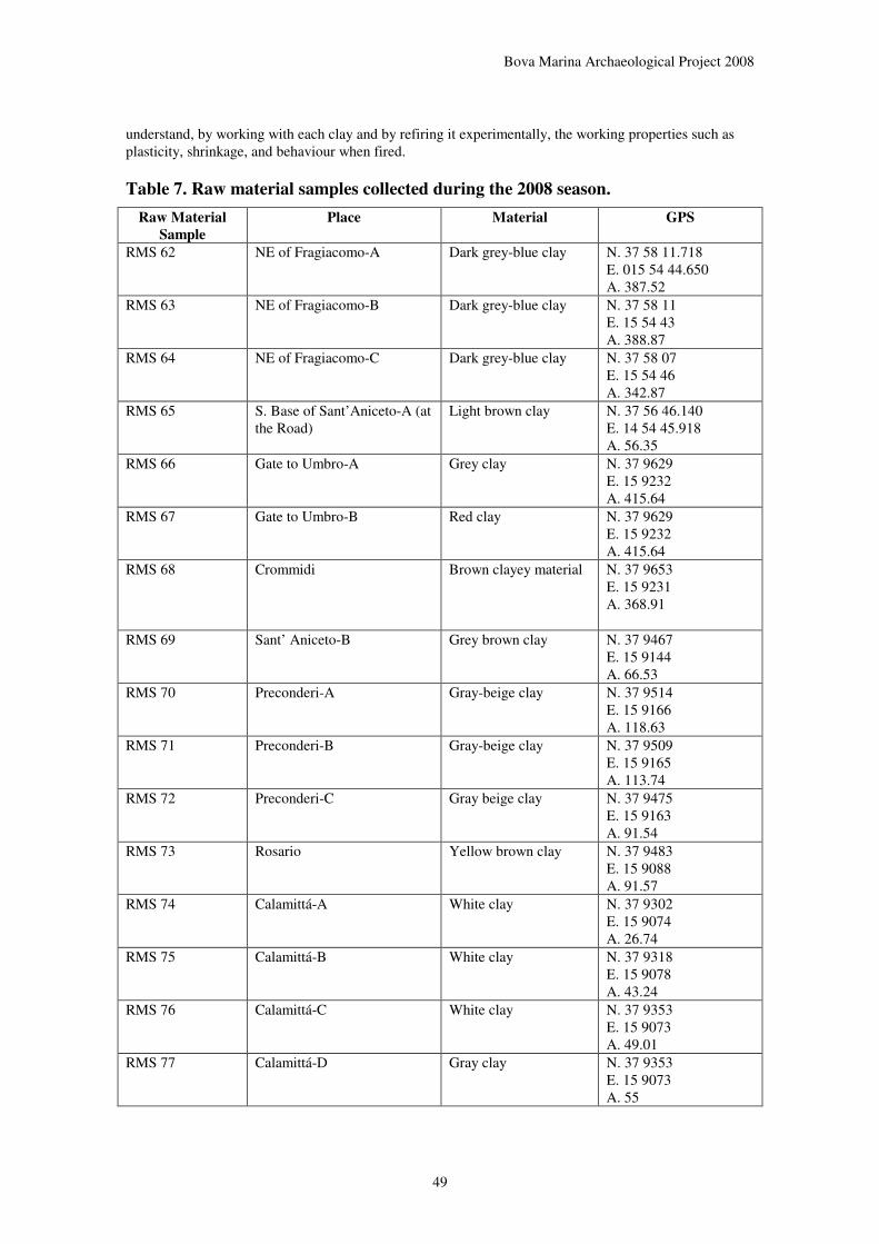
Bova Marina Archaeological Project 2008
49
understand, by working with each clay and by refiring it experimentally, the working properties such as plasticity, shrinkage, and behaviour when fired.
Table 7. Raw material samples collected during the 2008 season.
Raw Material
Sample
Place Material GPS
RMS 62 NE of Fragiacomo-A Dark grey-blue clay N. 37 58 11.718 E. 015 54 44.650 A. 387.52
RMS 63 NE of Fragiacomo-B Dark grey-blue clay N. 37 58 11 E. 15 54 43 A. 388.87
RMS 64 NE of Fragiacomo-C Dark grey-blue clay N. 37 58 07 E. 15 54 46 A. 342.87
RMS 65 S. Base of Sant’Aniceto-A (at the Road)
Light brown clay N. 37 56 46.140 E. 14 54 45.918 A. 56.35
RMS 66 Gate to Umbro-A Grey clay N. 37 9629 E. 15 9232 A. 415.64
RMS 67 Gate to Umbro-B Red clay N. 37 9629 E. 15 9232 A. 415.64
RMS 68 Crommidi Brown clayey material N. 37 9653 E. 15 9231 A. 368.91
RMS 69 Sant’ Aniceto-B Grey brown clay N. 37 9467 E. 15 9144 A. 66.53
RMS 70 Preconderi-A Gray-beige clay N. 37 9514 E. 15 9166 A. 118.63
RMS 71 Preconderi-B Gray-beige clay N. 37 9509 E. 15 9165 A. 113.74
RMS 72 Preconderi-C Gray beige clay N. 37 9475 E. 15 9163 A. 91.54
RMS 73 Rosario Yellow brown clay N. 37 9483 E. 15 9088 A. 91.57
RMS 74 Calamittá-A White clay N. 37 9302 E. 15 9074 A. 26.74
RMS 75 Calamittá-B White clay N. 37 9318 E. 15 9078 A. 43.24
RMS 76 Calamittá-C White clay N. 37 9353 E. 15 9073 A. 49.01
RMS 77 Calamittá-D Gray clay N. 37 9353 E. 15 9073 A. 55

Bova Marina Archaeological Project 2008
50
RMS 78 Calamittá-E Yellow clay N. 37 9353 E. 15 9073 A. 55
RMS 79 Calamittá-F White clay N. 37 9309 E. 15 9031 A. 31.23
RMS 80 Deri-A Brown gray clay N. 4197806 E. 58480 A. 85
RMS 81 Deri-B Light brown yellow clay
N. 4197806 E. 58480 A. 85
RMS 82 Deri-C Red Ochre N. 4297806 E. 58480 A. 85
RMS 83 Deri-D Dark grey clay N. 4197805 E. 584877 A. 100
RMS 84 Deri-E Red Ochre N. 4197805 E. 584877 A. 100
RMS 85 Deri-F Dark gray clay N. 4197822 E. 584868 A. 95
RMS 86 Deri-G Oxidized stone N. 4197822 E. 584868 A. 95
RMS 87 San Pasquale-A Gray red clay N 4198577 E. 583713 A. 27
RMS 88 San Pasquale-B Red clay N. 4198577 E. 583713 A. 27
All the raw material samples were shipped to McMaster University, and analysis is underway at the time of writing. At the Laboratory for Interdisciplinary Research for Archaeological Ceramics (LIRAC) we placed each sample in glass beakers and let them dissolve under water for approximately two weeks. Once the water was removed and the clays had dried enough, we formed seven test-tiles from each sample. One tile we keep unfired, while another one we keep to fire under targeted reducing conditions once we are finished with our firing experiments. Our firing experiments involve the firing of one test-tile from each sample in oxidizing conditions under 600, 700, 800, 900 and 1000 degrees Celsius. The figures below (taken by Christine Sally) demonstrate all our clay samples fired at the temperatures mentioned above. Table 9 provides the Munsell soil colours of all test-tiles.
As this research continues, these samples will also be used for the same battery of tests to which the archaeological sherds are subjected, including thin sectioning and chemical analysis of their composition. The results will be integrated with the database on archaeological ceramics to allow a full analysis for the identification of sources and working processes.

Bova Marina Archaeological Project 2008
51
Figure 30. Test tiles of raw material samples collected in 2008 -- unfired.
Figure 31. Test tiles of raw material samples collected in 2008 -- 600º C.
Figure 32 Test tiles of raw material samples collected in 2008 -- 700º C.
Figure 33 Test tiles of raw material samples collected in 2008 -- 800º C.
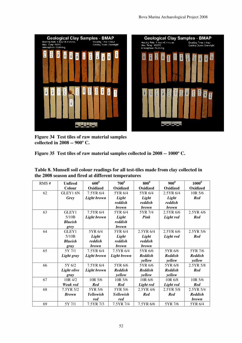
Bova Marina Archaeological Project 2008
52
Figure 34 Test tiles of raw material samples
collected in 2008 -- 900º C.
Figure 35 Test tiles of raw material samples collected in 2008 -- 1000º C.
Table 8. Munsell soil colour readings for all test-tiles made from clay collected in
the 2008 season and fired at different temperatures
RMS # Unfired
Colour
6000
Oxidized
7000
Oxidized
8000
Oxidized
9000
Oxidized
10000
Oxidized
62 GLEY1 6N Grey
7.5YR 6/4 Light brown
5YR 6/4 Light
reddish
brown
5YR 6/4 Light
reddish
brown
2.5YR 6/4 Light
reddish
brown
10R 5/6 Red
63 GLEY1 5/10B
Blueish
grey
7.5YR 6/4 Light brown
5YR 6/4 Light
reddish
brown
5YR 7/4 Pink
2.5YR 6/6 Light red
2.5YR 4/6 Red
64 GLEY1 5/10B
Blueish
gray
5YR 6/4 Light
reddish
brown
5YR 6/4 Light
reddish
brown
2.5YR 6/4 Light
reddish
brown
2.5YR 6/6 Light red
2.5YR 5/6 Red
65 5Y 7/1 Light gray
7.5YR 6/4 Light brown
7.5YR 6/4 Light brown
5YR 6/6 Reddish
yellow
5YR 6/6 Reddish
yellow
5YR 7/6 Reddish
yellow
66 5Y 6/2 Light olive
gray
7.5YR 6/4 Light brown
5YR 6/6 Reddish
yellow
5YR 6/6 Reddish
yellow
5YR 6/8 Reddish
yellow
2.5YR 5/8 Red
67 10R 4/2 Weak red
10R 5/6 Red
10R 5/6 Red
10R 6/6 Light red
10R 6/8 Light red
10R 5/6 Red
68 7.5YR 5/2 Brown
5YR 5/6 Yellowish
red
5YR 5/6 Yellowish
red
2.5YR 4/6 Red
2.5YR 5/8 Red
2.5YR 5/4 Reddish
brown
69 5Y 7/1 7.5YR 7/3 7.5YR 7/4 7.5YR 6/6 5YR 7/6 5YR 6/4
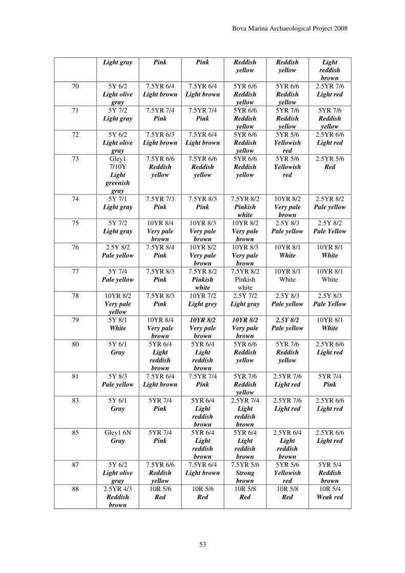
Bova Marina Archaeological Project 2008
53
Light gray Pink Pink Reddish
yellow
Reddish
yellow
Light
reddish
brown
70 5Y 6/2 Light olive
gray
7.5YR 6/4 Light brown
7.5YR 6/4 Light brown
5YR 6/6 Reddish
yellow
5YR 6/6 Reddish
yellow
2.5YR 7/6 Light red
71 5Y 7/2 Light gray
7.5YR 7/4 Pink
7.5YR 7/4 Pink
5YR 6/6 Reddish
yellow
5YR 7/6 Reddish
yellow
5YR 7/6 Reddish
yellow
72 5Y 6/2 Light olive
gray
7.5YR 6/3 Light brown
7.5YR 6/4 Light brown
5YR 6/6 Reddish
yellow
5YR 5/6 Yellowish
red
2.5YR 6/6 Light red
73 Gley1 7/10Y Light
greenish
gray
7.5YR 6/6 Reddish
yellow
7.5YR 6/6 Reddish
yellow
5YR 6/6 Reddish
yellow
5YR 5/6 Yellowish
red
2.5YR 5/6 Red
74 5Y 7/1 Light gray
7.5YR 7/3 Pink
7.5YR 8/3 Pink
7.5YR 8/2 Pinkish
white
10YR 8/2 Very pale
brown
2.5YR 8/2 Pale yellow
75 5Y 7/2 Light gray
10YR 8/4 Very pale
brown
10YR 8/3 Very pale
brown
10YR 8/2 Very pale
brown
2.5Y 8/3 Pale yellow
2.5Y 8/2 Pale Yellow
76 2.5Y 8/2 Pale yellow
7.5YR 8/4 Pink
10YR 8/2 Very pale
brown
10YR 8/3 Very pale
brown
10YR 8/1 White
10YR 8/1 White
77 5Y 7/4 Pale yellow
7.5YR 8/3 Pink
7.5YR 8/2 Pinkish
white
7.5YR 8/2 Pinkish white
10YR 8/1 White
10YR 8/1 White
78 10YR 8/2 Very pale
yellow
7.5YR 8/3 Pink
10YR 7/2 Light grey
2.5Y 7/2 Light gray
2.5Y 8/3 Pale yellow
2.5Y 8/3 Pale Yellow
79 5Y 8/1 White
10YR 8/4 Very pale
brown
10YR 8/2
Very pale
brown
10YR 8/2
Very pale
brown
2.5Y 8/2
Pale yellow
10YR 8/1 White
80 5Y 6/1 Gray
5YR 6/4 Light
reddish
brown
5YR 6/4 Light
reddish
brown
5YR 6/6 Reddish
yellow
5YR 7/6 Reddish
yellow
2.5YR 6/6 Light red
81 5Y 8/3 Pale yellow
7.5YR 6/4 Light brown
7.5YR 7/4 Pink
5YR 7/6 Reddish
yellow
2.5YR 7/6 Light red
5YR 7/4 Pink
83 5Y 6/1 Gray
5YR 7/4 Pink
5YR 6/4
Light
reddish
brown
2.5YR 7/4 Light
reddish
brown
2.5YR 7/6 Light red
2.5YR 6/6 Light red
85 Gley1 6N Gray
5YR 7/4 Pink
5YR 6/4 Light
reddish
brown
5YR 6/4 Light
reddish
brown
2.5YR 6/4 Light
reddish
brown
2.5YR 6/6 Light red
87 5Y 6/2 Light olive
gray
7.5YR 6/6 Reddish
yellow
7.5YR 6/4 Light brown
7.5YR 5/6 Strong
brown
5YR 5/6 Yellowish
red
5YR 5/4 Reddish
brown 88 2.5YR 4/3
Reddish
brown
10R 5/6 Red
10R 5/6 Red
10R 5/8 Red
10R 5/8 Red
10R 5/4 Weak red
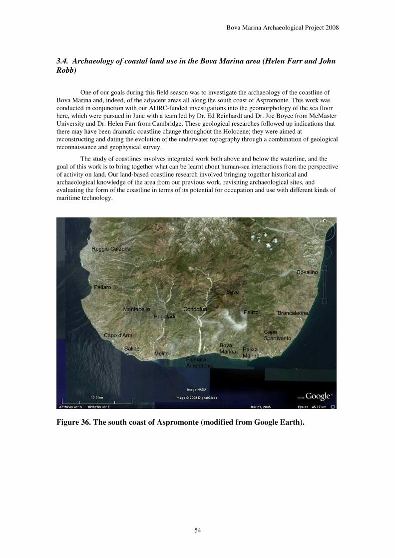
Bova Marina Archaeological Project 2008
54
3.4. Archaeology of coastal land use in the Bova Marina area (Helen Farr and John
Robb)
One of our goals during this field season was to investigate the archaeology of the coastline of Bova Marina and, indeed, of the adjacent areas all along the south coast of Aspromonte. This work was conducted in conjunction with our AHRC-funded investigations into the geomorphology of the sea floor here, which were pursued in June with a team led by Dr. Ed Reinhardt and Dr. Joe Boyce from McMaster University and Dr. Helen Farr from Cambridge. These geological researches followed up indications that there may have been dramatic coastline change throughout the Holocene; they were aimed at reconstructing and dating the evolution of the underwater topography through a combination of geological reconnaissance and geophysical survey.
The study of coastlines involves integrated work both above and below the waterline, and the goal of this work is to bring together what can be learnt about human-sea interactions from the perspective of activity on land. Our land-based coastline research involved bringing together historical and archaeological knowledge of the area from our previous work, revisiting archaeological sites, and evaluating the form of the coastline in terms of its potential for occupation and use with different kinds of maritime technology.
Figure 36. The south coast of Aspromonte (modified from Google Earth).

Bova Marina Archaeological Project 2008
55
Figure 37. The coastline of Bova Marina and Palizzi Marina (modified from
Google Earth).
Geographically, as satellite photos show clearly, the south coast of Aspromonte generally consists of long, gently curving level shores with Quaternary infill and dune formation. Characteristic gentle bulges reflect aggradation around the mouth of major river valleys, for instance at the fiumare of Amendolea and Melito; occasionally, as at San Pasquale, this convexity does not actually coincide with the modern mouth of the river channel, suggesting that the river mouth may have moved over time. Only occasionally are there rocky headlands (e.g. Capo d’Armi, Capo San Giovanni, Agrillei, Torre Mozza, Capo Spartivento). There are no large natural harbours east of the bays of Reggio and Pellaro. The former was chosen for the Greek colony of Rhegion.
Rhegion was ideally situated on the natural harbour, now Reggio, as a safe anchorage for ships and boats travelling through the Straits of Messina. To the north of Reggio, the Straits narrow into a channel two km wide that bottlenecks the water flowing between the Ionian and Tyrrhenian seas, causing strong tidal streams and whirlpools. A tidal stream of 6 knots runs in this northerly section of the Straits of Messina, decreasing as the channel widens. In addition, the strength and direction of the tidal stream is affected by wind strength and direction. The prevailing winds blow from the northwest but are funnelled between the high land on both sides of the channel, exposing vessels to violent squalls which descend through the valleys. Today, as in the past, this is a treacherous stretch of water to navigate:
“To the undecked boats of the Rhegians, Locrians, Zancleans and Greeks, it must have been formidable; for even in the present day, small craft are sometimes endangered by it, and I have seen several men-of-war, and even a 74-gun ship, whirled around on its surface.” (Admiral Smyth 1824 in Heikell 1998:302).
Reggio is located where the Straits begin to narrow and the tidal streams ease; as such it is the last place to stop and rest or to wait for conditions to improve, or the tide to change, when travelling northwards through the Straits. Equally it provides the first safe anchorage once out of the tidal stream when entering the Straits from the north. Strategically this would have been important in governing the trade through the Straits between the Tyrrhenian and Ionian coasts.
Bova Marina Archaeological Project 2008
56
Further south, along the coast at Bova Marina, the tidal streams are weaker and the sea state much calmer. Only after long periods of strong southerly winds does the sea swell increase with an increased fetch. Unlike the Tyrrhenian coast, the southerly coast of the Aspromonte has some shelter from the prevailing northwesterlies, although it is affected by the diurnal cycles of land and sea breezes. There is little shelter along this stretch of coastline from the strong Scirocco that blows from the south, turning the coast into a dangerous lee shore. Whilst weather conditions are generally better in the summer months, Scirocco winds are also more frequent.
The southern coast has few natural harbours, yet the wide bays can provide sufficient temporary shelter for boats inshore if conditions are good. Around the river mouths wide beaches shelve gently, providing easy access to launch or land small boats directly from the shore. The rocky headlands provide additional shelter from prevailing winds and deeper water for larger boats or ships to anchor, although in antiquity ships had shallower draughts and required less water for anchorage.
Modern coastline construction and management is visible in many places. The most obvious is the fact that almost all of the modern river beds have been channelled with concrete walls, often for several kilometres inland, to control the destructive effects of seasonal torrential flooding and to protect property along them. These fix the location of rivers, which may have previously changed course over time. They may also help torrential runoff wash detritus and sediments out to sea faster and more heavily than previously; flood deposits of heavy pebbles and large stones are visible in section along most river mouths, and after a heavy rain brown clouds of soil can be seen swirling into the ocean at distances more than a kilometre from river mouths. There are also small breakwaters at several points, usually in the form of large concrete cubes 50-100 meters offshore or piers extending out into the sea (e.g. Bova Marina) and occasionally (e.g. Capo S. Giovanni) in the form of a concrete-lined sea-front. Increasingly, there is also infrastructure aimed at protecting coastal property and allowing access to it, such as paved lungomari and commercial beach, hotel and restaurant constructions. Breakwaters create a very small boat shelter at Spropoli; besides this, vessels are drawn up on the beaches, harbour in small pockets behind headlands (e.g. Palizzi Marina, Bova Marina) or are anchored in open sea. Besides the large port at Reggio which handles ocean-going freight and ferry traffic, the only constructed port is the small-boat marina at Saline Ioniche, built some time in the past 40 years.
The modern regime of coastal management reflects 20th-century concerns. The major towns are all located along the coast, making heavy use of the railroad and the coastal road (which is in a continuous, if not eternal, process of upgrading in an attempt to develop the economy of the region). But in spite of this coastal location, very little activity is really directed towards maritime activity per se. Ocean traffic runs between major points such as Gioia Tauro, Messina, Reggio, Crotone and Taranto without landfalls in between, there is little commercial fishing activity, and almost all boats making land in our study area are small pleasure craft. Coastal land use and management is aimed at safeguarding property, roads and the coastal rail line against wave and storm damage and erosion, and at developing the coast as a tourist attraction.
This represents a major change from the 18th-19th century use of the coast. Historic evidence such as maps suggests that the coastline was in approximately the same location, but it was used very differently. The principal concern was not major land transport and tourism but a low-level, generally inward-looking maritime trade. Until about 1850 there were no towns along the coast; population was concentrated inland at centers including Montebello Ionico, Pentedattilo, Bagaladi, San Lorenzo, Condofuri, Roghudi, Roccaforte del Greco, Amendolea, Bova, Staiti, Palizzi, and Africo. Inland roads and mule trails such as that followed by Edward Lear in 1843 connected these towns; these may have been used to transport high-value, low-bulk products such as locally manufactured silk. Aside from farm settlements, settlement along the coast apparently began as noble families from Bova and other towns maintained storehouses along the coast for boats and goods; goods were shipped by sea in small boats to centers such as Reggio or ferried out to larger boats offshore. The small boats involved were apparently simply drawn up on the beach, without docks or port facilities. These coastal storehouses were connected to inland towns by mule paths rather than with each other by a real coastal road. As this suggests, coastwise land travel in this period was difficult and little practiced. As in most of Calabria, travellers such as Swinburne tended to bypass the area, viewing it from the decks of large ships travelling between metropolitan centers. The building of the coastal railroad between Reggio and Taranto around the 1870s was the first major step towards coastwise land development. In the mid-19th century, Melito was the only real town along the coast in the 18th and early 19th centuries, and Bova Marina was incorporated formally

Bova Marina Archaeological Project 2008
57
only in 1905. Even in 1913, the coastal road is recorded on a map of infrastructure as being interrupted by river valleys and frequently washed out or impassable.
The 19th-century situation probably reflects a continuous development of the early modern and medieval attitude towards the coastline. Settlement in both of these periods is concentrated in the old hilltop towns mentioned above. Local historical tradition holds that these often quite inaccessible centres were founded in order to escape the twin threats of North African piracy and malaria from insalubrious coastal marshes. While these may have been important threats, or at least perceived as important, there is also a modern bias in posing the question as “why didn’t people live on the coast”, which assumes that the coast is the natural or obviously most advantageous place to live. In a period of little trade and with an economy based upon peasant farming, inland locations may have offered not only security but a more useful environmental setting. The ecotone between lowlands and highlands offered a rich mosaic of resources, and traditionally grain was cultivated in the moister and cooler highland campi rather than today’s coastal terraces. Archaeologically, the only early modern or medieval sites known along the coast are a series of guard towers, apparently dated to the 16th century and intended as a precaution against pirate raids. Examples are known at the headlands of Torre Mozza west of Palizzi Marina, Torre Varata west of San Pasquale, and Capo San Giovanni west of Bova Marina. That these were not simply inspired by paranoia is suggested by an 18th-century account of a local militia repulsing a pirate raid on the beach of Bova Marina near the Torrente Vena (Alagna 1775 [2005]).
Going deeper in time, we can be relatively certain that the coastline in Classical periods was not higher than it is today; a number of important Roman sites are located directly along the coast at altitudes of less than 5 meters. However, it is more difficult to say whether sea level could have been lower. At several locations along the Ionian coast of Calabria, including Sibari and Crotone, classical Greek coastal sites are known under up to 5 m of water due to local land subsidence. The most prominent Greek site is Mazza, a large village on a hilltop above the San Pasquale valley; others include Monte Calamittà. Roman settlement is also dense along the coast. A Roman coastal road is recorded, apparently in approximately the same location as the modern SS106 highway, and there are substantial Imperial Roman sites located periodically along this road, particularly at the mouths of streams such as at San Pasquale (Deri); Siderone (Amigdalà) continued in use until Byzantine times, and the Roman site at Monte Calamittà may have done so also. Similarly, Roman necropoleis are known along the SS106 in Saline Ioniche and Condofuri Marina. For both Roman and Greek times, the fact that coastal sites are much more substantial than inland ones suggests a settlement pattern oriented to coastal trade as well as agricultural production. Roman economic production may also have involved an extensive commerce in agricultural products grown in estates in the coastal plains; these products would have been transported to market centres via boat.
In spite of this use of the sea for transport, actual Roman and Greek coastal installations such as harbour structures, quays, moles and breakwaters are lacking. If there were any, it is possible they now have been destroyed, covered by alluvium, or lie a few metres under water. However, for most small boats, no harbour works were ever necessary, small ships and boats could be beached for unloading and then man-handled up the beach if necessary. If any installations were used these may just have been gangways, timber rollers or timber slipways, mooring posts or stones and props for supports, all of which would be hard identify in archaeological settings. The earliest pre Roman depiction of a harbour scene comes from the 14th century BC tomb of Kenamon at Thebes and shows goods from Syrian ships being unloaded by stevedores directly to merchants on the beach, no harbour works are visible. The only depiction of a Classical Greek harbour comes from the coins of Zankle, now Messina. The name for the city, Zankle derived from its sickle shaped harbour which was also depicted with four quay like structures on its coins (Blackman 1982).
With larger merchant ships, breakwaters, moles and quays became more important as the ships became heavier and more difficult to manhandle and the quantity of goods meant that it was desirable to have a stable berth for loading and unloading the vessel. On a basic level this involved the building up of solid river embankments to serve as quays, and later excavating river banks to form small docks out of the traffic and current of the river. Later coastal harbour structures were built utilising natural features wherever possible. Rock cut harbour works and moles using ashlar masonry developed in the late 8th-7th century BC alongside the growth of maritime trade and the Greek colonies. Harbour size increased through Classical, Hellenistic and Roman periods as land transport was comparatively difficult and expensive. The Roman development of concrete enabled larger harbour structures, moles and breakwaters to be built along straight exposed areas of coastline that afforded no natural shelter. These moles and

Bova Marina Archaeological Project 2008
58
breakwaters were aligned to provide protection from heavy seas and prevailing winds and currents, but also provided some protection from enemy attack. Archaeologically, these structures can be identified through geophysical survey but dating is difficult.
It would appear that there was no important Roman or Greek harbour and infrastructure in the Bova Marina area, however there may have been local coastal installations which may be buried under the sediment or submerged and still need to be identified. The information we have from shipwrecks such as that found at Porticello dating to the late 5th century BC in the Straits of Messina (Eiseman and Ridgway 1987; Parker 1992 no 879), and the Gela on the south coast of Sicily, dating to the end of the 6th century BC (Freschi 1991; Parker 1992 no 441) suggest that merchant ships were traversing this coast. Caligula enlarged the port of Rhegium on the Straits of Messina because, whilst the Roman ships no longer needed to hug the coast, they often needed to shelter in the Straits. Providing a shelter for passing ships may have provided communities with an income. Equally, sanctuaries were often built up near to refuge harbours where ships regularly sheltered in bad weather. From initial survey, no submerged structures have been identified, however there are several locales that can be identified as giving the best shelter along the otherwise exposed coast, including the western end of Palizzi Marina and the western end of the San Pasquale valley.
Prehistoric coastline use is an open question. On one hand, while the exact location of many sites remains unknown (see gazetteer of sites below) and many are not datable, there are surprisingly few prehistoric sites located near the coast. Almost all are located inland of the SS106 and most are higher up in the hills. Coastal sites include Neolithic sites at Deri-b (Torre Varata) and Canturato in the San Pasquale Valley and Saltolavecchia in Melito, and the Bronze Age site of Melito - Cimiterio Nuovo Roghudi. Even these sites are located within about 200m of the present coast rather than directly on it. Even with the caveat that prehistoric coastal sites may have been covered by later settlement (this is likely at Melito and certain at Reggio itself) or destroyed, the prehistoric record does not indicate the coastal preference typical of Greek, Roman and modern settlement.
On the other hand, it is very likely that sea levels have risen, or land levels sunk, since prehistoric times. Preliminary geological prospection in 2005 revealed a submerged peat level at about 500 meters out in the open sea and about 27 metres depth which was radiocarbon dated to about 4000 BCcal. As peat forms in surface marshes, these deposits were presumably at sea level during the Late Neolithic. This is not to say that sea-levels have risen 27 metres since the Neolithic, the coastal zone is one of high tectonic activity and the geomorphological conformation of the seabed reveals a long continuous history of faulting, displacement and slumping. Many large earthquakes have disrupted the area, including the 1908 earthquake that destroyed Reggio and Messina, and it is unsurprising that we find evidence of a landscape repeatedly affected by this tectonic activity underwater. As for sea-level change itself, it is difficult to judge the lateral displacement. The sea-level would have risen, gradually or catastrophically, between 4000 BC and 0 BC to reach approximately its present position by classical times. In some areas of gently sloping bathymetry and topography, it is likely that the Neolithic, Copper Age and Bronze Age coastlines are now under water and known prehistoric “coastal” sites were actually located further inland.
Thus, to look for typical coastal sites, one must seek underwater. Dune sites, such as known at Acconia on the Tyrrehnian coast fo Calabria, for the Neolithic, are likely to be deeply buried by shifting bottom deposits. A different category of sites is located on rocky headlands and islets, which were a preferred location for Middle-Late Bronze Age sites, particularly those involved with long-distance trade (a pattern seen from Vivara, near Napoli, around the south coasts of Italy to Coppa Nevigata in the Adriatic). Rocky headlands are present in our study area. Underwater inspection shows that such headlands, as at Capo S. Giovanni, continue below the high water mark dropping down in much the same way as on land to form steep sided valleys. As such, these headlands would have been affected more by erosion than changes in sea-level since prehistory. To understand the relationship between sea-level change and tectonic activity in this area a geophysical survey and further geological samples for dating were taken during the June 2008 fieldwork; data from these are currently being processed.
Prehistoric maritime activity in this area is evidenced by the use of Liparian obsidian and coloured Sicilian cherts as found at the Neolithic sites of Umbro and Penitenzeria and many other sites. These lithic raw materials were likely to have been just one part of a maritime trade network that ran along the Aspromonte coast and between Calabria, Sicily and the Aeolian islands. Evidence for Neolithic seaworthy boats is scarce and it is difficult to know exactly what type of technology would have been

Bova Marina Archaeological Project 2008
59
used. The most likely boat traditions are the log boat or the reed boat, constructed from bundles of reeds. Preservation of prehistoric boats is rare. Log boats, once no longer in use, may be reused for their timber or discarded to rot in the wetland environment. Unless buried rapidly the waterlogged wood degrades and is particularly susceptible to wood borer infestations. Reed boats, on the other hand, are multi composite, as the reed bundles become waterlogged and rot they are replaced, thus leaving very little archaeological trace. It is unlikely to find actual archaeological evidence for these boats preserved within the high energy shore zone of the Aspromonte coast. Areas of better preservation might include the wetland areas around the river mouths where large amounts of sediment have accumulated, or sub-tidal zones where sediment slumps have moved buried deposits away from the active wave zone.
These boats would have been easy to manhandle and could have been beached at any location along the Aspromonte coast. Simple prehistoric boats would have required no particular installations and as such their use would have been highly flexible, equally, their use would have left very little archaeological evidence apart from the materials they traded.
The Bova Marina area has a long history of coastal land use and maritime activity that can be traced from the trade and exchange of lithic materials in prehistory to the tourism of the present day. The long view of the coastal zone is that it is one of ongoing change and development: from the tectonic activity and faulting, the high energy seasonal rivers eroding and depositing sediments from the Aspromonte, sea-level change and the development of the coastline, for transport, trade and tourism. The coast has undergone physical change but also cultural change in the way it has been thought about and used which can be seen from the movement of the main settlements back to the coast in recent years
Figure 38. The San Pasquale Valley, seen from offshore.
Bova Marina Archaeological Project 2008
60
4. RESTUDY OF THE PREHISTORIC COLLECTIONS IN THE MUSEO
ARCHEOLOGICO NAZIONALE, REGGIO CALABRIA (JOHN ROBB)
4.1. The collections
This research involved a confluence of two tasks. One is to bring together all the known data on prehistoric sites in our research area – here defined broadly as the area between Capo d’Armi on the west and Capo Spartivento to the east and extending as far inland as Gambarie and Montalto. There are a number of sources for this:
• Our own observations during the course of the Bova Marina Archaeological Project, including both formal field survey in the territory of Bova and Bova Marina (see Table 6 above for sites recorded in the BMAP field survey) and more general observations made while working in the area.
• Information from local archaeologists including Sebastiano Stranges and Luigi Saccà (Stranges 1992, 1993; Stranges and Saccà 1994), Enzio Praticò, and others who have visited surface sites over the years.
• Antiquarian collections from the area, including surface collections of axes made early in the 20th century and currently in the Pigorini Museum (Rome)(Salerno and Pessina 2004) and more recent ones such as those of the late Bruno Casile of Bova.
• Mention of sites or findings in this area in publications, notably Mantovani (1877, 1878) but also including Topa (1927), Tinè (1992), Cardosa (1996), and Cordiano and Accardo (2004).
The other task was to review the substantial archaeological collections from this area in the storerooms of the Museo Archeologico Nazionale di Reggio Calabria. At present, these collections hold finds from between 100 and 200 sites in this area. The collections derive from a number of sources: site visits by Soprintendenza archaeologists, surface collections by local archaeologists (probably over half the collections result from long-term work by Stranges and Saccà), and material turned in by members of the public. This body of material was of variable quality. While most collections were well-curated, some had lost or minimal indications of provenience. The collections had benefited from repeated attempts to set them in order and study them. The overall clear ordering of the collection reflects the activities of D.ssa E. Andronico over the last decade. Some collections were made during Tinè’s research visit to the area in 1992 (Tinè 1992), the Palizzi collections had renumbered and relabelled apparently as part of Accardo and Cordiano’s research (2004), and some Condofuri collections showed annotations reflecting the work of Cipolloni Sampò’s team during preparatory work for excavation at M. Tifia. Nevertheless, the collections as a whole have never been systematically reviewed and evaluated.
Since a substantial body of material is available, a systematic review offered an opportunity to re-date the material in light of our accumulated experience in the archaeology of the region; while such a review would have been useful at the beginning of our research, we lacked the experience particularly in the ceramics of different periods to assess them.
The review was quick and cursory. Each box (cassetta) of materials was given a number recorded in Robb’s 2008 lab notebook and correlated with the label on the box, and within it the bags of artefacts were assigned numbers in the same way and the provenience labels recorded. A rapid assessment was made of the contents of each bag. No attempt was made to record the abundant Classical or historical materials, both because of the limits of time and because Robb lacked the necessary expertise in historical ceramics to evaluate them. Notes on the contents of each bag were made, particularly of chronologically diagnostic pieces, and selected pieces were photographed for later comparison with published comparanda. No materials were drawn for publication, a task which remains for the future.
Of the 99 sites which yielded prehistoric material for inspection, 30 contained only non-diagnostic prehistoric body sherds which could not be dated. However, 69 sites could be given some indication of date, if only at a provisional level. The results change our knowledge of the prehistory of the

Bova Marina Archaeological Project 2008
61
area considerably, particularly for the Copper Age and the Final Bronze Age/ Iron Age which had previously been almost entirely unknown in this area.
Table 9. Prehistoric sites by period and temporal density.
Period Definite or probable sites
Centuries (approx.) Sites/ century
Palaeolithic-Mesolithic 2 n/a (?800,000 BC – 5800 BC)
n/a
Neolithic 31 20 (ca. 5800-3800 BC) 1.55
Copper Age 13 14 (ca. 3800-2400 BC) .93
Bronze Age* 30.5 14 (ca. 2400-1000 BC 2.18
Iron Age* 2.5 3 (ca. 1000-700 BC) .83
* calculated by dividing the four Ausonian sites and Monte Imbrisi evenly between the Bronze and Iron Age
Each period is discussed below. In panorama, the site totals are presented in the table above. Although some periods are better represented than others, both in absolute numbers of sites and in numbers of sites per century, we cannot really draw inferences about changing population densities from this; there are too many intervening factors and archaeological biases. Older sites are more likely to be either deeply buried and hence invisible, or destroyed through erosion. Archaeological visibility is important: the Neolithic numbers are patently inflated compared to other periods as they include not only sites defined by diagnostic pottery but also sites identified through obsidian and polished stone axes, both well-preserving and obvious finds of interest to antiquarians for many years. Similarly, Bronze Age sites are readily recognised through typical features such as rim form. Even if all sites were equally visible archaeologically, of course, sites may also have varied greatly in size and in how long they were occupied. Probably the principal conclusion to take from the cumulative picture is that all periods are represented in the prehistoric sequence in the area, and there has been a continuous, substantial human presence here at least since the end of the Mesolithic.
4.2. Review by period
Palaeolithic – Mesolithic
Two sites are known for these periods. Gunì (Palizzi) is a site with extensive Upper and Middle Paleolithic surface collections made by Stranges and Saccà; a Mousterian point is also provenienced to Serromandi (Palizzi). These collections suffice to establish a definite Middle Palaeolithic and Upper Palaeolithic presence in the area, though the exact chronological boundaries await a specialist evaluation of the lithic collections.
Neolithic
Many Neolithic sites are known, with 31 yielding Neolithic or possible Neolithic artefacts. Four areas (Africo, Bova, Bova-Cavalli, and Roccaforte del Greco) have recorded finds of polished stone axes which are highly likely to date to the Neolithic, although stone axes were also used in the Copper Age and earlier Bronze Age. These probably attest assiduous collecting over a large area rather than the presence of specific sites. A second category of sites consists of obsidian finds, either on their own (as with Bova-Travi B where an isolated core was found in the Campi di Bova) or together with otherwise undiagnostic

Bova Marina Archaeological Project 2008
62
fragments of impasto pottery. Obsidian is almost certain to connote a site of Neolithic date; it appears to have been little used from the Copper Age onwards. Sites in this category are surprisingly numerous, numbering 14 in total, although some of these, such as Saltolavecchia, would probably be assignable to a more precise category if we were able to examine the finds now.
Within the Neolithic, the Earlier/ Middle Neolithic is represented by 12 sites with finds of Stentinello and/or Impressed ware (from east to west, these include Canceddada, Poquilli, Cava Cordoba S., San Pasquale, Bova Castello, Umbro, Penitenzeria, Vadicamo, Monte Tifia, Cufolito, Tegara and Prastara. These cover the entire territory and range from sea level to about 10 km inland and 800 meters above sea level; they do not show any preference for particular kinds of location. The Diana period, in contrast, is represented by only four sites, including Monte Tifia, Vadicamo, Umbro, and Penitenzeria. However, we cannot conclude that there were necessarily fewer settlements in this period; it seems equally likely that this reflects a shift from a pottery style with identifiable decoration spread over much of a vessel’s surface to one whose plain-surfaced pots are difficult to identify when fragmented. Indeed, the most characteristic Diana pieces, the fine bowls, are often made of soft figulina which rarely survives well on the surface; it is notable that the Diana component at two of the four Diana sites was found when they were excavated.
Copper Age
One of the surprises of this review was the strong presence of the Copper Age in this area. 13 sites have definite or possible Copper Age occupation, which is remarkable for a period which, before this exercise, was known from one site, Umbro. The sequence appears to span the Spatarella periods, Piano Conte and finally a poorly defined later Copper Age facies.
One site (Spropoli) has a shallow bowl with a zig-zag inside the rim, which is very typical of the transitional Neolithic-Eneolithic period; in Calabria and Sicily it is usually associated with the final phase of the Diana period, named Spatarella, but similar wares are found in both Macchia a Mare and Zinzalusa groups in Puglia and Basilicata. Several other sides probably pertain to the Piano Conte facies (Pappagallo, Carmine, and Sulleria), marked here by incurving vessels with horizontal appliqués, crenellated rims (something found at the type site itself, Bernabò Brea and Cavalier 1956, 1957), and grooved decoration. The nature of the Copper Age following the Piano Conte group is not well-defined in this area, though some vessels similar to those at Umbro (for instance, dark, heavy burnished wares with cordons of finger-markings) have been reported in the Tropea area (Grandinetti et al. 2004). In any case, it seems likely that at least Umbro and Prastara II represent the later Copper Age, with a date of around 3000-2700 BC for Umbro.
Finally, a Copper Age presence is probable but hard to define clearly at Arcina, San Pancialeo, Santa Chiara, and Spilangara, and is probably also signalled by finds of axes with notches or grooves for hafting (Type D in Salerno and Pessina’s classification, 2004) at Bova, Cava Cordova, and Rocciaforte del Greco.
Bronze Age
The Bronze Age is the best-represented period of prehistory, with 32 probable or definite Bronze Age sites known. This may represent not only a genuine high population, but also distinctive pottery features such as tall strap handles, everted rims, and cordon decoration, which may make Bronze Age surface collections more identifiable archaeologically than other periods such as the Late Neolithic and Copper Age.
Although about half of the sites (15 in all) can be dated only as “Bronze Age” or “Bronze Age-ish”, others can be dated somewhat more precisely. Probable Early-Middle Bronze Age sites (7) include Mendolara II, Bova Castello, Limaca, Umbro, Penitenzeria, Puzzuracci, and Trombia. Of these, the two excavated sites, Umbro and Penitenzeria can be assigned to the Rodì-Tindari-Vallelunga facies; the RTV occupation at Umbro is dated to about 1800-1500 BC. Limaca is probably roughly contemporary with them. The other sites cannot be dated more precisely. All of these are open-air sites except for Bova Castello, where at least some Bronze Age remains came from niches and caves beneath the medieval castle (Cardosa 1996; BMAP survey).

Bova Marina Archaeological Project 2008
63
10 sites probably date to the Late-Final Bronze Age sites (Bronzo Recente-Finale), including Mendolara I, Jo, Sant’Aniceto, Condofuri Marina, Monte Tifia, Rodinò, Rossetti, Lacco, Spilangara, and Monte Imbrisi. Of these, Spilangara probably dates to somewhere between the Middle and Late Bronze Age (Bronzo Medio-Recente)(Tinè 1992) and Monte Tifia to the Late Bronze Age (Bronzo Recente). The find at Monte Imbrisi, Bagaladi, made in the 1950s, may also date to the later Bronze or Iron Age; apparently a black urn was found with burnt remains in it and a bronze knife folded in half on top of them, although only the knife remains in the Museum stores today. Four sites have the characteristic pottery of the Ausonian, with types such as straight-sided urns with square appliqué ridges set horizontally below the rim (cf. Bernabò Brea and Cavalier 1960, 1980); these include Sant’Aniceto in the south-western part of Bova Marina, Rodinò (Condofuri Marina), Rossetti (Condofuri Marina), and an unspecified location in Condofuri Marina.
Locationally, Bronze Age sites are spread throughout the territory. While the topographic setting of many is not recorded, those whose setting is known show a much greater tendency to be located upon very steep slopes (for instance, Monte Tifia, Sant’Aniceto, and many of the Pisciotta/ Agrillei group of sites), much as at Portella on Salina (Bernabò Brea and Cavalier 1968). They may also cluster, with groups of small sites known on the border of Bova Marina and Palizzi Marina (Pisciotta/ Agrillei) and around Umbro (Umbro, Limaca, Penitenzeria). Interestingly, all four of the Ausonian sites occur in a relatively small area between Bova Marina and Condofuri Marina. If this is not a vagary of sampling, it might perhaps connote a network of related sites centered on the coastal area around the Fiumara Amendolea.
Iron Age
No sites specifically datable to the Iron Age were identified. However, several sites yielded diagnostic Ausonian pottery (see above). The Ausonian site at Sant’Aniceto falls towards the earlier end of the chronological range for this ware, but (at least on Lipari) this ware is transitional between the Final Bronze Age and the first Iron Age, and hence there is a distinct possibility that at least some of these sites actually date to the first Iron Age. The same is true for the enigmatic find at Monte Imbrisi, Bagaladi.
No sites were identifiable to the second Iron Age (e.g. contemporary with Greek colonisation, as represented for instance by Iron Age necropoleis on the margins of the Greek colonies at Locri and Rhegion). There may be several reasons for this; local populations in this period may have gravitated to the environs of Locri and Rhegion, for instance, or there may simply be a low probability of finding sites for a period which lasted only a century at the most, particularly if there was continuity of occupation and they are covered by later settlements. It is worth noting that at a notable number of Greek sites in the area, small quantities of hand-made impasto pottery are found mixed in with Greek pottery; this may perhaps represent either indigenous occupation of the site prior to the appearance of Greek or Greek-inspired material culture at it, or the continuation of a local pottery tradition in the Greek period. San Salvatore (Bova) is one such site, as is the Umbro Greek site (Bova Marina) and Mazza (Bova Marina); perhaps the most striking example is a surface find from the Greek site of Grappidà (Bova Marina) in the collections of the Museo Nazionale which is of a black surfaced cup with a ring base, possibly inspired by Greek models but manufactured of impasto by hand.

Bova Marina Archaeological Project 2008
64
Table 10. Prehistoric sites between Capo d'Armi and Capo Spartivento
Comune Site Pal Neo CA BA IA Specific date/ notes References*
Africo Africo X Isolated axe find (one axe in Pigorini Museum) Topa 1927:27; Salerno and Pessina 2004:767. 769
Bagaladi Bagaladi X Isolated obsidian find Mantovani 1880; Topa 1927: 41-71
Bagaladi Bagaladi – Monte Imbrisi
? ? Non-diagnostic body sherds of a single fine black vessel, plus a bronze knife or dagger with a ribbed blade and riveted hilt, folded in half. Accompanying note says “olla cineraria d’impasto con resti del defunto col alla bocca punta di lancia repiegata”: suggests cremation burial, perhaps final BA/IA?
MANRC 10.1
Bova Alupu Non-diagnostic body sherds BMAP survey site 57 Bova Bova X X Isolated axe finds (5 in Pigorini Museum); some are grooved (Salerno
and Pessina category D) which may be Copper Age Topa 1927:27; Salerno and Pessina 2004:767
Bova Bova Castello X X Stentinello (on terrace immediately below castle) and Bronze Age (in caves below castle)
BMAP survey; Cardosa 1996; Tinè 1992
Bova Buccisa b Non-diagnostic body sherds BMAP survey site 21 Bova Cavalli X Sporadic find of polished stone axes B. Casile, pers. comm.;
Stranges 1993; Tinè 1992 Bova Grappidà b Non-diagnostic body sherds BMAP survey site 52 Bova Travi b X Isolated obsidian core find in Campi di Bova BMAP survey (no site
number) Bova Marina Agrapida X Impasto wares, one cordon-decorated sherd BMAP survey site 69 Bova Marina Agrillei Non-diagnostic body sherds BMAP survey site 15 Bova Marina Agrillei b/c X A few probable Bronze Age sherds BMAP survey site 39/ 40 Bova Marina Cimitero Non-diagnostic body sherds BMAP survey site 11 and
64 Bova Marina Deri b X Non-diagnostic body sherds and obsidian; called Torre Varata in Tinè
1992 BMAP survey site 7; Tinè 1992
Bova Marina L’Annunziata a Non-diagnostic body sherds BMAP survey site 46 Bova Marina Limaca X Early-Middle Bronze Age; village now destroyed by erosion BMAP excavations Bova Marina Limaccaria c Non-diagnostic body sherds BMAP survey site 61

Bova Marina Archaeological Project 2008
65
Bova Marina Marcasita X Non-diagnostic body sherds; 1-2 pieces obsidian BMAP survey site 32 Bova Marina Mazza Non-diagnostic body sherds mixed with Classical surface collections BMAP survey site 12 Bova Marina Pappagallo X Black impasto incurving vessel with horizontal ridge; body sherd with
horizontal grooves BMAP survey
Bova Marina Penitenzeria X X Stentinello habitation site dated to 5500-5000 BC; Diana and Early-Middle Bronze Age (Rodì-Tindari-Vallelunga) materials out of context in upper levels
BMAP excavations
Bova Marina Penitenzeria b-c Non-diagnostic body sherds BMAP survey site 55, 56 Bova Marina Pisciotta A X Bronze Age scatter, eroding out of vertical face at base of steep hill BMAP survey site 3 Bova Marina Pisciotta C X Bronze Age scatter in small terrace at top of hill BMAP survey site 5 Bova Marina Pisciotta d Non-diagnostic body sherds BMAP survey site 8 Bova Marina Pisciotta
e/Turdari Non-diagnostic body sherds; probably same site called Scigliaca-
Pisciotto in collections (40.1) MANRC 40.1; BMAP survey site 13/43
Bova Marina San Pasquale X Stentinello and Impressed; called Canturato in Museum collections MANRC 43.1-43.2; BMAP excavations; Stranges and Saccà 1994; Tinè 1992
Bova Marina San Procopio Non-diagnostic body sherds BMAP survey site 51 Bova Marina Sant’Aniceto X Final BA (Ausonian) habitation site with preserved hut; radiocarbon
dates ca. 1100-1000 BC BMAP excavations
Bova Marina Umbro Bronze age site
X Early-Middle Bronze Age (Rodì-Tindari-Vallelunga); called Crommidi (B) in Tinè 1992; Limacheria in some surface collections (39.1); radiocarbon dates ca. 1800-1500 BC
MANRC 39.1; BMAP excavations; Tinè 1992
Bova Marina Umbro d Non-diagnostic body sherds BMAP survey site 30 Bova Marina Umbro
Neolithic site X X Stentinello, Diana and Copper Age; called Crommidi (A) in Tinè
1992; note that Museum collections in box 42 derive from the range of sites around Umbro (Umbro Neolithic, Umbro Bronze Age, Limaca and others in the area) as well as this site. Radiocarbon dates suggest Stentinello occupation around 5700-4800 BC, Diana occupation from 4700 BC onwards, and post-Piano Conte Copper Age occupation ca. 3000-2700 BC
MANRC 42.1-42.29; BMAP excavations; Stranges 1992; Tinè 1992
Brancaleone Canceddada X Stentinello site in Fiumara di Capo Spartivento Museum of Locri exhibition “Locri prima di Locri”
Condofuri Casavia Non-diagnostic body sherds MANRC 49.5 Condofuri Cimitero “Condofuri Marina, loc. Cimitero e acquadotto”; non-diagnostic body MANRC 49.13

Bova Marina Archaeological Project 2008
66
sherds Condofuri Condufuri
Marina X No location given beyond “Condofuri Marina”. Impasto sherds with
one very typical Ausonian sherd with appliqué ridge below square rim MANRC 49.7
Condofuri La Salinella Non-diagnostic body sherds MANRC 46.4 Condofuri Lapsè X Non-diagnostic body sherds and one thin black straight rim; obsidian;
big strap handle; large red impasto jar with strap handle MANRC 27.1; 49.4; 49.11
Condofuri Macri X “A monte della superstrada”: non-diagnostic body sherds, one crenellated lug, a few everted rims. EBA? based upon crenellated rim
MANRC 46.1, 46.3
Condofuri Monte Tifia X X Obsidian, a couple of pieces of Impressed Ware, one Diana rim. Box 44 contains surface collections divided by locus and with body sherds counted, but no diagnostics, dating to 2002 – probably Cipolloni Sampò’s survey prior to excavation, minus diagnostics. 49.2, labelled “Tifia-Ozzena Bronzo recente-finale”, contains an impressed sherd (Neolithic) and a horned handle (BR-BF)
MANRC 17.4; all of box 44; 49.3
Condofuri Ozunè X “Fiumara Arangea, loc. Ozunè”; one spindle whorl, very similar to example from Umbro Bronze Age
MANRC 46.5
Condofuri Pellegrino Non-diagnostic body sherds MANRC 50.1 Condofuri Puzzuraci X Non-diagnostic body sherds; BA everted rims; 49.10 has very large
curved flanged lug plus thick strap handle a nastro, flints; carinated cups of all sizes with thickened body above carination; straight rim with fine scallops; BA-BM
MANRC 27.2, 48.1-48.2; 49.10; 49.12; 49.14
Condofuri Ristorante Oasi Marina di S. Lorenzo; non-diagnostic prehistoric sherds MANRC 3.1 Condofuri Rodinà (also
Rodinó) ? X ? Heavy red wares with strap handles, round handles, flat bases, everted
rims, applique ridge; clearly Bronze Age and possible BM-BR?; Rodinó (49.6) has Ausonian-like assemblage with applique ridge below rims, carinated cups, horned handle, as well as flints and a few bits of obsidian
MANRC 47.3; 49.6
Condofuri Rossetti X Non-diagnostic body sherds; big strap handles; square rim with appliqué ridge (Bronzo Finale -- Ausonian)
MANRC 49.2, 49.9
Condofuri Saracena ? Non-diagnostic body sherds; Neolithic feel to impasto but no real diagnostics. Reports of earlier Stentinello finds at the site, not represented in collections. Flints
MANRC 27.11-27.13
Condofuri Treaie X Non-diagnostic body sherds; one distinctive handle; obsidian and flint MANRC 47.2 Condofuri Tripito Non-diagnostic body sherds MANRC 27.9-27.10 Condofuri Trombia (also X Reddish body sherds with one everted rim and one grey flake; vague MANRC 27.5, 49.8
Bova Marina Archaeological Project 2008
67
Tromba) Bronze Age feel; 49.8 has 4-5 pieces grey flint, everted rims, strap handles, shallow wide bowls – BA-BM?
Condofuri Vadicamo X X Undiagnostic body sherds, plus one fragment Impressed Ware; Diana handle; several horizontal handles; very large cordoned body
MANRC 27.6-27.8; 47.1
Condofuri Condofuri Marina
X Complete Bronze Age vessel found by Praticò; no further indication of location; large impasto basin with four handles
MANRC 45
Melito Arcina X Carinated bowl with incised zig-zag on shoulder MANRC 12.3 Melito Cimiterio
Roghudi Nuovo X “Bivio 106 nuovo cimiterio”. Few diagnostics, but generally suggests
BA MANRC 1.1-1.5, 12,4
Melito Cufolito X Stentinello; note fragment of daub ring similar to Umbro, also fossil coral, obsidian
MANRC 12.5, 12.9
Melito Lacco X Possibly Bronzo Recente? Includes spindle whorl MANRC 12.1 Melito Melito Non-diagnostic body sherds in centre of modern city Tinè 1992 Melito Saltolavecchia X Neolithic: probably Diana and possibly Stentinello Mantovani 1878, 1880;
Tinè 1992 Melito Santa Chiara ? X “III Collina dopo cimiterio (S. Chiara)”. Includes typical BA everted
rims, two incised zig-zag sherds; some polished dark surfaces which feel earlier than BA but are not conclusive
MANRC 12.6, 12.7
Melito Spilangara (Monasterace)
? X Clearly BA (perhaps BM-BR?); note carinations, cordons, applique ridge. One handle supposedly Capo Graziano handle, and also a “Borg-in-Nadur” sherd which seems possible but may also be generically BA. 13.8 and 13.9 have dark burnished wares including rim with finger digitations on top, etc. – CA?
MANRC 13.3 – 13.11; Tinè 1992
Montebello Ionico
Masella Non-diagnostic prehistoric sherds MANRC 18.4
Palizzi Acqua Rugiada ? Non-diagnostic prehistoric sherds plus obsidian Tinè 1992 Palizzi Agrillei ? One flake obsidian in classical collection MANRC 33.2; Palizzi
survey site 41 Palizzi Agrillei E Non-diagnostic body sherds BMAP survey Palizzi Capitano ? “Tra Capo Spartivento e Fiumara di Palizzi”. Includes several hundred
body sherds and no diagnostics at all except for a couple rims. Non-diagnostic prehistoric sherds; any diagnostics may have been removed for inspection elsewhere. Tinè 1992 mentions obsidian
MANRC 20.8 – 20.10; 37.5; Palizzi survey site 62; Tinè 1992
Palizzi Capo Spartivento
X Non-diagnostic impasto sherds; some strap handles, flat bases, everted rims; seems probably later than Middle BA, but few solid diagnostics
MANRC 38.2
Bova Marina Archaeological Project 2008
68
Casa Greca Palizzi Carmine X Large, red non-diagnostic sherds. Crenellated rim, flints, curved
necked rims MANRC 25.1- 25.2. Palizzi survey site 44
Palizzi Cava Cordova X No provenience in bag, but from box it is probably Cava Cordova. Isolated find of channelled green axe (Salerno and Pessina type D, Copper Age?).
MANRC 35.2; Palizzi survey site 11
Palizzi Cava Cordova NE
X Bronze Age? MANRC 31.2 ; Palizzi survey site 8
Palizzi Cava Cordova S X One fragment of Stentinello, plus undiagnostic sherds. MANRC 31.1. Palizzi survey site 9
Palizzi Galati Superiore Non-diagnostic body sherds Tinè 1992 Palizzi Gunì X X Extensive collection of Middle and Upper Palaeolithic lithics; a few
pieces of obsidian and non-diagnostic pottery (apparently Amendolara is another name for one area of this site)
MANRC 32.1, 32.2; 37.3-37.4; 38.3; Palizzi survey site 25
Palizzi Iaria Non-diagnostic prehistoric sherds MANRC 20.9; Palizzi survey site 66
Palizzi Jo ? X Later Bronze Age? Note horizontal ridging, beaded strap handles, etc. Obsidian finds from this site are mentioned in Stranges 1993 but not seen in Museum collection
MANRC 31.3; Stranges 1993; Stranges and Saccà 1994
Palizzi Mendolara I X Bronzo Medio or Recente? (apparently different from Mendolara II, Palizzi survey site 10)
MANRC 26.2; Palizzi survey site 53
Palizzi Mendolara II X Heavy red non-diagnostic sherds, with a few probable BA sherds; apparently Palizzi survey site 10, different from Mendolara I
MANRC 35.3; Palizzi survey site 10
Palizzi Mendolarella Non-diagnostic prehistoric sherds MANRC 33.1 Palizzi Monte Corica Non-diagnostic prehistoric sherds, plus one flint tool. MANRC 20.7; Palizzi
survey site 68 Palizzi Ondiglio ? Non-diagnostic body sherds and obsidian finds in valley of Fiumara di
Spartivento Tinè 1992
Palizzi Pirigaglia Non-diagnostic body sherds MANRC 33.1; Palizzi survey site 21
Palizzi Poquilli X Non-diagnostic pottery, plus one piece obsidian and one base from Impressed Ware footed cup.
MANRC 19.2; Palizzi survey site 83
Palizzi S. Pancileo X “Capo Spartivento sotto il faro (a W)”; “Dalla base del faro al Lato N del Semaf.” Lots of large, heavy, coarse red-brown non-diagnostic sherds. Diagnostics include everted rims, inverted rims with small
MANRC 21.9-21.10; Palizzi survey site 47

Bova Marina Archaeological Project 2008
69
handles, lugs, footed stands; note also thin greenstone axe with hafting grooves (Salerno and Pessina type D, Copper Age?) and quartzite disk (macehead or spindle whorl).
Palizzi Serromandi X X Near “Fiumara Spropoli”. Mousterian point (is this the one referred to in Stranges and Saccà 1994 as Torre Mozza?); pots include curled strap handle end, long straight rim with finger marks, cordons, BA wares
MANRC 34.1-34.5; Palizzi survey site 32; Tinè 1992; Stranges and Saccà 1994
Palizzi Spropoli X Incurved rims; wide shallow bowl with zigzag inside rim (Spatarella, initial Eneolithic); ridge on outside of incurving jar; ticked ridge with impressed decoration below
MANRC 37.7
Palizzi Sulleria X Two flints, non-diagnostic sherds, incised sherd, cup with protruding handle; channelled horizontal handles; incised vertical lines
MANRC 21.4; 37.2; 37.6; 38.2; Palizzi survey site 50
Palizzi Terrata X Coarse reddish non-diagnostic sherds, general BA feel MANRC 28.1; Palizzi survey site 33
Palizzi Torre Mozza Non-diagnostic body sherds and one flint MANRC 26.3 Roccaforte del Greco
Roccaforte del Greco
X X Isolated axe finds; Salerno and Pessina mention 25 in the Pigorini, which suggests a fairly assiduous collection over a fairly large territory; some are Type D which may be Copper Age
Topa 1927:27; Salerno and Pessina 2004:767
S. Lorenzo Dacava Non-diagnostic prehistoric sherds MANRC 3.2 S. Lorenzo S. Lorenzo X “S. Lorenzo – 2 km dal Campo Sportivo”. Few diagnostics. Prob. BA MANRC 3.4 S. Lorenzo S. Lorenzo –
Torre Non-diagnostic prehistoric sherds MANRC 3.6
Saline Ioniche Teani Non-diagnostic prehistoric sherds MANRC 17.5 Saline Ioniche Tegara X Undiagnostic body sherds, plus one fragment Impressed Ware, one
fragment probable figulina, one fragment rocker decorated MANRC 17.3
Saline Ionico Prastara I X Collection made by French geologist – frazione Prastara di Musicci 1981. Heavy burnished impasto wares without Neolithic or BA diagnostics, includes incurving rims, finger ticked rims, appliqué bands below incurving rim
MANRC 16
Saline Ionico Prastara II X Rocche Molara collection (Stranges-Saccà) – probably different location than Prastara I. Large collection with few diagnostics. One piece of Stentinello; beaded rim, burnished rhyton foot (?), one piece figulina, one fragment Impressed Ware. Overall probably Stentinello.
MANRC 17.6, 17.8-17.11

Bova Marina Archaeological Project 2008
70
BIBLIOGRAPHY
Alagna, D. 1775 (2005). Bova: Città nel Regno di Napoli nella Calabria Ulteriore, ed. F. Tuscano. Delianuova: Nuove Edizioni Barbaro.
Alessandri, L., I. Cassetta, and D. Gatti. 2004. Il Bronzo Finale nella Calabria settentrionale. Atti,
Riunione Scientifica dell'I.I.P.P. 37:393-402.
Bernabò Brea, L., and M. Cavalier. 1956. Civiltà preistoriche delle Isole Eolie e del territorio del Milazzo. Bullettino di Paletnologia Italiana 66:7-98.
Bernabò Brea, L., and M. Cavalier. 1957. Stazioni preistoriche delle Isole Eolie. Bullettino di
Paletnologia Italiana 66:97-151.
Bernabò Brea, L., and M. Cavalier. 1960 Meligunìs Lipára. Volume I: La stazione preistorica della
contrada Diana e la necropoli preistorica di Lipari. Pubblicazioni del Museo Eoliano di Lipari. S. F. Flaccovio, Palermo.
Bernabò Brea, L., and M. Cavalier. 1968. Meligunìs Lipàra, Volume III: Stazioni preistoriche delle isole
Panarea, Salina e Stromboli. Publications of the Museo Eolio. Palermo: Flaccovio.
Bernabò Brea, L., and M. Cavalier. 1980 Meligunìs Lipára, Volume IV: l'acropoli di Lipari nella preistoria. Publications of the Museo Eolio. Flaccovio, Palermo.
Bettelli, M., A. Cardarelli, F. Di Gennaro, S. Levi, D. Marino, M. Pacciarelli, R. Peroni, L. Vagnetti, and A. Vanzetti. 2004. L'età del Bronzo media e tarda in Calabria. Atti, Riunione Scientifica
dell'I.I.P.P. 37:325-347.
Blackmann, D. J. 1982 Ancient harbours in the Mediterranean, Part 1. The International Journal of
Nautical Archaeology and Underwater Exploration, 11.2:79-104.
Bova Marina Archaeological Project: Annual Reports, 1997-2007. Available online at: http://www.arch.cam.ac.uk/~jer39/BMAP/Reports.html
Bullock, P., N. Federoff, A. Jongerius, G. Stoops, T. Tursina, and U. Babel. 1985. Handbook for Soil
Thin Section Description. Wolverhampton, UK: Waine Research Publications.
Canti, M. 1998. “The micromorphological identification of faecal spherulites from archaeological and modern materials.” Journal of Archaeological Science 25: 435-444.
Canti, M. 1999. “The production and preservation of faecal spherulites: animals, environment and taphonomy.” Journal of Archaeological Science 26: 251-258.
Cardosa, M. 1996. Castello di Bova Superiore (Reggio Calabria): Nuovi dati sulla prima età del Bronzo nella Calabria meridionale ionica. In Convegni di Studi sulla Antica Età del Bronzo in Italia, edited by D. Cocchi Genick, pp. 592-593. Museo A.C. Blanc, Viareggio.
Cardosa, M. 2003. L'abitato dell'Età del Bronzo di Petti di Portigliola (RC). Atti, Riunione Scientifica
dell'Istituto Italiano di Preistoria e Protostoria 35:873-881.
Ciaraldi, M. 1998-2000. The role of plant economy at Pratola Serra (Avellino, southern Italy) in the context of the Italian Bronze Age. Origini 22: 251-266.
Cordiano, G. and S. Accardo. 2004. Ricerche storico-topografiche sulle aree confinarie dell’antica chora
di Rhegion. Pisa: ETS.

Bova Marina Archaeological Project 2008
71
Courty, M.-A., P. Goldberg, and R.I. Macphail. 1989. Soils and Micromorphology in Archaeology. Cambridge: Cambridge University Press.
Eiseman, C. J. and B. S. Ridgway. 1987. The Porticello shipwreck. A Mediterranean merchant vessel of
415-385 BC. Texas: Texas A & M University Press (College Station).
Freschi, A. 1991. Note techniche sur relitto greco arcaico di Gela, in Atti IV rassegna di archeologia
subacquea. Ed. P.A. Gianfrotta, pp. 201-210. Messina.
Grandinetti, G., A. Lo Torto, M. Pacciarelli, C. Rombolà, F. Rombolà, F. Staropoli, and M. R. Varricchio. 2004. Gli insediamenti di Gallo e Colarizzi (promontoria di Tropea): primi dati su un nuovo aspetto ceramico dell'Età del Rame. Atti, Riunione Scientifica dell'I.I.P.P. 37:275-294.
Heikell, R. 1998 Italian Waters Pilot, 5th ed. St Ives, Cambridgeshire: Imray, Laurie, Norie & Wilson.
Levi, S., G. Tigano, A. Vanzetti, L. Alessandri, B. Barbaro, I. Cassetta, M. A. Castagna, D. Gatti, S. Sabatini, and A. Schiappelli. 2003. Milazzo (ME): Distribuzione della ceramica e uso degli spazi della Capanna 1 di Viale dei Cipressi (Facies di Capo Graziano). Atti, Riunione Scientifica
dell'Istituto Italiano di Preistoria e Protostoria 35:895-898.
Mantovani, P. 1877. Stazione dell'età della pietra presso Reggio di Calabria. Bullettino di Paletnologia
Italiana 3:177-178.
Mantovani, P. 1878. Notizie paletnologiche di Calabria Ultra. Bullettino di Paletnologia Italiana 4:33-38.
Martinelli, M. C., L. Lopes, M. T. Calabria, G. Calderoni, G. Fiorentino, and S. Levi. 2003. Nuove ricerche sul sito dell'Età del Bronzo di Portella nell'isola di Salina. Atti, Riunione Scientifica
dell'Istituto Italiano di Preistoria e Protostoria 35:883-887.
Parker, A. J. 1992. Ancient Shipwrecks of the Mediterranean and the Roman Provinces. BAR International Series 580. Oxford: British Archaeological Reports.
Pacciarelli, M., and M. R. Varricchio. 2004. Fasi e facies del Bronzo medio e recente nella Calabria meridionale tirrennica. Atti, Riunione Scientifica dell'I.I.P.P. 37:359-379.
Salerno, A., and A. Pessina. 2004. Le asce in pietra levigata della Calabria nelle Collezioni del Museo Pigorini. Atti, Riunione Scientifica dell'I.I.P.P. 37:765-772.
Spigo, U., and M. C. Martinelli. 2003. L'insediamento della tarda età del Bronzo e prima età del Ferro di Monte Tidora (Peloritani -- ME). Atti, Riunione Scientifica dell'I.I.P.P. 35:899-902.
Stoops, G. 2003. Guidelines for Analysis and Description of Soil and Regolith Thin Sections. Madison, WI: Soil Science Society of America, Inc.
Stranges, S. 1992. Importante ritrovamento stentinelliano a Bova Marina. Calabria Sconosciuta 15:51-52.
Stranges, S. 1993. "Megale Hellas," in Ellefoni di Calabria: Aspetti Storici, Linguistici e Letterari. Edited by A. Casile and D. Fiorenza, pp. 128-137. Bova Marina: UTE-TEL-B.
Stranges, S., and L. Saccà. 1994. Nuove acquisizioni sulla preistoria nella Jonica Reggina. Calabria
Sconosciuta 17:19-22.
Tinè, S. 1992 Bova Survey 1992. Istituto Italiano di Archeologia Sperimentale, Genova.
Topa, D. 1927. Le Civiltà Primitive della Brettia, 2nd edition. Palmi: A. Genovesi e Figli.
Zohary, M. and M. Hopf. 2000. Domestication of Plants in the Old World. Third edition. New York: Oxford University Press.


