Boundary Monuments: Artificial and Natural MarkersBoundary Monuments: Artificial and Natural Markers...
33
PDHonline Course L152 (2 PDH) Boundary Monuments: Artificial and Natural Markers 2012 Instructor: Patrick C. Garner, PLS PDH Online | PDH Center 5272 Meadow Estates Drive Fairfax, VA 22030-6658 Phone & Fax: 703-988-0088 www.PDHonline.org www.PDHcenter.com An Approved Continuing Education Provider
Transcript of Boundary Monuments: Artificial and Natural MarkersBoundary Monuments: Artificial and Natural Markers...

PDHonline Course L152 (2 PDH)
Boundary Monuments: Artificial andNatural Markers
2012
Instructor: Patrick C. Garner, PLS
PDH Online | PDH Center5272 Meadow Estates Drive
Fairfax, VA 22030-6658Phone & Fax: 703-988-0088
www.PDHonline.orgwww.PDHcenter.com
An Approved Continuing Education Provider

www.PDHcenter.com PDH Course L152 www.PDHonline.org
Boundary Monuments: Artificial and Natural Markers
Patrick C. Garner, P.L.S.
Natural monuments are confined to the works of nature and artificial monuments are the works of man.
--Ray Skelton, The Legal Elements of Boundaries and Adjacent Properties, 1930
Figure 1. USGS disc set in stone.
Monuments and markers have been used as property corners for thousands of years. No discussion of property corners can be complete without starting at the beginning—which in the case of boundary corners, goes back almost to the start of civilization. As quickly as agriculture began to play a key role in human culture, marking the edges and points of turn became crucial. Wherever humankind has recognized local or individual land ownership, the physical establishment of boundaries —essentially lines defining use or divisions of ownership— has been crucial. Throughout history boundaries have defined wealth, fixed taxable areas, divided farms, marked lines of use between families and established the width and length of public roadways. In each of these cases, boundaries were marked or defined by a recognized monument. As we will discuss in greater depth shortly, monuments were either natural —a physical feature such as a riverbank— or artificial, invariably highly visible stones or large carved monuments. These markers denoted one kingdom from another, or one farm from another. Their purpose was to keep peace, and to keep away trespassers. Monuments were frequently protected from destruction by law. Ancient Surveys The establishment of boundaries goes back to at least 3,000 B.C. The civilization of ancient Egypt was oriented around the Nile River, which was subject to annual floods. Yearly retracement surveys between farms were required. Inscribed stones cut from locally available material were used to demarcate lines and corners. Surveying was not confined to Egypt. Archeologists have found evidence of Babylonian boundary surveys assumed to date to at least 2,500 B.C.
© Patrick C. Garner Page 2 of 33

www.PDHcenter.com PDH Course L152 www.PDHonline.org
Figure 2. Numerous examples abound in tombs and pyramids of Egyptian surveying & astronomical arts.
From about 150 B.C., boundary preservation was so important to the Romans that they worshipped a god called Terminus, who they believed protected boundary markers (terminus was the Latin word for a boundary marker). As the Encyclopedia Britannica notes,
“ Anyone who removed a boundary stone was accursed and might be slain; a fine was later substituted for the death penalty. From this sacred object evolved the god Terminus. On February 23 (the end of the old Roman year) the festival called the Terminalia was held. The owners of adjacent lands assembled at the common boundary stone, and each garlanded his side of the stone. Offerings of cakes, grain, honey, and wine were made, and a lamb or pig was sacrificed. ”
The Roman poet Ovid wrote,
O Terminus, whether you are a stone or a stump buried in the field, you have been deified from days gone by… you set bounds between peoples and cities and vast kingdoms; without you every field would be a place of dispute. You court no favor, and are bribed by no gold; you guard the lands entrusted to you in good faith.
Monuments were of the greatest public importance, and accordingly, throughout ancient times numerous countries had royal commandments (which were in reality often lengthy curses) against destroying or moving such markers. Romans called the art of determining and defining land ownership and boundaries cadastral surveying. The phrase —still commonly used throughout the world — is derived from Latin (capitastrum), and is first found in writings going back 2,000 years. Cadastral refers to the registration of the value, area and ownership of land.
© Patrick C. Garner Page 3 of 33
www.PDHcenter.com PDH Course L152 www.PDHonline.org
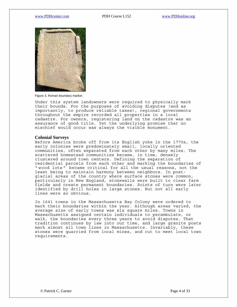
Figure 3. Roman boundary marker.
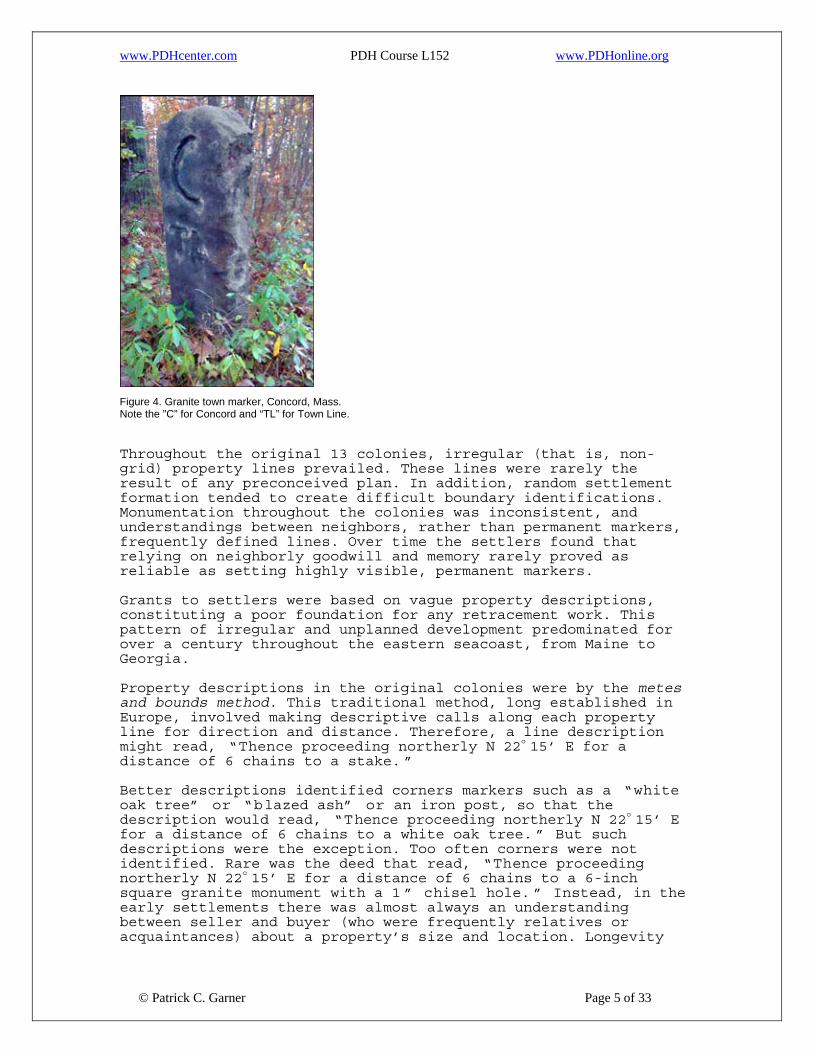
Under this system landowners were required to physically mark their bounds. For the purposes of avoiding disputes (and as importantly, to produce reliable taxes), regional governments throughout the empire recorded all properties in a local cadastre. For owners, registering land on the cadastre was an assurance of good title. Yet the underlying promise that no mischief would occur was always the visible monument. Colonial Surveys Before America broke off from its English yoke in the 1770s, the early colonies were predominately small, locally oriented communities, often separated from each other by many miles. The scattered homestead communities became, in time, densely clustered around town centers. Defining the separation of residential parcels from each other and marking the boundaries of “ wood lots ” became critical for all the usual reasons, not the least being to maintain harmony between neighbors. In post-glacial areas of the country where surface stones were common, particularly in New England, stonewalls were built to clear farm fields and create permanent boundaries. Points of turn were later identified by drill holes in large stones. But not all early lines were so obvious. In 1641 towns in the Massachusetts Bay Colony were ordered to mark their boundaries within the year. Although areas varied, the average size of early towns was six square miles. Towns in Massachusetts assigned certain individuals to perambulate, or walk, the boundaries every three years to avoid disputes. That tradition continues by law into our time, and large granite posts mark almost all town lines in Massachusetts. Invariably, these stones were quarried from local mines, and cut to meet local town requirements.
© Patrick C. Garner Page 4 of 33
www.PDHcenter.com PDH Course L152 www.PDHonline.org
Figure 4. Granite town marker, Concord, Mass. Note the ”C” for Concord and “TL” for Town Line.
Throughout the original 13 colonies, irregular (that is, non-grid) property lines prevailed. These lines were rarely the result of any preconceived plan. In addition, random settlement formation tended to create difficult boundary identifications. Monumentation throughout the colonies was inconsistent, and understandings between neighbors, rather than permanent markers, frequently defined lines. Over time the settlers found that relying on neighborly goodwill and memory rarely proved as reliable as setting highly visible, permanent markers. Grants to settlers were based on vague property descriptions, constituting a poor foundation for any retracement work. This pattern of irregular and unplanned development predominated for over a century throughout the eastern seacoast, from Maine to Georgia. Property descriptions in the original colonies were by the metes and bounds method. This traditional method, long established in Europe, involved making descriptive calls along each property line for direction and distance. Therefore, a line description might read, “Thence proceeding northerly N 22o 15’ E for a distance of 6 chains to a stake. ”
© Patrick C. Garner Page 5 of 33
Better descriptions identified corners markers such as a “white oak tree” or “blazed ash” or an iron post, so that the description would read, “Thence proceeding northerly N 22o 15’ E for a distance of 6 chains to a white oak tree. ” But such descriptions were the exception. Too often corners were not identified. Rare was the deed that read, “Thence proceeding northerly N 22o 15’ E for a distance of 6 chains to a 6-inch square granite monument with a 1 ” chisel hole. ” Instead, in the early settlements there was almost always an understanding between seller and buyer (who were frequently relatives or acquaintances) about a property’s size and location. Longevity

www.PDHcenter.com PDH Course L152 www.PDHonline.org
was not an issue. Land was inexpensive and lives were short. In those situations, a wood stake was a common marker. As surveyors who have worked from these early deeds know, hurried or careless descriptions were common. A line call might frequently read, “ Thence proceeding northerly for a distance of 6 chains.” Without calling out compass directions and without identifying physical, indisputable corner markers, the early surveyors, clerks, lawyers and village scriveners who crafted these conveyances doomed future generations to endless line disputes. As populations grew, the demand for land surveyors grew in tandem. In the earliest years there were few full time surveyors, except in the largest cities along the eastern seacoast. Most practitioners were local men who worked part-time at surveying, drawn to the work through their love of the outdoors and mathematics. No one licensed these individuals —they succeeded, if they practiced for more than a few years, through their reputations. (For more information, see my online course, American Land Surveying – A History.) The property corners they set were unpredictable, often random, and frequently impermanent. From the markers they set, we can safely conclude that few of them thought of permanence as lasting more than a couple generations, if that long. The Use of Boundary Monuments During Three Centuries of American Surveying Methods of marking property corners varied dramatically throughout the early colonies, as they did later in America as a nation. Boundary marking was inconsistent, and as noted, general agreements between abutters (rather than the use of permanent markers) frequently defined lines. In New England, lines were often defined by stonewalls that separated farm fields and wood lots— but even this practice was inconsistent. Marked trees were frequently used —but obviously lasted only as long as the tree stood. Fences were not maintained. Original wood and iron stakes rotted. Stone bounds were stolen, hit, plowed over or forgotten. Even natural monuments could not be relied upon — rivers leaped their banks, and descriptions that read, “… to the riverbank ” were meaningful only as long as rivers were stable.
© Patrick C. Garner Page 6 of 33
www.PDHcenter.com PDH Course L152 www.PDHonline.org
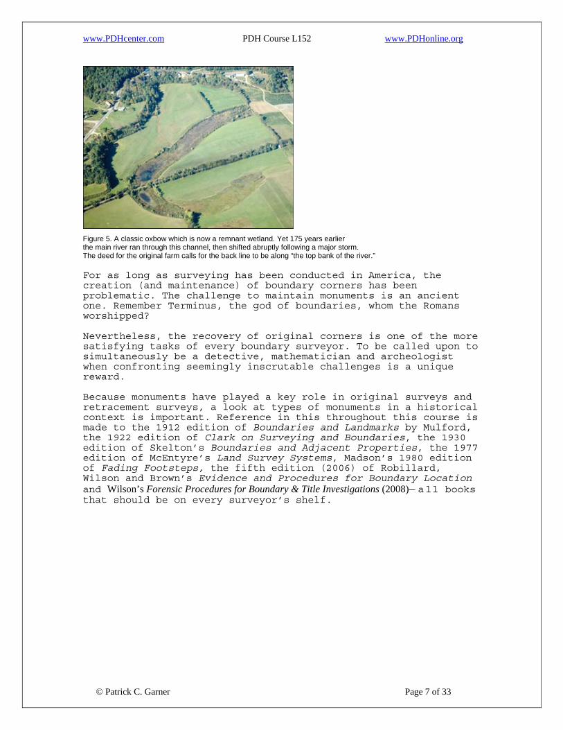
Figure 5. A classic oxbow which is now a remnant wetland. Yet 175 years earlier the main river ran through this channel, then shifted abruptly following a major storm. The deed for the original farm calls for the back line to be along “the top bank of the river.” For as long as surveying has been conducted in America, the creation (and maintenance) of boundary corners has been problematic. The challenge to maintain monuments is an ancient one. Remember Terminus, the god of boundaries, whom the Romans worshipped? Nevertheless, the recovery of original corners is one of the more satisfying tasks of every boundary surveyor. To be called upon to simultaneously be a detective, mathematician and archeologist when confronting seemingly inscrutable challenges is a unique reward. Because monuments have played a key role in original surveys and retracement surveys, a look at types of monuments in a historical context is important. Reference in this throughout this course is made to the 1912 edition of Boundaries and Landmarks by Mulford, the 1922 edition of Clark on Surveying and Boundaries, the 1930 edition of Skelton’s Boundaries and Adjacent Properties, the 1977 edition of McEntyre’s Land Survey Systems, Madson’s 1980 edition of Fading Footsteps, the fifth edition (2006) of Robillard, Wilson and Brown’s Evidence and Procedures for Boundary Location and Wilson’s Forensic Procedures for Boundary & Title Investigations (2008)— all books that should be on every surveyor’s shelf.
© Patrick C. Garner Page 7 of 33

www.PDHcenter.com PDH Course L152 www.PDHonline.org
Figure 6. An early monument, Scandinavia.
Man-made Monuments The American search for permanent boundary corners goes back to pre-Revolutionary times. The surveyor’s ingenuity has been endless, although genuinely permanent solutions have appeared only in the last decades. Historically, building corners, sidewalk intersections, gun barrels, plowshares, buggy and car axles, wagon hubs, and copper, lead and iron pipes have all been used. Iron bars, pry bars, iron rebar, nails, spikes, bricks and assorted stones, concrete monuments and wood stakes have also been used… and this list is by no means comprehensive. The recent introduction of alloy metal markers, often embedded with magnets and “ flarable ” ends (making their removal far more difficult) have brought the ancient quest for permanence closer to fruition. Depending on conditions, many of these newer markers are projected to last for centuries. In addition, manufacturers now furnish break-off monuments as well as sectional rods that may be driven deep into the ground to a point of refusal. None of these options prevents a determined person from removing a corner, but they are far superior to wood stakes, iron rebar or pipes, and even to concrete bounds. Recovery of corners has also been simplified as more and more new and old monuments are GPS-located to high accuracy. Of note, U.S. Public Land Survey (PLSS) Instruction Manuals require specific corner types. Although this course will not describe each corner type in detail, some were remarkable for their time. The 1855 manual set forth the most detailed corner instructions to that date. Corners were to be wood posts, beveled at the top to deflect rain, set 24-inches into the ground and the same height above the surface. Sides of the stakes were to be notched, with township, section corners and quarter section posts to be marked differently. In diagrams that accompany the instructions, the post is shown mounded in a rounded, earthen pyramid.
© Patrick C. Garner Page 8 of 33

www.PDHcenter.com PDH Course L152 www.PDHonline.org
The same manual specified instances that required stone monuments. Such stones were to be inserted to a minimum depth of 7 to 8-inches, and were specified as being a minimum size of 3 x 12 x 14-inches, or 504 cubic inches. Stone edges were to be set north and south on north and south lines, and east and west on east and west lines.
Figure 7. An example of an old Public Land Survey monument.
But 150 to 200 years earlier, the oldest monuments used in the colonies were fieldstones and wood stakes. Rectangular fieldstones, often chiseled with identifying marks, were commonly used in England and Europe. The colonists continued using fieldstones as they settled the northerly portion of the continent (see Figure 8).
Figure 8. Typical fieldstone corner marking an old farm boundary.
© Patrick C. Garner Page 9 of 33
As noted, in time corners became more sophisticated. For instance, ancient granite posts mark almost all town lines in Massachusetts. Invariably, these stones were quarried from local or regional mines and cut to required sizes. Many of these corners were large— some granite markers were five to six feet long and weighed hundreds of pounds. Setting them took several

www.PDHcenter.com PDH Course L152 www.PDHonline.org
men, and the monuments were hauled from point to point on horse or donkey-drawn wagons. Surveyors in many parts of America used combinations of stakes and stones (see Figure 9). Note that a wooden stake is used as the actual corner in two out of three of the combinations.
Figure 9. Various combinations of stakes and stones used as corners.
Where stonewalls marked property lines, it was generally accepted that property lines roughly split the middle of the walls. Particularly in New England, drill holes were often set in walls at points of turn. These holes were precise and permanent points —as long as stonewalls were not rebuilt, destroyed, or modified during seasonal maintenance, which are all common occurrences.
© Patrick C. Garner Page 10 of 33
www.PDHcenter.com PDH Course L152 www.PDHonline.org
Figure 10. A new drill hole in a stonewall.
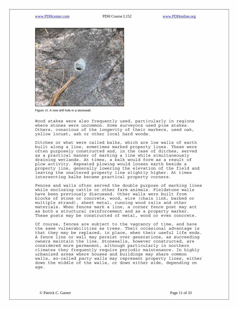
Wood stakes were also frequently used, particularly in regions where stones were uncommon. Some surveyors used pine stakes. Others, conscious of the longevity of their markers, used oak, yellow locust, ash or other local hard woods. Ditches or what were called balks, which are low walls of earth built along a line, sometimes marked property lines. These were often purposely constructed and, in the case of ditches, served as a practical manner of marking a line while simultaneously draining wetlands. At times, a balk would form as a result of plow activity. Repeated plowing would loosen earth beside a property line, generally lowering the elevation of the field and leaving the unaltered property line slightly higher. At times intersecting balks became practical property corners. Fences and walls often served the double purpose of marking lines while enclosing cattle or other farm animals. Fieldstone walls have been previously discussed. Other walls were built from blocks of stone or concrete, wood, wire (chain link, barbed or multiple strand), sheet metal, running wood rails and other materials. When fences mark a line, a corner fence post may act as both a structural reinforcement and as a property marker. These posts may be constructed of metal, wood or even concrete. Of course, fences are subject to the vagrancy of time, and have the same vulnerabilities as trees. Their occasional advantage is that they may be replaced, in place, when their useful life ends. A fence line or wall may persist over generations, as succeeding owners maintain the line. Stonewalls, however constructed, are considered more permanent, although particularly in northern climates they frequently require periodic maintenance. In highly urbanized areas where houses and buildings may share common walls, so-called party walls may represent property lines, either down the middle of the walls, or down either side, depending on age.
© Patrick C. Garner Page 11 of 33
www.PDHcenter.com PDH Course L152 www.PDHonline.org
Note that fences may not always reflect actual property lines. They may be random fences, or may have been intended to be on a property line but are not. On the other hand, fences may precisely occupy property lines. Some fences may indicate adverse possession, or may simply be built in the wrong location. It is outside the range of this course to discuss the many legal nuances that determine these issues. An interested surveyor should refer to some of the books noted throughout this course for appropriate information (or see my online course, Adverse Possession: An Advanced Course). Up to this point we’ve taken a broad approach to manmade corners. What specific corners might a surveyor encounter? Some of these have been discussed, but a complete list of commonly used corners includes:
• Disks, typically cast in bronze or an aluminum alloy • Plastic caps, made to cap a pipe or rebar corner • Car, truck and buggy axles • Wagon hubs • Wooden hubs, typically cut from pine, oak or other tree • Wooden stakes, offset or surrounded by stones • Concrete, fieldstone or granite monuments • Iron rebar, iron bars (either round or square) • Copper or iron pipes • Old pry bars • Gun barrels • Drilled stones found in stone walls • Metal spikes or large nails • Break-off or breakaway metal corners, and • Sidewalk intersections or corners
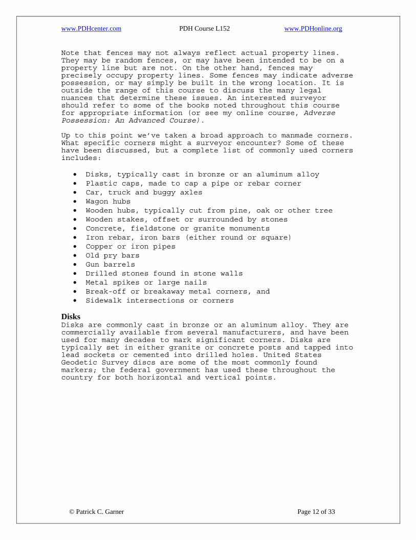
Disks Disks are commonly cast in bronze or an aluminum alloy. They are commercially available from several manufacturers, and have been used for many decades to mark significant corners. Disks are typically set in either granite or concrete posts and tapped into lead sockets or cemented into drilled holes. United States Geodetic Survey discs are some of the most commonly found markers; the federal government has used these throughout the country for both horizontal and vertical points.
© Patrick C. Garner Page 12 of 33

www.PDHcenter.com PDH Course L152 www.PDHonline.org
Figure 11. Aluminum alloy corner, City of Los Angeles.
Figure 12. A variety of brass discs.
Plastic Caps Similar in purpose, caps are intended to top a pipe or rebar corner. Far less expensive than metal disks, they are typically stamped with some form of identification —a surveyor’s name, certification number or other identification. Unlike discs, plastic caps are available in numerous colors.
Figure 13. Typical plastic cap, side view.
Car, Truck and Buggy Axles
© Patrick C. Garner Page 13 of 33
In the past, axles were often set because of their substantial diameter and tendency to greatly outlast narrower iron pipes or

www.PDHcenter.com PDH Course L152 www.PDHonline.org
rebar. Once set, axles were also more difficult to remove from the ground. At one time they could often be picked up for the asking at junkyards, and were a favorite “major corner ” marker for many surveyors. One of the downsides of using axles was their weight and the substantial hole that had to be dug to accommodate the 6’ - 7’ long steel shaft. Consequently, a portion was frequently left standing above ground.
Figure 14. Car or truck axles.
Wood Hubs and Stakes Wood hubs and stakes have been set as corners for almost as long as surveyors have established property corners. The obvious and continuing problem is that, although they are one of the least expensive corners, they also have the least permanence of almost any corner used. Depending on soil conditions (percentage of organics, seasonal moisture, exposure to unusual weather conditions), wood stakes may last as long as a century and as little as a few years. The type of wood used also determines longevity— heart pine, yellow locust, cedar or seasoned oak will far outlast soft pine, poplar or maple. Because of the impermanence of wood hubs and stakes, many municipalities and other authorities will not allow their use as property corners. As Skelton notes in Boundaries, “It is questionable whether or not wooden stakes meet all the requirements usually associated with a landmark, permanency especially. ” Those cities and states that do not prohibit their use often require them to be used in conjunction with a tack or nail. Regardless, surveyors using wood hubs and stakes as property corners may be doing their client a disservice, as good money has been paid for corners that may be lost to rot or decay in short time. It is fair to write, “ Surveyor be warned, ” as lawsuits have been filed against firms using wood corners. Former clients have been quick to claim that the good money they paid for services included an expectation that corners would be recoverable, and would endure for a reasonable period.
© Patrick C. Garner Page 14 of 33

www.PDHcenter.com PDH Course L152 www.PDHonline.org
Figure 15. Old cedar hub excavated at a property corner. Note the nail set during a recent survey.
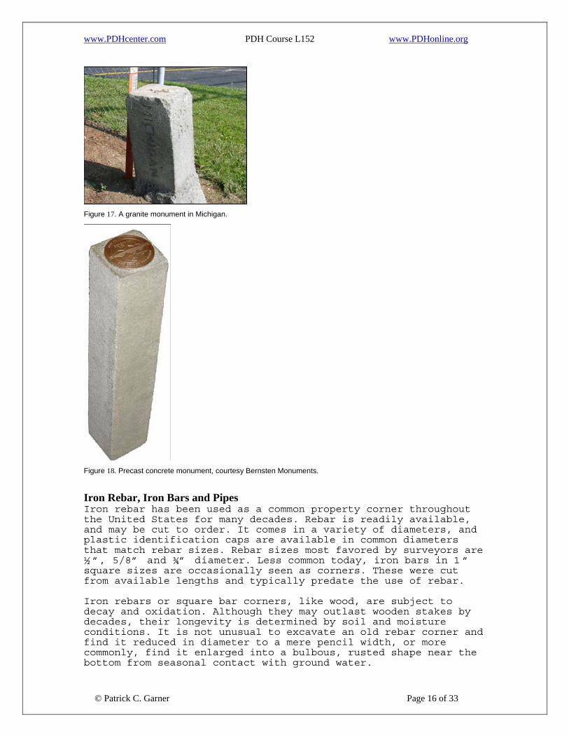
Concrete, Fieldstone and Granite Monuments Far more permanent than wood stakes, stone or concrete monuments come in an endless variety of sizes, shapes, materials and lengths. At times they are used as found—particularly in glaciated states, where fieldstones are common. More typically, monuments are cut from local quarries, or are poured into molds using concrete reinforced with pipe or rebar through the center. Monuments with reinforcing rebar are locatable with magnetic detectors, whereas traditional stone corners are not. Such monuments are typically set with three inches to several feet of the monument left exposed for easier recovery.
Figure 16. Ancient granite corner, approx. 9" x 12" x 5'.
Monuments that do not have a protruding center point of iron or rebar are often drilled or made with a cast center hole. Granite monuments may also be drilled and set with ceramic magnets for easier detection. Many cities and municipalities specify monument size by both width and length to achieve a consistency of monumentation. Because of all these variables, cost for monuments varies tremendously.
© Patrick C. Garner Page 15 of 33
www.PDHcenter.com PDH Course L152 www.PDHonline.org
Figure 17. A granite monument in Michigan.
Figure 18. Precast concrete monument, courtesy Bernsten Monuments.
Iron Rebar, Iron Bars and Pipes Iron rebar has been used as a common property corner throughout the United States for many decades. Rebar is readily available, and may be cut to order. It comes in a variety of diameters, and plastic identification caps are available in common diameters that match rebar sizes. Rebar sizes most favored by surveyors are ½ ”, 5/8” and ¾” diameter. Less common today, iron bars in 1 ” square sizes are occasionally seen as corners. These were cut from available lengths and typically predate the use of rebar.
© Patrick C. Garner Page 16 of 33
Iron rebars or square bar corners, like wood, are subject to decay and oxidation. Although they may outlast wooden stakes by decades, their longevity is determined by soil and moisture conditions. It is not unusual to excavate an old rebar corner and find it reduced in diameter to a mere pencil width, or more commonly, find it enlarged into a bulbous, rusted shape near the bottom from seasonal contact with ground water.

www.PDHcenter.com PDH Course L152 www.PDHonline.org
Figure 19. Typical rebar stored outside for use as corners.
Figure 20. 3/4" iron rebar with plastic identification cap.
Iron pipes are another common material used as property corners. Like rebar, pipe is readily available and may be cut to any length on order. Plastic identification caps are available in common diameters that match pipe diameters. Pipes are subject to the same weathering problems encountered with rebar. All iron or copper-based stakes, pipes or posts are locatable by metal detectors. Despite the years in the ground and subsequent disintegration, trace portions of these corners can still be detected. Consequently, in terms of permanency and cost, they remain popular. Some metals such are hard aluminum alloys are not detectable using conventional locators. As noted further in the course, such modern, non-ferrous monuments often come with ceramic magnets for ease of location.
© Patrick C. Garner Page 17 of 33

www.PDHcenter.com PDH Course L152 www.PDHonline.org
Figure 21. Looking down on an iron pipe corner.
The edge is rolled from being hammered.
Figure 22. 1 1/4" iron pipe found beside post.
Drill Holes Found in Stone Walls As noted, in New England and other regions where surface stones are common, stonewalls are found along many older property lines. These were originally built for a twofold purposes: moving the stones to property lines cleared fields for grazing and crops, and the subsequent walls themselves helped to confine cattle and demarcate lines. As surveying techniques allowed for greater and greater accuracy, land surveyors began to drill holes in stones at points of turn and at corners. Of interest, when stonewalls were initially recognized as highly visible and relatively permanent line and corner markers, surveying technology was relatively crude. It commonly yielded an accuracy of 1-ft in 500-ft or less. A survey of a woodlot with a total boundary linear footage of 2,000-ft (less than 6 acres) might easily have 4-feet of error. A survey of a 40-acre farm might have as much as 15-25-feet of error. Precise drill holes were meaningless in that context.
© Patrick C. Garner Page 18 of 33
As early American surveyors began to use theodolites and steel or brass chains, surveying accuracies steadily increased to 1/1,000 and then 1/2,500. There are many states today that allow so-

www.PDHcenter.com PDH Course L152 www.PDHonline.org
called rural surveys to be as inaccurate as 1/5,000-feet. The need to set pinpoint corners in stones increased only in tandem with increasing accuracies over time.
Figure 23. Old drill hole at a corner, widened during a recent survey.
Large stones, enhanced with drill holes in later years, tended to be relatively permanent when carefully chosen. But smaller stones, over the centuries, became subject to repeated freeze-thaw movement—or simply became lost as some owners enlarged their walls over time. Walls were rebuilt, or removed as uses changed. Permanence was unpredictable. A surveyor working in areas with ancient stonewalls still frequently encounters old drill holes in predictable locations, and many old and contemporary survey plans call for a “D.H. ” at corners.
Figure 24. Stonewall in Vermont.
Metal Spikes, Railroad Spikes and Large Nails
© Patrick C. Garner Page 19 of 33
Iron spikes and nails have been used as corners for hundreds of years. Nails and spikes have been common since the beginning of
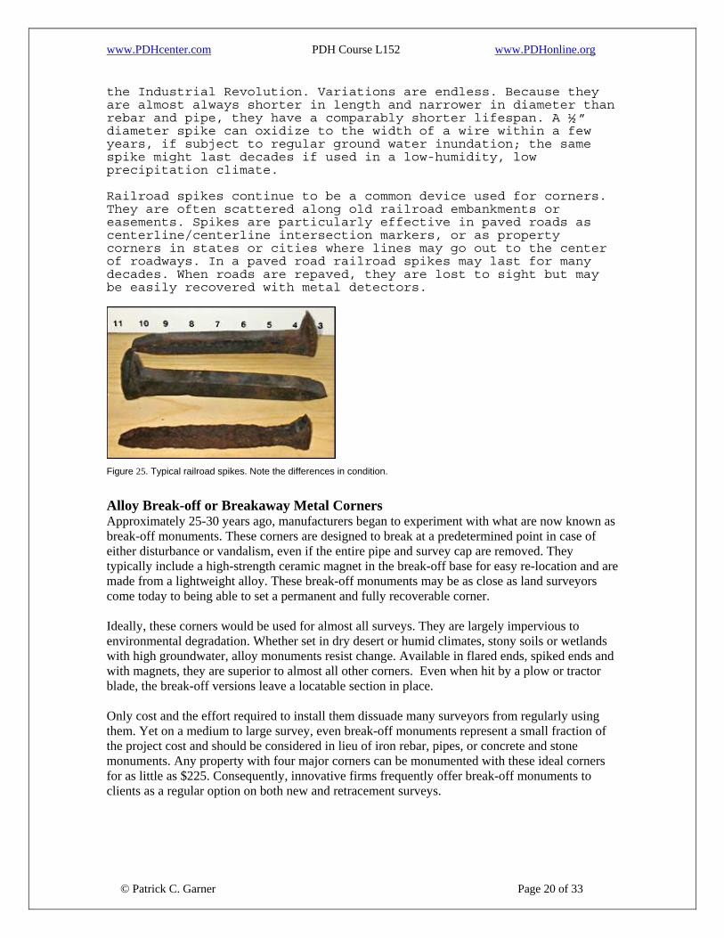
www.PDHcenter.com PDH Course L152 www.PDHonline.org
the Industrial Revolution. Variations are endless. Because they are almost always shorter in length and narrower in diameter than rebar and pipe, they have a comparably shorter lifespan. A ½ ” diameter spike can oxidize to the width of a wire within a few years, if subject to regular ground water inundation; the same spike might last decades if used in a low-humidity, low precipitation climate. Railroad spikes continue to be a common device used for corners. They are often scattered along old railroad embankments or easements. Spikes are particularly effective in paved roads as centerline/centerline intersection markers, or as property corners in states or cities where lines may go out to the center of roadways. In a paved road railroad spikes may last for many decades. When roads are repaved, they are lost to sight but may be easily recovered with metal detectors.
Figure 25. Typical railroad spikes. Note the differences in condition.
Alloy Break-off or Breakaway Metal Corners Approximately 25-30 years ago, manufacturers began to experiment with what are now known as break-off monuments. These corners are designed to break at a predetermined point in case of either disturbance or vandalism, even if the entire pipe and survey cap are removed. They typically include a high-strength ceramic magnet in the break-off base for easy re-location and are made from a lightweight alloy. These break-off monuments may be as close as land surveyors come today to being able to set a permanent and fully recoverable corner. Ideally, these corners would be used for almost all surveys. They are largely impervious to environmental degradation. Whether set in dry desert or humid climates, stony soils or wetlands with high groundwater, alloy monuments resist change. Available in flared ends, spiked ends and with magnets, they are superior to almost all other corners. Even when hit by a plow or tractor blade, the break-off versions leave a locatable section in place. Only cost and the effort required to install them dissuade many surveyors from regularly using them. Yet on a medium to large survey, even break-off monuments represent a small fraction of the project cost and should be considered in lieu of iron rebar, pipes, or concrete and stone monuments. Any property with four major corners can be monumented with these ideal corners for as little as $225. Consequently, innovative firms frequently offer break-off monuments to clients as a regular option on both new and retracement surveys.
© Patrick C. Garner Page 20 of 33

www.PDHcenter.com PDH Course L152 www.PDHonline.org
Figure 26. Break-off alloy monument, courtesy Bernsten Monuments.
Figure 27. Another example of a break-off monument, courtesy Surv-Kap.
Sidewalk Intersections and Street Corners In urban settings or even small towns, the outside edges of intersecting sidewalks—whether made of concrete, asphalt or some other material—often serve as functional property corners. Some of these intersections have a physical monument set at the intersection, but in many cases the edge of intersecting sidewalks serves as the monument itself. Surveyors may set a chisel point, drill hole or nail at these intersections, but not always. In some cases, deeds include a call (direction) to a sidewalk corner. As with other corners, surveyors should always be aware that sidewalks might be subject to maintenance, widening or other changes. And like any property corner, the intersection should correspond to deed distance and angle calls before being assumed to be accurate. In the illustration (see Figure 28) the sidewalk material has been recently changed from brick to concrete.
© Patrick C. Garner Page 21 of 33

www.PDHcenter.com PDH Course L152 www.PDHonline.org
Figure 28. The intersection of the outside sidewalk edges is the right-of-way corner.
Summary of Artificial Monuments This list of artificial monuments is comprehensive, but by no means complete. Many regional peculiarities exist. For instance, Charles Breed notes in Surveying that, “In prairie regions, where neither stone nor timber were available, a mound of earth was commonly raised over the corner and a small marked stone, a charred stake, a quart of charcoal, broken glass, or other permanent distinguishable object was placed beneath it.” The loss of many old, original corners is understandable. Corners that may have appeared obvious and visible when they were created are often lost to time. Farms become forests, or forests farms. Marker trees die, or are cut down as towns expand. Stone bounds are plowed over and iron pipes pulled out as a nuisance to a tractor driving over them. Vandals destroy corners, regardless of material. The course now shifts to an examination of natural monuments. Today’s surveyors do not encounter these as frequently as artificial corners, but natural monuments were commonly used in many original surveys. Natural Monuments Unlike manmade monuments, natural monuments are physical features found in the immediate area of a property corner: trees, creek centerlines, shores, beaches, riverbanks, rock outcrops, ridge tops, abrupt changes in topography or other distinct physical features. These typically vary by region, with outcrop tops, for instance, commonly used in New England, and lake edges—scattered throughout America’s Midwest—more frequently used outside of formerly glaciated areas.
© Patrick C. Garner Page 22 of 33
A list of natural monuments could be expanded to include springs, river forks or intersections, inlet and outlet points on ponds, old gulleys and any other naturally found object that seemed to be convenient, highly visible or appropriate. The American surveyor’s ingenuity, when use of such natural features was opportune, was endless. Using a natural monument often saved a

www.PDHcenter.com PDH Course L152 www.PDHonline.org
surveyor from having to carry markers into a wildness on a horse or donkey. Nevertheless, when conducting retracement surveys, a surveyor should confirm that natural boundaries recited in a deed generally fit the deed calls. As Grimes notes in Clark On Surveying and Boundaries, “ Before placing too much reliance on the natural features such as streams, ledges, rocks, swamps or otherwise, the surveyor should carefully inspect the surroundings and make certain such features are in substantially the same position as they were when the original survey was made. ” It should not be forgotten that to original surveyors the greatest advantage to using natural objects was their apparent permanence and visibility. Unlike iron pipes or other artificial markers, rock outcrops, massive boulders and springs tend to remain in place. On the other hand, as we have seen, rivers and streams that appear as permanent features may, in fact, be dynamic, frequently shifting location during large flood events. Lake and pond edges expand and retreat, their variability driven by seasonal ground water, flooding, withdrawals and impoundments. Both beavers and men can raise the elevation of a pond; a vertical change of three feet may shift a pond edge horizontally by dozens of feet over a short time. Brown’s Boundary Control and Legal Principles notes,
“Naturally occurring monuments such as rivers, lakes, oceans, bays, sloughs, cliffs, trees, hills, and large boulders are permanent objects found on the land as they were placed by nature and are usually considered controlling over artificial monuments (human made), such as iron stakes, wooden stakes, rock mounds, stones, and wooden fences, but if the writings clearly indicate a contrary intent, especially where the lines of a survey are called for, the control may be reversed.”
Indeed, as Skelton notes in Boundaries, “A natural monument will not prevail over an artificial one where it is clear that the parties concerned intended otherwise. ” On the other hand, Madson in Fading Footsteps notes that natural markers, if verifiable, “ take precedence over artificial monuments.” Clearly, intent, physical conditions and deed calls must be ascertained and correlated. For instance, a large oak tree found near a corner cannot be considered the controlling corner if a deed calls for a 2” iron pipe, nor can a predominant boulder be considered the controlling corner if a deed calls for a granite monument. A surveyor, using natural monuments, must be able to verify, as he would any monument, that the object itself is in a logical location in relation to the plan or deed description, and that the natural monument itself has not shifted horizontally. The best natural corners and/or boundaries possess the quality of being easily found, highly visible and reasonably permanent. The key lies in the definition of permanence. As we have seen, some natural monuments are more permanent than others. A rock outcrop may be expected to far outlast a tree, as a cliff edge is likely to be more stable than a lake edge.
© Patrick C. Garner Page 23 of 33
www.PDHcenter.com PDH Course L152 www.PDHonline.org
Let’s look more closely at specific natural monuments that a surveyor might encounter. A list of the most commonly used natural monuments follows:
• Trees, • Creek and stream centerlines • Riverbanks, shores and beaches • Rock outcrops, abrupt changes in topography and ridge tops • Springs, river forks or intersections • Inlet and outlet points on ponds, and old gulleys
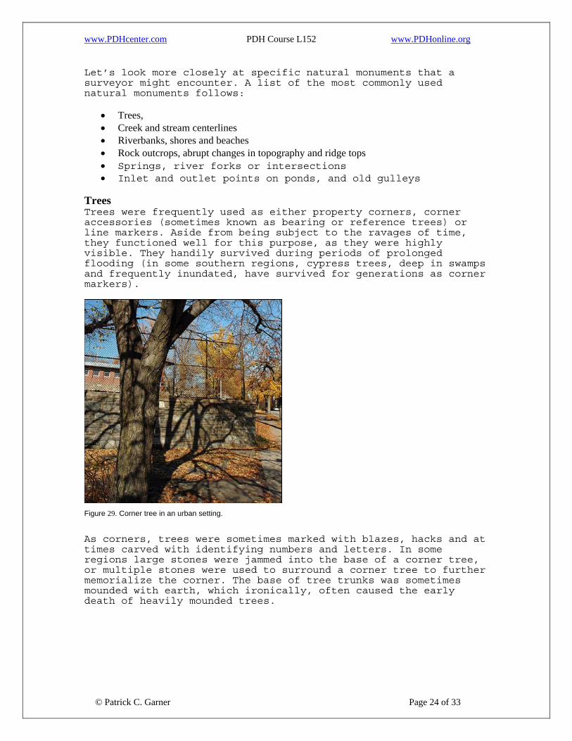
Trees Trees were frequently used as either property corners, corner accessories (sometimes known as bearing or reference trees) or line markers. Aside from being subject to the ravages of time, they functioned well for this purpose, as they were highly visible. They handily survived during periods of prolonged flooding (in some southern regions, cypress trees, deep in swamps and frequently inundated, have survived for generations as corner markers).
Figure 29. Corner tree in an urban setting.
As corners, trees were sometimes marked with blazes, hacks and at times carved with identifying numbers and letters. In some regions large stones were jammed into the base of a corner tree, or multiple stones were used to surround a corner tree to further memorialize the corner. The base of tree trunks was sometimes mounded with earth, which ironically, often caused the early death of heavily mounded trees.
© Patrick C. Garner Page 24 of 33
www.PDHcenter.com PDH Course L152 www.PDHonline.org
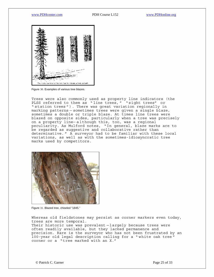
Figure 30. Examples of various tree blazes.
Trees were also commonly used as property line indicators (the PLSS referred to them as “ line trees, ” “sight trees” or “ station trees ”). There was great variation regionally in marking patterns — sometimes trees were given a single blaze, sometimes a double or triple blaze. At times line trees were blazed on opposite sides, particularly when a tree was precisely on a property line— although this, too, was a regional peculiarity. As Mulford notes, “In general, blaze marks are to be regarded as suggestive and collaborative rather than determinative. ” A surveyor had to be familiar with these local variations, as well as with the sometimes-idiosyncratic tree marks used by competitors.
Figure 31. Blazed tree, chiseled “1845.”
Whereas old fieldstones may persist as corner markers even today, trees are more temporal. Their historic use was prevalent —largely because trees were often readily available, but they lacked permanence and precision. Rare is the surveyor who has not been frustrated by an l00-year old legal description calling for a “ white oak tree ” corner or a “tree marked with an X.”
© Patrick C. Garner Page 25 of 33

www.PDHcenter.com PDH Course L152 www.PDHonline.org
Upon walking a property thus described, the contemporary surveyor too frequently observes open fields without a single tree, or simply cannot find a white oak tree in the vicinity that is older than 10-years. Further, most deeds (and most old plats) failed to note the tree diameter, age or any other defining characteristic. In short, trees remained ideal corner markers as long as neighbors agreed to their accuracy, as long as they were remembered by succeeding generations, and as long as they stood. Creek and Stream Centerlines Many old deeds called for a line to be a stream centerline. A typical deed description might read, “Thence, northerly about 200-feet to point which lies in the centerline of a stream; thence easterly along the thread or centerline of the stream for a distance of some 375-feet to a point; thence… ” As discussed, a stream may flow in the identical channel 200 years after an initial survey, or it may have shifted dramatically due to natural stream dynamics.
Figure 32a. A deed for an adjoining farm reads, "1045 ft to the top of bank," yet the river shown periodically shifts within the green "meander belt" by as much as 200-feet. Extreme precipitation events tend to shift channels naturally left and right within what is called a meander belt. A stream’s meander may be as little as 10-feet, or as much as 300 -400-feet. Older streams and rivers found in the western part of the country tend to be more stable than younger streams found in formerly glaciated areas. When a surveyor retraces a boundary based on deed descriptions that use streams as a natural boundary, it is important to know the rules of riparian surveying. Specific riparian boundary case law exists that addresses the nuances of surveying beside dynamic natural riparian systems.
© Patrick C. Garner Page 26 of 33
www.PDHcenter.com PDH Course L152 www.PDHonline.org
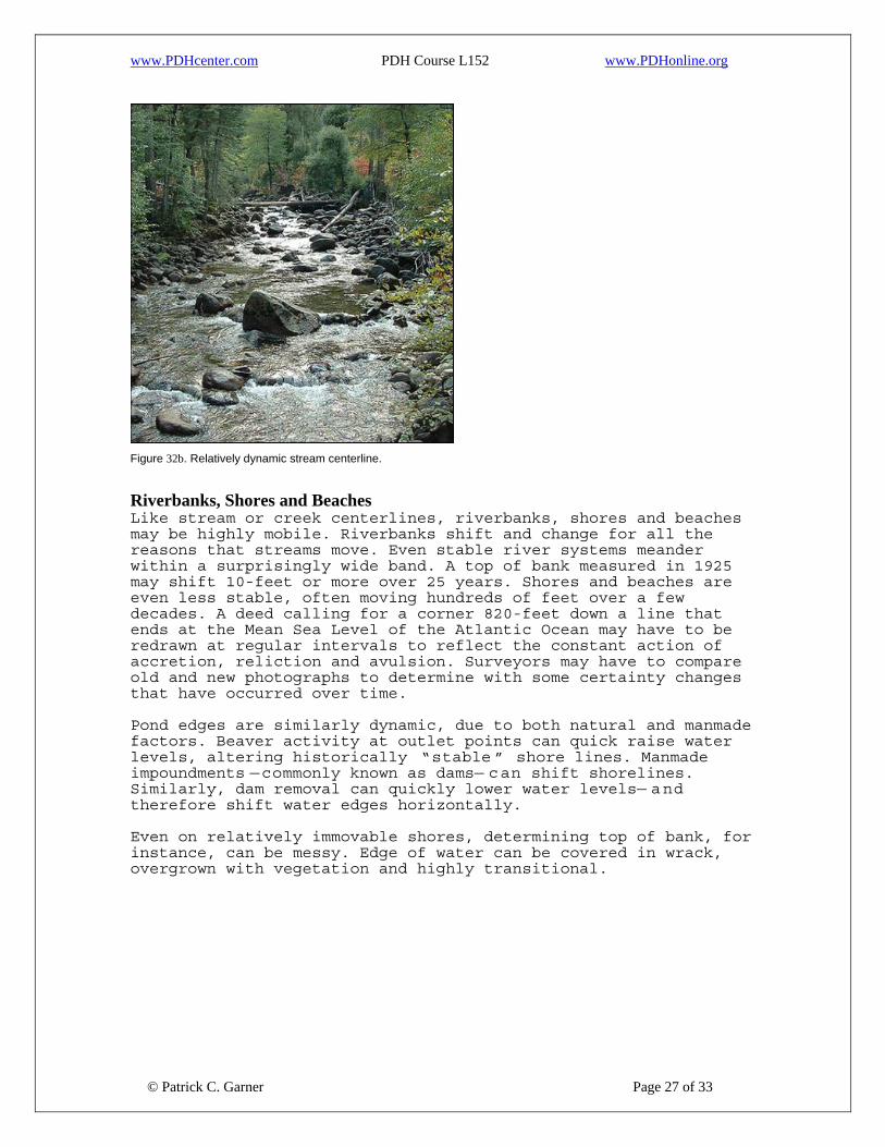
Figure 32b. Relatively dynamic stream centerline.
Riverbanks, Shores and Beaches Like stream or creek centerlines, riverbanks, shores and beaches may be highly mobile. Riverbanks shift and change for all the reasons that streams move. Even stable river systems meander within a surprisingly wide band. A top of bank measured in 1925 may shift 10-feet or more over 25 years. Shores and beaches are even less stable, often moving hundreds of feet over a few decades. A deed calling for a corner 820-feet down a line that ends at the Mean Sea Level of the Atlantic Ocean may have to be redrawn at regular intervals to reflect the constant action of accretion, reliction and avulsion. Surveyors may have to compare old and new photographs to determine with some certainty changes that have occurred over time. Pond edges are similarly dynamic, due to both natural and manmade factors. Beaver activity at outlet points can quick raise water levels, altering historically “stable ” shore lines. Manmade impoundments —commonly known as dams— can shift shorelines. Similarly, dam removal can quickly lower water levels— and therefore shift water edges horizontally. Even on relatively immovable shores, determining top of bank, for instance, can be messy. Edge of water can be covered in wrack, overgrown with vegetation and highly transitional.
© Patrick C. Garner Page 27 of 33
www.PDHcenter.com PDH Course L152 www.PDHonline.org
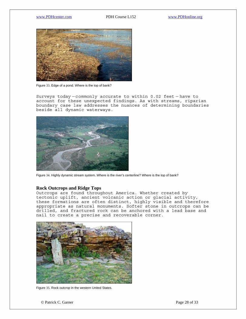
Figure 33. Edge of a pond. Where is the top of bank?
Surveys today —commonly accurate to within 0.02 feet — have to account for these unexpected findings. As with streams, riparian boundary case law addresses the nuances of determining boundaries beside all dynamic waterways.
Figure 34. Highly dynamic stream system. Where is the river’s centerline? Where is the top of bank?
Rock Outcrops and Ridge Tops Outcrops are found throughout America. Whether created by tectonic uplift, ancient volcanic action or glacial activity, these formations are often distinct, highly visible and therefore appropriate as natural monuments. Softer stone in outcrops can be drilled, and fractured rock can be anchored with a lead base and nail to create a precise and recoverable corner.
© Patrick C. Garner Page 28 of 33
Figure 35. Rock outcrop in the western United States.

www.PDHcenter.com PDH Course L152 www.PDHonline.org
Figure 36. Outcrops in a mountainous terrain.
Abrupt Changes in Topography and Ridge Tops Other natural features commonly used as monuments are abrupt changes in topography and ridgelines. A sharp drop in elevation of as little as three or four feet, or a point where a steep hill suddenly flattens into an almost level slope may create an abrupt change. A common deed call may be for a line to extend southerly to the “edge of swamp”—often a point where a slope abruptly flattens, the swamp itself acting as a bowl. Swamp edges were often used as property lines in 18th and 19th century surveys. Abrupt changes in topography can occur in lowlands, desert terrain and mountainous regions.
Figure 37. Note the sudden topographical change from steep slope to flatter terrain.
Ridgelines are found throughout the country. As distinct divisions between two watersheds, hills or ranges, original surveyors used them as natural lines and/or corner points. These features, unlike water-related monuments, tend to be highly stable. A ridgeline established in 1810 is likely to be in the same location today.
© Patrick C. Garner Page 29 of 33

www.PDHcenter.com PDH Course L152 www.PDHonline.org
Figure 38. Typical ridgeline. Note on the left side the wind-scoured discoloration along the ridge.
Inlet and Outlet Points on Ponds Naturally occurring pond inlets and outlets are highly visible, easily located points on a given landscape. Like a spring, they can be reasonably defined, and are not uncommon as old property corners. An original survey might show a line extending to a pond and ending at the intersection of the pond edge and its outlet stream. An associated deed might have a call that reads, “Thence proceeding 663 feet to a point on the shore which is the outlet of Bartlett’s Pond.”
Figure 39. A naturally-occurring pond outlet.
Summary of Natural Monuments
© Patrick C. Garner Page 30 of 33
Original surveyors frequently used natural monuments. Some natural monuments are far more reliable than others, given that rivers, streams, riverbanks, shores and pond edges are subject to movement. In contrast, a massive boulder or rock outcrop with a drill hole will be in the identical location 200 years later. A surveyor should make reference to Evidence and Procedures for Boundary Location, an essential text that outlines the correct procedures for boundary determinations using natural monuments. In addition, there are several books that specialize in

www.PDHcenter.com PDH Course L152 www.PDHonline.org
riparian surveys (see Bibliography). These should be consulted whenever a natural monument appears to be in conflict with a plan or deed description.
Figure 40. A county monument witness sign, Florida.
Conclusion Monuments and markers have been used as property corners for millennium. As soon as agriculture played a key role in human culture, marking corners of land used by farmers—or owned by royalty—became crucial. Wherever humankind has recognized land ownership, the physical establishment of boundaries is imperative. Boundaries have defined taxable areas, farms, lines between families and established public roadways. In each of these cases, boundaries were marked with a permanent, visible monument. Monuments have been either natural — a physical feature such as a large boulder —or artificial, that is, a corner made from manmade materials. These two distinctions are recognized by law and frequently cited in legal decisions. The purpose of markers has always been serious, and consequently, monuments are often protected from destruction or mischief by law and statute. Modern law makes destruction or movement of boundary monuments subject to civil penalties that may— depending on the severity of the destruction— include prison time and fines. The destruction or movement of monuments may also constitute trespass. The law considers the protection of property monumentation today as important as it did thousands of years ago.
© Patrick C. Garner Page 31 of 33
A surveyor’s intent when reestablishing or setting corners should be: (1) permanence; (2) visibility; and (3) accuracy. Permanence is one of the most difficult challenges, given that natural monuments are subject to erosion and movement, and artificial monuments subject to destruction.
www.PDHcenter.com PDH Course L152 www.PDHonline.org
Far too many surveyors compound this problem by setting wood stakes or carpentry nails for corners—and the life span of these objects is typically short. With the advent of aluminum alloy monuments—particularly break-off monuments with ceramic magnets—surveyors are as close as the profession has come to having truly permanent corners. Although break-off monuments are not usable in all situations, they may be considered “ideal monuments” for most common situations. Use of centimeter-accurate GPS and highly accurate total stations has also increased dimensional reliance and the ability to later recover lost corners. The course has also emphasized that natural monuments such as rivers, streams, riverbanks, shores and pond edges are all subject to substantial movement, no matter how accurately located by a surveyor at a given moment. Riparian rights and riparian law, the product of hundreds of years of legal decisions and state-by-state statutes, must be carefully consulted before the correct, contemporary property corner may be established. Regardless of these issues, a surveyor must still couple technology with experience and with knowledge of boundary law. Locating the correct corner always trumps making a so-called accurate survey. A surveyor has gained nothing by measuring to the nearest 0.01 foot, if in doing so he misses the original corner. Clearly, permanence and visibility of corners remains as meaningful today as it was in 3,000 B.C.
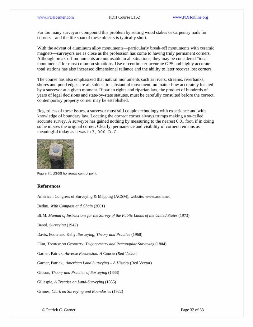
Figure 41. USGS horizontal control point.
References American Congress of Surveying & Mapping (ACSM), website: www.acsm.net Bedini, With Compass and Chain (2001) BLM, Manual of Instructions for the Survey of the Public Lands of the United States (1973) Breed, Surveying (1942) Davis, Foote and Kelly, Surveying, Theory and Practice (1968) Flint, Treatise on Geometry, Trigonometry and Rectangular Surveying (1804) Garner, Patrick, Adverse Possession: A Course (Red Vector) Garner, Patrick, American Land Surveying – A History (Red Vector) Gibson, Theory and Practice of Surveying (1833) Gillespie, A Treatise on Land-Surveying (1855)
© Patrick C. Garner Page 32 of 33
Grimes, Clark on Surveying and Boundaries (1922)

www.PDHcenter.com PDH Course L152 www.PDHonline.org
Leybourn, The Compleat Surveyor, Containing the whole Art of Surveying of Land (1653-57) Love, Geodaesia (1682) Madson, Fading Footsteps (1980) McEntyre, Land Survey Systems (1978) Mulford, Boundaries and Landmarks (1912) Robillard, Wilson and Brown, Evidence and Procedures for Boundary Location (2006) Skelton, Boundaries and Adjacent Properties (1930) Wilson, Forensic Procedures for Boundary & Title Investigations (2008) Acknowledgments
© Patrick C. Garner Page 33 of 33
The author wishes to acknowledge the contribution to the surveying profession of James L. Conine, P.L.S, and Lee I. Kicklighter, P.L.S., of Brunswick, Ga. They also contributed mightily to the author’s education and development as a young surveyor. In addition, he notes the immeasurable contribution to the profession of Walter Robillard, PLS.