Boundary Hill SoutH Project 3. - Anglo...
20
BOUNDARY HILL SOUTH PROJECT Description of the Project 3.
Transcript of Boundary Hill SoutH Project 3. - Anglo...

Boundary Hill SoutH Project
Description of the Project
3.

Boundary Hill South Environmental Impact Statement
3-1
3. DESCRIPTION OF THE PROJECT The Project is proposed as an extension to existing operations at Boundary Hill within the Callide Mine complex. The existing Boundary Hill pit will reduce operations from 2015 until economic reserves are depleted in approximately 2016. Beyond 2016, operations will significantly reduce at the existing Boundary Hill pit. Based on a planned production rate of approximately 2.6 million tonnes per annum (Mtpa) of product coal, the Project will extend the life of mining at Boundary Hill by approximately 20 years. The Project will ensure that Callide Mine can continue to supply product coal to current customers.
This section describes the proposed Project, including the open cut mining activities and associated mine infrastructure. The existing Callide Mine operations and the integration of the Project with existing mining activities are also discussed in this section.
3.1 Location
3.1.1 Regional Context
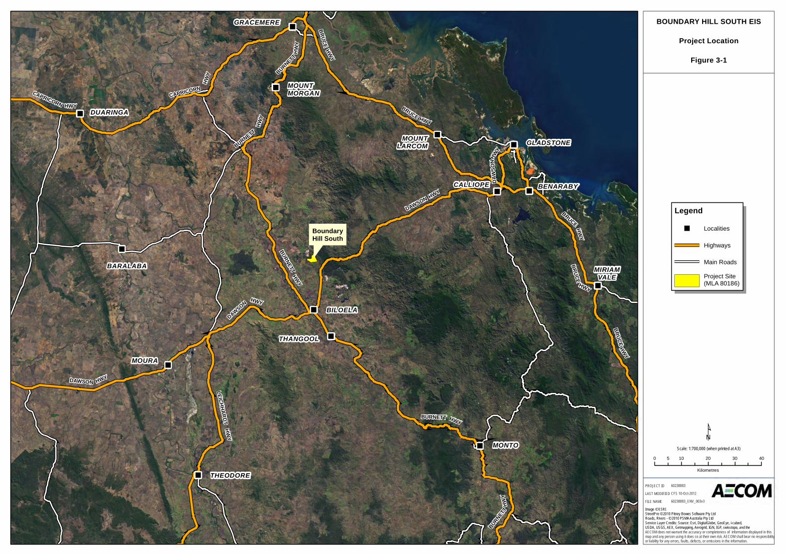
The Project is situated adjacent to existing Boundary Hill operations at Callide Mine, 20 kilometres north of Biloela in Central Queensland. Biloela is approximately 85 kilometres south-west of Gladstone and 120 kilometres south of Rockhampton. Callide Mine is located in the Callide Basin within the Banana Shire Council local government area (LGA). Biloela (population of approximately 6,000) is the nearest township to the Project.
The Biloela region supports a range of industries including agriculture, tourism, power generation and coal mining. Callide Mine and the nearby Callide Power Station are major contributors to the region’s economy. Biloela is accessed from Gladstone via the Dawson Highway, and from Rockhampton via the Burnett Highway.
Figure 3-1 illustrates the location of the Project in a regional context.
3.1.2 Local Context
The Project area is located immediately to the south and east of the existing Boundary Hill operations, covering an area of approximately 630 hectares (Figure 3-2). The current Boundary Hill operation is located over Mining Leases (ML) 5655 and 6994. The proposed Project is located within Mining Lease Application (MLA) 80186.
The Project is proposed to be carried out on land described as:
- Part Lot 1 SP231268;
- Part Lot 94 RN1524; and
- Part Lot 134 RN417.
The Callide Timber Reserve area (TR170 on plan FTY1843), located north-east of the Project site, is identified as a Timber Reserve under the Forestry Act 1959. The southern limit of the proposed Project is located approximately 1.2 kilometres to the north of the Kilburnie Homestead on Argoon-Kilburnie Road in the Leichhardt Pastoral District of Biloela. The closest pastoral homestead to the west is approximately two kilometres from the Project.
Existing road infrastructure at Boundary Hill includes the Link Road and Argoon-Kilburnie Road. Inverness Road currently transects the Project area and will be realigned as part of the Project. Campbell (Gate) Creek and tributaries of Campbell (Gate) Creek run through the Project site. A 275 kV power transmission line forms the eastern boundary of the Project site.
3.2 Construction The Project is proposed as an extension to existing operations at Callide Mine to allow the continuation of mining activities at Boundary Hill. The Project would make use of existing infrastructure at the mine to support operations. Some additional infrastructure including haul roads and workforce crib rooms would be required to support existing infrastructure at the mine. Given the extent of current operations and existing infrastructure, the Project would not involve an extensive construction phase.
"
"
"
"
"
"
"
"
"
"
"
"
"
"
BoundaryHill South
BARALABA
BENARABY
BILOELA
CALLIOPE
DUARINGA
GLADSTONE
GRACEMERE
MIRIAMVALE
MONTO
MOUNTLARCOM
MOUNTMORGAN
MOURA
THANGOOL
THEODORE
DAWS
ONHW
YBURNETT
HWY
DAWSON HWY
CAPRICORN
HWY
LEICHHARDTHWY
BRUCE
HWY
DAWSON HWY
BRUCE HWY
CAPRICORN HWY
BURNETT HWY
BRUCE HWY
BURNETT HWY
DAWSON HWY
BRUCEHWY
BRUCEHWY
BURNETT
HWY
BURNETT
HWY
¹0 10 20 30 405
Kilometres
AECOM does not warrant the accuracy or completeness of information displayed in thismap and any person using it does so at their own risk. AECOM shall bear no responsibilityor liability for any errors, faults, defects, or omissions in the information.
PROJECT IDLAST MODIFIEDFILE NAME
60238883CFS 10-Oct-201260238883_ENV_003v3
BOUNDARY HILL SOUTH EIS
Project Location
Figure 3-1
1:700,000 (when printed at A3)Scale:
Legend" Localities
Highways
Main Roads
Project Site(MLA 80186)
Image © ESRIStreetPro © 2010 Pitney Bowes Software Pty LtdRoads, Rivers - © 2010 PSMA Australia Pty LtdService Layer Credits: Source: Esri, DigitalGlobe, GeoEye, i-cubed,USDA, USGS, AEX, Getmapping, Aerogrid, IGN, IGP, swisstopo, and the

MLA 80186
ML6994
ML5655
ML80115
ML80107
ML80151
MLA80121
Argoon KilburnieRd
Dawso
nHwy
¹0 500 1,000250
Metres
AECOM does not warrant the accuracy or completeness of information displayed in thismap and any person using it does so at their own risk. AECOM shall bear no responsibilityor liability for any errors, faults, defects, or omissions in the information.
PROJECT IDLAST MODIFIEDFILE NAME
60238883CFS 11-Oct-201360238883_ENV_156v2
Image supplied by Callide Mine (date unknown).StreetPro © 2010 Pitney Bowes Software Pty Ltd.Roads, Rivers - © 2010 PSMA Australia Pty Ltd.Mine Data - Department of Natural resources and Mines, 2012
BOUNDARY HILL SOUTH EIS
Project Area
Figure 3-2
LegendHighway
Local Road
Railway Line
Property Boundary
Project Site(MLA 80186)
Previous MLA
Mine Lease
Surrendered Application
Granted
1:25,000 (when printed at A3)Scale:

Boundary Hill South Environmental Impact Statement
3-4
Construction activities associated with the Project include:
- construction of haul roads to link in with Callide Mine’s existing road network;
- installation of temporary workforce support facilities, such as crib rooms and amenities;
- project establishment, including site preparation works, vegetation clearing, fencing and construction of access tracks;
- establishment of pit, out-of-pit dump and run-of-mine (ROM) pad;
- realignment of Inverness Road; and
- establishment of mine water management infrastructure.
Construction will occur over approximately six months during late 2014 and early 2015 (weather dependent). Initial clearing for the Project will begin in 2015, with overburden removal commencing in late 2015. The existing equipment fleet at Callide Mine will be used to support construction of the Project. Surface soils and materials suitable for reuse as topsoil in rehabilitation activities will be salvaged from the establishment areas.
3.3 Operations
The current Boundary Hill pit is mined using conventional open cut mining techniques. Overburden is removed by a walking dragline supported by a hydraulic excavator and pre-strip truck fleet. A hydraulic excavator is used to load coal into rear dump trucks for transport to an in-pit crusher. The coal is either stockpiled at an in-pit ROM stockpile or crushed and screened at the Boundary Hill Coal Handling Plant (CHP) area. The crushed coal is then conveyed to a screening and secondary crusher plant. Coal is sold as an unwashed product and therefore no tailings are generated.
The proposed open cut mining operations at the Project involve the following:
- clearing of vegetation;
- stripping and stockpiling topsoil;
- drilling and blasting of the overburden;
- overburden removal using both truck and shovel, and dragline methods;
- coal mining using truck and shovel; and
- progressive rehabilitation of overburden emplacement areas, where mine plan allows.
These mining methods will continue to be used for the Project with minimal changes required to the current infrastructure. The Project comprises an area of approximately 630 hectares, of which approximately 485 hectares will be subject to disturbance associated with the mining operations, including pits and spoil dumps.
3.3.1 Tenements and Tenures
The Project MLA (MLA 80186) is shown in Figure 3-3. MLA 80186 incorporates the proposed Boundary Hill South pit, out-of-pit dumps and ROM stockpile. MLA 80186 is within the underlying Exploration Permit for Coal (EPC) 188 held by Anglo Coal (Callide Management) Pty Ltd and Anglo Coal (Callide) No. 2 Pty Ltd. A number of EPCs are located adjacent to EPC 188 to the north, south and west of the Project site (refer to Table 3-1). With the exception of EPC 1507, all are currently under application for EPC.
Table 3-1 Exploration tenements adjacent to the Project area
Tenement Status Tenement Holder
EPC 1507 Granted Great White Nominees Pty Ltd
EPC 1807 Competing application Qld Coal Aust No. 1 Pty Ltd
EPC 1808 Competing application Walloon Energy Pty Ltd
EPC 1809 Priority application ACN Mining Pty Ltd
Within EPC 188, Callide Mine currently holds five MLs located adjacent to current open cut mining operations at Boundary Hill (refer to Table 3-2). MLA 80121, a surrendered application for a ML lodged in 2007, overlaps the Project MLA 80186. Since then, the proposed lease expansion area has been altered to more effectively mitigate

MLA 80186
ML6994
ML5655
ML80115
ML80107
ML80151
EPCA1807
EPCA1808EPCA1809
EPC1507
EPC188
Argoon Kilburnie Rd
Dawso
nHwy
¹0 500 1,000250
Metres
AECOM does not warrant the accuracy or completeness of information displayed in thismap and any person using it does so at their own risk. AECOM shall bear no responsibilityor liability for any errors, faults, defects, or omissions in the information.
PROJECT IDLAST MODIFIEDFILE NAME
60238883CFS 02-Nov-201360238883_ENV_094v2
Image supplied by Callide Mine (date unknown).StreetPro © 2010 Pitney Bowes Software Pty Ltd.Roads, Rivers - © 2010 PSMA Australia Pty Ltd.Mine Data - Department of Natural resources and Mines, 2012
BOUNDARY HILL SOUTH EIS
Mining Tenure in the Project Area
Figure 3-3
LegendHighway
Local Road
Railway Line
Property Boundary
Project Site(MLA 80186)
Mine Lease
Granted
Exploration Permits for Coal
Application
Granted
1:25,000 (when printed at A3)Scale:

""
"
"
"""
"
"
"
"
"
ML80151
ML80107
ML80115
ML5655
ML6994
MLA 80186
Argoon Rd
Callide
Kilburn
ieRd
Jambin
DakenbahRd
Mallinsons
Rd
Argoon Kilburnie Rd
Daws
onHw
y
¹0 1,000 2,000500
Metres
AECOM does not warrant the accuracy or completeness of information displayed in thismap and any person using it does so at their own risk. AECOM shall bear no responsibilityor liability for any errors, faults, defects, or omissions in the information.
PROJECT IDLAST MODIFIEDFILE NAME
60238883CFS 09-OCT-201360238883_ENV_117v3
Image - ESRI 2012StreetPro © 2010 Pitney Bowes Software Pty Ltd.Roads, Rivers - © 2010 PSMA Australia Pty Ltd.Land Tenure - DERM 2013Dwellings - AECOM 2013
BOUNDARY HILL SOUTH EIS
Land Tenure in the Project Area
Figure 3-4
1:50,000 (when printed at A3)Scale:
Legend" Dwellings
Highway
Local Road
Project Site(MLA80186)
Mine Lease
Granted
Land Tenure
Easement
Freehold
Land Lease
State Land
Timber Reserve
Land Parcel Type
Intersection Parcel
Road Parcel
Water Parcel
Boundary Hill South Environmental Impact Statement
3-7
the impact from the mine on nearby sensitive receptors. Alterations to the Project MLA have involved removing some of the southern areas of the original MLA. This allows viable recovery of resources whilst introducing greater buffer zones to nearby sensitive receptors to mitigate potential impacts identified in 2007.
Currently there is no overlapping petroleum land tenure on the proposed Project MLA. It is believed that coal seam gas does not exist in commercially relevant quantities within the strata that would be disturbed by the proposed Project (Boyd, 2011). There are no existing geothermal or greenhouse gas leases or exploration permits in proximity to the Project area.
Land tenures within the Project area is described in Chapter 6 Land and illustrated on Figure 3-4.
Table 3-2 Mining tenements at Boundary Hill area
Tenement Status Name Principal Holder Area (hectares)
ML 80107 Granted Pete’s Rugby Field Anglo Coal (Callide Management) Pty Ltd 230
ML 80115 Granted Lake Gasteen Anglo Coal (Callide Management) Pty Ltd 80
ML 80151 Granted Boundary Hill SE Extension Anglo Coal (Callide Management) Pty Ltd 85
MLA 80121 Application surrendered
Kilburnie Anglo Coal (Callide Management) Pty Ltd 1200
MLA 80186 Application Boundary Hill South Anglo Coal (Callide Management) Pty Ltd 630
ML 5655 Granted Boundary Hill 1 Anglo Coal (Callide Management) Pty Ltd 820
ML 6994 Granted Boundary Hill 2 Anglo Coal (Callide Management) Pty Ltd 25
3.3.2 Resource Base and Mine Life
The Project will target the Callide Coal Measures of the Callide Basin, west of Gladstone. The Callide Coal Measures, at 22 kilometres long and eight kilometres wide, have been correlated with the Triassic Ipswich Coal Measures. It consists of up to 180 metres of conglomerate, sandstones, carbonaceous siltstones, carbonaceous shales and seams of sub-bituminous thermal coal. The coal is a dull, sub-bituminous, medium ash, high volatile, low sulphur steaming coal. Coal is present as thick pods (up to 23 metres) separated into seams with a thickness of around four metres (Boyd, 2011).
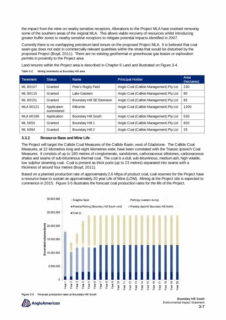
Based on a planned production rate of approximately 2.6 Mtpa of product coal, coal reserves for the Project have a resource base to sustain an approximately 20 year Life of Mine (LOM). Mining at the Project site is expected to commence in 2015. Figure 3-5 illustrates the forecast coal production rates for the life of the Project.
Figure 3-5 Forecast production rates at Boundary Hill South

Boundary Hill South Environmental Impact Statement
3-8
3.3.3 Mining Methods and Equipment
The current Boundary Hill pit is mined using open cut mining techniques. Overburden is removed by a walking dragline supported by a hydraulic excavator and truck pre-strip fleet. A hydraulic excavator is used to load coal into rear dump trucks for transport to the run-of-mine (ROM) stockpile located at the existing Boundary Hill pit. All coal is crushed and screened at the Boundary Hill Coal Handling Plant (CHP) area. The crushed coal is then conveyed to a screening and secondary crusher plant. Coal is sold as an unwashed product and therefore no tailings are generated.
This mining process will be adopted for the Project with minimal changes required to the current infrastructure that supports the existing mine. A hydraulic excavator will be used to load coal into rear dump trucks for transport to either the run-of-mine (ROM) stockpile located adjacent to the Boundary Hill South pit, or to the existing Boundary Hill ROM stockpile. It is expected that approximately one third of the coal mined will be stockpiled at the Boundary Hill South ROM for rehandle and transport to the existing Boundary Hill ROM. The remaining coal will be hauled directly to the existing Boundary Hill ROM stockpile for processing.
The proposed mining layout of the Project is illustrated on Figure 3-6.
The current Callide Mine equipment fleet is presented in Table 3-3.
Table 3-3 Callide Mine equipment fleet
Unit Type Capacity Quantity
Draglines Marion 8750 - 94 m3 1
BE 1350 - 35 m3 1
Loading Hitachi EX5600 Hydraulic Excavator 34 m3 1
Hitachi EX5500 Hydraulic Excavator 30 m3 1
Hitachi EX5500 Hydraulic Excavator 30 m3 1
Hitachi EX3600 Hydraulic Excavator 22 m3 1
Hitachi EX3600 Hydraulic Excavator 22 m3 1
Hitachi EX2500 Hydraulic Excavator 15 m3 1
Hitachi EX1200 Hydraulic Excavator 6 m3 1
Komatsu WA1200 Front End Loader 25 m3 1
Cat 992 Front End Loader 11 m3 1
Cat 992 Front End Loader 11 m3 1
Cat 994 Front End Loader 18 m3 1
Trucks Cat 789 (A, B, C) Rear Tipper 180 t 16
Cat 785 Rear Tipper 135 t 1
Cat 784B Belly Dumper 220 t 4
EH4500 Rear Tipper 280 t 16
EH4000 Rear Tipper 220 t 1
Bulldozers Cat D11R Track - 11
Cat D10 Track - 5
Tiger Rubber Tyred - 1
WD900 Rubber Tyred - 1
Drills BE 49R - - 1
BE 39R - - 1
Drilltec DK40 - - 2
Water carts
5
Graders 5

!
!
!!!
!
") ")
Southwestern Drain
ROMDam
Southern Sediment Dam 2
Southern Sediment Dam 3Pit
MLA 80186MLA 80186
Argoon Kilburnie Rd
Argoon Kilburnie Rd
¹0 500 1,000250
Metres
AECOM does not warrant the accuracy or completeness of information displayed in thismap and any person using it does so at their own risk. AECOM shall bear no responsibilityor liability for any errors, faults, defects, or omissions in the information.
PROJECT IDLAST MODIFIEDFILE NAME
60238883CFS 11-Oct-201360238883_ENV_007_powerPoint
Cadastre - © 2010 The State of Queensland.Image supplied by Callide Mine (date unknown).StreetPro © 2010 Pitney Bowes Software Pty Ltd.Roads, Rivers - © 2010 PSMA Australia Pty Ltd.Proposed Disturbed Land - Callide Mine 2011.
BOUNDARY HILL SOUTH EIS
Proposed Mining Layout
Figure 3-6
1:25,000 (when printed at A3)Scale:
Legend
") Coal Handling Plant
! ROM Dam
! Southern Sediment Dam
!Sump (progressive placementover life of mine)
Southern Extension Levee
Inverness Road Realignment(Indicative)
Drain
Highway
Local Road
Coal Haul Road
Mine Leases
Project Site(MLA 80186)
Mine Water Storage (progressiveplacement over life of mine)

Boundary Hill South Environmental Impact Statement
3-10
3.3.4 Mine Sequencing
Mining at the Boundary Hill South pit will commence following reduction in operations at the existing Boundary Hill pit. The proposed plan of operations is described in the following section.
Mining operations at Callide Mine are conducted in a staged approach from pre-strip to rehabilitation. Figure 3-7 illustrates a typical cross section of the mine operations showing the removal of overburden through to the extraction of coal. The pit will be progressively backfilled and rehabilitated as illustrated in Figure 3-8. Rehabilitation techniques are discussed in more detail in Chapter 4 Rehabilitation and Decommissioning.
During the first year of mining at Boundary Hill South, pre-strip operations are to occur in a staged approach similar to the current practice at Callide Mine. The initial box cut will have an overburden haulage ramp along the northern side of the pit. Dragline stripping will occur initially in the western third of the Project site, exposing the coal in strips.
Following completion of the initial box cut, a haulage ramp will be located at the southern side of the planned operation, which connects with an overburden dump haul road located along the southern boundary of the lease. Haulage also links to the main haul road heading north to the existing Boundary Hill pit. As the mine progresses, the in pit haulage ramp will be relocated to the northern side of the pit. Excess material from dragline stripping will be hauled north to the existing Boundary Hill pit void, with partings material being hauled to the western overburden dump.
Dragline stripping operations and subsequent mining of coal will progress in an easterly direction during the first three years of operation. Thereafter until approximately year 10 of the operation, stripping will alternate direction to the east and west. Beyond year 10, mining will continue east until cessation after an approximately 20 year mine life.
Volumes of excavated material considered for impact assessment modelling are detailed in Table 3-4. The modelled volumes are conservative, such that a production rate of up to 2.9 Mtpa of product coal has been considered for the purposes of assessment in this Environmental Impact Statement (EIS).
Table 3-4 Modelled volume estimates of excavated material during each year of the mine (bcm, bank cubic metre)
Year ROM Coal (t) Prestrip (backfill Boundary Hill North)
Prestrip/Parting (Boundary Hill
South void)
Partings (western dump)
Dragline Spoil
Tonnes bcm bcm bcm bcm
1 1,200,000 16,500,000 800,000 -
2 1,200,000 9,100,000 800,000 2,750,000
3 2,800,000 9,100,000 1,700,000 3,660,000
4 2,900,000 9,100,000 1,700,000 8,250,000
5 2,900,000 9,100,000 1,000,000 11,000,000
6 2,800,000 9,100,000 1,000,000 11,000,000
7 2,800,000 10,100,000 11,000,000
8 2,800,000 10,100,000 11,000,000
9 2,800,000 10,100,000 11,000,000
10 2,800,000 10,100,000 11,000,000
11 2,800,000 10,100,000 11,000,000
12 2,800,000 10,100,000 11,000,000
13 2,800,000 10,100,000 11,000,000
14 2,800,000 10,100,000 11,000,000
15 2,800,000 10,100,000 11,000,000
16 2,800,000 10,100,000 11,000,000
17 2,800,000 10,100,000 11,000,000
18 2,800,000 10,100,000 11,000,000

Boundary Hill South Environmental Impact Statement
3-11
Year ROM Coal (t) Prestrip (backfill Boundary Hill North)
Prestrip/Parting (Boundary Hill
South void)
Partings (western dump)
Dragline Spoil
Tonnes bcm bcm bcm bcm
19 2,800,000 10,100,000 11,000,000
20 2,800,000 10,100,000 11,000,000
Total 53,000,000 52,900,000 150,500,000 7,000,000 190,660,000
Figure 3-7 Typical open cut strip mining process
Figure 3-8 Typical open cut strip mine rehabilitation process
3.3.5 Workforce
Currently, Callide Mine directly employs approximately 500 permanent employees and 180 contractors. The operational workforce will not increase with the Boundary Hill South Project as employees will be remobilised from existing operations to commence construction and operation of the Project. The Callide Mine and nearby Callide Power Station are major employers within the region and contribute significantly to the local economy. A detailed profile of the workforce is provided in Chapter 14 Social Values.
During construction, use of approximately 25 contractors is expected for the realignment of Inverness Road and development of additional temporary mine infrastructure. Construction will occur over approximately six months during late 2014 and early 2015 (weather dependent).
It is assumed that approximately one-third of the total Callide Mine workforce will be employed at the Boundary Hill South Project. The operational workforce will average, across the life of the mine, approximately 180 permanent employees per year.
Employees, contractors and sub-contractors will be managed under the existing Safety, Health and Environment Management System (SHEMS) throughout the life of Callide Mine as required under the Coal Mining Safety and Health Act 1999.

Boundary Hill South Environmental Impact Statement
3-12
3.3.6 Workforce Accommodation
The majority of Callide Mine’s workforce lives in permanent accommodation in Biloela and surrounding districts. The existing Callide Mine does not contain any workers camps or villages. In consideration of workforce numbers during construction and operation, it is not expected that any new workers camps, villages, residential developments are required as part of the Project.
3.3.7 Processing and Products
Product coal from the Project will be directed to the CHP adjacent to the existing Boundary Hill pit. The coal will not be washed, but will be sized and screened and transported to a rail loop to the north-west of the pit. As the product is a raw thermal product, there is no beneficiation process. Consequently, there are no coal rejects or tailings associated with the mining activity.
The Callide Mine operates solely as an open cut operation, supplying low sulphur, sub-bituminous thermal coal. Whilst the majority of coal from Callide Mine is currently used for power generation in Queensland, production from the Boundary Hill operation is also required to directly support the alumina refining industry in Gladstone. Periodically, some opportunity also exists for coal to be exported to the international market.
Coal mined at Boundary Hill typically has moisture content between 14 and 22 percent, an ash content between 13 and 27 percent and a specific energy of 18 to 20 megajoules per kilogram. The target energy content of the ROM product coal at Boundary Hill South pit is 18.5 megajoules per kilogram.
The expected average annual quantities of product coal that would be produced by the Project are provided in Table 3-4.
3.3.8 Ongoing Evaluation and Exploration Activities
Exploration and evaluation activities are ongoing at Callide Mine and will continue to further define the availability of resources within the current EPC 188. Exploration activities involve conventional techniques such as drilling, sampling and seismic surveys. Evaluation and exploration activities at Callide Mine are conducted in accordance with the Code of Environmental Compliance for Exploration and Mineral Development Permits (DEHP, 2001) and other relevant industry standards.
A number of areas are currently being investigated at Callide Mine for potential future mining operations. Current prospective mining areas at Callide Mine include:
- Pete’s Rugby Field Prospect;
- The Heather Prospect;
- Amy’s Find Prospect;
- Rosendale Prospect;
- Callide Central; and
- Dingo Gully Prospect.
The extent of current exploration activities includes drilling, coal sampling and geological logging. This data provides information required to determine the viability of coal resources and allows for detailed mine planning for future operations.
3.4 Product Handling The Project proposes to use the existing infrastructure at Callide Mine. In addition to the existing infrastructure, the Project involves construction of an additional ROM stockpile area at Boundary Hill South. Coal will be hauled from the Boundary Hill South pit to either the Boundary Hill South ROM or directly to the existing Boundary Hill ROM area.
All coal will be crushed and screened at the Boundary Hill CHP area. The crushed coal will then be conveyed to a screening and secondary crusher plant. Coal will be further sized and screened at the CHP in preparation for transport. The product coal will be loaded at the rail loading facilities adjacent to the existing Boundary Hill pit, where it will be railed either directly to domestic customers in Gladstone or to the RG Tanna Coal Terminal for export to international customers.
Coal handling infrastructure is illustrated on Figure 3-6.

Boundary Hill South Environmental Impact Statement
3-13
3.5 Infrastructure Requirements
The significant mine infrastructure in the Project area includes an existing coal crushing system and a proposed haul route that runs from the Boundary Hill South ROM to the existing Boundary Hill ROM. Various haul roads will be located throughout the area, as well as a 275 kV power transmission line that forms the eastern boundary of the Project site. Where possible, existing transport, energy, water and associated infrastructure will be utilised for Boundary Hill South operations. This section details existing and future infrastructure required as part of the Project.
3.5.1 Transport
Existing transport infrastructure at Callide Mine will be utilised for the Project, where possible. In addition to the existing infrastructure, the Project includes construction of a number of haul roads to facilitate product handling and overburden haulage, and associated link roads and ramps to provide access and egress at the Boundary Hill South pit. Haul roads developed as part of the Project will also link in with the existing road network at Callide Mine.
The Project will involve realignment of Inverness Road. Inverness Road currently transects the Project area and will be realigned as part of the Project. The realigned road will be approximately five kilometres long and eight metres wide. Details of this aspect of the Project are discussed in Chapter 7 Transport. The realignment of Inverness Road is outside of the Project MLA and is therefore subject to local council development approval. The realignment is currently approved as part of an Operational Works Permit under the Sustainable Planning Act 2009.
Outside of the Project area there are also a number of important transportation networks. These include public roads, such as state-controlled and council-controlled roads, freight rail lines and stock routes. The Banana Shire Planning Scheme identifies stock routes throughout the region. The Planning Scheme does not identify any active stock routes in the vicinity of the Project. The Burnett Highway and Argoon-Kilburnie Road are identified as inactive stock routes under the Planning Scheme.
The Project will be accessed from Argoon-Kilburnie Road along the existing Boundary Hill Mine Road. Access from Southern operations at Callide Mine via the Link Road will also remain in place for operational vehicles. The existing Callide Mine plant and equipment fleet will be utilised during construction and operation of the Project. It is expected that additional contractors (approximately 25) will be required at various stages throughout construction. Therefore, a minor and temporary increase in traffic volumes is anticipated during the construction of the Project.
Details of traffic and transport impacts associated with the Project are provided in Chapter 7 Transport.
3.5.2 Energy
Energy requirements are anticipated to remain relatively unchanged from current consumption at the Callide Mine. Average electricity consumption at the Callide Mine ranges from 60 to 65 gigawatt hours per year. With the exception of the electric draglines, all machinery at Boundary Hill South will be powered by diesel fuel. Current diesel consumption at Callide Mine averages approximately 32 megalitres per year and this is not expected to change substantially upon commencement of the Project as the existing fleet will be utilised at Boundary Hill South.
Energy consumption and conservation measures at the Project are discussed in Chapter 10 Air quality.
3.5.3 Water Supply and Storage
Mine water is sourced from current onsite water storages. As product coal from Callide Mine is sold as an unwashed product, water demands at the mine are relatively low. Water demand at Callide Mine is anticipated to remain unchanged upon commissioning and operation of the Project. Major demands for water include dust suppression, however this water will be sourced from Lake Gasteen and excess water supplies within open cut pits.
Potable water is sourced from the Council water supply. Demand for potable water is likely to remain unchanged given that workforce numbers will not change as a result of the Project. Existing water management infrastructure at Boundary Hill will be used throughout the life of the Project, with some minor changes to piping networks for water supply for dust suppression.
Mine water management and surface water values are described in more detail in Chapter 9A Surface Water.

Boundary Hill South Environmental Impact Statement
3-14
3.5.4 Stormwater Drainage
The Boundary Hill mining area is located in the Callide Creek Valley. The southern and central portions of the Boundary Hill mining area drain westward via Campbell (Gate) Creek to Callide Creek, whereas the northern portion of Boundary Hill drains five kilometres northward to Bell Creek and subsequently to Callide Creek. Callide Creek discharges into the Dawson River and subsequently to the Fitzroy River where it continues until the convergence with the South Pacific Ocean near Rockhampton.
The quantity of discharge from onsite storages will be optimised through the implementation and continuous refinement of a site Water Management Plan (WMP). The Project site drainage will be constructed to maximise preservation of the clean water catchment area and minimise the area of the mine affected catchment for collection and containment. In addition, re-use of collected water will be employed in dust suppression and processing of the resource. Current sampling at the existing mine site water storages indicates a potential for re-use of stored site water for irrigation and stock consumption.
The development of the mine site water management system will be staged throughout the construction and operational phases. The main elements of the system are:
- a clean water diversion levee immediately to the east of the pit to direct runoff around the operation, to be incorporated with Inverness Road realignment, where possible;
- sediment dams to prevent discharge of mine affected runoff from spoil heaps and product stockpiles to creeks;
- pit sumps that collect pit water and allow it to be pumped to the mine water storage circuit;
- pit dewatering pumps to allow the open cut pit to be dewatered and piped to the mine water storage circuit;
- water fill points linked to Lake Gasteen to allow mine water to be used for dust suppression; and
- a system of minor diversion drains to ensure separation of runoff from undisturbed and disturbed catchments, typically:
in front of the progression of the pit to prevent accumulation of runoff from undisturbed areas between water diversion infrastructure and the pit; and
at the base of the spoil heaps to prevent discharge of mine affected water to the environment.
The site water management system would be designed in accordance with relevant standards and guidelines. Detailed design of site water management controls will be completed prior to the Project’s construction.
The proposed mine water management infrastructure at Boundary Hill South is illustrated on Figure 3-9.
3.5.5 Sewerage
Existing sewerage infrastructure at Boundary Hill will be used during Boundary Hill South operations. These facilities are expected to remain unchanged for the duration of the Project. Where required, additional mobile crib huts will be located at Boundary Hill South during construction of the Project which will contain holding tanks for waste. Sewage from these facilities will be removed regularly and transported to the central sewerage treatment plant for disposal as per existing waste disposal arrangements.
3.5.6 Telecommunications
Existing telecommunications infrastructure will continue to be used throughout the life of the Boundary Hill South pit. Communications across Callide Mine are predominantly via wireless technology, including mobile phones, UHF/VHF radio and local area network. Given the scale of the Project, telecommunications infrastructure is unlikely to be impacted by construction and operation of the Boundary Hill South pit.
3.5.7 Accommodation and Infrastructure
The existing workforce at Callide Mine will be remobilised from existing operations to commence construction and operation of the Project. As such, no additional demand for housing is expected during the life of the mine. Callide Mine does not currently have any accommodation camps and it is not expected that any new camps, townships, residential developments, technical workshops or laboratories are required as part of the Project.
Existing mine infrastructure for fuel storage, hardstand areas and maintenance areas located at Boundary Hill will continue to operate, where possible.

!
!
!!!
!
No Elevation Data
MLA 80186
CAMPBELL (GATE) CREEK
CAMPBELL (GATE) C
REEK
CAMPBELL (GATE) C
REEK
SouthernDrainage Line
EXISTING CALLIDE MINEWATER STORAGES
Transfer Pipe
Pit
ROMDam
Southern Sediment Dam 2
Southwestern Drain
a
a
a
a
a
a
a
a
a
a
a
a
Southern Sediment Dam 3
South WesternDrainage Line
NorthernDrainage Line
North EasternDrainage Line
EasternDrainage Line
L a k eG a s t e e n
SouthernExtension Levee
Eastern Road Diversion / Levee
ML5655
ML80115
ML80151
Argoon Kilburnie Rd
¹0 500 1,000250
Metres
AECOM does not warrant the accuracy or completeness of information displayed in thismap and any person using it does so at their own risk. AECOM shall bear no responsibilityor liability for any errors, faults, defects, or omissions in the information.
PROJECT IDLAST MODIFIEDFILE NAME
60238883CFS 23-Jan-201460238883_ENV_110v13
StreetPro © 2010 Pitney Bowes Software Pty Ltd.Roads, Rivers - © 2010 PSMA Australia Pty Ltd.Mine Data - Department of Natural resources and Mines, 2012Lidar- Callide Mine 2012Infrastructure - AECOM 2013
BOUNDARY HILL SOUTH EIS
Mine Water Management
Infrastructure
Figure 3-9
1:20,000 (when printed at A3)Scale:
Legend
Watercourse
! ROM Dam
! Southern Sediment Dam
! Sump
a Flow Direction
Eastern Road Diversion / Levee
Southern Extension Levee
Highway
Local Road
Railway Line
Inverness Road Realignment(Indicative)
Mine Water Storage
Property Boundary
Project Site(MLA 80186)
Final Pit and Dump Extent
Mine Lease

Boundary Hill South Environmental Impact Statement
3-16
3.6 Waste Management
The Project is intended to extend the life of the current mining operations at Boundary Hill without significantly increasing waste output. As such, minimal changes to the types and quantities of wastes produced from mining operations are anticipated. The main waste streams expected from the Project include green waste and topsoil cleared to develop the Boundary Hill South pit, and the ongoing excavated rock waste during the mine operation. An illustration of the wastes likely to be generated throughout each of the phases of the Project is presented on Figure 3-10.
Construction
Development of new pit
Haul road Operation
New overburden waste dump Mining operations
Realignment of Inverness Road Blasting Decommissioning
Contaminated topsoil Transportation Pit rehabilitation
Concrete, steel and timber Site office Building and infrastructure removal
Waste packaging Excavated rock and coarse rejects Road rehabilitation
General wastes Waste packaging and explosives Services removal
Waste oil, filters, oily water, grease Excavated rock
Wastewater / sewage Inert demolition wastes
Metal including wire
Concrete, steel and timber
Figure 3-10 Waste streams throughout the life of the Project
An inventory of all wastes to be generated by the Project during the construction, operational and decommissioning phases is presented in Chapter 8 Waste. The waste streams and quantities estimated for the Project are based on current waste generation at existing Callide Mine operations.
The Project area will incorporate a mine waste dump (western dump) which will be located immediately to the west of the new pit. As mining progresses, the western dump will comprise both partings and dragline spoil. The overall profile of the western dump and progressive rehabilitation of the exposed western face is described further in Chapter 4 Rehabilitation and Decommissioning. The western dump has been designed to meet Anglo American Metallurgical Coal’s geotechnical stability acceptability criterion and has a safety factor above the minimum target of 1.2.
The proposed final landform, including the western dump, is illustrated on Figure 3-11 and the current landforms within the Project area are illustrated on Figure 3-12.
Potential impacts associated with the geotechnical stability, sedimentation and erosion of the western dump, and the measures to manage these impacts, are detailed in various sections of the EIS. The likely performance of the western dump with regard to dump stability is discussed in Appendix V and summarised below. Surface drainage from the western dump will be managed through the development of the water management infrastructure as described in Chapter 9A Surface Water. The erosion potential of soils within the Project area, including material in the western dump is described in Chapter 6 Land.
A slope stability assessment (Anglo American, 2014) has been conducted for the western dump to be developed for the Project. The assessment considers the overall slope angle to be acceptable, while acknowledging that the ground conditions in the area can become soft and boggy in the wet season. The risk of personnel injury and equipment damage is considered to be low, provided that Callide Mine’s safety procedures are followed at all times (Anglo American, 2014). The full slope stability analysis is presented in Appendix V.
The erosion potential of the western dump is not considered significant. Of the four soil types to be disturbed by dragline operations, only one soil is considered to have a significant risk of erosion when disturbed. It is anticipated that the potential for soil erosion and subsequent on and off-site impacts to occur due to the Project can be mitigated through implementation of appropriate erosion control measures and stockpiling techniques.

Boundary Hill South Environmental Impact Statement
3-17
Surface runoff from the western dump will be captured by drains and sediment basins established on south-western side of the dump. The drains will divert the spoil runoff into one of two sediment dams also located on the south-western side of the dump. Water quality will be monitored in accordance with the site WMP to ensure that key water quality parameters remain within appropriate criteria.
Descriptions of each of the anticipated waste streams produced during the Project are described in the following sections.
Figure 3-11 Waste rock dump and pit profile proposed for the Project
3.6.1 Air Emissions
An assessment of air emissions generated by the Project has been undertaken as part of the air quality study for the EIS. During construction, it is anticipated that there will be limited emission sources with the potential for adverse impacts to workers and surrounding communities. A number of mining activities have been identified as potential sources of dust during the operation of the Project. These emission sources include:
- excavating overburden by dragline;
- loading trucks with overburden and dumping on overburden stockpiles;
- trucks hauling coal to and returning from ROM stockpile; and
- drilling and blasting activities.
Additionally, the operation of motorised vehicles and equipment during construction and operation will result in the release of exhaust gases containing nitrous oxides, particulate matter, volatile organic compounds and carbon monoxide. These pollutants may have both environmental and human health consequences. The quantities emitted will depend on factors such as engine type, service history, patterns of use and composition of fuel.
For a more detailed description of air quality impacts and proposed mitigations, refer to Chapter 10 Air Quality.

MLA 80186
ML6994
ML5655
ML80115
ML80107
ML80151
Argoon KilburnieRd
Dawso
nHwy
340
185
365360
190
195
200
350
280
275
375
370
365
360
355
365360
355350
345340
335330325320315
310
305
290
315
335
300
295290
285
280
275
270
265
255
250
390385
380370365
180
400395390
385
380
200 355
420410405
400395
270
275
295
290
285
280
275
270
265
260
320
325
330
340
345
320
280
285
295 300
305
310
200
210215
220
225
365
385
380
375
360
180185
190195
205
375
370
365
210215
435
415
395
390
385
375
225
230
235
245
305
300295
290
285
445
430
425
225
230
240
200
205
210
215
405
400
395
260255250245
475470465460
455
440
215220
375
375
370365
450435
345
210
215
240
200
22519
0
195
200
225
235
215
230
320
285
270
210
37022
0245 250
300
265
260
255 250
225
230
22522
0
31030
5
150
155
370
365
210205
325320
210
255
160
165
310
305
170
175
180
185
195
200
260
240
200
220
390
300
220
380
240
310
260
250
225
315
245
250
180 185
190
¹0 500 1,000250
Metres
AECOM does not warrant the accuracy or completeness of information displayed in thismap and any person using it does so at their own risk. AECOM shall bear no responsibilityor liability for any errors, faults, defects, or omissions in the information.
PROJECT IDLAST MODIFIEDFILE NAME
60238883CFS 11-Oct-201360238883_ENV_185
Image supplied by Callide Mine (date unknown).StreetPro © 2010 Pitney Bowes Software Pty Ltd.Roads, Rivers - © 2010 PSMA Australia Pty Ltd.Mine Data - Department of Natural resources and Mines, 2012
BOUNDARY HILL SOUTH EIS
Current Landforms
Figure 3-12
Legend5m Contour Interval
Highway
Local Road
Railway Line
Property Boundary
Project Site(MLA 80186)
Mine Lease
Granted
1:25,000 (when printed at A3)Scale:

Boundary Hill South Environmental Impact Statement
3-19
3.6.2 Excavated Waste
The Project will produce mine waste during the development phase and all subsequent mining operations. Mine wastes include overburden (pre-strip and dragline) and interburden (partings). Pre-strip, overburden removal and interburden removal will employ the techniques described in Section 3.3.
The excavated rock volumes from the mining activities have been estimated for the Project. Over the life of the Project, approximately 400 million bcm of waste are expected to be excavated, with an average prime to product strip ratio of 8 bcm waste per tonne of coal. Estimates of the waste, along with the physical, chemical and geochemical characterisation are provided in Chapter 8 Waste.
Characterisation of the overburden material by Emmerton (2003) at the existing mine indicates that the material is slightly acidic (pH 4.5 to 6.5) and generally is non-acid forming. The remaining overburden and interburden material (coal seam sediments) are neutral to slightly acidic (pH 4.5 to 7) and also generally non-acid forming. Soils analysis indicates that the surface soils have good structural stability, reasonable carbon and moderate phosphorous and nitrogen levels for surface soil (Emmerton, 2003).
Detailed soil and mine waste characterisation, including their potential for acid drainage and potential quality of leachate, has been summarised from Emmerton (2003) in Chapter 6 Land. The suitability of this material for reuse during rehabilitation is detailed in Chapter 4 Rehabilitation and Decommissioning.
Proposed measures for managing mine wastes are described in Chapter 8 Waste. Measures include design of waste dumps to minimise the risk of erosion and instability.
3.6.3 Solid Waste Disposal
The Project will generate solid wastes throughout the construction, operation and decommissioning of the proposed Boundary Hill South pit. Solid wastes generated by the Project are expected to consist of:
- general municipal waste, such as food scraps, paper, cardboard, glass and aluminium;
- green waste, including vegetation; and
- regulated waste, such as batteries, tyres and contaminated material.
As the Project is proposed as an extension to existing operations at Callide Mine, volumes of solid waste are not anticipated to increase significantly once the Project commences. Solid waste generated during the construction of haul roads and associated infrastructure, and realignment of Inverness Road is anticipated to account for the majority of non-mining waste generated by the Project. A detailed description of the quantity and quality of solid wastes, and the proposed methods of their disposal are included in Chapter 8 Waste.
3.6.4 Liquid Waste
The Project is not anticipated to produce any additional wastewater above what is currently produced at Callide Mine operations. Liquid wastes generated by the Project will include small quantities of regulated wastes such as hydrocarbons, solvents and chemicals. These compounds are only used for vehicle maintenance and as such the quantities of liquid waste are expected to be very minor throughout the duration of the Project. For a more detailed description of liquid waste management, refer to Chapter 8 Waste.
The coal mined at the Project will not be washed as the product is supplied to Callide Mine customers as raw thermal coal. Consequently there will be no tailings associated with the mining activity. Mine water management is described in more detail in Chapter 9A Surface Water.
3.7 References
Boyd. (2011). Initial Development Plan, Boundary Hill South (Report Number 5106.8, December 2011). n.s: John T Boyd Company (Boyd), Prepared for Anglo American Metallurgical Coal.
DEHP. (2001). Code of environmental compliance for Exploration and Mineral Development Project. Brisbane: State of Queensland (Department of Environment and Heritage Protection).
Emmerton, B. (2003). Investigation of overburden, roof, interburden, and floor characteristics for the Kilburnie area, Callide Coalfields (1999 and 2003 Investigations). Gaynda: B.R.Emmerton Pty. Ltd.