BOUNDARIES OF THE SUISUN MARSH Exhibit 4 - BCDC · BOUNDARIES OF THE SUISUN MARSH Primary...
3
BOUNDARIES OF THE SUISUN MARSH Primary Management Area Secondary Management Area Water Related Industry Reserve Area Proposed Water Related Industry Reserve Area to be deleted 1 .5 0 1 MILE 1 .5 0 1 KILOMETER PREPARED BY: San Francisco Bay Conservation and Development Commission MAP DATUM USGS Quadrangle Maps, Sacramento and Santa Rosa, 1:125,000 Amended 2011 Exhibit 4 TO BE DELETED CORRECTION (Deletion)
Transcript of BOUNDARIES OF THE SUISUN MARSH Exhibit 4 - BCDC · BOUNDARIES OF THE SUISUN MARSH Primary...

BOUNDARIES OF THE SUISUN MARSHPrimary Management Area
Secondary Management Area
Water Related IndustryReserve Area
Proposed Water Related Industry Reserve Area to be deleted
1 .5 0 1 MILE
1 .5 0 1 KILOMETER
PREPARED BY: San Francisco BayConservation and Development Commission
MAP DATUMUSGS Quadrangle Maps, Sacramento and Santa Rosa,1:125,000
Amended 2011
Exhibit 4
TO BE DELETED
CORRECTION(Deletion)
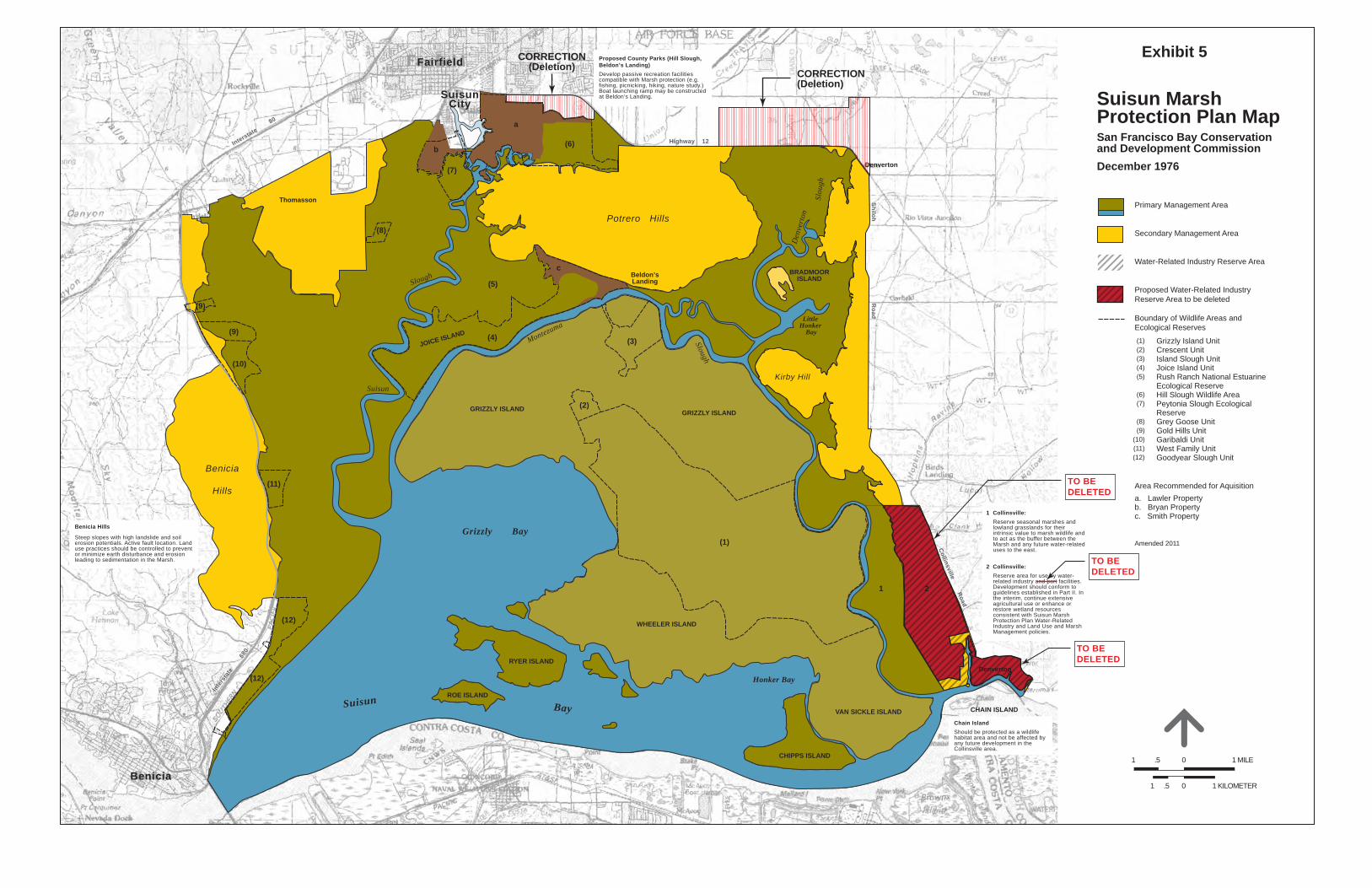
Suisun MarshProtection Plan MapSan Francisco Bay Conservationand Development CommissionDecember 1976
Primary Management Area
Secondary Management Area
Water-Related Industry Reserve Area
Proposed Water-Related Industry Reserve Area to be deleted
Boundary of Wildlife Areas andEcological Reserves Grizzly Island Unit Crescent Unit Island Slough Unit Joice Island Unit Rush Ranch National Estuarine Ecological Reserve Hill Slough Wildlife Area Peytonia Slough Ecological Reserve Grey Goose Unit Gold Hills Unit Garibaldi Unit West Family Unit Goodyear Slough Unit
Area Recommended for Aquisitiona. Lawler Propertyb. Bryan Propertyc. Smith Property
Amended 2011
1 .5 0 1 MILE
1 .5 0 1 KILOMETER
Exhibit 5
(1)(2)(3)(4)(5)
(6)(7)
(8)(9)
(10)(11)(12)
Denverton
Thomasson
Beldon’sLanding
BRADMOORISLAND
VAN SICKLE ISLAND
CHIPPS ISLAND
CHAIN ISLAND
WHEELER ISLAND
GRIZZLY ISLAND
JOICE ISLAND
(1)
(2)
(9)
(9)
GRIZZLY ISLAND
RYER ISLAND
ROE ISLAND
Potrero Hills
Grizzly Bay
Honker Bay
Little Honker
Bay
Suisun
Montezuma
Slough
Slough
Suisun Bay
Benicia
Hills
Kirby Hill
Fairfield
Benicia
SuisunCity
Benicia Hills
Steep slopes with high landslide and soil erosion potentials. Active fault location. Land use practices should be controlled to prevent or minimize earth disturbance and erosion leading to sedimentation in the Marsh.
Proposed County Parks (Hill Slough, Beldon’s Landing)Develop passive recreation facilities compatible with Marsh protection (e.g. fishing, picnicking, hiking, nature study.) Boat launching ramp may be constructed at Beldon’s Landing.
Highway 12
Shiloh
Collinsville Road
Road
1 Collinsville: Reserve seasonal marshes and lowland grasslands for their intrinsic value to marsh wildlife and to act as the buffer between the Marsh and any future water-related uses to the east.
2 Collinsville: Reserve area for use by water- related industry and port facilities. Development should conform to guidelines established in Part II. In the interim, continue extensive agricultural use or enhance or restore wetland resources consistent with Suisun Marsh Protection Plan Water-Related Industry and Land Use and Marsh Management policies.
TO BE DELETED
TO BE DELETED
TO BE DELETED
Chain IslandShould be protected as a wildlife habitat area and not be affected by any future development in the Collinsville area.
Interstate 8
0
1 2
Inte
rsta
te
68
0
Den
vert
on
Slou
gh
Denverton
(3)(4)
(5)
(6)
(7)
(8)
(10)
(11)
(12)
(12)
a
c
b
CORRECTION(Deletion)
CORRECTION(Deletion)

Exhibit 6
Corrected _________,2011
CORRECTION(Deletion)