Boulder City Council STUDY SESSION · PDF fileBoulder City Council STUDY SESSION Study Session...
100
Boulder City Council STUDY SESSION Study Session is Televised Tuesday March 31, 2015 5-6:30 PM Annual Sister City Dinner Municipal Lobby 6:30-8:30 PM Civic Area Park Site Plan & Master Plan Update 8-9 PM Update on Planning Includes BVCP, Resilience Strategy and Design Excellence and Form Based Code Pilot Council Chambers Municipal Building 1777 Broadway Submit Comments to City Council Email: [email protected] or Attention: Alisa Lewis, City Clerk PO Box 791, Boulder, CO 80306 Fax: 303-441-4478
Transcript of Boulder City Council STUDY SESSION · PDF fileBoulder City Council STUDY SESSION Study Session...

Boulder City Council STUDY SESSION Study Session is Televised
Tuesday
March 31, 2015
5-6:30 PM Annual Sister City Dinner
Municipal Lobby
6:30-8:30 PM Civic Area Park Site Plan & Master Plan Update
8-9 PM
Update on Planning Includes BVCP, Resilience Strategy and Design Excellence
and Form Based Code Pilot
Council Chambers Municipal Building
1777 Broadway
Submit Comments to City Council Email: [email protected]
or Attention: Alisa Lewis, City Clerk PO Box 791, Boulder, CO 80306
Fax: 303-441-4478

Study Session M E M O R A N D U M
TO: Members of Council FROM: Jane S. Brautigam, City Manager Maureen Rait, Executive Director of Public Works David Driskell, Executive Director of Community Sustainability & Planning
Jeff Dillon, Director of Parks and Recreation Bob Eichem, Chief Financial Officer David Farnan, Director of Boulder Library Mike Sweeney, Interim Director of Public Works for Transportation Molly Winter, Director of Downtown & University Hill Management Division & Parking Services Sam Assefa, Senior Urban Designer, Project Coordinator Jeff Haley, Project Coordinator Joanna Crean, Project Coordinator
DATE: March 31, 2015 SUBJECT: Study Session on Civic Area Park Site Plan & Master Plan Update
I. PURPOSE With the passage of the Community, Culture and Safety tax initiative in November 2014, the first phase of improvements in the Civic Area are moving forward. Building on the council-adopted vision plan and community feedback, a Civic Area Park Site Plan is being developed to implement the $8.7 million Phase I improvements and coordinate with the more than $5 million from the tax devoted to Boulder Creek Path, 11th Street lighting, public art and Arapahoe underpass improvements. In order to advance implementation items for the near-term and guide further work on longer-term investments, amendments to the adopted Civic Area Vision Plan are being developed with the intent of replacing the existing 1992 Boulder Civic Center Master Plan and serving as the updated Civic Area Master Plan. This study session is an opportunity to provide an update on the Civic Area implementation and collect feedback on:
1. Preferred option for a Park Site Plan that focuses on the Boulder Creek at the core, enhancing public spaces, and improving connectivity and access (Attachment A); and
1
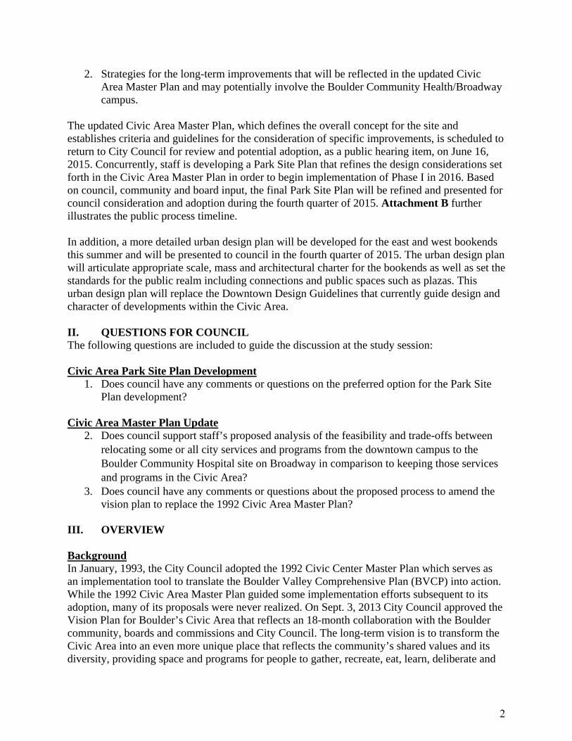
2. Strategies for the long-term improvements that will be reflected in the updated Civic Area Master Plan and may potentially involve the Boulder Community Health/Broadway campus.
The updated Civic Area Master Plan, which defines the overall concept for the site and establishes criteria and guidelines for the consideration of specific improvements, is scheduled to return to City Council for review and potential adoption, as a public hearing item, on June 16, 2015. Concurrently, staff is developing a Park Site Plan that refines the design considerations set forth in the Civic Area Master Plan in order to begin implementation of Phase I in 2016. Based on council, community and board input, the final Park Site Plan will be refined and presented for council consideration and adoption during the fourth quarter of 2015. Attachment B further illustrates the public process timeline. In addition, a more detailed urban design plan will be developed for the east and west bookends this summer and will be presented to council in the fourth quarter of 2015. The urban design plan will articulate appropriate scale, mass and architectural charter for the bookends as well as set the standards for the public realm including connections and public spaces such as plazas. This urban design plan will replace the Downtown Design Guidelines that currently guide design and character of developments within the Civic Area.
II. QUESTIONS FOR COUNCIL The following questions are included to guide the discussion at the study session: Civic Area Park Site Plan Development
1. Does council have any comments or questions on the preferred option for the Park Site Plan development?
Civic Area Master Plan Update
2. Does council support staff’s proposed analysis of the feasibility and trade-offs between relocating some or all city services and programs from the downtown campus to the Boulder Community Hospital site on Broadway in comparison to keeping those services and programs in the Civic Area?
3. Does council have any comments or questions about the proposed process to amend the vision plan to replace the 1992 Civic Area Master Plan?
III. OVERVIEW Background In January, 1993, the City Council adopted the 1992 Civic Center Master Plan which serves as an implementation tool to translate the Boulder Valley Comprehensive Plan (BVCP) into action. While the 1992 Civic Area Master Plan guided some implementation efforts subsequent to its adoption, many of its proposals were never realized. On Sept. 3, 2013 City Council approved the Vision Plan for Boulder’s Civic Area that reflects an 18-month collaboration with the Boulder community, boards and commissions and City Council. The long-term vision is to transform the Civic Area into an even more unique place that reflects the community’s shared values and its diversity, providing space and programs for people to gather, recreate, eat, learn, deliberate and
2

innovate. The vision plan established the goals, guiding principles and core themes for Civic Area implementation. Realizing Boulder’s aspirations for a new “civic heart” requires more detailed planning and additional public engagement. In order to advance implementation items for the near-term and guide further work on longer-term investments, amendments to the vision plan are being developed, with the intent of replacing the existing 1992 Boulder Civic Center Master Plan and serving as the updated Civic Area Master Plan. With the passage of the Community, Culture and Safety tax initiative in November 2014, a Civic Area Park Site Plan is being developed to implement the $8.7 million in phase I improvements and coordinate with the more than $5 million from the tax devoted to Boulder Creek Path, 11th Street lighting and Arapahoe underpass improvements. Both the Park Site Plan development and updated Civic Area Master Plan build on the public engagements held by the city and its consultant team (Tom Leader Studio, along with real estate and economic development consultant HR&A) in the fall of 2014. At those meetings, community feedback was collected about program preferences and park design themes. See the public feedback reports from the fall of 2014. The Park Site Plan development and updated Civic Area Master Plan will be advanced concurrently through June 2015. Final review of the Park Site Plan will occur after June 2015 due to the length of the site review process. A detailed urban design plan for the east and west bookends will be presented in the fourth quarter of 2015. Public Process The city hosted a stakeholder1 workshop and a public open house on March 9 and 10, respectively. The city also hosted a joint boards and commissions workshop on March 11, 2015. The purpose was to collect feedback on draft Park Site Plan options and long-term improvement strategies related to the Master Plan update. Attachment C provides a more detailed summary of the comments as well as the verbatim comments from each meeting. Below is a brief summary of the consistent themes: Park Development Participants expressed overall support for the plans and believe that the designs will begin to transform the area into a more actively used and engaging public space. Many agree the physical site development must be complemented by intentional programs and activation strategies to invite users with a range of dynamic activities supported by attractive public spaces. Community members offered that certain existing uses should be reconsidered and improved such as the current alignment of the Boulder Creek Path and the location of the bandshell to achieve desired outcomes. Additionally, strong emphasis was placed on the Farmers’ Market and opportunities for expansion into the park.
1 Stakeholders, for the purpose of this workshop, included on-site property owners and tenants, organizations with a clear interest in the project, and participants from previous Civic Area focus groups.
3

East Bookend The general preference is for a mix of uses in the 1300 Block, not for single predominant use such as a large municipal facility or performing arts center. However, many expressed desire for small performance or events space that will activate the area. Additionally, smaller scale building forms are preferred to allow more permeability, sightlines and to bring light and air to the plazas and the outdoor Farmers’ Market. Finally, there are mixed views related to the existing Atrium building. Some felt it could be repurposed, while others felt it would be better to redevelop the site to accommodate a richer mix of uses. West Bookend Outreach indicated that the west end needs more activation and mix of uses ranging from senior services to performance spaces and enhanced connection to park areas. While there is mixed support for new residential use, there is consistent support for parking structures to be located in this area to support the larger development of the Civic Area. Some expressed interest in expanding the Canyon theatre to increase performance space as small size venues to complement the existing library function. IV. CIVIC AREA PARK SITE PLAN DEVELOPMENT Guiding Questions for City Council
1. Does council have any comments or questions on the preferred option for the Park Site Plan development?
Background Based on the outcomes of the Civic Area Vision Plan process and the outreach completed in the fall of 2014, five key goals were developed for the near-term design and development of the park. Park development goals include:
UNIFY the creek core – creating more connected green spaces and public areas that encourage year-round activities both day and night;
Create Strategic CONNECTIONS – enhancing the link to Pearl Street Mall as well as the University of Colorado and University Hill to the south to encourage use of the park;
ACTIVATE existing edges – creating more access and visibility into the park from the adjacent land use across Canyon Boulevard and Arapahoe Avenue to activate the park and invite visitors;
Provide a VARIETY of experiences – the current site has many singular uses and the new park should accommodate flexibility for multiple uses to occur concurrently to engage park users; and
Reveal the site’s HISTORY – the park has a rich history dating back to the early 1900s including both physical and cultural aspects. The proposed design should celebrate this history through intentional design.
Preferred Option The initial park design process included three plan alternatives that illustrated multiple scenarios for improvements to achieve the park development goals. Feedback on the plan alternatives was collected from stakeholders, boards and commissions, community members and staff. The three initial alternative plans are summarized below and illustrated in Attachment D:
4

Creek Valley – largest amount of contiguous green space with dynamic topography that
allows for the most flexibility of park rooms as well as large gatherings. The Creek Path is moved to the north of the site and the bandshell has been relocated off-site to another location in the community to be determined.
Creek Grove – provides for the most generous plaza spaces north of the creek and a core green lawn at the center to accommodate gatherings. The Creek Path is realigned to the north and this option leaves the bandshell in its existing location within Central Park.
Creek Promenade – this option illustrates the site similar to its existing configuration with a large, flat lawn north of the creek and a formal plaza between the library and Municipal Building. This alternative relocates the bandshell to the south portion of Central Park on the west side of Broadway.
Based on the feedback received and guidance from the vision plan, a preferred option was developed that incorporates the successful elements of each of the alternatives. Several consistent elements of the three plans include a promenade along Canyon, 11th Street “spine,” creek terraces, nature play, improved creek path, plaza spaces and an expanded Farmers’ Market area. The following represent the primary components of the “new” preferred option that will allow the development of vibrant spaces that accommodate a range of activities and uses within the park:
Promenade – a continuous promenade along Canyon and repeated along Arapahoe as feasible for access, arts and events, inviting visitors to the Civic Area and creating a strong edge for the park.
11th Street Spine – continuous paved access corridor aligning the north and south areas of the park to connect Pearl Street through the Civic Area and south to University Hill that features a signature bridge across the creek as well as distinct gateways located at both Canyon and Arapahoe entrances.
5

Environmental Play Areas – nature play and interactive physical play spaces primarily south of the creek and incorporated throughout the park for innovative activation and to create a destination for families.
Creek Lawn – a large contiguous lawn with dynamic topography and necessary infrastructure to accommodate large formal gatherings and special events as well as less formal daily uses and activities.
Access / Circulation – relocation and management of select parking spaces to create improved connectivity and access into the park.
Creek Terrace – enhanced access opportunities with walls and plaza areas along the creek both east and west of Broadway that invite visitors to experience the creek.
Plaza / Café Space – distinct plaza areas adjacent to the Library and Municipal building
that feature urban design elements to support a range of activities and flexible uses. Performance Hill / Art Plazas – large mounds and hills to accommodate outdoor
performance and adjacent plaza spaces to feature interactive art displays. Bandshell – option to relocate bandshell off-site or within Civic Area. Restroom / Park Support – development of attractive structures for restrooms and
storage areas for event and programming support of the enhanced park. Expanded Farmers’ Market – development of picnic areas and gathering spaces within
Central Park to better accommodate the market and allow expansion into the park areas for stalls and tents on market days.
Park Furnishings, Lighting and Signage – distinct furnishings installed throughout the park as well as consistent signage and lighting to provide wayfinding, interpretive and recreation opportunities for park visitors.
Public Art – multiple opportunities throughout the park for display of interactive art. Sustainability Measures – the proposed design affords the latest best practices in low-
impact design (LID) and innovative opportunities for sustainability measures throughout the construction and ongoing management of the park that will be further illustrated in the final plan.
6

Throughout this spring and summer, the Park Site Plan will also be informed by detailed site analysis work and various concurrent technical studies, including the Canyon Boulevard Complete Street that began in 2014 and will continue through 2015. Several allied initiatives will also ensure the Civic Area continues its transformation through the following opportunities:
Nature Play – On June 10 and 11, 2015 the city will host a Nature Play Symposium and Workshop with Robin Moore and Louise Chawla. Robin is a world-renowned nature play educator from North Carolina State University. Louise is a professor emeritus at CU Boulder’s Environmental Design School, an internationally recognized expert on the importance of nature in child development, and lead advisor with Growing Up Boulder (GUB). Robin and Louise will share their expertise on the importance of nature play opportunities in the urban setting and provide design examples from other communities. This interactive workshop will inform the nature play design development, integrating nature play and learning with the new children’s library wing and other parts of the park design.
Activation & Programming – Several events and initiatives are scheduled for the upcoming spring and summer to continue activation of the Civic Area as illustrated in Attachment D.
Financing & Operation Costs – Phase I improvements to the Civic Area will be funded by the recently passed Community, Culture and Safety tax initiative. Ongoing operation and maintenance costs are not anticipated to increase significantly as a result of the Phase I improvements and will be evaluated throughout the design phase to understand any cost implications. As the initial park investment provides the catalyst for future development, additional funding sources will be explored, such as those identified in the vision plan, including philanthropy or endowments, state and federal grants, and crowd sourced funding opportunities. These sources vary in their revenue generation potential and may require specific governance structures. The Civic Area team will continue to explore both finance and governance strategies for future implementation phases. Public Safety – Recognizing that visitor safety is a critical component for the successful transformation of the Civic Area, staff are working closely with multiple departments including Human Services and Police to review the site plans as well as understand strategies and enforcement to complement the site transformation. The goal is to not only develop attractive and functional spaces, but integrate programs and strategies to maintain safety and comfort for the park users.
V. CIVIC AREA MASTER PLAN UPDATE Municipal Services Guiding Questions for City Council
4. Does council support staff’s proposed analysis of the feasibility and trade-offs between relocating some or all city services and programs from the downtown campus to the Boulder Community Hospital site on Broadway in comparison to keeping those services and programs in the Civic Area?
7

Background As highlighted in the vision plan, the first guiding principle is the “civic heart of boulder” meaning that the Civic Area will serve as the primary location for city management and government. The plan also identifies the opportunity to improve life and property safety by removing existing city buildings (New Britain and Park Central) from the High Hazard Flood Zone (HHZ). In addition, it also describes the opportunity for a new mixed-use community services center for public and private offices and city hall functions (suggested in 13th/14th Street block). At the request of council, staff has further evaluated the extent to which city services and programs currently located across the Boulder community, including those on the city’s Municipal Campus, could be a potential fit for the Boulder Community Health (BCH) facility on Broadway that may become available for re-use this year. Based on preliminary analysis, the Boulder County assessed value of the BCH site is approximately $48.6 million, including the site at 1100 Balsam Ave., connected medical pavilion at 1155 Alpine Ave. and structured parking at 2655 Broadway. Renovations are estimated to be approximately $91.7 million, including costs needed to comply with the city’s energy code, environmental remediation and address flood mitigation. In total, the preliminary cost to purchase and renovate the BCH facility (324,000 square feet) is approximately $140.3 million. To demolish the existing BCH facility and build a new structure (200,000 square feet) is estimated to cost $140.2 million. The cost to build new facilities, including a 200,000 square foot building that could be used for public use and city services as well as underground parking, in the Civic Area is approximately $100 million. This is based on the assumption that there is no cost to acquire property or demolish an existing facility. Details of the preliminary analysis, including funding mechanism, and a summary of the scope for further analysis are provided in Attachment F. Regardless of location, the purpose of new facilities is to address the space needs related to the removal of New Britain and Park Central buildings and the leases of space elsewhere that accommodates the ongoing shortfall. The space needs include customer service areas, public meeting and training rooms, support space, office/work rooms, and parking. Many city services exist within the Civic Area along with access to parking, including:
Building Permits City Administration City Clerk City Council Chambers & Office Community Planning Housing LEAD/ Energy Services Public Works/ Engineering Sales Tax & Licensing Senior Services Utility Billing
As part of the Civic Area public outreach in March 2015, participants were asked which city services should be located in the downtown core and which should be relocated. There was not a
8

clear preference for which services should stay or be relocated but there was approval for moving some city services. However, the conversation was also tempered with the concern that the “civic heart of boulder” should include the city government. Preliminary Recommendation Staff recommends that the city further analyze the feasibility and trade-offs between relocating some or all city services and programs from the downtown campus to the Boulder Community Hospital site on Broadway in comparison to keeping those services and programs in the Civic Area. The analysis will include monetary impact (both positive and negative) and timing as well as the opportunity to consolidate municipal services and programs and potentially sell city-owned property. Staff will be working to better understand the value of the BCH facility and potential renovation costs. Included in the future analysis would be the opportunity to increase public parking options in the area of downtown. The results of the additional analysis would be presented to City Council as part of the June 16 meeting on the Park Site Plan and Master Plan. Given the estimated cost of approximately $140 million for the BCH site and approximately $100 million to build on existing city-owned property in the Civic Area, neither option can be paid for from current operating revenues without significant reductions in expenditures for programs and services. However, the city could issue bonds through voter approval to cover a portion of the debt service with a new source of revenue. If council would like to have more information on this option, then staff would propose refining the estimates further and include that information in the April 14 study session when all potential ballot items will be discussed with council. Updating the Civic Area Master Plan Guiding Questions for City Council
5. Does council have any comments or questions about the proposed process to amend the vision plan to replace the 1992 Civic Area Master Plan?
The purpose of the master plan is to establish detailed policies, priorities, service standards, facility and system needs to guide future improvements in the Civic Area. The 1992 Civic Area Master Plan was developed to advance these goals and serve as the implementation tool for the Boulder Valley Comprehensive Plan. The 2013 vision plan established site performance goals, guiding principles and core themes for the Civic Area; however, it was not adopted as a master plan, a necessary implementation document that provides a common framework for planning the delivery and funding of city services, facilities and programs. Therefore, amending the vision plan and presenting it for adoption as the updated Civic Area Master Plan is needed. The updated plan will integrate technical and site analysis and public input, including amendments to enhance the goals, guiding principles and core themes as outlined on the following pages. In order to enhance and implement the adopted vision plan, the city will also be developing specific guidelines for future improvements for the west and east “bookends” of the Civic Area. At the March 2015 public outreach, preliminary concepts, which include four site development options for the east and three options for the west (Attachment G), were presented to get public feedback. Attachment C provides all of the verbatim comments from the outreach. A more detailed urban design plan will be developed this summer through a robust public process,
9

including the engagements of boards, commissions and council, and will be presented for council’s acceptance in the fourth quarter of 2015. The primary goal of the urban design plan is to serve as an implementation tool to provide clear design guidelines on urban form that address scale, mass, height and architectural character of buildings and the public realm (streets, plazas, connections, etc.). The urban design plan may be presented as a hybrid Form Based Code (FRC), depending on the outcome of the comments from the FRC pilot. Some of the program elements highlighted in the vision plan continue to be in progress in terms of analysis. These elements include the following:
Bandshell Performing Arts Center Civic Use Pad Market Hall Innovation Center Access & Parking West Senior Center
Below is a brief update on the status of these program elements. The options for these program elements will continue to be reflected in the updated Civic Area Master Plan. Bandshell One of the historic resources mentioned in the vision plan is the Glen Huntington Bandshell. The bandshell was built in 1938 and is a local historic landmark with architectural significance as an example of Art Deco in Boulder. Currently, the bandshell faces many challenges including worn appearance, uncomfortable seating, frequent transient occupation, and traffic noise and access challenges for performances. To improve its functionality and accommodate enhancements along Canyon Boulevard, the plan states that the bandshell may be relocated and that a new park pavilion such as a horticultural conservatory, or year-round market hall, could be located in its place. The plan also recommends that additional analysis be completed regarding site acoustics and the feasibility, cost and implications of moving the bandshell. This analysis has been completed and the results are that the bandshell has poor acoustics, limited programming opportunities, and the structure can be moved (in its entirety) to another location, preserving as much of the historic fabric of the structure as possible. The preliminary estimates for relocating the bandshell show a cost of approximately $305,000. Public input suggested relocating the bandshell to achieve the vision for Central Park improvements and provide the opportunity to place the bandshell where it could better serve its intended purpose. However, there are concerns about the precedent of the city relocating a landmarked structure, and the Landmarks Board recommends that all efforts should be made to design the future of this area to keep the bandshell in its current location. Performing Arts Center As stated in the vision plan, one of the program elements to explore is the opportunity to expand culture, arts or entertainment amenities that are otherwise lacking in the community. The active use of such a facility is important throughout the week in order to support the overall activation of the area. The plan presented two options: a mid-sized (800-1,200 seat) performing arts center
10

to be located on the East bookend between 13th and 15th streets on Canyon Boulevard. This project was proposed and would be financed and operated by the nonprofit group, The Boulder Center for the Performing Arts (BCPA). BCPA has not yet released a business plan indicating the feasibility of operating a performing arts center. Another option is to develop the north side of the main library located on the West bookend to accommodate a smaller performing arts facility (300-500 seats). This space would be flexible enough to allow for other uses. The proposed operation would be run under an as yet undefined public and private partnership. Early results of the City of Boulder’s Community Cultural Plan, as well as an outside consultant’s assessment completed in 2014 (contracted by BCPA) indicate a need for increased performance and rehearsal space in Boulder. The 2014 consultant’s assessment indicates the highest use would be for a performance space with less than 500 seats. BCPA has not yet released a business plan indicating the feasibility operating and sustaining a performing arts center. A study session involving the Draft Community Cultural Plan is scheduled for April 28, 2015. Civic Use Pad Related to the performance space assessment at the north wing of the library is the Civic Use Pad. Discussions are ongoing regarding the potential for a mixed-use building on the pad adjacent to the St. Julien Hotel, which could include a “civic use” space of approximately 8,000 square feet on the first floor along with hotel uses above. The civic use space is envisioned as a flexible space to be available at a discounted rate to community and non-profit groups for civic and cultural functions. The potential for a civic use on the St. Julien Hotel site was included in the 9th and Canyon Urban Renewal Plan revised in the 1990s and numerous proposals have been discussed over the years. In the last several years, the Civic Use Task Force has been working in partnership with the St. Julien Hotel to develop a mixed-use building that could include a roof top terrace in addition to the civic use space. City staff is working with the St. Julien on a memorandum of understanding to develop preliminary designs and operating agreements which will be brought to City Council later this year. Market Hall A new program element identified in the vision plan is a public market hall that may supplement (not replace) the outdoor seasonal market on 13th Street. This venue is envisioned to expand the Farmers’ Market function as an outdoor market, and possibly expand it as a year round (or extended season) activity. The Market Hall could serve as a vital component of the area, potentially including local and healthy food options (e.g., cottage foods, bakery, cheese/meat stalls, restaurants, etc.) as well as a demonstration kitchen to provide a site of community pride and economic benefit. Subject to further analysis and coordination with the Farmers’ Market, a public market hall could be part of a new vertically mixed-use structure or repurposed Atrium building. Continued exploration including financial feasibility, management, scale and type of desired year-round or extended market hall facility will occur. However, as part of the phase I park site improvements, a temporary structure to support the Farmers’ Market will be piloted. The results will further inform the function and programming of a permanent market hall.
11

Innovation Center A program element identified in the vision plan is to create a mixed-use community services/innovation and events center in one or several buildings on the 13th/14th Street block. This would be a space for public/private collaboration, gathering and celebration events. The Boulder Chamber is exploring an ‘Innovation HQ’ to spur collaboration across businesses, nonprofits, and local government. The Innovation HQ is aimed at strengthening Boulder’s stature as a global innovation leader by creating the physical environment that facilitates collaboration among Boulder’s business-support organizations and serves as a one-stop resource for Boulder’s startup and growing businesses. Its proximity or adjacency to the city’s municipal government service center, where community members, officials, and partners can meet, interact, and innovate is envisioned as a bridge to local business leadership for mutual understanding, collaboration and creative problem-solving on community issues. Parking & Access Strategies The goal as stated in the vision plan is to create a strong pedestrian environment in the Civic Area with “just enough” parking spaces provided for those who arrive by car. Parking demand will be managed to the greatest extent possible by providing facilities, services and a physical environment that supports and encourages multi-modal access as well as off-site parking. The ultimate number of parking spaces and locations will be determined based upon land uses determined in the future. Over time, the surface parking in the High Hazard Zone (HHZ) will be removed to improve life and safety and to open up more parkland. Removal of parking in future improvement phases will require replacement with parking structures on either or both the west and east end of the Civic Area, possibly in partnership with the downtown parking district. Options being considered as part of Phase I improvements propose potentially relocating approximately 30 to 60 spaces on the civic campus. Some of these spaces are currently metered and some are dedicated as city employee paid parking. Any parking removed in the short-term will be relocated or accounted for using transportation demand management (TDM) strategies. It is anticipated that planned operational changes at the library and increased programming of the Civic Area will result in an increase in person trips accessing the area, including parking. Building on earlier parking evaluations, the city and consultants are analyzing a set of parking management and TDM strategies that will mitigate the impacts to existing parking and proposed relocation in parking as well as accommodate the increase in-person trips. Prior to relocating parking spaces during Phase I improvements in the Civic Area, staff will pilot the parking management and TDM strategies to inform next steps to address the immediate and longer term Civic Area improvements. West Senior Center A key program element currently part of the Civic Area is the West Senior Center. The long-term location of the West Senior Center will continue to be evaluated as part of the Human Services Strategic Plans and Needs Assessment. It is anticipated that the Human Services Strategic Plans and Needs Assessment will be discussed with City Council later in 2015 and early 2016.
12

VI. NEXT STEPS Staff will incorporate City Council’s feedback from the March 31 discussion and revise the Park Site Plan and Civic Area Master Plan accordingly. The updated Civic Area Master Plan will be presented to the Planning Board as a public hearing item on May 21, 2015 for a recommendation. It is anticipated that the Civic Area Master Plan will then be presented to City Council as a public hearing item for review and consideration on June 16, 2015. During the fourth quarter of 2015, the Park Site Plan will be brought to the Parks and Recreation Advisory Board, Planning Board and City Council for review and consideration. For more information about Civic Area implementation, visit www.BoulderCivicArea.com. VII. ATTACHMENTS
A – Preferred Park Site Plan Option B – Boulder Civic Area Public Process Timeline C– Summary and Verbatim Feedback from Civic Area Public Outreach in March 2015 D – Initial Three Park Site Plan Options E – List of Spring & Summer 2015 Events in the Civic Area F – Possible Funding Mechanisms to Relocate City Services & Programs to Boulder Community Health Facility G – East and West Bookend Preliminary Development Options
13

CREEK VALLEY HYBRID- SITE PLAN
1
42
3 6
8
8 8
8
7
c
10 9 12
13
13
a
a
a
a
b
c
d
13
11
5
8
14
KEY CHARACTERISTICS:• Biggest continuous green space• Dynamic topography creates a diversity of spaces and experiences• Most access to the creek with the re-grading• Largest entrance promenade announces park along Canyon• Picnic Plaza along North Farmer’s Ditch• Enhanced circulation through Oak Market to 14th Street• Increased Plaza spaces west of the Municipal Building and east of the
North Library• Possible Relocated bandshell South of the North Boulder Farmer’s Ditch• Expanded shoulder of Central Park bike path to accomodate an Expanded
Farmer’s Market Loop
Limit of Near-Term Improvements
Complete Street ROW
Complete Street ROW
Canyon
Canyon
Arapahoe
Broadw
ay
9th
13th
14th
11thArapahoe
a
b
c
d
Promenade
Picnic Plaza
Possible Location for Relocated Bandshell
Expanded Farmer’s Market Park Loop
1
9
Creek Lawn
2 Cafe Terrace
Oak Grove
3
10
Performance Hill
Seasonal Farmer’s Market Structure
4
11
Creek Walk/Terrace
5 Cherry Tree Plaza
6 11th Street Spine
Peformance Area
7
8
11th Street Spine Bridge
Nature Play
12
13
14
Oak Market Plaza
Transit PlazaRestroom BuildingOpportunity
46 parking spaces relocated
19 parking spaces relocated
ATTACHMENT A:Preferred Park Site Plan OptionAttachment A - Preferred Park Site Plan Option
14
CREEK VALLEY HYBRID - MASTER PLAN
1
42
3
6
8
8 8
8
7
a
b
e f
9 12
13
15
17
20
21
21
21
19
19
16
13
a
a
13
11
5
8
14
18
18
Peformance Area
10
Seasonal Farmer’s Market Structure
Possible Location for Relocated BandshellExpanded Farmer’s Market Park Loop
c
d
a
b
c
d
e
f
Promenade
Picnic Plaza
Ecological PlaygroundPossible Existing Gas Station Relocation
1
9
Creek Lawn
2 Cafe Terrace
Oak Grove
3
10
Performance Hill
4
11
Creek Walk/Terrace
5 Cherry Tree Plaza
6 11th Street Spine
7
8
11th Street Spine Bridge
Nature Play
12
13
14
15
16
17
18
19
20
21
22
Oak Market Plaza
Transit Plaza
Restroom BuildingOpportunity
Great Lawn
Stage Terrace
Event Hill
Park Support Building
Wetland Garden
Pedestrian Bridge
Site for Below Grade Parking
Site for Above Grade Parking
Limit of Near-Term Improvements
Complete Street ROW
Complete Street ROW
Canyon
Canyon
Arapahoe
Broadway
9th
13th
14th
11thArapahoe
22
Attachment A - Preferred Park Site Plan Option
15

ATTACHMENT B: Boulder Civic Area Process TimelineAttachment B - Boulder Civic Area Public Process Timeline
16

ATTACHMENT :
Summary and Verbatim Feedback from Boulder Civic Area
The week of March 9th, the Boulder Civic Area team hosted three consecutive nights of public meetings. The purpose of these meetings was to allow the public, stakeholders, and board/commission members to:
Meet with consultants and city staff to learn about the status of the design process.Review design options for the initial development of the park using voter-approved capitalfunding;Review strategies and concepts for long-term improvements to the Civic Area; andLearn about upcoming events, partnership opportunities and programs to activate the CivicArea.
We asked several specific questions that allowed us to collect feedback in a meaningful way. The questions are as follows:
PARK SITE PLAN DEVELOPMENT
Three initial park design plan options were presented to get public feedback. Specific questions are listed below:
Programming / activation
Related to programming/ activation, which option provides the:
o Most favorable approach to address Bandshell?o Greatest variety of experiences daily and throughout the year?o Most active and well used park spaces?o Most functional for large events or gatherings?
Circulation & Access
Which option provides the: o Best physical and visual access to Boulder Creek?o Best bike and pedestrian connectivity and access?o Most appropriate accommodation of parking while enhancing park use?
Attachment C - Summary and Verbatim Feedback from BCA Public Outreach in March 2015
17

Long-Term Plan
o Should the plan for Central Park include a structure for a Park Conservatory?
Are there any areas of the plan alternatives that you feel have missed the mark or need further research and refinement?
East and West Bookend Development
Preliminary concepts which included four site development options for the east and three options for the west were presented to get public feedback. Specific questions are provided below:
East Bookend: Features & Characteristics
Which option provides for: o Most flexibility in accommodating multiple uses and a variety of experiences? o Activating the space day and night? o Preserving and celebrating the history of the civic area? o Creating connections and movement through the space?
o What do you see as the most appealing and least appealing about the options
presented?
Land Use: Municipal Services
While balancing the redevelopment of the Civic Area: o What services do you believe are critical to maintain within the downtown core of
the city? o What services should be relocated?
Land Use: Performance Space
Should the city explore partnerships to expand or redevelop the north wing of the main library to accommodate a 300-500 seat performing arts facility? What do you see as the key opportunities and constraints to further consider?
Attachment C - Summary and Verbatim Feedback from BCA Public Outreach in March 2015
18

West Bookend: Features & Characteristics
o Which option provides for: o Most flexibility in accommodating multiple uses and a variety of experiences? o Activating the space day and night? o Preserving and celebrating the history of the civic area? o Creating connections and movement through the space?
o What do you see as the most appealing and least appealing about the options presented?
Attachment C - Summary and Verbatim Feedback from BCA Public Outreach in March 2015
19

BOULDER CIVIC AREA STAKEHOLDER WORKSHOP March 9, 2015
Feedback from the stakeholder1 workshop was collected via group discussion being recorded on flip chart notes. The room was divided into two stations. The stakeholders were asked to self select between Park Site Development and Bookend Development.
Summary of consistent themes:
Concern about height and sight lines on East End Differing opinions about Bandshell
Noise levels Historic Landmark
Slight preference for E3 and E4 with more underground parking Support for keeping municipal services downtown with a mix of uses Do not support performing arts center taking over the whole block Preference for W3 Concern about seniors Support for moving the Bandshell Creek Valley
Preferred mix of uses Like the path configuration Sheltered from bikes
Creek Grove Feels fragmented Easy access along creek walk
Creek Promenade Differing opinions
Uncomfortable big open space Event spaces
Keep structures out of the park Concern about Broadway/Canyon
Need to create entry way Concern about circulation along Concern about commuters on bikes vs. strolling pedestrians
Need significant parking in bookends Make the bridges places to stop
1 Stakeholders, for the purpose of this workshop, included on-site property owners and tenants, organizations with a clear interest in the project, and participants from previous Civic Area focus groups.
Attachment C - Summary and Verbatim Feedback from BCA Public Outreach in March 2015
20

EAST AND WEST BOOKEND MASTER PLAN UPDATE EAST END (Asked what is most and least appealing)
Would 13th Street still be used as a road? Options—connects to downtown Bike/pedestrian only—shared street Congestion can be avoided with the North/South Streets
Use 14th as pedestrian parkway? Possible expansion for bus transit Will the buildings be 4-story buildings to accommodate parking? Concerned about height on Canyon in Option 3 & 4—blocking views University building conference center near hill—13th having no auto use 13th bookend park as pedestrian street Atrium:
scale, design, repurposed—excellent possibilities multiple uses support options
Band shell—doesn’t work because of the noise If 13th closed to autos—how would it affect the Tea House? Farmer’s market—attendance affected by sunshine
Could some proposed buildings block that out? Band shell—concern with noise level at farmer’s market Desire to place band shell offsite Sharing 13th—parking, traffic, ped, bike Option 4 great extension to Farmer’s Market
BMoCA gets to expand Underground parking
Option 3 great outdoor art space Option 4—liked plaza Parking vital (underground) more if necessary E4 needs underground parking
13th open parking attracts people
E3 for city offices for collaboration Lower mass—transitional area—mixed use
Site lines important Band shell—adds variety—trees around –more about history/community
Likes green promenade along Canyon E2, E3, E4—removing historical buildings
Mixture of mass by keeping older buildings Band shell—preserving/moving as historical landmark
Municipal Services Combine all services—people come to one place Sister City Plaza—how can we mark this so people know about it?
Relocate it? Why do services have to be downtown?
No prime space used for city offices
Attachment C - Summary and Verbatim Feedback from BCA Public Outreach in March 2015
21

Library, council chambers should stay Transportation access is important City offices on east end not in original vision plans Makes sense to have on site—central location Bring more people downtown—city offices draws people downtown Consolidated city offices is important—support consolidated in a location Many city buildings only used by city employees (FAM—Risk Mgmt)
Would consolidating make it more difficult for them? Civic area—event/cultural center—something to activate the space—not city offices 1300 block on Canyon—performance arts space—used all week long
Performance Space: It’s performing arts and events(gathering space)
Needs both uses Community space
Use space very efficiently Capital to build it—envisioned as this for years
Make it be funded by private philanthropy Option remains for performing arts site Make sure other options don’t cancel out this option
Option 1: larger building Option 2: the whole downtown area as a performance arts center
Another multifunctional hotel on Atrium site Concern that large Performing Arts (PA)center—Farmer’s Market could suffer
Concern Farmers’ Market needs met Ground level of PA center creates dead space
More area could consume Farmer’s Market PA applies to all—all on one site could create a conflict between events—activate every single day Events during the day/cultural events at night
Atrium should go CU conference/hotel—a hotel could be part of the use here in conjunction with CU Atrium:
Arch-pedigree, continuity Repurpose it used in conjunction with PA uses Creating more density not smart Atrium—leave pillars and create a dance floor/gathering space Funding not easy—caution against utopian dreams—use what’s here now
WEST END: Consider underground parking (Ex: cherry creek north)—multi-use parking Senior center was intended to be temporary
Option 3 is best PA center on west end
West Senior Center (WSC) doesn’t have to be on this site—but needs to be expanded with parking SW on option 2 & 3?
Grade of parking
Attachment C - Summary and Verbatim Feedback from BCA Public Outreach in March 2015
22
Not just for seniors—more integrated Makes sense to have it there
Option 3 will help reactivate/connect both ends WSC is site large enough for this vision?
Different options being looked at Could look at old hospital—the core used for social/cultural center
Why housing here? (reflects community feedback) Focus is people—homeless and transients? What are the plans?
Portion of funds go towards helping this? Activate space to help
Include seniors in plan—look at integration opportunities Seniors will use services on CA—parking important. Affordable housing for aging and disabled Structured parking will allow for WS Will be expanding library space—don’t assume performance space will be involved Arapaho parking—narrow street—concern for high capacity garage
shouldn’t be issue Climate change/resiliency/flood plain taken into consideration? NE with library—retain look of original library
9th and Canyon dead
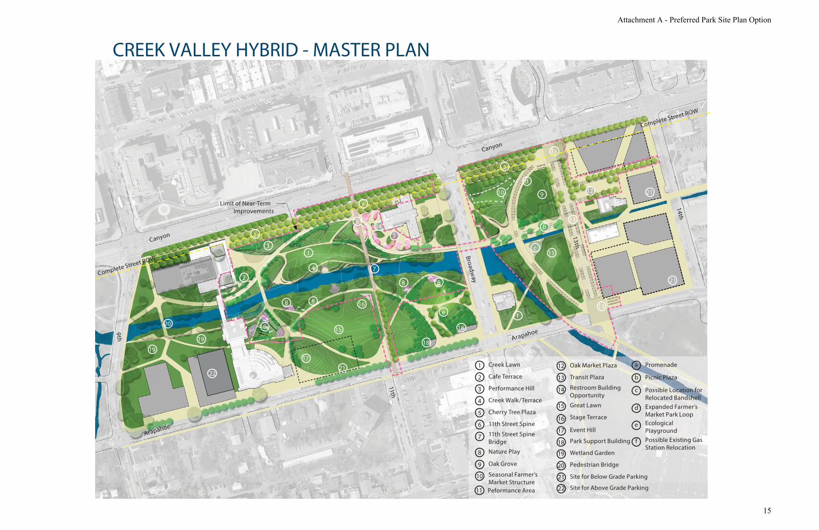
PARK SITE PLAN UPDATE Broadway is a barrier—is there any plan for a bridge or easier crossing? Narrow b-way even? Backside of the band shell is not attractive or engaging Conservatory along 13th would be better connected to Farmer’s Market than proposed location
Bandshell Construction in park with new building Re-orient band shell
Audience—13th street? Not space for picnics if facing 13th street
Creek Promenade: can’t hear around current location Acoustical analysis—long term—creek valley best place out of the way Competing space for band shell
(side Chuck Anderson—greenhouses—survived flooding) Band shell
Valley Relocate completely If not place in civic area—where? If don’t find space for it there, won’t find space for it elsewhere
Timeline of site versus master plan Site maybe even next year Master plan 10-20 years
Active Uses/Events Promenade—best for creek fest Daily user group—weekly basis
Attachment C - Summary and Verbatim Feedback from BCA Public Outreach in March 2015
23

Creek grove—fragmented? Loses openness Continuity Loses community coherency
Enjoy the promenade along canyon Creek promenade:
less comfortable with big open space Creek valley:
Saturday afternoon Has both
Topography: Don’t put them everywhere Places that make sense, maybe not all centralized Event layout Boulder Creek Fest superimposed
Are we thinking about slopes—sitting vs. more extreme What do we want to represent Boulder?
Nature environment vs. formal spaces Connection Farmers Market to Park
Might lose it with conservatory Green space along 13th Love conservatory idea—maybe not in the park
Keep the structures out of green space Repurpose atrium Not worried about overly programmed if it is beautiful, people will come Example: Highline Updating the peace garden
Creek Valley Diversity is great Dynamic and inviting space
Creek Promenade Combines everything? Don’t like it
Sister City Plaza Under-utilized right now—location Near term—stays Maybe increase way-finding/signage Long term—if there is a more functional place, maybe we can move it? Discussion of improving entrance to municipal building
Use is low Community interaction is low Make the space a destination
Creek Valley Like it
Path back from 13th 11th street connection is strong
conservatory—on the other side of the path seems like it might work better in Bookend
Attachment C - Summary and Verbatim Feedback from BCA Public Outreach in March 2015
24

Market Hall Don’t affect the Tea House business—whatever configuration Little nooks—acoustic studies?
Sound will travel more on Promenade (Dairy Center) concerned about sound bleed
Effects multiple use Permitting in the park
Circulation and Access Bike lanes on Broadway
How do we deal with Canyon & Broadway Broadway
Lose 1 side walk—divided roadway Safer for pedestrian crossing
Canyon—opportunity on South North is static Multi-way boulevard Creek Grove experience
Porosity across Broadway—lacking Underpass is great, but Better access/multimodal access
Circulation: Broadway—major arterial
Opportunities for more enhanced crossings? Gateway treatments?
Sense of Entry Arapahoe/Broadway specifically Canyon/Broadway
Don’t feel that we have addressed this adequately Broadway sits above everything in the park Bike access/Pedestrian access 11th and 13th to address this Enhanced multi-modal loop Broadway—noisy
Is it valuable to hear more about east/west alignment? Bike path is no longer safe for pedestrians—commuter pathway Away from creek—fast paced Slower people close to creek Leisurely walk through park
Grove/ Valley Like the grading Performance of spaces Creek Promenade—lest favorite band shell placement
BMoCA Access to creek
Any plans address this better than others? Creek grove: easy access along creek walk
Attachment C - Summary and Verbatim Feedback from BCA Public Outreach in March 2015
25

More direct for pedestrian access Looking for places—sheltered from bikes
Valley—may be good to be away from bike lane Material treatments throughout the park
Example—under Broadway Build the bridges as places not just crossing—people stop/take pictures Gilbert White Memorial flood Marker Creek Edge East of Broadway—edge treatment—creek access
Parking Removing parking—provides opportunity to improve access Need significant parking in Bookends—not in parks
Want it to be successful for people not cause complaining Enjoy the promenade—more important than parking Enhanced uses—will mean more people—multimodal, but still parking Valley—most preferable for short term Grove—most similar to what’s there
Really critical to allow pedestrian alignment/access into the park Streetscape along Arapahoe—11th-Arapahoe Consistent corridor—look all the way around Conservatory
Beacon in the park Integrated in
Some plans—more potential to interact with Farmers Market Right now-markets turn their back to the park Potential to do better Benches along ditch
Attachment C - Summary and Verbatim Feedback from BCA Public Outreach in March 2015
26

BOULDER CIVIC AREA PUBLIC OPEN HOUSE March 10, 2015
Themes from the Public Open House were collected in a variety of forms. The public was offered a comment card with all of the questions as they walked in the door. They also had the option to comment
on flipcharts set up around the room. The third way to provide comments was through sticky notes placed directly on the boards themselves.
Summary of consistent themes:
Preference for Market Hall/Conservatory, but not in the park – in bookends instead Combine several uses education/events/culinary/arts/innovation Open air gathering space
Many people liked the idea of a strong event space on the south side of the creek People showed a preference for the Creek Valley plan
More varied Like the re-grading of the site Best access to Creek Well used park spaces
Then the Creek Promenade Easy load/unload to Bandshell Liked the Bandshell arrangement Bike/Pedestrian Connectivity Large events
Then the Creek Grove Like the circulation Worried bikers will take shortcuts
Slight preference for E1 Historic buildings
Differing opinions about closing 13th street Preference for underground parking in the East end Concern about flooding in the area Differing opinions about appropriateness of housing in the West end Differing opinions about Municipal services
All should be removed Floodway
vs. all should stay Take advantage of city transportation
Comments for a smaller venue with the performance space Strong positive comments about promenade along Canyon
Attachment C - Summary and Verbatim Feedback from BCA Public Outreach in March 2015
27

Comment Cards. 20 responses received
Park development 1) Could a park conservatory building in Central Park better support existing park uses as well as enhance new
activities within the Civic Area? (Why or Why Not?) I don’t understand this vision, lack of explanation on it- maybe an indoor/outdoor gathering spot would be good Don’t know – what would it bring to the eovation? Don’t see why it is necessary. Devote land only to essential structures As a replacement for the Bandshell? It could in that weather would not be an issue for events. Also could control access so doesn’t become hangout for transients I would prefer the Market Hall – to replace Atrium Building – instead of taking park space way for another building Central Park is not big enough for a “conservatory” building. Much better to accommodate uses elsewhere Possibly – but I don’t think it’s something that needs to be there. Seems like it will just take up space since it’s just set in the middle. I could see it being popular at first and them forgotten about. A lovely Idea but fear it would be overrun by the homeless population who reside in Central Park I don’t understand the conservatory plan and this exhibit did not enlighten me. No – Not necessary, focus on nature creek and views instead Yes- more points of interest make for a stronger Civic Area. Perhaps partner with Growing Gardens for a low water demo garden. Host a tulip or daffodil show. Worm Composting. Only if a multiservice building for Farmers Market and will pass a major flood with minimal damage/obstruction No seems it would be an empty shell. People in boulder want their outdoor spaces and it would be a conflict of interest (block views) Conservatory building-term usually used for music or exotic plants- term is vague. Do not add building footprint to core of park. –turn the Bandshell into a conservatory building? –Hide the conservatory building behind the Library and put library parking underground? – combine the conservatory building with expansion to BMOCA? – combine conservatory building with “RiverCafe” building? –repurpose municipal building as a conservatory
2) Should the master plan vision for the area south of Boulder Creek prioritize a large event space for hosting
large community gatherings? (Why or Why Not?) 300-500 seat venue preferably near BMoCA Does it include the Bandshell, then yes Only if they are creek focused or no other feasible location Not sure large rectangle space necessary , the active path warp in and cocoon green space
Attachment C - Summary and Verbatim Feedback from BCA Public Outreach in March 2015
28

Yes – it is better to have event space/nature play on this side. I think the Creek path itself should not be too developed on the North side. Important to keep current nature walk Yes – large community events give Boulder a chance to showcase all the great things about Boulder and enhance a community feel Absolutely! Especially for outdoor summertime events – this truly makes Boulder a special place to live. I don’t think it should be top priority but it seems like a valuable asset and a nice perk. The park should be community- oriented. Yes! More public space for organizations to host events makes Boulder more inclusive, interesting, and fun. No – more appropriate located somewhere else Yes – make the Civic Area a destination for acoustic music, acrobats, poetry reading, and outdoor movies + theater in the summer. Partner with local theater groups, circus groups + libraries Yes Yes – there are already a number of festivals and events in the area. It would benefit current programs. Yes but when not in use it should be an attractive “lawn” space. It should not be an empty amphitheater paved area (unless it’s used for skating and roller-skating)
3) Which plan do you feel best meets the goals described for the park development? (Why?) Creek Grove – like more pretty trees Valley, lots of space to gather/wander/play but I’d like to see a promenade or main thruway that is lighted at night. I totally see the wisdom of a path set on higher topography then the creek itself. This would also lean itself to some structural/architectural lighting element The Creek Valley b/c it has the most green space. Pearl Street is for people seeking bustle – pop jets, play areas, businesses. We don’t need to duplicate – make this area about nature and the arts 11yh St – yes Creek Valley – more varied and interesting use of space Save the Atrium Building (Landmark it). Do not put this huge parking building between “Atrium” and BMoCA. Ugh! Leave the Bandshell where it is Creek Promenade – better access for loading/unloading for use of the Bandshell *con: Bandshell is much less visible I really like the Promenade. Lots of natural aspects and easier load in and out for Bandshell performances. Grove or Valley. Promenade feels a little “why bother” to me- why do all that work to have the same flat lawns and straight paths? I like the creek access of the Valley plan but I’m concerned about so much topography and the extreme diversion of the bike path might lead to disruptive shortcutting by cyclists. I bike a lot and that seems like an issue to me.
Attachment C - Summary and Verbatim Feedback from BCA Public Outreach in March 2015
29

Promenade – I’m in favor of more green space as well as flexible space for events. Especially since the Bandshell will continue to exist, having a stage area seems redundant and unnecessary. Creek Promenade – maintain a lot already in place; Atrium building, keeps Bandshell although moves it Hard to understand what is going on from the drawings. Grove or Valley seem most appealing – several smaller destinations. Add a bike pedal powered merry-go-round There are parts of all 3 of them that are good. They all have major weaknesses. Creek Valley – because of the best access to the Creek and topography None of the designs seem connected to the “spirit of Boulder” or “spirit of place”. All seem too fragmented [a strong overall vision (design concept) can accommodate lots of circumstantive incidental needs] the summary diagram on the program elements board expressed a unified vision better/ the unity diagram on the principals board.
4) From the information presented and discussed, what aspects of the plans best accommodates and succeeds at the following topics:
Grove Valley Promenade Comments Don’t over activate!
a. Best physical and visual access to Boulder Creek?
2 9 5 Not clear
b. Best bike and pedestrian connectivity and access?
3 1 9 Good bike calming, separates ped & bikes better
c. Appropriate accommodation of parking while enhancing park use?
0 2 5 No parking, take it off site All seem same w/ parking structure on East end Maybe remove atrium building for temporary parking until underground built All look similar Not clear none
b. The most functional approach
to the Bandshell? .5 1 9 Valmont Park
Not in Valley plan- turn back to Farmers Market Leave Bandshell where it is and let trees continue around it, remove benches
c. Greatest variety of experiences daily and throughout the year?
0 6 5 Uncertain Teahouse, BMoCA, Bandshell, offer lots of variety and speak to history of site Hard to differentiate
d. Most active and well used park spaces?
1 6 5 Nature space good
e. Most functionality for large events and gatherings?
2.5 1 7 None of them are there yet Bur do we need?
Attachment C - Summary and Verbatim Feedback from BCA Public Outreach in March 2015
30

East Bookend 1) From the information presented and discussed, which option provides for: E1
x E2 E3
. E4 .
Comments
a. Most flexibility in accommodating multiple uses and a variety of experiences?
3 4 1 2
b. Activating the space day and night?
3 2 1 2 Not sure any of them do this
c. Preserving and celebrating the history of the civic area?
3 1.5 2 2
d. Create connection and movement through the space?
3 2 2 1 About the same
2) What do you see as the most appealing and least appealing about the options presented? Must provide parking! 13th in E1and E2 is nice –extends park and integrates better with buildings on East side of 13th. Also underground parking is nice. Surface lots in E3 and E4 are useless will fill Market Hall! Performance Building – attach to Library – 300-500 I would be very sorry to see a 4 story building on the SE corner of Canyon and 13th St. It will create a “tunnel” with the wall of development across canyon. 4 story building on the East ½ of block if fine to provide support services & density activity. Low scale from BMoCA –Tea House- Plaza hip roof building connection to 13th St. Bank One Plaza is great. Housing is not an appropriate use of this area. Flood mapping needs to be redone as this area flooded in a 25 year flood Most – not cluttered with buildings. Like the residential aspect. Least-conservatory in the middle of the park “exterior space” concept missing in all – much too fragmented
West Bookend
How tall are new housing buildings? 1) From the information presented and discussed, which option provides for:
W1 x
W2 .
W3 . x (too dense overdeveloped)
b. Most flexibility in accommodating multiple uses and a variety of experiences?
2 2 2
c. Activating the space day and night?
1 2 2
d. Preserving and celebrating the history of the civic area?
5 0 0
e. Create connection and movement through the space?
4 2 1
2) What do you see as the most appealing and least appealing about the options presented?
Attachment C - Summary and Verbatim Feedback from BCA Public Outreach in March 2015
31
W1-Most: city building, least: no performing arts additions W2 most: numerous housing options, least: less city use W3 most: new performing arts/community building, least: parking structure Expanding the library to accommodate a performance center like space is good, keeping the senior center as a place for seniors to play/learn/take advantage of services – also good Don’t put seniors in high hazard zone Access to creek - spaces for small and large gatherings are appealing. Children’s Adventure area is least appealing I like the idea of expanding Library theater to West Does not take Floodway Impacts from Farmer’s Ditch/Boulder Slough into account. Most – larger performing arts space Least- large scale city buildings West bookend should not be housing- stupid use for creek side park space
Performance Space 1) What do you see as the key opportunities and constraints to further consider?
I would love to preserve existing library auditorium and add 300-500 seat venue A civic space in no place for housing – can this be relocated off site? Ongoing operating expense, even if capital raised for construction Not in the park – 300-500 seats max Other community spaces can be located at East end. Space availability for community events Pedestrian accessibility to Pearl St., Broadway, Canyon Flood A comedy club (improv)
Municipal Services 1) What services do you believe are critical to maintain within the downtown core of the city?
Public transportation Library, art and performance, access to paths and ability to walk/bike to and through area Multigenerational space to meet and play City council chambers, city manager Library None City Council, Library Event infrastructure Parks and FAM – especially for having special events in the park None – should all be removed from floodway Transportation All but not in the current buildings
2) What services should be relocated? Housing need to find a better place to be
Attachment C - Summary and Verbatim Feedback from BCA Public Outreach in March 2015
32

Any others Either move gas station at Broadway and Arapahoe or rework corner so access isn’t cut off – bridge directly behind gas station connecting to Arapahoe. Odd corner overall. Consolidate many govt services in one building-somewhere else Permit offices, utilities & support could go elsewhere. Bathrooms All of them Hop bus dropping off “transient” people to that area. The hop bus should take them to another location. All should be in downtown core to take advantage of transportation plan (i.e. buses)
General Reaction
The three plans creativity and don’t improve upon the existing park. For 37 million I think it’s reasonable to expect something stunning otherwise should be left as is- the way the questions are phrased, there’s no way the place can be criticized.
Notes from Flipcharts at Open house I’d like to see shaded places to sit and work outside. Sort of an expansion of the Library campus. (Indoor/Outdoor) Bear in mind that people live and work around here when considering sound issues! I should never need earplugs inside my home with the windows closed. Why no expansion of the Farmers Market? There is inadequate Parking at the Senior Center – There is inadequate parking at the Library. There is inadequate parking here. What are the costs? Looks like a scam to get now city offices building to me Where are the homeless gangs? We currently can’t use what we have now. Don’t put bike path going through middle of park. Keep on edge to reduce conflicts. Limit scale of events. Area can’t handle more cars/ congestion. Don’t increase flood risk to neighborhoods. Bandshell conflicts with Market (Events conflict as well) Lack of Parking Market Hall might not be feasible for local farmers Bandshell is antique – not useful for contemporary events. Relocate (not in front of Farmers Market) or remove The bandshell, Midland Bank building (NE corner of 13th & canyon), Tea House & BMoCA all speak about the history of the site and add variety. Maybe the Farmers Market can use the 9000 & Midland Bank Building and open up to adjacent plaza. Opportunities for permeable/ green paving?
Prevent/reduce snow melt mud
Attachment C - Summary and Verbatim Feedback from BCA Public Outreach in March 2015
33

No expansion of Farmers market Don’t move the bandshell off campus – it would be lost trying to find another place in this town for it. Remember how long it took for the depot? The bandshell is part of the city’s history. Save the landmarked bandshell; perhaps relocate it? Realigning the pedestrian bridge over the creek to line up with 11th street on both sides is a good idea Creek Grove w/ relocated Bandshell- leave enough room for art and cultural exhibits/ events Connection to pearl Street along 11th street down to the park with landscaping – no parking from pearl to canyon Remove some trees and lots of brush to creek is a visual goal for community – play Maintain and enhance some area of creek with brush, trees that support wildlife – a very important value for many Boulder citizens I like the way they hid all underground parking at 2th St mall. Could a park/ green space be on top of below ground parking like that? I wish planners had chosen a different format for these presentations. Very hectic. Hard to understand and focus on these important options. Wish there were at least a 40 minute presentations of all options.
Agree +1
Let’s be leaders and design a food forest like Seattle has done. Don’t build anything until you fix the “homeless problem”. Waste of money as citizens can’t enjoy it.
These improvements will help the homeless problem! Partner with CU to build a performing arts center on land east of university overlooking Boulder High
Be very aware of noise issues! BHS is north of CU right?
Don’t wake park to empty Add iconic pavilions for activities, cafes, art, exhibitions, amphitheater, silent movies, etc. Make it busy and fun!
“green” inspiring building with lots of plants Buy the old hospital for city staff office space which does not need to be in the city play ground Too crazy Too many Forks If some of these private properties go away, I will have to leave boulder. I don’t qualify for affordable housing but I can’t afford the usual Boulder rent! If new active park needs more parking while waiting for ground parking structure possible remove atrium building and put parking there – later add the market hall – great idea Relocate city offices – create park – entertainment complex in center
Attachment C - Summary and Verbatim Feedback from BCA Public Outreach in March 2015
34

Retractable roof for “Market Hall” with open air feel Innovation center! Housing is not appropriate on a municipal campus
This! Senior center area flooded in a 25 year flood. Modeling predicted no flooding in a 100 year flood. The modeling is obviously wrong. Redo the modeling before assuming that building in these areas is safe Move the municipal campus out of the flood zones to another site entirely The Farmers Ditch will be a major flood was in future large floods. Buildings on the East end need to recognize this reality. Market hall is SO COOL! Maybe it or another innovation center area could have a community kitchen? With workshop and public classes Wish there was a more specific definition of “community activity”… ( re: the performance space) I would find it VERY helpful to have the ideas presented and not just posted. Too much mumbo jumbo to get through I would like to come here again. A structured open air gathering space (or multiple spaces) would be great, but one big conservation “shed” as shown is too big and monolithic. Don’t underestimate the value of charm The tree promenade along canyon is great! It would be very unfortunate to build a “conservatory” in central park. We need the open space. Use the parking lots along 14th St for support services. I agree that conservatory shouldn’t occupy Central Park but border it. Call Pete Nelson from Tree house Masters (Animal Planet). His work is incredible Separate bikers and walkers on different paths Edible landscapes/ food forest like Seattle Find a way to put entertaining activities right by the creek Great idea for the library treehouse! Make sure there are multiple examples
Bikes and pedestrians to connect over the creek Edible landscaping!! Don’t be afraid to move the bandshell to the dump Create enhance area for fish – not just the children’s pond, but spawning & life cycle areas for wild fish too. People love to watch wildlife.
Attachment C - Summary and Verbatim Feedback from BCA Public Outreach in March 2015
35
Sticky Notes from Boards at Open house East End Development 1&2
Do not exceed 38ft height. No exceptions! Where will we fill our tubes? Do not increase traffic on Arapahoe. Maxed out. Gunshop and buildings on the corner of 14th are historic!
Over 100 years old! East End Development 3&4
Farmers Market is a community asset I do not support an expansion of farmers market Underground Parking under all East End Development option #4 on #3 east end
Prefer option #4 13th street does not need to be open to cars, make it more bikeable. Need good options for bikes when Farmers market is open. Tea house, Farmers Market, & BMoCA all need car/truck access. Not 55ft How does underground parking effect neighborhood? Like underground parking, better visually
+1 We should be encouraging biking and walking, not driving and parking
+1 The Chicago windy City setting! Why new buildings in “high hazard zone”. This is a flood plain!
Preserve historic aspects of the Civic Center area Let’s make 13th St. pedestrian/bike only
+1 +1 +1
Traffic increase on Arapahoe? West end Development
Why housing? Expensive – great place to live but not paid for by city – senior housing ok – no other New housing for whom? We need parking for library Is a civic park area really the most appropriate spot for “housing” of
Attachment C - Summary and Verbatim Feedback from BCA Public Outreach in March 2015
36

any kind? Senior Center – yes. Housing – not so much +1
Performing Arts space should be 300 -500 seats no larger. We already have those and miss many opportunities for smaller acts Option #W3 Large performing arts/community building – adjacent to St Julien’s Civic Pad could activate this area I like the idea of expanding the present library auditorium to 300 -500 capacity and get a good acoustic engineer involved so it ends up with excellent acoustics! Why housing? For who? Underground parking in flood zone? Flood Zone? Take advantage of creek views for the most buildings and people’s enjoyment
Municipal Services An expansion of Farmers Market is not needed The entire municipal campus should be relocated to a site out of flood zone. Don’t try make a silk purse out of a sow’s ear. I have not heard Farmer’s Market Folks express desire for year round space They want sunshine! Get the city offices out of the park
Our playground This will only exacerbate flooding to abutting properties Why?
+1
Performance Space We’ve got the Bo, the Library Maeby & B Moea ( handwriting hard to read) Make it a place for classes in the arts too where citizens of all ages can make and do. Important to create practice and rehearsal space as well as performance Best idea 300-500 seats at library Good idea. Why have performing arts separate from the library? Modern libraries are hubs for a wide range of cultural & creative activities including theater, film, writing, internet, maker spaces, etc. Smaller venue! -200 to 250 seats, yes! Smaller facility please
Attachment C - Summary and Verbatim Feedback from BCA Public Outreach in March 2015
37

When voters have turned down performance space 3 times. Why dedicate land in core to it?
For Continued Consideration board
Might not be a bad plan to include the hill area when considering an active/interactive “think tank” like space/building/setting Innovation center and market hall in same area – market hall could incorporate “local foods and spirits center” education/ events/ culinary school Love this idea! Why have some city offices already taken over come of the senior center This sounds nice but is sort of a collection of feel-good buzzwords without a lot of understandable substance Like this idea if it expands local/organic food availability, etc… but not 100% clear whether it is needed of asked for (or will remain viable) Make the center into an intergenerational shared use space! ?
Park Development Goals- Vision Plan principles
Kids love big berms for rolling, sledding, running Great to re-grade flat site for a more natural contour
Park development goals – Program elements
Allow nature play with natures loose parts – stones, branches, leaves, earth
Creek Grove – Masterplan Creek Grove – Site Plan
Cherry trees - keep enough distance from bike pathway they don’t cover it Need a bike – specific signal at NE corner of 13th to avoid bike/car conflicts crossing Broadway This area will be dangerous for peds because of all the intersecting paths I like detour of bike path so not blockade Like the circulation here! Too large a curve bicyclists will go straight on creek path
Attachment C - Summary and Verbatim Feedback from BCA Public Outreach in March 2015
38

Creek Promenade – Masterplan The creek promenade is fine, but don’t destroy the naturalness of the creek bank. The plan should enhance biodiversity not destroy it. People like to see biodiversity. It would be wonderful to have an area like this for interactive art! What is a “transit t plaza”? How does this differ from transit station at 14th & Canyon?
Creek Promenade – Site Plan
We need high quality, flexible event space north of the creek (boulder creek fest, Arts fest, Microbrew fest, etc. Keep the Bandshell but of the way preserve mountain views and free circulation Remove bandshell
Keep bandshell It would be great to have the bandshell close to the Farmers Market away from Canyon (less noise) Bandshell would be better facing East over by #11 in this plan it blocks BMoCA view into park Lots of bike path vs. ped conflicts Uninteresting rectangle reflect the creek or downtown or both – add contextual response Like the bandshell and okay to relocate but not sure this location cuts noise sufficiently This has less impacts on employee parking, yet improves the outdoor experience (bike path is nice distance from the muni bldg. with nice area for trees)
Creek Valley – Masterplan
Start out leaving as many public parking spaces as possible. Add trees only as there is really viable mass transit Fugly bridge Good spot for bandshell – south of creek I like the variability of terrain creating many intimate spaces; better access/views to creek.
Attachment C - Summary and Verbatim Feedback from BCA Public Outreach in March 2015
39

Creek Valley – Site Plan Love the promenade on Canyon to move bikes/ peds Like the creativity of these paths, just worried they may not be practical. Subtler curves of “Grove” may be a better compromise between this and current boring rectangle People will make social shortcut across long loop for bikes and peds on this plan Great creek regarding. Thank you! This allows good flood way and also debris detention and removal post flood.
Nature Play (both literally and figuratively) Who is programming and paying for these? Kids want rocks, logs, water and dirt to play in Yes to Nature play space. Check out Seattle Zoo play area I like the idea of “Nature play area integrating a child’s version of waterwheels +- sustainable play area Great idea!
Glad you have Louise Chawla involved! Nature play also important in the development of environmental consciousness as kid grows up.
Incorporate edible plants w/ signage for youth Youth Perspective
Yes to food trucks Plant fruit bearing trees and shrubs
Attachment C - Summary and Verbatim Feedback from BCA Public Outreach in March 2015
40

JOINT BOARD/COMMISSION WORKSHOP
March 11, 2015
This workshop involved a facilitated discussion at each of four tables. Members of the boards and commissions were purposefully mixed between tables. Each table went through the questions described
at the beginning of this document. The table discussions were recorded on flipcharts.
Blue Table Summary of consistent themes:
Split over Bandshell Landmark vs. performance needs Noise
Keep bikers away from pedestrians Like the concept of smaller rooms that come together for large events Concerns about rooms being too secluded Need more activation on the west end of the park Put the parking in the bookends Premature to talk about performing arts Split over municipal services Need a mix of uses in the East bookend Like E3 and E2 above ground Generally positive about Market Hall
Need more uses than just produce Concern for support of uses in the west end so far from downtown
Could it be parking? Park Site Development
Bandshell Landmark – site as well as structure Oriented that way for a reason – creates a hub Canyon/ Broadway are super busy Strongly encourage staying Counter: limits the potential for attracting people Driving along – see a performance Context has changed so much
2nded green seating instead of benches- might get used more often The function doesn’t function Limits the flow It would be great to move it Repurpose – need a screen – green seating – accommodates different types of uses
Attachment C - Summary and Verbatim Feedback from BCA Public Outreach in March 2015
41

Homeless issue – the answer is to aggressively activate the space. TAB has encountered strong resistance to changing Canyon- don’t count on it Odd that in Promenade the Bandshell turn its back to plaza Farmers Market might actually be annoyed with the noise Maybe it needs to be farther away Not gone all together - another space could be found
Variety of experience Must have active uses – Farmers Market Activities that draw people in Wide open is less appealing Separate programming pieces Is this a quiet section of the creek? Unsure about Grove – hangout space so close to the path – disruptive to both Looking for an option that has rooms but also allows for large events Promenade does not represent what boulder wants to be – not a Frisbee fields We might get push back from "rooms" concept. Undesirables hang out How secluded are we talking? _ not that secluded People watching is desirable Lots of events are looking for smaller – room like – spaces The rooms are more interesting – discovery Like the Nature Play – more activities – more families- children’s library – direct egress from the library to nature play Connect park back to west side- smooth labyrinth area If you’ve gone there in the past, you don’t go back there Like the promenade/ large plaza in all the plans – separates from traffic - art festival – food trucks Food trucks – awesome Are we cutting down trees? A: no, some of them are historic
Circulation/Access 3 second longer is okay Struggle with fast bikers – can we slow them down even more? Want to see the paths moved apart – cyclists farther Can we send the biker to the south side of the creek? There is conflict with sending bikes through an activated space Different materiality of paths is not super successful Canyon complete street – biker take that instead Path under 9th on the south side needed – master plans do show some of that connection Grading- brings people down to the creek If you want to interact with eh creek get off the bike path Surface materials – pedestrian maybe it’s not a hard surface
Parking 60% of people who come in cars do so because they have kids What if we put parking on the west side behind the Library?
Attachment C - Summary and Verbatim Feedback from BCA Public Outreach in March 2015
42

Parking should go in the bookends- structures Free up the surface parking for more park But you can’t send people across canyon to park Short term taking a few parking spaces and turning them into public spaces, actually gaining spaces Overall impact is low – its only a few spaces
What have we missed? Sculptured park on the other side of 9th Extension west as well as east How come the plans don’t extend? A: 2A ballot money and the Civic Area Fiscal questions: cost analysis – differences between the plans Lighting? Fixing Canyon is really the issue- creates disconnect form downtown – problem is that canyon serves those two buildings ( Muni building + North Library)
Conservatory/Market Hall Temporary space Big outdoor covered space Like the idea of market hall Need different types of uses Better that it not be a dedicated formal space
Bookend Development
Performance Space Premature to speak about Performing Arts space – Culture and Arts Master plan – 2 different studies going on – business analysis needed Other arts that might need the city’s attention Look at in the in longer term- undefined timeline
Municipal Services City offices in the east end changes the opportunities available – fill in the gaps What’s critical? – Library – Senior Services Which of these bring people down to the park? Is it a hassle to conduct city business here? On the other hand- there is something to be said for making sure city offices have a physical and mental place in the city We need as many things as possible to be around the park to support it Synergy with the transit center and the city center Offices could be the top floor of 3 to 4 story buildings – other uses on the ground floors- innovation center Permitting is a hassle with parking and causes traffic Makes sense to keep city services downtown – need to prioritize the one that bring people into the space It’s ironic to not have civic people in civic area
Attachment C - Summary and Verbatim Feedback from BCA Public Outreach in March 2015
43

Table is split – those who support, support the offices being in the East end
Parking Underground parking – devote the above ground space to uses – utilizing the space Mix of uses instead of the whole block devoted to city offices Above ground uses vs. the cost of underground parking – comes out to a wash Like the below ground of E4 with the above grade configuration of E3 Like the above ground elements of E2 and E3 Active uses and quiet plazas – opportunity for café
Atrium Not excited about taking down the Atrium to build a new building- there are other ways- repurpose Envisioning the Atrium with the walls that open up in the summer. Market hall sounds awesome – not sure if Atrium is the best place for it Grocery stores sell enough local – losing some potential by having it be year round. Maybe call it multiuse- expanded farmers market + something more Local food push – sheep – cattle – dairy – the supply is there
West end South side of Arapahoe- rezone to high density to activate the park It’s not a park on the west end – reclaim it Parking – Structure might make more sense on this end Parking makes sense because of the library, but confused about other uses Some variety of affordable housings Is anything sustainable this far away from downtown Remove buildings – plaza spaces or let it be park The east end is commercial – not a problem bringing people in, how does the west do that? Partnership for development? Library needs more study to understand the needs of the site. W3 development pattern – dense – south side is great What is mixed use? A café is too far from downtown- maybe not retail – maybe studio space Live / work option Affordable vs. low income housing (BHP and all the programs they have to implement this) Who is going to do the programming? Cost is a factor Higher density zoning on south side. Split in the group
Misc Be careful of language around library space
Not performance space – community space Denver Public Library example Maker space example
Attachment C - Summary and Verbatim Feedback from BCA Public Outreach in March 2015
44

Green Table Summary of consistent themes:
Split over Bandshell Problem with no good solution
Like Valley or Grove best Valley topography and connections Grove cherry tree plaza and cyclist path
Think about the conservatory/market hall in the bookend Split over East end option
E3 connections E1 or E2 to preserve atrium E4 density
Mixed opinions over historical value of Atrium Maintain some municipal services – non public facing should move Move City office to West end? Like Senior Housing in this area
Park Site Development
Bandshell
Remain current location Historical + strategic to DT Blocks visibility Need long-term solution
Remove off-site Park location Could relocate on-site Problem w/no good solution
Variety of experience Make north side of creek more active (valley or grove options) (artistic landforms) Family experience – valley or grove Move cyclists north (grove) Most active & well used park space?
Cyclists north as in grove Children friendly spaces Hills/water feature for kids
Event Spaces Should think about day-to-day
Not big events Strong promenade on valley option Edges on grove option + more on valley option
Circulation/Access
Attachment C - Summary and Verbatim Feedback from BCA Public Outreach in March 2015
45

Best visual/physical access to creek Valley option provides access corridors with topography In-creek water crossing Consider lighting throughout, but also on the 11th street spine On grove option – like cherry tree plaza
Best bike/pedestrian connectivity/access? Valley option provides most connections Clear ________ of bike/pedestrian travel Close 13th street to cars
Year around plaza Limit but don’t close 13th completely
Appropriate accommodation of parking Structured (long term) Proposed removed parking is good
Could do more long term
Conservatory/Market Hall Premature, unnecessary idea right now Repurpose municipal building Odd proposed location in grove
Option – could move to 13th Street Uses belong on the bookends
Bookend Development
East end Flexibility for multiple uses & experiences
Not E1 – reduces activity to site E3 – most opportunities for connections Creates a gateway Opportunity for green architecture Most variety, smaller buildings E3 doesn’t need mid-block connections E1 or E2 preserves atrium E4 because it allows for more density Activating space day & night? Generally diverse retail on ground floor (op. E3/E4) Variety of uses -not necessarily one of the options (i.e. performing arts/space) multi use spaces rehearsal.
Celebrate history of area Mixed opinions on historical value of atrium Not necessarily demand for atrium Preserves history best- E1 + 2 for structures 2 + 9 best use of space
Attachment C - Summary and Verbatim Feedback from BCA Public Outreach in March 2015
46
Connections + movement thru space Close 13th Street to auto-traffic Lot lines should meet building footprint Path along ditch should be called out
Municipal Services Library City Council chambers Add chamber + BBB Consolidate services logically Non public facing services could move
Performance Space Explore East end Parking capacity How to interact w/library? Civic use pad?
West end Senior center provides nice transition to residential neighborhoods Relationship w/Senior center & library (seniors + children) How used is senior center? Partner w/AAs space Relocate city offices to Senior Center (W3) Housing/studio space Express gateway corner of area W3 may be too auto=oriented (ex DCPA) Library bridge acts as barrier Could be used for ‘parking +’ as incubator Senior housing is a plus in the area
Red Table Summary of consistent themes:
Current location of the Bandshell is not working Face BMoCA across 13th?
Farmers Market is key Sister City Plaza is a horrible location Split about Promenade site Split over conservatory/market hall
Don’t build in the park Café to draw people in - Penned in play area w/café Create places to eat, use the restrooms
Balance parking with needs – bringing families in
Attachment C - Summary and Verbatim Feedback from BCA Public Outreach in March 2015
47

Keep bikers away from pedestrians Slow bikers down (dismount area?) Simplify the paths – Creek Valley is a little confusing, Creek Grove is better organized 13th street bike/walk only Smaller buildings desired in East end Split over municipal services - Need a mix of uses
Civic offices in civic center To move would lose touch with the heart of Boulder Housing to draw people here
Preserve buildings – History is important Concern that lots of buildings in the West end would put pressure on residential
More people bringing more traffic Park Site Development
Bandshell
Move YMCA center for performances Backend not on prominent street/area – separate from ___ Can plan – south road to move north Other functions Have face 13th – facing BMoCA w/13th in between No Farmer’s Market
Variety of Experience Plans aren’t highly different Farmers Market is key Program events – go for high quality design Promenade – more versatility Could link library & municipal building Flexibility for larger events Depends on 13th & Broadway & Canyon – which plan is successful – access challenges Pedestrian bridge over Canyon All plans – nature flowing into city Don’t give up on creating comfortable pedestrian experience Need good programming – playgrounds wouldn’t need programming
Promenade wouldn’t work Not working as it is Oddly laid out
Muni building – horrible courtyard (_____ city plaza) West end made entrance to park
Conservatory/Market Hall Example – café in park could draw in people (rather than conservatory – don’t build in park space) concerned of scale – something that’s a daily draw Free standing in park
Attachment C - Summary and Verbatim Feedback from BCA Public Outreach in March 2015
48

Conservatory – year round use – shade/programmed activities Places for children to play, eat, restrooms Fenced in play area w/café North of south side for children’s area?
North is good
Circulation/Access Remove parking Where is parking in Creek Valley? All options should have parking spaces Why isn’t it included in that option? How do you know if it won’t impact everything? If trying to attract children, parking is needed Balance between parking & housing Creek Valley – paths a little confusing – chaotic – no identifiable space Grove Creek organized better Simple common type space still valid Keep bikes/pedestrians separated Children + Walkers + Safety Reroute bike path through park (Creek Grove) Possible demount sections Events conflict w/bike paths Ensure people can get though – doesn’t have to be by creek Transient – rich part of town – more aggressive w/parking OK Bike/pedestrian not completely separate Techniques to slow bikers/signage, _______ strips, tight turns Intention on all plans – Canyon be complete street Redundancy with all plans Simplify the paths
Bookend Development East End Flexibility for multiple uses & experiences
What efforts to purchase private properties? E2 – E4 can’t happen if not purchased Massive structures don’t appeal (historic aspect of community) Openness to connect transit center 13th as bike/walk only Smaller buildings for connectivity Pt. over emphasized/our thinking – PP will be walking a ways ________ Big things can be beautiful Park, not _____, destination E1 - ____ land uses; atrium repurposed; plaza – BMoCA expand Performance Spaces deal when not occupied Has to do w/safety of area & programming, not parking/housing
Attachment C - Summary and Verbatim Feedback from BCA Public Outreach in March 2015
49

Housing not solution – shops/restaurants Mixed use of housing/retail/etc… Parking very necessary here Bandshell – How many people accommodate? Atrium – Mustard’s – Muni building – preserve
Indoor market space
Municipal Services City center – fundamental to democracy Moving it out contradicts that – loses touch Merging city offices & commercial uses New row on Canyon (expanded) Take down municipal building – big building on east and/underground parking/city offices above Access & lots of parking Build based on historic past City offices DT somewhere – housing to draw people here City offices have problematic
Conservatory/Market Hall Possible a temp structure in park Would contain noise (structure in park) Hold corner w/it (Shields Street & opens up to park) Putting on corner doesn’t enhance park Too much emphasis on programming Nicely spaced – looks great – people will come w/a little progress Individualized programming
Performance Space How will they be different (performing center on east & west?)
West End Lots of buildings will cut off the area Pressure for surrounding streets/neighborhood More people, traffic In & out access? Adding to park doesn’t work Housing isn’t solution – evaluated on its own Lower left corner – needs to be activated Economics drive decision of above/underground parking
Place for senior housing here Canyon & 9th – dead corner Lots of unused area Utilize to maximum extent Hill brutal up Arapahoe – 9th – problematic Must focus on how to accommodate people – parking
Attachment C - Summary and Verbatim Feedback from BCA Public Outreach in March 2015
50

Orange Table Summary of consistent themes:
Current location of the Bandshell is not working Doesn’t meet performance needs Noisy
Interested in grass lawn seating Like the variety of scales
Valley Concern about “hiding places” Split over formal lawn space Bikers should be away from pedestrians Plaza behind Municipal building needs work Split about housing in the East end Mix of residential/retail/office Some municipal E3 buildings – E2 also Split about Atrium Not excited about west end options
No energy Maybe parking behind Library on west side
Park Site Development Bandshell
Challenging – noise, changing rooms Designated as a landmark Relocation: Better use – hard surface better for dancing Artists: better lighting, sound, changing room Grass/lawn okay Plus performance place positive, Bandshell doesn’t work Relocate to BMoCA – bad idea – cuts off from park Backend of Bandshell Relocate important – to less noisy location higher priority to complete street Re contextualize Potential – Boulder high? Should stay as close to ________context End of 11th street? Near library (noise study) Facing NW toward library Redesign Canyon to be less noisy Must be useful Give to CU Can it be integrated into a useable structure? Conservancy? It needs a definition.
Attachment C - Summary and Verbatim Feedback from BCA Public Outreach in March 2015
51

Move 10-15’ south? Allow complete street Near library – tie into programming Parking critical to library Bandshell currently doesn’t meet performance needs.
Variety of Experience Walkability/human scale/charming: small compact Approve for town center Valley: many different scales – flexible Urbanized by creeks – variety w/natural Improve spaces near Riverside For children – good to have natural: designed space Lunch/Farmers Market – intimate
Activation Conservatory near library Portable stage – flexible: as big or small as needed Better performance area needed. Homeless: smaller spaces will make more active Quad least desirable for intimate use Town green – formal, important to town center Easy to stage community evens South side Easiest to monitor large spaces/packets – dangerous? Grove: Grade to flatten Concern – Quad hard to activate Piazza surrounded by active buildings Used to be more activated Grove – great potential must be programmed Library connected to BMoCA – Lighting? Systems, not pieces of art Expand BMoCA: Arts Green Advertize space Playground For children + adults Promenade – like formality but could be dead space Activate space Light lines Gap in trees for 13th street Little valve of plaza behind municipal building dysfunctional New front for the municipal building – sense of entry Purpose of cherry grove? Café/energize Plaza needed at Farmers’ Market Keep Boulder Creek natural – have both
Circulation/Access
Attachment C - Summary and Verbatim Feedback from BCA Public Outreach in March 2015
52

Separation of bike path * - dangerous combination Town center – slow speed Alternate routes – reduce conflict Functional pathways critical *Pull bike connection (13th) into park Bike trail in park – good 13th – don’t close/could be improved _______ alignments better for town center __________ = suburban
Disagree *11th Street crossing should be strong Bridges = views = art Rendering – chunky/should be delicate Use space behind library for parking Slope – careful: make sure sight lines work
(no hiding places)
Bookend Development East end Flexibility for multiple uses & experiences
Open space (not as much) needed – because of adjacent park Avoid context of historic depot – should be low level Encourage movement through spaces Mix: rest/retail w/office Public face of government should stay in Civic Area Provide residential = 24 hour act. Against residential/hotel in Civic area ++ Expansion of BMoCA – like Santa Fe Campus ++ Rec yard Galleries, farmers markets, day & night theater Performance center = art center (DAM) Housing ok - ___________ space Needs energy/urban campus Residential not needed for success of business Disagree – residential important Parking – minimize above ground. Very necessary Hard to convert to non-parking – not adaptive *Wrap garages (E4) Footprints: E3 most permeable/move doors, E2 activity too Through (Boulder One) building Connections not great/don’t work Should feel like a campus – not there yet Missing: a formal space bound by a square No attachment to atrium building Interest from landmarks bound BMoCA with landmarking
Attachment C - Summary and Verbatim Feedback from BCA Public Outreach in March 2015
53

Build in similar scale Design for modern age/ architecture should be timeless BMoCA – express iconic contemporary art (iconic like library) Timeless = old timey or iconic?
Municipal Services Consolidate municipal offices BUT daytime use only Employees commute after 5 High tech = active move time Maximize parking – very few opp. Left Hospital Broadway better for city employees? Activate w/variety of uses (municipal + retail, etc) Footprints
Conservatory/Market Hall Reuse atrium – flex space – year round market Space for non-profit sales Minimal investment Opportunity – demo atrium Indoor market – Eastern Market farmer + art DC Nashville = failure Can boulder support this? Ferry building = $$$ boutiques, touristy Farmers’ Market interested in year round. Education space Incubator space: boulder startups Must function 1st (Atrium) Year round market – multifunctional space
West end North portion of library north landmarking Performing arts should be integrated – expand to NW corner “Senior” center = symbolic (rethink “Senior”) Rethink/currently doesn’t work, underutilized location, building, programming, no energy Family center – daycare Footprints: are smaller buildings more flexible? Too small = hard/big buildings challenging Surface area to daylight ratio * Canyon theatre – stays/expanded *focus on arts – gallery Connect to civic pad * 8,000 sq. feet W2 – Treatment of canyon theater Keep library as primary use Anchor of parking on either side W2 – activate corner of 9th & Canyon Opportunity to expand SW corner = _______ Entry to performing area
Attachment C - Summary and Verbatim Feedback from BCA Public Outreach in March 2015
54

Need for multiple performance spaces Small and large (east side energy) Arts campus No housing – poor use of space, not required for service retail Parking behind library
Attachment C - Summary and Verbatim Feedback from BCA Public Outreach in March 2015
55

CREEK GROVE SITE PLAN OPTION
Performance Plaza10,000 sfD: 660
Cafe Terrace11,000 sf· C: 550
Creek Terrace 15,000 sf· C: 750
Creek Lawn - 24,300 sf· E: 3,470
2,200 sf· B: 55
3,200 sf· B: 80
Gateway Promenade 16,000 sf· D: 1,000
Cherry Tree Plaza20,100 sf· D: 1,340
KEY CHARACTERISTICS » Generous plaza spaces along North Library and Municipal Building
» One Core Green Space at the Center
» Creek walk along the creek edge
» Minor detour of Creek Path (+3.12 seconds longer than existing)
» Enhanced circulation through Oak Market to 14th Street
» Smallest Portion of Green Space
» Limited regrading for creek access
» Bandshell remains, interferes with the Canyon Complete Street right of way,
and limits promenade with the expanded Farmers Market into the park
event space sizes
Stage
Promenade
FESTIVAL / MOVIE
amphitheater
PLAZA
PLAZA
FESTIVAL STALLS / RESTROOMS
Food Truck
Creek WalkCafe
PLAZA
Stage
creek terracecreek terracecreek access
program overlay
Individual [80sf per person]
Small Groups [40sf per person]
Classroom [20sf per person]
Small Assembly [15sf per person]
Large Assembly [7sf per person]
A B C D E
Relocates 22 parking spaces north of Boulder Creek and 19 spaces
south of Boulder Creek
»
AERIAL VIEW
ATTACHMENT D: Initial Three Park Site Plan OptionsAttachment D - Initial Three Park Site Plan Options
56

CREEK GROVE SITE PLAN
1
4
2
3
6
8
8 8
8
7
b
a
5
8
14
Limit of Near-Term Improvements
Complete Street ROW
Complete Street ROW
Canyon
Canyon
ArapahoeB
roadway
9th
13th
14th
11th
Arapahoe
10 9 12
13
13
13
11
a
b
Promenade
Existing Bandshell Remains the Same
1
9
Creek Lawn
2 Cafe Terrace Oak Grove
3 10Peformance Hill Temporary ParkConservatory
4 11Creek Walk/Terrace
5 Cherry Tree Plaza
6 11th Street Spine
Art Green
7
8
11th Street Spine Bridge
Nature Play
12
13
14
Oak Market Plaza
Transit Plaza
Restroom BuildingOpportunity
080 160
Attachment D - Initial Three Park Site Plan Options
57

CREEK GROVE MASTER PLAN
1
4
2
3
6
8
8 8
8
7
b
c e
d
f
10 9 12
13
15
17
20
2121
19
19
16
13
a
13
115
8
14
18
18
Limit of Near-Term Improvements
Complete Street ROW
Complete Street ROW
Canyon
Canyon
ArapahoeB
roadway
9th
13th
14th
11th
Arapahoe
f
tthhhha
d
e
f
b
c
Promenade
Existing Bandshell Remains the same
Adventure Playground
Atrium Market Hall
Possible Existing Gas Station Relocation Limited opportunities for a significant amount of structured parking
1
9
Creek Lawn
2 Cafe Terrace Oak Grove
3 10Peformance Hill Temporary ParkConservatory
4 11Creek Walk/Terrace
5 Cherry Tree Plaza
6 11th Street Spine
Art Green
7
8
11th Street Spine Bridge
Nature Play
12
13
14
15
16
17
18
19
20
21
Oak Market Plaza
Transit Plaza
Restroom BuildingOpportunity
Great Lawn
Stage Terrace
Event Hill
Park Support Blg
Wetland Garden
Pedestrian Bridge
Site for Structured Parking080 160
Attachment D - Initial Three Park Site Plan Options
58
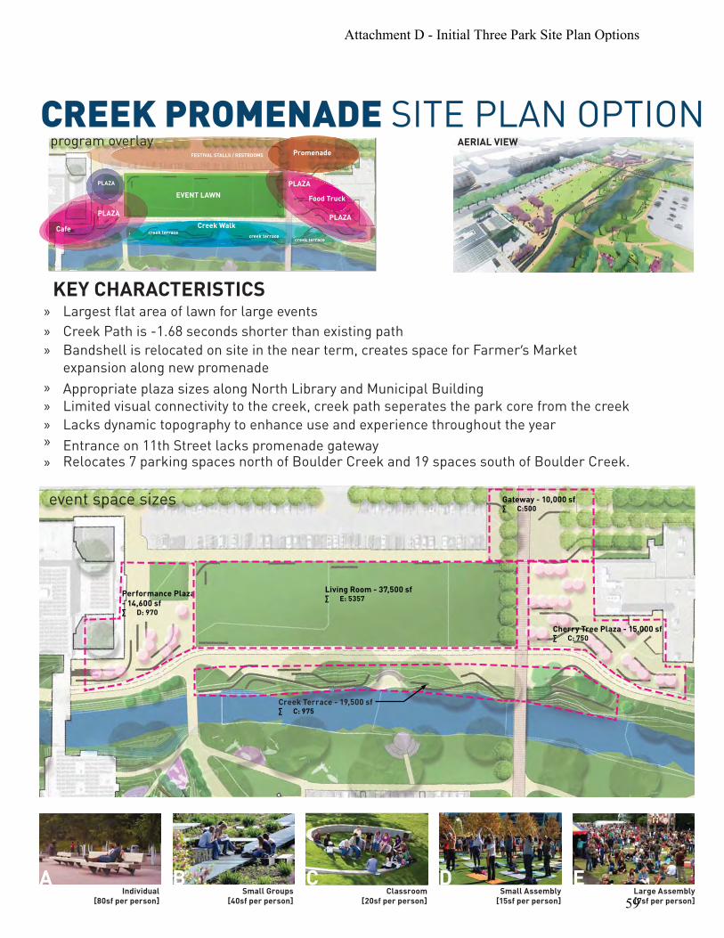
CREEK PROMENADE SITE PLAN OPTION
KEY CHARACTERISTICS » Largest flat area of lawn for large events
» Creek Path is -1.68 seconds shorter than existing path
» Bandshell is relocated on site in the near term, creates space for Farmer’s Market
expansion along new promenade
» Appropriate plaza sizes along North Library and Municipal Building
» Limited visual connectivity to the creek, creek path seperates the park core from the creek
» Lacks dynamic topography to enhance use and experience throughout the year » Entrance on 11th Street lacks promenade gateway
Relocates 7 parking spaces north of Boulder Creek and 19 spaces south of Boulder Creek.»
Promenade
PLAZA
FESTIVAL STALLS / RESTROOMS
Food Truck
Creek WalkCafe
PLAZA
creek terracecreek terrace
creek terrace
EVENT LAWN
PLAZAPLAZA
program overlay AERIAL VIEW
Living Room - 37,500 sf· E: 5357
Performance Plaza - 14,600 sf · D: 970
Creek Terrace - 19,500 sf· C: 975
Gateway - 10,000 sf· C:500
Cherry Tree Plaza - 15,000 sf· C: 750
Individual [80sf per person]
Small Groups [40sf per person]
Classroom [20sf per person]
Small Assembly [15sf per person]
Large Assembly [7sf per person]
A B C D E
event space sizes
Attachment D - Initial Three Park Site Plan Options
59

CREEK PROMENADE SITE PLAN
1
4
2
6
8
8 8
8
7
bc
10 9 12
13
13
a
a
13
11
5
8
14
3
Limit of Near-Term Improvements
Complete Street ROW
Complete Street ROW
Canyon
Canyon
ArapahoeB
roadway
9th
13th
14th
11th
Arapahoe
7 parking spaces re
19 parking spaces
a
b
c
Promenade
Relocated Existing BandshellCoveredFarmer’s Ditch
1
9
Creek Lawn
2 Cafe Terrace Oak Grove
3 10Peformance Hill Temporary ParkConservatory
4 11Creek Walk/Terrace
5 Cherry Tree Plaza
6
Art Green
7
8 Nature Play
12
13
14
Oak Market Plaza
Transit Plaza
Restroom BuildingOpportunity
080 160 11th Street Spine11th Street Spine Bridge
Attachment D - Initial Three Park Site Plan Options
60

CREEK PROMENADE MASTER PLAN
1
4
2
6
8
8 8
8
7
bc
f
g
e
d
d
10 9 12
13
13
a
a
13
11
5
14
3
15
17
20
1919
16
1818
8
Limit of Near-Term Improvements
Complete Street ROW
Complete Street ROW
Canyon
Canyon
ArapahoeBroadw
ay
9th
13th
14th
11th
Arapahoe
2121
21
21
16 parking spaces
19 parking spaces
a
d
e
f
g
b
c
Promenade
Relocated Existing BandshellCoveredFarmer’s DitchInteractive Art Park
Atrium Market HallPossible Existing Gas Station Relocation Existing Mustard’s Last Stand Building
1
9
Creek Lawn
2 Cafe Terrace Oak Grove
3 10Peformance Hill Temporary ParkConservatory
4 11Creek Walk/Terrace
5 Cherry Tree Plaza
6 11th Street Spine
Art Green
7
8
11th Street Spine Bridge
Nature Play
12
13
14
15
16
17
18
19
20
21
Oak Market Plaza
Transit Plaza
Restroom BuildingOpportunity
Great Lawn
Stage Terrace
Event Hill
Park Support Blg
Wetland Garden
Pedestrian Bridge
Site for Structured Parking080 160
Attachment D - Initial Three Park Site Plan Options
61

CREEK VALLEY SITE PLAN OPTION
KEY CHARACTERISTICS » Biggest continuous green space
» Dynamic topography creates a diversity of spaces and experiences
» Regrading allows most visual & physical access to the creek
» Largest entrance promenade announces park along Canyon
» Picnic Plaza along North Farmer’s Ditch
» Enhanced circulation through Oak Market to 14th Street
» Smaller plaza spaces
» Biggest detour of the Creek Path (+5.28 seconds longer than existing)
» No location on site for relocated Bandshell
Relocates 46 parking spaces north of Boulder Creek and 19 parking spaces south of Boulder Creek
to enhance the 11th Street access into the park.»
Promenade
PLAZA
PLAZA
FESTIVAL STALLS / RESTROOMS
Food
Cafe
PLAZA
Stage
creek terrace
e
amphitheaterview/overlook
view/overlook
view/overlook
view/overlook
Stage
FESTIVAL / MOVIE
creek accesscreek accesscreek lawn
program overlayAERIAL VIEW
Performance Plaza 8,700 sf· D: 580
Cafe Terrace 6,700 sf· C: 335
Creek Terrace· C: 1,500
1,500 sfB: 36
1,800 sfB: 40
4,000 sfB: 100
Creek Lawn 2,600 sf· C: 130
Green Valley - 30,000 sf· E: 4,285
4,200 sfC: 200
5,100 sf · C: 260
3,800 sfC: 200
4,800 sfC: 240
Gateway Promenade 12,300 sf· D: 820
Gateway Promenade13,300 sf· D: 885
Cherry Tree Plaza 8,500 sf· C: 425
Stormwater Graden
Nature Play
event space sizes
Individual [80sf per person]
Small Groups [40sf per person]
Classroom [20sf per person]
Small Assembly [15sf per person]
Large Assembly [7sf per person]
A B C D E
Attachment D - Initial Three Park Site Plan Options
62

CREEK VALLEY SITE PLAN
1
4
2
3
6
8
8 8
8
7
c
10 9 12
13
13
a
a
a
a
b13
11
5
8
14
Limit of Near-Term Improvements
Complete Street ROW
Complete Street ROW
Canyon
Canyon
ArapahoeB
roadway
9th
13th
14th
11th
Arapahoe
46 parking spaces
19 parking spaces
a
b
Promenade
Picnic Plaza
1
9
Creek Lawn
2 Cafe Terrace Oak Grove
3 10Peformance Hill Temporary ParkConservatory
4 11Creek Walk/Terrace
5 Cherry Tree Plaza
6
Art Green
7
8 Nature Play
12
13
14
Oak Market Plaza
Transit Plaza
Restroom BuildingOpportunity
11th Street Spine11th Street Spine Bridge
Attachment D - Initial Three Park Site Plan Options
63

CREEK VALLEY MASTER PLAN
Limit of Near-Term Improvements
Complete Street ROW
Complete Street ROW
Canyon
Canyon
ArapahoeB
roadway
9th
13th
14th
11th
Arapahoe
1
4
2
3
6
8
8 8
8
7
a
b
c d
10 9 12
13
15
17
20
2121
21
21
19
19
16
13
a
a
13
11
5
8
14
18
18
tha
d
b
c
Promenade
Picnic Plaza
Ecological Playground
1
9
Creek Lawn
2 Cafe Terrace Oak Grove
3 10Peformance Hill Temporary ParkConservatory
4 11Creek Walk/Terrace
5 Cherry Tree Plaza
6 11th Street Spine
Art Green
7
8
11th Street Spine Bridge
Nature Play
12
13
14
15
16
17
18
19
20
21
Oak Market Plaza
Transit Plaza
Restroom BuildingOpportunity
Great Lawn
Stage Terrace
Event Hill
Park Support Blg
Wetland Garden
Pedestrian Bridge
Site for Structured Parking080 160
Possible Existing Gas Station Relocation
Attachment D - Initial Three Park Site Plan Options
64

ATTACHMENT E:
List of Spring & Summer 2015 Events in the Civic Area
March 2015 Free Nature Play Camp March 23-26, 2015 | 9:00am - 11:00am International Peace Garden Volunteer Boulder Creek Clean-up Sunday, March 29, 2015 | 3:30pm April 2015 *Free Civic Area Walking Tour Wednesdays, Starting April 1, 2015 | 1:00pm - 2:00pm Dushanbe Tea House Plaza *Boulder County Farmers' Market Saturdays, Starting April 11, 2015 | 8:00am - 2:00pm 13th Street *Free Civic Area Walking Tour Sundays, Starting April 12, 2015 | 11:00am - 12:00pm Dushanbe Tea House Plaza Nepal Day Parade Sunday, April 19, 2015 | 12:00pm - 3:00pm Civic Area - Bandshell Communikey Festival Sunday, April 19, 2015 | 2:00pm - 10:00pm Civic Area - Central Park South Dia Del Nino Saturday, April 25, 2015 | 11:00am - 2:00pm Civic Area - Bandshell & Central Park North May 2015 *Boulder County Farmers' Market Wednesdays, Starting May 6, 2015 | 4:00pm - 8:00pm 13th Street
May 2015 continued Boulder Symphony Concert Saturday, May 2, 2015 | 12:00pm - 1:00pm Civic Area - Bandshell Boulder Community Day (Community Clean-up and Kids to Parks) Saturday, May 16, 2015 | 8:30am - 4:00pm Scott Carpenter Park Boulder Creek Festival Kickoff Concert Friday, May 22, 2015 | 7:00pm - 10:00pm Civic Area - Central Park North, South & Bandshell Boulder Creek Festival May 23-25, 2015 | 10:00am - 10:00pm Civic Area - Central Park North, South & Bandshell June 2015 *Free Nature Play Program Mondays, Starting June 1, 2015 | 9:00am - 11:00am| 1:00pm - 3:00pm Civic Area - International Peace Garden
*Free Nature Play Program Thursdays, Starting June 4, 2015 | 9:00am - 11:00am| 1:00pm - 3:00pm Civic Area - International Peace Garden
Boulder County Farmers’ Market Arts & Crafts Fair Saturday, June 13, 2015 | 8:00am - 2:00pm Civic Area - Central Park North Boulder Museum of Contemporary Art (BMoCA) Summer Games Friday, June 19, 2015 | 8:00am - 5:00pm *ongoing events
Attachment E - List of Spring & Summer 2015 Events in the Civic Area
65

ATTACHMENT : Preliminary Analysis and Possible Funding Mechanisms to
Relocate City Services & Programs to Boulder Community Health Facility
Overview of Preliminary Feasibility Analysis As a follow up to the January 20 City Council Information Packet [insert link], staff has continued to explore the potential opportunity to relocate city services and programs to the Boulder Community Health (BCH) facility located on Broadway. An initial feasibility analysis examined the following items related to BCH:
Three properties were reviewed in this analysis (see map at end of Attachment):o 1100 Balsam Avenue, the main hospital facility with 404 surface parking spaceso 1155 Alpine Avenue, the medical pavilion connected to the hospitalo 2655 Broadway, the parking garage with 391 parking spaces
Boulder County assessed value:o 2655 Broadway – $6.1 milliono 1100 Balsam and 1155 Alpine – $42.5 million
Renovations – The city’s potential occupancy of BCH, constructed in 1960, would not “trigger” achange in use, under the building code. However, renovations that may be warranted tomaximize the use of the facilities for city functions would trigger a change in use (from an“institutional” use to that of a “business/office” use) along with the corresponding requirementsneeded to bring the building into conformance with current codes. In particular, modificationsto the building would require complete replacement of the current HVAC systems to meet 30percent higher energy efficiency than 2012 International Energy Conservation Code standards.Such changes could be phased-in overtime, recognizing that a phased-approach would need to“compartmentalize” the structure and that there are practical limitations, given the integratednature of building systems and components, for how much phasing could occur.100-year Floodplain – the site is partially located within the 100 year floodplain and would needto be brought into compliance with the current flood proofing requirements. An emergencymanagement plan would also need to be prepared.Zoning – creating a government facility is consistent with the current zoning.Planned Unit Development (PUD) – any changes to the site would require an amendment to thePUD and it would potentially require Planning Board approval.
Attachment F - Possible Funding Mechanisms to Relocate City Services & Programs to Boulder Community Health Facility
66

TABLE I: Preliminary Analysis Results Purchase BCH* &
Renovate Scenario Purchase BCH*, Demolish & Build New Scenario
Alternate City-Owned Property in Civic Area & Build New Scenario
Property Acquisition (Boulder County Assessed Value)
48,600,000 48,600,000 N/A
Potential Sale of City-Owned Property
TBD TBD N/A
Renovation 91,700,00 N/A TBD Demolition N/A 1,600,000 TBD Construction N/A 90,000,000 90,000,000 Parking Included in Property
Acquisition Included in Property Acquisition
10,000,000
Total $140,300,00 $140,200,000 $100,000,000 *BCH includes property located at 1100 Balsam Ave. (main hospital with parking), 1155 Alpine Ave. (medical pavilion), and 2655 Broadway (parking garage). For any of the options, remodel and major renovation work would be needed in both the 1100 Balsam and 1155 Alpine properties to make the area ready for public use and to effectively deliver city services. Therefore, the amount borrowed for purchase would need to include funds to pay for these costs. Current estimates to purchase and renovate is approximately $140.3 million. Based on past experiences with renovations, there will need to be a higher contingency than if it was new construction. Therefore, a 15 to 20 percent contingency is included in the estimate. An additional parking structure is located at 2655 Broadway and could be purchased with the rest of the BCH property listed previously. Including the Broadway parking structure, a total of 795 parking spaces would be available on site. The estimated purchase price of the parking structure is around $6 million, which is a little less than half of the cost of a brand new structure. The BCH Broadway campus is an opportunistic site given the build-out status within the boundaries of the city. There are limited options for consolidating city services in one location, and even fewer if only those that are somewhat near the current location of the civic area are considered. Currently, city staff is located in numerous buildings and more leased space will be needed in the near future. An annual cost of $880,000 is currently paid in lease payments. Potential Funding Mechanisms If there is a desire by City Council to explore the purchase and renovation of the BCH property, the following describes potential funding mechanisms that may be considered.
Certificates of Participation (COP) – which is a form of a lease purchase, is often a good option if funds are needed within a short timeframe and current revenues are sufficient to make the annual lease payments. The City of Boulder has used COPs in the past for the public safety building and the East Boulder Recreation Center. The use of COPs does not require voter approval before issuing COPs. However, City Council could ask for voter approval. If this path was chosen, the vote must comply with the Taxpayer Bill of Rights (TABOR) requirements and can only be voted on in November.
Attachment F - Possible Funding Mechanisms to Relocate City Services & Programs to Boulder Community Health Facility
67

Issue Bonds – If there is not an immediate need for funds, then another option is to ask the voters to approve a ballot item in November to allow for the issuance of bonds and make annual debt payments to repay the borrowed money. The bonds can either be paid from current revenues, or voters can be asked to provide for new revenues that would make or help to make the annual debt payments.
Preliminary Estimate of Annual Debt Service and Feasibility of Possible Financing Methods Given the estimated cost of approximately $140 million for the BCH site and using a 30 year final maturity, which is common given that the buildings and land will still be in existence in 30 years, the annual payments are estimated to be between $7.5 and $8.0 million (dependent on interest rates at the time of issue). If the city were to build on existing city-owned property in the Civic Area for approximately $100 million, then the annual payments are estimated to be between $5.2 and $5.7 million annually. With either option, the total amount cannot be paid from current operating revenues without significant reductions in expenditures for programs and services in order to free up additional monies to make the annual debt payments. Due to the inability to pay for the total annual principle and interest payments from current city revenues, neither the issuance of COPs nor asking voters to authorize bonds without a tax increase are a valid option of funding for either location. Instead of asking voters to provide a new source of revenue to pay for the total debt service on $140 or $100 million of bonds, the debt service could be split between being paid with a new source and existing city revenue. If this is preferred, the voters would still need to approve the total amount of the bonds needed (dependent on the location). Then, a certain amount would be paid from current city revenues and the voters would be asked to provide a new source of revenue to pay the balance of the total annual debt service. If council would like to have more information on this option, then staff would propose refining the estimates further and include that information in the April 14 study session when all potential ballot items will be discussed by council. In regard to operating costs, it is too early to project the amount of increase in operating costs. In some cases, economies of scale and improvements made during renovation may reduce or maintain costs to current levels. If there are cost increases, they would also be cost allocated to the departments in the new location. If council wants staff to continue research on this site possibility, the examination of operating costs will be included in the scope of future analysis. Summary of Scope of Further Analysis If council is supportive of completing a more detailed feasibility analysis, then staff will focus on refining the initial financial analysis. This will include compiling a list of the city-owned/occupied facilities potentially vacated as a result of the proposed move. For leases, this evaluation will include the review of when the current lease ends and the conditions triggered by early termination of the lease. Additionally, staff could evaluate opportunities to partner with the property owners on the acquisition. If the city owns the facility, then staff would be prepared to analyze the following scenarios:
Demolition Lease Sell Repurpose
Attachment F - Possible Funding Mechanisms to Relocate City Services & Programs to Boulder Community Health Facility
68

In all scenarios, staff would look at the monetary impact (both positive and negative) and timing. Also, during this analysis, staff will be working to better understand the value of the BCH facility and potential renovation costs. Included in the future analysis would be the opportunity to increase public parking options in the area of downtown.
Attachment F - Possible Funding Mechanisms to Relocate City Services & Programs to Boulder Community Health Facility
69

N20’
40’
120’
n
13th St.
14th St.
Arapahoe
Farmers Ditch
Option E1: City Properties Only
1
2
3
4
6
8
9
7
8
8
9
9
9
9 6
5
Legend: 1 Tea House 2 BMoCA 3 Atrium Building 4 Enhanced green space at Farmer’s Ditch 5 New underground parking
7 Large setback at Arapahoe Ave. to promote views to park 6 Potential parking entry
8 Enhanced 13th. St. at special crossing 9 New building site
Repurpose Atrium Building with 1-story link
No redevelopment on private properties
Preserves existing utility corridors/alleys
Some underground parking could exist
Key Characteristics:
East Preliminary
ATTACHMENT G: East and West Bookend Preliminary Development Options
Attachment G - East and West Bookend Preliminary Development Options
70

N20’
40’
120’
on
13th St.
14th St.
Arapahoe
Farmers Ditch
Option E2: City + Private Properties
1
2
3
4
5
6
7
8
9
Legend: 1 Tea House 2 BMoCA 3 Atrium Building 4 Enhanced green space at Farmer’s Ditch 5 New underground parking
7 Large setback at Arapahoe Ave. to promote views to park 6 Potential parking entry
8 Enhanced 13th. St. at special crossing 9 New building site
6
8
8
9
9
9
9
5
Re-purpose Atrium Building with plaza on all sides
Redevelopment of private Properties
Extend plaza to 14th St.
Preserves East-West Alley at south end of block
Key Characteristics:
East Preliminary
Attachment G - East and West Bookend Preliminary Development Options
71

N20’
40’
120’
Option E3: City & Private Properties + Atrium Site + Underground Parking
Canyon
13th St.
14th St.
Arapahoe
Farmers Ditch
Legend: 1 Tea House 2 BMoCA 3 Atrium Building 4 Enhanced green space at Farmer’s Ditch 5 New underground parking
7 Large setback at Arapahoe Ave. to promote views to park 6 Potential parking entry
8 Shared street and plaza for 13th St 9 New Building Site10 Conservatory in the park
1
2
7
4
9
6
8
5
9
9
9
9
10
8
5
6
9
Redevelopment Atrium building siteRedevelopment of private parcelsExtend plaza to 14th St.
A variety of building scales around Tea House Connectivity to Transit Center/14th & CanyonNorth-South Alley links all public spaces
Underground parking
Key Characteristics:
9
East Preliminary
Attachment G - East and West Bookend Preliminary Development Options
72

Option E4: City & Private Properties + Atrium Site + Above/Underground Parking
Legend: 1 Tea House 2 BMoCA 3 Atrium Building 4 Enhanced green space at Farmer’s Ditch
7 Large setback at Arapahoe Ave. to promote views to park 6 Potential parking entry
8 Shared street and plaza for 13th St. 9 New Building Site10 Conservatory in the park
5 New underground parking
11 New above ground parking garage N20’
40’
120’
Canyon
way
13th St.
14th St.
Arapahoe
1
2
7
4
9
6
8
5
9
9
9
9
10
11
N20’
40’
120’
Canyon
way
13th St.
14th St.
Arapahoe
1
2
7
4
9
6
8
5
9
9
9
9
10
11
N20’
40’
120’
Canyon
way
13th St.
14th St.
Arapahoe
1
2
7
4
9
6
8
5
9
9
9
9
10
11
N20’
40’
120’
Canyon
way
13th St.
14th St.
Arapahoe
1
2
7
4
9
6
8
5
9
9
9
9
10
11
N20’
40’
120’
Canyon
way
13th St.
14th St.
Arapahoe
1
2
7
4
9
6
8
5
9
9
9
9
10
11
N20’
40’
120’
Canyon
way
13th St.
14th St.
Arapahoe
1
2
7
4
9
6
8
5
9
9
9
9
10
11
Redevelopment Atrium building siteRedevelopment of private parcelsExtend plaza to Farmers Ditch/14th St
Pedestrian connections to both 14th St. and Canyon through building
North-South Alley links all public spaces Above ground parking garage at south end wrapped with active uses Underground parking at north end of site
Key Characteristics:
East Preliminary
Attachment G - East and West Bookend Preliminary Development Options
73

Option W1: Human Services/Housing & Renovation of Library North
Key Characteristics: Renovate existing Library North building
New larger scale city buildings on Arapahoe
Housing facing Boulder Creek
Underground parking
Legend: 1 Main Library - South 2 Renovated North Library 3 New underground parking 4 Potential parking entry 5 New multi-purpose senior facility 6 New Housing 7 Parking access/drop-off
N1” = 80’20’
40’
120’
Boulder Creek
Canyon
9th
St.
Arapahoe
1
2
3
4
5
5
66
7
West Preliminary
Attachment G - East and West Bookend Preliminary Development Options
74

Option W2: Housing with Community Space & Addition to Library North
Addition to existing Library North building
Larger Performing Arts uses
New Mixed Use buildings on Arapahoe
Less intensive Human Service function
Housing facing Boulder Creek
Underground parking
Key Characteristics:
Legend: 1 Main Library - South 2 Renovated North Library with addition 3 New underground parking 4 Potential parking entry 5 New mixed use building 6 New Housing
Boulder Creek
Canyon
9th
St.
Arapahoe
N1” = 80’20’
40’
120’
1
2
3
45
5
666
6
West Preliminary
Attachment G - East and West Bookend Preliminary Development Options
75

Option W3: Housing with Community Space & North Library Redevelopment
New large performing arts/community building on north side
New larger scale city buildings on Arapahoe
Housing or city uses
Above grade parking structure -wrapped with new uses
New Bridge between north and south
Key Characteristics:
Legend: 1 Main Library - South 2 Redeveloped North Library 3 New parking structure 4 Potential parking entry 5 New mixed use building 6 New housing wraps parking structure 7 Parking access/drop-off
Boulder Creek
Canyon
9th
St.
Arapahoe
bridge
N1” = 80’20’
40’
120’
1
2
3
45
6
67
5
West Preliminary
Attachment G - East and West Bookend Preliminary Development Options
76

Study Session MEMORANDUM
To: Members of City Council From: Jane S. Brautigam, City Manager David Driskell, Executive Director of Community Planning & Sustainability (CP&S) Susan Richstone, Deputy Director of CP&S Lesli Ellis, Comprehensive Planning Manager, CP&S Greg Guibert, Chief Resilience Officer, CP&S
Sam Assefa, Senior Urban Planner, CP&S Courtland Hyser, Senior Planner, CP&S Karl Guiler, Senior Planner, CP&S Jean Gatza, Sustainability Planner II, CP&S
Date: March 31, 2015 Subject: Update on Planning, including Boulder Valley Comprehensive Plan,
Resilience Strategy, and Design Excellence and Form Based Code Pilot
STUDY SESSION PURPOSE The purpose of the study session on Mar. 31, 2015 is to provide an update to City Council on the following planning work and receive feedback on:
1. Boulder Valley Comprehensive Plan (BVCP) 2015 work plan (Foundations work) and draft Community Engagement Plan;
2. Resilience Strategy; and 3. Design Excellence and Form Based Code Pilot.
QUESTIONS FOR CITY COUNCIL Does City Council have questions or feedback on the following topics?:
1. BVCP 2015 Update (See pages 2 to 7 and Attachment A.) a. Overall work plan and schedule, b. Ideas for the Community Engagement Plan, and c. Foundations tasks underway that will be presented on March 31?
2. The general approach and scope presented for the Form Based Code pilot and Design Excellence, including aspects of site review criteria that would be beneficial to consider
1
as part of this scope (See pages 11 to 13). Staff is also interested in any feedback or questions regarding the memo information provided regarding the proposed resilience strategy phases, work-to-date, and next steps. However, since Chief Resilience Officer Greg Guibert is unable to be at the March 31 study session, responses to questions may need to be addressed at a later date.
2015 Planning Projects In 2015, the city is moving forward with multiple planning initiatives, as noted below. A link to the latest integrated project timeline can be found here.
Vision, policy, and strategy development work includes: the Boulder Valley Comprehensive Plan (BVCP) 2015 update, the Resilience Strategy, Housing Boulder, and the Climate and Energy Blueprint.
Implementation work includes: Design Excellence and Form Based Code Pilot, Development Fees, University Hill Code Amendments (and follow up work such as CU conference center planning, exploration of a potential historic district, and façade improvement program).
Community engagement improvements including new web-based platforms to keep the community better informed about planning projects, enhanced notification for development review projects, and new tools and ideas for people to more conveniently provide feedback and shape outcomes.
This memo and study session will address a subset of the projects, including: (1) BVCP, (2) Resilience, and (3) Form Based Code. The BVCP effort is interrelated to the Housing Boulder project, including coordination with neighborhood-level analyses and community engagement, with subcommunity/neighborhood-level engagement activities planned for late April/May. The work plan for Housing Boulder can be found at HousingBoulder.net. Additionally, the BVCP, Resilience Strategy, and Climate and Energy work plans are being coordinated to find relevant intersecting topics and engagement opportunities.
Boulder Valley Comprehensive Plan
BriefUpdateThe 2010 plan and maps are available online at www.bouldervalleycompplan.net, which is also the webpage for the 2015 update and portal for interested participants to sign up for project updates. The Dec. 16, 2014 City Council Information Packet described the scoping process and consultant assessment and contains summaries of the Nov. 3, 2015 – Joint Study Session with the Board of County Commissioners and Planning Commission and the Oct. 14, 2014 Study Session with the City Council and Planning Board. The final version of the consultant’s BVCP Assessment is located online here. At the annual retreat, council gave direction to move forward with the Foundations work for the BVCP and conduct the official public involvement later in 2015 with the plan adoption occurring in 2016. At subsequent meetings, council has provided additional direction, such as considering a community survey, and coordination with the Housing Boulder effort. Staff has been coordinating the BVCP work plan with Housing Boulder and other citywide initiatives.
2

BVCPFeedback
CityCouncilonFeb.24,2015On Feb. 24, staff provided a brief overview of the foundations work and community engagement ideas to City Council, and council offered questions and feedback as follows:
Clarify what metrics will include. Council liked the idea of measurable objectives and the ability to measure goals. A jobs and housing dashboard would be helpful to clarify how we keep track of development permits. Staff explained it is easier to measure housing units than jobs, which are more assumptions-based (although it is possible to report on square footage of commercial space created and demolished or repurposed each year).
Consider the recent employment study for downtown (sampling in certain areas) as a possible approach.
Track density of owner occupied housing, or people density – is it declining? Consider using a survey tool to poll the community about growth issues. “Meetings in a Box” were very successful during the Integrated Planning Project. 3D urban form tools are helpful. Resilience diagnostic as part of BVCP might be hard, but it is important to do. Generally, the work plan is on the right track.
PlanningBoardDiscussiononFeb.19–SummaryOn Feb. 19, 2015, staff provided an overview of the draft work plan (with focus on the Phase 1 Foundations work) and ideas for community engagement. Planning Board provided the following feedback and suggestions: Work Plan/Foundations work
The work and engagement plans are off to a good start. Incorporate recent information from master plans and measurable objectives. Planning Board liked the subcommunity/neighborhood approach. Staff explained that
analysis and information about conditions will be prepared by subcommunity to assist with discussions and engagement. The intent is not to prepare neighborhood plans, but provide a finer-grained level of analysis and ability for neighborhoods to understand/give input and ideas.
Intergovernmental Agreement (IGA) renewal should happen in 2016 – ideally at the same time that the plan is adopted.
Use a lot of visuals to present information to aid in community engagement. Community Engagement Plan
Neighborhoods should be involved in determining how to support goals as well as be self determining.
Community engagement needs to entail a lot of listening, analysis, and information gathering. Need to distill ideas and make sure all voices are included.
It would be helpful to do a community survey (or scientifically valid poll) of some sort – perhaps a bit later in the process when specific policy or design questions can be posed.
Involve older community members (e.g., retirement homes) in community engagement.
3

OverallTimelineforBVCPFour phases are proposed for the BVCP update – each with extensive community dialogue and engagement – with the plan update completed in 2016.
1. Foundations and Community Engagement Plan (through June 2015) 2. Issues Scoping with Community (through summer 2015) 3. Analyze and Update Plan Policies and Maps (Begins summer 2015 - to early 2016) 4. Prepare Draft Plan for Adoption, Extend IGA (mid 2016)
Implementation steps, such as changes to code and zoning map updates, would be completed following plan adoption. More detailed tasks by phase are identified in Attachment A, which also includes the draft timeline.
DraftBVCPCommunityEngagementPlan
Over the next few months, the city and county will complete the Community Engagement Plan for the BVCP update, with the aim of including diverse perspectives, an open and transparent process that provides helpful information, and multiple opportunities for community dialoguewhile remaining focused on critical issues as defined by the city council based on community input. The city and county will also aim to coordinate the BVCP engagement with other initiatives such as housing, climate, and resilience.
EngagementApproachAttachment A provides an overview of the principles for engagement. In general, the city and county are aiming to design a highly visible and responsive process that is transparent and accessible and that facilitates dialogue and partnerships. The project will involve listening and going to people, businesses, and neighborhoods. The approach includes:
1. Overall, regular check-ins with guidance and approval by the City Council and Planning Board as well as County Commissioners and Planning Commission (periodic joint meetings), as well as input related to the community process from a process subcommittee.
2. Working with countywide boards and commissions where appropriate. While Planning Board and the Planning Commission have an approval role, staff will check in with other city and county boards that have potential technical or specialized input (see boards listed in Attachment A).
3. Partnering with established organizations that may host or co-host events (see list in Attachment A).
4. Building relationships and working within subcommunities and neighborhoods (e.g., providing information and hosting events at the subcommunity level in different parts of the Boulder Valley; providing opportunities for HOAs, neighborhood representatives and others to identify their unique issues, needs, and potential solutions; etc.).
5. Using creative and effective ways to engage people throughout the process, potentially including:
4

Hands-on Meetings – Set up forums co-hosted by others that are well-designed and facilitated, and/or charrettes that foster dialogue and build understanding.
Videos and Channel 8 - Use video, especially for an intriguing kick off that captures the community’s imagination and encourages participation.
Speaker’s Panel - Invite speakers representing different planning viewpoints. Web-based - Use online, social engagement and surveys (e.g., Inspire Boulder,
Facebook, etc.). Code for America is trying new tools such as “Click that Hood” to define neighborhoods.
Subcommunity Meetings – Host meetings that are customized for different parts of the city and the Boulder Valley.
Mobile planning - Get out into the community (e.g., a plan van asking for direct ideas and input). The city did not receive the Knight Foundation grant, but will seek other ways to do mobile work planning.
Community Survey - Gauge perspectives on urban form issues and other critical topics of interest at the right time during the process.
Go to People and Events - Go to events and meetings already taking place – e.g., farmers’ market, festivals or events, new tech meet ups, and places of worship.
Portable Meeting Kits - Design “Meeting in a Box”/ “Meeting to Go,” kits so neighborhoods and small groups can address planning questions on their own time.
EarlyEngagementtoShapetheCommunityEngagementPlanThe plan’s “kick off” with the community will begin in spring/summer of 2015, with policy discussions through 2016. Between now and June, activities and events to help further refine the Community Engagement Plan will include:
Continuing to improve the project web page. Coordinating with Code for America to pilot new engagement tools; collaborating with
the city’s newly hired neighborhood liaison; and working with the Housing Boulder Process Committee to plan for and design the subcommmunity/neighborhood outreach process for late April/May (which, while focused on Housing Boulder, will also provide the opportunity to discuss neighborhood-level issues pertinent to the comp plan).
Working with established organizations to host forum(s) that invite ideas around the engagement plan and key issues (June or July 2015).
Developing a timeline and information about Boulder’s history of planning to foster better understanding of the BVCP and its importance (for summer release).
CommunityWebinarsandotherinputonCommunityEngagementPlanThe city is hosting two short webinars and one public meeting to capture additional ideas to inform the Community Engagement Plan including:
Webinar - Monday, April 6 from 12 to 1 p.m. Public Meeting - Tuesday, April 7 from 5 to 6 p.m. at the Boulder Public Library Webinar – Wednesday, April 8 from 6 to 7 p.m.
The webinars and public meeting will feature surveys to help prioritize and inform the Community Engagement Plan.
5

BVCPFoundationsTechnicalWork–(throughJune,2015)Attachment A includes an outline of the four-phased work plan with focus on technical foundations work (in addition to developing the Community Engagement Plan). Staff will present more detailed information about these tasks on March 31. Technical work that is underway and largely to be completed within the first two quarters of 2015 includes:
1. Update 2015 “Profiles” – update both community and housing profiles, last updated in 2014.
2. Prepare 2040 Forecasts (25 years) – update citywide forecasts for housing and employment and prepare summary analysis of Residential Growth Management System.
3. Prepare Trends Snapshot – prepare report to examine social, economic, and environmental trends, potentially organized by sustainability categories and systems.
4. Prepare Map Inventory Updates - develop subcommunity / neighborhood maps and infographics to document existing conditions and help identify factors related to areas of stability and change. Do Land Use Map and Area I, II, III map clean up to clarify parcels, identify inconsistencies with zoning, and identify suggestions for improving the descriptions and definitions.
5. Align Master Plans and Measurable Objectives/Metrics, including survey of measurable objectives and metrics, and identifying policy directions or data from master plans and subcommunity or area plans that may be relevant.
6. Prepare 3D Urban Form Tools – identify purpose, intent and options for conveying urban form information in a manner that is easily understood and which supports meaningful community dialogue about the future.
7. Identify Initial Accomplishments and Challenges – begin to identify actions and remaining needs and opportunities for discussion and refinement with the community at initial outreach events.
The diagnostic for the Resilience Strategy is happening concurrently.
FoundationsWorkUnderway
FoundationsTask1:2015CommunityProfileThe updated community and housing profiles will be available for review at the Study Session.
FoundationsTask2:2040ForecastsIn preparation for completing 2040 forecasts by June of this year, the city is currently assessing its forecast methodology, which was initially developed in 2002 as part of the Jobs to Population project. The current method uses a combination of a “land use model” and an “economic model”, where accurate estimates of existing dwelling units, population, and employment are established as a first step.
2010 Residential and Nonresidential Forecasts – BVCP As of January 2010, the City of Boulder (Area I) had approximately 43,400 housing units, 97,500 residents, and 97,000 jobs. The remainder of the Service Area (Area II) had approximately 6,000 housing units, 12,000 residents, and 3,000 jobs. About 30,000 students attended the University of Colorado. In 2010, Area I was projected to add about 6,000 housing units, 15,000 residents, and 19,000 jobs by 2035. At the same time, CU enrollment was anticipated to increase by an additional 5,000-15,000 students by 2030. It was expected that most growth would occur through redevelopment, since the city has little vacant land left within the Service Area.
6

Future residential growth is then projected forward from the current estimate using a combination of zoning capacity and historic growth rates. Non-residential growth is projected using a combination of Bureau of Labor Statistics information, zoning capacity, and average annual growth rate information. Since the methodology is parcel-based, projected residential and non-residential growth can be presented at the Subcommunity and Service Area geographies. Current efforts to assess the forecasting methodology could result in possible refinements for the 2015 BVCP update.
FoundationsTask3:TrendsSnapshotBuild on the 2010 format. Make the analysis systems-focused. Coordinate with other data (TMP, housing) to organize it by Sustainability Framework and address topics such as: population, housing, education, income, age, employment, industries, employment share and commuting, transportation, energy and climate, natural resources, urban form, and local food.
FoundationsTask4:Subcommunity–ExistingConditionsandDataMappingThe city is preparing subcommunity maps and data information for each of the areas shown at right, including information about neighborhood demographics, land use mix, features and assets, history/historic features, and travel patterns within each area. The first drafts will be ready for the subcommunity meetings in May to use for discussions.
BVCPNextStepsApril 2015 (April 15, as joint meeting, or April 16) Planning Commission and Planning
Board, respectively, review of preliminary BVCP technical work and Community Engagement Plan
Early May (TBD) Subcommunity events coordinated with Housing Boulder process June 9, 2015 City Council Study Session – review Foundations work July 21, 2015 City Council Agenda Item to accept BVCP schedule, work plan, and process
for public requests for changes to the plan, including assessing interest in considering requests for changes to the service area
July 2015 (TBD) Board of County Commissioners
7

Resilience Strategy
OverviewAs part of the Rockefeller Foundation’s 100 Resilient Cities (100RC) campaign, Boulder is developing strategies to become a more resilient community – addressing the physical, social, and economic challenges of the 21st century. See ResilientBoulder.com. Resilience is a multi-faceted concept and generally defined as the ability of a community to prepare for and respond effectively to stress. Some of the stresses will come on suddenly, like the 2013 flood, wildfires, violence or flu. Others take their toll over time, such as economic hardship or social inequality. In either case, a resilient community is able to not only bounce back from these challenges but also "bounce forward.” The 100RC program supports city resilience-building by providing funding for a Chief Resilience Officer (CRO), providing technical support for development of a resilience strategy (i.e., consultant HR&A), providing access to tools to help assess the city’s resilience, and including Boulder in the resilience network with 99 other cities.
ResilienceWorkPlanandSchedule100RC has outlined a general approach and methodology for developing resilience strategies that the city has used to customize a process according to community goals and capacity and in coordination with the BVCP scope of work and other city projects. Generally, the phases of work are as follows:
1. Phase I (through May 2015): Preliminary Resilience Assessment. To date, this phase has included shocks and stresses workshops with 100RC staff in April 2014, and the CRO hiring in September 2014. In late October 2014 the city began diagnostic and analytical activities designed to more comprehensively assess the city’s risk profile (i.e., what is the city’s exposure?), and catalogue the existing portfolio of resilience-related projects, policies, and programs (i.e., what is currently happening that relates to resilience?), and map a stakeholder engagement plan. In February, the city hosted a web-based resilience Perceptions Survey for two weeks. Additional work to be completed in Phase I includes identifying gaps, opportunities and challenges and identifying preliminary focus areas for work in Phase II.
2. Phase II (through late 2015): Strategy Development. The second phase will focus on creating the resilience strategy for the identified focus areas.
3. Phase III (in 2016) will be dedicated to early implementation activities and ensuring financial sustainability of resilience beyond the initial 100RC investment.
PreliminaryResilienceAssessmentThe Preliminary Resilience Assessment (PRA) is a synthesis of the outputs and findings of Phase I and is used to develop the analytical foundation for selecting Focus Areas. Focus Areas are thematic areas around which the city wants to develop more knowledge, gather more data, and conduct more analysis to shape its work in Phase II of the strategy process. The purpose of defining Focus Areas at this stage is to:
Enable cities to customize and narrow the scope of activities to be undertaken in Phase II, and define a Scope of Work that reflects each city’s capacity and needs;
Build a fact base, and deepen a city’s knowledge and understanding around a few specific issues the resilience strategy will aim to address;
Help the city identify appropriate stakeholders, working groups, data sets, tools necessary for Phase II;
8

Help ensure that cities identify actionable priorities and specific initiatives for discovery/planning/implementation; and
Create consensus around the direction of the resilience strategy development process. Focus areas could correlate directly to specific resilience strengths and weaknesses, specific shocks and/or stresses, and/or cross-cutting issues, for example:
Address further understanding and analysis of a city’s vulnerability to a shock; Analyze how shocks and stresses might interact (for example -- how aging
infrastructure and poverty impact the city’s ability to respond to flooding events); Integrate and prioritize existing planning efforts; or Focus on a specific part of a shock or stress which requires deep articulation.
The city is working toward identifying initial Focus Areas from the feedback and survey work so far.
Feedback
Several of the outcomes from Phase I, including the a summary of the April 2014 workshops and the additional analysis of the February 2015 Perceptions Survey (highlights below) will be available on the project website by the end of March. (See ResilientBoulder.com.)
ResiliencePerceptionSurveyIn February 2015, the city hosted a web-based Resilience Perceptions survey to which 550 people responded. To notify the community, the city issued a press release, sent email to the resilience and planning email lists, and issued other social media notices. The survey is not statistically valid because respondents were self-selecting, however the respondent profile indicates some diversity in terms of tenure in Boulder, place of residence, and work sector. A high level summary of results are noted below, highlighting some potential topics for further analysis and discussion. Additional survey results will be posted to the webpage by the end of March, with a full analysis incorporated into the final Preliminary Resilience Assessment in May.
1. Boulder is viewed as having strengths in resilience areas of: safety/crime deterrence, robust local economy, protection of natural resources and ecosystems, emergency information systems, water supply, sufficient and affordable local or organic food supplies, hazard monitoring and alerts, updated codes and standards and plans for urban development.
2. The community is viewed as having weaknesses and work to be done in areas of: a. Community Engagement – Providing greater sense of belonging in the city and
being more integrated and inclusive of civil society. Adding measures to promote trust of government.
b. Transportation Systems – Integrating transportation links with other cities/regions, and providing a multi-modal system with inclusive coverage of the city.
c. Inclusive Housing/Health Care – Addressing Boulder’s affordability and social and economic challenges related to housing and access to health care and mental health.
d. Resilient Governance – increasing transparent, inclusive, and integrated decision-making and leadership; increasing collaboration, and integrating land use and inclusive planning process.
9

ResilienceNextSteps
At the April 28, 2015 Study Session, staff will present a draft version of the Preliminary Resilience Assessment and Phase II Focus Areas.
10

Form Based Code Pilot
OverviewAs part of the larger Design Excellence Initiative, the city is piloting a form-based code (FBC) in Boulder Junction, defined as the area addressed in the adopted Transit Village Area Plan. The purpose of the effort is to test FBC as an approach to address design quality and development review issues recently articulated through community, board and council conversations, as summarized in the Jan. 15, 2015 memo from Dover Kohl (link to memo). The Community Planning & Sustainability Department is leading the effort in collaboration with other city departments and two consultant teams. In addition, the applicants for the proposed S’PARK project at Boulder Junction and the Reve project at 30th and Pearl have indicated an interest in exploring how the two projects could serve as real-world pilot projects for the FBC. The Site Review process for S’PARK and the anticipated Site Review process for Reve (they have not yet submitted, but have indicated their intention to do so) are intended to move in tandem with the FBC pilot process.
Consultants–OverviewofRolesIn January, the city initiated a competitive Request for Proposals process and received two proposals. In February, an interview panel made up of interdepartmental staff and representatives from the Planning Board (PB), Boulder Design Advisory Board (BDAB), Transportation Advisory Board (TAB), the Boulder Junction Access District (BJAD) Parking Commission, and the BJAD Travel Demand Management (TDM) Commission interviewed the two firms. In general the outcome of that process is as follows:
A team led by CodaMetrics was selected through the RFP process as the consultant for the Boulder Junction FBC pilot and will complete the work plan tasks outlined below.
Dover, Kohl & Partners will continue as the city’s on-call consultant for the broader Design Excellence Initiative to provide consulting services focused on addressing design and development issues citywide, while also playing a role in the FBC pilot in collaboration with CodaMetrics.
DraftWorkPlanThe desired results of the Design Excellence initiative are: 1) A FBC pilot applied to the Boulder Junction area; 2) Updated Site Review criteria that better address design quality, achieve city goals, and increase predictability, and 3) Potential application of other FBCs in other areas of the city. Staff is currently in the process of negotiating the contracts and specific scope of work for each of the selected consultants to accomplish the changes discussed above. The summary provided here reflects the current understanding of each team’s roles and responsibilities within the project, although specific details may be subject to change as discussions and contract negotiations progress. Staff is also investigating how to best address the issue of community benefit in projects and will work with both the consultants on how they could assist in this conversation. Lastly, staff is proposing to form a working committee made up of board representatives (i.e., PB, BDAB, TAB, BJAD’s Parking and TDM Commissions similar to the interview panel) to provide advice on the FBC pilot. While the independent boards would provide specific recommendations to council, the working committee would include liaisons from the boards to enable ongoing robust input from the different perspectives throughout the formulation process. At present, staff is considering two board members from Planning Board, two board members
11

from BDAB, one from each of the BJAD boards and one board member from TAB.
FormBasedCodeCodaMetrics will work with the city to complete the following high level tasks:
1. Conduct a synoptic survey to photographically catalog buildings, their context, their relationship to the street, and elements of their design.
2. Work with the city to engage the community during each stage, including: o Explain FBC – what it is/isn’t and how it might work with Boulder’s current
regulatory structure; o Host listening sessions with neighborhood groups, property owners, developers,
elected officials, board members, and city staff; o Host working committee meetings; o Hold three community workshops; o Present to boards and commissions; and o Support development of online outreach materials.
3. Coordinate with applicants for the proposed S’PARK and Reve developments to consider the possibility of the two projects becoming a “real world” pilot FBC.
4. Draft a FBC for the Boulder Junction pilot area, including but not limited to sections to address: Administration and Intent; How to Use the Code; General Provisions; Definitions; Building Typology and Envelope Standards; Public Realm Standards; and Architectural Standards.
If the city finds that the FBC pilot is beneficial at accomplishing the set goals, CodaMetrics could be retained in the future to assist in creating new FBCs outside of the Boulder Junction area.
DesignExcellenceWhile the FBC pilot work is occurring, Dover, Kohl & Partners will work with the city to conduct a public process for the Design Excellence Initiative to addresses big picture design questions and topics associated with the FBC pilot, and any necessary adjustments to the city’s Site Review Criteria, as follows:
1. Determine how to structure the FBC so that it fits into the framework of the city’s land use code and site review process:
o Coordinate with the CodaMetrics team on the specific structure of the FBC pilot; o Identify any necessary adjustments to the land use code and/or site review
process to accommodate the FBC pilot; and o Look beyond the pilot project and recommend any additional changes to the land
use code that would be necessary if FBC were to expand beyond the pilot area or be implemented citywide.
2. Provide specific recommendations to changes to the site review criteria necessary to achieve the broad community goals, address elements of good design and increase predictability in development projects.
12

FBCNextStepsMarch 31 Finalize scope and contract with CodaMetrics and Dover, Kohl & Partners and finalize a schedule Early April Form a working committee made up of board representatives (i.e., PB, BDAB,
TAB, BJAD’s Parking and TDM Commissions) to provide advice on the FBC pilot Early April FBC project community kick-off April – Oct. Public engagement, including boards/commissions, community, and City Council Oct. Draft and finalize FBC proposal for council review and acceptance
ATTACHMENT(S)
A. BVCP Attachments: a. Draft work plan graphic b. Draft Community Engagement Plan ideas c. BVCP Work Plan (Focused on Phase 1 Foundations Work)
13

Boulder Valley Comprehensive Plan 2015 Update: Work PlanMar
2015Apr May Jun Jul Aug Sept Oct Nov Jan
2016Dec Feb March Apr May Jun
Phase 1: Foundations and Community EngagementWhat are Existing Conditions?
Phase 2: Issues
What are the Issues?
Phase 3: Analyze + Update Policies and Maps
What are Choices and Directions?
Phase 4:Draft Plan and IGA Renewal
Draft 3/19/2015
Prod
ucts
City
/Cou
nty
App
rovi
ng B
odie
s
Com
mun
ity
Enga
gem
ent
Draft Foundations Technical Work
CC
SS3/31
Han
ds O
n M
eetin
gsD
igita
l
Invitations to Community
OrganizationsMarch - May
Focu
sed
+ Te
chni
cal
Gro
ups
4/7
Webinar4/6
Webinar4/8
Survey?
PB
4/15 or
4/16
PC
Rela
ted
Proj
ect
Even
ts
Issues + Ideas
Meeting “To Go”
BOCC
TBD
PublicMeeting
Subcommunity Meetings +
Polling
Subcommunity Meetings (w/Housing Boulder)
Choices + ScenariosVision + Choices/3D Model
Draft Plan
Boards and Commissions Phase 3 Dates TBD
Boards and Commissions Phase 4 Dates TBD
Refine Issues + Accomplish-ments
Invite Land Use + Service AreaRequests
Vision and Choice
Draft Policy + Land Use Options
Develop Actions + Strategies
Prepare Draft Plan
Adopt Plan Renew IGA
Technical + Focused Groups
Technical + Focused Groups
Technical + Focused Groups
Mobile PlanningCommunity
Engagement Plan
Identify Issues
BOCCCCPC PB
SS6/9
CC
7/21
CC BOCCCCPC PB
Issues ForumChoices Charrette
with Speakers Scenarios Event
Survey?
Open House
Note: Community Engagement Plan Will Be Revised After March/April Discussions
TBD
Climate/Energy Blueprint Event
TBD
Design Excellence/ Form Based Code
KeyCity Council
Boulder County Commissioners
City PlanningBoard
County Planning Commission
BOCC
CC
PC
PB
Attachment A - BVCP Attachments
14

Boulder Valley Comprehensive Plan (BVCP) 2015 Update A—Initial Ideas for Community Engagement Plan Work in Progress - 03/18/15
Goal: A smart, open engaging process focused on critical issues.
All phases for the plan update will entail extensive community dialogue and engagement. The plan update will be complete in 2016.
Engagement Objectives and Principles
1. Listen2. Include diverse perspectives3. Provide relevant information4. Remain focused on critical issues as identified by the community and its leadership5. Have a civil/civic conversation6. Be transparent7. Provide multiple and meaningful ways for people to feel included, including small
groups organized by geographic areas (subcommunities, neighborhoods)8. Use input to inform approaches and the plan update (i.e., effective feedback loops)9. Strengthen community partnerships
Engagement Approach
Design a High Quality and Responsive Process Design Design engagement processes and techniques to appropriately fit the scope project and evaluate and adapt it to changing needs and issues as the project progresses.
Be Transparent Design the public decision-making processes to be accessible, open, honest, and understandable. Provide multiple ways for people to receive the information they need, and with enough lead time, to participate effectively. Show and explain how community input will be incorporated into the options for consideration and decision-making.
Facilitate Partnerships Facilitate respectful and engaged participation from community members, groups and organizations as community partners. Provide specific opportunities for engaging targeted communities (such as Gen Y or hard-to-reach people). Build partnerships during the engagement process, thus empowering people to use the plan moving forward and partner with the city and county to achieve the goals in the plan.
Attachment A - BVCP Attachments
15

1—BVCP will be guided and approved by: City Council and Planning Board. County Commissioners and Planning Commission (with periodic joint meetings).
2—Involving Boards and Commissions
• City Planning Board (approval)• County Planning Commission (approval)
City and county boards with potential technical or specialized input role:
• Arts Commission• Boulder Design Advisory Board• Downtown Management• Environmental Advisory Board• Health (County)• Human Relations• Immigrant Advisory Committee• Landmarks Preservation• Library Commission• Parks and Recreation / Parks, Open Space• Senior Community• Transportation• Water Resources• Youth
3—Partnering with Established Organizations that may lead in convening events(alphabetical):
• Better Boulder• Boulder Chamber• Boulder Tomorrow• Community Foundation and other social service organizations• Consortium of Cities• Downtown Boulder, Inc.• Growing Up Boulder• Faith Based Organizations (tbd)• Historic Boulder, Inc.• Human Service organizations• Impact Hub Boulder
Attachment A - BVCP Attachments
16

• Livable Boulder• New Era Colorado• Open Boulder• Plan Boulder CountyRetirement/Seniors: Frasier Meadows, Presbyterian Manor, Academy, etc.• Sierra Club (other environmental)
4—Working with Subcommunities and Neighborhoods
Provide information and host events at the subcommunity level and in different parts of the city and Boulder Valley to help include, inform, and engage neighborhoods. Include HOAs, neighborhood representatives in contact with the city, renters, etc. Coordinate with the city’s new neighborhood liaison and with the Code for America Partnership project to improve a neighborhood database and online engagement.
5—Using Multiple Ways to Engage Boulder and Boulder Valley
A few types of engagement or events include:
1. Invitations: Distribute information and invitations to organizations and individuals early in theprocess to help people understand the purpose and scope of the comprehensive plan update,encourage people to sign-up for communication, and build relationships.
2. Webinars: Host several meetings to ask people about best ways to engage the community andtheir neighborhood in the plan update.
3. Hands-on Meetings: Host forums co-hosted by others, well-designed and facilitated, charrettesthat foster dialogue and build understanding.
4. Videos and Channel 8: Use video, especially for intriguing kick off that captures thecommunity’s imagination and encourages participation.
5. Speaker’s Panel: During Phases 2 and 3 of the project, invite speakers representing differentviewpoints on community planning. Some of the speakers identified during Housing Bouldermay be fitting.
6. Web-based: Online social engagement – dialogues and surveys (e.g., Inspire Boulder, Facebook,surveys, etc.). Current webpage is: www.bouldervalleycompplan.net, with link from county’BVCP web page, and vice versa. Code for America is trying new tools such as “Click that Hood”to define neighborhoods.
7. Subcommunity Meetings: (See above.) Meetings will be designed for different parts of the cityand county.
8. Mobile planning: Get out into the community (e.g., a plan van/food truck, or bikes aroundtown, scannable codes directing people to web or asking for direct ideas and input).
9. Community Survey: Potentially during Phase 3 of the process (policy development), design asurvey to gauge perspectives on urban form issues and other critical topics of interest.
10. Go to Events: Be present at events and places where people are (e.g., farmers’ market, festivalsor events, new tech meet ups, Ignite, at work, senior centers, school events, places of worship).
Attachment A - BVCP Attachments
17

11. Design Portable meetings. (e.g., “Meeting in a Box” or “Meeting to Go” types of approaches) soneighborhoods and small groups can address planning questions and issues on their own.
6—With Possible Committee Input
1. Possible Process committee: A process committee could provide ideas to make the processtransparent, informative, and democratic. The committee may include members of City council,Planning Board, and county representatives from BOCC and the Planning Commission as well asmembers from other boards.
2. Possible Technical committee(s): May include other agencies or departments with data or infoto share (e.g., BVSD, CU, City/County resource managers, Human Services, etc.) and to providefeedback on technical accuracy of information (not policy direction).
Attachment A - BVCP Attachments
18

B—BVCP Work Plan Outline (Focused on Phase 1 Foundations Work)
The Boulder Valley Comprehensive Plan (BVCP) is adopted jointly by the City of Boulder (“city”) (Planning Board and City Council) and Boulder County “county” (County Commissioners and Planning Commission) in their legislative capacities. A link to the 2010 plan and maps is located at www.bouldervalleycompplan.net. The BVCP is updated periodically to respond to changed circumstances or evolving community needs and priorities. This year, the plan is due for a major five year update.
What Preparatory Work was Completed in late 2014/early 2015? • City provided background information for joint study sessions of the City Council and Planning
Board (Oct. 14, 2014) and Board of County Commissioners and Planning Commission (Nov. 3,2014).
• Additionally, a consultant team (Clarion Associates/Godschalk) prepared an assessment of the2010 Plan and ideas about how communities make their plans strategic and effective. Thereport is one piece of information to assist with the community dialogue.
• The project web page provides up to date information.• City Council solidified their priorities for the 2015 city planning work plan during their Annual
retreat in January.
Preliminary Timeline and What to Expect in 2015 Four phases are proposed – each with extensive community dialogue and engagement. The plan update will be complete in 2016.
1. Foundations and Community Engagement Plan (through June 2015)2. Issues Scoping with Community (through summer 2015)3. Analyze and Update Plan Policies and Maps (Begins summer 2015 - to early 2016)4. Prepare Draft Plan for Adoption, Extend IGA (mid 2016)
With follow up code reform and implementation.
More opportunities for the community to participate in shaping the Community Engagement Plan will occur in March and April 2015. Additionally, as part of Phase 2 the city and county will work with the community and leadership to identify plan issues and finalize a focused scope of work. City and county staff are working together to prepare a more detailed work plan and schedule, but more detailed tasks by phase are identified in the outline that follows.
Attachment A - BVCP Attachments
19

Phase 1 – Foundations / Snapshot of Community and Community Engagement Plan Phase 1 consists of the following tasks:
Task 1.1 - Refine Scope of Work and Schedule.
Task 1.2 - Develop a Community Engagement Plan. Finalizing the engagement strategy for the BVCP will include input from the community and will be coordinated with neighborhood liaison and other city initiatives. (See “Initial Ideas for Community Engagement”.)
Task 1.3 - Foundations Technical Work. Work to be developed and used during community engagement will focus on:
a. 2015 “Profile” Update. The housing and community profiles were last updated in 2014 andwill be updated in March 2015.
b. Prepare 2040 Forecasts (next 25 years). Update forecasts (residential, non-residential) mapped citywide and by geographic
areas of city (e.g., subcommunity level). Build from 2010 forecast methodology, possibly using CommunityVIZ, and identify
necessary categories that may assist with other work such as commercial linkagefees.
Prepare brief summary analysis of Residential Growth Management System.c. Prepare Trends Snapshot. Building on the 2010 format, identify and examine social,
economic, and environmental trends (e.g., Boulder Past, Present, Future). Present data andinformation in clear, compelling maps and graphics, possibly by subcommunity, and/or withinformation on cross-cutting topics, potentially by sustainability categories (e.g., safecommunity, healthy/socially thriving, livable community, etc.). Make the informationsystems focused. Include the following: Social: Population, housing, education, income, and age (and national and regional
growth) Economic: employment, industries, employment share and commuting Environmental: Transportation, energy and climate, natural resources (and urban
form and food)d. Prepare Map Inventory Updates (for use in trends reporting).
Update maps, tools and info-graphic approach to presenting system-based data,including but not limited to:
• Update to subcommunities and neighborhoods maps as appropriate• Update 15-minute neighborhood assessment tool• Floodplains and current wetlands inventory• Parks, schools, and other public facilities map• Boulder Valley Natural Ecosystems map update• Hazards map update• Incorporate information from transportation connections and transit
corridors plan
Attachment A - BVCP Attachments
20
• Utilities map updates• Trails, greenways, and open space updates• Major institutions, ownership• Current land uses and density, including people density
Begin Land Use Map/Area map clean up and analysis.• Begin clean up of existing Land Use Map and Area I, II, III maps to better
align data with parcel boundaries. Identify where land use is unclear oruncertain that may need to be considered later in map update (Phase 2).
• Prepare analysis of Land Use Map descriptions identifying inconsistencies orambiguity with intent or zoning districts.
Identify factors for stability/change areas. Using updated map(s) and other data,prepare preliminary assessment factors relating to stability/maturity vs. areas ofchange for use in later community dialogue.
e. Align Master Plans and Measurable Objectives/Metrics. Review Master Plans/Summaries. Identify policy directions or data from master
plans and subcommunity and area plans that might be relevant for previous tasks ordiscussions in Phase 2. Update summaries as necessary to reflect current plans.
Measurable Objectives/Metrics. Survey existing measureable objectives in use atthe city from master plans, budget process, etc. Identify gaps. Identify measurableobjectives and metrics in use in other communities that may be usefulconsiderations for Boulder.
f. Prepare 3d urban form tool for use in community dialogue about urban form. Using theupdated land use map, prepare land capacity mapping that conveys information abouturban form based on current land use and zoning, three-dimensionally.
g. Identify Initial Accomplishments and Challenges (to be finalized in Phase 2 after furthercommunity input). Identify what the community has accomplished (e.g., land use mix and urban
patterns, growth management, neighborhoods, resource conservation, design andpublic spaces, services and infrastructure, historic preservation, infill andredevelopment).
Identify remaining challenges and opportunities (e.g., how will the cityaccommodate future lifestyle shifts? How will the city address infrastructureneeds?)
Parallel Efforts:
• Resilience Diagnostic. Resilience analysis and diagnostic also happening.• Housing Strategy. Several milestones may overlap between Housing Boulder and BVCP,
including the subcommunity community engagement proposed for May 2015.• Other integrated planning efforts are shown on the 2015 Integrated Planning Timeline (Q1 and
Q2).
Attachment A - BVCP Attachments
21

Phase 2 – Issues Focus (Note: Additional detail about this phase and tasks will be added after Phase 1 is complete)
Phase 2 builds on Phase 1, and will entail extensive community engagement to accomplish the following:
Task 2.1 - Identify Issues. With community, identify areas of focus for the plan update, building on the work completed in the consultant assessment, joint study sessions of the city and county, and foundations technical work.
Task 2.2 - Initiate Community Engagement/City and County Leadership Input. Engage the community regarding the completed technical analysis (e.g., trends, challenges and opportunities), and identify priority issues to explore and update community engagement schedule for this phase of the plan. Check in with city and county (council and Planning Board, Board of Commissioners and Planning Commission).
Task. 2.3 - Confirm Issues: Based on community input, refine and confirm issues.
Task 2.4 - Refine Accomplishments and Challenges. Based on community input, refine and confirm accomplishments and challenges.
Task 2.5 - Refine Scope. Refine overall scope of work and schedule of meetings.
Phase 3 – Analyze / Update Policies and Maps (Note: Additional detail about this phase and tasks will be added after Phases 1 and 2 are complete)
Phase 3 builds on previous phases, and will entail extensive community engagement to accomplish:
Task 3.1 – Update Community Engagement Schedule. Schedule will include specific activities for this phase, including sessions with City and County leadership.
Task 3.2 - Verify Vision. With community, verify parts of the vision that are still valid. What new ideas should be added, using consultant report and input from the city and county joint study sessions as a way to help frame an initial set of issues. Revamp format to make the vision more accessible and user friendly. Consider adding illustrative map (e.g., from 2000 plan).
Task 3.3 - Invite Public Land Use Requests and Possibly Service Area Expansion or Contractions. Take in requests and begin review using criteria set forth in BVCP. As part of the process, clarifications to that section of the plan may be made.
Task 3.4 - Formulate Policy Options. Based on community input, determine options.
Task 3.5 - Land Use/Urban Form. Invite and initiate land use map changes and prepare analysis. Prepare 3D form based plans as relevant for certain areas of city. Improve land use descriptions to
Attachment A - BVCP Attachments
22

make consistent with zoning and considering other factors such as land use/transportation relationships and services and infrastructure.
o Analyze choices. Prepare analysis of key choices -- policy and map basedo Add Metrics. Depending on analysis in Phase 1 and input, add plan metrics.o Resilience Strategy. Ongoing.
Phase 4 – Prepare Draft Plan for Adoption. Update IGA. (Note: Detail about this phase will be added after previous phases are complete)
Phase 4 builds on previous phases, also with extensive community engagement to address:
Task 4.1 – Update Community Engagement Schedule. Schedule will include specific activities for this phase, including sessions with City and County leadership.
Task 4.2 - Develop Actions and Strategies. Identify strategies to achieve plan (e.g., priority actions, addressing priorities, necessary actions, how city will pay for what community wants, monitoring tools and indicators to continually renew the plan?). Engage community in discussion and prioritization.
Task 4.3 - Prepare Draft Plan. Develop draft plan update.
Task 4.4 - Adopt Plan. Prepare and bring plan for adoption.
Task 4.5 - Extend the Intergovernmental Agreement (IGA) between the City of Boulder and Boulder County for the purpose of coordinated planning and land regulation. Current IGA expires on Dec. 31, 2017.
Resilience Strategy In parallel, the city is undertaking the Resilience Strategy to increase the community’s resilience, which gives the community a unique opportunity to assess its resilience strengths and weaknesses, considering local and regional multi-faceted resilience topics. Early steps in the Resilience Strategy that overlap with Phases 1 and 2 of the BVCP work plan include:
1. Identify Resilience Perceptions2. Map stakeholder network (i.e., Stakeholder Engagement Plan)3. Develop City Context Document4. Prepare Resilience Diagnostic of Shocks and Stresses5. Prepare Actions Inventory (to identify actions underway)
Attachment A - BVCP Attachments
23