Predicting Differential Loran-C Performance in Boston Harbor

Boston Harbor Watershed 1999 Water Quality Assessment Report 228 70wqar.doc DWM CN 49.0
BOSTON HARBOR – ESTUARINE SEGMENT ASSESSMENTS Winthrop Bay (Segment MA70-10) ........................................................................................................... 230 Boston Inner Harbor (MA70-02)................................................................................................................ 233 Pleasure Bay (Segment MA70-11) ........................................................................................................... 238 Dorchester Bay (Segment MA70-03)........................................................................................................ 240 Quincy Bay (Segment MA70-04) .............................................................................................................. 245 Quincy Bay (Segment MA70-05) .............................................................................................................. 248 Hingham Harbor (Segment MA70-08) ...................................................................................................... 252 Hingham Bay (Segment MA70-06) ........................................................................................................... 254 Hingham Bay (Segment MA70-07) ........................................................................................................... 257 Hull Bay (Segment MA70-09) ................................................................................................................... 260 Boston Harbor (Segment MA70-01) ......................................................................................................... 262
MA70-01
MA70-10
MA70-03
MA70-04
MA70-05
MA
70-0
6
MA70-07
MA70-08
MA70-09
MA70-11
Boston
Boston
BostonBoston
Milton Quincy
Braintree WeymouthHingham
Hull
Cohasset
MA70-02
Charles River Basin
Weymouth and Weir SubwatershedNeponset River Subwatershed
Mystic River Subwatershed
N
2 0 2 4 Miles
Figure 20. Estuarine segments in Boston Harbor (Proper)

Boston Harbor Watershed 1999 Water Quality Assessment Report 229 70wqar.doc DWM CN 49.0
GENERAL ISSUES/RECOMMENDATIONS FOR BOSTON HARBOR (PROPER)
The majority of metropolitan Boston’s municipal and industrial waste is treated at the MWRA Deer Island WWTP and is discharged 9.5 miles out into Massachusetts Bay. However, there are significant contributions of wastewater to the harbor in the form of permitted CSOs (MWRA and Boston Water and Sewer Commission), storm water, construction dewatering from the Big Dig, discharges from two major power plants, and NCCW from the Gillette Company. Water quantity is an important issue throughout the Boston Harbor Watershed. The majority of public water, whether from local supplies or through the interbasin transfer of water from Quabbin Reservoir in central Massachusetts by the MWRA, is processed at the MWRA’s Deer Island Wastewater Treatment Plant and discharged to Massachusetts Bay. Recharge of the local systems is mainly limited to precipitation events and low streamflow is a serious problem. This loss of water essentially reduces available streamflow, and threatens instream uses such as aquatic life, habitat quality and quantity and recreational uses. Strong conservation measures through implementation strategies such as block rate pricing, installation of water- saving devices in homes and public buildings, in concert with a strong educational program, will all help reduce the stress placed on the water resources throughout the Boston Harbor Watershed. The Boston Harbor Association with financial support of the Massachusetts Port Authority, the mayor’s office, the City of Boston Environment Department, the Massachusetts Water Resources Authority, the United States Environmental Protection Agency, the Massachusetts Environmental Trust, and the Massachusetts Coastal Zone Management, initiated the Boston Harbor Marine Debris Salvage Program to clean up the waterfront and inner tributaries of Boston Harbor. This project has led to efforts to curtail the entrance of debris from the shore to the harbor. The Boston Conservation Commission and the MA DEP have developed certain conditions to keep waterfront construction debris from entering the harbor. Numerous cleanup projects along the Charles River, the Mystic River, and harbor beaches have also resulted (East Boston 21 August 2000).

Boston Harbor Watershed 1999 Water Quality Assessment Report 230 70wqar.doc DWM CN 49.0
WINTHROP BAY (SEGMENT MA70-10) Location: From the tidal flats at Coleridge Street, East Boston to a line between Logan International Airport and Point Shirley, East Boston/Winthrop. Segment Area: 1.5 square miles. Classification: Class SB Shellfishing (Restricted) More than 2,200 acres of Boson Harbor have been filled in (including Bird Island Flats) to expand Logan International Airport to its present size of 2,400 acres (MassPort 2002). This segment is on the 1998 303(d) list of impaired waters for pathogens (MA DEP 1999a). There is one vessel sewage pump-out facility located within this segment: Atlantis Marina (CZM 3 October 2001). WMA WATER WITHDRAWAL AND SURFACE NPDES DISCHARGE SUMMARY: There are no regulated water withdrawals or wastewater discharges in this segment. However, all communities in the Boston Harbor Watershed (excluding Boston) are required to obtain Phase II NPDES storm water general permit coverage for their municipal drainage systems. EPA is currently writing this general permit (with input from MA DEP) and a preliminary draft is currently available for internal review. The draft for public comment should be available by the end of June 2002. The final version of the Phase II storm water general permit for regulated small municipal separate storm sewer systems (MS4) will be issued by December 9, 2002. The towns must submit applications for coverage under the permit to EPA by March 10, 2003 (Scarlet 2002). The Boston Water and Sewer Commission (the Commission) operates the separate storm drainage system serving the City of Boston. The Commission applied to EPA in 1993 for an NPDES storm water individual permit for the system and received the permit in October 1999. The Commission operated drain system has 104 major and 102 lesser outfalls. The system currently serves 13.85 square miles of Boston. The remainder of Boston is served by combined sewers and the Commission is currently undertaking two major separation efforts under the MWRA CSO Control Plan. There are other public storm drains in the city owned by other state agencies such as the Massachusetts Department of Public Works, Massachusetts Turnpike Authority and the Metropolitan District Commission. While currently unpermitted, these other public agencies will be required to obtain coverage for outfalls from separate drainage they operate under an NPDES storm water general permit by March 10, 2003 (Scarlet 2002). Logan MassPort has an individual storm water permit (MA0000787) for four major outfalls to Winthrop Bay. The permit is expected to be reissued in 2002. Since March 15, 1982, Logan’s sanitary wastewater has been processed by the MWRA. Boston Water and Sewer with MWRA funds has completed sewer separation work in the Constitution Beach section of East Boston. The facility discharged screened and disinfected CSO flows approximately 16 times per year. As of October 2000 the Constitution Beach CSO was eliminated and the Constitution Beach CSO Treatment Facility was decommissioned (Coughlin and Stanley 2001).
WINCHESTER
EVERETT
CHELSEA
SOMERVILLECAMBRIDGE
SHARON
NORWOOD
WESTWOOD
STOUGHTON
HOLBROOK
RANDOLPH
BRAINTREE
WEYMOUTH
HINGHAM COHASSET
CANTON
MILTONQUINCY
LEXINGTON
BURLINGTON
READING
MELROSE
WOBURN
MALDENMEDFORD
MEDFIELD
ST ONEHAM
BOSTON
ARLINGTON
BELMONT
DEDHAM
WALPOLEROCKLAND
Boston Harbor WatershedBoston Harbor (Proper) Subwatershed
Winthrop BayMA70-10
N
Tidal Flats Point Shirley
Logan International Airport

Boston Harbor Watershed 1999 Water Quality Assessment Report 231 70wqar.doc DWM CN 49.0
USE ASSESSMENT AQUATIC LIFE Chemistry - water As part of their ongoing CSO monitoring program, MWRA collected monthly surface and bottom water quality samples (DO, temperature, turbidity, Chlorophyll a and TSS) from 1998 to 2000 at station 130 - Winthrop Harbor, green can #1(Coughlin 2001a).
DO Dissolved oxygen concentrations were not below 5.0 mg/L in either the surface or bottom waters during any of the sampling events (range 5.32 – 11.68 mg/L; n=262). Additionally, percent saturation levels were below 75% on only 10 occasions and were above 115% on 19 occasions (range 67.1 – 140.1%; n=265). It should be noted that the majority of the low DO concentrations were recorded in the bottom waters and the high percent saturations were recorded in the surface waters. No measurements were collected pre-dawn and, therefore, these data do not represent worst-case conditions.
Temperature No temperature readings (n=273) were above the SWQS for a class SB waterbody.
Turbidity Turbidity measurements were taken on 100 occasions with levels ranging between 0 and 39.9 NTU.
Chlorophyll a Chlorophyll a measurements were taken on 204 occasions. The bottom concentrations ranged from 0.59 to 33.7 µg/L and surface concentrations ranged from 0.57 to 36.9 µg/L.
Total Suspended Solids TSS measurements at station 130 were taken on 202 occasions. Bottom concentrations ranged from 1.3 to 15.5 mg/L and surface concentrations ranged from 0.6 to 21.4 mg/L.
Water chemistry parameters (DO, temperature, water clarity, and chlorophyll a) were generally within the SWQS for a Class SB waterbody, therefore the Aquatic Life Use is assessed as support. SHELLFISHING
The DMF Shellfish Status Report of October 2000 indicates that shellfish growing areas GBH5.1, GBH5.2, GBH5.4, and GBH5.5 are conditionally restricted and shellfish growing areas GBH5.0, GBH5.10, GBH5.11, GBH5.12, and GBH5.9 are prohibited (DFWELE 2000).
Based on the conditionally restricted and prohibited shellfish growing area status the Shellfishing Use is assessed as partial support for 0.62 mi2 and non-support for 0.88 mi2 of this segment of Winthrop Bay. PRIMARY CONTACT AND SECONDARY CONTACT RECREATION
As part of their ongoing CSO monitoring program, MWRA recorded 72 Secchi disk depths between 1998-2000 at station 130 - Winthrop Harbor, green can #1 (Coughlin 2001a). Secchi disk depths ranged from 0.8 to 5.2 m with only ten of the 165 measurements below the SWQS of 1.2 m (on one occasion the Secchi disk could be seen to the bottom). Additionally, between 1998-2000, as part of the CSO monitoring program, MWRA collected 249 fecal coliform bacteria samples from this station. Bacteria counts ranged from <5 to 1,250 cfu/100mL with only four samples above 400 cfu/100mL. The MWRA collected daily fecal coliform bacteria samples between 12 June 1996 and 3 September 2000 at three stations on Constitution Beach: MDC16 North; MDC17 Bathhouse; MDC18 South. At these three stations, bacteria counts ranged from <5 to 61,600 cfu/100mL. Percentages of counts above the Primary and Secondary Recreational Use guidance are presented below in Table 13. On 15 occasions bacteria counts were greater than 4,000 cfu/100mL: four dates in 1996, three dates in 1998, one date in 1999, and one date in 2000. The high bacteria counts were generally associated with wet
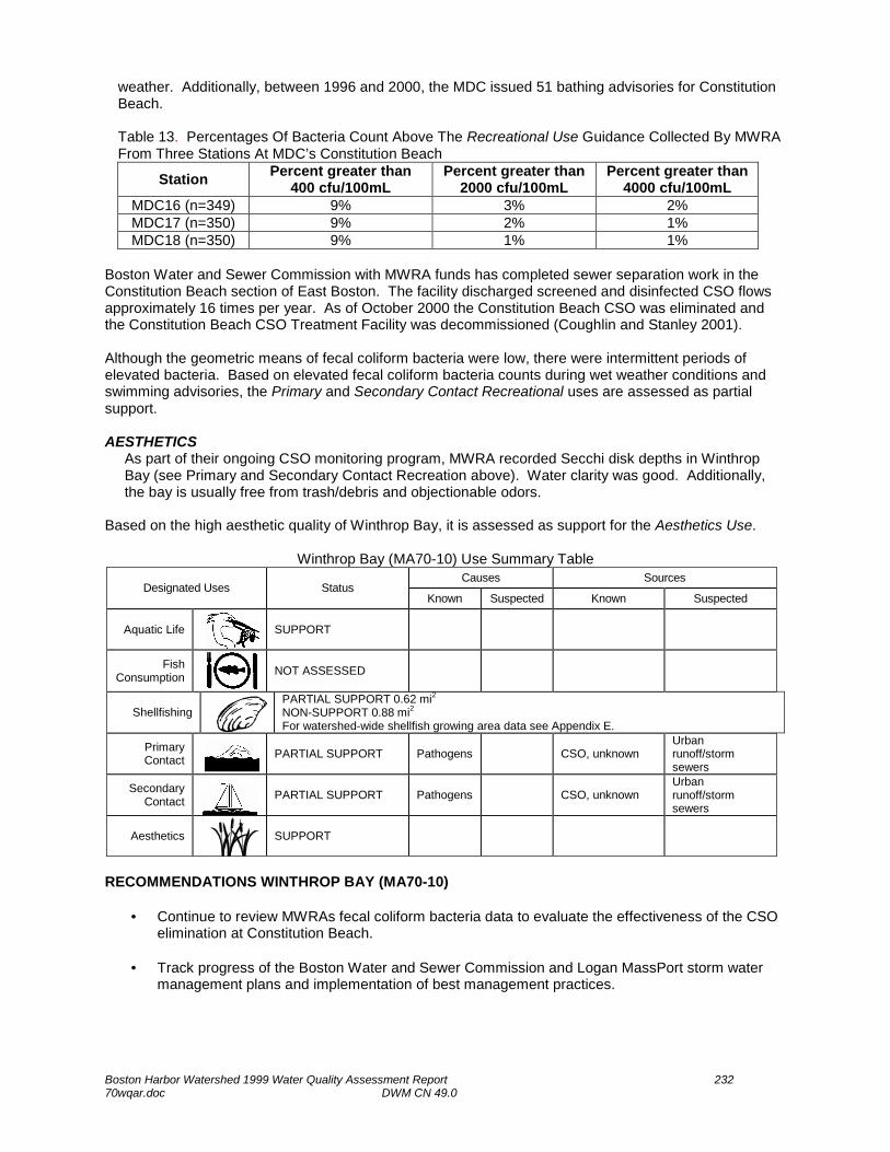
Boston Harbor Watershed 1999 Water Quality Assessment Report 232 70wqar.doc DWM CN 49.0
weather. Additionally, between 1996 and 2000, the MDC issued 51 bathing advisories for Constitution Beach. Table 13. Percentages Of Bacteria Count Above The Recreational Use Guidance Collected By MWRA From Three Stations At MDC’s Constitution Beach
Station Percent greater than 400 cfu/100mL
Percent greater than 2000 cfu/100mL
Percent greater than 4000 cfu/100mL
MDC16 (n=349) 9% 3% 2% MDC17 (n=350) 9% 2% 1% MDC18 (n=350) 9% 1% 1%
Boston Water and Sewer Commission with MWRA funds has completed sewer separation work in the Constitution Beach section of East Boston. The facility discharged screened and disinfected CSO flows approximately 16 times per year. As of October 2000 the Constitution Beach CSO was eliminated and the Constitution Beach CSO Treatment Facility was decommissioned (Coughlin and Stanley 2001). Although the geometric means of fecal coliform bacteria were low, there were intermittent periods of elevated bacteria. Based on elevated fecal coliform bacteria counts during wet weather conditions and swimming advisories, the Primary and Secondary Contact Recreational uses are assessed as partial support. AESTHETICS
As part of their ongoing CSO monitoring program, MWRA recorded Secchi disk depths in Winthrop Bay (see Primary and Secondary Contact Recreation above). Water clarity was good. Additionally, the bay is usually free from trash/debris and objectionable odors.
Based on the high aesthetic quality of Winthrop Bay, it is assessed as support for the Aesthetics Use.
Winthrop Bay (MA70-10) Use Summary Table Causes Sources
Designated Uses Status Known Suspected Known Suspected
Aquatic Life
SUPPORT
Fish Consumption
NOT ASSESSED
Shellfishing
PARTIAL SUPPORT 0.62 mi2 NON-SUPPORT 0.88 mi2 For watershed-wide shellfish growing area data see Appendix E.
Primary Contact
PARTIAL SUPPORT Pathogens CSO, unknown
Urban runoff/storm sewers
Secondary Contact
PARTIAL SUPPORT Pathogens CSO, unknown
Urban runoff/storm sewers
Aesthetics
SUPPORT
RECOMMENDATIONS WINTHROP BAY (MA70-10)
• Continue to review MWRAs fecal coliform bacteria data to evaluate the effectiveness of the CSO elimination at Constitution Beach.
• Track progress of the Boston Water and Sewer Commission and Logan MassPort storm water
management plans and implementation of best management practices.

Boston Harbor Watershed 1999 Water Quality Assessment Report 233 70wqar.doc DWM CN 49.0
BOSTON INNER HARBOR (MA70-02) Location: From the Mystic and Chelsea rivers, Chelsea/Boston, to the line between Governors Island and Fort Independence, East Boston/Boston (including Fort Point and Reserved channels, and Little Mystic River.) Segment Area: 2.3 square miles. Classification: Class SB, CSO* (* In the updated 2002 SWQS, this segment will be reclassified to SBCSO. See Classification section.) This segment is on the 1998 303(d) list of impaired waters for pathogens (MA DEP 1999a). There are four vessel sewage pump put facilities located within the Boston Inner Harbor: Boston Waterboat Marina, Long Wharf; Constitution Marina; Shipyard Quarters Marina; and Marina at Rowes Wharf (CZM 3 October 2001). In mid-summer 1998, the wastewater previously treated at the MWRA Nut Island facility was transferred, via a deep-rock tunnel, to the Deer Island facility. This transfer, through the ‘inter-island tunnel’, ended more than 50 years of discharges of primary treated wastewater to the South Harbor, and increased flows of secondary treated wastewater to the outer North Harbor. Wastewater is now discharged via a deep ocean outfall to Massachusetts Bay. In a Comparison of Water Quality in Boston Harbor Before and After Inter-island Transfer MWRA compared data collected from 14 sampling stations in Boston Harbor (north harbor and south harbor) before and after the inter-island transfer. In each region, sampling was conducted at two sets of stations: ‘outfall stations’ - in the immediate vicinity of the outfalls of the two treatment facilities and ‘receiving-water stations’ - located further afield, away from the outfalls. The report focused on three water quality issues: symptoms of eutrophication of the Boston Harbor water column (nutrient concentrations, standing stocks of phytoplankton, and dissolved oxygen), water clarity and concentrations of solids in the water column, and counts of sewage indicator bacteria in the water column (Taylor 2001). In the South Harbor, the region where the wastewater discharges were discontinued, nitrogen and Phosphorus concentrations were generally lower after transfer than before while in the North Harbor (the region that received the discharges added from Nut Island) N and P concentrations were generally greater after transfer than before. The spatial patterns of changes in water clarity within the two regions suggested that the effects of inter-island transfer were smaller for these variables than for N and P, and were focused around the outfalls in the regions. In both the South and North harbors, DO percent saturation values in the bottom waters were significantly lower after transfer. In the South Harbor, (at the former Nut Island outfalls and in the region), average counts of both fecal coliform and Enterococcus bacteria were lower after transfer. In the North Harbor, no significant increases in counts of either type of bacterium were observed at the Deer Island outfalls. The North Harbor as a whole, however, showed a significant decrease in Enterococcus, and two stations showed decreased counts of fecal coliform bacteria (Taylor 2001). WMA WATER WITHDRAWAL SUMMARY: There are no water withdrawals from this segment. SURFACE NPDES DISCHARGE SUMMARY: Boston Inner Harbor will be classified as SB CSO water body under the 2002 updated Massachusetts Surface Water Quality Standards. The discharge of CSO is authorized in accordance with the final CSO Facilities Plan. Thirty-six CSO outfalls were identified in the CSO Facilities Plan in the Inner Harbor (as defined in the WQS). These CSOs are permitted to MWRA, Boston Water & Sewer Commission, and the
WINC HESTER
EVERETT
CHELSEA
SOMERVILLECAMBRIDGE
SHARON
NORWOOD
WESTWOOD
STOUGHTON
HOLBROOK
RANDOLPH
BRAINTREE
WEYMOUTH
HINGHAM COHASSET
CANTON
MILTONQUINCY
LEXINGTON
BURLINGTON
READING
MELROSE
WOBURN
MALDENMEDFORD
MEDFIELD
STONEHAM
BOSTON
ARLINGTON
BELMONT
DEDHAM
WALPOLE
ROCKLAND
Boston Harbor WatershedBoston Harbor (Proper) Subwatershed
Boston Inner HarborMA70-02
N
From the Mystic and Chelsea rivers, Chelsea/Boston Governors Island
Fort Independence

Boston Harbor Watershed 1999 Water Quality Assessment Report 234 70wqar.doc DWM CN 49.0
City of Chelsea. The approved Facilities Plan includes a combination of sewer separation, CSO storage, and CSO treatment facilities. These improvements will eliminate seven of these CSO outfalls, and substantially mitigate CSO discharges at all other outfalls (CSO discharges to Constitution Beach have already been eliminated). The MWRA owns and operates two existing CSO treatment facilities in this subwatershed, which will remain active: the Prison Point and Somerville Marginal facilities. Two additional MWRA CSO treatment facilities will be constructed at Union Park at the Fort Point Channel in Boston and at the Reserved Channel in South Boston to treat CSO prior to discharge. Discharges from active CSO outfalls will be limited to the frequency and volume established for a typical year under recommended plan conditions in the approved CSO Facilities Plan; discharges from active untreated outfalls are expected to occur less than four times per year on an average basis when the planned facilities are constructed. Floatables controls will be provided for all active CSO outfalls. Under NPDES permit number MA0103284, MWRA is permitted (issued 2001) to discharge combined sewage from the Prison Point CSO Treatment Facility (MWR 203) to Boston Inner Harbor. The facility is required to conduct and report on the results of two whole effluent toxicity tests annually. This outfall also has average discharge event TRC limits of 0.1 mg/L. MWRA has upgraded the facility to improve treatment performance and meet new residual chlorine discharge limits. At this facility MWRA began using the upgraded chlorination and new dechlorination equipment in manual mode since October 2000. MWRA expects to complete improvement to this facility and have full system acceptance by Spring 2001 (Coughlin and Stanley 2001). In October 2000 and March 2001 the facility analyzed the TRC concentrations of their discharge, which were above the permit limit in 2000. Gillette Company – Safety Razor Division (MA0003832) is permitted to discharge 53.1 MGD of NCCW to this segment of Boston Harbor. The existing permit includes a maximum temperature limit of 83°F. The permit is currently (2001) being reissued with Gillette seeking an increase in flow. Massachusetts Highway Department (MA0033928) is permitted to discharge construction dewatering via 45 outfalls to Boston Harbor Proper. The permit includes both dry and wet weather monitoring requirements and limits. Under this permit, a SWPPP is required. The permit expires 21 December 2002. Massachusetts Bay Transit Authority (MBTA)- South Boston Piers/Transitway Project (MA0036781) is permitted to discharge construction dewatering via eight outfalls to Fort Port Channel. The permit has a TSS limit of 100 mg/L (average) and a 250 mg/L daily maximum: and a TPH limit of 5 mg/L. The permit also requires a Best Management Practices (BMP) Plan and expires 12 August 2002. Coastal Oil N.E. Inc., formerly known as Belcher of New England, (MA0004405) is permitted to discharge treated storm water via outfall 001 and 30 GPM of treated groundwater via outfall 002 to the Reserved Channel. The permit includes a TSS limit of 30 mg/L. The permit expires in 30 January 2005. New England Aquarium (MA0003123) is permitted to discharge 200,000 GPD of treated effluent to this segment of Boston Harbor. The permit includes limits for TSS (30mg/L), TRC (1.0 mg/L) and requires two whole effluent toxicity tests per year with an LC50 >100%. The permit expires January 2006. Seaboard Enterprises Inc. (MA0024988), Boston Shipyard (MA0003484), and the U.S. Navy Department Supervisor of Ships (MA0029424) are listed on the EPA October 2000 active list. All communities in the Boston Harbor Watershed (excluding Boston) are required to obtain Phase II NPDES storm water general permit coverage for their municipal drainage systems. EPA is currently writing this general permit (with input from MA DEP) and a preliminary draft is currently available for internal review. The draft for public comment should be available by the end of June 2002. The final version of the Phase II storm water general permit for regulated small municipal separate storm sewer systems (MS4) will be issued by December 9, 2002. The towns must submit applications for coverage under the permit to EPA by March 10, 2003 (Scarlet 2002). The Boston Water and Sewer Commission (the Commission) operates the separate storm drainage system serving the City of Boston. The Commission applied to EPA in 1993 for an NPDES storm water

Boston Harbor Watershed 1999 Water Quality Assessment Report 235 70wqar.doc DWM CN 49.0
individual permit for the system and received the permit in October 1999. The Commission operated drain system has 104 major and 102 lesser outfalls. The system currently serves 13.85 square miles of Boston. The remainder of Boston is served by combined sewers and the Commission is currently undertaking two major separation efforts under the MWRA CSO Control Plan. There are other public storm drains in the city owned by other state agencies such as the Massachusetts Department of Public Works, Massachusetts Turnpike Authority and the Metropolitan District Commission. While currently unpermitted, these other public agencies will be required to obtain coverage for outfalls from separate drainage they operate under an NPDES storm water general permit by March 10, 2003 (Scarlet 2002). USE ASSESSMENT AQUATIC LIFE Biology As part of the MWRA 2000 fish and shellfish monitoring program caged blue mussels (Mytilus edulis), from Rockport were deployed at Boston Inner Harbor to evaluate bioaccumulation potential. Mussel survival within the deployed arrays from Boston Inner Harbor was high (96%). The 2000 data were similar to previous years with the highest body burdens of contaminants observed in mussels deployed in Boston Inner Harbor. The 2000 contaminant levels (total PCBs, pesticides, total PAHs, mercury, and lead), like other monitoring years, were well below the federal action limits and indicate no risk for human consumption (Lefkovitz et al. 2001). Toxicity
Effluent In October 2000 and March 2001, MWRA Deer Island (MA0103284) conducted two whole effluent toxicity tests using the mysid shrimp, Mysidopsis bahia and the inland silverside, Menidia beryllina on the Prison Point CSO outfall. The CSO discharges were not acutely toxic to the shrimp or fish in either test event.
Chemistry - water As part of their ongoing CSO monitoring program, MWRA collected monthly surface and bottom water quality samples (DO, temperature, turbidity, Chlorophyll a and TSS) at seven sites on this segment between 1996 and 2000 (Coughlin 2001a):
• 014 Inner Harbor, mouth Charles, Coast Guard Base • 015 Inner Harbor, Confluence Mystic/ Chelsea Rivers • 018 Inner Harbor, Fort Point Channel at Summer Street • 019 Inner Harbor, off mouth of Fort Point Channel • 022 Inner Harbor, Reserved Channel Middle • 024 Inner Harbor, Mouth of Harbor, R Buoy 10 • 138 Inner Harbor, off New England Aquarium
DO Dissolved oxygen concentrations (at the seven stations) were below 5.0 mg/L on only 33 occasions (range 0.87-14.89 mg/L n=1,947). Percent saturations (range 9.79-152.4%; n=1,946) were below 75% on 202 occasions (10%) and above 115% on 57 occasions. No measurements were collected pre-dawn and, therefore, these data do not represent worst-case conditions.
Temperature All temperature readings (n=2,041) were below the SWQS for a class SB waterbody.
Turbidity Turbidity at the seven stations ranged from 0 to 424 NTU with an average of 6.28 NTU (n=1,026).
Chlorophyll a Chlorophyll a collected from stations 024 and 138 (n= 373) ranged from 0.15 to 49.6 µg/L.

Boston Harbor Watershed 1999 Water Quality Assessment Report 236 70wqar.doc DWM CN 49.0
Total Suspended Solids TSS concentrations at stations 024 and 138 (n=714) ranged from 0.5 to 12 mg/L in the surface and in the bottom concentrations ranged from 1.3 to 41.4 mg/L.
Water chemistry data collected at multiple stations over multiple years was generally within the SWQS for a Class SB waterbody, therefore, the Aquatic Life Use is assessed as support. However, because of the highly industrialized/developed nature of the Inner Harbor and multiple active CSO discharges, this segment is on “Alert Status”. FISH CONSUMPTION In 1998, MDPH issued an advisory concerning consumption of seafood from Boston Harbor, including Quincy Bay (Celona 2001):
“Lobster tomalley—all persons should eliminate consumption of the lobster tomalley (liver). This recommendation applies to tomalley from lobsters from any source due to the finding of abnormally high chemical contaminant levels… Boston Harbor Fishery Products—Pregnant and breast –feeding women, women who intend to become pregnant, children under the age of 12, and individuals with lowered immunity should avoid consuming certain fishery products from Boston Harbor. This applies to lobster, flounder, soft-shell clams and other bivalves…”
Based on the MDPH seafood fish consumption advisory for Boston Harbor, the Fish Consumption Use is assessed as non-support for this entire segment. SHELLFISHING
The DMF Shellfish Status Report of October 2000 indicates that shellfish growing area GBH4.0 and GBH6.0 are prohibited (DFWELE 2000b).
Based on the prohibited status of the shellfish growing areas, the Shellfishing Use is assessed as non-support for 2.3 mi2 of Boston Inner Harbor. PRIMARY CONTACT AND SECONDARY CONTACT RECREATION
MWRA collected fecal coliform bacteria samples at station 138 (n=376) and at station 024 (n=375) between 1996 and 2000 as part of their ongoing CSO monitoring program (Coughlin 2001b). At station 138 (near the New England Aquarium) fecal coliform bacteria counts ranged from <5 to 9,160 cfu/100mL (wet weather) with 20 counts above 400 cfu/100mL (5%). At station 024, the mouth of the Inner Harbor, fecal coliform bacteria counts ranged from <5 to 5,600 cfu/100mL (wet weather) with ten counts above 400 cfu/100mL (3%). Additionally, MWRA recorded Secchi disk depths at all seven of the water quality stations on this segment from 1996-2001(Coughlin 2001b). Secchi disk depths ranged from 0.5 to 5.6 m with 20 of the 932 measurements not meeting the SWQS of 1.2 m.
Fecal coliform bacteria levels were generally low at the two stations in Boston Inner Harbor. Exceedances were neither frequent nor prolonged; therefore, the Primary and Secondary Contact Recreational uses are assessed as support. The Inner Harbor is, however, on “Alert Status” due to large potential for bacterial contamination from this urban subwatershed (e.g., CSOs, storm water, and illicit sewer connections). AESTHETICS
As part of their ongoing CSO monitoring program, MWRA recorded Secchi disk depths in Boston Inner Harbor (see Primary and Secondary Contact Recreation above). Only infrequent excursions (2%) of the Secchi disk depth criterion were noted. More than 130 barrels of small debris, 300 pieces of large debris, and 30 pieces of piers and other oversized debris were collected between July 1, 2000 and September 15, 2000 during the pilot year of the Boston Harbor Marine Debris Salvage Program. Debris was collected from “high activity areas”

Boston Harbor Watershed 1999 Water Quality Assessment Report 237 70wqar.doc DWM CN 49.0
such as the downtown waterfront, the Charlestown Navy Yard, the East Boston waterfront, South Boston waterfront, the Outer Fort Point Channel, and Chelsea Creek. In 2001, the second year of this program, more than 57 tons were collected (East Boston 2000).
The Aesthetics Use is assessed as support because the trash and debris associated with this urban watershed is currently being managed by the Marine Debris Salvage Program. However, this segment is on “Alert Status” due to the quantity of trash and debris collected and the potential for aesthetic quality degradation.
Boston Inner Harbor (MA70-02) Use Summary Table Causes Sources
Designated Uses Status Known Suspected Known Suspected
Aquatic Life*
SUPPORT*
Fish Consumption
NON-SUPPORT Priority organics Unknown
Shellfishing
NON-SUPPORT 2.3 mi2 For watershed-wide shellfish growing area data see Appendix E.
Primary Contact*
SUPPORT*
Secondary Contact*
SUPPORT*
Aesthetics*
SUPPORT*
* “Alert Status” issues identified, see the Aquatic Life, Primary and Secondary Contact Recreation, and Aesthetics uses RECOMMENDATIONS BOSTON INNER HARBOR (MA70-02)
• Continue to review MWRAs fecal coliform bacteria data to evaluate the effectiveness of the CSO abatement program.
• Track progress of storm water management plans and implementation of best management
practices. • Work with local citizens to promote good stewardship of the waterfront including education
outreach programs and waterfront clean-ups. • Continue to support the Boston Harbor Marine Debris Salvage Program. • Review results of the MWRA’s Final 1998 CSO Sediment Synthesis Report.

Boston Harbor Watershed 1999 Water Quality Assessment Report 238 70wqar.doc DWM CN 49.0
WINCHESTER
EVERETT
CHELSEA
SOMERVILLECAMBRIDGE
SHARON
NORWOOD
WESTWOOD
STOUGHTON
HOLBROOK
RANDOLPH
BRAINTREE
WEYMOUTH
HINGHAM COHASSET
CANTON
MILTONQUINCY
LEXINGTON
BURLINGTON
READING
MELROSE
WOBURN
MALDENMEDFORD
MEDFIELD
STONEHAM
BOSTON
ARLINGTON
BELMON T
DEDHAM
WALPOLEROCKLAND
Boston Harbor WatershedBoston Harbor (Proper) Subwatershed
Pleasure BayMA70-11
NCastle Island
Head Island
PLEASURE BAY (SEGMENT MA70-11) Location: A semi-enclosed bay, the flow restricted through two channels between Castle and Head islands, Boston. Segment Area: 0.22 square miles. Classification: Class SB Shellfishing (Restricted). WMA WATER WITHDRAWAL AND SURFACE NPDES DISCHARGE SUMMARY: There are no regulated water withdrawals or wastewater discharges in this segment. The Boston Water and Sewer Commission (the Commission) operates the separate storm drainage system serving the City of Boston. The Commission applied to EPA in 1993 for an NPDES storm water individual permit for the system and received the permit in October 1999. The Commission operated drain system has 104 major and 102 lesser outfalls. The system currently serves 13.85 square miles of Boston. The remainder of Boston is served by combined sewers and the Commission is currently undertaking two major separation efforts under the MWRA CSO Control Plan. There are other public storm drains in the city owned by other state agencies such as the Massachusetts Department of Public Works, Massachusetts Turnpike Authority and the Metropolitan District Commission. While currently unpermitted, these other public agencies will be required to obtain coverage for outfalls from separate drainage they operate under an NPDES storm water general permit by March 10, 2003 (Scarlet 2002). USE ASSESSMENT FISH CONSUMPTION In 1998, MDPH issued an advisory concerning consumption of seafood from Boston Harbor, including Quincy Bay (Celona 2001):
“Lobster tomalley—all persons should eliminate consumption of the lobster tomalley (liver). This recommendation applies to tomalley from lobsters from any source due to the finding of abnormally high chemical contaminant levels… Boston Harbor Fishery Products—Pregnant and breast –feeding women, women who intend to become pregnant, children under the age of 12, and individuals with lowered immunity should avoid consuming certain fishery products from Boston Harbor. This applies to lobster, flounder, soft-shell clams and other bivalves…”
Based on the MDPH seafood fish consumption advisory for Boston Harbor, the Fish Consumption Use is assessed as non-support for this entire segment. SHELLFISHING
The DMF Shellfish Status Report of October 2000 indicates that shellfish growing area GBH3.7 is under a management closure (DFWELE 2000b).
Based on the management closure the Shellfishing Use is not assessed.

Boston Harbor Watershed 1999 Water Quality Assessment Report 239 70wqar.doc DWM CN 49.0
PRIMARY CONTACT AND SECONDARY CONTACT RECREATION The MWRA collected weekly fecal coliform bacteria samples at stations MDC20 Pleasure Bay, Broadway from 1996 to 2000 (Coughlin 2001b). At this station, bacteria counts (n=183) ranged from <5 to 1,440 cfu/100mL (dry weather). On only five occasions bacteria counts were greater than 400 cfu/100mL (3%). Additionally, between 1996 and 2000, the MDC issued 15 bathing beach advisories for Pleasure Bay beach (Coughlin and Stanley 2001).
Since there were 15 bathing beach advisories issued for Pleasure Bay, the Primary Contact Recreational Use is assessed as partial support. However, based on the fact that no fecal coliform bacteria counts were greater than 2,000 cfu/100mL, the Secondary Contact Recreational Use is assessed as support.
Pleasure Bay (MA70-11) Use Summary Table Causes Sources
Designated Uses Status Known Suspected Known Suspected
Aquatic Life
NOT ASSESSED
Fish Consumption
NON-SUPPORT Priority organics Unknown
Shellfishing
NOT ASSESSED For watershed-wide shellfish growing area data see Appendix E.
Primary Contact
PARTIAL SUPPORT Pathogens Unknown Urban runoff/storm sewers
Secondary Contact
SUPPORT
Aesthetics
NOT ASSESSED
RECOMMENDATIONS PLEASURE BAY (MA70-11)
• Continue to review MWRAs fecal coliform bacteria data to evaluate the effectiveness of the CSO abatement program.
• Track progress of the Boston Water and Sewer, MWRA, and municipal storm water management
plans and implementation of best management practices.
• Work with local citizens to promote good stewardship of the waterfront including education outreach programs and waterfront clean-ups.

Boston Harbor Watershed 1999 Water Quality Assessment Report 240 70wqar.doc DWM CN 49.0
DORCHESTER BAY (SEGMENT MA70-03) Location: From the mouth of the Neponset River, Boston/Quincy to the line between Head Island and the north side of Thompson Island and the line between the south point of Thompson Island and Chapel Rocks, Boston/Quincy. Segment Area: 4.6 square miles. Classification: Class SB Shellfishing (Restricted), CSO*. (* In the updated 2002 SWQS, the CSO designation will be removed from Dorchester Bay. See Classification section.) This segment is on the 1998 303(d) list of impaired waters for pathogens (MA DEP 1999a). There is one vessel sewage pump-out facility located at Marina Bay on this segment (CZM 3 October 2001). In a Comparison of Water Quality in Boston Harbor Before and After Inter-island Transfer MWRA presents data collected from 14 sampling stations in Boston Harbor divided into two regions (north harbor and south harbor). In each region, sampling was conducted at two sets of stations: ‘outfall stations’ - in the immediate vicinity of the outfalls of the two treatment facilities and ‘receiving-water stations’ - located further afield, away from the outfalls. The report focused on three water quality issues: symptoms of eutrophication of the Boston Harbor water column (nutrient concentrations, standing stocks of phytoplankton, and dissolved oxygen), water clarity and concentrations of solids in the water column, and counts of sewage indicator bacteria in the water column (Taylor 2001). WMA WATER WITHDRAWAL There are no regulated water withdrawals from this segment. SURFACE NPDES DISCHARGE SUMMARY: In northern Dorchester Bay, there are presently seven CSO outfalls which discharge to areas adjacent to Carson and L Street Beaches. The approved CSO plan includes construction of a consolidation and storage conduit, which will eliminate these CSO discharges. The conduit is also being sized to collect storm water runoff presently discharging to the beach areas, which are contributing to use impairments. Flows in excess of the storage capacity will be discharged after treatment to the Reserved Channel. The project, however, has encountered serious permitting difficulties and is behind the court schedule at this time. MWRA is presently developing additional planning level documents, which will be subject to public environmental review in the MEPA process, to assess the feasibility of the existing approved plan and other CSO control alternatives (Brander 2001a). In southern Dorchester Bay, MWRA currently owns and operates the Fox Point (MWR 209) and Commercial Point (MWR 211) CSO Treatment Facilities. These facilities provide screening, chlorination and dechlorination of CSO flows prior to discharges to Dorchester Bay. The MWRA, in coordination with the Boston Water and Sewer Commission and in accordance with the approved CSO Facilities Plan, Federal Court Order, and Water Quality Standards is proceeding with a sewer separation program in the sewersheds tributary to these facilities, which will ultimately eliminate CSO discharges through these facilities. These facilities are therefore considered interim facilities, which will remain in operation until the extensive sewer separation work necessary to eliminate CSO discharges is completed in November 2008 (Brander 2001a). Under NPDES permit number MA0103284, MWRA is permitted (issued 2001) to discharge combined sewage from the Fox Point CSO Treatment Facility (MWR 209) and the Commercial Point CSO
WINC HESTER
EVERETT
CHELSEA
SOMERVILLECAMBRIDGE
SHARON
NORWOOD
WESTWOOD
STOUGHTON
HOLBROOK
RANDOLPH
BRAINTREE
WEYMOUTH
HINGHAM COHASSET
CANTON
MILTONQUINCY
LEXINGTON
BURLINGTON
READING
MELROSE
WOBURN
MALDENMEDFORD
MEDFIELD
STONEHAM
BOSTON
ARLINGTON
BELMONT
DEDHAM
WALPOLE
ROCKLAND
Boston Harbor WatershedBoston Harbor (Proper) Subwatershed
Dorchester BayMA70-03
N
From the mouth of the Neponset River, Boston/Quincy
Head Island
Thompson Island
Chapel Rocks

Boston Harbor Watershed 1999 Water Quality Assessment Report 241 70wqar.doc DWM CN 49.0
Treatment Facility (MWR 211) to Dorchester Bay. The facilities are required to conduct and report on the results of two whole effluent toxicity tests annually from each outfall. These outfalls also have average discharge event TRC limits of 0.1 mg/L. MWRA has upgraded both CSO treatment facilities through the construction of new chlorination and dechlorination buildings. Boston Water & Sewer Commission (BWSC) (MA01011992) is permitted to discharge combined sewage via seven outfalls (BOS 081 through BOS 087) to North Dorchester Bay. [It should be noted that BWSC outfalls 088 and 089 are the same as MWRA’s outfalls 209 and 211.] BWSC has historically discharged 9.03 MG of untreated CSO discharge to Dorchester Bay-North via outfalls BOS 081-BOS 087. These outfalls will be eliminated under the MWRA North Dorchester Bay/Reserved Channel CSO Project as part of the approved 1997 MWRA CSO Facilities Plan. The Boston Water and Sewer Commission (the Commission) operates the separate storm drainage system serving the City of Boston. The Commission applied to EPA in 1993 for an NPDES storm water individual permit for the system and received the permit in October 1999. The Commission operated drain system has 104 major and 102 lesser outfalls. The system currently serves 13.85 square miles of Boston. The remainder of Boston is served by combined sewers and the Commission is currently undertaking two major separation efforts under the MWRA CSO Control Plan. There are other public storm drains in the city owned by other state agencies such as the Massachusetts Department of Public Works, Massachusetts Turnpike Authority and the Metropolitan District Commission. While currently unpermitted, these other public agencies will be required to obtain coverage for outfalls from separate drainage they operate under an NPDES storm water general permit by March 10, 2003 (Scarlet 2002). USE ASSESSMENT AQUATIC LIFE Biology MWRA began its studies of infaunal communities and benthic habitats in Boston Harbor in 1991, just prior to the cessation of sludge dumping into the Harbor (Kropp et al. 2000). In 1998 sediments at station T04, inner Dorchester Bay, appeared to be hypoxic with gas voids indicative of high rates of bacterial activity and organic matter. Benthic habitat conditions improved at this station in 1999. Station T04 appeared to be organically enriched with dark-gray silty sediments. The benthic community structure at station T04 consistently showed signs of being the most stressed of all harbor stations, probably resulting from physical processes and high rates of sediment accumulation and organic enrichment. Organic content of sediment was highest of all MWRA’s stations at T04. Values for infaunal abundance, species numbers, diversity, and evenness in April and August 1999 generally were similar to those estimated for the previous two years. Toxicity
Effluent In March 2001, MWRA Deer Island (MA0103284) conducted two whole effluent toxicity tests using the mysid shrimp, M. bahia and the inland silverside, M. beryllina on both the Fox Point and on the Commercial Point CSO outfalls. The CSO discharges were not acutely toxic to the shrimp or fish in either test event from either outfall.
Chemistry - water As part of their ongoing CSO monitoring program, MWRA collected monthly water quality samples (DO, temperature, turbidity, Chlorophyll a and TSS) at six sites on this segment of Dorchester Bay between 1996 and 2000 (Coughlin 2001b):
• 033, North Dorchester Bay, Carson Beach off L St. • 036, North Dorchester Bay, Carson Beach off Bathhouse • 038, Northern Dorchester Bay • 040, South Dorchester Bay, Malibu Bay • 084, South Dorchester Bay, Columbia Pt at Buoy 12 • 140, South Dorchester Bay, Columbia Point/Savin Hill Cove

Boston Harbor Watershed 1999 Water Quality Assessment Report 242 70wqar.doc DWM CN 49.0
DO Dissolved oxygen concentrations were not below 5.0 mg/L at any station in the surface or bottom waters during the sampling events (range 5.09 – 15.45 mg/L; n=1,107). Percent saturation levels were never below 60% (range 65.1 – 144.6%; n=1,114) and were above 115% on 72 occasions (6%). No samples were collected pre-dawn and, therefore, do not represent a worst-case scenario.
Temperature All temperature readings (n=1,150) were below the SWQS for a class SB waterbody.
Turbidity Turbidity ranged from 0 to 114 NTU with an average of 5.84 NTU (n=576).
Chlorophyll a Chlorophyll a samples were collected on 366 occasions at station 140. Concentrations ranged from 0.3 to 49.2 µg/L.
Total Suspended Solids TSS samples were collected on 359 occasions at station 140. Concentrations ranged from 0.3 to 39.2 mg/L with only one greater than 25 mg/L.
Although the benthic community structure showed signs of stress (at the one MWRA sampling location), water chemistry data from the six sampling locations in Dorchester Bay identified no obvious signs of water quality impairment. The Aquatic Life Use is, therefore, assessed as support for the entire 4.6 mi2 of Dorchester Bay. The Bay is, however, on “Alert Status” due to the possible nutrient and sediment inputs from multiple CSOs. FISH CONSUMPTION In 1998, MDPH issued an advisory concerning consumption of seafood from Boston Harbor, including Quincy Bay (Celona 2001):
“Lobster tomalley—all persons should eliminate consumption of the lobster tomalley (liver). This recommendation applies to tomalley from lobsters from any source due to the finding of abnormally high chemical contaminant levels… Boston Harbor Fishery Products—Pregnant and breast –feeding women, women who intend to become pregnant, children under the age of 12, and individuals with lowered immunity should avoid consuming certain fishery products from Boston Harbor. This applies to lobster, flounder, soft-shell clams and other bivalves…”
Based on the MDPH seafood fish consumption advisory, the Fish Consumption Use is assessed as non-support for Dorchester Bay. SHELLFISHING
The DMF Shellfish Status Report of October 2000 indicates that shellfish growing area GBH3.2 is conditionally restricted, shellfish growing area GBH3.6 is closed seasonally for management, and shellfish growing areas GBH3.0, GBH3.3, and GBH3.5 are prohibited (DFWELE 2000b).
Based on the status of the shellfish growing areas in Dorchester Bay, 0.52 mi2 are assessed as partial support, 4.03 mi2 are assessed as non-support. Due to the management closure, 0.05 mi2 of Dorchester Bay are not assessed at this time. . PRIMARY CONTACT AND SECONDARY CONTACT RECREATION
Dorchester Bay receives the flow from ten BWSC CSO outfalls and from two MWRA CSO Treatment facilities. The MWRA collected 366 fecal coliform bacteria samples from south Dorchester Bay, Columbia Point/Savin Hill Cove (station 140) between 1996 and 2000 as part of their ongoing CSO monitoring program. Fecal coliform bacteria counts ranged from <5 to 9,160 cfu/100mL with 20 counts above 400 cfu/100mL (5%) and only one above 4,000 cfu/100mL. As part of this project, MWRA also recorded Secchi disk depths at the six water quality stations (033, 036, 038, 040, 084, and 140)

Boston Harbor Watershed 1999 Water Quality Assessment Report 243 70wqar.doc DWM CN 49.0
throughout this segment of Dorchester Bay. Secchi disk depths ranged from 0.4 to 3.9 m with 124 of the 657 measurements less than 1.2 m (19%). It should be noted that on 40 occasions the Secchi disk was seen all the way to the bottom (Coughlin 2001b). As part of the MWRA/MDC bathing beach monitoring, weekly fecal coliform bacteria samples were collected during the primary contact recreation season (1996 through 2000) at six stations within this segment: MDC21, Carson Beach, M Street; MDC22, Carson Beach at I St.; MDC23, Carson Beach Bathhouse; MDC24, Malibu Beach Bathhouse; MDC25, Savin Hill Beach Bayside; MDC39, Beades Bridge (Coughlin 2001a). Percentages of counts above the Primary and Secondary Recreational Use guidance are presented below in Table 14. At these stations, bacteria counts ranged from <5 to 47,200 cfu/100mL (n=1,277). On 12 occasions bacteria counts were greater than 4,000 cfu/100mL (1%). The majority of these high bacteria counts were associated with wet weather. Table 14. Percentages Of Bacteria Count Above The Recreational Use Guidance Collected By MWRA From Six Stations At MDC’s Bathing Beaches.
Station Percent greater than 400 cfu/100mL
Percent greater than 2000 cfu/100mL
Percent greater than 4000 cfu/100mL
MDC21 (n=355) 3% <1% 0 MDC22 (n=353) 7% <1% <1% MDC23 (n=354) 7% 2% 2% MDC24 (n=81) 12% 5% 1% MDC25 (n=77) 13% 5% 4% MDC39 (n=57) 12% 5% 0
Additionally, between 1996 and 2000, the MDC issued 28 bathing beach advisories for Carson Beach (averaged data from three stations), 24 advisories for Malibu Beach (one station), and 27 advisories for Savin Hill Beach (one station) (Coughlin and Stanley 2001).
Although the geometric means of fecal coliform bacteria were low, there were intermittent periods of elevated bacteria. Based on elevated fecal coliform bacteria counts during wet weather conditions (CSOs), poor water clarity (Secchi disk transparency) and swimming advisories, the Primary and Secondary Contact Recreational uses are assessed as partial support. AESTHETICS
Dorchester Bay presently receives the flow from seven BWSC CSO outfalls and from two MWRA CSO Treatment facilities. MWRAs turbidity and TSS samples from six sites on Dorchester Bay indicated relatively low turbidity, however, Secchi disk depth transparencies were frequently below 1.2 m (Coughlin 2001a). Additionally, sunken barges and trash/debris have been observed at various locations on this segment (Chretien 2002).
Based on the intermittent low water clarity of Dorchester Bay, and the negative impacts of multiple CSO discharges, and intermittent areas of trash and debris, the Aesthetic Use is assessed as partial support.

Boston Harbor Watershed 1999 Water Quality Assessment Report 244 70wqar.doc DWM CN 49.0
Dorchester Bay (MA70-03) Use Summary Table
Causes Sources Designated Uses Status
Known Suspected Known Suspected
Aquatic Life*
SUPPORT*
Fish Consumption
NON-SUPPORT Priority organics Unknown
Shellfishing
PARTIAL SUPPORT 0.52 mi2 NON-SUPPORT 4.03 mi2 NOT ASSESSED 0.05 mi2 For watershed-wide shellfish growing area data see Appendix E.
Primary Contact
PARTIAL SUPPORT Pathogens CSO
Secondary Contact
PARTIAL SUPPORT Pathogens CSO
Aesthetics
PARTIAL SUPPORT Turbidity, suspended solids, trash and debris CSO
* “Alert Status” Issues identified – see Aquatic Life Use Assessment RECOMMENDATIONS DORCHESTER BAY (SEGMENT MA70-03)
• Continue to review MWRAs fecal coliform bacteria data to evaluate water quality and the effectiveness of CSO abatement projects.
• Work with local citizens to promote good stewardship of the waterfront including education
outreach programs and waterfront clean-ups. • The benthic substrates near the Fox Point CSO discharge appear to be suffering the impacts of
increased nutrients and hypoxic sediments. Conduct water column nutrient monitoring in Dorchester Bay to determine if sediments are also increasing the water column nutrient levels.
• Track progress of Boston Water and Sewer storm water management programs and
implementation of best management practices.
• Review results of the MWRA’s Final 1998 CSO Sediment Synthesis Report.

Boston Harbor Watershed 1999 Water Quality Assessment Report 245 70wqar.doc DWM CN 49.0
QUINCY BAY (SEGMENT MA70-04) Location: From Bromfield Street near the Wallaston Yacht Club, Quincy, northeast to N42.2781 W70.9941, southeast to N42.2735 W70.9678, and south to Newton Street on the northerly shore of Houghs Neck, Quincy. Segment Area: 1.0 square miles. Classification: Class SA, Shellfishing (Open), CSO*. (* In the next SWQS, the CSO designation will be removed from Quincy Bay. See Classification section.) This segment is on the 1998 303(d) list of impaired waters for pathogens (MA DEP 1999a). In a Comparison of Water Quality in Boston Harbor Before and After Inter-island Transfer MWRA presents data collected from 14 sampling stations in Boston Harbor divided into two regions (north harbor and south harbor). In each region, sampling was conducted at two sets of stations: ‘outfall stations’ - in the immediate vicinity of the outfalls of the two treatment facilities and ‘receiving-water stations’ - located further afield, away from the outfalls. The report focused on three water quality issues: symptoms of eutrophication of the Boston Harbor water column (nutrient concentrations, standing stocks of phytoplankton, and dissolved oxygen), water clarity and concentrations of solids in the water column, and counts of sewage indicator bacteria in the water column (Taylor 2001). WMA WATER WITHDRAWAL AND SURFACE NPDES DISCHARGE SUMMARY: There are no regulated water withdrawals or wastewater discharges in this segment. However, all communities in the Boston Harbor Watershed (excluding Boston) are required to obtain Phase II NPDES storm water general permit coverage for their municipal drainage systems. EPA is currently writing this general permit (with input from DEP) and a preliminary draft is currently available for internal review. The draft for public comment should be available by the end of June 2002. The final version of the Phase II storm water general permit for regulated small municipal separate storm sewer systems (MS4) will be issued by December 9, 2002. The towns must submit applications for coverage under the permit to EPA by March 10, 2003 (Scarlet 2002). USE ASSESSMENT AQUATIC LIFE Chemistry – water As part of their ongoing receiving water monitoring program, MWRA collected monthly water quality samples (DO, temperature, turbidity, Chlorophyll a and TSS) at station 077, Quincy Bay, off Merrymount Park (Coughlin 2001a):
DO Dissolved oxygen concentrations were only below 5.0 mg/L in the surface or bottom waters on two occasions (range 0.59 – 14.26 mg/L; n=341). Additionally, percent saturation levels were below 60% on only one occasion and above 115% on 19 occasions (range 7.8 – 148.5%; n=341). No measurements were collected pre-dawn and, therefore, do not represent a worst-case scenario.
Temperature All temperature readings (n=362) were below the SWQS for a class SB waterbody.
WINCHESTER
EVERETT
CHELSEA
SOMERVILLECAMBRI DGE
SHARON
NORWOOD
WESTWOOD
STOUGHTON
HOLBROOK
RANDOLPH
BRAINTREE
WEYMOUTH
HINGHAM COHASSET
CANTON
MILTONQUINCY
LEXINGTON
BURLINGTON
READING
MELROSE
WOBURN
MALDENMEDFORD
MEDFIELD
ST ONEHAM
BOSTON
ARLINGTON
BELMONT
DEDHAM
WALPOLE
ROCKLAND
Bromfield Street, Quincy
N42.2781 W70.9941 N42.2735 W70.9678
Newton Street,Quincy
Boston Harbor WatershedBoston Harbor (Proper) Subwatershed
Quincy BayMA70-04
N

Boston Harbor Watershed 1999 Water Quality Assessment Report 246 70wqar.doc DWM CN 49.0
Turbidity Turbidity measurements were recorded on 183 occasions in the surface and bottom waters. Levels ranged between 0 and 503 NTU with an average of 7.94 NTU.
Chlorophyll a Chlorophyll a samples were collected on 367 occasions. Concentrations in the surface and bottom waters ranged from 0.16 to 27.1 µg/L.
Total Suspended Solids TSS samples were collected on 351 occasions. Concentrations in the surface and bottom waters ranged from 0.5 to 75 mg/L with only three greater than 25 mg/L.
The water quality monitoring data (i.e., DO, temperature, turbidity) collected over multiple years indicated no extreme or prolonged violations of the SWQS for a Class SB waterbody, therefore, this segment of Quincy Bay is assessed as support for the Aquatic Life Use. FISH CONSUMPTION In 1998, MDPH issued an advisory concerning consumption of seafood from Boston Harbor, including Quincy Bay (Celona 2001):
“Lobster tomalley—all persons should eliminate consumption of the lobster tomalley (liver). This recommendation applies to tomalley from lobsters from any source due to the finding of abnormally high chemical contaminant levels… Boston Harbor Fishery Products—Pregnant and breast –feeding women, women who intend to become pregnant, children under the age of 12, and individuals with lowered immunity should avoid consuming certain fishery products from Boston Harbor. This applies to lobster, flounder, soft-shell clams and other bivalves…”
Based on the MDPH seafood fish consumption advisory for Boston Harbor, the Fish Consumption Use is assessed as non-support for this entire segment. SHELLFISHING
The DMF Shellfish Status Report of October 2000 indicates that shellfish growing areas GBH2.1 and GBH2.2 are conditionally restricted and shellfish growing area GBH2.0 is prohibited (DFWELE 2000b).
Based on the shellfish growing area data, the Shellfishing Use is assessed as partial support for 0.36 mi2 and non-support for 0.64 mi2 of this segment of Quincy Bay. PRIMARY CONTACT AND SECONDARY CONTACT RECREATION
Also as part of their ongoing receiving water monitoring program, MWRA collected fecal coliform bacteria samples from station 077, Quincy Bay, off Merrymount Park (Coughlin 2001a) from 1996-2000. Fecal coliform bacteria levels (n=374) ranged from <5 to 11,100 cfu/100mL (wet weather). Bacteria counts were above 400 cfu/100mL on 23 occasions and were greater than 4,000 cfu/100mL on only two occasions. Samples were collected during both wet and dry weather conditions. Additionally, 201 Secchi depth readings were recorded between 1996 and 2001 ranging from 0.7 to 4.8 m. Secchi disk readings were less than the SWQS of 1.2 m on only 12 occasions and could be seen all the way to the bottom on 18 occasions.
Based on multiple years of low fecal coliform bacteria counts during both wet and dry weather conditions and good water clarity the Primary and Secondary Contact Recreational uses are assessed as support for this segment of Quincy Bay. AESTHETICS
MWRAs turbidity and TSS samples and Secchi disk depth from station 077, Quincy Bay, off Merrymount Park indicated relatively low turbidity with good water clarity (Coughlin 2001a).

Boston Harbor Watershed 1999 Water Quality Assessment Report 247 70wqar.doc DWM CN 49.0
Based on the good water quality and overall high aesthetic quality of this segment of Quincy Bay the Aesthetic Use is assessed as support.
Quincy Bay (MA70-04) Use Summary Table
Causes Sources Designated Uses Status
Known Suspected Known Suspected
Aquatic Life
SUPPORT
Fish Consumption
NON-SUPPORT Priority organics Unknown
Shellfishing
PARTIAL SUPPORT 0.36 mi2 NON-SUPPORT 0.64 mi2 For watershed-wide shellfish growing area data see Appendix E.
Primary Contact
SUPPORT
Secondary Contact
SUPPORT
Aesthetics
SUPPORT
RECOMMENDATIONS QUINCY BAY (MA70-04)
• Continue to review MWRAs fecal coliform bacteria data when assessing the recreational uses. • Track progress of municipal storm water management plans and implementation of best
management practices. • Investigate storm drain system to determine if illegal connections may be contributing bacteria to
Quincy Bay.

Boston Harbor Watershed 1999 Water Quality Assessment Report 248 70wqar.doc DWM CN 49.0
QUINCY BAY (SEGMENT MA70-05) Location: Quincy Bay, north of the class SA waters (segment MA70-04), Quincy to the line between Moon Head and Nut Island, Quincy Segment Area: 4.7 square miles. Classification: Class SB, Shellfishing (Restricted), CSO*. (* In the next SWQS, the CSO designation will be removed from Quincy Bay. See Classification section.) This segment is on the 1998 303(d) list of impaired waters for pathogens (MA DEP 1999a). WMA WATER WITHDRAWAL There are no regulated water withdrawals from this segment. SURFACE NPDES DISCHARGE SUMMARY: MWRA Nut Island Headworks (MA0103268) is permitted to discharge storm water via outfalls 001 and 002 to Quincy Bay and Boston Harbor. This permit expired 14 December 1997. This facility discharged approximately 270 MGD of primary treated sanitary sewage into Quincy Bay. Discharges ended in July 1998 when the plant was converted to a headworks facility and flows were transferred to Deer Island (Coughlin and Stanley 2001). All communities in the Boston Harbor Watershed (excluding Boston) are required to obtain Phase II NPDES storm water general permit coverage for their municipal drainage systems. EPA is currently writing this general permit (with input from DEP) and a preliminary draft is currently available for internal review. The draft for public comment should be available by the end of June 2002. The final version of the Phase II storm water general permit for regulated small municipal separate storm sewer systems (MS4) will be issued by December 9, 2002. The towns must submit applications for coverage under the permit to EPA by March 10, 2003 (Scarlet 2002). USE ASSESSMENT AQUATIC LIFE Biology MWRA began its studies of infaunal communities and benthic habitats in Boston Harbor in 1991, just prior to the cessation of sludge dumping into the Harbor (Kropp et al. 2000). Sampling was conducted at one station, T07, on this segment of Quincy Bay. Values for infaunal abundance, species numbers, diversity, and evenness in April and August 1999 generally were similar to those estimated for the previous two years. Chemistry - water As part of their ongoing receiving water monitoring program, MWRA collected monthly water quality samples (DO, temperature, turbidity, Secchi, Chlorophyll a and TSS) at two sites on this segment of Quincy Bay between 1996 and 2000 (Coughlin 2001a): 047, Quincy Bay, Wollaston Beach at Sachem St.; 139, Quincy Bay, Hangmans Island.
DO Dissolved oxygen concentrations were not below 5.0 mg/L at either station in the surface or bottom waters during any of the sampling events (range 5.51 – 13.68 mg/L; n=497). Additionally, percent saturation levels were not below 60%, however, they were above 115% on 22 occasions
WINCHESTER
EVERETT
CHELSEA
SOMERVILLECAMBRIDGE
SHARON
NORWOOD
WESTWOOD
STOUGHTON
HOLBROOK
RANDOLPH
BRAINTREE
WEYMOUTH
HINGHAM COHASSET
CANTON
MILTONQUINCY
LEXINGTON
BURLINGTON
READING
MELROSE
WOBURN
MALDENMEDFORD
MEDFIELD
ST ONEHAM
BOSTON
ARLINGTON
BELMONT
DEDHAM
WALPOLE
ROCKLAND
Boston Harbor WatershedBoston Harbor (Proper) Subwatershed
Quincy BayMA70-05
N
Moon Head
Nut Island
SA waters

Boston Harbor Watershed 1999 Water Quality Assessment Report 249 70wqar.doc DWM CN 49.0
(range 69.5 – 134.2; n=497). No measurements were collected pre-dawn and, therefore, do not represent a worst-case scenario.
Temperature All temperature readings (n=532) were below the SWQS for a class SB waterbody.
Turbidity Turbidity measurements were taken on 267 occasions. Levels ranged between 0 and 799.4 NTU with an average of 7.18 NTU.
Chlorophyll a Chlorophyll a measurements were taken on 366 occasions. Concentrations ranged from 0.24 to 26.99 µg/L.
Total Suspended Solids TSS concentrations were collected on 359 occasions. Concentrations ranged from 0.5 to 48.2 mg/L with only two greater than 25 mg/L.
The water quality monitoring data (i.e., DO, temperature, turbidity) collected over multiple years indicated no extreme or prolonged violations of the SWQS for a Class SB waterbody, therefore, this segment of Quincy Bay is assessed as support for the Aquatic Life Use. FISH CONSUMPTION
In 1998, MDPH issued an advisory concerning consumption of seafood from Boston Harbor, including Quincy Bay (Celona 2001):
“Lobster tomalley—all persons should eliminate consumption of the lobster tomalley (liver). This recommendation applies to tomalley from lobsters from any source due to the finding of abnormally high chemical contaminant levels… Boston Harbor Fishery Products—Pregnant and breast –feeding women, women who intend to become pregnant, children under the age of 12, and individuals with lowered immunity should avoid consuming certain fishery products from Boston Harbor. This applies to lobster, flounder, soft-shell clams and other bivalves…”
Based on the MDPH seafood fish consumption advisory for Boston Harbor, the Fish Consumption Use is assessed as non-support for this entire segment.
SHELLFISHING
The DMF Shellfish Status Report of October 2000 indicates that shellfish growing area GBH2.5 is conditionally restricted and shellfish growing areas GBH2.0, GBH2.3, GBH2.4, GBH2.6, and GBH2.7 are prohibited (DFWELE 2000b).
Based on shellfish growing area status, the Shellfishing Use is assessed as partial support 0.2 mi2 and non-support for 4.5 mi2 of this segment of Quincy Bay. PRIMARY CONTACT AND SECONDARY CONTACT RECREATION
As part of their receiving water monitoring program, MWRA collected fecal coliform bacteria samples and recorded Secchi disk depths at the two water quality stations on this segment of Quincy Bay (Coughlin 2001a). Fecal coliform bacteria counts (n=512) ranged from <5 to 7,100 cfu/100mL (wet weather). Bacteria counts were greater than 400 cfu/100mL on 16 occasions and greater than 4,000 cfu/100mL on only two occasions. Secchi disk depth readings (n=310) ranged from 0.9 to 5.1m and were less than the SWQS of 1.2 m on only nine occasions. It should be noted that on 16 occasions the Secchi disk could be seen all the way to the bottom The MWRA also collected weekly fecal coliform bacteria samples between 12 June 1996 and 21 September 2000 at four sites at Wollaston Beach: MDC29, Milton St.; MDC30, Sachem St.; MDC31, Channing St.; MDC32, Rice St. Percentages of counts above the Primary and Secondary

Boston Harbor Watershed 1999 Water Quality Assessment Report 250 70wqar.doc DWM CN 49.0
Recreational Use guidance are presented below in Table 15. At the four stations, bacteria counts ranged from <5 to 66,000 cfu/100mL (n=1605). Forty-nine bacteria counts were greater than 4,000 cfu/100mL. It should be noted that the high bacteria counts were generally not associated with wet weather. Bacteria counts were slightly lower at station MDC32 at Rice Street on Wollaston Beach.
Table 15. Percentages Of Bacteria Count Above The Recreational Use Guidance Collected By MWRA From Six Stations At MDC’s Bathing Beaches.
Station Percent greater than 400 cfu/100mL
Percent greater than 2000 cfu/100mL
Percent greater than 4000 cfu/100mL
MDC29 (n=398) 18% 7% 4% MDC30 (n=402) 22% 8% 4% MDC31 (n=404) 23% 6% 3% MDC32 (n=401) 23% 6% 3%
Additionally, between 1996 and 2000, the MDC issued 593 bathing beach advisories for Wollston Beach (Coughlin and Stanley 2001). It should be noted that eight storm drains that drain residential areas of East Quincy, discharge directly onto Wollaston Beach. The City of Quincy has spent more than $24 million on surveys, repairs, and rehabilitation to the sewer and storm drain system in the area of Wollaston Beach since 1994. Sewers near Rice Road were completely separated from the storm drains in 1997 and since 1998 extensive projects undertaken by the City include repairing cracked sewer lines and service connections, cleaning of outfalls, and increasing street and catch basin cleaning during the summer season. Additionally, prior to July 1998, this segment received approximately 270 MGD of primary treated sanitary sewage from the MWRA Nut Island Treatment Plant. The discharge is now conveyed through the inter-basin tunnel to the Deer Island WWTP and is discharged to Massachusetts Bay (Coughlin and Stanley 2001).
Based on the frequency of elevated fecal coliform bacteria counts during dry weather conditions and bathing beach closures the Primary and Secondary Contact Recreational uses are assessed as non-support.
Quincy Bay (MA70-05) Use Summary Table Causes Sources
Designated Uses Status Known Suspected Known Suspected
Aquatic Life*
SUPPORT*
Fish Consumption
NON-SUPPORT Priority organics Unknown
Shellfishing
PARTIAL SUPPORT 0.2 mi2 NON-SUPPORT 4.50 mi2 For watershed-wide shellfish growing area data see Appendix E.
Primary Contact
NON-SUPPORT Pathogens
Urban runoff/storm sewers, municipal point source
Secondary Contact
NON-SUPPORT Pathogens
Urban runoff/storm sewers, municipal point source
Aesthetics
NOT ASSESSED
* “Alert Status” issues identified – See Aquatic Life Use Assessment
Boston Harbor Watershed 1999 Water Quality Assessment Report 251 70wqar.doc DWM CN 49.0
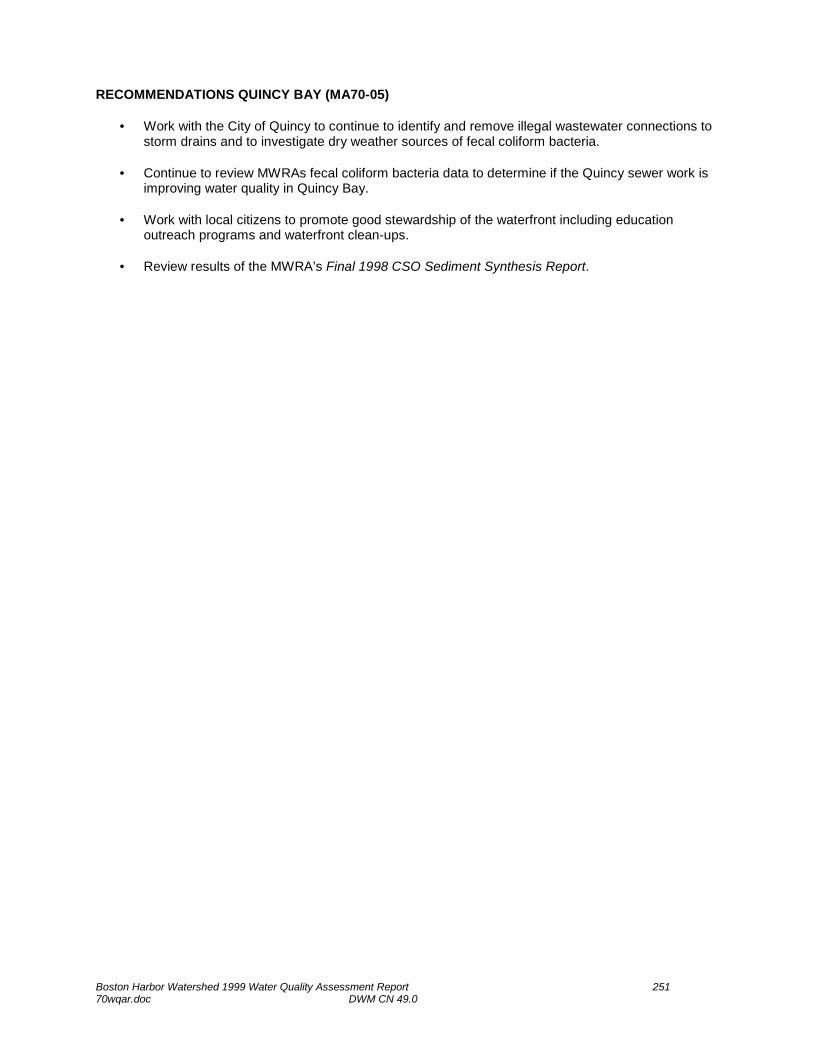
RECOMMENDATIONS QUINCY BAY (MA70-05)
• Work with the City of Quincy to continue to identify and remove illegal wastewater connections to storm drains and to investigate dry weather sources of fecal coliform bacteria.
• Continue to review MWRAs fecal coliform bacteria data to determine if the Quincy sewer work is
improving water quality in Quincy Bay. • Work with local citizens to promote good stewardship of the waterfront including education
outreach programs and waterfront clean-ups. • Review results of the MWRA’s Final 1998 CSO Sediment Synthesis Report.
Boston Harbor Watershed 1999 Water Quality Assessment Report 252 70wqar.doc DWM CN 49.0
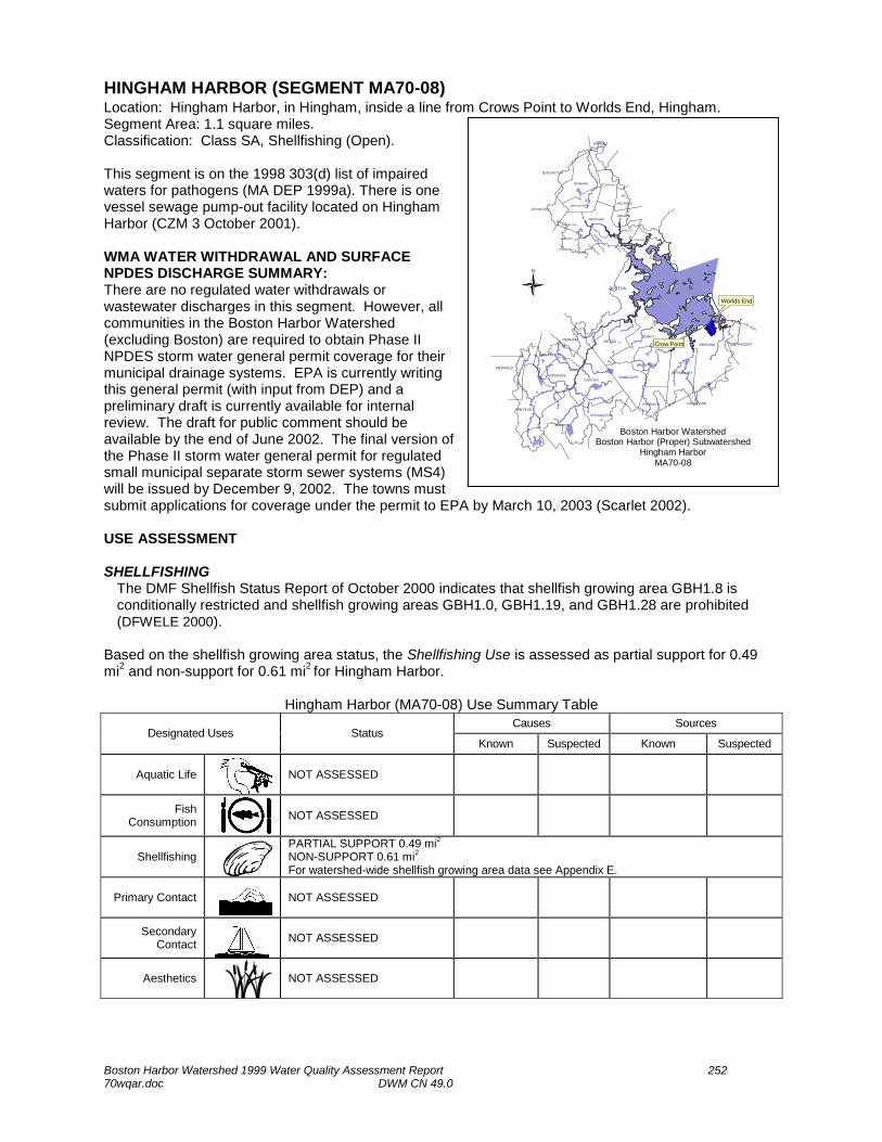
HINGHAM HARBOR (SEGMENT MA70-08) Location: Hingham Harbor, in Hingham, inside a line from Crows Point to Worlds End, Hingham. Segment Area: 1.1 square miles. Classification: Class SA, Shellfishing (Open). This segment is on the 1998 303(d) list of impaired waters for pathogens (MA DEP 1999a). There is one vessel sewage pump-out facility located on Hingham Harbor (CZM 3 October 2001). WMA WATER WITHDRAWAL AND SURFACE NPDES DISCHARGE SUMMARY: There are no regulated water withdrawals or wastewater discharges in this segment. However, all communities in the Boston Harbor Watershed (excluding Boston) are required to obtain Phase II NPDES storm water general permit coverage for their municipal drainage systems. EPA is currently writing this general permit (with input from DEP) and a preliminary draft is currently available for internal review. The draft for public comment should be available by the end of June 2002. The final version of the Phase II storm water general permit for regulated small municipal separate storm sewer systems (MS4) will be issued by December 9, 2002. The towns must submit applications for coverage under the permit to EPA by March 10, 2003 (Scarlet 2002). USE ASSESSMENT SHELLFISHING
The DMF Shellfish Status Report of October 2000 indicates that shellfish growing area GBH1.8 is conditionally restricted and shellfish growing areas GBH1.0, GBH1.19, and GBH1.28 are prohibited (DFWELE 2000).
Based on the shellfish growing area status, the Shellfishing Use is assessed as partial support for 0.49 mi2 and non-support for 0.61 mi2 for Hingham Harbor.
Hingham Harbor (MA70-08) Use Summary Table Causes Sources
Designated Uses Status Known Suspected Known Suspected
Aquatic Life
NOT ASSESSED
Fish Consumption
NOT ASSESSED
Shellfishing
PARTIAL SUPPORT 0.49 mi2 NON-SUPPORT 0.61 mi2 For watershed-wide shellfish growing area data see Appendix E.
Primary Contact
NOT ASSESSED
Secondary Contact
NOT ASSESSED
Aesthetics
NOT ASSESSED
WINCHESTER
EVERETT
CHELSEA
SOMERVILLECAMBRIDGE
SHARON
NORWOOD
WESTWOOD
STOUGHTON
HOLBROOK
RANDOLPH
BRAINTREE
WEYMOUTH
HINGHAM COHASSET
CANTON
MILTONQUINCY
LEXINGTON
BURLINGTON
READING
MELROSE
WOBURN
MALDENMEDFORD
MEDFIELD
ST ONEHAM
BOSTON
ARLINGTON
BELMONT
DEDHAM
WALPOLE
ROCKLAND
Boston Harbor WatershedBoston Harbor (Proper) Subwatershed
Hingham HarborMA70-08
N
Crow Point
Worlds End

Boston Harbor Watershed 1999 Water Quality Assessment Report 253 70wqar.doc DWM CN 49.0
RECOMMENDATIONS HINGHAM HARBOR (MA70-08)
• Conduct bacteria monitoring in Hingham Harbor to determine if the bacteria causing the closure of the shellfish growing areas is also impairing the recreational uses. Additionally, identify and eliminate sources causing the closure of the shellfish beds. Suspected causes include faulty septic systems, sewage discharges from boats, and illicit connections.
• Work with CZM and the EOEA Watershed Team to educate boaters about vessel sewage pump-
out facilities and transfer procedures. • Determine if suspected failing septic systems in Hingham have been repaired. • Track progress of municipal storm water management plans and implementation of best
management practices.

Boston Harbor Watershed 1999 Water Quality Assessment Report 254 70wqar.doc DWM CN 49.0
HINGHAM BAY (SEGMENT MA70-06) Location: The area north of the mouth of the Weymouth Fore River extending on the west along the line between Nut Island and the south point of West Head, and on the east side along a line from Prince Head just east of Pig Rock to the mouth of the Weymouth Fore River (midway between Lower Neck and Manot Beach), Quincy. Segment Area: 1.0 square miles. Classification: Class SB, Shellfishing (Restricted) This segment is on the 1998 303(d) list of impaired waters for pathogens (MA DEP. 1999). WMA WATER WITHDRAWAL: There are no regulated water withdrawals from Hingham Bay. SURFACE NPDES DISCHARGE SUMMARY: MWRA Nut Island (MA0102351) was permitted to discharge from POTW outfalls 001, 002, 003, 004, and 005 to Boston Harbor; outfalls 101,102, and 103 to Boston Harbor/Quincy Bay; and outfall 104 to Hingham Bay. The Nut Island Treatment Plant Emergency Relief Outfall (104) was permitted to discharge continuously for flow rates above 250 MGD and/or high tides to Hingham Bay. The permit was issued in December 1986 and remained effective until the new Deer Island Treatment Plant permit (MA0103284) was issued in May of 1999. MWRA Nut Island Headworks (MA0103268) is permitted to discharge storm water via outfalls 001 and 002 to Quincy Bay and Boston Harbor. This permit expired 14 December 1997. The facility no longer discharges, however, they still maintain an emergency discharge. All communities in the Boston Harbor Watershed (excluding Boston) are required to obtain Phase II NPDES storm water general permit coverage for their municipal drainage systems. EPA is currently writing this general permit (with input from DEP) and a preliminary draft is currently available for internal review. The draft for public comment should be available by the end of June 2002. The final version of the Phase II storm water general permit for regulated small municipal separate storm sewer systems (MS4) will be issued by December 9, 2002. The towns must submit applications for coverage under the permit to EPA by March 10, 2003 (Scarlet 2002). USE ASSESSMENT AQUATIC LIFE Chemistry - water As part of their ongoing CSO monitoring program, MWRA collected monthly water quality samples (DO, temperature, and percent saturation) at one site (080 Quincy Bay, Quincy Yacht Club, Red Buoy #2) between 1996 and 2000 from this segment of Hingham Bay (Coughlin 2001a):
DO Dissolved oxygen concentrations were below 5.0 mg/L on only one occasion (n=122; range 1.22- 12.87 mg/L). Additionally, percent saturation levels were only below 60% on one occasion (n= 122; range 15.5-123.5%). No measurements were collected pre-dawn and, therefore, do not represent a worst-case scenario.
Temperature All temperature readings (n=135) were below the SWQS for a class SB waterbody.
WINCHESTER
EVERETT
CHELSEA
SOMERVILLECAMBRIDGE
SHARON
NORWOOD
WESTWOOD
STOUGHTON
HOLBROOK
RANDOLPH
BRAINTREE
WEYMOUTH
HINGHAM COHASSET
CANTON
MILTONQUINCY
LEXINGTON
BURLINGTON
READING
MELROSE
WOBURN
MALDENMEDFORD
MEDFIELD
ST ONEHAM
BOSTON
ARLINGTON
BELMONT
DEDHAM
WALPOLE
ROCKLAND
Boston Harbor WatershedBoston Harbor (Proper) Subwatershed
Hingham BayMA70-06
N
Nut Island
Prince Head
Pig Rock
Boston Harbor Watershed 1999 Water Quality Assessment Report 255 70wqar.doc DWM CN 49.0
Turbidity Turbidity measurements were taken on 70 occasions. Levels ranged between 0 and 809.9 NTU with an average of 21.06 NTU.
Chlorophyll a Chlorophyll a measurements were taken on 90 occasions. Concentrations ranged from 4.16 to 38.4 µg/L.
Total Suspended Solids TSS concentrations were collected on 90 occasions. Concentrations ranged from 0.8 to 24.4 mg/L.
Based on the available water chemistry data (DO, temperature, water clarity, and chlorophyll a), the Aquatic Life Use is assessed as support for this segment of Hingham Harbor. SHELLFISHING
The DMF Shellfish Status Report of October 2000 indicates that shellfish growing area GBH1.27 is closed seasonally for management and shellfish growing areas GBH1.0 and GBH2.0 are prohibited (DFWELE 2000).
Based on the shellfish growing area information the Shellfishing Use is assessed as non-support for 0.99 mi2 of this segment Hingham Bay. Due to a management closure, 0.01 mi2 of this segment of Hingham Bay are currently not assessed. PRIMARY CONTACT AND SECONDARY CONTACT RECREATION
Between 1996 and 2000, MWRA collected fecal coliform bacteria samples and recorded Secchi disk depths at one site (080 Quincy Bay, Quincy Yacht Club, Red Buoy #2) as part of their ongoing CSO monitoring program (Coughlin 2001a). Fecal coliform bacteria counts were less than 5 cfu/100mL in all samples. Bacteria samples were collected during both wet and dry weather conditions. Secchi disk depths (n=109) ranged from 1 to 4.5 m with only three readings less than SWQS of 1.2 m. The disk was seen on the bottom on one occasion.
Based on the low fecal coliform bacteria counts and good water clarity the Primary Contact and Secondary Contact Recreational uses are assessed as support for this segment of Hingham Bay. AESTHETICS
MWRAs turbidity and TSS samples and Secchi disk depth from station 080, Quincy Yacht Club, Red Buoy #2) indicated relatively low instream turbidity with good water clarity (Coughlin 2001a).
Based on the good water quality and overall high aesthetic quality of this segment of Hingham Bay the Aesthetic Use is assessed as support.
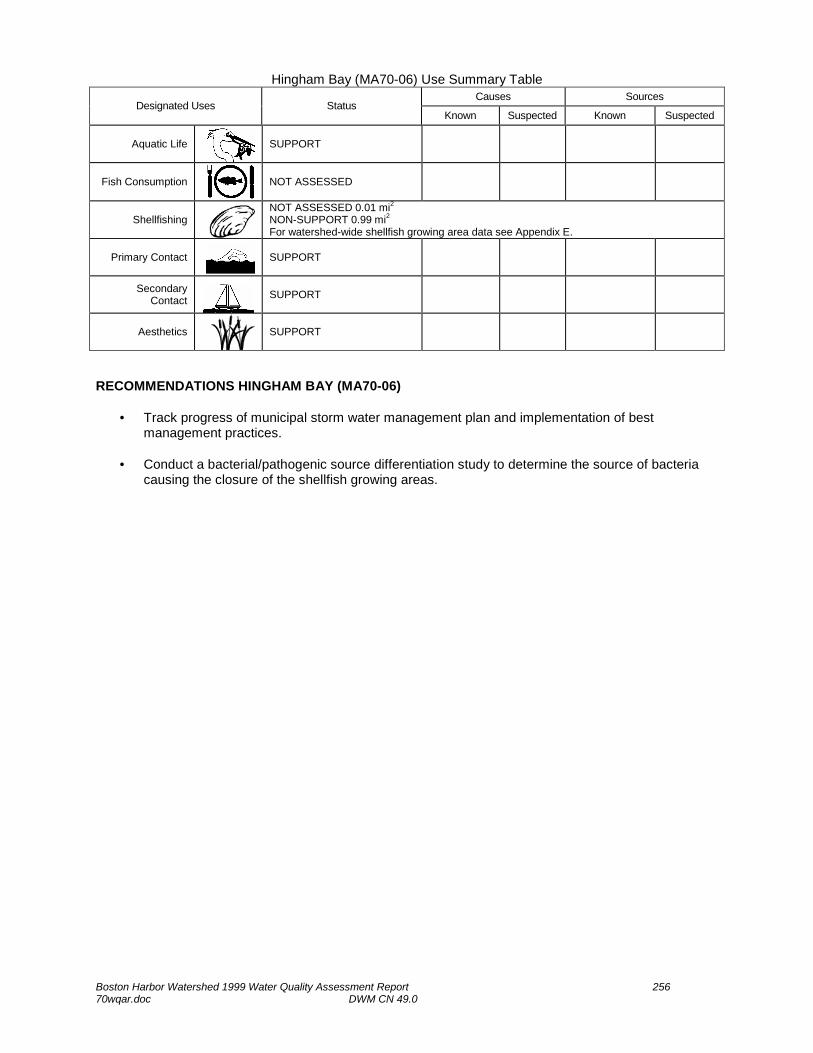
Boston Harbor Watershed 1999 Water Quality Assessment Report 256 70wqar.doc DWM CN 49.0
Hingham Bay (MA70-06) Use Summary Table Causes Sources
Designated Uses Status Known Suspected Known Suspected
Aquatic Life
SUPPORT
Fish Consumption
NOT ASSESSED
Shellfishing
NOT ASSESSED 0.01 mi2 NON-SUPPORT 0.99 mi2 For watershed-wide shellfish growing area data see Appendix E.
Primary Contact
SUPPORT
Secondary Contact
SUPPORT
Aesthetics
SUPPORT
RECOMMENDATIONS HINGHAM BAY (MA70-06)
• Track progress of municipal storm water management plan and implementation of best management practices.
• Conduct a bacterial/pathogenic source differentiation study to determine the source of bacteria
causing the closure of the shellfish growing areas.

Boston Harbor Watershed 1999 Water Quality Assessment Report 257 70wqar.doc DWM CN 49.0
HINGHAM BAY (SEGMENT MA70-07) Location: The area defined between Peddocks Island and Windmill Point; from Windmill Point southeast to Bumkin Island; from Bumkin Island southeast to Sunset Point; from Sunset Point across the mouth of the Weir River to Worlds End; from Worlds End across the mouth of Hingham Harbor to Crow Point; from Beach Lane, Hingham across the mouth of the Weymouth Back River to Lower Neck; and from Lower Neck midway across the mouth of the Weymouth Fore River. Segment Area: 5.8 square miles. Classification: Class SB Shellfishing (Restricted). This segment is on the 1998 303(d) list of impaired waters for pathogens (MA DEP 1999a). In a Comparison of Water Quality in Boston Harbor Before and After Inter-island Transfer MWRA presents data collected from 14 sampling stations in Boston Harbor divided into two regions (north harbor and south harbor). In each region, sampling was conducted at two sets of stations: ‘outfall stations’ - in the immediate vicinity of the outfalls of the two treatment facilities and ‘receiving-water stations’ - located further afield, away from the outfalls. The report focused on three water quality issues: symptoms of eutrophication of the Boston Harbor water column (nutrient concentrations, standing stocks of phytoplankton, and dissolved oxygen), water clarity and concentrations of solids in the water column, and counts of sewage indicator bacteria in the water column (Taylor 2001). WMA WATER WITHDRAWAL AND SURFACE NPDES DISCHARGE SUMMARY: There are no regulated water withdrawals or wastewater discharges in this segment. However, all communities in the Boston Harbor Watershed (excluding Boston) are required to obtain Phase II NPDES storm water general permit coverage for their municipal drainage systems. EPA is currently writing this general permit (with input from DEP) and a preliminary draft is currently available for internal review. The draft for public comment should be available by the end of June 2002. The final version of the Phase II storm water general permit for regulated small municipal separate storm sewer systems (MS4) will be issued by December 9, 2002. The towns must submit applications for coverage under the permit to EPA by March 10, 2003 (Scarlet 2002). USE ASSESSMENT AQUATIC LIFE Biology MWRA began its studies of infaunal communities and benthic habitats in Boston Harbor in 1991, just prior to the cessation of sludge dumping into the Harbor (Kropp et al. 2000). Sampling was conducted at one station, T08, on this segment of Hingham Bay. Values for infaunal abundance, species numbers, diversity, and evenness in April and August 1999 generally were similar to those estimated for the previous two years. Chemistry - water As part of their ongoing receiving water monitoring program, MWRA collected monthly water quality samples (DO, temperature, turbidity, chlorophyll a and TSS) at two sites on this segment of Hingham Bay between 1996 and 2000: 117 - Hingham/Hull Bay, green Can #1; 124 - Hingham Bay, Crow Point Flats (Coughlin 2001a).

Boston Harbor Watershed 1999 Water Quality Assessment Report 258 70wqar.doc DWM CN 49.0
DO Dissolved oxygen concentrations were not below 5.0 mg/L at either station in the surface or bottom waters during any of the sampling events (range 5.8 –14.1 mg/L; n=470). Additionally, percent saturation levels were not below 60% on any occasion, however, on 17 occasions it was greater than 115% (range 72.1 – 130.1%; n=471). No measurements were collected pre-dawn and, therefore, do not represent a worst-case scenario.
Temperature All temperature readings (n=502) were below the SWQS for a class SB waterbody.
Turbidity Turbidity measurements were taken on 253 occasions ranging from 0 to 589.9 NTU with an average of 6.37 NTU.
Chlorophyll a Chlorophyll a measurements (n=175) ranged from 0.22 to 39.3 µg/L in the surface and bottom waters.
Total Suspended Solids TSS measurements (n=171) ranged from 1 to 45.1 mg/L with only one greater than 25 mg/L.
The water quality monitoring data (i.e., DO, temperature, turbidity) collected over multiple years at two stations indicated no prolonged violations of the SWQS for a Class SB waterbody, therefore, this segment of Hingham Bay is assessed as support for the Aquatic Life Use.
SHELLFISHING
The DMF Shellfish Status Report of October 2000 indicates that shellfish growing areas GBH1.3, GBH1.8 and GBH1.9 are conditionally restricted and shellfish growing areas GBH1.0, GBH1.16, GBH1.17, and GBH1.18 are prohibited (DFWELE 2000b).
Based on the DMF Shellfish Status Report, the Shellfishing Use is assessed as partial support for 0.15 mi2 and non-support for 5.65 mi2 of this segment of Hingham Bay. PRIMARY CONTACT AND SECONDARY CONTACT RECREATION
As part of their ongoing receiving water monitoring program, MWRA also collected fecal coliform bacteria samples and recorded Secchi disk depths at the two water quality stations on this segment of Hingham Bay between 1996 and 2000 (Coughlin 2001a). Fecal coliform bacteria counts (n=485) ranged from <5 to 4,400 cfu/100mL with 12 samples greater than 400 cfu/100mL (3%) and one sample greater than 4,000 cfu/100mL(wet weather). Bacteria samples were collected during both wet and dry weather conditions. Secchi disk depth readings (n=183) ranged from 0.9 to 5.7m. On only four occasions the depths were less than the SWQS of 1.2 m and the Secchi disk could be seen all the way to the bottom on eight occasions.
Based on the low fecal coliform bacteria counts (only isolated instances of SWQS exceedances) and good water clarity, the Primary and Secondary Contact Recreational uses are assessed as support for this segment of Hingham Bay.
AESTHETICS
MWRAs turbidity and TSS samples and Secchi disk depths indicated relatively low turbidity with good water clarity (Coughlin 2001a).
Based on the good water quality and overall high aesthetic quality of this segment of Hingham Bay the Aesthetic Use is assessed as support.

Boston Harbor Watershed 1999 Water Quality Assessment Report 259 70wqar.doc DWM CN 49.0
Hingham Bay (MA70-07) Use Summary Table
Causes Sources Designated Uses Status
Known Suspected Known Suspected
Aquatic Life
SUPPORT
Fish Consumption
NOT ASSESSED
Shellfishing
PARTIAL SUPPORT 0.15 mi2 NON-SUPPORT 5.65 mi2 For watershed-wide shellfish growing area data see Appendix E.
Primary Contact
SUPPORT
Secondary Contact
SUPPORT
Aesthetics
SUPPORT
RECOMMENDATIONS HINGHAM BAY (MA70-07)
• Conduct a bacterial/pathogenic source differentiation study to determine the source of bacteria causing the closure of the shellfish growing areas.
• Track progress of municipal storm water management plans and implementation of best
management practices.

Boston Harbor Watershed 1999 Water Quality Assessment Report 260 70wqar.doc DWM CN 49.0
HULL BAY (SEGMENT MA70-09) Location: The area defined east of a line from Windmill Point to Bumpkin Island and from Bumpkin Island to Sunset Point, Hull. Segment Area: 2.3 square miles. Classification: Class SB, Shellfishing (Restricted). This segment is on the 1998 303(d) list of impaired waters for pathogens (MA DEP 1999a). WMA WATER WITHDRAWAL AND SURFACE NPDES DISCHARGE SUMMARY: There are no regulated water withdrawals or wastewater discharges in this segment. However, all communities in the Boston Harbor Watershed (excluding Boston) are required to obtain Phase II NPDES storm water general permit coverage for their municipal drainage systems. EPA is currently writing this general permit (with input from DEP) and a preliminary draft is currently available for internal review. The draft for public comment should be available by the end of June 2002. The final version of the Phase II storm water general permit for regulated small municipal separate storm sewer systems (MS4) will be issued by December 9, 2002. The towns must submit applications for coverage under the permit to EPA by March 10, 2003 (Scarlet 2002). USE ASSESSMENT SHELLFISHING
The DMF Shellfish Status Report of October 2000 indicates that shellfish growing areas GBH1.1 and GBH1.2 are conditionally restricted and GBH1.0 and GBH1.17 are prohibited (DFWELE 2000b).
Based on the DMF Shellfish Status Report the Shellfishing Use is assessed as partial support for 0.25 mi2 and non-support for 2.05 mi2 of this segment of Hull Bay.
Hull Bay (MA70-09) Use Summary Table Causes Sources
Designated Uses Status Known Suspected Known Suspected
Aquatic Life
NOT ASSESSED
Fish Consumption
NOT ASSESSED
Shellfishing
PARTIAL SUPPORT 0.25 mi2 NON-SUPPORT 2.05 mi2 For watershed-wide shellfish growing area data see Appendix E.
Primary Contact
NOT ASSESSED
Secondary Contact
NOT ASSESSED
Aesthetics
NOT ASSESSED
WINCHESTER
EVERETT
CHELSEA
SOMERVILLECAMBRIDGE
SHARON
NORWOOD
WESTWOOD
STOUGHTON
HOLBROOK
RANDOLPH
BRAINTREE
WEYMOUTH
HINGHAM COHASSET
CANTON
MILTONQUINCY
LEXINGTON
BURLINGTON
READING
MELROSE
WOBURN
MALDENMEDFORD
MEDFIELD
ST ONEHAM
BOSTON
ARLINGTON
BELMONT
DEDHAM
WALPOLE
ROCKLAND
Boston Harbor WatershedBoston Harbor (Proper) Subwatershed
Hull BayMA70-09
N

Boston Harbor Watershed 1999 Water Quality Assessment Report 261 70wqar.doc DWM CN 49.0
RECOMMENDATIONS HULL BAY (MA70-09)
• Conduct a bacterial/pathogenic source differentiation study to determine the source of bacteria causing the closure of the shellfish growing areas.
• Track progress of municipal storm water management plans and implementation of best
management practices.

Boston Harbor Watershed 1999 Water Quality Assessment Report 262 70wqar.doc DWM CN 49.0
BOSTON HARBOR (SEGMENT MA70-01) Location: The area extending into Massachusetts Bay from the line between Fort Dawes on Deer Island to The Graves, and from The Graves south to Point Allerton; across Hull and West guts; across the mouths of Quincy and Dorchester bays, Boston Inner Harbor and Winthrop Bay (including President Roads and Nantasket Roads). Segment Area: 23 square miles. Classification: Class SB Shellfishing (R) This segment is on the 1998 303(d) list of impaired waters for pathogens (MA DEP 1999a). The Coastal Lobster Investigations Project of DMF conducts an annual coastwide commercial lobster sea sampling program which provides biological and catch/effort data from six coastal regions during the major lobstering season, May-November (20-year time series to date). This is a cooperative effort with the lobster industry conducted aboard commercial lobster vessels. A second annual sampling effort for early benthic phase/juvenile lobsters is conducted using Self Contained Underwater Breathing Apparatus (SCUBA) through suction sampling in order to generate density indices of newly settled post-larval lobsters (6-year time series to date) and delineate coastal habitat important to the settlement of these juveniles. Year-round bottom temperature monitoring (13-year time series to date) is conducted with programmable electronic recorders at various depths at seven coastal sites, north and south of Cape Cod. These are replaced annually by SCUBA diving. Additional sites will be added during 2001 (Estrella 2001). In mid-summer 1998, the wastewater previously treated at the MWRA Nut Island facility was transferred via a deep-rock tunnel, to the Deer Island facility. This transfer, known as ‘inter-island transfer’, ended more than 50 years of discharges of primary treated wastewater to the South Harbor, and increased flows of secondary treated wastewater to the outer North Harbor. In a Comparison of Water Quality in Boston Harbor Before and After Inter-island Transfer MWRA compared data collected from 14 sampling stations in Boston Harbor (north harbor and south harbor) before and after the inter-island transfer. In each region, sampling was conducted at two sets of stations: ‘outfall stations’ - in the immediate vicinity of the outfalls of the two treatment facilities and ‘receiving-water stations’ - located further afield, away from the outfalls. The report focused on three water quality issues: symptoms of eutrophication of the Boston Harbor water column (nutrient concentrations, standing stocks of phytoplankton, and dissolved oxygen), water clarity and concentrations of solids in the water column, and counts of sewage indicator bacteria in the water column (Taylor 2001). WMA WATER WITHDRAWAL: There are no regulated water withdrawals from Boston Harbor. SURFACE NPDES DISCHARGE SUMMARY: MWRA (MA0102351) was permitted to discharge from POTW outfalls to this segment of Boston Harbor.
001- Deer Island Treatment Plant Outfall #1, continuous discharge 002- Deer Island Treatment Plant Outfall #2, continuous discharge 003- Deer Island Treatment Plant Relief #1, continuous discharge for flow rates above 400 MGD 004- Deer Island Treatment Plant Relief #2, continuous discharge for flow rates above 500 MGD 005- Deer Island Treatment Plant Relief #3, continuous discharge for flow rates above 600 MGD
WINCHESTER
EVERETT
CHELSEA
SOMERVILLECAMBRIDGE
SHARON
NORWOOD
WESTWOOD
STOUGHTON
HOLBROOK
RANDOLPH
BRAINTREE
WEYMOUTH
HINGHAM COHASSET
CANTON
MILTONQUINCY
LEXINGTON
BURLINGTON
READING
MELROSE
WOBURN
MALDENMEDFORD
MEDFIELD
ST ONEHAM
BOSTON
ARLINGTON
BELMONT
DEDHAM
WALPOLE
ROCKLAND
Boston Harbor (includes PresidentRoads and Nantasket Roads)
Boston Harbor WatershedBoston Harbor (Proper) Subwatershed
Boston HarborMA70-01
N

Boston Harbor Watershed 1999 Water Quality Assessment Report 263 70wqar.doc DWM CN 49.0
As part of their whole effluent toxicity tests, MWRA analyzed their effluent for TRC on 85 occasions between March 1996 and July 2000. Concentrations ranged from BDL to 3.4 mg/L (TOXTD). The permit was issued in December 1986 and remained effective until the new Deer Island Treatment Plant permit (MA0103284) was issued in May of 1999 Permit MA0102351 was rescinded. Massachusetts Water Resources Authority Deer Island WWTP (MA0103284) is now permitted (issued 1999, modified May 2000) to discharge 436 MGD treated wastewater to Massachusetts Bay via outfall T01. The facility’s whole effluent toxicity limit is LC50 >50%. The facility’s TRC limit is 631 µg/L (maximum daily). The new Deer Island outfall (T01) begins with a deep rock tunnel extending under Massachusetts Bay to a point about 9.5 miles east of Deer Island. The tunnel is 24 feet in diameter and can convey a flow from the plant of up to 1.27 billion gallons a day. The actual discharge of treated effluent is through a diffuser, which consists of more than fifty pipes that rise to the seabed over the last 6,600 feet of the tunnel's length. The purpose of the diffuser is to assure that the maximum dispersion and dilution is achieved for the wastewater flow. Outfall T01 became operational in September 2000. MWRA Nut Island Headworks (MA0103268) is permitted to discharge storm water via outfalls 001 and 002 to Quincy Bay and Boston Harbor and temporary site dewatering discharge via outfalls 011, 012, and 013 to Hingham and Quincy bays. This permit expired 14 December 1997. This facility no longer discharges. Sithe-New Boston Station (MA0004731) has two condenser cooling water discharges (258 and 232 MGD) to the Boston Harbor proper. The permit contains a 96 °F temperature limit with a < 25 °F temperature change. The permit expired on 15 January 1999. The permit is expected to be reissued in 2003. Hull WWTP (MA0101231) is permitted to discharge 3.07 MGD of treated wastewater to this segment of Boston Harbor (at Stony Beach) via outfall 001. The facility’s permit limit for whole effluent toxicity is LC50 > 100%. Secondary limits include BOD and TSS concentrations of 30 mg/L and a fecal coliform bacteria limit of 200 colonies/100mL. TRC concentrations, in the effluent, between February 1996 and February 2001 ranged from BDL to 0.200 mg/L (TOXTD), below the permit limit of 1.0 mg/L. This permit is currently (December 2001) up for reissuance. Long Island Hospital WWTP (MA0102377) was closed and ceased to discharge in 2001. All communities in the Boston Harbor Watershed (excluding Boston) are required to obtain Phase II NPDES storm water general permit coverage for their municipal drainage systems. EPA is currently writing this general permit (with input from DEP) and a preliminary draft is currently available for internal review. The draft for public comment should be available by the end of June 2002. The final version of the Phase II storm water general permit for regulated small municipal separate storm sewer systems (MS4) will be issued by December 9, 2002. The towns must submit applications for coverage under the permit to EPA by March 10, 2003 (Scarlet 2002). The Boston Water and Sewer Commission (the Commission) operates the separate storm drainage system serving the City of Boston. The Commission applied to EPA in 1993 for an NPDES storm water individual permit for the system and received the permit in October 1999. The Commission operated drain system has 104 major and 102 lesser outfalls. The system currently serves 13.85 square miles of Boston. The remainder of Boston is served by combined sewers and the Commission is currently undertaking two major separation efforts under the MWRA CSO Control Plan. There are other public storm drains in the city owned by other state agencies such as the Massachusetts Department of Public Works, Massachusetts Turnpike Authority and the Metropolitan District Commission. While currently unpermitted, these other public agencies will be required to obtain coverage for outfalls from separate drainage they operate under an NPDES storm water general permit by March 10, 2003 (Scarlet 2002).

Boston Harbor Watershed 1999 Water Quality Assessment Report 264 70wqar.doc DWM CN 49.0
USE ASSESSMENT AQUATIC LIFE Biology As part of the MWRA 2000 fish and shellfish monitoring program, winter flounder (Pseudopleuronectes americanus) and lobster (Homarus americanus) samples were collected from Deer Island Flats. Caged blue mussels (Mytilus edulis), from Rockport were also deployed at Deer Island Flats to evaluate bioaccumulation potential (Lefkovitz et al. 2001). The external condition of winter flounder indicated few abnormalities. Mean concentrations of organic compounds in winter flounder fillets (PCB, DDT chlordane, Mirex) and liver tissue (PCBs, chlorinated pesticides, PAHs) were generally higher at Deer Island Flats than at MWRA’s other sampling locations. The flounder edible tissue contaminant levels, (wet weight), like those detected in previous monitoring years (1992-1999), were well below the federal action limits and the 1992-1999 MWRA Appreciable Change Levels (Lefkovitz et al. 2001). No deleterious external conditions were noted in lobsters. Mean concentrations of organic compounds in edible tail meat tissue and the hepatopancreas were generally highest at Deer Island Flats than at MWRA’s other sampling locations. Concentrations of total PCB in lobster hepatopancreas continued to show an upward trend in 2000 at Deer Island Flats. The 2000 levels, like other monitoring years, were well below the federal action limits for pesticides, PCBs and mercury and indicate no risk for human consumption (Lefkovitz et al. 2001). Mussel survival within the deployed arrays from Deer Island, Boston Inner Harbor, upon recovery was high (96%). The 2000 data were similar to previous years with the highest body burdens of contaminants observed in mussels deployed in Boston Inner Harbor. The 2000 levels (total PCBs, pesticides, total PAHs, mercury, and lead), like other monitoring years, were well below the federal action limits and indicate no risk for human consumption (Lefkovitz et al. 2001). Toxicity
Effluent MWRA Nut Island (MA0102351) conducted 27 whole effluent toxicity tests on outfall 101 using the mysid shrimp, M. bahia between March 1996 and June 1998. In twenty-three of the M. bahia acute toxicity tests the LC50 was < 100% effluent. Additionally, between April 1997 and June 1998, MWRA conducted 15 whole effluent toxicity tests using the sheepshead minnow, Cyprinodon variegatus. In three C. variegatus acute toxicity tests (20%) the LC50 was > 100% effluent. It should be noted that this discharge was eliminated when MWRA moved their discharge to Massachusetts Bay. MWRA Deer Island WWTP (MA0102351) conducted monthly whole effluent toxicity tests on outfall 001 using M. bahia between March 1996 and July 2000. The facility did not meet its LC50 limit of > 50% effluent in 11 of the 51 M. bahia tests. Since December 1997 (n=30), the facility only violated their acute toxicity permit limit twice. Additionally, between April 1997 and July 2000, monthly whole effluent toxicity tests were conducted using C. variegatus. Only one of the 38 C. variegatus tests violated the permit limit of 50% effluent. This discharge has also been eliminated by the deep ocean outfall that discharges to Massachusetts Bay. Between February 1996 and February 1997, Hull WWTP conducted four whole effluent toxicity tests using the mysid shrimp M. bahia. The M. bahia LC50’s ranged between 82% and 88% effluent. Additionally, between February 1996 and February 2001, Hull WWTP conducted 16 whole effluent toxicity tests using the inland silverside, M. beryllina. M. beryllina LC50’s ranged between 82 -100% with no violations of the permit limits since 1997. Ambient Hull WWTP collects water from Stony Beach in Boston Harbor for use as their dilution water in their whole effluent toxicity tests. Between February 1996 and February 1997, survival (48-hour) of M. bahia was not less than 90% and M. beryllina survival exposed (48 hr) to the Harbor water was good (not less than 88%).

Boston Harbor Watershed 1999 Water Quality Assessment Report 265 70wqar.doc DWM CN 49.0
Chemistry – water Hull WWTP collects water from Boston Harbor for use as dilution water in their whole effluent toxicity tests. Water quality parameters (pH, TSS, and ammonia-nitrogen) from the 16 sampling events are summarized below. As part of their ongoing receiving water monitoring program, MWRA collected monthly water quality samples (DO, temperature, turbidity, Chlorophyll a, and TSS) at 11 sites on this segment of Boston Harbor (Coughlin 2001a):
044, mouth of Dorchester Bay, day marker #5; 1996-2000 048, Quincy Bay, off Moon Island Outfall; 1996-200 050, Outer harbor, Calf Island; 1996-2000 065, Inner Harbor, President Roads, R Buoy #2; 1996-2000 075, Inner Harbor, Fort Point Channel at Broadway; 1996 and 1997 106, Outer Harbor, Long Island, green can #17; 1996 -2000 116, Hingham Bay, Mouth of Fore River, Red Nun#28; 1998 and 1999 118, Outer Harbor, Lovell Island, Red Nun #8; 1996-2000 129, Deer Island Flats (between Deer Island and airport); 1997-2000 135, Boston North Channel, Red #10 Fl Red Bell; 1996-2000 141, Quincy Bay/ Outer Harbor, Peddocks Island; 1996-2000
DO MWRA DO concentrations ranged from 2.4 – 12.99 mg/L; n=2,357. Dissolved oxygen concentrations were below 5.0 mg/L in the surface waters on 18 occasions (station 075S; 1996-1997) and in the bottom waters on two occasions (station 065B; 1998). Additionally, percent saturations were below 75% on 69 occasions and were above 115% on 135 occasions (range 25.5-144.8%; n=2,361).
pH pH in Boston Harbor as reported in the Hull WWTP toxicity testing reports ranged between 7.09 and 7.9 SU (n=16).
Temperature MWRA temperature readings (n=2,502) were below the SWQS for a class SB waterbody.
Turbidity Turbidity levels recorded by MWRA ranged from 0.4 to 1,000 NTU with an average of 8.39 NTU (n=1,239).
Chlorophyll a Chlorophyll a measurements were collected on 708 occasions by MWRA. Bottom concentrations ranged from 0.16 to 20.7 µg/L and surface concentration ranged from 0.206 to 28.3 µg/L.
Total Suspended Solids Suspended solids concentrations as reported in the Hull WWTP toxicity testing reports ranged between 32 and 132 mg/L (n=16). However, MWRA TSS concentrations, recorded on 692 occasions, ranged from 0.43 to 16.1 mg/L.
Ammonia-Nitrogen (as N) Concentrations of ammonia reported in the Hull WWTP toxicity testing reports ranged between BDL and 1.420 mg/L (n=16).
The Aquatic Life Use is assessed as support based on water chemistry data within the SWQS for a Class SB waterbody (high spatial and temporal coverage), the biological data (fish and shellfish) and good ambient survival data.

Boston Harbor Watershed 1999 Water Quality Assessment Report 266 70wqar.doc DWM CN 49.0
FISH CONSUMPTION In 1998, MDPH issued an advisory concerning consumption of seafood from Boston Harbor, including Quincy Bay (Celona 2001):
“Lobster tomalley—all persons should eliminate consumption of the lobster tomalley (liver). This recommendation applies to tomalley from lobsters from any source due to the finding of abnormally high chemical contaminant levels… Boston Harbor Fishery Products—Pregnant and breast –feeding women, women who intend to become pregnant, children under the age of 12, and individuals with lowered immunity should avoid consuming certain fishery products from Boston Harbor. This applies to lobster, flounder, soft-shell clams and other bivalves…”
The Fish Consumption Use is assessed as non-support for this entire segment due to the MDPH seafood fish consumption advisory for Boston Harbor. SHELLFISHING
The DMF Shellfish Status Report of October 2000 indicates that shellfish growing area GBH5.3 is conditionally restricted, shellfish growing area MB13.0 is closed seasonally for management, and shellfish growing areas GBH2.0, GBH3.0, GBH3.1, GBH4.0, GBH5.0, GBH5.6, GBH6.0, MB13.0, and N28.0 are prohibited (DFWELE 2000b).
Based on the DMF Shellfish Status Report the Shellfishing Use is assessed as partial support for 0.15 mi2 and non-support for 18.22 mi2 of this segment of Boston Harbor. Due to the management closure, 4.63 mi2 are not assessed. PRIMARY CONTACT AND SECONDARY CONTACT RECREATION
As part of their ongoing receiving water monitoring program, MWRA collected fecal coliform bacteria samples at seven of their water quality stations (050, 065, 106, 118, 129, 135, and 141) on this segment of Boston Harbor (Coughlin 2001a). Of the 1,853 samples collected, only eight were greater than 400 cfu/100mL (range <5 to 2,960 cfu/100mL). The sample with the highest count was collected during wet weather conditions. Additionally, MWRA recorded Secchi disk depths at nine water quality stations (044, 048, 050, 065, 106, 118, 129, 135, and 141) on this segment of Boston Harbor (Coughlin 2001a). Secchi disk depths ranged from 0.7-13 m. Of the 1,282 readings recorded, 25 were less than SWQS of 1.2 m and on nine occasions the Secchi disk was seen all the way to the bottom.
The MWRA also collected fecal coliform bacteria samples at MDC38 Lovells Island (between August 1996 and August 1997). Of the 14 samples collected, the highest fecal coliform bacteria count was 12 cfu/100 mL (Coughlin2001b).
Based on the low fecal coliform bacteria counts (only isolated instances of SWQS exceedances) and good water clarity, the Primary and Secondary Contact Recreational uses are assessed as support for this segment of Boston Harbor. AESTHETICS MWRAs turbidity and TSS samples and Secchi disk depths indicated relatively low turbidity with good water clarity (Coughlin 2001a). However, more than 130 barrels of small debris, 300 pieces of large debris, and 30 pieces of piers and other oversized debris were collected between July 1, 2000 and September 15, 2000 during the pilot year of the Boston Harbor Marine Debris Salvage Program. Debris was collected from “high activity areas” such as the downtown waterfront, the Charlestown Navy Yard, the East Boston waterfront, South Boston waterfront, the Outer Fort Point Channel, and Chelsea Creek. Additionally, more than 57 tons were collected in 2001 (East Boston 2001). Since the trash and debris collected by the Marine Debris Salvage program was associated with storm water runoff, and therefore, localized, it is best professional judgment that the Aesthetics Use is assessed as support for Boston Harbor. Boston Harbor is, however, on “Alert Status” due to this large volume of trash and debris.

Boston Harbor Watershed 1999 Water Quality Assessment Report 267 70wqar.doc DWM CN 49.0
Boston Harbor (MA70-01) Use Summary Table
Causes Sources Designated Uses Status
Known Suspected Known Suspected
Aquatic Life
SUPPORT
Fish Consumption
NON-SUPPORT Priority organics Unknown
Shellfishing
PARTIAL SUPPORT 0.15 mi2 NON-SUPPORT 18.22 mi2 NOT ASSESSED 4.63 mi2 For watershed-wide shellfish growing area data see Appendix E.
Primary Contact
SUPPORT
Secondary Contact
SUPPORT
Aesthetics*
SUPPORT*
* “Alert Status” issues identified—See Aesthetics Use Assessment RECOMMENDATIONS BOSTON HARBOR (MA70-01)
• Conduct a bacterial/pathogenic source differentiation study to determine the source of bacteria causing the closure of the shellfish growing areas. • Review results of the MWRA’s Final 1998 CSO Sediment Synthesis Report.