Book Title - Auckland Transport Web viewStep 1: Read about the proposed changes within this...
151
18p Help us transform North Shore's bus network Auckland Transport Metro
Transcript of Book Title - Auckland Transport Web viewStep 1: Read about the proposed changes within this...

18pt
Help us transform North Shore's bus network
Auckland Transport Metro
Tell us what you think about the New Network for public transportFeedback is open 2 June to 13 July

Adapted in accordance with Section 69 of the Copyright Act 1994 by the Royal New Zealand Foundation of the Blind, for the sole use of persons who have a print disability. No unauthorised copying is permitted.
Produced 2015 by Accessible Format Production, Blind Foundation, Auckland
Total print pages: 8
Total large print pages: 89


Notes for the Large Print ReaderPrint page numbers are indicated as:
Page 1Main text is in Arial typeface, 18 point.
Headings, in order of significance, are indicated as:
Heading 1Heading 2Heading 3
Omissions and AlterationsIn the large print some figures have been verbalised.
Notes by the transcriber are indicated with TN (transcriber's note).

How to have your sayStep 1: Read about the proposed changes within this brochure, and look at the map of the new services on page 5
Step 2: Check if the service times work for you on page 4
Step 3: Tell us what you think, via:
the Freepost feedback form on page 8, or the online feedback form at
www.AT.govt.nz/NewNetwork the online discussion forum at
www.AT.govt.nz/NewNetwork
Want to talk to us? Come to an event (see page 7) or call us on (09) 366 6400.

Page 1
Moving to a new public transport network for an Auckland of today and tomorrowWhy are we transforming Auckland's public transport network?Now is the time for a new way of thinking about public transport in Auckland. If Auckland is to cope with the expected growth in population, public transport must become the transport choice for more Aucklanders.
To provide a public transport network that reduces congestion and offers freedom from car-dependence, making more minor improvements is not an option. Bold changes are needed to provide a better level of service, respond to public demand and provide better connections to the places Aucklanders want to go.
1

The principles behind the New NetworkThe New Network fundamentally changes the way bus services operate. The key principle is to run a number of high frequency services that are designed to work together through easy connections. It is based on a principle already working in many North American and European cities.
2

Model 1
Direct Service Option: many infrequent overlapping routes (Auckland now)
3

Model 2
Connective Network Option: fewer routes, more frequency (Auckland future)
Auckland's current network tries to run direct services from everywhere to everywhere at low frequencies, as in model 1 of the diagram. We are moving towards model 2, which has fewer routes but higher frequencies. The
4

point at which the lines intersect illustrates where a transfer would happen.
What are the main benefits? Simplicity—a simpler network will make public
transport a more attractive and easier option for a wider range of activities, as well as new or one-off trips.
All Day Frequency—Instead of buses only running frequently at morning and evening peak, some buses will run frequently through the whole day, 7am-7pm, 7 days a week. This means that you can throw away the timetable and just "turn up and go," even on weekends.
Connectivity—a more connected network will provide far greater access to more destinations than ever before.
5

Page 2
What does this mean for the North Shore? Rapid buses on the busway
Frequent buses to and from the City at least every 3-10 mins Mon to Fri, and at least every 10-15 mins on weekends (similar to current service levels).
More buses during morning and evening peak to cater for busy periods, including buses starting from Constellation Station in the morning.
Additional double decker buses on busway services.
Choice of three City destinations (see below).6

New frequent services across the North ShoreOn key routes across the North Shore we will be introducing a new Frequent Network. Buses will run at least every 15 minutes between 7am-7pm, 7 days a week, and at lower frequencies outside of these times.
On the North Shore Frequent services will run:
Between Verrans Corner and the City, via Highbury and Onewa Road (N9).
Between Glenfield and the City, via Onewa Road (N8).
Between Massey University, Browns Bay and Takapuna, via Albany Station, Mairangi Bay and Constellation / Smales Farm Stations (N6).
Between Milford, Takapuna and the City (N4 / N4a).
A new way of calculating fares is on the way We are planning to implement a new simplified zone fare system in 2016 (before the New Network changes are made) that calculates a fare based on how many zones you travel through as part of your journey. You will not be charged more for transferring as part of your
7

journey. Visit www.AT.govt.nz/simplifiedzonefares for more detailed information.
Buses from your neighbourhood to connect at busway stationsNot all neighbourhoods will have direct services to the City. Instead there will be more buses running directly and more frequently to the busway stations. This will enable us to run these services generally every 10-20 mins during peak times to connect with the rapid busway services. These improved connections will provide a hassle-free alternative to driving to the Park and Ride.
Peak period servicesDuring weekday peak times there will still be some peak only buses to the City and other destinations. These include:
Windy Ridge to City universities (N81)
8

Chatswood to City universities (N91) Belmont to City universities (N11) Crown Hill to Smales Farm Station (N43)
Refer to the map on page 5 for details.
Busway stations will become hubsOnce you get to a busway station you will be able to choose to go to a wider variety of destinations, including neighbourhood locations and other suburbs.
What are the trade-offs?Making transfersUnder the New Network some journeys may require a transfer. Transfers are essential to both frequency and simplicity, and provide access to a far greater choice of destinations.
If we tried to run individual services from everywhere to everywhere we wouldn't be able to afford to run any of them frequently enough to be worth waiting for.
The inconvenience associated with transferring will be off-set by improved frequencies, vehicle capacity, the provision of good interchange facilities, and simplified zone fares which will be implemented in 2016.
9

A simpler and more direct networkThe New Network will provide shorter and more direct journeys, however you may have to walk further to a bus stop.
Visit www.AT.govt.nz/NewNetwork for details of streets losing and gaining service.
Residents of these streets will receive a letter about the proposed changes.
North Shore changes will happen in 2017Check our website regularly for up-to-date timings or to sign up to our email newsletter. You can also follow us on Twitter.
North Shore bus routes in the CityIn the future all North Shore buses entering and exiting the City will follow one of three different route paths (see map).1. To Britomart (Lower Albert St) via Fanshawe St
2. To the City universities via Halsey St and Wellesley St
10

3. To Newmarket via Ponsonby Rd, Karangahape Rd and Auckland City Hospital (Mon to Fri service only)
The benefit of operating buses on these three separate paths is that we can better match the number of buses with the number of passengers. In this way, services will be less likely to be overcrowded for people travelling to end destinations, such as Newmarket.
Transfer to access your City destinationIf you want to access another City destination other than where your bus is travelling to, we suggest that you transfer on the busway, or at the Fanshawe St bus stop (opposite Victoria Park) to another City bus.
Changes to North Shore bus routes during City Rail Link (CRL) enabling worksDuring construction of the City Rail Link tunnels, which is planned to begin in early 2016 and will take about three years, it will no longer be possible for buses to use some sections of Albert St. For this reason, current services will begin to use the above route paths as early as the end of this year (2015).
11

Information about how current services will be affected will be available closer to the time the changes are made. Sign up to our email newsletter at www.AT.govt.nz/NewNetwork to receive updates.
12

TN: The map shows the three routes by which all north shore buses will enter / exit the city. The bus services listed on the map follow below.
Route Path 1 [terminating at Britomart]: NX1; N8a; N8b; N9a; N9b
Route Path 2 [terminating at City universities]: All day: NX2; N4; N4a; N23a; N92; Peak only: N11; N23b; N81; N91
Route Path 3 [terminating at Newmarket]: NX3; N93
13

Page 3
Key changes to services in your neighbourhoodLook for your neighbourhood and refer to the map on page 5 for detail
14

Albany / North Harbour Schnapper Rock will have a service to Constellation
Station via Rosedale Rd (N65). North Harbour Industrial Estate (William Pickering
Dr) will have a service to Constellation Station. This
15

service will also connect with Albany Station via Albany Highway (N66).
Fairview Heights, Gills Rd and Albany Village will have an all day service to and from Albany Station (N74).
Massey University will have a frequent connection to Albany Station (also serving Browns Bay and Mairangi Bay) (N6), and a direct connection to Constellation Station (N82).
Birkenhead Ferry / Northcote Point
Birkenhead Ferry terminal will have an all day service to Smales Farm Station via Highbury, Northcote Shops and North Shore Hospital (N21b). This service will be timed to connect with the ferry.
Northcote Point will have an all day service to Smales Farm Station, via Northcote Shops and North Shore Hospital (N21a). This service will not connect with the Northcote Point ferry.
By combining the above two services there will be a half hour service between Northcote Shops, North Shore Hospital and Smales Farm Station (N21a/b).
16

Beach Haven / Birkdale / Highbury
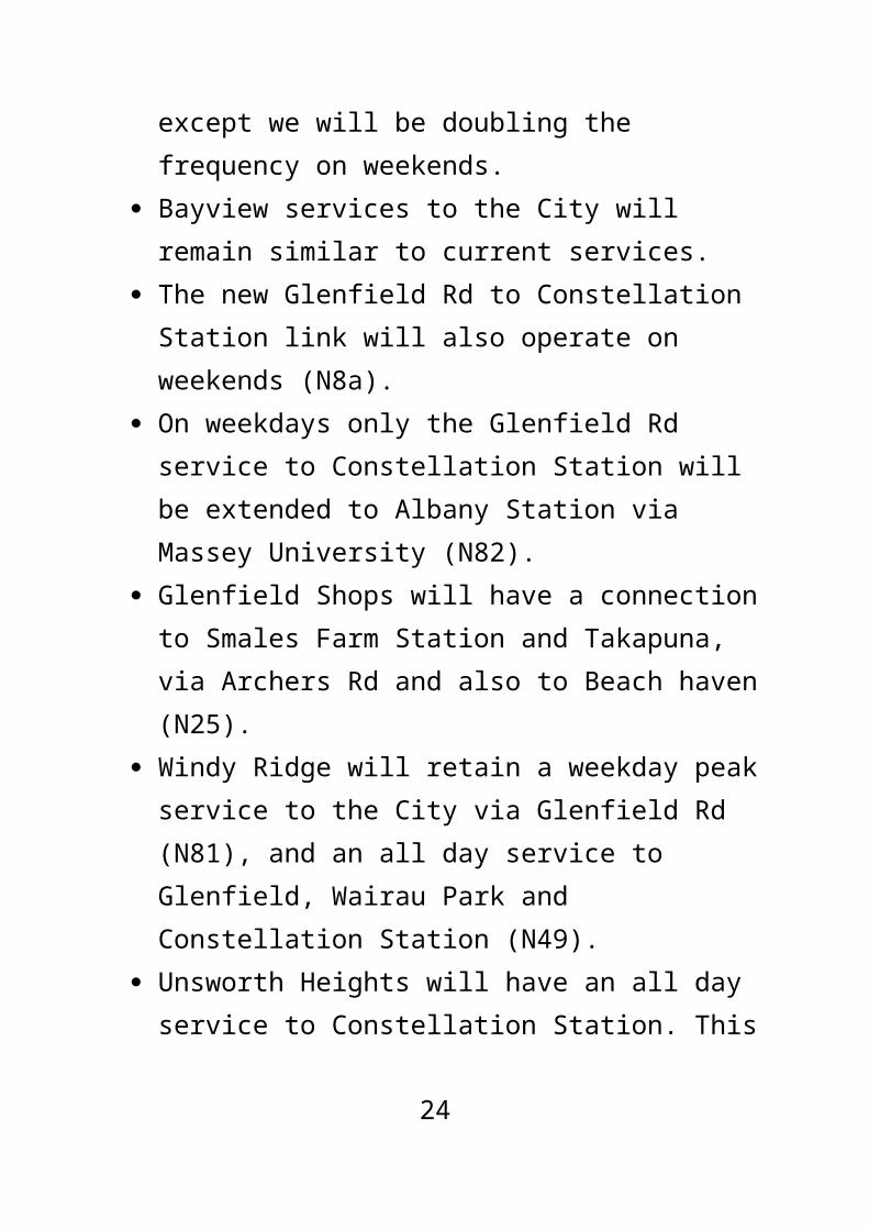
Beach Haven and Birkdale services to the City will remain similar to current services, except we will be doubling the frequency on weekends.
There will be a new route from Beach Haven to Takapuna that will run via Kaipatiki Bridge, Glenfield, Archers Rd, and Smales Farm Station in one direction; and via Highbury, Northcote Shops and Akoranga Station in the other direction (N25).
Chatswood will have a weekday peak only service to the City (Wellesley St and universities) (N91).
There will be an all day (Monday to Friday) service from Beach Haven wharf to the City (Wellesley St and universities) via Verbena Rd, Highbury and Onewa Rd (N92).
There will be an all day (Monday to Friday) service from Highbury to Newmarket via Ponsonby, Karangahape Rd and Auckland Hospital (N93).
By combining Beach Haven and Glenfield Rd services, Onewa Rd will have buses running to the City every 7-8 mins, 7am-7pm, 7 days a week, and more often at peak times.
17

East Coast Bays All suburbs north of Mairangi Bay will have all day
services to the busway at Albany Station or Constellation Station. These services would replace direct buses to the City.
A new frequent service will run every 15 mins from Massey University, through Albany Station, Browns Bay, Mairangi Bay and Constellation Station; then along the busway to Smales Farm Station and Takapuna (N6).
Mairangi Bay, Campbells Bay and Castor Bay will have a more direct service to the busway (Smales Farm and Constellation Stations), where passengers can connect to services to the City or elsewhere (N41).
Sunnynook and Crown Hill will have an all day service to Takapuna and the City (Wellesley St and universities) (N4a).
Forest Hill will have an all day service to Smales Farm Station and Takapuna (N31).
Milford and Takapuna will have a frequent service to the City (Wellesley St and universities) (N4/N4a).
18

Greenhithe Greenhithe will have an all day service to
Constellation Station via Sunset Rd (W5). This service also goes to Westgate and Henderson.
Greenhithe will have additional peak services that will also serve Upper Harbour Dr (W5c).
Glenfield / Bayview / Unsworth Heights
Glenfield Rd services to the City will remain similar to current services, except we will be doubling the frequency on weekends.
Bayview services to the City will remain similar to current services.
The new Glenfield Rd to Constellation Station link will also operate on weekends (N8a).
On weekdays only the Glenfield Rd service to Constellation Station will be extended to Albany Station via Massey University (N82).
Glenfield Shops will have a connection to Smales Farm Station and Takapuna, via Archers Rd and also to Beach haven (N25).
Windy Ridge will retain a weekday peak service to the City via Glenfield Rd (N81), and an all day
19

service to Glenfield, Wairau Park and Constellation Station (N49).
Unsworth Heights will have an all day service to Constellation Station. This service also connects with Smales Farm Station via Wairau Rd (N45).
Northcote / Hillcrest Hillcrest (Hillcrest Ave, Sylvia Rd, Ocean View Rd)
will have an all day service to the City (Wellesley St and universities) via Northcote shops. This service will also link Hillcrest to Smales Farm Station (N23).
The above service (N23) will travel via Sylvan Ave, except for morning peak services to the City which will travel via College Rd and Akoranga Station, to avoid congestion.
Hillcrest West will have an all day service to Smales Farm Station via Porana Rd, and to Akoranga Station via Northcote Shops (N24).
Takapuna / Devonport Peninsula Bayswater will have an all day service from the
wharf to Takapuna and Smales Farm Station, via Northboro Rd (N31). This service will connect with the Bayswater ferry.
Devonport will have an all day service to Takapuna and Smales Farm Station, via Vauxhall Rd (N30). This service will connect with the Devonport ferry.
20

Local services that will serve Devonport are: a Cheltenham loop service (N13), and a service to Stanley Bay (N12).
There will be a weekday peak only service from Belmont, through Hauraki, to the City (Wellesley St and universities) via Northboro Rd (N11).
West Auckland There will be more frequent and direct services from
Constellation Station to Westgate and Henderson, via Greenhithe and Hobsonville Rd (W5).
21

Page 4
Proposed frequencies and hours of serviceThis information is to give a general idea of the span of hours and frequency of services proposed, so you can see if the first and last service times work for you. It is likely to change as a result of public feedback and detailed timetable planning.
22

TN: The following table has been split into multiple tables by service type.
All Day ServicesBusway ServicesThe route numbers used are for consultation purposes only, and may not be the final numbers.
Route: Description
Weekdays Weekends Additional Information
Frequency Frequency
First service by
Last service after
All day (7am-7pm)
Peak (morning & evening)
Late (after 7pm)
First service by
Last service after
All day (7am-7pm)
Late (after 7pm)
NX1: Albany to Britomart (Lower Albert St)
5.30am midnight 10 mins 3-5 mins* 10 mins 5.30am 11.00pm 15 mins 15 mins * Including buses starting at Constellation Stn at peak times
NX2: Albany to City universities
5.30am 11.00pm 10 mins 3-5 mins* 15 mins 5.30am 10.00pm 15 mins 15 mins * Including buses starting at Constellation Stn at peak times
NX3: Albany to Newmarket
6.00am 9.00pm 30 mins 10 mins 60 mins blank blank blank blank blank
23

Frequent, Connector, and Local Services
Route: Description
Weekdays Weekends Additional Information
Frequency Frequency
First service by
Last service after
All day (7am-7pm)
Peak (morning & evening)
Late (after 7pm)
First service by
Last service after
All day (7am-7pm)
Late (after 7pm)
N4; N4a: Milford to City universities via Takapuna; Constellation Stn to City universities
6.00am 11.00pm 15 mins 15 mins 30 mins 6.00am 10.00pm 15 mins 30 mins Between Constellation Stn and Milford the N4a will run half as often except after 7pm (30 mins)
N6: Massey University to Takapuna via Albany Stn and Browns Bay
6.00am 11.00pm 15 mins 15 mins 30 mins 6.00am 10.00pm 15 mins 30 mins blank
24

Route: Description
Weekdays Weekends Additional Information
Frequency Frequency
First service by
Last service after
All day (7am-7pm)
Peak (morning & evening)
Late (after 7pm)
First service by
Last service after
All day (7am-7pm)
Late (after 7pm)
N8; N8a; N8b: Glenfield to Britomart (Lower Albert St); Constellation Stn to Britomart (Lower Albert St) via Glenfield Rd; Bayview to Britomart (Lower Albert St) via Glenfield Rd
6.00am 11.00pm 15 mins 7-8 mins 30 mins 6.00am 10.00pm 15 mins 30 mins Between Constellation Stn and Glenfield Rd (N8a) and the Bayview loop and Glenfield Rd (N8b), this service runs at approximately half the frequency
25

Route: Description
Weekdays Weekends Additional Information
Frequency Frequency
First service by
Last service after
All day (7am-7pm)
Peak (morning & evening)
Late (after 7pm)
First service by
Last service after
All day (7am-7pm)
Late (after 7pm)
N9; N9a/b: Beach Haven to Britomart (Lower Albert St)
5.30am 11.00pm 15 mins 7-8 mins 30 mins 6.00am 10.00pm 15 mins 30 mins When route splits, the two paths have half the frequency
N11: Belmont to City universities (Peak service)
blank blank blank 30 mins* blank blank blank blank blank * 3 trips 30 mins apart in both morning and afternoon peaks
N12: Stanley Point to Devonport Ferry Terminal
6.30am 7.00pm 30 mins blank blank 6.30am 7.00pm 60 mins blank blank
26
Route: Description
Weekdays Weekends Additional Information
Frequency Frequency
First service by
Last service after
All day (7am-7pm)
Peak (morning & evening)
Late (after 7pm)
First service by
Last service after
All day (7am-7pm)
Late (after 7pm)
N13: Devonport Ferry Terminal to Mt Victoria / Cheltenham
6.30am 7.00pm 30 mins 15 mins blank 6.30am 11.00pm 30 mins 60 mins blank
27

Route: Description
Weekdays Weekends Additional Information
Frequency Frequency
First service by
Last service after
All day (7am-7pm)
Peak (morning & evening)
Late (after 7pm)
First service by
Last service after
All day (7am-7pm)
Late (after 7pm)
N21; N21a/b: Birkenhead Wharf* and Northcote Point; to Smales Farm Stn via North Shore Hospital
6.30am 7.00pm 30 mins**
15 mins blank 6.30am 7.00pm 30 mins blank * Buses will only connect with ferry at Birkenhead Ferry Terminal, not Northcote ** Buses alternate between Northcote Point (N21a) and Birkenhead Ferry Terminal (N21b), therefore runs at half the frequency on these branches until they meet at Northcote Shops
28

Route: Description
Weekdays Weekends Additional Information
Frequency Frequency
First service by
Last service after
All day (7am-7pm)
Peak (morning & evening)
Late (after 7pm)
First service by
Last service after
All day (7am-7pm)
Late (after 7pm)
N23; N23a/b: Smales Farm Stn to City universities via Hillcrest and Sylvan Ave
6.30am 10.30pm 20 mins 15 mins 30 mins 6.30am 10.00pm 30 mins 60 mins All buses follow route N23a via Sylvan Ave, except morning peak buses to City which follow route N23b via Akoranga Stn, to avoid heavy traffic
N24: Smales Farm Stn to Akoranga Stn via Hillcrest West
6.30am 9.00pm 30 mins blank 60 mins 6.30am 7.00pm 60 mins blank blank
29

Route: Description
Weekdays Weekends Additional Information
Frequency Frequency
First service by
Last service after
All day (7am-7pm)
Peak (morning & evening)
Late (after 7pm)
First service by
Last service after
All day (7am-7pm)
Late (after 7pm)
N25: Beach Haven to Takapuna, via Glenfield and Smales Farm Stn or Highbury and Northcote Shops*
6.30am 10.00pm 30 mins 15 mins 30 mins 6.30am 10.00pm 30 mins 30 mins * Services operate in both directions
N30: Devonport Ferry Terminal to Smales Farm Stn via Takapuna
6.30am 10.30pm 30 mins 30 mins* 60 mins 6.30am 10.00pm 30 mins 60 mins * A bus every 15 mins in peak periods between Belmont and Devonport Wharf to connect with the ferry
30
Route: Description
Weekdays Weekends Additional Information
Frequency Frequency
First service by
Last service after
All day (7am-7pm)
Peak (morning & evening)
Late (after 7pm)
First service by
Last service after
All day (7am-7pm)
Late (after 7pm)
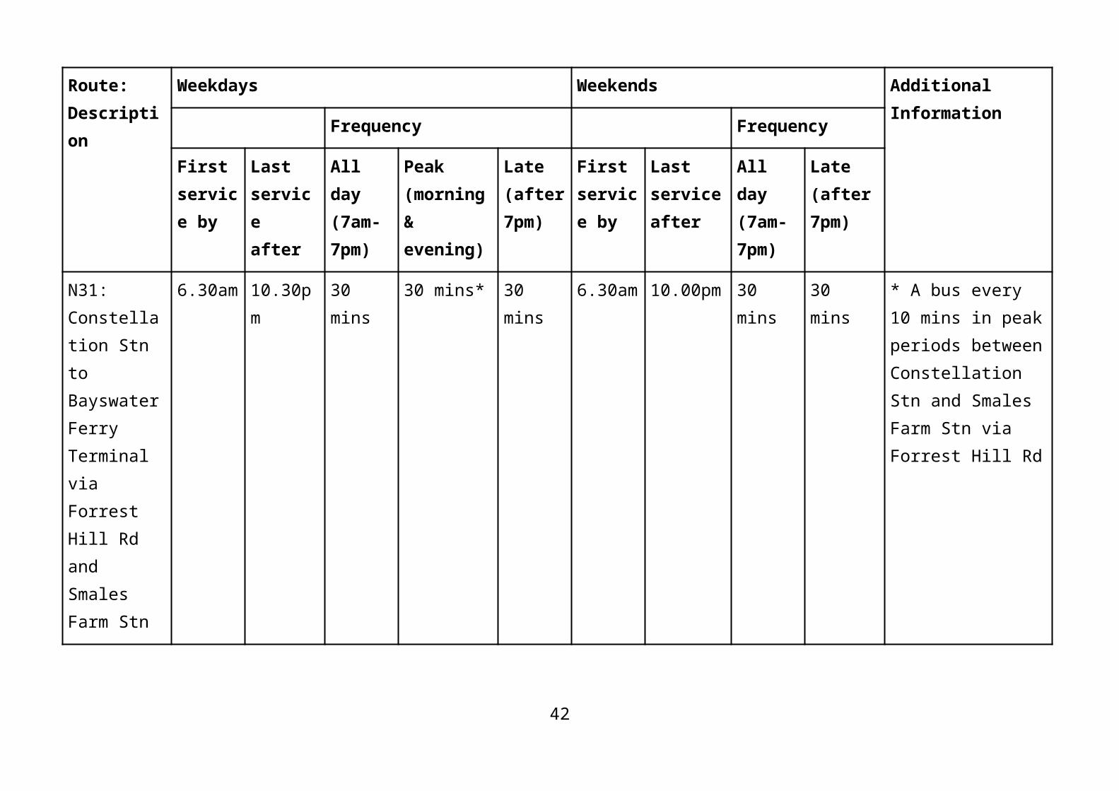
N31: Constellation Stn to Bayswater Ferry Terminal via Forrest Hill Rd and Smales Farm Stn
6.30am 10.30pm 30 mins 30 mins* 30 mins 6.30am 10.00pm 30 mins 30 mins * A bus every 10 mins in peak periods between Constellation Stn and Smales Farm Stn via Forrest Hill Rd
N32: Milford to Takapuna via North Shore Hospital
9.30am 5.00pm 60 mins blank blank blank blank blank blank blank
31

Route: Description
Weekdays Weekends Additional Information
Frequency Frequency
First service by
Last service after
All day (7am-7pm)
Peak (morning & evening)
Late (after 7pm)
First service by
Last service after
All day (7am-7pm)
Late (after 7pm)
N41: Constellation Stn to Smales Farm Stn via Beach Rd
6.30am 10.30pm 30 mins 30 mins* 30 mins 6.30am 10.00pm 30 mins 30 mins * Plus extra buses between Mairangi Bay and Constellation Stn at peak times, to provide a bus every 15 mins
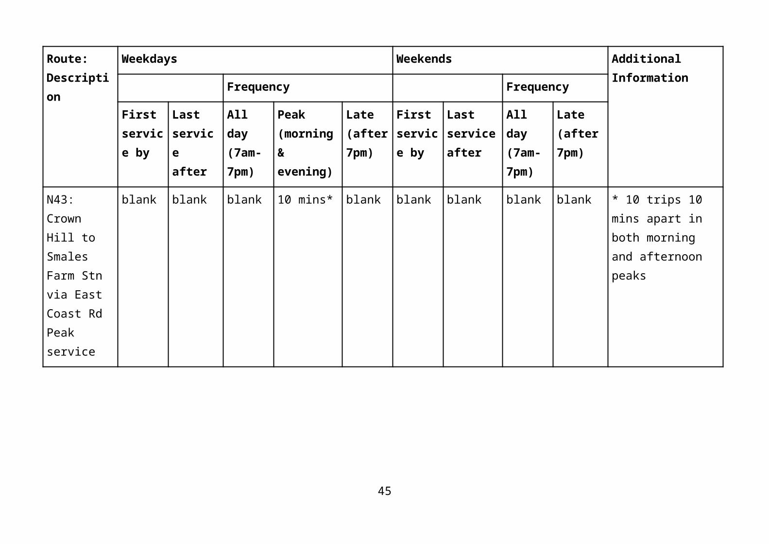
N43: Crown Hill to Smales Farm Stn via East Coast Rd Peak service
blank blank blank 10 mins* blank blank blank blank blank * 10 trips 10 mins apart in both morning and afternoon peaks
32

Route: Description
Weekdays Weekends Additional Information
Frequency Frequency
First service by
Last service after
All day (7am-7pm)
Peak (morning & evening)
Late (after 7pm)
First service by
Last service after
All day (7am-7pm)
Late (after 7pm)
N45: Smales Farm Stn to Constellation Stn via Wairau Rd and Unsworth Dr
6.30am 10.00pm 30 mins 20 mins* 60 mins 6.30am 9.00pm 60 mins blank * Peak service direction is to Constellation Stn in the morning, and away from Constellation Stn in the evening
N49: Windy Ridge to Constellation Stn
6.30am 7.00pm 30 mins blank blank 6.30am 7.00pm 60 mins blank blank
N62: Albany Stn to Constellation Stn via East Coast Rd
6.30am 10.30pm 30 mins 15 mins 30 mins 6.00am 10.00pm 30 mins 30 mins blank
33

Route: Description
Weekdays Weekends Additional Information
Frequency Frequency
First service by
Last service after
All day (7am-7pm)
Peak (morning & evening)
Late (after 7pm)
First service by
Last service after
All day (7am-7pm)
Late (after 7pm)
N63: Albany Stn to Constellation Stn via Hugh Green Dr
6.30am 8.00pm 30 mins 15 mins 60 mins 6.30am 8.00pm 60 mins blank blank
N65: Schnapper Rock to Constellation Stn
6.30am 9.00pm 30 mins 20 mins blank 6.30am 9.00pm 60 mins blank blank
N66: Albany Stn to Constellation Stn via William Pickering Dr
6.30am 9.00pm 30 mins 15 mins blank 6.30am 7.00pm 60 mins blank blank
34

Route: Description
Weekdays Weekends Additional Information
Frequency Frequency
First service by
Last service after
All day (7am-7pm)
Peak (morning & evening)
Late (after 7pm)
First service by
Last service after
All day (7am-7pm)
Late (after 7pm)
N74: Albany Stn to Fairview Heights circuit
6.30am 9.00pm 60 mins 30 mins blank 6.30am 7.00pm 60 mins blank blank
N78: Long Bay to Albany Stn
6.30am 10.30pm 30 mins 15 mins 30 mins 6.00am 10.00pm 30 mins 30 mins blank
N79: Torbay to Albany Stn via Fitzwilliam Dr or Oaktree Ave*
6.30am**
10.30pm***
30 mins 15 mins 30 mins 6.30am 10.00pm 30 mins 30 mins * Services operate in both directions; ** Services start from Torbay; *** Last departures in both directions from Albany
35

Route: Description
Weekdays Weekends Additional Information
Frequency Frequency
First service by
Last service after
All day (7am-7pm)
Peak (morning & evening)
Late (after 7pm)
First service by
Last service after
All day (7am-7pm)
Late (after 7pm)
N81: Windy Ridge to City universities Peak service
blank blank blank 20 mins* blank blank blank blank blank * 7 trips 20 mins apart in both morning and afternoon peaks
N82: Highbury to Albany via Glenfield Rd, Constellation Stn and Massey University
7.00am 7.00pm 30 mins 10 mins* blank blank blank blank blank * Some services start at Britomart (Lower Albert St)
N91: Chatswood to City universities Peak service
blank blank blank 15 mins* blank blank blank blank blank * 9 trips 15 mins apart in both morning and afternoon peaks
36

Route: Description
Weekdays Weekends Additional Information
Frequency Frequency
First service by
Last service after
All day (7am-7pm)
Peak (morning & evening)
Late (after 7pm)
First service by
Last service after
All day (7am-7pm)
Late (after 7pm)
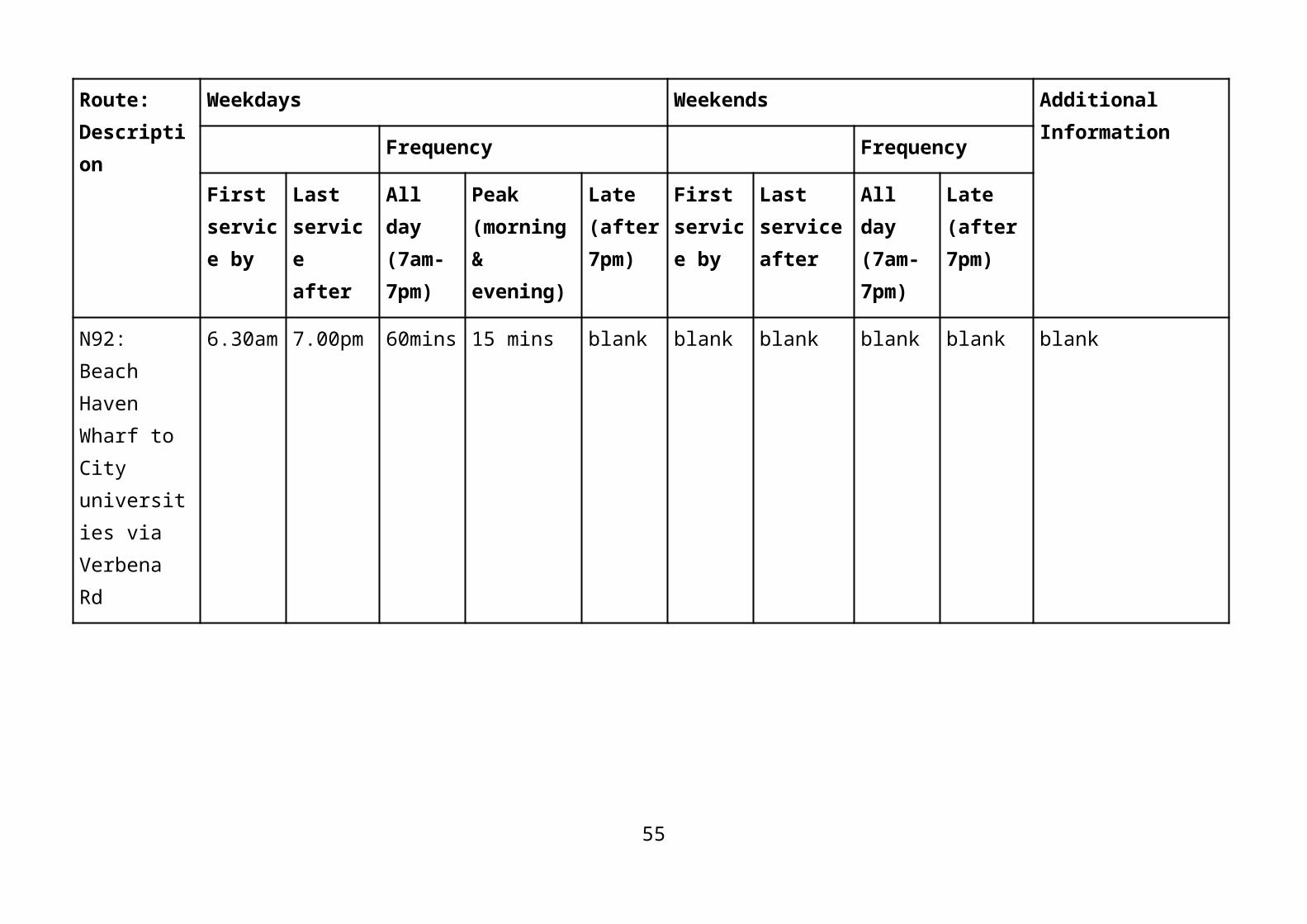
N92: Beach Haven Wharf to City universities via Verbena Rd
6.30am 7.00pm 60mins 15 mins blank blank blank blank blank blank
N93: Highbury to Newmarket via Ponsonby Rd and Auckland Hospital
6.30am 7.00pm 30 mins 15 mins blank blank blank blank blank blank
37

Route: Description
Weekdays Weekends Additional Information
Frequency Frequency
First service by
Last service after
All day (7am-7pm)
Peak (morning & evening)
Late (after 7pm)
First service by
Last service after
All day (7am-7pm)
Late (after 7pm)
W5; W5c: Henderson to Constellation Stn via Greenhithe; W5c is a peak service
6.30am 10.00pm 30 mins 20 mins* 60 mins 6.30am 10.00pm 30 mins 60 mins * Plus extra buses between Greenhithe and Constellation Stn at peak times, to provide a bus every 10 mins
Late Night Services (Niterider)Route Description Frequency Operational Hours Fri-Sat
OnlyAdditional Information
Britomart (Lower Albert St) to Albany* (NX1)
30 mins midnight to 3:00am * Operates in both directions
City to Takapuna and Browns Bay
30 mins midnight to 3:00am blank
City to Beach Haven and 30 mins midnight to 3:00am blank
38

Glenfield
39

Pages 5-6
North Shore New Network MapAll current bus services are changing. Ferries and school buses are not part of this consultationThe route numbers used are for consultation purposes only and may not be the final numbers. Bus stop locations will be reviewed once the New Network is finalised. All routes travel in both directions except where arrows indicate.
Get to know the new service typesFrequent services: Operate on key routes across Auckland. Run at least every 15 mins during the day (7am-7pm, 7 days a week), and may run less frequently outside of these times. In some cases run more often at peak times.
Connector services: Run at least every 30 mins during the day (7am-7pm, 7 days a week), and may run less frequently outside of these times. Generally run every 10-15 mins at peak.
40

Local services: Frequency and days of week vary. Please see Proposed Frequencies and Hours of Service table for details about each service.
Peak period services: Services that only operate during weekday peak periods. Generally run 7am-9am, and 4pm-6pm.
TN: Map omitted. See accessible route descriptions below by Auckland Transport.
North Shore Bus RoutesN11—Belmont to City Universities (Peak Only, One Way) Lake Road, (Left) into Bardia Street, (Right) into Creamer Avenue, (Right) into Eversleigh Road, (Left) into Northboro Road, (Left) into Jutland Road, (Right) into Francis Street, (Right) into Hart Road, (Left) into Lake Road, (Left) into Esmonde Road, (Left) into Northern Busway, (Left) into Northern Motorway, into Auckland Harbour Bridge, into Southern Motorway, into Fanshawe Off-ramp Southbound, (Left) into Fanshawe Street, (Right) into Halsey Street, into Wellesley Street West, into Wellesley Street East
41

N12—Stanley Point to DevonportStanley Point Road, (Left) into Calliope Road, (Right) into Victoria Road, (Right) into Marine Square
N12—Devonport to Stanley PointMarine Square, (Left) into Victoria Road, (Left) into Calliope Road, (Right) into Stanley Point Road
N13—Cheltenham Circuit to DevonportMarine Square, (Right) into Victoria Road, (Right) into King Edward Parade, (Left) into Cheltenham Road, (Left) into Tainui Road, (Left) into Vauxhall Road, (Right) into Albert Road, (Left) into Victoria Road, (Right) into Marine Square
N21a—Northcote Point to Smales Farm Station via North Shore HospitalQueen Street, (Left) into Onewa Road, (Right) into Lake Road, (Right) into Exmouth Road, (Left) into College Road, (Left) into Kilham Avenue, (Left) into Pearn Crescent, (Right) into Lake Road, (Right) into Ocean View Road, into Northcote Road, (Left) into Taharoto Road, (Right) into Shea Terrace, (Left) into Hospital Road, (Left) into Shakespeare Road, into Smales Farm Station
42

N21a—Smales Farm Station to Northcote Point via North Shore HospitalSmales Farm Station, into Shakespeare Road, (Right) into Hospital Road, (Right) into Shea Terrace, (Left) into Taharoto Road, (Right) into Northcote Road, into Ocean View Road, (Left) into Lake Road, (Left) into Pearn Crescent, (Right) into Kilham Avenue, (Right) into College Road, (Right) into Exmouth Road, (Left) into Lake Road, (Left) into Onewa Road, (Right) into Queen Street
N21b—Birkenhead Wharf to Smales Farm Station via North Shore HospitalHinemoa Street, (Right) into Birkenhead Avenue, (Right) into Pupuke Road, (Right) into Raleigh Road, into Exmouth Road, (Left) into College Road, (Left) into Kilham Avenue, (Left) into Pearn Crescent, (Right) into Lake Road, (Right) into Ocean View Road, into Northcote Road, (Left) into Taharoto Road, (Right) into Shea Terrace, (Left) into Hospital Road, (Left) into Shakespeare Road, into Smales Farm Station
N21b—Smales Farm Station to Birkenhead Wharf via North Shore HospitalSmales Farm Station, into Shakespeare Road, (Right) into Hospital Road, (Right) into Shea Terrace, (Left) into
43

Taharoto Road, (Right) into Northcote Road, into Ocean View Road, (Left) into Lake Road, (Left) into Pearn Crescent, (Right) into Kilham Avenue, (Right) into College Road, (Right) into Exmouth Road, into Raleigh Road, (Left) into Pupuke Road, (Left) into Birkenhead Avenue, (Left) into Hinemoa Street
N23a—Hillcrest to City from Smales Farm StationSmales Farm Station, (Right) into Northcote Road, (Right) into Sunnybrae Road, (Left) into Coronation Road, (Left) into Hillcrest Avenue, (Right) into Sylvia Road, (Left) into Eban Avenue, (Right) into Ocean View Road, (Left) into Raleigh Road, (Left) into Lake Road, (Right) into Pearn Crescent, (Right) into Kilham Avenue, (Right) into College Road, (Left) into Exmouth Road, (Right) into Sylvan Avenue, (Left) into Ramp, (Left) into Northern Busway, (Left) into Northern Motorway, into Auckland Harbour Bridge, into Southern Motorway, into Fanshawe Off-ramp Southbound, (Left) into Fanshawe Street, (Right) into Halsey Street, into Wellesley Street, into Wellesley Street East
N23a—City to Hillcrest and Smales Farm StationWellesley Street East, into Wellesley Street West, into Halsey Street, (Left) into Fanshawe Street, (Right) into
44
Fanshawe Onramp Northbound, (Left) into Southern Motorway, into Auckland Harbour Bridge, into Northern Motorway, (Left) into Onewa Offramp Northbound, (Right) into Sylvan Avenue, (Left) into Exmouth Road, (Right) into College Road, (Left) into Kilham Avenue, (Left) into Pearn Crescent, (Left) into Lake Road, (Right) into Raleigh Road, (Right) into Ocean View Road, (Left) into Eban Avenue, (Right) into Sylvia Road, (Left) into Hillcrest Avenue, (Right) into Coronation Road, (Right) into Sunnybrae Road, (Left) into Northcote Road, (Left) into Smales Farm Business Park Road, into Smales Farm Station
N23b—Hillcrest to City (Morning Peak Only)Sunnybrae Road, (Left) into Coronation Road, (Left) into Hillcrest Avenue, (Right) into Sylvia Road, (Left) into Eban Avenue, (Right) into Ocean View Road, (Left) into Raleigh Road, (Left) into Lake Road, (Right) into Pearn Crescent, (Right) into Kilham Avenue, (Left) into College Road, (Right) into Akoranga Drive, (Left) into Esmonde Road, (Left) into Akoranga Station, into Northern Busway, (Left) into Northern Motorway, into Auckland Harbour Bridge, into Southern Motorway, into Fanshawe Offramp Southbound, (Left) into Fanshawe Street, (Right) into Halsey Street, into Wellesley Street, into Wellesley Street East
45

N24—Hillcrest West Circuit (Smales Farm Station to Akoranga Station)Smales Farm Station, into Shakespeare Road, (Left) into Wairau Road, (Left) into Porana Road, (Left) into Sunnybrae Road, (Right) into Coronation Road, (Left) into Lynden Avenue, (Right) into Mountbatten Avenue, (Left) into Hume Drive, (Left) into Monarch Avenue, (Left) into Betsland Crescent, (Left) into McDowell Crescent, (Left) into Moore Street, (Right) into Tilden Avenue, (Left) into Pupuke Road, (Right) into Raleigh Road, (Left) into Lake Road, (Right) into Pearn Crescent, (Right) into Kilham Avenue, (Left) into College Road, (Right) into Akoranga Drive, (Left) into Esmonde Road, (Left) into Access Road, into Akoranga Station
N24—Hillcrest West Circuit (Akoranga Station to Smales Farm Station)Akoranga Station, (Left) into Access Road, (Right) into Esmonde Road, (Right) into Akoranga Drive, (Left) into College Road, (Right) into Kilham Avenue, (Left) into Pearn Crescent, (Left) into Lake Road, (Right) into Raleigh Road, (Left) into Pupuke Road, (Right) into Tilden Avenue, (Left) into Moore Street, (Right) into McDowell Crescent, (Right) into Betsland Crescent, (Right) into Monarch Avenue, (Right) into Hume Drive, (Right) into Mountbatten Avenue, (Left) into Lynden
46

Avenue, (Right) into Coronation Road, (Left) into Sunnybrae Road, (Right) into Porana Road, (Right) into Wairau Road, (Right) into Shakespeare Road, into Smales Farm Station
N25—Birkenhead to Takapuna Circuit via Northcote, Akoranga Station and Smales Farm StationVerran Road, (Right) into Waipa Street, (Left) into Mokoia Road, (Left) into Birkenhead Avenue, (Right) into Onewa Road, (Left) into Lake Road, (Right) into Pearn Crescent, (Right) into Kilham Avenue, (Left) into College Road, (Right) into Akoranga Drive, (Left) into Esmonde Road, (Left) into Access Road, (Right) into Akoranga Station, (Right) into Access Road, (Left) into Fred Thomas Drive, (Right) into Anzac Street, (Right) into Auburn Street, (Left) into Huron Street, (Left) into Lake Road, (Left) into Anzac Street, (Right) into Taharoto Road, (Left) into Northcote Road, (Right) into Smales Farm Business Park Road, (Left) into Smales Farm Exit Road, (Right) into Northern Busway, into Shakespeare Road, (Left) into Wairau Road, (Left) into Archers Road, (Right) into Blenheim Street, (Right) into Lingfield Street, (Left) into Chartwell Avenue, (Left) into Bentley Avenue, (Left) into Glenfield Road, (Right) into Kaipatiki Road, (Left) into Kaipatiki Bridge, into Beach
47
Haven Road, (Left) into Rangatira Road, (Right) into Verran Road
N25—Birkenhead to Takapuna Circuit via Smales Farm Station, Akoranga Station and NorthcoteVerran Road, (Left) into Rangatira Road, (Right) into Beach Haven Road, into Kaipatiki Bridge, (Right) into Kaipatiki Road, (Left) into Glenfield Road, (Right) into Bentley Avenue, (Right) into Chartwell Avenue, (Right) into Lingfield Street, (Left) into Blenheim Street, (Left) into Archers Road, (Right) into Wairau Road, (Right) into Shakespeare Road, into Northern Busway, (Left) into Smales Farm Exit Road, (Left) into Smales Farm Business Park Road, (Right) into Taharoto Road, (Left) into Anzac Street, (Right) into Lake Road, (Right) into Huron Street, (Right) into Auburn Street, (Left) into Anzac Street, (Left) into Fred Thomas Drive, (Right) into Access Road, (Left) into Northern Busway, (Left) into Access Road, (Right) into Esmonde Road, (Right) into Akoranga Drive, (Left) into College Road, (Right) into Kilham Avenue, (Left) into Pearn Crescent, (Left) into Lake Road, (Right) into Onewa Road, (Left) into Birkenhead Avenue, (Right) into Mokoia Road, (Right) into Waipa Street, (Left) into Verran Road
48

N30—Smales Farm Station to Devonport via TakapunaSmales Farm Station, (Left) into Smales Farm Exit Road, (Left) into Smales Farm Business Park Road, (Right) into Taharoto Road, (Left) into Anzac Street, (Right) into Lake Road, (Left) into Old Lake Road, into Vauxhall Road, into Church Street, (Right) into King Edward Parade, (Left) into Victoria Road, (Left) into Marine Square
N30—Devonport to Smales Farm Station via TakapunaMarine Square, (Right) into Victoria Road, (Right) into King Edward Parade, (Left) into Church Street, into Vauxhall Road, into Old Lake Road, (Right) into Lake Road, (Left) into Anzac Street, (Right) into Taharoto Road, (Left) into Northcote Road, (Right) into Smales Farm Business Park Road, (Left) into Smales Farm Exit Road, (Right) into Smales Farm Station
N31—Bayswater to Constellation Station to Via Hauraki, Takapuna, Smales Farm Station and Forrest Hill RoadSir Peter Blake Parade, (Right) into Bayswater Avenue, (Left) into Lake Road, (Left) into Bardia Street, (Right) into Creamer Avenue, (Right) into Eversleigh Road,
49

(Left) into Northboro Road, (Left) into Jutland Road, (Right) into Francis Street, (Right) into Hart Road, (Left) into Lake Road, (Left) into Anzac Street, (Right) into Taharoto Road, (Left) into Northcote Road, (Right) into Smales Farm Business Park Road, (Left) into Smales Farm Exit Road, (Right) into Northern Busway, into Shakespeare Road, (Left) into Wairau Road, (Right) into Forrest Hill Road, (Left) into East Coast Road, (Left) into Sunset Road, (Right) into Constellation Station
N31—Constellation Station to Bayswater via Forrest Hill Road, Smales Farm Station, Takapuna and HaurakiConstellation Station, (Left) into Sunset Road, (Right) into East Coast Road, (Right) into Forrest Hill Road, (Left) into Wairau Road, (Right) into Shakespeare Road, into Northern Busway, (Left) into Smales Farm Exit Road, (Left) into Smales Farm Business Park Road, (Right) into Taharoto Road, (Left) into Anzac Street, (Right) into Lake Road, (Right) into Hart Road, (Left) into Francis Street, (Left) into Jutland Road, (Right) into Northboro Road, (Right) into Eversleigh Road, (Left) into Creamer Avenue, (Left) into Bardia Street, (Right) into Lake Road, (Right) into Bayswater Avenue, (Left) into Sir Peter Blake Parade
50

N32—Milford to Takapuna via Nile Road, North Shore Hospital, Smales Farm Station and Karaka StreetMilford Road, (Right) into Kitchener Road, into East Coast Road, (Left) into Wolsley Avenue, (Right) into Dallinghoe Crescent, (Left) into Stanley Avenue, (Left) into Nile Road, (Left) into Waterloo Road, (Right) into Shakespeare Road, (Left) into Hospital Road, (Right) into Shea Terrace, (Left) into Hospital Road, (Left) into Shakespeare Road, into Smales Farm Station, (Left) into Smales Farm Business Park Road, (Right) into Taharoto Road, (Right) into Karaka Street, (Left) into Puriri Street, (Left) into Dominion Street, (Right) into Taharoto Road, (Left) into Anzac Street, (Right) into Lake Road
N32—Takapuna to Milford via Karaka Street, Smales Farm Station, North Shore Hospital and Nile RoadLake Road, (Left) into Anzac Street, (Right) into Taharoto Road, (Left) into Dominion Street, (Right) into Puriri Street, (Right) into Karaka Street, (Left) into Taharoto Road, (Left) into Northcote Road, (Right) into Smales Farm Business Park Road, (Left) into Smales Farm Exit Road, (Right) into Smales Farm Station, into Shakespeare Road, (Right) into Hospital Road, (Right)
51

into Shea Terrace, (Left) into Hospital Road, (Right) into Shakespeare Road, (Left) into Waterloo Road, (Right) into Nile Road, (Right) into Stanley Avenue, (Right) into Dallinghoe Crescent, (Left) into Wolsley Avenue, (Right) into East Coast Road, into Kitchener Road, (Left) into Milford Road
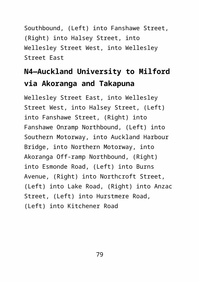
N4—Milford to Auckland University via Takapuna and Akoranga StationKitchener Road, (Right) into Hurstmere Road, (Right) into Anzac Street, (Left) into Lake Road, (Right) into Northcroft Street, (Left) into Burns Avenue, (Right) into Esmonde Road, (Left) into Northern Busway, (Left) into Northern Motorway, into Auckland Harbour Bridge, Southern Motorway, into Fanshawe Off-ramp Southbound, (Left) into Fanshawe Street, (Right) into Halsey Street, into Wellesley Street West, into Wellesley Street East
N4—Auckland University to Milford via Akoranga and TakapunaWellesley Street East, into Wellesley Street West, into Halsey Street, (Left) into Fanshawe Street, (Right) into Fanshawe Onramp Northbound, (Left) into Southern Motorway, into Auckland Harbour Bridge, into Northern Motorway, into Akoranga Off-ramp Northbound, (Right) into Esmonde Road, (Left) into Burns Avenue, (Right)
52

into Northcroft Street, (Left) into Lake Road, (Right) into Anzac Street, (Left) into Hurstmere Road, (Left) into Kitchener Road
N41—Constellation Station to Smales Farm Station via Mairangi Bay, Beach Road and MilfordConstellation Station, (Left) into Parkway Drive, (Right) into Constellation Drive, (Left) into East Coast Road, (Right) into Sunrise Avenue, (Right) into Beach Road, into Inga Road, (Right) into Omana Road, (Left) into Ihumata Road, (Right) into Milford Road, (Right) into Kitchener Road, (Left) into Slip Road, (Left) into Shakespeare Road, into Smales Farm Station
N41—Smales Farm Station to Constellation Station via Milford, Beach Road and Mairangi BaySmales Farm Station, into Shakespeare Road, (Right) into Kitchener Road, (Left) into Milford Road, (Left) into Ihumata Road, (Right) into Omana Road, (Left) into Inga Road, into Beach Road, (Left) into Sunrise Avenue, (Left) into East Coast Road, (Right) into Constellation Drive, into Upper Harbour Highway Onramp Southbound, (Left) into Constellation Station
53

N43—Forrest Hill to Smales Farm Station via East Coast Road (Peak Only)Forrest Hill Road, (Right) into East Coast Road, into Kitchener Road, (Right) into Shakespeare Road, into Smales Farm Station
N43—Smales Farm Station to Forrest Hill via East Coast Road (Peak Only)Smales Farm Station, into Shakespeare Road, (Left) into Kitchener Road, into East Coast Road, (Left) into Forrest Hill Road
N45—Constellation Station to Smales Farm Station via Unsworth DriveConstellation Station, (Right) into Sunset Road, (Right) into Meadowood Drive, (Right) into Barbados Drive, (Left) into Unsworth Drive, (Left) into Albany Highway, into Glenfield Road, (Left) into Wairau Road, (Right) into Shakespeare Road, into Smales Farm Station
N45—Smales Farm Station to Constellation Station via Unsworth DriveSmales Farm Station, into Shakespeare Road, (Left) into Wairau Road, (Right) into Glenfield Road, into Albany Highway, (Right) into Unsworth Drive, (Right)
54

into Barbados Drive, (Left) into Meadowood Drive, (Left) into Sunset Road, (Left) into Constellation Station
N49—Windy Ridge to Constellation Station via Glenfield and Link DriveGlenfield Road, (Right) into Roberts Road, (Right) into Stanley Road, (Left) into Seaview Road, (Right) into Tamahere Drive, (Right) into Contessa Drive, (Left) into Stanley Road, (Right) into Kaipatiki Road, (Left) into Glenfield Road, (Right) into Chivalry Road, (Left) into Diana Drive, (Left) into Wairau Road, (Right) into Target Road, (Right) into Link Drive, (Left) into Sunnynook Road, (Right) into Target Road, (Right) into Sunset Road, (Left) into Constellation Station
N49—Constellation Station to Glenfield via Link DriveConstellation Station, (Right) into Sunset Road, (Left) into Target Road, (Left) into Sunnynook Road, (Right) into Link Drive, (Left) into Target Road, (Left) into Wairau Road, (Right) into Diana Drive, (Right) into Chivalry Road, (Left) into Glenfield Road
55

N4a—Constellation Station to Auckland University via East Coast Road, Milford, Takapuna and AkorangaNorthern Busway, (Left) into Sunset Road, (Right) into Juniper Road, (Left) into Sycamore Drive, (Left) into Sunnynook Road, (Right) into East Coast Road, into Kitchener Road, (Right) into Hurstmere Road, (Right) into Anzac Street, (Left) into Lake Road, (Right) into Northcroft Street, (Left) into Burns Avenue, (Right) into Esmonde Road, (Left) into Northern Busway, (Left) into Northern Motorway, into Auckland Harbour Bridge, into Southern Motorway, into Fanshawe Off-ramp Southbound, (Left) into Fanshawe Street, (Right) into Halsey Street, into Wellesley Street West, into Wellesley Street East
N4a—Auckland University to Constellation Station via Akoranga, Takapuna, Milford and East Coast RoadWellesley Street East, into Wellesley Street West, into Halsey Street, (Left) into Fanshawe Street, (Right) into Fanshawe Onramp Northbound, (Left) into Southern Motorway, into Auckland Harbour Bridge, into Northern Motorway, into Akoranga Off-ramp Northbound, (Right) into Esmonde Road, (Left) into Burns Avenue, (Right) into Northcroft Street, (Left) into Lake Road, (Right) into
56

Anzac Street, (Left) into Hurstmere Road, (Left) into Kitchener Road, into East Coast Road, (Left) into Sunnynook Road, (Right) into Sycamore Drive, (Right) into Juniper Road, (Left) into Sunset Road, (Right) into Northern Busway
N6—Massey University to Takapuna via Albany, Browns Bay, Constellation Station, and Smales Farm StationUniversity Avenue, (Left) into State Highway 17, (Right) into Coliseum Drive, (Left) into Don Mckinnon Drive, (Right) into Civic Crescent, into Mcclymonts Road, (Left) into Elliott Rose Avenue, (Right) into Albany Busway, (Left) into Oteha Valley Off-ramp Northbound, (Right) into Oteha Valley Road, (Right) into Carlisle Road, (Right) into Beach Road, (Left) into Bute Road, (Right) into Clyde Road, (Right) into Browns Bay Road, (Left) into Beach Road, (Right) into Ramsgate Terrace, (Right) into Maxwelton Drive, (Left) into East Coast Road, (Right) into Constellation Drive, (Left) into Parkway Drive, (Right) into Northern Busway, (Right) into Smales Farm Exit Road, (Right) into Smales Farm Business Park Road, (Left) into Northcote Road, (Right) into Taharoto Road, (Left) into Anzac Street, (Right) into Lake Road
57
N6—Takapuna to Massey University via Smales Farm Station, Constellation Station, Mairangi Bay and AlbanyLake Road, (Left) into Anzac Street, (Right) into Taharoto Road, (Left) into Northcote Road, (Right) into Smales Farm Business Park Road, (Left) into Northern Busway, (Right) into Sunset Road, (Left) into Constellation Station, (Left) into Parkway Drive, (Right) into Constellation Drive, (Left) into East Coast Road, (Right) into Maxwelton Drive, (Left) into Ramsgate Terrace, (Left) into Beach Road, (Right) into Browns Bay Road, (Left) into Clyde Road, (Left) into Bute Road, (Right) into Beach Road, (Left) into Carlisle Road, (Left) into Oteha Valley Road, (Left) into Cornerstone Drive, (Left) into Elliott Rose Avenue, (Left) into Albany Busway, into Elliott Rose Avenue, (Right) into Mcclymonts Road, into Civic Crescent, (Left) into Don Mckinnon Drive, (Right) into Coliseum Drive, (Left) into State Highway 17, (Right) into University Avenue
N6—Massey University to Constellation Station via Albany, Browns Bay and Mairangi BayUniversity Avenue, (Left) into State Highway 17, (Right) into Coliseum Drive, (Left) into Don Mckinnon Drive, (Right) into Civic Crescent, into Mcclymonts Road, (Left)
58

into Elliott Rose Avenue, (Right) into Albany Busway, (Left) into Oteha Valley Offramp Northbound, (Right) into Oteha Valley Road, (Right) into Carlisle Road, (Right) into Beach Road, (Left) into Bute Road, (Right) into Clyde Road, (Right) into Browns Bay Road, (Left) into Beach Road, (Right) into Ramsgate Terrace, (Right) into Maxwelton Drive, (Left) into East Coast Road, (Right) into Constellation Drive, (Left) into Parkway Drive, (Right) into Constellation Station
N6—Constellation Station to Massey University via Mairangi Bay, Browns Bay and AlbanyNorthern Busway, (Left) into Parkway Drive, (Right) into Constellation Drive, (Left) into East Coast Road, (Right) into Maxwelton Drive, (Left) into Ramsgate Terrace, (Left) into Beach Road, (Right) into Browns Bay Road, (Left) into Clyde Road, (Left) into Bute Road, (Right) into Beach Road, (Left) into Carlisle Road, (Left) into Oteha Valley Road, (Left) into Cornerstone Drive, (Left) into Elliott Rose Avenue, (Left) into Albany Busway, into Elliott Rose Avenue, (Right) into Mcclymonts Road, into Civic Crescent, (Left) into Don Mckinnon Drive, (Right) into Coliseum Drive, (Left) into State Highway 17, (Right) into University Avenue
59

N62—Albany to Constellation Station via East Coast RoadAlbany Station, (Left) into Oteha Valley Offramp Northbound, (Right) into Oteha Valley Road, (Right) into East Coast Road, (Right) into Constellation Drive, into Upper Harbour Highway Onramp Southbound, (Left) into Constellation Station
N62—Constellation Station to Albany Station via East Coast RoadConstellation Station, (Left) into Parkway Drive, (Right) into Constellation Drive, (Left) into East Coast Road, (Left) into Oteha Valley Road, (Left) into Cornerstone Drive, (Left) into Elliott Rose Avenue, (Left) into Albany Station
N63—Albany Station to Constellation Station via Hugh Green DriveAlbany Station, into Elliott Rose Avenue, (Left) into Mcclymonts Road, into Hugh Green Drive, into Apollo Drive, (Right) into Constellation Drive, (Left) into Parkway Drive, (Right) into Constellation Station
60

N63—Constellation Station to Albany Station via Hugh Green DriveConstellation Station, (Left) into Parkway Drive, (Right) into Constellation Drive, (Left) into Apollo Drive, into Hugh Green Drive, into Mcclymonts Road, (Right) into Elliott Rose Avenue, (Right) into Albany Station
N65—Schnapper Rock to Constellation Station via Rosedale RoadSchnapper Rock Road, (Right) into Aberley Road, (Left) into Schnapper Rock Road, (Left) into Oakway Drive, (Left) into Albany Highway, (Right) into Rosedale Road, (Right) into Triton Drive, (Left) into Arrenway Drive, (Right) into Apollo Drive, (Right) into Constellation Drive, (Left) into Parkway Drive, (Right) into Constellation Station
N65—Constellation Station to Schnapper Rock via Rosedale RoadConstellation Station, (Left) into Parkway Drive, (Right) into Constellation Drive, (Left) into Apollo Drive, (Left) into Arrenway Drive, (Right) into Triton Drive, (Left) into Rosedale Road, (Left) into Albany Highway, (Right) into Oakway Drive, (Right) into Schnapper Rock Road
61

N66—Albany to Constellation Station via Albany Highway and William Pickering DriveAlbany Station, into Elliott Rose Avenue, (Right) into Mcclymonts Road, (Left) into Don Mckinnon Drive, (Left) into Mercari Way, (Right) into State Highway 17, (Right) into State Highway 17, (Right) into State Highway 17, (Left) into Albany Highway, (Left) into Rosedale Road, (Right) into William Pickering Drive, (Left) into Bush Road, (Right) into Paul Matthews Road, (Left) into Upper Harbour Highway, (Right) into Upper Harbour Highway Offramp Southbound, (Left) into Constellation Station
N66—Constellation Station to Albany via Albany Highway and William Pickering DriveConstellation Station, (Left) into Parkway Drive, (Left) into Constellation Drive, into Constellation Drive, into Upper Harbour Highway, into Upper Harbour Highway Slip, (Right) into Paul Matthews Road, (Left) into Bush Road, (Right) into William Pickering Drive, (Left) into Rosedale Road, (Right) into Albany Highway, (Left) into Slip Road, (Right) into State Highway 17, (Left) into Mercari Way, (Right) into Don Mckinnon Drive, (Right)
62

into Mcclymonts Road, (Left) into Elliott Rose Avenue, (Right) into Albany Station
N74—Fairview Circuit AnticlockwiseAlbany Station, (Left) into Oteha Valley Offramp Northbound, (Right) into Oteha Valley Road, (Left) into Fairview Avenue, (Left) into Lonely Track Road, (Left) into Gills Road, (Left) into State Highway 17, (Left) into Coliseum Drive, (Left) into Don Mckinnon Drive, (Right) into Civic Crescent, into Mcclymonts Road, (Left) into Elliott Rose Avenue, (Right) into Albany Station
N78—Long Bay to Massey University via Torbay, Glamorgan Drive and Oteha Valley RoadBeach Road Extension, into Beach Road, (Right) into Deep Creek Road, (Right) into Glamorgan Drive, (Left) into East Coast Road, (Right) into Oteha Valley Road, (Left) into Cornerstone Drive, (Left) into Elliott Rose Avenue, (Left) into Albany Station, (Left) into Elliott Rose Avenue, (Right) into Mcclymonts Road, (Left) into Don Mckinnon Drive, (Left) into Mercari Way, (Right) into State Highway 17, (Left) into University Avenue
63
N78—Massey University to Long Bay via Oteha Valley Road, Glamorgan Drive and TorbayUniversity Avenue, (Right) into State Highway 17, (Left) into Mercari Way, (Right) into Don Mckinnon Drive, (Right) into Mcclymonts Road, (Left) into Elliott Rose Avenue, (Right) into Albany Station, (Left) into Oteha Valley Offramp Northbound, (Right) into Oteha Valley Road, (Left) into East Coast Road, (Right) into Glamorgan Drive, (Left) into Deep Creek Road, (Left) into Beach Road Extension
N79—Torbay to Albany Circuit via Oaktree and Fitzwilliam Drive ClockwiseAlbany Station, (Left) into Oteha Valley Offramp Northbound, (Right) into Oteha Valley Road, (Left) into Rising Parade, (Right) into Lonely Track Road, (Right) into East Coast Road, (Left) into Glenvar Road, (Right) into Fitzwilliam Drive, into Stredwick Drive, (Right) into Glenvar Road, (Left) into Ashley Avenue, (Right) into Ian Sage Avenue, (Left) into Glenvar Road, (Right) into County Road, (Right) into Beach Road, (Right) into Deep Creek Road, (Left) into Mizpah Road, (Right) into Beach Road, (Left) into Bute Road, (Right) into Clyde Road, (Right) into Anzac Road, into Glencoe Road, (Left) into Oaktree Avenue, (Left) into East Coast Road,
64

(Right) into Greville Road, (Right) into Hugh Green Drive, into Mcclymonts Road, (Right) into Elliott Rose Avenue, (Right) into Albany Station
N79—Albany to Torbay Circuit via Browns Bay and Fitzwilliam Drive AnticlockwiseAlbany Station, into Elliott Rose Avenue, (Left) into Mcclymonts Road, into Hugh Green Drive, (Left) into Greville Road, (Left) into East Coast Road, (Right) into Oaktree Avenue, (Right) into Glencoe Road, into Anzac Road, (Left) into Clyde Road, (Left) into Bute Road, (Right) into Beach Road, (Left) into Mizpah Road, (Right) into Deep Creek Road, (Left) into Beach Road, (Left) into County Road, (Left) into Glenvar Road, (Right) into Ian Sage Avenue, (Left) into Ashley Avenue, (Right) into Glenvar Road, (Left) into Stredwick Drive, into Fitzwilliam Drive, (Left) into Glenvar Road, (Right) into East Coast Road, (Left) into Lonely Track Road, (Left) into Rising Parade, (Right) into Oteha Valley Road, (Left) into Cornerstone Drive, (Left) into Elliott Rose Avenue, (Left) into Albany Station
N81—Windy Ridge to City Universities (Peak Only) Roberts Road, (Right) into Stanley Road, (Left) into Seaview Road, (Right) into Tamahere Drive, (Right) into Contessa Drive, (Left) into Stanley Road, (Right) into
65

Kaipatiki Road, (Right) into Glenfield Road, into Birkenhead Avenue, (Left) into Onewa Road, into Ramp, (Left) into Northern Busway, (Left) into Northern Busway, (Left) into Northern Motorway, into Auckland Harbour Bridge, into Southern Motorway, into Fanshawe Off-ramp Southbound, (Left) into Fanshawe Street, (Right) into Halsey Street, into Wellesley Street West, into Wellesley Street East
N81—City Universities to Windy Ridge (Peak Only) Wellesley Street East, into Wellesley Street West, into Halsey Street, (Left) into Fanshawe Street, (Right) into Fanshawe Onramp Northbound, (Left) into Southern Motorway, into Auckland Harbour Bridge, into Northern Motorway, (Left) into Onewa Off-ramp Northbound, into Onewa Road, (Right) into Birkenhead Avenue, into Glenfield Road, (Left) into Roberts Road, (Right) into Stanley Road, (Left) into Seaview Road, (Right) into Tamahere Drive, (Right) into Contessa Drive, (Left) into Stanley Road, (Right) into Kaipatiki Road
66

N82—Highbury to Albany via Glenfield Road, Constellation Station and Massey UniversityAlbany Station, into Elliott Rose Avenue, (Right) into Mcclymonts Road, into Civic Crescent, (Left) into Don Mckinnon Drive, (Right) into Coliseum Drive, (Left) into State Highway 17, (Right) into University Avenue, (Right) into State Highway 17, (Left) into Roundabout, (Left) into Greville Road, (Right) into Greville Onramp Southbound, into Northern Motorway, into Upper Harbour Highway Off-ramp Southbound, into Upper Harbour Highway Onramp Southbound, (Left) into Constellation Station, (Right) into Sunset Road, (Left) into Glenfield Road, into Birkenhead Avenue
N82—Highbury to Albany via Glenfield Road, Constellation Station and Massey UniversityBirkenhead Avenue, into Glenfield Road, (Right) into Sunset Road, (Left) into Constellation Station, (Left) into Parkway Drive, (Left) into Constellation Drive, into Upper Harbour Highway, (Right) into Slip Road, into Upper Harbour Highway Onramp Northbound, (Left) into Northern Motorway, (Left) into Greville Off-ramp Northbound, (Left) into Roundabout, (Left) into State Highway 17, (Left) into University Avenue, (Left) into
67

State Highway 17, (Right) into Coliseum Drive, (Left) into Don Mckinnon Drive, (Right) into Civic Crescent, into Mcclymonts Road, (Left) into Elliott Rose Avenue, (Right) into Albany Station
N8a—Constellation Station to Britomart via Glenfield Road and Onewa RoadConstellation Station, (Right) into Sunset Road, (Left) into Glenfield Road, into Birkenhead Avenue, (Left) into Onewa Road, into Onewa Onramp Southbound, (Left) into Northern Motorway, into Auckland Harbour Bridge, into Southern Motorway, into Fanshawe Off-ramp Southbound, (Left) into Fanshawe Street, (Left) into Lower Albert Street
N8a—Britomart to Constellation Station via Onewa Road and Glenfield RoadLower Albert Street, (Left) into Quay Street, (Left) into Lower Hobson Street, (Right) into Fanshawe Street, (Right) into Fanshawe Onramp Northbound, (Left) into Southern Motorway, into Auckland Harbour Bridge, into Northern Motorway, (Left) into Onewa Off-ramp Northbound, into Onewa Road, (Right) into Birkenhead Avenue, into Glenfield Road, (Right) into Sunset Road, (Left) into Constellation Station
68

N8b—Bayview to BritomartGlenfield Road, (Left) into James Street, (Right) into Spinella Drive, (Right) into Bayview Road, (Left) into Lynn Road, into Manuka Road, (Right) into Glenfield Road, into Birkenhead Avenue, (Left) into Onewa Road, into Onewa Onramp Southbound, (Left) into Northern Motorway, into Auckland Harbour Bridge, into Southern Motorway, into Fanshawe Off-ramp Southbound, (Left) into Fanshawe Street, (Left) into Lower Albert Street
N8b—Britomart to Bayview via Onewa RoadLower Albert Street, (Left) into Quay Street, (Left) into Lower Hobson Street, (Right) into Fanshawe Street, (Right) into Fanshawe Onramp Northbound, (Left) into Southern Motorway, into Auckland Harbour Bridge, into Northern Motorway, (Left) into Onewa Off-ramp Northbound, into Onewa Road, (Right) into Birkenhead Avenue, into Glenfield Road
N91—Chatswood to Auckland Universities (Peak Only)Balmain Road, (Left) into Onetaunga Road, (Left) into Chelsea View Drive, (Right) into Porritt Avenue, (Right) into Mokoia Road, (Left) into Birkenhead Avenue, (Right) into Onewa Road, into Ramp, (Left) into Northern
69

Busway, (Left) into Northern Motorway, into Auckland Harbour Bridge, into Southern Motorway, into Fanshawe Off-ramp Southbound, (Left) into Fanshawe Street, (Right) into Halsey Street, into Wellesley Street West, into Wellesley Street East
N91—Auckland Universities to Chatswood (Peak Only)Wellesley Street East, into Wellesley Street West, into Halsey Street, (Left) into Fanshawe Street, (Right) into Fanshawe Onramp Northbound, (Left) into Southern Motorway, into Auckland Harbour Bridge, into Northern Motorway, (Left) into Onewa Off-ramp Northbound, into Onewa Road, (Left) into Birkenhead Avenue, (Right) into Mokoia Road, (Left) into Porritt Avenue, (Left) into Chelsea View Drive, (Right) into Onetaunga Road, (Right) into Balmain Road
N92—Beach Haven Wharf to Universities via Lauderdale RoadBeach Haven Road, (Right) into Lauderdale Road, (Left) into Eskdale Road, (Right) into Verbena Road, (Left) into Verran Road, (Right) into Waipa Street, (Left) into Mokoia Road, (Left) into Birkenhead Avenue, (Right) into Onewa Road, (Left) into Northern Busway, (Left) into Northern Motorway, into Auckland Harbour Bridge, into Southern Motorway, into Fanshawe Off-ramp
70

Southbound, (Left) into Fanshawe Street, (Right) into Halsey Street, into Wellesley Street West, into Wellesley Street East
N92—Universities to Beach Haven Wharf via Lauderdale RoadWellesley Street East, into Wellesley Street West, into Halsey Street, (Left) into Fanshawe Street, (Right) into Fanshawe Onramp Northbound, (Left) into Southern Motorway, into Auckland Harbour Bridge, into Northern Motorway, (Left) into Onewa Off-ramp Northbound, into Onewa Road, (Left) into Birkenhead Avenue, (Right) into Mokoia Road, (Right) into Waipa Street, (Left) into Verran Road, (Right) into Verbena Road, (Left) into Eskdale Road, (Right) into Lauderdale Road, (Left) into Beach Haven Road
N93—Highbury to Newmarket via Ponsonby RoadBirkenhead Avenue, (Right) into Onewa Road, into Onewa Road, into Ramp, (Left) into Northern Busway, (Left) into Northern Motorway, into Auckland Harbour Bridge, into Shelly Off-ramp Southbound, (Left) into Shelly Beach Road, (Left) into Jervois Road, (Right) into Ponsonby Road, (Left) into Karangahape Road, (Right) into Grafton Bridge, into Park Road, (Left) into Khyber
71

Pass Road, (Right) into Crowhurst Street, into Gillies Avenue, (Left) into Mortimer Pass, (Left) into Broadway
N93—Newmarket to Highbury via Ponsonby RoadBroadway, (Left) into Khyber Pass Road, (Right) into Park Road, into Grafton Bridge, (Left) into Karangahape Road, (Right) into Ponsonby Road, (Left) into Pompallier Terrace, (Right) into Redmond Street, (Left) into Jervois Road, (Right) into Curran Street, (Right) into Curran Onramp Northbound, into Auckland Harbour Bridge, into Northern Motorway, (Left) into Onewa Off-ramp Northbound, into Onewa Road, (Left) into Birkenhead Avenue
N9a—Beach Haven to Britomart via Rangatira RoadVerran Road, (Left) into Rangatira Road, (Right) into Beach Haven Road, (Right) into Birkdale Road, (Left) into Verran Road, (Right) into Waipa Street, (Left) into Mokoia Road, (Left) into Birkenhead Avenue, (Right) into Onewa Road, into Ramp, (Left) into Northern Busway,(Left) into Northern Motorway, into Auckland Harbour Bridge, into Southern Motorway, into Fanshawe Off-ramp Southbound, (Left) into Fanshawe Street, (Left) into Sturdee Street, (Right) into Customs Street West (Left) into Lower Albert Street
72
N9a—Britomart to Beach Haven via Rangatira RoadLower Albert Street, (Left) into Quay Street, (Left) into Lower Hobson Street, (Right) into Lower Hobson Street Overbridge, (Right) into Fanshawe Street, (Left) into Fanshawe Street, (Right) into Fanshawe Onramp Northbound, (Left) into Southern Motorway, into Auckland Harbour Bridge, into Northern Motorway, (Left) into Onewa Off-ramp Northbound, into Onewa Road, (Left) into Birkenhead Avenue, (Right) into Mokoia Road, (Right) into Waipa Street, (Left) into Verran Road, (Left) into Rangatira Road, (Right) into Beach Haven Road, (Right) into Birkdale Road, (Left) into Verran Road
N9b—Beach Haven to Britomart via Birkdale RoadVerran Road, (Right) into Birkdale Road, (Left) into Beach Haven Road, (Left) into Rangatira Road, (Right) into Verran Road, (Right) into Waipa Street, (Left) into Mokoia Road, (Left) into Birkenhead Avenue, (Right) into Onewa Road, into Ramp, (Left) into Northern Busway, (Left) into Northern Motorway, into Auckland Harbour Bridge, into Southern Motorway, into Fanshawe Off-ramp Southbound, (Left) into Fanshawe Street,
73

(Left) into Sturdee Street, (Right) into Customs Street West, (Left) into Lower Albert Street
N9b—Britomart to Beach Haven via Birkdale RoadLower Albert Street, (Left) into Quay Street, (Left) into Lower Hobson Street, (Right) into Lower Hobson Street Overbridge, (Right) into Fanshawe Street, (Left) into Fanshawe Street, (Right) into Fanshawe Onramp Northbound, (Left) into Southern Motorway, into Auckland Harbour Bridge, into Northern Motorway, (Left) into Onewa Off-ramp into Northbound, into Onewa Road, (Left) into Birkenhead Avenue, (Right) into Mokoia Road, (Right) into Waipa Street, (Left) into Verran Road, (Right) into Birkdale Road, (Left) into Beach Haven Road, (Left) into Rangatira Road, (Right) into Verran Road
Nx1—Albany Station to BritomartAlbany Station, into Elliott Rose Avenue, (Left) into Mcclymonts Road, (Right) into Northern Motorway, into Upper Harbour Highway Off-ramp into Southbound, into Upper Harbour Highway Onramp Southbound, (Left) into Northern Busway, (Left) into Northern Motorway, into Auckland Harbour Bridge, into Southern Motorway, into Fanshawe Off-ramp Southbound, (Left) into Fanshawe
74

Street, (Left) into Sturdee Street, (Right) into Customs Street West, (Left) into Lower Albert Street
Nx1—Britomart to Albany StationLower Albert Street, (Left) into Quay Street, (Left) into Lower Hobson Street, (Right) into Fanshawe Street, (Right) into Fanshawe Onramp Northbound, (Left) into Southern Motorway, into Auckland Harbour Bridge, into Northern Motorway, (Left) into Akoranga Offramp Northbound, (Right) into Esmonde Road, (Left) into Access Road, (Left) into Akoranga Station, into Northern Busway, (Right) into Sunset Road, (Left) into Constellation Station, (Left) into Parkway Drive, (Left) into Constellation Drive, into Upper Harbour Highway, (Right) into Upper Harbour Highway Onramp Northbound, (Left) into Northern Motorway, into Albany Station
Nx1—Constellation Station to BritomartConstellation Station, (Left) into Northern Busway, (Left) into Northern Motorway, into Auckland Harbour Bridge, into Southern Motorway, into Fanshawe Off-ramp Southbound, (Left) into Fanshawe Street, (Left) into Sturdee Street, (Right) into Customs Street West, (Left) into Lower Albert Street
75

Nx1—Britomart to Constellation StationLower Albert Street, (Left) into Quay Street, (Left) into Lower Hobson Street, (Right) into Fanshawe Street, (Right) into Fanshawe Onramp Northbound, (Left) into Southern Motorway, into Auckland Harbour Bridge, into Northern Motorway, (Left) into Akoranga Offramp Northbound, (Right) into Esmonde Road, (Left) into Access Road, (Left) into Akoranga Station, into Northern Busway, (Right) into Sunset Road, (Left) into Constellation Station
Nx1—Silverdale to BritomartHibiscus Coast Highway, (Left) into Silverdale Onramp Southbound, into Northern Motorway, into Oteha Valley Off-ramp Southbound, (Right) into Oteha Valley Road, (Left) into Cornerstone Drive, (Left) into Elliott Rose Avenue, (Left) into Albany Station, into Elliott Rose Avenue, (Left) into Mcclymonts Road, (Right) into Northern Motorway, into Upper Harbour Highway Off-ramp Southbound, into Upper Harbour Highway Onramp Southbound, (Left) into Northern Busway, (Left) into Northern Motorway, into Auckland Harbour Bridge, into Southern Motorway, into Fanshawe Off-ramp Southbound, (Left) into Fanshawe Street, (Left) into Sturdee Street, (Right) into Customs Street West, (Left) into Lower Albert Street
76

Nx1—Britomart to SilverdaleLower Albert Street, (Left) into Quay Street, (Left) into Lower Hobson Street, (Right) into Fanshawe Street, (Right) into Fanshawe Onramp Northbound, (Left) into Southern Motorway, into Auckland Harbour Bridge, into Northern Motorway, into Akoranga Off-ramp Northbound, (Right) into Esmonde Road, (Left) into Access Road, (Left) into Northern Busway, (Right) into Sunset Road, (Left) into Northern Busway, (Left) into Parkway Drive, (Left) into Constellation Drive, into Upper Harbour Highway, (Right) into Upper Harbour Highway Onramp Northbound, (Left) into Northern Motorway, into Albany Busway, (Left) into Oteha Valley Off-ramp into Northbound, into Oteha Valley Onramp Northbound, (Left) into Northern Motorway, (Left) into Silverdale Offramp Northbound, (Left) into Roundabout, (Left) into Hibiscus Coast Highway, (Left) into Roundabout, (Left) into Hibiscus Coast Highway
Nx2—Albany Station to Auckland UniversitiesAlbany Station, into Elliott Rose Avenue, (Left) into Mcclymonts Road, (Right) into Northern Motorway, into Upper Harbour Highway Off-ramp Southbound, into Upper Harbour Highway Onramp Southbound, (Left) into Northern Busway, (Left) into Northern Busway, (Left)
77
into Northern Motorway, into Auckland Harbour Bridge, into Southern Motorway, into Fanshawe Off-ramp Southbound, (Left) into Fanshawe Street, (Right) into Halsey Street, into Wellesley Street West, into Wellesley Street East
Nx2—Auckland Universities to Albany StationWellesley Street East, into Wellesley Street West, into Halsey Street, (Left) into Fanshawe Street, (Right) into Fanshawe Onramp Northbound, (Left) into Southern Motorway, into Auckland Harbour Bridge, into Northern Motorway, into Akoranga Off-ramp Northbound, (Right) into Esmonde Road, (Left) into Access Road, (Left) into Northern Busway, (Right) into Sunset Road, (Left) into Northern Busway, (Left) into Parkway Drive, (Left) into Constellation Drive, into Upper Harbour Highway, (Right) into Upper Harbour Highway Onramp Northbound, (Left) into Northern Motorway, into Albany Station
Nx2—Constellation Station to UniversityConstellation Station, (Left) into Northern Busway, (Left) into Northern Motorway, into Auckland Harbour Bridge, into Southern Motorway, into Fanshawe Off-ramp Southbound, (Left) into Fanshawe Street, (Right) into
78
Halsey Street, into Wellesley Street West, into Wellesley Street East
Nx2—University to Constellation StationWellesley Street East, into Wellesley Street West, into Halsey Street, (Left) into Fanshawe Street, (Right) into Fanshawe Onramp Northbound, (Left) into Southern Motorway, into Auckland Harbour Bridge, into Northern Motorway, into Akoranga Off-ramp Northbound, (Right) into Esmonde Road, (Left) into Access Road, (Left) into Northern Busway, (Right) into Sunset Road, (Left) into Constellation Station
Nx3—Albany Station to NewmarketAlbany Station, into Elliott Rose Avenue, (Left) into Mcclymonts Road, (Right) into Northern Motorway, into Upper Harbour Highway Off-ramp Southbound, into Upper Harbour Highway Onramp Southbound, (Left) into Northern Busway, (Left) into Northern Busway, (Left) into Northern Motorway, into Auckland Harbour Bridge, into Shelly Off-ramp Southbound, (Left) into Shelly Beach Road, (Left) into Jervois Road, (Right) into Ponsonby Road, (Left) into Karangahape Road, into Grafton Bridge, into Park Road, (Left) into Khyber Pass Road, (Right) into Broadway
79

Nx3—Newmarket to Albany StationBroadway, (Left) into Khyber Pass Road, (Right) into Park Road, into Grafton Bridge, into Karangahape Road, (Right) into Ponsonby Road, (Left) into Pompallier Terrace, (Right) into Redmond Street, (Left) into Jervois Road, (Right) into Curran Street, (Right) into Curran Onramp Northbound, into Auckland Harbour Bridge, into Northern Motorway, into Akoranga Off-ramp Northbound, (Right) into Esmonde Road, (Left) into Access Road, (Left) into Northern Busway, (Right) into Sunset Road, (Left) into Northern Busway, (Left) into Parkway Drive, (Left) into Constellation Drive, into Upper Harbour Highway, (Right) into Upper Harbour Highway Onramp Northbound, (Left) into Northern Motorway, into Albany Station
Page 7
Tell us what you thinkHow to have your sayWe have tried to create the best possible network for the North Shore, but we need your help to get it right.
80

81
You can either:
Complete the online feedback form at www.AT.govt.nz/NewNetwork, or
Complete the Freepost feedback form on page 8 and mail it back to us, or
Attend an event and complete the feedback form, or Join our online discussion forum at
www.AT.govt.nz/NewNetwork to make a comment, ask a question, or read other people's views. Comments will be counted as feedback.
If you are visually impaired or have difficulty completing forms due to a disability, you can call us on (09) 366 6400, and our call centre staff can complete the form on your behalf.
This brochure is available in Chinese, Korean and accessible formats on our website.
A consultation summary will be available on our website approximately 6 months after feedback closes.
82

Tips on feedback Be specific: Please include street names, bus route
numbers, times of day and days of week. Let us know that you'll use it: If there are services
that you are in favour of it's important that you let us know, as positive feedback also helps us to make the best decision.
Spread the word: If you know other people who will be affected by these changes, including other family members in your household, please encourage them to submit their own feedback.
Why will changes happen in 2017?The New Network will be rolled out in phases by area. We expect changes to happen on the North Shore in 2017.
83

This timeframe is required for analysing public feedback, approval of the final New Network routes and timetables, a competitive tendering process for bus operators, and for any infrastructure changes.
An information campaign will be carried out prior to changes being made, and timetables will be available ahead of time so that passengers can plan their journeys.
EventsTo find out more or to speak to us, come along to an event happening near you.
Date Event Address
Sat 6 June 10am-3pm
Devonport Library
3 Victoria Rd
Sun 7 June 5.30pm-10pm
Glenfield Night Markets
Glenfield Mall indoor carpark
Sun 14 June 7am-midday
Browns Bay Market
25 Anzac Rd
Thurs 18 June 4pm-7pm
Albany and Constellation Busway Stations
blank
Sat 20 June Northcote Library Norman King
84

Date Event Address
10am-2pm Square, 2 Ernie Mays St
Sat 20 June 8am-1pm
Beach Haven Market
Beach Haven Hall, 336 Rangatira Rd
Sun 21 June 10am-3pm
Birkenhead Library
Nell Fisher Reserve, Hinemoa St
Sat 27 June 10am-2pm
Mairangi Bay Shops
Beach Rd
Sun 28 June 7am-midday
Takapuna Markets
Takapuna Central Carpark, Cnr Anzac St and Lake Rd
Weds 1 July 4pm-7pm
Sunnynook and Smales Farm Busway Stations
blank
Fri 3 July midday-4.30pm
Upper Harbour Local Board office
Kell Dr, Albany
Sat 4 July Greenhithe 7 Greenhithe Rd
85

Date Event Address
10.30am-2.30pm Village Hall
Sun 5 July 2.30pm-7pm
Sunnynook Community Centre
Cnr of Sunnynook Rd and Sycamore Dr
86

Which network would you choose?Old Network
Serving Auckland as it is Buses only running frequently during morning and
evening peak times Long routes, but one bus all the way Many different routes, difficult to understand Small changes to improve bus services, but only
benefiting a few people
New Network Shaping Auckland to support future growth More buses running frequently, all day, every day Shorter routes that run more often, but may require
a transfer Fewer routes that are much easier to understand,
but may require a slightly longer walk to the bus stop
Total transformation, making public transport more attractive to more people
87

We've got more information onlineGo to www.AT.govt.nz/NewNetwork
More detailed information is available online, including maps of individual routes, FAQs, statistics and frequency comparison maps.
88

Page 8
Feedback on the New NetworkIf possible, please provide feedback via the online feedback form at www.AT.govt.nz/NewNetwork as you will have more space to respond and be able to include attachments. However, if this is not possible please fill out this feedback form and send it back by 13 July 2015.
TN: Form fields are omitted. Please fill out the online feedback form or call Auckland Transport on (09) 366 6400, and their call centre staff can complete the form on your behalf.
Question 1Do you currently use public transport?
Yes (go to question 2) / No, I don't use public transport (go to question 4)
Question 2Generally, do you:
A) Use a local bus stop
B) Drive or are driven to a busway station (specify station)
89

C) Take a bus to a busway station and transfer (specify station)
D) Drive or are driven to a ferry (specify wharf)
E) Take a bus to a ferry and catch a ferry (specify wharf)
F) Walk or cycle to a ferry or busway station (specify location)
G) Other (please specify)
Question 3What times do you usually travel by public transport, and how often? Please tick all boxes that apply to you.
Monday to Friday:
TN: In the print the following levels of frequency are provided for each time frame listed below: Daily; 1-4 times a week; 1-3 times a month; Less than once a month.
Before 7am 7am-9am 9am-3pm 3pm-7pm 7pm-9pm After 9pm
90
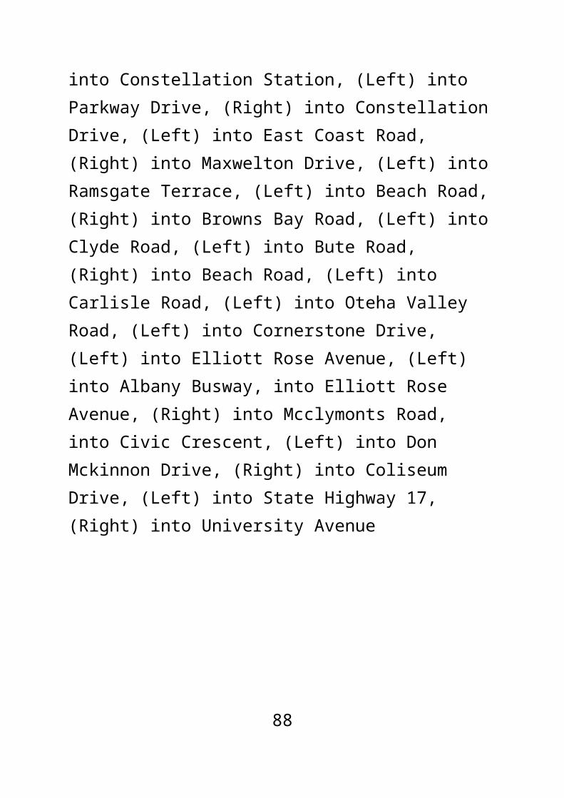
Weekend:Saturday:
TN: In the print the following levels of frequency are provided for each time frame listed below: Every weekend; 2-3 times a month; Once a month; Less than once a month.
Before 9am 9am-7pm After 7pm
Sunday:
TN: In the print the following levels of frequency are provided for each time frame listed below: Every weekend; 2-3 times a month; Once a month; Less than once a month.
Before 9am 9am-7pm After 7pm
Question 4Please answer the following questions. If it doesn't affect you, please tick "Doesn't affect me". Doesn't affect me / Strongly support / Support / Neutral / Oppose / Strongly oppose.
91

Do you support having more frequent and more direct bus services to the busway, even if in some cases a transfer is required to continue your journey?
Do you support the new service (N25) linking Beach Haven and Glenfield via Kaipatiki Rd?
Do you support the new service (N65) around Schnapper Rock?
Do you support the new service (N74) via Lonely Track Rd and Gills Rd?
Do you support the Devonport service (N30) running via Vauxhall Rd instead of Victoria Rd and Albert Rd?
Question 5What do you like about the proposed New Network and why? What works for you?
Please make sure that you tell us what you do like, so that we don't change a service because we only hear from people who don't like it.
Question 6What could we change about the New Network to better meet your travel needs? What doesn't work for you? Please explain below.
Hours of service Buses not frequent enough
92

Too far to walk to / from my bus service Other
Question 7Overall to what extent do you support or oppose the North Shore New Network? Strongly support / Support / Neutral / Oppose / Strongly oppose
Question 8How do you feel about each of the following statements? Agree / Neutral / Disagree
The New Network will improve public transport for me
The New Network will improve public transport for my neighbourhood
The New Network will improve public transport for Auckland
Question 9How would you like to hear about the changes when we implement them? For example: email newsletter, posters, adverts.
Personal InformationProviding your personal details is optional, however providing us with the name of your street helps us to better understand how the changes could affect you.
93

Please also provide your email address in case we need to contact you with any queries about your submission.
Privacy: Auckland Transport is committed to protecting our customers' personal information. Please see our privacy policy at https://at.govt.nz/about-us/about-this-site/privacy-policy/ for further info.
Name:
Which organisation are you submitting on behalf of (if any)?
Email address:
Please email me the outcome of this consultation and updates on the New Network [checkbox]
House number:
(Required) Street name:
(Required) Closest intersecting street:
Suburb:
Age: 15 years and under / 16-19 / 20-29 / 30-39 / 40-49 / 50-59 / 60-64 / 65+ / Prefer not to say
Gender: Male / Female
Are you (tick all that apply): Employed / School student / Tertiary student / Retire / Not Working / Other
94