BOLIVIA COCA SURVEY 2009 english - United … · Map 9: Coca crops and other crops in the Yungas of...
68
Transcript of BOLIVIA COCA SURVEY 2009 english - United … · Map 9: Coca crops and other crops in the Yungas of...

ABBREVIATIONS
BOB Bolivianos (Bolivian currency) CONALTID Bolivian National Council for Fighting against Drugs DIGCOIN Bolivian National Direction of Coca Leaf Control and Industrialization DIGECO Bolivian National Direction of Coca Leaf Commercialization (up to 2005) DIGPROCOCA Bolivian National Direction of Development for Coca Growing Areas DIRECO National Direction of Agricultural Re-conversion (up to 2005) FELCN Special Force against Drug Trafficking GCP Ground Control Point GIS Geographical Information Systems GPS Global Positioning System ICMP UNODC Illicit Crop Monitoring Programme UNODC United Nations Office on Drugs and Crime WDR World Drug Report
ACKNOWLEDGEMENTS
The following organizations and individuals contributed to the implementation of the coca cultivation survey in Bolivia and to the preparation of the present report:
Government of Bolivia: Vice-Ministry for Coca and Integral Development
National Direction of Development for Coca Growing Areas (DIGPROCOCA)
Vice-Ministry of Social Defense
UNODC: Ivan Alfaro – Manager (Project) Robert Szucs - GIS Specialist (Project) Patricia Delgado - GIS Specialist (Project) Blanca Vega – Remote Sensing Specialist (Project) Helder Catari –Remote Sensing Specialist (Project) Claudia Ortega - Administrative Assistant (Project) Varinia Herbas – Technichian in Geomatics (Project) Stephan Campos - Technichian in Geomatics (Project) Isabel Condori – Intern (Project) Marien Avalos - Intern (Project) Mariela Moreno - Intern (Project) Gaby Flores - Intern (Project) Miguel López - Intern (Project) Cesar Echeverría - Intern (Project)
Christina Albertin - UNODC Representative (field office) José Rocabado - UNODC National Programme Officer (field office) Carlos Diaz - UNODC National Programme Officer (field office)
Coen Bussink - Remote Sensing and GIS Expert (Statistics and Survey Section, Vienna) Anja Korenblik - Programme Management Officer (Studies and Threat Analysis Section, Vienna) Angela Me – Chief (Statistics and Survey Section, Vienna) Martin Raithelhuber - Programme Officer (Statistics and Survey Section, Vienna) Javier Teran – Statistician (Statistics and Survey Section, Vienna)
Photo credits: UNODC BOL/F57 project or otherwise indicated.
The implementation of UNODC’s Illicit Crop Monitoring Programme in the Andean countries and the Bolivia survey in 2007 was made possible thanks to financial contributions from the Governments of Austria, Colombia, France, the United States of America, and from the European Commission.

Bolivia Coca Survey for 2008
1
PREFACE
In Bolivia, coca cultivation increased by 6% in 2008, to a total of 30,600 hectares. Potential production of cocaine increased by 9% to 113 metric tons.
The increases, while relatively small, continue an upward trend noticed over the past few years. Compared to 2005, potential cocaine production is up 41%, and the area under coca cultivation is up 20%. In 2008, both coca cultivation and cocaine production were at their highest levels since 1998, though still far lower than the peak of the mid 1990s.
The area with the largest increase continues to be La Asunta, in Yungas of La Paz, where there is no coca eradication or alternative development. There was also an increase detected in the amount of coca cultivation carried out in national parks. Bolivia should learn from Colombia’s success with manual as well as self-eradication, and would benefit from greater development assistance to wean cocaleros off of coca cultivation
President Morales has called for greater appreciation of the use of coca leaves for traditional consumption. I welcome the EU-sponsored study that should shed more light on this issue.
The Bolivian Government deserves praise for a significant increase in drug interdiction. There was a 45% increase in reported seizures of cocaine base, from 14,912 kg to 21,641, and a 145% increase in seizures of cocaine hydrochloride. Moreover, the number of dismantled laboratories continued to increase.
Antonio Maria Costa Executive Director
United Nations Office on Drugs and Crime

Bolivia Coca Survey for 2008
2

Bolivia Coca Survey for 2008
3
TABLE OF CONTENT
1 INTRODUCTION ....................................................................................................................................... 7
2 FINDINGS.................................................................................................................................................. 9
2.1 COCA CULTIVATION.............................................................................................................................. 92.2 REGIONAL ANALYSIS .......................................................................................................................... 13
2.2.1 Coca cultivation in the Yungas of La Paz................................................................................................ 152.2.2 Coca cultivation in Apolo......................................................................................................................... 232.2.3 Coca cultivation in Cochabamba Region ................................................................................................ 25
2.3 COCA YIELD AND PRODUCTION........................................................................................................... 302.3.1 Results of the study on coca yield in the Yungas of La Paz.................................................................... 312.3.2 Coca yield in the Cochabamba Tropics .................................................................................................. 32
2.4 COCA PRICES AND TRADING............................................................................................................... 332.5 COCA CULTIVATION AND RELATED ISSUES............................................................................................ 41
2.5.1 Coca cultivation and land use...................................................................................................... 412.5.2 Coca cultivation related with other crops..................................................................................... 432.5.3 Coca cultivation in National Parks ............................................................................................... 49
2.6 REPORTED ERADICATION.................................................................................................................... 502.7 REPORTED SEIZURES......................................................................................................................... 532.8 MÁXIMUN COCAINE PRODUCTION IN BOLIVIA ........................................................................................ 55
Index of maps
Map 1: Coca cultivation density, Bolivia, 2008 ............................................................................... 8 Map 2: Coca cultivation density in the Andean Region, 2008 ...................................................... 11 Map 3: Coca cultivation change 2007-2008, Bolivia..................................................................... 12 Map 4: Coca cultivation density, for the Yungas of La Paz and Apolo, Bolivia 2008.................... 14 Map 5: Coca cultivation density for Chapare, Bolivia 2008 .......................................................... 24 Map 6: Coca leaf trading authorized by DIGCOIN, by department, 2008..................................... 35 Map 7: Land use and coca cultivation, Bolivia 2008..................................................................... 40 Map 8: Coca Cultivation and other crops in Cochabamba Tropics .............................................. 42 Map 9: Coca crops and other crops in the Yungas of La Paz, Caranavi and Alto Beni................ 44 Map 10: Coca cultivation and National Parks, Bolivia 2008........................................................... 48 Map 11: Rationalization in Cochabamba Tropics .......................................................................... 50 Map 12: Satellite imagery acquired by the Project in 2008............................................................ 60 Map 13: Location geo-video flight lanes over the Chapare............................................................ 61

Bolivia Coca Survey for 2008
4
FACT SHEET – Bolivia Coca Survey for 2007
2007Changeon 2008 2008
Coca cultivation 28,900 ha +6% 30,500 ha
Of which in the Yungas of La Paz 19,800 ha +5% 20,700 ha
in Chapare 8,800 ha +8% 9,500 ha
in Apolo 300 ha 0% 300 ha
Of which permitted by Bolivian law 1008 12,000 ha 12,000 ha
not permitted by Bolivian law 1008 16,900 ha +6% 18,600 ha
Of which in national parks 1,825 ha +13% 2,063 ha
Average annual sun-dried coca leaf yield1
in Chapare 2,764 kg/ha 2,764 kg/ha
in the Yungas of La Paz 1,321 kg/ha 1,321 kg/ha
in the Yungas, traditional coca growing areas 1,215 kg/ha 1,215 kg/ha
Production of sun-dried coca leaf 51,000 tm +6% 54,000
Potential production of cocaine 104 tm +9% 113 mt
as % of global cocaine production 10% +3% 13%
National weighted average farm-gate price of coca leaf (outside state-authorized market) US$ 4.1/kg +29% US$ 5.3/kg
Chapare average farm-gate price of coca leaf US$ 3.8/kg +37% US$ 5.2/kg
Total farm-gate value of coca leaf production US$ 214 millones +37% US$ 293
millón
GDP2 US$ 9.1 billones +6.15% US$ 9.7
billón Farm-gate value of coca leaf production as per cent of GDP 2.4% 3.0%
Value of agricultural sector GDP US$ 1.36 billones +2.94% US$ 1.40
billónFarm-gate value of coca leaf production as % of value of 2007 agricultural sector 16% 21%
Reported eradication of coca bush 6,269 ha -13% 5,484 ha
Reported seizure of cocaine base 14,912 kg +45% 21,641 kg
Reported seizure of cocaine hydrochloride 2,923 kg +148% 7,246 kg
1 2008 yield figures are updated by the new cultivation levels across the sampling strata as defined by the 2006 yield study.2 GDP of the respective year as reported by the Government.

Bolivia Coca Survey for 2008
5
Executive Summary
Under its Illicit Crop Monitoring Programme, UNODC assists the Bolivian Government in the implementation of a national coca monitoring system. This joint Pluri-National State of Bolivia and UNODC report, the sixth since 2003, provides an estimate of coca cultivation at the national level for the year 2008. It also presents information on coca yield, prices and other issues related to coca cultivation in Bolivia.
This year’s Survey revealed that 35,500 ha were under coca bush cultivation in Bolivia in 2008, anincrease by 6% compared to last year’s estimate of 28,900 ha. Coca cultivation in Bolivia accounted for 18% of global coca cultivation in 2008, far below the levels estimated in the early- to mid-nineties when Bolivia accounted for about a quarter of the global total. In 2008, coca cultivation in Bolivia remained below cultivation levels in Colombia and Peru.
The increase in coca cultivation in Bolivia between 2007 and 2008 was due to an increase in the two main areas of coca cultivation, the Yungas of La Paz and Chapare. Coca cultivation in the Yungas reached 20,700 ha, an increase of 5% and in Chapare 9,700 ha, an increase of 8%. The Yungas of La Paz accounted for 69% of the total cultivation in 2008.
The total estimate of 30,500 ha also included the 12,000 ha (39% of total cultivation) permitted by the Bolivian Law No 1008 (“Law on the Regime Applicable to Coca and Controlled Substances”, 1988) for traditional uses such as leaf chewing, medicinal preparations and coca tea.
In the Cochabamba Tropics, a total of 2,063 ha of coca cultivation was found in two National Parks, this represented 22% of the coca cultivation of Chapare region, meaning an increase of 13% compared with 2007. Ecosystems in National Parks are particularly fragile and the deforestation for the establishment of coca fields is thought to contribute to fragmentation of habitats, loss of biodiversity, and soil erosion, among other environmental problems.
The overall area under coca cultivation produced an estimated 54,000 metric tons of sun-dried leaf, of which 39,400 metric tons were estimated to be available for cocaine production. These figures are based on the result of a new coca leaf yield study implemented by UNODC in 2006. Other studies of the international cooperation concluded that in Cochabamba Tropics 370 kg of coca leaf for one kg of cocaine and for Yungas of 315 kg of coca leaf for one kg of cocaine, the potential cocaine production in Bolivia amounted to 113 metric tons in 2008. This corresponded to an increase of 13% compared to the 2006 estimate of 94 metric tons.
Farm-gate prices of sun dried coca leaf increased in 29.3% in 2008, Prices of coca base and cocaine hydrochloride, remained stable. Between 2007 and 2008 the Seizures of coca leaves increased from 1,706mt to 2,065 mt. Cocaine HCL seizures increased significantly as well from 2,923mt to 7,246mt in 2008, almost 150%
The farm-gate value of coca leaf production in Bolivia reached US$293 million in 2008. This estimate took into account the total value of coca leaf in the market controlled by DIGCOIN, as well as the farm-gate value of coca leaf outside this market. The total value was equivalent to 3% of the country’s GDP for 2008 (US$ 9.7 billion) or 21% of the value of the agricultural sector in 2008 (US$ 1.40 billion).
Bolivia Coca Survey for 2008
6
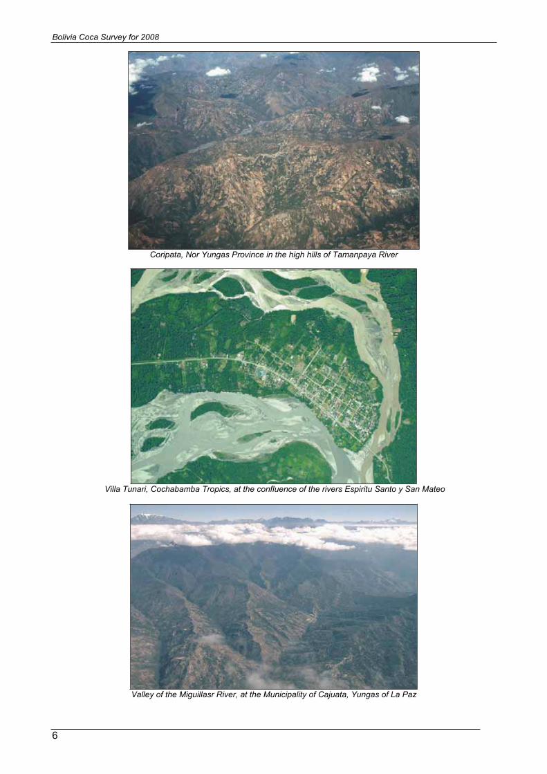
Coripata, Nor Yungas Province in the high hills of Tamanpaya River
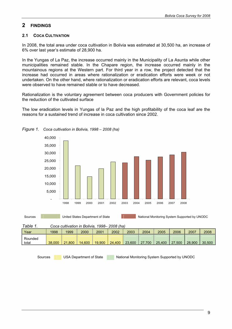
Villa Tunari, Cochabamba Tropics, at the confluence of the rivers Espiritu Santo y San Mateo
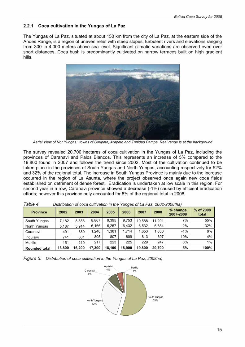
Valley of the Miguillasr River, at the Municipality of Cajuata, Yungas of La Paz

Bolivia Coca Survey for 2008
7
1 INTRODUCTION
The objectives of UNODC’s Illicit Crop Monitoring Programme (ICMP) are to establish methodologies for the collection and analysis of data on illicit crops and to improve Governments’ capacity to monitor these crops in the context of the strategy adopted by Member States at the General Assembly Special Session on Drugs in June 1998. ICMP is currently active in seven countries: Afghanistan, Bolivia, Colombia, Lao PDR, Morocco, Myanmar and Peru.
The Plurinational State of Bolivia and UNODC launched the project “Land use management and monitoring system in the Yungas of La Paz” in October 2001. Initially, the project focused only on the Yungas of La Paz, but since 2003 it has extended its scope to provide estimates on coca cultivation at the national level. This report presents the project’s findings for 2008, which are based on a satellite images monitoring
During 2008, the project was implemented in cooperation with the National Direction of Development for the Coca Growing Regions (DIGPROCOCA), Vice-Ministry of Coca and Integral Development. DIGPROCOCA provided logistical support during the implementation of ground activities, including the collection of a large number of ground control points, mainly in the Chapare area. The Bolivian National Government, through the National Council of Fight against Illicit Trafficking of Drugs (CONALTID) uses the information provided by this project for planning and implementing its strategy for the fight against illicit drug trafficking.
Coca cultivation decreased significantly in Bolivia at the end of the 1990s, following a significant reduction in the area under coca cultivation in the Chapare region. Bolivia is now the third largest coca producer worldwide, far behind Colombia and Peru. Coca cultivation is concentrated in the departments of La Paz (in the areas of the Yungas of La Paz and Apolo) and in the Chapare area (department of Cochabamba).
Bolivian Law 1008 (“Law on the Regime Applicable to Coca and Controlled Substances”, 1988) permits up to 12,000 ha of traditional coca cultivation for traditional consumption and other legal uses. Most of this area is located in the Yungas of La Paz. In addition, in October 2004, the Bolivian Government temporarily authorized the cultivation of 3,200 ha of coca in the Chapare region. Law No 1008 does not provide a precise definition of the geographic limits of the traditional coca growing areas, however, the Bolivian Government has launched a study with the participation of social organizations which is intended to lead to a legal delineation of the area where coca for traditional use may be cultivated.
The Plurinational State already started a study to determine the national coca leaf demand for traditional purposes. This study, sponsored by the European Union is scheduled to provide results by mid 2010.

!
!
^
!
!
!
!
!
!
Rio Beni
Rio Itenez
RioMamore
Madrede D
ios
Madera
Rio Pilcomayo
Beni
Santa Cruz
Potosi
La Paz
Pando
Oruro
Tarija
Chuquisaca
Cochabamba
B R A Z I L
A R G E N T I N A
C H I L EPA R A G U AY
PE
RU
Sucre
Oruro
Tarija
Potosi
La Paz
Cobija
Trinidad
Santa Cruz
Cochabamba
60°W
60°W
65°W
65°W
70°W
70°W10
°S
10°S
15°S
15°S
20°S
20°S
25°S
25°S
Coca cultivation density, Bolivia 2008
Chapare
YungasTiticaca lake
Apolo
Source: Government of Bolivia - National monitoring system supported by UNODC.The boundaries and names shown and the designation used on this map do not imply official endorsement or acceptance by the United Nations.
1:8,000,000Geographic coordinates, WGS 1984
0 300150 km
Poopo lake
Bolivia
SOUTH AMERICA
Yun... :
Department boundaries
International boundaries
Coca growing areas
Cultivation density(ha/km² )
0.1 - 1
1.1 - 4.0
> 4
Bolivia Coca Survey for 2008
9
2 FINDINGS
2.1 COCA CULTIVATION
In 2008, the total area under coca cultivation in Bolivia was estimated at 30,500 ha, an increase of 6% over last year’s estimate of 28,900 ha.
In the Yungas of La Paz, the increase occurred mainly in the Municipality of La Asunta while other municipalities remained stable. In the Chapare region, the increase occurred mainly in the mountainous regions at the Western part. For third year in a row, the project detected that the increase had occurred in areas where rationalization or eradication efforts were week or not undertaken. On the other hand, where rationalization or eradication efforts are relevant, coca levels were observed to have remained stable or to have decreased.
Rationalization is the voluntary agreement between coca producers with Government policies for the reduction of the cultivated surface
The low eradication levels in Yungas of la Paz and the high profitability of the coca leaf are the reasons for a sustained trend of increase in coca cultivation since 2002.
Figure 1. Coca cultivation in Bolivia, 1998 – 2008 (ha)
-
5,000
10,000
15,000
20,000
25,000
30,000
35,000
40,000
1998 1999 2000 2001 2002 2003 2004 2005 2006 2007 2008
Sources United States Department of State National Monitoring System Supported by UNODC
Table 1. Coca cultivation in Bolivia, 1998– 2008 (ha) Year 1998 1999 2000 2001 2002 2003 2004 2005 2006 2007 2008
Rounded total 38,000 21,800 14,600 19,900 24,400 23,600 27,700 25,400 27,500 28,900 30,500
Sources USA Department of State National Monitoring System Supported by UNODC

Bolivia Coca Survey for 2008
10
In spite of the increases in Bolivia and Peru, the global coca cultivation area in 2008 decreased by 8% caused by the significant decrease in Colombia (-18%). Coca cultivation in Bolivia represented 18% of global coca cultivation in 2008, compared to 16% in 2007. Bolivia remained the third largest coca cultivator, behind Colombia and Peru.
Figure 2. Coca cultivation in the Andean region, 1990 – 2008 (ha)
0
50,000
100,000
150,000
200,000
250,000
1990 1991 1992 1993 1994 1995 1996 1997 1998 1999 2000 2001 2002 2003 2004 2005 2006 2007 2008
Hec
tare
s
Bolivia Colombia Peru
Table 2. Coca cultivation in the Andean region, 1998- 2008 (ha)
Country 1998 1999 2000 2001 2002 2003 2004 2005 2006 2007 2008%
cambio Bolivia 38,000 21,800 14,600 19,900 21,600 23,600 27,700 25,400 27,500 28,900 30,500 6%Colombia 101,800 160,100 163,300 144,800 102,000 86,000 80,000 86,000 78,000 99,000 81,000 -18%Peru 51,000 38,700 43,400 46,200 46,700 44,200 50,300 48,200 51,400 53,700 56,100 4%Total 190,800 220,600 221,300 210,900 170,300 153,800 158,000 159,600 156,900 181,600 167,700 -8%
Sources United States Department of State National Monitoring Systems Supported by UNODC

80°W
80°W
70°W
70°W
60°W
60°W20
°S
20°S
10°S
10°S
0° 0°
10°N
10°N
Nariño
AltoHuallaga
Putumayo -Caqueta
ApurímacEne
La Convencionand Lares
BRAZIL
BOLIVIA
Catatumbo
VENEZUELA
CHILE
South America
Peru
Putumayo
Amazonas
Huallaga
Marañon
Ucayali
Ene Urubamba
Purus
Apurimac
MadredeDios
Yungas
km
0 250 500
Caqueta
Meta -Guaviare
Norte deAntioquia
Colombia
Bolivia
Meta
Vichada
Guaviare
Magdalena
Atrato
PANAMÁ
Chapare
PERU
ARGENTINA
PARAGUAY
Beni
Mamore
Guapare
Pilcomayo
^La Paz
^Lima
^Bogota
GUYANACOLOMBIA
Esmeraldas
Quito^
Napo
Esmeraldas Coca
Daule Curaray
Pastaza
Zamora
Sucumbios
ECUADOR
Coca cultivation density in the Andean Region, 2008
Caribbean Sea
Pacific
Ocean
Sources: National monitoring systems supported by UNODC - Governments of Bolivia, Colombia and PeruThe boundaries and names shown and the designations used on this map do not imply official endorsement or acceptance by the United Nations
Cultivation density(ha/km )2
0.1 - 1.01.1 - 4.0> 4.0InternationalboundariesDepartmentboundaries
Geographic coordinates WGS 84
Lake
Titicaca

!
!
^
!
!
!
!
!
!
Rio Beni
Rio Itenez
RioMamore
Madrede D
ios
Madera
Rio Pilcomayo
Beni
Santa Cruz
Potosi
La Paz
Pando
Oruro
Tarija
Chuquisaca
Cochabamba
Sucre
Oruro
Tarija
Potosi
La Paz
Cobija
Trinidad
Santa Cruz
Cochabamba
B R A Z I L
A R G E N T I N A
C H I L EPA R A G U AY
PE
RU
60°W
60°W
65°W
65°W
70°W
70°W10
°S
10°S
15°S
15°S
20°S
20°S
25°S
25°S
Coca cultivation changes 2007 - 2008, Bolivia 2008
Chapare
YungasTiticaca lake
Apolo
Source: Government of Bolivia - National monitoring system supported by UNODC.The boundaries and names shown and the designation used on this map do not imply official endorsement or acceptance by the United Nations.
1:8,000,000Geographic coordinates, WGS 1984
0 300150 km
Poopo lake
Bolivia
SOUTH AMERICA
Cultivation changes2007 - 2008
Department boundaries
International boundaries
Significant decrease
Decrease
Insignificant changes
Increase
Significant increase

Bolivia Coca Survey for 2008
13
2.2 REGIONAL ANALYSIS
The increase in coca cultivation at the national level of 6%, from 28,900 ha to 30,500Ha, is the result of a combined increase in the Chapare and Yungas areas. The most relevant increase took place in certain isolated areas of Yungas of La Paz, mainly in the Municipality of la Asunta. Eradication is not undertaken in these areas.
In most of the Cochabamba Tropics region, farmers are cultivating an average of 0.16 ha of coca, locally called “cato”. This is the maximum amount allowed according to an agreement reached between the Government and social organizations of coca farmers in October 2004. Aerial photographs and geo-videos taken over Chapare during the survey clearly show the trend of coca cultivation on fields with the size of one cato in most parts of the region.
Table 3. Coca cultivation estimates by region (ha) 2002-2008
Region 2002 2003 2004 2005 2006 2007 2008 % change 2007-2008
% of 2008 total
Yungas of La Paz 13,800 16,200 17,300 18,100 18,900 19,800 20,700 5% 68%
Cochabamba tropics n.a. 7,300 10,100
7,000
8,300
8,800
9,500 8% 31%
Apolo n.a. 50
300
300
300
300
300 0% 1%
Country total 23,550 27,700 25,400 27,500 28,900 30,500 6% 100%
Figure 3. Coca cultivation estimates by region, 2002 – 2008 (ha)
0
5000
10000
15000
20000
25000
Yungas of La Paz Chapare Apolo
hect
are
2002 2003 2004 2005 2006 2007 2008
Figure 4. Distribution of coca cultivation in Bolivia by region, 2008
Yungas of La Paz69%
Cochabamba Tropics
30%
Apolo1%

Coca cultivation density for the Yungas of La Paz and Apolo, Bolivia 2008
&
&
&
&
&
&
&
&
&
&
&
&
&
&
&
&
&
^
Apolo
Cohoni
Tirata
Guanay
Cajuata
Lambate
Arapata
Irupana
Coroico
Coripata
Caranavi
La Asunta
Yanacachi Chulumani
Ecia. Pata
Pto. Linares
Palos Blancos
L a P a z
B e n i
La Paz
Apolo
Guanay
San Borja
Inquisivi
Murillo
La Asunta
Sorata Caranavi
Reyes
Palos Blancos
Rurrenabaque
Irupana
Viacha
Laja
Quime
Coroico
Pucarani
Palca
Morochata
Charazani
Batallas
Cajuata
Coripata
Tacacoma
Cairoma
Achacachi
Sapahaqui
Ayata
YanacachiEl Alto
Malla
Mecapaca
Caquiaviri
Calamarca
Comanche
Tipuani
Independencia
Ayo Ayo LuribayColquencha
Chulumani
Achocalla
Licoma
RíoCotacajes
Río LaPaz
Río Consata
RíoAten
Río Boopi
Río Tuichi
RíoTipuani
Río Unduavi
RíoChallana
Río Zongo
Río Beni
Río Quiquibey
Río Rapulo
RíoKaka
Río Coroico
RíoYacuma
Río Sapaqui
Río Inicua
Río Camata
Río Machariapu
Río Quendeque
67°0'W
67°0'W
67°30'W
67°30'W
68°0'W
68°0'W
68°30'W
68°30'W14
°30'
S
14°3
0'S
15°0
'S
15°0
'S
15°3
0'S
15°3
0'S
16°0
'S
16°0
'S
16°3
0'S
16°3
0'S
17°0
'S
17°0
'SYungas
Apolo
Source: Government of Bolivia - National monitoring system supported by UNODC.The boundaries and names shown and the designation used on this map do not imply official endorsement or acceptance by the United Nations.
Geographic coordinates, WGS 1984
0 5025 km
1 :1.200.000
PARAGUAY
ARGENTINA
B R A Z I L
PER
U
CHILE
La Paz
Bol i v i a
Cul t ivat ion densi ty(ha/km² )
0.1 - 1.0
1.1 - 2.0
2.1 - 4.0
4.1 - 8.0
> 8.0
RiverMain Road
Department boundaries
Department capital
Municipality boundaries
^
& Village center
Bolivia Coca Survey for 2008
15
2.2.1 Coca cultivation in the Yungas of La Paz
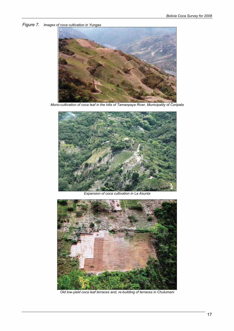
The Yungas of La Paz, situated at about 150 km from the city of La Paz, at the eastern side of the Andes Range, is a region of uneven relief with steep slopes, turbulent rivers and elevations ranging from 300 to 4,000 meters above sea level. Significant climatic variations are observed even over short distances. Coca bush is predominantly cultivated on narrow terraces built on high gradient hills.
Aerial View of Nor Yungas: towns of Coripata, Arapata and Trinidad Pampa. Real range is at the background
The survey revealed 20,700 hectares of coca cultivation in the Yungas of La Paz, including the provinces of Caranavi and Palos Blancos. This represents an increase of 5% compared to the 19,800 found in 2007 and follows the trend since 2002. Most of the cultivation continued to be taken place in the provinces of South Yungas and North Yungas, accounting respectively for 52% and 32% of the regional total. The increase in South Yungas Province is mainly due to the increase occurred in the region of La Asunta, where the project observed once again new coca fields established on detriment of dense forest. Eradication is undertaken at low scale in this region. For second year in a row, Caranavi province showed a decrease (-1%) caused by efficient eradication efforts; however this province only accounted for 8% of the regional total in 2008.
Table 4. Distribution of coca cultivation in the Yungas of La Paz, 2002-2008(ha)
Province 2002 2003 2004 2005 2006 2007 2008 % change 2007-2008
% of 2008 total
South Yungas 7,182 8,356 8,867 9,395 9,753 10,588 11,291 7% 55%North Yungas 5,187 5,914 6,166 6,257 6,432 6,532 6,654 2% 32%Caranavi 491 889 1,248 1,381 1,714 1,653 1,630 -1% 8%Inquisivi 741 801 805 807 809 813 897 10% 4%Murillo 151 210 217 223 225 229 247 8% 1%
Rounded total 13,800 16,200 17,300 18,100 18,900 19,800 20,700 5% 100%
Figure 5. Distribution of coca cultivation in the Yungas of La Paz, 2008ha)
South Yungas55%North Yungas
32%
Caranavi8%
Inquisivi4%
Murillo1%

Bolivia Coca Survey for 2008
16
In this year’s survey, the municipality of Coripata in North Yungas province remained the most important centre of coca cultivation in the region of the Yungas of La Paz, with 5,044 ha in 2008 (or 24 of the regional total), followed closely by La Asunta, with 4,688ha or 23% of the total.
Table 5. Distribution of coca cultivation by municipality in the Yungas of La Paz, 2002-2008(ha)
Province Municipality 2002 2003 2004 2005 2006 2007 2008
% change 2007-2008
% of 2008total
Nor Yungas Coripata 4,032 4,456 4,651 4,708 4,872 4,925 5,044 2% 24%South Yungas La Asunta 2,678 3,020 3,157 3,252 3,266 4,028 4,688 16% 23%South Yungas Chulumani 1,771 2,314 2,666 3,055 3,386 3,423 3,450 1% 17%South Yungas Irupana 2,253 2,481 2,502 2,544 2,553 2,583 2,587 0% 12%Caranavi Caranavi 491 889 1248 1381 1,714 1,653 1,630 -1% 8%Nor Yungas Coroico 1,155 1,458 1,515 1,549 1560 1607 1610 0% 8%Inquisivi Cajuata 741 801 805 807 807 813 897 10% 4%South Yungas Yanacachi 421 483 488 494 499 507 519 2% 3%Murillo La Paz 151 210 217 223 225 229 247 8% 1%
South Yungas PalosBlancos 59 58 53 50 49 47 47 0% 0%
TOTAL 13,800 16,200 17,300 18,100 18,900 19,800 20,700 5% 100%
Figure 6. Distribution of coca cultivation by municipality in the Yungas of La Paz, 2002-2008(ha)
0
1000
2000
3000
4000
5000
6000
Coripata La Asunta Chulumani Irupana Caranavi Coroico Cajuata Yanacachi La Paz PalosBlancos
hect
are
2002 2003 2004 2005 2006 2007 2008
Bolivian Law 1008 (“Law on the Regime Applicable to Coca and Controlled Substances”, 1988) permits up to 12,000 ha of traditional coca cultivation for traditional consumption and other legal uses. Most of this area is located in the Yungas of La Paz, although the law does not provide for a geographic delimitation of the traditional coca cultivation area. Most of the coca leaf produced in the Yungas of La Paz, Caranavi and Palos Blancos is traded through the coca market, controlled by DIGCOIN, of Villa Fatima in La Paz-city.
A study on coca leaf yield conducted by UNODC and the Government in the Yungas in 2006 confirms that farmers were using agricultural techniques in their coca fields employing more fertilizers, pesticide and mechanical irrigation to improve the yield of their coca fields.
Bolivia Coca Survey for 2008
17
Figure 7. Images of coca cultivation in Yungas
Mono-cultivation of coca leaf in the hills of Tamanpaya River, Municipality of Coripata
Expansion of coca cultivation in La Asunta
Old low-yield coca leaf terraces and, re-building of terraces in Chulumani

Bolivia Coca Survey for 2008
18
Figure 8. Example of the evolution of the coca cultivation in Puerto Rico, La Asunta, 2004-2008, Images Ikonos Multispectral
Puerto Rico region in year 2004, the circles enclose primary forest areas
Same region in year 2008, showing the expansion of the agricultural border for coca cultivation on detriment of primary forest

Bolivia Coca Survey for 2008
19
Figure 9. Technological itinerary for coca cultivation in the Yungas of La Paz 1. Fitting out of terrain for the establishment of new coca cropsa. Cut of bush and herbaceous
speciesb. Cut of arboreal species c. Sun-drying of vegetal
coverage.d. Burning of dried vegetal
coverage.e. Homogenous distribution of
ashes among the parcel to fertilize it.
2. Design and building of terraces Dimensioning of the terrain
for the division of “cuts” (a conglomerate of wachus orterraces).
Digging of ditches or wuachus, terrace compacting and removing of soil to conform the terraces with sand and gravel
Design of the drain system for the rainy season and water storage for the dry season
This technology is employed in the traditional region of La Paz Yungas.
The width and form of the wuachusvary according with slope and terrain structure.

Bolivia Coca Survey for 2008
20
3. Selection of seed and seedbed preparation
Identification of productive parcels aged between 5 and 10 year for the obtaining of suitable seed. Pre-germination of seed in
dried banana leafs over wet environment. Preparation of substrate: mix
of local soil with rice peel, sand and organic matter composed of vegetal residuals for the formation of ditches Sowing: Homogenous
distribution of pre-germinated seed and coverage with substrate and dried banana leafs to maintain humidity. Installation of partial shadow
and protection of the seedbed: Once the seeds germinate, the seedbed is covered and protected with a net to avoid that sun damages the small plants and to protect it from animals and other intruders.
Irrigation is applied regularly.
Coca seeds in plant and storage
Seedbed last between 4 and 6 weeks until the transplant of the small plants to the final location in the parcel

Bolivia Coca Survey for 2008
21
Coca plants with organic fertilizer
Old coca plants with several pillu
4. Transplant to the production parcelHealthy and well formed plants are selected and definitely transplanted to the field. Plants are located in rows each 5cm, practicing small holes in the ditch
5. Cultural labor Weed elimination by the application of chemical treatment avoiding competition with coca cultivation
Fertilizing with organic and chemical supplies. Irrigation by aspersion is widely
used in the Yungas. Pruning or pillu. Is a transversal
cut 45° at 5 cm from the plant base to induce the re-foliation. This practice is undertaken starting from the fifth year of age.

Bolivia Coca Survey for 2008
22
6. Harvest First harvest of a coca crop happens at about 12 months alter the transplant. Harvest is manual, leaf by leaf, removing all the mature foliar mass for its storage and further drying.
7. Drying and transport : Coca leaves drying is carefully performed, in order to protect the leaves and maintain its quality. After the harvest fresh coca leaves are saved for at least one night in a dark place, and then they are spread over for the sun-drying. In the traditional area, leaves are spread in a special floor called “cachi”. The “cachi”considerable accelerates the drying time. In other regions, the leaves are spread over nets. If the coca leaves are spread right after the harvest, they become damaged and their value reduces drastically. If rain comes over the drying coca leaves, or the farmer picks them up before complete drying, the leaves are also damaged.
Drying coca leaves in a net
Spreading coca leaves in a cachi
Bolivia Coca Survey for 2008
23
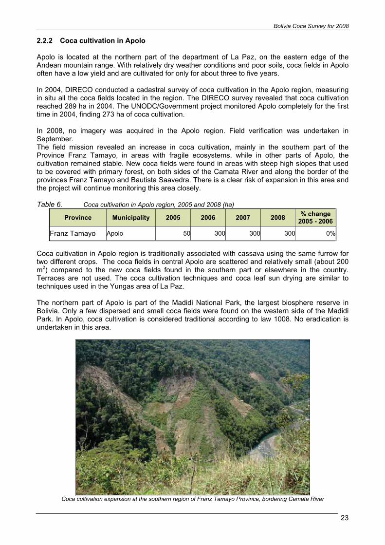
2.2.2 Coca cultivation in Apolo
Apolo is located at the northern part of the department of La Paz, on the eastern edge of the Andean mountain range. With relatively dry weather conditions and poor soils, coca fields in Apolo often have a low yield and are cultivated for only for about three to five years.
In 2004, DIRECO conducted a cadastral survey of coca cultivation in the Apolo region, measuring in situ all the coca fields located in the region. The DIRECO survey revealed that coca cultivation reached 289 ha in 2004. The UNODC/Government project monitored Apolo completely for the first time in 2004, finding 273 ha of coca cultivation.
In 2008, no imagery was acquired in the Apolo region. Field verification was undertaken in September.The field mission revealed an increase in coca cultivation, mainly in the southern part of the Province Franz Tamayo, in areas with fragile ecosystems, while in other parts of Apolo, the cultivation remained stable. New coca fields were found in areas with steep high slopes that used to be covered with primary forest, on both sides of the Camata River and along the border of the provinces Franz Tamayo and Bautista Saavedra. There is a clear risk of expansion in this area and the project will continue monitoring this area closely.
Table 6. Coca cultivation in Apolo region, 2005 and 2008 (ha)
Province Municipality 2005 2006 2007 2008 % change 2005 - 2006
Franz Tamayo Apolo 50 300 300 300 0%
Coca cultivation in Apolo region is traditionally associated with cassava using the same furrow for two different crops. The coca fields in central Apolo are scattered and relatively small (about 200 m2) compared to the new coca fields found in the southern part or elsewhere in the country. Terraces are not used. The coca cultivation techniques and coca leaf sun drying are similar to techniques used in the Yungas area of La Paz.
The northern part of Apolo is part of the Madidi National Park, the largest biosphere reserve in Bolivia. Only a few dispersed and small coca fields were found on the western side of the Madidi Park. In Apolo, coca cultivation is considered traditional according to law 1008. No eradication is undertaken in this area.
Coca cultivation expansion at the southern region of Franz Tamayo Province, bordering Camata River

!
!
!
!
!
!
!
!
!
!
!
!
!
!
!
!
B e n i
C o c h a b a m b a
S a n t a C r u z
P o t o s i
Chimore
Bulo Bulo
Villa Tunari
Puerto Villarroel
Isinuta
Senda F
Senda B
Shinahota
Eterazama
Chipiriri
Entre Rios
Ivirgarzama
Valle SactaValle Ivirza
Yungas de Vandiola
Villa 14 de Septiembre
San Ignacio
Villa Tunari
Yapacaní
Loreto
Pojo
Aiquile
Chimore
Tiraque
ComarapaTotora
San Andrés
Mizque
Pasorapa
El Puente
Toro Toro
Puerto Villarroel
Pocona
Mineros
Entre Rios (Bulo Bulo)Sacaba
Poroma
Omereque
San Pedro de Buena Vista
Colomi
Anzaldo
San Carlos
Vila Vila
Trigal
Alalay
Pampa Grande
Moro Moro
SaipinaAcasio
Vacas
Vallegrande
Tarata
Pocoata
Arani
MairanaCapinota
Arampampa
Presto
Buena Vista
Arbieto
Ravelo
TolataSan Benito
RíoIsiboro
RíoIchilo
Río Mizque
Río Ichoa
RíoSecure
Río Chore
RíoYapacani
RíoChapare
Río Ibare
RíoApere
RíoChim
oré
Río Pajta
Río Chipiriri
Río Sajta
Río Caine
Río San Pedro
Río Useuta
Río Mamor
é
Río Espuma
RíoCabito
Río Ivirizu
Río Grande ó
Guapay
Arr. Uriuta
Río Osos
Río Eterasama
Río Alizar
Río Cienaga
Río Zabala
Río San Mateo
Río Piray
RíoIsinota
Río Molle
Río Malpaso
Río SanJuán
Río MoileRíoAltam
achi
RíoTembladeras
Arr. Mariposas
Río Chapare
64°30'W
64°30'W
65°0'W
65°0'W
65°30'W
65°30'W
66°0'W
66°0'W15
°30'
S
15°3
0'S
16°0
'S
16°0
'S
16°3
0'S
16°3
0'S
17°0
'S
17°0
'S
17°3
0'S
17°3
0'S
18°0
'S
18°0
'S
18°3
0'S
18°3
0'S
Coca cultivation density for Tropic of Cochabamba, Bolivia, 2008
0 5025km
Geographic coordinates, WGS 19841 : 1.400.000
Source: Government of Bolivia - National monitoring system supported by UNODC.The boundaries and names shown and the designation used on this map do not imply official endorsement or acceptance by the United Nations.
PARAGUAY
ARGENTINA
B R A Z I L
PER
U
CHILE
CochabambaBol i v i a
Cul t ivat ion densi ty(ha/km² )
0.1 - 1.0
1.1 - 2.0
2.1 - 4.0
4.1 - 8.0
> 8.0
RiverMain Road
Department boundaries
Municipality boundaries
& Village center

Bolivia Coca Survey for 2008
25
2.2.3 Coca cultivation in Cochabamba Tropics Region
The Cochabamba tropics region extends over the provinces of Chapare, Carrasco and Tiraque. In contrast to the Yungas of La Paz, Chapare region has moderate slopes and huge rivers. Elevations vary from 300 to 2500 meters, with coca cultivated between 300 and 1000 meters. The highest mountains are located in the south and the country’s large tropical savannas begin in the northern part of Chapare. Temperatures are tropical and the area records the highest precipitation levels in Bolivia.
In the 1990s, the Chapare region held the largest amount of coca cultivation, but following sustained eradication efforts and alternative development programmes, cultivation decreased dramatically.
The 2008 survey found 9,500 ha of coca cultivation in the Chapare, representing an increase of 8% compared to the 8,800 ha found in 2007. The increase took place mainly in areas that lacked eradication. On the other hand, some decrease and stability was observed in areas where eradication efforts were undertaken,
Table 7. Distribution of coca cultivation by province in Chapare region, 2003-2008 (ha)
Province 2003 2004 2005 2006 2007 2008 % change 2006-2007
% of 2008 total
Chapare 4,250 5,844 4,094 4,857 4,536 4,767 5% 50%Carrasco 2,864 3,520 2,312 2,791 3,492 3,807 9% 40%
Tiraque 214 723 605 691 777 959 23% 10%
Rounded Total 7,300 10,100 7,000 8,300 8,800 9,500 8% 100%
Table 8. Distribution of coca cultivation by municipality in Chapare region, 2003-2008(ha)
Province Municipality 2003 2004 2005 2006 2007 2008 % change 2006-2007
% of 2008 total
Chapare Villa Tunari 4,250 5,841 4,094 4,857 4,536 4,767 5% 50% Carrasco Entre Rios 1,106 1,921 817 870 1,103 1,151 4% 12% Carrasco Puerto Villarroel 1,394 821 818 1,110 1,531 1,666 9% 18% Tiraque Tiraque 214 724 605 691 777 959 23% 10% Carrasco Chimoré 250 525 432 542 587 701 19% 7% Carrasco Totora 114 253 245 270 274 289 5% 3% Rounded Total 7,300 10,100 7,000 8,300 8,800 9,500 6% 100%
The municipality of Villa Tunari continued to be the most important area of coca cultivation in the region representing 50% of the coca cultivation in Chapare in 2008. The municipality includes part of the Isiboro Secure National Park, where coca cultivation also decreased during the reported period.
It should be noted that political boundaries are not properly defined between the departments of Cochabamba and Beni. For this reason, although some coca cultivation might actually be located in Beni Department, all the coca fields identified during the survey along the undefined departmental border were counted as part of the municipality of Villa Tunari, in the Department of Cochabamba.

Bolivia Coca Survey for 2008
26
Figure 10. Distribution of coca cultivation by municipality in Chapare region, 2003 – 2008 (ha)
0
1000
2000
3000
4000
5000
6000
7000
Villa Tunari Entre Ríos PuertoVillarroel
Tiraque Chimore Totora
hect
are
2003 2004 2005 2006 2007 2008
Figure 11. Distribution of coca cultivation by municipality in Chapare region, 2008 (ha)
Entre Ríos 12%
Villa Tunari51%
Puerto Villarroel
17%
Tiraque10%
Chimore7%
Totora3%

Bolivia Coca Survey for 2008
27
Figure 12. Coca fields of 1 cato size in Chapare
Field picture of a cato example in the Cochabamba Tropics
Satellite Image with interpreted coca fields of cato size
In past years, farmers of the Cochabamba Tropics used to intersperse or hide coca bushes in order to avoid detection and eradication. These practices are not very common nowadays because of the “cato” policy, and most coca fields were found were free of association with other crops.
It is generally accepted that coca cultivation is done with much more care in Yungas than in Chapare, and due to the differences in climate and soil, the techniques of cultivation differ from the ones used in Yungas.
In Cochabamba tropics, terraces are not built, coca bushes are bigger than in the Yungas and pruning practice does not exist.

Bolivia Coca Survey for 2008
28
Figure 13. Images of coca leaf cultivation in Cochabamba Tropics
Prepared land for coca cultivation in hilly regions. The practice of burning land and vegetation to plant is common in the Yungas and Chapare, but is also used to cultivate other crops.
The topography and climate conditions greatly differ in Chapare from Yungas, and therefore the techniques for coca cultivation are different as well.
Coca cultivation starts with a seedling. Small plants are transplanted at a distance of 30-40cm, producing dense adult plants, yielding more than the coca fields
in Yungas
Soils of hilly areas are very fragile in Chapare. The establishment of coca crops or any other agricultural activity in these lands, without proper handling, produces rapid effects of erosion and degradation of soil conditions
Although the “cato” (40x40m) is the predominant size in Chapare, in certain areas bigger coca fields can be
found

Bolivia Coca Survey for 2008
29
Sometimes a cato is implemented in a rectangular shape not 40x40, but it maintains the surface of 1,600 square meters. This practice is observed when a coca field is
implemented in the middle of other crop, like this example of a coca cato partially harvested in the middle
of a banana plantation.
Coca harvest is done in similar way in Yungas and Cochabamba tropics, manually removing the mature foliar mass completely
In Cochabamba Tropics, coca leaves are sun-dried before its commercialization, but not with same
care as in the Yungas
Coca leaves are spread in plastic or directly over bare soil, and must be at least three hours under sun. After drying, leaves are packed for commercialization

Bolivia Coca Survey for 2008
30
2.3 COCA YIELD AND PRODUCTION
In December 2005, UNODC started a new coca yield study in the Yungas of La Paz. The survey was implemented jointly by the UNODC Illicit Crop Monitoring Programme through its experts in Bolivia and in Vienna. The field work was implemented by researchers from the Unidad Academica Campesina (UAC) of Carmen Pampa, Yungas de La Paz.
During the survey, samples of sun-dried coca leaf were weighted from 98 coca parcels selected randomly across the region. To determine the sun-dried coca yield in the Yungas de La Paz, the Bolivian survey is based on a “Multistage Stratified Area Frame Sample Design”,
Sample frame As in any survey, the quality of the data collected from the sample surveys depends to a large extent on the quality of the sampling frame from which the sample is to be selected. The sampling frame was constructed according to the principles of the Area Sampling Frame methodology. The basis for the construction of the frame was the coca fields interpreted during the 2004 Coca Cultivation Survey in the Yungas in Bolivia. Within the limits of coca cultivation interpreted in this survey, the frame was divided in a collection of one km2 grids.
Stratification Most surveys estimating crop production are based on stratified multistage cluster designs. Stratification divides the units in the population into mutually exclusive and collectively exhaustive subgroups or strata. Separate samples are then independently selected from each stratum. The main purpose of stratification is to improve the precision of the survey estimates. Therefore, the construction of the strata should be such that units in the same stratum are as homogeneous as possible and units in different strata area as heterogeneous as possible with respect to one or more characteristics of interest to the survey.
Based on previous experience acquired on site by the project team and by the researchers of Carmen Pampa University, the variables that have been considered for stratification were terrain slope and the altitude. These two variables were combined and used as the basis for the stratification of the sampling frame.
Sample Size and sampling allocation The sample size was decided taking into account the desired precision of the estimates, the constraint of verification of all steps of the survey, the necessity to obtain estimates at the regional level, and the availability of the field researchers to reach the fields.
The precision of an estimate is measured by its standard error. The degree of precision required for the coca yield was set at about +/- 10% of the true value with a 95 per cent probability that it contains the true value.
The sample size has been defined in a way that a thorough verification process can be performed at any time and at every step of the implementation. This assures the high quality of the data collected and the confidence of the estimates generated.

Bolivia Coca Survey for 2008
31
The table below summarizes the sample frame along the different strata.
Table 9. Coca yield stratification in the Yungas of La Paz
Strata Strata definition Grids
Coca Hectares
(2004)
Number of coca
Polygons Number of Samples
Elevation (m) Slope (degrees) 1 300-1000 0-15 490 1,455 3,890 10 2 300-1000 15-38 11 47 109 10 3 1000-2000 0-15 1,563 10,418 28,124 45 4 1000-2000 15-38 496 3,580 8,246 15 5 > 2000 0-15 170 780 2,368 10 6 > 2000 15-38 163 599 2,080 10
Total 2,893 16,880 44,817 100
Measuring a sample coca field sample of recently harvested fresh leaves
2.3.1 Results of the study on coca yield in the Yungas of La Paz
The averages presented in this section are derived from the field survey, and corresponded to the simple averages found in the survey sample and extrapolated to the full extent of the sampling frame.
From the analysis of the collected data, the annual sun dried coca leaf yield was estimated at 1,312 kg/hectare. The highest annual sun dried coca leaf yield was found in stratum 1 (elevation between 300 and 1,000 meters, and slope less than 15 degrees), and the lowest annual sun dried coca leaf yield was found in stratum 5 (elevation greater than 2,000 meters and slope less than 15 degrees). The complete averages are described below.
Table 10. Yield results in the Yungas of La Paz for 2006 and 2007
Strata Coca surface Ha % IncreaseNumber of Samples
Weighted Average Yield TM/Ha/Year
Estimated potential amount of sun dried coca
leaf (mt)2007 2008 2007 2008 2007 2008
1 2,200 2,483 13% 6 2.17 2.17 4,774 5,3882 50 76 52% 0 1.23 1.23 62 943 11,150 11,738 5% 71 1.24 1.24 13,826 14,5554 4,300 4,335 1% 12 1.21 1.21 5,203 5,2455 1,250 1,245 0% 6 0.82 0.82 1,025 1,0216 850 842 -1% 3 1.49 1.49 1,267 1,255
19,800 20,719 5% 98 1.311 1.321 26,156 27,558

Bolivia Coca Survey for 2008
32
The analysis of the yield survey data concluded that the estimated production of sun dried coca leaf in the Yungas is approximately 27,558 metric tons in 2008. This would represent an increase of 5% in comparison to 2007.
Law 1.008 authorizes 12,000 ha of coca cultivation in the traditional region. This area is dispersed among the strata 3, 4, 5 and 6. Therefore the weighted sun dried coca leaf yield for this region in 2007 is estimated at 1.2156 metric tons/ha/year. The total estimated production of sun dried coca leaf under this law is estimated at 14,558 metric tons in 2008.
2.3.2 Coca yield in the Cochabamba Tropics
Since an updated study of coca yield in Cochabamba Tropics is still not undertaken, information of other studies of international cooperation has been used. Based in the data of the UNODC’s WDR, a hectare of coca cultivation yields 2,674Kg of dried coca leaf in one year. Using this factor, the Cochabamba Tropics potential production of coca leaf is estimated in 26,258 metric tons in 2008.
Therefore, coca cultivation areas generated approximately 54,000 metric tons of dried coca leaf in 2008.
Bolivia Coca Survey for 2008
33
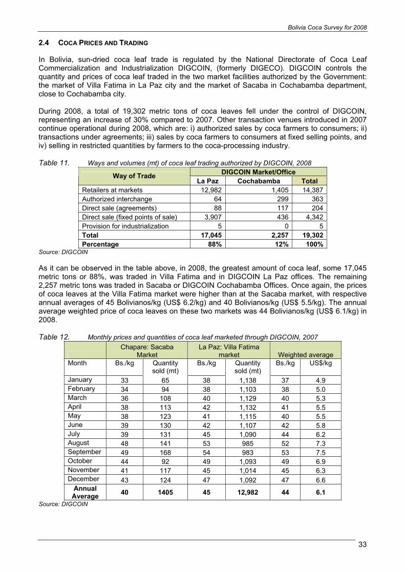
2.4 COCA PRICES AND TRADING
In Bolivia, sun-dried coca leaf trade is regulated by the National Directorate of Coca Leaf Commercialization and Industrialization DIGCOIN, (formerly DIGECO). DIGCOIN controls the quantity and prices of coca leaf traded in the two market facilities authorized by the Government: the market of Villa Fatima in La Paz city and the market of Sacaba in Cochabamba department, close to Cochabamba city.
During 2008, a total of 19,302 metric tons of coca leaves fell under the control of DIGCOIN, representing an increase of 30% compared to 2007. Other transaction venues introduced in 2007 continue operational during 2008, which are: i) authorized sales by coca farmers to consumers; ii) transactions under agreements; iii) sales by coca farmers to consumers at fixed selling points, and iv) selling in restricted quantities by farmers to the coca-processing industry.
Table 11. Ways and volumes (mt) of coca leaf trading authorized by DIGCOIN, 2008 DIGCOIN Market/Office Way of Trade
La Paz Cochabamba TotalRetailers at markets 12,982 1,405 14,387 Authorized interchange 64 299 363 Direct sale (agreements) 88 117 204 Direct sale (fixed points of sale) 3,907 436 4,342 Provision for industrialization 5 0 5 Total 17,045 2,257 19,302 Percentage 88% 12% 100%
Source: DIGCOIN
As it can be observed in the table above, in 2008, the greatest amount of coca leaf, some 17,045 metric tons or 88%, was traded in Villa Fatima and in DIGCOIN La Paz offices. The remaining 2,257 metric tons was traded in Sacaba or DIGCOIN Cochabamba Offices. Once again, the prices of coca leaves at the Villa Fatima market were higher than at the Sacaba market, with respective annual averages of 45 Bolivianos/kg (US$ 6.2/kg) and 40 Bolivianos/kg (US$ 5.5/kg). The annual average weighted price of coca leaves on these two markets was 44 Bolivianos/kg (US$ 6.1/kg) in 2008.
Table 12. Monthly prices and quantities of coca leaf marketed through DIGCOIN, 2007 Chapare: Sacaba
MarketLa Paz: Villa Fatima
market Weighted average Month Bs./kg Quantity
sold (mt) Bs./kg Quantity
sold (mt) Bs./kg US$/kg
January 33 65 38 1,138 37 4.9 February 34 94 38 1,103 38 5.0 March 36 108 40 1,129 40 5.3 April 38 113 42 1,132 41 5.5 May 38 123 41 1,115 40 5.5 June 39 130 42 1,107 42 5.8 July 39 131 45 1,090 44 6.2 August 48 141 53 985 52 7.3 September 49 168 54 983 53 7.5 October 44 92 49 1,093 49 6.9 November 41 117 45 1,014 45 6.3 December 43 124 47 1,092 47 6.6
Annual Average 40 1405 45 12,982 44 6.1
Source: DIGCOIN

Bolivia Coca Survey for 2008
34
According to DIGCOIN information, a total of 17,045 metric tons of traded coca came from the Yungas. Based on the data of the yield study, the equivalent area would be 12,903 ha of coca grown in the Yungas of La Paz. 2,257 metric tons from the Chapare were traded, with an equivalent area of 817 ha.
DIGCOIN monthly authorizes a fixed amount according to each type of trader. Retailers in markets are authorized to trade 750 pounds, of which 500 can be from the ADEPCOCA market, and the rest 250 are mandatory to be acquired from Sacaba. Producers with direct sale on fixed points are authorized to trade 300 pounds of coca leaves coming from its respective communities and must pass for the Villa Fatima market for its registration. Direct sales across agreements and for industrialization purposes vary according to each agreement, finally the authorized interchange can be up to 50 pounds per three months, and it has to be a in kind trade. DIGCOIN authorization specifies the precedence of the leaves and the final point of destination. Retailed sales of coca leaves are sold in packages of maximum 15 pounds.
The following map shows the distribution of traded coca leaves throughout the country according to the DIGCOIN registry. In 2008, most of the coca leaves ended up in La Paz department, followed by the departments of Cochabamba, Santa Cruz, Tarija, and Potosi. For second year in a row, there was a significant increase in La Paz department, where the new transaction venues were used to trade to the rural communities of the Altiplano.
In Santa Cruz, coca leaves are supplied mostly for the workers of large scale industrial farms of soy beans and sugar canes who habitually chew it. Coca chewing is also widespread among miners of the departments of La Paz, Potosi and Oruro. An increasing quantity of coca leaves traded in the southern part of the country is smuggled to neighboring Argentina.

!
!
^
!
!
!
!
!
!
Rio Beni
Rio Itenez
RioMamore
Madrede D
ios
Madera
Rio Pilcomayo
BRAZIL
ARGENTINA
CHILEPARAGUAY
PERU
Sucre
Oruro
Tarija
Potosi
La Paz
Cobija
Trinidad
Santa Cruz
Cochabamba
B e n i
S a n t a C r u z
P o t o s i
P a n d o
O r u r o
Ta r i j a
C h u q u i s a c a
L a P a z
C o c h a b a m b a
60°W
60°W
65°W
65°W10
°S
10°S
15°S
15°S
20°S
20°S
25°S
25°S
Coca leaf trading authorized by DIGCOIN, Bolivia 2008
1:8,000,000Geographic coordinates, WGS 1984
0 300150 km
Bolivia
SOUTH AMERICA
Water bodies
Main rivers
Department boundaries
International boundaries
Coca growing areas
Titicaca lake
792
1,62
2
5,44
6
3,50
5
39
279
688
2,25
4
4,70
4
Source: Government of Bolivia - DIGCOIN - National monitoring system supported by UNODC.The boundaries and names shown and the designation used on this map do not imply official endorsement or acceptance by the United Nations.
Laguna Verde
Quantity of traded cocaleaves (metric tons)
2004
2005
2006
2007
2008

Bolivia Coca Survey for 2008
36
Farm-gate prices of sun-dried coca leaf have been collected in Chapare on a monthly basis by DIGPROCOCA (former DIRECO) since 1990 and by the UNODC monitoring project in the Yungas of La Paz since 2004. Average annual prices for coca leaf were lower in the Yungas of La Paz, at BOB 38/kg (US$ 5.17/kg) than in the Chapare, at BOB 26/kg (US$ 3.2/kg).
Table 13. Monthly sun-dried coca leaf price in the Yungas of La Paz, 2008
AverageMonth Municipality of Coripata
Bs/Kg
Municipality of Chulumani
Bs/Kg
Municipality of La Asunta
Bs/Kg
Municipality of Caranavi
Bs/Kg Bs/Kg $US/KgJanuary 40 37 40 40 39 5.09February 40 36 40 40 39 5.10March 37 37 40 39 38 5.07Apr 37 36 39 38 37 5.01May 35 35 40 38 37 5.04June 37 36 39 39 38 5.21July 38 37 39 39 38 5.30August 37 36 39 40 38 5.32September 36 36 39 40 38 5.31October 36 37 38 40 38 5.32November 35 36 37 38 37 5.17December 35 35 37 37 36 5.10Annual average 37 36 39 39 38 5.17
Compared to 2007, sun-dried coca leaf prices remained stable in 2008 to BOB 38/kg in the Yungas, but experienced a relevant increase in Chapare to $US 40.
Table 14. Reported monthly sun-dried coca leaf prices in the Chapare, 2008 Month Bs/Kg $US/Kg
January 33 4.30February 31 4.11March 33 4.36Apr 36 4.80May 38 5.21June 38 5.29July 38 5.32August 44 6.25September 49 6.84October 48 6.82November 47 6.66December 47 6.65Annual Average 40.2 5.5
Source: DIGPROCOCA
The increasing trend in Cochabamba Tropics continues in 2008, with a significant raise from BOB 29.3/kg to BOB 40.2 (+37%). The increase in prices, parallel to the increase in cultivated surface, could be attributed to an increase in the demand of coca leaves.

Bolivia Coca Survey for 2008
37
Figure 14. Monthly sun-dried coca leaf price in the Yungas of La Paz, Chapare and markets controlled by DIGCOIN, 2007
0.00
1.00
2.00
3.00
4.00
5.00
6.00
7.00
8.00
Jan Feb Mar Apr May Jun Jul Aug Sep Oct Nov Dec
$US/
Kg
Yungas Chapare Digcoin
Sources: UNODC monitoring project/DIGPROCOCA/ DIGCOIN
Weighted by production, the annual average price for coca leaf outside the market controlled by DIGCOIN was US$ 5.27/kg. This was a lower price than that of US$ 6.0/kg on the market controlled by DIGCOIN.
Prices of coca leaves have not been systematically recorded for Apolo. Anecdotal information suggests much lower prices in Apolo than elsewhere in the country, ranging from US$ 2.5 to US$ 2.8/kg in 2006. The reason for lower prices in Apolo could be attributed to the remoteness of the region, being far from the main trading centers. Coca leaf production in Apolo (281 mt) was negligible compared to the national total, and was therefore not taken into account in the establishment of the national annual price estimate.
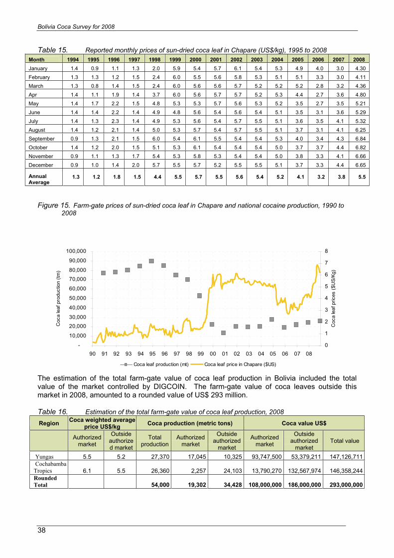
The existence of coca leaf price data from Chapare collected by DIRECO since 1990 provides a picture of long term price trends. Following a strong price rise in 1999 – in line with a strong increase in eradication – sun-dried coca leaf prices reached a peak of US$ 5.7 /kg in 2000. Prices subsequently fell to the lowest level since 1998 (US$ 3.2/kg in 2006) and rose again to U$ 5.5/kg in 2008.
Bolivia Coca Survey for 2008
38
Table 15. Reported monthly prices of sun-dried coca leaf in Chapare (US$/kg), 1995 to 2008Month 1994 1995 1996 1997 1998 1999 2000 2001 2002 2003 2004 2005 2006 2007 2008January 1.4 0.9 1.1 1.3 2.0 5.9 5.4 5.7 6.1 5.4 5.3 4.9 4.0 3.0 4.30 February 1.3 1.3 1.2 1.5 2.4 6.0 5.5 5.6 5.8 5.3 5.1 5.1 3.3 3.0 4.11 March 1.3 0.8 1.4 1.5 2.4 6.0 5.6 5.6 5.7 5.2 5.2 5.2 2.8 3.2 4.36 Apr 1.4 1.1 1.9 1.4 3.7 6.0 5.6 5.7 5.7 5.2 5.3 4.4 2.7 3.6 4.80 May 1.4 1.7 2.2 1.5 4.8 5.3 5.3 5.7 5.6 5.3 5.2 3.5 2.7 3.5 5.21 June 1.4 1.4 2.2 1.4 4.9 4.8 5.6 5.4 5.6 5.4 5.1 3.5 3.1 3.6 5.29 July 1.4 1.3 2.3 1.4 4.9 5.3 5.6 5.4 5.7 5.5 5.1 3.6 3.5 4.1 5.32 August 1.4 1.2 2.1 1.4 5.0 5.3 5.7 5.4 5.7 5.5 5.1 3.7 3.1 4.1 6.25 September 0.9 1.3 2.1 1.5 6.0 5.4 6.1 5.5 5.4 5.4 5.3 4.0 3.4 4.3 6.84 October 1.4 1.2 2.0 1.5 5.1 5.3 6.1 5.4 5.4 5.4 5.0 3.7 3.7 4.4 6.82 November 0.9 1.1 1.3 1.7 5.4 5.3 5.8 5.3 5.4 5.4 5.0 3.8 3.3 4.1 6.66 December 0.9 1.0 1.4 2.0 5.7 5.5 5.7 5.2 5.5 5.5 5.1 3.7 3.3 4.4 6.65
Annual Average
1.3 1.2 1.8 1.5 4.4 5.5 5.7 5.5 5.6 5.4 5.2 4.1 3.2 3.8 5.5
Figure 15. Farm-gate prices of sun-dried coca leaf in Chapare and national cocaine production, 1990 to 2008
-
10,000
20,00030,000
40,000
50,000
60,000
70,000
80,000
90,000
100,000
90 91 92 93 94 95 96 97 98 99 00 01 02 03 04 05 06 07 08
Coc
a le
af p
rodu
ctio
n (tm
)
0
1
2
3
4
5
6
7
8
Coc
a le
af p
rices
($U
S/Kg
)
Coca leaf production (mt) Coca leaf price in Chapare ($US)
The estimation of the total farm-gate value of coca leaf production in Bolivia included the total value of the market controlled by DIGCOIN. The farm-gate value of coca leaves outside this market in 2008, amounted to a rounded value of US$ 293 million.
Table 16. Estimation of the total farm-gate value of coca leaf production, 2008
Region Coca weighted average price US$/kg Coca production (metric tons) Coca value US$
Authorized market
Outsideauthorized market
Total production
Authorized market
Outsideauthorized
market
Authorized market
Outsideauthorized
marketTotal value
Yungas 5.5 5.2 27,370 17,045 10,325 93,747,500 53,379,211 147,126,711 Cochabamba Tropics 6.1 5.5 26,360 2,257 24,103 13,790,270 132,567,974 146,358,244Rounded Total 54,000 19,302 34,428 108,000,000 186,000,000 293,000,000

Bolivia Coca Survey for 2008
39
The increase of the coca value in 2008 is attributable to the increase in prices and production in both Yungas and Chapare regions.
The total farm-gate value of coca leaf production in 2008 is equivalent to 3% of the projected Bolivian GDP3 of US$ 9.7 billions for 2008. It represents 20% of the projected value of the agricultural sector of US$ 1.36 billions in 2007. These figures suggest that, for the country as a whole, coca production still has an impact on the Bolivian economy, and continues to play an important role within the coca producing regions.
Street prices of cocaine paste and cocaine of unknown purity from the major cities and coca growing regions in Bolivia were also reported by FELCN and are provided in the table below.
Table 17. Reported prices of cocaine base and cocaine HCl (US$/kg), 2007
City Cocaine
base Cocaine
HCLLa Paz 800 2,200 Cochabamba 1,200 2,200 Santa Cruz 1,400 2,100
Region Yungas of La Paz 800 1,100 Chapare 1,250 1,900
Source: FELCN
3 Source: INE, 2007
!
^
!
!
4654
34
14
4128
10
25
35
26
1327
45
55
20
16
32
23
9
3
42
22
15
12
30
197
BEN
I
LAPA
Z
CO
CH
ABA
MB
A
SAN
TAC
RU
Z
OR
UR
OPO
TOS
I
SAN
TAC
RU
Z
Oru
ro
LaP
az
Trin
idad
Coc
haba
mba
64°W
64°W
65°W
65°W
66°W
66°W
67°W
67°W
68°W
68°W
69°W
69°W
15°S
15°S
16°S
16°S
17°S
17°S
18°S
18°S
Titicacalake
Apolo
Yungas
Chapare
2525
PE
RU
1:2,
500,
000
Geo
grap
hic
coor
dina
tes,
WG
S19
84
010
050
km
Land use and coca cultivation, Bolivia 2008
35
34
54
4641
10
46
46
34
34
Sou
rce:
Gov
ernm
ento
fBol
ivia
-La
ndM
anan
gem
ent2
001
-N
atio
nalm
onito
ring
syst
emsu
ppor
ted
byU
NO
DC
.The
boun
darie
san
dna
mes
show
nan
dth
ede
sign
atio
nus
edon
this
map
dono
tim
ply
offic
iale
ndor
sem
ento
rac
cept
ance
byth
eU
nite
dN
atio
ns.
Bo
livi
a
PAR
AG
UA
Y
AR
GE
NT
INA
BR
AZ
IL
PERU CH
ILE
Bo
livi
a
113
Land
Use
3 11
Ext
ensi
veag
ricul
turw
ithliv
est
ock
anua
lcro
ps
Ext
ensi
veag
ricul
turw
ithliv
est
ock
anua
lcro
ps,o
vine
s
Ext
ensi
veag
ricul
turw
ithliv
est
ock
perm
anen
tcro
ps
Ext
ensi
veag
ricul
turw
ithliv
est
ock,
anua
lcr
ops,
ovin
es,g
oats
Sca
ttere
dex
tens
ive
agric
ultu
rwith
live
stoc
k
Ext
ensi
veag
ricul
turw
ithliv
est
ock,
anua
lcr
ops,
ovin
es,g
oats
Ext
ensi
veag
ricul
turw
ithliv
est
ock,
anua
lcr
ops,
ovin
es,l
lam
as,v
icuñ
as
Sca
ttere
dex
tens
ive
agric
ultu
rwith
live
stoc
k,pe
rman
entc
rops
Ext
ensi
veag
ricul
turw
ithliv
est
ock,
ovin
es
Ext
ensi
vera
isin
gov
ines
7 9 10 12 13 14 15 16 19 20
Inte
nsiv
eAg
ricul
turw
ithliv
est
ock
Ext
ensi
veag
ricul
turw
ithliv
est
ock,
anua
lan
dpe
rman
entc
rops
,ovi
nes,
goat
s
27
Ext
ensi
veliv
est
ock
llam
as,o
vino
s,vi
cuña
s
Ext
ensi
veliv
est
ock,
ovin
es
Sca
ttere
dex
tens
ive
live
stoc
k,ov
ines
llam
as
Ext
ensi
veliv
est
ock
ovin
esan
dlla
mas
Sca
ttere
dliv
est
ock
with
alpa
cas,
llam
as,v
icuñ
as
Ext
ensi
veliv
est
ock
ovin
es,
llam
as
Ext
ensi
veliv
est
ock
llam
as,a
lpac
as,v
icuñ
as
Ext
ensi
veliv
est
ock,
woo
dre
cole
ctio
n
Sca
ttere
dex
tens
ive
live
stoc
kov
ines
Very
Sca
ttere
dex
tens
ive
live
stoc
k
Sca
ttere
dex
tens
ive
live
stoc
k
24 25 26 28 30 32 34 3521 22 23
Sca
ttere
dex
tens
ive
live
stoc
klla
mas
,ovi
nos,
vicu
ñas
54
Agro
fore
stry
with
cattl
ean
dgo
ats
Fore
stry
with
cattl
ean
dgo
ats
Fore
stry
with
cattl
ean
dw
ood
Very
scat
tere
dFo
rest
ryw
ithca
ttle
Fore
stry
Fore
stal
and
seco
ndar
yfo
rest
Fore
stal
mad
erab
ledi
sper
so
No
agric
ultu
ral,
live
stoc
k,no
r
Bod
yw
ater
s
Sno
w
40 41 42 45 46 47 48 55 57 58
Hun
ting,
fishi
ngot
her
agric
ultu
rew
ithliv
est
ock
agric
ultu
rew
ithliv
est
ock
agric
ultu
rew
ithliv
est
ock
agric
ultu
rew
ithliv
est
ock
agric
ultu
rew
ithliv
est
ock,
anua
l
agric
ultu
rew
ithliv
est
ock,
anua
l
agric
ultu
re
agric
ultu
re agric
ultu
re
agric
ultu
re
32
41
Ap...:
Gro
win
gar
eas
Coc
acu
ltiva
tion
(200
8)
Dep
artm
entb
ound
arie
sIn
tern
atio
nalb
ound
arie
s
Mai
nro
ads
Wat
erbo
dies

Bolivia Coca Survey for 2008
41
2.5 COCA CULTIVATION AND RELATED ISSUES
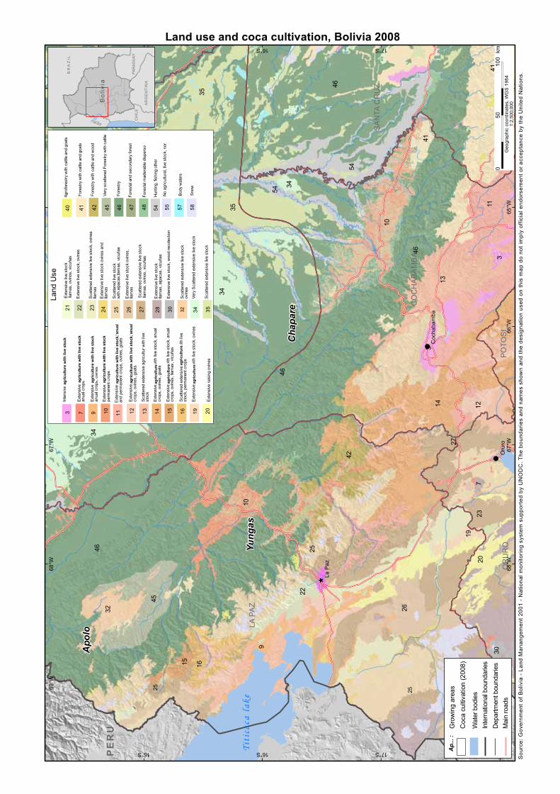
2.5.1 COCA CULTIVATION AND LAND USE
The Bolivian National Authorities of Land Management (‘Ordenamiento Territorial’) released in 2002 a country wide map of major land use (scale 1:500,000), based on the classification of Landsat images. ´The map of coca cultivation was laid on top of this land use map since 2003. This analysis revealed that coca cultivation is found over four main types of land use: Extensive livestock and agriculture with permanent crop; timber forest; timber forest and cattle; non-timber forest and cattle; hunting, fishing and non-timber forest products.
In 2008, 77% of coca cultivation took place on land dedicated to extensive livestock and agriculture with permanent crop, and 20% over land where the major land use is classified as timber forest. This last category corresponded mainly to the border of the Isiboro Secure National Park that is now protected, meaning that activities like extensive agricultural or logging are no longer permitted.
Table 18. Distribution of 2003 - 2008 coca cultivation by major land use and by region (ha)
Region Major land use 2005 2006 2007 2008 % change
2007 - 2008 % of 2008
total
Yungas Extensive livestock and agriculture with permanent crop 16,381 17,160 17,635 18,052 2% 59% timber forest 1,498 1,534 1,958 2,471 26% 8% timber forest and cattle 204 208 215 201 -7% 1%
Cochabamba Tropics
Extensive livestock and agriculture with permanent crop 3,366 4,401 5,185 5,629 9% 18% timber forest 3,069 3,285 2,988 3,161 6% 10% non-timber forest and cattle 298 302 331 431 30% 1% hunting, fishing and non-timber forest products 277 287 301 289 -4% 1%
Apolo Extensive livestok, sheep 178 178 178 178 0% 1% Timber forest 11 11 11 11 0% 0% Very scattered forest with cattle 51 51 51 51 0% 0% non-timber forest and cattle 61 61 61 61 0% 0%
Rounded Total 25,400 27,500 28,900 30,500 6% 100%
Figure 16. Coca cultivation and major land uses in Bolivia
77%
20%3%
Extensive livestock and agriculture with permanent crop timber forest Other

!
!
!
!
!
!
!
!
!
!
!
!
!
!
!
!
Ichi
loC
hapa
re
Car
rasc
o
Mox
os
Tira
que
Sara
Aran
i
Sant
iest
evan
Puna
ta
Mar
ban
ArceJo
rdan
Chi
mor
e
Bulo
Bulo
Villa
Tuna
ri
Puer
toVi
llarro
el
Isin
uta
Send
aF
Send
aB
Shin
ahot
a
Eter
azam
a
Chi
pirir
i
Entre
Rio
s
Ivirg
arza
ma
Valle
Sact
aVa
lleIv
irza
Yung
asde
Vand
iola
Villa
14de
Sep
tiem
bre
Co
ch
ab
am
ba
Sa
nt
aC
ru
z
Be
ni
Río I
ch ilo
Río Chore
RíoIsiboro
Río Yap
ac
ani
Río C
himoré
RíoIchoa
RíoChipiriri
Río Sajta
R
íoC
hapare
RíoUse
uta
R ío Espum
a
Rí oIvirizu
Arr.U
riuta
Río Osos
RíoP iray
RíoEterasama
RíoZabala
RíoIsinota
Rí oMo
l le
Río Moile
Río
Malpaso
RíoSanMat
eo
Arr.M
ariposas
Río Alizar
RíoC
hapare
64°W
64°W
65°W
65°W
66°W
66°W
17°S
17°S
Titicacalake
Sou
rce:
Gov
ernm
ento
fBol
ivia
-N
atio
nalm
onito
ring
syst
emsu
ppor
ted
byU
NO
DC
.The
boun
darie
san
dna
mes
show
nan
dth
ede
sign
atio
nus
edon
this
map
dono
tim
ply
offic
iale
ndor
sem
ento
rac
cept
ance
byth
eU
nite
dN
atio
ns.
Coca cultivation and integral development cultivation for Tropic of Cochabamba, Bolivia, 2008
PAR
AG
UA
Y
AR
GE
NT
INA
BR
AZ
IL
PERU CH
ILE
Bo
livi
a
1:90
0,00
0G
eogr
aphi
cco
ordi
nate
s,W
GS
1984
050
25km
Inte
gral
culti
vatio
n
Coc
agr
owin
gar
eas
Mul
tiple
use
fore
st
Dep
artm
entb
ound
arie
s
Prov
ince
boun
darie
s
Mai
nro
ads
Mai
nriv
ers

Bolivia Coca Survey for 2008
43
2.5.2 COCA CULTIVATION RELATED WITH OTHER CROPS
In 2005, the Project started monitoring and quantifying the most important crops resides coca crops, generating in this manner a complete land use map for both regions. This data has been employed to analyze the dynamics of coca cultivation related with other crops.
Cochabamba Tropics The most important investments were developed in this region for the promotion of alternative crops, which actually supply local and exporting markets. The intervention of integral development has been focused mainly in the region known as Multiple Use Forest (BUM), located at the centre of the Cochabamba Tropics, without taking into account the National Parks, as shown in the map. The project quantified the crops in this area using satellite images since 2003.
Table 19. Coca leaf and other crops in the BUM area of the Cochabamba tropics.
Crop 2003 2004 2005 2006 2007 % change
2003 – 2007* Coca 4.370 4.317 4.107 5.200 6.015 38% Banana 14.555 16.548 20.358 23.005 22.646 56% Citrus 6.679 8.120 10.052 12.686 12.702 90% Palm heart 2.607 3.428 4.448 5.329 5.358 106% Pineapple 1.359 1.582 1.967 1.995 1.634 20%
Since there is not yet data available for 2008 The % of change for alternative crops is calculated for the period 2003-2007
Figure 17. Coca cultivation and exporting alternative cultivation in the BUM area since 2003
-
5,000
10,000
15,000
20,000
25,000
2003 2004 2005 2006 2007
hect
ares
coca banana citrus palm heart pineapple
In spite of the increase in coca cultivation inside the BUM area, there is no evidence of replacement of other crops by coca cultivation.
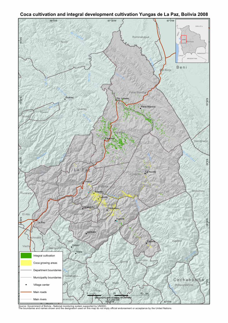
Coca cultivation and integral development cultivation Yungas de La Paz, Bolivia 2008
&
&
&
&
&
&
&
&
&
&
&
&
&
&
&
^
Cohoni
Tirata
Guanay
Cajuata
Lambate
Arapata
Irupana
Coroico
Coripata
Caranavi
La Asunta
Yanacachi Chulumani
Pto. Linares
Palos Blancos
L a P a z
B e n i
C o c h a b a m b a
La Paz
Guanay
Apolo
San Borja
Inquisivi
Murillo
La Asunta
Caranavi
Palos Blancos
Morochata
Irupana
Quime
Coroico
PalcaCajuata
Coripata
Sapahaqui
Rurrenabaque
Cairoma
Luribay
Ichoca
Ayo Ayo
MallaIndependencia
YanacachiEl Alto
ViachaMecapaca
Calamarca
Yaco
Pucarani
Tipuani
Chulumani
San Ignacio
Achocalla
Licoma
Sorata
PatacamayaCoro Coro
RíoCotacajes
Río LaPaz
Río Boopi
Río Rapulo
Río Unduavi
RíoChallana
Río Zongo
Río Quiquibey
RíoKaka
Río Coroico
RíoTipuani
Río Consata
RíoAten
Río Sapaqui
Río Inicua
Río Quendeque
Río Santa Elena
Río Ayopaya
67°0'W
67°0'W
67°30'W
67°30'W
68°0'W
68°0'W15
°0'S
15°0
'S
15°3
0'S
15°3
0'S
16°0
'S
16°0
'S
16°3
0'S
16°3
0'S
17°0
'S
17°0
'S
Source: Government of Bolivia - National monitoring system supported by UNODC.The boundaries and names shown and the designation used on this map do not imply official endorsement or acceptance by the United Nations.
Geographic coordinates, WGS 1984
0 5025 km
1 :1.200.000
PARAGUAY
ARGENTINA
B R A Z I L
PER
U
CHILE
La Paz
Bol i v i a
Integral cultivation
Coca growing areas
Department boundaries
Municipality boundaries
& Village center
Main roads
Main rivers
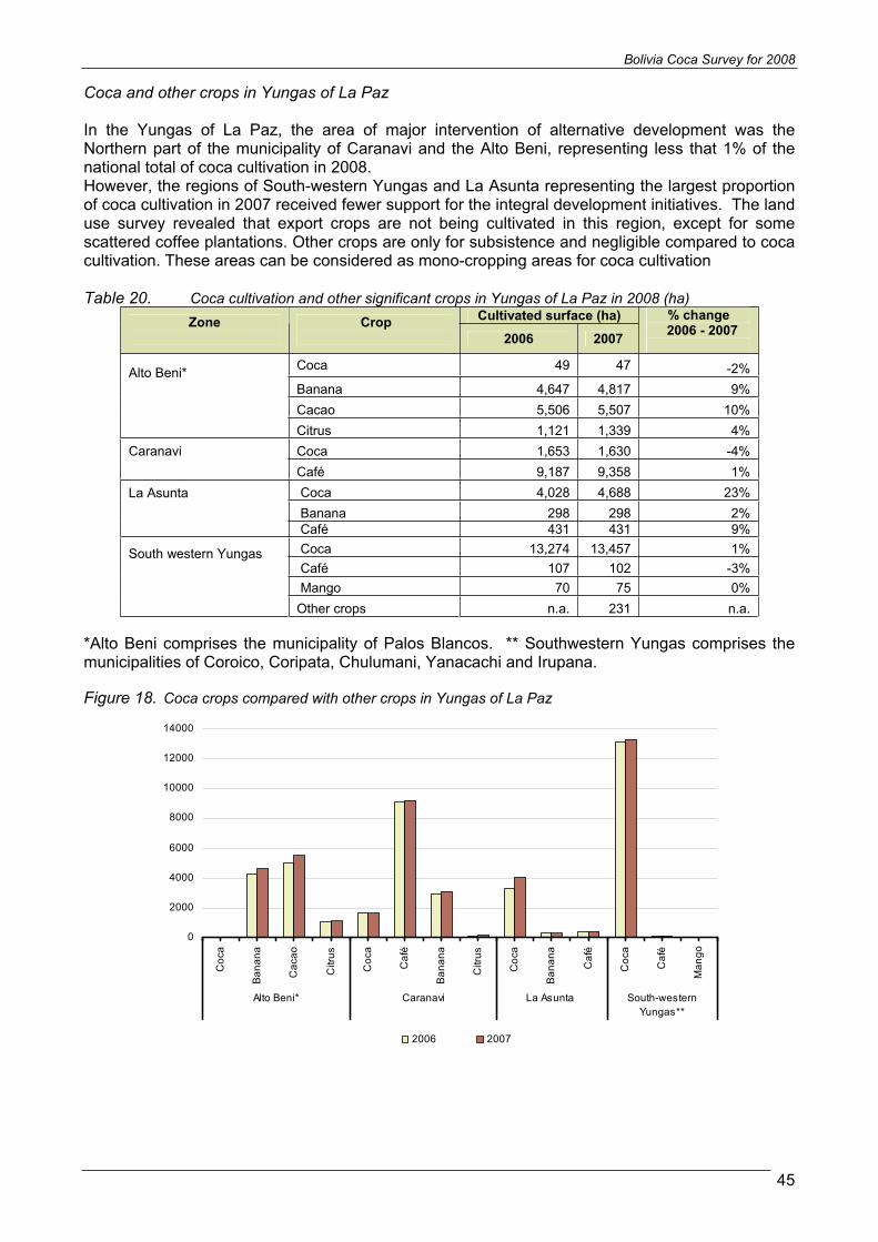
Bolivia Coca Survey for 2008
45
Coca and other crops in Yungas of La Paz
In the Yungas of La Paz, the area of major intervention of alternative development was the Northern part of the municipality of Caranavi and the Alto Beni, representing less that 1% of the national total of coca cultivation in 2008. However, the regions of South-western Yungas and La Asunta representing the largest proportion of coca cultivation in 2007 received fewer support for the integral development initiatives. The land use survey revealed that export crops are not being cultivated in this region, except for some scattered coffee plantations. Other crops are only for subsistence and negligible compared to coca cultivation. These areas can be considered as mono-cropping areas for coca cultivation
Table 20. Coca cultivation and other significant crops in Yungas of La Paz in 2008 (ha) Cultivated surface (ha) Zone Crop
2006 2007
% change 2006 - 2007
Coca 49 47 -2%Banana 4,647 4,817 9% Cacao 5,506 5,507 10%
Alto Beni*
Citrus 1,121 1,339 4% Coca 1,653 1,630 -4% Caranavi Café 9,187 9,358 1% Coca 4,028 4,688 23% Banana 298 298 2%
La Asunta
Café 431 431 9% Coca 13,274 13,457 1% Café 107 102 -3% Mango 70 75 0%
South western Yungas
Other crops n.a. 231 n.a.
*Alto Beni comprises the municipality of Palos Blancos. ** Southwestern Yungas comprises the municipalities of Coroico, Coripata, Chulumani, Yanacachi and Irupana.
Figure 18. Coca crops compared with other crops in Yungas of La Paz
0
2000
4000
6000
8000
10000
12000
14000
Coc
a
Ban
ana
Cac
ao
Citr
us
Coc
a
Caf
é
Ban
ana
Citr
us
Coc
a
Ban
ana
Caf
é
Coc
a
Caf
é
Man
go
Alto Beni* Caranavi La Asunta South-westernYungas**
2006 2007

Bolivia Coca Survey for 2008
46
Figure 19. Alternative crops in Cochabamba Tropics
.
In Cochabamba Tropics exporting crops are disposed in large
extensions
In this Aerial picture, a well arranged distribution of banana,
Herat of palm and citrus is shown
Herat of Palm is one of the main exporting crops, and presents a great development in Cochabamba Tropics.
Different ages of Citrus crops

Bolivia Coca Survey for 2008
47
Figure 20. Alternative crops in los Yungas Caranavi and Alto Beni
Aerial view of papaya and banana y crops in Alto Beni.
In Alto Beni, coca crops are insignificant compared with other crops like organic cacao, with a high exportation potential
Caranavi’s Coffee is internationally acknowledged for its high quality
The Picture shows a coffee of the typical sun-protected variety
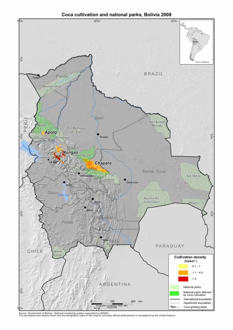
!
!
^
!
!
!
!
!
!
Rio Pilcomayo
Madera
Madrede D
ios
RioMamore
Rio Itenez
Rio Beni
Beni
Santa Cruz
Potosi
La Paz
Pando
Oruro
Tarija
Chuquisaca
Cochabamba
B R A Z I L
A R G E N T I N A
C H I L EPA R A G U AY
PE
RU
Sucre
Oruro
Tarija
Potosi
La Paz
Cobija
Trinidad
Santa Cruz
Cochabamba
60°W
60°W
65°W
65°W
70°W
70°W10
°S
10°S
15°S
15°S
20°S
20°S
25°S
25°S
Coca cultivation and national parks, Bolivia 2008
Chapare
Yungas
Titicaca lake
Apolo
Manuripi Heat
Madidi
Apolobamba Pilon Lajas
Est. Biológicadel Beni
Isiboro Secure
CarrascoAmboro
Cotapata
Tunari
Sajama
Noel KempffMercado
Toro Toro
El PalmarKaa Iya delGran Chaco
San Matias
Otuquis
EduardoAvaroa
Cordillera deSama
Tariquia
Source: Government of Bolivia - National monitoring system supported by UNODC.The boundaries and names shown and the designation used on this map do not imply official endorsement or acceptance by the United Nations.
Poopo lake
1:8,000,000Geographic coordinates, WGS 1984
0 300150 km
Cultivation density(ha/km² )
National parks
National parks affectedby coca cultivation
Yun... :Department boundariesInternational boundaries
Coca growing areas
0.1 - 1
1.1 - 4.0
> 4
Bolivia
SOUTH AMERICA

Bolivia Coca Survey for 2008
49
2.5.3 COCA CULTIVATION IN NATIONAL PARKS
There are 21 protected areas and National Parks in Bolivia, totalizing an area of 165,000 sq km, representing 15% of the national territory. Coca cultivation slightly increased in the National Parks of Chapare, however the amount of coca cultivation found in this regions is still substantially smaller than the largest figure reported in 2004.
National Parks are particularly fragile and deforestation for establishment of coca cultivation causes irreversible damage to their environment. Although eradication has been efficient during 2007, it should be noted that the damage to the forest due to coca cultivation is irreversible.
Table 21. Coca cultivation estimates by National Parks in Chapare (ha), 2003 – 2008
Area 2003 2004 2005 2006 2007 2008% change
2007 - 2008 % of 2008
total Isiboro Secure Nacional Park 1,605 2,807 1,161 1,451 985 1,081 10% 11%Carrasco National Park 778 1,257 781 837 830 972 17% 10%Madidi National Park n.a. 10 10 10 10 10 0% 0%Total within National Parks 2,383 4,074 1,952 2,298 1,825 2,063 13% 22%Outside National Parks 4,917 6,026 5,053 6,002 6,975 7,474 7% 79%Rounded Total 7,300 10,100 7,005 8,300 8,800 9,500 8% 100%
Figure 21. Distribution of coca cultivation in Chapare region inside and outside national parks (ha), 2003 – 2008
0
1,000
2,000
3,000
4,000
5,000
6,000
7,000
8,000
Total within National Parks Outside National Parks
2003 2004 2005 2006 2007 2008

Mox
os
Ichi
lo
Mar
banIte
nez
Yacu
ma
Cha
pare
Paca
jes
Car
rasc
o
Lare
caja
Fran
zTa
may
o
Jose
Balli
vian
Ayop
aya
Inqu
isiv
i
Sud
Yung
as
Arom
a
Inga
vi
Mur
illo
Cer
cado
Sara
Loay
za
Iturra
lde
Saav
edra
Tira
que
Arce
Gua
rayo
s
Car
anav
i
Los
And
es
Miz
que
Saja
ma
Villa
rroel
Tapa
cari
Muñ
ecas
Arqu
e
Cam
acho
Sant
iest
evan
J.M
.Pan
do
Nor
Yung
as
Baur
es
Om
asuy
os
Aran
i
Bilb
aoBo
livar
Sauc
ari
Be
ni
La
Pa
z
Co
ch
ab
am
ba
Sa
nt
aC
ru
z
Or
ur
o Oru
ro
LaP
az
Trin
idad
Coc
haba
mba
RíoApere
RíoIsiboro
RíoIchi
lo
RíoRap
uloRíoIbare
RíoM
amoré
RíoYapacani
RíoSecure
RíoIchoa
R íoSanPab lo
Río Tuic
hi
Río Chore
RíoTijamu
chi
RíoChapa
re
RíoConsa ta
Rí
oMauri
RíoCotacaje
s
RíoDe saguadero
RíoYacuma
Río Piray
RíoLaPaz
R ío C
himoré
RíoAten
RíoNegro
RíoBoop
i
RíoCocharca
RíoPajta
RíoChipirir
i
Río Sajt
a
RíoCabito
RíoBeni
Río Altamach
i
Río Unduavi
RíoTipuani
RíoMono
Río Grande óGuapay
RíoChallan
aRío
Zongo
RíoUseuta
Río Santa
Elena
Río E s
puma
RíoM
izque
Rí
o Ayopaya
Río Camata
RíoQuiquibey
Río Iv iriz
u
RíoCoroico
RíoCuberene
RíoKaka
Arr.Uriuta
RíoCaine
Rí
o Osos
Río Sapaqui
Río Aliz
ar
Río Inicua
Río
Zabala
RíoSan M
ateo
RíoM
achariapu
RíoIsinota
RíoMolle
RíoMalpaso
Río Quendeque
Río Moile
RíoSurutu
RíoPailas
RíoBarra
s
RíoIruplum
o
RíoSanJuán
Arr.Mariposas
64°W
64°W
65°W
65°W
66°W
66°W
67°W
67°W
68°W
68°W
69°W
69°W
15°S
15°S
16°S
16°S
17°S
17°S
18°S
18°S
Titicacalake
Apolo
Yungas
Chapare
PE
RU
1:2,
500,
000
Geo
grap
hic
coor
dina
tes,
WG
S19
84
010
050
km
Eradication reported by DIGPROCOCA, Bolivia 2008
PAR
AG
UA
Y
AR
GE
NT
INA
BR
AZ
IL
PERU CH
ILE
Bo
livi
a
Sou
rce:
Gov
ernm
ento
fBol
ivia
-N
atio
nalm
onito
ring
syst
emsu
ppor
ted
byU
NO
DC
.The
boun
darie
san
dna
mes
show
nan
dth
ede
sign
atio
nus
edon
this
map
dono
tim
ply
offic
iale
ndor
sem
ento
rac
cept
ance
byth
eU
nite
dN
atio
ns.
Erad
icatio
nar
eas
(200
8)C
ultiv
atio
nch
ange
s20
07-2
008
Sign
ifica
ntde
crea
seD
ecre
ase
Insi
gnifi
cant
chan
ges
Incr
ease
Sign
ifica
ntin
crea
se
Dep
artm
entb
ound
arie
s
Mun
icip
ality
boun
darie
s
Mai
nro
ad
Villa
gece
nter
Riv
er
!.

Bolivia Coca Survey for 2008
51
2.6 REPORTED ERADICATION
The Plurinational State of Bolivia applies two different concepts inside its policy of control of coca crops: On one hand, the rationalization of coca crops, which includes the participation or voluntary agreement of coca producers with Government policies for the reduction of cultivated surface, and on the other hand, the eradication, which is undertaken in National Parks and in areas where coca crops are not permitted.
In 2008, the Bolivian Government reported the eradication of 5,483 ha of coca, 365 ha of coca were eradicated in the Yungas of La Paz, (7%) and 5,118 ha in the Cochabamba Tropics (93%).
In Bolivia, no chemical or aerosol agents are used and the eradication of coca cultivation is exclusively manual. In 2008 the coca crops rationalization was developed under an environment of harmony and social peace, without violence and respecting human rights.
Figure 22. Reported eradication and coca cultivation in Bolivia (ha), 1995 – 2008
0
10,000
20,000
30,000
40,000
50,000
60,000
hect
ares
Eradication 5,498 7,512 7,026 11,621 16,999 7,953 9,435 11,853 10,087 8,437 6,073 5,070 6,269 5,483
Coca cultivation 48,600 48,100 45,800 38,000 21,800 19,600 19,900 24,400 22,800 27,600 25,400 27,500 28,900 30,500
95 96 97 98 99 00 01 02 03 04 05 06 07 08
Sources: For coca cultivation: UNODC; for eradication: DIGPROCOCA
Figure 23. Reported monthly eradication in Bolivia (ha), 2008
-
100
200
300
400
500
600
700
Eradication (ha) 64 510 594 578 578 573 598 560 358 544 450 75
Jan Feb Mar Apr May Jun Jul Aug Sep Oct Nov Dec
Source: DIGPROCOCA

Bolivia Coca Survey for 2008
52
The Bolivian government also reported the eradication of 6.4 ha of coca seedlings in the Chapare and Yungas regions, a decrease of 15% compared to 2007. The eradication of coca seedlings helps to avoid the replanting of eradicated coca fields.
Table 22. Reported monthly eradication of coca seedlings (m2), 2003-2008 Month 2003 2004 2005 2006 2007 2008
January 1,460 1,795 2,748 444 1,077 905February 1,415 2,830 4,516 1,907 4,196 8911March 4,520 3,296 4,320 2,904 4,052 13245April 4,013 2,936 4,825 3,764 4,014 6570May 2,352 2,989 3,639 2,691 8,856 7696June 2,972 5,411 4,737 5,683 8,245 6188July 5,962 6,963 4,372 7,328 7,595 5898August 10,140 4,344 5,294 10,035 7,879 3554September 6,438 3,156 4,010 7,667 7,568 3012October 9,978 4,470 4,812 7,083 8,299 5448November 7,280 5,869 4,222 6,166 7,387 2570December 3,294 5,488 4,862 1,814 5,436 72Total 59,823 49,547 52,357 57,486 74,604 64,069
Source: DIGPROCOCA
Manual eradication of coca field in Caranavi

Bolivia Coca Survey for 2008
53
2.7 REPORTED SEIZURES
DIGCOIN, through FELCN, controls the trade of coca leaves within the country, including control over the transport of coca leaves. Coca leaves are seized if transported without a license or outside of the authorized route specified in the license. In 2008, DIGCOIN seized 2,065 metric tons of coca leaves, representing a significant increase of 21% compared to the reported seizure of 1,705 metric tons in 2007. The increase in seizure of coca leaf can be attributed to the increased number of operatives and the more efficiency achieved by the FELCN and other control institutions.
Table 23. Reported seizure of coca leaves (kg), 2002 – 2007 Department 2002 2003 2004 2005 2006 2007 2008 La Paz 31,291 22,375 66,396 172,331 197,854 315,463 196,829 Cochabamba 214 11,105 37,748 591,803 1,030,834 1,203,767 1,628,706 Santa Cruz 7,343 20,828 30,441 68,508 52,018 130,703 155,464 Tarija 1,407 4,451 10,183 16,499 19,604 11,843 21,030 Oruro 1,205 4,682 6,120 24,814 21,913 24,393 34,075 Potosi 357 1,321 1,942 1,509 4,010 4,999 7,149 Chuquisaca 0 1,450 1,448 3,229 11,780 7,013 8,444 Beni 728 600 904 7,525 4,778 6,768 13,076 Pando 0 0 0 50 271 686 50 Total: 42,544 66,811 155,182 886,268 1,343,062 1,705,636 2,064,823
Source: FELCN
Figure 24. Reported seizure of coca leaves, 2002-2008
Source: FELCN
The Special Force for the Fight against Drugs (FELCN) reports annually on drugs seizures. Between 2007 and 2008, there was a significant increase in reported seizures. In Coca paste, the increment is around 45%, and in cocaine clorhidrate ia approximately 148%.
Table 24. Reported seizure of drugs in Bolivia, 1998 – 2008 (kg) Product 1997 1998 1999 2000 2001 2002 2003 2004 2005 2006 2007 2008
Cocaine base 10,848 8,906 6,905 5,044 4,280 4,741 6,934 8,189 10,152 12,779 14,911 21,641,470 Cocaine HCL 1,477 2,440 802 555 334 362 5,969 531 1,300 1,309 2,923 7,245,872
Source: FELCN
0
1000
2000
3000
4000
5000
6000
LA PAZ SANTA CRUZ COCHABAMBA TARIJA POTOSI Otrosdepartamentos
tone
lada
s m
étric
as
2004 2005 2006 2007 2008
Otherdepartments

Bolivia Coca Survey for 2008
54
FELCN also reported a relevant amount of canabis seized, nevertheless, local quantification methods are not comparable with the applied in other producer countries in the region.
Figure 25. Reported seizures of cocaine base and cocaine HCl in Bolivia (kg), 1997 to 2008
0
5000
10000
15000
20000
25000
1997 1998 1999 2000 2001 2002 2003 2004 2005 2006 2007 2008
kg
Cocaine base Cocaine HCL
Source: FELCN
The increasing trend of cocaine base seizures has continued in 2008; the destruction of coca/cocaine laboratories and maceration pits notably increased.
Table 25. Reported destruction of clandestine laboratories and macerations pits, 1998 – 2007
0
1,000
2,000
3,000
4,000
5,000
6,000
7,000
8,000
num
ber o
f des
truct
ion
Coca paste and/or cocainelaboratories
1,066 1,245 925 628 1,006 1,420 1,769 2,254 2,619 4,070 3,087 4,988
Maceration pit 1,481 1,659 1,179 790 1,292 1,950 2,544 3,293 4,064 6,268 6,268 7,557
1997 1998 1999 2000 2001 2002 2003 2004 2005 2006 2007 2008
Source: FELCN

Bolivia Coca Survey for 2008
55
FELCN also reports chemical precursors seized. In 2008, most of the seized amount corresponds to cement, gas, diesel and lime.
Figure 26. Most relevant precursor seized by FELCN inl 2008 Precursor Unit Quantity
Cement Kg 148,587 Lime Kg 82,429 Lime soda Kg 56,904 sulfuric Acid Kg 42,632 Calcium Carbonate Kg 36,410 Sodium Carbonate Kg 24,987 Gas Liter 1,042,784 Diesel Liter 294,524
Source: FELCN
2.8 MAXIMUM POTENTIAL OF COCAINE PRODUCTION IN BOLIVIA
Other studies Developer with international cooperation have determined that 370Kg of dried coca leaf from the Cochabamba Tropics and 315 Kg from Yungas are required to obtain 1 Kg of cocaine paste. Using these factors and the potential amount determined in the yield studies performed by the project, the maximum potential of cocaine production has been estimated in 113 metric tons for the year 2008
Figure 27. Potential cocaine production in Bolivia 1996-2008 in (metric tons)
0
50
100
150
200
Met
ric T
ons
Production 200 150 70 43 60 60 79 98 80 94 104 113
1997 1998 1999 2000 2001 2002 2003 2004 2005 2006 2007 2008
Source: UNODC World Drug Report 2008
It is necessary to clarify that this estimation represents the maximum potential of cocaine paste production, Due to lack of information, the possible portion of coca leaf destined to traditional consumption (chewing, infusions and medicines) it is not considered.. A better estimate will be available at the conclusion of the Integral Study of Coca Leaf, undertaken with international cooperation support.

Bolivia Coca Survey for 2008
56
Relating the cocaine paste potential with seizures od cocaine paste and cocaine HCL, it can be observed that the efficiency of the Special Force Against Drug Dealing (FELCN) has been significantly increased, reaching its highest value in year 2008, with approximately 19% .
Coca leaf seizing have reduced the maximum potential of cocaine production, and further more, the increasing seizures of drugs and chemical precursors have significantly reduced the cocaine offer in the market, mainly for exportation purposes.
Figure 28. Efficiency of drug seizing in Bolivia, 1998 – 2008 (percentage)
0%
5%
10%
15%
20%
25%
eficiency FELCN % 6% 10% 12% 7% 8% 9% 8% 13% 14% 14% 19%
1998 1999 2000 2001 2002 2003 2004 2005 2006 2007 2008
In spite of the increase in the potential of cocaine paste in Bolivia, its global share remains in third place after Colombia and Perú, with 13% of the global potential of 845 metric tons. Production continues far from the levels of the 90’s, when Bolivia had around a quarter of cocaine global production. The highest index of cocaine production was reached in 1998, with 150 metric tons.
Table 26. Cocaine production in the Andean region (mt) Country 1998 1999 2000 2001 2002 2003 2004 2005 2006 2007 2008
%change 2007-2008
% of 2008 total
Bolivia 150 70 43 60 60 79 98 80 94 104 113 9% 13% Colombia 435 680 695 617 580 550 640 640 610 600 430 -28% 51%
Peru 240 175 141 150 160 230 270 260 280 290 302 4% 36% Total 825 925 879 827 800 859 1,008 980 984 994 845 1% 100%
Source: UNODC World Drug Report 2008
Figure 29. Cocaine production in the Andean region 1998 - 2008 ( %)
0%
10%
20%
30%
40%
50%
60%
70%
80%
90%
100%
1998 1999 2000 2001 2002 2003 2004 2005 2006 2007 2008
Bolivia Colombia Peru
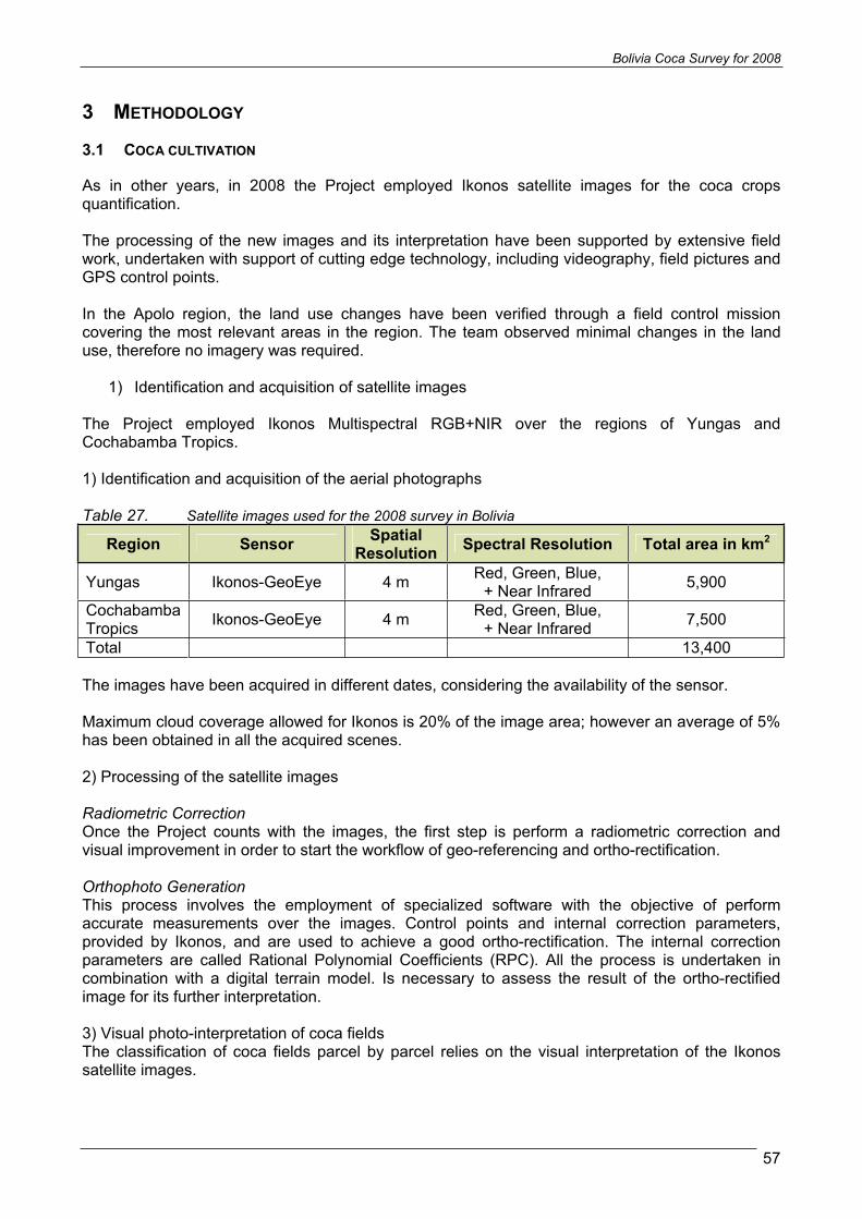
Bolivia Coca Survey for 2008
57
3 METHODOLOGY
3.1 COCA CULTIVATION
As in other years, in 2008 the Project employed Ikonos satellite images for the coca crops quantification.
The processing of the new images and its interpretation have been supported by extensive field work, undertaken with support of cutting edge technology, including videography, field pictures and GPS control points.
In the Apolo region, the land use changes have been verified through a field control mission covering the most relevant areas in the region. The team observed minimal changes in the land use, therefore no imagery was required.
1) Identification and acquisition of satellite images
The Project employed Ikonos Multispectral RGB+NIR over the regions of Yungas and Cochabamba Tropics.
1) Identification and acquisition of the aerial photographs
Table 27. Satellite images used for the 2008 survey in Bolivia
Region Sensor SpatialResolution Spectral Resolution Total area in km2
Yungas Ikonos-GeoEye 4 m Red, Green, Blue, + Near Infrared 5,900
Cochabamba Tropics Ikonos-GeoEye 4 m Red, Green, Blue,
+ Near Infrared 7,500
Total 13,400
The images have been acquired in different dates, considering the availability of the sensor.
Maximum cloud coverage allowed for Ikonos is 20% of the image area; however an average of 5% has been obtained in all the acquired scenes.
2) Processing of the satellite images
Radiometric Correction Once the Project counts with the images, the first step is perform a radiometric correction and visual improvement in order to start the workflow of geo-referencing and ortho-rectification.
Orthophoto Generation This process involves the employment of specialized software with the objective of perform accurate measurements over the images. Control points and internal correction parameters, provided by Ikonos, and are used to achieve a good ortho-rectification. The internal correction parameters are called Rational Polynomial Coefficients (RPC). All the process is undertaken in combination with a digital terrain model. Is necessary to assess the result of the ortho-rectified image for its further interpretation.
3) Visual photo-interpretation of coca fields The classification of coca fields parcel by parcel relies on the visual interpretation of the Ikonos satellite images.
Bolivia Coca Survey for 2008
58
The project continues systematizing the interpretation process across interpretation keys. In 2006, the project team attended a workshop on interpretation key development led by ICMP in cooperation with the University of Natural Resources and Applied Life Sciences (BOKU), Vienna. Since then, the project has been developing several interpretation keys for satellite imagery interpretation.
Interpretation keys reflect the decision taking process of the interpreter, using typical characteristics like the shape, the texture, the context and the surroundings of the fields. No distinction is made between the different phenological stages of coca bushes.

Mul
tispe
ctra
l ban
ds Ik
nos
imag
ery
Enha
ncem
ent o
f sa
tellit
e im
ages
Mul
tispe
ctra
l im
age
enha
nced
Dig
ital E
leva
tion
Mod
el
(DM
E)
Bas
e m
ap
Vis
ual c
ontro
l of o
rtho-
rect
ified
im
ages
Coc
a cr
ops
quan
tifie
d ar
eas
Orth
o-re
ctifi
catio
n pr
oces
s
File
d ve
rific
atio
n w
ith
Geo
vide
o an
d P
ix P
oint
te
chno
logi
es
Visu
alin
terp
reta
tion
proc
ess
Met
hodo
logi
cal w
orkf
low
Inte
rpre
tatio
n ke
ys
Indi
vidu
al b
and
enha
ncem
ent
Def
initi
on o
f sat
ellit
e im
age
area
Con
trol p
oint
loca
tion

!
^
!
!
Río Secure
RíoI bare
RíoTijamu
chi
RíoIsib
oro
RíoDesa guadero
Río
Ichoa
RíoSan
Julia
nR
íoTuichi
RIOMAM
ORE
RíoYa
pacan
i
RíoChap
are
RíoApere
RIO BENI
Río Ichilo
Río P
iray
RíoSajta
RíoMauri
RíoRapulo
RíoYacuma
RíoCuber ene
RíoLaPaz
RíoCoroico
Río Boopi
RIOALTO
BE
NI
R íoCotacajes
RíoPajta
RíoUnd
uav
i
RíoMa
niq
ui
Río Altamachi
RíoCabito
RíoZ
ongo
RíoC
onsata
RíoUseuta
Río Ayopaya
Río SantaElena
RíoKaka
R ío Cocha
rcaRíoQu
iquibey
RíoCam
a ta
Río Pailas
Río C
hore
R íoB
lanco
Río Sapaqui
Río Suru
tu
RíoQuend
eque
RíoMizque
RIOGRANDEOGUAPAY
RíoM
alpaso
RíoCaine
Río S
an Juán
RíoBarras
RíoYapacani
Río Yapacani
RíoChore
Mo
xo
sM
ox
os
Ich
ilo
Ich
ilo
Ma
rba
nM
arb
an
Ya
cu
ma
Ya
cu
ma
Ite
ne
zIt
en
ez
Ch
ap
are
Ch
ap
are
Pa
ca
jes
Pa
ca
jes
Ca
rra
sc
oC
arr
as
co
Fra
nz
Ta
ma
yo
Fra
nz
Ta
ma
yo
La
rec
aja
La
rec
aja
Jo
se
Ba
lliv
ian
Jo
se
Ba
lliv
ian
Ay
op
ay
aA
yo
pa
ya
Inq
uis
ivi
Inq
uis
ivi
Aro
ma
Aro
ma
Su
dY
un
ga
sS
ud
Yu
ng
as
Ing
av
iIn
ga
vi
Mu
rill
oM
uri
llo
Sa
raS
ara
Ce
rca
do
Ce
rca
do
Lo
ay
za
Lo
ay
za
Itu
rra
lde
Itu
rra
lde
Gu
ara
yo
sG
ua
ray
os
Sa
av
ed
raS
aa
ve
dra
Gu
ara
yo
sG
ua
ray
os
Tir
aq
ue
Tir
aq
ue
Ca
ba
lle
roC
ab
all
ero
Arc
eA
rce
Ca
ran
av
iC
ara
na
vi
Lo
sA
nd
es
Lo
sA
nd
es
Ba
ure
sB
au
res
Miz
qu
eM
izq
ue
Sa
nti
es
tev
an
Sa
nti
es
tev
an
Vil
larr
oe
lV
illa
rro
el
Mu
ñe
ca
sM
uñ
ec
as
Ta
pa
ca
riT
ap
ac
ari
Arq
ue
Arq
ue
Ca
ma
ch
oC
am
ac
ho
Sa
jam
aS
aja
ma
J.M
.Pa
nd
oJ
.M.P
an
do
Om
as
uy
os
Om
as
uy
os
Ara
ni
Ara
ni
Ca
ba
lle
roC
ab
all
ero
Bil
ba
oB
ilb
ao
Ma
mo
reM
am
ore
No
rY
un
ga
sN
or
Yu
ng
as
Qu
illa
co
llo
Qu
illa
co
llo
Ca
pin
ota
Ca
pin
ota
Sa
nP
ed
rod
eT
oto
raS
an
Pe
dro
de
To
tora
Pu
na
taP
un
ata
Sa
uc
ari
Sa
uc
ari
Ba
rro
nB
arr
on
No
rC
ara
ng
as
No
rC
ara
ng
as
Bo
liv
ar
Bo
liv
ar
Ce
rca
do
Ce
rca
do
Ca
mp
ero
Ca
mp
ero
Jo
rda
nJ
ord
an
Iba
ñe
zIb
añ
ez
Iba
ñe
zIb
añ
ez
Ca
mp
ero
Ca
mp
ero
Be
ni
La
Pa
z
Co
ch
ab
am
ba
Sa
nt
aC
ru
z
Or
ur
o
Oru
ro
LaP
az
Trin
idad
Coc
haba
mba
64°W
64°W
65°W
65°W
66°W
66°W
67°W
67°W
68°W
68°W
69°W
69°W
15°S
15°S
16°S
16°S
17°S
17°S
Titicacalake
Yungas
Chapare
PE
RU
Sou
rce:
Gov
ernm
ento
fBol
ivia
-N
atio
nalm
onito
ring
syst
emsu
ppor
ted
byU
NO
DC
.The
boun
darie
san
dna
mes
show
nan
dth
ede
sign
atio
nus
edon
this
map
dono
tim
ply
offic
iale
ndor
sem
ento
rac
cept
ance
byth
eU
nite
dN
atio
ns.
1:2,
500,
000
Geo
grap
hic
coor
dina
tes,
WG
S19
84
010
050
km
Project intervention area coverage, Bolivia 2008
PAR
AG
UA
Y
AR
GE
NT
INA
BR
AZ
IL
PERU CH
ILE
Bo
livi
a
Dep
artm
entb
ound
arie
s
Inte
rnat
iona
lbou
ndar
ies
Prov
ince
boun
darie
s
Wat
erbo
dies
Inte
rven
tion
area
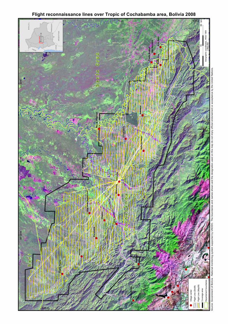
Sou
rce:
Gov
ernm
ento
fBol
ivia
-N
atio
nalm
onito
ring
syst
emsu
ppor
ted
byU
NO
DC
.The
boun
darie
san
dna
mes
show
nan
dth
ede
sign
atio
nus
edon
this
map
dono
tim
ply
offic
iale
ndor
sem
ento
rac
cept
ance
byth
eU
nite
dN
atio
ns.
&3
&3
&3
&3
&3
&3
&3
&3
&3
&3
&3
&3
&3
&3
&3
&3
&3
&3
&3
&3
&3
&3
&3&3
&3
&3
&3
&3
Co
ch
ab
am
ba
Sa
nt
aC
ru
z
Be
ni
Vaca
sA
rani
Tola
ta
Col
omi Pu
nata
Men
doza
Tira
que
Isin
ota
Agu
irre
Chi
mor
e
Hua
ncun
i
Isar
zam
a
Para
caya
Bul
oB
ulo
Chi
pirir
i
Eter
azam
a
Shin
ahot
a
Entr
eR
ios
San
Ben
ito
Ivirg
arza
ma
San
Salv
ador
Tabl
asM
onte
Villa
Tuna
ri
Puer
toPa
tiño
Valle
Her
mos
o
Puer
toG
reth
er
Pto.
G.V
illar
roel
Villa
14de
Sept
iem
bre
64°3
0'W
64°3
0'W
65°W
65°W
65°3
0'W
65°3
0'W
16°30'S
16°30'S
17°S
17°S
17°30'S
17°30'S
Flight reconnaissance lines over Tropic of Cochabamba area, Bolivia 2008
&3Vi
llage
cent
er
Flig
htLi
ne(D
ic08
)
Flig
htLi
ne(M
ay09
)
Cov
erag
ear
ea
Dep
arta
men
tbou
ndar
ies
030
15km
Geo
grap
hic
coor
dina
tes,
WG
S19
841:
800,
000
PAR
AG
UA
Y
AR
GE
NT
INA
BR
AZ
IL
PERU CH
ILE
Bo
livi
a

Bolivia Coca Survey for 2008
62
Figure 30. interpretation of ortho-rectified satellite images
Ortho-image ready for interpretation
Visible details in the green rectangle Ortho-image interpreted with coca polygons

Bolivia Coca Survey for 2008
63
Example of interpretation keys for coca crops of a cato size in the Cochabamba Tropics using Ikonos imagery
CATEGORY Interpretation ELEMENT DESCRIPTION
Shape Regular – Rectangle
Size Cato (1,600m2), or close
Tone/Color Light green, spots of dark green
Texture Fine with a clear boundary of bare soil surrounding the coca crops.
Association With small dwellings and coca-dryers.
Site Central area of the Cochabamba Tropics, near or associated with alternative crops
Coca pre-harvest state
Observation The cultivated area is closely to 1600m2
In addition, the interpretation process is substantially supported by the geo-video and geo-referenced field pictures obtained by helicopter. When the videos are played back on the computers embedded in the GIS software, the interpreter is able to compare the video with the aerial photos. Since the videos are geo-referenced, the link with the aerial photos is easily performed.
For a second year in a row, in 2006, geo-referenced videos were acquired over the whole area of the Cochabamba Tropics. The flight paths, with direction north-south or east –west, are shown on the map 12. A total of 40 hours were flown, covering a distance of 9,700 km and covering a total area of 9,800 sq km.

Bolivia Coca Survey for 2008
64
Example of the use of videography for identify a group of catos marked with red in the ortho-image
4) Field verification The use of high resolution satellite images it self it is not enough for an accurate measurement of the coca crops without a detailed on-site verification. The data collected during field verification, allowed adjust the monitoring area, determine spectral signatures of coca and other crops and correct the confusion between coca crops after the initial interpretation.
Taking a GCP in a coca field in Yungas
In Yungas of La Paz and Apolo, field control has been obtained directly from the ground, taking advantage of the topography to interpreter images in field from high areas. But, in Cochabamba Tropics this job is difficult and risky. The project obtained most of its control points using helicopter flights combined with videography.

Bolivia Coca Survey for 2008
65
During six years of monitoring, the project obtained a large number of ground reference data, starting in 2002 in the Yungas of La Paz and, as of 2003, extending to Chapare and Apolo. Since 2002, more than 10,000 ground reference data were collected, of which 1,200 in 2008. All these points were obtained directly from the ground, using regular GPS techniques. Additionally, geo-referenced field pictures are obtained, employing pix point techniques.
Visual interpretation was also facilitated for the control points acquired from the eradication campaign undertaken by DIGPROCOCA.
3.2 YIELD AND PRODUCTION OF COCA LEAF
In December 2005, UNODC started a new coca yield study in the Yungas of La Paz. The field work was implemented by selected students of Carmen Pampa University, located in the Municipality of Coroico. The knowledge of the terrain and the accessibility to the coca fields for the students was an appreciated advantage for the implementation of the field work.
The survey obtained a sample of 100 coca fields randomly selected among six strata. The strata were defined based on altitude and slope ranges, which are two physical factors that have influence in coca yield. The sample was designed by the statistician of the UNODC Illicit Crop Monitoring Programme.
The sampling approach used to estimate the average sun-dried coca leaf yield in Bolivia was a multistage stratified area probability sampling design. Sample selection was carried out within strata. The units selected at the first stage with PPS, know in the survey literature as Primary Sampling Units or PSU’s (grids), were constructed on the basis of complete enumeration of areas identified in the coca bush census. The units selected at the second stage with PPS within each selected PSU are referred to as Secondary Sampling Units or SSU’s (fields).
In the case of multistage designs, the base weights reflect the probability of selection at each stage. In general, the base weight of a sampled unit is the reciprocal of its probability of selection for inclusion in the sample.
Under this scheme of sampling with PPS of sampling units, the coca leaf yield estimation at the h-th stratum is calculated as the simple arithmetic mean of all the actual harvested parcels within the stratum. Therefore, in order to calculate the leaf yield for a region, the simple arithmetic means in the strata should be weighted by their area under coca cultivation.
The field methodology complies with UNODC standards for coca yield measurement, relying on weighing fresh and sun-dried coca leaves from a sample of harvest. The sample field was at least of 1,000 square meters size, and is distributed in all the Yungas area.
The study successfully concluded establishing an average annual yield, after weighing all the harvests that took place during the year.
In the Cochabamba Tropics, for the 2006 annual estimate of coca leaf and cocaine production, UNODC continues to rely on information available from other sources.
3.3 PRICES
The project collected coca leaf prices from farmers in the Yungas of La Paz on an ad hoc basis while performing the field verification missions. In the Chapare region, prices of coca leaf were collected by DIGPROCOCA on a monthly basis throughout 2005 in three points of the department of Cochabamba.