BMP INSPECTION & MAINTENANCE MANUAL
278
BMP INSPECTION & MAINTENANCE MANUAL Guidance Manual for BMP Inspection & Maintenance Program and Process CO-Maintenance Division 1401 E. Broad Street Richmond, Virginia 23219 July 2021 1
Transcript of BMP INSPECTION & MAINTENANCE MANUAL

BMP INSPECTION & MAINTENANCE MANUAL
Guidance Manual for BMP Inspection & Maintenance Program and Process
CO-Maintenance Division 1401 E. Broad Street
Richmond, Virginia 23219
July 2021
1

TABLE OF CONTENTS I. INTRODUCTION............................................................................................................ 7 A. MANUAL ORGANIZATION AND DISTINCTIONS .......................................................... 7 B. PURPOSE...................................................................................................................... 8 C. URBAN HYDROLOGY AND STORMWATER OVERVIEW ............................................ 8
i. Stormwater Runoff .......................................................................................10 ii. Stormwater Quantity Management ...............................................................11 iii. Stormwater Quality Management .................................................................11
II. STORMWATER MANAGEMENT REGULATORY & PROGRAMMATIC FRAMEWORK ..............................................................................................................14
A. FEDERAL AND STATE LAWS AND REGULATIONS ...................................................14 B. VDOT MS4 PROGRAM AND IMPORTANT DOCUMENT LINKS ..................................15 C. STORMWATER MANAGEMENT BMP INSPECTOR TRAINING AND
CERTIFICATION...........................................................................................................17 D. STORMWATER BMPS .................................................................................................20
i. Design Storms .............................................................................................21 ii. Design Storm Requirements for BMPs.........................................................21 iii. BMP Outlet Structures..................................................................................21
E. EROSION CONTROL REQUIREMENTS FOR BMPS...................................................22 F. NUTRIENT CREDITS....................................................................................................22 III. FIELD WORK PREP & SAFETY AND DATABASE STRUCTURE & SURVEY 1-
2-3 APPLICATION........................................................................................................23 A. TOOLBOX & SAFETY GUIDELINES ............................................................................23 B. BMP INSPECTION, MAINTENANCE AND REPAIR CREW & EQUIPMENT
DESCRIPTIONS ...........................................................................................................26 C. DATABASE INSTRUCTION MANUAL (JOB AID) .........................................................27 D. INSPECTION RATING SCORING.................................................................................28 E. MAINTENANCE HIERARCHY ......................................................................................30 F. ARCHIVING OR CHANGING A BMP IN THE DATABASE............................................31 IV. BMP DESCRIPTIONS WITH HYPERLINKS .................................................................32 A. STORMWATER BASINS...............................................................................................36
i. Basins (Legacy BMPs) .................................................................................36 B. FILTRATION PRACTICES ............................................................................................38
i. Filtration (Legacy BMPs) ..............................................................................38 ii. Filtration (BMP Clearinghouse) ....................................................................38
C. INFILTRATION PRACTICES.........................................................................................41 i. Infiltration (Legacy BMPs) ............................................................................41 ii. Infiltration (BMP Clearinghouse)...................................................................41
D. CONVEYANCE PRACTICES ........................................................................................46 i. Conveyance (Legacy BMPs)........................................................................46 ii. Conveyance (BMP Clearinghouse) ..............................................................47
E. MISCELLANEOUS (PERMANENT E&S) ......................................................................52 F. HYBRID SURFACE/UNDERGROUND MANUFACTURED FILTERING BMPS.............55 G. UNDERGROUND MANUFACTURED FILTERING BMPS.............................................59 H. UNDERGROUND MANUFACTURED HYDRODYNAMIC BMPS ..................................74 I. OTHER UNDERGROUND PRACTICES .......................................................................93 V. BMP INSPECTION AND MAINTENANCE CRITERIA ................................................105 A. BMP INSPECTION TO MAINTENANCE CYCLE COORDINATION AND
COMMUNICATIONS ...................................................................................................106 B. SPECIAL CONSIDERATIONS FOR UNDERGROUND DEVICES ..............................106
2
C. EXTREME MAINTENANCE ISSUES ..........................................................................107 D. INSPECTOR RECONNAISSANCE FOR PREVIOUSLY UNIDENTIFIED MS4
OUTFALLS AND PODS ..............................................................................................107 E. IMPROVING DOCUMENTATION OF MAINTENANCE ACTIVITIES...........................108 F. DATABASE BMP INSPECTION QUESTIONS BY CATEGORY..................................109 G. CONTRIBUTING DRAINAGE AREA ...........................................................................116 H. INFLOW AREAS & INLET CHANNELS – SURFACE CONDITION .............................120 I. FOREBAY AND PRETREATMENT OPTIONS ............................................................132 J. IMPOUNDMENT-TREATMENT AREA........................................................................135 K. CONTROL STRUCTURE (PRINCIPAL SPILLWAY) ...................................................170 L. AUXILIARY OR EMERGENCY SPILLWAY.................................................................189 M. OUTLETS & OUTLET STRUCTURES ........................................................................200 N. UNDERGROUND PRACTICES...................................................................................207 APPENDIX A............................................................................................................................. 1 APPENDIX B............................................................................................................................. 1 SAFETY PLAN........................................................................................................................... 1 FIRST AID ................................................................................................................................. 2 HEAT STRESS PREVENTION .................................................................................................. 2 WORKING IN COLD ENVIRONMENTS..................................................................................... 4 SAFE DRIVING.......................................................................................................................... 5 WILDLIFE ENCOUNTERS......................................................................................................... 6 APPENDIX C............................................................................................................................. 1 BMP TYPE:................................................................................................................................ 1 REGION:.................................................................................................................................... 1 HYDROLOGIC ZONE: ............................................................................................................... 2 WETLAND INDICATOR STATUS: ............................................................................................. 2 MOISTURE:............................................................................................................................... 2 SHADE TOLERANCE:............................................................................................................... 2 SALINITY:.................................................................................................................................. 2 MAX HEIGHT:............................................................................................................................ 3 LEAF TYPE: .............................................................................................................................. 3 PH RANGE: ............................................................................................................................... 3 INUNDATION:............................................................................................................................ 3 BLOOM SEASON / SEASONAL INTEREST:............................................................................. 3 NOTABLE FALL FOLIAGE: ....................................................................................................... 3 NOTABLE CHARACTERISTICS:............................................................................................... 3 REFERENCES .......................................................................................................................... 4 APPENDIX D............................................................................................................................. 1 TROUBLESHOOTING INFILTRATION RATES ......................................................................... 2 CHECKING THE UNDERDRAIN ............................................................................................... 2 BASIC INFILTRATION RING TEST ........................................................................................... 2 EXAMPLES ............................................................................................................................... 4 APPENDIX E ............................................................................................................................. 1 ARE THERE BENEFITS TO HAVING WATERFOWL IN A STORMWATER POND? ................ 1 WHAT IS SO BAD ABOUT WATERFOWL IN STORMWATER PONDS? .................................. 2 HOW MANY DUCKS/GEESE IS TOO MANY FOR A POND? ................................................... 2 HOW CAN WE REDUCE THE NUMBER OF WATERFOWL IN OUR PONDS? ........................ 3
3
FIGURES
1.1 The Hydrologic Cycle
1.2 Average Virginia Annual Precipitation, 1981-2010
2.1 Stormwater Management Conceptual Framework
2.2 DCR Recommended Outlet Configuration 1 for the Control of Trash, Sediment and Debris
3.1 ArcGIS Online Statewide BMP Location Map
3.2 The BMP Maintenance Hierarchy Pyramid
B.1 Bristol District Hospitals Safety Plan Map
TABLES
1.1 Stormwater Pollutant Removal Processes 2.1 Summary of VDOT ESC/SWM Roles and Responsibilities 3.1 BMP Inspection, Maintenance and Repair Crew & Equipment Summary 3.2 Inspection Rating Scoring Summary 4.1 Hyperlinks to BMP Descriptions and Database Questions
5.1 Level of Maintenance Significance
4
Acronyms
ADS Advanced Drainage System
AS&S Annual Standards and Specifications
BMP Best Management Practice
BOD Biochemical Oxygen Demand
CDS Continuous Deflective Separation
CFS Cubic Feet per Second
COD Chemical Oxygen Demand
CMP Corrugated Metal Pipe
CUA Census Urban Area
CWA Clean Water Act
DCR Virginia Department of Conservation and Recreation
DEQ Virginia Department of Environmental Quality
DHE District Hydraulics Engineer
DIM District Infrastructure Manager
DME District Maintenance Engineer
DVS Dual Vortex Separator
ED Extended Detention
EPA Environmental Protection Agency
ESC Erosion and Sedimentation Control
ESD Environmental Site Design
GIS Geographic Information System
HUC Hydrologic Unit Code
HW/D Headwater to Depth Ratio
IDDE Illicit Discharge Detection and Elimination
IIM Instruction and Informational Memoranda
5

LUP Land Use Permit
LID Low Impact Development
MCM Minimum Control Measure
MS4 Municipal Separate Storm Sewer System
MTD Manufactured Treatment Device
MTFR Manufacturer’s Treatment Flow Rate
NOAA National Oceanic and Atmospheric Administration
NPDES National Pollutant Discharge Elimination System
P2 Pollution Prevention
POC Pollutants of Concern
PPE Personal Protective Equipment
RECP Rolled Erosion Control Product
ROW Right-of-Way
SWM Stormwater Management
SWMF Stormwater Management Facilities
SWMP Stormwater Management Plan
TMDL Total Maximum Daily Load
TP Total Phosphorous
TSS Total Suspended Solids
USGS U.S. Geological Survey
VCE Channel Erosion Control Volume
VDOT Virginia Department of Transportation
VPDES Virginia Pollutant Discharge Elimination System
VSMP Virginia Stormwater Management Program
WLA Waste Load Allocation
WQV Water Quality Volume
6
I. INTRODUCTION
The Virginia Department of Transportation (VDOT) Virginia Stormwater Management Program (VSMP)
Individual Permit for Discharges of Stormwater from Small Municipal Separate Storm Sewer Systems
(MS4s) requires VDOT to develop and implement a long-term documented operation and maintenance plan
for stormwater management facilities. This includes development of a Best Management Practice (BMP)
inspection and maintenance manual describing operations and procedures to meet this requirement. The
VDOT MS4 Program is designed to reduce the discharge of pollutants from all regulated activities the
Department undertakes within its right-of-way and property boundaries located inside Census Urban Areas
(CUAs), as determined by the latest Decennial Census by the U.S. Bureau of the Census. The MS4
Program ensures the proper operation of stormwater facilities that reduce the discharge of pollutants,
protect water quality, and reduce water quantity to satisfy requirements of the Clean Water Act and the
State Water Control Law. The MS4 Program is consistent with the VSMP Permit Regulations (9 VAC 25-
870 et seq.) and VDOT’s legal authority, as authorized by the Commonwealth of Virginia. BMP inspections
are required to be conducted on an annual basis (once every 12 months) and within 48 hours after a storm
event that exceeds the capacity of the BMP’s principal spillway unless there are more stringentrequirements
in the VDOT Erosion and Sedimentation Control (ESC) and Stormwater Management (SWM) Annual
Standards and Specifications. BMP Maintenance tasks should be completed within 12 months of the
inspection identifying those maintenance needs, and if extenuating circumstances apply, then the task
needs to be completed as soon as is feasible. Annual BMP inspections and maintenance activities must be
documented in VDOT’s BMP database, managed by the Central Office Location and Design Division.
A. Manual Organization and Distinctions
The intent of the Manual is to provide (1) a guide to use the online BMP inspection forms provided by VDOT
that update the BMP inspection database, and (2) to provide guidance regarding appropriate maintenance
tasks needed to correct deficiencies identified during BMP inspections and ensure proper function of
VDOT’s stormwater BMPs. This Manual provides guidance on the inspection of these facilities and
characterizes the different components of each type of BMP. As part of this characterization, examples of
component features and deterioration levels are discussed, and pictures are provided as examples. In
addition, the rating system is further defined and correlated with examples of BMP component conditions
that represent specific rating levels.
Navigation within the document and links to external information are provided throughout the document
using hyperlinks in the Table of Contents and on key words. Bold hyperlinks take the reader to
locations within the document giving more detail on a specific topic. All references to a particular section or
appendix are hyperlinked to that section in the report. Non-bolded hyperlinks are to websites or files
outside of this document, such as Virginia Department of Environmental Quality (DEQ) resources or other
pertinent VDOT manuals.
The Sections contained within the Manual serve the following purposes:
• Introduction: This first section generally describes the improvements that were made to the Manual
how the Manual is organized, and a brief overview of urban hydrology and basic stormwater
management principles.
• Stormwater Management Programmatic and Regulatory Framework: This second section briefly
discusses applicable state and federal laws, regulations, permits and other requirements that apply
to the stormwater program and govern BMP inspections and maintenance.
7

• Field Work Prep & Safety and Database Structure & Survey 1-2-3 Application: This third section
prepares an inspector for going into the field and explains the database structure and the Survey
1-2-3 application.
• BMP Descriptions with Hyperlinks: This fourth section describes the different Legacy BMPs and
BMP Clearinghouse structures included in the database.
• BMP Inspection and Maintenance Criteria: The fifth section describes all applicable functional
components of BMPs as well as peripheral elements that contribute to their performance and the
associated inspection questions and maintenance tasks.
Keep in mind, the Manual is intended to address routine and corrective BMP maintenance tasks, not
significant repairs or reconstruction that typically involve issues unique to the facility, additional engineering
design/studies and, perhaps, heavier equipment to accomplish needed repairs. Such significant repairs are
typically accomplished through contracts with more experienced and better-equipped maintenance
consultants/contractors.
In some cases, an inspector may identify a significant or even dynamic problem with a BMP, for which this
manual and the iPad inspection app does not have a simple, straightforward maintenance solution. In such
cases, the Manual and app direct the inspector to contact the District Infrastructure Manager (DIM) or
District Maintenance Engineer (DME) – and/or sometimes the District Hydraulics Engineer (DHE) – to
request that the District NPDES Coordinator look at the situation and make a recommendation or, in
addition, perhaps a licensed Professional Engineer (either VDOT staff or a contractor) evaluate the
situation. Keep in mind that Central Office Location and Design (L&D) Division’s MS4 Program has an on-
call Engineering Services Contract to support the MS4 program, and contractor P.E.s are available through
that contract to assist with such evaluations. Access to those contractors must be requested through L&D.
B. Purpose
Central Office Maintenance Division has updated the Manual to incorporate stormwater BMP inspection
and maintenance procedures into one document that can be downloaded to a computer or tablet for use in
the field during inspections. Section V of the Manual mirrors the BMP Inspection Database and Inspection
Forms, referencing each question and the associated response options, including a picture of a
corresponding condition. This minimizes the subjectivity regarding the BMP condition and maintenance
required.
By streamlining the Manual, the goal is to provide the user with a single resource where the answers are
found in one document or interactive file. In order to make the Manual user friendly, hyperlinks have been
added throughout the document to quickly and easily maneuver to the precise section needed for reference.
This Manual eliminates the duplication that occurred in the original separate manuals and addresses the
subject of stormwater management treatment devices in a much more thorough manner. Our intention is
that the guidance provided in this Manual should be sufficient to address routine conditions encountered
by VDOT’s BMP Inspectors and maintenance crews.
C. Urban Hydrology and Stormwater Overview
Scientists estimate the earth is about four and a half billion years old. After all that time, we continue to
have water available for our use because of a natural process called the water cycle. The sun provides the
8
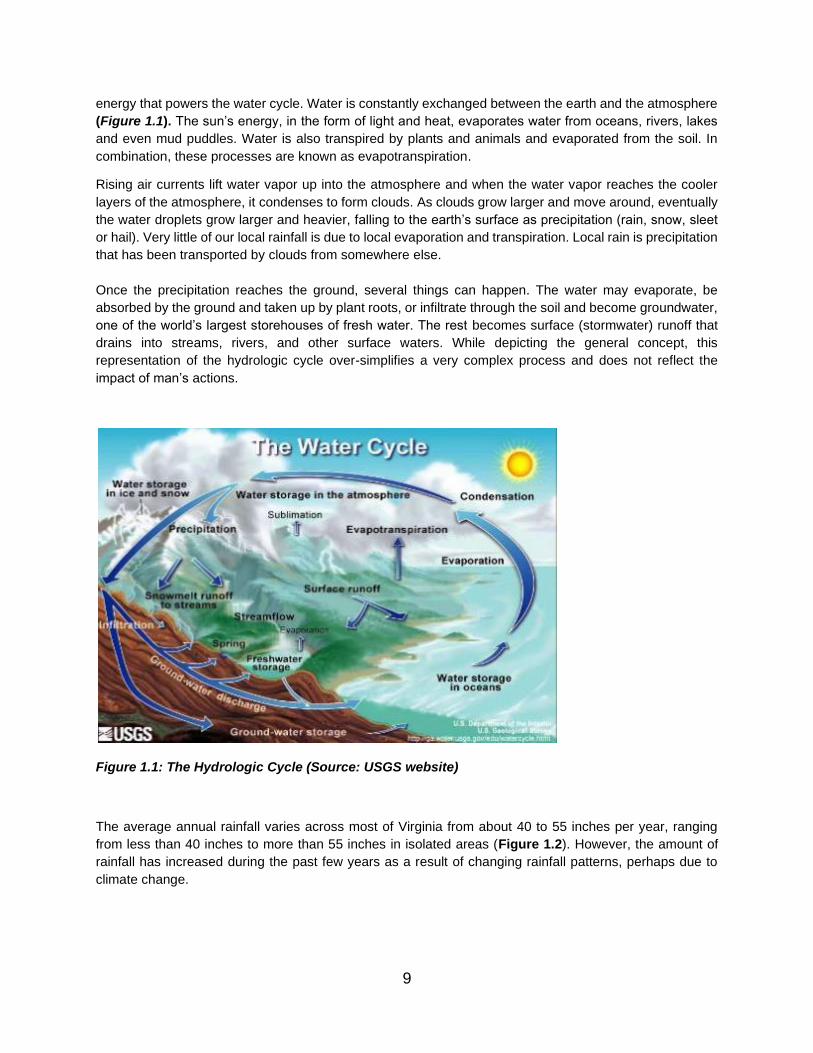
energy that powers the water cycle. Water is constantly exchanged between the earth and the atmosphere
(Figure 1.1). The sun’s energy, in the form of light and heat, evaporates water from oceans, rivers, lakes and even mud puddles. Water is also transpired by plants and animals and evaporated from the soil. In
combination, these processes are known as evapotranspiration.
Rising air currents lift water vapor up into the atmosphere and when the water vapor reaches the cooler
layers of the atmosphere, it condenses to form clouds. As clouds grow larger and move around, eventually
the water droplets grow larger and heavier, falling to the earth’s surface as precipitation (rain, snow, sleet
or hail). Very little of our local rainfall is due to local evaporation and transpiration. Local rain is precipitation
that has been transported by clouds from somewhere else.
Once the precipitation reaches the ground, several things can happen. The water may evaporate, be
absorbed by the ground and taken up by plant roots, or infiltrate through the soil and become groundwater,
one of the world’s largest storehouses of fresh water. The rest becomes surface (stormwater) runoff that
drains into streams, rivers, and other surface waters. While depicting the general concept, this
representation of the hydrologic cycle over-simplifies a very complex process and does not reflect the
impact of man’s actions.
Figure 1.1: The Hydrologic Cycle (Source: USGS website)
The average annual rainfall varies across most of Virginia from about 40 to 55 inches per year, ranging
from less than 40 inches to more than 55 inches in isolated areas (Figure 1.2). However, the amount of
rainfall has increased during the past few years as a result of changing rainfall patterns, perhaps due to
climate change.
9

Figure 1.2: Average Virginia Annual Precipitation, 1981-2010
i. Stormwater Runoff
Stormwater runoff is overland flow from precipitation that accumulates in and flows through natural or man-
made conveyance systems during and immediately after a rainfall event or from snowmelt. Stormwater
runoff has traditionally been viewed as a nuisance to be disposed of as quickly as possible. However,
depending on the magnitude of changes to the land surface, the total runoff volume can increase
dramatically. These changes can not only increase the total volume of runoff but also accelerate the rate
at which runoff flows across the land. This effect is further exacerbated by drainage systems, such as
gutters, storm sewers and smooth-lined channels that are designed to quickly carry runoff to rivers and
streams. Impervious surfaces reduce the amount of water infiltrated into the soil and groundwater, thus
decreasing the amount of water that can recharge aquifers and feed streamflow during periods of dry
weather.
When rain falls on the landscape and runs over the land surface, the water washes off various pollutants
that have accumulated on those surfaces during the time since the last rain event. The pollutant-laden
stormwater runoff typically flows either directly into nearby streams and rivers or is indirectly channeled into
storm sewers (underground pipes) that ultimately lead to streams and rivers. Pollutants in stormwater runoff
contaminate local water bodies, often causing violations of state water quality standards. Ultimately,
stormwater flows downstream and connects to larger water bodies, such as the Chesapeake Bay, causing
more extensive water quality degradation as the contamination from the tributaries collectively accumulates
in the larger water bodies. Some stormwater BMPs are designed to remove pollutants from stormwater
near its source, before it is released into the natural stream system, thus minimizing impacts on water
quality and ecosystems.
10

ii. Stormwater Quantity Management
Another purpose of stormwater BMPs is to manage the increased volume and velocity of stormwater runoff
in ways that protect receiving streams from pollution and erosion and flooding impacts. Such impacts can
diminish or even destroy the ecological integrity of receiving streams in several ways. For example,
sediment washed downstream from land development projects can smother stream bottoms and increase
the turbidity of the water, covering the natural habitat of various organisms that contribute to healthy stream
ecology and disrupting the food chain of the stream inhabitants. Various other pollutants can also diminish
the quality of the stream water, poisoning some stream inhabitants and driving others further downstream.
Another result of unmanaged stormwater runoff is localized stream channel erosion and flooding, which
can impact downstream neighborhoods and property owners. Such erosion and flooding can limit the use
of such properties and result in high property damage costs and, potentially, litigation.
Some construction BMPs, such as bioretention, infiltration, and permeable pavements, capture and/or
infiltrate some or even much of the runoff, preventing it from leaving the development site. These kinds of
BMPs, often referred to as Low Impact Development (LID) Practices, are most effective when the underlying
soils allow for rapid infiltration of water. Moving runoff water through the soil into groundwater also ensures
sufficient dry weather recharge of nearby streams. Furthermore, runoff capture and infiltration have water
quality benefits, described below.
Other construction BMPs, such as various types of retention and detention ponds, are designed to capture
runoff from the development site and slowly release it over time into the receiving stream. The release rate
is calculated to reflect the natural rate of stormwater discharge from the site before the development
occurred and, most importantly, to not exceed the rate and volume of flow the receiving channel can
naturally carry without eroding or flooding over the banks. Detention ponds are designed to be relatively
dry between rainstorms, only detaining the runoff for the short period of time needed to transport it safely
into the receiving stream. Retention ponds are designed to have a permanent pool, i.e., constantly retaining
water. Retention/wet ponds also provide significant water quality protection, described more fully below.
They may have multi-stage outlets to allow them to address the following multiple stormwater management
functions: water quality protection, stream channel protection, and protection against localized flooding
downstream. All pond-type BMPs are designed so that very large storms with long statistical recurrence
intervals (25-, 50-, 100-year storms, etc.) can pass safely over an emergency spillway without risking the
structural integrity of the dam and outlet structures.
iii. Stormwater Quality Management
There are a variety of pollutants that appear in stormwater runoff, depending on the development site and
type. These pollutants include the following:
• Excess nutrients (phosphorus and nitrogen)
• Sediments and other suspended solids
• Pathogens (bacteria and viruses)
• Organic materials
• Hydrocarbons
• Trace metals
• Pesticides and synthetic organic chemicals
• Chlorides and de-icing constituents
11

• Trash and debris
• Thermal impacts (typically cause receiving streams to warm up)
The best way to prevent pollutants from degrading water quality in receiving waters is to employ Pollution
Prevention practices and techniques, which manage pollutants at their source and prevent them from
accumulating in stormwater runoff. However, to address the stormwater pollution that does occur, certain
BMP designs can be implemented to reduce or remove pollutants using various physical, chemical and
biological processes (Table 1.1 below).
Table 1.1: Stormwater Pollutant Removal Processes
Process Pollutants Affected
Gravity settling of particulate
pollutants
Solids, Biochemical Oxygen Demand (BOD), pathogens,
particulate Chemical Oxygen Demand (COD), phosphorus,
nitrogen, synthetic organics, particulate metals
Filtration and physical straining of
pollutants through a filter media or
vegetation
Solids, BOD, pathogens, particulate COD, phosphorus,
nitrogen, synthetic organics, particulate metals
Infiltration of particulate and
dissolved pollutants
Solids, BOD, pathogens, particulate COD, phosphorus,
nitrogen, synthetic organics, particulate metals
Absorption on particulates and
sediments Dissolved phosphorus, metals, synthetic organics
Photo-Degradation COD, petroleum hydrocarbons, synthetic organics, pathogens
Gas exchange and volatilization Volatile organics, synthetic organics
Biological uptake and
biodegradation
BOD, COD, petroleum hydrocarbons, synthetic organics,
phosphorus, nitrogen, metals
Chemical precipitation Dissolved phosphorus, metals
Ion exchange Dissolved metals
Oxidation COD, petroleum hydrocarbons, synthetic organics
Nitrification and denitrification Ammonia, nitrate, nitrite
Density separation and removal of
floatables Petroleum hydrocarbons
Source: NRC (2008)
Since many pollutants in urban stormwater runoff are attached to solid particles, practices designed to
remove suspended solids from runoff will remove other pollutants as well. Exceptions to this rule can include
nutrients, which are also transported in a dissolved form, soluble metals and organics, and extremely fine
particulates (i.e., having a diameter smaller than 10 microns), which can only be removed by treatment
practices other than traditional separation methods.
12

Virginia’s approved BMPs are organized into five main groups, affecting rainfall as it flows from rooftops to
streams:
• Infiltration practices: achieve runoff volume reduction and provide pollution removal
• Conveyance practices: swales or open channels that convey runoff and may also provide various
levels of pollution removal
• Filtering systems: primary benefit is removing nutrients, sediment, heavy metals, grease and oil
from runoff (this is the category in which most manufactured BMP devices fit)
• Basins: reduce the rate of runoff (dry detention ponds), improve pollution removal (wet retention
ponds and constructed wetlands), and add wildlife habitat
• Manufactured Underground Treatment Devices (MTDs): hybrid devices that are often used where
land values are very high, space is very limited, and/or groundwater tables are very high, and they
provide a variety of runoff management mechanisms from reducing discharge velocities to pre-
treatment of pollutants (hydrodynamic types) to filtration of pollutants (filtration types)
• VDOT has a sixth group of “Miscellaneous” BMPs that involve several permanent erosion and sediment control practices that are typically used on steep cut and fill slopes to prevent stormwater
runoff from causing the slopes to erode. Examples are the Level Spreader (Perm E&S) and the
Riprap Berm (Perm E&S).
Runoff volume reduction BMPs not only help achieve runoff quantity control but also contribute to runoff
quality control. The volume of water that is captured and removed from the runoff stream also contains
concentrations of various pollutants, such as nutrients. The portion of such pollutants contained in the
captured/removed runoff volume will not be transported downstream. Therefore, this removal can be
calculated and credited towards VDOT’s pollution removal requirements.
13

Federal Clean Water Act (CWA)
Federal National Pollution Discharge Elimination
System (NPDES)
Virginia Stormwater Management Program
(VSMP)
State Water Control Law
VDOT Individual Permit
VDOT MS4 Program (SWM)
VDOT AS&S (SWM & ESC)
Figure 2.1: Stormwater Management Conceptual Framework
II. STORMWATER MANAGEMENT REGULATORY &
PROGRAMMATIC FRAMEWORK
This section will briefly explain applicable state and federal laws, regulations, permits and other
requirements that comprise the regulatory and programmatic framework for the VDOT stormwater
management program, illustrated below in Figure 2.1. Virginia and most other states also have laws and
regulations requiring the management of stormwater quantity and quality discharges to protect downstream
resources and properties from the impacts of increased runoff volumes and velocity as well as water
pollution. The stormwater regulatory requirements for management of stormwater quality (e.g., removing
pollutants) and quantity (e.g., reducing peak flows and volumes) established by DEQ mitigate degradation
of surface waters (e.g., flooding, erosion of banks and stream beds, and increased pollutant loading to
waterbodies) due to increased impervious surfaces (e.g., streets and roads). Portions of these requirements
apply both during the construction stage, when using temporary erosion control and stormwater
management measures, and the post-construction stage, involving the use of long-term stormwater
managements BMPs.
A. Federal and State Laws and Regulations
In 1972, the U.S. Congress introduced the Federal Water Pollution Control Act, commonly known as the
Clean Water Act (CWA) to protect the waters of the United States (U.S.) with programs for water quality
improvements (Fedorchak et al., 2017). These programs include requiring treatment for municipal and
14
industrial wastewater, mandating permits for discharges of pollutants from point sources in navigable waters
and gave the U.S. Environmental Protection Division (EPA) the authority to create pollution control
programs (33 USC 26 §§ 1,251-1,387). This act largely focused on wastewater and industry discharges,
and stormwater quality was not specifically addressed. The Water Quality Act of 1987 amended the CWA
and created a system for permitting discharges from MS4s, i.e., the NPDES stormwater program (33 USC
26, §§ 402). The NPDES permit program was promulgated for large MS4s (population > 100,000) in 1990,
and for small and medium MS4s (population < 100,000) in 1999, known as Phase I and Phase II of the
MS4 programs, respectively. Large population phase I permits require municipalities to develop a
Stormwater Management Plan (SWMP) to reduce pollutants in the stormwater run-off to the maximum
extent practicable. The Phase II program, applicable to municipalities with smaller populations, requires
municipalities to address six minimum control measures (MCMs).
Another important regulatory requirement is that those who are responsible for inspecting stormwater BMPs
must be trained and certified as Stormwater Management Inspectors by the Department of Environmental
Quality (DEQ). For specific information about this requirement and what VDOT employees need to be
certified, see Section C below for guidance regarding which VDOT employees need to have which training
and certifications and to the DEQ certification and training website.
B. VDOT MS4 Program and Important Document Links
VDOT holds a VSMP Individual Permit, issued by DEQ, for discharges of stormwater from MS4s. The
VDOT MS4 Program is designed to reduce the discharge of pollutants from all regulated activities
undertaken by the Department within its right-of-way and property boundaries located inside urbanized
areas (as determined by the latest Decennial Census by the Bureau of the Census). The MS4 Program
ensures the proper operation of stormwater management facilities that reduce the discharge of pollutants,
protect water quality, and reduce water quantity impacts to satisfy requirements of the CWA and the State
Water Control Law consistent with associated state regulations (9 VAC 25-870 et seq.) and VDOT’s legal authority, as authorized by the Commonwealth of Virginia. This includes development of a BMP Inspection
and Maintenance Manual describing the procedures for inspecting and maintaining VDOT’s permanent
stormwater management structures. BMP inspections are required on an annual basis, once every 12
months, and within 48 hours after a storm event that exceeds the principal spillway capacity.
Pursuant to the provisions of the General VPDES Permit for Discharges of Stormwater from Construction
Activities (9VAC25-880), VDOT is also required to comply with DEQ SWM and ESC laws and regulations
in the remainder of the Commonwealth, outside its MS4 urban areas. Therefore, VDOT is required to
inspect all its stormwater BMPs annually, not just those within its MS4 permit areas. For state agencies and
other entities with extensive landholdings throughout Virginia, DEQ has authorized the development and
implementation of Annual ESC and SWM Standards and Specifications (AS&S). These apply to all plan
design, construction and maintenance activities administered by VDOT and performed either by its internal
workforce or contracted external entities, where such activities are regulated by the Virginia ESC and SWM
Law and Regulations. VDOT secures an annual approval of its AS&S from DEQ, constituting compliance
with the agency’s MS4 permit and other applicable laws and regulations. The benefit to the agency of having
approved AS&S is that VDOT can inspect and monitor its own compliance with the applicable state codes.
However, during any oversight inspections of VDOT land-disturbing activities and facilities by DEQ, EPA,
or other such regulatory agency, compliance with VDOT’s AS&S is required.
15

Further information regarding VDOT’s MS4 permit and VSMP Laws and Regulations related to MS4
permitting and programs is accessible through the following links:
• VDOT’s Individual MS4 permit:
https://www.virginiadot.org/business/resources/LocDes/VA0092975_VDOT_MS4_Permit_2017.p
df
• Virginia Administrative Code Virginia Stormwater Management Program (VSMP) Regulation
(9VAC25-870): https://law.lis.virginia.gov/admincode/title9/agency25/chapter870/
• Virginia Administrative Code Erosion and Sediment Control Regulations (9VAC25-840):
https://law.lis.virginia.gov/admincode/title9/agency25/chapter840/
• Virginia Administrative Code General VPDES Permit for Discharges of Stormwater from
Construction Activities (9VAC25-880):
https://law.lis.virginia.gov/admincode/title9/agency25/chapter880/
• VDOT guidance for which employees need to obtain which DEQ SWM/ESC training and
certifications:
https://www.deq.virginia.gov/permits-regulations/training-certification/vdot-training-551
• DEQ Certification and Tracking System (CATS) website: https://portal.deq.virginia.gov/v2/cats
Pursuant to the provisions of the General VPDES Permit for Discharges of Stormwater from Construction
VDOT’s AS&S are housed in an on-line electronic database which includes both the current and previous
versions of the standards and specifications. The database is dynamic and items within the database may
be added to, deleted or revised at any time to reflect changes or updates to VDOT’s ESC and SWM Program or the laws and regulations that drive the program. VDOT’s AS&S are a compilation of all VDOT documents related to the design, construction, inspection and maintenance of ESC measures, Pollution
Prevention (P2) practices, Good Housekeeping Practices, and post-development stormwater BMPs
including, but not limited to, all or a portion of the documents listed below. The following link provides access
to online versions of the remaining documents listed below:
http://www.virginiadot.org/business/manuals-default.asp
• Road & Bridge Standards
• Road & Bridge Specifications, Supplemental Specifications and Special Provisions
• Instructional and Informational Memoranda (IIMs)
• Drainage Manual
• Pollution Prevention Field Guide for Construction Activities
• Road Design Manual
• Maintenance Division’s BMP Inspection and Maintenance Manuals
• Maintenance Division’s Maintenance Best Practices Manual
The following link provides access to online versions of the key Location and Design Division’s stormwater-
management related Informational and Instruction Memoranda:
https://www.virginiadot.org/business/locdes/iim_table_of_contents.asp
• IIM-LD-251: Application of the VSMP Regulations As It Relates to Utilization of Nutrient Credits As
An Off-Site Compliance Option
• IIM-LD-256.1: VDOT Oversight Responsibilities for VDOT Projects with Coverage Under the
General Virginia Pollutant Discharge Elimination System (VPDES) Permit for Discharges of
Stormwater from Construction Activities and Other Regulated Land Disturbing Activities
16

• IIM-LD-258: ESC and Stormwater Roles and Responsibilities for Projects where VDOT is not the
Construction General Permit Permittee
C. Stormwater Management BMP Inspector Training and Certification
The Virginia Stormwater Management (SWM) Act (§ 62.1-44.15:30) requires personnel working for a Virginia Stormwater Management Program (VSMP) authority – noting that VDOT is considered by Department of Environmental Quality (DEQ) to be a VSMP authority – including anyone who is contracted by a VSMP authority, to obtain and maintain a certificate of competence from the State Water Control Board (SWCM) in the area of stormwater management. The DEQ is required by the Act to administer a stormwater management training and certification program. There are similar requirements pertaining to VDOT employees and contractors involved with activities subject to the Virginia Erosion and Sediment Control (ESC) Law (§ 62.1-44.15:53), and DEQ provides training and certifications related to that program as well. The Erosion and Sediment Control and Stormwater Management Certification Regulations may be found at 9VAC25-850-50 of the Virginia Administrative Code.
More specifically, any VDOT employee or contractor who inspects and recommends maintenance of VDOT-owned BMPs must complete appropriate training and be certified by the State Water Control Board (SWCB) as a Stormwater Management Inspector. These certifications last for three years and then the person must request recertification. Recertification requires that the person must have completed a DEQ-specified number of hours of continuing education involving designated training courses approved by the DEQ. Information about the training and certification program, its requirements, and links for scheduling training can be found on the following DEQ web page: https://portal.deq.virginia.gov/v2/cats
Individuals seeking SWM Inspector certifications are considered provisionally certified as an Inspector for one year from the date they complete the require training course(s). However, they must complete and pass the associated examination within that one-year period in order to continue to be certified.
There is a fee associated with taking the required course and a separate fee associated with taking the required exam. Those fees must be paid out of the budget supporting the VDOT individual seeking certification. It is important to note that VDOT has demonstrated competence and has received permission from DEQ to offer ESC Inspector and SWM Inspector courses for half the cost DEQ charges. VDOT has been scheduling these courses around the state to make them easy to reach from various Districts. The VDOT pathway to certification takes pressure off DEQ, since there is so much demand to attend the DEQ courses; and this also makes it easier for VDOT to qualify all the staff needing these certifications. The VDOT Central Office Location and Design (L&D) Division coordinates this VDOT training. Anyone taking the VDOT-provided courses must also take the DEQ provided certification exam.
It is important to note that during the Covid-19 Pandemic and commensurate telecommuting and social distancing requirements, both DEQ and VDOT had to discontinue teaching these courses in person. DEQ has transitioned to virtual training and VDOT is in the process of doing that as well. Eventually, when the virus comes under control and it is appropriate to resume normal training efforts, in-person on-site training will resume. Individuals and managers can check the DEQ Training website for updates on current training efforts. VDOT’s L&D Division will provide email and other updates, as appropriate, to VDOT staff regarding changes in VDOT’s course offerings. If there is ever a similar kind of pandemic in the future, VDOT staff should expect those similar kinds of alternative procedures to achieve needed training and certifications will be enacted.
The following table identifies which VDOT employees/roles must have which kind of DEQ stormwater management or erosion and sediment control training and certifications.
17

Table 2.1 – Summary of VDOT ESC/SWM Roles and Responsibilities
Role & Responsibility VDOT Position Certification/License Signature Requirements
PROGRAM ADMINISTRATION
Senior Executive Officer State L&D Engineer None
Registration Statements, Notices of Termination, Delegation of Authority, Reports and other documents required by SWCB, DEQ, or CGP
ESC Program Administrator L&D MS4 Program Manager
ESC PA, Dual PA, ESC CA, or Dual CA
As delegated by Senior Executive Officer
ESC/SWM Program Administrator
MS4 Section Managers, District Hydraulics Engineers, District NPDES Coordinators
ESC PA, Dual PA, ESC CA, or Dual CA
As delegated by Senior Executive Officer
SWM Program Administrator
L&D MS4 Program Manager
SWM PA, Dual PA, SWM CA, or Dual CA
As delegated by Senior Executive Officer
SWM Program Administrator
MS4 Section Managers, District Hydraulics Engineers, District NPDES Coordinators
SWM PA, Dual PA, SWM CA, or Dual CA
As delegated by Senior Executive Officer
PRELIMINARY ENGINEERING
SWM Planner and Designer Hydraulic Engineer, Consultant Designer
Professional License (A, PE, LS, LA)
Seal and sign SWM plans and supporting documents
ESC Plan Reviewer Hydraulic Engineer, Consultant Designer
ESC PR, Dual PR, ESC CA, Dual CA, or Professional License (A, PE, LS, LA, or CPSS)
Form LD-445C, updates to ESC Plan
SWM Plan Reviewer Hydraulic Engineer, Consultant Designer
SWM PR, Dual PR, SWM CA, or Dual CA
Form LD-445C, updates to SWM Plan
Responsible Land Disturber ACE, RA RLD, ESC (any), or Professional License (A, PE, LS, LA, or CPSS)
SWPPP General Information Sheet certification
CONSTRUCTION
Qualified Personnel Construction Contractor
ESCCC, ESC IN, Dual IN, ESC CA, Dual CA, or Professional License (A, PE, LS, LA or CPSS)
Form C-107 Part I
Responsible Land Disturber ACE RLD, ESC (any), or Professional License (A, PE, LS, LA, or CPSS)
Form C-107 Parts I and/or II, Updates to SWPPP, Record Plan Set
ESC Inspector ACE, CM, PI, CEI ESC IN, Dual IN, ESC CA, or Dual CA
Form C-107 Part I
SWM Inspector ACE, CM, PI, CEI SWM IN, Dual IN, SWM CA, or Dual CA
Form C-107 Part II
VPDES Construction Permit Coverage Termination Notice
ACE RLD Form LD-445D
SWMF/BMP Certification ACE, Consultant Professional License (A, PE, LS, or LA)
Form LD-445D
18
Role & Responsibility VDOT Position Certification/License Signature Requirements
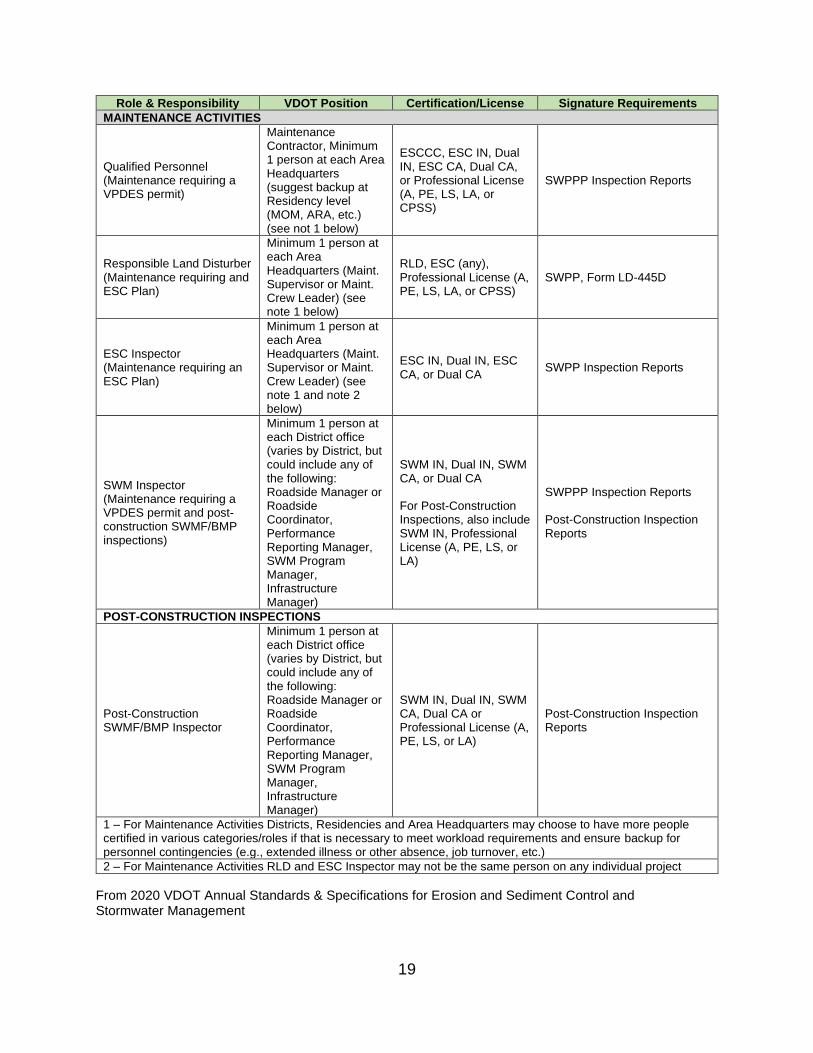
MAINTENANCE ACTIVITIES
Maintenance
Qualified Personnel (Maintenance requiring a VPDES permit)
Contractor, Minimum 1 person at each Area Headquarters (suggest backup at Residency level (MOM, ARA, etc.)
ESCCC, ESC IN, Dual IN, ESC CA, Dual CA, or Professional License (A, PE, LS, LA, or CPSS)
SWPPP Inspection Reports
(see not 1 below)
Minimum 1 person at
Responsible Land Disturber (Maintenance requiring and ESC Plan)
each Area Headquarters (Maint. Supervisor or Maint. Crew Leader) (see
RLD, ESC (any), Professional License (A, PE, LS, LA, or CPSS)
SWPP, Form LD-445D
note 1 below)
ESC Inspector (Maintenance requiring an ESC Plan)
Minimum 1 person at each Area Headquarters (Maint. Supervisor or Maint. Crew Leader) (see note 1 and note 2 below)
ESC IN, Dual IN, ESC CA, or Dual CA
SWPP Inspection Reports
SWM Inspector (Maintenance requiring a VPDES permit and post-construction SWMF/BMP inspections)
Minimum 1 person at each District office (varies by District, but could include any of the following: Roadside Manager or Roadside Coordinator, Performance Reporting Manager, SWM Program Manager, Infrastructure Manager)
SWM IN, Dual IN, SWM CA, or Dual CA
For Post-Construction Inspections, also include SWM IN, Professional License (A, PE, LS, or LA)
SWPPP Inspection Reports
Post-Construction Inspection Reports
POST-CONSTRUCTION INSPECTIONS
Post-Construction SWMF/BMP Inspector
Minimum 1 person at each District office (varies by District, but could include any of the following: Roadside Manager or Roadside Coordinator, Performance Reporting Manager, SWM Program Manager, Infrastructure Manager)
SWM IN, Dual IN, SWM CA, Dual CA or Professional License (A, PE, LS, or LA)
Post-Construction Inspection Reports
1 – For Maintenance Activities Districts, Residencies and Area Headquarters may choose to have more people certified in various categories/roles if that is necessary to meet workload requirements and ensure backup for personnel contingencies (e.g., extended illness or other absence, job turnover, etc.)
2 – For Maintenance Activities RLD and ESC Inspector may not be the same person on any individual project
From 2020 VDOT Annual Standards & Specifications for Erosion and Sediment Control and Stormwater Management
19

Table 2.1 – Summary of VDOT ESC/SWM Roles and Responsibilities - Acronym Key A = Architect ACE = Area Construction Engineer AHQ = Area Headquarters BMP = Best Management Practice CA = Combined Administrator CEI = Construction Engineering and Inspection CGP = Construction General Permit or “General VPDES Permit for Discharges of Stormwater Associated with Construction Activities” CM = Construction Manager CPSS = Certified Professional Soil Scientist DEQ = Department of Environmental Quality Dual = ESC and SWM Combined ESC = Erosion and Sediment Control ESCCC = Erosion and Sediment Control Contractor Certification ESC/SWM = ESC and SWM IN = Inspector L&D = Location and Design LA = Landscape Architect LS = Land Surveyor MOM = Maintenance Operations Manager MS4 = Municipal Separate Storm Sewer System PA = Program Administrator PE = Professional Engineer PI = Project Inspector PR = Plan Reviewer RA = Residency Administrator RLD = Responsible Land Disturber SWCB = State Water Control Board SWM = Stormwater Management SWMF = Stormwater Management Facility SWPPP = Stormwater Pollution Prevention Plan Form LD-445C = Erosion and Sediment Control (ESC) and Stormwater Management (SWM) Certification Form Form LD-445D = Termination Notice Form LD-445H = Delegation of Authority Form C-107 Part I = Construction Runoff Control Inspection Form (CRCIF) (Appendix D) Form C-107 Part II = VDOT Inspection Sheet (Appendix D)
D. Stormwater BMPs
The AS&S and MS4 Program ensure the proper operation of stormwater BMPs that reduce the discharge of pollutants, protect water quality, and manage water quantity. VDOT’s BMPs are required to be inspected at least once during each annual MS4 permit year (July 1 – June 30) unless otherwise specified on the BMP’s approved plans. The inspections must be documented in VDOT’s database of permanent BMPs, and any deficiencies identified during these inspections must be corrected so that the BMP continues to function correctly as designed.
Periodically, VDOT must verify that all BMPs are functioning as designed in order to maintain pollution reduction credits assigned to the BMPs under the USEPA’s Chesapeake Bay Watershed Total Maximum Daily Load (TMDL). The MS4 permit also requires VDOT to report annually (1) that all permanent BMPs were inspected during the reporting year, and (2) a summary of
20

significant maintenance activities performed that addressed structural deficiencies or other significant maintenance issues. All this information is documented within the BMP database.
Traditionally, long-term stormwater management activities have focused on BMPs that are constructed onsite with the capacity to temporarily hold and treat stormwater runoff. Most of the VDOT BMPs are dry detention or extended detention basins but also include enhanced extended detention basins, retention (wet) basins, grass swales, infiltration basins, bioretention, sand filters and manufactured BMPs. Some permanent SWMF may be used as temporary sediment basins during the construction phase of the project and, if so, the design of the SWMF will need to include a detailed conversion plan addressing the dual function and permanent configuration. SWM retention ponds and extended detention ponds that are not covered by the Impounding Regulations (https://law.lis.virginia.gov/admincode/title4/agency50/chapter20/) must, at a minimum, be engineered for structural integrity for the 100-yr storm event.
i. Design Storms
Unless otherwise specified, the prescribed design storms are the 1-year, 2-year, and 10-year 24-hour
storms using the site-specific rainfall precipitation frequency data recommended by the U.S. National
Oceanic and Atmospheric Administration (NOAA) Atlas 14. Unless otherwise specified, all hydrologic
analyses must be based on the existing watershed characteristics and how the ultimate development
condition of the subject project will be addressed.
ii. Design Storm Requirements for BMPs
Control structure release rates are usually designed to approximate pre-developed peak runoff rates from
the site for the 2- and 10-year design storms, with an emergency spillway capable of handling the 100-year
peak discharge. Design calculations are required to demonstrate that the post-development release rates
for the 2- and 10-year design storms are equal to or less than the pre-development release rates. Multi-
stage control structures may be required to control runoff from both the 2- and 10-year storms. This can be
accomplished using orifices and weirs. An orifice is an opening into a standpipe, riser, weir, or concrete
structure. An orifice for water quality is usually small (less than 6 inches) and round. VDOT has determined
that the orifice is less prone to clogging when located in a steel plate rather than a 6- or 8-inch hole in a
concrete wall. Some orifices will have a cage type trash/debris rack on a hinge to assist with cleaning
blockages.
iii. BMP Outlet Structures
Outlet structures typically include a principal spillway and an emergency overflow and must accomplish the
design functions of the facility. Outlet structures can take the form of combinations of drop inlets, pipes,
weirs, and orifices. The principal spillway is intended to convey the design storm for downstream localized
flood prevention without allowing flow to enter an emergency outlet. As noted above, the emergency
spillway is designed to pass the 100-year design storm. The sizing of an outlet structure is based on results
of hydrologic routing calculations. A principal spillway system that controls the rate of discharge from a
stormwater facility will often use a multi-stage riser, such as the VDOT standard SWM-1. A multi-stage riser
is a structure that incorporates separate openings or devices at different elevations to control the rate of
discharge from a stormwater basin, managing multiple design storms, as illustrated below in Figure 2.2.
Permanent multi-stage risers are typically constructed of concrete to help increase their life expectancy.
The geometry of risers will vary from basin to basin. The designer can be creative to provide the most
economical and hydraulically efficient riser design possible.
21

Figure 2.2: DCR Recommended Outlet Configuration 1 for the Control of Trash, Sediment and Debris (Virginia Stormwater Management Handbook, 1999, Et seq.)
E. Erosion Control Requirements for BMPs
During construction, sediment basins are constructed as erosion control measures to treat sediment laden
runoff from leaving the site based on the disturbed area. Frequently these basins are converted into a post-
construction permanent SWMF which is designed to treat a higher volume of runoff from impervious areas
associated with a developed site. Conversion may include additional excavation of the basin floor, installing
new orifices at different elevations, and closing others. Water quantity control may be needed if there is
existing or anticipated downstream erosion or channel degradation. Facilities, such as extended detention,
can be designed to treat a specified volume of stormwater runoff to protect downstream channels from
erosion that would occur from development. The design of an extended-detention orifice for erosion or
quantity control is similar to the design of the water quality orifice in that previous orifice sizing methods can
be used.
F. Nutrient Credits
While past regulatory guidelines required stormwater quality to be managed using onsite structural
practices, there are now options in Virginia for achieving compliance with stormwater quality regulations
through substituting or buying nutrient credits. Nutrient credits, as well as stormwater quality regulations
(i.e., required nutrient reductions), are expressed in pounds of Phosphorous removed annually. This is
because DEQ considers phosphorous a keystone pollutant exhibiting some characteristics of both
particulate and soluble pollutants, making it an indicator of urban pollutants in general. Nutrient banks are
similar to wetland banks such that they improve existing conditions and install additional pollutant reduction
measures as regulated by DEQ. Nutrient banks are established by third-party organizations to offer, with
DEQ’s approval, nutrient credits for purchase by organizations like VDOT. For VDOT, purchasing nutrient credits to comply with the required post-construction stormwater quality regulations, in lieu of constructing
onsite BMPs, often offers a more cost-effective means of achieving stormwater compliance. The ability to
purchase nutrient credits is restricted for certain sites and areas based on criteria established in the VSMP
regulations. VDOT has purchased credits from multiple nutrient banks across the State to support new
projects. These credits are for compliance with the water quality reduction requirements only; credits for
water quantity are currently not allowed by the regulations. Because of this, some projects may have a dry
water quantity basin and satisfy the water quality requirements by purchasing credits.
22
III. FIELD WORK PREP & SAFETY AND DATABASE STRUCTURE &
SURVEY 1-2-3 APPLICATION
Section III prepares an inspector for going into the field and covers the needed safety devices, tools, and
preparation of a field safety manual. Then, the section continues with an explanation of the database
structure, the Survey 123 application and the BMP Rating Criteria.
VDOT is using ArcGIS Enterprise and the ESRI Survey 1-2-3 programming environment to map its existing
BMPs within Virginia. Data collection is documented in the field using the Survey 1-2-3 application and
saved locally on a collection device, such as an iPad, iPhone, or other compatible device. This associated
database inventories all existing BMPs along with their associated inspection forms. An inspector or user
must first obtain access to ArcGIS and receive a VDOT username by contacting the Geospatial Data
Manager in the Central Office Location and Design (L&D) Division. Prior to initiating fieldwork, the inspector
should consult the Database Instruction Manual located in Appendix A to learn how to use the Survey 123
application. Field personnel should upload data once they return to a reliable WiFi connection, rather than
uploading in the field, to prevent data loss or duplication due to spotty wireless coverage in rural areas.
A. Toolbox & Safety Guidelines
The inspection toolbox is comprised of tools and accessories that a BMP inspector should have in the field
to conduct an inspection. This may include tangible [e.g., shovel, grate puller, measuring tape, laser
measuring device, personal protective equipment (PPE), hand tools, iPad and/or cell phone, and a Safety
Plan] as well as non-tangible items (e.g., common sense and situational awareness). Safety is the first and
foremost priority when conducting field work, which is why field work should be done in pairs whenever
possible. VDOT requires that the following PPE items, meeting the current VDOT standards, are included
in the Toolbox:
• Protective steel toe boots or steel toe muck boots.
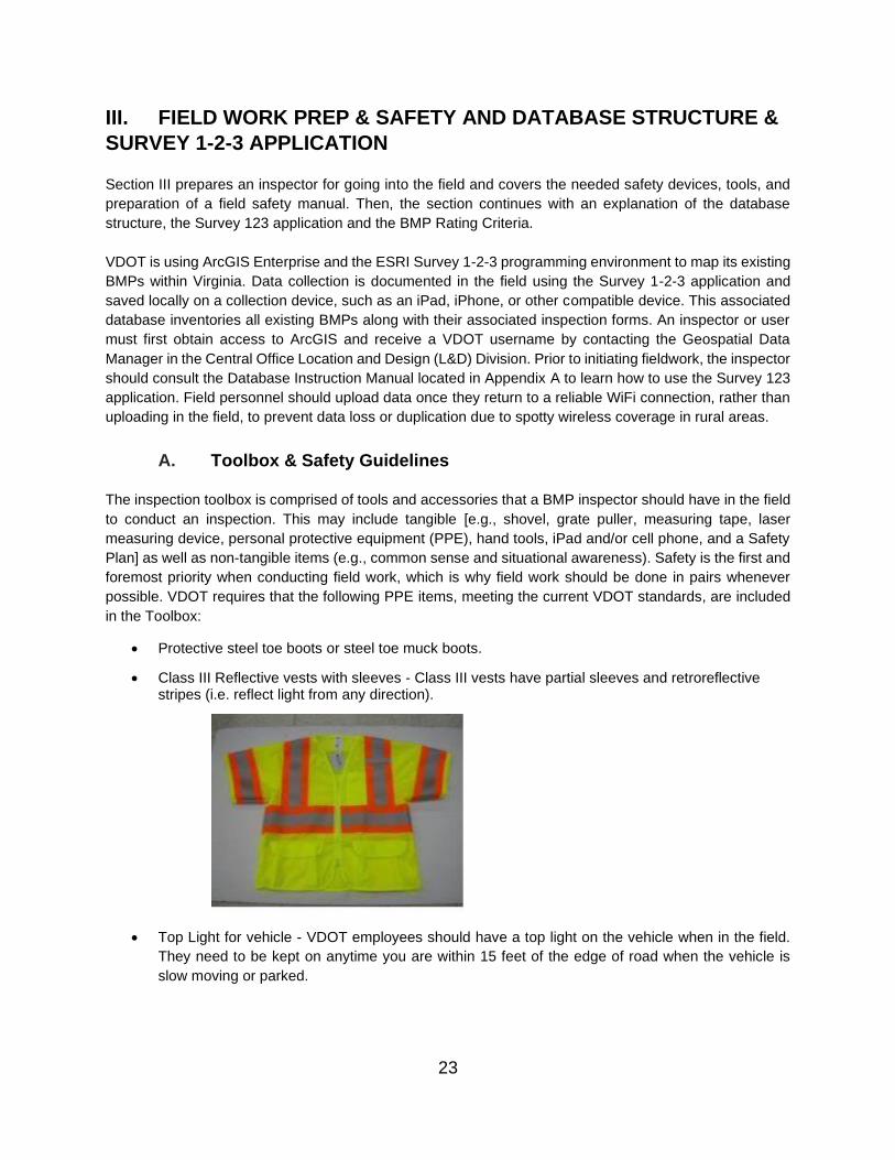
• Class III Reflective vests with sleeves - Class III vests have partial sleeves and retroreflective stripes (i.e. reflect light from any direction).
• Top Light for vehicle - VDOT employees should have a top light on the vehicle when in the field.
They need to be kept on anytime you are within 15 feet of the edge of road when the vehicle is
slow moving or parked.
23
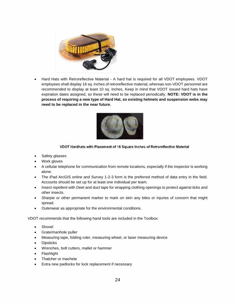
• Hard Hats with Retroreflective Material - A hard hat is required for all VDOT employees. VDOT
employees shall display 16 sq. inches of retroreflective material, whereas non-VDOT personnel are
recommended to display at least 10 sq. inches. Keep in mind that VDOT issued hard hats have
expiration dates assigned, so these will need to be replaced periodically. NOTE: VDOT is in the
process of requiring a new type of Hard Hat, so existing helmets and suspension webs may
need to be replaced in the near future.
• Safety glasses
• Work gloves
• A cellular telephone for communication from remote locations, especially if the inspector is working
alone.
• The iPad ArcGIS online and Survey 1-2-3 form is the preferred method of data entry in the field.
Accounts should be set up for at least one individual per team.
• Insect repellent with Deet and duct tape for wrapping clothing openings to protect against ticks and
other insects.
• Sharpie or other permanent marker to mark on skin any bites or injuries of concern that might
spread.
• Outerwear as appropriate for the environmental conditions.
VDOT recommends that the following hand tools are included in the Toolbox:
• Shovel
• Grate/manhole puller
• Measuring tape, folding ruler, measuring wheel, or laser measuring device
• Dipsticks
• Wrenches, bolt cutters, mallet or hammer
• Flashlight
• Thatcher or machete
• Extra new padlocks for lock replacement if necessary
24

Information pertaining to Health, Safety, Security, and Environment is included in Appendix C, whereas an
example of a Safety Plan is included in Appendix B. The following actions include some basic practical
safety guidelines from past field experience and previous procedures on VDOT work:
• Obey all motor vehicle laws, including seat belts, speed limits, and cellular phone usage at all times
in the moving vehicle.
• Scout the area to be visited prior to the field visit on google earth or another online map to identify
access roads, entry points or other safe areas to pull off and stop prior to driving to the facility. This
will facilitate pulling safely off the roadway with a plan of where to park and safely access the facility.
• Flashing safety lights are to be used on all vehicles when stopped within the right-of-way and when
parked on the shoulder, or within 15 feet of the roadway edge when speeds are slow or the vehicle
is parked. These also need to be used when moving slowly. Hazard lights should additionally be
used when moving slower than the pace of traffic.
• Vehicles should be parked on the side of the road where work is to be performed and should be
parked as far away from moving traffic as possible. Pull as far into the BMP access road, a fire road
or side-road if one is available to park the vehicle away from moving traffic.
• If working on a major interstate, try to avoid parking on the shoulder near interchange on/off ramps,
as oncoming vehicles may be more likely to leave the main travel-way traversing the shoulder to
reach an on/off ramp.
• Drivers need to avoid sudden maneuvers (i.e., slamming on brakes and pulling over at the last
second) and need to provide other motorists and pedestrians plenty of notice before pulling over
or stopping. Use the rooftop light and directional signals as appropriate.
• Personnel need to check both directions before crossing traffic. Look left, look right, look left a 2nd
time for a clear path.
• Personnel should consider whether it is safer and more time-efficient to park their vehicle once and
carefully walk between closely located BMPs or move the vehicle multiple times. For example, if
three potential BMPs are identified within a close segment of interstate, the vehicle could be parked
in a safe location and the personnel could walk the area, facing traffic if possible, and as far away
from the roadway as is feasible. Each time the vehicle is moved, it increases the risk of an accident.
• If walking outside the vehicle and near a roadway, whether facing traffic or not, personnel should
be as vigilant as possible. If one individual is logging data and looking at their iPad or notebook,
another team member should be watching oncoming traffic making visual contact.
• If a guardrail is present along a roadway, walk on the inside of the guardrail (with guardrail between
you and the travel-way).
• Personnel need to check very carefully before opening any doors while parked on the shoulder.
• Sitting within the vehicle on the shoulder on a high-traffic area should be minimized. Pull over to a
safer location to re-group, if feasible.
• VDOT only allows the use of cell phones or other wireless devices if the devices can be set up for
hands-free use for ANY purpose, including phone calls, within vehicles by drivers.
• Interstate and high traffic locations should be avoided in non-ideal weather conditions, unless the
District crew is engaged in emergency operations.
• Inspection and/or maintenance of underground BMPs that requires confined space entry
equipment and procedures may be carried out only by VDOT staff or contractors certified for
confined space entry.
• Weather - If the weather conditions pose a hazard (e.g., fog, heavy rain, snow/icy conditions, do
not do field work for that day, unless there is enough room to access the BMP completely away
from the roadway shoulder area.
• If you are in the field and feel that an area may be unsafe or access to an outfall or feature could
25
be dangerous, do not pursue it. Make a note that the inspection was not completed that day and
why. Contact your supervisor to determine how to conduct that inspection.
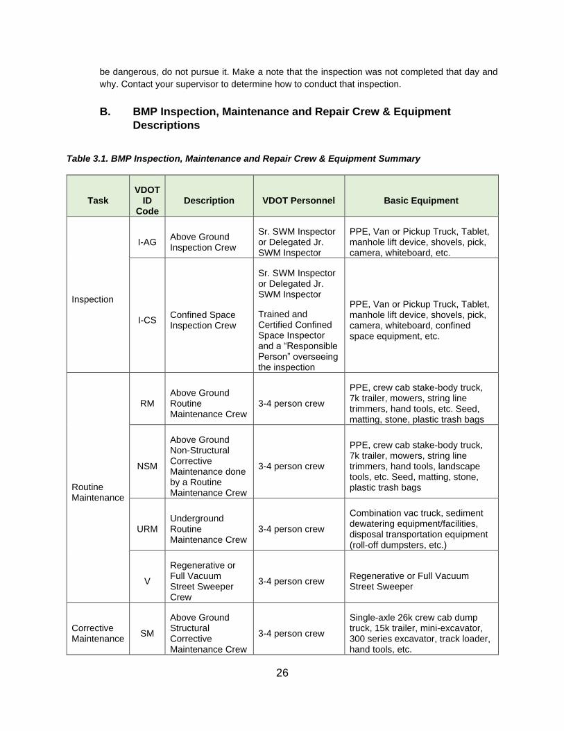
B. BMP Inspection, Maintenance and Repair Crew & Equipment
Descriptions
Table 3.1. BMP Inspection, Maintenance and Repair Crew & Equipment Summary
Task VDOT
ID Code
Description VDOT Personnel Basic Equipment
I-AG Above Ground Inspection Crew
Sr. SWM Inspector or Delegated Jr. SWM Inspector
PPE, Van or Pickup Truck, Tablet, manhole lift device, shovels, pick, camera, whiteboard, etc.
Inspection
I-CS Confined Space Inspection Crew
Sr. SWM Inspector or Delegated Jr. SWM Inspector
Trained and Certified Confined Space Inspector and a “Responsible Person” overseeing the inspection
PPE, Van or Pickup Truck, Tablet, manhole lift device, shovels, pick, camera, whiteboard, confined space equipment, etc.
RM Above Ground Routine Maintenance Crew
3-4 person crew
PPE, crew cab stake-body truck, 7k trailer, mowers, string line trimmers, hand tools, etc. Seed, matting, stone, plastic trash bags
Routine Maintenance
NSM
Above Ground Non-Structural Corrective Maintenance done by a Routine Maintenance Crew
3-4 person crew
PPE, crew cab stake-body truck, 7k trailer, mowers, string line trimmers, hand tools, landscape tools, etc. Seed, matting, stone, plastic trash bags
URM Underground Routine Maintenance Crew
3-4 person crew
Combination vac truck, sediment dewatering equipment/facilities, disposal transportation equipment (roll-off dumpsters, etc.)
V
Regenerative or Full Vacuum Street Sweeper Crew
3-4 person crew Regenerative or Full Vacuum Street Sweeper
Corrective Maintenance
SM
Above Ground Structural Corrective Maintenance Crew
3-4 person crew
Single-axle 26k crew cab dump truck, 15k trailer, mini-excavator, 300 series excavator, track loader, hand tools, etc.
26

Task VDOT
ID Code
Description VDOT Personnel Basic Equipment
UCM Underground Confined Space Maintenance Crew
3-4 person crew, including trained and certified CS personnel and a “Responsible Person” overseeing the work
Single-axle 26k crew cab dump truck, 15k trailer, mini-excavator, concrete tools, hand tools, confined space equipment, etc.
QP Qualified Professional
VDOT NPDES Coordinator
VDOT or contract licensed professional (, PE, LS, or LA)
Professional Support
LA Landscape Architect
Licensed Landscape Architect
(NOTE: Geotechnical Specialists/ Engineers on call as needed)
C. Database Instruction Manual (Job Aid)
The full instructions for using the Database and logging collected data are in Appendix A. The instructions
cover logging into the VDOT system and manipulating through data collection. It also points out known
errors in the ESRI product and how to work through them. The user can then look at the history of a BMP
brought into the system, as well as receive a report for the BMPs throughout a region and the State as a
whole. The user may then log in and click on “Stormwater Basin Map” which will direct them to a map of Virginia with points marking the location of each VDOT owned or maintained BMP in Virginia, see Figure
3.1 below. District BMP Inspectors will also have maps of the BMPs just in their Districts.
27

Figure 3.1: ArcGIS Online Statewide BMP Location Map
D. Inspection Rating Scoring
The database has taken the inspection rating subjectivity away from the inspector and is relying on
algorithms based on the answers to the field condition questions. Each section will continue to receive a
rating of either A, B, C, D, E, based on how the questions are answered. These algorithms are also used
to set up the maintenance requirements per BMP. The inspector will not see the inspection rating per
question category but will see the final rating or the suggested maintenance recommendation. The per
category rating will not be displayed until the inspection data is uploaded and a maintenance report is
generated.
Please note the inspection rating establishes a relative time frame to act on the maintenance plan consisting
of the items listed in the inspection database. The Survey 1-2-3 iPad BMP Inspection Application can
generate a Maintenance Report at the end of each inspection that lists all issues identified during the
inspection that require maintenance. The report also generally describes the type of maintenance that is
necessary to be conducted. The time frames described in the Overall Facility Rating prioritize maintenance
based on the severity of deterioration, failure potential and failure impacts. Each BMP will be rated based
on a letter score A-E. With “A” being “Okay” and “E” reserved for “Failure,” requiring engineering re-design
or full replacement of the BMP. The following is a brief description of the ratings
Table 3.2. Inspection Rating Scoring Summary
RATING CATEGORY DESCRIPTION TIME TO DEVELOP
MAINTENANCE PLAN
A = OKAY The BMP is functioning per design. Semi-
annual preventive maintenance will
No maintenance plan is
needed.
28

RATING CATEGORY DESCRIPTION TIME TO DEVELOP
MAINTENANCE PLAN
continue to keep the facility in accordance
with original design and specifications.
B = ROUTINE Minor problems are observed; however, Maintenance tasks
MAINTENANCE the BMP is functioning as designed and associated with this
REQUIRED no critical components have problems.
Routine maintenance will bring the BMP
back to original design and specifications.
rating should be
completed within the
same fiscal year.
C = CORRECTIVE
MAINTENANCE
REQUIRED
Moderate problems are observed, and the
BMP has, at most, minor changes in
functionality that do not change the water
level or impact its structural integrity. The
BMP is still functioning as designed.
Maintenance tasks
associated with this
rating should be
completed within 6
months of the
inspection, but within the
following 12 months.
D = URGENT
MAINTENANCE
NEEDED
Significant problems are observed that
impact the overall function of the BMP.
This would include items such as
overtopping, less than 50% storage
available, dry facility holding water, etc.
Maintenance tasks
associated with this
rating should ideally be
completed within 3
months of the
inspection, but they may
take longer due to
potential design changes
and permitting
requirements.
E = BMP REQUIRES
EMERGENCY REPAIR
AND MAY HAVE
STRUCTURAL OR
FUNCTIONAL FAILURE
Severe problems are observed that
require major repairs, or potentially,
reconstruction. The conditions
compromise the BMP’s performance and
functionality, and failure may be imminent
or may have already occurred, risking
downstream and potential off-site
impacts. Urgent/emergency repairs are
needed.
Achieving maintenance
tasks associated with
this rating may be more
complicated and require
additional planning time.
Ideally the maintenance
should be complete as
soon as is feasible.
Each of the resulting five levels of overall facility ratings has a different set of specified maintenance repairs,
and thus a specific VDOT procedure to follow. As used in this process, the term “implemented” describes any step in the process leading to repair completion. The first step in any maintenance plan consists of a
supervisor review and approval of the inspection and requested maintenance items, including the time
29

frame for enacting the plan. The goal of using this concept is to show progress towards repair completion,
accounting for the project specific issues while following appropriate and established VDOT procedures.
As stated earlier, VDOT BMPs must be inspected annually (minimum of once each MS4 permit/fiscal year)
and, if there are repairs needed, those repairs must be completed and the BMP restored to full functionality
within that same fiscal year, unless there are extenuating circumstances. BMPs with overall inspection
ratings of A – C are assumed to be fully functional. Therefore, although the maintenance plans can be
developed quickly from the Maintenance report generated at completion of the inspection, it is not as urgent
to complete that maintenance right away. However, BMPs with overall inspection ratings of D or E will
typically need to have maintenance performed as soon as the budget, applicable contracts, and the
maintenance plan allow. This may also depend on whether additional design is required.
As indicated on the Survey 1-2-3 BMP Inspection Forms, some of the C and D ratings and all of the E
ratings suggest contacting the District Infrastructure Manager or the Inspector’s direct manager, if different, to obtain assistance in determining the cause of the identified problem and what will be needed to repair
the facility. This level of assistance may only be needed for defects that fall within the parameters of the
inspection question but were not anticipated by the question. The District NPDES Coordinator could provide
that level of feedback, as could the District Maintenance Engineer or the District Hydraulic Engineer. District
maintenance staff have flexibility in scheduling all needed BMP maintenance based on available schedules
and resources. Keep in mind that, upon completion of the necessary maintenance/repairs, the BMP must
be re-inspected again to ensure that the maintenance was completed correctly and completely, and the
BMP is again fully functional as designed.
E. Maintenance Hierarchy
Many stormwater BMP maintenance issues start out as small, easily rectified problems if they are detected
early enough through an inspection. However, if the small problem is not addressed early, there will come
a point when the problem escalates and becomes more serious. Some problems escalate to the point
where a Qualified Professional (i.e. Professional Engineer or Landscape Architect) is needed to bring the
BMP back to a good functioning condition. For example, removing a small amount of sediment from a
filtering medium or permeable pavement surface is much less serious and expensive than replacing a
surface that has already become clogged. Therefore, VDOT stormwater BMPs require inspections and
maintenance to proactively identify minor problems (B Rating) or moderate problems (C Rating) before they
escalate and become more serious (D and E Ratings) and expensive to repair. If the regular inspections
are conducted properly, it follows that most of the problems an inspector will observe will be B or C Ratings,
leaving a smaller percentage designated as D or E Ratings. Figure 3.2 establishes an annual goal
regarding the percentages of overall BMP inspection ratings each year. Over time, VDOT’s Highway Maintenance Management System (HMMS) and the BMP database Dashboard should be able to further
refine these annual percentages to reflect actual conditions, with the aim that the D and E ratings will rarely,
if ever, occur.
30

<1%
E Rating
3%
D Rating
11%
C Rating
35%
B Rating
50%
A Rating
Figure 3.2 The BMP Maintenance Hierarchy Pyramid
F. Archiving or Changing a BMP in the Database
Occasionally, a District will have a reason to remove a specific BMP from the list of BMPs that must be inspected annually. A few examples are:
• An existing BMP may be in an area of a road design change, such as a widening or relocation, and
will be eliminated during construction. In this case, another BMP may be constructed as part of the
design to accommodate the old BMP and compensate for the new construction. As well, Nutrient
Credits may be purchased from a bank to replace what was lost and to mitigate for the additional
impervious area.
• A private developer may be developing land adjacent to a VDOT BMP. In order to complete the
project, the developer purchases from VDOT the BMP for reconstruction for the development. If
the developer needs to remove the BMP to accommodate the design, a new BMP can be
constructed, or Nutrient Credits can be purchased or a combination of both can occur to make up
for the loss of the BMP.
• There are also occasions where a BMP has changed over time (e.g., a dry pond now permanently
holding water and developing wetland characteristics). Subject to an engineering evaluation, it
makes more sense for VDOT to change the name of the BMP type and begin inspecting it to reflect
the new condition rather than expend resources to return the BMP to its original condition. In such
instances, the District should contact Central Office L&D Division’s Geospatial/GIS Manager to
discuss the situation, and L&D will make the changes to the database. District staff should not make
the database changes.
31

IV. BMP DESCRIPTIONS WITH HYPERLINKS
Stormwater BMPs are devices of either public domain or proprietary design that are placed to intercept and
manage stormwater runoff. Such BMPs are required to be used on some land development projects
(including roadways), both public and private, that are subject to state and federal stormwater management
regulations and permits. Structures are designed to manage the quantity and quality of stormwater running
off developed properties and land including rooftops, roads and streets, parking lots, and park lands. BMPs
are intended to prevent harmful impacts to downstream waters and stream channels as well as downstream
property owners. These impacts could be erosion and sediment accumulation, flooding, and nutrient or
toxic pollutants.
The Virginia Stormwater Management Act, which is part of the State Water Control Law, is administered by
the State Water Control Board (SWCB) and the Virginia Department of Environmental Quality (DEQ). The
Stormwater Management Act requires that BMPs be approved by DEQ for use in Virginia. The DEQ posts
all approved stormwater BMPs on the BMP Clearinghouse website and keeps the website up to date so
the public will know what BMPs are eligible for use in Virginia. The newer post-2013 public domain BMP
designs, which are more effective at managing both water quantity and water quality, and all approved
proprietary manufactured BMPs are posted on the website. The BMP Clearinghouse design enhancements
are approved for post-construction use to meet the total phosphorus (TP) water quality requirements of the
VSMP regulation. VDOT’s version of the public domain BMP design specifications can be accessed at the
following web link:
https://www.virginiadot.org/business/resources/LocDes/Part_II_B_BMP_MOP_Combined_6-24-19.pdf
Legacy BMPs have older designs from Virginia’s 1991 and 1999 Stormwater Management Handbooks that
VDOT no longer uses, although many remain in the VDOT inventory and still require maintenance. VDOT’s version of the public domain legacy BMP design specifications can be accessed at the following web link:
https://www.virginiadot.org/business/resources/LocDes/Part_II_C_BMP_Design_Manual.pdf
When VDOT chooses to use a proprietary manufactured BMP, the manufacturer is usually contacted to
provide, or at least assist with, designing the device for the specific site and application. Therefore, VDOT
does not maintain design specifications for manufactured TMPs
Table 4.1 below provides hyperlinks to descriptions and database questions for each type of BMP structure
included in the inspection database.
Table 4.1: Hyperlinks to BMP Descriptions and Database Questions
Dry Detention Description
Fenced –
Table
Extended Detention Description
Above Ground Table Basins Legacy
Structural With Enhanced Extended Description Gate/Lock Detention Table
Retention I, II or III Description
Table
32

Constructed Wetland Description
Table
BMP Clearinghouse
Extended Detention Description
Table
Wet Pond Description
Table
Constructed Wetland Description
Table
Unfenced – Above Ground
Structural, No
Gate or Lock
Filtration
Legacy
Sand Filter Description
Table
Vegetated Filter Strip Description
Table
BMP
Clearinghouse
Filtering Practices Description
Table
Sheet Flow to
Vegetated Filter Strip
Description
Table
Sheet Flow to
Conserved Open
Space
Description
Table
Infiltration
Legacy
Bioretention Basin Description
Table
Bioretention Filter Description
Table
Infiltration Trench Description
Table
Infiltration Basin Description
Table
BMP
Clearinghouse
Bioretention Description
Table
Infiltration Description
Table
Permeable Pavement Description
Table
Conveyance Legacy
Grass Swale Description
Table
Water Quality Swale
or Bioswale
Description
Table
Earthen Berm with
Cutoff Trench
Description
Table
Grass Channel Description
33

BMP
Clearinghouse
Table
Dry Swale Description
Table
Wet Swale Description
Table
Miscellaneous
(Permanent E&S)
BMP
Clearinghouse
Level Spreader Description
Table
Check Dam Description
Table
Riprap Berm Description
Table
Hybrid Surface/Underground
Manufactured Filtering BMPs
Convergent Focal
Point Performance
Modular Biofiltration
System
Description
Table
BioClean
Environmental
Modular Wetland
Description
Table
Contech Filterra
(Tree Box Filter)
Description
Table
Underground Manufactured Filtering
BMPs
ADS Baysaver
BayFilter
Description
Table
AquaShield Inc.
AquaFilter
Description
Table
Bioclean
Environmental
Kraken Filter
Description
Table
Contech Jellyfish
Filter
Description
Table
Contech Stormfilter Description
Table
Hydro Int’l Up-Flow
Filter
Description
Table
Oldcastle Precast
PerkFilter Media
Device
Description
Table
Underground Manufactured
Hydrodynamic BMPs
ADS Baysaver Bay
Separator
Description
Table
ADS Baysaver
Barracuda
Description
Table
34

ADS HDPE Water
Quality Unit
Description
Table
Aquashield Inc.
Aqua-Swirl
Description
Table
BioClean SciClone Description
Table
Contech CDS Description
Table
Contech Vortech Description
Table
Crystal Stream Tech
ChrystalClean
Separator
Description
Table
Environment 21 LLC
StormPro
Description
Table
Environment 21 LLC
V2B1
Description
Table
Hydro Int’l Downstream
Defender
Description
Table
Hydro Int’l First
Defense
Description
Table
Hydroworks LLC
Hydroguard
Description
Table
Oldcastle Precast
Dual Vortex
Separator
Description
Table
Rinker Materials
Stormceptor
Description
Table
Other Underground Practices
ADS Baysaver
Stormtech Isolator
Row
Description
Table
Brentwood Inc.
StormTank Module
Debris Row
Description
Table
Underground Pipe
Detention
Description
Table
Underground Vault
Detention
Description
Table
Underground Gravel
Infiltration
Description
Table
35

Underground Sand Description
Filter Table
Oil/Grit Separator Description
(Hyrdrodynamic Table
Separator)
Catch Basin Inserts Description
Table
Disclaimer: VDOT does not endorse any manufacturer or model of commercially available
proprietary Manufactured Treatment Devices or Underground BMPs.
A. Stormwater Basins
Basins are ponds (wet or dry) designed to manage the volume and velocity of stormwater being released
from VDOT Rights-of-Way (ROWs) and facilities. Downstream flood control is provided by designing the
basin with enough temporary water storage volume during a storm event and controlling the discharge rate
to prevent or minimize channel erosion. The goal is to keep flows below a critical velocity that causes the
downstream receiving channel to erode. For more information regarding the stormwater management
cycle, refer to Section I of the manual.
Basins require the underlying soil to be somewhat impervious, since infiltration is not the goal of these
BMPs. Newer basin designs also provide for some water quality treatment, and as development occurs within a watershed, some old basins are being retrofitted to provide water quality treatment.
i. Basins (Legacy BMPs)
Several Basin BMPs that VDOT no longer constructs are older designs from Virginia’s 1999 Stormwater Management Handbook. Many remain in the VDOT inventory and still require maintenance. These Legacy
Basin BMPs include the following structures:
Dry Detention – primarily water quantity control
A Dry Detention basin collects runoff at a controlled rate, temporarily ponding the water during and
immediately after a rainstorm, and slowly drains the water into the local stream or conveyance system so
that the pond is dry between rainfall events.
36

Dry Detention Basin at the Ladysmith (Caroline Co.) Northbound VDOT Safety Rest Area
Photo credit: Scott Crafton
Extended Detention – both water quantity and water quality control
An Extended Detention basin is an impoundment that temporarily stores runoff for a specific period and
discharges it through a hydraulic outlet structure to a downstream conveyance system. These basins are typically dry during non-rainfall periods, but they also have small, deeper excavated cells that permanently
hold water, improving the quality of stormwater runoff through gravitational settling.
Enhanced Extended Detention (link to inspection criteria) – both water quantity and water quality
control
An Enhanced Extended Detention basin incorporates a shallow marsh in its bottom that provides additional
pollutant removal by providing additional treatment mechanisms, including wetland plant nutrient uptake
and absorption, physical filtration, and chemical decomposition. The shallow marsh further reduces
resuspension of settled pollutants.
Retention I, II, or III – both water quantity and water quality control
Retention basins retain a permanent pool of water. In order to prevent the basin from drying out, the
contributing watershed should be at least ten acres with a good source of base flow present. Retention basins are designed for both water quantity and water quality control, protecting downstream receiving
waters and properties from channel erosion and minor flooding by providing additional storage volume
above the permanent pool elevation. While stormwater volume reduction (via infiltration) is not the goal of
retention basins, as the underlying soil is somewhat impervious, very slow infiltration in combination with
evapotranspiration from the pool surface may result in some volume reduction. Retention basins are very
effective at removing pollutants from stormwater. In addition to settling solids, biological nutrient uptake,
microbial activity and chemical decomposition occur. The pool itself acts as a barrier to the re-suspension
of pollutants from previous storms. Since these basins have multiple functions, it is not unusual for them to have riser pipes with multiple discharge orifices or weirs to address outflow for rainstorms of different return
intervals (e.g., 1-inch, 2-year, 10-year) and an emergency spillway that will pass the 100-year stormflow.
37
Constructed Wetland – both water quantity and water quality control
Constructed Wetlands, i.e., stormwater wetlands, are shallow depressions that treat stormwater to remove
pollutants and improve water quality. These wetlands are typically less than 1-foot-deep (although depths
vary by location) and use variable water and land levels to promote dense and diverse wetland vegetation.
Runoff from each new storm displaces runoff from previous storms, and the long residence time allows
multiple pollutant removal processes to operate. The wetland habitat provides an ideal environment for
gravitational settling, biological uptake, and microbial activity.
B. Filtration Practices
i. Filtration (Legacy BMPs)
Sand Filter Basin – water quality control
Sand Filter Basins referred to in this section are essentially excavated areas filled with sand. These filters
capture, temporarily store, and treat stormwater runoff by passing it through the sand or another type of
filter media, collecting the filtered water in an underdrain, and then returning it cleaner back to the storm
drainage system or discharging it to a receiving channel. The sand filter consists of two chambers: the first
is for pre-treatment, devoted to settling (to prevent clogging of the sand in the second chamber), and the
second serves as a filter bed consisting of a sand or organic filter media.
Vegetated Filter Strip – water quality control
Vegetated Filter Strips are vegetated areas that treat runoff delivered from adjacent impervious and
managed turf areas. Stormwater must enter the filter strip as sheet flow. If the inflow is from a pipe or
channel, an engineered level spreader must be designed in accordance with the criteria contained in the
design specification to convert the concentrated flow to sheet flow. The filter strip then slows down the
runoff velocities and allows sediment and attached pollutants to settle out and/or be filtered by the
vegetation.
ii. Filtration (BMP Clearinghouse)
Filtering Practices – water quality control
BMP Clearinghouse Filtering Practices capture, temporarily store, and treat stormwater runoff by passing
it through a filter media, collecting the filtered water in an underdrain, and then returning it back to the storm
drainage system cleaner than it was initially. These designs are improvements of the original Sand Filter
practice. They are similar to Bioretention BMPs, but without the vegetative plantings on the surface. BMP
Clearinghouse Filters also consist of two chambers: the first is devoted to settling, and the second serves
as a filter bed consisting of a sand or organic filter media. Stormwater filters depend mainly on physical
treatment mechanisms to remove pollutants from stormwater runoff, including gravitational settling in the
sedimentation chamber, straining particles at the top of the filter bed, and filtration and adsorption onto the
filter media. Microbial films often form on the surface of the filter bed, which can also enhance biological
removal. Filters are usually designed only for water quality treatment and provide no runoff volume
reduction. The BMP Clearinghouse has Level 1 and Level 2 Filter designs. The Level 2 design treats a
larger water quality volume and typically involves some additional features that collectively provide greater
water quality treatment. For more information, go to: https://swbmpvwrrc.wp.prod.es.cloud.vt.edu/wp-
content/uploads/2018/07/BMP_Spec_No_2_SHEET_FLOW.pdf
38

Sheet Flow to Vegetated Filter Strip – water quality control
Vegetated Filter Strips are vegetated areas that treat runoff delivered from adjacent impervious and
managed turf areas. Stormwater must enter the filter strip as sheet flow. If the inflow is from a pipe or
channel, an engineered level spreader must be designed in accordance with the criteria contained in the
design specification to convert the concentrated flow to sheet flow. The level spreader releases the
collected runoff at a slower velocity than the concentrated flow coming into it. This allows sediment and
attached pollutants to settle out and/or be filtered by the vegetation as the flow passes through the filter
strip.
Sheet Flow to Conserved Open Space – water quality control
Conserved Open Spaces are existing areas of mostly mature, native vegetation that are meant to be left
undisturbed. Stormwater must enter the conserved open space as sheet flow. If the inflow is from a pipe or
channel, an engineered level spreader must be designed in accordance with the criteria contained in the
design specification to convert the concentrated flow to sheet flow. The level spreader releases the
collected runoff at a slower velocity than the concentrated flow coming into it. This allows sediment and
attached pollutants to settle out and/or be filtered by the vegetation as the water flows over the surface.
39

40
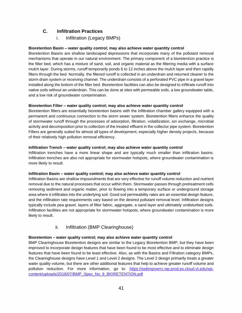
C. Infiltration Practices
i. Infiltration (Legacy BMPs)
Bioretention Basin – water quality control; may also achieve water quantity control
Bioretention Basins are shallow landscaped depressions that incorporate many of the pollutant removal
mechanisms that operate in our natural environment. The primary component of a bioretention practice is
the filter bed, which has a mixture of sand, soil, and organic material as the filtering media with a surface
mulch layer. During storms, runoff temporarily ponds 6 to 12 inches above the mulch layer and then rapidly
filters through the bed. Normally, the filtered runoff is collected in an underdrain and returned cleaner to the
storm drain system or receiving channel. The underdrain consists of a perforated PVC pipe in a gravel layer
installed along the bottom of the filter bed. Bioretention facilities can also be designed to infiltrate runoff into
native soils without an underdrain. This can be done at sites with permeable soils, a low groundwater table,
and a low risk of groundwater contamination.
Bioretention Filter – water quality control; may also achieve water quantity control
Bioretention filters are essentially bioretention basins with the infiltration chamber gallery equipped with a
permanent and continuous connection to the storm sewer system. Bioretention filters enhance the quality
of stormwater runoff through the processes of adsorption, filtration, volatilization, ion exchange, microbial
activity and decomposition prior to collection of the treated effluent in the collector pipe system. Bioretention
Filters are generally suited for almost all types of development, especially higher density projects, because
of their relatively high pollution removal efficiency.
Infiltration Trench – water quality control; may also achieve water quantity control
Infiltration trenches have a more linear shape and are typically much smaller than infiltration basins.
Infiltration trenches are also not appropriate for stormwater hotspots, where groundwater contamination is
more likely to result.
Infiltration Basin – water quality control; may also achieve water quantity control
Infiltration Basins are shallow impoundments that are very effective for runoff volume reduction and nutrient
removal due to the natural processes that occur within them. Stormwater passes through pretreatment cells
removing sediment and organic matter, prior to flowing into a temporary surface or underground storage
area where it infiltrates into the underlying soil. Good soil permeability rates are an essential design feature,
and the infiltration rate requirements vary based on the desired pollutant removal level. Infiltration designs
typically include pea gravel, layers of filter fabric, aggregate, a sand layer and ultimately undisturbed soils.
Infiltration facilities are not appropriate for stormwater hotspots, where groundwater contamination is more
likely to result.
ii. Infiltration (BMP Clearinghouse)
Bioretention – water quality control; may also achieve water quantity control
BMP Clearinghouse Bioretention designs are similar to the Legacy Bioretention BMP, but they have been
improved to incorporate design features that have been found to be most effective and to eliminate design
features that have been found to be least effective. Also, as with the Basins and Filtration category BMPs,
the Clearinghouse designs have Level 1 and Level 2 designs. The Level 2 design primarily treats a greater
water quality volume, but there are other additional features that help to achieve greater runoff volume and
pollution reduction. For more information, go to: https://swbmpvwrrc.wp.prod.es.cloud.vt.edu/wp-
content/uploads/2018/07/BMP_Spec_No_9_BIORETENTION.pdf
41
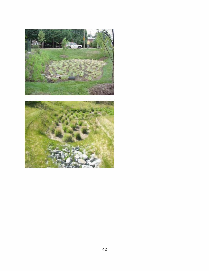
42
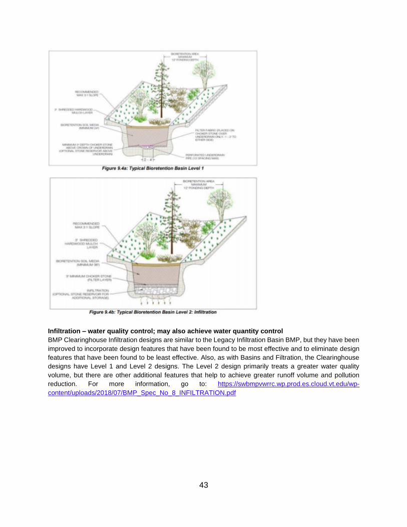
Infiltration – water quality control; may also achieve water quantity control
BMP Clearinghouse Infiltration designs are similar to the Legacy Infiltration Basin BMP, but they have been
improved to incorporate design features that have been found to be most effective and to eliminate design
features that have been found to be least effective. Also, as with Basins and Filtration, the Clearinghouse
designs have Level 1 and Level 2 designs. The Level 2 design primarily treats a greater water quality
volume, but there are other additional features that help to achieve greater runoff volume and pollution
reduction. For more information, go to: https://swbmpvwrrc.wp.prod.es.cloud.vt.edu/wp-
content/uploads/2018/07/BMP_Spec_No_8_INFILTRATION.pdf
43

44

Permeable Pavement – water quality control; may also achieve water quantity control
Permeable Pavement systems have integrated voids for runoff to filter through the surface into an
underground stone reservoir. This reservoir stores the runoff and infiltrates it into the underlying soils. If the
soil under the gravel bed has low infiltration rates, an underdrain system is used to return the stormwater
to the storm sewer system, usually after detaining the runoff for a short period of time to control discharge
flow rates. Various types of permeable pavement systems are available such as pervious concrete, porous
asphalt pavement, and interlocking concrete pavers. Again, Permeable Pavement designs have Level 1
and Level 2 designs. The Level 2 design treats a slightly greater water quality volume, has more porous
native soils beneath, and does not have an underdrain, all of which help to achieve greater runoff volume
and pollution reduction. For more information, go to: https://swbmpvwrrc.wp.prod.es.cloud.vt.edu/wp-
content/uploads/2018/07/BMP_Spec_No_7_PERMEABLE_PAVEMENT.pdf
45
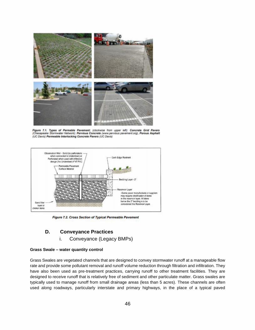
D. Conveyance Practices
i. Conveyance (Legacy BMPs)
Grass Swale – water quantity control
Grass Swales are vegetated channels that are designed to convey stormwater runoff at a manageable flow
rate and provide some pollutant removal and runoff volume reduction through filtration and infiltration. They
have also been used as pre-treatment practices, carrying runoff to other treatment facilities. They are
designed to receive runoff that is relatively free of sediment and other particulate matter. Grass swales are
typically used to manage runoff from small drainage areas (less than 5 acres). These channels are often
used along roadways, particularly interstate and primary highways, in the place of a typical paved
46
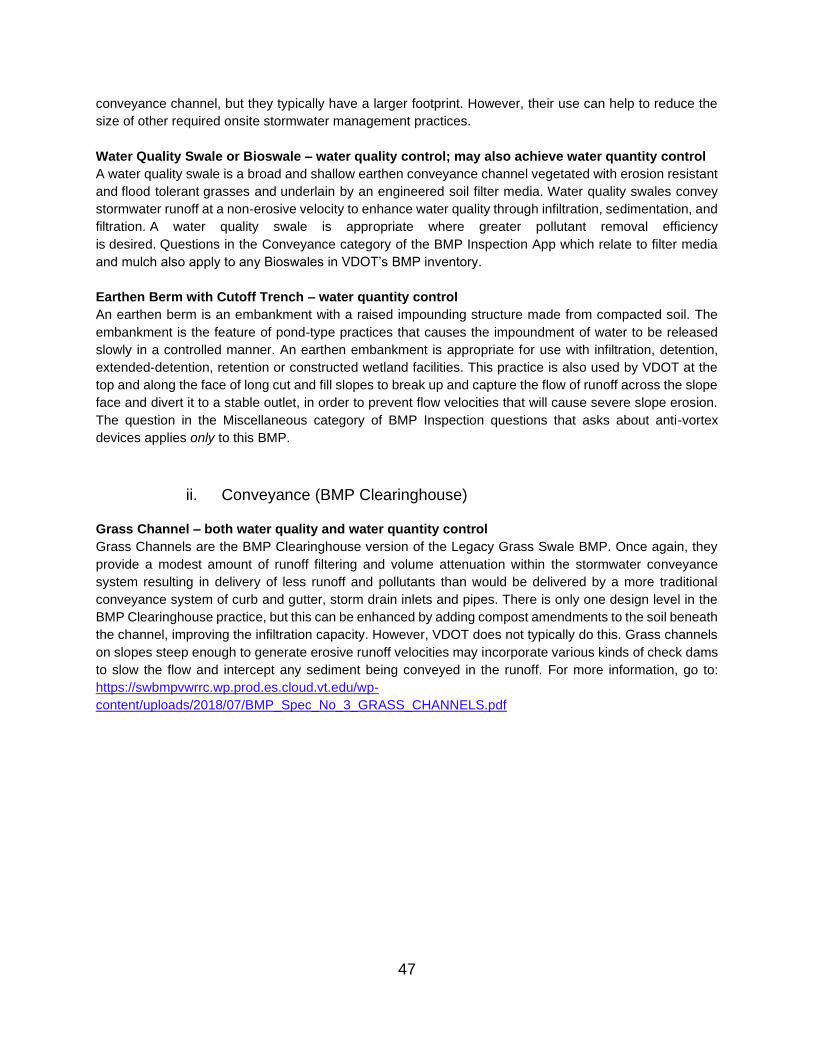
conveyance channel, but they typically have a larger footprint. However, their use can help to reduce the
size of other required onsite stormwater management practices.
Water Quality Swale or Bioswale – water quality control; may also achieve water quantity control
A water quality swale is a broad and shallow earthen conveyance channel vegetated with erosion resistant
and flood tolerant grasses and underlain by an engineered soil filter media. Water quality swales convey
stormwater runoff at a non-erosive velocity to enhance water quality through infiltration, sedimentation, and
filtration. A water quality swale is appropriate where greater pollutant removal efficiency
is desired. Questions in the Conveyance category of the BMP Inspection App which relate to filter media
and mulch also apply to any Bioswales in VDOT’s BMP inventory.
Earthen Berm with Cutoff Trench – water quantity control
An earthen berm is an embankment with a raised impounding structure made from compacted soil. The
embankment is the feature of pond-type practices that causes the impoundment of water to be released
slowly in a controlled manner. An earthen embankment is appropriate for use with infiltration, detention,
extended-detention, retention or constructed wetland facilities. This practice is also used by VDOT at the
top and along the face of long cut and fill slopes to break up and capture the flow of runoff across the slope
face and divert it to a stable outlet, in order to prevent flow velocities that will cause severe slope erosion.
The question in the Miscellaneous category of BMP Inspection questions that asks about anti-vortex
devices applies only to this BMP.
ii. Conveyance (BMP Clearinghouse)
Grass Channel – both water quality and water quantity control
Grass Channels are the BMP Clearinghouse version of the Legacy Grass Swale BMP. Once again, they
provide a modest amount of runoff filtering and volume attenuation within the stormwater conveyance
system resulting in delivery of less runoff and pollutants than would be delivered by a more traditional
conveyance system of curb and gutter, storm drain inlets and pipes. There is only one design level in the
BMP Clearinghouse practice, but this can be enhanced by adding compost amendments to the soil beneath
the channel, improving the infiltration capacity. However, VDOT does not typically do this. Grass channels
on slopes steep enough to generate erosive runoff velocities may incorporate various kinds of check dams
to slow the flow and intercept any sediment being conveyed in the runoff. For more information, go to:
https://swbmpvwrrc.wp.prod.es.cloud.vt.edu/wp-
content/uploads/2018/07/BMP_Spec_No_3_GRASS_CHANNELS.pdf
47

48

Dry Swale – water quality control; may also achieve water quantity control
Dry Swales are essentially updated BMP Clearinghouse designs of the Legacy Bioswale BMP. They are
designed to decrease flow rates, increase pollutant removal through filtration and infiltration, and enhance
runoff storage. They can be used as pre-treatment practices, carrying runoff to other treatment facilities.
They are designed to receive runoff that is relatively free of sediment and other particulate matter, in order
to prevent clogging of the filter media below the surface. BMP Clearinghouse Dry Swales have Level 1 or
Level 2 designs. The Level 2 design treats a slightly greater water quality volume, has a flatter slope and
deeper filter media, and may eliminate the underdrain if the soils beneath the swale are sufficiently porous.
Questions in the Conveyance category of the BMP Inspection App which relate to filter media and mulch
also apply to Dry Swales. For more information, go to: https://swbmpvwrrc.wp.prod.es.cloud.vt.edu/wp-
content/uploads/2018/07/BMP_Spec_No_10_DRY_SWALE.pdf
49
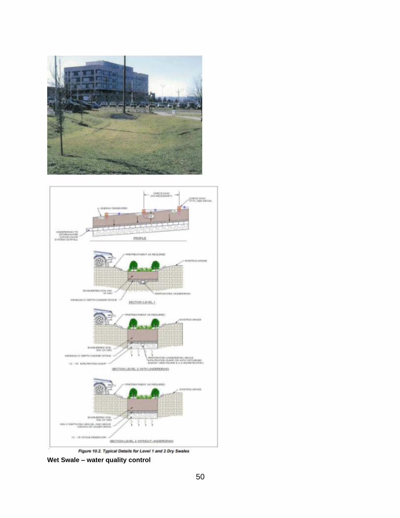
Wet Swale – water quality control
50

Wet Swales are a linear version of a constructed wetland, with a permanent pool (due to interception of the
groundwater table), designed wetland vegetation plantings, and a control structure such as a weir at the
end. Pollutant removal occurs via the same processes as in the constructed wetland BMP. They are
typically installed in areas where shallow groundwater occurs. Wet swales are long and have a flat slope
to store water and allow for settlement and biological uptake of pollutants as they convey stormwater away
from the site. As with Dry Swales, there are Level 1 and Level 2 designs. The Level 2 design treats a greater
water quality volume and has a flatter slope as well as off-line swale cells. For more information, go to:
https://swbmpvwrrc.wp.prod.es.cloud.vt.edu/wp-
content/uploads/2018/07/BMP_Spec_No_11_WET_SWALE.pdf
51

E. Miscellaneous (Permanent E&S)
Level Spreader – water quantity control
Level Spreaders consist of a level excavated depression that disperses concentrated runoff as sheet flow
across a stabilized, vegetated surface. It reduces erosion potential and impacts to downstream channels
and other erosion control measures. The depth of the depression may be increased to improve debris
removal and sediment settling, and to increase the level spreader’s temporary storage capacity. These practices slow runoff flow, and thereby decrease erosion and increase the opportunities for filtering and
absorption of pollutants. Additionally, they are effective long-term erosion control measures, particularly
above long cut and fill slopes, to prevent concentrated flows across the slopes from causing significant
erosion.
http://prj.geosyntec.com/npsmanual/levelspreader.aspx
https://swbmpvwrrc.wp.prod.es.cloud.vt.edu/wp-
content/uploads/2018/07/BMP_Spec_No_2_SHEET_FLOW.pdf
52
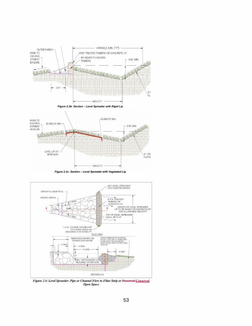
53

Check Dam – water quantity control
A Check Dam is a small, temporary dam constructed of rock, wood or concrete. Check Dams are typically
installed in channels and swales to slow runoff and trap sediment. There can be a single check dam or
multiple check dams in series. Check dams are often installed in long VDOT grass swales and channels to
prevent channel erosion. Outlet stabilization measures, such as riprap or geotextile linings, should be in
place after the final check dam in a channel to protect against erosion.
https://swbmpvwrrc.wp.prod.es.cloud.vt.edu/wp-
content/uploads/2018/07/BMP_Spec_No_10_DRY_SWALE.pdf
54
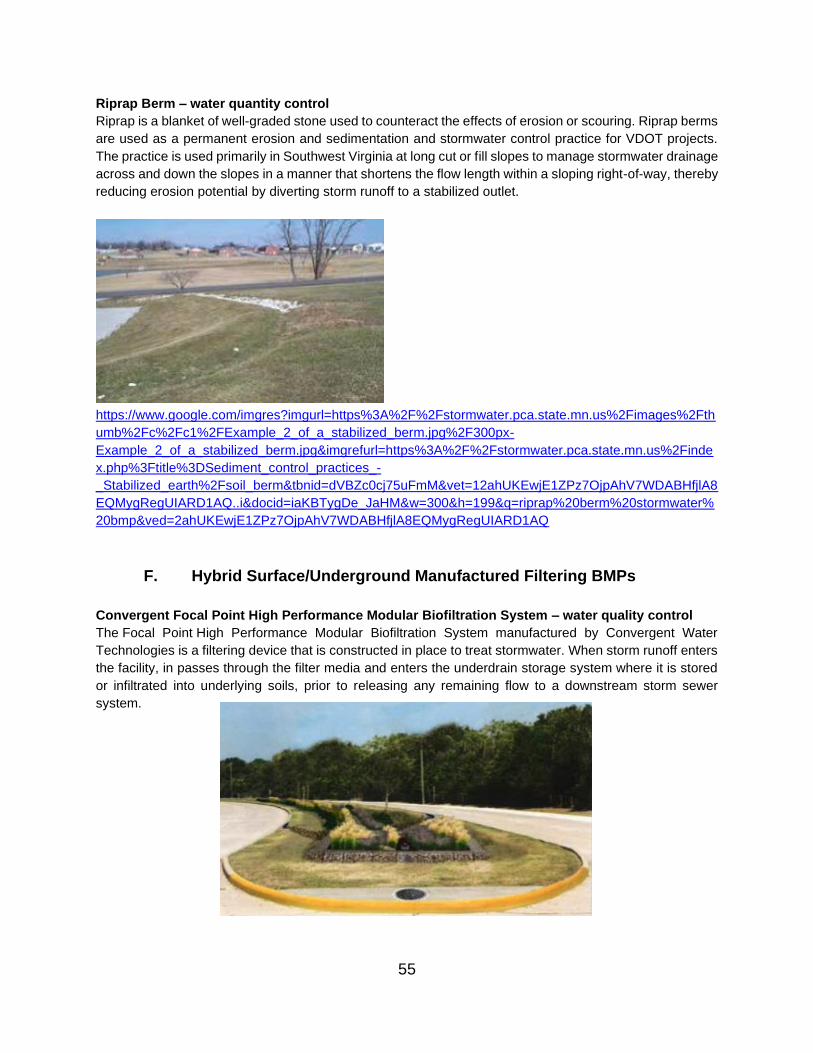
Riprap Berm – water quantity control
Riprap is a blanket of well-graded stone used to counteract the effects of erosion or scouring. Riprap berms
are used as a permanent erosion and sedimentation and stormwater control practice for VDOT projects.
The practice is used primarily in Southwest Virginia at long cut or fill slopes to manage stormwater drainage
across and down the slopes in a manner that shortens the flow length within a sloping right-of-way, thereby
reducing erosion potential by diverting storm runoff to a stabilized outlet.
https://www.google.com/imgres?imgurl=https%3A%2F%2Fstormwater.pca.state.mn.us%2Fimages%2Fth
umb%2Fc%2Fc1%2FExample_2_of_a_stabilized_berm.jpg%2F300px-
Example_2_of_a_stabilized_berm.jpg&imgrefurl=https%3A%2F%2Fstormwater.pca.state.mn.us%2Finde
x.php%3Ftitle%3DSediment_control_practices_-
_Stabilized_earth%2Fsoil_berm&tbnid=dVBZc0cj75uFmM&vet=12ahUKEwjE1ZPz7OjpAhV7WDABHfjlA8
EQMygRegUIARD1AQ..i&docid=iaKBTygDe_JaHM&w=300&h=199&q=riprap%20berm%20stormwater%
20bmp&ved=2ahUKEwjE1ZPz7OjpAhV7WDABHfjlA8EQMygRegUIARD1AQ
F. Hybrid Surface/Underground Manufactured Filtering BMPs
Convergent Focal Point High Performance Modular Biofiltration System – water quality control
The Focal Point High Performance Modular Biofiltration System manufactured by Convergent Water
Technologies is a filtering device that is constructed in place to treat stormwater. When storm runoff enters
the facility, in passes through the filter media and enters the underdrain storage system where it is stored
or infiltrated into underlying soils, prior to releasing any remaining flow to a downstream storm sewer
system.
55
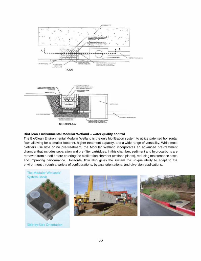
BioClean Environmental Modular Wetland – water quality control
The BioClean Environmental Modular Wetland is the only biofiltration system to utilize patented horizontal
flow, allowing for a smaller footprint, higher treatment capacity, and a wide range of versatility. While most
biofilters use little or no pre-treatment, the Modular Wetland incorporates an advanced pre-treatment
chamber that includes separation and pre-filter cartridges. In this chamber, sediment and hydrocarbons are
removed from runoff before entering the biofiltration chamber (wetland plants), reducing maintenance costs
and improving performance. Horizontal flow also gives the system the unique ability to adapt to the
environment through a variety of configurations, bypass orientations, and diversion applications.
56

Contech Filterra (Tree Box Filter) – water quality control
Tree Box Filters (specifically such filters manufactured by Contech) are manufactured BMPs that function
as miniature bioretention cells. There is typically an inlet that routes flow into the facility. The subgrade
inside the structure is filled with patented organic filter media as specified by the designer to provide
filtration. The visible part of the facility is the top layer of mulch, some type of planting, such as a shrub or
small tree, to help absorb and filter pollutants, and a grate on top. [Note the tree box must be maintained in
accordance with the manufacturer’s specifications for proper function, which may require the use of certified
service technicians for maintenance in some cases]. For more information on Contech Filterra device, go
to: https://www.conteches.com/.
57
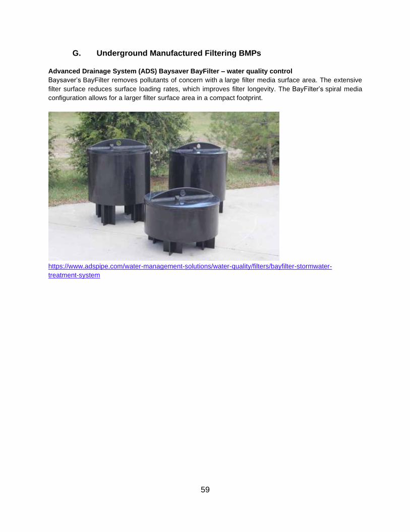
G. Underground Manufactured Filtering BMPs
Advanced Drainage System (ADS) Baysaver BayFilter – water quality control
Baysaver’s BayFilter removes pollutants of concern with a large filter media surface area. The extensive
filter surface reduces surface loading rates, which improves filter longevity. The BayFilter’s spiral media
configuration allows for a larger filter surface area in a compact footprint.
https://www.adspipe.com/water-management-solutions/water-quality/filters/bayfilter-stormwater-
treatment-system
59
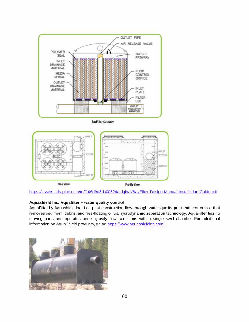
https://assets.ads-pipe.com/m/f106d9d3dc00324/original/BayFilter-Design-Manual-Installation-Guide.pdf
Aquashield Inc. Aquafilter – water quality control
AquaFilter by Aquashield Inc. is a post construction flow-through water quality pre-treatment device that
removes sediment, debris, and free-floating oil via hydrodynamic separation technology. AquaFilter has no
moving parts and operates under gravity flow conditions with a single swirl chamber. For additional
information on AquaShield products, go to: https://www.aquashieldinc.com/.
60

Bioclean Environmental Kraken Filter – water quality control
Bioclean’s Kraken Filter is a filtration BMP that uses advanced membrane filtration, ensuring a high level
of removals for TSS, phosphorous, nutrients, metals, trash, and hydrocarbons. The Kraken (membrane)
Filter cartridge provides high flow rates, while the system can operate at a low loading rate to ensure
maximum performance, minimum maintenance, and far less clogging.
61
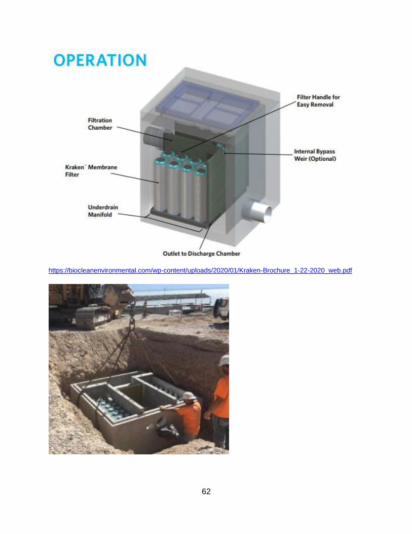
https://biocleanenvironmental.com/wp-content/uploads/2020/01/Kraken-Brochure_1-22-2020_web.pdf
62

https://biocleanenvironmental.com/wp-content/uploads/2018/06/KF-10-16-72-Standard.pdf
Contech Jellyfish Filter – water quality control
The Contech Jellyfish Filter features high flow pretreatment and membrane filtration in a stand-alone system. The Jellyfish Filter removes floatables, trash, oil, debris, TSS, fine silt-sized particles, and a high percentage of particulate-bound pollutants, including phosphorus, nitrogen, metals and hydrocarbons. The high surface area membrane tentacle cartridges, combined with up-flow hydraulics, frequent passive backwashing, and rinseable/reusable cartridges ensures long-lasting performance. For more information on Contech devices, go to: https://www.conteches.com/.
63

64

65

Contech Stormfilter – water quality control
The Conch Stormfilter uses rechargeable, media-filled cartridges to absorb and retain the most challenging
pollutants from stormwater runoff including total suspended solids, hydrocarbons, nutrients, metals, and
other common pollutants. For more information on Contech Stormfilter, go to: https://www.conteches.com/.
66
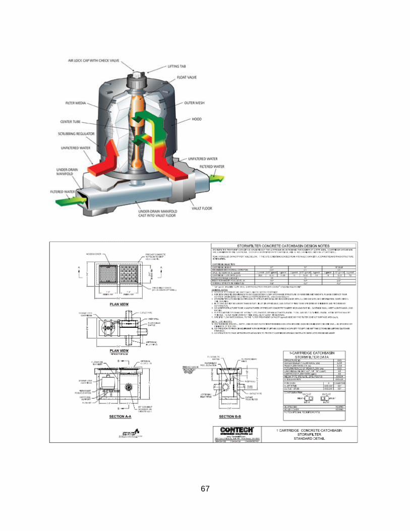
67
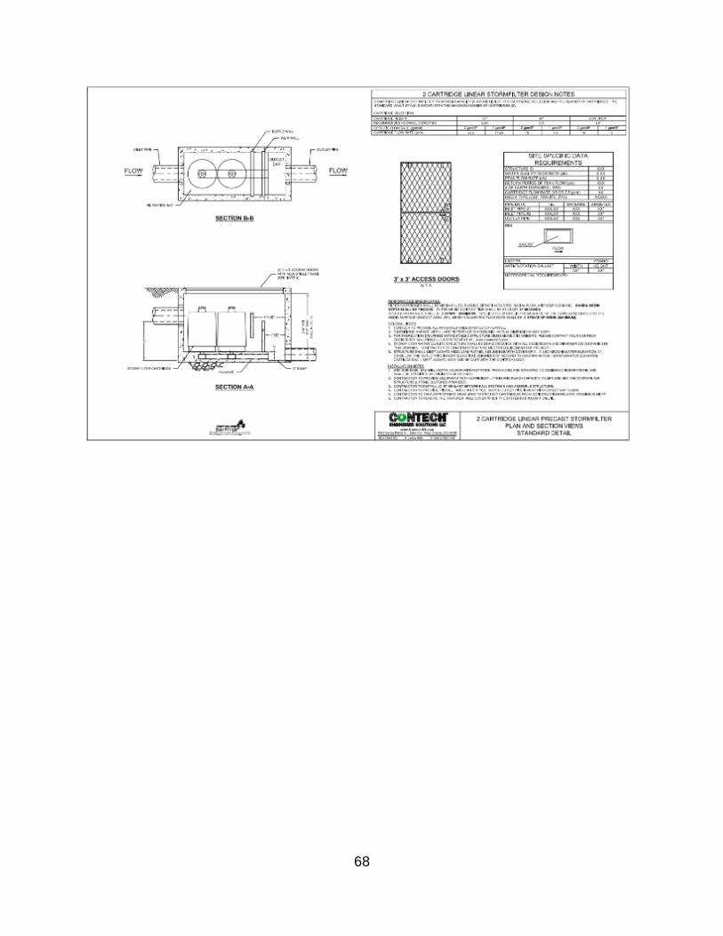
68

Hydro Int’l Up-Flow Filter – water quality control
The Up-Flo Filter is an advanced stormwater treatment system that combines sedimentation and screening
with filtration to deliver exceptional surface water pollution removal. Trash, gross debris and sediment settle
out in the sump. Oil and floatables rise to the surface of the water, and treated water flows out of the Filter
Module to the Outlet Module and into the outlet pipe. Excess flows are discharged to the outlet using a
Siphonic Bypass, which also acts as a floatables baffle, preventing the escape of oil and floatable trash. To
guard against pollutant leaching and filter media degradation between storm events, water drains out of the
chamber through the filtered Drain Down Port as the storm subsides. For additional information on the
Hydro International Up-Flow Filter products shown, go to: https://hydro-int.com/en.
69

70

Oldcastle Precast Perkfilter Media Device – water quality control
The Oldcastle Precast PerkFilter Media Device is a water treatment filtration device that uses a wide variety
of proprietary media to treat specific pollutants of concern. The device uses physical and chemical treatment
processes, such as separation, sedimentation, filtration and absorption to remove sediment, metals,
nutrients and hydrocarbons close to their sources. The PerkFilter typically consists of an inlet chamber for
removal of gross pollutants and diversion of bypass flows, a treatment chamber for filtration through media-
filled cartridges, and an outlet chamber for flow collection and discharge. A variety of filter media is available
to target specific pollutants of concern. For additional information on Oldcastle Precast Perkfilter Media
Device, go to: https://oldcastleinfrastructure.com/products/water/stormwater-drainage/ .
71
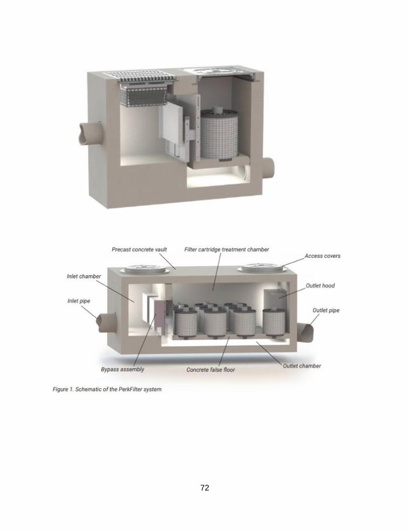
72

73

H. Underground Manufactured Hydrodynamic BMPs
ADS Baysaver Separator – water quality control
The ADS Baysaver Separator is a hydrodynamic stormwater treatment unit. The Baysaver Separator uses
three flow paths to direct stormwater between the structures and trap suspended solids and floatables until
they are removed during maintenance. Incoming stormwater travels through the primary manhole where
the coarse sediments settle undisturbed during high and low flow events. Waters containing free oils, fine
sediments, and floatables enter the storage manhole for secondary treatment. Lastly, the remainder of the
stormwater passes through the separator unit, over the internal bypass plate, to avoid the resuspension of
collected contaminants. This direct path of the water flow assures that the system will not cause a backup
in the storm drain. For more information regarding ADS Baysaver Devices, go to: https://www.adspipe.com/
74

ADS Baysaver Barracuda – water quality control
The ADS Baysaver Barracuda is a vortex hydrodynamic separator designed to remove suspended solids
in order to protect the public waterways from POC. The Barracuda treats stormwater and prevents removes
suspended solids by preventing turbulence and resuspension of captured contaminants. The Barracuda
system mitigates turbulence in the sump area to prevent resuspension of captured contaminants. The
apparatus is fabricated and designed for quick and easy field assembly. Plus, it is easy to maintain using a
vacuum truck or comparable equipment. For more information regarding ADS Baysaver Devices, go to:
https://www.adspipe.com/
75
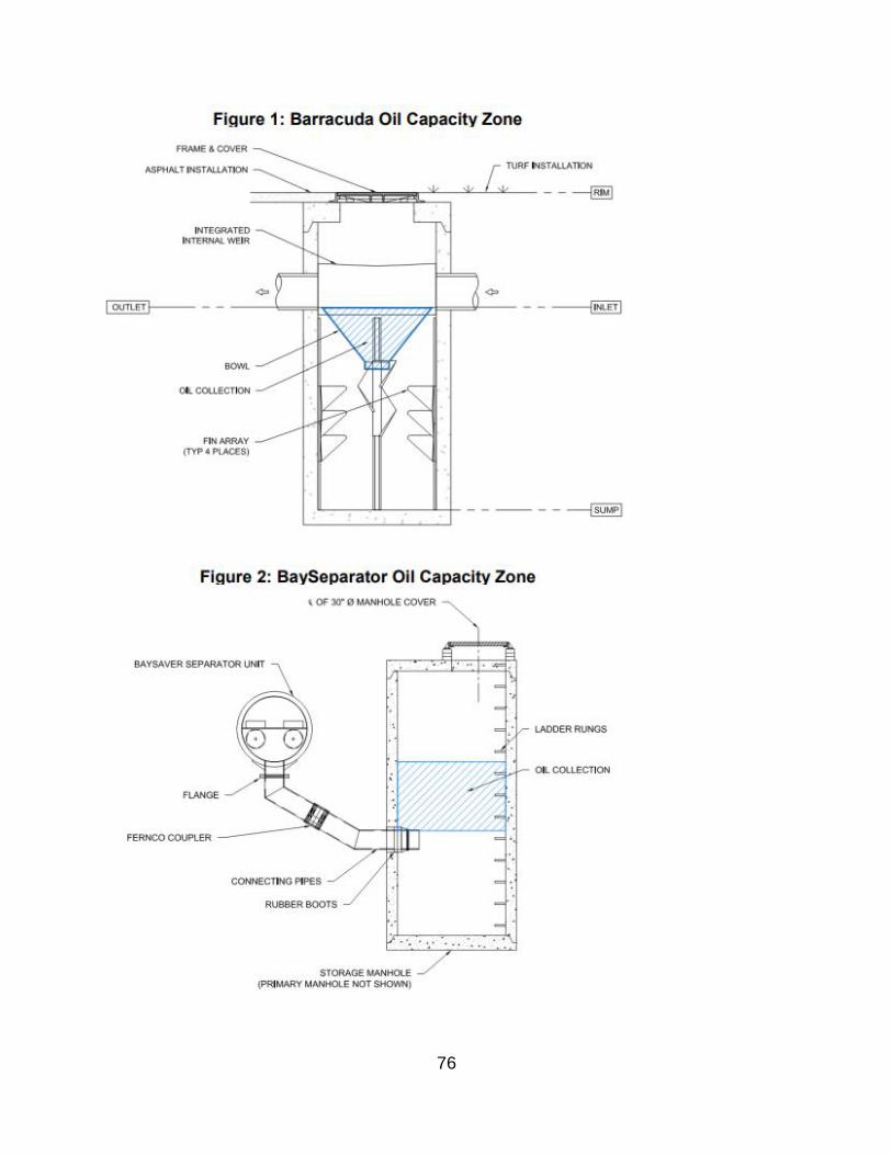
76

ADS HDPE Water Quality Unit – water quality control
The ADS HDPE Water Quality Unit is designed to trap hydrocarbons and TSS from stormwater. Two weir
plates act as trapping devices as the stormwater flows through surface drainage structures and into the
water quality unit. This structure also incorporates the use of a bypass system, which prevents re-
suspension of captured solids by diverting water flows greater than ‘first flush’. For more information
regarding ADS HDPE Water Quality devices, go to: https://www.adspipe.com/
77

AquaShield Inc. Aqua-Swirl – water quality control
AquaSwirl by Aquashield Inc. post construction flow-through water quality pre-treatment device that
removes sediment, debris, and free-floating oil via hydrodynamic separation technology. AquaSwirl has no
moving parts and operates under gravity flow conditions with a single swirl chamber. For additional
information on AquaShield products, go to: https://www.aquashieldinc.com/.
78
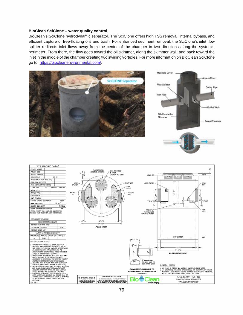
BioClean SciClone – water quality control
BioClean’s SciClone hydrodynamic separator. The SciClone offers high TSS removal, internal bypass, and
efficient capture of free-floating oils and trash. For enhanced sediment removal, the SciClone’s inlet flow
splitter redirects inlet flows away from the center of the chamber in two directions along the system's
perimeter. From there, the flow goes toward the oil skimmer, along the skimmer wall, and back toward the
inlet in the middle of the chamber creating two swirling vortexes. For more information on BioClean SciClone
go to: https://biocleanenvironmental.com/.
79
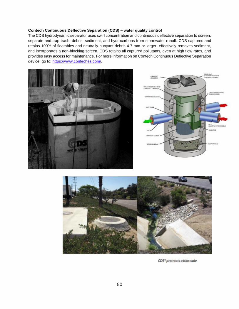
Contech Continuous Deflective Separation (CDS) – water quality control
The CDS hydrodynamic separator uses swirl concentration and continuous deflective separation to screen,
separate and trap trash, debris, sediment, and hydrocarbons from stormwater runoff. CDS captures and
retains 100% of floatables and neutrally buoyant debris 4.7 mm or larger, effectively removes sediment,
and incorporates a non-blocking screen. CDS retains all captured pollutants, even at high flow rates, and
provides easy access for maintenance. For more information on Contech Continuous Deflective Separation
device, go to: https://www.conteches.com/.
80
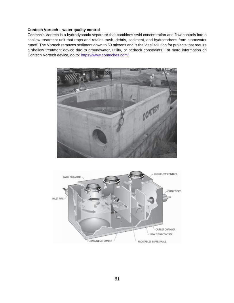
Contech Vortech – water quality control
Contech’s Vortech is a hydrodynamic separator that combines swirl concentration and flow controls into a
shallow treatment unit that traps and retains trash, debris, sediment, and hydrocarbons from stormwater
runoff. The Vortech removes sediment down to 50 microns and is the ideal solution for projects that require
a shallow treatment device due to groundwater, utility, or bedrock constraints. For more information on
Contech Vortech device, go to: https://www.conteches.com/.
81

https://crystalstream.com/
STANDARD DETAIL: VORTECHS 1000
Crystal Stream Tech CrystalClean Separator – water quality control
The Crystal Stream Tech CrystalClean Separator is a Hydrodynamic BMP that utilizes a fine mesh to
capture floating debris and vegetative matter. The device has a standing pool at all times, and the debris is
held in a permanent pool to prevent waterlogging, sinking, and decomposing. The water proceeds around
baffles, slowing the flow and ensuring the oil gathers at the top. A reservoir spans the device from side to
side and nearly to the bottom, blocking flow from going directly to the outlet. As the water level rises, the oil
flows over the edge of the reservoir and the water flows under it to the outflow pipe. Other elements, such
as absorbents, flocculants, or charcoal canisters, can be added to target specific pollutant. For more
information on Crystal Stream CrystalClean Separator, go to: https://crystalstream.com/.
82
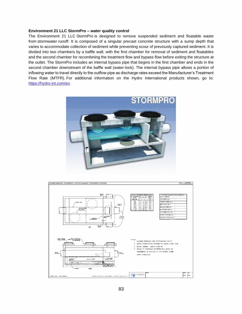
Environment 21 LLC StormPro – water quality control
The Environment 21 LLC StormPro is designed to remove suspended sediment and floatable waste
from stormwater runoff. It is composed of a singular precast concrete structure with a sump depth that
varies to accommodate collection of sediment while preventing scour of previously captured sediment. It is
divided into two chambers by a baffle wall, with the first chamber for removal of sediment and floatables
and the second chamber for recombining the treatment flow and bypass flow before exiting the structure at
the outlet. The StormPro includes an internal bypass pipe that begins in the first chamber and ends in the
second chamber downstream of the baffle wall (water-lock). The internal bypass pipe allows a portion of
inflowing water to travel directly to the outflow pipe as discharge rates exceed the Manufacturer’s Treatment Flow Rate (MTFR). For additional information on the Hydro International products shown, go to:
https://hydro-int.com/en.
83

Environment 21 LLC V2B1 – water quality control
Environment 21 LLC V2B1 is a Hydrodynamic separator that is comprised of two concrete chambers. The
stormwater runoff enters through an inlet pipe in the first chamber, which induces a centrifuge action. The
centrifuge action and flow path allow for an extended settling time of TSS. This causes most of the TSS,
floatable debris and hydrocarbons to be trapped in the first chamber. The discharge from the first chamber
is at the design elevation and acts as a weir/orifice directing flow to the second chamber. The second
chamber is comprised of two compartments that capture additional TSS and directs the outflow. For
additional information on the Hydro International First Defense products shown, go to: https://hydro-
int.com/en.
84
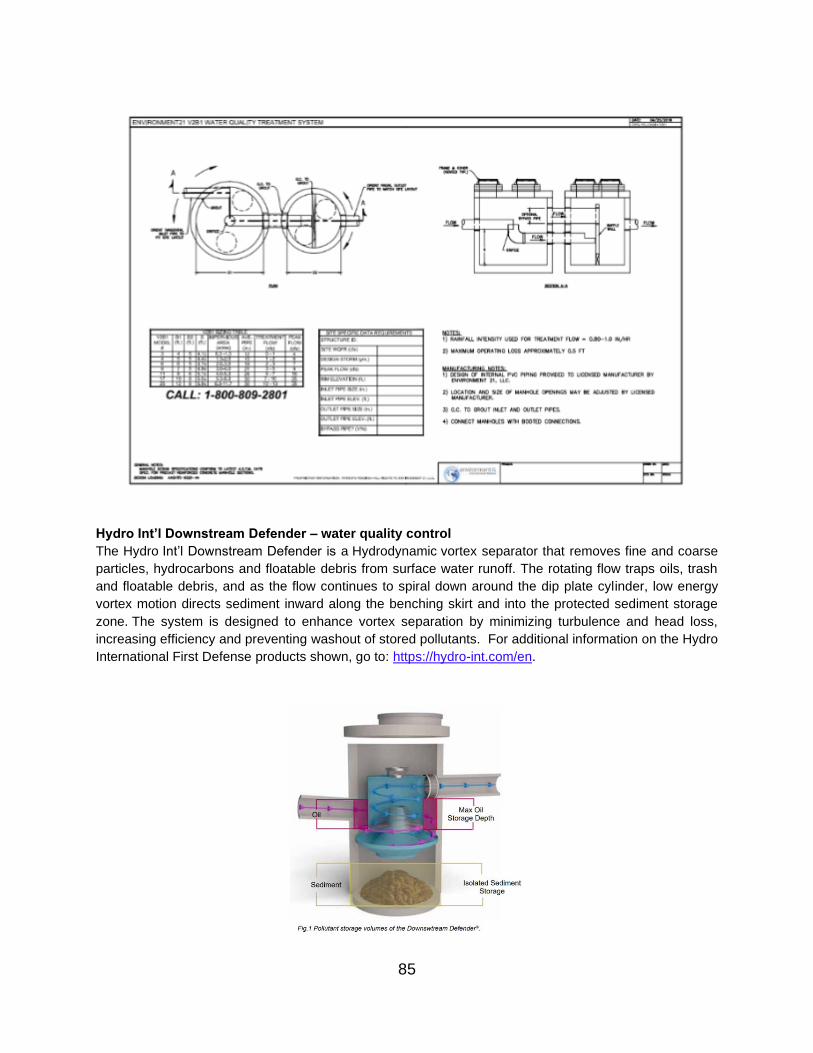
Hydro Int’l Downstream Defender – water quality control
The Hydro Int’l Downstream Defender is a Hydrodynamic vortex separator that removes fine and coarse
particles, hydrocarbons and floatable debris from surface water runoff. The rotating flow traps oils, trash
and floatable debris, and as the flow continues to spiral down around the dip plate cylinder, low energy
vortex motion directs sediment inward along the benching skirt and into the protected sediment storage
zone. The system is designed to enhance vortex separation by minimizing turbulence and head loss,
increasing efficiency and preventing washout of stored pollutants. For additional information on the Hydro
International First Defense products shown, go to: https://hydro-int.com/en.
85

Hydro Int’l First Defense – water quality control
The Hydro Int’l First Defense is a Hydrodynamic stormwater separator designed for high flow rates. As
stormwater enters the inlet chute from a surface grate and/or inlet pipe, the inlet chute introduces flow into
the chamber tangentially to create a low energy vortex flow regime that directs sediment into the sump.
Treated stormwater exits through a submerged outlet chute located opposite to the direction of the rotating
flow. Enhanced vortex separation is provided by forcing the rotating flow within the vessel to follow the
longest path possible, rather than directly from inlet to outlet. Higher flows bypass the treatment chamber
to prevent turbulence and washout of captured pollutants. An integral bypass chute conveys infrequent
peak flows directly to the outlet chute, eliminating the expense of external bypass control structures.
Floatables are diverted away from the bypass chute into the treatment chamber through the floatables
draw-off port. For additional information on the Hydro International First Defense products, go to:
https://hydro-int.com/en.
86
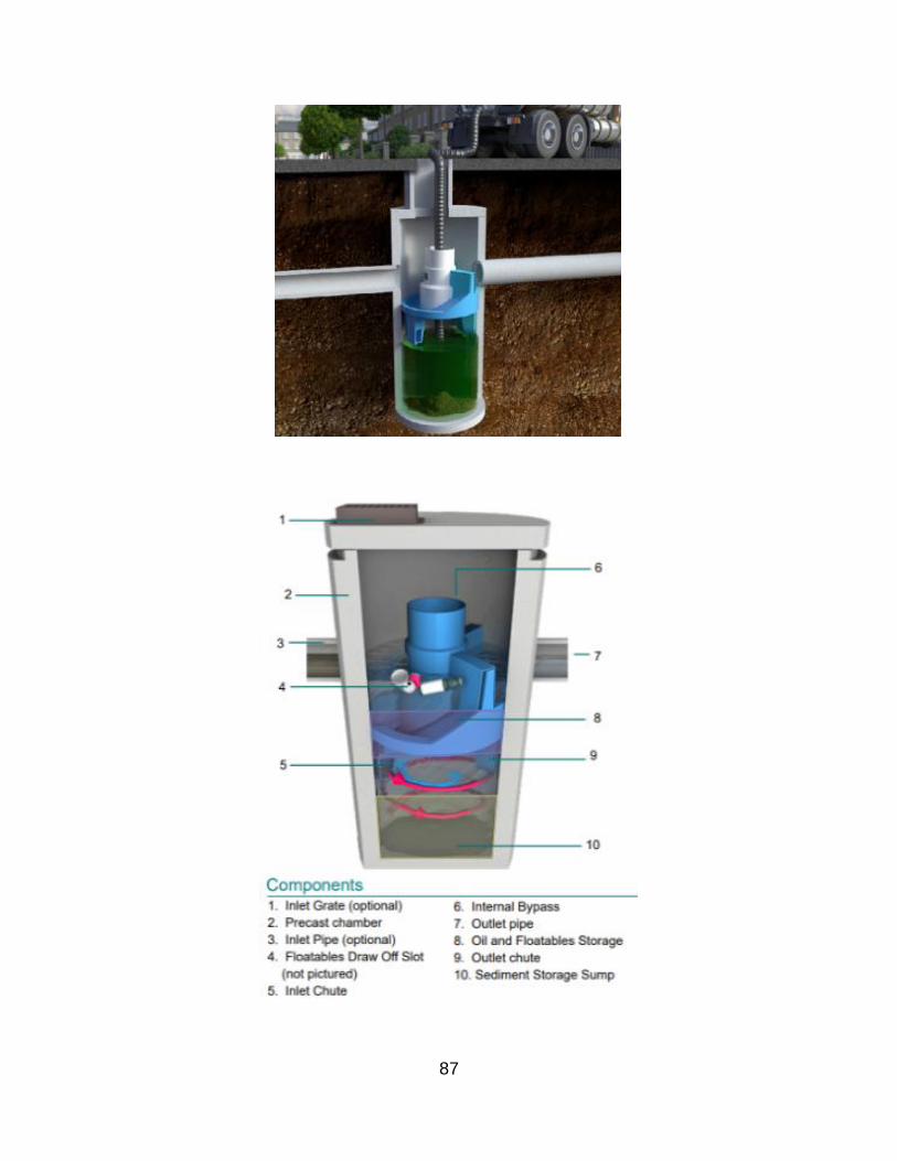
87

88

Hydroworks LLC Hydroguard – water quality control
The Hydroworks LLC Hydroguard is a Hydrodynamic separator that removes suspended solid, oil, and
trash. The Hydroguard can treat high and low flows via two separate treatment areas. The design treats
low flows differently from higher flows, as the transport and POC vary with flow rate. This allows the
Hydroguard separator to treat higher flows but also minimizes scour and resuspension of previously
captured fines. For additional information on Hydroworks products shown, go to: https://hydroworks.com/.
89

Oldcastle Precast Dual Vortex Separator – water quality control
The Oldcastle Precast Dual Vortex Separator (DVS) is a Hydrodynamic separator that removes TSS, gross
solids, trash and debris as well as petroleum hydrocarbons from storm water runoff. The DVS enhances
pollutant removal by directing incoming flow to two vortex tubes that operate in parallel. The configuration
of the vortex tubes and the extended flow path maximize residual time to increase the settling of solids.
Sediment is collected in an isolated storage area, while floating trash, debris and petroleum hydrocarbons
are retained behind internal baffles. The DVS contains an internal high-flow bypass weir system that diverts
excess flows around the settling chamber, minimizing the risk of resuspension of pollutants and allowing
for either online or offline configurations. For additional information on Oldcastle Precast Dual Vortex
Separator, go to: https://oldcastleinfrastructure.com/products/water/stormwater-drainage/.
90

91

Rinker Materials Stormceptor – water quality control
The Stormceptor System is a water quality treatment device used to remove total suspended solids (TSS)
and free oil (total petroleum hydrocarbons) from stormwater runoff. Depending on project
constraints, Stormceptor can be used as a stand-alone treatment device or as part of a treatment train
providing pre-treatment for Green Infrastructure designs. For additional information on Rinker Materials
Stormceptor, go to: https://www.rinkerpipe.com/Products/StormwaterTreatment.aspx
92
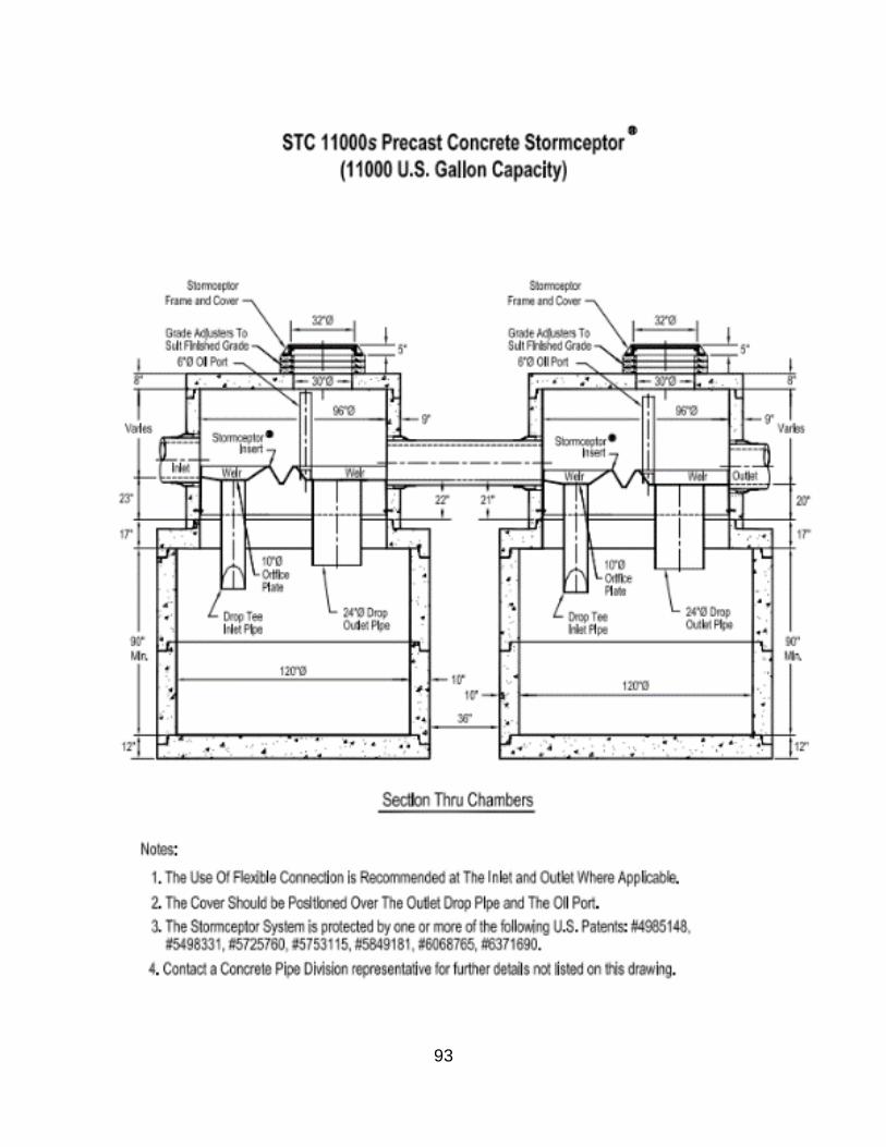
I. Other Underground Practices
93

ADS Baysaver Stormtech Isolator Row – water quantity
The StormTech Isolator Row, a row of StormTech chambers wrapped in woven geotextile fabric (with two
layers at the bottom), is a filter strip that provides enhanced removal of suspended solids and other
pollutants while providing surface area for infiltration and runoff reduction. For more information regarding
ADS Baysaver Devices, go to: https://www.adspipe.com/.
94
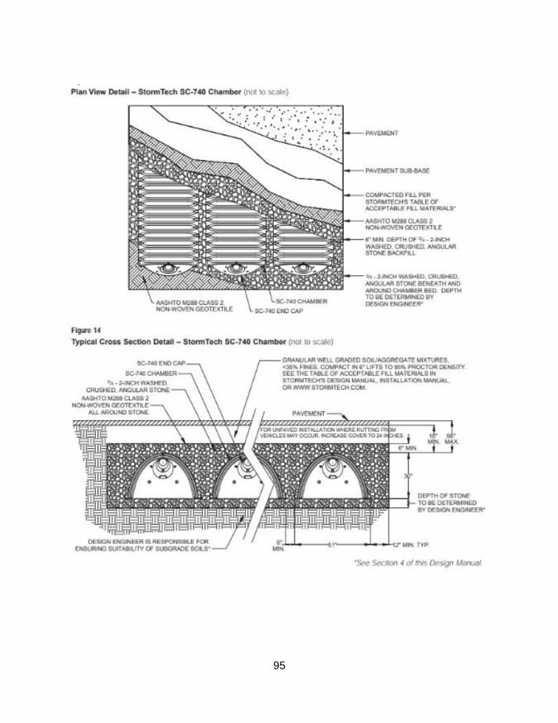
95
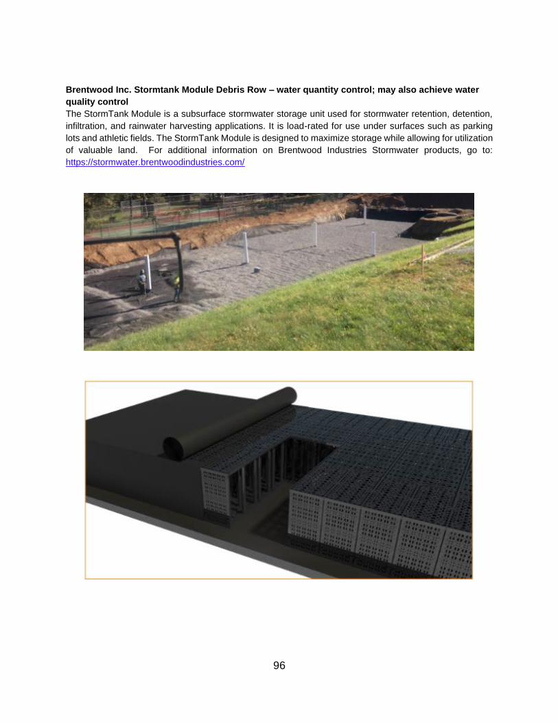
Brentwood Inc. Stormtank Module Debris Row – water quantity control; may also achieve water
quality control
The StormTank Module is a subsurface stormwater storage unit used for stormwater retention, detention,
infiltration, and rainwater harvesting applications. It is load-rated for use under surfaces such as parking
lots and athletic fields. The StormTank Module is designed to maximize storage while allowing for utilization
of valuable land. For additional information on Brentwood Industries Stormwater products, go to:
https://stormwater.brentwoodindustries.com/
96

97
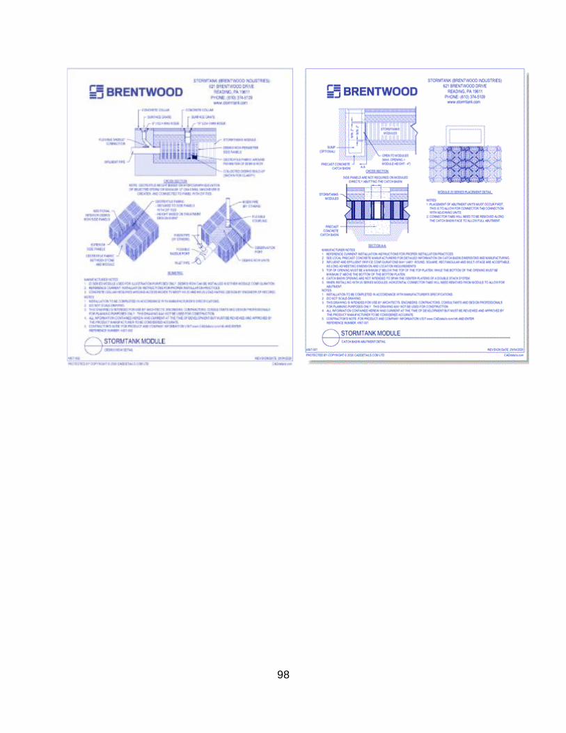
98

Underground Pipe Detention – water quantity control
Underground pipe detention is used when VDOT installs pipes underground (e.g., under a commuter
parking lot) to temporarily hold stormwater and slowly release it into the receiving system. The underground
practice achieves the stormwater management requirement using the same footprint as the parking lot, as
opposed to building a different detention practice (e.g., Detention Basin) that would require additional land.
Underground Pipe Detention manages the volume of stormwater flowing off the surface, helping to
prevent flooding and reducing the risk of erosion in receiving streams. Pipe detention does not provide
pollution removal to improve water quality.
https://csengineermag.com/moncton-moves-to-underground-stormwater-detention-system/
https://ctstormwatermanual.nemo.uconn.edu/11-design-guidance/underground-detention-facilities/
99

Underground Vault Detention – water quantity control
Underground vault detention is similar to pipe detention but uses large concrete or PVC arch vaults instead
of pipes beneath the parking area or other surface condition/use, where the stormwater is stored within the
vaults over a gravel base. Detention vaults manages the volume of stormwater flowing to nearby surface
waters and may be selected when there is insufficient space to build a surface facility, such as a detention
basin. They also help prevent flooding and can reduce erosion in receiving streams. They do not provide
pollution removal to improve water quality, though some are attached to a media filter bank to remove
pollutants.
https://www.highmarkellc.com/view-our-work/excavation--site-prep/imag0559.html#previous-photo
https://www.youtube.com/watch?v=Mn0ksMM3Hjw
100

https://fortress.wa.gov/ecy/madcap/wq/2014SWMMWWinteractive/Content/Topics/VolumeIII2014/VolIII%
20Ch3%202014/VolIII%20Ch3-2%202014/VolIII%20Ch3-2-3%202014.htm
101

Underground Gravel Infiltration – both water quantity and water quality control
Underground Gravel Infiltration beds or trenches are shallow excavated structures filled with permeable
materials such as gravel or stone to create an underground reservoir beneath an underground detention
vault structure. They are designed to hold stormwater runoff within a subsurface space and gradually
release it into the underlying soil and groundwater systems. They are generally designed for stormwater
volume reduction. Although not typically designed as a water quality treatment measure, they can provide
some level of treatment by infiltrating pollutants into the soil profile. A layer of geotextile fabric is often used
to line the trench in order to prevent the sediments and other particulates from migrating into the rock or
gravel fill.
Underground Sand Filter – water quality control Sand filters are a variation of the infiltration basin/trench principle and operate in a way similar to
bioretention systems. Stormwater is passed through them for treatment prior to discharge to the
downstream stormwater system. Sand filters are very useful in treating runoff from confined hard surfaces
such as car parks, vehicle repair yards, gas pumps, and from large, impermeable industrial-like areas. They
usually do not support vegetation owing to the filtration media (sand) not retaining sufficient moisture and
because they are usually installed underground. The filter usually consists of a sedimentation chamber as
a pre-treatment device to remove litter, debris, gross pollutants and medium-sized sediments, and a weir
followed by a sand layer that filters sediments, finer particulates and dissolved pollutants. The filtered water
is collected by perforated underdrain pipes in a similar manner to bioretention systems. These systems
may also have an overflow chamber. The sedimentation chamber can have permanent water or can be
designed to drain with weep holes between storm events. Permanent water storage can risk anaerobic
conditions that can lead to the release of pollutants (e.g. phosphorus) in the discharge water. For more
information, go to:
https://swbmpvwrrc.wp.prod.es.cloud.vt.edu/wp-
content/uploads/2018/07/BMP_Spec_No_12_FILTERING_PRACTICES.pdf
102

Oil/Grit Separator (Hydrodynamic Separator) – water quality control
Oil/grit separators (small Hydrodynamic Separators) are widely deployed as stormwater treatment BMPs,
both in stand-alone applications and as pretreatment devices in a treatment train. Oil/grit separators target
the removal of high specific gravity suspended solids (such as sand, grit, and degraded asphalt), as well
as free-floating oil, grease, trash and debris. Oil/grit separators are typically vertically oriented cylinders
(manholes) or multi-chambered rectangular vaults that contain a permanent pool of water in the bottom of
the treatment chamber. Oil/grit separators may use special components such as baffles, weirs, and screens
to direct the flow path, attenuate water velocity, and enhance the settling of particulates and the capture of
oil and other floatables. Often Oil/grit separators use internal bypass features to prevent or minimize
resuspension and washout of previously captured pollutants.
https://www.oilandwaterseparator.com/products-services/oil-and-water-separation-services-mohr-
separations-research/
http://prj.geosyntec.com/npsmanual/oilgritseparators.aspx
103

Catch Basin Inserts – water quality control
Catch basin filtration inserts are storm drain filters that are highly effective at removing certain contaminants
from stormwater runoff. As full capture devices, these post-construction BMPs effectively remove a variety
of pollutants, from turbidity to suspended solids, dissolved metals and floatables/debris. Filtration inserts
can be deployed in catch basins, drop inlets and stormwater drains to capture non-point source pollutants,
function as pre-treatment for Underground Injection Controls, and for use as an integral part of a treatment
train for protection of downstream devices such as swales, detention/retention ponds and infiltration
trenches.
https://oldcastleinfrastructure.com/product/flogard-plus-standard-catch-basin-insert-filter/
https://oldcastleinfrastructure.com/wp-content/uploads/2018/11/FF-GSCB-0001-REV-NR.pdf
104
V. BMP INSPECTION AND MAINTENANCE CRITERIA
The following information is derived from and organized to reflect VDOT’s ESRI Survey 1-2-3 application
for stormwater BMP inspections. This section sets forth the inspection questions in each category and sub-
category of questions. There is additional clarifying information included for some questions because we
have more space in the Manual than in the Survey 1-2-3 Inspection Forms App. Additional guidance or
clarifying information about questions is inserted in italicized-boldface typeface in the same table box as
the question. Photos are included to portray what the inspectors might expect to see as related to specific
inspection questions. We have used photos of VDOT BMPs as much as possible.
If the inspector determines that there are issues that need to be corrected for specific inspection questions,
the maintenance tasks associated with each inspection question are also set forth here. Including that
information herein enables VDOT to avoid the need to create a separate “BMP Maintenance Manual.”
The tables showing the BMP inspection questions and associated maintenance tasks are organized so that
individual questions fall under several categories of difficulty or significance. These maintenance categories
relate to the inspection category rating or overall inspection rating/score, as explained earlier. The scoring
relationship is shown in Table 5.1, shown below.
Level of Maintenance Significance Rating/Score
The condition is “okay” regarding the question – no maintenance is needed
A (1)
Routine maintenance is needed B (2)
Corrective maintenance is needed, but BMP is still fully functional C (3)
Urgent maintenance is needed D (4)
Emergency maintenance is needed / BMP failure E (5)
Table 5.1: Level of Maintenance Significance
Keep in mind that all inspection questions from all eight of the different BMP inspection forms in the Survey
1-2-3 App are shown here, but they are organized differently from the App. Here they are organized by the
category of inspection questions. In the App, certain questions may not appear in some BMP Inspection
Forms because they are not relevant for that specific BMP type.
Also keep in mind that there are some inspection questions asked for which there may not be a
straightforward maintenance task associated with the question. For example, questions that have
administrative solutions (related to easements, illicit discharges, etc.) need to be referred to others up the
chain of command in order to determine the needed correction. Other questions that imply urgent or failure-
related issues may involve complicated solutions involving redesign and reconstruction, will also need to
be referred up the chain of command to determine the appropriate corrective process.
Each DEQ Certified SWM Inspector is deemed to be a “qualified professional,” capable of making an initial determination of the level of problem encountered and to recommend associated maintenance steps.
However, if the inspector is not sure of what to recommend, they should not hesitate to refer the urgent
needs or potential failures to others up their chain of command, including the District Infrastructure Manager
or the District Maintenance Engineer, who have more technical experience and greater professional
expertise and may also need to engage District Hydraulics staff or contractual assistance in extreme
situations.
105
A. BMP Inspection to Maintenance Cycle Coordination and
Communications
VDOT’s MS4 Permit and Annual Standards and Specifications (for Erosion & Sediment Control and Stormwater Management) require that all VDOT stormwater BMPs must be inspected at least once
annually, and also whenever the emergency spillway is crested during an extreme storm event, to
determine whether they are in good condition and functioning as designed or, alternatively, that they need
some type of maintenance. If maintenance is needed, it must be completed within the same permit year
(same as VDOT fiscal year – July 1 – June 30) in which the inspection was conducted, unless there are
mitigating circumstances.
This is very important because VDOT must submit an annual report to the Virginia DEQ verifying that all
BMPs were inspected and all necessary maintenance was conducted within the permit year and, therefore,
all VDOT BMPs continue to be in good functional condition, as originally designed and constructed. DEQ
and/or the USEPA periodically audit VDOT’s MS4 permit program, during which they can request to inspect randomly selected BMPs and all records associated with those BMPs. If they find the records or the
condition of any BMPs deficient, the agency can be subject to substantial fines or other penalties. VDOT
senior management has emphasized that VDOT must stay in compliance with the permit without exception.
BMP inspections are conducted by staff at the District offices, who are also responsible for interfacing with
the BMP database (entering new BMPs into the database, entering inspection results, etc.). However, BMP
maintenance is conducted by Area Headquarters staff or contractors. It is also important to recognize that
currently these two elements of BMP care are tracked in two separate databases. Inspections are
documented in the Maintenance BMP database, and work orders and maintenance are tracked in the
Highway Maintenance Management System (HMMS) database. Currently these separate databases have
only limited interaction.
Therefore, it will be very important to cooperatively develop a process that closes the communications loop
between the inspectors and maintenance forces, by reporting back to the BMP inspector that all directed
maintenance on the particular BMP was completed, including the completion date. This is needed so the
inspector will know to schedule a follow-up inspection to verify completion of the work and enter that into
the BMP database to complete the annual record for that BMP. Maintenance Division intends over time to
integrate the BMP Inspection application with the HMMS database so communication of BMP repair work
orders and maintenance completion reports will all exist within the same system.
Because different Districts operate somewhat differently and may have staff with different role titles conducting inspections or different forces conducting maintenance activities, it will be important for those involved in the process at any District to have periodic conversations to determine how they will interact to ensure effectiveness.
B. Special Considerations for Underground Devices
Underground Manufactured Treatment Devices (MTDs) present some challenges not associated with BMPs constructed on the land surface. For example, a number of them require the use of confined space equipment and procedures to inspect and/or conduct maintenance operations.
When VDOT accepts each underground MTD into its inventory of BMPs, the manufacturer provides a detailed Inspection and Maintenance Plan for that device. This Plan should be on file at the District complex. Inspectors should have access to each of those Plans and refer to them when inspecting and maintaining each MTD. The questions in the BMP Inspection App are more general in nature and allow VDOT to track the inspection and maintenance of each MTD through our data systems without the need to include distinctive question sets for each BMP. These questions are useful if the Inspector cannot locate the Inspection and Maintenance Plan for the BMP provided by the Manufacturer. If the Inspector is unable to locate the plan, then the Inspector should request a replacement copy from the Manufacturer.
106
Also keep in mind that the manufacturer of each VDOT MTD provided a warranty upon completion of construction. The warranty periods may differ in length and vary in the items covered. If an inspector identifies maintenance needs in an MTD, he or she should check to see if the device is still under warranty. If so, contact the manufacturer about providing the needed maintenance.
Finally, manufactured BMPs are patented and proprietary, and some or all replacement parts may only be available from the Manufacturer. Also keep in mind that when encountering a complicated or confusing maintenance issue regarding a manufactured BMP, the Manufacturer may be willing and able to provide on-site technical assistance in diagnosing the problem and recommending appropriate corrective actions.
C. Extreme Maintenance Issues
Inspectors may occasionally identify significant and/or complicated problems with BMPs for which straightforward maintenance solutions are not clear and available, and the actual maintenance solutions could vary from one instance to another, even though the visual cues look very similar. In such cases, it is prudent to request assistance in diagnosing the problem and determining the appropriate maintenance procedures.
For questions that are more likely to fall into this category, the listed maintenance task is to contact the District Infrastructure Manager or the inspector’s direct manager, if different, to request the needed assistance. The request may need to be forwarded upline to the District Maintenance Engineer or District Hydraulics Engineer, depending on the nature of the problem. The District NPDES Coordinator is another “Qualified Professional” that may be able to provide the needed assistance.
Also, issues such as leaking basin dams may require the services of a Geotechnical Engineer from within VDOT or from one of VDOT’s contractors. These kinds of severe problems may require some type of redesign and/or reconstruction, and such solutions can obviously extend the time frame to restore the BMP to full functionality. Additional assistance may also be needed regarding determinations about issues with the condition or content of vegetation in a BMP – is it still the vegetation that was specified in the plans or has it converted to less desirable or invasive vegetation? In such cases vegetation specialists or Landscape Architects (VDOT staff or contractor) may need to be consulted. Also, the State Roadside Manager in Central Office Maintenance Division often has a vegetation specialist on staff.
In some instances, the maintenance issue may be complicated or expensive enough to warrant reclassifying the BMP to a type conducive with the current characteristics. For example, a Dry Basin may now permanently hold water and may have developed to functional wetland characteristics, in which case it may make more sense to reclassify the Basin as a Constructed Wetland, which would also provide additional water quality benefits for which VDOT could take credit.
D. Inspector Reconnaissance for Previously Unidentified MS4 Outfalls
and PODs
VDOT Central Office needs BMP Inspectors to assist in identifying MS4 Outfalls and Points of Discharge (PODs), because VDOT is required by its MS4 permit to track and map these features. An "outfall" is defined as the point at which any discernible, confined, and discrete conveyance that is part of VDOT's municipal separate storm sewer system discharges to federal or state regulated surface waters. If an item does not satisfy this definition, then no outfall exists and the item will not be inventoried. Examples of items that will not be inventoried include:
• Open conveyances connecting two MS4s, or pipes, tunnels or other conveyances which connect segments of the same stream or other surface waters and are used to convey surface waters.
• Discharges from a conveyance that is connecting segments of the same stream or other surface waters of the Commonwealth and is used to convey surface waters of the Commonwealth, such as a cross culvert under a road.
107

• Discharges from VDOT's storm sewer system that leave VDOT right-of-way before entering surface waters of the Commonwealth. Although these locations are not outfalls, if they are in the area of investigation for outfalls they will be collected and identified as Points of Discharge (PODs).
• Discharges from VDOT's storm sewer system to another storm sewer system component, such as a catch basin, pipe, ditch, channel, culvert, or conduit.
• Discharges from VDOT's storm sewer system to an open conveyance connecting the VDOT storm sewer system with another city/county/agency storm sewer system. These points are considered to be interconnections and are not being collected at this time.
• Stormwater runoff that enters surface waters of the Commonwealth from diffuse sources or sources other than a discernible, confined, and discrete conveyance of VDOT's storm sewer system.
• Discharges from pavement subsurface drainage features, such as pipe underdrains, prefabricated edge drains, aggregate drains, and discharges from bridge drains located on the bridge deck.
A "point of discharge (POD)" is defined as the point at which any discernible, confined, and discrete conveyance that is part of VDOT's municipal separate storm sewer system discharges to off VDOT ROW or property without a direct connection to federal or state regulated surface waters. This could be sheet flow over the ground surface of an adjoining property or into a discrete conveyance system (e.g., open channel, storm sewer, etc.) for which another, neighboring entity or locality is responsible.
VDOT’s intent is that when a BMP Inspector is undertaking an annual inspection of a BMP and is looking for potential Illicit Discharges (IDDEs) at the site, the inspector should also look around the discharge point from the BMP to determine if there is a legitimate “outfall” or “POD” present on VDOT property. If so, then the GPS coordinates should be collected and the outfall or POD should be reported to the Central Office Location and Design Division’s Geospatial and GIS Coordinator, who is responsible for cataloging and mapping these features.
E. Improving Documentation of Maintenance Activities
For VDOT maintenance forces to learn from the experiences of others, it is important for BMP Inspectors and Infrastructure Managers to capture information that is instructive to others and help to further improve this Manual in future years. The following are examples of important actions that will help us to learn from one another’s experiences and enable VDOT to better document prescriptive maintenance activities.
• If the example photos currently included in the Manual are not the best illustrations of specific maintenance issues and you remember that you have taken photos that provide better illustrations, email these to the MS4 Program Manager in CO Maintenance Division for future Manual updates.
• Several significant but complicated maintenance tasks associated with inspection questions are not specifically described because the actual maintenance prescribed will be situation- and BMP-specific, based on additional evaluation. When the Corrective Action Plan for such a situation is completed and the actual maintenance is conducted, it will be very helpful to document the maintenance process, using the Corrective Action Plan as an outline and including photos taken at key steps in the maintenance process. For example, if a basin BMP is found to have water piping along the outside of the discharge pipe through the embankment, significant reconstruction may be needed. However, finding continual wet spots on the face of the embankment but not near the discharge pipe may have a different cause and resulting maintenance plan. It will be useful and instructive to build a library of reports of such situations. The District Infrastructure Manager or BMP Inspector could be the photo taker and report scribe, but they might also recruit assistance from District Communications staff and Hydraulics staff.
• If a BMP Inspector identifies a problem in the field that is not addressed by a question in the Inspection App, he/she should let the MS4 Program Manager in CO Maintenance Division know that, so the question can be added to the App and addressed in a future Manual update.
108
F. Database BMP Inspection Questions by Category
Accessibility- General Access
Relevant Photo Question/ Inspection
Condition
Response/ Maintenance
Required
Okay
Q. BMP is sufficiently accessible
If “Yes,” sub-items do not show
up or are grayed out
Routine
Q. Minor erosion in access
way making access difficult
Yes. Repair minor erosion (up
to 3" deep, 12" wide, & 20'
long) with 2" stone as needed
Ladysmith (Caroline Co.) Northbound VDOT
Safety Rest Area
Corrective
Q. Access way blocked by
vegetation, vehicles, debris,
etc.
Clear vegetation or other
blockages as needed to
ensure access as shown on
original design plans or as
otherwise directed.
Q. Access way damaged and
blocked
Unblock and/or repair access
as needed with 2" stone or as
otherwise directed.
Q. Access way removed or
never constructed per plans
Reinstall access per original
design plans or as otherwise
directed.
Urgent
Q. Easement needed for
access or to accomplish
appropriate BMP function
Notify the DIM for direction.
Q. Easement exists, but
unauthorized encroachment(s)
or structure(s) observed in
easement area that impacts
access or functionality
Notify the DIM for direction.
109
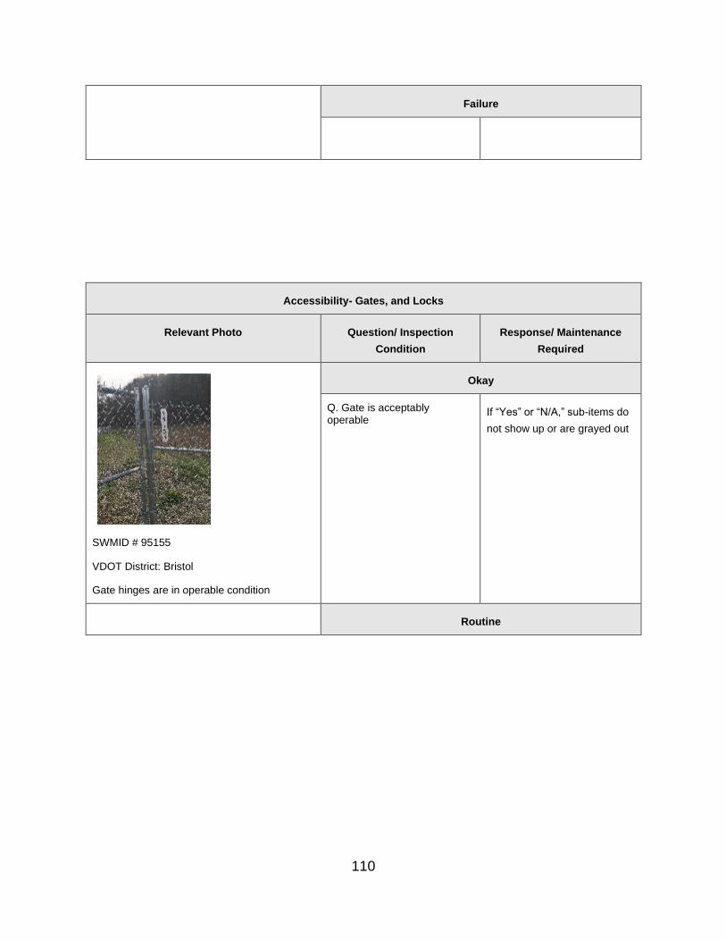
110
Failure
Accessibility- Gates, and Locks
Relevant Photo Question/ Inspection
Condition
Response/ Maintenance
Required
SWMID # 95155
VDOT District: Bristol
Gate hinges are in operable condition
Okay
Q. Gate is acceptably operable
If “Yes” or “N/A,” sub-items do
not show up or are grayed out
Routine

SWMID # 95060
VDOT District: Bristol
Daisy-Chain Locks
Q. Gate supposed to be
locked/secured, but lock
missing or in disrepair,
unauthorized locks in place, or
security system not working.
Helpful Hint: Some Districts
have every gate padlock
keyed to the same key so
they only have to carry one
key with them to open gates
at all BMP locations. Several
copies are made of the key,
in case one is lost or
misplaced. Keys should be
kept at an obvious but
secure location. Another
option is to use combination
locks, all set to the same
combination that is easy for
all involved staff to
remember.
Yes. Remove unauthorized
locks. Daisy-chain locks if
multiple parties have
authorized access. Replace
lock and/or chain if needed.
Q. Access lock, chain requires
minor adjustment
Yes: Lubricate lock(s) and
hinges with approved lubricant
on gates or other access to
ensure proper function. Notify
DIM of other repairs needed.
Q. Gate requires minor
adjustments
Yes: Make minor adjustments
to gate as needed to ensure it
functions properly.
Corrective
Q. Gate locked and no key or
key-code available
Yes: Obtain key or key code
from appropriate VDOT
manager, or obtain a
replacement lock, cut the
existing lock from the gate and
replace it with the new lock.
Q. Gate in disrepair. Yes: Repair or replace gate as
needed to ensure it functions
properly.
Urgent
111

Failure
.
Accessibility – Fences
Relevant Photo Question/ Inspection
Condition
Response/ Maintenance
Required
SWMID # 95030
VDOT District: Bristol
Fence is free of vegetation
Okay
Q. Fence in acceptable condition
If “Yes” or “N/A,” sub-items do
not show up or are grayed out
SWMID # 95030
VDOT District: Salem
Routine
Q. Removal of vegetation,
unapproved signs, etc. and/or
minor adjustments necessary
Yes. Remove all vegetation
and unapproved signs, etc.,
from fence in conjunction with
mowing and string line
trimming operations. Make
minor adjustments to fence as
needed to ensure it functions
properly.
112

Vegetation on fence
Corrective
SWMID # 95030
VDOT District: Bristol
Animal borough under fence
Q. Fence in disrepair or
portions of fence missing
Yes: Repair or replace portions
of fence that are missing or in
disrepair with in-kind materials
and construction, per design
drawings or as directed.
Urgent
Failure
.
Accessibility – Signs
Relevant Photo Question/ Inspection
Condition
Response/ Maintenance
Required
Okay
Q. BMP ID and/or Instructional signs stipulated on plans are
If “Yes” or “N/A,” sub-items do
not show up or are grayed out
113

`
SWMID # 95025
VDOT District: Bristol
present and in good condition; posts are vertical and stable
Routine
Q. BMP ID and/or Instructional
signs missing, damaged,
faded, or unstable
Yes: Repair or reproduce and
replace sign(s), as necessary.
Corrective
Urgent
Failure
Accessibility - Manhole Covers at Initial Access
Relevant Photo Question/ Inspection
Condition
Response/ Maintenance
Required
114

Okay
Q. Manhole covers and inlet grates are in good repair and securely in place
If “Yes” or “N/A,” sub-items do
not show up or are grayed out
Routine
Q. Minor damage to inlet grate
or manhole that does not pose
an immediate risk
Yes: Install orange safety
fence around inlets or
manholes that have missing or
damaged grates or covers,
and report to DIM immediately.
Q. Manhole cover or inlet grate
not securely seated
Yes: Adjust manhole rings as
needed and secure manhole
cover in place.
Corrective
Urgent
Q. Manhole cover or inlet
grate broken or missing
Yes: Safety risk -- replace inlet
grate in-kind, repair and/or
adjust inlet height as needed.
Failure
Accessibility- Graffiti
Relevant Photo Question/ Inspection
Condition
Response/ Maintenance
Required
Okay
Q. Graffiti is absent at this BMP
If “Yes” or “N/A,” sub-items do
not show up or are grayed out
115

Routine
Q. Graffiti observed but not in
public view, has no offensive
language or is not otherwise
undesirable
Yes: Report to DIM if graffiti is
considered offensive or
otherwise undesirable.
Corrective
Q. Graffiti observed that is in
obvious public view, contains
offensive language or is
otherwise undesirable
Yes: Remove or re-paint over
offensive or undesirable graffiti
as directed.
Urgent
Failure
G. Contributing Drainage Area
Contributing Drainage Area- Surface Condition, Trash, and Debris
Relevant Photo Question/ Inspection
Condition
Response/ Maintenance
Required
Okay
116

Q. The contributing drainage
area is stable, well-vegetated,
non-erosive, and free of trash
and debris.
If the answer is Yes or N/A,
additional questions in this
category do not show up or
are grayed out.
SWMID # 177211.2
VDOT District: Salem
Routine
Q. Minor (< 0.25 CY) Yes: Use hand tools to
sediment, debris, or trash remove minor sediment,
accumulated in the channel debris, and trash from
and/or at check dams. channel and/or at check
dams. Replace other erosion
protection as needed; also as
needed, revegetate the CDA
on VDOT property per the
original design and
specifications.
Corrective
Q. Turf grass or other
herbaceous cover in the
immediate CDA has less than
75% coverage, contributing to
erosion in the area and
delivery of sediment to the
BMP.
Yes: Re-establish turf grass in
sparse areas on VDOT
property by properly
preparing seed bed, importing
topsoil as needed, seeding
per permanent seeding and
Roadside Nutrient
Management specifications,
and applying appropriate
RECP matting or other
appropriate mulch, consistent
with VDOT stds and specs
117

VDOT District- Salem
Build-up of sediment and debris in channel.
Q. Excessive (> 0.25 CY)
sediment, debris, or trash
accumulated in the channel
and/or at check dams.
Yes: Remove all accumulated
sediment, trash, and debris
from CDA. Replace other
erosion protection as needed;
also as needed, revegetate
the CDA on VDOT property
per the original design and
specifications.
Urgent
Failure
Contributing Drainage Area- Illicit Discharge
Relevant Photo Question/ Inspection
Condition
Response/ Maintenance
Required
Okay
IDDE Yes or N/A: No further action
required.
118

Q. The BMP area is free of
illicit discharge.
MS4 Outfalls or PODs
Q. There are no MS4 Outfalls or Points of Discharge in the area around the BMP’s outlet.
No: Follow-up questions will be
asked relating to the nature of
the IDDE.
SWMID # 60000804.84
VDOT District: Salem
Routine
MS4 Outfalls or PODs Q. Yes. Collect the GPS
A MS4 Outfall or Point of coordinates of the Outfall or
Discharge is present on POD. Note the presence of the
VDOT property in the area Outfall or POD in the Inventory
of the BMP outlet. data for the BMP and report it to
the Geospatial-GIS Coordinator
in VDOT’s Central Office
Location and Design Division.
Corrective
Urgent
IDDE Yes: Confirm, document and
Q. Illicit discharge observed
flowing into the BMP being
inspected or otherwise onto
the VDOT property and/or
into VDOT drainage
system.
report the illicit discharge to
VDOT IDDE team
(IDDEReports#vdot.virginia.gov)
per the Illicit Discharge
Detection and Elimination
Program Manual and the
associated IDDE Field Guide.
119

VDOT District- Bristol
IDDE – Petroleum run-off from truck side of the rest area I-85.
Q. Illicit discharge observed
flowing from another VDOT
outfall in the immediate
vicinity of this BMP
(ON VDOT PROPERTY
OR ONTO AN ADJACENT
PROPERTY)
Yes: Confirm, document and
report the illicit discharge to
VDOT IDDE team
(IDDEReports#vdot.virginia.gov)
per the Illicit Discharge
Detection and Elimination
Program Manual and the
associated IDDE Field Guide.
Failure
H. Inflow Areas & Inlet Channels – Surface Condition
Inflow Areas & Inlet Channel(s) - Erosion, Sediment, Trash and Debris
Relevant Photo Question/ Inspection
Condition
Response/ Maintenance
Required
Okay
120
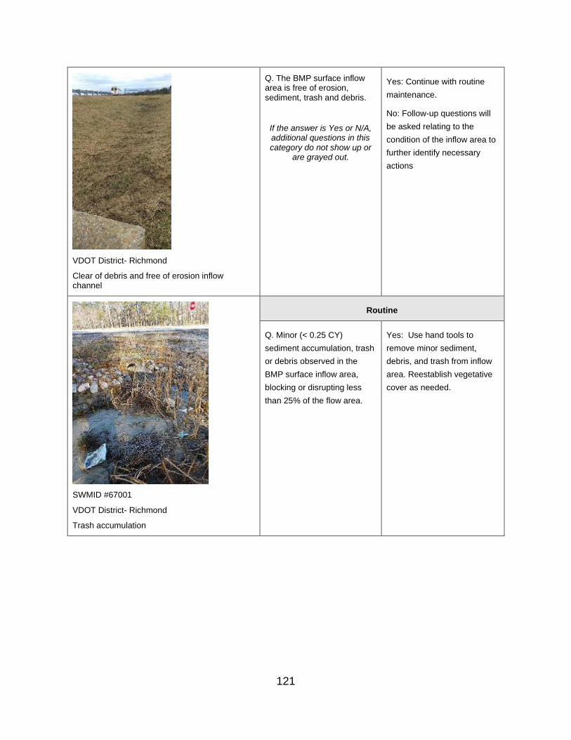
Q. The BMP surface inflow area is free of erosion, sediment, trash and debris.
If the answer is Yes or N/A, additional questions in this category do not show up or
are grayed out.
Yes: Continue with routine
maintenance.
No: Follow-up questions will
be asked relating to the
condition of the inflow area to
further identify necessary
actions
VDOT District- Richmond
Clear of debris and free of erosion inflow channel
Routine
Q. Minor (< 0.25 CY)
sediment accumulation, trash
or debris observed in the
BMP surface inflow area,
blocking or disrupting less
than 25% of the flow area.
Yes: Use hand tools to
remove minor sediment,
debris, and trash from inflow
area. Reestablish vegetative
cover as needed.
SWMID #67001
VDOT District- Richmond
Trash accumulation
121

Q. Minor erosion on channel and/or at check dam(s) that is less than 1 foot deep with no impact on flow or slope stability and can be repaired with up to 10 SY of seed and appropriate RECP matting.
Yes: Repair minor erosion or
scour at sides of inflow pipe
not threatening slope stability.
Backfill eroded areas and
stabilize with topsoil, seed,
mulch and/or RECP matting
as needed, consistent with
VDOT stds & specs or as
otherwise directed.
SWMID# 706872.7
VDOT District- Salem
Erosion on channel
Corrective
Q. Excessive (more than 0.25 Yes: Use hand tools to
CY) erosion, sediment, debris remove sediment, debris, and
or trash accumulated in the trash from the surface inflow
BMP surface inflow area area. Dispose of removed
blocking or disrupting more materials at a proper facility.
than 25% of the flow area. As needed, reconfigure or
reconstruct per original design
or as otherwise directed.
Q. Significant erosion (deeper
than 1 foot or larger than 10
SY) observed on channel
and/or at check dam(s) or
that is blocking or disrupting
flow.
Yes: Repair all erosion in
channel and/or around check
dams with compacted fill and
topsoil per specification or as
otherwise directed. Remove
sediment and return grades to
original design. Reconstruct
check dam(s) per original
design. Stabilize all disturbed
areas with seed, mulch and/or
RECP matting, consistent
with VDOT stds & specs or as
otherwise directed.
122

Q. Excessive erosion that Yes: Repair all erosion in
compromises channel and/or channel and/or at check
dislodges or bypasses check dam(s) with compacted fill
dam(s) or pretreatment. and topsoil per specification
or as otherwise directed.
Remove sediment that
resulted from erosion and
return grades to original
design. Reconstruct check
dam(s) per design. Stabilize
all disturbed areas with
topsoil, seed, mulch and/or
appropriate RECP matting,
consistent with VDOT stds &
specs, or as otherwise
directed. Ensure that flow is
directed into the pretreatment
structure, if one is present.
Urgent
Q. Excessive sediment
accumulation is more than 1
foot deep and exceeds one-
half the height of the check
dam(s).
Yes: Remove accumulated
sediment and properly
dispose of material.
Reconfigure or as needed,
reconstruct check dam(s) per
original design or as
otherwise directed.
Failure
123

Inflow Areas & Inlet Channel(s) - Inflow Area Surface Condition
Relevant Photo Question/ Inspection
Condition
Response/ Maintenance
Required
SWMID # 42026
VDOT District: Richmond
Vegetated Inflow/Inlet Area of a dry detention
pond
Okay
Turf/ Herbaceous Coverage
Q. Turf or other herbaceous vegetation coverage in the inflow area is greater than 75%.
If the answer is Yes or N/A, additional questions in this category do not show up or
are grayed out.
No: Follow-up questions will
be asked relating to the
condition of the inflow area to
further identify necessary
actions
Yes: Continue with routine
maintenance.
N/A: Inflow via enclosed pipe
system.
Landscaping Material
Q. Landscaping plant material (trees, shrubs, ground cover) survival is greater than 75% of design.
No: Follow-up questions will
be asked relating to the
condition of the inflow area to
further identify necessary
actions
Yes: Continue with routine
maintenance.
SWMID# 30004
VDOT District- Culpeper
Greater than 75% survival of landscaping plant material.
N/A: Inflow via enclosed pipe
system.
124
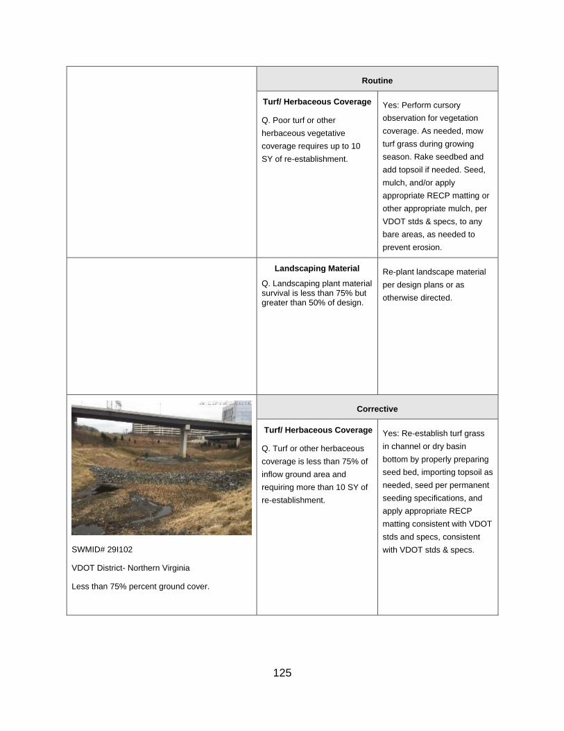
Routine
Turf/ Herbaceous Coverage Yes: Perform cursory
Q. Poor turf or other observation for vegetation
herbaceous vegetative coverage. As needed, mow
coverage requires up to 10 turf grass during growing
SY of re-establishment. season. Rake seedbed and
add topsoil if needed. Seed,
mulch, and/or apply
appropriate RECP matting or
other appropriate mulch, per
VDOT stds & specs, to any
bare areas, as needed to
prevent erosion.
Landscaping Material Re-plant landscape material
Q. Landscaping plant material per design plans or as survival is less than 75% but
otherwise directed. greater than 50% of design.
SWMID# 29I102
VDOT District- Northern Virginia
Less than 75% percent ground cover.
Corrective
Turf/ Herbaceous Coverage
Q. Turf or other herbaceous
coverage is less than 75% of
inflow ground area and
requiring more than 10 SY of
re-establishment.
Yes: Re-establish turf grass
in channel or dry basin
bottom by properly preparing
seed bed, importing topsoil as
needed, seed per permanent
seeding specifications, and
apply appropriate RECP
matting consistent with VDOT
stds and specs, consistent
with VDOT stds & specs.
125
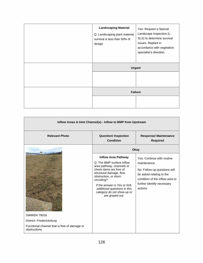
Landscaping Material
Q. Landscaping plant material
survival is less than 50% of
design
Yes: Request a Special
Landscape Inspection (L-
SLS) to determine survival
issues. Replant in
accordance with vegetation
specialist’s direction.
Urgent
Failure
Inflow Areas & Inlet Channel(s) - Inflow to BMP from Upstream
Relevant Photo Question/ Inspection
Condition
Response/ Maintenance
Required
Okay
Inflow Area Pathway
Q. The BMP surface inflow area pathway, channels or check dams are free of structural damage, flow obstruction, or short-circuiting?
If the answer is Yes or N/A, additional questions in this category do not show up or
are grayed out.
Yes: Continue with routine
maintenance.
No: Follow-up questions will
be asked relating to the
condition of the inflow area to
further identify necessary
actions
SWMID# 79016
District- Fredericksburg
Functional channel that is free of damage or obstructions
126

SWMID#15016
VDOT District- Lynchburg
BMP inflow pipe free of structural damages or obstructions.
Inflow Area Pipe
Q. The BMP surface inflow area pipes discharging into the BMP are free of structural damage or obstruction
If the answer is Yes or N/A, additional questions in this category do not show up or
are grayed out.
Yes: Continue with routine
maintenance.
No: Follow-up questions will
be asked relating to the
condition of the inflow area to
further identify necessary
actions
SWMID # 81021
District- Staunton
A properly functioning level spreader.
Level Spreader
Q. Level Spreader is level
and functioning properly,
discharging as sheet flow
across the entire surface
If the answer is Yes or N/A,
additional questions in this
category do not show up or
are grayed out.
Yes: Continue with routine
maintenance.
No: Follow-up questions will
be asked relating to the
condition of the inflow area to
further identify necessary
actions
N/A: Inflow via enclosed pipe
system or clear where CDA is
located.
Routine
Inflow Area Pathway
Q. Minor flow obstruction,
damage or disrepair to
channel and/or at check
dams that do not impact flow
or stability and can be
repaired without importing
material or re-constructing
channel.
Yes: Remove obstruction
and properly dispose of
obstruction materials. Mow
channel, as needed. Repair
minor damage or disrepair to
channel and/or check dams.
SWMID# 02015
VDOT District- Culpeper
Leaf debris in channel.
127
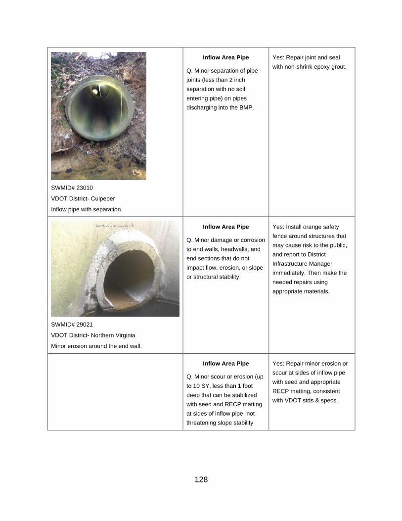
Inflow Area Pipe
Q. Minor separation of pipe
joints (less than 2 inch
separation with no soil
entering pipe) on pipes
discharging into the BMP.
Yes: Repair joint and seal
with non-shrink epoxy grout.
SWMID# 23010
VDOT District- Culpeper
Inflow pipe with separation.
Inflow Area Pipe
Q. Minor damage or corrosion
to end walls, headwalls, and
end sections that do not
impact flow, erosion, or slope
or structural stability.
Yes: Install orange safety
fence around structures that
may cause risk to the public,
and report to District
Infrastructure Manager
immediately. Then make the
needed repairs using
appropriate materials.
SWMID# 29021
VDOT District- Northern Virginia
Minor erosion around the end wall.
Inflow Area Pipe
Q. Minor scour or erosion (up
to 10 SY, less than 1 foot
deep that can be stabilized
with seed and RECP matting
at sides of inflow pipe, not
threatening slope stability
Yes: Repair minor erosion or
scour at sides of inflow pipe
with seed and appropriate
RECP matting, consistent
with VDOT stds & specs.
128

Inflow Area Pipe
Q. Scour, erosion, or
displacement of erosion
control protection less than 1
foot deep at inflow to the
BMP that does not impact the
pipe or slope stability and can
be repaired with up to 10 SY
seed and RECP matting
and/or by re-setting existing
riprap
Yes: Repair minor scour or
erosion at sides of inflow pipe
with seed and appropriate
RECP matting and/or by re-
setting riprap, consistent with
VDOT stds & specs.
Level Spreader
Q. Level Spreader plunge
pool has stone displaced
Yes: Move and replace stone
in plunge pool, as necessary,
and configure per original
design or as otherwise
directed.
Level Spreader
Q. Level Spreader plunge
pool clogged with sediment
Yes: Remove stone and
accumulated sediment from
plunge pool and properly
dispose of sediment material.
Clean and replace stone in
plunge pool and configure per
original design or as
otherwise directed.
SWMID# 29084
VDOT District- Northern Virginia
Inflow pipe flow is obstructed.
Corrective
Inflow Area Pathway
Q. Excessive flow
obstruction, damage or
disrepair to channel and/or at
check dams that may impact
flow or stability or requires
imported material or re-
construction
Yes: Remove obstruction and
properly dispose of materials.
Repair channel and/or check
dams to restore consistency
with original design drawings
or as otherwise directed.
129

Inflow Area Pipe Yes: Remove and reset or
Q. Excessive separation of
pipe joints (less than 2 -inch
separation but with soil
entering pipe) on pipes
discharging into the BMP
replace sections of pipe that
have issues. Ensure pipe
bedding is stable and
compacted and that pipe
joints are properly sealed with
non-shrink epoxy grout.
Inflow Area Pipe Yes: Remove and reset,
Q. End walls, headwalls, &
end sections failed, deflected,
or corroded, causing erosion,
slope failure, or impeding flow
on less than 25% of pipe or
inflow area
repair or replace end wall,
headwall, or end section.
Ensure subgrade is stable
and compacted and that the
pipe is properly sealed to the
structure with non-shrink
epoxy grout.
SWMID# 7005830.9
VDOT District- Salem
Scour hole erosion at inlet area.
Inflow Area Pipe
Q. Significant scour or
erosion (greater than 10 SY
or 1 foot deep or requiring
riprap) at sides of inflow pipe
that is impacting slope
stability or is undermining the
inflow pipe
Yes: Repair scour or erosion
by excavating and armoring
with riprap on top of approved
geotextile. If beneath pipe,
remove and reset pipe onto
compacted subgrade, as
needed, and armor at outlet
with riprap on top of approved
geotextile. Ensure that pipe
joints are properly sealed with
non-shrink epoxy grout.
Inflow Area Pipe
Q. Scour, erosion, or
displacement of erosion
control protection at inflow to
the BMP greater than 1 foot
deep or that requires
supplemental riprap
Yes: Repair erosion by
undercutting, compacting fill
as needed, and replacing
erosion control protection with
riprap (in-kind) or more
effective and robust materials.
Level Spreader
Q. Level Spreader lip broken
or otherwise not level,
allowing concentrated flow to
form
Yes: Repair or replace
elements of Level Spreader,
as needed, and ensure
finished condition is
consistent with original design
to ensure that discharge from
the device is only in sheet
flow.
130

Level Spreader
Q. Flow bypassing Level
Spreader around ends,
allowing concentrated flow to
form
Yes: Repair or replace
elements of Level Spreader,
as needed, and ensure
finished condition is
consistent with original design
to ensure that discharge from
the device is only in sheet
flow.
SWMID# 76103
Urgent
Inflow Area Pipe
Q. Significant separation,
failure, corrosion or collapse
of pipe joints on pipes
discharging into the BMP
(greater than 2 inch joint gaps
with soil entering pipe, or less
than 25% pipe of flow area
blocked)
Yes: Remove and reset or
replace sections of pipe that
have issues. Ensure pipe
bedding is stable and
compacted and that pipe
joints are properly sealed with
non-shrink epoxy grout.
VDOT District- Northern Virginia
Significant joint separation at inlet.
Inflow Area Pipe Yes: Remove and reset or
Q. Inflow storm drains
collapsed, blocking more than
25% of pipe or inflow area;
pipes corroded with holes;
joint separation with clear
separation of pipe sections,
or otherwise major damage
replace sections of pipe that
have issues. Ensure pipe
bedding is stable and
compacted and that pipe
joints are properly sealed with
non-shrink epoxy grout.
131

Inflow Area Pipe
Q. End walls, headwalls, &
end sections failed, deflected,
or corroded, causing erosion,
slope failure, impeding flow
on greater than 25% of pipe
or inflow area or causing
active discharge of sediment.
Yes: Remove and reset,
repair or replace end wall,
headwall, or end section.
Ensure subgrade is stable
and compacted and that pipe
joints are properly sealed with
non-shrink epoxy grout.
Failure
I. Forebay and Pretreatment Options
Forebay and Pretreatment Options – Pretreatment in Proper Location
Relevant Photo Question/ Inspection
Condition
Response/ Maintenance
Required
VDOT District- Northern Virginia
Properly functioning forebay.
Okay
Q. Forebay or other pre-treatment device shown on plans is present in proper location and properly functioning.
If the answer is Yes or N/A,
additional questions in this
category do not show up or
are grayed out
Routine
Q. Forebay or pre-treatment
device does not conform to
As-Built plans.
Notify DIM or the Inspector’s
manager, if different from the
As-Built plans, for direction. If
it is determined that the
inconsistent elements do not
diminish the functionality of
the BMP, document this
132

decision in the comment box
for future reference.
Corrective
Urgent
Q. Forebay or other pre-
treatment device shown on
plans is not present, never
constructed
Yes: Notify DME and DHE for
further direction. If it is
determined that the pre-
treatment will not or cannot be
constructed for this BMP,
document this decision in the
comment box for future
reference.
Forebay has collapsed and/or
deteriorated to the point that it
is no longer functional.
Yes: Clean out and restore
the forebay to its original
design; stabilize the ground
surface with appropriate
vegetation and as needed,
RECP matting, consistent with
VDOT standards and
specifications.
Failure
Forebay and Pretreatment Options – Erosion, Sediment, Trash and Debris
Relevant Photo Question/ Inspection
Condition
Response/ Maintenance
Required
Okay
133

Sediment, Debris, and Trash
Q. The forebay or other pretreatment device is free of sediment, trash, debris or obstruction.
If the answer is Yes or N/A,
additional questions in this
category do not show up or
are grayed out.
Erosion
Q. The area in or around the forebay or other pre-treatment device is free of erosion
If the answer is Yes or N/A,
additional questions in this
category do not show up or
are grayed out.
Routine
Sediment, Debris, and Trash
Q. Minor (less than 0.25 CY)
sediment, debris, or trash
observed in forebay or other
pre-treatment device.
Yes: If accessible, use hand
tools to remove minor
sediment, debris, and trash
from forebay or pre-treatment
area; restore to original
design capacity; reset or
remove and replace riprap or
other erosion protection, as
needed.
Erosion
Q. Minor erosion in or around
the forebay or other pre-
treatment device less than 1
foot deep with no impact on
flow or slope stability and can
be repaired with up to 10 SY
seed and RECP matting
Yes. Repair minor erosion in
forebay or other pre-treatment
device with seed and
appropriate RECP matting,
consistent with VDOT
standards & specifications.
Corrective
134

SWMID# 53035
VDOT District- Northern Virginia
Excessive sediment accumulation in the forebay.
Forebay/ Pre-treatment Device
Q. Excessive (greater than
0.25 CY) sediment, debris, or
trash accumulated in forebay
or other pre-treatment device,
especially if approaching
maximum sediment capacity.
Yes: Remove all accumulated
sediment, trash, and debris
from forebay or other pre-
treatment area; restore to
original design capacity; re-
set or remove and replace
riprap or other erosion
protection, as needed.
Forebay/ Pre-treatment Device
Q. Gravel diaphragm stone dislodged or displaced
Yes: Replace or add proper stone as needed and reset gravel diaphragm correctly, consistent with the plans.
Erosion Yes: Repair all erosion in
SWMID# 290092
VDOT District- Northern Virginia
Excessive erosion around the forebay spillway.
Q. Excessive (deeper than 1
foot or larger than 10 SY)
erosion observed in or around
the forebay or other pre-
treatment device or that is
blocking, diverting, or
disrupting flow
forebay or other pre-treatment
area with compacted fill and
topsoil per specification or as
otherwise directed. Remove
sediment that resulted from
erosion to return grades to
original design. Stabilize all
disturbed areas with seed and
appropriate RECP matting,
consistent with VDOT
standards & specifications.
Urgent
Failure
J. Impoundment-Treatment Area
Impoundment / Treatment Area – Erosion, Sediment, Trash and Debris
Relevant Photo Question/ Inspection
Condition
Response/ Maintenance
Required
135

SWMID# 29067
VDOT District- Northern Virginia
BMP Impoundment area in good condition.
Okay
Trash/ Debris
Q. BMP impoundment (water storage/treatment) bottom area and shoreline are free of trash or debris
Trash/Debris, Erosion,
Sediment
Yes: Follow-up questions will
be asked relating to the
condition of the pond/basin
area to further identify
necessary actions
Erosion
Q. The non-pool area of the BMP bottom, excavated side slopes and shoreline are free of erosion
Sediment Accumulation
Q. The non-pool area of the BMP bottom, Dry Detention Basin pilot channel, excavated side slopes and shoreline are free of sediment accumulation
If the answer is Yes, additional questions in this category do not show up or
are grayed out.
Routine
Trash/Debris
Q. Minor (up to 0.25 CY)
debris or trash accumulated in
the BMP bottom or on
shoreline that is not blocking
or disrupting flow
Trash/Debris
Yes: If accessible, use hand
tools to remove minor (up to
0.25 CY) debris, and trash
from BMP bottom or on
shoreline
SWMID# 29027
VDOT District- Northern Virginia
Erosion in the non-pool areas of the BMP.
Erosion
Q. Minor erosion in the non-
pool area of the BMP bottom,
excavated side slopes and
shoreline bottom that is less
than 1 foot deep with no
impact on flow or slope
stability and can be repaired
with up to10 SY seed and
RECP matting
Erosion
Yes: Repair up to 10 SY
minor erosion in basin
bottom with seed and
appropriate RECP matting,
consistent with VDOT stds &
specs.
136

Sediment Accumulation
Q. Minor (up to 0.25 CY)
sediment observed in the non-
pool area of the BMP bottom,
Dry Detention Basin pilot
channel, excavated side
slopes and shoreline that is
not blocking or disrupting flow
Sediment Accumulation
Yes: Use hand tools to
remove minor (sediment from
basin bottom area, Dry
Detention Basin pilot
channel, excavated side
slopes and/or shoreline.
SWMID# 45002
VDOT District- Staunton
Shale sediment accumulation in BMP bottom.
SWMID# 81014
VDOT District- Staunton
Accumulation of debris on BMP shoreline.
Corrective
Trash/Debris
Q. Excessive (more than 0.25
CY) trash or debris observed
in BMP bottom or on shoreline
or that is blocking or
disrupting flow
Trash/Debris
Yes: Remove accumulated
trash and debris from basin
bottom and/or shoreline.
SWMID# 71036
VDOT District- Lynchburg
Eroded banks of BMP basin.
Erosion
Q. Excessive erosion (deeper
than 1 foot or area larger than
10 SY) observed in the non-
pool area of the BMP bottom,
excavated side slopes and
shoreline and/or that is
blocking or disrupting flow
Erosion
Yes: Repair all erosion in
basin bottom, side slopes
and/or shoreline with
compacted fill and topsoil per
specification or as directed.
Remove sediment that
resulted from erosion to
return grades to original
design. Stabilize all disturbed
areas with seed and
appropriate RECP matting
consistent with VDOT stds &
specs, or as otherwise
directed.
137

Sediment Accumulation Sediment Accumulation
Q. Excessive (more than 0.25 Yes: Remove accumulated
CY) sediment observed in the sediment. Reconstruct per
non-pool area of the BMP original design or as directed.
bottom, Dry Detention Basin Stabilize all disturbed areas
pilot channel, excavated side with seed and appropriate
slopes and/or shoreline or that RECP matting per VDOT
is blocking or disrupting flow stds & specs.
Urgent
Sediment Accumulation
Q. Significant sediment
observed (fills more than 50%
of BMP’s design depth) that is
diminishing water storage
volume
Sediment Accumulation
Yes: Remove accumulated
sediment from BMP storage
area. Reconstruct per
original design or as
otherwise directed. Stabilize
all disturbed areas with seed
and RECP matting per VDOT
stds & specs.
Failure
Impoundment/ Treatment Area – Vegetation
Relevant Photo Question/ Inspection
Condition
Response/ Maintenance
Required
Okay
Herbaceous Cover
Q. The non-pool area of the BMP bottom area and on the basin’s excavated side slopes and shoreline has greater than
If the answer is Yes,
additional questions in this
category do not show up or
are grayed out.
138

SWMID #10010
VDOT District- Bristol
A properly vegetated dry detention basin.
75% coverage of turf or other herbaceous vegetation
No: Follow-up questions will be asked relating to the condition of the pond/basin area to further identify necessary actions
Native Herbaceous – Pollinator Cover
Q. Native Herbaceous and/or Pollinator Vegetative Cover was mowed once in the past year during the dormant season.
Undesirable Vegetation
Q. The BMP bottom, excavated side slopes and shoreline are free of undesirable or invasive vegetation
Overgrown Vegetation
Q. The non-pool area of the BMP bottom area, excavated side slopes and shoreline are free of overgrown vegetation
SWMID# 76161
VDOT District- Northern Virginia
Lack of vegetative cover on side slopes.
Routine
Herbaceous Cover
Q. Poor vegetative cover in
non-pool area of BMP bottom,
excavated side slopes and
shoreline, requiring up to 10
SY of re-establishment
Yes: Note and continue to
observe in Dry or Extended
Detention Basin bottom or
side slopes. Mow turf grass
during growing season.
Rake seedbed, add topsoil if
needed, re-seed and apply
appropriate RECP matting
to any bare areas,
consistent with VDOT stds &
specs.
139
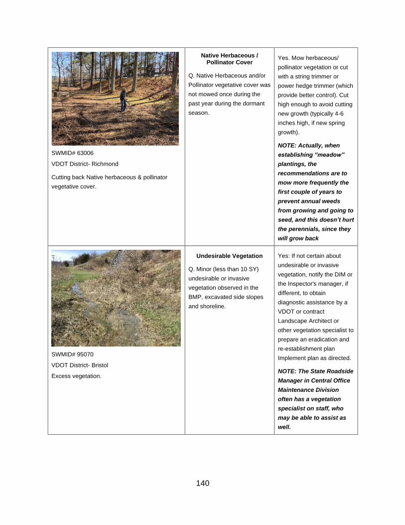
SWMID# 63006
VDOT District- Richmond
Cutting back Native herbaceous & pollinator
vegetative cover.
Native Herbaceous / Pollinator Cover
Q. Native Herbaceous and/or
Pollinator vegetative cover was
not mowed once during the
past year during the dormant
season.
Yes. Mow herbaceous/
pollinator vegetation or cut
with a string trimmer or
power hedge trimmer (which
provide better control). Cut
high enough to avoid cutting
new growth (typically 4-6
inches high, if new spring
growth).
NOTE: Actually, when
establishing “meadow”
plantings, the
recommendations are to
mow more frequently the
first couple of years to
prevent annual weeds
from growing and going to
seed, and this doesn’t hurt
the perennials, since they
will grow back
SWMID# 95070
VDOT District- Bristol
Excess vegetation.
Undesirable Vegetation
Q. Minor (less than 10 SY)
undesirable or invasive
vegetation observed in the
BMP, excavated side slopes
and shoreline.
Yes: If not certain about
undesirable or invasive
vegetation, notify the DIM or
the Inspector's manager, if
different, to obtain
diagnostic assistance by a
VDOT or contract
Landscape Architect or
other vegetation specialist to
prepare an eradication and
re-establishment plan
Implement plan as directed.
NOTE: The State Roadside
Manager in Central Office
Maintenance Division
often has a vegetation
specialist on staff, who
may be able to assist as
well.
140

Overgrown Vegetation
Q. Minor overgrown vegetation
(less than 24 inches tall, with
no woody vegetation)
observed in non-pool area of
BMP bottom area and/or on
the BMP’s excavated side
slopes and shoreline
Yes: Mow vegetation in non-
pool area of basin bottom,
side slopes and shoreline
during growing season per
plan, specifications, or as
otherwise directed.
SWMID # 30012
VDOT District- Culpeper
Excess woody vegetation (including fallen trees) in the BMP impoundment area.
141

SWMID #65002
VDOT District- Hampton Roads
Corrective
Herbaceous Cover
Q. Vegetative cover is less
than 75% of BMP bottom area,
excavated side slopes and
shoreline, requiring more than
10 SY of re-establishment
Yes: Re-establish vegetative
cover in BMP bottom area,
side slopes, and/or shoreline
by properly preparing seed
bed, importing topsoil as
needed, seeding per
permanent seeding
specifications, and applying
appropriate RECP matting,
consistent with VDOT stds &
specs and stapled per detail.
Sparsely vegetated detention basin
Undesirable Vegetation
Q. Excessive (greater than 10
SY) undesirable or invasive
vegetation observed in the
BMP, excavated side slopes
and shoreline
Yes: If not certain about
undesirable or invasive
vegetation, notify the DIM or
the Inspector’s manager, if
different to obtain diagnostic
assistance by a staff or
contract Landscape
Architect or other vegetation
specialist to prepare an
eradication and re-
establishment plan.
Implement plan as directed.
NOTE: The State Roadside
Manager in Central Office
Maintenance Division
often has a vegetation
specialist on staff, who
may be able to assist as
well.
142

Overgrown Vegetation
Q. Excessive overgrown
vegetation (taller than 24"
growth and/or woody)
observed in non-pool area of
BMP bottom area and/or on
the BMP’s excavated side
slopes and shoreline
Yes: Mow or use a brush
cutter to clear overgrown
vegetation in non-pool area
of basin bottom, side slopes
and shoreline during
growing season per plan,
specifications, or as
otherwise directed. Also
remove woody vegetation
from the entire bottom of a
Dry Detention Basin.
Properly dispose of the
vegetative waste.
Urgent
Failure
Impoundment/ Treatment Area – Presence of Geese or Other Waterfowl
Relevant Photo Question/ Inspection
Condition
Response/ Maintenance
Required
Okay
Presence of Waterfowl
Q. Geese or other waterfowl are not present at the BMP.
NOTE: Waterfowl congregating at BMPs, particularly ponds, introduce bacteria into the drainage, which can ultimately pollute the downstream receiving waters. This is particularly troublesome in a watershed where a
If the answer is Yes or N/A, additional questions in this category do not show up or
are grayed out.
No: Follow-up questions will
be asked relating to the
condition of the pond/basin
area to further identify
necessary actions
143

TMDL for bacteria has been established, especially if VDOT has been assigned a waste load allocation for bacteria.
Q. Waterfowl or wildlife are not observed inside BMP enclosure (fence, netting, etc.)
Netting Support Structure
Q. Netting support structure is properly configured, upright and sturdy.
Perimeter Netting Condition
Q. Perimeter netting is gaps, holes and breeching by waterfowl or wildlife.
Bird Netting Condition
Q. Overhead bird netting is free of gaps, holes, sagging and debris.
Routine
Presence of Waterfowl Yes: Note and continue to
Q. A few Geese or other monitor site for Geese and
waterfowl are observed in the waterfowl. If the numbers
area of the BMP, but no increase or nests are
nests are detected. detected, raise rating to
CORRECTIVE status.
Q. Waterfowl or wildlife are observed inside BMP enclosure (fence, netting, etc.)
Yes. Provide an opening in
the perimeter fence or
netting and herd waterfowl
and/or wildlife to the outside
of the fenced area; then
securely close the opening
to block wildlife re-entry.
144

Netting Support Structure
Q. Support posts are not vertical and/or not properly tensioned.
Yes: Straighten support
posts and secure in a
vertical position by re-
tightening and/or re-
anchoring support posts.
Q. Anchor cables and/or suspended cables are not taut.
Yes. Re-tighten and, if
necessary, re-anchor
support posts.
Perimeter Netting Condition
Q. Perimeter fence or netting has gaps, holes and/or breeching by waterfowl or other wildlife.
Yes. Repair any gaps or
holes in side fence/netting.
Block any breeched areas,
ensuring that all waterfowl
and/or wildlife present are
moved outside the
enclosure.
Bird Netting Condition
Q. Overhead bird netting
is observed to have gaps,
holes, sagging and/or
debris.
Yes. Repair any gaps or
holes in the overhead bird
netting. Re-tighten the
overhead netting to correct
sagging. Remove any
debris on overhead netting
and properly dispose of it.
Corrective
Q. Many Geese or other Yes: Notify the DIM to
waterfowl are observed obtain diagnostic assistance
regularly in the area of the and to develop a Corrective
BMP and nesting sites may Action Plan. Implement
be present or nearby. Corrective Action Plan, as
directed.
NOTE: Refer to APPENDIX
E in the VDOT BMP
Inspection and
Maintenance Manual for
options to discourage
geese and waterfowl
presence.
145

Urgent
Failure
Vegetation – Constructed Wetlands (for Constructed Wetlands only)
Relevant Photo Question/ Inspection
Condition
Response/ Maintenance
Required
Okay
Q. Wetland vegetation appears to be thriving.
If the answer is Yes, additional questions in this category do not show up or
are grayed out
No: Follow-up questions will
be asked relating to the
condition of the pond/basin
area to further identify
necessary actions
Routine
Q. Less than 40% of wetland
vegetation present appears
to be unhealthy, dying or
dead.
Yes: Note and photo-
document this condition in
the inspection report and
continue to monitor the
condition of the wetland
plants; elevate to
CORRECTIVE status if
condition worsens.
Corrective
146

Q. More than 40% of
wetland vegetation present
appears to be unhealthy,
dying or dead.
Yes: Notify the DIM or the
Inspector’s manager, if
different, to obtain diagnostic
assistance by a staff or
contract Landscape
Architect or Wetlands
Specialist to consult and
develop a Corrective Action
Plan; implement Corrective
Action Plan as directed.
Urgent
Failure
Impoundment/ Treatment Area – Structural Damage (for Dry Detention Basins Only)
Relevant Photo Question/ Inspection Condition Response/ Maintenance Required
Okay
Q. The Dry Detention Basin pilot channel is free of damage
If the answer is Yes, additional
questions in this category do not
show up or are grayed out
No: Follow-up questions will be
asked relating to the condition of the
pond/basin area to further identify
necessary actions
Routine
Q. Minor damage or disrepair to
pilot channel that does not impact
flow or stability and can be repaired
without importing material or re-
constructing channel
Yes: Mow pilot channel and edges
in conjunction with Dry Basin
maintenance. Repair minor damage
to pilot channel.
147
Corrective
Q. Excessive damage or disrepair
to pilot channel that may impact
flow or stability or requires imported
material or re-construction
Yes: Repair pilot channel to reflect
original design drawings or as
otherwise directed.
Urgent
Failure
Impoundment/ Treatment Area – Standing Water (for Dry of Extended Detention Basins only)
Relevant Photo Question/ Inspection Condition Response/ Maintenance
Required
SWMID #10010
VDOT District- Bristol
Dry detention basin free of standing water.
Okay
Q. The Dry or Extended Detention Basin is free of standing water (with no rainfall within the past 72 hours)
If the answer is Yes,
additional questions in this
category do not show up or
are grayed out
No: Follow-up questions will
be asked relating to the
condition of the pond/basin
area to further identify
necessary actions
Routine
148
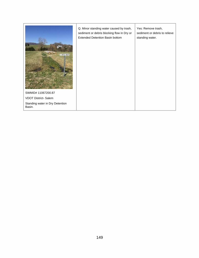
Q. Minor standing water caused by trash, Yes: Remove trash,
sediment or debris blocking flow in Dry or sediment or debris to relieve
Extended Detention Basin bottom standing water.
SWMID# 11067200.87
VDOT District- Salem
Standing water in Dry Detention Basin.
149

SWMID# 84005
VDOT District- Bristol
Extended Detention basin with >2 feet of standing water.
Corrective
Q. Standing water in Dry or
Extended Detention Basin not
caused by clogged low flow,
trash, sediment/debris, or
other circumstances restricting
discharge from basin
Yes: If not certain of the
cause or appropriate
maintenance needs, notify
the DIM or the inspector’s
manager, if different, to
obtain diagnostic assistance
and develop a corrective
action plan. Implement
corrective action plan as
directed.
NOTE: Resolution options
may include reclassifying
basin type (ED, Wet Pond,
Wetland, etc.), retiring the
basin to purchase
replacement pollution
credits, or converting
basin to one of these
types.
Urgent
Failure
150
Impoundment/ Treatment Area – Permanent Pool
Relevant Photo Question/ Inspection Condition Response/ Maintenance Required
Okay
Q. Permanent pool level appears to be consistent with design elevation (from plans)
If the answer is Yes, additional questions in this category do not
show up or are grayed out.
No: Follow-up questions will be
asked relating to the condition of the
pond/basin area to further identify
necessary actions
Routine
Q. Permanent pool level appears to
be above design elevation (with no
rainfall within the past 72 hours),
due to an obstructed low flow
orifice.
Yes: Clear obstruction from low flow
orifice.
Corrective
Q. Permanent pool level appears
below design elevation
Yes: If not certain of the cause or
appropriate maintenance needs,
notify the DIM or the Inspector’s
manager, if different, to obtain
diagnostic assistance and to
develop a corrective action plan.
Implement corrective action plan as
directed.
Urgent
Failure
151

Impoundment/ Treatment Area - Trash or Debris
Relevant Photo Question/ Inspection Condition Response/ Maintenance
Required
SWMID #01013
VDOT District- Hampton Roads
Infiltration BMP that is free of trash and debris
Okay
Q. The filter or infiltration bed (water storage/treatment) surface and side slopes are free of trash and debris
If the answer is Yes, additional questions in this category do not show up or
are grayed out.
No: Follow-up questions will
be asked relating to the
condition of the pond/basin
area to further identify
necessary actions
Routine
Q. Minor (up to 0.25 CY) trash or debris
observed on filter or infiltration bed
surface (water storage/treatment area) or
on side slopes that is not blocking or
disrupting flow
Yes: Use hand tools to
remove minor debris and
trash (from BMP treatment
area and side slopes.
Corrective
Q. Excessive (more than 0.25 CY) trash
or debris observed on filter or infiltration
bed (water storage/treatment area)
surface or on side slopes that is blocking
or disrupting flow
Yes: Remove accumulated
trash and debris from BMP
treatment area and side
slopes.
Urgent
Failure
152

Impoundment/ Treatment Area- Filter Bed Mulch and Vegetation
Relevant Photo Question/ Inspection
Condition
Response/ Maintenance
Required
SWMID# 29190
VDOT District- Northern Virginia
Filterra Box that is properly vegetated and in good working condition.
Okay
Filter Bed Condition
Q. Filter bed mulch appears to be in acceptable condition and correct depth
NOTE: Mulch unnecessary beyond 2nd year of BMP life, except for Tree Box Filters (e.g., Filterra, Focal Point, etc.)
If the answer is Yes,
additional questions in this
category do not show up or
are grayed out.
No: Follow-up questions will be asked relating to the condition of the pond/basin area to further identify necessary actions
Herbaceous Cover
Q. Filter bed is designed to have turf or other herbaceous vegetative cover, and the coverage is greater than 90% of area intended to be vegetated
Landscaping Plant Material
Q. Landscaping plant material survival is greater than 90% of design
Undesirable Vegetation
Q. The filter bed is free of undesirable or invasive vegetation
Overgrown Vegetation
Q. The filter bed is free of overgrown vegetation
Routine
153
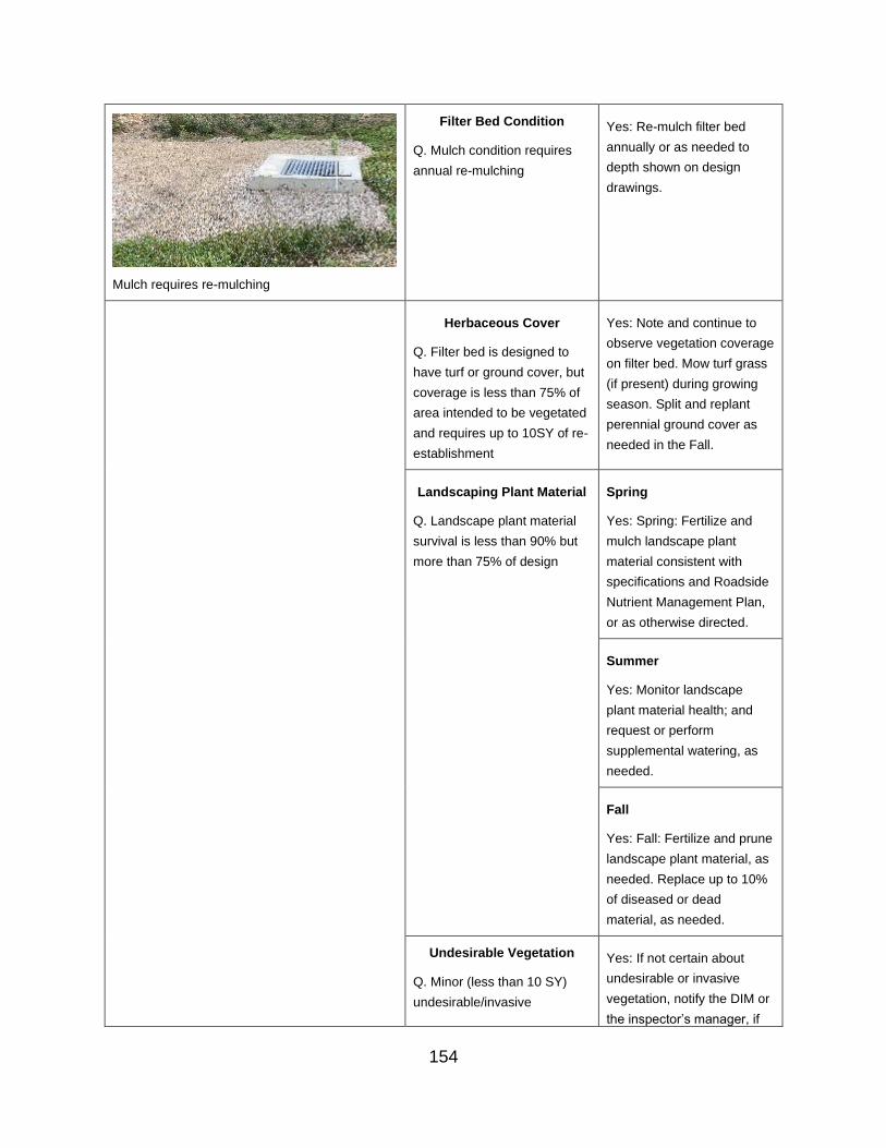
Mulch requires re-mulching
Filter Bed Condition
Q. Mulch condition requires
annual re-mulching
Yes: Re-mulch filter bed
annually or as needed to
depth shown on design
drawings.
Herbaceous Cover
Q. Filter bed is designed to
have turf or ground cover, but
coverage is less than 75% of
area intended to be vegetated
and requires up to 10SY of re-
establishment
Yes: Note and continue to
observe vegetation coverage
on filter bed. Mow turf grass
(if present) during growing
season. Split and replant
perennial ground cover as
needed in the Fall.
Landscaping Plant Material
Q. Landscape plant material
survival is less than 90% but
more than 75% of design
Spring
Yes: Spring: Fertilize and
mulch landscape plant
material consistent with
specifications and Roadside
Nutrient Management Plan,
or as otherwise directed.
Summer
Yes: Monitor landscape
plant material health; and
request or perform
supplemental watering, as
needed.
Fall
Yes: Fall: Fertilize and prune
landscape plant material, as
needed. Replace up to 10%
of diseased or dead
material, as needed.
Undesirable Vegetation Yes: If not certain about
Q. Minor (less than 10 SY) undesirable or invasive
undesirable/invasive vegetation, notify the DIM or
the inspector’s manager, if
154

vegetation observed on filter
bed
different, to obtain diagnostic
assistance from a VDOT or
contract Landscape
Architect or other vegetation
specialist. Remove
undesirable or invasive
vegetation by hand weeding
(including roots) or treatment
with herbicide, as directed.
NOTE: The State Roadside
Manager in Central Office
Maintenance Division
often has a vegetation
specialist on staff, who
may be able to assist as
well.
Overgrown Vegetation Yes: Weed by hand or, if turf
Q. Minor overgrown grass, mow filter bed (during
vegetation (less than 24” tall, growing season consistent
no woody vegetation) with original plan and
observed on the filter bed specifications, or as
otherwise directed.
SWMID# 76164
VDOT District- Northern Virginia
Mulch requires re-mulching
Corrective
Filter Bed Condition
Q. Mulch is missing or is
deeper than specified in the
design plans
Yes: Re-mulch if needed.
Remove mulch to conform to
design depth, if needed.
Herbaceous Cover Yes: In the Fall, re-establish
Q: Filter bed is designed to
have turf or ground cover, but
coverage is less than 75% of
area intended to be vegetated
turf grass or groundcover to
100% of area intended to be
vegetated, consistent with
original design specifications
or as otherwise directed.
155

and requires more than 10 SY
re-establishment
Landscaping Plant Material
Q. Landscape plant material
survival is less than 75% but
more than 50% of design
Yes: Re-plant landscape
material per design plans or
re-establish vegetative cover
as directed.
Q. Landscape plant material
survival is less than 50% of
design
Yes: Notify the DIM or the
Inspector’s manager, if
different, to obtain diagnostic
assistance by a staff or
contract Landscape
Architect or other vegetation
specialist. Re-establish
vegetative cover in
accordance with direction
from landscape professional
or other up-line manager.
NOTE: The State Roadside
Manager in Central Office
Maintenance Division
often has a vegetation
specialist on staff, who
may be able to assist as
well.
Overgrown Vegetation
Q. Excessive overgrown
vegetation (taller than 24”
growth and/or woody
vegetation present) observed
on the filter bed
Yes: Weed by hand or, if turf
grass, mow overgrown
vegetation on filter bed per
original plan and
specifications, or as
otherwise directed.
Urgent
Failure
156

Impoundment/ Treatment Area Media - Erosion, Sediment, Sinkholes and Standing Water
Relevant Photo Question/ Inspection
Condition
Response/ Maintenance
Required
Okay
Erosion
Q. The filter bed is free of erosion (due to the force of flowing water, not from sinking or a sinkhole)
If the answer is Yes,
additional questions in this
category do not show up or
are grayed out.
No: Follow-up questions will be asked relating to the condition of the pond/basin area to further identify necessary actions
.
.
Sediment/Oil Accumulation
Q. The surface of the filter bed is free of sediment or oil accumulation
Test Pits
Q. Test pit(s) (NOTE: See Appendix D) in filter bed show(s) only minimal or no sediment accumulation in filter media profile (no deeper than 1 inch below surface)
Surface Depression
Q. The filter bed is free of surface depressions or sinkholes
Standing Water
Q. The filter bed is free of standing water (with no rainfall within the past 72 hours).
Cleanouts
Q. Cleanouts or observation wells appear to be in acceptable condition and operating properly
157

Routine
Erosion Yes: Repair minor erosion on
Q. Minor erosion on filter bed
that is less than 1 inch deep
with no impact on flow or
slope stability and can be
repaired with up to 10 SY
seed and RECP matting.
filter media with in-kind filter
media materials, including
supplementing mulch, if
present, and/or appropriate
RECP matting, if needed,
consistent with VDOT stds &
specs.
Sediment/Oil Accumulation Yes: Use hand tools to
Q. Minor sediment or oil remove minor sediment or oil
accumulation (up to 0.25 CY) accumulation from surface of
observed on filter bed that is filter bed. Rake entire filter
not blocking or disrupting flow bed surface to ensure even
flow distribution throughout
media surface.
Test Pits
Q. Test pit(s) (NOTE: See
Appendix D) in filter bed
shows minor sediment (up to
3 inches below surface) in
filter media profile
NOTE: Test pits are
typically used only when
there are indications of
media clogging, such as
standing water on the
surface of the filter bed.
Yes: Use hand tools to
remove filter media
discolored by sediment from
filter media profile. Replace
removed filter media with in-
kind materials. Rake entire
filter bed surface to ensure
even flow distribution
throughout media surface.
Surface Depression
Q. Minor sinking or sinkhole
(less than 6 inches deep and
1 SY) that has no impact on
flow or slope stability nor is it
at a cleanout or structure
Yes: Repair minor sinking of
filter media by adding in-kind
filter media materials
including mulch, if present.
Monitor sinking area. If
sinking continues, elevate
Rating to CORRECTIVE
status.
158
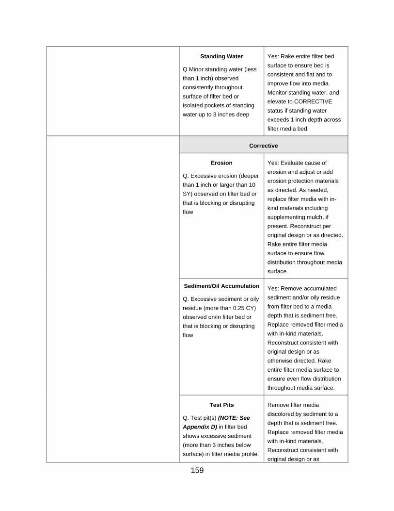
Standing Water Yes: Rake entire filter bed
Q Minor standing water (less
than 1 inch) observed
consistently throughout
surface of filter bed or
isolated pockets of standing
water up to 3 inches deep
surface to ensure bed is
consistent and flat and to
improve flow into media.
Monitor standing water, and
elevate to CORRECTIVE
status if standing water
exceeds 1 inch depth across
filter media bed.
Corrective
Erosion
Q. Excessive erosion (deeper
than 1 inch or larger than 10
SY) observed on filter bed or
that is blocking or disrupting
flow
Yes: Evaluate cause of
erosion and adjust or add
erosion protection materials
as directed. As needed,
replace filter media with in-
kind materials including
supplementing mulch, if
present. Reconstruct per
original design or as directed.
Rake entire filter media
surface to ensure flow
distribution throughout media
surface.
Sediment/Oil Accumulation
Q. Excessive sediment or oily
residue (more than 0.25 CY)
observed on/in filter bed or
that is blocking or disrupting
flow
Yes: Remove accumulated
sediment and/or oily residue
from filter bed to a media
depth that is sediment free.
Replace removed filter media
with in-kind materials.
Reconstruct consistent with
original design or as
otherwise directed. Rake
entire filter media surface to
ensure even flow distribution
throughout media surface.
Test Pits Remove filter media
Q. Test pit(s) (NOTE: See
Appendix D) in filter bed
shows excessive sediment
(more than 3 inches below
surface) in filter media profile.
discolored by sediment to a
depth that is sediment free.
Replace removed filter media
with in-kind materials.
Reconstruct consistent with
original design or as
159

NOTE: Test pits are
typically used only when
there are indications of
media clogging, such as
standing water on the
surface of the filter bed.
otherwise directed. Rake
entire filter media surface to
ensure even flow distribution
throughout media surface.
Surface Depression
Q. Excessive sinking (deeper
than 6 inches or larger than 1
SY) observed on filter bed;
any sinking at a cleanout or
structure, or sinking that is
blocking or disrupting flow
Yes: Excavate all filter media
and other material layers in
the area of the sinking to
determine the cause of the
sinking. Excavate, clean and
reinstall all underdrain stone
that has filter media present.
Clean out downstream
structures or pipes to ensure
positive flow. Replace filter
media and other material
layers with in-kind materials
including mulch, if present.
Re-plant or replace plant
material, if applicable, as
directed.
Standing Water
Q. Excessive standing water
(greater than 1 inch)
observed consistently
throughout surface of filter
bed.
Yes: If not certain of the
cause or appropriate
maintenance needs, notify
the DIM or the Inspector’s
manager, if different, to
obtain diagnostic assistance
and to develop a corrective
action plan. Analysis should
include a test pit
investigation, evaluation of
flow capacity through soil
media and all other layers,
and verification that the
underdrain is perforated and
functioning correctly.
Implement corrective action
plan as directed.
Cleanouts Yes: Replace missing or
damaged cleanout or
observation well caps.
160

Q. Cleanout or observation
well caps missing or
damaged
Cleanouts
Q. Cleanout or observation
well pipe damaged
Yes: Repair cleanout or
observation well pipe.
Cleanouts
Q. Cleanouts or observation
wells are obstructed
Yes: Remove obstruction
from cleanouts or observation
wells.
Urgent
Surface Depression
Q. Significant failure of the
filter bed resulting in active
loss of filter media into
underdrain or that impacts
adjacent structures or
pavement
Yes: Excavate all filter media
and other material layers in
the area of the sinking to
determine the cause of the
sink. Excavate, clean and
replace all underdrain stone
that has filter media present.
Clean out or, if broken,
replace underdrain and
downstream structures or
pipes to ensure positive flow.
Replace filter media and
other material layers with in-
kind materials including
mulch, if present. If
applicable, re-plant or replace
plant materials.
Failure
161

Impoundment/ Treatment Area - Permeable Pavement - Material Stockpiles
Relevant Photo Question/ Inspection Condition Response/ Maintenance Required
Okay
Q. Pavement surface and immediate surrounding area free of material stockpiles (salt, sand, gravel, soil, etc.)
If the answer is Yes, additional questions in this category do not
show up or are grayed out
No: Follow-up questions will be asked relating to the condition of the pond/basin area to further identify necessary actions
Routine
Corrective
Q. Material stockpiles (salt, sand,
gravel, soil, etc.) on pavement
surface and/or surface of immediate
surrounding area
Yes. Remove stockpiled material to
an appropriate alternative storage
location and vacuum sweep the
surface where the material had
been stockpiled, if on the pavement
surface.
Urgent
Failure
162

Impoundment/ Treatment Area - Permeable Pavement - Damage from Vegetation or Roots
Relevant Photo Question/ Inspection Condition Response/ Maintenance
Required
SWMID# 80FR29700.4A
VDOT District- Salem
Area adjacent to the pavement is free
of exposed soil, distressed
vegetation, and root damage.
Okay
Area Adjacent to Pavement
Q. The drainage area immediately adjacent to the pavement/pavers is free of exposed soil, distressed vegetation or root damage
If the answer is Yes,
additional questions in this
category do not show up or
are grayed out
No: Follow-up questions will be asked relating to the condition of the pond/basin area to further identify necessary actions
Routine
Corrective
Q. Unspecified vegetation or moss
observed in spaces between pavers or on
pavement/paver surface
Yes: Remove or treat
vegetation or moss and
underlying sediment with
pesticide and remove
sediment in crevices of
pavers to prevent recurrence.
Restore fine stone between
pavers with in-kind materials,
consistent with original plans.
Q. Distressed or dead vegetation Yes: Replace distressed or
observed adjacent to pavement dead vegetation. If vegetation
continues to be distressed,
notify DIM or Inspector’s
manager, if different, to
obtain diagnostic assistance
by a VDOT or contract
Landscape Architect or other
vegetation specialist to
develop a corrective action
163
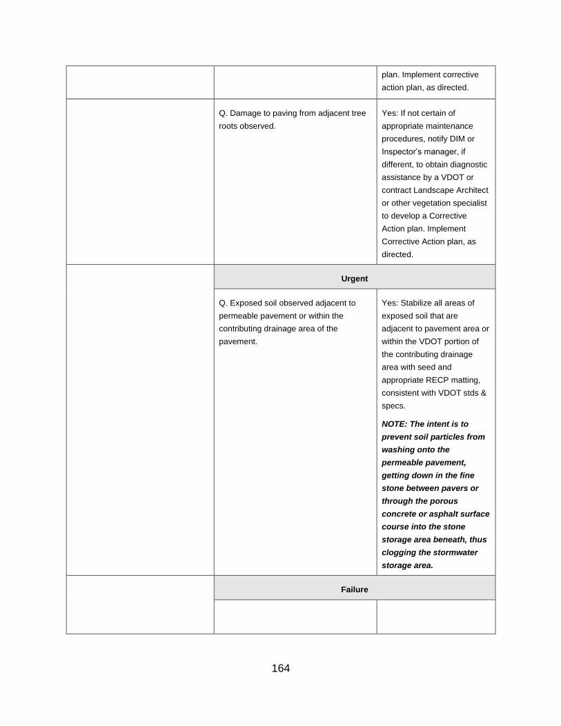
plan. Implement corrective
action plan, as directed.
Q. Damage to paving from adjacent tree
roots observed.
Yes: If not certain of
appropriate maintenance
procedures, notify DIM or
Inspector’s manager, if
different, to obtain diagnostic
assistance by a VDOT or
contract Landscape Architect
or other vegetation specialist
to develop a Corrective
Action plan. Implement
Corrective Action plan, as
directed.
Urgent
Q. Exposed soil observed adjacent to
permeable pavement or within the
contributing drainage area of the
pavement.
Yes: Stabilize all areas of
exposed soil that are
adjacent to pavement area or
within the VDOT portion of
the contributing drainage
area with seed and
appropriate RECP matting,
consistent with VDOT stds &
specs.
NOTE: The intent is to
prevent soil particles from
washing onto the
permeable pavement,
getting down in the fine
stone between pavers or
through the porous
concrete or asphalt surface
course into the stone
storage area beneath, thus
clogging the stormwater
storage area.
Failure
164

Permeable Pavement - Structural Concerns
Relevant Photo Question/ Inspection
Condition
Response/ Maintenance
Required
Okay
Q. The permeable pavement/pavers is free of spalling, cracking or improper pavement sealer
If the answer is Yes, additional questions in this category do not show up or
are grayed out
No: Follow-up questions will be asked relating to the condition of the pond/basin area to further identify necessary actions
Routine
Corrective
Q. Minor spalling or cracking
of pavement surface
observed (less than 10% of
pavement surface area)
Yes: Repair by patching or
replacing portions of
pavement with in-kind
materials, consistent with
original plans. Continue to
monitor cracking or spalling
of pavement surface.
Urgent
Q. Excessive spalling or
cracking of pavement surface
(greater than 10% of
pavement surface)
Yes: If not certain of
appropriate maintenance
needs, notify the DIM or the
inspector’s manager, if
different, to obtain diagnostic
assistance and to develop a
corrective action plan.
165
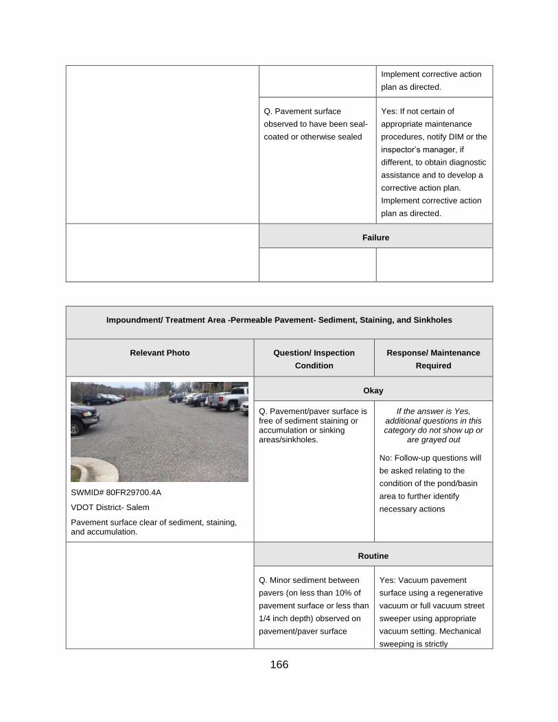
Implement corrective action
plan as directed.
Q. Pavement surface
observed to have been seal-
coated or otherwise sealed
Yes: If not certain of
appropriate maintenance
procedures, notify DIM or the
inspector’s manager, if
different, to obtain diagnostic
assistance and to develop a
corrective action plan.
Implement corrective action
plan as directed.
Failure
Impoundment/ Treatment Area -Permeable Pavement- Sediment, Staining, and Sinkholes
Relevant Photo Question/ Inspection
Condition
Response/ Maintenance
Required
SWMID# 80FR29700.4A
VDOT District- Salem
Pavement surface clear of sediment, staining, and accumulation.
Okay
Q. Pavement/paver surface is free of sediment staining or accumulation or sinking areas/sinkholes.
If the answer is Yes, additional questions in this category do not show up or
are grayed out
No: Follow-up questions will
be asked relating to the
condition of the pond/basin
area to further identify
necessary actions
Routine
Q. Minor sediment between Yes: Vacuum pavement
pavers (on less than 10% of surface using a regenerative
pavement surface or less than vacuum or full vacuum street
1/4 inch depth) observed on sweeper using appropriate
pavement/paver surface vacuum setting. Mechanical
sweeping is strictly
166
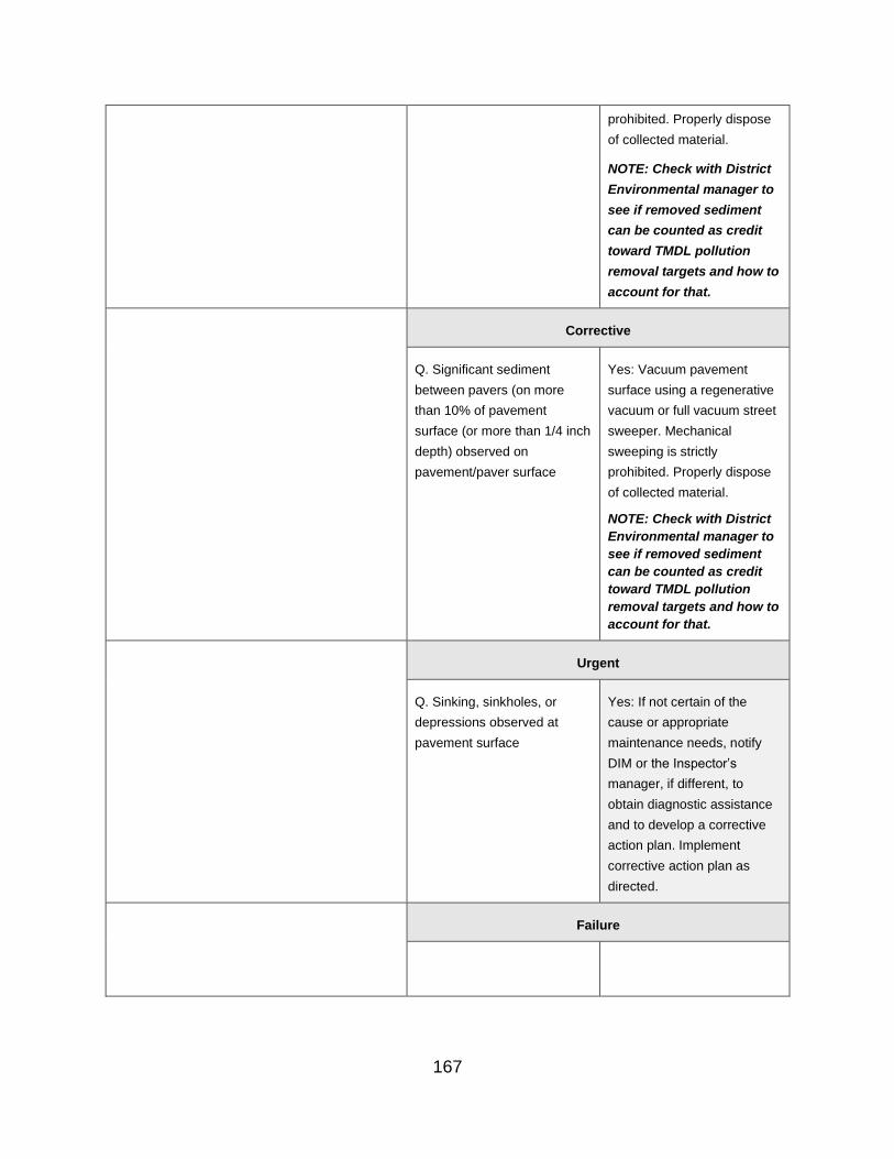
prohibited. Properly dispose
of collected material.
NOTE: Check with District
Environmental manager to
see if removed sediment
can be counted as credit
toward TMDL pollution
removal targets and how to
account for that.
Corrective
Q. Significant sediment
between pavers (on more
than 10% of pavement
surface (or more than 1/4 inch
depth) observed on
pavement/paver surface
Yes: Vacuum pavement
surface using a regenerative
vacuum or full vacuum street
sweeper. Mechanical
sweeping is strictly
prohibited. Properly dispose
of collected material.
NOTE: Check with District
Environmental manager to
see if removed sediment
can be counted as credit
toward TMDL pollution
removal targets and how to
account for that.
Urgent
Q. Sinking, sinkholes, or
depressions observed at
pavement surface
Yes: If not certain of the
cause or appropriate
maintenance needs, notify
DIM or the Inspector’s
manager, if different, to
obtain diagnostic assistance
and to develop a corrective
action plan. Implement
corrective action plan as
directed.
Failure
167
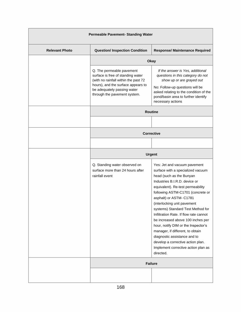
Permeable Pavement- Standing Water
Relevant Photo Question/ Inspection Condition Response/ Maintenance Required
Okay
Q. The permeable pavement
surface is free of standing water
(with no rainfall within the past 72
hours), and the surface appears to
be adequately passing water
through the pavement system.
If the answer is Yes, additional
questions in this category do not
show up or are grayed out
No: Follow-up questions will be
asked relating to the condition of the
pond/basin area to further identify
necessary actions
Routine
Corrective
Urgent
Q. Standing water observed on
surface more than 24 hours after
rainfall event
Yes: Jet and vacuum pavement
surface with a specialized vacuum
head (such as the Bunyan
Industries B.I.R.D. device or
equivalent). Re-test permeability
following ASTM-C1701 (concrete or
asphalt) or ASTM- C1781
(interlocking unit pavement
systems) Standard Test Method for
Infiltration Rate. If flow rate cannot
be increased above 100 inches per
hour, notify DIM or the Inspector’s
manager, if different, to obtain
diagnostic assistance and to
develop a corrective action plan.
Implement corrective action plan as
directed.
Failure
168

Permeable Pavement- Drainage System
Relevant Photo Question/ Inspection Condition Response/ Maintenance Required
Okay
Q. All overflows, piping, or hydraulic controls appear to be functioning as designed
If the answer is Yes, additional
questions in this category do not
show up or are grayed out
No: Follow-up questions will be
asked relating to the condition of the
pond/basin area to further identify
necessary actions
Routine
Corrective
Q. Observation wells damaged Yes: Repair or replace observation
wells as needed.
Q. Water observed in observation
wells 72 hours or more after the last
rainfall event
Yes: If not certain of the cause of
the problem or the appropriate
maintenance needs, notify the DIM
or the Inspector’s manager, if
different, to obtain diagnostic
assistance and to develop a
corrective action plan. Implement
corrective action plan as directed.
Q. Surface overflow structures,
subsurface piping or hydraulic
control components missing or not
functioning as intended
Yes: Install, replace, or repair
surface overflow structures,
subsurface piping or hydraulic
controls as directed. Replace any
pavement removed during these
repairs with in-kind materials,
consistent with original plans.
Q. Surface overflow structures,
subsurface piping or hydraulic
controls observed to have sediment
and/or debris in them
Yes: Clean sediment and debris
from surface overflow structures,
subsurface piping or hydraulic
169

controls as needed to ensure they
continue to function as designed.
Q. Corrosion observed on surface
overflow structures, subsurface
piping or hydraulic controls
Yes: Repair corrosion and recoat or
re-paint metal components of
surface overflow structures,
subsurface piping or hydraulic
controls.
Q. Damage observed to surface
overflow structures, subsurface
piping or hydraulic controls
Yes: Repair damaged surface
overflow structures, subsurface
piping or hydraulic controls as
directed.
Urgent
Failure
K. Control Structure (Principal Spillway)
Control Structure- Vegetation
Relevant Photo Question/ Inspection
Condition
Response/ Maintenance
Required
Okay
Q. The area within 25’ of the Control Structure is free of woody or excessive vegetation
If the answer is Yes, additional questions in this category do not show up or
are grayed out
No: Follow-up questions will be asked relating to the condition of the pond/basin area to further identify necessary actions.
170

SWMID #10010
VDOT District- Bristol
Area surrounding the control structure is free of woody or excess vegetation.
Routine
Q. Minor woody (less than 2
inch diameter) or other
vegetation (mowable) not on
the original design observed
within 25 feet of Control
Structure
Yes: Mow and cut vegetation
within 25 feet of control
structure and not on the
original design, in conjunction
with other vegetation
maintenance.
SWMID# 97020
VDOT District- Bristol
Minor woody vegetation within the control structure.
Corrective
Q. Significant (greater than 2
inch diameter) woody or
other vegetation (requiring
clearing) not on the original
design observed within 25
feet of Control Structure
Yes: Clear vegetation thicker
than 2 inches in diameter
and/or not part of the original
design within 25 feet of
control structure.
SWMID# 00I008
VDOT District- Northern Virginia
Excessive woody vegetation within 25’ of structure.
Urgent
Failure
171

Control Structure- Manhole Access
Relevant Photo Question/ Inspection
Condition
Response/ Maintenance
Required
SWMID# 53089
VDOT District- Northern Virginia
Manhole cover in good condition.
Okay
Q. Control Structure manhole ladder/steps, cover and/or access door appear to be present, secure, and operational without damage
If the answer is Yes, additional questions in this category do not
show up or are grayed out
No: Follow-up questions will be
asked relating to the condition
of the pond/basin area to further
identify necessary actions.
SWMID# 29I069
VDOT District- Northern Virginia
Damaged manhole cover.
Routine
Q. Manhole cover or access
door observed with minor
damage or operability issues
but is still functional
Yes: Note and continue to
monitor manhole cover or door
issue on control structure;
elevate to CORRECTIVE or
URGENT status if condition
worsens.
Corrective
172
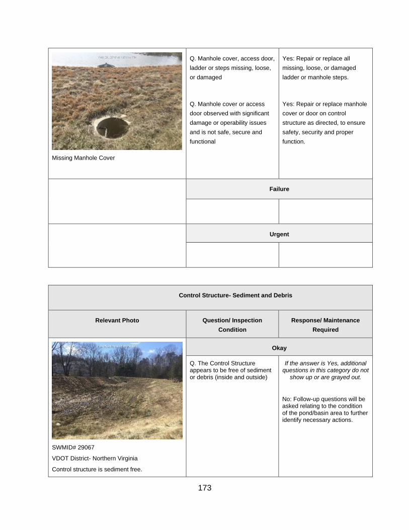
Missing Manhole Cover
Q. Manhole cover, access door,
ladder or steps missing, loose,
or damaged
Q. Manhole cover or access
door observed with significant
damage or operability issues
and is not safe, secure and
functional
Yes: Repair or replace all
missing, loose, or damaged
ladder or manhole steps.
Yes: Repair or replace manhole
cover or door on control
structure as directed, to ensure
safety, security and proper
function.
Failure
Urgent
Control Structure- Sediment and Debris
Relevant Photo Question/ Inspection
Condition
Response/ Maintenance
Required
SWMID# 29067
VDOT District- Northern Virginia
Control structure is sediment free.
Okay
Q. The Control Structure appears to be free of sediment or debris (inside and outside)
If the answer is Yes, additional questions in this category do not
show up or are grayed out.
No: Follow-up questions will be asked relating to the condition of the pond/basin area to further identify necessary actions.
173

SWMID # 95020
VDOT District: Bristol
Sediment and debris accumulation.
Routine
Q. Minor sediment or debris (up
to 0.25 CY) observed in Control
Structure that is not blocking or
disrupting flow
Yes: Use hand tools to remove
sediment or debris from control
structure.
Corrective
SWMID# 45002
VDOT District- Staunton
Excessive sediment accumulation.
Q. Excessive sediment or
debris (more than 0.25 CY)
observed in Control Structure
or that is blocking or disrupting
flow
Yes: Remove accumulated
sediment or debris from control
structure.
Urgent
Failure
174

Control Structure- Structural Issues
Relevant Photo Question/ Inspection
Condition
Response/ Maintenance
Required
SWMID# 9903
VDOT District- Hampton Roads
Metal trash/debris rack free of rust and corrosion.
Okay
Rust/ Corrosion
Q. The metal features of the Control Structure are free of rust/corrosion
If the answer is Yes, additional
questions in this category do
not show up or are grayed out
No: Follow-up questions will be asked relating to the condition of the pond/basin area to further identify necessary actions.
Spalling
Q. Concrete on the Control Structure is free of spalling
Seepage
Q. Control Structure joints appear to be water-tight, with no visible leaks
Structural Issues
Q. The Control Structure appears to have no structural deficiencies or concerns
Routine
Rust/ Corrosion
Q. Minor rust/corrosion
observed on the metal of the
Control Structure that can be
recoated and does not pose a
risk of failure or other danger
Yes: Recoat corrosion on
control structure with a
bituminous coating or as
otherwise directed.
SWMID# 29145
VDOT District- Northern Virginia
Rust and corrosion observed on metal pipe.
175

Spalling
Q. Minor spalling of concrete
observed that does not pose an
immediate risk of failure or
other danger
Yes: Repair spalling on control
structure with appropriate grout
or as otherwise directed. If
parging (i.e., sealing or re-
coating) is not feasible for an
effective repair, elevate to
CORRECTIVE status.
SWMID# 29017
VDOT District- Northern Virginia
Minor spalling on outfall structure.
Seepage
Q. Minor seepage observed at
Control Structure joint(s)
Yes: Note and continue to
monitor seepage; if the seepage
worsens, elevate to URGENT
status and notify the DIM or the
inspector’s manager, if different,
to obtain diagnostic assistance
to and to develop a Corrective
Action Plan. Implement the
Corrective Action Plan as
directed.
VDOT District- Staunton
Joint seepage.
Structural Issues
Q. Minor structural issues
observed that can be parged
(i.e., sealed or recoated)
Yes: Parge (i.e. seal or re-coat)
applicable portions of the
Control Structure.
SWMID# 29125
VDOT District- Northern Virginia
176
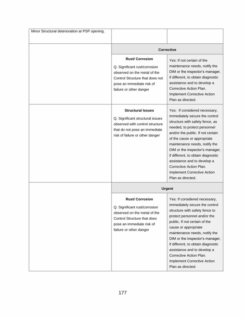
Minor Structural deterioration at PSP opening.
Corrective
Rust/ Corrosion
Q. Significant rust/corrosion
observed on the metal of the
Control Structure that does not
pose an immediate risk of
failure or other danger
Yes: If not certain of the
maintenance needs, notify the
DIM or the inspector’s manager,
if different, to obtain diagnostic
assistance and to develop a
Corrective Action Plan.
Implement Corrective Action
Plan as directed.
Structural Issues
Q. Significant structural issues
observed with control structure
that do not pose an immediate
risk of failure or other danger
Yes: If considered necessary,
immediately secure the control
structure with safety fence, as
needed, to protect personnel
and/or the public. If not certain
of the cause or appropriate
maintenance needs, notify the
DIM or the inspector’s manager,
if different, to obtain diagnostic
assistance and to develop a
Corrective Action Plan.
Implement Corrective Action
Plan as directed.
Urgent
Rust/ Corrosion
Q. Significant rust/corrosion
observed on the metal of the
Control Structure that does
pose an immediate risk of
failure or other danger
Yes: If considered necessary,
immediately secure the control
structure with safety fence to
protect personnel and/or the
public. If not certain of the
cause or appropriate
maintenance needs, notify the
DIM or the inspector’s manager,
if different, to obtain diagnostic
assistance and to develop a
Corrective Action Plan.
Implement Corrective Action
Plan as directed.
177

Spalling
Q. Significant spalling observed
with control structure that does
pose an immediate risk of
failure or other danger
Yes: If considered necessary,
immediately secure the control
structure with safety fence to
protect personnel and/or the
public. If not certain of the
cause or appropriate
maintenance needs, notify the
DIM or the inspector’s manager,
if different, to obtain diagnostic
assistance and to develop a
Corrective Action Plan.
Implement Corrective Action
Plan as directed.
Seepage
Q. Observable flow from control
Structure joint(s)
Yes: Parge (seal) Control
Structure joint leaks with grout,
as directed.
SWMID# 29145
VDOT District- Northern Virginia
Rust and corrosion observed on metal pipe.
Structural Issues
Q. Significant structural issues
observed with control structure
that does pose an immediate
risk of failure or other danger
Yes: If considered necessary,
immediately secure the control
structure with safety fence to
protect personnel and/or the
public. If not certain of the
cause or appropriate
maintenance needs, notify the
DIM or the inspector’s manager,
if different, to obtain diagnostic
assistance and to develop a
Corrective Action Plan.
Implement Corrective Action
Plan as directed.
Failure
Control Structure- Valves
Relevant Photo Question/ Inspection Condition Response/ Maintenance Required
178

VDOT District- Staunton
Control valve
Okay
Q. BMP control or drain valve appears to be undamaged and functional
If the answer is Yes, additional questions in this category do not
show up or are grayed out.
No: Follow-up questions will be asked relating to the condition of the pond/basin area to further identify necessary actions.
Routine
Corrective
Q: BMP control or drain valve
appears to be frozen closed or has
minor leaks (less than a rate that will
dewater the facility)
Yes: Repair or replace pond control
valve, as needed, to ensure proper
function.
Urgent
Q. BMP control or drain valve leaks
at a rate that will dewater the facility
Yes: Repair or replace pond control
valve, as needed, to ensure proper
function.
Failure
Low-Flow Orifice
179
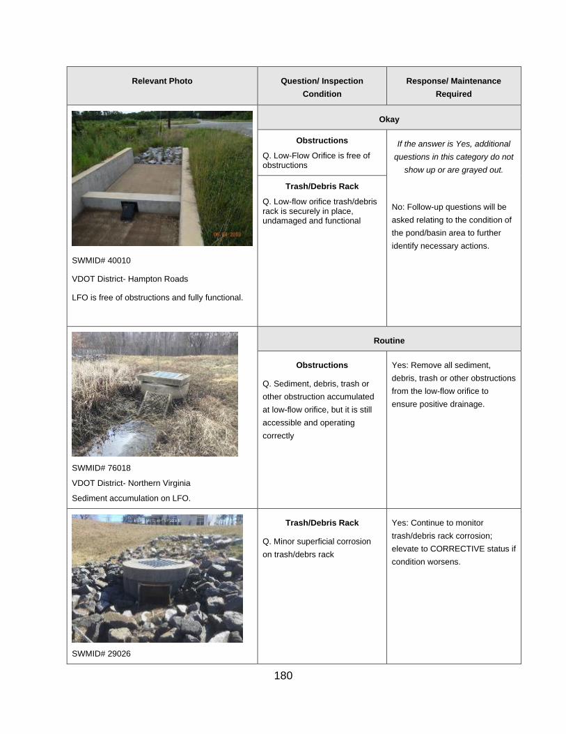
Relevant Photo Question/ Inspection
Condition
Response/ Maintenance
Required
SWMID# 40010
VDOT District- Hampton Roads
LFO is free of obstructions and fully functional.
Okay
Obstructions
Q. Low-Flow Orifice is free of obstructions
If the answer is Yes, additional
questions in this category do not
show up or are grayed out.
No: Follow-up questions will be
asked relating to the condition of
the pond/basin area to further
identify necessary actions.
Trash/Debris Rack
Q. Low-flow orifice trash/debris rack is securely in place, undamaged and functional
Routine
Obstructions
Q. Sediment, debris, trash or
other obstruction accumulated
at low-flow orifice, but it is still
accessible and operating
correctly
Yes: Remove all sediment,
debris, trash or other obstructions
from the low-flow orifice to
ensure positive drainage.
SWMID# 76018
VDOT District- Northern Virginia
Sediment accumulation on LFO.
SWMID# 29026
Trash/Debris Rack
Q. Minor superficial corrosion
on trash/debrs rack
Yes: Continue to monitor
trash/debris rack corrosion;
elevate to CORRECTIVE status if
condition worsens.
180
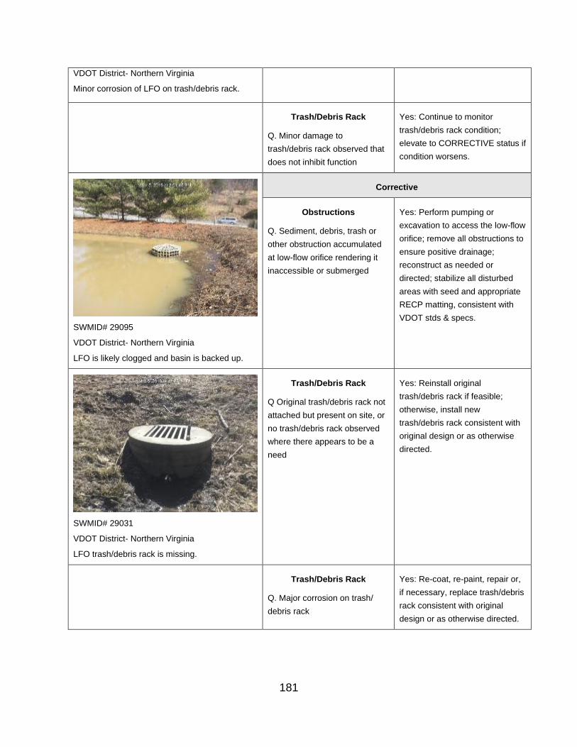
VDOT District- Northern Virginia
Minor corrosion of LFO on trash/debris rack.
Trash/Debris Rack
Q. Minor damage to
trash/debris rack observed that
does not inhibit function
Yes: Continue to monitor
trash/debris rack condition;
elevate to CORRECTIVE status if
condition worsens.
SWMID# 29095
VDOT District- Northern Virginia
LFO is likely clogged and basin is backed up.
Corrective
Obstructions
Q. Sediment, debris, trash or
other obstruction accumulated
at low-flow orifice rendering it
inaccessible or submerged
Yes: Perform pumping or
excavation to access the low-flow
orifice; remove all obstructions to
ensure positive drainage;
reconstruct as needed or
directed; stabilize all disturbed
areas with seed and appropriate
RECP matting, consistent with
VDOT stds & specs.
Trash/Debris Rack
Q Original trash/debris rack not
attached but present on site, or
no trash/debris rack observed
where there appears to be a
need
Yes: Reinstall original
trash/debris rack if feasible;
otherwise, install new
trash/debris rack consistent with
original design or as otherwise
directed.
SWMID# 29031
VDOT District- Northern Virginia
LFO trash/debris rack is missing.
Trash/Debris Rack
Q. Major corrosion on trash/
debris rack
Yes: Re-coat, re-paint, repair or,
if necessary, replace trash/debris
rack consistent with original
design or as otherwise directed.
181

SWMID# 29I013
VDOT District- Northern Virginia
LFO trash/debris rack is no longer attached to the structure.
Trash/Debris Rack
Q. Damage to trash/debris rack
observed that does impact
function
Yes: Repair or replace
trash/debris rack consistent with
original design or as otherwise
directed.
Urgent
Failure
High-Flow Orifice
Relevant Photo Question/ Inspection
Condition
Response/ Maintenance
Required
Okay
Obstructions
182

SWMID# 76I061
VDOT District- Northern Virginia
High-flow orifice is free of obstructions and functional and anti-vortex device is in place and secure.
Q. High-Flow Orifice is free of obstructions If the answer is Yes, additional
questions in this category do
not show up or are grayed out
No: Follow-up questions will be asked relating to the condition of the pond/basin area to further identify necessary actions.
Trash/Debris Rack
Q. High-flow orifice trash/debris rack is securely in place, undamaged and functional
Anti-Vortex Device
Q. Anti-vortex device securely in place, in acceptable condition, and functioning correctly
Routine
Obstructions
Q. Sediment, debris, trash or
other obstruction accumulated
at high-flow orifice, but it is still
accessible and operating
correctly
Yes: Remove all sediment,
debris, trash or other
obstructions from the high-flow
orifice to ensure positive
drainage.
SWMID# 53013
VDOT District- Northern Virginia
High flow orifice grate with minor debris
accumulation.
183

Trash/Debris Rack
Q. Minor superficial corrosion on
trash/debris rack
Yes: Continue to monitor
trash/debris rack corrosion;
elevate to CORRECTIVE status
if condition worsens.
VDOT District- Staunton
Trash/debris rack with minor corrosion.
Trash/Debris Rack
Q. Minor damage to trash/debris
rack observed that does not
inhibit function
Yes: Continue to monitor
trash/debris rack condition;
elevate to CORRECTIVE status
if condition worsens.
SWMID# 82046
VDOT District- Staunton
High flow orifice is obstructed by vegetation.
Corrective
Obstructions
Q. Sediment, debris, trash or
other obstruction accumulated
at high-flow orifice rendering it
inaccessible or submerged
Yes: Perform pumping or
excavation to access the high-
flow orifice; remove all
obstructions to ensure positive
drainage; reconstruct as
needed or directed; stabilize all
disturbed areas with seed and
appropriate RECP matting,
consistent with VDOT stds &
specs.
184

Trash/Debris Rack
Q. Original trash/debris rack not
attached but present on site, or
no trash/debris rack observed
where there appears to be a
need
Yes: Reinstall original
trash/debris rack if feasible;
otherwise, install new
trash/debris rack consistent
with original design or as
otherwise directed.
SWMID# 52125
VDOT District- Bristol
Trash/Debris rack is missing.
Trash/Debris Rack
Q. Major corrosion on
trash/debris rack
Yes: Re-coat, re-paint, repair
or, if needed, replace
trash/debris rack consistent
with original design or as
otherwise directed.
185
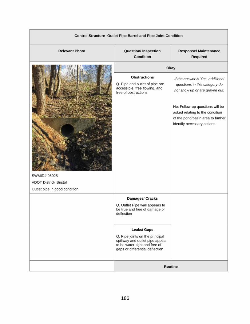
Control Structure- Outlet Pipe Barrel and Pipe Joint Condition
Relevant Photo Question/ Inspection
Condition
Response/ Maintenance
Required
SWMID# 95025
VDOT District- Bristol
Outlet pipe in good condition.
Okay
Obstructions
Q. Pipe and outlet of pipe are accessible, free flowing, and free of obstructions
If the answer is Yes, additional
questions in this category do
not show up or are grayed out.
No: Follow-up questions will be
asked relating to the condition
of the pond/basin area to further
identify necessary actions.
Damages/ Cracks
Q. Outlet Pipe wall appears to be true and free of damage or deflection
Leaks/ Gaps
Q. Pipe joints on the principal spillway and outlet pipe appear to be water-tight and free of gaps or differential deflection
Routine
186

Obstructions
Q. Pipe or outlet of pipe has
minor obstruction affecting less
than 10% of flow area that can
be removed with hand tools
Yes: Remove obstruction of
outlet pipe to ensure free flow.
Corrective
Obstructions
Q. Pipe or outlet of pipe is
obstructed less than 50% of
flow area
Yes: Remove obstruction of
outlet pipe to ensure free flow.
SWMID# 05003
VDOT District- Lynchburg
Debris in the outlet pipe.
Damages/ Cracks
Q. Pipe has surface corrosion
or spalling or is damaged,
cracked, or deflected less than
10% of diameter
Yes: If not certain of the cause
or appropriate maintenance
needs, notify the DIM or the
inspector’s manager to obtain
diagnostic assistance and to
develop a Corrective Action
Plan. Implement Corrective
Action Plan as directed.
SWMID# 71010
VDOT District- Lynchburg
Outlet pipe is rusting at the end.
Leaks/ Gaps Yes: If not certain of the cause
Q. Pipe joints are misaligned or
have gaps showing soil without
seepage or signs of flow or
piping (flow along outside
surface of pipe)
or appropriate maintenance
procedures, notify the DIM or
the Inspector’s manager, if
different to obtain diagnostic
assistance and to develop a
Corrective Action Plan.
187

Implement Corrective Action
Plan as directed.
Urgent
Obstructions
Q. Pipe or outlet of pipe is
obstructed more than 50% of
flow area
Yes: Remove obstruction of
outlet pipe to ensure free flow.
Damages/ Cracks
Q. Pipe is corroded with holes
or is damaged, cracked, or
deflected more than 10% of
diameter
Yes: If not certain of cause or of
appropriate maintenance
procedures, notify the DIM or
the Inspector’s manager, if
different, to obtain diagnostic
assistance and to develop a
Corrective Action Plan.
Implement Corrective Action
Plan as directed.
Leaks/ Gaps
Q. Pipe joints visibly leaking or
signs of piping (flow along
outside of pipe) observed
Yes: If not certain of cause or
appropriate maintenance
procedures, notify the DIM or
the Inspector’s manager, if
different, to obtain diagnostic
assistance and to develop a
Corrective Action Plan.
Implement Corrective Action
Plan as directed.
VDOT District – Staunton
Failure
188

L. Auxiliary or Emergency Spillway
Dam Embankment and Emergency Spillway- Vegetation
Relevant Photo Question/ Inspection
Condition
Response/ Maintenance
Required
SWMID# 95025
VDOT District- Bristol
Dam is properly vegetated.
Okay
Herbaceous Cover
Q. Turf grass or other herbaceous vegetation coverage of embankment and spillway area is greater than 75%
If the answer is Yes or N/A,
additional questions in this
category do not show up or are
grayed out
No: Follow-up questions will be asked relating to the condition of the pond/basin area to further identify necessary actions.
Overgrown/ Undesirable Vegetation
Q. Embankment and spillway appear to be acceptably mowed and free of overgrown, woody of other undesirable vegetation
Routine
Herbaceous Cover
Q. Turf grass coverage is less
than 75% of embankment
and/or spillway area and
requiring up to 10 SY of re-
establishment
Yes: Conduct a cursory
determination of vegetative
cover; rake seedbed and add
topsoil, if needed; re-seed and
apply mulch or appropriate
RECP matting to any bare
areas, consistent with VDOT
stds & specs.
SWMID# 29I001
VDOT District- Northern Virginia
Dam has several denuded areas.
189
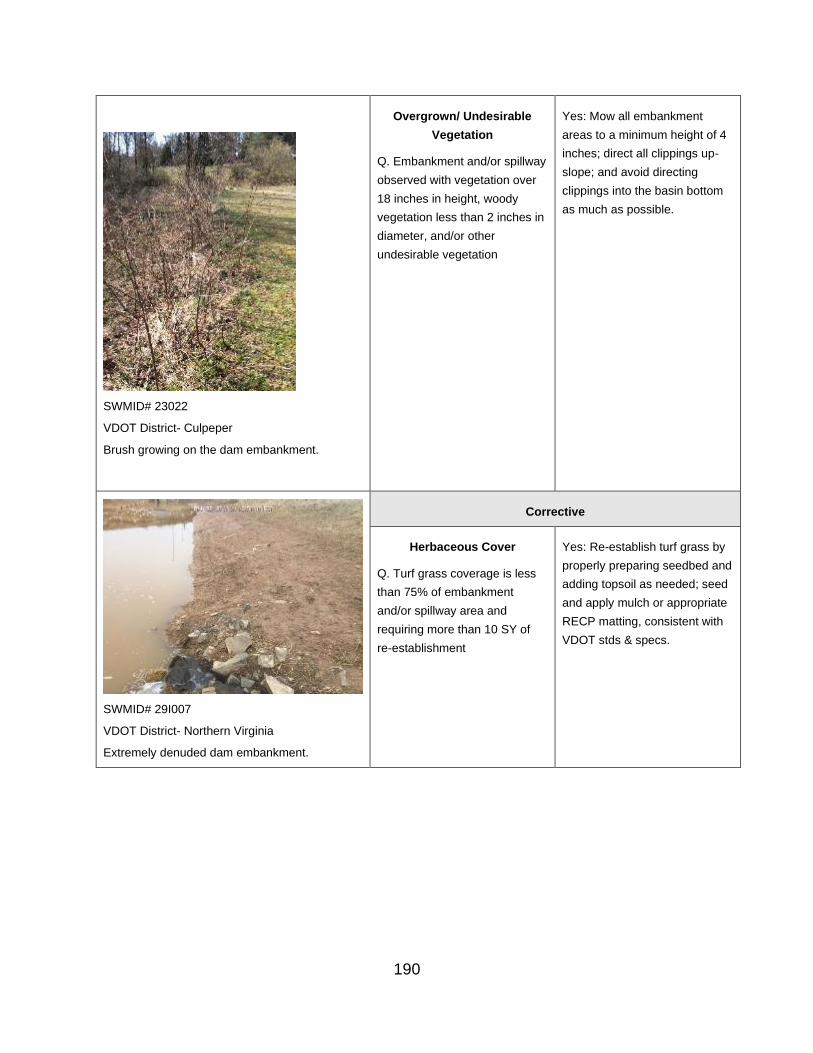
Overgrown/ Undesirable
Vegetation
Q. Embankment and/or spillway
observed with vegetation over
18 inches in height, woody
vegetation less than 2 inches in
diameter, and/or other
undesirable vegetation
Yes: Mow all embankment
areas to a minimum height of 4
inches; direct all clippings up-
slope; and avoid directing
clippings into the basin bottom
as much as possible.
SWMID# 23022
VDOT District- Culpeper
Brush growing on the dam embankment.
Corrective
Herbaceous Cover
Q. Turf grass coverage is less
than 75% of embankment
and/or spillway area and
requiring more than 10 SY of
re-establishment
Yes: Re-establish turf grass by
properly preparing seedbed and
adding topsoil as needed; seed
and apply mulch or appropriate
RECP matting, consistent with
VDOT stds & specs.
SWMID# 29I007
VDOT District- Northern Virginia
Extremely denuded dam embankment.
190

SWMID# 00I008
VDOT District- Northern Virginia
Excessive vegetation on the dam embankment
Overgrown/ Undesirable
Vegetation
Q. Embankment and/or spillway
observed with vegetation over
24 inches in height, woody
vegetation greater than 2
inches in diameter, stumps over
6 inches in diameter, and/or
other significant undesirable
vegetation.
Yes: Clear woody or other
significant growth, removing or
chipping onsite away from the
basin area. Remove root mass
for stumps over 6 inches in
diameter, fill with clay and 3
inches of topsoil and stabilize
with seed and appropriate
RECP matting, consistent with
VDOT stds & specs. Mow all fill
embankment areas to a
minimum height of 4 inches.
Direct all clippings up-slope,
avoiding directing clippings into
the basin bottom as much as
possible. NOTE: Woody
vegetation greater than 2 inches
in diameter and stumps greater
than 6 inches in diameter must
be removed from the
embankment for a distance of
25 feet beyond the
embankment toe and abutment
contacts with the native soil, to
the degree feasible.
Urgent
Failure
Dam Embankment and Emergency Spillway- Embankment Integrity
Relevant Photo Question/ Inspection
Condition
Response/ Maintenance
Required
Okay
Animal Burrows If the answer is Yes or N/A, additional questions in this
191

SWMID# 28004
VDOT District- Fredericksburg
Dam is in good condition. However, the trees
may be to close and should be removed.
Q. The BMP is free of animal burrows
category do not show up or are grayed out
No: Follow-up questions will be asked relating to the condition of the pond/basin area to further identify necessary actions.
Erosion
Q. The embankment face and spillway are free of erosion
Sinkholes
Q. The embankment face and spillway are free of surface depressions or sinkholes
Cracking, Bulging, or Sloughing
Q. The embankment face and spillway are free of cracking, bulging, or sloughing
Soft, Saturated, or Boggy Areas
Q. The embankment face and spillway are free of soft, saturated, or boggy areas
Dam Seepage Controls
Q. Discharge points from Dam Seepage Controls (dewatering features within the embankment) appear to be either dry or discharging clear water
192

Routine
Animal Burrows
Q. One or two animal burrows
observed on embankment or
BMP side slopes or in the
immediate vicinity of BMP.
Yes: Note existence of burrow(s)
in inspection form comment box.
Continue monitoring the situation
and, In the following inspection,
observe whether burrow(s) is still
present and whether its
condition has changed or
additional burrows are present.
Then take maintenance action
as considered necessary or as
otherwise directed.
Q. More than two animal
burrows observed on
embankment or BMP side
slopes or in immediate vicinity
of BMP
Yes: Eradicate animal(s) by
trapping and relocating or by
other means. Fill burrow(s) with
subsoil or bentonite, cap with 3"
topsoil, and stabilize with seed
and appropriate RECP matting,
installed consistent with VDOT
stds & specs.
Erosion
Q. Minor erosion that is less
than 1 foot deep and can be
repaired with less than 10 SY
of seed and erosion control
matting.
Yes: Repair minor erosion with
seed and appropriate RECP
matting, installed consistent with
VDOT stds & specs.
SWMID# 76I019
VDOT District- Northern Virginia
Slight erosion on dam embankment.
Cracking, Bulging, or Yes: Regrade area to have line
Sloughing
Q. Minor cracking (up to 1 inch
gap and 25 foot length),
bulging (up to 3 inch height
with no moisture evident), or
sloughing (up to 6 inches
maximum slippage) observed
on embankment area.
and grade consistent with
adjacent areas; stabilize all
disturbed areas with seed and
appropriate RECP matting,
installed consistent with VDOT
stds & specs or as otherwise
directed; monitor location, and
escalate to URGENT status if
condition returns.
193

Soft, Saturated, or Boggy
Areas
Q. Minor soft, saturated, or
boggy areas (less than 4
inches sinking under foot with
no visible flow) observed on
embankment face and/or
spillway
Yes: Note and continue to
monitor conditions. If the
condition becomes excessive,
escalate to URGENT status and
notify the DIM or the Inspector’s
manager, if different, to obtain
diagnostic assistance and to
develop a Corrective Action
Plan. Implement the Corrective
Action Plan as directed.
VDOT District- Northern Virginia
Corrective
Animal Burrows
Q. One or more animal
burrows observed on
embankment or emergency
spillway that do not appear to
be at a depth or alignment that
could form a conduit through
the embankment
Yes: Eradicate animal(s) by
trapping and relocating or by
other means. Fill burrow(s) with
flowable fill, cap with 3 inches of
topsoil, and stabilize with seed
and appropriate RECP matting,
consistent with VDOT stds &
specs.
Animal burrow in embankment.
SWMID# 29111
VDOT District- Northern Virginia
Dam Is eroded.
Erosion
Q. Excessive erosion observed
(deeper than 1 foot or more
than 10 SY in area)
Yes: Repair all erosion with
compacted fill and topsoil
consistent with specifications or
as otherwise directed. Remove
sediment that resulted from
erosion and return grades to
original design. Stabilize all
disturbed areas with seed and
appropriate RECP matting,
consistent with VDOT stds &
specs, or as otherwise directed.
Sinkholes
Q. Minor sinking or sinkhole
observed (less than 6 inches
deep and 1 SY in area) that is
not near a structure or conduit.
Yes: Repair sinking area by
adding compacted clay and 3
inches of topsoil to match
adjacent line and grade; stabilize
all disturbed areas with seed and
appropriate RECP matting,
consistent with VDOT stds &
194

specs or as otherwise directed;
monitor sinking area; If sinking
continues, elevate Rating to
URGENT status and notify the
DIM or the Inspector’s manager,
if different, to obtain diagnostic
assistance and to develop a
Corrective Action Plan.
Implement the Corrective Action
Plan as directed.
Dam Seepage Controls Yes: If not certain about the
Q. Seepage or more lush
vegetation observed at toe of
dam, along dam face, or
around discharge pipe; or
areas along dam face
slumping and slope of dam
face changing, implying
potential blockage of internal
seepage controls.
cause or appropriate
maintenance procedures, notify
and the DIM or the Inspector’s
manager, if different, to obtain
diagnostic assistance and to
develop a Corrective Action
Plan; implement the Corrective
Action Plan as directed.
Urgent
Animal Burrows
Q. One or more animal
burrows observed on the dam
embankment or emergency
spillway that do appear to be at
a depth or alignment that could
form a conduit through the
embankment
Yes: If not certain of appropriate
maintenance procedures, notify
the DIM or the Inspector’s
manager, if different, for further
guidance. Eradicate animal(s) by
trapping and relocating or by
other means. Fill burrow(s) with
flowable fill, cap with 3 inches of
topsoil, and stabilize with seed
and appropriate RECP matting,
consistent with VDOT stds &
specs.
195
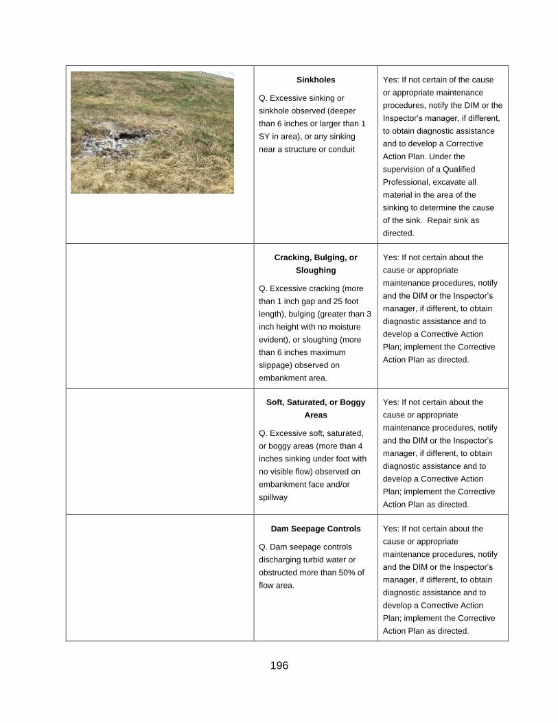
Sinkholes
Q. Excessive sinking or
sinkhole observed (deeper
than 6 inches or larger than 1
SY in area), or any sinking
near a structure or conduit
Yes: If not certain of the cause
or appropriate maintenance
procedures, notify the DIM or the
Inspector’s manager, if different,
to obtain diagnostic assistance
and to develop a Corrective
Action Plan. Under the
supervision of a Qualified
Professional, excavate all
material in the area of the
sinking to determine the cause
of the sink. Repair sink as
directed.
Cracking, Bulging, or
Sloughing
Q. Excessive cracking (more
than 1 inch gap and 25 foot
length), bulging (greater than 3
inch height with no moisture
evident), or sloughing (more
than 6 inches maximum
slippage) observed on
embankment area.
Yes: If not certain about the
cause or appropriate
maintenance procedures, notify
and the DIM or the Inspector’s
manager, if different, to obtain
diagnostic assistance and to
develop a Corrective Action
Plan; implement the Corrective
Action Plan as directed.
Soft, Saturated, or Boggy Yes: If not certain about the
Areas
Q. Excessive soft, saturated,
or boggy areas (more than 4
inches sinking under foot with
no visible flow) observed on
embankment face and/or
spillway
cause or appropriate
maintenance procedures, notify
and the DIM or the Inspector’s
manager, if different, to obtain
diagnostic assistance and to
develop a Corrective Action
Plan; implement the Corrective
Action Plan as directed.
Dam Seepage Controls
Q. Dam seepage controls
discharging turbid water or
obstructed more than 50% of
flow area.
Yes: If not certain about the
cause or appropriate
maintenance procedures, notify
and the DIM or the Inspector’s
manager, if different, to obtain
diagnostic assistance and to
develop a Corrective Action
Plan; implement the Corrective
Action Plan as directed.
196

Dam Embankment and Emergency Spillway- Emergency Spillway Condition
Relevant Photo Question/ Inspection
Condition
Response/ Maintenance
Required
Structural Deficiencies
Q. The emergency spillway or
overflow weir surface is free of
structural deficiencies or
concerns.
If the answer is Yes or N/A, additional questions in this
category do not show up or are grayed out
No: Follow-up questions will be
asked relating to the condition of
the pond/basin area to further
identify necessary actions.
Metal Spillway Components
Q. Metal portions of the
spillway surface are free of
rust/corrosion.
Concrete Spillway
Components
Q. Concrete portions of the
spillway surface are free of
spalling or cracking.
Sediment and Debris
Q. The spillway/overflow weir
surface is free of sediment or
debris.
Routine
Structural Deficiencies
Q. Minor structural issues
observed that can be parged
(i.e., sealed or re-coated)
Yes. Parge applicable portions
of emergency spillway.
Metal Spillway Components
Q. Minimal corrosion issues
observed that do not pose an
immediate risk of failure or
other danger.
Yes. Note and continue to
monitor corrosion and elevate to
CORRECTIVE status if
condition worsens.
197
Q. Minor corrosion issues
observed that can be re-coated
and do not pose a risk of failure
or other danger.
Yes. Re-coat corroded areas
with a bituminous coating or as
otherwise directed.
Concrete Spillway
Components
Q. Minimal spalling of concrete
observed that does not pose an
immediate risk of BMP
malfunction.
Yes. Note and continue to
monitor spalling and elevate to
CORRECTIVE status if
condition worsens.
Sediment and Debris
Q. Minor sediment or debris (up
to 0.25 CY) observed on
spillway surface that is not
blocking or disrupting flow.
Yes. Use hand tools to remove
sediment and/or debris from
spillway surface. Spread
accumulated sediment
elsewhere on site, seed,
fertilize, and stabilize with
appropriate RECP matting,
consistent with VDOT stds &
specs; alternatively, properly
dispose of sediment off-site.
Corrective
Structural Deficiencies
Q. Significant structural issues
observed that do not pose an
immediate risk of failure or
other danger.
Yes. If not certain of the cause
or appropriate maintenance
needs, notify the DIM or the
Inspector’s manager, if different,
to obtain diagnostic assistance
and to develop a corrective
action plan. Implement the
corrective action plan as
directed.
198

Metal Spillway Components
Q. Significant corrosion issues
observed that do not pose an
immediate risk of failure or
other danger.
Yes. If not certain of the cause
or appropriate maintenance
needs, notify the DIM or the
Inspector’s manager, if different,
to obtain diagnostic assistance
and to develop a corrective
action plan. Implement the
corrective action plan as
directed.
Concrete Spillway
Components
Q. Minor spalling of concrete
observed that does not pose an
immediate risk of BMP
malfunction.
Yes. Repair spalling with
appropriate grout or as
otherwise directed.
Sediment and Debris
Q. Significant sediment or
debris (more than 0.25 CY)
observed on surface of spillway
or that is blocking or disrupting
flow.
Yes. Use appropriate tools to
remove accumulated sediment
and debris from spillway
surface. Spread removed
sediment elsewhere on site,
seed, fertilize and stabilize with
appropriate RECP matting,
installed consistent with VDOT
stds & specs. Alternatively,
properly dispose of sediment
off-site.
URGENT
Structural Deficiencies
Q. Significant structural issues
observed that do pose an
immediate risk of failure or
other danger.
Yes. Immediately secure
emergency spillway with safety
fence, as needed, to protect
VDOT personnel and the public;
if not certain of the cause or
appropriate maintenance
needs, notify the DIM or the
Inspector's manager, if different,
to obtain diagnostic assistance
and to develop a corrective
action plan; implement the
corrective action plan as
directed.
199
Metal Spillway Components
Significant corrosion issues
observed that do pose an
immediate risk of failure or
other danger.
Immediately secure emergency
spillway with safety fence, as
needed, to protect VDOT
personnel and the public; notify
the DIM or the Inspector's
manager, if different, to obtain
diagnostic assistance and to
develop a corrective action
plan; implement the corrective
action plan as directed.
Concrete Spillway
Components
Significant spalling observed on
spillway surface that does pose
an immediate risk of failure or
other danger.
If not certain of the cause or
appropriate maintenance
needs, notify the DIM or the
Inspector's manager, if different,
to obtain diagnostic assistance
and to develop a corrective
action plan; implement the
corrective action plan as
directed.
Failure
M. Outlets & Outlet Structures
Outlet Structure and Discharge Channel- Erosion, Sediment, Debris, and Trash
Relevant Photo Question/ Inspection
Condition
Response/ Maintenance
Required
Okay
Sediment, Debris, or Trash
Q. The outlet area is free of sediment, debris or trash
If the answer is Yes or N/A, additional questions in this
category do not show up or are grayed out.
No: Follow-up questions will be asked relating to the condition of the pond/basin area to further identify necessary actions.
Vegetation
Q. The outlet area is free of woody or overgrown vegetation within 25 feet of the structure
200
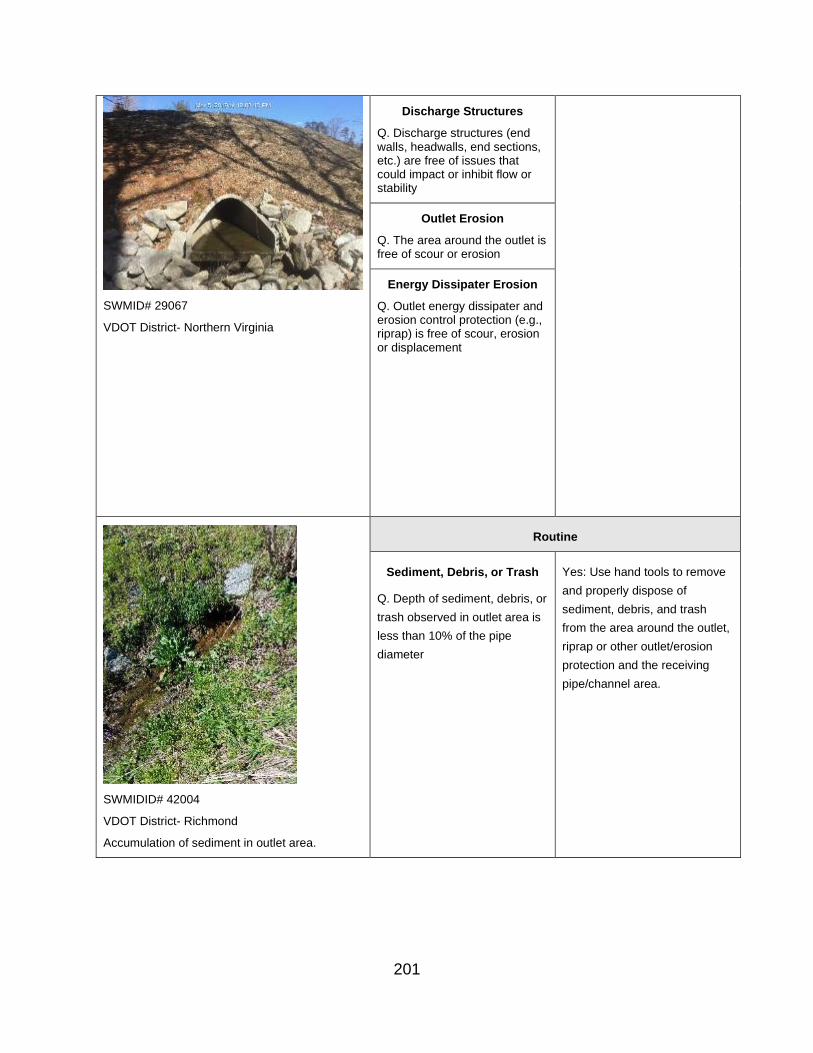
SWMID# 29067
VDOT District- Northern Virginia
Discharge Structures
Q. Discharge structures (end walls, headwalls, end sections, etc.) are free of issues that could impact or inhibit flow or stability
Outlet Erosion
Q. The area around the outlet is free of scour or erosion
Energy Dissipater Erosion
Q. Outlet energy dissipater and erosion control protection (e.g., riprap) is free of scour, erosion or displacement
Routine
Sediment, Debris, or Trash
Q. Depth of sediment, debris, or
trash observed in outlet area is
less than 10% of the pipe
diameter
Yes: Use hand tools to remove
and properly dispose of
sediment, debris, and trash
from the area around the outlet,
riprap or other outlet/erosion
protection and the receiving
pipe/channel area.
SWMIDID# 42004
VDOT District- Richmond
Accumulation of sediment in outlet area.
201

Vegetation
Q. Woody vegetation less than
2 inches in diameter, and/or
other undesirable vegetation
are observed in outlet area
within 25 feet of the structure
Yes: Remove all woody
vegetation from outlet area;
properly dispose of material off-
site or in an approved on-site
disposal location outside of any
flow or impoundment areas.
SWMID# 84010
VDOT District- Bristol
Vegetation in the outlet area.
Discharge Structure
Q. Minor damage to or
corrosion of discharge
structures observed that does
not impact flow or cause
erosion or slope or structural
instability
Yes: Note and continue to
monitor damage or corrosion to
endwalls, headwalls, and end
sections; elevate to
CORRECTIVE status if
condition worsens.
Outlet Erosion
Q. Minor scour or erosion (up to
10 SY but less than 1 foot deep
that can be stabilized with seed
and matting) at sides of outlet
pipe, but not threatening slope
stability
Yes: Repair minor erosion or
scour at sides of discharge pipe
with seed and appropriate
RECP matting, consistent with
VDOT stds & specs or as
otherwise directed.
SWMID # 87002
VDOT District- Hampton Roads
An eroded outlet pipe.
202
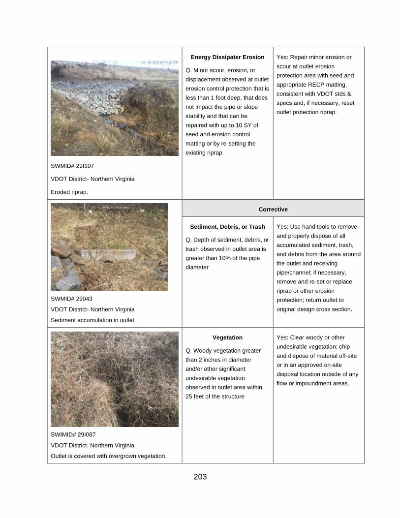
SWMID# 29I107
VDOT District- Northern Virginia
Eroded riprap.
Energy Dissipater Erosion
Q. Minor scour, erosion, or
displacement observed at outlet
erosion control protection that is
less than 1 foot deep, that does
not impact the pipe or slope
stability and that can be
repaired with up to 10 SY of
seed and erosion control
matting or by re-setting the
existing riprap.
Yes: Repair minor erosion or
scour at outlet erosion
protection area with seed and
appropriate RECP matting,
consistent with VDOT stds &
specs and, if necessary, reset
outlet protection riprap.
SWMID# 29043
VDOT District- Northern Virginia
Sediment accumulation in outlet.
Corrective
Sediment, Debris, or Trash
Q. Depth of sediment, debris, or
trash observed in outlet area is
greater than 10% of the pipe
diameter
Yes: Use hand tools to remove
and properly dispose of all
accumulated sediment, trash,
and debris from the area around
the outlet and receiving
pipe/channel; if necessary,
remove and re-set or replace
riprap or other erosion
protection; return outlet to
original design cross section.
Vegetation
Q. Woody vegetation greater
than 2 inches in diameter
and/or other significant
undesirable vegetation
observed in outlet area within
25 feet of the structure
Yes: Clear woody or other
undesirable vegetation; chip
and dispose of material off-site
or in an approved on-site
disposal location outside of any
flow or impoundment areas.
SWIMID# 29I087
VDOT District. Northern Virginia
Outlet is covered with overgrown vegetation.
203

Discharge Structure Erosion Yes: Remove and reset, repair,
Q. Discharge structures failed,
deflected, broken or
rusted/corroded, causing
erosion or slope failure, or
impeding flow from up to 25%
of the flow area
or replace endwall, headwall, or
end section, as needed; ensure
subgrade is stable and
compacted. Ensure that the
discharge pipe is joined to the
outlet structure and sealed with
non-shrink epoxy grout.
Outlet Erosion
Q. Significant scour or erosion
(greater than 10 SY or 1 foot
deep or requiring riprap)
beneath or at the sides of outlet
pipe and that is impacting slope
stability
Yes: Repair erosion or scour by
excavating and armoring with
riprap or an appropriate
alternative and an approved
geotextile product; if beneath
pipe, remove and reset pipe
onto compacted subgrade and
armor at outlet with riprap or an
appropriate alternative and an
approved geotextile product;
return outfall to original design
cross section.
SWMID# 170582.34
VDOT District- Salem
Severely eroded outlet.
Energy Dissipater Erosion
Q. Scour, erosion, or
displacement of outlet erosion
control protection that is greater
than 1 foot deep or that requires
additional riprap to be placed
Yes: Repair erosion by
undercutting, compacting fill as
needed, and replacing erosion
control protection with riprap or
other in-kind or more protective
materials, consistent with VDOT
stds & specs.
SWMID# 29003
VDOT District- Northern Virginia
Eroded riprap.
204

Urgent
Discharge Structure Erosion
Q. Discharge structures failed,
deflected, rusted/corroded, or
collapsed, causing erosion or
slope failure, impeding flow
from greater than 25% of the
flow area, or causing active
discharge of sediment
Yes: Remove and reset, repair,
or replace endwall, headwall, or
end section, as needed; ensure
subgrade is stable and
compacted. Ensure that the
discharge pipe is joined to the
outlet structure and sealed with
non-shrink epoxy grout.
VDOT District- Richmond
Pipe separation and severely eroded outlet.
Outlet Erosion
Q. Soil loss observed around
any portion of the outlet pipe
perimeter that shows signs of
piping (flow from within the
embankment along the exterior
of the wall of the pipe)
Yes: If not certain of appropriate
maintenance procedures, notify
the DIM or the Inspector’s
manager, if different, to obtain
diagnostic assistance and to
develop a Corrective Action
Plan; implement the Corrective
Action Plan as directed.
SWMID# 88017
VDOT District- Fredericksburg
Severely eroded outlet.
Failure
Outlet Structure and Discharge Channel- Receiving Channel or Storm Sewer
205

Relevant Photo Question/ Inspection
Condition
Response/ Maintenance
Required
Okay
Q. The outlet receiving channel or outlet storm sewer pipe is free of detrimental impacts (erosion, blockages, signs of flooding, etc.)
If the answer is Yes or N/A, additional questions in this
category do not show up or are grayed out.
No: Follow-up questions will be asked relating to the condition of the pond/basin area to further identify necessary actions.
Routine
Corrective
Q. Outlet receiving channel is
eroding or blocked but is not
back cutting nor undermining
the outlet structure
Yes: Remove any blockage and
repair erosion by undercutting,
compacting fill as needed, and
replacing RECP matting, riprap
or other in-kind or more
protective materials, consistent
with VDOT stds & specs, or as
otherwise directed.
Q. Erosion is observed around
inlet of receiving storm sewer
Yes: Repair erosion by
undercutting, compacting fill as
needed, and replacing erosion
control protection with seed and
appropriate RECP matting,
riprap or other in-kind or more
protective materials, consistent
with VDOT stds & specs or as
otherwise directed.
206

Q. Receiving storm sewer is
inadequate or blocked and is
backing up flow.
Yes: Perform appropriate
maintenance to relieve the back-
up; if not certain of the cause or
appropriate maintenance
procedures, notify the DIM or the
Inspector’s manager, if different,
to obtain diagnostic assistance
and to develop a Corrective
Action Plan; implement the
Corrective Action Plan as
directed.
SWMID # 87002
VDOT District- Hampton Roads
An eroded outlet pipe.
Urgent
Q. Outlet receiving channel is
eroding or blocked and is back-
cutting or undermining the
outlet structure
NOTE: If the receiving
channel damage is
extensive, contact the
District Environmental
Manager to determine
whether there might be
interest in conducting a
stream restoration project
that could result in VDOT
achieving TMDL pollution
reduction credits while at the
same time repairing the
receiving channel damage.
Yes: If not certain of appropriate
maintenance procedures, notify
the DIM or the Inspector’s
manager, if different, to obtain
diagnostic assistance and to
develop a Corrective Action
Plan; implement the Corrective
Action Plan as directed.
Failure
N. Underground Practices
Remember that manufactured/underground BMPs involve special considerations for inspection
and maintenance and are supposed to have manufacturer-provided Inspection-Maintenance
Plans for each individual structure, so the following questions in the Survey 123 App are
intended to serve if that Plan is unavailable and also to provide a platform for recording the
207

inspections within VDOT’s data tracking system. Refer to the special considerations for these kinds of BMPs in Part B of Chapter V.
Accessibility and Above Ground Condition - Accessibility
Relevant Photo Question/ Inspection
Condition
Response/ Maintenance
Required
SWMID #10010 - VDOT District- Bristol
BMP is easily accessible.
Okay
Q. BMP/MTD is sufficiently accessible
.
If the answer is Yes or N/A, additional questions in this
category do not show up or are grayed out.
No: Follow-up questions will be asked relating to the condition of the pond/basin area to further identify necessary actions.
Routine
SWMID# 76113
VDOT District- Northern Virginia
Manhole cover is totally buried.
Corrective
Q. Access manhole is buried or
cannot be located.
Yes: Locate or expose manhole
lid or access door.
208
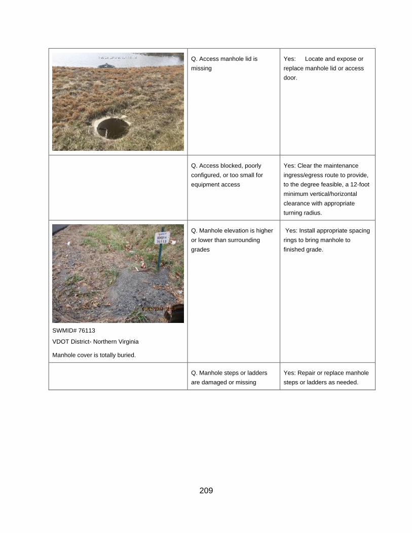
Q. Access manhole lid is
missing
Yes: Locate and expose or
replace manhole lid or access
door.
Q. Access blocked, poorly
configured, or too small for
equipment access
Yes: Clear the maintenance
ingress/egress route to provide,
to the degree feasible, a 12-foot
minimum vertical/horizontal
clearance with appropriate
turning radius.
SWMID# 76113
VDOT District- Northern Virginia
Manhole cover is totally buried.
Q. Manhole elevation is higher
or lower than surrounding
grades
Yes: Install appropriate spacing
rings to bring manhole to
finished grade.
Q. Manhole steps or ladders
are damaged or missing
Yes: Repair or replace manhole
steps or ladders as needed.
209

SWMID# 89014
VDOT District- Fredericksburg
Manhole is damaged and not functioning.
Q. Access door or manhole
cover and/or entrance is
damaged or not functioning
correctly
Yes: Repair or replace door or
manhole cover or repair
entrance, as needed.
Urgent
Failure
Accessibility and Underground Condition – Above Ground Condition
Relevant Photo Question/ Inspection
Condition
Response/ Maintenance
Required
Okay
Q. Ground surfaces around the underground BMP/MTD are free from land disturbance.
If the answer is Yes or N/A, additional questions in this
category do not show up or are grayed out.
No: Follow-up questions will be asked relating to the condition of the pond/basin area to further identify necessary actions.
210

Routine
Corrective
Q. Disturbed area is observed
on ground surface in immediate
area of the Underground BMP.
Yes: Stabilize disturbed area
with seed and mulch, or with in-
kind materials, as applicable. If
land disturbance not on VDOT
property, notify the source to
ensure sediment control
measures are in place to
prevent sediment from entering
the VDOT BMP/MTD.
Urgent
Failure
Contributing Drainage Area - Surface Condition, Trash, and Debris
Relevant Photo Question/ Inspection
Condition
Response/ Maintenance
Required
Okay
SWMID # 177211.2
Q. The contributing drainage
area is stable, well-vegetated,
non-erosive, and free of trash
and debris.
If the answer is Yes or N/A,
additional questions in this
category do not show up or are
grayed out.
No: Follow-up questions will be asked relating to the condition of the pond/basin area to further identify necessary actions.
211

VDOT District: Salem
Routine
Q. Turf grass or other
herbaceous cover in the
immediate CDA has less than
75% coverage, contributing to
erosion in the area and
potential delivery of sediment
to the BMP.
Yes: Re-establish turf grass or
other herbaceous cover in sparse
areas on VDOT property by
properly preparing seed bed,
importing topsoil as needed. Seed
per permanent seeding and
Roadside Nutrient Management
specifications, and apply
appropriate RECP matting or other
appropriate mulch, consistent with
VDOT stds & specs.
Q. Minor (< 0.25 CY)
sediment, debris, or trash
accumulated in the channel
and/or at check dams.
Yes: Use hand tools to remove
minor sediment, debris, and trash
from channel and/or at check
dams. Replace other erosion
protection as needed; also as
needed, revegetate the CDA on
VDOT property per the original
design and specifications.
Corrective
Q. Excessive (more than 0.25
CY) sediment, debris, or
trash accumulated in the
channel and/or at check
dams.
Yes: Remove all accumulated
sediment, trash, and debris from
CDA. Replace other erosion
control measures as needed; as
needed, revegetate the CDA on
VDOT property per the original
design and specifications.
Urgent
Failure
212

Contributing Drainage Area – Illicit Discharge – MS4 Outfalls
Relevant Photo Question/ Inspection
Condition
Response/ Maintenance Required
Okay
IDDE
Q. The BMP area is free of
illicit discharge.
If the answer is Yes or N/A,
additional questions in this category
do not show up or are grayed out.
SWMID # 60000804.84
VDOT District: Salem
MS4 Outfalls
Q. There are no MS4
Outfalls or Points of
Discharge in the area
around the BMP outlet.
No: Follow-up questions will be asked relating to the condition of the pond/basin area to further identify necessary actions.
Routine
MS4 Outfalls
Q. A MS4 Outfall or Point
of Discharge is present on
VDOT property in the area
of the BMP outlet.
Yes. Collect the GPS coordinates of
the Outfall or POD. Note the
presence of the Outfall or POD in
the inventory data for the BMP and
report it to the Geospatial-GIS
Coordinator in VDOT’s Central
Office Location and Design Division.
Corrective
Urgent
Q. Illicit discharge observed
flowing into the BMP being
inspected or otherwise onto
the VDOT property and/or
into VDOT drainage
system.
Yes: Confirm, document and report
the illicit discharge to VDOT IDDE
team
per the Illicit Discharge Detection
and Elimination Program Manual
and the associated IDDE Field
Guide.
213

Q. Illicit discharge observed
flowing from another VDOT
outfall in the immediate
vicinity of this BMP
(NOTE: ONTO VDOT
PROPERTY OR ONTO AN
ADJACENT PROPERTY)
R. Yes: Confirm, document and
report the illicit discharge to VDOT
IDDE team
per the Illicit Discharge Detection
and Elimination Program Manual
and the associated IDDE Field
Guide.
Failure
Inflow Areas & Inlet Channel(s) - Erosion, Sediment, Trash and Debris
Relevant Photo Question/ Inspection
Condition
Response/ Maintenance
Required
Okay
Q. The BMP surface inflow area is free of erosion, sediment, trash and debris.
If the answer is Yes or N/A, additional questions in this category do not show up or
are grayed out.
If the answer is Yes or N/A,
additional questions in this
category do not show up or
are grayed out.
NOTE: N/A typically means
the Inflow enters through an
enclosed pipe system.
No: Follow-up questions will
be asked relating to the
condition of the pond/basin
area to further identify
necessary actions.
214
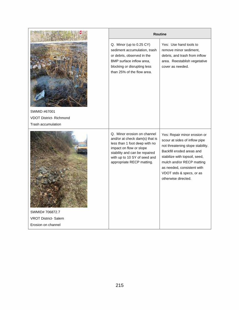
Routine
Q. Minor (up to 0.25 CY)
sediment accumulation, trash
or debris, observed in the
BMP surface inflow area,
blocking or disrupting less
than 25% of the flow area.
Yes: Use hand tools to
remove minor sediment,
debris, and trash from inflow
area. Reestablish vegetative
cover as needed.
SWMID #67001
VDOT District- Richmond
Trash accumulation
Q. Minor erosion on channel
and/or at check dam(s) that is
less than 1 foot deep with no
impact on flow or slope
stability and can be repaired
with up to 10 SY of seed and
appropriate RECP matting.
Yes: Repair minor erosion or
scour at sides of inflow pipe
not threatening slope stability.
Backfill eroded areas and
stabilize with topsoil, seed,
mulch and/or RECP matting
as needed, consistent with
VDOT stds & specs, or as
otherwise directed.
SWMID# 706872.7
VROT District- Salem
Erosion on channel
215

Corrective
Q. Excessive (more than
0.25 CY) erosion, sediment,
debris or trash accumulated
in the BMP surface inflow
area blocking or disrupting
more than 25% of the flow
area.
Yes: Use hand tools to
remove accumulated
sediment, debris, and trash
from the surface inflow area.
Properly dispose of removed
materials. As needed,
reconfigure or reconstruct per
original design or as
otherwise directed.
Q. Significant erosion
(deeper than 1 foot or larger
than 10 SY) observed on
channel and/or at check
dam(s) that is blocking or
disrupting flow.
Yes: Repair all erosion in
channel and/or around check
dams with compacted fill and
topsoil per specification or as
otherwise directed. Remove
sediment and return to grades
to original design.
Reconstruct check dam(s) per
design. Stabilize all disturbed
areas with topsoil, seed,
mulch and/or appropriate
RECP matting, installed
consistent with VDOT stds &
specs or as otherwise
directed.
Q. Excessive erosion that
compromises channel and/or
dislodges or bypasses check
dam(s).
Yes: Repair all erosion in
channel and/or at check
dam(s) with compacted fill
and topsoil per specification
or as otherwise directed.
Remove sediment and return
Grades to original design.
Reconstruct check dam(s) per
original design. Stabilize all
disturbed areas with topsoil,
seed, mulch and/or
appropriate RECP matting,
consistent with VDOT stds &
specs or as otherwise
directed. Ensure that flow is
directed into the pretreatment
practice, if one is present.
216

Urgent
Q. Excessive sediment
accumulation is more than 1
foot deep or 1/2 the height of
the check dam(s).
Yes: Remove accumulated
sediment and properly
dispose of material.
Reconfigure or, as needed,
reconstruct check dam(s) per
original design or as
otherwise directed.
Failure
Surface Inflow Areas & Inlet Channel(s) - Inflow to BMP from Upstream
Relevant Photo Question/ Inspection
Condition
Response/ Maintenance
Required
SWMID#15016 VDOT District- Lynchburg
BMP inflow pipe free of structural damages or obstructions.
Okay
Inflow Area Pipe
Q. The BMP surface inflow
area pipes discharging into
the BMP are free of structural
damage or obstruction
If the answer is Yes or N/A,
additional questions in this
category do not show up or
are grayed out.
No: Follow-up questions will
be asked relating to the
condition of the pond/basin
area to further identify
necessary actions.
217

Routine
Q. Minor separation of pipe
joints (less than 2 inches with
no soil entering pipe) on
pipes discharging into the
BMP.
Yes: Repair joint with non-
shrink epoxy grout.
SWMID# 23010
VDOT District- Culpeper
Inflow pipe with separation.
Q. Minor damage or
corrosion to end walls,
headwalls, and end sections
that do not impact flow,
erosion, or slope or structural
stability, but which may
present safety risks to VDOT
workers and the public.
Yes: Install orange safety
fence around structures that
may cause risk to the public,
and report to District
Infrastructure Manager
immediately. Then make the
needed repairs using
appropriate materials.
SWMID# 29021
VDOT District- Northern Virginia
Minor erosion around the end wall.
Q. Minor scour or erosion (up Repair minor erosion or scour
to 10 SY, less than 1 foot at sides of inflow pipe with
deep that can be stabilized seed and appropriate RECP
with seed and RECP matting) matting, installed consistent
at sides of inflow pipe and not with VDOT stds & specs.
threatening slope stability
218

Q. Scour, erosion, or
displacement of erosion
control protection less than 1
foot deep at inflow to the
BMP that does not impact the
pipe or slope stability and can
be repaired with up to 10 SY
seed and RECP matting
and/or by re-setting existing
riprap.
Repair minor scour or erosion
at sides of inflow pipe, with
seed and appropriate RECP
matting and/or by re-setting
riprap, consistent with VDOT
stds & specs.
Corrective
Q. Excessive separation of
pipe joints (less than 2-inch
separation but with soil
entering pipe) on pipes
discharging into the BMP
Yes: Remove and reset or
replace sections of pipe that
have issues. Ensure pipe
bedding is stable and
compacted and that pipe
joints are properly sealed with
non-shrink epoxy grout.
SWMID# 29084 - VDOT District- Northern Virginia - Inflow pipe flow is obstructed.
Q. Endwalls, headwalls, and
end sections failed, deflected,
or corroded, causing erosion
or slope failure, or impeding
flow on up to 25% of the pipe
or inflow area.
Yes: Remove and reset,
repair or replace endwall,
headwall, or end section.
Ensure subgrade is stable
and compacted and that the
pipe is properly sealed to the
structure with non-shrink
epoxy grout.
SWMID# 7005830.9 - VDOT District- Salem
Scour hole erosion at inlet area.
Q. Significant scour or
erosion (greater than 10 SY
or 1 foot deep or requiring
riprap) at sides of inflow pipe
that is impacting slope
stability or is undermining the
inflow pipe
Yes: Repair scour or erosion
by excavating and armoring
with riprap on top of approved
geotextile. If beneath pipe,
remove and reset pipe onto
compacted subgrade, as
needed, and armor at outlet
with riprap on top of approved
geotextile. Ensure that pipe
joints are properly sealed with
non-shrink epoxy grout.
219
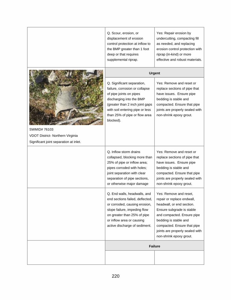
Q. Scour, erosion, or
displacement of erosion
control protection at inflow to
the BMP greater than 1 foot
deep or that requires
supplemental riprap.
Yes: Repair erosion by
undercutting, compacting fill
as needed, and replacing
erosion control protection with
riprap (in-kind) or more
effective and robust materials.
SWMID# 76103
VDOT District- Northern Virginia
Significant joint separation at inlet.
Urgent
Q. Significant separation,
failure, corrosion or collapse
of pipe joints on pipes
discharging into the BMP
(greater than 2 inch joint gaps
with soil entering pipe or less
than 25% of pipe or flow area
blocked).
Yes: Remove and reset or
replace sections of pipe that
have issues. Ensure pipe
bedding is stable and
compacted. Ensure that pipe
joints are properly sealed with
non-shrink epoxy grout.
Q. Inflow storm drains
collapsed, blocking more than
25% of pipe or inflow area;
pipes corroded with holes;
joint separation with clear
separation of pipe sections,
or otherwise major damage
Yes: Remove and reset or
replace sections of pipe that
have issues. Ensure pipe
bedding is stable and
compacted. Ensure that pipe
joints are properly sealed with
non-shrink epoxy grout.
Q. End walls, headwalls, and Yes: Remove and reset,
end sections failed, deflected, repair or replace endwall,
or corroded, causing erosion, headwall, or end section.
slope failure, impeding flow Ensure subgrade is stable
on greater than 25% of pipe and compacted. Ensure pipe
or inflow area or causing bedding is stable and
active discharge of sediment. compacted. Ensure that pipe
joints are properly sealed with
non-shrink epoxy grout.
Failure
220

Underground Inflow Pipes and Peripheral Pipe Components - Inflow Pipes
Relevant Photo Question/ Inspection Condition Response/ Maintenance Required
Okay
Sediment, Trash, and Debris
Q. Inflow pipes appear to be clear of
sediment, trash and debris
If the answer is Yes or N/A, additional
questions in this category do not
show up or are grayed out.
No: Follow-up questions will be
asked relating to the condition of the
pond/basin area to further identify
necessary actions.
Damage/ Corrosion/Obstruction
Q. Inflow pipes are free from
damage, corrosion, or obstruction.
Joint Separation/ Misalignment
Q. Inflow pipes are free from joint
separation or misalignment
Routine
Sediment, Trash, and Debris
Q. Sediment, trash and/or debris
observed in inflow pipes, blocking
less than 25% of the flow area.
Yes: Remove by jetting and
vacuuming all sediment, trash and/or
debris within inflow pipe for at least
10 feet upstream of facility.
Joint Separation/ Misalignment
Q. Inflow pipe joints are misaligned or
separated, but no exposed soil or
other material is entering the pipe.
Yes: Note and continue to monitor
joint separation or misalignment;
elevate to CORRECTIVE status if soil
becomes exposed or material is
observed entering pipe.
Corrective
Sediment, Trash, and Debris
Q. Sediment, trash and/or debris
observed in inflow pipes, blocking
more than 25% but less than 75% of
the flow area.
Yes: Remove by jetting and
vacuuming all sediment, trash and/or
debris within inflow pipe for at least
10 feet upstream of facility.
221
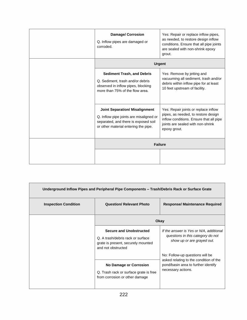
Damage/ Corrosion
Q. Inflow pipes are damaged or
corroded.
Yes: Repair or replace inflow pipes,
as needed, to restore design inflow
conditions. Ensure that all pipe joints
are sealed with non-shrink epoxy
grout.
Urgent
Sediment Trash, and Debris
Q. Sediment, trash and/or debris
observed in inflow pipes, blocking
more than 75% of the flow area.
Yes: Remove by jetting and
vacuuming all sediment, trash and/or
debris within inflow pipe for at least
10 feet upstream of facility.
Joint Separation/ Misalignment Yes: Repair joints or replace inflow
Q. Inflow pipe joints are misaligned or
separated, and there is exposed soil
or other material entering the pipe.
pipes, as needed, to restore design
inflow conditions. Ensure that all pipe
joints are sealed with non-shrink
epoxy grout.
Failure
Underground Inflow Pipes and Peripheral Pipe Components – Trash/Debris Rack or Surface Grate
Inspection Condition Question/ Relevant Photo Response/ Maintenance Required
Okay
Secure and Unobstructed
Q. A trash/debris rack or surface
grate is present, securely mounted
and not obstructed
If the answer is Yes or N/A, additional
questions in this category do not
show up or are grayed out.
No: Follow-up questions will be
asked relating to the condition of the
pond/basin area to further identify
necessary actions.
No Damage or Corrosion
Q. Trash rack or surface grate is free
from corrosion or other damage
222

Routine
Secure and Unobstructed
Q. Trash/debris rack or surface grate
is loose and not mounted securely.
Yes: Tighten trash/debris rack
attachments; if cannot accomplish
this, notify the DIM or the Inspector's
manager, if different about problem
and change rating to CORRECTIVE.
Q. Trash/debris rack or surface grate
is accessible, but it has accumulated
trash and debris and has become
obstructed.
Yes: Remove all sediment, trash,
debris or other obstructions from
trash/debris rack or surface grate to
ensure positive drainage.
Corrosion or Damage
Q. Minor surficial corrosion on the
trash/debris rack or surface grate
Yes: ADMIN: Note and continue to
monitor trash rack or surface grate
corrosion; if condition worsens,
upgrade rating to CORRECTIVE
status.
Q. Trash/debris rack or surface grate
needs minor repairs that do not
inhibit its function.
Yes: ADMIN: Note and continue to
monitor trash rack or surface grate
condition; if condition worsens,
upgrade rating to CORRECTIVE
status.
Corrective
Secure and Unobstructed
Q. Original trash/debris rack or
surface grate specified on plans but
is missing, or no trash rack or surface
grate observed where there appears
to be a need for one.
Yes: Install trash/debris rack or
surface grate consistent with original
plans or as otherwise directed.
Q. Trash/debris rack or surface grate
is not attached but is present at the
site.
Yes: Reattach trash/debris rack or
surface grate, ensuring a nice secure
mounting.
Q. Sediment , trash, debris, or other
obstruction has accumulated at the
trash/debris rack or on the surface
grate, rendering it inaccessible or
submerged
Yes: Perform pumping, vacuuming or
other measures to access
trash/debris rack or surface grate;
remove all obstructions as needed to
ensure positive drainage; reconstruct
as needed or directed.
Corrosion or Damage
Q. Major corrosion or damage on the
trash/debris rack or surface grate
Yes: Recoat, repaint, repair, or
replace trash rack or surface grate,
consistent with the original design or
as otherwise directed.
223

Q. Trash/debris rack or surface grate
needs repairs to damage that does
affect its function.
Yes: Repair or replace trash/debris
rack or surface grate consistent with
original design or as otherwise
directed.
Urgent
Failure
Underground Chambers - Sediment, Trash, and Debris
Relevant Photo Question/ Inspection Condition Response/ Maintenance Required
Okay
Sediment/ Debris
Q. Chamber appears to be clear of
sediment and/or debris or these are
insufficient to trigger the need for
maintenance
If the answer is Yes or N/A, additional
questions in this category do not
show up or are grayed out.
No: Follow-up questions will be
asked relating to the condition of the
pond/basin area to further identify
necessary actions.
Floatable Trash, Debris, and
Hydrocarbons
Q. Floatable trash, debris and
hydrocarbons observed on less than
10% of the pool or filter media
surface area
Routine
224

Sediment/ Debris
Q. Sediment and/or debris observed
in chamber has accumulated to less
than 25% of design storage volume.
Yes: Remove all fluid, sediment
and/or debris within chamber by
vacuuming and, if needed, power-
wash all surfaces; properly dispose of
all removed material.
Floatable Trash, Debris, and
Hydrocarbons
Q. Floatable trash, debris, and
hydrocarbons observed on more than
10% but less than 50% of the pool or
filter media surface area.
Yes: Remove all fluid, sediment
and/or debris within chamber by
vacuuming and, if needed, power-
wash all surfaces; properly dispose of
all removed material.
Corrective
Sediment/ Debris
Q. Sediment and/or debris observed
in chamber has accumulated to more
than 25% but less than 75% of
design storage volume.
Yes: Remove all fluid, sediment
and/or debris within chamber by
vacuuming and, if needed, power-
wash all surfaces; properly dispose of
removed material.
Urgent
Sediment/ Debris Yes: Remove all fluid, sediment
Q. Sediment and/or debris observed
in chamber has accumulated to more
than 75% of design storage
and/or debris within chamber by
vacuuming and, if needed, power-
wash all surfaces; properly dispose of
all removed material.
Floatable Trash, Debris, and
Hydrocarbons
Q. Floatable trash, debris and
hydrocarbons observed on more than
50% of the pool surface area
Yes: Remove all fluid, sediment
and/or debris within chamber by
vacuuming and, if needed, power-
wash all surfaces; properly dispose of
removed material.
Failure
Underground Chambers - General Structural Issues
225

Relevant Photo Question/ Inspection Condition Response/ Maintenance Required
Okay
Q. Dry storage area underground
chamber free from general structural
issues
If the answer is Yes or N/A, additional
questions in this category do not
show up or are grayed out.
No: Follow-up questions will be
asked relating to the condition of the
pond/basin area to further identify
necessary actions.
Routine
Q. Potential structural issues
observed in underground chamber.
Yes. If minor issues observed, note
and continue to monitor condition; if
condition worsens, upgrade to
CORRECTIVE status.
Corrective
Q. Minor structural issues observed
in underground chamber
Yes: Check the product warranty to
determine if damage is covered by
the manufacturer. It may be prudent
to consult the manufacturer regarding
needed repairs and procedures.
Replacement parts may need to be
procured from the manufacturer in
order to not void the device warranty.
Develop a corrective action plan and
implement it, as directed.
Urgent
Q. Significant structural issues
observed in underground chamber
that could impact stability or result in
failure
Yes: If not certain of the cause or
appropriate maintenance procedures,
notify the DIM or the Inspector’s
manager, if different, to obtain
diagnostic assistance and to develop
a Corrective Action Plan. Check the
product warranty to determine if
damage is covered by the
manufacturer. It may be prudent to
consult the manufacturer regarding
needed repairs and procedures. I
Replacement parts may need to be
226

procured from the manufacturer in
order to not void the device warranty.
Implement Corrective Action Plan, as
directed.
Failure
Underground Chambers - Condition of Concrete, Metal Components, and Piping
Relevant Photo Question/ Inspection Condition Response/ Maintenance Required
Okay
Spalling/ Cracking
Q. Condition of concrete in chamber
appears acceptable with no spalling,
cracking, leaks or other issues
observed
If the answer is Yes or N/A, additional
questions in this category do not
show up or are grayed out.
No: Follow-up questions will be
asked relating to the condition of the
pond/basin area to further identify
necessary actions.
Rust/ Corrosion/Damage
Q. Metal components of chamber
free from rust/corrosion or other
damage
Internal Piping
Q. Internal piping observed to be
clear and functioning as intended
Routine
Internal Piping
Q. Internal piping (orifices, low flow,
weirs, elbows, T-pipes, drop pipes,
connecting pipes, etc.) observed to
have sediment and/or debris
Yes: Clean/flush internal piping as
needed to ensure proper function.
Corrective
227
Spalling/ Cracking
Q. Spalling or cracking of concrete
observed in chamber
Yes: Repair spalling or cracking of
concrete in chamber by removing
loose material and parging (sealing
or coating) with non-shrink epoxy
grout, or as otherwise directed.
Spalling/ Cracking
Q. Leaks or other issues with joints
observed in chamber
Yes: Repair joints in chamber as
directed. Ensure joints are sealed
with non-shrink epoxy grout, or as
otherwise directed.
Rust/ Corrosion/Damage
Q. Corrosion on metal components of
chamber observed
Yes: Repair rust or corrosion, and re-
coat or re-paint deteriorated metal
components of chamber.
Rust/ Corrosion/Damage
Q. Damage to metal components of
chamber observed
Yes: Repair or, as needed, replace
damaged metal components of
chamber. Check the product warranty
to determine if damage is covered by
the manufacturer. It may be prudent
to consult the manufacturer regarding
needed repairs and procedures.
Replacement parts will likely need to
be procured from the manufacturer of
the MTD in order to not void the
device warranty.
Internal Piping
Q. Differential settlement of pipe
joints with no soil visible.
Yes: If not certain of the cause or
appropriate maintenance procedures,
notify the DIM or the Inspector’s manager, if different, to obtain
diagnostic assistance and to develop
a Corrective Action Plan. Check the
product warranty to determine if
damage is covered by the
manufacturer. It may be prudent to
consult the manufacturer regarding
needed repairs and procedures.
Implement the Corrective Action
Plan.
Internal Piping
Q. Pipe deflection observed, but it is
less than 10% of the pipe diameter.
Yes: If not certain of the cause or
appropriate maintenance procedures,
notify the DIM or the Inspector’s manager, if different, to obtain
diagnostic assistance and to develop
a Corrective Action Plan. Check the
product warranty to determine if
damage is covered by the
manufacturer. It may be prudent to
consult the manufacturer regarding
228
needed repairs and procedures.
Implement the Corrective Action
Plan.
Internal Piping
Q. Internal piping components shown
on plans missing or not functioning
as intended
Yes: Install, replace, or repair internal
piping components, as directed.
Check the product warranty to
determine if damage is covered by
the manufacturer. It may be prudent
to consult the manufacturer regarding
needed repairs and procedures.
Replacement parts will likely need to
be procured from the manufacturer of
the MTD in order to not void the
device warranty.
Internal Piping
Q. Rust/corrosion observed on piping
in chamber.
Yes: Repair rust/corrosion, and re-
coat or re-paint piping, as needed.
Internal Piping
Q. Other damage to piping of
chamber observed
Yes: Repair damaged piping in
chamber, as directed. Check the
product warranty to determine if
damage is covered by the
manufacturer. It may be prudent to
consult the manufacturer regarding
needed repairs and procedures.
Replacement parts will likely need to
be procured from the manufacturer of
the MTD in order to not void the
device warranty.
Need Photo Urgent
Spalling/ Cracking
Q. Failure or potential failure of
concrete observed in chamber
Yes: If not certain of cause or
appropriate maintenance procedures,
notify the DIM or the Inspector’s
manager, if different, to obtain
diagnostic assistance and to develop
a Corrective Action Plan. Check the
product warranty to determine if
damage is covered by the
manufacturer. It may be prudent to
consult the manufacturer regarding
needed repairs and procedures.
Implement Corrective Action Plan
and repair or reconstruct failing or
failed portions of chamber as
directed.
229

Need Photo Internal Piping
Q. Differential settlement of pipe
joints with soil visible or deflection
greater than 10% of pipe diameter
Yes: If not certain of the cause or
appropriate maintenance procedures,
notify the DIM or the Inspector’s
manager, if different, to obtain
diagnostic assistance and to develop
a Corrective Action Plan, if
warranted. Check the product
warranty to determine if damage is
covered by the manufacturer. It may
be prudent to consult the
manufacturer regarding needed
repairs and procedures. Implement
the Corrective Action Plan.
Need Photo Internal Piping
Q. Pipe deflection observed that is
greater than 10% of pipe diameter.
Yes. If not certain of the cause or
appropriate maintenance procedures,
notify the DIM or the Inspector’s
manager, if different, to obtain
diagnostic assistance and to develop
a Corrective Action Plan, if
warranted. Check the product
warranty to determine if damage is
covered by the manufacturer. It may
be prudent to consult the
manufacturer regarding needed
repairs and procedures. Implement
the Corrective Action Plan.
Failure
Underground Filter Cartridge/Media Issues
Relevant Photo Question/ Inspection Condition Response/ Maintenance Required
Okay
230
Filter Cartridge / Media
Q. Filter media or cartridge media
observed to have minimal particulate
accumulation, discoloration or
clogging and appears to be
functioning well and passing flow
acceptably.
If the answer is Yes or N/A, additional
questions in this category do not
show up or are grayed out.
No: Follow-up questions will be
asked relating to the condition of the
pond/basin area to further identify
necessary actions.
Routine
Filter/ Cartridge Media Yes: Rake surface of filter media;
Q. Filter media or cartridge media
appears to have minor particulate
accumulation and/or discoloration,
but appears to be passing flow and
functioning acceptably
remove and properly dispose of
minor sediment accumulation. If a
cartridge system, note condition and
continue to monitor for potential
clogging.
Corrective
Filter/ Cartridge Media
Q. Minor sediment/particulate
observed within the initial 3" of filter
media or cartridge (may be at the
bottom of the cartridge, if flow moves
upward through device).
Yes: Remove layers of sediment
laden or discolored filter media and
replace with in-kind media material,
consistent with manufacturer specs;
properly dispose of removed
material. If cartridge system, check
with manufacturer representative or
provided maintenance instructions for
proper procedures. Replacement
media or cartridges will likely need to
be procured from the manufacturer in
order to not void the device warranty.
Filter/ Cartridge Media Yes: Remove layers of sediment
Q. Significant sediment accumulation
on media surface or observed to be
more than 3" deep into filter cartridge
(may be at the bottom of the
cartridge, if flow moves upward
through the cartridge), slowing flow
through cartridge.
laden or discolored filter media and
replace with in-kind media material,
consistent with manufacturer specs;
properly dispose of removed
material. If cartridge system, check
with manufacturer representative or
provided maintenance instructions for
proper procedures. Replacement
media or cartridges will likely need to
be procured from the manufacturer in
order to not void the device warranty.
Urgent
Filter/ Cartridge Media
Q. Water standing on surface of filter
media or filter cartridge clogged with
particulate with very slow flow
Yes: Check the product warranty to
determine if damage is covered by
the manufacturer. It may be prudent
to consult the manufacturer regarding
231

through the cartridge; or time limit for
replacing filter cartridge has passed.
needed repairs and procedures.
Replacement parts will likely need to
be procured from the manufacturer in
order to not void the device warranty.
Dewater chamber and remove
sediment, litter and debris in order to
pump water back into chamber at
end of maintenance process;
properly dispose of removed
material; remove and replace all filter
media material or cartridges,
consistent with manufacturer specs.
Failure
Underground Chambers - Control Structure, Outlet Area, Discharge Structures, and Receiving Channel or
Storm Sewer
Relevant Photo Question/ Inspection Condition Response/ Maintenance Required
Okay
Control Structure
Q. Control structure (orifices, low
flows, weirs, elbows, etc.) observed
to be clear and functioning as
intended
If the answer is Yes or N/A, additional questions in this category do not
show up or are grayed out.
N/A: Typically means the BMP discharges into an enclosed pipe.
No: Follow-up questions will be asked relating to the condition of the pond/basin area to further identify necessary actions.
Outlet Area
Q. Outlet area is free of sediment,
debris and trash.
Discharge Structures
Q. Discharge structures (end walls,
headwalls, end sections, etc.) are
free of issues that could impact or
inhibit flow or stability.
Receiving Channel/Storm Sewer
Q. The outlet receiving channel or
outlet storm sewer pipe is free of
detrimental impacts (erosion,
blockages, signs of flooding, etc.).
232

Routine
Control Structure
Q. Control structure observed to have
minor sediment and/or debris present
that does not significantly hinder
hydraulic performance
Yes: Remove all fluid, sediment
and/or debris within chamber by
vacuuming, and power-wash all
surfaces; properly dispose of
removed material.
Outlet Area
Q. Depth of sediment, debris, or trash
observed in outlet area is less than
10% of the pipe diameter.
Yes: Use hand tools to remove and
properly dispose of sediment, debris,
and trash from the area around the
outlet, riprap or other outlet/erosion
protection, and receiving
pipe/channel area.
Discharge Structures
Q. Minor damage to discharge
structures observed that does not
impact flow or cause erosion or slope
or structural instability.
Yes: Note and continue to monitor
damage to endwalls, headwalls, and
end sections; elevate to
CORRECTIVE status if condition
worsens.
Corrective
Control Structure
Q. Control structure observed to have
sufficient sediment and/or debris
present that does impact hydraulic
performance
Yes: Remove all fluid, sediment
and/or debris within chamber by
vacuuming, and power-wash all
surfaces; properly dispose of
removed material.
Control Structure
Q. Components in control structure
missing or not functioning as
intended
Yes: Install, repair, or replace,
components as needed and as
directed. Replacement parts will likely
need to be procured from the MTD
manufacturer in order to not void the
device warranty.
Control Structure
Q. Rust/corrosion observed on metal
parts in control structure
Yes: Repair rust/corrosion, and re-
coat or re-paint metal surfaces, as
needed.
Control Structure
Q. Other damage to control structure
observed (specify)
Yes: Check the product warranty to
determine if damage is covered by
the manufacturer. It may be prudent
to consult the manufacturer regarding
needed repairs and procedures.
Replacement parts will likely need to
233

be procured from the manufacturer in
order to not void the device warranty.
Develop a Corrective Action Plan and
repair damage in chamber as
directed.
Outlet Area
Q. Depth of sediment, debris, or trash
observed in outlet area is greater
than 10% of the pipe diameter.
Yes: Use hand tools to remove and
properly dispose of accumulated
sediment, trash and debris from the
area around the outlet, riprap or other
outlet/erosion protection, and
receiving pipe/channel area.
Discharge Structures
Q. Discharge structures deflected,
broken, or rusted/corroded, causing
erosion or slope failure, or impeding
flow from less than 25% of the flow
area.
Yes: Remove and reset, repair, or
replace endwall, headwall, or end
section, as needed; ensure subgrade
is stable and compacted. Ensure that
the discharge pipe is joined to the
outlet structure and sealed with non-
shrink epoxy grout.
Receiving Channel/Storm Sewer
Q. The outlet receiving channel is
eroding or blocked but is not back-
cutting nor undermining the outlet
structure.
Yes: Remove any blockage and
repair erosion by undercutting,
compacting fill as needed, and
replacing RECP matting, riprap or
other in-kind or more protective
materials, consistent with VDOT stds
& specs or as otherwise directed.
Receiving Channel/Storm Sewer
Q. Erosion is observed around the
head of the outlet receiving channel.
Yes: Repair erosion by undercutting,
compacting fill as needed, and
replacing existing erosion control
protection with seed and appropriate
RECP matting, riprap or other more
protective and more resilient
materials, consistent with VDOT stds
& specs, or as otherwise directed..
Receiving Channel/Storm Sewer
Q. The receiving storm sewer is
inadequate or blocked and is backing
up flow.
Yes: Perform appropriate
maintenance to relieve the back-up. If
not certain of the cause or
appropriate maintenance procedures,
notify the DIM or the Inspector’s
manager, if different, to obtain
diagnostic assistance and to develop
a Corrective Action Plan; implement
234
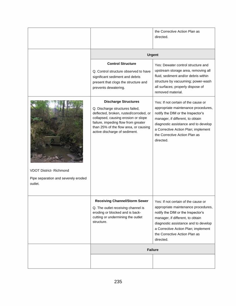
the Corrective Action Plan as
directed.
Urgent
Control Structure
Q. Control structure observed to have
significant sediment and debris
present that clogs the structure and
prevents dewatering.
Yes: Dewater control structure and
upstream storage area, removing all
fluid, sediment and/or debris within
structure by vacuuming; power-wash
all surfaces; properly dispose of
removed material.
Discharge Structures
Q. Discharge structures failed,
deflected, broken, rusted/corroded, or
collapsed, causing erosion or slope
failure, impeding flow from greater
than 25% of the flow area, or causing
active discharge of sediment.
Yes: If not certain of the cause or
appropriate maintenance procedures,
notify the DIM or the Inspector’s
manager, if different, to obtain
diagnostic assistance and to develop
a Corrective Action Plan; implement
the Corrective Action Plan as
directed.
VDOT District- Richmond
Pipe separation and severely eroded
outlet.
Receiving Channel/Storm Sewer
Q. The outlet receiving channel is
eroding or blocked and is back-
cutting or undermining the outlet
structure.
Yes: If not certain of the cause or
appropriate maintenance procedures,
notify the DIM or the Inspector’s
manager, if different, to obtain
diagnostic assistance and to develop
a Corrective Action Plan; implement
the Corrective Action Plan as
directed.
Failure
235

APPENDIX A
JOB AID: STORMWATER BMP FIELD INSPECTION APP (October 2019)
BMP Field Inspections
Esri Field Apps | Collector & Survey123 2
Logging into Collector 2
Logging into Survey123 3
Beginning BMP Inspections in Collector App 4
Prepping Collector For Offline Use 4
Using Collector To Locate Existing BMP Points 5
Completing the BMP Inspection Form in Survey123 App 6
Things to Note 7
Uploading Photos 7
Submitting Completed Surveys 9
Reviewing Submitted Inspections Online 10
Adding A BMP to Inventory 11
Documenting “Work Completed” Date for Repaired BMPs 14
Inspection, Maintenance, and Status Reports 14
Generating Inspection And Maintenance Reports 15
Upload Document as Attachment in HMMS 17
Generating Status Reports [coming soon] 18
1

ESRI FIELD APPS | COLLECTOR & SURVEY 123
VDOT’s BMP Inspection and Maintenance Program utilizes the ESRI Collector and Survey123 field apps. Field inspection begins with the Collector app where an inspector locates the BMP they are inspecting. From Collector, the pre-populated Survey123 form is launched and inspectors begin filling out the survey form for the selected BMP.
Before beginning inspections, the user should log in to both apps before beginning, following the instructions below to log into VDOT’s GIS Portal. If signed into ArcGIS Online, or the Non Production portal (or if unsure), log out and log in with the following steps.
NOTE when logging in:
There is a known error when signing in to the Production portal through any of the applications or browsers. It will look something like this:
If you ignore this error and sign in a few times, and continue trying to sign in, it will eventually stick!
LOGGING INTO COLLECTOR
1. Open the Collector app on the iPad.
2. Tap the “Sign In with ArcGIS Enterprise” button. 3. In the Sign In box, specify the Portal URL.
https://vdotgisportal.vdot.virginia.gov/portalx
Note: Next time Collector is opened, this link will appear
below in the “Recent” section
4. Tap “Continue”.
2

5. Tap the blue “Using your VDOT Account” button to log in with your VDOT credentials.
6. Enter your VDOT email address and password when prompted. 7. Tap “Sign On” to log in.
LOGGING INTO SURVEY 123
1. Open the Survey123 app on the iPad. 2. Tap the menu icon in the top right. 3. In the menu, tap “Sign In”.
4. On the Sin In page, tap the settings gear Icon In the top-right corner
5. On the Portals page, tap the “Add Portal” Button at the bottom of the screen.
6. Specify the Portal URL at the bottom of the screen.
https://vdotgisportal.vdot.virginia.gov/portalx
7. Ensure that the “Use external web Browser for sign in” is selected.
8. Tap “Add Portal.”
9. On the Portals page, confirm that “Prod Portal for ArcGIS” is listed and highlighted in grey.
Note: If not highlighted, click it to select
this Portal before proceeding.
10.Tap the back arrow in the top-left corner to return to the sign-in page.
11.On the sign-in page, tap the blue “Using Your VDOT Account” button to log in to Portal with your VDOT credentials.
3
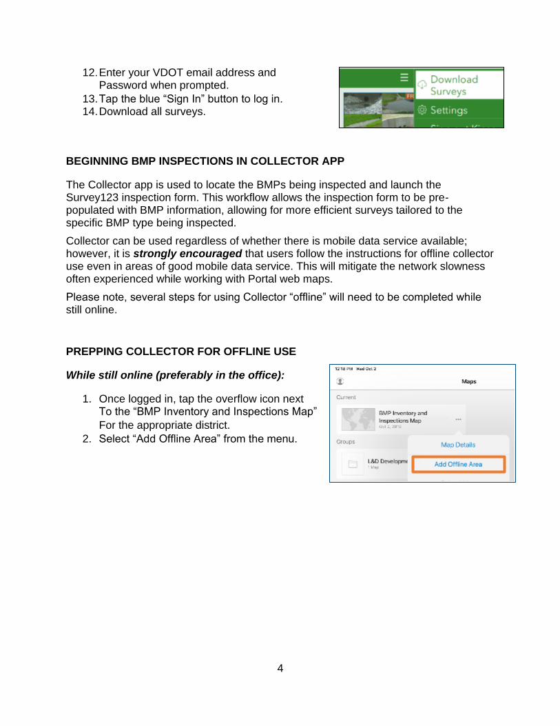
12.Enter your VDOT email address and Password when prompted.
13.Tap the blue “Sign In” button to log in. 14.Download all surveys.
BEGINNING BMP INSPECTIONS IN COLLECTOR APP
The Collector app is used to locate the BMPs being inspected and launch the Survey123 inspection form. This workflow allows the inspection form to be pre-populated with BMP information, allowing for more efficient surveys tailored to the specific BMP type being inspected.
Collector can be used regardless of whether there is mobile data service available; however, it is strongly encouraged that users follow the instructions for offline collector use even in areas of good mobile data service. This will mitigate the network slowness often experienced while working with Portal web maps.
Please note, several steps for using Collector “offline” will need to be completed while still online.
PREPPING COLLECTOR FOR OFFLINE USE
While still online (preferably in the office):
1. Once logged in, tap the overflow icon next To the “BMP Inventory and Inspections Map” For the appropriate district.
2. Select “Add Offline Area” from the menu.
4

3. In the “Add Offline Area” box, pan and zoom until the needed area is visible on the
Screen, within the black rectangular outline.
Note: The is a limit on how much of the
map can be downloaded, due to the large
file size. Any area outside of the black
rectangular box will not be downloaded.
4. Optionally, tap on the level of detail to adjust how much detail is included in the
download. Less detail allows for a larger
download area; more detail shows more on
the map when you zoom in. “Rooms” level of detail is recommended.
5. Tap the blue “Download Area” button.
Note: If prompted to sign into AGO, choose
the Enterprise login, enter “VDOT” in the URL box, and sign in with your VDOT email
and password.
In the field:
1. Open the Collector app and select “BMP Inventory and Inspections Map” for the appropriate district.
2. Select the previously downloaded area – the map will open, showing only the downloaded area.
3. Begin using Collector normally, following the steps below to locate the BMP and launch the Survey 123 form.
USING COLLECTOR TO LOCATE EXISTING BMP POINTS
Initially “open groups” and locate the map for Your district.
1. The map will automatically zoom into the iPad’s Current location when the map is opened.
2. Pan and zoom into the desired area and locate The BMP to be inspected.
5
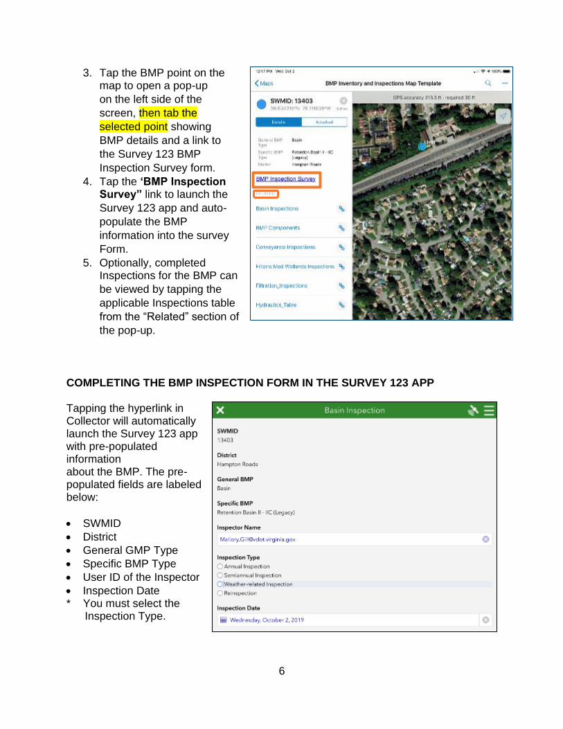
3. Tap the BMP point on the map to open a pop-up
on the left side of the
screen, then tab the
selected point showing
BMP details and a link to
the Survey 123 BMP
Inspection Survey form.
4. Tap the ‘BMP Inspection Survey” link to launch the
Survey 123 app and auto-
populate the BMP
information into the survey
Form.
5. Optionally, completed Inspections for the BMP can
be viewed by tapping the
applicable Inspections table
from the “Related” section of
the pop-up.
COMPLETING THE BMP INSPECTION FORM IN THE SURVEY 123 APP
Tapping the hyperlink in Collector will automatically launch the Survey 123 app with pre-populated information about the BMP. The pre-populated fields are labeled below:
• SWMID
• District
• General GMP Type
• Specific BMP Type
• User ID of the Inspector
• Inspection Date * You must select the
Inspection Type.
6
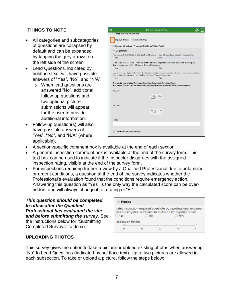
THINGS TO NOTE
• All categories and subcategories of questions are collapsed by
default and can be expanded
by tapping the grey arrows on
the left side of the screen
• Lead Questions, indicated by boldface text, will have possible
answers of “Yes”, “No”, and “N/A” o When lead questions are
answered “No”, additional
follow-up questions and
two optional picture
submissions will appear
for the user to provide
additional information.
• Follow-up question(s) will also have possible answers of
“Yes”, “No”, and “N/A” (where applicable).
• A section-specific comment box is available at the end of each section.
• A general inspection comment box is available at the end of the survey form. This text box can be used to indicate if the Inspector disagrees with the assigned inspection rating, visible at the end of the survey form.
• For inspections requiring further review by a Qualified Professional due to unfamiliar or urgent conditions, a question at the end of the survey indicates whether the Professional’s evaluation found that the conditions require emergency action. Answering this question as “Yes” is the only way the calculated score can be over-ridden, and will always change it to a rating of “E.”
This question should be completed In-office after the Qualified Professional has evaluated the site and before submitting the survey. See the instructions below for “Submitting Completed Surveys” to do so.
UPLOADING PHOTOS
This survey gives the option to take a picture or upload existing photos when answering “No” to Lead Questions (indicated by boldface text). Up to two pictures are allowed in each subsection. To take or upload a picture, follow the steps below:
7

Take a new picture: 1. In the “Picture 1” or “Picture 2” section
of the applicable category and
sub-category, tap the Camera icon – the device’s camera will automatically open.
2. Once the picture is taken, it is loaded into the survey and the user has the
following options:
a. Retake the picture by tapping the Camera icon.
b. Upload a picture from the device instead, by tapping the folder icon
(described in more detail below).
c. Rotate the image 90o in counter-clockwise or clockwise directions
using the Rotate icons.
d. Delete the picture by tapping the Trashcan icon – a pop-up will
appear asking the user to confirm
the image is to be deleted.
Upload a picture: 1. In the “Picture 1” or “Picture 2” section
for the applicable category or sub-
category, tap the Folder icon.
2. The device’s Photos App automatically opens, where the Inspector can browse
to the desired picture, and tap to select it.
3. The picture is loaded into the survey and the user again has the following options:
a. Retake the picture by tapping the Camera icon.
b. Upload a picture from the device instead, by tapping the folder icon
(described in more detail below).
c. Rotate the image 90o in counter-Clockwise or clockwise directions
using the Rotate icons.
d. Delete the picture by tapping the Trashcan icon – a pop-up will
appear asking the user to confirm
the image is to be deleted.
a b c d
a b c d
8
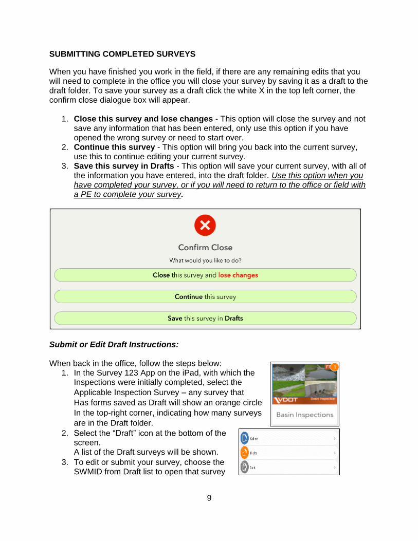
SUBMITTING COMPLETED SURVEYS
When you have finished you work in the field, if there are any remaining edits that you will need to complete in the office you will close your survey by saving it as a draft to the draft folder. To save your survey as a draft click the white X in the top left corner, the confirm close dialogue box will appear.
1. Close this survey and lose changes - This option will close the survey and not save any information that has been entered, only use this option if you have opened the wrong survey or need to start over.
2. Continue this survey - This option will bring you back into the current survey, use this to continue editing your current survey.
3. Save this survey in Drafts - This option will save your current survey, with all of the information you have entered, into the draft folder. Use this option when you have completed your survey, or if you will need to return to the office or field with a PE to complete your survey.
Submit or Edit Draft Instructions:
When back in the office, follow the steps below: 1. In the Survey 123 App on the iPad, with which the
Inspections were initially completed, select the
Applicable Inspection Survey – any survey that
Has forms saved as Draft will show an orange circle
In the top-right corner, indicating how many surveys
are in the Draft folder.
2. Select the “Draft” icon at the bottom of the screen. A list of the Draft surveys will be shown.
3. To edit or submit your survey, choose the SWMID from Draft list to open that survey
9
4. Complete any remaining questions or changes you would like to make in your survey. a. Note: If you have had to return to the field with a Qualified Professional to
make a decision on whether or not the BMP requires special or emergency repairs, be sure to complete the final question, and enter notes into the final “Notes” section describing the Professional’s directions. This will change the inspection rating to an “E.”
5. After your edits are made, tap the white Checkmark icon in the bottom-right of the screen and choose “Send Now.” Note: Remember the total size limit for uploading is 10Gb.
REVIEWING SUBMITTED INSPECTIONS ONLINE
Submitted inspections can be reviewed using the BMP web app available in VDOT’s portal. Follow the instructions below to access VDOT’s portal and open the web app.
Accessing the BMP Inventory and Inspection Web App:
1. Type the VDOT Portal URL into a browser window.
https://vdotgisportal.vdot.virginia.gov/portalx
2. Click “Sign In” in the top-right of the screen. 3. Click the blue “Using Your VDOT Account” button. 4. Enter your VDOT email address and password when prompted. 5. Click the blue “Sign In” button to log in. 6. On VDOT’s Portal Home Page, click on the “Groups” tab at the top of the
window. 7. Then, locate and click on the “MS4 BMP Survey123” group. (Change heading)
10

8. In the list of contents, locate and click on the “BMP Inventory and Inspections App” for the appropriate district.
9. In the item details page for the web App, click the blue “View Application” button on the right side of the window.
10.Optionally, bookmark the URL in your browser window for quick access to the web app in the future.
Review Submitted Inspections:
1. In the web app, click on the black arrow at the bottom center of the screen to expand the attribute table.
2. From the listed tabs, click the applicable Inspection table to review all submitted inspections for that BMP type.
3. To export the table to a CSV file, click the triangle beside the “Option” button and choose “Export All to CSV.”
ADDING A BMP TO THE INVENTORY
Downloading the “Add BMP to Inventory” Survey:
1. Open the Survey 123 App on the mobile device. 2. Make sure you are signed in to Portal. If not,
please refer to Logging into Survey123 in the
previous steps
3. Tap the “Menu” icon, and tap “Download Surveys.”
11

4. Find the “Add BMP to Inventory” survey and download it by tapping the icon right
next to the survey title.
5. After the download is completed, tap the back arrow on the top-left corner of the
screen to go back to the “My Survey”
page.
Deleting the Old “Add BMP to Inventory” Surveys:
1. Find the “Ádd BMP to Inventory” survey. You may find more than one survey with that name,
like what is shown on the right. Please click
on each one and check its creation date. We
only need the one created on 11/8/2019.
2. If the survey was created before that date, please click on the “Menu” icon on the top-
right corner of the screen and choose “Delete survey” to delete the old surveys and avoid confusion. (If you accidentally delete the new
survey created on 11/8/2019, please refer to
steps 3-5 in the previous section to download
it again.
12

Opening the New “Add BMP to Inventory” Survey:
1. Now you should only have one “Add BMP to Inventory” survey in your App. Click on that survey, and make sure it’s the one created on 11/8/2019.
2. Tap “Collect,” and the survey will appear. Type in the required information of the BMP and tap the check mark ( ✓ ) to send this survey.
Adding location information:
1. Under the Location Information section, for the Map Location question, click the “Map” icon.
2. Type the address of the BMP or the coordinates (e.g., 37.429607, -77.432711)
into the search bar to locate the BMP.
3. Click the check mark ( ✓ ) to save the chosen
location.
4. Finally, after all the required information is
entered, click the check mark ( ✓ ) to
send this survey.
13

DOCUMENTING “WORK COMPLETED” DATE FOR REPAIRED BMPs
For any BMPs rated “C” or worse that required maintenance beyond routine tasks (e.g. debris removal, mowing), the date of completion for the work must be documented using the BMP web app.
1. Access the web app using the instructions above.
2. Pan and zoom to the applicable BMP inventory point or search for the SWMID.
3. Click the BMP point where work has been completed.
4. In the pop-up, click on the applicable inspection type in the “Related Tables” section
5. Click on the applicable inspection in the list of inspections.
6. Click the “Menu” icon in the bottom right of the pop-up.
7. Click “Edit” from the drop-down. 8. In the “Edit Attributes” window, click the
“Maximize Window” icon in the top-right of
the pop-up screen.
9. Scroll to the bottom of the listed survey questions to locate the
“Maintenance Work Completion Date” field and enter the applicable date.
10.Click the white “X” in the top-right of the screen to save the edit and close
the Editor box.
11.Close the “Edit Widget” Window to exit the editing mode.
INSPECTION, MAINTENANCE, AND STATUS REPORTS
Users can create several types of word document reports based on submitted inspection results. Using the BMP Report Tool will give a zipped download that includes:
1. A folder including all photos associated with the inspection.
2. The Inspection Report word document. This a comprehensive report of a single
inspection, and will include all submitted answers as well as any pictures taken during
the field inspection.
14

3. The Maintenance Report is a list of the maintenance actions required for a single
BMP, based on the conditions gathered during the field inspection.
4. The Admin Report word document that includes necessary maintenance steps that
require administrative steps.
The status report (yet to come) will list all of the BMP’s in your district, the date they were last inspected if it is within the current year, a message indicating the BMP still needs to be inspected this fiscal year, and the current BMP rating.
GENERATING INSPECTION AND MAINTENANCE REPORTS
To access the report tool, first connect to the network (via VPN or Zscaler). Follow the instructions above to access VDOT’s portal and open the BMP Report app.
The Inspection, Maintenance and Admin report are all generated using a geo-processing script that is run from the web app’s Reporting widget.
1. Click on the Reporting Widget icon from the menu in the top-left of the screen.
2. In the “Input” tab, enter the following information for the desired BMP:
a. Inspection table: Select BMP type from
the dropdown options
b. SWM ID selected from the dropdown.
c. Inspection date: for the SWM ID chosen
there will be a list of inspection dates
available.
3. Click “Submit” to generate the reports. 4. Once successful, there will be a link
saying “Click to get report” that will initiate the download of a zipped file.
Note The zipped file will be named as
“ReportOutput”; please rename it to
“SWMID Inspection Date” to avoid
confusion.
15

If you find that no inspection shows up for a certain type of inspection table (e.g., Miscellaneous, etc.), then please try clearing your browser cache, or opening the app in Incognito Mode.
Clearing the browser cache: 1. Open the Chrome web browser.
2. Click on the icon on the top right corner of the screen and choose
“Settings.” 3. Type “Clear browsing data” into the
Search bar at the top, and tap
“Enter” on your keyboard. 4. Choose the first choice: “Clearing
browsing data.” 5. Under the “Basic” tab, set the time
range to “All time,” and only check the box in front of “Cached images and files.”
6. Click on the “Clear data” button at the bottom right of the pop-up window.
7. Close all your tabs in your Chrome browser, and restart it. Reopen the
BMP Report App, and then you
should be able to see all the
inspection records in the reporting
tool.
Open the App in incognito mode:
1. Open the Chrome web browser. 2. Right-click the Chrome icon on the
taskbar.
3. Choose “New incognito window.” 4. Paste the Report App’s link in the
Address bar at the top
(https://rnsarcgisprd.cov.virginia.gov/BMP_Report_App/). Then, hit “Enter” on your
keyboard.
5. Log into the portal, and you should be able to see all inspection records in the reporting tool.
16

If you would like to search for a BMP, you can use the “Query” tool to search by SWMID.
1. Select or search for the SWMID, then select “Apply.” 2. Under “Results” you will see the information related
to the SWMID you selected, and the map will zoom
to that BMP.
UPLOAD DOCUMENT AS ATTACHMENT IN HMMS
1. Navigate to the BMP on the map or by searching under “GIS Assets -> Find/Manage/Report.
2. Select “Documents” from the drop-down menu in either location.
3. Click on ‘Add Document” in the “Create Document Link” window that appears. Select “Choose Files,” navigate to the file on your local hard drive, and click “Create Link.” You can also link to a file already in HMMS (Link from Library) or directly to a URL (Direct Link).
17

4. Locate the file again by returning to the BMP and selecting “Documents” from the drop-down menu.
GENERATING STATUS REPORTS (COMING SOON)
The status report will indicate those BMPs that still need to be inspected for the current fiscal year or the date they were last inspected, and the current BMP rating. This report tool is also accessible via the BMP Inventory and Inspections Web App.
1. Click on the Status Widget icon from the menu in the top-right of the screen.
2. In the Input tab, enter the following information for the desired BMP:
a. District
b. File location to save the output PDF
3. Click the “Generate” button to generate the status report.
4. In Windows Explorer, navigate to the selected file location – the folder will contain a
single PDF that lists those BMPs still requiring an inspection for the current fiscal year.
18
APPENDIX B
Health, Safety, Security, and Environment
The safe work practices described below are designed to protect VDOT employees’ health, safety, security, and environment. These provisions may differ from local regulations, and based
on individual circumstances, it is expected that the more stringent requirement will be applied.
Safety Plan
A Safety Plan should also be included in the toolbox when conducting field work. This may seem
a bit excessive when the inspector is very familiar with the district, but another team member may
not be as familiar with the area, thus making the Safety Plan an essential item during
emergencies. A good Safety Plan should identify the location and range of services offered by
medical treatment facilities within the area, noting any limitations of these services. Most rural
emergency rooms cover all emergencies; however in metropolitan areas, there may be facilities
that offer a smaller range of services (i.e., specialty centers). It is difficult to remember these
details in the midst of an emergency, so it is important to include them in an easily accessible
Safety Plan. VDOT also recommends that a district map which visually identifies the location of
nearby medical treatment facilities be both included in the Safety Plan and used as the cover to
the Safety Plan. An example Safety Plan District Map is shown below in Figure B.1.
Figure B.1: Bristol District Hospitals Safety Plan Map
1
First Aid
Employees in the field are provided a first aid kit that meets the local requirements and is adequate
for the number of employees and the nature of the hazards. Providing ready access to appropriate
first aid equipment and providers/responders requires consideration of the following factors:
• The number of workers who may require first aid at any time,
• The nature and extent of the risks and hazards in the workplace, including whether or
not the workplace as a whole creates a low risk of injury,
• The types of injuries likely to occur,
• An effective means of communication between the first aid providers/responders and the
employees being attended to, and for the attendant to call for assistance.
• Any barriers to first aid being provided to an injured worker, and
• The time that may be required to obtain transportation and to transport an injured worker
to medical treatment.
VDOT employees are trained in the requirements for emergency communication and
transportation in the event of serious injury. The situation, the injury, and/or regulations may
dictate that the first aid provider accompany an injured employee to a medical facility.
Heat Stress Prevention
Workers who are exposed to extreme heat or work in hot environments may be at risk of heat
stress. Heat stress is the net (overall) heat burden on the body from a combination of the body
heat generated while working; environmental sources (air temperature, relative humidity, air
movement (wind), and radiation from the sun and/or hot surfaces/sources). Heat stress can result
in heat stroke, heat exhaustion, heat cramps, or heat rashes. Heat can also increase the risk of
injuries in workers as it may result in sweaty palms, fogged-up safety glasses, and dizziness. Heat
Stress can be broken down into 4 disorders, based on the severity of the symptoms experienced:
2

Heat Disorder Symptoms First Aid
HEAT RASH
Occurs in hot, humid environments
where sweat is not easily removed
from the body by skin evaporation.
Skin is red. In severe cases, infection
may occur.
Get the victim out of the sun and allow the
skin to dry. Washing the skin may further
cool the person.
Move the worker to a cooler environment; if
HEAT CRAMPS
Heat cramps are painful muscle
cramps caused by losing too much salt
through sweating. Heat cramps usually
occur in the muscles that have been
used the most strenuously, such as
those in the legs and abdomen. The
cramps typically occur late in a
workday or after the muscles have
cooled.
possible, lay the worker down, and remove
or loosen tight-fitting clothing. Cool the
worker by sponging with cool water and
fanning. Take care not to cool the worker
too much. If the worker begins to shiver,
stop cooling. If the worker is fully alert and
not nauseated, provide oral fluids. Juice,
non-caffeinated soft drinks, or commercially
available oral rehydrating solutions (sport
drinks), are best. Alcoholic and caffeinated
beverages are not recommended.
HEAT
EXHAUSTION
Heavy sweating, weakness, skin
cold, pale and clammy. Pulse
thready. Confusion possible.
Normal temperature possible.
Fainting and vomiting. Usually
caused when worker has failed to
drink enough fluids, take in enough
salt, or both.
Stop Work. Get victim out of sun. Lie down
and loosen clothing. Apply cool, wet cloths.
Fan or move victim to air-conditioned room.
Sips of water. If nausea occurs,
discontinue the fluids. If vomiting
continues, seek immediate medical
attention.
HEAT STROKE IS A SEVERE MEDICAL
HEAT STROKE
High body temperature (106F / 41C or
higher). Hot, dry skin which may be red,
mottled or bluish. Rapid and strong
pulse. Possible loss of consciousness.
Mental confusion or convulsions.
Caused by the body’s inability to effectively regulate its core
temperature.
EMERGENCY. ALL HEAT STROKE
VICTIMS REQUIRE HOSPITALIZATION.
Stop Work Immediately. Call 911 or
Emergency Medical Number in HASP.
Move the victim to a cooler place. Remove
heavy clothing. Cool the victim immediately
by any available means (ice packs, wet
towels or sheets, even wet clothing or AC).
Use extreme caution. If temperature rises
again, repeat process. Do not give fluids or
medication. Keep head and shoulders
elevated.
Most heat related health problems can be prevented or the risk of developing them controlled.
Below is a list of options that can help VDOT employees protect against heat exposure:
• Take timely access to shade, e.g., umbrellas, awnings, tree branches, or inside vehicles.
• Drink plenty of water (as much as 1 quart/0.94 liters per worker per hour).
• Alternate work and rest periods. As the temperature increases, more rest is required.
Schedule heavy work during the cooler parts of the workday, when possible. If
scheduling around the hottest part of the day is not possible, consider following a
modified work/rest work regimen.
3
• In all cases, VDOT employees should stop activity and exposure to hot weather when
the following symptoms occur:
• Sustained heart rate greater than 160 beats per minute for those under 35 and
140 for those 35 and over.
• Complaints of sudden and severe fatigue, nausea, dizziness, lightheadedness, or
fainting.
• Periods of inexplicable irritability, malaise or flu-like symptoms.
• Sweating stops and the skin becomes hot and dry.
• Wear sunscreen with an SPF factor of at least 30.
• Wear long sleeved cotton clothing. Hats can also reduce sun exposure if hard hats are
not being worn.
• If taking medication check the pharmacy safety pamphlet to determine if the medication
can cause the body to react to the sun and heat.
• Avoid caffeinated drinks, alcohol and drugs. Even used the night before working in heat,
these products can increase the potential for dehydration, increasing the potential for
heat stress. Personnel taking medications should discuss with their doctor the response
to heat and sunlight.
The bottom line with heat stress and heat disorders is to use common sense. If it’s hot, take precautions for yourself and watch fellow workers on the job site. Listen to your body, and use
the training provided in the first aid sessions.
Working in Cold Environments
Wind chill is the combined effect of air temperature and wind on exposed skin. This is the most
common metric for cold stress, but not the only factor that must be considered. The higher the
wind speed and the lower the temperature in the work environment, the lower the wind chill will
be. This equivalent temperature is relevant only to exposed flesh. The US National Weather
Service issues wind chill advisories and warnings for extremely dangerous weather conditions.
Warnings mean conditions are life threatening. Therefore, it is important to check the weather
forecast as well as current conditions before heading initiating inspections. Rapid cooling of a
body to below freezing temperatures can lead to an increased potential for serious medical
conditions and death if left untreated.
As temperatures decrease and the length of exposure increases, the following symptoms can
appear:
• Reduced dexterity of hands and feet
• Reduced tactile sensation
• Impaired ability to perceive heat, cold and pain
• Reduced joint mobility
4

• Reduced grip strength
• Hypothermia (reduced body temperature)
• Frostbite (freezing of exposed skin)
• Reduced coordination
• Reduced decision-making ability
VDOT makes the following recommendations for employees working in cold weather:
1. Under conditions of continuous work in the cold, heated warming shelters (tents, truck
cabins, rest rooms, etc.) should be utilized.
2. Warm fluids should be consumed to provide energy, warmth, and replace fluids lost
during work. Significant fluid loss can occur in the cold due to sweating, breathing, and
the extra energy requirements of working in the cold.
3. Dehydration in the cold is a serious concern, increasing a worker’s susceptibility to
hypothermia.
4. Employees experiencing the onset of severe shivering, feeling of excessive fatigue,
drowsiness, irritability or euphoria should immediately return to warm shelter.
5. An employees’ work rate should not be high enough to cause sweating. If heavy work must be performed, VDOT employees should take rest periods in heated shelters and
change into dry clothing if necessary.
Safe Driving
Driving is among the most hazardous tasks performed by VDOT employees; therefore, it is
imperative to follow safe driving practices. Employees are expected to develop journey
management plans, to perform pre-trip vehicle inspections, and to drive with care and without
distraction.
While driving during inspections, VDOT expects its employees to comply with local traffic
regulations, while also being conscious of general safe driving practices. The following actions
are viewed as serious breaches of conduct:
• Being under the influence of drugs or alcohol while driving
• Driving while disqualified or not correctly licensed or insured
• Driving without proper care and control of the vehicle
• Driving without regard for local traffic regulations
• Failing to stop after an accident
Driver hazards include drowsiness/fatigue, distractions within or around the vehicle, and
environmental and road conditions (e.g. weather, landscape topography, driving at night,
vegetation, etc.). Therefore, VDOT employees should plan ahead and take into consideration pre-
trip work duties, the length of the trip, and post-trip commitments. It is the responsibility of each
employee to come to work rested and alert in order to carry out work duties safely. VDOT prohibits
the use of mobile phones and other portable electronic devices (e.g., tablets, laptops) while
driving. Regulations in some districts have restrictions that exceed VDOT’s requirements, so
5

employees should be aware of the expectations for the district in which they are driving. Wherever
practicable, avoid driving in adverse weather conditions, but if that is not possible, drivers must
adapt when conditions deteriorate due to bad weather or otherwise.
Wildlife Encounters
There are VDOT inspection activities which require working in remote, forested areas where the
possibility of encountering wildlife increases dramatically. Working near farmlands with
domesticated livestock or farm animals may also increase the chance of an animal encounter.
Threats include bears, coyote, any animals with young, deer, cougars and rabid animals such as
fox, wolf, beaver, to name a few. Domesticated animals such as dogs, cats, horses or cattle may
also pose a threat. Bites from any animal are potentially dangerous because of the possibility of
rabies or severe infection. Almost all animal attacks are the result of surprise (to both parties)
encounters. In the event of a wildlife encounter, VDOT employees should notify appropriate
government agencies and appropriate VDOT personnel. In the event of an adverse wildlife
encounter resulting in injury, VDOT employees should obtain first aid and medical treatment for
any wounds or other injuries. All animal bites and scratches should be treated by a doctor to
prevent infections and for the possibility of rabies.
• Bear Avoidance
o Delegate at least one person to watch for bears and other animals.
o Stay in open areas as much as possible.
o If you are working near a river or dense brush, be sure to make noise as a bear may
not otherwise hear you.
o Be aware of the wind direction and walk with the wind whenever you can.
o Be observant and watch for bear signs. Fresh tracks, droppings and new digging are
all signs that a bear is in the area. If you see fresh bear signs, leave the area!
o Never approach a wild animal as it may feel threatened and attack you.
• How to React to a Bear Attack
o Stay calm.
o If you have bear spray, spray it directly at the bear or between you and the bear, so
that the bear has to run through to get to you.
o If you don’t have bear spray, or if it doesn’t have any effect, roll into a ball or lie face down.
o Vacate the area, keeping in mind the bear could still be around.
o If the bear mauls you continuously, you may have to fight back using any available
weapon - a knife, rock, fist - and concentrate on hitting the bear’s head, eyes and
nostrils.
o Apply or administer first aid as soon as possible.
• Cougars/Mountain Lions
o Mountain Lions usually do not like confrontation. Leave a wide berth between you and
the lion for its escape.
6

o Never turn your back or run away from a mountain lion. Running stimulates a mountain
lion’s instinct to chase. o Always make eye contact with the lion and stand up as tall as possible. Making yourself
look larger intimidates the lion and often makes them turn and run.
o Avoid stooping, leaning over, squatting, or bending at the waist.
o If you are attacked, fight back. Never succumb or roll into a ball.
o Where possible, throw the cat over your head and forward to get it off your back.
• Ungulates (Deer)
o If you find yourself close to a deer, (1) If it hasn’t detected you yet, keep it that way; (2) If it knows you’re there, talk to it softly and move away slowly; (3) Don’t be aggressive – you want to convince the animal that you aren’t a threat; and (4) If you think the animal is going to charge you, take cover or run away.
o Ungulates behave aggressively during their rutting season (typically late August to
October). Don’t completely turn your back on the animal. Keep an eye on it and remain aware of what it is doing. Whatever the season, do not approach ungulates. Always
maintain a distance of at least 30 meters/100 feet.
o Watch for signs that the moose or elk is upset. If its ears are laid back and its hackles
are up, it is likely to charge. Most of the time, when an ungulate charge, it is a ‘bluff’, or warning for you to get back – a warning you should take very seriously! If possible,
get behind something solid (like a tree or a car). Unlike with bears, it is okay to run
from a moose. They usually won’t chase you and if they do, it’s unlikely that they’ll chase you very far.
o If a moose knocks you down, curl up in a ball and protect your head with your arms
and keep still. Fighting back will only convince the moose that you may still be a threat.
Move only when the moose has backed off to a safe distance or it may renew its attack.
• Coyotes and Wolves
o If you encounter a coyote or a wolf, make the experience unpleasant for the animal.
o Respond to their presence aggressively by making yourself appear larger; wave your
arms overhead or thrust long objects like a walking stick toward the animal.
o Throw rocks, sticks or other objects.
o Carry a whistle and blow it to startle the animal or shout in a deep voice and maintain
eye contact.
o If the animal continues to approach, back away slowly. Do not turn away or run. This
will encourage the animal to chase you.
• Livestock
o If you find yourself among a herd of animals (cattle, horses, sheep, goats etc.) do not
panic. Be calm and confident. Some animals are naturally curious and will move in
closer to figure out what you are; all they require is to catch your odor and they will
move off. Speak gently but firmly to them.
o Be alert! When entering a property where you do not know the animals, it is impossible
to predict an animal’s actions or behaviors. Always be aware of what is happening around you.
o If you need to approach an animal, do this carefully without any sudden movements.
Always announce yourself when approaching. Do not stand or walk directly in front or
7

directly behind a horse or bovine; always approach from an angle and stay out of
kicking range of an animal (3-6 feet, usually). REMEMBER: If an animal kicks, DO
NOT Slap, Kick or Hit back! This will cause the animal to kick again and become even
more agitated.
• Dogs
o Never approach an unfamiliar dog.
o Never run from a dog or scream (loud noises make animals very nervous).
o Stay still when an unfamiliar dog comes up to you.
o Do not look a dog in the eye.
o Do not disturb a dog that is sleeping, eating or caring for puppies.
o Do not pet a dog without letting it see and sniff you first.
o Do not play with a dog you do not know.
o If knocked over by a dog, roll into a ball and lie still.
• Snakes
o The following section has been taken directly from The Virginia Herpetological
Society’s Guide to the Snakes of Virginia. To see the entire list of Virginia snakes and
information regarding their characteristics follow this link:
https://www.virginiaherpetologicalsociety.com/reptiles/snakes/snakes_of_virginia.htm
l
o To protect yourself from snake bites, keep a visual on where you are walking looking
for movement in brush and rocks. It may also help to wear thick loose-fitting clothing
and tall muck boots with steel toes.
o About 8,000 people are bitten by venomous snakes a year in the US, 5-10 people die.
In contrast, 15,000 to 20,000 die every year from the side effects of aspirin. Venomous
snake bites are medical emergencies, and they can be deadly if not treated quickly.
However, the chances of being envenomated are extremely low. Getting the person
to an emergency room as quickly as possible is the very best treatment. If properly
treated, many snakebites will not have serious effects.
8

o What to do in case of a venomous snakebite:
1. Get medical help immediately. Call 911. Keep the person calm.
2. Mark the place of the bite, and write the time of the bite on the person with a
sharpie or other permanent marker.
3. Restrict movement, create a loose splint to help restrict movement of the area.
4. Keep the affected area higher than heart level or at least level with the heart.
5. Remove any rings or constricting items because the affected area may swell.
6. Monitor the person’s vital signs – temperature, pulse, rate of breathing, and for
signs of shock (such as paleness), lay the person flat, raise the feet about a
foot, and cover the person with a blanket.
7. If swelling occurs, mark the extent of the swelling with a marker, and write the
time.
• DO NOT
o DO NOT allow the person to become over-exerted. If necessary, carry
the person to safety.
o DO NOT apply a tourniquet.
o DO NOT apply a cold compress to a snake bite.
o DO NOT cut into a snake bite with a knife or razor.
o DO NOT try to suction the venom by mouth.
o DO NOT give the person stimulants or pain medications unless
instructed to do so by a doctor.
o DO NOT give the person anything by mouth, except water.
o Keep in mind that non-venomous snakes can bite as well, so whenever one is tramping
through brush, it is important to carefully scan the ground and immediate surroundings,
especially for places where snakes like to settle, such as under logs or rocks or in a
sunny spot to warm themselves. Also, don’t discount the risk associated with bites from non-venous snakes. Their mouths are dirty and their bites can cause nasty
infections, even if they are not poisonous.
9
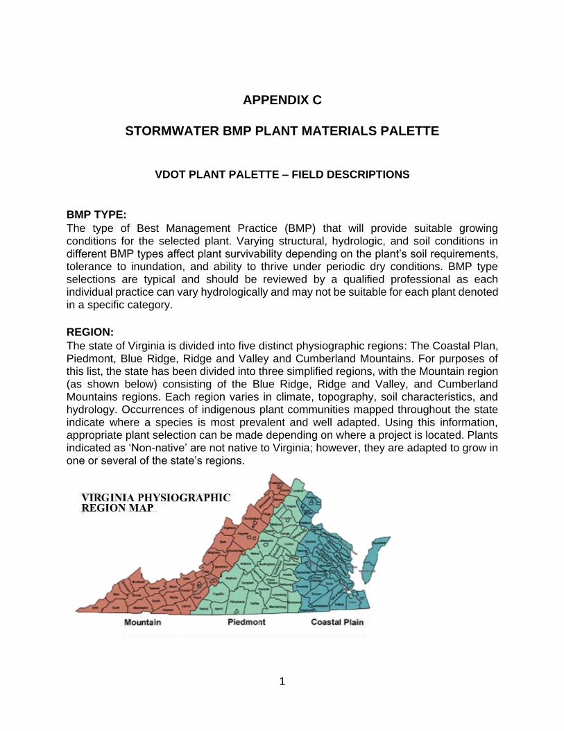
APPENDIX C
STORMWATER BMP PLANT MATERIALS PALETTE
VDOT PLANT PALETTE – FIELD DESCRIPTIONS
BMP TYPE:
The type of Best Management Practice (BMP) that will provide suitable growing conditions for the selected plant. Varying structural, hydrologic, and soil conditions in different BMP types affect plant survivability depending on the plant’s soil requirements, tolerance to inundation, and ability to thrive under periodic dry conditions. BMP type selections are typical and should be reviewed by a qualified professional as each individual practice can vary hydrologically and may not be suitable for each plant denoted in a specific category.
REGION:
The state of Virginia is divided into five distinct physiographic regions: The Coastal Plan, Piedmont, Blue Ridge, Ridge and Valley and Cumberland Mountains. For purposes of this list, the state has been divided into three simplified regions, with the Mountain region (as shown below) consisting of the Blue Ridge, Ridge and Valley, and Cumberland Mountains regions. Each region varies in climate, topography, soil characteristics, and hydrology. Occurrences of indigenous plant communities mapped throughout the state indicate where a species is most prevalent and well adapted. Using this information, appropriate plant selection can be made depending on where a project is located. Plants indicated as ‘Non-native’ are not native to Virginia; however, they are adapted to grow in one or several of the state’s regions.
1

HYDROLOGIC ZONE:
Under HYDROLOGIC ZONE there are six categories indicating a plant’s level of tolerance of periodic, regular or permanent inundation. These categories were derived from various sources, including Virginia DCR Natural Heritage, USDA (Wetland Indicator Status), and the Virginia DCR Stormwater Design Specifications for Constructed Wetlands.
WETLAND INDICATOR STATUS:
The WETLAND INDICATOR STATUS field contains information taken directly from the USDA Wetland Indicator 2013 database, which details how frequently a plant is likely to be found within a wetland. The list is divided into Atlantic and Gulf Coastal Plain (AGCP) and Eastern Mountains and Piedmont (EMP) regions. These designations categorize the indicator status based on geographic location.
Indicator Code Indicator Status Comment
OBL Obligate Wetland Almost always occur in wetlands
FACW Facultative Wetland Usually occur in wetlands, but may occur in non-wetlands
FAC Facultative Occur in wetlands and non-wetlands
FACU Facultative Upland Usually occur in no-wetlands, but may occur in wetlands
UPL Obligate Upland Almost never occur in wetlands
NI Non-Indicator Status not yet determined (Non-native)
MOISTURE:
MOISTURE indicates level of moisture tolerance the plant will prefer for optimal growth.
SHADE TOLERANCE:
Categories are provided to indicate the amount of shade that a plant can tolerate in order to grow and thrive. The minimum or maximum amount of sunlight a plant receives throughout the day can affect its performance. It there is no indication in one or more of the categories, then selecting a plant for that type of location is not recommended.
SALINITY:
This field indicates the amount of salt exposure that the plant can tolerate. Concentrations
2

of salt can be measured in soil, water, and air. ‘Sensitive’ indicates a low salt tolerance whereas ‘Resistant’ indicates a high salt tolerance.
MAX HEIGHT:
This represents the maximum observed height that has been documented each plant under ideal growing conditions. A selected plant may or may not achieve the maximum height as indicated depending on specific site conditions. Units are in inches for herbaceous plants and in feet for woody shrubs and trees.
LEAF TYPE:
Seasonal persistence of foliage varies among plants. Evergreens retain their leaves year-round, whereas deciduous plants loose leaves in winter and regenerate the following spring. Semi-evergreen plants may or may not loose leaves depending on climate variability and geographic location.
PH RANGE:
This provides a low point and high point for acidity/alkalinity in soils that a selected plant will tolerate. These values are intended to provide general guidance on plant adaptability, and the mid-point among these values would be considered the ideal pH level for the plant.
INUNDATION:
Permanent inundation depth as measured in a wetland or pond condition is provided in inches. This is not a measure of periodic inundation level which may occur in bioretention facilities or BMP’s that are only wet during storm events.
BLOOM SEASON / SEASONAL INTEREST:
Selected months of the year are provided to indicate when a plant displays showy characteristics. These can be flowers, fruit, foliage color, stem color, bark texture, or other characteristics that would merit attention.
NOTABLE FALL FOLIAGE:
Notable fall foliage is an indication of visual interest displayed by deciduous plant foliage during the autumn months. Foliage color is provided in the ‘Notable Characteristics’ field.
NOTABLE CHARACTERISTICS:
This provides a more in-depth description about particular characteristics for plants indicated as having seasonal interest. Flower color, fruit color, fall foliage color, and bark texture are some of the attributes provided.
3

REFERENCES
DCR Natural Heritage http://www.dcr.virginia.gov/natural_heritage/np.shtml
The Lady Bird Johnson Wildflower Center http://www.wildflower.org/ladybird/
USDA Forest Service Fire Effects Information System http://www.fs.fed.us/database/feis/plants/index.html
USDA-NRCS Plant Database http://plants.usda.gov/java/
Virginia Cooperative Extension http://pubs.ext.vt.edu/category/trees-shrubs-roundcovers.html
Virginia Stormwater BMP Clearinghouse http://vwrrc.vt.edu/swc/NonProprietaryBMPs.html
Dirr, M. A. Manual of Woody Landscape Plants
Hightshoe, G. L. Native Trees, Shrubs, and Vines for Urban and Rural North America; a Planting Design Manual for Environmental Designers
U.S. Fish and Wildlife Service, Native Plants for Wildlife Habitat and Conservation Landscaping; Chesapeake Bay Watershed
Weakley, A. S., Ludwig, C. J., Townsend, J. F. Flora of Virginia
4
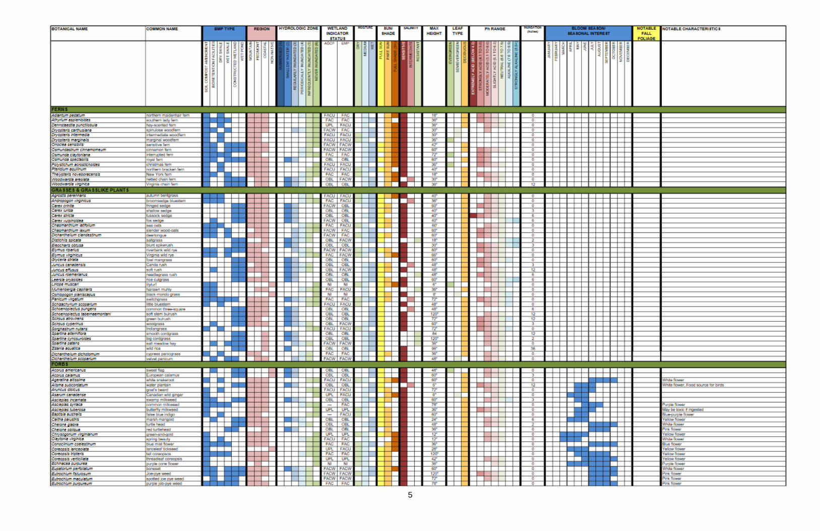
5

6
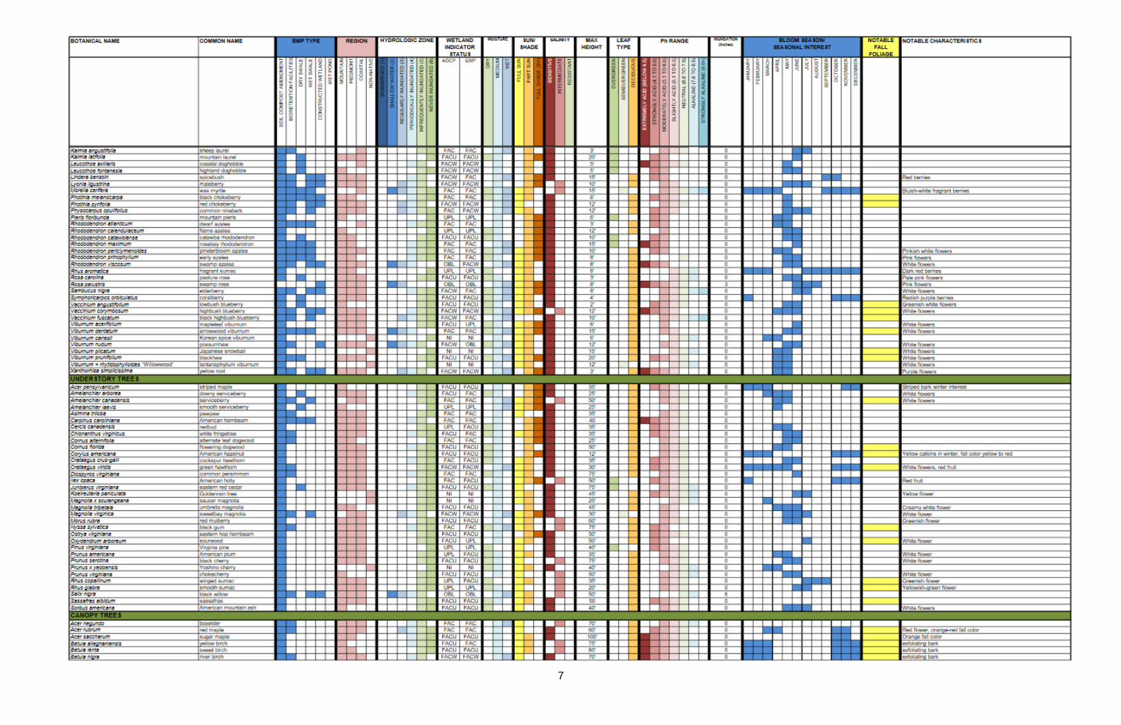
7

8
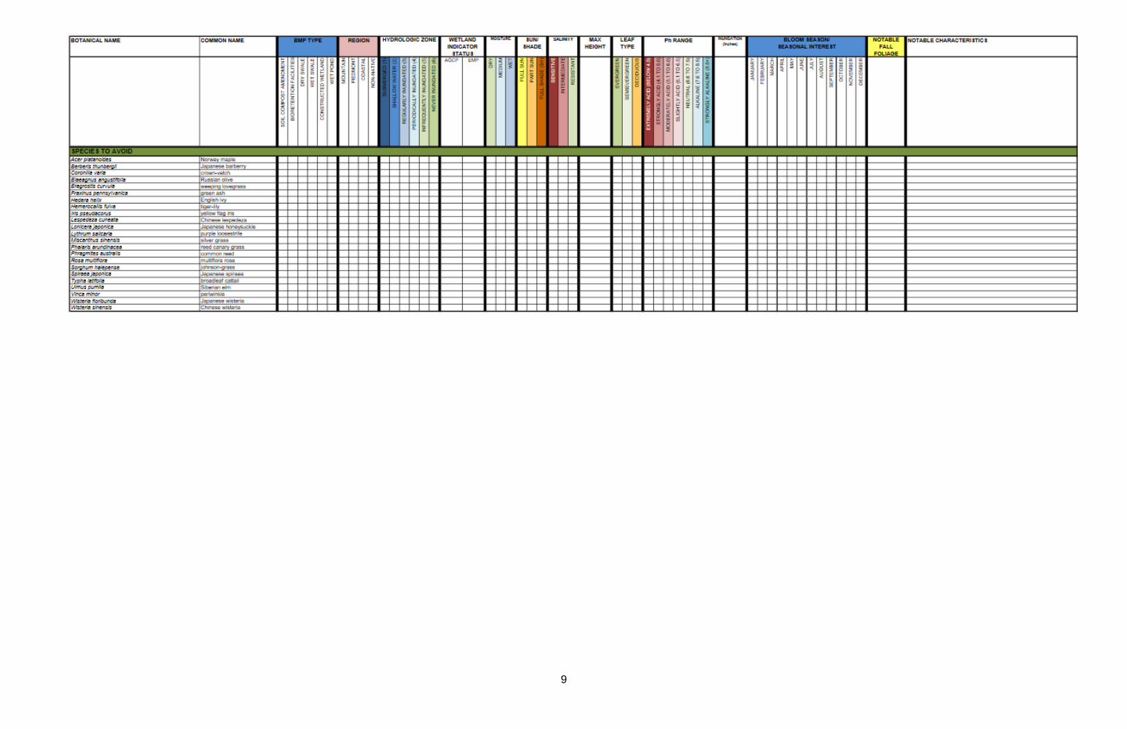
9
APPENDIX D
TEST PIT DESCRIPTION AND STANDARDS
1
Troubleshooting Infiltration Rates Most Clearinghouse BMPs have a key infiltration component to incorporate stormwater runoff
back into the soil and the water table. Infiltration rates vary with soil types due to both the size of
the soil particles (e.g. clay, silt, sand, and gravel) and the compaction of the soil particles, as these
affect the void spaces that allow water to drain into them. Bioretention facilities are a type of
infiltration facility and are designed to fully dewater within 48 hours, and, in most storm events,
should be free of standing water in as little as 12 hours.
The most common non-routine maintenance item with infiltration BMPs is clogging of the filter
media, indicated by standing water. The filter media can become clogged for a variety of reasons,
including upstream erosion which can cause silt to fill in the void spaces and negatively affect the
infiltration rate. While there are ASTM standard tests that can be performed by construction
testing companies, the following are basic techniques that can be applied in the field to determine
infiltration rates and identify problematic areas.
Checking the Underdrain In facilities with an underdrain, there is typically an observation/clean out well to assist with trouble
shooting. There are typically multiple vertical capped PVC pipes in the middle of the facility that
tie into the horizontal pipe across the length of the facility. For further information see the cross-
section on the approved plans. The following should be done to assess the infiltration based on
observations of the cleanout well:
1. Open the observation well and visually note the standing water level if any.
2. Pour water into the observation well. If the water passes down the well and into the
underdrain, then the underdrain is functioning properly.
3. If there is standing water in the observation well, it may indicate:
a. A blockage in the underdrain which would need to be snaked, or
b. High water tables, especially in the Tidewater region.
4. If the underdrain is functioning properly, and there is standing water on the surface of the
facility for 48 hours or more after a rain event, this is an indication of a clogged media
layer.
Basic Infiltration Ring Test If a clean out well is not present, infiltration can be measured with a basic infiltration ring test, as
described in the following section.
Required Tools:
- Schedule 40 PVC Pipe with an Internal Diameter Between 3 in and 6 inches
- Ruler
- PVC Cutter
- Permanent Marker
- Stopwatch
- Water (preferably rainwater or distilled water)
- Rubber Mallet or Similar Tool
2
Creating the PVC Infiltration Ring:
1. Cut a 4” minimum length from the PVC pipe. 2. Draw a ring on the outside of the pipe at an elevation of 1” above the bottom of the pipe.
3. Draw marking lines inside of the pipe at elevations of 1” and 2” below the top of the level ring.
4. Label each line as the corresponding number of inches below the top of the pipe.
Running the Infiltration Test:
1. Use the rubber mallet to hammer the ring into the ground to the 1” exterior line (from the
top) on the infiltration ring. The ground should be as level as possible for a uniform depth
reading.
2. Fill the infiltration ring to the top with water.
3. Start the stopwatch when water reaches the top of the pipe.
4. Record the stopwatch reading when the water draws down to the 1” line. 5. Record the time in minutes. Round any seconds to the nearest tenth of a minute. (For
example, if it the stopwatch reads 30 seconds, record 0.5 minutes.)
6. Establish the infiltration rate as 1” of water per number of recorded minutes and divide for
an inches/minute numeric rate. (For example, if it took 3 minutes and 20 seconds to draw
down an inch, the infiltration rate would be 1 in/3.3 min = 0.3 in/min.)
7. Take the infiltration rate from above and multiply by 60 to convert the infiltration rate to
in/hr consistent with BMP specifications. (For example, 0.3 in/min X 60 min/hr = 18 in/hr)
8. If the infiltration rate is still less than 1 in/hr and there is no discernable clogging, refer the
BMP facility to a VDOT District Hydraulics Engineer for further review.
9. If the infiltration rate is greater than 1 in/hr and meets the specification you may stop.
Additional data may be warranted if the rates are lower than expected in order to
specifically identify the problem. For additional data, proceed to steps 10-11.
10. Dig down 4-6” or more, remove the material, being careful to preserve the mulch and the
filter media and perform steps 1-7 again. This establishes the infiltration rate of the second
layer.
11. If the infiltration rate of the second layer is less than or equal to the infiltration rate of the
top layer, then the lower layer may be clogged, among other potential issues. Refer the
BMP facility to a VDOT District Hydraulics Engineer for further review. If the infiltration rate
of the second layer is significantly greater than the infiltration rate of the top layer, this may
indicate clogging in the top layer only.
12. Clogging may also be indicated by discoloration and mottling around the upper layers of
the soil media. If there is a layer of soil that is colored significantly different than the
bioretention media below it, then the upper, differently colored layer of filter media is likely
clogged with fine particles. To determine the depth of clogging, perform steps 1-7 at
differently discolored strata.
13. The clogged layer will require removal and replacement to re-establish the specified
infiltration rates. Contact appropriate VDOT staff to establish a maintenance plan.
14. Fill the hole back in with the filter media and cover the replaced filter media with the layer
of removed mulch.
3

Examples Searches on the internet for “infiltration test” provided the following videos as examples.
https://www.youtube.com/watch?v=3PSroyhfXDM
Soil Infiltration Test - YouTube
4

APPENDIX E
Managing Waterfowl at Stormwater Ponds and BMPs
Thanks to the Fairfax County, VA Geese Management Program, Virginia Tech Cooperative Extension, Clemson University Cooperative Extension, the N.C. State University Sea Grant Program, Purdue University Cooperative Extension Service, AND the American Humane Society, for the following information, some of which is copyrighted by these various sources.
Although migratory by nature, ducks, geese, and swans often choose to reside in residential stormwater ponds year-round because there are few predatory threats and they can find suitable habitat. As a result, populations of these birds can grow to the extent that they begin to cause significant property damage and become a health concern for themselves, for residents in the community, and for swimmers, surfers, and fishermen using rivers and beaches downstream.
Are there benefits to having waterfowl in a stormwater pond?
Very few. The most significant benefit is aesthetic and a matter of opinion. Having at least some ducks, geese, or swans in a pond does make the pond seem more natural and appealing. Also, waterfowl can be very playful and an enjoyment to watch. Otherwise, waterfowl do not provide any real management services such as controlling weeds or
1

managing pollution. Quite the contrary, concentrated populations of these birds can cause serious property damage and water quality problems in stormwater ponds and can make aquatic weed and algae problems much worse.
What is so bad about waterfowl in stormwater ponds?
Large aggregations of waterfowl cause significant damage to stormwater ponds. Large groups of ducks, geese, and swans can:
1. erode shorelines by trampling and feeding on shoreline plants
2. destroy lawns and gardens
3. introduce invasive weeds that are stuck to their feathers and carried in their digestive
tracts
4. deposit large volumes of feces (excrement) that increase algae and weed growth and
introduce disease causing pathogens into the water that threaten the health of
residents, pets, and the birds themselves
5. make water muddy and cloudy as they sift through the mud for invertebrates and
uproot vegetation
6. become aggressive with children and pets
7. create unsightly conditions when they molt, leaving feces and feathers in yards, on
porches and on driveways and roads
How many ducks/geese is too many for a pond?
Two birds per acre of pond is a manageable number that will not result in significant property damage or water quality impairments. This number should be considered as an average because ducks are highly mobile and migratory. At certain times of the day, ducks in the community may aggregate in one area or another, and at certain times of the year (mainly the winter months) migratory birds may temporarily reside in a community's
2

ponds. At other times, ecological pressure (competition and predation) will force the birds to disperse and move on.
How can we reduce the number of waterfowl in our ponds?
STOP FEEDING THEM! Although stormwater ponds provide suitable open space and water for ducks and geese, they do not usually provide adequate food. Waterfowl require a diversity of plants and invertebrates for healthy growth, and stormwater ponds do not normally have the appropriate food base to sustain large groups of waterfowl. The primary reason waterfowl aggregate in stormwater ponds is that their diet is being supplemented by humans. Before any other strategy can be employed, a community that is trying to reduce waterfowl numbers MUST curtail all feeding of birds; otherwise, other efforts will be futile.
3