blogs.ubc.cablogs.ubc.ca/giscience/files/2016/01/DataDescription_ne… · Web viewOur geography...
4
UBC Geography Server Datasets Our geography department GIS datasets are located under the G:\ courses\data\ file structure and can only be accessed from the labs. These folders represent many different datasets that we have accumulated over the years. The datasets are grouped mostly by geographic location, with a few folders referring to topic or data source. For your GEOB270 project, you have the choice to work with 1 out 4 datasets: 1. CityOfVancouver * 2. FieldCamp07 3. gvrd.av 4. ubc * preview this data to see what is there but NOTE: all of this data is now available on the City of Vancouver open data web site – download the layers you are interested in for the most up to date data It would be good idea to preview the different datasets using ArcCatalog. This is likely the first time you are using the G:\ so it will not initially show up in the table of contents. You will need to connect to G:\courses\ data\ before you can explore the files. Unfortunately, not all layers have metadata visible through ArcCatalog, so you might have to use My Computer to read documentation files in Word of PDF format. What follows is a
Transcript of blogs.ubc.cablogs.ubc.ca/giscience/files/2016/01/DataDescription_ne… · Web viewOur geography...

UBC Geography Server Datasets
Our geography department GIS datasets are located under the G:\courses\data\ file structure and can only be accessed from the labs. These folders represent many different datasets that we have accumulated over the years.
The datasets are grouped mostly by geographic location, with a few folders referring to topic or data source.
For your GEOB270 project, you have the choice to work with 1 out 4 datasets:
1. CityOfVancouver * 2. FieldCamp073. gvrd.av4. ubc
* preview this data to see what is there but NOTE: all of this data is now available on the City of Vancouver open data web site – download the layers you are interested in for the most up to date data
It would be good idea to preview the different datasets using ArcCatalog. This is likely the first time you are using the G:\ so it will not initially show up in the table of contents. You will need to connect to G:\courses\data\ before you can explore the files.
Unfortunately, not all layers have metadata visible through ArcCatalog, so you might have to use My Computer to read documentation files in Word of PDF format. What follows is a general
description of the files that might of interest for you project.
There are many other layers you can explore and possibly use, but the four listed above are the more complete datasets.
ArcGIS documentationThis folder contains a limited number of ArcGIS tutorials that can bundled with the software. Most of the tutorials can now be accessed through ArcGIS’s online help.

G: Drive General Data Description
1. City Of Vancouver:
Although there are many layers listed on the geog server, these datalayers will be out of date , the City of Vancouver routinely releases to the public many geospatial layers that it uses on its interactive mapping services. The most up-to-date layers can be accessed from the City’s catalogue web page at:
http://data.vancouver.ca/
This data can also be used with layers from the gvrd.av folder described later in this document.
2. FieldCamp07
The Geography department ran a physical geography field course (GEOG309) May 07 around Shatford Creek, west of Penticton in the Okanagan Valley . This dataset contains information for that area.
AgriculturalLandReserve: land in BC that has been reserved for agricultural use. More information can be found at http://www.alc.gov.bc.ca/
BC_Wind: a dataset of 1-Km polygons that measures wind speed and wind power. Originally obtained from: http://www.windatlas.ca/
Climate_stations: climate stations location with elevation data. DEM_30m resolution DEM_90m resolution FieldCampBEC: digital Biogeoclimatic
Zone/Subzone/Variant/Phase map. More information on BEC here: How BEC Works
Forest Cover: contains forest cover information. Uses the same index as TRIM tiles. You can read its metadata at http://gis.ubc.ca/gis-reference/
Landcover: Land Cover information is the result of vectorization of raster thematic data originating from classified Landsat 5 and Landsat 7 ortho-images, for agricultural and forest areas of Canada, and for Northern Territories. Obtained from: http://www.geobase.ca/geobase/en/index.html
NatRoadNetwork: The National Road Network (NRN) provides quality geospatial and attributive data, homogeneous and normalized of the entire Canadian road network.Obtained from: http://www.geogratis.ca/
NatTopDB_250K: national topographic sheets in GIS format. They contain contour lines, manmade features, water features, etc. Read background information at http://www.nrcan.gc.ca/earth-sciences/geography/topographic-information/maps/11086, and the list of features at http://chatt.hdsb.ca/~crowej/FOV1-000B918F/FOV1-001052EA/S0CC4060D.4/Topographic_Map_Symbols_official_.pdf . Obtained from: http://www.geogratis.ca/
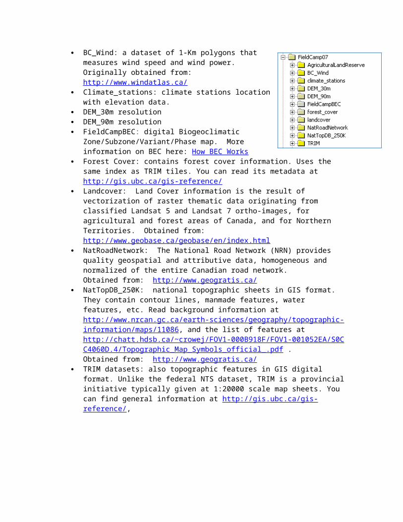
TRIM datasets: also topographic features in GIS digital format. Unlike the federal NTS dataset, TRIM is a provincial initiative typically given at 1:20000 scale map sheets. You can find general information at http://gis.ubc.ca/gis-reference/,
3. gvrd.av (gvrd = Greater Vancouver Regional District - now called Metro Vancouver)
Contain many layers for the GVRD area: 5m_orthophoto AgriLandRes: agricultural land reserve ambient2001: daytime population estimates.
Contains word document with metadata. Census xxxx: geography and data tables at DA(EA)
and CT level for different years. The 2011 is not complete since it is missing the National Household Survey. You will have to download this data as you did in lab 4 from the UofT web site.
Floodplain: Historical vegetation of the floodplain of the Lower Fraser, Serpentine, and Nicomekl rivers
gvrddem: 25 meter resolution DEM ICBC_crash_stats: regional statistics on crashes involving
vehicles, pedestrians, and cyclists. Landuse2001: produced by GVRD for 2001. PublicTransit2010: 2010 public transit including
routes and stops. RouteLogistics_2012: another DMTI product which
includes a network ready road layer as well a more recent land use layer. Documentation is in PDF folder.
4. UBC
The UBC data contains information about the infrastructure on campus, over many years. The metadata are not always present.