Black Creek Floodplain Risk Management Study and … Creek Floodplain Risk Management Study and Plan...
24
Black Creek Floodplain Risk Management Study and Plan Floodplain Management Committee Meeting 15 February 2016 David Whyte
Transcript of Black Creek Floodplain Risk Management Study and … Creek Floodplain Risk Management Study and Plan...

Black Creek Floodplain Risk Management Study and Plan
Floodplain Management Committee Meeting15 February 2016
David Whyte

Black Creek Floodplain Risk Management Study and Plan
Presentation Outline
Project background Community Consultation Extension and update of hydraulic
model
Flood mitigation option assessment
Floodplain Risk Management Plan
Public Exhibition and Comments
Actions post Public Exhibition
Next Steps/Finalisation

Black Creek Floodplain Risk Management Study and Plan
Study Team
Cessnock City Council
Cardno
Black Creek Floodplain Risk Management Study & Plan
Community &Agencies
Peer Review
Support & Funding
Consultation & Feedback
Consultation & Feedback OEH

Black Creek Floodplain Risk Management Study and Plan
Project Background
Black Creek Flood Study (DHI, 2010)
Developed models to identify existing flooding behaviour within the catchment
Extended and updated by Cardno (2014)
Black Creek Floodplain Risk Management Study and Plan (Cardno, current)
Evaluation of floodplain management options for existing and future development
Floodplain Risk Management Committee
Data Collection
Flood Study
Floodplain Risk Management Study
Floodplain Risk Management Plan
Adoption and Implementationof the Plan
Monitor and R
eview

Black Creek Floodplain Risk Management Study and Plan
Community ConsultationCommunity engagement is important for the study
To gather community knowledge to inform the assessments
To ensure that the proposed mitigation strategies meet community needs
Press Release (2012)Information brochure (2013)
Mailed out to 1,600 propertiesCommunity questionnaire (2013)
Mailed out to 1,600 properties Floodengage online questionnaire
Information brochure (2015) Mailed out to 1,600 properties
Public Exhibition of Draft FRMS&P (2015) Community drop-in session

Black Creek Floodplain Risk Management Study and PlanMIKE FLOOD Model Extension

Black Creek Floodplain Risk Management Study and Plan
Extension and Update of Flood Study ModelReasons for updates:
Availability of LiDAR survey data collected in 2011 Existing model did not have sufficient coverage throughout Cessnock to
provide flooding information to inform future development
Existing model results inconsistent in places
Extension of 2D model area to give better definition of flooding behaviour in urban areas of Cessnock
Outputs: Flood mapping (flood extents, depths, velocities, provisional and true
hazard, hydraulic categories) Impacts of climate change on flood behaviour Flood damages assessment

Black Creek Floodplain Risk Management Study and Plan
1% AEP Flood Depths

Black Creek Floodplain Risk Management Study and Plan
Flood Damages Assessment

Black Creek Floodplain Risk Management Study and Plan
Flood Management Options
Preliminary options assessment Results of flood modelling Community responses to
questionnaire Engineering judgement and Council
liaisonOptions assessment of Preferred Options
Structural flood mitigation options Property modification options Emergency response modification
options
Confluence of Black Creek and Kearsley Creek, CBD
Oliver Street Channel, South Cessnock
Black Creek Floodplain Risk Management Study and Plan
Four Detention Basins along Black Creek upstream of Bellbird Creek
Major reductions in flood levels and overfloor flooding along Balck Creek in all events up to the 1% AEP event
Large cost of construction due to large volumes to achieve the flood mitigation.
Option not optimised and potential environmental constraints.
Structural Option FM1 – Multiple Detention Basins along Black Creek

Black Creek Floodplain Risk Management Study and Plan
Bellbird Creek channel reshaping from Stephen Street to confluence with Lavender Creek
Detention Basin at former PCYC centre
Local bund at Stephen Street
Minor reductions only on overland flow path adjacent to Bellbird Creek in 1% AEP event
Increased flow in Bellbird Creek adversely impacts flood levels along Black Creek, upstream of the confluence
Structural Option FM2 – Bellbird Creek Reshaping, Detention Basin, Local Bund at Stephen Street
Detention basin

Black Creek Floodplain Risk Management Study and Plan
Black Creek channel widening within available open space from Wollombi Road to Ferguson Street
Channel reshaping/flood walls downstream of Ferguson Street
Culvert upgrades at Wollombi Road, Doyle Street, Henderson Street
Reductions up to 0.3m in 1% AEP flood levels, however increases occur due to flood walls
Flood walls cause local ponding, could be reviewed at design stage
Structural Option FM3 – Black Creek Widening/Reshaping, Culvert Upgrades
Black Creek channel reshaping
Black Creek channel wideningCulvert upgrade Wollombi Road
1% AEP

Black Creek Floodplain Risk Management Study and Plan
Existing Hunter Water channel doubled in size along Oliver Street
Existing channel has reverse grade, widened channel optimised
Channel flow is controlled by Kearsley Creek which has a larger contributing catchment
Channel widening does not improve the flooding in this area in the 1% AEP
Does have some improvement in the lower events
Structural Option FM4 – Oliver Street Channel Widening100yr
Channel widening

Black Creek Floodplain Risk Management Study and Plan
Proposed bund to retain flows on the eastern side of the railway line
Flow diverted north towards Kearsley Creek and away from South Cessnock residential properties
Reductions in 1% AEP flood levels up to 0.3m, reductions up to 500mm for 20% AEP event.
Proposed bund on private land, implications on railway line and existing culverts to be investigated at concept design stage
Structural Option FM5 –Bund/Detention Basin Upstream of South Cessnock
Proposed bund
1% AEP

Black Creek Floodplain Risk Management Study and Plan
Proposed detention basin to retain flows in Bellbird Creek on the eastern side of the railway line
Flows detained, reducing flows along Bellbird Creek
Reductions in 1% AEP flood levels up to 0.3m, reductions up to 500mm for 20% AEP event.
Proposed basin on Austar Mining Lease, concept design provided. Good flood damages reductions, however, expensive option
Structural Option FM6 – Detention Basin DB1 on Bellbird Creek

Black Creek Floodplain Risk Management Study and Plan
Reductions in Overfloor Flooding

Black Creek Floodplain Risk Management Study and Plan
Property Modification Measures
ObjectiveAimed at making structures better able to cope with flooding, and thus reducing the flood damage
Options identified for potential inclusion in the Plan LEP Update Building & Development Controls Update House Raising and Rebuilding Voluntary Purchase Land Swap Council Redevelopment Flood Proofing
House Raising

Black Creek Floodplain Risk Management Study and Plan
Property Modification Measures
House raising optionNumber of properties with overfloor flooding*
Reduction in AAD per property
Overall reduction in AAD NPV of reduction Estimated cost of
raising
20% to FPL 18 $5,954$107,168.34 $1,329,856 $1,440,000
10% to FPL 32 $5,073$162,345.64 $2,014,554 $2,560,000
5% to FPL 93 $1,272$118,313.68 $1,468,159 $7,440,000
2% to FPL 183 $1,266$231,598.62 $2,873,917 $14,640,000
1% to FPL 278 $336$93,422.64 $1,159,285 $22,240,000
1.Reduction in AAD resulting from Various House Raising Scenarios

Black Creek Floodplain Risk Management Study and Plan
Emergency Response Modification Options Changes to how emergency services, Council and
residents respond to flood events Aimed at improving the response to flood events to
reduce the risk to life and property They would be applied across the study area
Options identified for potential inclusion in the Plan Transfer of information from this study to the SES
(updated flood extent, hazard mapping) Flood awareness campaigns for residents and
businesses within the floodplain Flood warning signs at critical locations
SES Floodsafe app

Black Creek Floodplain Risk Management Study and Plan
Benefit Cost Ratio

Black Creek Floodplain Risk Management Study and Plan
Multi Criteria Assessment of Options
Triple bottom line approach Economic – cost of implementation
compared to likely reduction in flood damages
Environment – considering positive or negative impacts on environment
Social – Likely positive or negative social impacts
Top ranked options Public awareness and education Flood warning signs Review of LEP and DCP Emergency Management Proposed bund east of Sixth Street
and railway, South Cessnock Land Swap, House raising or House
rebuilding Voluntary Purchase Other Structural Options
Black Creek Floodplain Risk Management Study and Plan
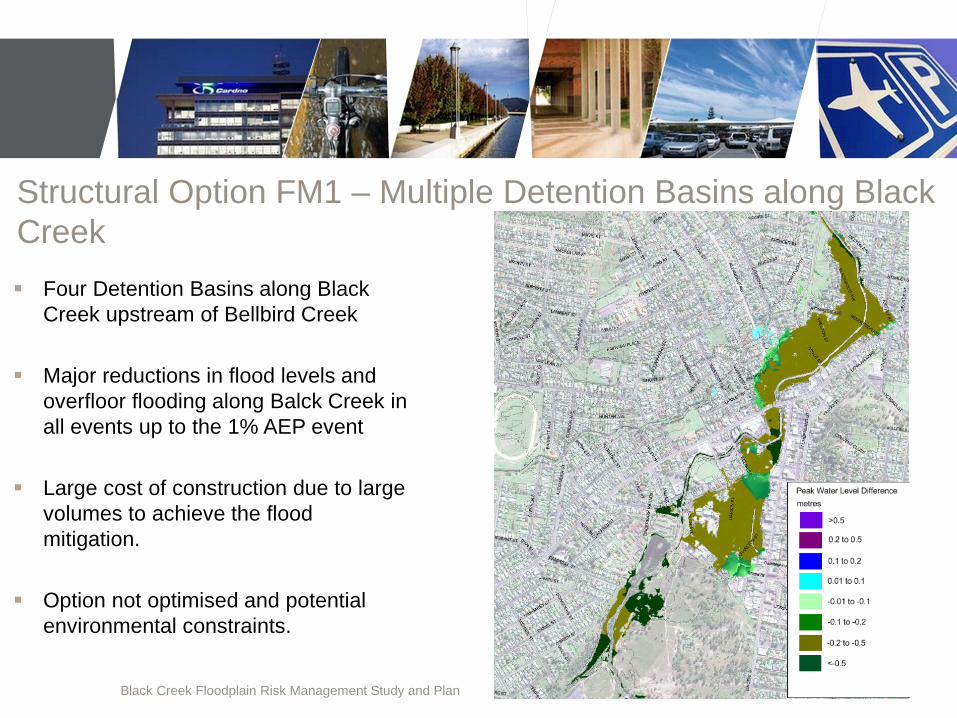
Recommended Floodplain Risk Management Measures

Black Creek Floodplain Risk Management Study and Plan
Completion Final Report has been provided to Council by Cardno Endorsement of revised Floodplain Risk Management
Study and Plan by the FMC Report to Council for adoption Handover of Study Materials to Council
Mount View Detention Basin
Black Creek, CBD Bellbird Creek, Abbotsford Street bridge