Biostratigraphic Evidence Relating to the Age-Old Question ...
16
Biostratigraphic Evidence Relating to the Age-Old Question of Hannibal's Invasion of Italy, I: History and Geological Reconstruction Mahaney, W. C., Allen, C. C. R., Pentlavalli, P., Kulakova, A., Young, J. M., Dirszowsky, R. W., West, A., Kelleher, B., Jordan, S., Pulleyblank, C., O'Reilly, S., Murphy, B. T., Lasberg, K., Somelar, P., Garneau, M., Finkelstein, S. A., Sobol, M. K., Kalm, V., Costa, P. J. M., ... Milner, M. W. (2017). Biostratigraphic Evidence Relating to the Age-Old Question of Hannibal's Invasion of Italy, I: History and Geological Reconstruction. Archaeometry, 59(1), 164-178. https://doi.org/10.1111/arcm.12231 Published in: Archaeometry Document Version: Publisher's PDF, also known as Version of record Queen's University Belfast - Research Portal: Link to publication record in Queen's University Belfast Research Portal Publisher rights © 2016 The Authors. This is an open access article under the terms of the Creative Commons Attribution License, which permits use, distribution and reproduction in any medium, provided the original work is properly cited. General rights Copyright for the publications made accessible via the Queen's University Belfast Research Portal is retained by the author(s) and / or other copyright owners and it is a condition of accessing these publications that users recognise and abide by the legal requirements associated with these rights. Take down policy The Research Portal is Queen's institutional repository that provides access to Queen's research output. Every effort has been made to ensure that content in the Research Portal does not infringe any person's rights, or applicable UK laws. If you discover content in the Research Portal that you believe breaches copyright or violates any law, please contact [email protected]. Download date:05. Jan. 2022
Transcript of Biostratigraphic Evidence Relating to the Age-Old Question ...

Biostratigraphic Evidence Relating to the Age-Old Question ofHannibal's Invasion of Italy, I: History and Geological Reconstruction
Mahaney, W. C., Allen, C. C. R., Pentlavalli, P., Kulakova, A., Young, J. M., Dirszowsky, R. W., West, A.,Kelleher, B., Jordan, S., Pulleyblank, C., O'Reilly, S., Murphy, B. T., Lasberg, K., Somelar, P., Garneau, M.,Finkelstein, S. A., Sobol, M. K., Kalm, V., Costa, P. J. M., ... Milner, M. W. (2017). Biostratigraphic EvidenceRelating to the Age-Old Question of Hannibal's Invasion of Italy, I: History and Geological Reconstruction.Archaeometry, 59(1), 164-178. https://doi.org/10.1111/arcm.12231Published in:Archaeometry
Document Version:Publisher's PDF, also known as Version of record
Queen's University Belfast - Research Portal:Link to publication record in Queen's University Belfast Research Portal
Publisher rights© 2016 The Authors. This is an open access article under the terms of the Creative Commons Attribution License, which permits use,distribution and reproduction in any medium, provided the original work is properly cited.
General rightsCopyright for the publications made accessible via the Queen's University Belfast Research Portal is retained by the author(s) and / or othercopyright owners and it is a condition of accessing these publications that users recognise and abide by the legal requirements associatedwith these rights.
Take down policyThe Research Portal is Queen's institutional repository that provides access to Queen's research output. Every effort has been made toensure that content in the Research Portal does not infringe any person's rights, or applicable UK laws. If you discover content in theResearch Portal that you believe breaches copyright or violates any law, please contact [email protected].
Download date:05. Jan. 2022

B IOSTRATIGRAPHIC EVIDENCE RELATING TO THE AGE -OLD QUEST ION OF HANNIBAL’S INVAS ION OF ITALY, I :
H I STORY AND GEOLOGICAL RECONSTRUCTION*
W. C. MAHANEY,1,2† C. C. R. ALLEN,3 P. PENTLAVALLI,3 A. KULAKOVA,3 J. M.
YOUNG,3 R. W. DIRSZOWSKY,4 A. WEST,5 B. KELLEHER,6 S. JORDAN,6 C.
PULLEYBLANK,6 S. O’REILLY,6 B. T. MURPHY,6 K. LASBERG,7 P. SOMELAR,7 M.
GARNEAU,8 S. A. FINKELSTEIN,9 M. K. SOBOL,9 V. KALM,7 P. J. M. COSTA,10 R. G. V.
HANCOCK,11 K. M. HART,12 P. TRICART,13 R. W. BARENDREGT,14 T. E. BUNCH15 and
M. W. MILNER16
1,2Department of Geography, York University, 4700 Keele Street, Toronto, Ontario M3J 1P3, Canada and Quaternary Surveys,26 Thornhill Avenue, Thornhill, Ontario L4J 1J4, Canada
3School of Biological Sciences, Queens University Belfast, University Road, Belfast BT7 1NN, UK4School of the Environment, Laurentian University, Sudbury, Ontario P3E 2C6, Canada
5GeoScience Consulting, Dewey, AZ 86327, USA6School of Chemical Sciences, Dublin City University, Glasnevin, Dublin 9, Ireland
7Institute of Ecology and Earth Sciences, University of Tartu, Vanemuise 46-208, 51014 Tartu, Estonia8Centre de Recherche en Géochimie et Géodynamique (GEOTOP), Université du Québec et Montréal (UQAM), CP 8888,
Succursale Centre-Ville, Montréal, Québec H3C 3P8 Canada9Department of Earth Sciences, University of Toronto, 22 Russell Street, Toronto, ON M5S 3B1, Canada
10Centro de Geologia da Universidade de Lisboa, Faculdade de Ciźncias da Universidade de Lisboa, Edificio C6, CampoGrande, Lisboa 1749-016, Portugal
11Department of Anthropology, McMaster University, Hamilton, Ontario L8S 4K1, Canada12School of Biological and Chemical Sciences, Queen Mary University of London, Mile End Road, London E1 4NS, UK
13Institut des Sciences de la Terre, Observatoire des Sciences de l’Univers de Grenoble, Université Joseph Fourier, BP 53, 38041Grenoble cedex 9, France
14Department of Geography, University of Lethbridge, Lethbridge, Alberta T1K 3M4, Canada15Geology Program, School of Earth Science and Environmental Sustainability, Northern Arizona University, 525 S. Beaver
Street, PO Box 5694, Flagstaff, AZ 86011, USA16MWM Consulting, 182 Gough Avenue, Toronto, Ontario M4K 3P1, Canada
Controversy over the alpine route that Hannibal of Carthage followed from the Rhône Basin intoItalia has raged amongst classicists and ancient historians for over two millennia. The motivationfor identifying the route taken by the Punic Army through the Alps lies in its potential for identifyingsites of historical archaeological significance and for the resolution of one of history’s mostenduring quandaries. Here, we present stratigraphic, geochemical and microbiological evidencerecovered from an alluvial floodplain mire located below the Col de la Traversette(~3000 m asl—above sea level) on the French/Italian border that potentially identifies theinvasion route as the one originally proposed by Sir Gavin de Beer (de Beer 1974). The dated layeris termed the MAD bed (mass animal deposition) based on disrupted bedding, greatly increasedorganic carbon and key/specialized biological components/compounds, the latter reported in PartII of this paper. We propose that the highly abnormal churned up (bioturbated) bed wascontaminated by the passage of Hannibal’s animals, possibly thousands, feeding and wateringat the site, during the early stage of Hannibal’s invasion of Italia (218 BC).
*Received 20 June 2015; accepted 11 November 2015†Corresponding author: email [email protected] copyright line for this article was changed on 27 July 2016 after original online publication.
Archaeometry ••, •• (2016) ••–•• doi: 10.1111/arcm.12231
© 2016 The Authors.Archaeometry published by John Wiley & Sons Ltd on behalf of University of OxfordThis is an open access article under the terms of the Creative Commons Attribution License, which permits use, distribution andreproduction in any medium, provided the original work is properly cited.
bs_bs_banner

KEYWORDS: HANNIBALIC WAR, SECOND PUNIC WAR, ENVIRONMENTAL PARAMETERS, INVASIONROUTE QUESTION, HANNIBAL ROUTE ENIGMA UNMASKED
INTRODUCTION
The main approach routes (Livy, 1965; Proctor 1971; de Beer 1974; Polybius 1979) and associ-ated mountain passes (cols) identified as likely transit points of Hannibal’s army into CisalpineGaul (northern Italy) have been debated and discussed by historians for over two millennia(Freshfield 1886, 1899; Dodge 1891; Wilkinson 1911; de Beer 1956, 1967, 1969, 1974;Connolly 1981; Seibert 1993; Lazenby 1998; Bagnall 1999; Lancel 1999; Mahaney 2004;Mahaney et al. 2007b, 2008a, 2008b, 2008c, 2010a, 2010b, 2010c, 2014). These invasion pas-sages are referred to here as the southern, northern and intermediate routes, as shown in Figure1 (Hart 1967; Proctor 1971; de Beer 1974). The southernmost follows the lower Rhône Rivervalley northwards to the Drôme River, thence across the Col de Grîmone (1318 m; Alpes duDauphiné) to the Durance Basin, through the Queyras (Guil River) to the Col de la Traversette,finally exiting through the two-tier rockfall similar to that described by Polybius (1979) into theupper Po River catchment. The northern route parallels the Rhône River to the Isère River, pastpresent-day Grenoble along the Arc River to either the Col du Mont Cenis (2083 m) or the Col duClapier (2497 m), finally exiting into the Dora Riparia west of Torino (Turin in Fig. 1). Theintermediate route follows the same initial course as the northern route, then west of the Pelvoux
Figure 1 A satellite image showing the terrain of the Western Alps and the three prominent invasion routes consideredby most authorities to demarcate Hannibal’s route into Italia in 218 BC (courtesy of NASA and USGS).
2 W. C. Mahaney et al.
© 2016 The Authors.Archaeometry published by John Wiley & Sons Ltd on behalf of University of Oxford, Archaeometry ••, •• (2016) ••–••

Massif to join the Durance River continuing towards the Col de Mont Genèvre (1830 m), exitinginto the Dora Riparia.
After two millennia, the question remains unsettled of the specific path over the Alps taken byHannibal or by Hasdrubal, his brother, who followed him 11 years later (Proctor 1971; Lazenby1998; de Beer 1974). However, time–motion analysis of these three potential routes, and inves-tigations of each pass into Italia carried out by Mahaney (2008) revealed the southern route to bethe most direct and highest track into northern Italy from the Rhône Basin, and all authoritiesagree that Hannibal had to march with speed to cross the Alps before winter set in. Furthermore,Polybius (1979), a primary ancient authority who interviewed survivors of the invasionand retraced the invasion route some 60 years after the fact, is definite that Hannibaldescended upon the Po River plains rather than the Dora Riparia approximately 50 kmto the north.
Uncertainty regarding Hannibal’s route stems from contested interpretations of ancientplace names, preferential use of either Livy (1965) or Polybius (1979) as a primary an-cient source (the two are not compatible) and competing views by other historians oftravel times between points.
Traditional arguments have not relied on physical or environmental parameters (Mahaney2008), because no physical artefacts (nails, coins, buckles etc.) have ever been found on anyof the potential alpine routes. However, organic compounds associated with people andanimals can easily persist for several millennia and are easy to detect, leading us to hypoth-esize that Hannibal’s army and his horses/mules/elephants may have left organic evidence oftheir passage. To investigate this possibility, we located a site at ~2580 m asl along thesouthern route in the Alps that could have been used as a campsite for a large group ofpeople and animals (~30 000 infantry, ~7000 cavalry, unknown number of handlers and37 elephants; Lancel 1999) (Fig. 2). Then, we used multidisciplinary techniques to searchfor pedological, micropalaeontological, biochemical and lipid biomarker evidence that mighthelp determine if the site was along Hannibal’s invasion route.
ENVIRONMENTAL FACTORS
There are distinctive topographical landmarks for the Hannibalic route that are identified inthe ancient literature (Proctor 1971; de Beer 1974; Polybius 1979; Mahaney 2008; Mahaneyet al. 2014). These include a gorge on the approach to the summit, a ‘certain bare rock’, abivouac near the col, a view into Italia, fired rock and a regrouping area, and all of theseelements are common to most potential invasion routes. However, the only route that meetstwo key historical descriptions—the rockfall and frozen ground—is the southern routeacross the Col de la Traversette into the Po River plains of northern Italy.
Of all environmental factors used to identify the invasion route (Mahaney 2008), there aretwo paramount clues. The first is the superposed two-tier rockfall described by Polybius(1979). It is interesting that of all the repeat histories published over the years, and quotesfrom both Livy and Polybius, few, if any, have focused on Polybius’ mention of a two-tierdeposit, one mass produced by two mass wasting events. Following a survey of all likelypasses used by the Punic Army (Mahaney 2008), the only such rockfall debris below allthe cols that could have blocked the infiltrating army is located on the lee flank of the Alpsin the upper Po Valley, below the Col de la Traversette (Mahaney et al. 2010c, 2014) at2600 m asl.
Hannibal’s invasion of Italy, I 3
© 2016 The Authors.Archaeometry published by John Wiley & Sons Ltd on behalf of University of Oxford, Archaeometry ••, •• (2016) ••–••
Perhaps relying on a first-hand account by Silenus (Hannibal’s historiographer; Lancel 1999),Livy maintained (Livy 1965, XXI, 37) that the rockfall provided such an impediment to passageof the army that Hannibal ordered its firing to allow the passage of the horses and elephants. Ac-cording to this account, wood was brought to the site at 2600 m asl, then set alight, producing
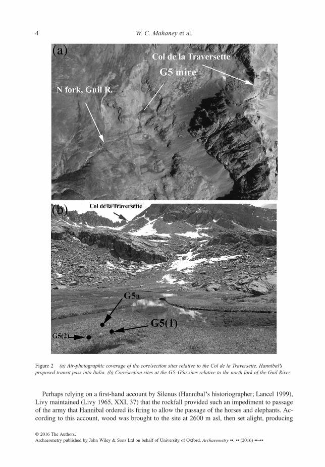
Figure 2 (a) Air-photographic coverage of the core/section sites relative to the Col de la Traversette, Hannibal’sproposed transit pass into Italia. (b) Core/section sites at the G5–G5a sites relative to the north fork of the Guil River.
4 W. C. Mahaney et al.
© 2016 The Authors.Archaeometry published by John Wiley & Sons Ltd on behalf of University of Oxford, Archaeometry ••, •• (2016) ••–••

sufficient heat to physically disrupt and crack boulders that could not be moved by hand. Bagnall(1999) questioned Livy’s interpretation, arguing that green wood would not be expected to burn.Wood might have been available up to perhaps 2400 m asl (Mahaney et al. 2010b), provided thatone might expect starving soldiers to be capable of harvesting/transporting it to the rockfall, alsoa doubtful outcome. Not even Kuhle and Kuhle (2012), who mention the firing event, were ableto substantiate how it might apply to the northern route across the Col du Clapier, their preferredroute of passage. Previous work by Mahaney (2013) showed conclusively that while therockfall described by Polybius exists below the Col de la Traversette, there is no evidencethat it was fired, as no carbonized/split boulders are resident in the rockfall mass (Sodhiet al. 2006). Moreover, Polybius is mute on the firing event, and since he was the primeauthority who followed the invasion route, the obvious conclusion is that, despite its perpet-uation, the firing never happened.
The second vital clue is the presence of frozen ground. Sporadic permafrost, wherepresent today, is deeply buried in the Western Alps (Mahaney et al. 2007a), and thatwas probably true in Hannibal’s time, because today’s climate is similar (Neumann1992). Thus, it is likely that the major terrain obstacle of frozen ground referred to by Po-lybius (1979 was not permafrost but, rather, discontinuous frozen soil or firnpack (densesnow) covered with fresh snow. The Col de la Traversette, compared to the other moun-tain passes, is the only pass that reaches to within the snowline (~2800 m asl), with dis-continuous permanent snow (firnpack). At lower elevations, the Col Agnel and the Col laCroix, adjacent to Traversette (Fig. 1), provide somewhat shorter routes into Italy, but lackfirnpack, which is a prerequisite to identifying the correct col. Moreover, none of the othermajor cols—Clapier, Genèvre and Cenis—have permanent snow/firnpack or blockingrockfall, which is why de Beer (1974) and other researchers (Mahaney 2008) favouredthe Traversette as the route Hannibal used to cross the Alps. Even with elevations impre-cisely known at the time, Polybius’s (1979) description of the invasion route strongly sug-gests the Traversette as the crossing point into the peninsula, an inference supported byVarro’s mention in De re rustica (quoted by Proctor 1971) of the passes in geographicalorder from north to south—‘Hannibal’s Pass’ lying south of the Col de Genèvre (Fig. 1).Moreover, reference to Varro’s mention of the five cols, including Hannibal’s Col as thehighest, is quoted in Servius’ commentaries, translated in Savage (1934).
In addition to the two-tier rockfall and the presence of frozen ground, a third requirement for a suc-cessful passage into Italy is the presence of forage plants (grasses and sedges) and sufficient wateringholes for animals and humans alike. If the Col de la Traversette is the route taken by Hannibal, as alltopographical data indicate (Mahaney 2008), the mire sites investigated here (G5 and G5a—describedbelow) could have provided an area of forage and fresh water for use by Hannibal’s troops and ani-mals. The mire evidence presented here strongly supports previous estimates that the southern routethrough the Traversette was the route taken by Hannibal.
SITES
Recently, Mahaney (2008) used time–motion analysis, elevation modelling and field observa-tions on sites along the southern route originally favoured by de Beer (1974) to identify potentialhearths and watering hole/feeding grounds that might have been used by the Punic Army duringtransit. The army would have had access to stream water in many places along the Guil catch-ment (west flank), but there are only a few grassy and level areas above 2000 m asl upon whichto graze horses and provide feed. After searching those areas for soils composed mainly of
Hannibal’s invasion of Italy, I 5
© 2016 The Authors.Archaeometry published by John Wiley & Sons Ltd on behalf of University of Oxford, Archaeometry ••, •• (2016) ••–••
organic materials (Histosols; Soil Survey Staff 1999), we located a candidate site ~425 m belowthe Col de la Traversette. The ~60 × ~40 m wide location (latitude/longitude: 44°42’ 587N; 07°032 74E; 2580 m asl), designated G5 and G5a, is the only organics-rich peat bed (mire) above2000 m asl in the Guil Valley along the southern route to the Col de la Traversette. It lies 30m higher than nested Late Glacial (~13–15 ka) and Younger Dryas (~11–13 ka) moraines inthe lower Guil Valley (Mahaney and Keiser 2012; Mahaney et al. 2013) and below the levelof nearby talus, all of which are Little Ice Age (LIA) or post-LIA in age. Therefore, sedimentsof Hannibalic age should be present.
The site is located on a gently sloping bedrock bar composed of metabasalt (Tricart et al.2003), lying adjacent to the headwaters of the Guil River and, therefore, is subject to periodicoverbank flooding. The stratum overlying the flood-derived sediments consists of ~1 m oforganic-rich, alluvial mire (Fig. 2). In summary, the mire comprises one of the few near-level,forage-covered watering holes in the upper Guil catchment, located astride the southern route ap-proaching the Col de la Traversette. Thus, it would have provided a prime watering hole, ifHannibal’s cavalry and pack animals passed this way en route to the mountain pass.
MATERIALS AND METHODS: THE GEO-RECORD
Two cores [G5(1) and G5(2) (Fig. 2 (b)); ~68 cm depth] were recovered from the mire in 2011.The cores provided radiocarbon ages, along with preliminary stratigraphic and geochemical datathat, in turn, led to the excavation of an adjacent trench (G5a) to a depth of ~75 cm in 2013(Fig. 3 (a)). A photograph of the excavated section from 0 to 38 cm (Fig. 3 (a)) shows thatthe horizontal bedding of the trench matches that in the macrophotograph of the combined core(Fig. 3 (b)).
Cores were recovered using 5-cm diameter PVC tubes fitted with a core catcher and werestored cool until opened in the laboratory. Colours were determined using the colour chips ofOyama and Takehara (1970); G5 under dry conditions in the laboratory and G5a in the field.In the laboratory, cores were split and allowed to dry slightly to improve handling prior to sed-imentological description, surface penetration, photography and subsampling. Since the twocores were stratigraphically correlated, they were combined into one single core to increase sed-iment volume for analysis subsection by subsection (Fig. 3 (b)).
Sediment samples acquired from the trench and the two cores (Fig. 3 (b)), provided measure-ments of organic carbon, bulk density and moisture. Subsamples (~1 cm3) were removed with astainless steel knife at 5-cm intervals. One set of samples was oven dried at 60 °C for 24 h, andthe moisture content and the wet and dry bulk density calculated based on weight change andsubsample dimensions. The total organic matter content was estimated from the basic sequentialLOI (550 °C/1 h) using a muffle furnace. Elemental analysis was also performed in triplicate onthe 2013 G5a samples, using a Fisons NCS 1500 NA elemental analyser.
The mineralogy of the G5a section was investigated by SEM/EDS (for more information onSEM imagery interpretation, see Mahaney 2002) and XRD at various depths to determine com-position and variations. The quantitative mineralogical composition was interpreted andmodelled by the Rietveld algorithm-based program Siroquant-3 (Taylor 1991).
Pollen was analysed from 10 samples in the GUIL5a sequence (depths 5, 15, 20, 25, 30, 35,40, 45, 50 and 55 cm). Samples were prepared using standard methods, including digestions in10% HCl, 10% KOH, concentrated HF and acetolysis, and mechanical separation using 10-μm and 150-μm sieves. Dehydrated residues were stored in silicone oil and mounted for light mi-croscopy. Pollen grains were enumerated under brightfield optics at ×400 magnification, and
6 W. C. Mahaney et al.
© 2016 The Authors.Archaeometry published by John Wiley & Sons Ltd on behalf of University of Oxford, Archaeometry ••, •• (2016) ••–••

identified using standard references (Moore et al. 1991). A main pollen sum consisting of trees,shrubs and herbaceous taxa was used to calculate percentages of all taxa. Aquatic pollen typeswere excluded from the sum; percentages of aquatic taxa were determined on the basis of themain sum.
All 14C dates are from peat samples in two cores and one trench. These were prepared byaccepted standards, stored cold/frozen until dating by conventional or AMS means at theQueen’s University Belfast CHRONO dating centre, at Beta Analytic and at the RadiocarbonLaboratory at the University of Tartu, Tartu, Estonia.
Radiocarbon dates were adjusted by 13C and calibrated using IntCal-13 in OxCal v.4.2.4(Bronk Ramsey 2009; Reimer et al. 2013), and then further modelled using Bayesian statistical
Figure 3 (a) The excavated sedimentary section G5a (44o 42’ 588N; 7o03’281E, 2573 m asl). Hannibal’s invasioncoincides with the age of the top of the churned-up layer. All dates are OxCal v.4.2.4 calibrated dates. Open symbolsare dates from the section; closed symbols are dates from the core. The dashed line is the contact between the Fibrist(undecomposed organics) and Hemist (moderate organic decomposition) suborders of the Histosol order (Soil SurveyStaff 1999). The base of the overbank sediment probably corresponds to an unconformity hiatus produced by erosionaccompanying deposition of the overbank sediment. (b) The G5 core, showing macrophotography, moisture (lightgrey), bulk density (solid line) and organic carbon. The MAD bed centres on 45 ± 5 cm in this image, but varies upto ~ ±10 cm. The basal sediment (unsampled) is ~5 cm alluvium over bedrock. Depths of units in the section (G5a)and core (G5) are offset by ~5 cm between the two sites.
Hannibal’s invasion of Italy, I 7
© 2016 The Authors.Archaeometry published by John Wiley & Sons Ltd on behalf of University of Oxford, Archaeometry ••, •• (2016) ••–••
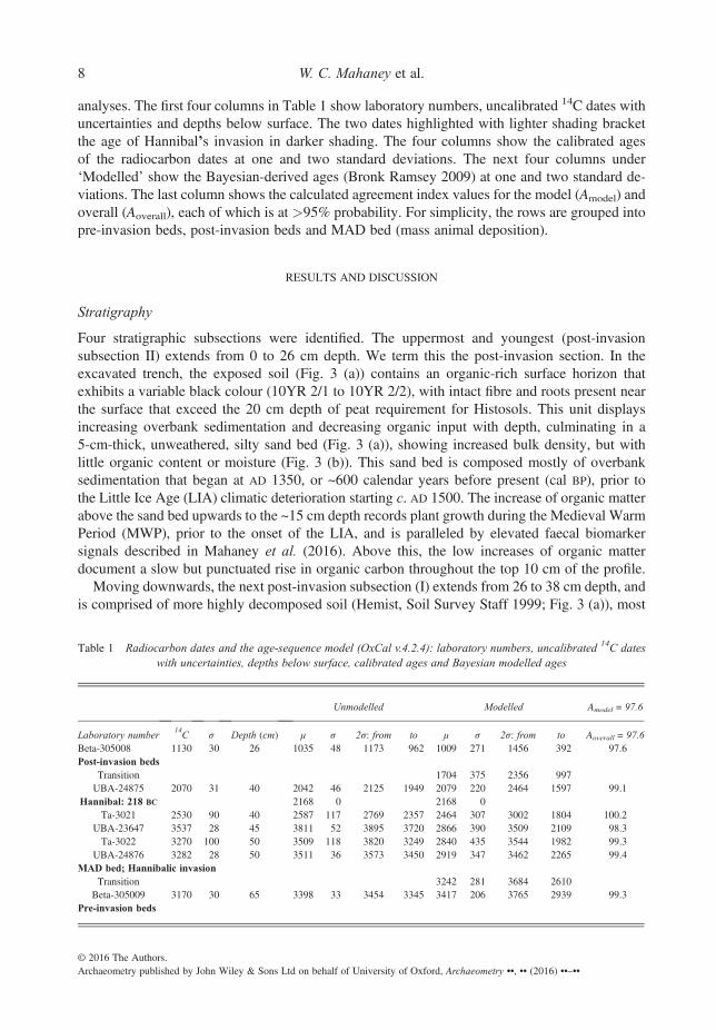
analyses. The first four columns in Table 1 show laboratory numbers, uncalibrated 14C dates withuncertainties and depths below surface. The two dates highlighted with lighter shading bracketthe age of Hannibal’s invasion in darker shading. The four columns show the calibrated agesof the radiocarbon dates at one and two standard deviations. The next four columns under‘Modelled’ show the Bayesian-derived ages (Bronk Ramsey 2009) at one and two standard de-viations. The last column shows the calculated agreement index values for the model (Amodel) andoverall (Aoverall), each of which is at >95% probability. For simplicity, the rows are grouped intopre-invasion beds, post-invasion beds and MAD bed (mass animal deposition).
RESULTS AND DISCUSSION
Stratigraphy
Four stratigraphic subsections were identified. The uppermost and youngest (post-invasionsubsection II) extends from 0 to 26 cm depth. We term this the post-invasion section. In theexcavated trench, the exposed soil (Fig. 3 (a)) contains an organic-rich surface horizon thatexhibits a variable black colour (10YR 2/1 to 10YR 2/2), with intact fibre and roots present nearthe surface that exceed the 20 cm depth of peat requirement for Histosols. This unit displaysincreasing overbank sedimentation and decreasing organic input with depth, culminating in a5-cm-thick, unweathered, silty sand bed (Fig. 3 (a)), showing increased bulk density, but withlittle organic content or moisture (Fig. 3 (b)). This sand bed is composed mostly of overbanksedimentation that began at AD 1350, or ~600 calendar years before present (cal BP), prior tothe Little Ice Age (LIA) climatic deterioration starting c. AD 1500. The increase of organic matterabove the sand bed upwards to the ~15 cm depth records plant growth during the Medieval WarmPeriod (MWP), prior to the onset of the LIA, and is paralleled by elevated faecal biomarkersignals described in Mahaney et al. (2016). Above this, the low increases of organic matterdocument a slow but punctuated rise in organic carbon throughout the top 10 cm of the profile.
Moving downwards, the next post-invasion subsection (I) extends from 26 to 38 cm depth, andis comprised of more highly decomposed soil (Hemist, Soil Survey Staff 1999; Fig. 3 (a)), most
Table 1 Radiocarbon dates and the age-sequence model (OxCal v.4.2.4): laboratory numbers, uncalibrated 14C dateswith uncertainties, depths below surface, calibrated ages and Bayesian modelled ages
Unmodelled Modelled Amodel = 97.6
Laboratory number14C σ Depth (cm) μ σ 2σ: from to μ σ 2σ: from to Aoverall = 97.6
Beta-305008 1130 30 26 1035 48 1173 962 1009 271 1456 392 97.6Post-invasion beds
Transition 1704 375 2356 997UBA-24875 2070 31 40 2042 46 2125 1949 2079 220 2464 1597 99.1
Hannibal: 218 BC 2168 0 2168 0Ta-3021 2530 90 40 2587 117 2769 2357 2464 307 3002 1804 100.2
UBA-23647 3537 28 45 3811 52 3895 3720 2866 390 3509 2109 98.3Ta-3022 3270 100 50 3509 118 3820 3249 2840 435 3544 1982 99.3
UBA-24876 3282 28 50 3511 36 3573 3450 2919 347 3462 2265 99.4MAD bed; Hannibalic invasion
Transition 3242 281 3684 2610Beta-305009 3170 30 65 3398 33 3454 3345 3417 206 3765 2939 99.3
Pre-invasion beds
8 W. C. Mahaney et al.
© 2016 The Authors.Archaeometry published by John Wiley & Sons Ltd on behalf of University of Oxford, Archaeometry ••, •• (2016) ••–••
probably caused by stream migration away from the site of deposition that caused increasedorganic/peat accumulation with moderate but variable decomposition. All organic material in thisinterval exists as finely disseminated peat lacking any fibrous character, except for a few narrowroots. At 26–27 cm, a calibrated radiocarbon age of 1035 ± 48 cal BP (Beta-305008) dates theupper part of this section to within the beginning of the MWP at ~1200 cal BP (c. AD 950). Thisinterval is organic-rich with parallel beds and is presumably a product of increased humidity andtemperature.
The next subsection (III, or MAD) extends from 38 to 50 cm, and near the top at 42 cm, thebulk density drops to its lowest level in the core, except for surface samples (Fig. 3 (b)). Atthe same time, the organic content rises to its highest level below surface values, and the sedi-ment colour becomes darker black, with a solid colour expression of 10YR 1/1. This interval con-sists of an open structure of loosely matted organic fragments mixed with finer decomposedmaterial, suggesting that it has been mixed or churned (bioturbated). This churning is rarely, ifever, seen in bog cores elsewhere in alpine or other areas (for examples, see Mahaney 1990,figs 7.4 and 7.5).
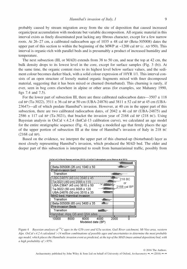
For the lower part of subsection III, there are three calibrated radiocarbon dates—3507 ± 118cal BP (Ta-3022), 3511 ± 36 cal BP at 50 cm (UBA-24876) and 3811 ± 52 cal BP at 45 cm (UBA-23647)—all of which predate Hannibal’s invasion. However, at 40 cm in the upper part of thissubsection, there are two calibrated radiocarbon dates, of 2042 ± 46 cal BP (UBA-24875) and2586 ± 117 cal BP (Ta-3021), that bracket the invasion year of 2168 cal BP (218 BC). UsingBayesian analysis in OxCal v.4.2.4 (IntCal-13 calibration curve), we calculated an age modelfor the entire stratigraphic sequence (Fig. 4), yielding a modelled age that firmly places the ageof the upper portion of subsection III at the time of Hannibal’s invasion of Italy in 218 BC
(2168 cal BP).Based on the evidence, we interpret the upper part of this churned-up (bioturbated) layer as
most closely representing Hannibal’s invasion, which produced the MAD bed. The older anddeeper part of this subsection is interpreted to result from human/animal traffic, possibly from
Figure 4 Bayesian analyses of 14C ages in the G5b core and G5a section, Guil River catchment, Mt Viso area, westernAlps. OxCal v.4.2.4 calculated >14 million combinations of possible ages and uncertainties to determine the most probableagemodel, which places the Hannibalic invasion event as predicted, at the top of theMAD (mass animal deposition) bed, witha high probability of >95%.
Hannibal’s invasion of Italy, I 9
© 2016 The Authors.Archaeometry published by John Wiley & Sons Ltd on behalf of University of Oxford, Archaeometry ••, •• (2016) ••–••

activity of Hannibal’s army that disturbed and churned pre-existing, stratified organic beds intoone massive, non-laminated bed of finely disseminated peat. The increase of organic carbonand moisture, originating from trampled vegetation and dung from animals, provided an organicbase supporting the ingress of Clostridia, a prominent endospore-producing bacterial componentof the mammalian gut, as discussed among biological contingents in Part II.
For the pre-invasion subsection below 50 cm (subsection IV), the stratified base of the coreat ~68 cm depth yields a calibrated age of 3400 ± 35 cal BP (Beta-305009) that is slightlyyounger than the three dates above it, thus supporting the interpretation of sedimentreworking due to a mass invasion of animals and humans in the overlying MAD bed. The bot-tom of the core to 80 cm crumbled upon recovery and provided little usable data. The totalcore depth of 68 cm, comprising variable organic matter content, yields an estimated sedimen-tation rate of 5 mm yr–1.
Mineralogy and geochemical analysis
The G5–G5a section data recorded here provide palaeoecological and geochemical data addingto the corpus of information previously reported for the Traversette area (Mahaney et al. 2010b).
Primary minerals follow from the local metabasalt bedrock, with detrital species of Ca-plagioclase, albite, amphibole, antigorite, opal phytolith and micron/submicron organic materialsmostly adhering to primary mineral grains. Opal phytoliths are derived from plants that incorpo-rate silica from the soil, depositing it within the intracellular and extracellular plant structure. Asplants decay, silica remains as a weathering-resistant, almost elliptical microscopic mineral(Alexandre et al. 1997).
Because leaching might affect the distribution of organic compounds within the cores, ratios ofsoluble to insoluble macroelements such as Ca/Ti, Na/Ti, Ca/Al, Na/Al, P/Ti and P/Al were stud-ied to test for translocation. These chemical element ratios show no evidence of leaching throughthe core or trenched section, although minor fluctuations occurred with organic dilution of themineral component or high mineral content as in the sandy bed at 26–30 cm depth.
The 20–40% organic matter staggered through the G5 section (Fig. 3 (b)), coupled with the60–80% mineral content by weight, affords considerable physical stability to the peat beds. Thisis further indicated by the out-of-phase organic matter to bulk density measurements in Figure 3(b) that support field observations depicting a stable, semi-dry peatland, wet at the base andbecoming progressively drier upwards in the section (see the macrofossil evidence below).
Palaeoecological analysis
Macrofossil analyses of the entire G5 core showed a dominance of herbaceous assemblages, cor-responding well with a reconstructed climate record (Neumann 1992) for the Western Alps withnear-unvarying temperature/precipitation straddling the time of the Hannibalic invasion. At thebase (65–50 cm), the abundance of Typha seeds confirms an open freshwater marsh condition.From 15 cm to the surface, conditions became drier, as suggested by the introduction ofSphagnum spp. followed by ligneous species at the surface of the site.
While palaeoecology studies for Early to Late Holocene time periods are rare in the SouthernAlps, the Swiss (Valsecchi and Tinner 2010) document sections, some at high elevations, similarto sections reported here. Coincidentally, these authors report 14C dates in peat, at 35 cm depth, to890 ± 60 yr BP (700–900 cal yr), correlating close to MWP dates reported herein.
10 W. C. Mahaney et al.
© 2016 The Authors.Archaeometry published by John Wiley & Sons Ltd on behalf of University of Oxford, Archaeometry ••, •• (2016) ••–••

Pollen (Fig. 5) was analysed from 10 samples in the GUIL5a sequence. Pollen grains were abun-dant and well preserved throughout. The mean pollen sum was 195 grains (min.–max. = 119–380);the mean total number of grains counted was 333 (min.–max. = 218–457). The pollen assem-blages confirm the persistence of the alpine mire through the period of record. The assemblagesare dominated by pollen of Cyperaceae, Alnus, upland herbaceous taxa (including Poaceae) andneedle-leaved trees. The percentage of tree pollen is low through the sequence. Needle-leavedtaxa dominate the tree pollen assemblages, and reflect transport from local and regional mon-tane forests at treeline or below. Broad-leaved trees are recorded at low abundance throughout(generally <3%, with a maximum of 8% at depth of 15 cm), reflecting the high-elevation set-ting of the site and the low local abundance of broad-leaved trees. Shrub pollen is present atmoderate abundance, dominated by Alnus types, and probably reflects local mire dynamics.The pollen assemblages broadly support the four zones presented above. The upper section(0–25 cm) is characterized by a minor up-core decrease in needle-leaved tree pollen, whichmay reflect a shift in the position of the treeline or in forest composition with climatic changesassociated with the MWP-to-LIA transition. A modest increase in herbaceous taxa, bryophytes,ferns, fern allies and shrubs also occurs from 25 cm and above, which supports the interpreta-tion from macrofossils and other proxies of a drier mire surface. These changes could also, inpart, reflect land-use change and forest clearance, supported by increases in pollen ofChenopodiaceae/Amaranthaceae in the upper samples. The middle portion of the pollen se-quence is characterized by moderate abundances of Cyperaceae pollen, corresponding to thelower post-invasion zone. The MAD section (38–50 cm) corresponds to a large peak inCyperaceae pollen. Below the MAD section, Cyperaceae pollen drops significantly, and theassemblages are dominated again by needle-leaved trees and upland herbs, including Poaceae.
The strongest signals in the pollen record are in the local wetland pollen types, particularlyCyperaceae. The Cyperaceae (sedges) are a large family of plants found in a variety of aquatichabitats, and are common dominants in alpine meadows (Cronk and Fennessy 2001). Cyperaceaepollen may be locally very abundant in sediment records, and thus Cyperaceae pollen
Figure 5 A summary of the pollen data for GUIL5b. Pollen types are expressed as percentages of the main pollen sum,which excludes aquatic taxa (Cyperaceae). Needle-leaved trees include Abies, Larix, Picea and Pinus; herbaceous taxainclude Poaceae, among other types. The raw data can be accessed by contacting Sarah Finkelstein ([email protected]) and/or Magda Sobol ([email protected]).
Hannibal’s invasion of Italy, I 11
© 2016 The Authors.Archaeometry published by John Wiley & Sons Ltd on behalf of University of Oxford, Archaeometry ••, •• (2016) ••–••

abundances are generally interpreted as indicative of local mire processes (Miola et al. 2006).Cyperaceae pollen is not reliably identified to genus or species (Moore et al. 1991); thus, the pol-len percentages in the GUIL5a record probably include several genera and species, each of whichmay vary in terms of ecological preferences. Because of the strong affinity for aquatic habitats,fluctuations in Cyperaceae pollen tend to be interpreted as signals for fluctuations in water level.However, some Cyperaceae are emergent plants in standing water while others are associatedwith mesic but aerated forest soils (Cronk and Fennessy 2001), making inference of absolutechanges in the position of the water table based solely on Cyperaceae pollen difficult. Theincrease in Cyperaceae pollen in the upper section of the GUIL5a record, coincident with otherindicators of drying, probably reflects a shift in species composition of Cyperaceae in responseto a drying mire surface.
The spike in Cyperaceae in the MAD bed (38–50 cm) is less likely to be a response to achange in the position of the water table, because of the rapidity with which this sectionwas deposited, based on the radiocarbon age model. Thus, the spike in the Cyperaceae pol-len may be interpreted as further support for human passage through this section.Cyperaceae frequently dominate in alpine meadows. While animals tend to prefer grassesto sedges for grazing, sedges will be grazed upon when grasses are not available (Elliottand Henry 2011). Given the evidence for faecal matter in the MAD section (see Part II),it is possible that the Cyperaceae peak in the MAD layer reflects the deposition of pollengrains through animal guts following the passage of large numbers of grazing animals.Pollen grains survive gut passage; coprolites have been used as sources of palynologicalinformation in a variety of contexts (Carrion et al. 2001; Kropf et al. 2007).
Transhumance
Transhumance has been practiced for millennia in the Western Alps (Schwörer et al. 2014) and, asWalsh et al. (2007) have shown, human activity (including transhumance) accelerated during the lastmillennium in the Parc National des Ecrins, Hautes-Alpes, sites located near Mt Viso. Archaeologistsare divided over the extent to which environment determines human activity, with some pro (Leveau2007) and others con (Walsh 2005). Transhumance may be read into the slight increase of faecalbiosignatures recorded during the MWP part of the G5–G5a sections, at depths < 30 cm. However,these sediments lack evidence of the kind of major bioturbation observed in the MAD bed. There isnothing to indicate a high level of animal (including human) disturbance in the two sections other thanwhat exists in the MAD bed (~45 cm). Furthermore, the abundance of bacteria—endospores for themost part—sourced specifically from mammals and located primarily within the churned-up beds(see Part II), could only result from the passage of hundreds, if not thousands, of animals, indicatingmovement of something more than animals involved in tribal trade.
CONCLUSIONS
Previous analysis of environmental factors has strongly favoured the southern route for Hannibal’spassage through the Alps. In addition to features indicated by ancient authors, including the presenceof frozen ground and the two-tiered rockfall, there must have been sufficient grounds for grazinglarge numbers of army animals, including horses and elephants.
The highly anomalous MAD sediments recovered in cores from site G5 and the G5asection in the upper Guil Valley reveal intensive convolution of organic sediment, indicatingmajor disturbance to the beds. Radiocarbon-dating indicates that this disturbance occurred
12 W. C. Mahaney et al.
© 2016 The Authors.Archaeometry published by John Wiley & Sons Ltd on behalf of University of Oxford, Archaeometry ••, •• (2016) ••–••
within the Hannibal window. This extensive churning observed in the MAD layer suggeststrampling/disaggregation of organic layers by animals, and possibly humans as well, thatcannot be accounted for by small-scale transhumance. The MAD layer contains a spike inCyperaceae pollen, which may be indicative of the passage of large numbers of grazing an-imals. The beds also feature strong faecal biosignatures and the presence of bacteria frommammals, discussed in Part II.
This may be the first tangible, if unusual, evidence of human/animal activity at the timeof Hannibal’s invasion of Italia. Although we cannot determine conclusively that the ev-idence pertains to Hannibal, the results are consistent with the passage of large numbers ofanimals and people, and because of the high elevation, are inconsistent with normal trans-humance in the area. If confirmed, the findings presented here have far-reaching implica-tions for solving the Hannibalic route question and, more importantly, for theidentification of a site that might be expected to yield significant historical archaeologicaldata and artefacts related to the Punic invasion. If the site was affected by human–animaltraffic, as the evidence indicates, there is every possibility that artefacts such as coins, beltbuckles, daggers, equestrian fasteners and so on might have been buried in the mire. Ifsuch archaeological evidence can be found and definitively linked to Hannibal, it wouldanswer the question of which route Hannibal and his army took into Italia.
ACKNOWLEDGEMENTS
This work benefitted from conversations/correspondence with John Lazenby (University ofNewcastle) and Craig Hanyan (Brock University, St Catharines, Ontario, Canada). The satellite im-agery in Figure 1 was provided by Trent Hare, USGS, Flagstaff, Arizona (credit JPL, NASA/USGS).We gratefully acknowledge assistance from Sarah and Paul Ginty-Ciselar, custodians of the Refugedu Viso, License granting authority of the Prefét des Hautes Alpes, to conduct excavations on theFrench side of the Traversette (Réserve Naturelle Ristolas-Mont Viso), and staff of the Pian del Reand Giacoletti refuges in the upper Po River catchment. We also acknowledge funding support fromthe QUESTOR centre (PP), the Invest Northern Ireland Grant for R&D programme (CCRA), InvestNorthern Ireland (AK), the Geological Survey of Ireland (INFOMAR) and the Irish Research Council(RS/2012/499, BK), H2020 REMEDIATE Marie Curie ETN, Grant agreement no. 643087 (BK),Quaternary Surveys, Toronto and research/travel grants (YU-493885) fromYorkUniversity, Toronto(WCM).
REFERENCES
Alexandre, A., Meunier, J., Colin, F., Koud, J., 1997, Plant impact on the biogeochemical cycle of silicon and relatedweathering processes, Geochimica et Cosmochimica Acta, 61, 677–82.
Bagnall, N., 1999, The Punic wars, Pimlico, London.Bronk Ramsey, C., 2009, Bayesian analysis of radiocarbon dates, Radiocarbon, 51, 337–60.BronkRamsey, C., and Lee, S., 2013, Recent and planned developments of the programOxCal., Radiocarbon, 55(2–3), 720–30.Carrion, J. S., Riquelme, J. A., Navarro, C., and Munuera, M., 2001, Pollen in hyaena coprolites reflects late glacial land-
scape in southern Spain, Palaeogeography, Palaeoclimatology, Palaeoecology, 176, 193–205.Connolly, P., 1981, Greece and Rome at war, Greenhill Books, London.Cronk, J. K., and Fennessy, M. S., 2001, Wetland plants: biology and ecology, CRC Press, Boca Raton, FL.de Beer, Sir G., 1956, Alps and elephants, E. P. Dutton, New York.de Beer, Sir G., 1967, Hannibal’s march, Sidgwick and Jackson, London.de Beer, Sir G., 1969, Hannibal: challenging Rome’s supremacy, The Viking Press, New York.de Beer, Sir G., 1974, Hannibal: the struggle for power in the Mediterranean, Book Club Associates, London.Dodge, T. A., 1891, Hannibal, Houghton-Mifflin, Boston.
Hannibal’s invasion of Italy, I 13
© 2016 The Authors.Archaeometry published by John Wiley & Sons Ltd on behalf of University of Oxford, Archaeometry ••, •• (2016) ••–••
Elliott, T. L., and Henry, G. H. R., 2011, Effects of simulated grazing in ungrazed wet sedge tundra in the high Arctic,Arctic Antarctic and Alpine Research, 43, 198–206.
Freshfield, D. W., 1886, The Alpine pass of Hannibal, Proceedings of the Royal Geographical Society and MonthlyRecord of Geography, 8(10), 638–44.
Freshfield, D. W., 1899, Hannibal’s pass, The Geographical Journal, 13(5), 547–51.Hart, B. H. L., 1967, Strategy, Faber and Faber, London.Kropf, M., Mead, J. I., and Anderson, R. S., 2007, Dung, diet, and the paleoenvironment of the extinct shrub-ox
(Euceratherium collinum) on the Colorado Plateau, USA, Quaternary Research, 67, 143–51.Kuhle, M., and Kuhle, S., 2012, Hannibal gone astray? A critical comment on W. C. Mahaney et al.: ‘The
Traversette (Italia) rockfall: geomorphological indicator of the Hannibalic invasion route’ (Archaeometry, 52,1 [2010] 156–72), Archaeometry, 54, 591–601.
Lancel, S., 1999, Hannibal, Blackwell, Oxford.Lazenby, J. F., 1998, Hannibal’s war, University of Oklahoma Press, Norman, OK.Leveau, P., 2007, Archeology and geoarchaeology in the Alps: the paradigm of Romanization,Geomorphologie, no. 1, 85–98.Livy, 1965, The war with Hannibal, transl. A. de Sélincourt, Penguin, London.Mahaney, W. C., 1990, Ice on the Equator, Wm Caxton Press, Ellison Bay, WI.Mahaney, W. C., 2002, Atlas of sand grain surface textures and applications, Oxford University Press, Oxford.Mahaney, W. C., 2004, Geological/topographical reconnaissance of Hannibal’s invasion route into Italia in 218 BC, in Studies in
military geography and geology (eds. D. R. Caldwell et al.), 67–78, Kluwer Academic, Dordrecht.Mahaney, W. C., 2008, Hannibal’s odyssey: environmental background to the Alpine invasion of Italia, Gorgias Press,
Piscataway, NJ.Mahaney, W. C., 2013, Comments on M. Kuhle and S. Kuhle (2012): ‘Hannibal gone astray? A critical comment on W.
C. Mahaney et al., “The Traversette (Italia) rockfall: geomorphological indicator of the Hannibalic invasion route”(Archaeometry, 52, 1, [2010], 156–72}’, Archaeometry, 55, 1196–204.
Mahaney,W. C., Keiser, L., 2012,Weathering rinds—unlikely host clasts for an impact-induced event,Geomorphology, 184,74–83.
Mahaney, W. C., Kalm, V., and Dirszowsky, R., 2008a, The Hannibalic invasion of Italia in 218 BC:geological/topographic analysis of the invasion routes, in Military geography and geology: history and technology(eds. C. P. Nathanail et al.), 76–86, Land Quality Press, Nottingham.
Mahaney, W. C., Kapran, B., and Tricart, P., 2008b, Hannibal and the Alps: unraveling the invasion route from thegeological evidence, Geology Today, 4(6), 223–30.
Mahaney, W. C., Barendregt, R. W., Carcaillet, C., Tricart, P., Rabufetti, D., and Kalm, V., 2010a, Debris flow burial ofancient wall systems in the upper Po River valley, Italia, Geology Today, 26(6), 209–15.
Mahaney, W. C., Miyamoto, H., Dohm, J., Baker, V., Cabrol, N., Grin, E., and Berman, D., 2007a, Rock glaciers on Mars:Earth-based clues to Mars’ recent paleoclimatic history, Journal of Planetary and Space Sciences, 55(1–2), 181–92.
Mahaney, W. C., Kapran, B., Kalm, V., Tricart, P., Blarquez, O., Milner, M. W., Barendregt, R. W., and Somelar, P., 2010c,Hannibal’s invasion route: age-old question revisited with new scientific data, Archaeometry, 52, 1096–109.
Mahaney, W. C., Tricart, P., Carcaillet, C., Blarquez, O., Ali, A. A., Argant, J., Barendregt, R. W., and Kalm, V., 2010b,The Traversette rockfall: geomorphological reconstruction and importance in interpreting classical history,Archaeometry, 52, 156–72.
Mahaney, W. C., Allen, C. C. R., Pentlavalli, P., Dirszowsky, O., Tricart, P., Keiser, L., Somelar, P., Kelleher, B.,Murphy, B., Costa,, P. J. M., and Julig, P., 2014, Polybius’s ‘previous landslide’: proof that Hannibal’s invasion routecrossed the col de la Traversette, Journal of Mediterranean Archaeology and Archaeometry, 14(2), 1–20.
Mahaney, W. C., Keiser, L., Krinsley, D. H., Pentlavalli, P., Allen, C. C. R., Somelar, P., Schwartz, S., Dohm, J. M.,Dirzowsky, R., West, A., Julig, P., and Costa, P. J. M., 2013, Weathering rinds as mirror images of palaeosols: exam-ples from the Western Alps with correlation to Antarctica and Mars, Journal of the Geological Society, 170, 833–47.
Mahaney, W. C., Milner, M. W., Sodhi, R. N. S., Dorn, R. I., Boccia, S., Beukens, R. P., Tricart, P., Schwartz, S.,Chamorro-Perez, E., Barendregt, R. W., Kalm, V., and Dirszowsky, R. W., 2007b, Analysis of burnt schist outcropsin the Alps: relation to historical archaeology and Hannibal’s crossing in 218 BC, Geoarchaeology, 22(7), 799–818.
Mahaney, W. C., Kalm, V., Dirszowsky, R. W., Milner, M. W., Sodhi, R. N. S., Beukens, R., Dorn, R. I., Dorn, R. I.,Tricart, P., Schwartz, S., Chamorro-Perez, E., Boccia, S., Barendregt, R. W., Krinsley, D. H., Seaquist, E., Merrick,D., and Kapran, B., 2008c, Hannibal’s trek across the Alps: identification of sites of geoarchaeological interest,Mediterranean Archaeology and Archaeometry, 8(2), 39–54.
Mahaney, W. C., Allen, C. C. R., Pentlavalli, P., Kulakova, A., Young, J. M., Dirszowsky, R. W., West, A., Kelleher, B.,Jordan, S., Pulleyblank, C., O’Reilly, S., Murphy, B. T., Lasberg, K., Somelar, P., Garneau, M., Finkelstein, S. A.,Sobol, M. K., Kalm, V., Costa, P. J. M., Hancock, R. G. V., Hart, K. M., Tricart, P., Barendregt, R. W., Bunch, T.
14 W. C. Mahaney et al.
© 2016 The Authors.Archaeometry published by John Wiley & Sons Ltd on behalf of University of Oxford, Archaeometry ••, •• (2016) ••–••
E., and Milner, M. W., 2016, Biostratigraphic evidence relating to the age-old question of Hannibal’s invasion ofItaly, II: chemical biomarkers and microbial signatures, Archaeometry, doi: 10.1111/arcm.12228.
Miola, A., Bondesan, A., Corain, L., Favaretto, S., Mozzi, P., Piovan, S., and Sostizzo, I., 2006, Wetlands in the VenetianPo Plain (northeastern Italy) during the last glacial maximum: interplay between vegetation, hydrology and sedimen-tary environment, Review of Palaeobotany and Palynology, 141, 53–81.
Moore, P. D., Webb, J. A., and Collinson, M. E., 1991, Pollen analysis, 2nd edn, Blackwell, Oxford.Neumann, J., 1992, Climatic conditions in the Alps in the years about the year of Hannibal’s crossing (218 BC),Climatic Change,
22, 139–50.Oyama, M., and Takehara, H., 1970, Standard soil color charts, Japan Research Council for Agriculture, Forestry and
Fisheries, Tokyo, Japan.Polybius, 1979, The rise of the Roman Republic, trans. I. Scott-Kilvert, 215–29, Penguin, London.Proctor, D., 1971, Hannibal’s march in history, Oxford University Press, Oxford.Reimer, P. J., Bard, E., Bayliss, A., Beck, J. W., Blackwell, P. G., Bronk Ramsey, C., Buck, C. E., Cheng, H., Edwards,
R. L., Friedrich, M., Grootes, P. M., Guilderson, T. P., Haflidason, H., Hajdas, I., Hatté, C., Heaton, T. J., Hoffman, D.L., Hogg, A. G., Hughen, K. A., Kaiser, K. F., Kromer, B., Manning, S. W., Niu, M., Reimer, R. W., Richards, D. A.,Scott, E. M., Southon, J. R., Staff, R. A., Turney, C. S. M., and Van Der Plicht, J., 2013, IntCal13 and Marine13radiocarbon age calibration curves 0–50,000 years cal BP, Radiocarbon, 55(4), 1869–87.
Savage, J. J. H., 1934, The manuscripts of Servius’ commentary on Virgil,Harvard Studies in Classical Philology, 45, 157–204.Schwörer, C., Kaltenrieder, P., Glur, L., Berlinger, M., Elbert, J., Frei, S., Gilli, A., Hafner, A., Anselmetti, F. S.,
Grosjean, M., and Tinner, W., 2014, Holocene climate, fire and vegetation dynamics at the treeline in the northwesternSwiss Alps, Vegetation History and Archaeobotany, 23, 479–96.
Seibert, J., 1993, Hannibal, 75–134, Wissenschaftliche Buchgesellschaft, Darmstadt.Sodhi, R., Mahaney, W. C., and Milner, M. W., 2006, ToF-SIMS applied to historical archaeology in the Alps, Applied
Surface Science, 252, 7140–3.Soil Survey Staff, 1999, Soil taxonomy, USDA Agricultural Handbook No. 436, Government Printing Office,
Washington, DC.Taylor, J. C., 1991, Computer programs for standardless quantitative analysis of minerals using the full powder diffraction
profile, Powder Diffraction, 6, 2–9.Tricart, P., Schwartz, S., Lardeaux, J. -M., Thouvenot, F., and Du Chaffaut, S. A., 2003, Aiguilles-Col Saint-Martin,
Carte Géologique de la France, 1:50000.Valsecchi, V., and Tinner, W., 2010, Vegetation responses to climatic variability in the Swiss Southern Alps during the
Misox event at the early–mid Holocene transition, Journal of Quaternary Science, 25(8), 1248–58.Walsh, K., 2005, Risk and marginality at high altitude: new interpretations from fieldwork in the Faravel Plateau, Hautes
Alpes, Antiquity, 79, 289–315.Walsh, K., Mocci, F., and Palet-Martinez, J., 2007, Nine thousand years of human landscape dynamics in a high altitude
zone in the southern French Alps (Parc National des Ecrins, Hautes-Alpes), Preistoria Alpina, 42, 9–22.Wilkinson, H. S., 1911, Hannibal’s march through the Alps, The Clarendon Press, Oxford.
Hannibal’s invasion of Italy, I 15
© 2016 The Authors.Archaeometry published by John Wiley & Sons Ltd on behalf of University of Oxford, Archaeometry ••, •• (2016) ••–••