BIOLOGICAL TECHNICAL REPORT PARCEL 9U, MARINA DEL ...
42
BIOLOGICAL TECHNICAL REPORT PARCEL 9U, MARINA DEL REY, CALIFORNIA PREPARED FOR Woodfin Suite Hotels 12730 High Bluff Drive San Diego, California 92130 PREPARED BY Glenn Lukos Associates 29 Orchard Street Lake Forest, California Contact: Tony Bomkamp Draft, January 2006
Transcript of BIOLOGICAL TECHNICAL REPORT PARCEL 9U, MARINA DEL ...

BIOLOGICAL TECHNICAL REPORT PARCEL 9U, MARINA DEL REY, CALIFORNIA
PREPARED FOR
Woodfin Suite Hotels 12730 High Bluff Drive
San Diego, California 92130
PREPARED BY
Glenn Lukos Associates 29 Orchard Street
Lake Forest, California Contact: Tony Bomkamp
Draft, January 2006

TABLE OF CONTENTS
Section Page I. INTRODUCTION……………………………………………………1 II. PROJECT AND PROPERTY DESCRIPTION……………………1 III. METHODOLOGY OF BIOLOGICAL SURVEYS AND JURISDICTIONAL DELINEATION………………………………2 Literature Review…………………………………………….2 Vegetation Mapping………………………………………….3 Botanical Surveys..……………………………………………3 Wildlife Surveys……………………..………………………..3 USFWS Protocol Surveys…………………………………….3 Historic Aerial Photograph Analysis………………………..3
Jurisdictional Delineation……………………………………4 IV. SPECIES EVALUATED IN THIS STUDY……………….……….11 Special-Status Flora..……………………………….………..11 Special-Status Wildlife.……………...……………………….12 Special-Status Vegetation Communities and Habitats…….15 V. RESULTS……………………………………………………………..16 Vegetation Surveys…………………………………………...16 Special-Status Flora..…………………………………………17 Special-Status Wildlife……………………………………….17 Corps, CDFG, and Regional Board Jurisdiction…..………19
California Coastal Commission Jurisdiction.………………19 VI. PROJECT IMPACTS………………………………………………..19 VII. IMPACT ANALYSIS………………………………………………..19 CEQA Thresholds of Significance…………………………..20 Criteria for Determining Significance Pursuant to CEQA..21 Direct Impacts………………………………………………..21 Indirect Impacts…………………………………………...…22 VIII. MITIGATION………………………………………………………..23

I. INTRODUCTION Glenn Lukos Associates, Inc. (GLA) conducted a biological evaluation of the Parcel 9U project site in order to determine whether the site supports, or exhibits potential to support, state or federally listed threatened or endangered species or other special-status species or vegetation communities. The biological evaluation included a review of the California Natural Diversity Database (CNDDB) as well as other general and focused plant and animal surveys. The site was also evaluated for the presence of areas subject to the jurisdiction of the U.S. Army Corps of Engineers (Corps) pursuant to Section 404 of the Clean Water Act, the Regional Water Quality Control Board pursuant to Section 401 of the Clean Water Act, the California Department of Fish and Game pursuant to Section 1602 of the California Fish and Game Code, and the California Coastal Commission. The results of the jurisdictional delineation are also included in a letter report prepared by GLA1. This report includes a project description, methodologies, list of target sensitive species that have the potential to occur on site, results of project surveys, and a discussion of potential direct and indirect impacts to sensitive biological resources that would results from project development of Parcel 9U. II. PROJECT AND PROPERTY DESCRIPTION The 3.8-acre Parcel 9U is located in the City of Marina Del Rey, Los Angeles County, California [USGS 7.5’ Venice, California quadrangle map at Township 2S, Range 15W, unsectioned], [Exhibit 1 – Regional Map]. The project is located north of Tahiti Way, west of Basin B of Marina Del Rey, east of Via Marina, and south of a residential development [Exhibit 2 – Vicinity Map]. According to the U.S. Geological Survey (USGS) topographic map of Venice, California [dated 1964 and photorevised in 1981], the Project area supports no blue-line streams. Adjoining properties consist of residential development and Basin B of Marina Del Rey. The property consists of an empty lot vegetated primarily with upland ruderal species. The south side of the parcel includes an excavated depression that supports a mixture of native and exotic plant species. The southern margin of the basin consists of a berm made up of spoil materials excavated from the basin. The berm supports narrow-leaved willow (Salix exigua). The proposed project includes the construction of a hotel on the northern section of the property. Vegetation The dominant vegetation on the 3.8-acre Parcel 9U property is primarily ruderal, with dominant species in the upland portions including ripgut (Bromus diandrus), rattail fescue (Vulpia myuros), telegraph weed (Heterotheca grandiflora), slender wild oat (Avena barbata), hare barley (Hordeum murinum ssp. leporinum), soft chess (Bromus hordeaceus), garland chrysanthemum (Chrysanthemum coronarium), cheeseweed (Malva parviflora), white-stemmed filaree (Erodium moschatum), bur clover (Medicago polymorpha), sow-thistle (Sonchus oleraceus), small flower
1 Glenn Lukos Associates. 2005. Letter Report to Mr. Tom Farrell. Subject: Jurisdictional Wetland Status of Parcel 9U, Marina Del Rey, Los Angeles County, California. Dated: June 9.

2
iceplant (Mesembryanthemum nodiflorum), Australian saltbush (Atriplex semibaccata), alkali heliotrope (Heliotropum curassivicum), and giant horseweed (Conyza canadensis). Dominant species in the excavated area include alkali weed (Cressa truxillensis), five-hook bassia (Bassia hyssopifolia), sickle grass (Parapholis incurva), red brome (Bromus madritensis ssp. rubens), Bermuda grass (Cynodon dactylon), toad rush (Juncus bufonius), and alkali bulrush (Scirpus maritimus). The berm is dominated by narrow leaf willow (Salix exigua), with an understory of yellow sweet clover (Melilotus officianalis) and slender wild oat. Wildlife Avifauna observed on site include Say’s phoebe (Sayornis saya), black phoebe (Sayornis nigricans), Anna’s hummingbird (Calypte anna), mallard (Anas platyrhynchos), belted kingfisher (Ceryle alcyon), green heron (Butorides virescens), American crow (Corvus brachyrhynchos), European starling (Sturnus vulgaris), ruby-crowned kinglet (Regulus calendula), northern mockingbird (Mimus polyglottos), house finch (Carpodacus mexicanus), yellow-rumped warbler (Dendroica coronata), and bushtit (Psaltriparus minimus). No reptiles or amphibians were observed on site during general biological surveys. No mammals were observed on site during general biological surveys. III. METHODOLOGY OF BIOLOGICAL SURVEYS AND JURISDICTIONAL DELINEATION Biologists from GLA visited the project site to perform the following tasks: (1) general reconnaissance and vegetation mapping; (2) floristic plant surveys; (3) general wildlife surveys; (4) focused surveys for special-status plants and animals; (5) protocol surveys for listed animals; and (6) delineation of areas subject to the jurisdiction of the Corps pursuant to Section 404 of the Clean Water Act and CDFG jurisdiction pursuant to Division 2, Chapter 6, Section 1600 of the Fish and Game Code. Observations of all plant and wildlife species were recorded during each of the above-mentioned survey efforts. A floral compendium is attached as Appendix A and a list of the wildlife observed on site is attached as Appendix B. The 90-Day Report Of Wet-Season Vernal Pool Branchiopod Sampling is attached as Appendix C. The Jurisdictional Delineation is Appendix D and is bound as a stand-alone document. Literature Review Sensitive biological resources present, or potentially present, were identified through a literature review using the following sources: U.S. Fish and Wildlife Service (USFWS 1997 through 2002), California Department of Fish and Game (CDFG 1988 through 2002), California Natural Diversity Database (CNDDB 2004), for the Venice quadrangle, and the California Native Plant Society (Tibor et al. 2001). Sensitive species reported in the project vicinity were noted and the project site was evaluated for the potential to support such species. The USDA Soil Conservation Service’s (SCS)

3
soil map was consulted to verify the soils that occur on site. Field guides and other literature pertinent to the project area were also consulted, and are referenced below. Vegetation Mapping Vegetation associations were mapped based upon descriptions provided by Sawyer and Keeler-Wolf (1995) and Holland (1986) with, as appropriate, modifications to more accurately characterize on site conditions [Exhibit 3 – Vegetation Map]. Botanical Surveys A GLA botanist conducted general vegetation surveys of the site on July 18, September 22, and December 1, 2004, and focused surveys for special-status plants on the site on January 23, February 13, 2005, and June 16, 2005. The site was covered on foot in a manner that allowed for visual examination of the entire site. All species of plants observed on the site were recorded in field notes during each visit. A complete list of the plant species observed during the surveys is provided in Appendix A. Fieldwork was coordinated throughout the season with the blooming periods, site-specific habitat conditions, and vegetation associates of the target species. Wildlife Surveys A GLA wildlife biologist conducted general wildlife surveys on July 18, October 22, and December 1, 2004, and focused surveys for special-status animals on the site on January 23, February 13, 2005, and June 16, 2005. The site was covered on foot in a manner that allowed for visual examination of the entire site. All animal species observed on the site were recorded in field notes during each visit. Wildlife species were detected during field surveys by sight, call, tracks, and scat. A complete list of wildlife species detected during the surveys is provided in Appendix B. USFWS Protocol Surveys Because of the presence of seasonal ponding within the excavated depression, USFWS protocol surveys for listed anostracan species were performed by Frank Wegscheider (Permit # TE-038716-0). See Appendix C for a complete report of the protocol surveys. Historical Photograph Analysis In order to better understand the current site conditions and how previous activities have altered the site, GLA conducted an analysis of historic aerial photographs of the site in conjunction with a review of the history of the site covering the period between 1927 and the present. This historical review includes a review of previous documentation that addresses soil/geological conditions on the site and interviews with local experts who have conducted geotechnical investigations during the previous five decades. A detailed review of the site history is provided in the Jurisdictional Delineation Report [Appendix D].

4
Jurisdictional Delineation On August 18, October 22, November 3, and December 1, 2004, and January 14, 2005, regulatory specialists of Glenn Lukos Associates, Inc. (GLA) examined the project site to determine potential presence of (1) Corps jurisdiction pursuant to Section 404 of the Clean Water Act, (2) CDFG jurisdiction pursuant to Division 2, Chapter 6, Section 1600 of the Fish and Game Code, and (3) any wetlands as defined by the California Coastal Commission. The jurisdictional delineation report is attached as Appendix D. A map depicting wetland areas is provided as Exhibit 4. Methodology Prior to beginning the field delineation a 200-scale aerial photograph and 100-scale base topographic map of the property, were evaluated along with previous constraints reports prepared by PCR Services and EDAW to determine the locations of potential areas of Corps/CDFG jurisdiction and CCC-defined wetlands. Suspected jurisdictional areas were field checked for the presence of wetland vegetation, soils and hydrology using the methodology set forth in the U.S. Army Corps of Engineers 1987 Wetland Delineation Manual2 (Wetland Manual). While in the field, the vegetation, soils, and hydrology field data were recorded onto wetland data sheets, and data collection locations were recorded onto a 100-scale base topographic map using visible landmarks. As noted above, site visits were conducted on August 18, October 22, November 3, and December 1, 2004, with the October 22 and November 3 visits timed to evaluate the site within seven days of significant rainfall events, providing for optimal conditions for evaluating wetland hydrology. A succession of winter storms during late December and early January, which ended on January 10, 2005, resulted in record rainfall for a 15-day period. This period of rainfall that accounted for approximately 15 inches, and resulted in inundation of the depression. For purposes of determining wetland hydrology, this period does not represent a “normal” or “average” rainfall year and is not suitable for making a positive determination for wetland hydrology. As such, the limits of jurisdictional wetlands (or potential wetlands) discussed below are based on the data collected prior to the storms of late December and early January 2004/05.
2 Environmental Laboratory. 1987. Corps of Engineers Wetlands Delineation Manual, Technical Report Y-87-1, U.S. Army Engineer Waterways Experimental Station, Vicksburg, Mississippi.

5
Federal Regulatory Setting U.S. Army Corps of Engineers 1. Section 404 of the Clean Water Act Pursuant to Section 404 of the Clean Water Act, the Corps regulates the discharge of dredged and/or fill material into waters of the United States. The term "waters of the United States" is defined in Corps regulations at 33 CFR Part 328.3(a) as:
(1) All waters which are currently used, or were used in the past, or may be susceptible to use in interstate or foreign commerce, including all waters which are subject to the ebb and flow of the tide;
(2) All interstate waters including interstate wetlands; (3) All other waters such as intrastate lakes, rivers, streams (including
intermittent streams), mudflats, sandflats, wetlands, sloughs, prairie potholes, wet meadows, playa lakes, or natural ponds, the use, degradation or destruction of which could affect foreign commerce including any such waters:
(i) Which are or could be used by interstate or foreign travelers for recreational or other purposes; or
(ii) From which fish or shell fish are or could be taken and sold in interstate or foreign commerce; or
(iii) Which are used or could be used for industrial purpose by industries in interstate commerce...
(4) All impoundments of waters otherwise defined as waters of the United States under the definition;
(5) Tributaries of waters identified in paragraphs (a) (1)-(4) of this section; (6) The territorial seas; (7) Wetlands adjacent to waters (other than waters that are themselves wetlands)
identified in paragraphs (a) (1)-(6) of this section.
Waste treatment systems, including treatment ponds or lagoons designed to meet the requirements of CWA (other than cooling ponds as defined in 40 CFR 123.11(m) which also meet the criteria of this definition) are not waters of the United States.
In the absence of wetlands, the limits of Corps jurisdiction in non-tidal waters, such as intermittent streams, extend to the OHWM which is defined at 33 CFR 328.3(e) as:
...that line on the shore established by the fluctuation of water and indicated by physical characteristics such as clear, natural line impressed on the bank, shelving, changes in the character of soil, destruction of terrestrial vegetation, the presence of litter and debris, or other appropriate means that consider the characteristics of the surrounding areas.

6
The term “wetlands” (a subset of “waters of the United States”) is defined at 33 CFR 328.3(b) as "those areas that are inundated or saturated by surface or ground water at a frequency and duration sufficient to support...a prevalence of vegetation typically adapted for life in saturated soil conditions." In 1987 the Corps published a manual to guide its field personnel in determining jurisdictional wetland boundaries. The methodology set forth in the 1987 Wetland Delineation Manual generally requires that, in order to be considered a wetland, the vegetation, soils, and hydrology of an area exhibit at least minimal hydric characteristics. While the manual provides great detail in methodology and allows for varying special conditions, a wetland should normally meet each of the following three criteria: • more than 50 percent of the dominant plant species at the site must be typical of wetlands
(i.e., rated as facultative or wetter in the National List of Plant Species that Occur in Wetlands3);
• soils must exhibit physical and/or chemical characteristics indicative of permanent or
periodic saturation (e.g., a gleyed color, or mottles with a matrix of low chroma indicating a relatively consistent fluctuation between aerobic and anaerobic conditions); and
• hydrologic characteristics must indicate that the ground is saturated to within 12 inches of
the surface for at least five percent of the growing season during a normal rainfall year4. a. Solid Waste Agency of Northern Cook County v. United States Army Corps of
Engineers, et al. Pursuant to Article I, Section 8 of the U.S. Constitution, federal regulatory authority extends only to activities that affect interstate commerce. In the early 1980s the Corps interpreted the interstate commerce requirement in a manner that restricted Corps jurisdiction on isolated (intrastate) waters. On September 12, 1985, EPA asserted that Corps jurisdiction extended to isolated waters that are used or could be used by migratory birds or endangered species, and the definition of “waters of the United States” in Corps regulations was modified as quoted above from 33 CFR 328.3(a). On January 9, 2001, the Supreme Court of the United States issued a ruling on Solid Waste Agency of Northern Cook County v. United States Army Corps of Engineers, et al. (SWANCC). In this case the Court was asked whether use of an isolated, intrastate pond by migratory birds is a sufficient interstate commerce connection to bring the pond into federal jurisdiction of Section 404 of the Clean Water Act. The written opinion notes that the court’s previous support of the Corps’ expansion of jurisdiction beyond navigable waters (United States v. Riverside Bayview Homes, Inc.) was for a
3 Reed, P.B., Jr. 1988. National List of Plant Species that Occur in Wetlands. U.S. Fish and Wildlife Service Biological Report 88(26.10). 4 For most of low-lying southern California, five percent of the growing season is equivalent to 18 days.
7
wetland that abutted a navigable water and that the court did not express any opinion on the question of the authority of the Corps to regulate wetlands that are not adjacent to bodies of open water. The current opinion goes on to state:
In order to rule for the respondents here, we would have to hold that the jurisdiction of the Corps extends to ponds that are not adjacent to open water. We conclude that the text of the statute will not allow this.
Therefore, we believe that the court’s opinion goes beyond the migratory bird issue and says that no isolated, intrastate water is subject to the provisions of Section 404(a) of the Clean Water Act (regardless of any interstate commerce connection). However, the Corps and EPA have issued a joint memorandum which states that they are interpreting the ruling to address only the migratory bird issue and leaving the other interstate commerce clause nexuses intact. b. Adjacency and Adjacent Wetlands As noted in Paragraph 7 of 33 CFR 328.3, the Corps regulates wetlands that are adjacent to other jurisdictional waters. Corps regulations define adjacent to mean “bordering, contiguous, or neighboring” and further state: “Wetlands separated from other waters of the United States by man-made dikes or barriers, natural river berms, beach dunes and the like are ‘adjacent wetlands’. It should be noted that the courts have interpreted the ‘criterion’ for adjacency broadly, and found that wetland were ‘adjacent’ even when separated by substantial distances or by substantial barriers. For example, one court found adjacency for lots one-half-mile from a navigable water and in another instance where a wetland was separated from a navigable water by a fifty-foot-wide paved street. 2. Section 10 of the Rivers and Harbors Act Pursuant to Section 10 of the Rivers and Harbors Acts of 1899 (33 U.S.C. 403), the Corps regulates any obstruction or alteration to navigable waters of the United States. Navigable waters of the Pacific Ocean extend to the line on the shore reached by the mean of the higher high waters (MHHW)5. The MHHW reaches an elevation of about 3.0 feet near Marina del Rey.
5 Corps of Engineers. Los Angeles District. November 29, 1972. Public Notice Relative to Navigable Waters Within the Los Angeles District.

8
State of California Regulatory Setting A. California Coastal Commission - California Coastal Act 1. California Coastal Act Wetland Definitions and Policy Guidance The CCC regulates the diking, filling, or dredging of wetlands within the coastal zone. Section 30121 of the Coastal Act defines “wetlands” as land “which may be covered periodically or permanently with shallow water and include saltwater marshes, freshwater marshes, open or closed brackish water marshes, swamps, mudflats, and fens.” The 1981 CCC Statewide Interpretive Guidelines state that hydric soils and hydrophytic vegetation “are useful indicators of wetland conditions, but the presence or absence of hydric soils and/or hydrophytes alone are not necessarily determinative when the Commission identifies wetlands under the Coastal Act. In the past, the Commission has considered all relevant information in making such determinations and relied upon the advice and judgment of experts before reaching its own independent conclusion as to whether a particular area will be considered wetland under the Coastal Act. The Commission intends to continue to follow this policy.” The 1981 CCC Statewide Interpretive Guidelines define riparian habitats as areas of riparian vegetation. Riparian vegetation is defined as “an association of plant species which grows adjacent to freshwater watercourses, including perennial and intermittent streams, lakes, and other bodies of fresh water.” Riparian habitats may encompass wetland areas, but may also extend beyond those areas. As discussed above (and below), areas regulated by the Corps, CCC, and CDFG are often not coincident due to the differing goals of the respective regulatory programs and also because these agencies use different definitions for determining the extent of wetland areas. For example, the Corps requires that positive indicators for the presence of wetland hydrology, hydric soils, and a predominance of hydrophytic vegetation be present for an area to meet the Corps’ wetland definition. The Coastal Commission does not necessarily require that indicators for wetland hydrology, hydric soils, and a predominance of hydrophytic vegetation be present for an area to be determined to by a “wetland”; rather, the presence of hydric soils in the absence of a predominance of hydrophytes (or vice versa) could be sufficient for a positive wetland determination. 2. California Coastal Act – Environmentally Sensitive Habitat Areas The California Coastal Act (California Public Resources Code Division 20, Section 30240a) restricts land uses within or adjacent to environmentally sensitive habitat areas (ESHAs).6 The Coastal Act Section 30107.5 defines an ESHA as:
6 Although ESHA policies do not exist within the LCP, this report elaborates on ESHA policies simply to demonstrate that the evidence does not suggest this area constitutes ESHA.

9
…any area in which plant or animal life or their habitats are either rare or especially valuable because of their special nature or role in an ecosystem and which could be easily disturbed or degraded by human activities and developments.
Included within this definition are wetlands, estuaries, streams, riparian habitats, lakes, and portions of open coastal waters, which meet the rare or valuable habitat criteria. Not all wetlands necessarily meet the “rare or valuable habitat criteria” and as set forth in Section 30233, “where there is no feasible less environmentally damaging alternative, and where feasible mitigation measures have been provided to minimize adverse environmental effects” degraded or low-value wetlands that do not which meet the rare or valuable habitat criteria may be subject to restoration in accordance with Section 30233.7. B. Regional Water Quality Control Board Subsequent to the SWANCC decision, the Chief Counsel for the State Water Resources Control Board issued a memorandum that addressed the effects of the SWANCC decision on the Section 401 Water Quality Certification Program.7 The memorandum states:
California’s right and duty to evaluate certification requests under section 401 is pendant to (or dependent upon) a valid application for a section 404 permit from the Corps, or another application for a federal license or permit. Thus if the Corps determines that the water body in question is not subject to regulation under the COE’s 404 program, for instance, no application for 401 certification will be required… The SWANCC decision does not affect the Porter Cologne authorities to regulate discharges to isolated, non-navigable waters of the states…. Water Code section 13260 requires “any person discharging waste, or proposing to discharge waste, within any region that could affect the waters of the state to file a report of discharge (an application for waste discharge requirements).” (Water Code § 13260(a)(1) (emphasis added).) The term “waters of the state” is defined as “any surface water or groundwater, including saline waters, within the boundaries of the state.” (Water Code § 13050(e).) The U.S. Supreme Court’s ruling in SWANCC has no bearing on the Porter-Cologne definition. While all waters of the United States that are within the borders of California are also waters of the state, the converse is not true—waters of the United States is a subset of waters of the state. Thus, since Porter-Cologne was enacted California always had and retains authority to regulate discharges of waste into any waters of the state, regardless of whether the COE has concurrent jurisdiction under section 404. The fact that often Regional Boards opted to regulate discharges to,
7 Wilson, Craig M. January 25, 2001. Memorandum addressed to State Board Members and Regional Board Executive Officers.
10
e.g., vernal pools, through the 401 program in lieu of or in addition to issuing waste discharge requirements (or waivers thereof) does not preclude the regions from issuing WDRs (or waivers of WDRs) in the absence of a request for 401 certification….
Thus, discharge of fill material into waters of the State that do not fall under the jurisdiction of the Corps pursuant to Section 404 of the Clean Water Act, may require authorization through application for waste discharge requirements (WDRs) or through waiver of WDRs. C. California Department of Fish and Game Pursuant to Division 2, Chapter 6, Sections 1600-1603 of the California Fish and Game Code, the CDFG regulates all diversions, obstructions, or changes to the natural flow or bed, channel, or bank of any river, stream, or lake, which supports fish or wildlife. CDFG defines a "stream" (including creeks and rivers) as "a body of water that flows at least periodically or intermittently through a bed or channel having banks and supports fish or other aquatic life. This includes watercourses having surface or subsurface flow that supports or has supported riparian vegetation." CDFG's definition of "lake" includes "natural lakes or man-made reservoirs." CDFG jurisdiction within altered or artificial waterways is based upon the value of those waterways to fish and wildlife. CDFG Legal Advisor has prepared the following opinion: • Natural waterways that have been subsequently modified and which have the potential to
contain fish, aquatic insects and riparian vegetation will be treated like natural waterways... • Artificial waterways that have acquired the physical attributes of natural stream courses and
which have been viewed by the community as natural stream courses, should be treated by [CDFG] as natural waterways...
• Artificial waterways without the attributes of natural waterways should generally not be
subject to Fish and Game Code provisions... Thus, CDFG jurisdictional limits closely mirror those of the Corps. Exceptions are CDFG's exclusion of isolated wetlands (those not associated with a river, stream, or lake), the addition of artificial stock ponds and irrigation ditches constructed on uplands, and the addition of riparian habitat supported by a river, stream, or lake regardless of the riparian area's federal wetland status. As with Corps jurisdiction, the limits of CDFG jurisdiction were determined in the field, and if present, were mapped on a 200-scale topographic map.

11
IV. SPECIES EVALUATED IN THIS STUDY Special-Status Flora Table 1 provides a list of special-status plants that have been documented to occur in the vicinity of the site and that were considered during general biological surveys (in some instances the occurrences are historical and the species have been extirpated). Plants were selected for consideration primarily through review of the November 2004 CNDDB and the 2001 CNPS inventory. See the Results Section for discussion of all special-status plants that occur on site or have the potential to occur on site
Table 1. Special-status plant species considered for this report
Species Name Status Habitat Requirements Potential for Occurrence
Ballona cinquefoil Potentilla multijuga
Federal: None State: None CNPS: List 1A
Brackish meadows; apparently extinct
Not expected to occur on site due to the lack of suitable habitat.
Beach spectaclepod Dithrea maritima
Federal: None State: ST CNPS: List 1B
Coastal dunes and coastal scrub Not expected to occur on site due to the lack of suitable habitat.
Brand's phacelia Phacelia stellaris
Federal: None State: None CNPS: List 1B
Coastal dunes and coastal sage scrub.
Not expected to occur on site due to the lack of suitable habitat.
Coastal dunes milk-vetch Astragalus tener var. titi
Federal: FE State: FE CNPS: List 1B
Coastal bluff scrub and coastal dunes.
Not expected to occur on site due to the lack of suitable habitat.
Coulter's goldfields Lasthenia glabrata ssp. coulteri
Federal: None State: None CNPS: List 1B
Playas, vernal pools, marshes and swamps (coastal salt).
Marginally suitable habitat present on site.
Estuary seablite Suaeda esteroa
Federal: None State: None CNPS: List 1B
Coastal salt marsh and swamps. Occuring in sandy soils
Marginally suitable habitat present on site
Mud nama Nama stenocarpum
Federal: None State: None CNPS: List 2
Marshes and swamps. Marginally suitable habitat present on site.
Orcutt's pincushion Chaenactis glabriuscula var. orcuttiana
Federal: None State: None CNPS: List 1B
Coastal bluff scrub (sandy soils) and coastal dunes.
Not expected to occur on site due to the lack of suitable habitat.
Parish's brittlescale Atriplex parishii
Federal: None State: None CNPS: List 1B
Chenopod scrub, playas, vernal pools.
Not expected to occur on site due to the lack of suitable habitat.

12
Species Name Status Habitat Requirements Potential for Occurrence
Prostrate navarretia Navarretia prostrata
Federal: FSC State: None CNPS: List 1B
Coastal sage scrub, valley and foothill grassland (alkaline), vernal pools. Occurring in mesic soils.
Marginally suitable habitat present on site.
San Fernando Valley spineflower Chorizanthe parryi var. fernandina
Federal: Candidate State: Candidate CNPS: List 1B
Coastal sage scrub, occurring on sandy soils.
Not expected to occur on site due to the lack of suitable habitat.
Salt spring checkerbloom Sidalcea neomexicana
Federal: None State: None CNPS: List 2
Mesic, alkaline soils in chaparral, coastal sage scrub, lower montane coniferous forest, Mojavean desert scrub, and playas.
Not expected to occur on site due to the lack of suitable habitat.
Salt marsh bird's-beak Cordylanthus maritimus ssp. maritimus
Federal: FE State: SE CNPS: List 1B
Coastal dune, coastal salt marshes and swamps.
Not expected to occur on site due to the lack of suitable habitat.
South coast saltscale Atriplex pacifica
Federal: None State: None CNPS: List 1B
Coastal bluff scrub, coastal dunes, coastal sage scrub, playas.
Not expected to occur on site due to the lack of suitable habitat.
Southern tarplant Centromadia parryi ssp. australus
Federal: None State: None CNPS: List 1B
Disturbed habitats, margins of marshes and swamps, vernally mesic valley and foothill grassland, vernal pools.
Marginally suitable habitat present on site.
Ventura Marsh milk-vetch Astragalus pycnostachyus var. lanosissimus
Federal: FE State: SE CNPS: List 1B
Coastal salt marsh within reach of high tide or protected by barrier beaches; more rarely near seeps on sandy bluffs.
Not expected to occur on site due to the lack of suitable habitat.
Federal State CNPS FE-Federally Endangered FT-Federally Threatened
SE-State Endangered ST-State Threatened
List 1B - Plants rare, threatened, or endangered in California. List 2 - Plants rare, threatened, or endangered in California, but more common elsewhere. List 3 - Plants about which more information is needed.
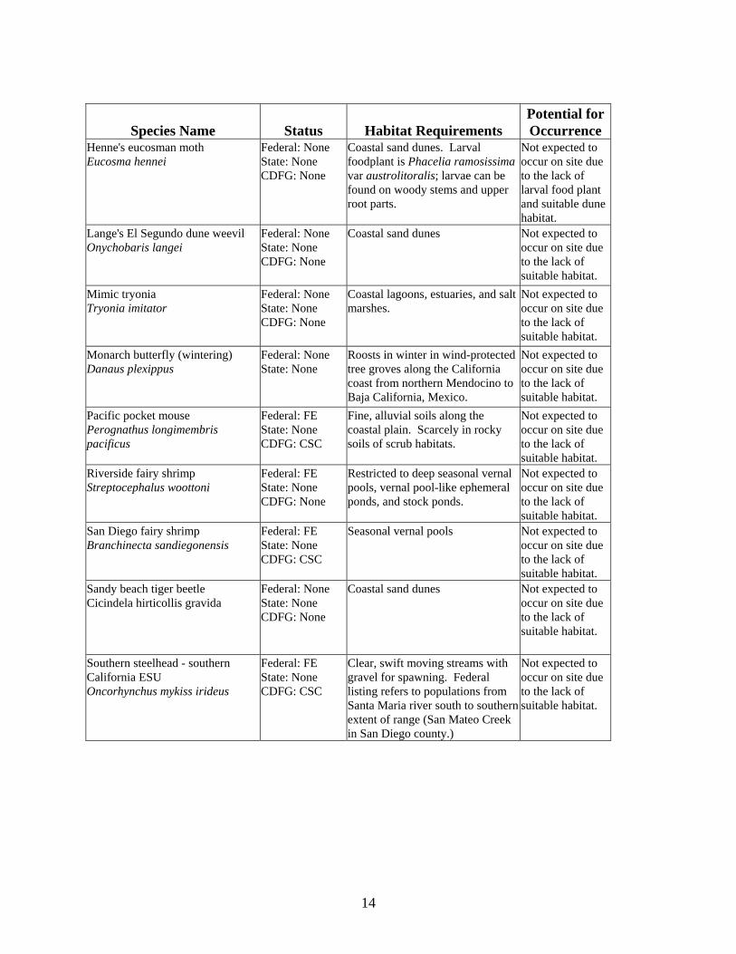
Special-Status Wildlife Table 2 provides a list of special-status wildlife species that have been documented to occur in the vicinity of the site and that were considered during general biological surveys (in some instances the occurrences are historical and the species have been extirpated). Wildlife species were selected for consideration primarily through review of the November 2004 CNDDB. See the Results Section for discussion of all special-status wildlife species that occur on site or have the potential to occur on site.

13
Table 2. Special-status wildlife species considered for this report
Species Name Status Habitat Requirements Potential for Occurrence
Belding's savannah sparrow Passerculus sandwichensis beldingi
Federal: None State: SE CDFG: CSC
Coastal Marshes. Nests in pickleweed in tidal margins.
Not expected to occur on site due to the lack of suitable habitat.
Belkin's dune tabanid fly Brennania belkini
Federal: None State: None CDFG: None
Coastal sand dunes Not expected to occur on site due to the lack of suitable habitat.
Burrowing owl Athene cunicularia
Federal: FSC State: None CDFG: CSC
Shortgrass prairies, grasslands, lowland scrub, agricultural lands (particularly rangelands), coastal dunes, desert floors, and some artificial, open areas as a year-long resident. Occupies abandoned ground squirrel burrows as well as artificial structures such as culverts and underpasses.
Not expected to occur on site due to the lack of suitable habitat.
California black rail Laterallus jamaicensis coturniculus
Federal: None State: ST CDFG: None
Occurs in coastal saltmarsh and brackish marsh dominated by pickleweed.
Not expected to occur on site due to the lack of suitable habitat.
California least tern Sterna antillarum browni
Federal: FE State: SE CDFG: CFP
Occurs near estuaries, bays, or harbors where fish is abundant. Breeds colonially on flat, sparsely vegetated substrates near the coast, including sandy beaches, alkali flats, land fills, and paved areas.
Marginally suitable breeding habitat is present on site.
Coastal California gnatcatcher Polioptila californica californica
Federal: FT State: None CDFG: CSC
Low elevation coastal sage scrub and coastal bluff scrub.
Not expected to occur on site due to the lack of suitable habitat.
Dorothy's El Segundo dune weevil Trigonoscuta dorothea dorothea
Federal: None State: None CDFG: None
Coastal sand dunes Not expected to occur on site due to the lack of suitable habitat.
El Segundo blue butterfly Euphilotes battoides allyni
Federal: FE State: None CDFG: None
Coastal sand dunes. Hostplant is Eriogonum parviflorum.
Not expected to occur on site due to the lack of host plant and suitable dune habitat.
Globose dune beetle Coelus globosus
Federal: None State: None CDFG: None
Coastal sand dunes. Not expected to occur on site due to the lack of suitable habitat.
14
Species Name Status Habitat Requirements Potential for Occurrence
Henne's eucosman moth Eucosma hennei
Federal: None State: None CDFG: None
Coastal sand dunes. Larval foodplant is Phacelia ramosissima var austrolitoralis; larvae can be found on woody stems and upper root parts.
Not expected to occur on site due to the lack of larval food plant and suitable dune habitat.
Lange's El Segundo dune weevil Onychobaris langei
Federal: None State: None CDFG: None
Coastal sand dunes Not expected to occur on site due to the lack of suitable habitat.
Mimic tryonia Tryonia imitator
Federal: None State: None CDFG: None
Coastal lagoons, estuaries, and salt marshes.
Not expected to occur on site due to the lack of suitable habitat.
Monarch butterfly (wintering) Danaus plexippus
Federal: None State: None
Roosts in winter in wind-protected tree groves along the California coast from northern Mendocino to Baja California, Mexico.
Not expected to occur on site due to the lack of suitable habitat.
Pacific pocket mouse Perognathus longimembris pacificus
Federal: FE State: None CDFG: CSC
Fine, alluvial soils along the coastal plain. Scarcely in rocky soils of scrub habitats.
Not expected to occur on site due to the lack of suitable habitat.
Riverside fairy shrimp Streptocephalus woottoni
Federal: FE State: None CDFG: None
Restricted to deep seasonal vernal pools, vernal pool-like ephemeral ponds, and stock ponds.
Not expected to occur on site due to the lack of suitable habitat.
San Diego fairy shrimp Branchinecta sandiegonensis
Federal: FE State: None CDFG: CSC
Seasonal vernal pools Not expected to occur on site due to the lack of suitable habitat.
Sandy beach tiger beetle Cicindela hirticollis gravida
Federal: None State: None CDFG: None
Coastal sand dunes Not expected to occur on site due to the lack of suitable habitat.
Southern steelhead - southern California ESU Oncorhynchus mykiss irideus
Federal: FE State: None CDFG: CSC
Clear, swift moving streams with gravel for spawning. Federal listing refers to populations from Santa Maria river south to southern extent of range (San Mateo Creek in San Diego county.)
Not expected to occur on site due to the lack of suitable habitat.

15
Species Name Status Habitat Requirements Potential for Occurrence
Southwestern pond turtle Clemmys marmorata pallida
Federal: FSC State: None CDFG: CSC
Slow-moving permanent or intermittent streams, small ponds and lakes, reservoirs, abandoned gravel pits, permanent and ephemeral shallow wetlands, stock ponds, and treatment lagoons. Abundant basking sites and cover necessary, including logs, rocks, submerged vegetation, and undercut banks.
Not expected to occur on site due to the lack of suitable habitat.
Tiger beetle Cicindela senilis frosti
Federal: None State: None CDFG: None
Coastal salt marsh Not expected to occur on site due to the lack of suitable habitat.
Vernal pool fairy shrimp Branchinecta lynchi
Federal: FT State: None CDFG: None
Seasonal vernal pools Not expected to occur on site due to the lack of suitable habitat.
Wandering skipper Panoqina errans
Federal: None State: None CDFG: None
Coastal salt marsh; requires moist salt grass for development.
Not expected to occur on site due to the lack of suitable habitat.
Western snowy plover Charadrius alexandrinus nivosus
Federal: FT State: None CDFG: CSC
Sandy or gravelly beaches along the coast, estuarine salt ponds, alkali lakes, and at the Salton Sea.
Not expected to occur on site due to the lack of suitable habitat.
Federal State CDFG FE-Federally Endangered FT-Federally Threatened FSC-Federal Species of Concern
SE-State Endangered ST-State Threatened
CSC-California Species of Concern CFP-California Fully Protected Species
Special-Status Vegetation Communities and Habitats A review of the CNDDB (November 2004) indicated that the following sensitive vegetation associations are known from the Venice quadrangle: coastal salt marsh, coastal dune scrub. Neither of the above-mentioned sensitive habitats occurs on the Parcel 9U Property.

16
V. RESULTS Vegetation Surveys Vegetation types within the project area were mapped incorporating habitat descriptions provided by Holland (1986). Project-specific vegetation types were modified or created as necessary to reflect on site associations, as discussed in detail below. A summary of the vegetation cover within the project area is presented in Table 3. A map showing vegetation within the project area is attached as Exhibit 3.
TABLE 3. Summary of Vegetation Cover Within Project Area
Vegetation Association Total (Acres) Narrow-leaved Willow Scrub 0.22
Ruderal 3.23 Emergent Marsh 0.04 Ruderal Wetland 0.31
Totals 3.80 Narrow-leaved willow scrub. The southern edge of the project site consists of a berm dominated by narrow-leaved willow (Salix exigua) with an understory of yellow sweet clover (Melilotus indica) and non-native annual grasses. Ruderal. The majority of the project site, including some portions of the excavated depression and all of the areas outside the depression (except the berm on the southern edge of the property), is dominated by upland non-native herbaceous species including ripgut brome (Bromus diandrus), soft chess (Bromus hordeaceus), foxtail barley (Hordeum murinum ssp. Leporinum), bur clover (Medicago polymorpha), yellow sweet-clover (Melilotus indica), white sweet-clover (Melilotus alba), cheeseweed (Malva parviflora), white-stemmed filaree (Erodium moschatum), small-flowered iceplant (Mesembryanthemum nodiflorum), and garland chrysanthemum (Chrysanthemum coronarium). Also common is the native telegraph weed (Heterotheca grandiflora). Emergent Marsh. A portion of the excavated basin is dominated by hydrophytic herbaceous species including the native alkali bulrush (Scirpus maritimus) and toad rush (Juncus bufonius). Ruderal Wetland. A portion of the excavated basin is vegetated with hydrophytic herbaceous species including small locally dominant areas of native species including alkali weed (Cressa truxillensis), saltgrass (Distichlis spicata), and pickleweed (Salicornia virginica). Locally dominant non-native species include five-hook bassia (Bassia hyssopifolia), sickle grass (Parapholis incurva), and rabbitfoot grass (Polypogon monospeliensis).

17
Special-Status Flora Focused surveys for four special-status plant species with the potential to occur on site were conducted. These plant species include Coulter’s goldfields (Lasthenia glabrata ssp. coulteri; CNPS List 1B), estuary seablight (Sueda esteroa; CNPS List 1B), prostrate navarretia (Navarretia prostrata; Federal Species of Concern, CNPS List 1B) southern tarplant (Centromadia parryi ssp. australus; CNPS List 1B). None of these species were detected on site. Coulter’s Goldfields (Lasthenia glabrata ssp. Coulteri) is a CNPS List 1B species that occurs in salt marsh areas near the coast at the extreme upper end of tidal inundation. It has also been noted on the periphery of vernal pools such as near Miramar Airfield and in alkali marshes and meadows in the inland valleys of western Riverside County. The flowering period is April to June. This species has never been detected at the project site, and is not expected to occur based on lack of detection and marginally suitable habitat. Mud Nama (Nama stenocarpum) is a CNPS List 2 species that occurs near the high tide line of marshes and on the margins of swamps, lakes, and on riverbanks. In southern California, this species occurs in Los Angeles, Orange, Riverside, San Diego, and Imperial counties. The flowering period is January to July. This species has never been detected at the project site, and is not expected to occur based on lack of detection and marginally suitable habitat. Prostrate Navarretia (Navarretia prostrata) is a CNPS List 1B species that in mesic soils in Coastal sage scrub, valley and foothill grassland, and vernal pools. The flowering period is April to July. In southern California, it has been recorded in Los Angeles, Orange, Riverside, San Bernadino, and San Diego counties. This species is recorded in the CNDDB from Manhattan Beach at the junction of Sepulveda Boulevard and West Railroad; however, this occurrence dates from 1944 and is probably extirpated. This species has never been detected at the project site, and is not expected to occur based on lack of detection and marginally suitable habitat. Southern Tarplant (Centromadia parryi var. australis) is a CNPS List IB species and is an annual member of the sunflower family that occurs in vernal pools, alkali playas, alkali grasslands, and along the margins of salt marshes. This species is very distinctive, reaching heights of three feet. The flowering period is June to November. This species has never been detected at the project site, and is not expected to occur based on lack of detection and marginally suitable habitat. No federally or state-listed plant species were detected on site, and none are expected to occur due to the lack of suitable habitat. Special-Status Wildlife No special-status wildlife species were observed on site. Based on initial observations, it was determined that the projects site exhibited potential habitat for listed species including California least tern (Sterna antillarum browni) and Riverside fairy shrimp (Streptocephalus wootoni); however, following more detailed survey work, it was determined that there is very low potential

18
for California least tern to occur on site and no potential for Riverside fairy shrimp to occur on site. California Least Tern (Sterna antillarum browni) is a federally and state-listed endangered migratory seabird. This species is a small tern, about nine inches long with a 20-inch wingspan. It is mostly white and pale gray, and wingtips are black. The head of the adult has a black cap and white forehead, and the yellow beak is black-tipped. This migratory bird winters somewhere in Latin America, but the winter range and habitats are unknown. The nesting range is along the Pacific coast from southern Baja California to San Francisco Bay. Least terns usually arrive in California in April and depart in August. Suitable habitat for breeding colonies consists of open sandy beaches, dunes, or sparsely vegetated disturbed sites adjacent to bays and lagoons. The project site is suitable breeding habitat, as it consists of a sparsely vegetated site adjacent to a bay. However, this species was not detected by surveys conducted during the breeding period by either GLA (July 18, 2004 and June 16, 2005) or during the course of a fairy shrimp protocol survey conducted by Frank Wegscheider (April 10, 2005). Riverside Fairy Shrimp (Streptocephalus wootoni) is a federally listed endangered branchiopod crustacean. This species has a limited distribution and is known from pool complexes in western Riverside, San Diego, and Orange Counties. It is also known to have occurred historically in the vicinity of Los Angeles International Airport and at one location in Ventura County, based on dry season sampling. The pools in which this species is found are located at elevations of 30-415 meters in seasonal grasslands, some of which are interspersed among chaparral or coastal sage scrub vegetation. These pools tend to be long-lived, have low-to moderate total dissolved solids (less than 600 ppm), and have relatively warm water8. Protocol surveys performed by Frank Wegscheider (Permit # TE-038716-0) did not detect Riverside fairy shrimp or any other listed fairy shrimp species. Total dissolved solids (TDS) levels in the excavated depression ranged above 4,000 ppm and on 25 March the depression exhibited a TDS level of 7530 ppm. Conditions are likely unsuitable for the Riverside fairy shrimp as well as for the San Diego and Vernal Pool fairy shrimps in these pools due to excessively high TDS levels. See Appendix C for a complete report of the protocol surveys. Corps, CDFG, and Regional Board Jurisdiction Corps jurisdiction at the site totals approximately 0.26 acre [Exhibit 4 – Potential Wetland Areas]. This 0.26-acre area exhibits positive indicators for wetland hydrology, hydric soils and hydrophytic vegetation; however, it is not connected hydrologically to other navigable waters (i.e., Marina del Rey/Pacific Ocean). As discussed in (3.1.b.) above, the Corps could assert jurisdiction over the 0.26-acre area based on adjacency to other navigable waters (i.e., Marina del Rey/Pacific Ocean), and given the proximity of the 0.26-acre area to the marina (approximately 85 feet), it is expected that the Corps will assert jurisdiction over this feature.
8 Eriksen, C and D. Belk. 1999. Fairy Shrimps of California’s Puddles, Pools, and Playas. Mad River Press, Eureka, California.

19
The excavated depression does not meet the definition of either a lake or a stream in accordance with the California Fish and Game Code, and would not be subject to regulation by CDFG pursuant to Section 1602 of the California Fish and Game Code. If the Corps asserts jurisdiction over the 0.26-acre portion of the isolated depression, it will be necessary to obtain a Section 401 Water Quality Certification from the Regional Board as a condition of the Section 404 from the Corps. If the Corps does not assert jurisdiction over this feature, then the Regional Board would assert jurisdiction in accordance with the Porter Cologne Act and require a waste discharge permit (WDR). California Coastal Commission Jurisdiction Coastal Commission Jurisdiction on site totals 0.47 acre [Exhibit 4 – Potential Wetland Areas]. Of this, 0.26 acre consists of the previously discussed area that exhibits characteristics consistent with the presence of a three-parameter wetland as defined by the Corps. The additional 0.21-acre area exhibits at least one parameter (positive indicators for hydric soils or hydrophytic vegetation) that would be regulated as wetland by the Coastal Commission. VI. PROJECT IMPACTS The impact analysis is based on the assumption that all development on site will avoid the 0.47-acre area subject to Coastal Commission jurisdiction, with the addition of a 25-foot-wide buffer around the Coastal Commission jurisdictional wetland. VII. IMPACT ANALYSIS The following discussion examines the potential impacts to plant and wildlife resources that may occur as a result of the development of Parcel 9U. Project-related impacts can occur in two forms, direct and indirect. Direct impacts are considered to be those that involve the loss, modification or disturbance of plant communities, which in turn, directly affect the flora and fauna of those habitats. Direct impacts also include the destruction of individual plants or wildlife, which may also directly affect regional population numbers of a species or result in the physical isolation of populations, thereby reducing genetic diversity and population stability. In general, indirect impacts involve the effects of increases in ambient levels of noise or light, unnatural predators (i.e., domestic cats and other non-native animals), competition with exotic plants and animals, and increased human disturbances such as hiking. Generally, indirect impacts may be associated with the subsequent day-to-day activities of project build-out, such as increased traffic use, permanent concrete barrier walls or chain-link fences, exotic ornamental plantings that provide a local source of seed, etc., which may be both short-term and long-term in their duration. These impacts are commonly referred to as “edge effects” and may result in a slow replacement of native plants by exotics, and changes in the behavioral patterns of wildlife and reduced wildlife diversity and abundance in habitats adjacent to the project site. Therefore, potential significant adverse effects, either directly or through habitat modifications, on any special-status plant, animal, or habitat that could occur as a result of project development

20
require evaluation under CEQA. It should be noted that project design features such as the use of non-invasive plants, careful light placement, and light shielding could eliminate some adverse effects of development. California Environmental Quality Act (CEQA) Thresholds of Significance Environmental impacts relative to biological resources are assessed using impact significance threshold criteria, which reflect the policy statement contained in CEQA, Section 21001(c) of the California Public Resources Code. Accordingly, the State Legislature has established it to be the policy of the State of California:
“Prevent the elimination of fish or wildlife species due to man’s activities, ensure that fish and wildlife populations do not drop below self-perpetuating levels, and preserve for future generations representations of all plant and animal communities...”
Determining whether a project may have a significant effect, or impact, plays a critical role in the CEQA process. According to CEQA, Section 15064.7 (Thresholds of Significance), each public agency is encouraged to develop and adopt (by ordinance, resolution, rule, or regulation) thresholds of significance that the agency uses in the determination of the significance of environmental effects. A threshold of significance is an identifiable quantitative, qualitative or performance level of a particular environmental effect, non-compliance with which means the effect will normally be determined to be significant by the agency and compliance with which means the effect normally will be determined to be less than significant. In the development of thresholds of significance for impacts to biological resources CEQA provides guidance primarily in Section 15065, Mandatory Findings of Significance, and the CEQA Guidelines, Appendix G, Environmental Checklist Form. Section 15065(a) states that a project may have a significant effect where:
“The project has the potential to substantially degrade the quality of the environment, substantially reduce the habitat of a fish or wildlife species, cause a fish or wildlife population to drop below self-sustaining levels, threaten to eliminate a plant or wildlife community, reduce the number or restrict the range of an endangered, rare, or threatened species, ...”
Therefore, for the purpose of this analysis, impacts to biological resources are considered potentially significant (before considering offsetting mitigation measures) if one or more of the following criteria discussed below would result from implementation of the proposed project.

21
Criteria for Determining Significance Pursuant to CEQA Appendix G of the 1998 State CEQA guidelines indicate that a project may be deemed to have a significant effect on the environment if the project is likely to:
a) Have a substantial adverse effect, either directly or through habitat modifications, on any species identified as a candidate, sensitive, or special status species in local or regional plans, policies, or regulations, or by the California Department of Fish and Game or U.S. Fish and Wildlife Service.
b) Have a substantial adverse effect on any riparian habitat or other sensitive
natural community identified in local or regional plans, policies, regulations or by the California Department of Fish and Game or U.S. Fish and Wildlife Service (including protections provided pursuant to Section 1600 et seq.).
c) Have a substantial adverse effect on federally protected wetlands as defined
by Section 404 of the Clean Water Act (including, but not limited to, marsh, vernal pool, coastal, etc.) through direct removal, filling, hydrological interruption, or other means.
d) Interfere substantially with the movement of any native resident or migratory
fish or wildlife species or with established native resident or migratory wildlife corridors, or impede the use of native wildlife nursery sites.
e) Conflict with any local policies or ordinances protecting biological resources,
such as a tree preservation policy or ordinance. f) Conflict with the provisions of an adopted Habitat Conservation Plan, Natural
Community Conservation Plan, or other approved local, regional, or state habitat conservation plan.
Direct Impacts The Parcel 9U project site does not support any state- or federally-listed threatened or endangered plant or animal species, nor does it support any special-status plant or animal species. There would be no impacts to state- or federally listed species on the Parcel 9U site. Furthermore, the project site supports only common species, many of which are non-native. All of the species detected onsite are adapted to the urban environment and conversion of portions of the site from ruderal habitat to developed area would not have a significant affect on regional populations of any species detected onsite. The project site contains wetlands potentially subject to the jurisdiction of the U.S. Army Corps of Engineers and California Coastal Commission. However, the proposed development of Parcel 9U includes both full avoidance of the 0.47 acre of Coastal Commission jurisdictional wetlands

22
and 0.26 acre of Corps jurisdictional wetlands, and a 25-foot wide buffer on the perimeter of the wetland area. As a component of the project, the applicant proposes to restore the wetland, including establishment of a “muted” tidal connection and restoration of coastal salt marsh habitat. In order to establish the appropriate elevation that would provide for tidal influence, it will be necessary to re-contour the existing wetland as well as to install the pipe that will provide for the tidal connection. Temporary impacts to the degraded wetland for purposes of restoration would not be considered significant; nevertheless, it will be necessary to obtain authorizations from the Corps and Coastal Commission in order to implement the proposed restoration. Following restoration, the wetland will exhibit higher hydrologic, biogeochemical, and habitat functions. The Parcel 9U does not support any special-status vegetation communities; therefore, there would be no impacts to special-status vegetation communities. Indirect Impacts The Parcel 9U project site does not support any state- or federally-listed threatened or endangered plant or animal species, and no such species have been detected on the site historically subsequent to the construction of the marina. Therefore, no indirect impacts to special-status plant or animal species are associated with the project. As noted in the project description above, the site is generally surrounded by existing development and is clearly “urban”. All of the wildlife species observed on the site are well adapted to the urban environment and are not measurably affected by the noise, ambient lighting, and conditions within the urban setting. As such, development of the site would not affect those species that use the site which are fully adapted to the urban setting. No significant affects due to indirect impacts would be associated with the project. Wetlands subject to the jurisdiction of the Corps and/or the CCC are at a minimum of 25 feet from the areas proposed for development. This wetland area is highly degraded and located in a depression excavated from marine dredge spoils deposited during the construction of the marina, and is dominated by non-native species. There would therefore be no significant indirect impact to wetlands associated with the project. In the post-project restored condition, it is expected that wildlife usage would be increased; however, species expected to use the site exhibit tolerance of the urban environment and no indirect impacts to the restored wetland area would be associated with the project.
23
VIII. MITIGATION Development of the Parcel 9U project would not result in significant direct or indirect impacts to biological resources. Therefore, no mitigation is proposed, as none is necessary to reduce impacts to a less than a significant level. Nevertheless, as addressed above, the applicant has proposed to restore the degraded wetland, which will include establishment of a muted tidal regime that will substantially enhance the hydrologic, biogeochemical and habitat functions of the degraded wetland, and will include the establishment of coastal salt marsh vegetation. S:0668-1a_biotech_012506.doc

PAR
CEL
9UR
egio
nal M
ap
Adapted from National Geographic TOPO! ⇐
NORTH
PRO
JEC
T SI
TE
EXH
IBIT
1
0 2 4 6
MILES

PAR
CEL
9UVi
cini
ty M
ap
⇐
NORTH
EXH
IBIT
2
Adapted from USGS Venice quadrangle0 1000 2000 3000
FEET
PRO
JEC
T SI
TE

T:\0363-THE REST\0668-01P9U\0668-01P9U.GIS\668-1VegMap.mxdJune 21, 2005
0 100 200
FeetVegetation Map
PARCEL 9U MARINA DEL REYExhibit 3
LegendProject Boundary
Emergent Marsh
Ruderal
Ruderal Wetland
Narrow-leaved Willow Scrub

54
9
6 2
3
8 7
1
10
0 75 150
Feet
DRAFTT:\0363-THE REST\0668-01P9U\0668-01P9U.GIS\668-1PotentialWetland.mxdFebruary 2, 2005
25 Foot Buffer
Data Point
Wetland Meeting Three Parameters
Areas with Hydric Soils orIndicator Plant Species LackingHydrology in Normal Years
Potential Wetland Areas
PARCEL 9U MARINA DEL REY

APPENDIX A
FLORAL COMPENDIUM The floral compendium lists species identified on the project site. Taxonomy follows the Jepson Manual (Hickman 1993) and, for sensitive species, the California Native Plant Society's Rare Plant Inventory (Tibor 2001). Common plant names are taken from Munz (1974) and Roberts (1998). An asterisk (*) denotes a non-native species.
SCIENTIFIC NAME COMMON NAME
ANGIOSPERMS-DICOTS
AIZOACEAE FIG-MARIGOLD FAMILY Carpobrotus edulis* Hottentot Fig Malephora crocea* Croceum Iceplant
ASTERACEAE SUNFLOWER FAMILY
Chrysanthemum coronarium* Garland Daisy Conyza canadensis Horseweed
Heterotheca grandiflora Telegraph Weed Sonchus oleraceus* Common Sow-thistle
CHENOPODIACEAE GOOSEFOOT FAMILY Atriplex semibaccata* Australian Saltbush Bassia hyssopifolia* Five-hook Bassia Salicornia virginica* Pickleweed
CONVOLVULACEAE MORNING GLORY FAMILY
Cressa truxillensis Alkali Weed
FABACEAE PEA FAMILY Medicago polymorpha* Bur clover
Melilotus alba* White sweet-clover Melilotus indica* Yellow sweet-clover
GERANIACEAE GERANIUM FAMILY
Erodium moschatum* White-Stemmed Filaree
MALVACEAE MALLOW FAMILY Malva parviflora* Cheeseweed

SALICACEAE WILLOW FAMILY Salix exigua Narrow-Leaved Willow
ANGIOSPERMS-MONOCOTS
CYPERACEAE SEDGE FAMILY Scirpus maritimus Alkali Bulrush
POACEAE GRASS FAMILY
Avena barbata* Slender Wild Oat Bromus diandrus* Ripgut
Bromus hordeaceus* Soft Chess Bromus madritensis ssp. rubens* Red Brome
Cynodon dactylon* Bermuda Grass Distichlis spicata Salt grass
Hordeum murinum ssp. leporinum* Foxtail Barley Parapholis incurva* Sickle grass
Polypogon monospeliensis* Rabbitfoot grass Vulpia myuros* Rattail Fescue

APPENDIX B
WILDLIFE COMPENDIUM The wildlife compendium lists species identified on the project site. * = non-native species ** = Species not detected, but expected to occur
SCIENTIFIC NAME COMMON NAME
BIRDS
ARDEIDAE HERONS
Butorides virescens Green-backed heron
ANATIDAE DUCKS, GEESE, SWANS
Anas platyrhynchos Mallard
CORVIDAE JAYS AND CROWS Corvus brachyrhynchos American crow
TYRANNIDAE TYRANT FLYCATCHERS Sayornis nigricans black phoebe
Sayornis saya Say’s phoebe
TROCHILIDAE HUMMINGBIRDS Calypte anna Anna’s hummingbird
ALCEDINIDAE KINGFISHERS
Ceryle alcyon Belted kingfisher
AEGITHALIDAE BUSHTITS Psaltriparus minimus bushtit
REGULIDAE KINGLETS Regulus calendula ruby-crowned kinglet
MIMIDAE THRASHERS Mimus polyglottos northern mockingbird

STURNIDAE STARLINGS *Sturnus vulgaris European starling
PARULIDAE WOOD WARBLERS Dendroica coronata yellow-rumped warbler
FRINGILLIDAE FINCHES Carpodacus mexicanus house finch
22 June 2005
Mr. Daniel Marquez Recovery Permit Coordinator U. S. Fish & Wildlife Service – Carlsbad 6010 Hidden Valley Rd. Carlsbad, CA 92009
Re: 90-Day Letter Report Of Wet-Season Vernal Pool Branchiopod Sampling For The Parcel 9U Property Located In Marina Del Rey, Los Angeles County, California; Conducted Under The Endangered Species Act Section 10(A)(1)(A) Permit # TE-038716-0.
Dear Mr. Marquez: The following report has been prepared to submit survey information and results of the 2005 wet-season sampling for vernal pool branchiopods at the Parcel 9U property located in the City of Marina Del Rey, Los Angeles County, California. SUMMARY Glenn Lukos Associates (GLA) conducted wet-season surveys for federally endangered or threatened branchiopods at the Parcel 9U property, located within the city of Marina Del Rey, Los Angeles County, California (Exhibit 1; Regional Map). Survey sampling was authorized under the federal Endangered Species Act Section 10(a)(1)(A), and was conducted by Frank Wegscheider (permit #TE-038716-0) in accordance with the U.S. Fish and Wildlife Service Vernal Pool Branchiopods Survey Guidelines (1996). No anostracans were found on site during the survey dates. PROJECT LOCATION AND DESCRIPTION The 3.8-acre Parcel 9U is located in the City of Marina Del Rey, Los Angeles County, California [USGS 7.5’ Venice, California quadrangle map at Township 2S, Range 15W, unsectioned], [Exhibit 1 – Regional Map]. The project is located north of Tahiti Way, west of Basin B of Marina Del Rey, east of Via Marina, and south of a residential development [Exhibit 2 – Vicinity Map]. According to the U.S. Geological Survey (USGS) topographic map of Venice, California [dated 1964 and photorevised in 1981], the Project area supports no blue-line streams. Adjoining properties consist of residential development and Basin B of Marina Del Rey. The property consists of an empty lot vegetated primarily with upland ruderal species. The south side of the parcel includes an excavated depression that supports a mixture of native and exotic plant species. The southern margin of the basin consists of a berm made up of spoil materials excavated from the basin. The berm supports narrow-leaved willow (Salix exigua). The proposed project includes the construction of a hotel on the northern section of the property.

Fig. 1 Regional Map
2

Fig. 2 Vicinity Map
3

4
Vegetation The dominant vegetation on the 3.8-acre Parcel 9U property is primarily ruderal, with dominant species in the upland portions including ripgut (Bromus diandrus), rattail fescue (Vulpia myuros), telegraph weed (Heterotheca grandiflora), slender wild oat (Avena barbata), hare barley (Hordeum murinum ssp. leporinum), soft chess (Bromus hordeaceus), garland chrysanthemum (Chrysanthemum coronarium), cheeseweed (Malva parviflora), white-stemmed filaree (Erodium moschatum), bur clover (Medicago polymorpha), sow-thistle (Sonchus oleraceus), small flower iceplant (Mesembryanthemum nodiflorum), Australian saltbush (Atriplex semibaccata), alkali heliotrope (Heliotropum curassivicum), and giant horseweed (Conyza canadensis). Dominant species in the excavated area include alkali weed (Cressa truxillensis), five-hook bassia (Bassia hyssopifolia), sickle grass (Parapholis incurva), red brome (Bromus madritensis ssp. rubens), Bermuda grass (Cynodon dactylon), and alkali bulrush (Scirpus maritimus). The berm is dominated by narrow leaf willow (Salix exigua). Seasonal Pools GLA identified ponding within the basin on the south side of the project site. During the field visits conducted in October, November and early December 2004, ponding was limited to three small sub-pools in the center of the basin, although rainfall totals were above average during this period. Subsequently, following the extreme storms of late December 2004 and early January 2005, the entire basin became inundated; however the approximately 15 inches of rain in a two week period do not represent “normal” conditions. Depending upon yearly rainfall, the depression may not exhibit inundation in average or below-average rainfall years, or the pools may initially exist as three sub-pools, then become one large pool if rainfall conditions are sufficient, and subsequently trisect into three smaller pools as the depression desiccates. BRANCHIOPOD SURVEYS GLA associate biologist Frank Wegscheider (permit #TE-038716-0) conducted protocol fairy shrimp surveys between 13 February and 10 April 2005 during the wet-season study. The selected fairy shrimp sampling site is found on Public Land Survey Sections (California, San Bernardino Base and Meridian) within the following USGS 7.5-minute topographic maps: Venice Quadrangle, dated 1964, photo-revised 1981, (Exhibit 2). Pools Sampled One large man-made seasonal pool/depression was originally identified within the basin on the south study area during the initial field visits. However, this pool subsequently trisected into three smaller pools as the depression desiccated. Photographs taken of the sampled pools are shown in the Appendix. The location of the fully-inundated pool is depicted on Exhibit 3 (Pool Location Map); GPS data follows: Feature 1 Seasonal pool 1 UTM 11 365480E 3760054N “ 2 Seasonal pool 1A UTM 11 365449E 3760056N “ 3 Seasonal pool 1B UTM 11 365459E 3760093N

Fig. 3 Pool Location Map
5
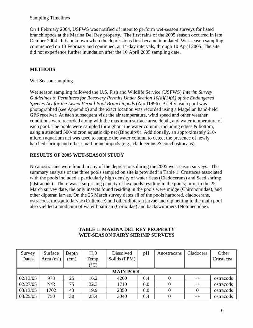
6
Sampling Timelines On 1 February 2004, USFWS was notified of intent to perform wet-season surveys for listed branchiopods at the Marina Del Rey property. The first rains of the 2005 season occurred in late October 2004. It is unknown when the depressions first became inundated. Wet-season sampling commenced on 13 February and continued, at 14-day intervals, through 10 April 2005. The site did not experience further inundation after the 10 April 2005 sampling date. METHODS Wet Season sampling Wet season sampling followed the U.S. Fish and Wildlife Service (USFWS) Interim Survey Guidelines to Permittees for Recovery Permits Under Section 10(a)(1)(A) of the Endangered Species Act for the Listed Vernal Pool Branchiopods (April1996). Briefly, each pool was photographed (see Appendix) and the exact location was recorded using a Magellan hand-held GPS receiver. At each subsequent visit the air temperature, wind speed and other weather conditions were recorded along with the maximum surface area, depth, and water temperature of each pool. The pools were sampled throughout the water column, including edges & bottom, using a standard 500-micron aquatic dip net (Bioquip®). Additionally, an approximately 210-micron aquarium net was used to sample the water column to detect the presence of newly hatched shrimp and other small branchiopods (e.g., cladocerans & conchostracans). RESULTS OF 2005 WET-SEASON STUDY No anostracans were found in any of the depressions during the 2005 wet-season surveys. The summary analysis of the three pools sampled on site is provided in Table 1. Crustacea associated with the pools included a particularly high density of water fleas (Cladocerans) and Seed shrimp (Ostracods). There was a surprising paucity of hexapods residing in the pools; prior to the 25 March survey date, the only insects found residing in the pools were midge (Chironomidae), and other dipteran larvae. On the 25 March survey dates all of the pools harbored, cladocerans, ostracods, mosquito larvae (Culicidae) and other dipteran larvae and dip netting in the main pool also yielded a modicum of water boatman (Corixidae) and backswimmers (Notonectidae).
TABLE 1: MARINA DEL REY PROPERTY WET-SEASON FAIRY SHRIMP SURVEYS
Survey Dates
Surface Area (m2)
Depth (cm)
H20 Temp. (°C)
Dissolved Solids (PPM)
pH Anostracans Cladocera Other Crustacea
MAIN POOL 02/13/05 978 25 16.2 4260 6.4 0 ++ ostracods 02/27/05 N/R 75 22.3 1710 6.0 0 ++ ostracods 03/13/05 1702 43 19.9 2350 6.0 0 0 ostracods 03/25/05 750 30 25.4 3040 6.4 0 ++ ostracods

7
04/10/05 DRY N/A N/A N/A N/A N/A N/A N/A
Survey Dates
Surface Area (m2)
Depth (cm)
H20 Temp. (°C)
Dissolved Solids (PPM)
pH Anostracans Cladocera Other Crustacea
POOL A 02/13/05 91 10 N/R N/R N/R 0 ++ ostracods 02/27/05 DRY N/A N/A N/A N/A N/A N/A N/A 03/13/05 DRY N/A N/A N/A N/A N/A N/A N/A 03/25/05 80 14 29.4 7530 6.6 0 ++ ostracods 04/10/05 DRY N/A N/A N/A N/A N/A N/A N/A
Survey Dates
Surface Area (m2)
Depth (cm)
H20 Temp. (°C)
Dissolved Solids (PPM)
pH Anostracans Cladocera Other Crustacea
POOL B 02/13/05 23 6 N/R N/R N/R 0 0 0 02/27/05 DRY N/A N/A N/A N/A N/A N/A N/A 03/13/05 DRY N/A N/A N/A N/A N/A N/A N/A 03/25/05 280 15 29.4 3830 6.4 0 ++ ostracods 04/10/05 DRY N/A N/A N/A N/A N/A N/A N/A
DISCUSSION Seasonal/Vernal Pools Vernal pools are characterized as shallow, ephemeral wetlands with very specific hydrologic characteristics and possess a unique vegetative community (Zedler, 1987). As such, they also support specific types of wildlife including fairy shrimp. The basin on the south side of the Parcel 9U project site was excavated in 1984 for a development project, but was halted well before completion. The I-beam pilings installed as part of the construction operation still ring the site and a concrete foundational structure, which was installed within the excavated basin, is still intact. The excavated depression is clearly not a natural feature, and therefore the pools within the man-made basin are termed “seasonal pools.” Fairy Shrimp Species of Concern Only two species of anostracans listed for protection under the Federal Endangered Species Act have the potential to occur at this site; the Riverside fairy shrimp Streptocephalus woottoni and the vernal pool fairy shrimp The versatile fairy shrimp Branchinecta lindahli, which may range throughout this area, is not a concern since it is a widespread and common, non-listed species. Streptocephalus woottoni is a fairy shrimp that lives in warm-water, long-lived pools with low to moderate total dissolved solids (TDS) generally with a depth greater than 30 cm (Eriksen

and Belk 1999). Riverside fairy shrimp cysts have been found in soils adjacent to the Los Angeles International Airport (T. Bomkamp, pers. comm.), although it is unknown whether the cysts were viable. TDS levels in pool 1 ranged above 4,000 ppm and on 25 March pool 1a had a TDS level of 7530 ppm. Conditions are likely unsuitable for S. woottoni in these pools due to excessively high TDS levels. None of the surveyed depressions/drainages contained fairy shrimp within the genus Streptocephalus. Branchinecta lynchi lives in cool-water, short-lived pools, again with low to moderate TDS that may exist for only three weeks in the spring (Eriksen and Belk 1999). The vernal pool fairy shrimp generally hatches early in the season when water temperatures are below 10° C (Gallagher, 1996; Helm, 1998). The vernal pool fairy shrimp may cohabit with the versatile fairy shrimp, but is found in very low densities typically comprising perhaps only one to five percent of the total population in the pool. The nearest pool that harbors vernal pool fairy shrimp is within the Cruzan (Mystery) Mesa vernal pool complex north of Santa Clarita ca., 60 miles distant from the Marina Del Rey site. However, no branchinectids were found in the Marina Del Rey pools. If you have any questions regarding this report please contact me via phone at (714) 993-9249 or email at [email protected]. I certify that the information in this survey report and attached exhibits fully and accurately represents my work.
15 April 2005 TE-038716-0 _________________________ ______________ ________________________ Frank J. Wegscheider Date Permit No.
8

9
REFERENCES California Department of Fish and Game, Natural Diversity Data Base (CNDDB). 2003. Sensitive
Element Record Search for the Winchester Quadrangle. California Department of Fish and Game. Sacramento, California.
Eriksen, C. & D. Belk. 1999. Fairy Shrimp of California’s Puddles, Pools, and Playas.
Mad River Press, Inc. 196 pp. Gallagher, S. 1996. Seasonal Occurrence and habitat Characteristics of Some Vernal Pool
Branchiopods in Northern California, U.S.A. Journal of Crustacean Biology 16:323-329. Helm, B. 1998. The Biogeography of Eight Large Branchiopods Endemic to California. In:
C. Witham, E. Bauder, D. Belk, W. Ferren, and R. Ornduff (eds.), Ecology, Conservation, and Management of Vernal Pool Ecosystems – Proceedings from a 1996 Conference. California Native Plant Society, Sacramento, California.
U. S. Department of the Interior, Fish and Wildlife Service. 1996. Interim Survey Guidelines to Permittees for Recovery Permits Under Section 10(a)(1)(A) of the Endangered Species Act for the Listed Vernal Pool Branchiopods. 12 pp.
Zedler, P. 1987. The Ecology of Southern California Vernal Pools: A Community Profile. U. S.
Fish and Wildlife Service Biological Report 85(7.11).