Biodiversity, Flora and Key information Data Source · ents.asp?catid=29 Soil Quality Key...
19
Appendix 2: Baseline Data Information and Maps The information in this appendix shows baseline data for Caithness and Sutherland. It consists of a series of maps and links to sources used in the preparation of this Revised Environmental Report. Data has been taken at either Highland wide level or, when available, Caithness and Sutherland level. Biodiversity, Flora and Fauna Key information Data Source Protect, enhance and where necessary restore designated wildlife sites and protected species There are currently 150 SSSI’s, 29 SAC’s, 15 SPA’s, 4 NNR’s, 3 RAMSAR in the Plan area. SNH website for information on designated sites, site condition and qualifying interests/features: www.snh.org.uk Scottish Biodiversity Strategy (Scotland’s Biodiversity - It’s In Your Hands; 2020 Challenge for Scotland’s Biodiversity) Flow Country, nominated to UNESCO as a tentative World Heritage Site, is a vitally important habitat on a regional and international scale. It is the largest expanse of blanket bog in Europe, and covers about 4,000 km 2 and home to a rich variety of wildlife, and is used as a breeding ground for many different species of birds. The Peatlands of Caithness and Sutherland - Management Strategy 2005 - 2015 Improve biodiversity, avoiding irreversible losses. Highland region supports 192 of the 238 priority species in Scotland and 40 of the 42 priority habitats. 455 of the priority species of conservation importance are found in Highland. Highland Biodiversity Action Plan www.highlandbiodiversity.com Habitat and Birds Directive – Annex 1 Provide appropriate opportunities for people to come into contact with and appreciate wild life and wild places. Core Paths and Rights of Way THC Core Paths Scotways Fisheries and Aquaculture Natural Resources of the Seas around Highland. http://www.highland.gov.uk/yourenvir onment/agriculturefisheriesandforestr y/fisheriesandaquaculture/ Protected species THC's Statutorily Protected Species Supplementary Guidance. SNH website http://www.snh.gov.uk/publications- data-and-research/snhi-information-
Transcript of Biodiversity, Flora and Key information Data Source · ents.asp?catid=29 Soil Quality Key...
Appendix 2: Baseline Data Information and Maps
The information in this appendix shows baseline data for Caithness and Sutherland. It
consists of a series of maps and links to sources used in the preparation of this Revised
Environmental Report. Data has been taken at either Highland wide level or, when available,
Caithness and Sutherland level.
Biodiversity, Flora and Fauna
Key information Data Source
Protect, enhance and where necessary restore designated wildlife sites and protected species
There are currently 150 SSSI’s, 29 SAC’s, 15 SPA’s, 4 NNR’s, 3 RAMSAR in the Plan area.
SNH website for information on designated sites, site condition and qualifying interests/features: www.snh.org.uk Scottish Biodiversity Strategy (Scotland’s Biodiversity - It’s In Your Hands; 2020 Challenge for Scotland’s Biodiversity)
Flow Country, nominated to UNESCO as a tentative World Heritage Site, is a vitally important habitat on a regional and international scale. It is the largest expanse of blanket bog in Europe, and covers about 4,000 km2 and home to a rich variety of wildlife, and is used as a breeding ground for many different species of birds.
The Peatlands of Caithness and Sutherland - Management Strategy 2005 - 2015
Improve biodiversity, avoiding irreversible losses.
Highland region supports 192 of the 238 priority species in Scotland and 40 of the 42 priority habitats. 455 of the priority species of conservation importance are found in Highland.
Highland Biodiversity Action Plan www.highlandbiodiversity.com Habitat and Birds Directive – Annex 1
Provide appropriate opportunities for people to come into contact with and appreciate wild life and wild places.
Core Paths and Rights of Way
THC Core Paths Scotways
Fisheries and Aquaculture
Natural Resources of the Seas around Highland.
http://www.highland.gov.uk/yourenvironment/agriculturefisheriesandforestry/fisheriesandaquaculture/
Protected species THC's Statutorily Protected Species Supplementary Guidance. SNH website http://www.snh.gov.uk/publications-data-and-research/snhi-information-

service/map/ Presence of protected species may be able to be derived from the NBN Gateway http://data,nbn.org.uk/ (although absence of any record is not conclusive that the species is not present).
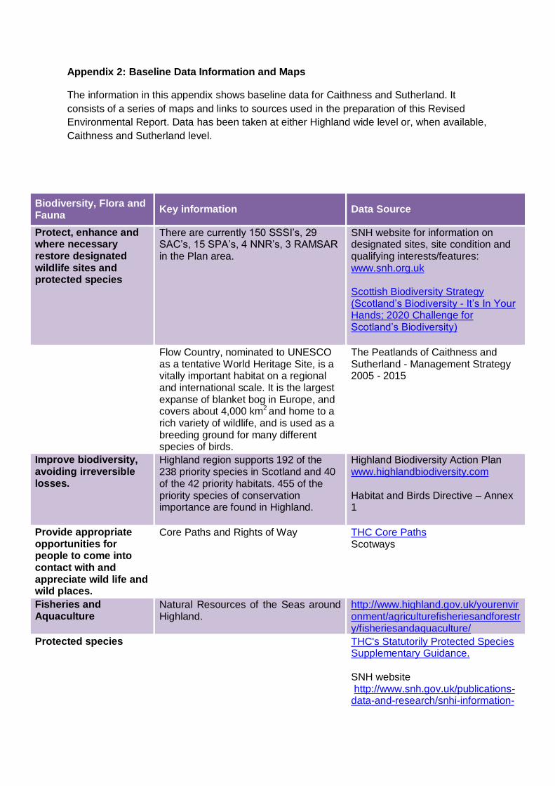
Forest and Woodland The forestry map below shows the key features within the existing forestry industry across Highland. In the Plan area there are 1,338 Semi-natural woodland sites, 1,010 ancient woodland sites and 8 Tree Preservation Orders.
The Highland Forest and Woodland Strategy Forestry Commission Scotland: http://www.forestry.gov.uk/scotland Native Woodland Survey of Scotland
Protect and enhance the connectivity of green networks
Mapped extent and mapping methodology for identification of green networks in Highland
Green Networks Supplementary Guidance
Marine Protected Areas
2 Nature Conservation Marine Protected Areas
SNH website for information Marine Protected Areas
Seal Haul-out Areas Seal Haul-out Areas


NEED TO INSERT MAP for MPAS

Population and Human Health
Key Information Data Source
Population and demographics
Information on the current situation and forecasts for future demographic changes at local, regional and international levels.
Population of Highland increased from 208, 914 to 232,132 between 2001 and 2011 (11% increase)
Population is projected to increase by 15% by 2035.
There is expected to be 16, 029 more people of retirement age and 5507 fewer children than in 2004. Therefore the population is expected to age.
3 data zones in highland Region fall within the 5% most deprived zones in Scotland. 2 data zones fall within the top 5% least deprived.
A large proportion of Highland Region is referred to as “Fragile” in terms of remoteness and scarcity of population. An average of 8 people live per sq km, throughout the region, reducing to 2 people per sq km in some parts.
In Caithness and Sutherland the population has grown by 1,312 between 2001 and 2011 to 37,020 but is expected to decline to 35,556 by 2031. Current population density in the Plan area is 5.1 people per km2 (compared to Highland at 8.7 people per km2 and 67.4 for Scotland. Sutherland is the most sparsely populated area of Scotland with only 2.2 people per km2.
Census statistics and analysis www.ons.gov.uk Scottish Household Survey 2012 http://www.scotland.gov.uk/Topics/Statistics/16002 Scottish Index of Multiple Deprivation Highland Council Deprivation and Fragility Informaton
Health and well-being Baseline information on the current situation and forecasts for future trends on a variety of topics including health, crime, environmental health.
www.isdscotland.org
Transport Scotland: Household Survey 2012 www.audit-scotland.gov.uk http://www.transportscotland.gov.uk/news/scottish-household-survey-travel-diary-2012
School rolls Many of the primary and secondary schools are significantly under capacity.
School roll forecasts
Physical activity and active travel
Information on physical activity organisations and current and planned active travel projects.
47.7% of Highland has not walked as a means of transport in the past
2012 Scottish Household Survey www.scotland.gov.uk/Topics/Statistics/16002
week and only 40.5% walked for pleasure in the last week.
49% of Highland population has access to a bicycle (second only to Moray at 49.6%
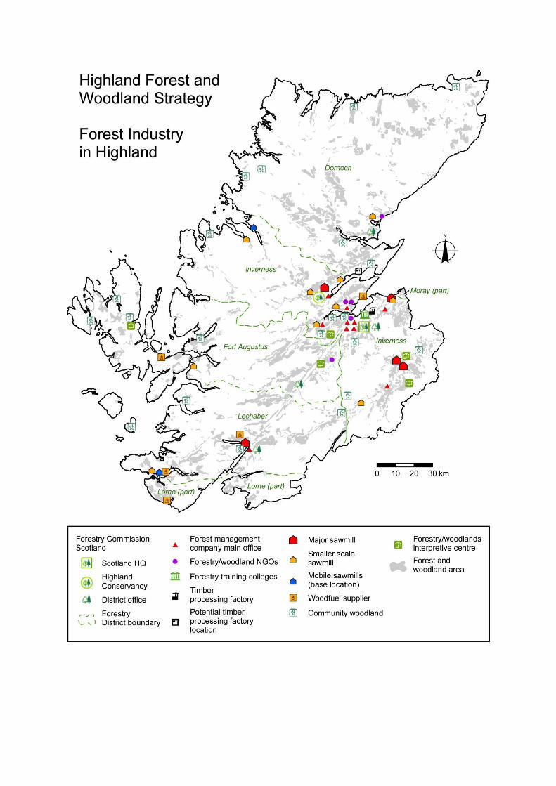
Sustrans National Cycle Network Map; http://www.sustrans.org.uk/ncn/map/national-cycle-network
Active Travel audits are available for Thurso and Wick
Footpath networks – Highlights the proportion of population living within 200m of a footpath.
THC Core Paths Scotways
Open Space Highlights the proportion of population who live within 200m of open space
THC Open Space Supplementary Guidance and Greenspace Audit
Greenspace Scotland
http://www.greenspacescotland.org.uk/audits-and-strategies.aspx
Scottish Household Survey 2012
www.gov.scot/Topics/Statistics/1600
2
SNH - Attitudes to Greenspace in Scotland

Air Key Information Data Source
2013 Air Quality Progress Report
Generally the air quality in the Highland Council area is good.
Risk that 15 minute mean air quality objective SO2 could be exceeded in Castletown as a result of the density of dwellings which burn solid fuels.
http://www.highland.gov.uk/downloads/file/405/2013_air_quality_progress_report
Number of Air Quality Management Areas (AQMA) in Highland
None at present http://www.scottishairquality.co.uk/

Water Key Information Data Source
Flooding likelihood Within nearly all the main towns and villages there are areas which are at risk of flooding and that both coastal and fluvial flood risk can be an issue in the CaSPlan area.
SEPA flood risk management maps Strategic Flood Risk Assessment - SEPA technical guidance to support Development Planning
Water Quality North Coast –contains 8 coastal water bodies: 4 ‘high’ ecological status and 4 ‘good’
Tongue - 19 natural water bodies in coastal catchment: 3 high and 16 good.
River Hope - 5 natural water bodies: 4 ‘good’ and 1 ‘poor’.
River Borgie - 7 natural water bodies: 3 high and 4 good.
River Strathy - 4 natural water bodies: 4 good
Helmsdale River - 7 natural water bodies: 6 high and 1 good
Forss Water – 6 natural, 1 heavily modified: 5 high and 1 poor
Wick Coastal – 11 natural water bodies: 7 good, 2 moderate, 1 poor
East Coast – 10 coastal water bodies, 7 high, 2 good and 1 heavily modified
Wick River – 5 water bodies: 2 moderate, 2 poor and 1 bad
River Thurso – 15 water bodies (13 natural and 2 heavily modified): 1 high, 13 good, 3 moderate, 1 poor, 1 bad
River Helmsdale – 28 water bodies: 6 high, 21 good, 1 moderate
River Naver – 20 water bodies (1 heavily modified): 19 high and 1 moderate.
Dunbeath Water – 5 water bodies 1 high 4 good
Berriedale Water – 3 water bodies: 1 high, 1 good and 1 moderate
River Brora – 14 water bodies (1 heavily modified): 12 good, 1 moderate
Brora Coastal – 2 water bodies: both good
River Shin – 23 water bodies (3 heavily modified): 20 good, 2 moderate, 1 bad
River Oykel – 16 water bodies: 3 high, 12 good and 1 moderate
River Caron (Sutherland) – 8 water
River Basin Management Plans
SEPA
http://www.sepa.org.uk/environment/water/monitoring SEPA Water Quality Classifications

bodies (1 heavily modified) : 1 high, 5 good, 2 moderate.
Hydro-power Over 80 hydro-powered stations in Highlands and Islands More than half of Scotland’s 145 hydroelectric schemes are in the Highlands and Islands area
Hi Energy http://www.hi-energy.org.uk/hydroenergy.html
Wave and tidal renewable energy
Pentland Firth and Orkney Waters commercial lease area hosts 6 of the top 10 tidal energy sites in the UK. Potential to generate up to 1.6GW (gigawatts) from tidal and wave device deployment by 2020.
Hi Energy http://www.hi-energy.org.uk/Renewables/Tidal-Energy.htm www.hi-energy.org.uk/Renewables/Wave-Energy.htm
Ground Water and River Levels
SEPA River Levels http://www.sepa.org.uk/water/river_levels.aspx Centre for Hydrology and Ecology. National Water Archive; http://www.ceh.ac.uk/data/NWA.htm Scotland’s River Basin management plan RBMP Interactive Map http://gis.sepa.org.uk/rbmp/
Climatic Factors Key Information Data Source
Vulnerability to effects of climate change
The Scottish Climate Change
Impacts Partnership
www.adaptationscotland.org.uk/1/1/0
/Home.aspx
Consideration of Climatic Factors within Strategic Environmental Assessment (SEA)
www.scotland.gov.uk/Publications/2010/03/18102927/0 SEPA flood risk management maps
Marine Climate Change Impacts Partnership
UKCP09 The climate of the United
Kingdom and recent trends.
ukclimateprojections.defra.gov.uk http://www.sniffer.org.uk/
Energy consumption
Highland Council energy consumption is 22, 250GWH per annum.
THC energy consumption
www.highland.gov.uk/downloads/download/354/energy_consumption
Energy from renewable sources
Renewable Energy installations in Highland Council Building is 1200KWh Promotion of renewable energy.
Renewable energy in THC buildings
www.highland.gov.uk/info/1034/land_and_property/271/renewable_energy_in_our_buildings
Highland Council Renewable Energy
Strategy
www.highland.gov.uk/info/198/planning_-_long_term_and_area_policies/152/r
enewable_energy
Community Benefits from
Renewables
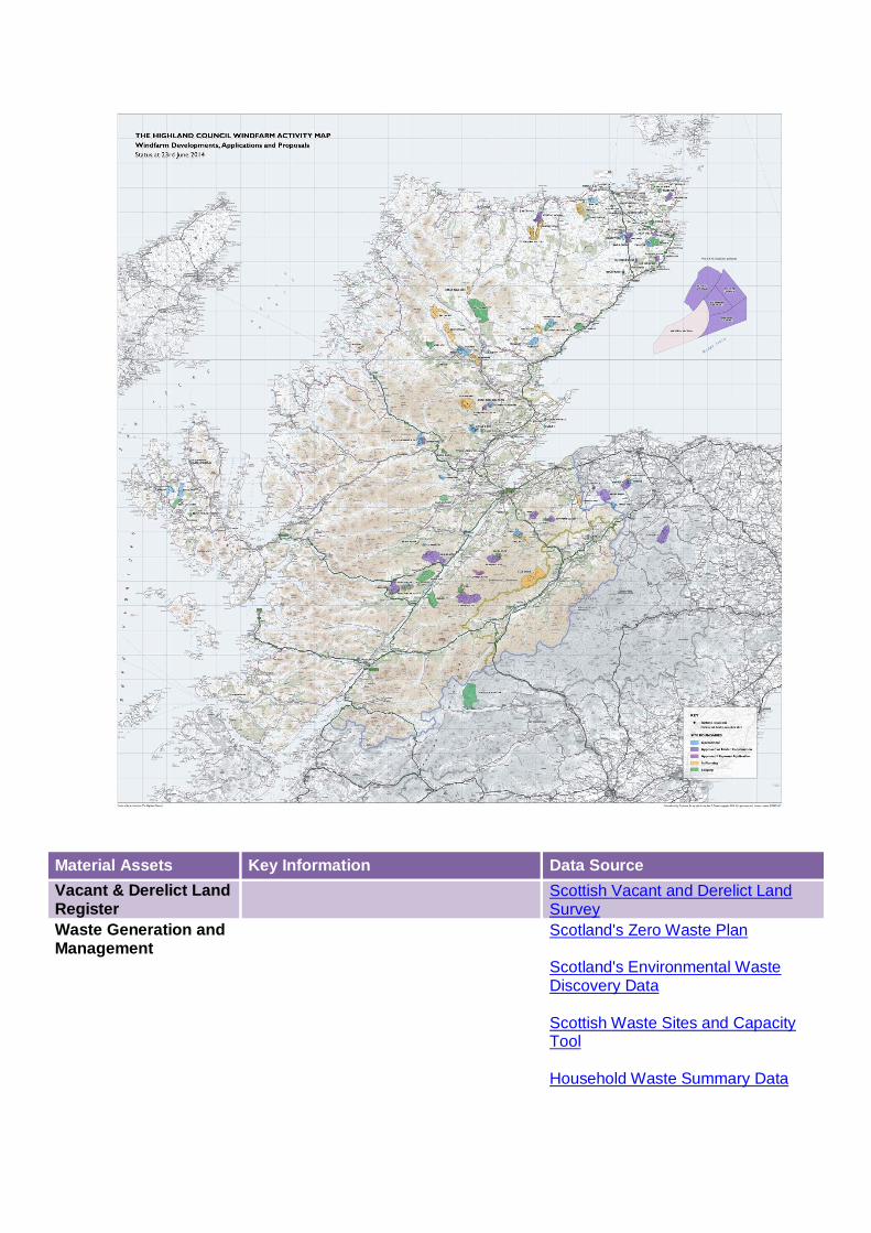
Highland Council Wind Turbine Map
Air Quality Management Areas (AQMA)
None at present in Caithness and Sutherland
http://www.scottishairquality.co.uk/
Travel
44% of people within Highland taking public transport or active travel means to work and study. Active travel audits for Wick and Thurso which includes a variety of baseline information.
Local Transport Strategy and Active Travel Plans www.highland.gov.uk/info/1523/transport_and_streets/121/local_transport_planning
Improve the use of sustainable building techniques
Promotion of Sustainable design in the Community.
Designing for Sustainability in the Highlands
NEED TO INSERT UPDATED WINDFARM MAP
http://http/www.highland.gov.uk/info/198/planning_-_long_term_and_area_policies/152/renewable_energy
http://http/www.highland.gov.uk/info/198/planning_-_long_term_and_area_policies/152/renewable_energy
http://http/www.highland.gov.uk/info/198/planning_-_long_term_and_area_policies/152/renewable_energy
Material Assets Key Information Data Source
Vacant & Derelict Land Register
Scottish Vacant and Derelict Land Survey
Waste Generation and Management
Scotland's Zero Waste Plan Scotland's Environmental Waste Discovery Data Scottish Waste Sites and Capacity Tool Household Waste Summary Data
THC Waste Data Report
www.highland.gov.uk/downloads/file/13531/annual_waste_data_report_2011_to_2013
Core Path Plan & Rights of Way
The Highland Council (THC)
/Scotways
www.highland.gov.uk/info/1457/tourism_and_visitor_attractions/163/paths_in_the_highlands
Land Use Plan & Open Space Audit
THC Open Space Supplementary
Guidance and Greenspace Audit:
www.highland.gov.uk/info/178/
Soil Key Information Data Source
Erosion Distance and numbers of path where erosion or poor path construction has or is reducing soil quality and quantity. No data available but possible monitoring of core paths in the future can be used.
The Highland Council Core Paths Plan
Contaminated Land Highland Council Contaminated Land Database. Scottish Vacant and Derelict Land Survey
Agricultural Land Land use, employment and production information. Crofting in Highland Prime agricultural land (considered to be 3.2 and above)
National Farmers Union Scotland; http://www.nfus.org.uk/facts_index.asp Scotland’s Soils http://www.soils-scotland.gov.uk/data/lca250k Crofting Commission Annual Report www.crofting.scotland.gov.uk/documents.asp?catid=29
Soil Quality Key indicators of soil quality Soil Indicators for Scottish Soils sifss.hutton.ac.uk/
Carbon Rich Soils Peat soils make up 22.5% of Scotland’s soil. Scottish soils are estimated to contain approximately 3000 million tonnes
SNH www.snh.gov.uk/planning-and-development/advice-for-planners-and-developers/
carbon, which is the majority of the soil carbon stock of the whole of the UK.
Scotland’s Soils – survey data http://www.soils-scotland.gov.uk/data/soil-survey
Geology http://www.scottishgeology.com/ SNH GCR Sites
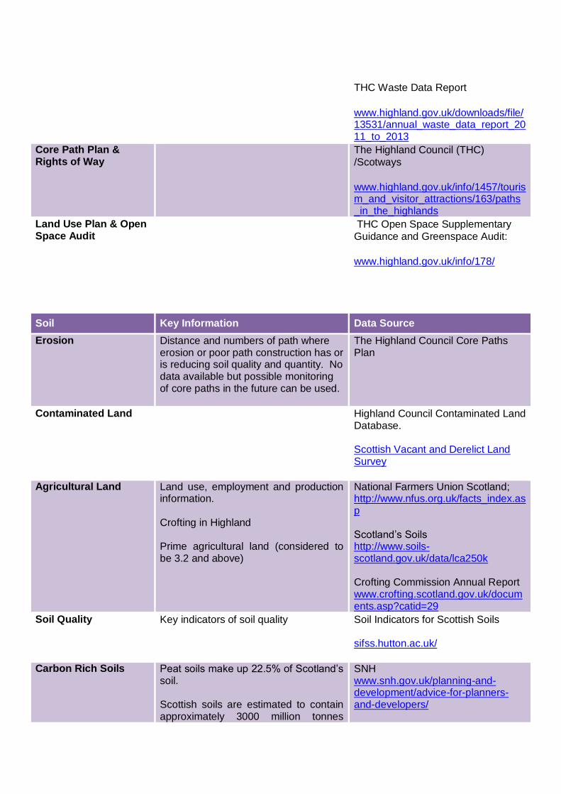
Map: Soil types in the Caithness and Sutherland area
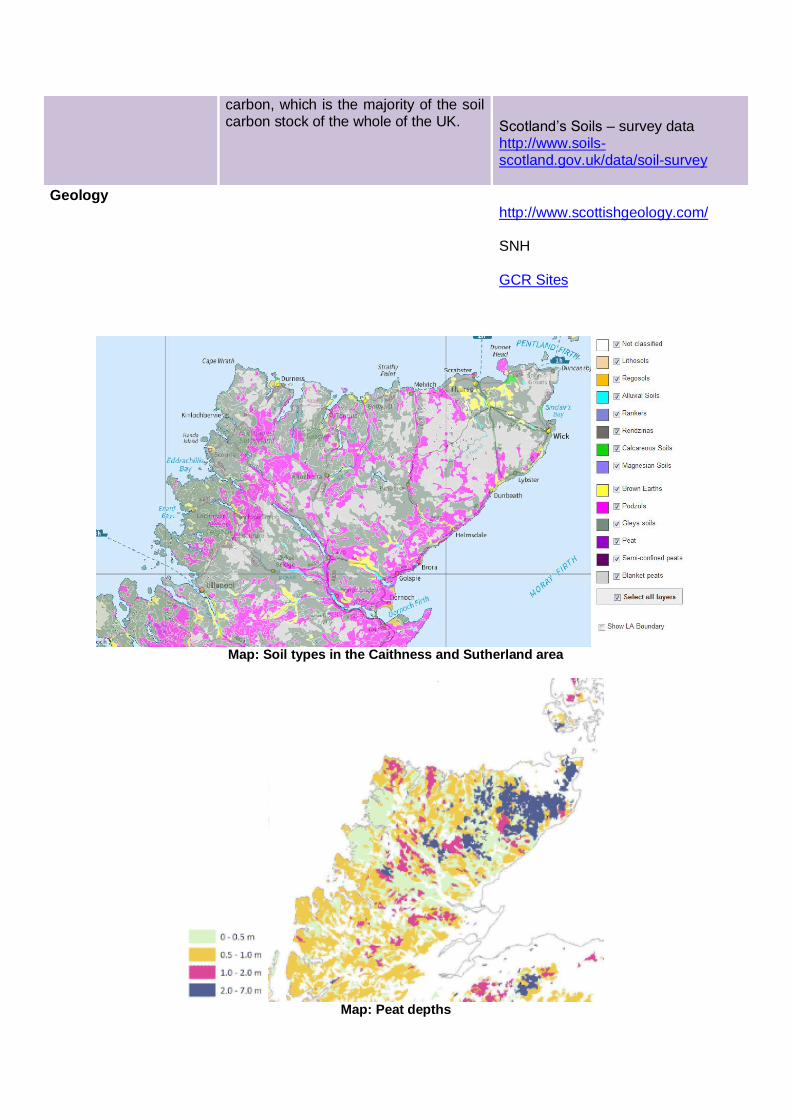
Map: Peat depths
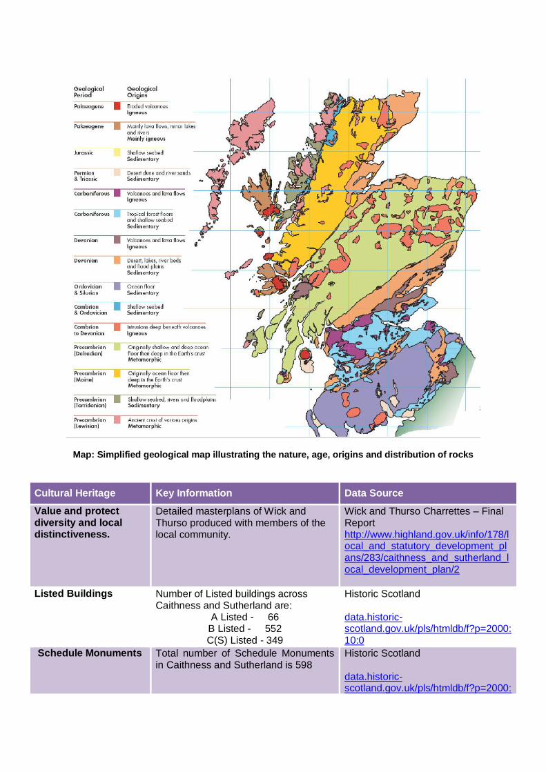
Map: Simplified geological map illustrating the nature, age, origins and distribution of rocks
Cultural Heritage Key Information Data Source
Value and protect diversity and local distinctiveness.
Detailed masterplans of Wick and Thurso produced with members of the local community.
Wick and Thurso Charrettes – Final Report http://www.highland.gov.uk/info/178/local_and_statutory_development_plans/283/caithness_and_sutherland_local_development_plan/2
Listed Buildings Number of Listed buildings across Caithness and Sutherland are:
A Listed - 66 B Listed - 552 C(S) Listed - 349
Historic Scotland data.historic-scotland.gov.uk/pls/htmldb/f?p=2000:10:0
Schedule Monuments Total number of Schedule Monuments in Caithness and Sutherland is 598
Historic Scotland data.historic-scotland.gov.uk/pls/htmldb/f?p=2000:

10:0
Inventory Gardens and Designed Landscapes
There is 1 Inventory Gardens and Designed Landscapes in the Plan area.
Historic Scotland data.historic-scotland.gov.uk/pls/htmldb/f?p=2000:10:0
Conservation areas There are 4 conservation areas across the Plan area.
www.highland.gov.uk/info/192/planning_-_listed_buildings_and_conservation_areas/167/conservation/2
Building at Risk There are 172 buildings on the Buildings at Risk register in Highland. Many of these are within Caithness.
Buildings At Risk Register http://www.buildingsatrisk.org.uk/
Landscape Key Information Data Source
Retain and improve quality and quantity of publicly accessible open space.
There are 15 separate Landscape Character Types identified within Caithness and Sutherland.
Scottish Natural Heritage: Overview of Scotland’s national programme of Landscape Character Assessment (2004)
Sutherland landscape capacity study: an analysis of housing potential

(2006).
Caithness and Sutherland Landscape Character Assessment (1998)
www.snh.gov.uk/protecting-scotlands-nature/looking-after-landscapes/lca/
National Scenic Areas Caithness and Sutherland includes 4 National Scenic Areas – Scotland’s finest landscapes.
SNH National Scenic Areas
Wild Land Areas There are 10 Wild Land Areas identified in the CaSPlan area that make up approx. 45% of the total CaSPlan area.
SNH Wild Land Areas
Coast Highland Coastal Strategy
Impact of Built development
Visual impact of built development SNH’s visual indicator of built development and land use change – http://www.snh.gov.uk/publications-data-and-research/trends/scotlands-indicators/natural-heritage-indicators
Special Landscape Areas
There are 10 SLAs wholly or partially within the Plan area.
SLA Citations www.highland.gov.uk/developmentplans

Add map of wild land areas